Embed Size (px)
Citation preview

TS 39 - Land Administration Organisations and the Future Asri Attallah, Muqbel Jaber and Tuomo Heinonen Piloting of Systematic Land Registration in Palestine Shaping the Change XXIII FIG Congress Munich, Germany, October 8-13, 2006
1/11
Piloting of Systematic Land Registration in Palestine
Asri ATTALLAH and Muqbel JABER, Palestine and Tuomo HEINONEN, Finland
Key words: Land registration, Land title, Surveying. SUMMARY The area of historical Palestine is 27 027 k-m2 of which 704 k-m2 are water areas. As a result of the political conditions and the establishment of the state of Israel in 1948 the land of Palestine was divided as follows: − Israel 20 922 k-m2 (77.4%) − The West Bank 5,755 k-m2 (21.3%) − The Gaza Strip 351 k-m2 (1.3%) − Land in Palestine was originally managed and treated in accordance with the religious laws of Islam until the era of the Ottoman Empire that started to regulate land ownership. The system was proper at the time although it was primitive and far from being accurate in establishing the rights of all owners. In the 1930’s a new law was initiated and the first wave of land surveyors was trained by the British to carry out the assignment. The latest relevant land law was created in 1952 by the Jordan Government and carries the number 40. This law is still applicable in the Palestinian Territories until the present day. However, the Palestinian authority is presently working on passing new laws that govern land ownership and may form a stimulus for economic growth in Palestine. The systematic land registration (settlement) was interrupted in Palestine Territories by the war 1967. Since then only sporadic registration has been carried through by the 1993 established Palestinian Authority. With the help the World Bank and the Finnish Government a Land Administration Project was planned to modernize the department involved in land administration in the Palestinian Territories. A pilot project is planned within the said project and aims at registering some 500 hectares in the Ramallah governorate. If successful the project will be followed by an even more ambitious one aiming at registering all the land in the West Bank, which presently stands between 25 – 30 %.

TS 39 - Land Administration Organisations and the Future Asri Attallah, Muqbel Jaber and Tuomo Heinonen Piloting of Systematic Land Registration in Palestine Shaping the Change XXIII FIG Congress Munich, Germany, October 8-13, 2006
2/11
Piloting of Systematic Land Registration in Palestine
Asri ATTALLAH and Muqbel JABER, Palestine and Tuomo HEINONEN, Finland
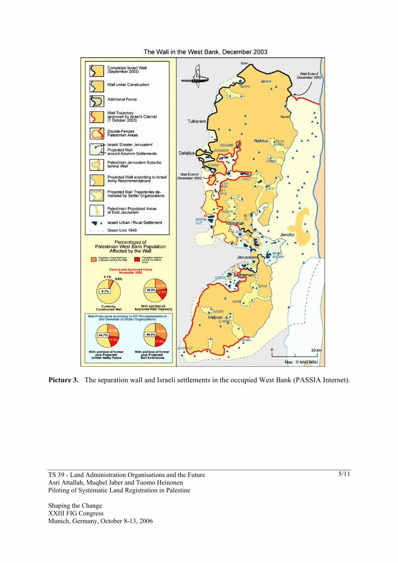
1. PALESTINE Palestine lies on the western edge of the Asian continent and the eastern shore of the Mediterranean Sea. It is bound to the north by Lebanon and Syria, to the west by the Mediterranean Sea, to the south by the Gulf of Agaba and the Egyptian Sinai Penisula, and to the east by Jordan. The area of historical Palestine is 27 027 k-m2 of which 704 k-m2 are water areas. As a result of the political conditions and the establishment of the state of Israel in 1948 the land of Palestine was divided as follows (Hezmawi 1998): − Israel 20 922 k-m2 (77.4%) − The West Bank 5,755 k-m2 (21.3%) − The Gaza Strip 351 k-m2 (1.3%) During the known history of Palestine it has been occupied by the surrounding empires and dynasties. It has been part of Persian (539-333 BC), Greek (333-63 BC), Roman (63 BC – 330 AD), Bysanthian (330 – 640 AD), Muslim (640 – 1516 AD) and Turkish (1516 – 1917 AD) empires. After the First World War Palestine passed into Great Britain’s sphere of interest. In the year 1878 about 88 % of 400 000 inhabitants of Palestine were Arab-Muslims, 9 % Arab-Christians and 3 % Jews. The major migration of Jews started in the year 1917 after the “Balfour Declaration”. In the year 1940 one third of the total population of 1.5 million were Jews. Soon after the Second World War Great Britain resigned its mandate and in the year 1947 the UN drew up a plan where Palestine was divided by two independent states Israel and Palestine. The plan didn’t come true and the Jewish Council unilaterally declared the foundation of Israel. This caused a war between Israel and the surrounding Arab states. After this war the area of Israel become much larger compared to the UN plan. The size of Israeli occupied areas became even bigger after the “Six Day’s War” in 1967. For example East Jerusalem, West Bank and Gaza were occupied by Israel in 1967. The total population of West Bank (including East Jerusalem) is nowadays about 2.4 million and Gaza strip about 1.4 million (PASSIA 2006). Mainly because of the Israeli invasion almost 5 million Palestinians are living outside the Palestine. The maps 1 – 3 give a picture of the ‘land use development’ in the Palestine. According to the latest calculations no more that 53 % of the West Bank will be left for the Palestinians (see the separation wall and Israeli control of the Jordan Valley in the picture 3).

TS 39 - Land Administration Organisations and the Future Asri Attallah, Muqbel Jaber and Tuomo Heinonen Piloting of Systematic Land Registration in Palestine Shaping the Change XXIII FIG Congress Munich, Germany, October 8-13, 2006
3/11
Picture 1. The population in Palestine in 1878 (PASSIA Internet).

TS 39 - Land Administration Organisations and the Future Asri Attallah, Muqbel Jaber and Tuomo Heinonen Piloting of Systematic Land Registration in Palestine Shaping the Change XXIII FIG Congress Munich, Germany, October 8-13, 2006
4/11
Picture 2. The West Bank and Gaza (PASSIA Internet).
TS 39 - Land Administration Organisations and the Future Asri Attallah, Muqbel Jaber and Tuomo Heinonen Piloting of Systematic Land Registration in Palestine Shaping the Change XXIII FIG Congress Munich, Germany, October 8-13, 2006
5/11
Picture 3. The separation wall and Israeli settlements in the occupied West Bank (PASSIA Internet).
TS 39 - Land Administration Organisations and the Future Asri Attallah, Muqbel Jaber and Tuomo Heinonen Piloting of Systematic Land Registration in Palestine Shaping the Change XXIII FIG Congress Munich, Germany, October 8-13, 2006
6/11
2. LAND REGISTRATION TODAY 2.1 Legislation Land in early Palestine was managed and treated in accordance with the religious laws of Islam until the era of the Ottoman (Turkish) empire that started to regulate land ownership. The system was proper at the time although it was primitive (without maps) and far from being accurate in establishing the rights of all owners. The British mandate conserved the Ottoman laws and in about 1930 the first wave of land surveyors was trained to carry out wholesale surveying of land and granting of titles known as “systematic settlement”. Borders for villages were then demarked. The “Settlement Law” number 9 from year 1939 was a ‘product’ of this period. Under the West Bank occupation of Jordan (1947 – 1967) about seventy laws on land registration and transactions were passed. The most relevant land law “Land and Water Dispute Settlement Law” was created in 1952 and carries the number 40. The 1967 invasion of Israel interrupted all the systematic settlement actions according to this law. The law from year 1952 is still applicable in the Palestinian Territories until the present day. The law is mostly out-of-date. However, the Palestinian authority is presently working on passing new laws that govern land ownership, land administration and registration. 2.2 Palestinian Land Authority The Palestinian Authority was established in 1993 and it inherited the Land Registration system. Nowadays sporadic land registration activities are performed by the Palestinian Land Authority (PLA) which was established in 2002. The PLA consists of three main functions: surveying, registration and state land administration. The headquarters of the PLA is in Gaza. The PLA has offices with about three hundred civil servants besides Gaza in Ramallah, Jericho, Nablus, Hebron, Bethlehem, Jenin, Qalqilia and Tulkarem (see the map 3). However for the present the PLA’s jurisdiction and responsibilities are not clearly determined. 2.3 Present Land Registration Process As mentioned before the systematic land registration (settlement) was interrupted in 1967. Only 25 – 30 % of the West Bank area is nowadays officially registered. The number of registration is much higher in Gaza (based originally on Egyptian systems). The sporadic land registration (registration of a transaction) in the West Bank and Gaza is today based on quite complicated manual process, which takes relatively long time. The process is also very laborious for both the officers and the customers. The complicated and for some landowners also expensive process with the services of lawyers and private surveyors has also promoted the use of other unofficial and insecure ‘titling’ systems.
TS 39 - Land Administration Organisations and the Future Asri Attallah, Muqbel Jaber and Tuomo Heinonen Piloting of Systematic Land Registration in Palestine Shaping the Change XXIII FIG Congress Munich, Germany, October 8-13, 2006
7/11
3. PILOT PROJECT 3.1 Land Administration Project The piloting of systematic land registration is one of the most important components of the “West Bank and Gaza Land Administration Project”, which started in the beginning of the year 2005 and will have duration of two and half years. The Project is funded by the World Bank and the Ministry of Foreign Affairs of Finland. The local beneficiaries of the project are the Ministry of Planning (MOP) and Palestinian Land Authority (PLA). The Project is so called LIL (learning and innovation) project, which constitutes the first phase of a long-term Land Administration Program. The “program aims at alleviating poverty and enhancing economic growth by improving land tenure security and facilitating the development of efficient land and property markets in rural and urban areas through the development of an efficient system of land titling and registration based on clear, transparent and coherent policies and laws and supported by an appropriate institutional structure.” (PAD 2004, p. 3) In addition to the piloting of systematic land registration the Project has components for: − Land policy formulation and development of regulatory framework, − Piloting of modern land offices, − Piloting of public land inventory and management strategy and − Institutional development. All these other components of the Project are closely linked to the systematic land registration piloting. The concrete experiences from the piloting will serve most of all the needs of regulatory framework and institutional development. 3.2 Systematic Land Registration (Settlement) Pilots 3.2.1 The Objectives The objectives of the pilots “are to test the legal and regulatory framework, institutional coordination and the technical capacity of the PLA and the private sector before embarking on an accelerated program of land titling. The output of these pilots will include: (i) detailed manuals for cadastral surveying, adjudication and registration including all necessary forms, consistent with the existing laws and regulations; (ii) model technical specifications for the procurement of private surveyors to undertake the cadastral surveys; (iii) three systematic adjudication teams fully trained for operation …; and (iv) issue and registration of some 4,000 titles (about 40% or so of all land parcels in the pilot areas according to the final design of the pilot projects)” (PAD 2004, p. 26-27). The aims of the pilot projects are also to: “(v) stress the benefits of land titling and registration and thus activating demand for the use of the land registry; (vi) achieve tangible results so as to build stakeholders’ momentum towards the project and limit the potential for

TS 39 - Land Administration Organisations and the Future Asri Attallah, Muqbel Jaber and Tuomo Heinonen Piloting of Systematic Land Registration in Palestine Shaping the Change XXIII FIG Congress Munich, Germany, October 8-13, 2006
8/11
opposition …” In addition, the pilot projects “will provide an opportunity to: (vii) analyze the nature of land disputes; (viii) test the title settlement and dispute resolution mechanisms that will be put in place (this includes examining the feasibility of setting specialized land courts or training designated judges, as well as identifying and capitalizing upon the existing formal and informal land dispute resolution mechanisms in operation in Palestinian society today), and; (ix) understand the nature of contested rights to land (both the cases that get settled and those that are not settled) in order to explore possibilities for settling these in a subsequent large-scale program” (PAD 2004 , p. 27). The piloting is expected to take about six to eight months in all. The action in the first pilot location will be started in the autumn 2006.
Picture 4. The pilot locations around the city of Ramallah in West Bank

TS 39 - Land Administration Organisations and the Future Asri Attallah, Muqbel Jaber and Tuomo Heinonen Piloting of Systematic Land Registration in Palestine Shaping the Change XXIII FIG Congress Munich, Germany, October 8-13, 2006
9/11
Picture 5. The Settlement Officers informing Bir Nabala councillors in June 2006.
3.2.2 The Process and the Responsibilities The settlement piloting process has been divided into two sub-processes: − Legal measures performed by the PLA and − Technical cadastral surveying tasks performed by the private surveyors The legal measures of the PLA are based on the present Settlement Law (see before). This process is related to the public announcing of Settlement activities, nominating PLA Settlement Officers (and further nominating of Settlement Teams of PLA), handling the claims for ownership, decisions during the adjudication process and preparation of the final registration table. The cadastral surveying performed by the private surveyors consists of preparation of aerial photo material (orthophoto-maps), parcel demarcation and preparation of the cadastral maps. The PLA will supervise and control all the work of private surveyors. The parcel demarcation stage will be led by the PLA Settlement Officers who will administer the work of the private surveyors. The preparation of cadastral maps will also be administrated by the PLA.

TS 39 - Land Administration Organisations and the Future Asri Attallah, Muqbel Jaber and Tuomo Heinonen Piloting of Systematic Land Registration in Palestine Shaping the Change XXIII FIG Congress Munich, Germany, October 8-13, 2006
10/11
The Land Courts will be established for settling land disputes, which can not be solved by the PLA Settlement Officers during the settlement process. The Courts will be independent of the Project. The Project Management Team with the international advisors is responsible for developing and monitoring the pilot process. The training of the PLA Settlement teams, preparation of the manuals, public awareness campaigning and social assessments are also carried through by the Project Management Team. 3.2.3 The Challenges Carrying out the piloting will be challenging for many different reasons. Some examples of them are given below. The Project is still a ‘pilot’ project, so one has to be realistic with the goals of it. As described earlier the present legislative basis for the settlement actions is incomplete and out-of-date. However the settlement pilot processes have to be built obeying this old legislation. The PLA is a new (2002) government agency without the necessary resources and capacity to undertake its mandate. The organizational structure of it is only in preparation. This means that responsibilities and work-flows in it are not clear. Especially the systematic settlement process lacks practices and routines as a result from the fact that the last settlement actions in Palestine were taken nearly 40 years ago. The shared process of the private surveyors and the PLA requires a lot of the process and the quality management system. The tasks and the responsibilities of these both parties have to be clear not only for them both but also for the land-owners, who maybe first time in their life will meet land surveyors on their plots. Meeting the land-owners and their needs will be the most crucial touchtone of the piloting. Actually the whole process is for the benefit of them. The public awareness campaign needs to be prepared carefully considering the sensitivity of the subject. A significant number of Palestinians, also land-owners live abroad for the compelling reasons we all know very well. They have to be handled equally with the land-owners remained in Palestine. Reaching them by the legal announcing of the settlement process is a real challenge. Last but not least ‘challenge’ is the political situation in the occupied Palestinian territories. Palestinian tax revenues kept by the Israeli authorities and the frozen foreign aid have caused a partial paralysis of the Palestinian Authority (PA) bodies. For the time being also PLA staff is working without their salaries. One could hardly think more difficult circumstances to run a development project.

TS 39 - Land Administration Organisations and the Future Asri Attallah, Muqbel Jaber and Tuomo Heinonen Piloting of Systematic Land Registration in Palestine Shaping the Change XXIII FIG Congress Munich, Germany, October 8-13, 2006
11/11
4. FUTURE The continuous systematic land registration (settlement) process in Palestine is hopefully true soon. No one knows exactly how long it will take to carry out the first-time registration in the rest of the West Bank. One should notice that according to the Oslo Accord from the year 1995 about 58 % of the West Bank area is controlled by the Israeli authorities (“area C”). The registration of the whole West Bank will be never achieved until this arrangement will be changed. The foundation of an independent Palestinian State with permanent borders is a prerequisite for creation of the complete land register. Among others the LAP Project with the ‘settlement piloting component’ is taking its small steps towards these bigger goals. REFERENCES Hezmawi 1998 Hezmawi, Mohammad: ‘Land Property in Palestine for the period between
1918 – 1948’, Alaswar Establishment, Acre 1998. PAD 2004 “Project Appraisal Document on a Proposed Learning and Innovation Loan in
the amount of US$3 Million to West Bank and Gaza for a Land Administration Project”. The World Bank / Private and Financial Sector Development / Department Middle East and North Africa Region. December 14, 2004.
PASSIA 2006 Diary 2006, Palestinian Academic Society for the Study of International Affairs Jerusalem – Al Quds, 2006.
PASSIA Internet http://www.passia.org/ CONTACTS Mr. Asri Attallah, Mr. Mugbel Jaber, Dr. Tuomo Heinonen Palestinian Land Authority / Land Administration Project El-Hamouri Building, Al Quds Street Ramallah PALESTINE Tel. + 972 2 297 46 90 Fax + 972 2 297 47 80 Email: [email protected]