Embed Size (px)
Citation preview

www.pagasa.dost.gov.ph
PILOT STUDIES TO IMPROVE UPTAKE OF
CLIMATE INFORMATION
23rd November 2016
Amihan Conference Room, Science Garden, PAGASA,
Quezon City

PROJECT APPROACH
Phase III: Preparing an Enabling roadmap
Consult sectoral stakeholders
Prepare roadmap Findings and
recommendations
Phase II: Piloting climate change (CC) information
production and dissemination CC
projections workshop
Prepare training
Local Government Units work
Train local officers
Report findings
Phase I: Situation review
Review literature Map stakeholders Consult
stakeholders Further actions

www.pagasa.dost.gov.ph
Outline:
I. Assessing Current Understanding of Climate Risks
Information
II. Pilot Selection
III. Pilot Approach and Development
IV. Pilot Outcomes and Outputs
V. Lessons Learned and Recommendation

www.pagasa.dost.gov.ph
I. Assessing Current Understanding of the Climate Risk Information
Following the situational review we worked closely with key
Government Departments with responsibilities for disaster
risk management and climate adaptation or who could play a
key role in better enabling information dissemination and
uptake information at different levels. This included:
DILG
NEDA
NDRRMC
OCD
CCC
DENR

Stakeholder issues and opportunities identified
Lots of hazard and risk
mapping information
Dissemination and
outreach limited
Data sharing and
“sector”
specific information
Mapping helpful but further
guidance required
Need to focus at
Local Government scale
Focus on pilots to develop approaches
Use learning from previous / existing
initiatives
Sector support and co-production
Inform and link planning processes
(LGU scale)
Learning to inform guidance for wider
uptake

www.pagasa.dost.gov.ph
II. Pilot Selection Pilot Location Characteristics Considerations
GMMA
Marikina City
San Juan City
Pasig City
Urban
Socio-economic class 1 (total
revenue of > 1,500,000 pesos per
year.)
All very prone to flooding
Pilot could potentially build on the approach
developed by the previous GMMA READY project,
the tools for which were formally piloted by the
CCC Ecotown project.
Each city already has some familiarity with climate
change and risk information as a result of their
involvement in such initiatives.
Municipality of
Salcedo, Eastern
Samar, Visayas
Rural
Socio-economic class 5 Fifth Class
Municipality (total revenue of
<300,000 pesos per year)
Very exposed coastline
Severely affected by Super Typhoon
Haiyan
Pilot could potentially build on previous UNDP work
on preparing contingency plans for storms, storm
surges and floods
Issues identified around lack knowledge and access to
climate information from previous studies
Potential opportunity to look at sea level rise (SLR)
impacts and link to the SLR component of DFID
project
II. Pilot Selection
GMMA
Salcedo
Marikina City
San Juan
City
Pasig City

www.pagasa.dost.gov.ph
Supply Chain of Information
Climate
Data
Climate
Information
Sector Knowledge
Planning and Decision
User
Actions

www.pagasa.dost.gov.ph
Pilot approach
To build Capacity to understand climate information
Development of User Needs Based Climate
Information
To develop mechanisms to utilise Climate
Information
www.pagasa.dost.gov.ph
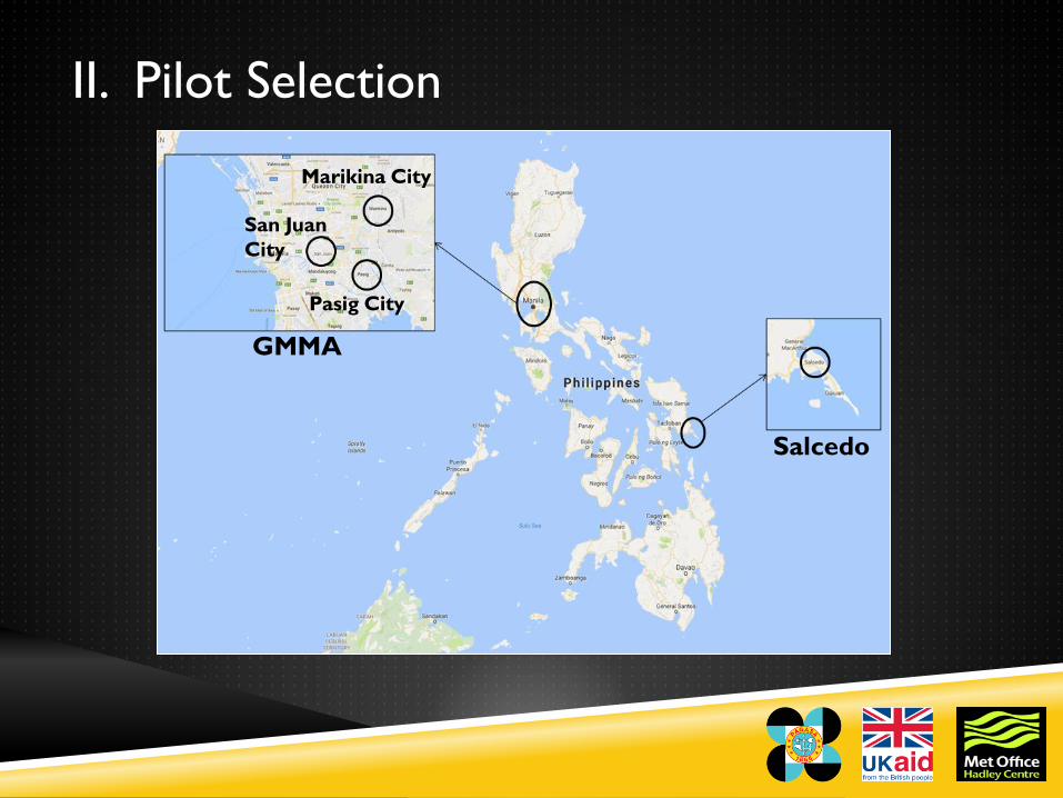
III. Pilot Approach and Development

www.pagasa.dost.gov.ph
a. Inception Workshops (Pilot Area Representatives)
a. Introduction to climate change and
related science
GMMA participants had a good
understanding of climate change,
Salcedo participants had a basic
understanding of climate change

www.pagasa.dost.gov.ph
a. Inception Workshops (Pilot Area Representatives)
b. Introduction to PAGASA produced climate information
Review of PAGASA
information to assess current
understanding

www.pagasa.dost.gov.ph
a. Inception Workshops (Pilot Area Representatives)
b. Introduction to PAGASA produced climate information
Critique and identify
difficulties and potential
improvements to make more
user-friendly

www.pagasa.dost.gov.ph
a. Inception Workshops (Pilot Area Representatives)
b. Introduction to PAGASA produced climate information
This improved their
awareness of what is
available

www.pagasa.dost.gov.ph
a. Inception Workshops (Pilot Area Representatives)
c. Learnt about priority sectors and planning activities in
the pilot areas
Plans included
Comprehensive
Development Plans,
Comprehensive Land Use
Plans, DRRMP and LCCAP

www.pagasa.dost.gov.ph
a. Inception Workshops (Pilot Area Representatives)
c. Learnt about priority sectors and planning activities in
the pilot areas
Priority sectors identified in
GMMA cities included health,
livelihoods, local businesses
(e.g. street side restaurants),
and informal housing. In
Salcedo the focus was
predominantly on agriculture
and fisheries.


www.pagasa.dost.gov.ph
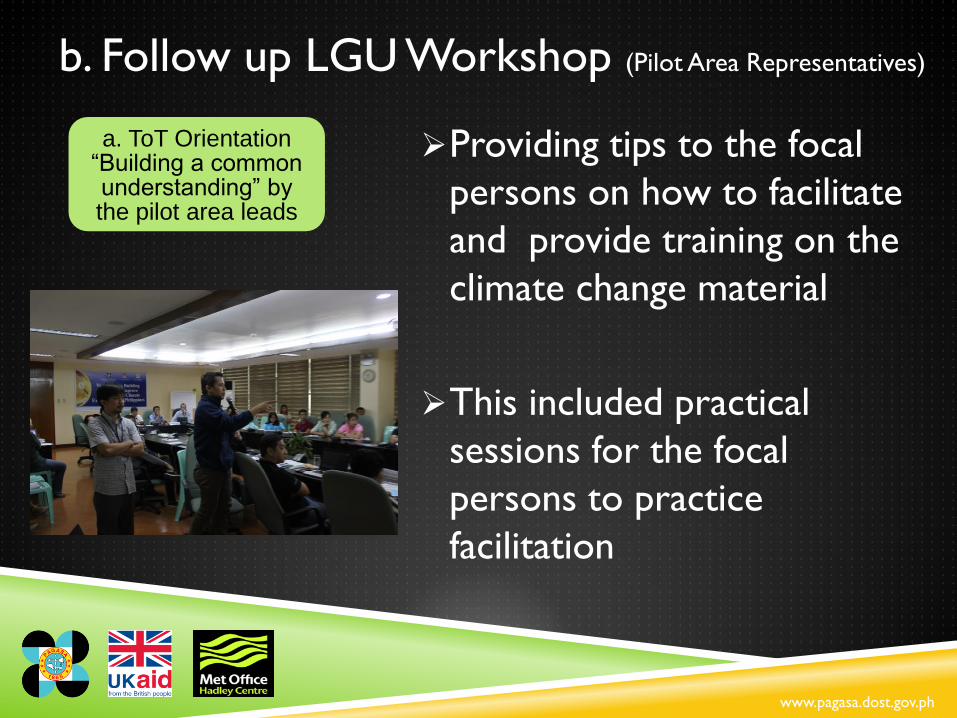
b. Follow up LGU Workshop (Pilot Area Representatives)
Providing tips to the focal
persons on how to facilitate
and provide training on the
climate change material
This included practical
sessions for the focal
persons to practice
facilitation
a. ToT Orientation “Building a common understanding” by the pilot area leads

www.pagasa.dost.gov.ph
b. Follow up LGU Workshop (Pilot Area Representatives)
Trainees again provided
feedback on the training
material to allow us to
improve the training pack
Note that we continued to
mentor and help the trainers
to deliver this training at
subsequent workshops
attended by Barangays
a. ToT Orientation “Building a common understanding” by the pilot area leads

www.pagasa.dost.gov.ph
b. Follow up LGU Workshop (Pilot Area Representatives)
Further review and critique
of PAGASA climate
information which we took
on board for future
workshops
b. Critical Review of PAGASA Information

www.pagasa.dost.gov.ph
b. Follow up LGU Workshop (Pilot Area Representatives)
Issues highlighted difficulties
in understanding climate
projections and uncertainties
associated with multi-model
ensembles of data and how
to apply this form of
information in their day-to-
day planning
b. Critical Review of PAGASA Information

www.pagasa.dost.gov.ph
b. Follow up LGU Workshop (Pilot Area Representatives)
At the GMMA workshop we
developed the Climate Information
Risk Analysis Matrix (CLIRAM) to
help focal leads interpret different
sets of projections (e.g. for
temperature, rainfall)
This was then used in Salcedo and
further enhancements were
suggested
b. Critical Review of PAGASA Information

www.pagasa.dost.gov.ph
b. Follow up LGU Workshop (Pilot Area Representatives)
We reviewed the planning
processes and guidance for
LGUs and listed common
stages across the plans
The focal leads then
highlighted where climate
information can easily be
integrated
c. Review of Planning Processes and available tools and assess where climate information can be integrated

www.pagasa.dost.gov.ph
b. Follow up LGU Workshop (Pilot Area Representatives)
We also reviewed existing tools
e.g. Vulnerability and Adaptation
(V&A) tools from the earlier
GMMA READY project) and
assessed how climate information
could be integrated
Focal leads then developed a
Business Continuity Plans process
to answer the questions “How to
make the livelihoods sector more
resilient to climate change?”
c. Review of Planning Processes and available tools and assess where climate information can be integrated

www.pagasa.dost.gov.ph
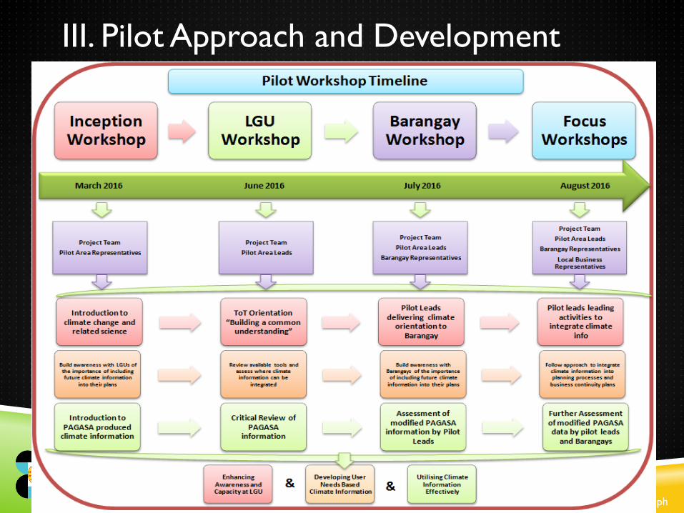
3-Cities ToT

www.pagasa.dost.gov.ph

www.pagasa.dost.gov.ph
Photos (June 2016)

www.pagasa.dost.gov.ph
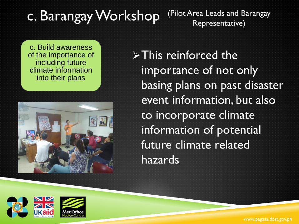
c. Barangay Workshop (Pilot Area Leads and Barangay
Representative)
Focal leads provided the
training directly to Barangay
participants
a. Pilot Leads delivering climate orientation to
Barangay

www.pagasa.dost.gov.ph
c. Barangay Workshop (Pilot Area Leads and Barangay
Representative)
Covered all modules including the
climate science component which
was identified previously as the
most difficult part!
a. Pilot Leads delivering climate orientation to
Barangay

www.pagasa.dost.gov.ph
c. Barangay Workshop (Pilot Area Leads and Barangay
Representative)
PAGASA presented “refined”
climate information based on
recommendations from
earlier workshops
This provided additional
feedback on ease of use and
understanding from Barangay
participants
b. Review and validation of
PAGASA Information

www.pagasa.dost.gov.ph
c. Barangay Workshop (Pilot Area Leads and Barangay
Representative)
Participants also “tested” the
CLIRAM and provided feedback in
order for us to make further
improvements
Noted the expectation was raised
by the Barangay participants that
climate information should be
communicated by those at the
city/municipal level
b. Review and validation of
PAGASA Information

www.pagasa.dost.gov.ph
c. Barangay Workshop (Pilot Area Leads and Barangay
Representative)
The participants looked at
historical events and thought
about how these could
change under different
climate scenarios
c. Build awareness of the importance of
including future climate information
into their plans

www.pagasa.dost.gov.ph
c. Barangay Workshop (Pilot Area Leads and Barangay
Representative)
They also looked at past
status, current and future
“vision” for Barangays and
related this back to the
climate change information
e.g. to inform what actions
would be required to adapt
based on the future climate
information
c. Build awareness of the importance of
including future climate information
into their plans
www.pagasa.dost.gov.ph
c. Barangay Workshop (Pilot Area Leads and Barangay
Representative)
This reinforced the
importance of not only
basing plans on past disaster
event information, but also
to incorporate climate
information of potential
future climate related
hazards
c. Build awareness of the importance of
including future climate information
into their plans

www.pagasa.dost.gov.ph
c. Barangay Workshop (Pilot Area Leads and Barangay
Representative)
Identification of local
businesses of different scales
for participation to the
following Barangay focus
workshop
c. Build awareness of the importance of
including future climate information
into their plans

www.pagasa.dost.gov.ph

www.pagasa.dost.gov.ph
Salcedo Barangay Workshop (July 2016)

www.pagasa.dost.gov.ph
d. Focus Workshops
Pilot Leads leading activities to integrate climate information
Working through sectoral V&A
assessments with representatives
from Barangay
Development of Business
Continuity Plans with small scale
businesses
Used CLIRAM to integrate climate
information into the above sector
analyses

www.pagasa.dost.gov.ph

www.pagasa.dost.gov.ph

www.pagasa.dost.gov.ph
IV. Pilot outcomes and outputs
I. Climate Orientation Pack
II. Co-produced Climate information
III. Climate Information and Risk Analysis Matrix
IV. Guidance to support integrating Climate Information in Local
Planning

www.pagasa.dost.gov.ph
I. Climate orientation pack
Climate Science
Climate Change
Climate Impacts
Available Climate Information from PAGASA
Other Climate Information
Hazards, Exposure, Vulnerability & Risk
Adaptation, Mitigation & Policy Environment
V & A Assessments & Other available tools

www.pagasa.dost.gov.ph
II. Co-produced Climate Information

ISSUE SOLUTION
Technical
Difficult to understand intensity on
temperature plots
Improvements will be made to the
temperature scale
Would be useful to identify amount and
volume of rainfall should be indicated
Will be included in revised plots
Projection plots presented in terms of
model is confusing
To be considered for future projections
Rainfall projections would be more useful
if presented as flood/drought related
information rather than percent changes
Present data in terms of percentiles and
not per model
The table formatted data needs more
detail in terms of values
Explore if adding extra values after decimal
will add value for users / scientifically
robust
Plots are too pixelized and resolution of
maps is too low to ensure information is
relevant to area of interest
Increase the resolution (show maps in a
larger scale) of maps to make it relevant to
the area

ISSUE SOLUTION
Format
Improve colour being used to identify
changes and differences – use different
colours for temperature and rainfall
Work with focal leads to choose a new
colour scheme
Unclear where the relevant locations are
on the plots
Use of administrative boundaries on maps
to clearly visualize the location.
All legends need to be complete Complete in revised version
Language
Explain clearly what all symbols mean, e.g.
Wind vectors
Update new plots with this information
The language used is too complicated
Where this can’t be changed include an
explanation
Do not use acronyms or explain what they
mean
Provide simple description where complex
terms and reduce use of abbreviations

www.pagasa.dost.gov.ph
Picture of old and improved information

www.pagasa.dost.gov.ph
Old and improved information

www.pagasa.dost.gov.ph
IV. Guidance to support integrating Climate
Information in Local Planning

Achievements 1. Provided valuable insights and learning to support the improved
production, communication and uptake of climate information
2. User-needs-based-approach” has greatly improved the understanding
of PAGASA of their end-user needs and increased capacity of LGUs
3. Learning from this process and the products developed will support
wider testing and development in other LGU areas
4. The process has clearly demonstrated how current climate
information can be made “user-friendly” to inform production of
future information by PAGASA
5. Knowledge gained of the links between national and local planning
processes have provided a common framework for integrating climate
information across local plans
6. Exploration of Business Continuity Planning to support resilient
sector specific planning activities provides an opportunity to further
increase outreach to local communities
www.pagasa.dost.gov.ph
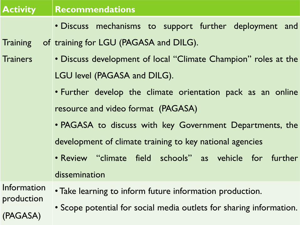
Activity Recommendations
Training of
Trainers
• Discuss mechanisms to support further deployment and
training for LGU (PAGASA and DILG).
• Discuss development of local “Climate Champion” roles at the
LGU level (PAGASA and DILG).
• Further develop the climate orientation pack as an online
resource and video format (PAGASA)
• PAGASA to discuss with key Government Departments, the
development of climate training to key national agencies
• Review “climate field schools” as vehicle for further
dissemination
Information
production
(PAGASA)
• Take learning to inform future information production.
• Scope potential for social media outlets for sharing information.

www.pagasa.dost.gov.ph
LEARNING AND RECOMMENDATIONS DC
TO DO
Put in tables from summary report
Activity Recommendations
Integrating
climate
information in
local planning
• Scope options for further piloting and testing of approach
developed (PAGASA and DILG).
• This should cover prioritised sectors and socio-geographic
regions / areas
Climate
Information and
Risk Analysis
Matrix
(CLIRAM)
• Further develop CLIRAM tool and link to information in
next national climate projections (PAGASA)
• Discuss mandating of V&A tools and linking to CLIRAM tool
(PAGASA, DILG, CCC)
Linking climate
information to
local sector
planning
• Discuss and scope concept of climate smart Business
Continuity Planning with NEDA, DTI and DILG to support
sector planning at the local level.