Embed Size (px)
Citation preview

Pierangelo MASSA & Michele CAMPAGNAUniversity of Cagliari, DICAAR
COST ACTION TD1202ESR EVENT
23 – 24 April 2015 IMREDD - Nice, FRANCE
Mapping and the citizen sensor
COST Action TD1202Mapping and the citizen sensor
Social Media Geographic Information (SMGI): analytical opportunities for spatial planning
Pierangelo Massa and Michele Campagna
University Nice Sophia Antipolis@IMREDD April 23-24 2015
Università di Cagliari

Pierangelo MASSA & Michele CAMPAGNAUniversity of Cagliari, DICAAR
COST ACTION TD1202ESR EVENT
23 – 24 April 2015 IMREDD - Nice, FRANCE
Mapping and the citizen sensor
Contents Introduction
Current practices with SMGI
Analytical opportunities for spatial planning
Our approach for SMGI analytics
Example case studies
Results and further research
Pierangelo MASSA & Michele CAMPAGNAUniversity of Cagliari, DICAAR
COST ACTION TD1202ESR EVENT
23 – 24 April 2015 IMREDD - Nice, FRANCE
Mapping and the citizen sensor
IntroductionUnprecedented availability of digital Geographic Information:
SUPPORT
ANALYSIS, DESIGN
DECISION-MAKING
Authoritative Geographic Information (A-GI)
Volunteered Geographic Information (VGI)
Social Media Geographic Information (SMGI)
Pierangelo MASSA & Michele CAMPAGNAUniversity of Cagliari, DICAAR
COST ACTION TD1202ESR EVENT
23 – 24 April 2015 IMREDD - Nice, FRANCE
Mapping and the citizen sensor
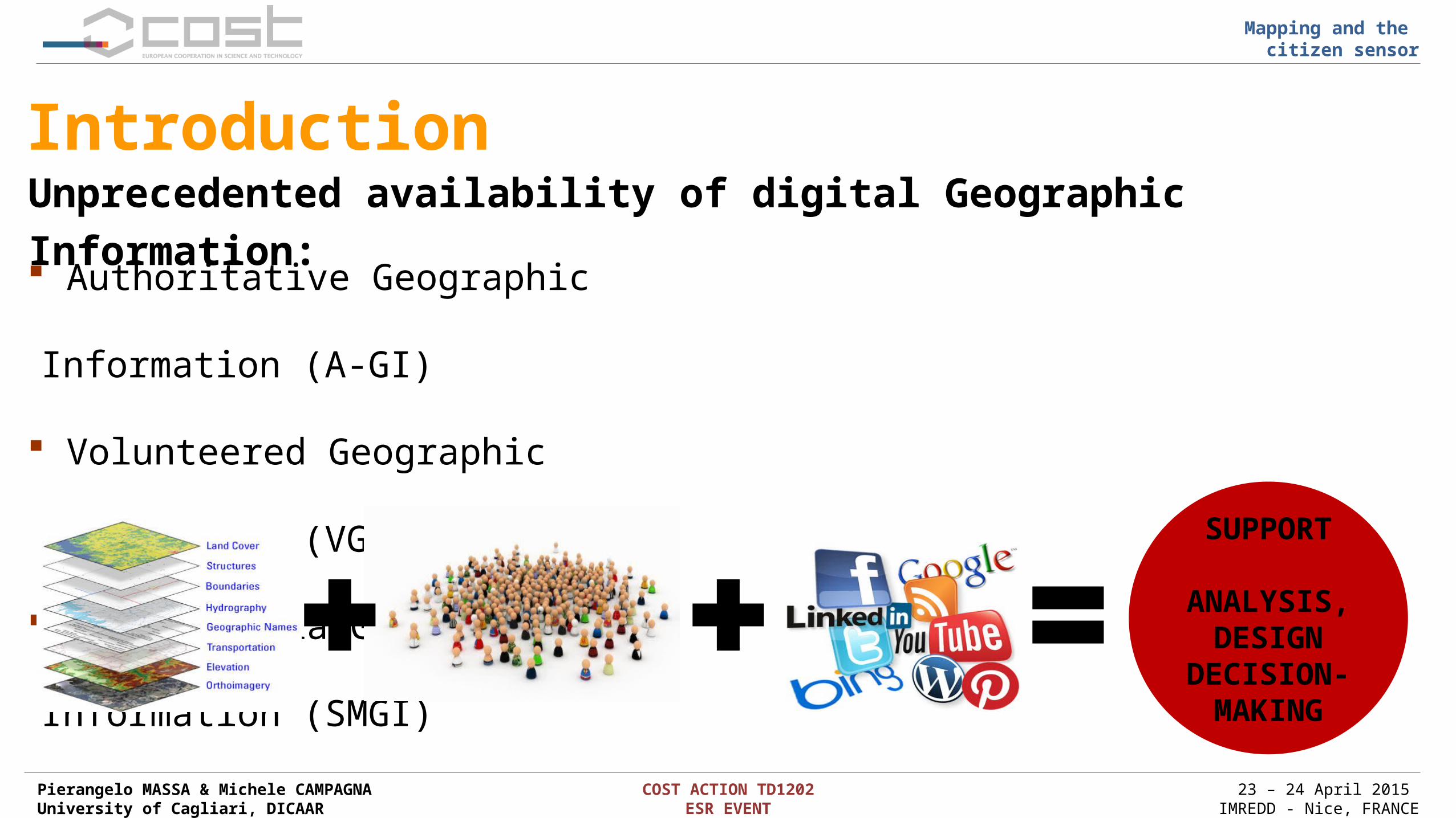
Current practices with SMGI
Disaster management response efforts – situation awareness – real-time analysis
Political events statistical reports – trends analysis
Media events events detection
Social studies sentimental analysis – semantic analysis – behavioral analysis
Urban planning land use investigation – urban movement – geodemographics
SMGI are increasingly used in diverse fields thanks to embedded Geo-information:

Pierangelo MASSA & Michele CAMPAGNAUniversity of Cagliari, DICAAR
COST ACTION TD1202ESR EVENT
23 – 24 April 2015 IMREDD - Nice, FRANCE
Mapping and the citizen sensor
Analytical opportunities for spatial planning Opportunities:
Citizens as volunteered (or un-volunteered) sensors for Geographic Information
Movement, interests, opinions, needs and experiential knowledge of community
Novel analytical frameworks for coupling Space, Time, User and Contents
Issues:Data Harvesting: new tools to collect social information
Data Management: Big Data analytics to manage, integrate and analyze information
Information Reliability: quality and credibility
Pierangelo MASSA & Michele CAMPAGNAUniversity of Cagliari, DICAAR
COST ACTION TD1202ESR EVENT
23 – 24 April 2015 IMREDD - Nice, FRANCE
Mapping and the citizen sensor
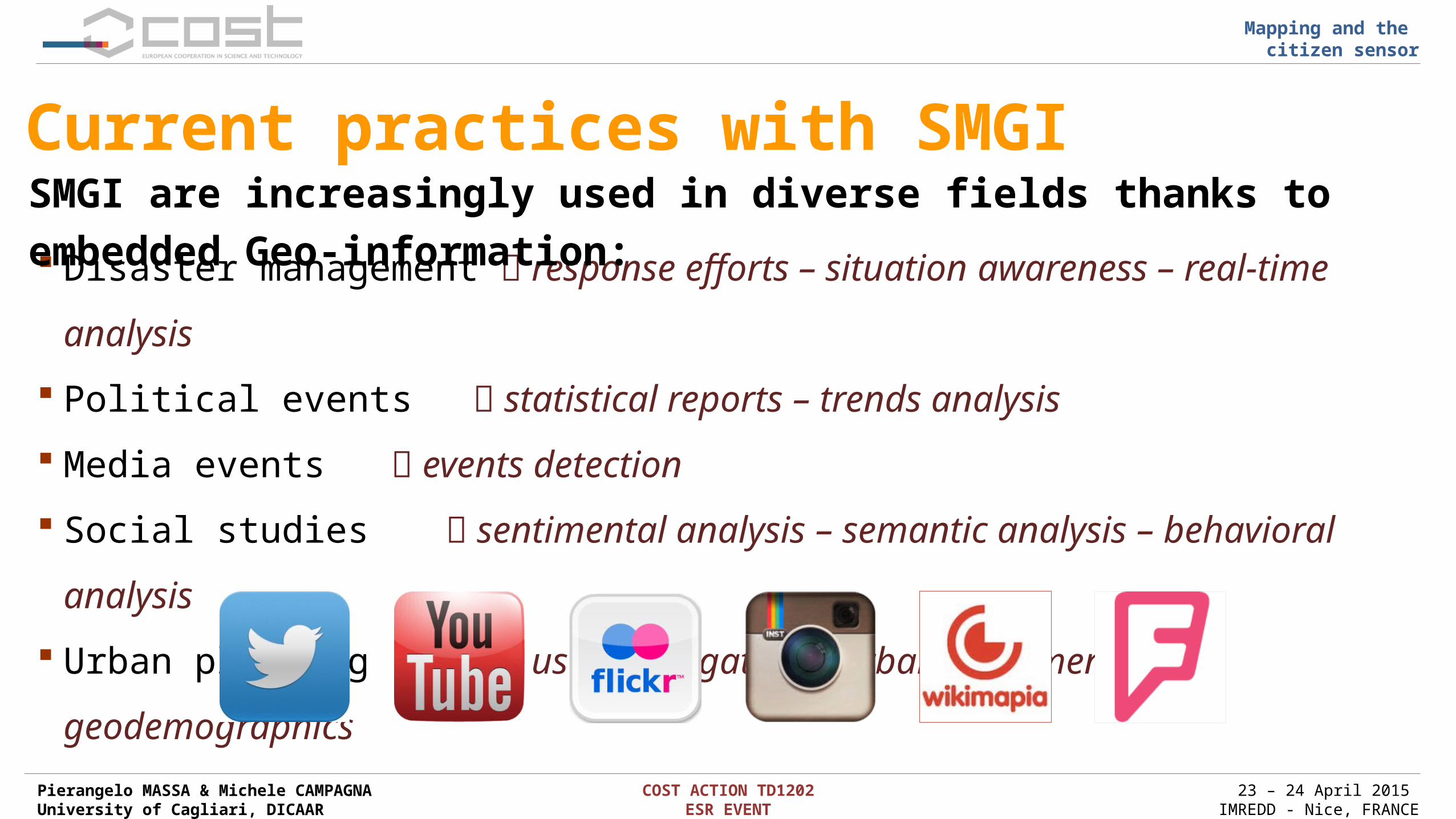
Our approach for SMGI analytics Spatext tool
Add-in for ESRI ArcGIS
Developed in Python 2.7
Connected to 5 social media
Harvest and manage data from social media
Geocode and georeference data
Temporal and Textual analysis
Spatial-User clustering

Pierangelo MASSA & Michele CAMPAGNAUniversity of Cagliari, DICAAR
COST ACTION TD1202ESR EVENT
23 – 24 April 2015 IMREDD - Nice, FRANCE
Mapping and the citizen sensor
Disaster event: the Cyclone Cleopatra Spatial distribution of 399 tweets for keyword “Sardinia floods” Cyclone occurred in Sardinia 18 November 2013

Pierangelo MASSA & Michele CAMPAGNAUniversity of Cagliari, DICAAR
COST ACTION TD1202ESR EVENT
23 – 24 April 2015 IMREDD - Nice, FRANCE
Mapping and the citizen sensor
Disaster event: the Cyclone Cleopatra Temporal analysis: trend and peaks Textual analysis: tag cloud Italy & World
Pierangelo MASSA & Michele CAMPAGNAUniversity of Cagliari, DICAAR
COST ACTION TD1202ESR EVENT
23 – 24 April 2015 IMREDD - Nice, FRANCE
Mapping and the citizen sensor
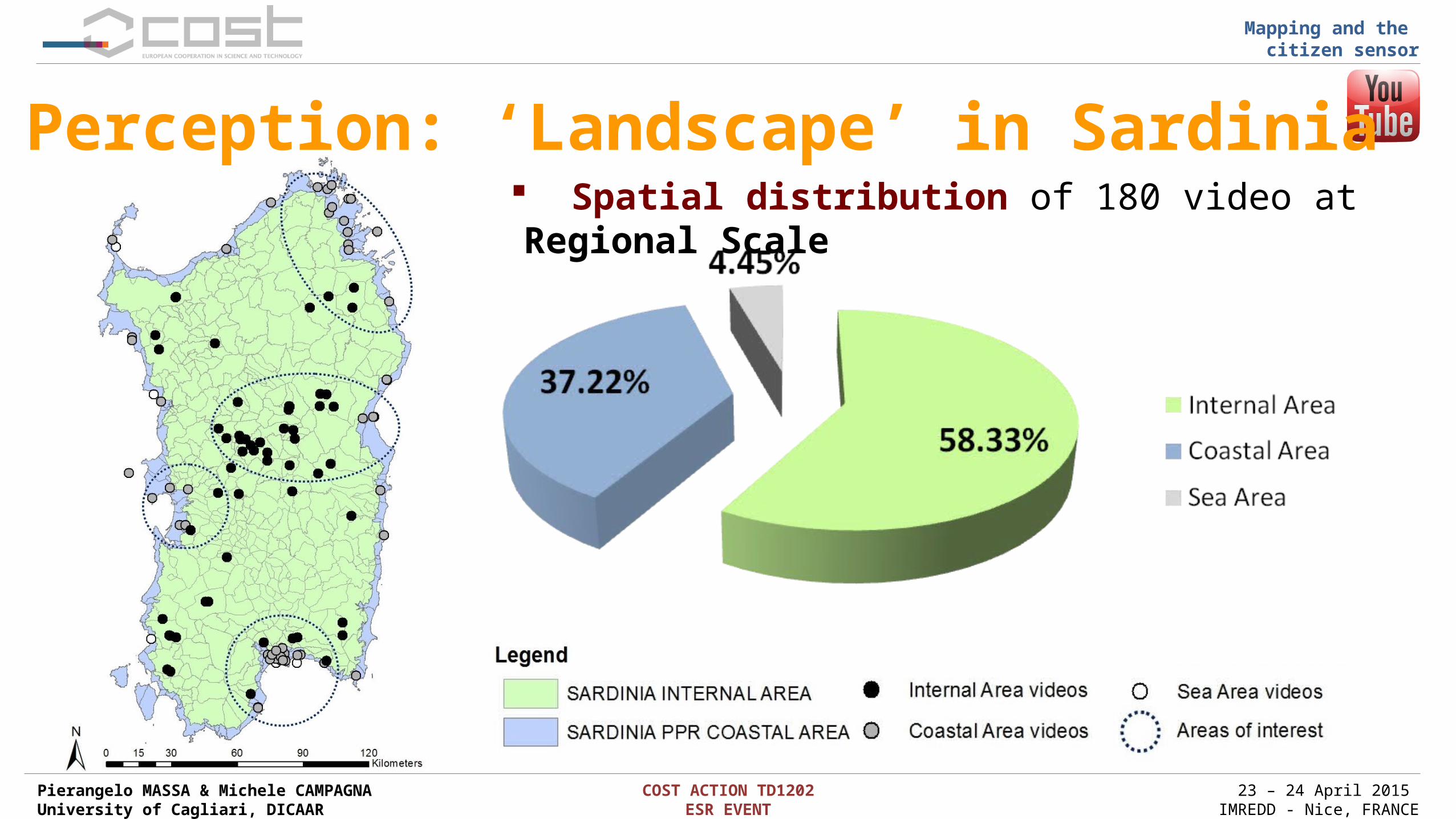
Spatial distribution of 180 video at Regional Scale
Perception: ‘Landscape’ in Sardinia

Pierangelo MASSA & Michele CAMPAGNAUniversity of Cagliari, DICAAR
COST ACTION TD1202ESR EVENT
23 – 24 April 2015 IMREDD - Nice, FRANCE
Mapping and the citizen sensor
Semantic analysis: semantic classification of words in title and caption of video
Tag Cloud analysis:tag-cloud analysis of most used words in title and caption of video
Perception: ‘Landscape’ in Sardinia

Pierangelo MASSA & Michele CAMPAGNAUniversity of Cagliari, DICAAR
COST ACTION TD1202ESR EVENT
23 – 24 April 2015 IMREDD - Nice, FRANCE
Mapping and the citizen sensor
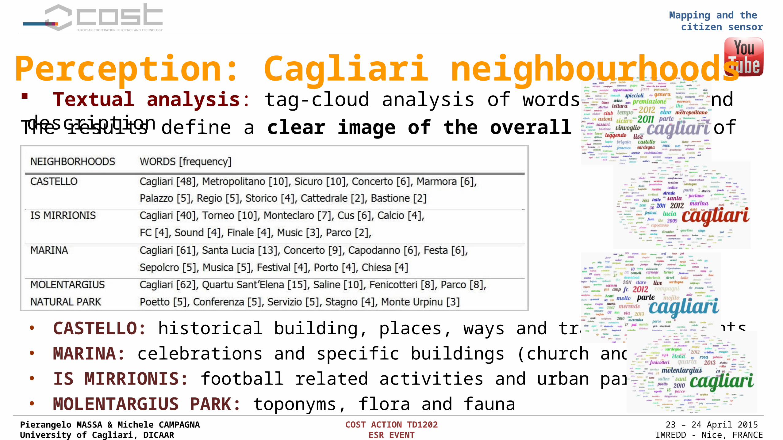
Spatial distribution of 395 video in neighborhoods and park at the local scalePerception: Cagliari neighbourhoods
Pierangelo MASSA & Michele CAMPAGNAUniversity of Cagliari, DICAAR
COST ACTION TD1202ESR EVENT
23 – 24 April 2015 IMREDD - Nice, FRANCE
Mapping and the citizen sensor
The results define a clear image of the overall perception of users:
• CASTELLO: historical building, places, ways and traditional events• MARINA: celebrations and specific buildings (church and harbor)• IS MIRRIONIS: football related activities and urban park• MOLENTARGIUS PARK: toponyms, flora and fauna
Textual analysis: tag-cloud analysis of words in title and descriptionPerception: Cagliari neighbourhoods

Pierangelo MASSA & Michele CAMPAGNAUniversity of Cagliari, DICAAR
COST ACTION TD1202ESR EVENT
23 – 24 April 2015 IMREDD - Nice, FRANCE
Mapping and the citizen sensor
Land use detection: Iglesias municipality
Photo Dataset : metadata
Place
User / UserID / UserPIC
Media URL
Data Publication
n° Likes / Comments
Caption / Tags
Spatial distribution of 13951 photos posted by 1243 users for 1 year Analysis: 89% of photos within established settlements

Pierangelo MASSA & Michele CAMPAGNAUniversity of Cagliari, DICAAR
COST ACTION TD1202ESR EVENT
23 – 24 April 2015 IMREDD - Nice, FRANCE
Mapping and the citizen sensor
Land use detection: temporal analysis Temporal analysis: investigation of patterns
Seasons Months Days
Workdays Weekends

Pierangelo MASSA & Michele CAMPAGNAUniversity of Cagliari, DICAAR
COST ACTION TD1202ESR EVENT
23 – 24 April 2015 IMREDD - Nice, FRANCE
Mapping and the citizen sensor
Land use detection: spatial clustering
Results:
290 clusters
public places
368 clusters
personal places
Spatial analysis: cluster detection using Density-Based scan (Ester et Al, 1996) Detection of popular places for local community and personal places of users
Pierangelo MASSA & Michele CAMPAGNAUniversity of Cagliari, DICAAR
COST ACTION TD1202ESR EVENT
23 – 24 April 2015 IMREDD - Nice, FRANCE
Mapping and the citizen sensor
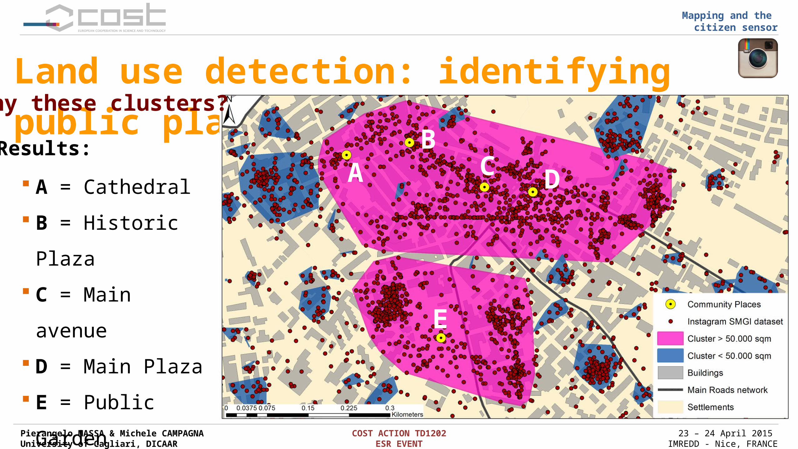
Land use detection: identifying public places
Results: A
BC D
E
A = Cathedral
B = Historic Plaza
C = Main avenue
D = Main Plaza
E = Public Garden
Why these clusters?

Pierangelo MASSA & Michele CAMPAGNAUniversity of Cagliari, DICAAR
COST ACTION TD1202ESR EVENT
23 – 24 April 2015 IMREDD - Nice, FRANCE
Mapping and the citizen sensor
Public places: (A) Cathedral
A A
SMGI related to the Cathedral of Santa Chiara

Pierangelo MASSA & Michele CAMPAGNAUniversity of Cagliari, DICAAR
COST ACTION TD1202ESR EVENT
23 – 24 April 2015 IMREDD - Nice, FRANCE
Mapping and the citizen sensor
Public places: (B) Historic Plaza
B B
SMGI related to the Plaza La Marmora

Pierangelo MASSA & Michele CAMPAGNAUniversity of Cagliari, DICAAR
COST ACTION TD1202ESR EVENT
23 – 24 April 2015 IMREDD - Nice, FRANCE
Mapping and the citizen sensor
Public places: (C) Main Avenue
C C
SMGI related to the Main Avenue Via Matteoti

Pierangelo MASSA & Michele CAMPAGNAUniversity of Cagliari, DICAAR
COST ACTION TD1202ESR EVENT
23 – 24 April 2015 IMREDD - Nice, FRANCE
Mapping and the citizen sensor
Public places: (D) Main Plaza
D D
SMGI related to the Piazza Sella

Pierangelo MASSA & Michele CAMPAGNAUniversity of Cagliari, DICAAR
COST ACTION TD1202ESR EVENT
23 – 24 April 2015 IMREDD - Nice, FRANCE
Mapping and the citizen sensor
Public places: (E) Public Garden
EE
SMGI related to the Giardini Pubblici

Pierangelo MASSA & Michele CAMPAGNAUniversity of Cagliari, DICAAR
COST ACTION TD1202ESR EVENT
23 – 24 April 2015 IMREDD - Nice, FRANCE
Mapping and the citizen sensor
Land use detection: residential areas
Used parameters cluster centroid Yes photo barycenter Yes number of photo => 5 photo/area => 4 Intersections <= 2 photo time dist. => 30
Results: 50 residential clusters
Spatial analysis: how to detect ‘residential areas’ from clusters?

Pierangelo MASSA & Michele CAMPAGNAUniversity of Cagliari, DICAAR
COST ACTION TD1202ESR EVENT
23 – 24 April 2015 IMREDD - Nice, FRANCE
Mapping and the citizen sensor
Land use detection: missing buildings Spatial analysis: how to identify missing buildings in A-GI?
Used parameters cluster centroid No photo barycenter No number of photo => 5 photo/area => 4 Intersections <= 2 photo time dist. => 30
Results: 40 clusters 9 not mapped buildings
A = mapped buildingB = not mapped buildingC = mapped buildingD = not mapped buildingE = mapped buildingF = mapped building

Pierangelo MASSA & Michele CAMPAGNAUniversity of Cagliari, DICAAR
COST ACTION TD1202ESR EVENT
23 – 24 April 2015 IMREDD - Nice, FRANCE
Mapping and the citizen sensor
Results and further development
Integration of further Social Media platforms in Spatext: Flickr, Panoramio, Vkontakte, Booking.com
Implementation of sentiment analysis Formalization of SMGI analytics for practices
Spatext tool for SMGI analytics Integration with standard GIS tools Spatial-Temporal Textual analysis Topics trend, Perceptions and Topography from SMGI Pluralist information with professional knowledge Innovative methods for supporting urban and regional planning

Pierangelo MASSA & Michele CAMPAGNAUniversity of Cagliari, DICAAR
COST ACTION TD1202ESR EVENT
23 – 24 April 2015 IMREDD - Nice, FRANCE
Mapping and the citizen sensor
Thank you for your attention!
Pierangelo MASSA
University of Cagliari
Michele CAMPAGNA
University of Cagliari