Embed Size (px)
Citation preview
01 December 2014 Final Report
Eskay Creek Gold Mine Site (Closed) Tom MacKay Lake Tailings Storage Facility Dam Safety Inspection Report
Photo taken October 2014
DOCUMENT INFORMATION
Author Michael Shelbourn Manager, Geotechnical Engineering – Corporate Technical Services Barrick Gold Corporation
Contact 460 West 50 North, Suite 500 Salt Lake City, Utah 84101 Telephone: (801) 990-3853 Cell: (801) 556-8484 Fax: (801) 990-3830 Email: [email protected]
Date 01 December 2014
Version Final Report
File Path C:\Users\mshelbourn\Downloads\BC TSF Inspections\Eskay Creek\20141008 Tom MacKay Lake DSI report.docx
Revision History
Version Description Author Date
Draft for Site Review
Sent to Eskay Creek Closure Manager for initial review
M. Shelbourn 20 October 2014
Draft for Final Review
Sent to senior management at Barrick Corporate for final review
M. Shelbourn 26 November 2014
Final Report Issued M. Shelbourn 01 December 2014
ESKAY CREEK GOLD MINE (CLOSED)
TOM MACKAY LAKE TAILINGS STORAGE FACILITY DAM SAFETY INSPECTION REPORT
01 December 2014
Tom MacKay Lake DSI report Page i
EXECUTIVE SUMMARY
As requested by the Ministry of Energy and Mines (MEM) of British Columbia, Barrick Gold Corporation (Barrick) has prepared this written report addressing the requirements of the MEM Guidelines for Annual Dam Safety Inspection Reports for the closed Tom MacKay Lake tailings storage facility (TSF) at Barrick’s Eskay Creek Mine site in northwestern British Columbia. This report incorporates background information and site monitoring data provided by Barrick in addition to observations made by the author during an aerial inspection on 01 October 2014.
Currently there are no engineered embankments, barriers or other structures impounding water or mine waste material in the Tom MacKay Lake TSF. Thus, no Dam Classification is possible for the facility in terms of Table 2‐1 of the Canadian Dam Association (CDA) 2013 Dam Safety Guidelines. There is an outflow measurement weir located in the natural outlet channel at the south end of Tom MacKay Lake.
There have been no significant changes in visual monitoring records for the Tom MacKay Lake TSF since the end of mine operations in early 2008. Principally because there are no engineered embankments to monitor, no geotechnical instrumentation installations exist or were ever installed at the site. Likewise, there have been no changes to surface water control in the Tom MacKay Lake TSF.
Part 10 of the British Columbia Mine Health Safety and Reclamation Code (the Code) defines a major impoundment as an impoundment that has a maximum depth of material greater than 10 metres at any point, or a maximum height of retaining dam or dike at any point that exceeds 15 metres, or is a storage facility designed to contain more than one million cubic metres of material or is constructed with dams or dikes that contain more than 50000 cubic metres of fill, or any other impoundment or water management facility so declared by the chief inspector. Understanding that the MEM has declared the Tom MacKay Lake TSF to be a major impoundment, the Code requires that a current Operation, Maintenance and Surveillance (OMS) Manual be available. Given the closed status of the facility, its remote location and the absence of any structure impounding water and/or tailings, an appropriate OMS Plan has been prepared and is provided in Appendix A of this report.
As there is no tailings dam or any other embankment structure at the Tom MacKay Lake TSF and no plausible failure mechanism by which any significant amount of tailings could foreseeably be released from the lacustrine impoundment, no Emergency Preparedness and Response Plan (EPRP) is required for the facility.
Table 5‐1 of the CDA 2013 Dam Safety Guidelines provides a schedule for formal Dam Safety Reviews, depending on the Dam Classification of the subject structure. There are no engineered barriers impounding water and/or mine waste material in the Tom MacKay Lake TSF and thus no structures to inspect.

ESKAY CREEK GOLD MINE (CLOSED)
TOM MACKAY LAKE TAILINGS STORAGE FACILITY DAM SAFETY INSPECTION REPORT
10 December 2014
Tom MacKay Lake DSI report Page iii
Table of Contents
1. Introduction ................................................................................................................................... 1
1.1. MEM Requirements ............................................................................................................. 1
1.2. Eskay Creek Mine History .................................................................................................. 1
1.3. Tom MacKay Lake TSF Status .......................................................................................... 3
2. Summary of Recent Construction ............................................................................................. 4
3. Plan and Representative Cross-Sections ................................................................................ 4
4. Site Photographs ......................................................................................................................... 6
5. Review of Climate Data .............................................................................................................. 6
6. Water Balance Review ................................................................................................................ 7
7. Freeboard and Storage Availability ........................................................................................... 9
8. Water Discharge System ............................................................................................................ 9
9. Seepage Occurrence and Water Quality ............................................................................... 10
10. Surface Water Control and Surface Erosion ..................................................................... 10
11. Instrumentation Review ........................................................................................................ 10
11.1. Phreatic Surfaces and Piezometric Data ................................................................... 10
11.2. Settlement ....................................................................................................................... 10
11.3. Lateral movement .......................................................................................................... 10
12. Report Use and Closure ....................................................................................................... 11
13. References .............................................................................................................................. 12
Appendices
Appendix A Operation, Maintenance and Surveillance Plan
Appendix B Email Correspondence
Appendix C Tom MacKay Lake WRSF Selected Photographs


ESKAY CREEK GOLD MINE (CLOSED)
TOM MACKAY LAKE TAILINGS STORAGE FACILITY DAM SAFETY INSPECTION REPORT
10 December 2014
Tom MacKay Lake DSI report Page 1
1. Introduction
1.1. MEM Requirements
In response to the Mount Polley tailings dam failure of 04 August 2014, the Chief Inspector of Mines of the Ministry of Energy and Mines (MEM) of British Columbia ordered on 18 August 2014 all mining companies to conduct a Dam Safety Inspection and an Independent Third-Party Review of the Dam Safety Inspection for every tailings storage facility (TSF), whether active or closed, at permitted mines in British Columbia by 01 December 2014. Under the Chief Inspector’s Order (the Order), a third-party review of the stated Dam Classification, as determined from the Canadian Dam Association (CDA) 2013 Dam Safety Guidelines, must be completed and a TSF assigned a High, Very High or Extreme Classification must have a current Emergency Preparedness and Response Plan (EPRP) available, including a dam break inundation study. The MEM has stated that all information obtained under the Order will be provided to First Nations in British Columbia and made public.
Barrick Gold Corporation (Barrick) currently manages its closed Eskay Creek Mine, located in northwestern British Columbia. During the mine’s operation, and under regulatory authorization, waste rock and tailings were permanently stored and remain submerged in two natural, non-fish bearing lakes, Albino Lake and [Big] Tom MacKay Lake. There are no tailings dams, engineered embankments, barriers or other structures retaining water or mine waste materials at either lacustrine impoundment.
Barrick requested of the MEM that the closed lacustrine waste rock and tailings storage facilities at the Eskay Creek Mine site be excluded from the Order, on the basis that there were no dams associated with either storage facility and no plausible geotechnical failure mechanism by which waste rock or tailings could be released. In an email response dated 22 September 2014, the MEM agreed that it would accept a written report from Barrick addressing each of the line items in the August 2013 MEM Guidelines for Annual Dam Safety Inspection Reports in lieu of the Dam Safety Inspection and an Independent Third-Party Review of the Dam Safety Inspection. A copy of the printed email correspondence is provided in Appendix B. An MEM representative confirmed in a subsequent telephone conversation requested that a separate written report was required for each lacustrine impoundment at Eskay Creek Mine.
This document addresses the requirements of the August 2013 MEM Guidelines for Annual Dam Safety Inspection Reports for the closed Tom MacKay Lake TSF at the Eskay Creek Mine site. A companion report has been prepared and submitted under separate cover for the closed Albino Lake impoundment.
1.2. Eskay Creek Mine History
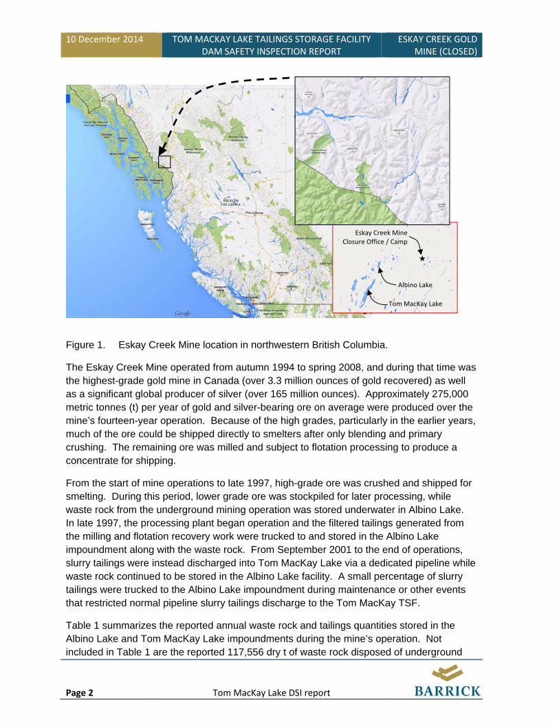
The Eskay Creek Mine site is located approximately 80 km northwest Stewart, a district municipality situated at the head of the Portland Canal in north-coastal British Columbia, and about 300 km southeast of Juneau, Alaska (Figure 1).
10 December 2014 TOM MACKAY LAKE TAILINGS STORAGE FACILITY DAM SAFETY INSPECTION REPORT
ESKAY CREEK GOLD MINE (CLOSED)
Page 2 Tom MacKay Lake DSI report
Figure 1. Eskay Creek Mine location in northwestern British Columbia.
The Eskay Creek Mine operated from autumn 1994 to spring 2008, and during that time was the highest-grade gold mine in Canada (over 3.3 million ounces of gold recovered) as well as a significant global producer of silver (over 165 million ounces). Approximately 275,000 metric tonnes (t) per year of gold and silver-bearing ore on average were produced over the mine’s fourteen-year operation. Because of the high grades, particularly in the earlier years, much of the ore could be shipped directly to smelters after only blending and primary crushing. The remaining ore was milled and subject to flotation processing to produce a concentrate for shipping.
From the start of mine operations to late 1997, high-grade ore was crushed and shipped for smelting. During this period, lower grade ore was stockpiled for later processing, while waste rock from the underground mining operation was stored underwater in Albino Lake. In late 1997, the processing plant began operation and the filtered tailings generated from the milling and flotation recovery work were trucked to and stored in the Albino Lake impoundment along with the waste rock. From September 2001 to the end of operations, slurry tailings were instead discharged into Tom MacKay Lake via a dedicated pipeline while waste rock continued to be stored in the Albino Lake facility. A small percentage of slurry tailings were trucked to the Albino Lake impoundment during maintenance or other events that restricted normal pipeline slurry tailings discharge to the Tom MacKay TSF.
Table 1 summarizes the reported annual waste rock and tailings quantities stored in the Albino Lake and Tom MacKay Lake impoundments during the mine’s operation. Not included in Table 1 are the reported 117,556 dry t of waste rock disposed of underground
Tom MacKay Lake
Albino Lake
Eskay Creek MineClosure Office / Camp

ESKAY CREEK GOLD MINE (CLOSED)
TOM MACKAY LAKE TAILINGS STORAGE FACILITY DAM SAFETY INSPECTION REPORT
10 December 2014
Tom MacKay Lake DSI report Page 3
and used to backfill portals during the mine’s operating life, nor the 7,426 dry t of waste rock relocated from the ore storage and transfer facility in Kitwanga, British Columbia to the Albino Lake impoundment in 2009 as part of initial mine closure activities.
Table 1. Reported Annual Waste Rock and Tailings Quantities Stored
Albino Lake Tom MacKay Lake
Year Waste Rock
(dry t) Tailings (dry t)
Waste Rock (dry t)
Tailings (dry t)
1994 49,035 0 0 0 1995 153,720 0 0 0 1996 44,835 0 0 0 1997 90,460 4,683 0 0 1998 67,410 39,526 0 0 1999 72,870 58,671 0 0 2000 72,000 72,203 0 0 2001 117,000 55,235 0 24,309 2002 137,000 250 0 95,453 2003 134,000 4,410 0 93,815 2004 184,000 4,158 0 88,239 2005 175,000 4,000 0 86,147 2006 153,760 8,536 0 82,768 2007 34,719 5,748 0 91,782 2008 0 0 0 21,944 Total 1,485,809 257,420 0 584,457
As indicated in Table 1, a reported 584,457 dry t of tailings were placed in the Tom MacKay Lake TSF over its eight-year operating period. Assuming an overall bulk density of around 1.4 t/m3, approximately 420,000 m3 of submerged tailings are contained in the facility.
Lacustrine waste rock and tailings placement at the Eskay Creek Mine provided a secure methodology for permanent, submerged storage of the potentially acid generating mine waste materials. The high-alpine, natural lakes and streams in the Tom MacKay watershed, including Albino Lake and Tom MacKay Lake, are oligotrophic (naturally low in plant nutrients) and barren of fish due to an impassible waterfall as well as stream velocity barriers to some 10 km downstream of the Eskay Creek Mine site (McGurk et al., 2006).
1.3. Tom MacKay Lake TSF Status
The now closed Tom MacKay TSF is situated approximately 10 km southwest of the Eskay Creek Mine closure office and camp site (refer to Figure 1). Big Tom MacKay Lake (herein referred to as Tom MacKay Lake, consistent with most other documents) is approximately 3,400 m long and 300 m wide with its long axis orientated southwest-northeast. For reference, Little Tom MacKay Lake (which remains in its natural, undisturbed state) is located approximately 1.5 km northwest of Tom MacKay Lake.
10 December 2014 TOM MACKAY LAKE TAILINGS STORAGE FACILITY DAM SAFETY INSPECTION REPORT
ESKAY CREEK GOLD MINE (CLOSED)
Page 4 Tom MacKay Lake DSI report
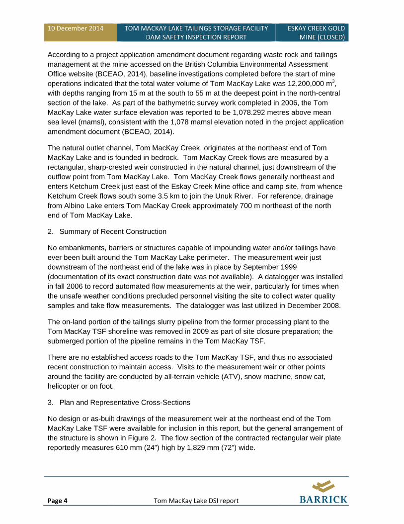
According to a project application amendment document regarding waste rock and tailings management at the mine accessed on the British Columbia Environmental Assessment Office website (BCEAO, 2014), baseline investigations completed before the start of mine operations indicated that the total water volume of Tom MacKay Lake was 12,200,000 m3, with depths ranging from 15 m at the south to 55 m at the deepest point in the north-central section of the lake. As part of the bathymetric survey work completed in 2006, the Tom MacKay Lake water surface elevation was reported to be 1,078.292 metres above mean sea level (mamsl), consistent with the 1,078 mamsl elevation noted in the project application amendment document (BCEAO, 2014).
The natural outlet channel, Tom MacKay Creek, originates at the northeast end of Tom MacKay Lake and is founded in bedrock. Tom MacKay Creek flows are measured by a rectangular, sharp-crested weir constructed in the natural channel, just downstream of the outflow point from Tom MacKay Lake. Tom MacKay Creek flows generally northeast and enters Ketchum Creek just east of the Eskay Creek Mine office and camp site, from whence Ketchum Creek flows south some 3.5 km to join the Unuk River. For reference, drainage from Albino Lake enters Tom MacKay Creek approximately 700 m northeast of the north end of Tom MacKay Lake.
2. Summary of Recent Construction
No embankments, barriers or structures capable of impounding water and/or tailings have ever been built around the Tom MacKay Lake perimeter. The measurement weir just downstream of the northeast end of the lake was in place by September 1999 (documentation of its exact construction date was not available). A datalogger was installed in fall 2006 to record automated flow measurements at the weir, particularly for times when the unsafe weather conditions precluded personnel visiting the site to collect water quality samples and take flow measurements. The datalogger was last utilized in December 2008.
The on-land portion of the tailings slurry pipeline from the former processing plant to the Tom MacKay TSF shoreline was removed in 2009 as part of site closure preparation; the submerged portion of the pipeline remains in the Tom MacKay TSF.
There are no established access roads to the Tom MacKay TSF, and thus no associated recent construction to maintain access. Visits to the measurement weir or other points around the facility are conducted by all-terrain vehicle (ATV), snow machine, snow cat, helicopter or on foot.
3. Plan and Representative Cross-Sections
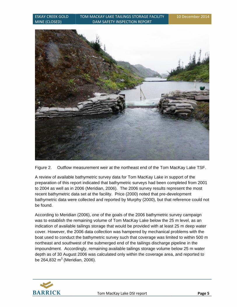
No design or as-built drawings of the measurement weir at the northeast end of the Tom MacKay Lake TSF were available for inclusion in this report, but the general arrangement of the structure is shown in Figure 2. The flow section of the contracted rectangular weir plate reportedly measures 610 mm (24”) high by 1,829 mm (72”) wide.
ESKAY CREEK GOLD MINE (CLOSED)
TOM MACKAY LAKE TAILINGS STORAGE FACILITY DAM SAFETY INSPECTION REPORT
10 December 2014
Tom MacKay Lake DSI report Page 5
Figure 2. Outflow measurement weir at the northeast end of the Tom MacKay Lake TSF.
A review of available bathymetric survey data for Tom MacKay Lake in support of the preparation of this report indicated that bathymetric surveys had been completed from 2001 to 2004 as well as in 2006 (Meridian, 2006). The 2006 survey results represent the most recent bathymetric data set at the facility. Price (2000) noted that pre-development bathymetric data were collected and reported by Murphy (2000), but that reference could not be found.
According to Meridian (2006), one of the goals of the 2006 bathymetric survey campaign was to establish the remaining volume of Tom MacKay Lake below the 25 m level, as an indication of available tailings storage that would be provided with at least 25 m deep water cover. However, the 2006 data collection was hampered by mechanical problems with the boat used to conduct the bathymetric survey such that coverage was limited to within 500 m northeast and southwest of the submerged end of the tailings discharge pipeline in the impoundment. Accordingly, remaining available tailings storage volume below 25 m water depth as of 30 August 2006 was calculated only within the coverage area, and reported to be 264,832 m3 (Meridian, 2006).
10 December 2014 TOM MACKAY LAKE TAILINGS STORAGE FACILITY DAM SAFETY INSPECTION REPORT
ESKAY CREEK GOLD MINE (CLOSED)
Page 6 Tom MacKay Lake DSI report
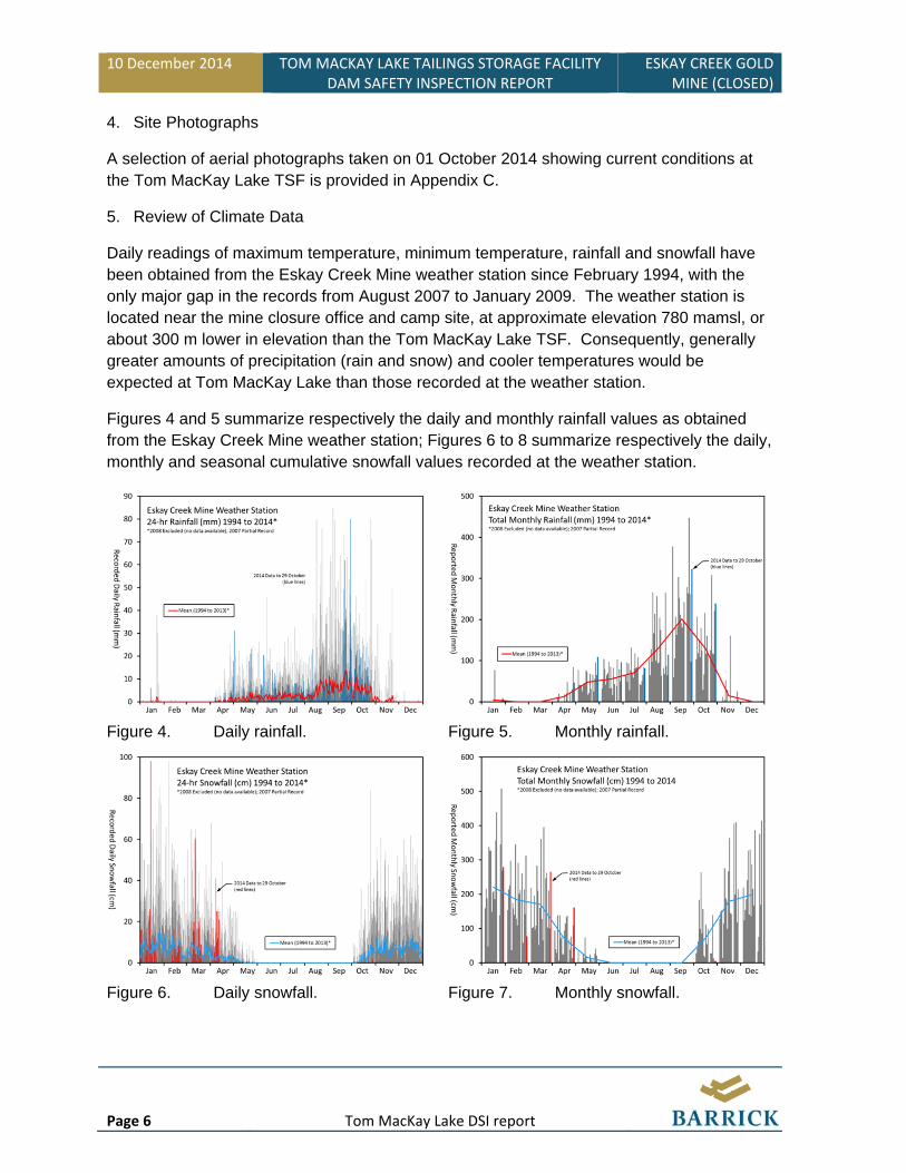
4. Site Photographs
A selection of aerial photographs taken on 01 October 2014 showing current conditions at the Tom MacKay Lake TSF is provided in Appendix C.
5. Review of Climate Data
Daily readings of maximum temperature, minimum temperature, rainfall and snowfall have been obtained from the Eskay Creek Mine weather station since February 1994, with the only major gap in the records from August 2007 to January 2009. The weather station is located near the mine closure office and camp site, at approximate elevation 780 mamsl, or about 300 m lower in elevation than the Tom MacKay Lake TSF. Consequently, generally greater amounts of precipitation (rain and snow) and cooler temperatures would be expected at Tom MacKay Lake than those recorded at the weather station.
Figures 4 and 5 summarize respectively the daily and monthly rainfall values as obtained from the Eskay Creek Mine weather station; Figures 6 to 8 summarize respectively the daily, monthly and seasonal cumulative snowfall values recorded at the weather station.
Figure 4. Daily rainfall. Figure 5. Monthly rainfall.
Figure 6. Daily snowfall. Figure 7. Monthly snowfall.
ESKAY CREEK GOLD MINE (CLOSED)
TOM MACKAY LAKE TAILINGS STORAGE FACILITY DAM SAFETY INSPECTION REPORT
10 December 2014
Tom MacKay Lake DSI report Page 7
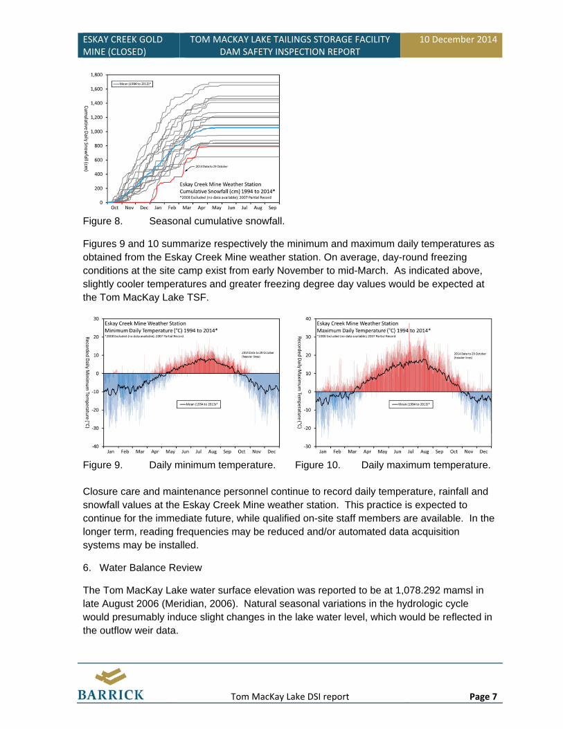
Figure 8. Seasonal cumulative snowfall.
Figures 9 and 10 summarize respectively the minimum and maximum daily temperatures as obtained from the Eskay Creek Mine weather station. On average, day-round freezing conditions at the site camp exist from early November to mid-March. As indicated above, slightly cooler temperatures and greater freezing degree day values would be expected at the Tom MacKay Lake TSF.
Figure 9. Daily minimum temperature. Figure 10. Daily maximum temperature.
Closure care and maintenance personnel continue to record daily temperature, rainfall and snowfall values at the Eskay Creek Mine weather station. This practice is expected to continue for the immediate future, while qualified on-site staff members are available. In the longer term, reading frequencies may be reduced and/or automated data acquisition systems may be installed.
6. Water Balance Review
The Tom MacKay Lake water surface elevation was reported to be at 1,078.292 mamsl in late August 2006 (Meridian, 2006). Natural seasonal variations in the hydrologic cycle would presumably induce slight changes in the lake water level, which would be reflected in the outflow weir data.
10 December 2014 TOM MACKAY LAKE TAILINGS STORAGE FACILITY DAM SAFETY INSPECTION REPORT
ESKAY CREEK GOLD MINE (CLOSED)
Page 8 Tom MacKay Lake DSI report
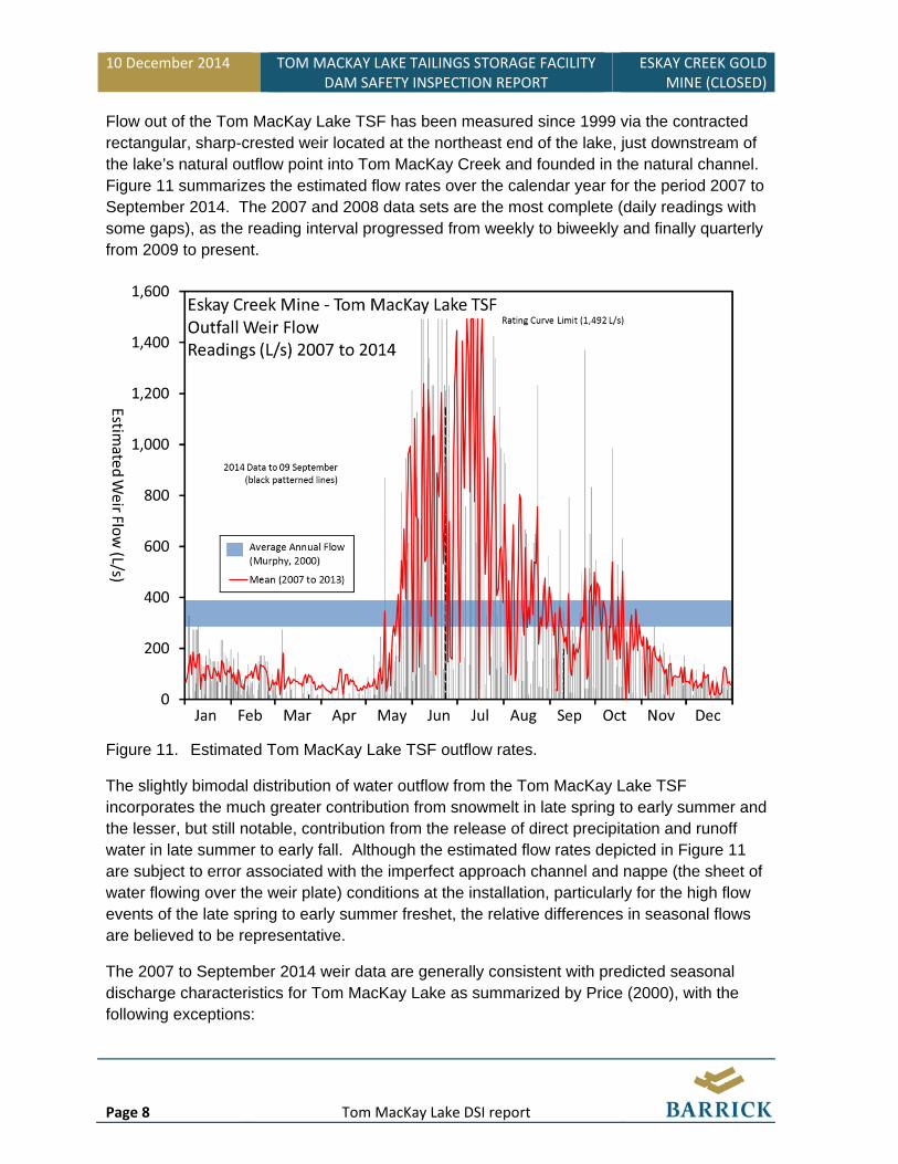
Flow out of the Tom MacKay Lake TSF has been measured since 1999 via the contracted rectangular, sharp-crested weir located at the northeast end of the lake, just downstream of the lake’s natural outflow point into Tom MacKay Creek and founded in the natural channel. Figure 11 summarizes the estimated flow rates over the calendar year for the period 2007 to September 2014. The 2007 and 2008 data sets are the most complete (daily readings with some gaps), as the reading interval progressed from weekly to biweekly and finally quarterly from 2009 to present.
Figure 11. Estimated Tom MacKay Lake TSF outflow rates.
The slightly bimodal distribution of water outflow from the Tom MacKay Lake TSF incorporates the much greater contribution from snowmelt in late spring to early summer and the lesser, but still notable, contribution from the release of direct precipitation and runoff water in late summer to early fall. Although the estimated flow rates depicted in Figure 11 are subject to error associated with the imperfect approach channel and nappe (the sheet of water flowing over the weir plate) conditions at the installation, particularly for the high flow events of the late spring to early summer freshet, the relative differences in seasonal flows are believed to be representative.
The 2007 to September 2014 weir data are generally consistent with predicted seasonal discharge characteristics for Tom MacKay Lake as summarized by Price (2000), with the following exceptions:

ESKAY CREEK GOLD MINE (CLOSED)
TOM MACKAY LAKE TAILINGS STORAGE FACILITY DAM SAFETY INSPECTION REPORT
10 December 2014
Tom MacKay Lake DSI report Page 9
the greatest freshet flows appear to occur in July rather than June; and August seems to be a moderate, rather than low, flow month.
As well, the estimated average annual flow rate for the Tom MacKay Lake watershed (Murphy, 2000 as cited by Price, 2000) as shown in Figure 11 appears to be consistent with the measured values.
Barrick intends to continue collecting weir flow readings four times per year while qualified on-site staff members are available. In the longer term, reading frequencies may be reduced and/or automated data acquisition systems may installed.
7. Freeboard and Storage Availability
As described above, calculations from the most recent (August 2006) bathymetric survey data for the Tom MacKay Lake TSF indicated an available tailings storage volume of 264,832 m3 below 25 m water depth around the submerged tailings discharge point. Approximately 141,300 t of tailings were stored in the facility from September 2006 to the end of mine operations in early 2008. At an assumed overall bulk density of 1.4 t/m3, the post-August 2006 additional settled tailings volume in the central discharge area would be approximately 100,900 m3, well within the indicated available volume to ensure a 25 m water cover depth post-closure.
With respect to the nominal lake level of around 1,078 mamsl, the reported, estimated pre-development total water volume of 12,200,000 m3 (BCEAO, 2014) and the approximately 420,000 m3 of submerged tailings contained in the facility, there remains about 11,780,000 m3 of reservoir (i.e. impoundment) capacity.
8. Water Discharge System
The water discharge system for the Tom MacKay Lake TSF is the natural outlet channel located at the northeast end of the lake. There have not been any problems reported with the lake outlet since operation and closure of the facility, and none were observed at a distance during the aerial inspection of 01 October 2014.
During operation of the Tom MacKay Lake TSF, a float boom was established across the natural outlet channel at the northeast end of the facility, just upstream of the measurement weir. Geotextile filter cloth was suspended from the floats to assist with reducing the release of any suspended sediments via the natural outlet channel, during active tailings discharge into the lake. The current condition of the filter cloth originally suspended from the float boom is not known.
With no more active tailings disposal or any post-closure activity that would otherwise generate significant quantities of suspended sediments, the float boom no longer serves the purpose for which it was designed. Barrick intends to remove the boom, subject to obtaining any necessary approval from the regulatory agencies.

10 December 2014 TOM MACKAY LAKE TAILINGS STORAGE FACILITY DAM SAFETY INSPECTION REPORT
ESKAY CREEK GOLD MINE (CLOSED)
Page 10 Tom MacKay Lake DSI report
9. Seepage Occurrence and Water Quality
No groundwater studies or monitoring were conducted to characterize seepage occurrences through the native soil and bedrock basin of the Tom MacKay Lake TSF. Outflow water quality from the impoundment was monitored during Eskay Creek Mine operation and continues to be monitored via visual observations and samples collected for laboratory testing four times per year as part of post-closure obligations. Barrick does not know of any current water quality compliance issues associated with the Tom MacKay Lake TSF. The water quality monitoring program will continue at its present schedule of four times per year as required to meet existing regulatory requirements.
10. Surface Water Control and Surface Erosion
The water level in the Tom MacKay Lake TSF is controlled by natural hydrologic processes, and as was the case during operation, there is no requirement for surface water control channels anywhere at the facility.
No measurement of, or modification to, natural surface erosion processes has occurred within the Tom MacKay Lake watershed. The deep, permanent water cover over the tailings stored within the facility precludes any erosion of those materials.
11. Instrumentation Review
There is no geotechnical instrumentation installed at the Tom MacKay Lake TSF. As indicated above, programs are established for recording mine site climate data, measuring downstream weir flow and monitoring lake water quality.
11.1. Phreatic Surfaces and Piezometric Data
There are no piezometric data available, nor inferences of phreatic surfaces in the natural soils and bedrock in the Tom MacKay Lake TSF area.
11.2. Settlement
There are no constructed embankments for which settlement could be measured. Inferences of progressive consolidation processes within the tailings stored in the facility could be derived with some difficulty from successive, future bathymetric surveys of the Tom MacKay Lake WRSF, but the need to conduct such work would be not be warranted given the satisfactory post-closure performance of the facility to date.
11.3. Lateral movement
There are no constructed embankments for which lateral movement could be measured.

10 December 2014 TOM MACKAY LAKE TAILINGS STORAGE FACILITY DAM SAFETY INSPECTION REPORT
ESKAY CREEK GOLD MINE (CLOSED)
Page 12 Tom MacKay Lake DSI report
13. References
British Columbia Environmental Assessment Office, 2014. Tom MacKay Lake Waste Rock & Tailings Project Application for a Project Approval Certificate, accessed 22 October 2014, http://a100.gov.bc.ca/appsdata/epic/documents/p68/1036786535877_07505034ba634131a16a95a13b071ccc.pdf.
McGurk, M., Landry, F. and MacGillivray, R., 2006. Eskay Creek Mine environmental effects monitoring program and its implications for closure planning. British Columbia Technical and Research Committee on Reclamation, Proceedings of the Thirtieth Annual British Columbia Mine Reclamation Symposium, Smithers, British Columbia, 19-22 June 2006. Bitech Publishers Ltd, 2006.
Meridan Mapping Ltd., 2006. Albino Lake and Tom MacKay Lake Bathymetric Surveys, Waste Surveys & Volume Calculations: August 2006. Barrick Gold Corporation, Eskay Creek Mine, British Columbia, Canada.
Price, W., 2000. Draft BC MEM ML/ARD Review of the Proposal to Dispose of Mine Wastes in Tom MacKay Lake. 14 June 2000.

ESKAY CREEK GOLD MINE (CLOSED)
TOM MACKAY LAKE TAILINGS STORAGE FACILITY DAM SAFETY INSPECTION REPORT
10 December 2014
Tom MacKay Lake DSI report A‐1
Appendix A
Operation, Maintenance and Surveillance Plan

Page 1 of 3
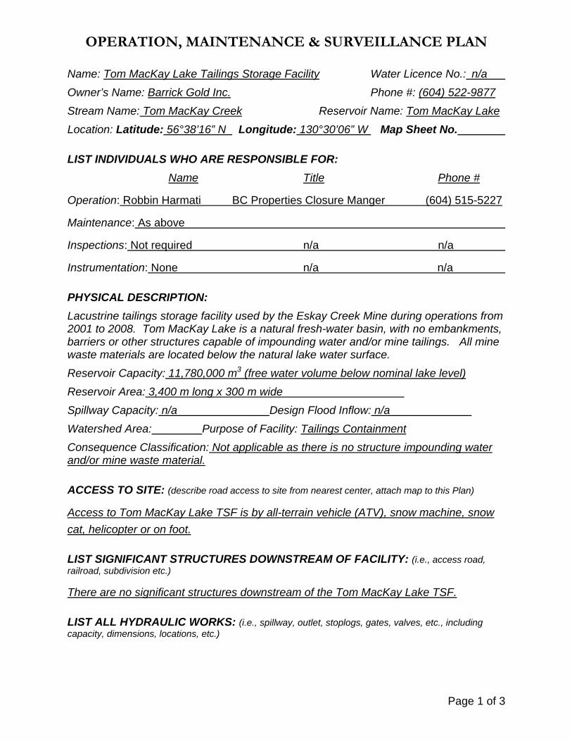
OPERATION, MAINTENANCE & SURVEILLANCE PLAN
Name: Tom MacKay Lake Tailings Storage Facility Water Licence No.: n/a
Owner’s Name: Barrick Gold Inc. Phone #: (604) 522-9877
Stream Name: Tom MacKay Creek Reservoir Name: Tom MacKay Lake
Location: Latitude: 56°38’16” N Longitude: 130°30’06” W Map Sheet No.
LIST INDIVIDUALS WHO ARE RESPONSIBLE FOR:
Name Title Phone #
Operation: Robbin Harmati BC Properties Closure Manger (604) 515-5227
Maintenance: As above
Inspections: Not required n/a n/a
Instrumentation: None n/a n/a
PHYSICAL DESCRIPTION:
Lacustrine tailings storage facility used by the Eskay Creek Mine during operations from 2001 to 2008. Tom MacKay Lake is a natural fresh-water basin, with no embankments, barriers or other structures capable of impounding water and/or mine tailings. All mine waste materials are located below the natural lake water surface.
Reservoir Capacity: 11,780,000 m3 (free water volume below nominal lake level)
Reservoir Area: 3,400 m long x 300 m wide
Spillway Capacity: n/a Design Flood Inflow: n/a
Watershed Area: Purpose of Facility: Tailings Containment
Consequence Classification: Not applicable as there is no structure impounding water and/or mine waste material.
ACCESS TO SITE: (describe road access to site from nearest center, attach map to this Plan)
Access to Tom MacKay Lake TSF is by all-terrain vehicle (ATV), snow machine, snow
cat, helicopter or on foot.
LIST SIGNIFICANT STRUCTURES DOWNSTREAM OF FACILITY: (i.e., access road, railroad, subdivision etc.)
There are no significant structures downstream of the Tom MacKay Lake TSF.
LIST ALL HYDRAULIC WORKS: (i.e., spillway, outlet, stoplogs, gates, valves, etc., including capacity, dimensions, locations, etc.)

Page 2 of 3
A float boom used during operation to suspend filter fabric for sediment transport control
remains in the northeastern end of the lake; the boom is no longer required for sediment
control and was/is not required for debris control.
A rectangular, sharp-crested weir located approximately 100 m downstream of the
northeastern end of Tom MacKay Lake is used to measure outflow.
LIST PROCEDURES FOR RESERVOIR OPERATION: (i.e., how reservoir level is controlled? what is the anticipated reservoir level for any given time of year? when are the drawdown and filling periods? what are the operation procedures during floods?)
There is no artificial control on the natural water level in Tom MacKay Lake. The lake’s
water level is set by natural inflow (precipitation and runoff) of the watershed.
LIST ALL ITEMS REQUIRING ROUTINE MAINTENANCE: (include type of maintenance to be performed, scheduling of maintenance, record keeping, etc.)
Visual inspection of the inactive datalogger shack, the float boom and the sharp-crested
weir. Maintenance of these items will be scheduled and completed as required, and a
report of pre and post-maintenance conditions and work completed will be documented
in a designated archive.
LIST ALL INSTRUMENTATION, FREQUENCY OF MONITORING, AND METHOD OF RECORD KEEPING: (i.e., seepage measurement weir, reservoir level gauge, piezometers, etc.)
Water quality samples and flow measurements from the weir downstream of the Tom
MacKay Lake TSF are collected four times per year. There is no other instrumentation
at the site.
LIST OF EQUIPMENT TO BE PERIODICALLY TEST OPERATED: (i.e., gates, valves, hoists, etc., including frequency of test operation)
There is no equipment requiring test operation.
Page 3 of 3
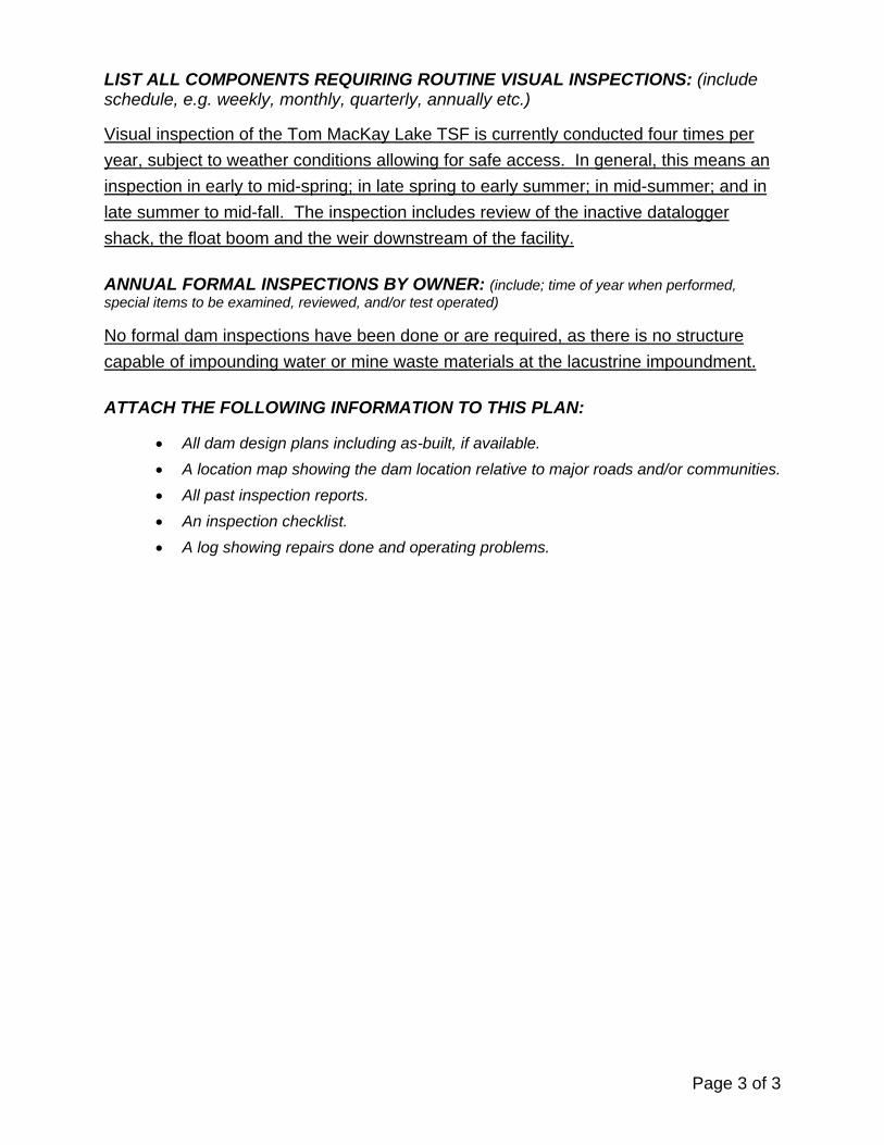
LIST ALL COMPONENTS REQUIRING ROUTINE VISUAL INSPECTIONS: (include schedule, e.g. weekly, monthly, quarterly, annually etc.)
Visual inspection of the Tom MacKay Lake TSF is currently conducted four times per
year, subject to weather conditions allowing for safe access. In general, this means an
inspection in early to mid-spring; in late spring to early summer; in mid-summer; and in
late summer to mid-fall. The inspection includes review of the inactive datalogger
shack, the float boom and the weir downstream of the facility.
ANNUAL FORMAL INSPECTIONS BY OWNER: (include; time of year when performed, special items to be examined, reviewed, and/or test operated)
No formal dam inspections have been done or are required, as there is no structure
capable of impounding water or mine waste materials at the lacustrine impoundment.
ATTACH THE FOLLOWING INFORMATION TO THIS PLAN:
All dam design plans including as-built, if available.
A location map showing the dam location relative to major roads and/or communities.
All past inspection reports.
An inspection checklist.
A log showing repairs done and operating problems.
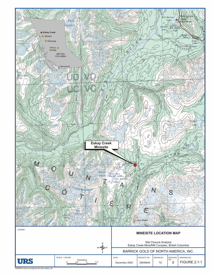
39548644-closure.rpt-figures.f0x site location.cdr
MINESITE LOCATION MAP
BARRICK GOLD OF NORTH AMERICA, INC.
LEGEND:
Site Closure AnalysisEskay Creek Mine/Mill Complex, British Columbia
N
EW
S
DATE: PROJECT NO.: DRAWING NO.:
FIGURE 2.1-139548644December 2005
REVISIONNO.:
0
DRAWN BY:
TS
SCALE: 1:250,000
0 2.5 5 7.5kilometres
Eskay Creek
Stewart
Vancouver
BRITISHCOLUMBIA
PrinceGeorge
Eskay CreekMinesite
Kitwanga
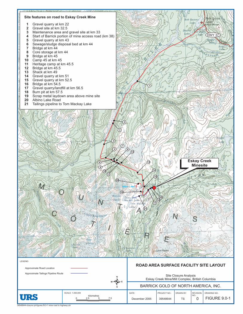
39548644-closure.rpt-figures.f9.0-1 mine road to highway.cdr
ROAD AREA SURFACE FACILITY SITE LAYOUT
BARRICK GOLD OF NORTH AMERICA, INC.
LEGEND:
Site Closure AnalysisEskay Creek Mine/Mill Complex, British Columbia
N
EW
S
DATE: PROJECT NO.: DRAWING NO.:
FIGURE 9.0-139548644December 2005
REVISIONNO.:
0
DRAWN BY:
TS
SCALE: 1:250,000
0 2.5 5 7.5kilometres
Approximate Road Location
Approximate Tailings Pipeline Route
Gravel quarry at km 22Gravel site at km 32.5Maintenance area and gravel site at km 33Start of Barrick portion of mine access road (km 38)Gravel quarry at km 43Sewage/sludge disposal bed at km 44Bridge at km 44Core storage at km 44Bridge at km 45Camp 45 at km 45Heritage camp at km 45.5Bridge at km 45.5Shack at km 49Gravel quarry at km 51Gravel quarry at km 52.5Bridge at km 54.5Gravel quarry/landfill at km 56.5Burn pit at km 57.5Scrap metal laydown area above mine siteAlbino Lake RoadTailings pipeline to Tom Mackay Lake
123456789
101112131415161718192021
Site features on road to Eskay Creek Mine
Albino Lake
Eskay CreekMinesite
20
1817
21
16
20
15
14
13
12
11
10
9
8
7
6
5
4
3
2
1
HWY 37

ESKAY CREEK GOLD MINE (CLOSED)
TOM MACKAY LAKE TAILINGS STORAGE FACILITY DAM SAFETY INSPECTION REPORT
10 December 2014
Tom MacKay Lake DSI report B‐1
Appendix B
Email Correspondence


From: Narynski, Heather M MEM:EXTo: Shelbourn, Michael (Salt Lake City)Cc: Harmati, Robbin (Eskay Creek); Warnock, George MEM:EX; Howe, Diane J MEM:EX; Hoffman, Al MEM:EXSubject: MEM Response: Eskay Creek Exemption from CI ordersDate: Monday, September 22, 2014 5:53:57 PM
Michael, Good speaking with you today. As discussed, MEM has carefully considered your request (dated September 11, 2014) for exemption from the Chief Inspector’s (CI) orders issued on August 18, 2014 to exclude Barrick’s Eskay Creek tailings storage facility (TSF). I understand that during the mine’s active life, tailings were disposed in Tom Mackay Lake and that no dams are associated with this lake. As discussed during our phone conversation, in some instances dam safety inspections may apply to impoundments that do not have any associated dams, although these are usually man-made excavations below ground. It is recognized that Tom Mackay Lake is a natural lake, but it would be also considered a “major impoundment” as defined on page 10-2 of the Health, Safety, and Reclamation Code for Mines in British Columbia (Code). As you have noted in your letter request, there is no plausible geotechnical failure mechanism by which the tailings could foreseeably be released from the lacustrine impoundment. I understand that there is a substantial water cover over the tailings, and that Tom Mackay Lake is located above treeline (no potential for logs in the lake or beaver activity blocking the natural outflow channel). However, it is also noted that some aspects of MEM’s Guidelines for Dam Safety Inspections (attached) would apply, and should be addressed. MEM would accept a signed and sealed letter report from yourself (a professional engineer registered in BC) which provides background on the facility and addresses each of the line items as outlined in MEM’s Guidelines. Where a particular item does not apply, this can simply be addressed as such with brief rationale. As MEM has committed to public release of all submissions, it is suggested that the letter report is written in the context of possible questions the public may have regarding the facility (i.e. potential for failure of the impoundment). This may minimize any follow-up questions/concerns (addressed to Barrick or MEM) that may come out of the public release. As discussed, if any recommendations arise from your review, please include a commitment letter/action plan from Barrick which outlines how and when these will be addressed. This letter report shall be submitted no later than December 1, 2014 (as per the original CI orders). If you have any additional questions, please don’t hesitate to contact me. Kind Regards,Heather

Heather Narynski, P.EngSr. Geotechnical InspectorMinistry of Energy and Mines1810 Blanshard St., Victoria, BC V8W 9N3Wk: 250-387-0883Cell: 250-893-3396
ESKAY CREEK GOLD MINE (CLOSED)
TOM MACKAY LAKE TAILINGS STORAGE FACILITY DAM SAFETY INSPECTION REPORT
10 December 2014
Tom MacKay Lake DSI report C‐1
Appendix C
Tom MacKay Lake TSF Selected Photographs

10 December 2014 TOM MACKAY LAKE TAILINGS STORAGE FACILITY DAM SAFETY INSPECTION REPORT
ESKAY CREEK GOLD MINE (CLOSED)
C‐2 Tom MacKay Lake DSI report
Tom MacKay Lake TSF looking southwest towards the natural outlet channel.
Closer view looking west of the float boom and measurement weir located in the natural outlet channel (which becomes Tom MacKay Creek) of Tom MacKay Lake.
ESKAY CREEK GOLD MINE (CLOSED)
TOM MACKAY LAKE TAILINGS STORAGE FACILITY DAM SAFETY INSPECTION REPORT
10 December 2014
Tom MacKay Lake DSI report C‐3
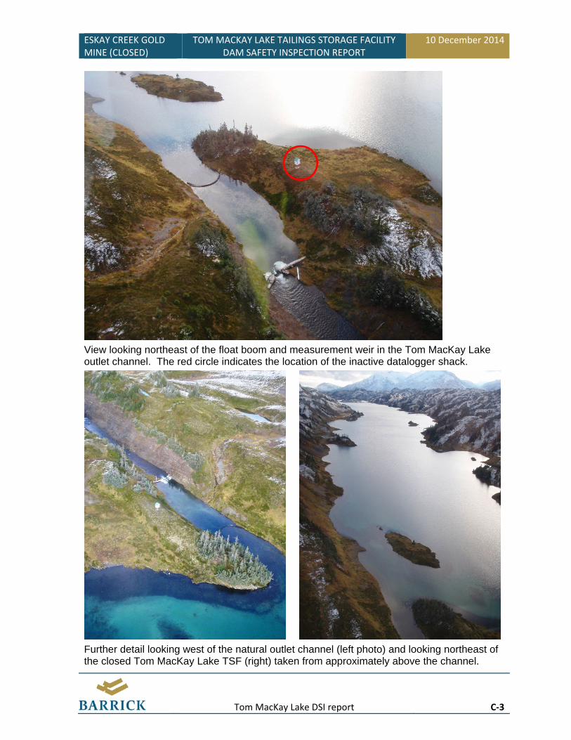
View looking northeast of the float boom and measurement weir in the Tom MacKay Lake outlet channel. The red circle indicates the location of the inactive datalogger shack.
Further detail looking west of the natural outlet channel (left photo) and looking northeast of the closed Tom MacKay Lake TSF (right) taken from approximately above the channel.

10 December 2014 TOM MACKAY LAKE TAILINGS STORAGE FACILITY DAM SAFETY INSPECTION REPORT
ESKAY CREEK GOLD MINE (CLOSED)
C‐4 Tom MacKay Lake DSI report