Embed Size (px)
Citation preview

June 2013
Phase One Environmental Site Assessment 3700 Jockvale Road Township of Nepean, Ontario
REP
OR
T
Report Number: 13-1122-0111
Distribution:
2 copies - Monarch Corporation
2 copies - Golder Associates Ltd.
Submitted to:Kris Haynes Ottawa - Low Rise Division Monarch Corporation 3584 Jockvale Road Nepean, Ontario K2C 3H2

PHASE ONE ESA - 3700 JOCKVALE ROAD, NEPEAN, ONTARIO
June 2013 Report No. 13-1122-0111 i
Executive Summary
Golder Associates Ltd. (“Golder”) was retained by Monarch Corporation (“Monarch”) to conduct a Phase One Environmental Site Assessment (“Phase One ESA”) of the property located at 3700 Jockvale Road, in the Township of Nepean, Ontario (herein after referred to as the “Site” and “Phase One Property”), as shown on
Figure 1. The legal description of the Site is: Part of Lot 7 Concession 2, Township of Nepean, Ottawa, Ontario. The property identification number (“PIN”) for the Site is 045911276.
The Executive Summary highlights key points from the report only; for complete information and findings, as well as the limitations, the reader should examine the complete report.
At the time of the Site reconnaissance, conducted on June 13, 2013, the Site consisted of an approximately 1.73 hectare parcel of undeveloped, vegetated and partially tree covered land. Evidence of fill material was observed through berms which were fully vegetated and are known to have been sourced locally during the adjacent golf
course and residential developments. A manhole was observed at the center of the eastern half of the Site providing access to a storm sewer installed in anticipation of future development. The majority of the surrounding properties to the west, north and east consisted of residential dwellings, roadways and golf course
fairways. The property to the south is occupied by the golf course maintenance facility.
Based on the information obtained and reviewed as part of this Phase One ESA, the Site and surrounding
properties within 250 metres of the Site boundaries were historically undeveloped agricultural and vacant land. At the time of writing this report, the Site remains undeveloped. From aerial photography, the first noted development surrounding the Site was the Stonebridge golf course in 2002 followed by the appearance of
residential dwellings and roads to the North and West starting in 2007.
The Phase One ESA was completed in accordance with O. Reg. 153/04 and included a review of available
current and historical information on the Site and surrounding properties, a Site walkover, interviews, evaluation of readily available information, and reporting, subject to the limitations outlined in Section 9.0 of this report. The Site is not considered an enhanced investigation property as defined by O.Reg. 153/04. A response to Golder’s
request for information from the Ministry of the Environment and City of Ottawa was not available at the time of writing this report.
Based on the information obtained and reviewed as part of this Phase One ESA, there were no areas of potential environmental concern (“APEC”) identified in association with the Site. The golf course maintenance building, including the three above ground storage tanks and chemical storage are not considered an APEC as
the ASTs and chemical storage area are located more than 20m from the Site boundary and show good housekeeping with no records or signs of spills. Groundwater is inferred to flow to the east towards the Rideau River so the ASTs are located hydraulically cross-gradient from the Phase One Property minimising the potential
for groundwater impacts related to the fuel tanks.
A Phase Two ESA is not recommended for the Site.

PHASE ONE ESA - 3700 JOCKVALE ROAD, NEPEAN, ONTARIO
June 2013 Report No. 13-1122-0111 ii
Table of Contents
EXECUTIVE SUMMARY ............................................................................................................................................................ i
1.0 INTRODUCTION ............................................................................................................................................................... 1
1.1 Phase One Property Information ......................................................................................................................... 1
2.0 SCOPE OF INVESTIGATION ........................................................................................................................................... 2
3.0 RECORDS REVIEW ......................................................................................................................................................... 3
3.1 General ................................................................................................................................................................ 3
3.1.1 Phase One Study Area Determination ........................................................................................................... 3
3.1.2 First Developed Use Determination ............................................................................................................... 3
3.1.3 Fire Insurance Plans ...................................................................................................................................... 3
3.1.4 Chain of Title .................................................................................................................................................. 3
3.1.5 City Directories ............................................................................................................................................... 3
3.1.6 Environmental Reports ................................................................................................................................... 3
3.2 Environmental Source Information ....................................................................................................................... 4
3.2.1 Ministry of the Environment ............................................................................................................................ 6
3.2.2 The City of Ottawa ......................................................................................................................................... 6
3.2.3 Ministry of Natural Resources ........................................................................................................................ 6
3.2.4 Technical Standards and Safety Authority, Fuel Safety Division Records ..................................................... 7
3.3 Physical Setting Sources ..................................................................................................................................... 7
3.3.1 Aerial Photographs......................................................................................................................................... 7
3.3.2 Topography, Hydrology and Geology............................................................................................................. 9
3.3.3 Fill Materials ................................................................................................................................................. 10
3.3.4 Water Bodies and Areas of Natural Significance ......................................................................................... 10
3.3.5 Well Records ................................................................................................................................................ 10
3.4 Site Operating Records ..................................................................................................................................... 11
4.0 INTERVIEWS .................................................................................................................................................................. 12
5.0 SITE RECONNAISSANCE ............................................................................................................................................. 13
5.1 General Requirements ....................................................................................................................................... 13
5.2 Specific Observations at Phase One Property ................................................................................................... 13

PHASE ONE ESA - 3700 JOCKVALE ROAD, NEPEAN, ONTARIO
June 2013 Report No. 13-1122-0111 iii
5.2.1 Phase One Property Details ......................................................................................................................... 13
5.2.2 Enhanced Investigation Property ................................................................................................................. 15
5.3 Surrounding Land Use ....................................................................................................................................... 15
6.0 REVIEW AND EVALUATION OF INFORMATION ......................................................................................................... 17
6.1 Current and Past Uses of the Site ..................................................................................................................... 17
6.2 Potentially Contaminating Activity and Areas of Potential Environmental Concern ........................................... 17
6.3 Conceptual Site Model ....................................................................................................................................... 17
6.3.1 Uncertainty and Absence of Information ...................................................................................................... 17
7.0 CONCLUSIONS .............................................................................................................................................................. 18
7.1 Need for a Phase Two ESA ............................................................................................................................... 18
8.0 REFERENCES ................................................................................................................................................................ 19
9.0 LIMITATIONS AND USE OF REPORT .......................................................................................................................... 20
10.0 STATEMENT OF COMPLETION ................................................................................................................................... 21
11.0 CLOSURE ....................................................................................................................................................................... 22
FIGURES
Figure 1 – Key Plan
Figure 2 – Site Plan
APPENDICES
APPENDIX A Survey Plan
APPENDIX B Regulatory Responses
APPENDIX C EcoLog ERIS Report
APPENDIX D Aerial Photographs
APPENDIX E Site Photographs

PHASE ONE ESA - 3700 JOCKVALE ROAD, NEPEAN, ONTARIO
June 2013 Report No. 13-1122-0111 1
1.0 INTRODUCTION
1.1 Phase One Property Information Golder Associates Ltd. (“Golder”) was retained by Monarch Corporation (“Monarch”) to conduct a Phase One Environmental Site Assessment (“Phase One ESA”) of the following property
Municipal Address 3700 Jockvale Road, Nepean, Ontario
Property Identification Number 045911276
Legal Description Part Lot 7, Concession 2, Township of Nepean
A plan of survey for the Site is provided in Appendix A. The Site location is shown on Figure 1. A plan of the Site is provided as Figure 2.
Authorization to proceed with this investigation was received from Mr. Kris Haynes of Monarch on June 6th, 2013. The contact information for the Site owner is:
Site Owner Address Contact Information
Monarch Corporation Ottawa - Low Rise Division
3584 Jockvale Road, Nepean, Ontario K2C 3H2
Mr. Kris Haynes Email: [email protected]

PHASE ONE ESA - 3700 JOCKVALE ROAD, NEPEAN, ONTARIO
June 2013 Report No. 13-1122-0111 2
2.0 SCOPE OF INVESTIGATION A Phase One ESA is a preliminary qualitative assessment of the environmental condition of a property, based on a review of current activities and historical information for the Site and a review of relevant and readily available
environmental information for the surrounding properties located within a 250 metre (“m”) radius of the municipal boundary of the Site (collectively referred to as the “Phase One Study Area”). The boundaries of the Phase One Study Area are presented in Figure 2.
According to Ontario Regulation (“O. Reg.”) 153/04 Records of Site Condition, the objectives of a Phase One ESA are to:
Develop a preliminary determination of the likelihood that one or more contaminants have affected any land or water on, in or under the Site;
Determine the need for a Phase Two Environment Site Assessment (“ESA”);
Provide a basis for carrying out a Phase Two ESA;
Provide adequate preliminary information about environmental conditions in the land or water on, in or
under the Site for the conduct of a risk assessment following completion of a Phase Two ESA; and,
Identify and report on evidence of actual and/or potential contamination on the Site from current and
historical activities at the Site or from adjacent properties.

PHASE ONE ESA - 3700 JOCKVALE ROAD, NEPEAN, ONTARIO
June 2013 Report No. 13-1122-0111 3
3.0 RECORDS REVIEW
3.1 General 3.1.1 Phase One Study Area Determination
For the purpose of this Phase One ESA, the Phase One Study Area is the area within a 250 m radius of the boundaries of the Site. Based on Golder’s review of the historical and current information compiled as part of this Phase One ESA for the area surrounding the Site and observations of neighbouring properties made during
the Site visit, it was concluded that an assessment of information pertaining to properties within 250 m of the Site was sufficient to achieve the objectives of the Phase One ESA.
3.1.2 First Developed Use Determination
The date of first developed use of the Phase One Property was determined based on review of the available
aerial photographs. The Phase One Property has never been developed and has always been agricultural or vacant. The surrounding areas were first developed into a golf course and residential dwellings starting in 2002.
3.1.3 Fire Insurance Plans
Golder contracted EcoLog Environmental Risk Information Services Ltd. (“EcoLog ERIS”) to conduct a search of
environmental sources, including federal, provincial and private sector databases, for information on the Phase One Property and Study Area. This included a search and a copy of any existing fire insurance plans relating to the Site. The searches revealed that none were available for the Site and Study Area. A copy of the EcoLog
ERIS report is provided in Appendix C.
3.1.4 Chain of Title
The current owner (Monarch) has reportedly owned the Phase One Property since 1989 (2004 Phase One ESA). From review of aerial photography and other information, the Phase One Property has never been
developed so a title search was not considered necessary to obtain information about the environmental condition of the Phase One Property.
3.1.5 City Directories
A review of historical city directories was completed by Opta Environmental Services for the Phase One Property
and surrounding properties (within 250 m).
No information was found in the Opta databases for the Phase One Property or the Study Area.
3.1.6 Environmental Reports
The following environmental reports related to the Site were obtained by Golder:
“2004 Phase I ESA”, Golder Associates Ltd. October 2004. Phase I Environmental Site Assessment Monarch
Lands – West of Jockvale Road Ottawa (Nepean), Nepean (04-1120-439), prepared for Monarch Corporation.
Based on Golder’s review of the 2004 Phase I ESA, the following are of note for the Site:
No issues of potential environmental concern were identified;
The Site was historically used for agricultural purposes and/or vacant;

PHASE ONE ESA - 3700 JOCKVALE ROAD, NEPEAN, ONTARIO
June 2013 Report No. 13-1122-0111 4
Several ASTs were encountered on the golf course containing oil, diesel and waste oil and did not have secondary containment. Minor staining was observed due to minor spilling during fueling and filling
operations; and
Fill, from off-site sources, was used in the making of the golf course but is not considered to have a risk of
environmental impact.
“2012 Geotechnical Investigation”, Golder Associates Ltd. August, 2012. Geotechnical Investigation Proposed
Residential Development Kilbirnie Drive Stonebridge Community, Ottawa, Ontario (12-1121-0130), prepared for Monarch Corporation.
Based on Golder’s review of the 2012 Geotechnical Investigation, the following are of note for the Site:
The Site was reportedly undeveloped and sparsely tree covered and was bound by the Stonebridge golf
course to the north and the golf course maintenance building to the south;
Subsurface conditions encountered consisted of weathered silty clay overlying sand and glacial till;
Some fill was encountered from 1.0 to 1.9 mbgs in two test pits and consisted of sand and silt and cobbles and boulders; and
No groundwater was observed in the test pits for the short time that they remained open.
“2013 Archeological Assessment” Past Recovery Archeological Service, May 2013. Stage 1 Archeological Assessment of the Stonebridge Phase 14 Property, Part Lot 7, Concession 2, Rideau Front, Geographic Township of Nepean, Carleton County, Now in the City of Ottawa.
Based on Golder’s review of the 2013 Archeological Assessment, the following are of note for the Site:
All portions of the study area have been determined to exhibit low archeological potential; and
The Site and its surroundings have been changed from their original natural state through the construction
and development of the Stonebridge residential development and golf course.
3.2 Environmental Source Information Golder contracted EcoLog Environmental Risk Information Services Ltd. (“EcoLog ERIS”) to conduct a search of
environmental sources, including federal, provincial and private sector databases, for information on the Phase One Property and Study Area. A copy of the EcoLog ERIS report is provided in Appendix C
The databases searched included the following:
Federal Provincial Private
Contaminated Sites on Federal Land Environmental Effects Monitoring Environmental Issues Information
System Federal Convictions Fisheries & Oceans Fuel Storage
Tanks Indian & Northern Affairs Fuel Tanks National Analysis of Trends in
Abandoned Aggregate Inventory Abandoned Mine Information System Aggregate Inventory Borehole Certificates of Approval Certificates of Property Use Coal Gasification Plants Commercial Fuel Oil Tanks Compliance and Convictions Drill Hole Database
Anderson's Storage Tanks
Anderson's Waste Disposal Sites
Automobile Wrecking & Supplies
Canadian Mine Locations
Canadian Pulp and
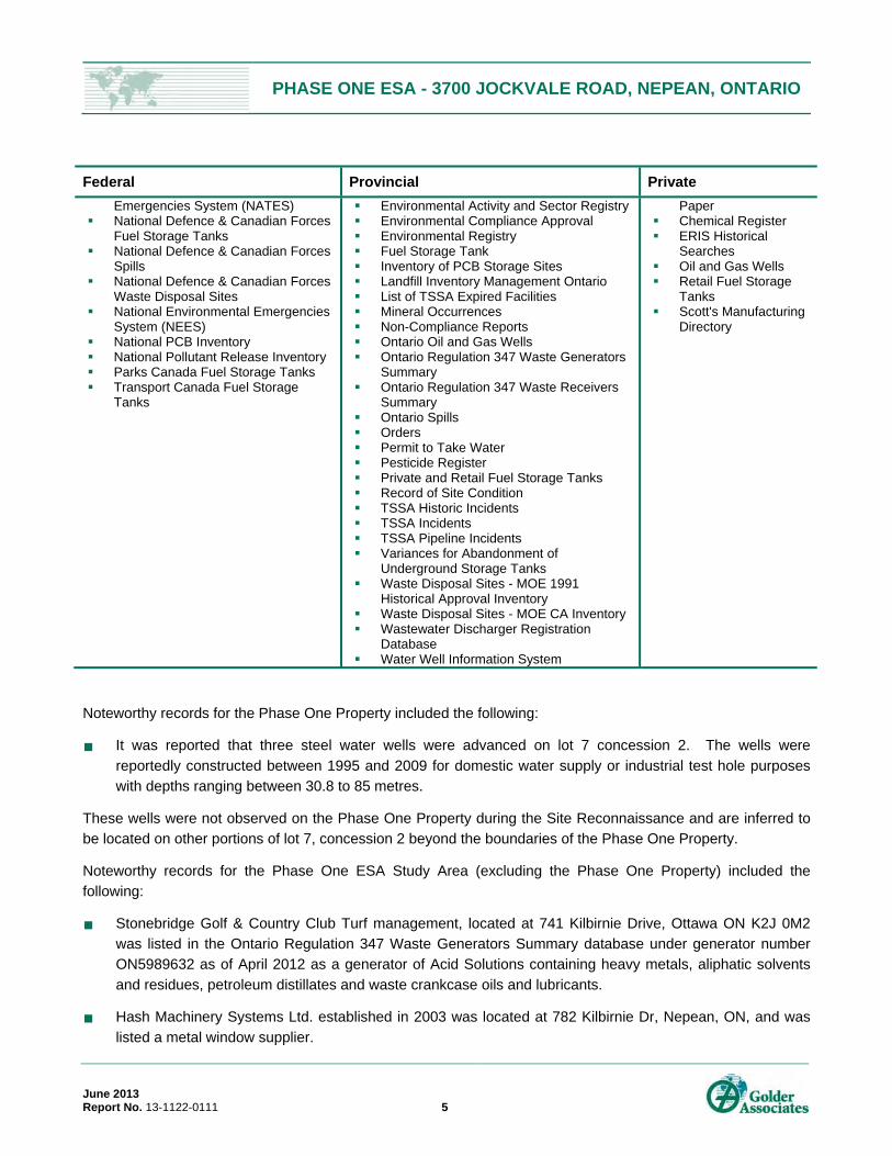
PHASE ONE ESA - 3700 JOCKVALE ROAD, NEPEAN, ONTARIO
June 2013 Report No. 13-1122-0111 5
Federal Provincial Private
Emergencies System (NATES) National Defence & Canadian Forces
Fuel Storage Tanks National Defence & Canadian Forces
Spills National Defence & Canadian Forces
Waste Disposal Sites National Environmental Emergencies
System (NEES) National PCB Inventory National Pollutant Release Inventory Parks Canada Fuel Storage Tanks Transport Canada Fuel Storage
Tanks
Environmental Activity and Sector Registry Environmental Compliance Approval Environmental Registry Fuel Storage Tank Inventory of PCB Storage Sites Landfill Inventory Management Ontario List of TSSA Expired Facilities Mineral Occurrences Non-Compliance Reports Ontario Oil and Gas Wells Ontario Regulation 347 Waste Generators
Summary Ontario Regulation 347 Waste Receivers
Summary Ontario Spills Orders Permit to Take Water Pesticide Register Private and Retail Fuel Storage Tanks Record of Site Condition TSSA Historic Incidents TSSA Incidents TSSA Pipeline Incidents Variances for Abandonment of
Underground Storage Tanks Waste Disposal Sites - MOE 1991
Historical Approval Inventory Waste Disposal Sites - MOE CA Inventory Wastewater Discharger Registration
Database Water Well Information System
Paper Chemical Register ERIS Historical
Searches Oil and Gas Wells Retail Fuel Storage
Tanks Scott's Manufacturing
Directory
Noteworthy records for the Phase One Property included the following:
It was reported that three steel water wells were advanced on lot 7 concession 2. The wells were
reportedly constructed between 1995 and 2009 for domestic water supply or industrial test hole purposes with depths ranging between 30.8 to 85 metres.
These wells were not observed on the Phase One Property during the Site Reconnaissance and are inferred to be located on other portions of lot 7, concession 2 beyond the boundaries of the Phase One Property.
Noteworthy records for the Phase One ESA Study Area (excluding the Phase One Property) included the following:
Stonebridge Golf & Country Club Turf management, located at 741 Kilbirnie Drive, Ottawa ON K2J 0M2 was listed in the Ontario Regulation 347 Waste Generators Summary database under generator number ON5989632 as of April 2012 as a generator of Acid Solutions containing heavy metals, aliphatic solvents
and residues, petroleum distillates and waste crankcase oils and lubricants.
Hash Machinery Systems Ltd. established in 2003 was located at 782 Kilbirnie Dr, Nepean, ON, and was
listed a metal window supplier.

PHASE ONE ESA - 3700 JOCKVALE ROAD, NEPEAN, ONTARIO
June 2013 Report No. 13-1122-0111 6
It was reported that 6 water wells were advanced on lot 8, adjacent to the Phase One Property. The wells were reportedly constructed between 1947 and 1994 for mainly domestic water supply purposes with one
listed as cooling and A/C (geothermal) with depths ranging between 6.4 to 30.5 metres.
Based on review of the EcoLog ERIS report, no issues of potential environmental concern were identified in
association with the Phase One Property.
3.2.1 Ministry of the Environment
The MOE was contacted on June 17, 2013, to determine if the MOE has maintained a file with respect to the Site. Specifically, the MOE was asked to respond in writing to the following questions:
Has the MOE ever issued any approvals, permits or licences for the Site?
Has the MOE ever issued any control orders or violation notices with respect to the Site?
At the time of preparation of this report, the MOE had not issued a response to Golder.
3.2.2 The City of Ottawa
A request for information was made to the City of Ottawa for records and information relating to any environmental concerns with the Site including any notices, charges, spills, violations or records of sewer-use non-compliance events regarding the Site. A formal request for any environmental records or information on the
Site was sent to the City on June 17, 2013.
At the time of preparation of this report, the City had not issued a response to Golder.
3.2.3 Ministry of Natural Resources
A request to the Ministry of Natural Resources (“MNR”) was sent on June 17, 2013. Records requested included any information relating to areas of natural significance in the vicinity of the Site, as well as any other environmental concerns that may be related to the Site and surrounding area. On June 21, 2013, Korey Walker,
Resource Management Planner of the MNR reported via e-mail that the following Natural Heritage values were identified in close proximity to the subject lands:
Spawning Area, Walley Spawning Area (Non-Sensitive)
Unevaluated Wetland (Not evaluated per OWES)
As per the Natural Heritage Reference Manual Section 13; (OMNR 2010) the MNR strongly recommends that an Ecological Site Assessment be carried out to more thoroughly determine the presence of natural heritage
features, and Species at Risk and their habitat located on Site.
The MNR also indicated that there is a potential for the following Threatened (THR) and/or Endangered (END)
species on the Site or in proximity to it:
Barn Swallow (THR)
Bobolink (THR)
Butternut (END)
Eastern Meadowlark (THR)

PHASE ONE ESA - 3700 JOCKVALE ROAD, NEPEAN, ONTARIO
June 2013 Report No. 13-1122-0111 7
These species and their habitats are protected by the Endangered Species Act and it is recommended that field surveys be conducted if the proposed work involves removal or disturbance of natural areas (including
overgrown grass areas) or disturbance to structures where nests may be present.
Additional studies and assessments suggested by the MNR, such as an Ecological Site Assessment, were
beyond the scope of this Phase I ESA and were not conducted by Golder.
3.2.4 Technical Standards and Safety Authority, Fuel Safety Division Records
The Technical Standards and Safety Authority (“TSSA”) maintains records related to registered underground storage tanks (“USTs”) for petroleum-related products. The TSSA was contacted to establish the status of the
Site and to identify outstanding instructions, incident reports, fuel oil spills or contamination records.
On June 24, 2013, Ms. Sarah Quibell of the TSSA reported via e-mail that there were no records on file
pertaining to the Site or surrounding area.
3.3 Physical Setting Sources 3.3.1 Aerial Photographs
Aerial photographs of the Site and vicinity were obtained from geoOttawa, the City of Ottawa’s interactive web mapping application (http://maps.ottawa.ca/geoOttawa/), and included images taken in the years 1976, 1999,
2002, 2005, 2007, 2008 and 2011. Photos from the National Air Photo Library (National Resources Canada) were also consulted and were dated 1936, 1945, 1952, 1973, 1979 and 1991. Information obtained from the review of the aerial photography is summarized in the table below. Copies of the most relevant aerial
photographs are presented in Appendix D.
Golder selected aerial photographs based on availability and date intervals, to help develop an understanding of
the history of the development of the Phase One Property and Phase One Study Area. The information obtained from the aerial photography is limited by the quality and scale of the available aerial photographs. The earliest aerial photograph available was from 1936.
Year Description Surrounding Area
1936 (A5403 Scale 1: 15000) The Site is an agricultural field with some trees.
North: Agricultural fields with a farmstead. East: Agricultural fields with a farmstead. South: Agricultural fields. West: Agricultural fields.
1945 (A9553, Scale 1:50000) As per 1936 As per 1936
1952 (A13510, Scale 1:15000) As per 1936 As per 1936
1973 (A23190, Scale 1:25000) As per 1936 As per 1936
1976 (geoOttawa Image) As per 1936 As per 1936
1979 (A25114, Scale 1:25000) As per 1936 As per 1936
1991 (A27761, Scale 1:50000) As per 1936 As per 1936

PHASE ONE ESA - 3700 JOCKVALE ROAD, NEPEAN, ONTARIO
June 2013 Report No. 13-1122-0111 8
Year Description Surrounding Area
1999 (geo Ottawa Image)
Vacant land with several trees or bushes.
North: Vacant fields with remnants of the former seemingly abandoned farmstead. East: Vacant fields. South: Agricultural fields. West: Vacant fields.
2002 (geo Ottawa Image)
As per the 1999 aerial photograph.
North and West: Fairway and path of Stonebridge golf course including an artificial pond (W) with vacant fields. East: Stonebridge golf course with an artificial pond (NE) and agricultural fields and farm. South: Agricultural and vacant fields.
2005 (geo Ottawa Image)
As per the 1999 aerial photograph.
As per 2002
2007 (geo Ottawa Image)
As per the 1999 aerial photograph but with the addition of planted trees in straight rows (possible landscaping).
North and West: Fairway and path of Stonebridge golf course including an artificial pond (W) and roadways have been built and residences (houses) are visible with some under construction on the former vacant fields. East: Stonebridge golf course with an artificial pond (NE) and agricultural fields and farm. South: Agricultural and vacant field with the section immediately to the south appearing to be covered in fill or may have been cleared of vegetation.
2008 (geo Ottawa Image)
As per 2007 aerial photograph.
North and West: Fairway and path of Stonebridge golf course including an artificial pond (W) and vacant a residential development is now present. East: Stonebridge golf course with an artificial pond (NE) and residential development. South: Golf maintenance facility followed by vacant land and residential development (SE).
2011 (geo Ottawa Image)
As per the 2008 aerial photograph.
As per the 2008 aerial photograph.
Based on the aerial photograph review, the Phase One Property appears to have never been developed and has
been used as agricultural fields (pasture) and has otherwise remained vacant with some minor landscaping limited to tree planting. The surrounding properties primarily included agricultural and vacant fields until 2002 when the Stonebridge golf course was present to North, North-East and North-West. Vacant lands to the North,
East, and West to South-West were redeveloped into residences in and between the golf course fairways.

PHASE ONE ESA - 3700 JOCKVALE ROAD, NEPEAN, ONTARIO
June 2013 Report No. 13-1122-0111 9
3.3.2 Topography, Hydrology and Geology
The following records were reviewed to identify topographic, geologic and hydrogeological conditions at the Site. The following maps/reports were reviewed to determine the general geological and topographical conditions in the area of the Site:
Natural Resources Canada – Topographical Map 31G5, Ottawa,11th Edition, 1994;
Ministry of Natural Resources, Ontario Geological Survey – Map P2716, Paleozoic Geology, Ottawa Area, 1984;
Geological Survey of Canada – Map 1506A, Surficial Geology, Ottawa, 1982; and,
Geological Survey of Canada – Paper 77-11, Figure 4, Drift Thickness Trend, 1979
Refer to Section 5 for additional information on Site features, as observed at the time of the Site visit.
Topic Conditions Comment / Source
Topography of Site and Surrounding Area
The topography of the Site generally flat with a very slight slope towards the East.
Site observations and 2004 Phase I ESA (Golder)
Overburden Soils
Offshore Marine Deposits: clay, silty clay and clay, commonly calcareous and fossiliferous; locally overlain by thin sands. Upper parts are generally mottled or laminated reddish brown and blueish grey and may contain lenses and pockets of sand, but at depth the clay is uniform and blue-grey.
Geological Survey of Canada, Map 1506A, Surficial Geology – Ottawa, Ontario
Type of Bedrock Oxford Formation: sub lithographic to fine crystalline dolostone.
Ontario Geological Survey – Map P2716, Paleozoic Geology, Ottawa Area
Depth to Bedrock Approximately 12m with localized variations. Geological Survey of Canada, Paper 77-11, Figure 4
Inferred Near Surface Groundwater Flow
East toward Rideau River
Natural Resources Canada – Topographical Map 31G5, Ottawa, and 2004 Phase I ESA (Golder)
Site Grade Relative to the Adjoining Properties
The northern portion of the Site appears to follow the topography of the golf fairway to the north and slopes down towards the south to match the grade of the golf maintenance area which is flat level ground.
Site observations
Depth to Groundwater
Based on the 2012 Geotechnical Investigation was not encountered in any of the test pits dug to 4.5 mbgs.
2012 Geotechnical Investigation (Golder)

PHASE ONE ESA - 3700 JOCKVALE ROAD, NEPEAN, ONTARIO
June 2013 Report No. 13-1122-0111 10
3.3.3 Fill Materials
Topic Conditions Comment / Source
Fill Materials
Based on the information collected during the 2012 Geotechnical Investigation, brown sand and silt and cobbles and boulders was present at the Site in two of the test pits to depths ranging between 1.0 m and 1.9 m below ground surface. Berms of fill or locally displaced materials were observed at the Site at the time of the Site reconnaissance. Fill material would be from local sources placed on Site during the golf course and residential development. The berms were completely vegetated and their quality and classification was not determined at the time of the Site visit.
2012 Geotechnical Investigation and Site visit observations
3.3.4 Water Bodies and Areas of Natural Significance
Topic Conditions Comment / Source
Nearest Open Water Body
Jock River (0.5 km and 1.0 km east) with flow towards the east. Rideau River (1.25 km east) with flow towards the north.
2004 Phase I ESA (Golder)
Areas of Natural Significance (“ANSI”)
None identified within the Phase One Study Area. Ministry of Natural Resources
3.3.5 Well Records
Topic Conditions Comment / Source
Water Wells on Site (location, stratigraphy of the overburden, from ground surface to bedrock, depth to bedrock, depth to water table, drilling date, use)
It was reported that three steel open hole water wells were advanced on lot 7 concession 2:
In 2009 to a depth of 280 ft (85 m) for domestic water supply purposes. Stratigraphy of the well reportedly comprised of sand, gravel and boulders to overlying limestone and sandstone bedrock at 13.2 ft;
In 2000 to depth of 101 ft (30.8 m) for industrial test hole purposes. Stratigraphy of the well reportedly comprised of clay to a depth of 4 ft (1.22 m) followed by soft sand to 7 ft (2.13 m) and clay again to 16 ft (4.9 m) followed by limestone dolomite rock 28 ft (8.53 m); and,
In 1995 to a depth of 222 ft (67.7 m) for domestic water supply purposes. Stratigraphy of the well reportedly comprised of clay, hardpan, stones to 87 ft (26.5 m) followed by limestone and sandstone bedrock
EcoLog ERIS Report

PHASE ONE ESA - 3700 JOCKVALE ROAD, NEPEAN, ONTARIO
June 2013 Report No. 13-1122-0111 11
Topic Conditions Comment / Source
Water Wells on the Neighbouring Properties (location, stratigraphy of the overburden, from ground surface to bedrock, depth to bedrock, depth to water table, drilling rate, use)
It was reported that 6 water wells were advanced on lot 8 adjacent to the Phase One Property. The wells were reportedly constructed between 1947 and 1994 for mainly domestic water supply purposes and listed as cooling and A/C (geothermal) with depths ranging between 21 to 100 ft (6.4 to 30.5 m).
EcoLog ERIS Report
3.4 Site Operating Records At the time of the Site visit, the Phase One Property was undeveloped. No Site Operating Records were provided to Golder in association with the property.

PHASE ONE ESA - 3700 JOCKVALE ROAD, NEPEAN, ONTARIO
June 2013 Report No. 13-1122-0111 12
4.0 INTERVIEWS Golder was accompanied at the time of the Site visit by Mr. Kris Haynes, with Monarch (hereinafter referred to as the “Site representative”), who also responded to an environmental questionnaire detailing historical and current
Site operations. Pursuant to the requirements O. Reg. 153/04, the Site representative was interviewed as the “current owner” with knowledge of current Site operations. The environmental questionnaire was completed by the Site representative on June 10th, 2013.
Relevant information obtained by interviews is provided in the Section 5.0.

PHASE ONE ESA - 3700 JOCKVALE ROAD, NEPEAN, ONTARIO
June 2013 Report No. 13-1122-0111 13
5.0 SITE RECONNAISSANCE
5.1 General Requirements Mr. Julien Hanrahan of Golder visited the Site for approximately one hour on June 13th, 2013 at 1:30 pm. The Site visit consisted of a walk-around the Site along with a cursory inspection of neighbouring properties from the
Site and publicly accessible areas. The weather conditions were sunny and the temperature was approximately 24C. The Site was undeveloped (i.e., no operations occurring at the Site).
Photographs of relevant features noted during the Site visit are attached in Appendix E.
5.2 Specific Observations at Phase One Property The specific observations made during the Site visit are presented herein.
5.2.1 Phase One Property Details
Topic Observations Comment / Source
Total Area of the Site Approximately 1.73 hectares. Site Representative
Number and Age of Buildings on the Site
No buildings or structures were present at the Site.
Site observations
Building Areas Not applicable Site observations
Number of Floors (include all levels, whether above or below ground)
Not applicable Site observations
Number, Age, and Depth of Levels Below Ground Level
Not applicable Site observations
Number and Details of all Aboveground Storage Tanks (“ASTs”)
No ASTs were observed or reported on the Phase One Property.
Site observations and Site Representative
Number and Details of all Underground Storage Tanks (“USTs”)
No USTs were observed or reported on the Phase One Property.
Site observations and Site Representative
Potable and Non-Potable Water Sources
No active water source is reportedly available at the Site. A fire hydrant is located on Kilbirnie drive immediately to the west of the Site. A dry fire main connecter runs along the access road down to a fire hydrant that services the golf maintenance facility, to the south of the Site.
Site Representative
Utility Lines Present (i.e. Electrical, Natural Gas, other)
No utility drawings are available for the Site. Given Golder’s understanding of the Site, the absence of these layout drawings does not represent a significant deviation.
Site Representative
Entry and Exit Points for Site Buildings
Not applicable Site observations
Existing and Former Heating Not applicable Site observations, Site

PHASE ONE ESA - 3700 JOCKVALE ROAD, NEPEAN, ONTARIO
June 2013 Report No. 13-1122-0111 14
Topic Observations Comment / Source
System(s) (include fuel type / source)
representative
Existing and Former Cooling System(s) (include fuel type / source)
Not applicable Site observations, Site representative
Drains, Pits, and Sumps (include current use, if any, and former use)
As no buildings or structures were present at the Site there were no drains, pits, or sumps observed or reported.
Site observations, Site representative
Unidentified Substances None identified. Site observations
Stains or Corrosion Located near a Potential Discharge Location
None identified. Site observations
Location of any Current and Former Wells
None identified. Site observations and Site Representative
Sanitary/Process Wastewater Receptor
No sanitary or process wastewater is generated on-Site.
Site Representative
Sanitary Sewer Connection No sanitary sewer connection is available at the Site.
Site observations and Site Representative
Septic Systems No signs or record of any septic systems were on-Site
Site observations and Site Representative
Storm Water Flow Infiltration Site observations and Site Representative
Storm Sewer Connection
A manhole was observed at the center of the eastern half of the Site which the Site Representative stated gave access to a storm sewer. A ditch runs along the south boundary of the Site.
Site observations and Site Representative
Ground Cover (i.e. grass, gravel, soil, or pavement, etc.)
The majority of the Phase One Property was covered with vegetation. This included grass, bushes and small to large trees. Some of the smaller trees had been dug up to be replanted at other locations of the golf course and residential development.
Site observations
Current or Former Railway Lines or Spurs
None observed or reported. Site observations and aerial photographs.
Presence of Stained Soil, Vegetation, or Pavement
None observed. Site observations
Presence of Stressed Vegetation
None observed. Site observations

PHASE ONE ESA - 3700 JOCKVALE ROAD, NEPEAN, ONTARIO
June 2013 Report No. 13-1122-0111 15
Topic Observations Comment / Source
Presence of Fill and/or Debris Materials
Berms of fill materials were observed across the Phase One Property that appeared to be related to the golf course landscaping. These were fully vegetated and are assumed to be sourced locally and placed on Site during the golf course and residential development.
Site observations
Potentially Contaminating Activity
None observed. Site observations
5.2.2 Enhanced Investigation Property
The Site is not considered to be an enhanced investigation property.
5.3 Surrounding Land Use During the Site visit, a visual reconnaissance of the outdoor operations in the Phase One Study Area was carried
out from the Site and publicly accessible areas.
The surrounding properties include residential and recreational land uses, as illustrated on Figure 2.
North: The Site is bounded to the north by a golf course fairway including a dirt road or trail for golf carts and maintenance equipment. Further to the north are residential dwellings and roads.
East: The Site is bounded to the east by vacant land and golf course fairways.
South: The Site is bounded to the south by the golf maintenance facility.
West: The Site is bounded to the west by residential dwellings and roads as well as other golf course fairways.
At the time of the Site reconnaissance, conducted on June 13th, 2013, the Site consisted of an approximately 1.73 hectare parcel of undeveloped vegetated land. No buildings or structures were noted on the Phase One
Property. Two manholes were observed, one at the south-western edge of the Site and another in the center of the eastern half of the Site. The Site Representative stated that the former gave access to the dry fire main connecting the fire hydrant on Kilbirnie Drive, to the east of the Site, to the one at the golf maintenance facility.
The latter, the Site Representative stated, gave access to the storm water sewer running under the property. Vegetation cover ranged from grass and bushes to smaller planted trees and older growth trees. Some of the smaller trees had been removed, to be replanted at other locations on the Stonebridge development, as stated
by the Site Representative and evidenced by large holes in the ground. The Site slopes gently downward towards the south.
The majority of the surrounding properties to the west, north and east consisted of residential dwellings, roadways and golf course fairways. The property to the south was also visited and consisted of the golf maintenance facility which includes a gravel parking lot, two Quonset hut type buildings and a golf course fill
material stockpile area. Of environmental importance was the vehicle maintenance building which included a vehicle parking area as well a garage with an above ground hoist. All chemicals including lubricants, oil, pesticides and fertilizers are stored within the maintenance building within a secure gated space on a concrete

PHASE ONE ESA - 3700 JOCKVALE ROAD, NEPEAN, ONTARIO
June 2013 Report No. 13-1122-0111 16
slab with a drain and underground retention tank to capture any spills and leaks. Immediately to the east of the vehicle maintenance garage are two fuel ASTs on top of a concreted slab, one for diesel and one for gasoline,
each with a capacity of 2270 L. Very minor staining was observed under both the tanks. A waste oil AST of the same capacity was also observed immediately north of the fuel ASTs and no staining was observed.
The vehicle maintenance building, including the three ASTs, chemical storage and fill material stored at the golf maintenance facility are not considered an issue of potential environmental concern to the Phase One Property as the ASTs and chemical storage area are located more than 20m from the Site boundary and show generally
good housekeeping with no records or signs of spills. Groundwater is inferred to flow to the east towards the Rideau River so the ASTs are located hydraulically cross-gradient from the Phase One Property minimising the potential for groundwater impacts related to the fuel tanks.

PHASE ONE ESA - 3700 JOCKVALE ROAD, NEPEAN, ONTARIO
June 2013 Report No. 13-1122-0111 17
6.0 REVIEW AND EVALUATION OF INFORMATION
6.1 Current and Past Uses of the Site From a review of aerial photography, the Site and surrounding areas were undeveloped prior to 2002 when the golf course first appeared and followed by residential development and roads in 2007. At the time of the Site
reconnaissance, the Site was undeveloped and sparsely tree covered. A manhole was observed at the center of the eastern half of the Site and was reported as providing access to a storm sewer.
6.2 Potentially Contaminating Activity and Areas of Potential Environmental Concern
Potentially contaminating activities, which if currently or historically carried out at a Site, may contribute to an area of potential environmental concern (“APEC”). Based on the information obtained as part of this Phase One
ESA, there were no potentially contaminating activities or areas of potential environmental concern identified.
6.3 Conceptual Site Model The Site is currently an undeveloped parcel of vegetated land. Vegetation cover ranged from grass and bushes to smaller planted trees and older growth trees. No buildings or structures were noted on the Phase One
Property.
Soil at the Site consists primarily of topsoil and fill underlain by silty sand deposits followed by glacial till
consisting of a heterogeneous mixture of gravel, cobbles and boulders in a matric of sandy silt or silty sand with a trace of clay. Local groundwater flow is anticipated to be east towards the Rideau River. Fill material used for golf course landscaping in the berms observed on the Phase One Property was reported as having been
sourced locally and displaced when constructing the golf course.
Based on the information obtained as part of this Phase One ESA, there were no potentially contaminating
activities or areas of potential environmental concern identified on the Phase One Property or within the Phase One Study Area.
6.3.1 Uncertainty and Absence of Information
A response to Golder’s request for information from the MOE and the City of Ottawa was not available at the
time of writing this report.
Given the past and current land use at the Phase One Property, and the information obtained from the Ecolog
ERIS report, future responses from the aforementioned agencies are not anticipated to present any new information or any potential environmental concern. When responses are received, and in the unlikely scenario that environmental concerns are identified, the responses will be attached to a short summary of the findings and
be transmitted to the Monarch to be appended to this report.
There were no material deviations to the Phase One ESA requirements set out in O.Reg. 153/04 that would
cause uncertainty or absence of information that would affect the validity of the findings of this assessment.

PHASE ONE ESA - 3700 JOCKVALE ROAD, NEPEAN, ONTARIO
June 2013 Report No. 13-1122-0111 18
7.0 CONCLUSIONS Based on the information obtained and reviewed as part of this Phase One ESA, there were no areas of potential environmental concern (“APEC”) identified in association with the Site.
7.1 Need for a Phase Two ESA No APECs were identified at the Phase One Property. Accordingly, a Phase Two ESA is not required.

PHASE ONE ESA - 3700 JOCKVALE ROAD, NEPEAN, ONTARIO
June 2013 Report No. 13-1122-0111 19
8.0 REFERENCES The following is a list of all documents or data cited in this report:
Source Date
Natural Resources Canada – Topographical Map 31G5, Ottawa,11th Edition, 1994; October, 2004
Ministry of Natural Resources, Ontario Geological Survey – Map P2716, Paleozoic
Geology, Ottawa Area, 1984 October, 2004
Geological Survey of Canada – Map 1506A, Surficial Geology, Ottawa, 1982 October, 2004
Geological Survey of Canada – Paper 77-11, Figure 4, Drift Thickness Trend, 1979 October, 2004
Aerial Photographs – National Air Photo Library (National Resources Canada) 1936, 1945, 1952, 1973, 1979, and 1991
Aerial Photographs - geoOttawa (http://maps.ottawa.ca/geoOttawa/) 1976, 1999, 2002, 2005, 2007, 2008 and 20011
EcoLog Environmental Risk Information Services June 18, 2013
Ontario Ministry of the Environment Pending
City of Ottawa Pending
Ministry of Natural Resources June 21, 2013
Previous Environmental Reports (refer to Section 3.1.6)
PHASE ONE ESA - 3700 JOCKVALE ROAD, NEPEAN, ONTARIO
June 2013 Report No. 13-1122-0111 20
9.0 LIMITATIONS AND USE OF REPORT This report (the “Report”) was prepared for the exclusive use of Monarch Corporation (“Monarch”) for the express purpose of providing advice with respect to the environmental condition of the Site. In evaluating the
Site, Golder Associates Ltd. (“Golder”) has relied in good faith on information provided by others as noted in the Report. We have assumed that the information provided is factual and accurate. We accept no responsibility for any deficiency, misstatement or inaccuracy contained in this Report as a result of omissions, misinterpretations
or fraudulent acts of persons interviewed or contacted, or incomplete or inaccurate historical information from the various agencies. Any use which a third party makes of this Report, or any reliance on or decisions to be made based on it, is the sole responsibility of such third party. If a third party requires reliance on this Report, prior
written authorization from Golder is required. Golder disclaims any responsibility of consequential financial effects on transactions or property values, or requirements for follow-up actions and costs.
The scope and the period of Golder’s assessment are described in this Report, and are subject to restrictions, assumptions and limitations. Except as noted herein, the work was conducted in accordance with the scope of work and terms and conditions of Golder’s proposal. Golder did not perform a complete assessment of all
possible conditions or circumstances that may exist at the Site referenced in the Report. Conditions may therefore exist which were not detected given the limited nature of the assessment Golder was retained to undertake with respect to the Site and additional environmental studies and actions may be required. In
addition, it is recognized that the passage of time affects the information provided in the Report. Golder’s opinions are based upon information that existed at the time of the writing of the Report. It is understood that the services provided for in the scope of work allowed Golder to form no more than an opinion of the actual
conditions at the Site at the time the Site was visited, and cannot be used to assess the effect of any subsequent changes in any laws, regulations, the environmental quality of the Site or its surroundings. Asbestos and mould surveys were not performed. If a service is not expressly indicated, do not assume it has been provided.
The results of an assessment of this nature should in no way be construed as a warranty that the Site is free from any and all contamination from past or current practices.

PHASE ONE ESA - 3700 JOCKVALE ROAD, NEPEAN, ONTARIO
June 2013 Report No. 13-1122-0111 21
10.0 STATEMENT OF COMPLETION The undersigned confirm that this Phase One Environmental Site Assessment was conducted in a manner consistent with the expected standard of care for the consulting industry in Ontario and meets the requirements
for Phase One ESAs as set out in O. Reg. 153/04.

PHASE ONE ESA - 3700 JOCKVALE ROAD, NEPEAN, ONTARIO
June 2013 Report No. 13-1122-0111 22
11.0 CLOSURE We trust that the information presented in this report meets your current requirements. Should you have any questions or concerns, please do not hesitate to contact the undersigned.
GOLDER ASSOCIATES LTD.
Julien Hanrahan, EIT Eric Wilson, P.Eng., PMP Environmental Consultant Associate, Qualified Person
JGH/EDW/hw
Golder, Golder Associates and the GA globe design are trademarks of Golder Associates Corporation.
\\golder.gds\gal\ottawa\active\2013\1122 - contaminated lands\13-1122-0111 monarch corp. phase i - west of jockvale road\5 preparation of deliverables\13-1122-0111 - phase i report
rev27jun13.docx

SITE
Sources: Esri, DeLorme, NAVTEQ, TomTom, Intermap, increment PCorp., GEBCO, USGS, FAO, NPS, NRCAN, GeoBase, IGN, KadasterNL, Ordnance Survey, Esri Japan, METI, Esri China (Hong Kong),swisstopo, and the GIS User Community
439000
439000
440000
440000
441000
441000
442000
442000
443000
443000
444000
444000
445000
445000
446000
446000
447000
447000
448000
448000
5006
000
5006
000
5007
000
5007
000
5008
000
5008
000
5009
000
5009
000
5010
000
5010
000
5011
000
5011
000
5012
000
5012
000
5013
000
5013
000
5014
000
5014
000
5015
000
5015
000
N:\A
ctiv
e\S
patia
l_IM
\Mon
arch
\370
0_Jo
ckva
le_
Rd
\Spa
tial_
IM\G
IS\M
XD
s\1
3-1
122
-011
1\R
epo
rtin
g\P
has
e10
00_
En
vAss
\131
122
0111
-10
00-0
1.m
xd
REV. 0.0DESIGN
KEY PLAN
FIGURE 1PROJECT No. 13-1122-0111 SCALE AS SHOWN
PROJECT
TITLE
GIS
REVIEW
JH June 2013
CHECK
PHASE I ESA - 3700 JOCKVALE ROADOTTAWA, ONTARIO
JEM June 2013
0 500 1,000 1,500 2,000 2,500
Metres
NOTE THIS FIGURE IS TO BE READ IN CONJUNCTION WITH THE ACCOMPANYINGGOLDER ASSOCIATES LTD. REPORT No. 13-1122-0111
REFERENCE DATUM: NAD 83, COORDINATE SYSTEM: UTM ZONE 18
³
JH June 2013EDW June 2013

443200
443200
443300
443300
443400
443400
443500
443500
443600
443600
443700
443700
443800
443800
5010
000
5010
000
5010
100
5010
100
5010
200
5010
200
5010
300
5010
300
5010
400
5010
400
5010
500
5010
500
5010
600
5010
600
5010
700
5010
700
N:\A
ctiv
e\S
patia
l_IM
\Mon
arch
\370
0_Jo
ckva
le_
Rd
\Spa
tial_
IM\G
IS\M
XD
s\1
3-1
122
-011
1\R
epo
rtin
g\P
has
e10
00_
En
vAss
\131
122
0111
-10
00-0
2.m
xd
REV. 0.0DESIGN
SITE PLAN
FIGURE 2PROJECT No. 13-1122-0111 SCALE AS SHOWN
PROJECT
TITLE
GIS
REVIEW
JH June 2013
CHECK
PHASE I ESA - 3700 JOCKVALE ROADOTTAWA, ONTARIO
JEM June 2013
0 40 80 120 160 200
Metres
NOTE THIS FIGURE IS TO BE READ IN CONJUNCTION WITH THE ACCOMPANYINGGOLDER ASSOCIATES LTD. REPORT No. 13-1122-0111
REFERENCE DATUM: NAD 83, COORDINATE SYSTEM: UTM ZONE 18
LEGEND
³
APPROXIMATE SITE BOUNDARY
PHASE I ESA STUDY AREA
JH June 2013EDW June 2013

PHASE ONE ESA - 3700 JOCKVALE ROAD, NEPEAN, ONTARIO
June 2013 Report No. 13-1122-0111
APPENDIX A Survey Plan

443400
443400
443450
443450
443500
443500
443550
443550
443600
443600
443650
443650
5010
300
5010
300
5010
350
5010
350
5010
400
5010
400
5010
450
5010
450
5010
500
5010
500
LEGEND
REV. 0DESIGN
SURVEY PLAN
FIGURE A-1PROJECT No. 13-1122-0111 SCALE AS SHOWN
PROJECT
TITLE
GIS
REVIEW
JH June 2013
CHECK
PHASE I ESA - 3700 JOCKVALE ROADOTTAWA, ONTARIO
JEM June 2013
³P
ath
: N:\
Act
ive
\Sp
atia
l_IM
\Mo
narc
h\3
700_
Jock
vale
_Rd\
Sp
atia
l_IM
\GIS
\MX
Ds\
13-1
122
-011
1\R
epo
rtin
g\P
has
e100
0_E
nvA
ss\1
311
2201
11-1
000-
A1.
mxd
0 10 20 30 40
Metres
NOTE BASE PLAN PROVIDED IN PDF FORMAT BY MONARCH CORP. DRAWING BY ANNIS O'SULLIVAN VOLLEBEKK LTD.
THIS FIGURE IS TO BE READ IN CONJUNCTION WITH THE ACCOMPANYING GOLDER ASSOCIATES LTD.REPORT No. 13-1122-0111
REFERENCE DATUM: NAD 83, COORDINATE SYSTEM: UTM ZONE 18
APPROXIMATE SITE BOUNDARY
JH June 2013EDW June 2013


PHASE ONE ESA - 3700 JOCKVALE ROAD, NEPEAN, ONTARIO
June 2013 Report No. 13-1122-0111
APPENDIX B Regulatory Responses


Endangered Species Act, 2007 & Species At Risk in Ontario
Background The Endangered Species Act (ESA) 2007 protects both species and habitat. Section 9 of the ESA “prohibits killing, harming, harassing, capturing, possessing, collecting, buying, selling, trading, leasing or transporting species that are listed as threatened, endangered or extirpated”. Section 10 of the ESA, 2007 prohibits damaging or destroying habitat of endangered or threatened species. Protected habitat is either based on general definition in the Act or prescribed through a regulation. The ESA 2007 defines general habitat as an area on which the species depends, directly or indirectly, to carry on its life processes, including reproduction, rearing, hibernation, migration or feeding. It is important to be aware that changes may occur in both species and habitat protection. The ESA applies to listed species on the Species at Risk in Ontario List (SARO). The Committee on the Status of Species in Ontario (COSSARO) meets regularly to evaluate species for listing and/or re-evaluate species already listed. As a result, species’ designations may change that could in turn change the level of protection they receive under the ESA 2007. Also, habitat protection provisions for a species may change e.g. if a species-specific habitat regulation comes into effect. The regulation would establish the area that is protected as habitat for the species.
Information with respect to SAR can be found in the online database at the Natural Heritage Information Centre (NHIC) - http://nhic.mnr.gov.on.ca/nhic.cfm . The NHIC compiles, maintains and distributes information on species at risk and updates its information on a regular basis. We encourage you to routinely check the NHIC database to obtain the most up to date SAR information for proposed work locations. However, while the NHIC database is the best available source of data, even when there are no known occurrences documented at a site, there is a possibility that SAR may occur at a proposed work location. All data represents the MNR’s best current available information, it is important to note that a lack of occurrence at a site does not mean that there are no Species at Risk (SAR) at the location. The MNR continues to encourage ecological site assessments to determine the potential for other SAR occurrences. When a SAR does occur on a proposed site, it is recommended that the proponent contact the MNR for technical advice and to discuss what activities can occur without contravention of the Act. If an activity is proposed that will contravene the Act (such as Section 9 or 10), the proponent must contact the MNR to discuss the potential for application of certain permits (Section 17) or agreement (Regulation 242/08). For specific questions regarding the Endangered Species Act (2007) or species at risk, please contact a district Species at Risk Biologist at [email protected].
Ministry of Natural Resources 2011 Kemptville District
Endangered Species Act: http://www.e-laws.gov.on.ca/html/statutes/english/elaws_statues-07e06_e.htm Species at Risk in Ontario List: www.mnr.gov.on.ca/en/Business/Species/2ColumnSubPage/246809.html

Natural Heritage Information Centre
The Natural Heritage Information Centre (NHIC) compiles, maintains and distributes information on natural species, plant communities and spaces of conservation concern in Ontario. This information is stored in a spatial database used for tracking this information. The Centre also has a library with conservation-related literature, reports, books, and maps, which are accessible for conservation applications, land use planning, and natural resource management. The NHIC website makes much of this information available through the internet.
Natural Heritage Information Centre 300 Water Street, 2nd Floor, North Tower
P.O. Box 7000, Peterborough, ON, K9J 8M5 Tel.:(705) 755-2159 Fax:(705) 755-2168
Land Information Ontario (LIO) manages key provincial datasets. LIO makes these and hundreds of other data sets available to registered users at no charge. LIO also coordinates public and private sector organizations to collect high resolution satellite imagery for Ontario providing significant cost savings for all partners. Technical bulletins, newsletters and more are available online. More details regarding Ontario imagery and data can be searched, ordered and accessed online. LIO’s Ontario Geospatial Data Exchange (OGDE) allows more than 400 public sector organizations to easily share and use digital geographic information under a single legal agreement. Membership is available to eligible public organizations at no costs. Through the website, Maps & Map Tools are made available, including online mapping software: LIO Make-a-Map.
Land Information Ontario [email protected]
LIO Support Team: (705) 755-1878
Or for specifics, see online at: http://www.mnr.gov.on.ca/en/Business/LIO/2Colum
nSubPage/STDPROD_068510.html
Ministry of Natural Resources 2012 Kemptville District
Natural Heritage Information Centre: http://nhic.mnr.gov.on.ca/ Biodiversity Explorer (mapping): https://www.biodiversityexplorer.mnr.gov.on.ca/nhicWEB/main.jsp Land Information Ontario: http://www.mnr.gov.on.ca/en/Business/LIO/index.html Ontario Geospatial Data Exchange: http://www.mnr.gov.on.ca/en/Business/LIO/2ColumnSubPage/STEL02_167959.html LIO Make-a-Map: http://www.mnr.gov.on.ca/en/Business/LIO/2ColumnSubPage/STDPROD_068999.html Ontario Maps: http://www.mnr.gov.on.ca/en/Business/LIO/2ColumnSubPage/STDPROD_068512.html
Land Information Ontario
Additional Information pertaining to NHIC, LIO and other Natural Heritage and Data and Information tools is available in the MNR Kemptville Information Request Guide (2012).

1
Ministry of Natural Resources
Kemptville District P.O. Box2002 10 Campus Drive Kemptville, ONK0G 1J0 Tel.: (613) 258-8204 Fax.: (613) 258-3920
Ministère des Richesses naturelles
District de Kemptville CP 2002 10 Campus Drive Kemptville, ONK0G 1J0 Tél.: (613) 258-8204 Téléc.: (613) 258-3920
Fri. Jun 21, 2013
Julien Hanrahan Golder Associates Ltd. [email protected] Attention: Julien Hanrahan Subject: Information Request Project Name: 3700 Jockvale Road Site Address: Our File No. 2013_NEP-2316 Natural Heritage Values The Ministry of Natural Resources (MNR) Kemptville District has carried out a preliminary review of the area in order to identify any potential natural resource and natural heritage values. The MNR works closely with partner agencies and local municipalities in order to establish concurrent approval process and to achieve streamlined and efficient service delivery. The MNR strongly encourages all proponents to contact partner agencies (e.g. MOE, Conservation Authority, etc.) and appropriate municipalities early on in the planning process. This provides the proponent with early knowledge regarding agency requirements and approval timelines. Natural heritage features and values contribute to the province’s rich biodiversity and provide habitat for a variety of species. The following Natural Heritage values were identified in close proximity to the subject lands:
Spawning Area, Walleye Spawning Area (Non-Sensitive)
Unevaluated Wetland (Not evaluated per OWES) Municipal Official Plans contain additional information related to natural heritage features. Please see the local municipal Official Plan for more information such as specific policies and direction pertaining to activities which may impact natural heritage features. For planning advice or Official Plan interpretation, please contact the local municipality.

2
Where natural values and natural hazards exist (e.g., floodplains), there may be additional approvals and permitting required from the local Conservation Authority. The MNR strongly recommends contacting the local Conservation Authority for further information and approvals. Please see the MNR Kemptville Information Guide (2012) for contact information pertaining to Conservation Authorities located within the Kemptville District area. The Natural Heritage Information Centre (NHIC) can provide additional information and mapping as it pertains to natural heritage features and species at risk. The NHIC website (including mapping tools) is available to all members of the public, for more information please see the attached NHIC Information Sheet. In addition, the following fish species were identified in the nearby water body: alewife, banded killifish, black crappie, blackchin shiner, blacknose shiner, bluegill, bluntnose minnow, brassy minnow, brook silverside, brook stickleback, brown bullhead, central mudminnow, common carp, common shiner, creek chub, eastern silvery minnow, emerald shiner, fallfish, fathead minnow, finescale dace, golden shiner, greater redhorse, green sunfish, johnny darter/tesselated darter, largemouth bass, logperch, longnose dace, mimic shiner, Moxostoma sp., muskellunge, North American Catfishes, northern pike, northern redbelly dace, pumpkinseed, rock bass, shorthead redhorse, silver redhorse, smallmouth bass, spottail shiner, tadpole madtom, trout-perch, walleye, white sucker, yellow perch. As per the Natural Heritage Reference Manual (Section 13; OMNR 2010) the MNR strongly recommends that an Ecological Site Assessment be carried out to more thoroughly determine the presence of natural heritage features, and Species at Risk and their habitat located on site. The MNR can provide survey methodology for particular species at risk and their habitats. In addition, the local planning authority may have more details pertaining to the requirements of the assessment process, which will result in allow for the municipality to make planning decisions which are consistent with the Provincial Policy Statement (2005). Species at Risk With the new Endangered Species Act (ESA, 2007) in effect, it is important to understand which species and habitats exist in the area and the implications of the legislation. A review of the Natural Heritage Information Centre (NHIC) and internal records and aerial photograph interpretation indicate that there is a potential for the following Threatened (THR) and/or Endangered (END) species on the site or in proximity to it:
Barn Swallow (THR)
Bobolink (THR)
Butternut (END)
Eastern Meadowlark (THR) All Endangered and Threatened species receive individual protection under Section 9 of the Endangered Species Act, 2007 (ESA). Species listed below receive both species and general habitat protection under Section 10 of the ESA, 2007. Thus any potential works should consider disturbance of possible important habitat (e.g. nesting sites). Please note that as of June 30, 2013 general habitat protection will apply to all Threatened and Endangered species. The habitat of these listed species will be protected from damage and destruction and certain activities may

3
require authorization(s) under the ESA. Please keep this date in mind when planning any species and habitat surveys. Species receiving General Habitat protection:
Bobolink (THR)
Eastern Meadowlark (THR)
Barn Swallow (THR) If the proposed activity is known to have an impact on the species mentioned above or any other SAR, a permit under the Endangered Species Act, 2007 (ESA) may be required. It is recommended that MNR Kemptville be contacted prior to any activities being carried out to discuss potential survey and mitigation measures to avoid contravention of the ESA. If any of these or any other species at risk are discovered throughout the course of the work, and/or should any species at risk or their habitat be potentially impacted by on site activities, MNR should be contacted immediately and operations be modified to avoid any negative impacts to species at risk or their habitat until further direction is provided by MNR. Please note that information regarding species at risk is based on documented occurrences only and does not include an interpretation of potential habitat within or in proximity to the site in question. Although this data represents the MNR’s best current available information, it is important to note that a lack of information for a site does not mean that additional features and values are not present. i.e.: Species at Risk (SAR) or their habitat could still be present at the location or in the immediate area. It is the responsibility of the proponent to ensure that species at risk are not killed, harmed, or harassed; or their habitat is not damaged or destroyed through the activities carried out on the site. The MNR continues to strongly encourage ecological site assessments to determine the potential for SAR habitat and occurrences. When a SAR or potential habitat for a SAR does occur on a site, it is recommended that the proponent contact the MNR for technical advice and to discuss what activities can occur without contravention of the Act. If an activity is proposed that will contravene the Act (such as Section 9 or 10), the proponent must contact the MNR to discuss the potential for a permit (Section 17). For specific questions regarding the Endangered Species Act (2007) or SAR, please contact a district Species at Risk Biologist at [email protected]. For more information regarding the ESA (2007), please see attached ESA Information Sheet. Please note: The advice in this letter may become invalid if:
The Committee on the Status of Species at Risk in Ontario (COSSARO) re-assesses the status of the above-named species OR adds a species to the SARO List such that the section 9 and/or 10 protection provisions apply to those species.
Additional occurrences of species are discovered.
Habitat protection comes into force for one of the above-mentioned species through the creation of a habitat regulation (general habitat protection above).
This letter is valid until: Sat. Jun 21, 2014

4
The MNR would like to advise, by way of this letter, that we continue to be circulated on information with regards to this project. If you have any questions or require clarification please do not hesitate to contact me. Sincerely,
Korey Walker Resource Management Planner [email protected] Encl.\ -ESA Infosheet -NHIC/LIO Infosheet

PHASE ONE ESA - 3700 JOCKVALE ROAD, NEPEAN, ONTARIO
June 2013 Report No. 13-1122-0111
APPENDIX C EcoLog ERIS Report

Project Property: Monarch Corp - Lands West of Jockvale Road, NepeanKilbernie Drive & Sandgate Ridge Ottawa ON
Report Type: Custom-Build Your Own Report
Order #: 20130607035
Date: June 18, 2013

1 erisinfo.com| EcoLog ERIS Ltd. Order #: 20130607035Monarch Corp - Lands West of Jockvale Road, Nepean Kilbernie Drive & Sandgate Ridge OttawaON
Table of ContentsTable of Contents...........................................................................................1Executive Summary........................................................................................2
Executive Summary: Report Summary................................................................................................3Executive Summary: Site Report Summary – Project Property...........................................................5Executive Summary: Site Report Summary – Surrounding Properties................................................6
Map.................................................................................................................7Aerial...............................................................................................................8Detail Report...................................................................................................9Unplottable Report........................................................................................12Appendix: Database Descriptions.................................................................17Definitions.....................................................................................................26
Notice: IMPORTANT LIMITATIONS and YOUR LIABILITY
Reliance on information in Report: This report DOES NOT replace a full Phase 1 Environmental Site Assessment but is solely intended to be used to focus further investigation.
Licence for use of information in Report: No page of this report can be used without this cover page, this notice and the project property identifier. The information in Report(s) may not be modified or re-sold.
Your Liability for misuse: Using this Service and/or its reports in a manner contrary to this Notice or your agreement will be in breach of copyright and contract and ERIS may obtain damages for such mis-use, including damages caused to third parties, and gives ERIS the right to terminate your account, rescind your licence to any previous reports and to bar you from future use of the Service.
No warranty of Accuracy or Liability for ERIS: The information contained in this report has been produced by EcoLog EnvironmentalRisk Information Services Ltd ("ERIS") using various sources of information, including information provided by Federal and Provincial government departments. The report applies only to the address and up to the date specified on the cover of this report, and any alterations or deviation from this description will require a new report. This report and the data contained herein does not purport to be and does not constitute a guarantee of the accuracy of the information contained herein and does not constitute a legal opinion nor medical advice. Although ERIS has endeavoured to present you with information that is accurate, EcoLog ERIS disclaims, any and all liability for any errors, omissions, or inaccuracies in such information and data, whether attributable to inadvertence, negligence or otherwise, and for any consequences arising therefrom. Liability on the part of EcoLog ERIS is limited to the monetary value paid for this report.
Trademark and Copyright: You may not use the ERIS trademarks or attribute any work to ERIS other than as outlined above. This Service and Report(s) are protected by copyright owned by EcoLog ERIS Ltd. Copyright in data used in the Service or Report(s) (the "Data") is owned by EcoLog ERIS or its licensors. The Service, Report(s) and Data may not be copied or reproduced in whole or in any substantial part without prior written consent of EcoLog ERIS.

2 erisinfo.com| EcoLog ERIS Ltd. Order #: 20130607035Monarch Corp - Lands West of Jockvale Road, Nepean Kilbernie Drive & Sandgate Ridge OttawaON
Executive Summary
Property Information:
Project Property: Monarch Corp - Lands West of Jockvale Road, NepeanKilbernie Drive & Sandgate Ridge Ottawa ON
Order Information:
Order No.: 20130607035 Date Requested: 18/06/2013 Requested by: Golder Associates Ltd. Report Type: Custom-Build Your Own Report
Additional Products:
Insurance Products Fire Insurance PlansInsurance Products Inpection ReportsInsurance Products Site Specific PlansLand Title Search Historical Title Search

3 erisinfo.com| EcoLog ERIS Ltd. Order #: 20130607035Monarch Corp - Lands West of Jockvale Road, Nepean Kilbernie Drive & Sandgate Ridge OttawaON
Executive Summary: Report Summary
Database Name Selected On Site Boundaryto 0.25KM
Total
AAGR Abandoned Aggregate Inventory Y 0 0 0
AGR Aggregate Inventory Y 0 0 0
AMIS Abandoned Mine Information System Y 0 0 0
ANDR Anderson's Waste Disposal Sites Y 0 0 0
AUWR Automobile Wrecking & Supplies Y 0 0 0
BORE Borehole Y 0 0 0
CA Certificates of Approval Y 0 0 0
CFOT Commercial Fuel Oil Tanks Y 0 0 0
CHEM Chemical Register Y 0 0 0
COAL Inventory of Coal Gasification Plants and Coal Tar Sites Y 0 0 0
CONV Compliance and Convictions Y 0 0 0
CPU Certificates of Property Use Y 0 0 0
DRL Drill Hole Database Y 0 0 0
EASR Environmental Activity and Sector Registry Y 0 0 0
EBR Environmental Registry Y 0 0 0
ECA Environmental Compliance Approval Y 0 0 0
EEM Environmental Effects Monitoring Y 0 0 0
EHS ERIS Historical Searches Y 0 0 0
EIIS Environmental Issues Inventory System Y 0 0 0
EXP List of TSSA Expired Facilities Y 0 0 0
FCON Federal Convictions Y 0 0 0
FCS Contaminated Sites on Federal Land Y 0 0 0
FOFT Fisheries & Oceans Fuel Tanks Y 0 0 0
FST Fuel Storage Tank Y 0 0 0
GEN Ontario Regulation 347 Waste Generators Summary Y 1 0 1
HINC TSSA Historic Incidents Y 0 0 0
IAFT Indian & Northern Affairs Fuel Tanks Y 0 0 0
INC TSSA Incidents Y 0 0 0
LIMO Landfill Inventory Management Ontario Y 0 0 0
MINE Canadian Mine Locations Y 0 0 0
MNR Mineral Occurrences Y 0 0 0
NATE National Analysis of Trends in Emergencies System (NATES)
Y 0 0 0
NCPL Non-Compliance Reports Y 0 0 0
NDFT National Defence & Canadian Forces Fuel Tanks Y 0 0 0
NDSP National Defence & Canadian Forces Spills Y 0 0 0
NDWD National Defence & Canadian Forces Waste Disposal Sites
Y 0 0 0
NEES National Environmental Emergencies System (NEES) Y 0 0 0

4 erisinfo.com| EcoLog ERIS Ltd. Order #: 20130607035Monarch Corp - Lands West of Jockvale Road, Nepean Kilbernie Drive & Sandgate Ridge OttawaON
Database Name Selected On Site Boundaryto 0.25KM
Total
NPCB National PCB Inventory Y 0 0 0
NPRI National Pollutant Release Inventory Y 0 0 0
OGW Oil and Gas Wells Y 0 0 0
OOGW Ontario Oil and Gas Wells Y 0 0 0
OPCB Inventory of PCB Storage Sites Y 0 0 0
ORD Orders Y 0 0 0
PAP Canadian Pulp and Paper Y 0 0 0
PCFT Parks Canada Fuel Storage Tanks Y 0 0 0
PES Pesticide Register Y 0 0 0
PINC TSSA Pipeline Incidents Y 0 0 0
PRT Private and Retail Fuel Storage Tanks Y 0 0 0
PTTW Permit to Take Water Y 0 0 0
REC Ontario Regulation 347 Waste Receivers Summary Y 0 0 0
RSC Record of Site Condition Y 0 0 0
RST Retail Fuel Storage Tanks Y 0 0 0
SCT Scott's Manufacturing Directory Y 0 1 1
SPL Ontario Spills Y 0 0 0
SRDS Wastewater Discharger Registration Database Y 0 0 0
TANK Anderson's Storage Tanks Y 0 0 0
TCFT Transport Canada Fuel Storage Tanks Y 0 0 0
VAR TSSA Variances for Abandonment of Underground Storage Tanks
Y 0 0 0
WDS Waste Disposal Sites - MOE CA Inventory Y 0 0 0
WDSH Waste Disposal Sites - MOE 1991 Historical Approval Inventory
Y 0 0 0
WWIS Water Well Information System Y 1 2 3
Total: 2 3 5

5 erisinfo.com| EcoLog ERIS Ltd. Order #: 20130607035Monarch Corp - Lands West of Jockvale Road, Nepean Kilbernie Drive & Sandgate Ridge OttawaON
Executive Summary: Site Report Summary – Project Property
MapKey
DB Company/Site Name Address Page Number
1 WWIS lot 7 con 2 NEPEAN ON 9
2 GEN Stonebridge Golf & Country Club Turf management
741 Kilbirnie Drive OTTAWA ON K2J 0M2 9

6 erisinfo.com| EcoLog ERIS Ltd. Order #: 20130607035Monarch Corp - Lands West of Jockvale Road, Nepean Kilbernie Drive & Sandgate Ridge OttawaON
Executive Summary: Site Report Summary – Surrounding Properties
MapKey
DB Company/Site Name Address Page Number
3 WWIS lot 7 con 2 ON 10
4 WWIS lot 7 con 2 ON 10
5 SCT Hash Machinery Systems Ltd. 782 Kilbirnie Dr Nepean ON K2J 0M3 11

#*
#*#*
#*
#*2
1
3 4
5
KILBIRNIE DR
SANDGATE RIDGE
ONEIDA TERR
CHENOA WAY
SHADEHILL CRES
CEDARDOWN PVT
EDGEFIELD TERR
KELSO PVT
JOCKVALE RD
DEERPATH TERR
KIRKOONNEL WAY
BARNSDALE RD
OSNABROOK PVT
SHADEHILL CRES
75°43'W75°43'30"W45
°14'
30
"N
45°1
4'3
0"N
Project Property
Buffer Outline
#* Eris Sites with Higher Elevation
") Eris Sites with Same Elevation
#*
Eris Sites with Lower Elevation
( Eris Sites with Unknown Elevation
Expressway
Principal Highway
Secondary Highway
Major Road
Local road
Trail
Proposed Road
Ferry Route/Ice Road
Industrial and Resource - Regions
Main Line
Sidetrack
Transit Line
Abandoned Line
National Park
Provincial or Territorial Park
Other Park
Golf Course or Driving Range
Park or Sports Field
Other Recreation Area
140 0 14070m
Order No: 20130607035Map
1:5000
Address: Kilbernie Drive & Sandgate Ridge, Ottawa, ON
Source: © 2012 DMTI Spatial Inc.
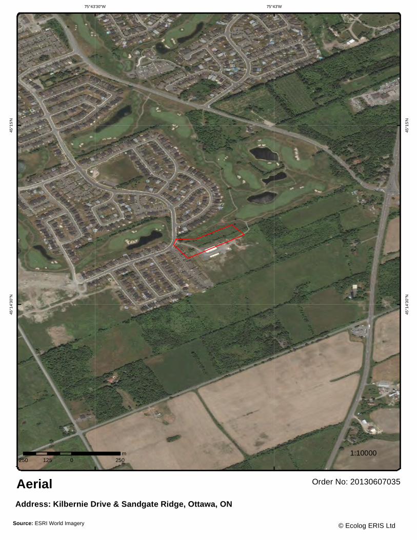
75°43'W75°43'30"W45
°15'
N
45°1
5'N
45°1
4'3
0"N
45°1
4'3
0"N
250 0 250125m
Order No: 20130607035Aerial
1:10000
Address: Kilbernie Drive & Sandgate Ridge, Ottawa, ON
© Ecolog ERIS LtdSource: ESRI World Imagery

9 erisinfo.com| EcoLog ERIS Ltd. Order #: 20130607035Monarch Corp - Lands West of Jockvale Road, Nepean Kilbernie Drive & Sandgate Ridge OttawaON
Detail Report
Map Key Number of Records
Elevation m
Site DB
1 1 of 1 100.8 lot 7 con 2NEPEAN ON
WWIS
Well Id: 7121823 Lot: 007 Concession: 02 Concession Name: RF County: OTTAWA-CARLETON Municipality: NEPEAN TOWNSHIP Easting Nad83: 443498 Northing Nad83: 5010335 Zone: 18 Utm Reliability: margin of error : 10 - 30 m Primary Water Use: Domestic Construction Date: 3/19/2009 Secondary Water Use:
Well Depth: 280 ft
Pump Rate: 20 GPM Static Water Level: 3.51 ft Flow Rate: Clear/Cloudy: Specific Capacity: Final Well Status: Water Supply Construction Method: Air Precussion Flowing (y/n): Elevation (m): 100.632499 Elevation Reliability: Depth to Bedrock: Overburden/Bedrock: Water Type: Untested Casing Material: STEEL, OPEN HOLE
--- Details --- Thickness: 43.5 ft Original Depth: 43.5 ft Material Colour: Material: SAND, GRAVEL, BOULDERS + Thickness: 111.5 ft Original Depth: 155 ft Material Colour: GREY Material: LIMESTONE + Thickness: 30 ft Original Depth: 185 ft Material Colour: WHITE Material: SANDSTONE + Thickness: 30 ft Original Depth: 215 ft Material Colour: GREY Material: LIMESTONE + Thickness: 65 ft Original Depth: 280 ft Material Colour: GREY Material: SANDSTONE
2 1 of 1 103.0 Stonebridge Golf & Country Club Turf management741 Kilbirnie Drive OTTAWA ON K2J 0M2
GEN
SIC Code: SIC Description: Generator #: ON5989632 Approval Yrs: As of Apr 2012
--- Details --- Waste Code: 112 Waste Description: Acid solutions - containing heavy metals + Waste Code: 212 Waste Description: Aliphatic solvents and residues +

10 erisinfo.com| EcoLog ERIS Ltd. Order #: 20130607035Monarch Corp - Lands West of Jockvale Road, Nepean Kilbernie Drive & Sandgate Ridge OttawaON
Map Key Number of Records
Elevation m
Site DB
Waste Code: 213 Waste Description: Petroleum distillates + Waste Code: 252 Waste Description: Waste crankcase oils and lubricants
3 1 of 1 100.0 lot 7 con 2 ON
WWIS
Well Id: 1531390 Lot: 007 Concession: 02 Concession Name: RF County: OTTAWA-CARLETON Municipality: NEPEAN TOWNSHIP Easting Nad83: 443723.3 Northing Nad83: 5010472 Zone: 18 Utm Reliability: unknown UTM Primary Water Use: Industrial Construction Date: 7/14/2000 Secondary Water Use:
Well Depth: 101 ft
Pump Rate: Static Water Level: Flow Rate: Clear/Cloudy: Specific Capacity: Final Well Status: Test Hole Construction Method: Air Precussion Flowing (y/n): N Elevation (m): 99.234817 Elevation Reliability: Depth to Bedrock: 16 Overburden/Bedrock: Bedrock Water Type: Not stated Casing Material: OPEN HOLE, STEEL, OPEN HOLE
--- Details ---
Thickness: 4 ft Original Depth: 4 ft
Material Colour: BROWN Material: CLAY, STONES, PACKED
+
Thickness: 3 ft Original Depth: 7 ft
Material Colour: BROWN Material: SAND, SOFT
+
Thickness: 9 ft Original Depth: 16 ft
Material Colour: GREY Material: CLAY, STONES, PACKED
+
Thickness: 12 ft Original Depth: 28 ft
Material Colour: GREY Material: LIMESTONE, DOLOMITE, FRACTURED
+
Thickness: 73 ft Original Depth: 101 ft
Material Colour: GREY Material: LIMESTONE, DOLOMITE, HARD
4 1 of 1 100.0 lot 7 con 2 ON
WWIS
Well Id: 1528552 Lot: 007 Concession: 02 Concession Name: RF County: OTTAWA-CARLETON Municipality: NEPEAN TOWNSHIP Easting Nad83: 443726.8 Northing Nad83: 5010471 Zone: 18 Utm Reliability: unknown UTM Primary Water Use: Domestic Construction Date: 6/28/1995 Secondary Water Use:
Well Depth: 222 ft
Pump Rate: 6 GPM Static Water Level: 50 ft Flow Rate: Clear/Cloudy: CLOUDY Specific Capacity: Final Well Status: Water Supply
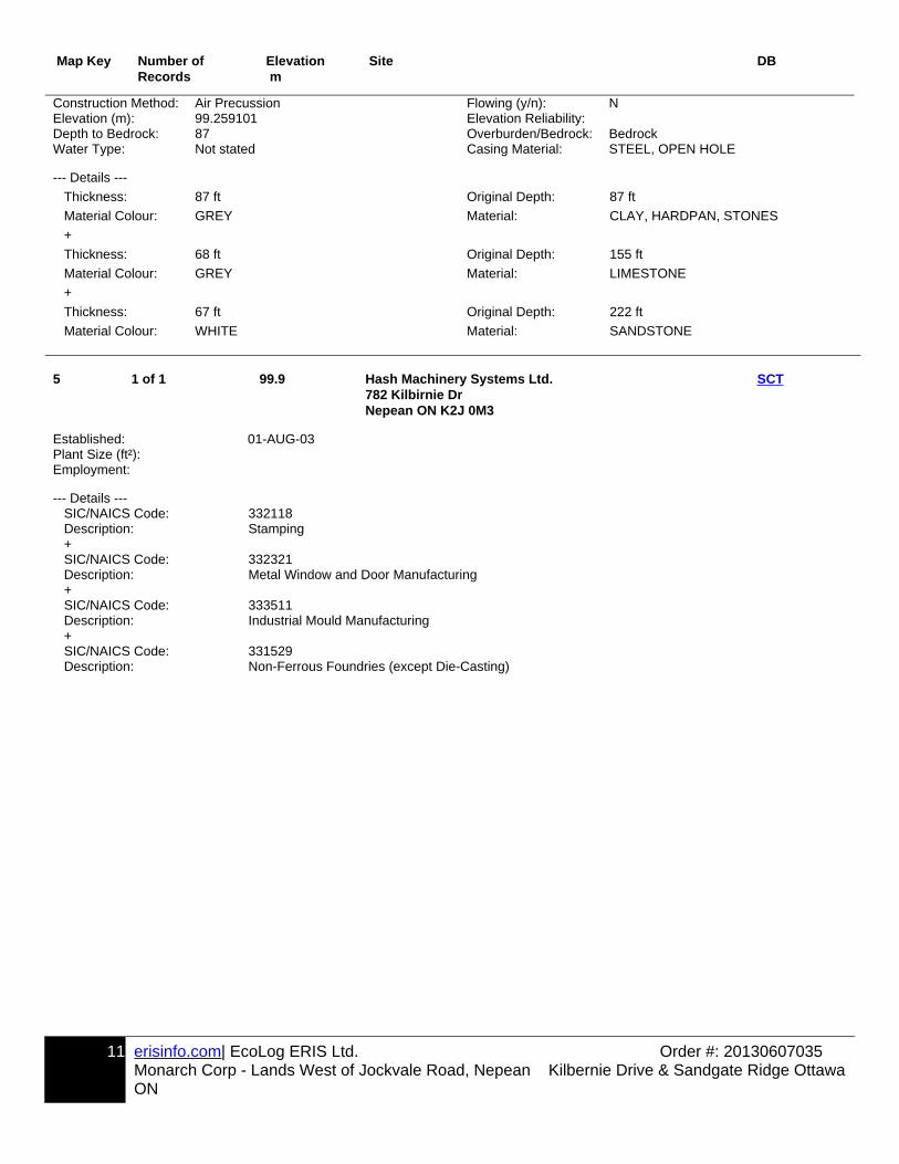
11 erisinfo.com| EcoLog ERIS Ltd. Order #: 20130607035Monarch Corp - Lands West of Jockvale Road, Nepean Kilbernie Drive & Sandgate Ridge OttawaON
Map Key Number of Records
Elevation m
Site DB
Construction Method: Air Precussion Flowing (y/n): N Elevation (m): 99.259101 Elevation Reliability: Depth to Bedrock: 87 Overburden/Bedrock: Bedrock Water Type: Not stated Casing Material: STEEL, OPEN HOLE
--- Details ---
Thickness: 87 ft Original Depth: 87 ft
Material Colour: GREY Material: CLAY, HARDPAN, STONES
+
Thickness: 68 ft Original Depth: 155 ft
Material Colour: GREY Material: LIMESTONE
+
Thickness: 67 ft Original Depth: 222 ft
Material Colour: WHITE Material: SANDSTONE
5 1 of 1 99.9 Hash Machinery Systems Ltd.782 Kilbirnie Dr Nepean ON K2J 0M3
SCT
Established: 01-AUG-03 Plant Size (ft²): Employment:
--- Details --- SIC/NAICS Code: 332118 Description: Stamping + SIC/NAICS Code: 332321 Description: Metal Window and Door Manufacturing + SIC/NAICS Code: 333511 Description: Industrial Mould Manufacturing + SIC/NAICS Code: 331529 Description: Non-Ferrous Foundries (except Die-Casting)

12 erisinfo.com| EcoLog ERIS Ltd. Order #: 20130607035Monarch Corp - Lands West of Jockvale Road, Nepean Kilbernie Drive & Sandgate Ridge OttawaON
Unplottable Report
Site: Monarch Corporation Formerly Nepean Ottawa ON
Database:CA
Certificate #: 0272-7H8J9BApplication Year: 2008Issue Date: 9/12/2008Approval Type: Municipal and Private Sewage WorksStatus: ApprovedApplication Type:Client Name:Client Address:Client City:Client Postal Code:Project Description:Contaminants:Emission Control:
Site: Monarch Corporation 7,8,9 &10 Stonebridge Phase Conc Ottawa ON
Database:CA
Certificate #: 9966-87HQ3TApplication Year: 2010Issue Date: 7/22/2010Approval Type: Municipal and Private Sewage WorksStatus: ApprovedApplication Type:Client Name:Client Address:Client City:Client Postal Code:Project Description:Contaminants:Emission Control:
Site: 15800478 Ontario Limited Part of the East ½ of Lot 8, Concession 2 Ottawa ON
Database:EBR
Year: 2005EBR Registry No.: IB05E2817Ministry Ref. No.: FSD MID 01/05Type: Instrument ProposalInstrument Type: Issuance of a Class A licence to remove more than 20,000 tonnes of aggregate annually from
a pit or a quarry - ARA s. 7 (2) (a)Proposal Date:Location: Part of the East ½ of Lot 8, Concession 2 Township of Clearview (formerly Nottawasaga
Township)Proponent Address: 449787 10th Concession, R.R.#2 Singhampton Ontario N0C 1M0
Site: Monarch Corporation Database:

13 erisinfo.com| EcoLog ERIS Ltd. Order #: 20130607035Monarch Corp - Lands West of Jockvale Road, Nepean Kilbernie Drive & Sandgate Ridge OttawaON
7,8,9 &10 Stonebridge Phase Conc Ottawa ON ECA
CofA Number: 1541-8UBNJCDate: 5/15/2012Status: ApprovedProject Type: Municipal and Private Sewage
Site: Monarch Construction Limited Lot: 7-10, Concession: 2 Ottawa ON
Database:PTTW
Year: 2010EBR Registry No.: 010-9847Ministry Ref. No.: 1376-84RLVWType: Instrument ProposalInstrument Type: (OWRA s. 34) - Permit to take waterProposal Date: June 28, 2010Location: Lot: 7-10, Concession: 2, Ottawa, CityProponent Address: 3584 Jockvale Road Nepean Ontario K2G 3H2
Site: Monarch Construction Limited Part of Lots 7 City of Nepean ON
Database:PTTW
Year: 2000EBR Registry No.: IA00E0243Ministry Ref. No.:Type: InstrumentInstrument Type: OWRA s. 34 - Permit to take waterProposal Date:Location: City of NepeanProponent Address: Monarch Construction Limited3584 Jockvale Road,Nepean, Ontario, K2G 3H2
Site: Ottawa ON
Database:WWIS
Well Id: 7109377 Lot: 008Concession: Concession
Name:County: OTTAWA-CARLETON Municipality: OTTAWA CITYEasting Nad83: Northing
Nad83:Zone: Utm Reliability: margin of error : 10 - 30 mPrimary Water Use: Construction
Date:Secondary Water Use:
Well Depth:
Pump Rate: Static Water Level:
Flow Rate: Clear/Cloudy:Specific Capacity: Final Well
Status:Abandoned-Other
Construction Method: Flowing (y/n):Elevation (m): Elevation
Reliability:Depth to Bedrock: Overburden/Be
drock:Water Type: Casing
Material: ,

14 erisinfo.com| EcoLog ERIS Ltd. Order #: 20130607035Monarch Corp - Lands West of Jockvale Road, Nepean Kilbernie Drive & Sandgate Ridge OttawaON
Site: ON
Database:WWIS
Well Id: 1522816 Lot: 008Concession: Concession
Name:County: OTTAWA-CARLETON Municipality: NEPEAN TOWNSHIPEasting Nad83: Northing
Nad83:Zone: 18 Utm Reliability: unknown UTMPrimary Water Use: Domestic Construction
Date:8/8/1988
Secondary Water Use:
Well Depth: 100 ft
Pump Rate: 20 GPM Static Water Level:
7 ft
Flow Rate: Clear/Cloudy: CLOUDYSpecific Capacity: Final Well
Status:Recharge Well
Construction Method: Air Precussion Flowing (y/n): NElevation (m): Elevation
Reliability:Depth to Bedrock: 67 Overburden/Be
drock:Bedrock
Water Type: FRESH Casing Material:
STEEL, OPEN HOLE
--- Details --- Thickness: 28 ft Original Depth: 28 ft Material Colour: GREY Material: CLAY, STONES + Thickness: 39 ft Original Depth: 67 ft Material Colour: GREY Material: HARDPAN, GRAVEL + Thickness: 23 ft Original Depth: 90 ft Material Colour: GREY Material: LIMESTONE, VERY, SOFT + Thickness: 10 ft Original Depth: 100 ft Material Colour: GREY Material: LIMESTONE
Site: ON
Database:WWIS
Well Id: 1500396 Lot: 008Concession: Concession
Name:JG
County: OTTAWA-CARLETON Municipality: OTTAWA CITY (GLOUCESTER)Easting Nad83: Northing
Nad83:Zone: 18 Utm Reliability: unknown UTMPrimary Water Use: Domestic Construction
Date:10/29/1947
Secondary Water Use:
Well Depth: 51 ft
Pump Rate: 8 GPM Static Water Level:
6 ft
Flow Rate: Clear/Cloudy: CLEARSpecific Capacity: Final Well
Status:Water Supply
Construction Method: Cable Tool Flowing (y/n): NElevation (m): Elevation

15 erisinfo.com| EcoLog ERIS Ltd. Order #: 20130607035Monarch Corp - Lands West of Jockvale Road, Nepean Kilbernie Drive & Sandgate Ridge OttawaON
Reliability:Depth to Bedrock: 28 Overburden/Be
drock:Bedrock
Water Type: Not stated Casing Material:
STEEL, OPEN HOLE
--- Details --- Thickness: 28 ft Original Depth: 28 ft Material Colour: BLUE Material: CLAY, STONES + Thickness: 23 ft Original Depth: 51 ft Material Colour: Material: ROCK, SLATE
Site: ON
Database:WWIS
Well Id: 1521407 Lot: 007Concession: Concession
Name:County: OTTAWA-CARLETON Municipality: NEPEAN TOWNSHIPEasting Nad83: Northing
Nad83:Zone: 18 Utm Reliability: unknown UTMPrimary Water Use: Domestic Construction
Date:5/5/1987
Secondary Water Use:
Public Well Depth: 78 ft
Pump Rate: 14 GPM Static Water Level:
21 ft
Flow Rate: Clear/Cloudy:Specific Capacity: Final Well
Status:Water Supply
Construction Method: Rotary (Air) Flowing (y/n): NElevation (m): Elevation
Reliability:Depth to Bedrock: 60 Overburden/Be
drock:Bedrock
Water Type: FRESH Casing Material:
OPEN HOLE, STEEL
--- Details --- Thickness: 8 ft Original Depth: 8 ft Material Colour: GREY Material: CLAY, BOULDERS, LOOSE + Thickness: 4 ft Original Depth: 12 ft Material Colour: GREY Material: CLAY, PACKED + Thickness: 48 ft Original Depth: 60 ft Material Colour: BLUE Material: CLAY, WATER-BEARING + Thickness: 18 ft Original Depth: 78 ft Material Colour: WHITE Material: QUARTZITE, HARD
Site: ON
Database:WWIS
Well Id: 1524618 Lot: 007Concession: Concession
Name:County: OTTAWA-CARLETON Municipality: OTTAWA CITYEasting Nad83: Northing
Nad83:

16 erisinfo.com| EcoLog ERIS Ltd. Order #: 20130607035Monarch Corp - Lands West of Jockvale Road, Nepean Kilbernie Drive & Sandgate Ridge OttawaON
Zone: 18 Utm Reliability: unknown UTMPrimary Water Use: Cooling And A/C Construction
Date:6/13/1990
Secondary Water Use:
Well Depth: 21 ft
Pump Rate: Static Water Level:
Flow Rate: Clear/Cloudy:Specific Capacity: Final Well
Status:Test Hole
Construction Method: Air Precussion Flowing (y/n):Elevation (m): Elevation
Reliability:Depth to Bedrock: 12 Overburden/Be
drock:Bedrock
Water Type: Casing Material:
STEEL
--- Details --- Thickness: 6 ft Original Depth: 6 ft Material Colour: BROWN Material: SAND, LOOSE + Thickness: 6 ft Original Depth: 12 ft Material Colour: GREY Material: SAND, FINE SAND + Thickness: 9 ft Original Depth: 21 ft Material Colour: BLACK Material: SHALE, SOFT
Site: ON
Database:WWIS
Well Id: 1528401 Lot: 008Concession: Concession
Name:County: OTTAWA-CARLETON Municipality: NEPEAN TOWNSHIPEasting Nad83: Northing
Nad83:Zone: 18 Utm Reliability: unknown UTMPrimary Water Use: Domestic Construction
Date:12/9/1994
Secondary Water Use:
Well Depth:
Pump Rate: Static Water Level:
Flow Rate: Clear/Cloudy:Specific Capacity: Final Well
Status:Abandoned-Quality
Construction Method: Not Known Flowing (y/n):Elevation (m): Elevation
Reliability:Depth to Bedrock: Overburden/Be
drock:No formation data
Water Type: Casing Material:

17 erisinfo.com| EcoLog ERIS Ltd. Order #: 20130607035Monarch Corp - Lands West of Jockvale Road, Nepean Kilbernie Drive & Sandgate Ridge OttawaON
Appendix: Database Descriptions
Ecolog Environmental Risk Information Services Ltd can search the following databases. The extent of Historical information varies with each database and current information is determined by what is publicity available to Ecolog ERIS at the time of update. Note: Databases denoted with " * " indicates that the database will no longer be updated. See the individual database description for more information.
Abandoned Aggregate Inventory: Up to Sept 2002 Provincial AAGRThe MAAP Program maintains a database of all abandoned pits and quarries. Please note that the database is only referenced by lot and concession and city/town location. The database provides information regarding the location, type, size, land use, status and general comments.
Aggregate Inventory: Up to Aug 2012 Provincial AGRThe Ontario Ministry of Natural Resources maintains a database of all active pits and quarries. Please note that the database is only referenced by lot\concession and city/town location. The database provides information regarding the registered owner/operator, location, status, licence type, and maximum tonnage.
Abandoned Mine Information System: 1800-Jan 2012 Provincial AMISThe Abandoned Mines Information System contains data on known abandoned and inactive mines located on both Crownand privately held lands. The information was provided by the Ministry of Northern Development and Mines (MNDM), withthe following disclaimer: "the database provided has been compiled from various sources, and the Ministry of Northern Development and Mines makes no representation and takes no responsibility that such information is accurate, current or complete". Reported information includes official mine name, status, background information, mine start/end date, primary commodity, mine features, hazards and remediation.
Anderson's Waste Disposal Sites: 1860s-Present Private ANDRThe information provided in this database was collected by examining various historical documents which aimed to characterize the likely position of former waste disposal sites from 1860 to present. The research initiative behind the creation of this database was to identify those sites that are missing from the Ontario MOE Waste Disposal Site Inventory,as well as to provide revisions and corrections to the positions and descriptions of sites currently listed in the MOE inventory. In addition to historic waste disposal facilities, the database also identifies certain auto wreckers and scrap yards that have been extrapolated from documentary sources. Please note that the data is not warranted to be complete, exhaustive or authoritive. The information was collected for research purposes only.
Automobile Wrecking & Supplies: 2001-Jun 2010 Private AUWRThis database provides an inventory of all known locations that are involved in the scrap metal, automobile wrecking/recycling, and automobile parts & supplies industry. Information is provided on the company name, location andbusiness type.
Borehole: 1875-Aug 2011 Provincial BOREA borehole is the generalized term for any narrow shaft drilled in the ground, either vertically or horizontally. The information here includes geotechnical investigations or environmental site assessments, mineral exploration, or as a pilothole for installing piers or underground utilities. Information is from many sources such as the Ministry of Transportation (MTO) boreholes from engineering reports and projects from the 1950 to 1990's in Southern Ontario. Boreholes from the Ontario Geological Survey (OGS) including The Urban Geology Analysis Information System (UGAIS) and the York Peel Durham Toronto (YPDT) database of the Conservation Authority Moraine Coalition. This database will include fields suchas location, stratigraphy, depth, elevation, year drilled, etc. For all water well data or oil and gas well data for Ontario please refer to WWIS and OOGW.

18 erisinfo.com| EcoLog ERIS Ltd. Order #: 20130607035Monarch Corp - Lands West of Jockvale Road, Nepean Kilbernie Drive & Sandgate Ridge OttawaON
Certificates of Approval: 1985-Oct 30, 2011* Provincial CAThis database contains the following types of approvals: Air & Noise, Industrial Sewage, Municipal & Private Sewage, Waste Management Systems and Renewable Energy Approvals. The MOE in Ontario states that any facility that releasesemissions to the atmosphere, discharges contaminants to ground or surface water, provides potable water supplies, or stores, transports or disposes of waste, must have a Certificate of Approval before it can operate lawfully. Fields include approval number, business name, address, approval date, approval type and status. This database will no longer be updated, as CofA's have been replaced by either Environmental Activity and Sector Registry (EASR) or Environmental Compliance Approval (ECA). Please refer to those individual databases for any information after Oct.31, 2011.
Commercial Fuel Oil Tanks: 1948-Apr 2013 Provincial CFOTSince May 2002, Ontario developed a new act where it became mandatory for fuel oil tanks to be registered with Technical Standards & Safety Authority (TSSA). This data would include all commercial underground fuel oil tanks in Ontario with fields such as location, registration number, tank material, age of tank and tank size.
Chemical Register: 1992, 1999-Jun 2010 Private CHEMThis database includes information from both a one time study conducted in 1992 and private source and is a listing of facilities that manufacture or distribute chemicals. The production of these chemical substances may involve one or more chemical reactions and/or chemical separation processes (i.e. fractionation, solvent extraction, crystallization, etc.).
Inventory of Coal Gasification Plants and Coal Tar Sites:
Apr 1987 and Nov 1988* Provincial COAL
This inventory includes both the "Inventory of Coal Gasification Plant Waste Sites in Ontario-April 1987" and the Inventoryof Industrial Sites Producing or Using Coal Tar and Related Tars in Ontario-November 1988) collected by the MOE. It identifies industrial sites that produced and continue to produce or use coal tar and other related tars. Detailed informationis available and includes: facility type, size, land use, information on adjoining properties, soil condition, site operators/occupants, site description, potential environmental impacts and historic maps available. This was a one-time inventory.*
Compliance and Convictions: 1989-Mar 2013 Provincial CONVThis database summarizes the fines and convictions handed down by the Ontario courts beginning in 1989. Companies and individuals named here have been found guilty of environmental offenses in Ontario courts of law.
Certificates of Property Use: 1994-Mar 2013 Provincial CPUThis is a subset taken from Ontario's Environmental Registry (EBR) database. It will include all CPU's on the registry such as (EPA s. 168.6) - Certificate of Property Use.
Drill Hole Database: 1886-Oct 2011 Provincial DRLThe Ontario Drill Hole Database contains information on more than 113,000 percussion, overburden, sonic and diamond drill holes from assessment files on record with the department of Mines and Minerals. Please note that limited data is available for southern Ontario, as it was the last area to be completed. The database was created when surveys submitted to the Ministry were converted in the Assessment File Research Image Database (AFRI) project. However, the degree of accuracy (coordinates) as to the exact location of drill holes is dependent upon the source document submitted to the MNDM. Levels of accuracy used to locate holes are: centering on the mining claim; a sketch of the mining claim; a1:50,000 map; a detailed company map; or from submitted a "Report of Work".
Environmental Activity and Sector Registry: Oct 31, 2011-May 2013 Provincial EASROn October 31, 2011, a smarter, faster environmental approvals system came into effect in Ontario. The EASR allows businesses to register certain activities with the ministry, rather than apply for an approval. The registry is available for common systems and processes, to which preset rules of operation can be applied. The EASR is currently available for: heating systems, standby power systems and automotive refinishing. Businesses whose activities aren't subject to the EASR may apply for an ECA (Environmental Compliance Approval), Please see our ECA database.

19 erisinfo.com| EcoLog ERIS Ltd. Order #: 20130607035Monarch Corp - Lands West of Jockvale Road, Nepean Kilbernie Drive & Sandgate Ridge OttawaON
Environmental Registry: 1994-Mar 2013 Provincial EBRThe Environmental Registry lists proposals, decisions and exceptions regarding policies, Acts, instruments, or regulations that could significantly affect the environment. Through the Registry, thirteen provincial ministries notify the public of upcoming proposals and invite their comments. For example, if a local business is requesting a permit, license, or certificate of approval to release substances into the air or water; these are notified on the registry. Data includes: Approval for discharge into the natural environment other than water (i.e. Air) - EPA s. 9, Approval for sewage works - OWRA s. 53(1), and EPA s. 27 - Approval for a waste disposal site. For information regarding Permit to Take Water (PTTW), Certificate of Property Use (CPU) and (ORD) Orders please refer to those individual databases.
Environmental Compliance Approval: Oct 31, 2011-May 2013 Provincial ECAOn October 31, 2011, a smarter, faster environmental approvals system came into effect in Ontario. In the past, a business had to apply for multiple approvals (known as certificates of approval) for individual processes and pieces of equipment. Today, a business either registers itself, or applies for a single approval, depending on the types of activities it conducts. Businesses whose activities aren't subject to the EASR may apply for an ECA. A single ECA addresses all of a business's emissions, discharges and wastes. Separate approvals for air, noise and waste are no longer required. This database will also include Renewable Energy Approvals. For CofA's prior to Nov 1st, 2011, please refer to the CA database. For all Waste Disposal Sites please refer to the WDS database.
Environmental Effects Monitoring: 1992-2007* Federal EEMThe Environmental Effects Monitoring program assesses the effects of effluent from industrial or other sources on fish, fish habitat and human usage of fisheries resources. Since 1992, pulp and paper mills have been required to conduct EEM studies under the Pulp and Paper Effluent Regulations. This database provides information on the mill name, geographical location and sub-lethal toxicity data.
ERIS Historical Searches: 1999-Mar 2013 Private EHSEcoLog ERIS has compiled a database of all environmental risk reports completed since March 1999. Available fields for this database include: site location, date of report, type of report, and search radius. As per all other databases, the ERIS database can be referenced on both the map and "Statistical Profile" page.
Environmental Issues Inventory System: 1992-2001* Federal EIISThe Environmental Issues Inventory System was developed through the implementation of the Environmental Issues and Remediation Plan. This plan was established to determine the location and severity of contaminated sites on inhabited First Nation reserves, and where necessary, to remediate those that posed a risk to health and safety; and to prevent future environmental problems. The EIIS provides information on the reserve under investigation, inventory number, name of site, environmental issue, site action (Remediation, Site Assessment), and date investigation completed.
List of TSSA Expired Facilities: Current to Feb 2012 Provincial EXPThis is a list of all expired facilities that fall under the TSSA (TSSA Act & Safety Regulations), including the six regulations that exist under the Fuels Safety Division. It will include facilities such as private fuel outlets, bulk plants, fuel oil tanks, gasoline stations, marinas, propane filling stations, liquid fuel tanks, piping systems, etc. These tanks have been removedand automatically fall under the expired facilities inventory held by TSSA.
Federal Convictions: 1988-Jun 2007 Federal FCONEnvironment Canada maintains a database referred to as the "Environmental Registry" that details prosecutions under theCanadian Environmental Protection Act (CEPA) and the Fisheries Act (FA). Information is provided on the company name, location, charge date, offence and penalty.

20 erisinfo.com| EcoLog ERIS Ltd. Order #: 20130607035Monarch Corp - Lands West of Jockvale Road, Nepean Kilbernie Drive & Sandgate Ridge OttawaON
Contaminated Sites on Federal Land: June 2000-Jan 2013 Federal FCSThe Federal Contaminated Sites Inventory includes information on all known federal contaminated sites under the custodianship of departments, agencies and consolidated Crown corporations as well as those that are being or have been investigated to determine whether they have contamination arising from past use that could pose a risk to human health or the environment. The inventory also includes non-federal contaminated sites for which the Government of Canada has accepted some or all financial responsibility. It does not include sites where contamination has been caused by, and which are under the control of, enterprise Crown corporations, private individuals, firms or other levels of government.
Fisheries & Oceans Fuel Tanks: 1964-Sept 2003 Federal FOFTFisheries & Oceans Canada maintains an inventory of all aboveground & underground fuel storage tanks located on Fisheries & Oceans property or controlled by DFO. Our inventory provides information on the site name, location, tank owner, tank operator, facility type, storage tank location, tank contents & capacity, and date of tank installation.
Fuel Storage Tank: Current to Jun 2011 Provincial FSTThe Technical Standards & Safety Authority (TSSA), under the Technical Standards & Safety Act of 2000 maintains a database of registered private and retail fuel storage tanks in Ontario with fields such as location, tank status, license date, tank type, tank capacity, fuel type, installation year and facility type.
Ontario Regulation 347 Waste Generators Summary: 1986-Apr 2012 Provincial GENRegulation 347 of the Ontario EPA defines a waste generation site as any site, equipment and/or operation involved in theproduction, collection, handling and/or storage of regulated wastes. A generator of regulated waste is required to register the waste generation site and each waste produced, collected, handled, or stored at the site. This database contains the registration number, company name and address of registered generators including the types of hazardous wastes generated. It includes data on waste generating facilities such as: drycleaners, waste treatment and disposal facilities, machine shops, electric power distribution etc. This information is a summary of all years from 1986 including the most currently available data. Some records may contain, within the company name, the phrase "See & Use..." followed by a series of letters and numbers. This occurs when one company is amalgamated with or taken over by another registered company. The number listed as "See & Use", refers to the new ownership and the other identification number refers to the original ownership. This phrase serves as a link between the 2 companies until operations have been fully transferred.
TSSA Historic Incidents: 2006-June 2009 Provincial HINCThis database will cover all incidences recorded by TSSA with their older system, before they moved to their new management system. TSSA's Fuels Safety Program administers the Technical Standards & Safety Act 2000, providing fuel-related safety services associated with the safe transportation, storage, handling and use of fuels such as gasoline, diesel, propane, natural gas and hydrogen. Under this Act, TSSA regulates fuel suppliers, storage facilities, transport trucks, pipelines, contractors and equipment or appliances that use fuels. The TSSA works to protect the public, the environment and property from fuel-related hazards such as spills, fires and explosions. This database will include spills and leaks from pipelines, diesel, fuel oil, gasoline, natural gas, propane and hydrogen recorded by the TSSA.
Indian & Northern Affairs Fuel Tanks: 1950-Aug 2003 Federal IAFTThe Department of Indian & Northern Affairs Canada (INAC) maintains an inventory of all aboveground & underground fuel storage tanks located on both federal and crown land. Our inventory provides information on the reserve name, location, facility type, site/facility name, tank type, material & ID number, tank contents & capacity, and date of tank installation.

21 erisinfo.com| EcoLog ERIS Ltd. Order #: 20130607035Monarch Corp - Lands West of Jockvale Road, Nepean Kilbernie Drive & Sandgate Ridge OttawaON
TSSA Incidents: June 2009-Apr 2013 Provincial INCTSSA's Fuels Safety Program administers the Technical Standards & Safety Act 2000, providing fuel-related safety services associated with the safe transportation, storage, handling and use of fuels such as gasoline, diesel, propane, natural gas and hydrogen. Under this Act, TSSA regulates fuel suppliers, storage facilities, transport trucks, pipelines, contractors and equipment or appliances that use fuels. Includes incidents from fuel-related hazards such as spills, fires and explosions. This database will include spills and leaks from diesel, fuel oil, gasoline, natural gas, propane and hydrogen recorded by the TSSA.
Landfill Inventory Management Ontario: 2010 Provincial LIMOThe Landfill Inventory Management Ontario (LIMO) database is updated every year, as the ministry compiles new and updated information. The inventory will include small and large landfills. Additionally, each year the ministry will request operators of the larger landfills complete a landfill data collection form that will be used to update LIMO and will include the following information from the previous operating year. This will include additional information such as estimated amount of total waste received, landfill capacity, estimated total remaining landfill capacity, fill rates, engineering designs, reporting and monitoring details, size of location, service area, approved waste types, leachate of site treatment, contaminant attenuation zone and more. The small landfills will include information such as site owner, site location and certificate of approval # and status.
Canadian Mine Locations: 1998-2009 Private MINEThis information is collected from the Canadian & American Mines Handbook. The Mines database is a national databasethat provides over 290 listings on mines (listed as public companies) dealing primarily with precious metals and hard rocks. Listed are mines that are currently in operation, closed, suspended, or are still being developed (advanced projects). Their locations are provided as geographic coordinates (x, y and/or longitude, latitude). As of 2002, data pertaining to Canadian smelters and refineries has been appended to this database.
Mineral Occurrences: 1846-Nov 2011 Provincial MNRIn the early 70's, the Ministry of Northern Development and Mines created an inventory of approximately 19,000 mineral occurrences in Ontario, in regard to metallic and industrial minerals, as well as some information on building stones and aggregate deposits. Please note that the "Horizontal Positional Accuracy" is approximately +/- 200 m. Many reference elements for each record were derived from field sketches using pace or chain/tape measurements against claim posts or topographic features in the area. The primary limiting factor for the level of positional accuracy is the scale of the source material. The testing of horizontal accuracy of the source materials was accomplished by comparing the planimetric (X and Y) coordinates of that point with the coordinates of the same point as defined from a source of higher accuracy.
National Analysis of Trends in Emergencies System (NATES):
1974-1994* Federal NATE
In 1974 Environment Canada established the National Analysis of Trends in Emergencies System (NATES) database, for the voluntary reporting of significant spill incidents. The data was to be used to assist in directing the work of the emergencies program. NATES ran from 1974 to 1994. Extensive information is available within this database including company names, place where the spill occurred, date of spill, cause, reason and source of spill, damage incurred, and amount, concentration, and volume of materials released.
Non-Compliance Reports: 1992(water only), 1994-2010 Provincial NCPLThe Ministry of the Environment provides information about non-compliant discharges of contaminants to air and water that exceed legal allowable limits, from regulated industrial and municipal facilities. A reported non-compliance failure may be in regard to a Control Order, Certificate of Approval, Sectoral Regulation or specific regulation/act.

22 erisinfo.com| EcoLog ERIS Ltd. Order #: 20130607035Monarch Corp - Lands West of Jockvale Road, Nepean Kilbernie Drive & Sandgate Ridge OttawaON
National Defence & Canadian Forces Fuel Tanks: Up to May 2001* Federal NDFTThe Department of National Defence and the Canadian Forces maintains an inventory of all aboveground & underground fuel storage tanks located on DND lands. Our inventory provides information on the base name, location, tank type & capacity, tank contents, tank class, date of tank installation, date tank last used, and status of tank as of May 2001. This database will no longer be updated due to the new National Security protocols which have prohibited any release of this database.
National Defence & Canadian Forces Spills: Mar 1999-Aug 2010 Federal NDSPThe Department of National Defence and the Canadian Forces maintains an inventory of spills to land and water. All spill sites have been classified under the "Transportation of Dangerous Goods Act - 1992". Our inventory provides informationon the facility name, location, spill ID #, spill date, type of spill, as well as the quantity of substance spilled & recovered.
National Defence & Canadian Forces Waste Disposal Sites:
2001-Apr 2007 Federal NDWD
The Department of National Defence and the Canadian Forces maintains an inventory of waste disposal sites located on DND lands. Where available, our inventory provides information on the base name, location, type of waste received, areaof site, depth of site, year site opened/closed and status.
National Environmental Emergencies System (NEES):
1974-2003 Federal NEES
In 2000, the Emergencies program implemented NEES, a reporting system for spills of hazardous substances. For the most part, this system only captured data from the Atlantic Provinces, some from Quebec and Ontario and a portion from British Columbia. Data for Alberta, Saskatchewan, Manitoba and the Territories was not captured. However, NEES is alsoa repository for all previous Environment Canada spill datasets. NEES is composed of the historic datasets ' or Trends ' which dates from approximately 1974 to present. NEES Trends is a compilation of historic databases, which were mergedand includes data from NATES (National Analysis of Trends in Emergencies System), ARTS (Atlantic Regional Trends System), and NEES. In 2001, the Emergencies Program determined that variations in reporting regimes and requirements between federal and provincial agencies made national spill reporting and trend analysis difficult to achieve. As a consequence, the department has focused efforts on capturing data on spills of substances which fall under its legislative authority only (CEPA and FA). As such, the NEES database will be decommissioned in December 2004.
National PCB Inventory: 1988-2008 Federal NPCBEnvironment Canada's National PCB inventory includes information on in-use PCB containing equipment in Canada including federal, provincial and private facilities. All federal out-of-service PCB containing equipment and all PCB waste owned by the federal government or by federally regulated industries such as airlines, railway companies, broadcasting companies, telephone and telecommunications companies, pipeline companies, etc. are also listed. Although it is not Environment Canada's mandate to collect data on non-federal PCB waste, the National PCB inventory includes some information on provincial and private PCB waste and storage sites.
National Pollutant Release Inventory: 1993-2010 Federal NPRIEnvironment Canada has defined the National Pollutant Release Inventory ("NPRI") as a federal government initiative designed to collect comprehensive national data regarding releases to air, water, or land, and waste transfers for recyclingfor more than 300 listed substances.
Oil and Gas Wells: 1988-Mar 2013 Private OGWThe Nickle's Energy Group (publisher of the Daily Oil Bulletin) collects information on drilling activity including operator and well statistics. The well information database includes name, location, class, status and depth. The main Nickle's database is updated on a daily basis, however, this database is updated on a monthly basis. More information is available at www.nickles.com.

23 erisinfo.com| EcoLog ERIS Ltd. Order #: 20130607035Monarch Corp - Lands West of Jockvale Road, Nepean Kilbernie Drive & Sandgate Ridge OttawaON
Ontario Oil and Gas Wells: 1800-Feb 2012 Provincial OOGWIn 1998, the MNR handed over to the Ontario Oil, Gas and Salt Resources Corporation, the responsibility of maintaining adatabase of oil and gas wells drilled in Ontario. The OGSR Library has over 20,000+ wells in their database. Information available for all wells in the ERIS database include well owner/operator, location, permit issue date, well cap date, licence no., status, depth and the primary target (rock unit) of the well being drilled. All geology/stratigraphy table information, plus all water table information is also provide for each well record.
Inventory of PCB Storage Sites: 1987-Oct 2004 Provincial OPCBThe Ontario Ministry of Environment, Waste Management Branch, maintains an inventory of PCB storage sites within the province. Ontario Regulation 11/82 (Waste Management - PCB) and Regulation 347 (Generator Waste Management) under the Ontario EPA requires the registration of inactive PCB storage equipment and/or disposal sites of PCB waste with the Ontario Ministry of Environment. This database contains information on: 1) waste quantities; 2) major and minor sites storing liquid or solid waste; and 3) a waste storage inventory.
Orders: 1994-Mar 2013 Provincial ORDThis is a subset taken from Ontario's Environmental Registry (EBR) database. It will include all Orders on the registry such as (EPA s. 17) - Order for remedial work, (EPA s. 18) - Order for preventative measures, (EPA s. 43) - Order for removal of waste and restoration of site, (EPA s. 44) - Order for conformity with Act for waste disposal sites, (EPA s. 136) - Order for performance of environmental measures.
Canadian Pulp and Paper: 1999, 2002, 2004, 2005, 2009
Private PAP
This information is part of the Pulp and Paper Canada Directory. The Directory provides a comprehensive listing of the locations of pulp and paper mills and the products that they produce.
Parks Canada Fuel Storage Tanks: 1920-Jan 2005 Federal PCFTCanadian Heritage maintains an inventory of all known fuel storage tanks operated by Parks Canada, in both National Parks and at National Historic Sites. The database details information on site name, location, tank install/removal date, capacity, fuel type, facility type, tank design and owner/operator.
Pesticide Register: 1988-Jun 2012 Provincial PESThe Ontario Ministry of Environment maintains a database of all manufacturers and vendors of registered pesticides.
TSSA Pipeline Incidents: June 2009-Mar 2012 Provincial PINCTSSA's Fuels Safety Program administers the Technical Standards & Safety Act 2000, providing fuel-related safety services associated with the safe transportation, storage, handling and use of fuels such as gasoline, diesel, propane, natural gas and hydrogen. Under this Act, TSSA regulates fuel suppliers, storage facilities, transport trucks, pipelines, contractors and equipment or appliances that use fuels. This database will include spills, strike and leaks from recorded by the TSSA.
Private and Retail Fuel Storage Tanks: 1989-1996* Provincial PRTThe Fuels Safety Branch of the Ontario Ministry of Consumer and Commercial Relations maintained a database of all registered private fuel storage tanks and licensed retail fuel outlets. This database includes an inventory of locations that have gasoline, oil, waste oil, natural gas and/or propane storage tanks on their property. The MCCR no longer collects this information. This information is now collected by the Technical Standards and Safety Authority (TSSA).
Permit to Take Water: 1994-Mar 2013 Provincial PTTWThis is a subset taken from Ontario's Environmental Registry (EBR) database. It will include all PTTW's on the registry such as OWRA s. 34 - Permit to take water.

24 erisinfo.com| EcoLog ERIS Ltd. Order #: 20130607035Monarch Corp - Lands West of Jockvale Road, Nepean Kilbernie Drive & Sandgate Ridge OttawaON
Ontario Regulation 347 Waste Receivers Summary: 1986-2009 Provincial RECPart V of the Ontario Environmental Protection Act ("EPA") regulates the disposal of regulated waste through an operatingwaste management system or a waste disposal site operated or used pursuant to the terms and conditions of a Certificateof Approval or a Provisional Certificate of Approval. Regulation 347 of the Ontario EPA defines a waste receiving site as any site or facility to which waste is transferred by a waste carrier. A receiver of regulated waste is required to register thewaste receiving facility. This database represents registered receivers of regulated wastes, identified by registration number, company name and address, and includes receivers of waste such as: landfills, incinerators, transfer stations, PCB storage sites, sludge farms and water pollution control plants. This information is a summary of all years from 1986 including the most currently available data.
Record of Site Condition: 1997-Sept 2001, Oct 2004-Apr 2013
Provincial RSC
The Record of Site Condition (RSC) is part of the Ministry of the Environment's Brownfields Environmental Site Registry. Protection from environmental cleanup orders for property owners is contingent upon documentation known as a record ofsite condition (RSC) being filed in the Environmental Site Registry. In order to file an RSC, the property must have been properly assessed and shown to meet the soil, sediment and groundwater standards appropriate for the use (such as residential) proposed to take place on the property. The Record of Site Condition Regulation (O. Reg. 153/04) details requirements related to site assessment and clean up. RSCs filed after July 1, 2011 will also be included as part of the new (O.Reg. 511/09).
Retail Fuel Storage Tanks: 1999-Jun 2010 Private RSTThis database includes an inventory of retail fuel outlet locations (including marinas) that have on their property gasoline, oil, waste oil, natural gas and / or propane storage tanks.
Scott's Manufacturing Directory: 1992-Mar 2011 Private SCTScott's Directories is a data bank containing information on over 200,000 manufacturers across Canada. Even though Scott's listings are voluntary, it is the most comprehensive database of Canadian manufacturers available. Information concerning a company's address, plant size, and main products are included in this database.
Ontario Spills: 1988-Aug 2012 Provincial SPLThis database identifies information such as location (approximate), type and quantity of contaminant, date of spill, environmental impact, cause, nature of impact, etc. Information from 1988-2002 was part of the ORIS (Occurrence Reporting Information System). The SAC (Spills Action Centre) handles all spills reported in Ontario. Regulations for spills in Ontario are part of the MOE's Environmental Protection Act, Part X.
Wastewater Discharger Registration Database: 1990-2011 Provincial SRDSInformation under this heading is combination of the following 2 programs. The Municipal/Industrial Strategy for Abatement (MISA) division of the Ontario Ministry of Environment maintained a database of all direct dischargers of toxic pollutants within nine sectors including: Electric Power Generation; Mining; Petroleum Refining; Organic Chemicals; Inorganic Chemicals; Pulp & Paper; Metal Casting; Iron & Steel; and Quarries. All sampling information is now collected and stored within the Sample Result Data Store (SRDS).
Anderson's Storage Tanks: 1915-1953* Private TANKThe information provided in this database was collected by examining various historical documents, which identified the location of former storage tanks, containing substances such as fuel, water, gas, oil, and other various types of miscellaneous products. Information is available in regard to business operating at tank site, tank location, permit year, permit & installation type, no. of tanks installed & configuration and tank capacity. Data contained within this database pertains only to the city of Toronto and is not warranted to be complete, exhaustive or authoritative. The information was collected for research purposes only.

25 erisinfo.com| EcoLog ERIS Ltd. Order #: 20130607035Monarch Corp - Lands West of Jockvale Road, Nepean Kilbernie Drive & Sandgate Ridge OttawaON
Transport Canada Fuel Storage Tanks: 1970-Mar 2007 Federal TCFTWith the provinces of BC, MB, NB, NF, ON, PE, and QC; Transport Canada currently owns and operates 90 fuel storage tanks. Our inventory provides information on the site name, location, tank age, capacity and fuel type.
TSSA Variances for Abandonment of Underground Storage Tanks:
Current to Oct 2011 Provincial VAR
The TSSA, Under the Liquid Fuels Handling Code and the Fuel Oil Code, all underground storage tanks must be removedwithin two years of disuse. If removal of a tank is not feasible, you may apply to seek a variance from this code requirement. This is a list of all variances granted for abandoned tanks.
Waste Disposal Sites - MOE CA Inventory: 1970-May 2013 Provincial WDSThe Ontario Ministry of Environment, Waste Management Branch, maintains an inventory of known open (active or inactive) and closed disposal sites in the Province of Ontario. Active sites maintain a Certificate of Approval, are approvedto receive and are receiving waste. Inactive sites maintain Certificate(s) of Approval but are not receiving waste. Closed sites are not receiving waste. The data contained within this database was compiled from the MOE's Certificate of Approval database. Locations of these sites may be cross-referenced to the Anderson database described under ERIS's Private Source Database section, by the CA number. All new Environmental Compliance Approvals handed out after Oct 31, 2011 for Waste Disposal Sites will still be found in this database.
Waste Disposal Sites - MOE 1991 Historical Approval Inventory:
Up to Oct 1990* Provincial WDSH
In June 1991, the Ontario Ministry of Environment, Waste Management Branch, published the "June 1991 Waste DisposalSite Inventory", of all known active and closed waste disposal sites as of October 30st, 1990. For each "active" site as of October 31st 1990, information is provided on site location, site/CA number, waste type, site status and site classification.For each "closed" site as of October 31st 1990, information is provided on site location, site/CA number, closure date and site classification. Locations of these sites may be cross-referenced to the Anderson database described under ERIS's Private Source Database section, by the CA number.
Water Well Information System: 1955-2011 Provincial WWISThis database describes locations and characteristics of water wells found within Ontario in accordance with Regulation 903. It includes such information as coordinates, construction date, well depth, primary and secondary use, pump rate, static water level, well status, etc. Also included are detailed stratigraphy information, approximate depth to bedrock and the approximate depth to the water table.

26 erisinfo.com| EcoLog ERIS Ltd. Order #: 20130607035Monarch Corp - Lands West of Jockvale Road, Nepean Kilbernie Drive & Sandgate Ridge OttawaON
Definitions
Database Descriptions: This section provides a detailed explanation for each database including: source, information available, time coverage, and acronyms used. They are listed in alphabetic order.
Detail Report: This is the section of the report which provides the most detail for each individual record. Records are summarized by location, starting with the project property followed by records in closest proximity.
Distance: The distance value is the distance between plotted points, not necessarily the distance between the sites' boundaries". All values are an approximation.
Elevation: The elevation value is taken from the location at which the records for the site address have been plotted. All values are an approximation. Source: Google Elevation API.
Executive Summary: This portion of the report is divided into 3 sections:
'Report Summary'- Displays a chart indicating how many records fall on the project property, within the report search radius, and the surrounding area outside the search radius.
'Site Report Summary'-Project Property'- This section lists all the records which fall on the project property. For more details, see the 'Detail Report' section.
'Site Report Summary-Surrounding Properties'- This section summarizes all records on adjacent properties, listing them in order of proximity from the project property. For more details, see the 'Detail Report' section.
Map Key: The map key number is assigned according to closest proximity from the project property. Map Key numbers always start at #1. The project property will always have a map key of '1' if records are available. If there is a number in brackets beside the main number, this will indicate the number of records on that specific property. If there is no number in brackets, there is only one record for that property.
The symbol and colour used indicates 'elevation': the red upside down triangle will dictate 'ERIS Sites with Lower Elevation', the yellow triangle will dictate 'ERIS Sites with Higher Elevation' and the orange square will dictate 'ERIS Sites with Same Elevation.'
Unplottables: These are records that could not be mapped due to various reasons, including limited geographic information. These records may or may not be in your study area, and were included as reference.

An SCM Company 150 Commerce Valley Drive W 8th Floor Markham, Ontario L3T 7Z3 T: 905-882-6300 www.optaintel.ca Report Completed By: Niruja Shanmuganathan
Site Address: Kilbernie Drive & Sandgate Ridge Ottawa, Ontario Project No: 20130607035 Opta ID No: 20130607035 Requested by: Eleanor Goolab Ecolog ERIS Date Completed: June 18, 2013

Opta Environmental Services
Historical Environmental Information Reporting System (HEIRSTM) June 18, 2013 Eleanor Goolab Ecolog ERIS 80 Valleybrook Drive North York, Ontario M3B 2S9 Dear Eleanor, Re: Your Site Address: “Kilbernie Drive & Sandgate Ridge, Ottawa, Ontario” Project No.: 20130607035 Opta Environmental Services ID: 20130607035 We are pleased to present our search results for “Kilbernie Drive & Sandgate Ridge, Ottawa, Ontario” in the table below.
Information Year Comment Cost Prior to HST
Research Fee $50.00 flat research fee per street address.
$50.00
Fire Insurance Plans (FIPs)
No Fire Insurance Plans were found in the Opta inventory.
$100.00 for each Fire Insurance Plan.
Insurance Report(s)
No Insurance Reports were found in the Opta databases.
$55.00 for each Insurance Report.
Site Plan(s) No Site Plans were found in the Opta databases.
$70.00 for small Site Plans. $105.00 for large Site Plans.
Total $50.00
The total cost for this report is $50.00 plus HST. Please see the Terms and Conditions for our search on page two of this report. Thank you for employing the services of Opta Information Intelligence. Regards, Niruja Shanmuganathan Opta Environmental Services

Opta Environmental Services
Historical Environmental Information Reporting System (HEIRSTM) Terms and Conditions
Report The documents (hereinafter referred to as the "Documents") to be released as part of the report (hereinafter referred to as the "Report") to be delivered to the purchaser as set out above are documents in Opta’s records relating to the described property (hereinafter referred to as the "Property"). Opta makes no representations or warranties respecting the Documents whatsoever, including, without limitation, with respect to the completeness, accuracy or usefulness of the Documents, and does not represent or warrant that these are the only plans and reports prepared in association with the Property. The Documents are current as of the date(s) indicated on them. Interpretation of the Documents, if any, is by inference based upon the information which is apparent and obvious on the face of the Documents only. Opta does not represent, warrant or guarantee that interpretations other than those referred to do not exist from other sources. The Report will be prepared for use by the purchaser of the services as shown above hereof only.
Disclaimer Opta disclaims responsibility for any losses or damages of any kind whatsoever, whether consequential or other, however caused, incurred or suffered, arising directly or indirectly as a result of the services (which services include, but are not limited to, the preparation of the Report provided hereunder), including but not limited to, any losses or damages arising directly or indirectly from any breach of contract, fundamental or otherwise, from reliance on Opta Reports or from any tortious acts or omissions of Opta's agents, employees or representatives.
Entire Agreement The parties hereto acknowledge and agree to be bound by the terms and conditions hereof. The request form constitutes the entire agreement between the parties pertaining to the subject matter hereof and supersedes all prior and contemporaneous agreements, negotiations and discussions, whether oral or written, and there are no representations or warranties, or other agreements between the parties in connection with the subject matter hereof except as specifically set forth herein. No supplement, modification, waiver, or termination of the request shall be binding, unless confirmed in writing by the parties hereto. Governing Document In the event of any conflicts or inconsistencies between the provisions hereof and the Reports, the rights and obligations of the parties shall be deemed to be governed by the request form, which shall be the paramount document. Law This agreement shall be governed by and construed in accordance with the laws of the Province of Ontario and the laws of Canada applicable therein.
Page 2 of 2

PHASE ONE ESA - 3700 JOCKVALE ROAD, NEPEAN, ONTARIO
June 2013 Report No. 13-1122-0111
APPENDIX D Aerial Photographs

SHADEHILL CRES
GOLFLINKS DR
DUNDONALD DR
BLACKLEAF DR
RAVENDALE WAY
CHENOA WAY
CHEYENNE WAY KILBIRNIE DR
RIDEAU VALLEY DR
KILMARNOCK WAY ONEIDA TERR
MAPLEHILL WAY
ERINWOODS CIR
PRIN
CE O
F WAL
ES D
R
GREENBANK RD
JOCKVALE RD
BARNSDALE RDQUETICO PVT
442600
442600
442800
442800
443000
443000
443200
443200
443400
443400
443600
443600
443800
443800
444000
444000
444200
444200
444400
444400 5009
400
5009
600
5009
600
5009
800
5009
800
5010
000
5010
000
5010
200
5010
200
5010
400
5010
400
5010
600
5010
600
5010
800
5010
800
5011
000
5011
000
5011
200
5011
200
5011
400
5011
400
N:\A
ctiv
e\S
patia
l_IM
\Mon
arch
\370
0_Jo
ckva
le_
Rd
\Spa
tial_
IM\G
IS\M
XD
s\1
3-1
122
-011
1\R
epo
rtin
g\P
has
e10
00_
En
vAss
\131
122
0111
-10
00-D
1.m
xd
REV. 0.0DESIGN
1979 AIR PHOTO
FIGURE D-1PROJECT No. 13-1122-0111 SCALE AS SHOWN
PROJECT
TITLE
GIS
REVIEW
JH June 2013
CHECK
PHASE I ESA - 3700 JOCKVALE ROADOTTAWA, ONTARIO
JEM June 2013
0 100 200 300 400 500
Metres
NOTE THIS FIGURE IS TO BE READ IN CONJUNCTION WITH THE ACCOMPANYINGGOLDER ASSOCIATES LTD. REPORT No. 13-1122-0111
REFERENCE DATUM: NAD 83, COORDINATE SYSTEM: UTM ZONE 18
LEGEND
³
APPROXIMATE SITE BOUNDARY
JH June 2013EDW June 2013

SHADEHILL CRES
GOLFLINKS DR
DUNDONALD DR
BLACKLEAF DR
RAVENDALE WAY
CHENOA WAY
CHEYENNE WAY KILBIRNIE DR
RIDEAU VALLEY DR
KILMARNOCK WAY ONEIDA TERR
MAPLEHILL WAY
ERINWOODS CIR
PRIN
CE O
F WAL
ES D
R
GREENBANK RD
JOCKVALE RD
BARNSDALE RDQUETICO PVT
442600
442600
442800
442800
443000
443000
443200
443200
443400
443400
443600
443600
443800
443800
444000
444000
444200
444200
444400
444400 5009
400
5009
600
5009
600
5009
800
5009
800
5010
000
5010
000
5010
200
5010
200
5010
400
5010
400
5010
600
5010
600
5010
800
5010
800
5011
000
5011
000
5011
200
5011
200
5011
400
5011
400
N:\A
ctiv
e\S
patia
l_IM
\Mon
arch
\370
0_Jo
ckva
le_
Rd
\Spa
tial_
IM\G
IS\M
XD
s\1
3-1
122
-011
1\R
epo
rtin
g\P
has
e10
00_
En
vAss
\131
122
0111
-10
00-D
2.m
xd
REV. 0.0DESIGN
1991 AIR PHOTO
FIGURE D-2PROJECT No. 13-1122-0111 SCALE AS SHOWN
PROJECT
TITLE
GIS
REVIEW
JH June 2013
CHECK
PHASE I ESA - 3700 JOCKVALE ROADOTTAWA, ONTARIO
JEM June 2013
0 100 200 300 400 500
Metres
NOTE THIS FIGURE IS TO BE READ IN CONJUNCTION WITH THE ACCOMPANYINGGOLDER ASSOCIATES LTD. REPORT No. 13-1122-0111
REFERENCE DATUM: NAD 83, COORDINATE SYSTEM: UTM ZONE 18
LEGEND
³
APPROXIMATE SITE BOUNDARY
JH June 2013EDW June 2013

QUETICO PVT
BLACKLEAF DRGOLFLIN
KS DR
DUNDONALD DR
RAVENDALE WAY
CHENOA WAY
CHEYENNE WAY KILBIRNIE DR
RIDEAU VALLEY DR
KILMARNOCK WAY
ONEIDA TERR
MAPLEHILL WAY
ERINWOODS CIR
PRIN
CE O
F WAL
ES D
R
GREENBANK RD
JOCKVALE RD
BARNSDALE RD
SHADEHILL CRES
365200
365200
365400
365400
365600
365600
365800
365800
366000
366000
366200
366200
366400
366400
366600
366600
366800
366800
5011
000
5011
000
5011
200
5011
200
5011
400
5011
400
5011
600
5011
600
5011
800
5011
800
5012
000
5012
000
5012
200
5012
200
5012
400
5012
400
5012
600
5012
600
5012
800
5012
800
N:\A
ctiv
e\S
patia
l_IM
\Mon
arch
\370
0_Jo
ckva
le_
Rd
\Spa
tial_
IM\G
IS\M
XD
s\1
3-1
122
-011
1\R
epo
rtin
g\P
has
e10
00_
En
vAss
\131
122
0111
-10
00-D
3.m
xd
REV. 0.0DESIGN
2002 AIR PHOTO
FIGURE D-3PROJECT No. 13-1122-0111 SCALE AS SHOWN
PROJECT
TITLE
GIS
REVIEW
JH June 2013
CHECK
PHASE I ESA - 3700 JOCKVALE ROADOTTAWA, ONTARIO
JEM June 2013
0 100 200 300 400 500
Metres
NOTE THIS FIGURE IS TO BE READ IN CONJUNCTION WITH THE ACCOMPANYINGGOLDER ASSOCIATES LTD. REPORT No. 13-1122-0111
REFERENCE DATUM: NAD 83, COORDINATE SYSTEM: MTM ZONE 9
LEGEND
³
APPROXIMATE SITE BOUNDARY
JH June 2013EDW June 2013

442600
442600
442800
442800
443000
443000
443200
443200
443400
443400
443600
443600
443800
443800
444000
444000
444200
444200
444400
444400 5009
400
5009
600
5009
600
5009
800
5009
800
5010
000
5010
000
5010
200
5010
200
5010
400
5010
400
5010
600
5010
600
5010
800
5010
800
5011
000
5011
000
5011
200
5011
200
5011
400
5011
400
N:\A
ctiv
e\S
patia
l_IM
\Mon
arch
\370
0_Jo
ckva
le_
Rd
\Spa
tial_
IM\G
IS\M
XD
s\1
3-1
122
-011
1\R
epo
rtin
g\P
has
e10
00_
En
vAss
\131
122
0111
-10
00-D
4.m
xd
REV. 0.0DESIGN
2012 AIR PHOTO
FIGURE D-4PROJECT No. 13-1122-0111 SCALE AS SHOWN
PROJECT
TITLE
GIS
REVIEW
JH June 2013
CHECK
PHASE I ESA - 3700 JOCKVALE ROADOTTAWA, ONTARIO
JEM June 2013
0 100 200 300 400 500
Metres
NOTE THIS FIGURE IS TO BE READ IN CONJUNCTION WITH THE ACCOMPANYINGGOLDER ASSOCIATES LTD. REPORT No. 13-1122-0111
REFERENCE DATUM: NAD 83, COORDINATE SYSTEM: UTM ZONE 18
LEGEND
³
APPROXIMATE SITE BOUNDARY
JH June 2013EDW June 2013

PHASE ONE ESA - 3700 JOCKVALE ROAD, NEPEAN, ONTARIO
June 2013 Report No. 13-1122-0111
APPENDIX E Site Photographs

APPENDIX E Site Photographs
June 2013 Project No. 13-1122-0111 1/5
Photograph 1: View of the western portion of the Site taken towards the north from the access road to the golf maintenance building
Photograph 2: View towards the east taken from the southwest corner of the Site.

APPENDIX E Site Photographs
June 2013 Project No. 13-1122-0111 2/5
Photograph 3: View towards the east taken from the center-north of the Site.
Photograph 4: View towards the west taken from the east end of the Site.

APPENDIX E Site Photographs
June 2013 Project No. 13-1122-0111 3/5
Photograph 5: View towards the south taken from the center-north of the Site.
Photograph 6: View towards the south of the eastern extent of the Site.

APPENDIX E Site Photographs
June 2013 Project No. 13-1122-0111 4/5
Photograph 7: View of the manhole at the center of the eastern half of the Site.
Photograph 8: View of the manhole at the western edge of the Site.

APPENDIX E Site Photographs
June 2013 Project No. 13-1122-0111 5/5
Photograph 9: View of golf course maintenance area, taken towards the south-east from the access road at the western edge of the Site.
Photograph 10: View the two diesel fuel ASTs and waste oil AST behind the golf maintenance hangar to the south of the Site.
\\golder.gds\gal\Ottawa\Active\2013\1122 - Contaminated Lands\13-1122-0111 Monarch Corp. Phase I - West of Jockvale Road\5 Preparation of Deliverables\Appendix E site photos 13-1122-0111 Rev A.doc

Golder Associates Ltd.
100 Scotia Court
Whitby, Ontario, L1N 8Y6
Canada
T: +1 (905) 723 2727