Embed Size (px)
Citation preview

ARIZONATHE UNIVERSITY OF
PHAiRS 2005-2006: Dust PHAiRS 2005-2006: Dust ModelingModeling
Dazhong Yin Slobodan Nickovic William A. SpriggDazhong Yin Slobodan Nickovic William A. Sprigg
March 14, 2006 March 14, 2006
ARIZONATHE UNIVERSITY OF
ARIZONATHE UNIVERSITY OF
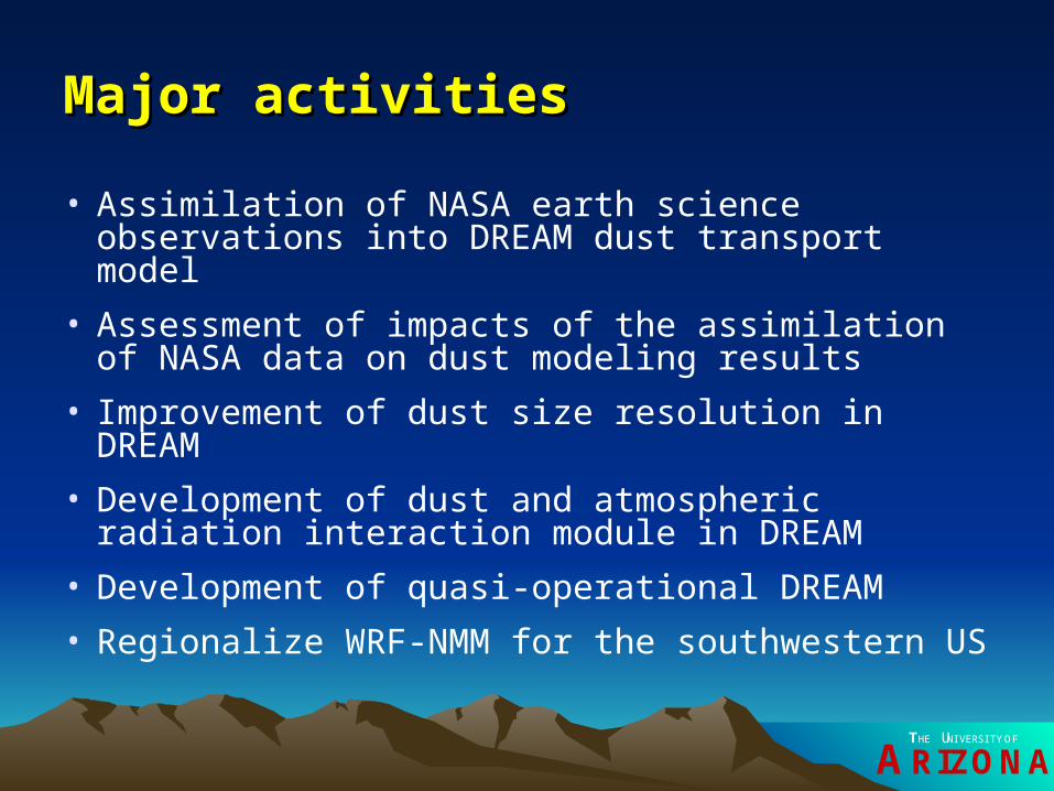
Major activitiesMajor activities
• Assimilation of NASA earth science observations into DREAM dust transport model
• Assessment of impacts of the assimilation of NASA data on dust modeling results
• Improvement of dust size resolution in DREAM
• Development of dust and atmospheric radiation interaction module in DREAM
• Development of quasi-operational DREAM
• Regionalize WRF-NMM for the southwestern US
ARIZONATHE UNIVERSITY OF
Assimilation of NASA data-MODIS land Assimilation of NASA data-MODIS land covercover
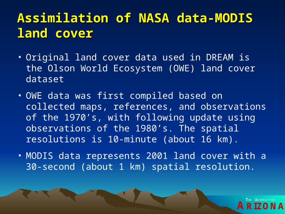
• Original land cover data used in DREAM is the Olson World Ecosystem (OWE) land cover dataset
• OWE data was first compiled based on collected maps, references, and observations of the 1970’s, with following update using observations of the 1980’s. The spatial resolutions is 10-minute (about 16 km).
• MODIS data represents 2001 land cover with a 30-second (about 1 km) spatial resolution.

ARIZONATHE UNIVERSITY OF
Assimilation of NASA data-MODIS land Assimilation of NASA data-MODIS land covercover
• MODIS data
ARIZONATHE UNIVERSITY OF
Assimilation of NASA data-MODIS land Assimilation of NASA data-MODIS land covercover
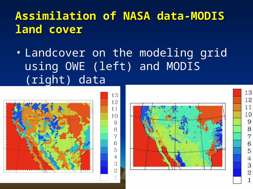
• Landcover on the modeling grid using OWE (left) and MODIS (right) data

ARIZONATHE UNIVERSITY OF
Assimilation of NASA data-SRTM terrain Assimilation of NASA data-SRTM terrain datadata
• Original terrain elevation data used in DREAM is USGS terrain with a 30-second (about 1 km) spatial resolution.
• Shuttle Radar Topography Missions (SRTM) terrain data has spatial resolutions as high as 90 m.
• Because of DREAM model dynamics restriction, model grid spacing normally should not be less than 10 km. SRTM data was reassembled for DREAM with a 30-second spatial resolution.

ARIZONATHE UNIVERSITY OF
Assimilation of NASA data-SRTM terrain Assimilation of NASA data-SRTM terrain datadata
• USGS terrain data (left) and SRTM data (right)

ARIZONATHE UNIVERSITY OF
Assimilation of NASA data-Roughness length Assimilation of NASA data-Roughness length datadata
• Preview of roughness length data

ARIZONATHE UNIVERSITY OF
Assimilation of NASA data-Roughness length Assimilation of NASA data-Roughness length datadata
• Original roughness length in DREAM
– Over sea: Maxi(0.0018U*U*, 1.59E-5)
– Over land: terrain height*0.0001+0.1+Maxi(0.0018U*U*, 1.59E-5)

ARIZONATHE UNIVERSITY OF
Assimilation of NASA data-FPAR dataAssimilation of NASA data-FPAR data
• Using category “barren, desert, or sparsely vegetated” based on FPAR data to pin point dust source area

ARIZONATHE UNIVERSITY OF
Assimilation of NASA data-AMSR-E soil Assimilation of NASA data-AMSR-E soil moisture datamoisture data
• It requires at least two days of the Advanced Microwave Scanning Radiometer for EOS (AMSR-E) data to completely cover our model domain
• An average soil moisture data for the modeling area using Dec 7-15, 2003 AMSR-E data was compiled
• This data was used to initialize soil moisture in DREAM

ARIZONATHE UNIVERSITY OF
Assimilation of NASA data-AMSR-E soil Assimilation of NASA data-AMSR-E soil moisture datamoisture data
• Preview of the average soil moisture data
ARIZONATHE UNIVERSITY OF
Assimilation of NASA data-AMSR-E soil Assimilation of NASA data-AMSR-E soil moisture datamoisture data
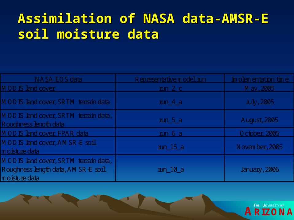
NASA EOS data Representative model run Implementation timeMODIS land cover run_2_c May, 2005
MODIS land cover, SRTM terrain data run_4_a July, 2005
MODIS land cover, SRTM terrain data, Roughness length data
run_5_a August, 2005
MODIS land cover, FPAR data run_6_a October, 2005MODIS land cover, AMSR-E soil moisture data
run_15_a November, 2005
MODIS land cover, SRTM terrain data, Roughness length data, AMSR-E soil moisture data
run_10_a January, 2006

ARIZONATHE UNIVERSITY OF
Assessment of impacts of NASA dataAssessment of impacts of NASA data
MODIS land cover
SRTM terrain
NASA roughness length
FPAR data
AMSR-E soil moisture
run1arun2c Yrun4a Y Yrun5a Y Y Yrun5b Y Y Yrun6a Y Yrun15a Y Yrun10a Y Y Y Y

ARIZONATHE UNIVERSITY OF
Assessment of impacts of NASA dataAssessment of impacts of NASA data
Wind speed-case 1
0.7400.7450.7500.7550.7600.7650.7700.7750.780
run1a
run2c
run4a
run5a
run5b
run6a
run15a
run10a
Wind direction-case1
0.7200.7250.7300.7350.7400.7450.7500.7550.760
run1a
run2c
run4a
run5a
run5b
run6a
run15a
run10a
Temperature-case 1
0.00
0.20
0.40
0.60
0.80
1.00
run1a run2c run4a run5a run5b run6a run15a run10a

ARIZONATHE UNIVERSITY OF
Assessment of impacts of NASA dataAssessment of impacts of NASA data
Wind speed-case 2
0.7250.7300.7350.7400.7450.7500.7550.7600.765
run1a
run2c
run4a
run5a
run5b
run6a
run15a
run10a
Wind direction-case 2
0.720
0.730
0.740
0.750
0.760
0.770
run1a
run2c
run4a
run5a
run5b
run6a
run15a
run10a
Temperature-case 2
0.00
0.20
0.40
0.60
0.80
1.00
run1a
run2c
run4a
run5a
run5b
run6a
run15a
run10a
ARIZONATHE UNIVERSITY OF
Assessment of impacts of NASA dataAssessment of impacts of NASA data
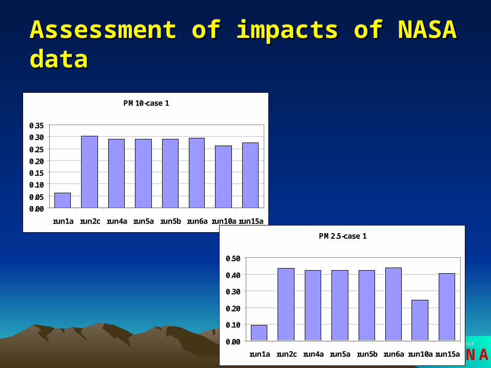
PM10-case 1
0.00
0.05
0.10
0.15
0.20
0.25
0.30
0.35
run1a run2c run4a run5a run5b run6a run10a run15a
PM2.5-case 1
0.00
0.10
0.20
0.30
0.40
0.50
run1a run2c run4a run5a run5b run6a run10a run15a

ARIZONATHE UNIVERSITY OF
Assessment of impacts of NASA dataAssessment of impacts of NASA data
PM2.5-case 2
0.00
0.10
0.20
0.30
0.40
0.50
0.60
0.70
run1a run2c run4a run5a run5b run6a run15a run10a
PM10-case2
0.00
0.05
0.10
0.15
0.20
0.25
run1a run2c run4a run5a run5b run6a run10a run15a

ARIZONATHE UNIVERSITY OF
Improvement of dust size resolution in Improvement of dust size resolution in DREAMDREAM
• Four size categories
Dust category Size bin
(m) Typical particle
radius (m)
Particle density (kg/m3)
Associated soil
component 1 0~3.4 0.73 2500 Clay 2 3.4~12 6.10 2650 small silt 3 12~28 18.00 2650 large silt 4 >28 38.00 2650 Sand

ARIZONATHE UNIVERSITY OF
Improvement of dust size resolution in Improvement of dust size resolution in DREAMDREAM
• Eight size categories k Type Typical particle radius
Rk (m)
Particle density
pk (g cm-3)
Productivity
factor
k
Bagnold param.
kA
1 Clay 0.15 2.50 0.02 1.0
2 Clay 0.25 2.50 0.04 0.9
3 Clay 0.40 2.50 0.15 0.8
4 Clay 0.80 2.50 0.67 0.8
5 Silt 1.50 2.65 1.00 0.7
6 Silt 2.50 2.65 1.00 0.6
7 Silt 4.00 2.65 1.00 0.5
8 Silt 8.00 2.65 1.00 0.4
ARIZONATHE UNIVERSITY OF
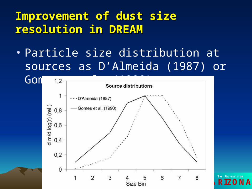
Improvement of dust size resolution in Improvement of dust size resolution in DREAMDREAM
• Particle size distribution at sources as D’Almeida (1987) or Gomes et al. (1990)

ARIZONATHE UNIVERSITY OF
Dust and atmospheric radiation interaction Dust and atmospheric radiation interaction module in DREAMmodule in DREAM
• Dust particles contribute to atmospheric optical thickness (), single-scattering albedo (w), and asymmetry factor (g)
kextk
kkkk QM
r)(
4
3)()(
8
1
8
1
8
1
8
1
)(
)()()(
kk
kkkw
w
8
1
8
1
)()(
)()()()(
kkk
kkkk
w
wgg

ARIZONATHE UNIVERSITY OF
Dust and atmospheric radiation interaction Dust and atmospheric radiation interaction module in DREAMmodule in DREAM
• Obvious dust radiative effects on the surface

ARIZONATHE UNIVERSITY OF
Dust and atmospheric radiation interaction Dust and atmospheric radiation interaction module in DREAMmodule in DREAM
• Negative feedback on atmospheric dust loading

ARIZONATHE UNIVERSITY OF
Dust and atmospheric radiation interaction Dust and atmospheric radiation interaction module in DREAMmodule in DREAM
• Better meteorological fields

ARIZONATHE UNIVERSITY OF
Development of quasi-operational DREAM Development of quasi-operational DREAM systemsystem
• Automatic download of the NCEP’s Global Forecast System (GFS), formerly Aviation (AVN) run of Medium Range Forecast (MRF) data
• GFS files with 12 hour time interval and 2.5 degree grid spacing
• Code to ingest GFS data to generate DREAM initial and boundary conditions
• Forecast wind-blown dust for the Southwest up to 72 hour in the future

ARIZONATHE UNIVERSITY OF
Development of quasi-operational DREAM Development of quasi-operational DREAM systemsystem

ARIZONATHE UNIVERSITY OF
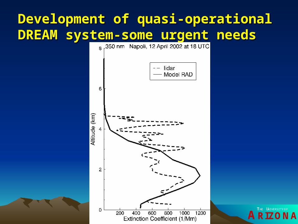
Development of quasi-operational DREAM Development of quasi-operational DREAM system-some urgent needssystem-some urgent needs
• Measurement data for model evaluation
– In-situ meteorological data
– In-situ PM2.5 and PM10
– In-site speciated PM observations
– Satellite images showing dust plumes
– AOT from remote sensing
– 3D dust observed dust concentrations, Lidar observation?
ARIZONATHE UNIVERSITY OF
Development of quasi-operational DREAM Development of quasi-operational DREAM system-some urgent needssystem-some urgent needs
ARIZONATHE UNIVERSITY OF
Development of quasi-operational DREAM Development of quasi-operational DREAM system-some urgent needssystem-some urgent needs
• Updated NASA land cover data to refresh land use in the model

ARIZONATHE UNIVERSITY OF
Development of quasi-operational DREAM Development of quasi-operational DREAM system-some urgent needssystem-some urgent needs
• Dust storm causes two pileups on I-8, Feb 15, 2006

ARIZONATHE UNIVERSITY OF
Development of quasi-operational DREAM Development of quasi-operational DREAM system-some urgent needssystem-some urgent needs
• Dust source differences due to using different land cover data

ARIZONATHE UNIVERSITY OF
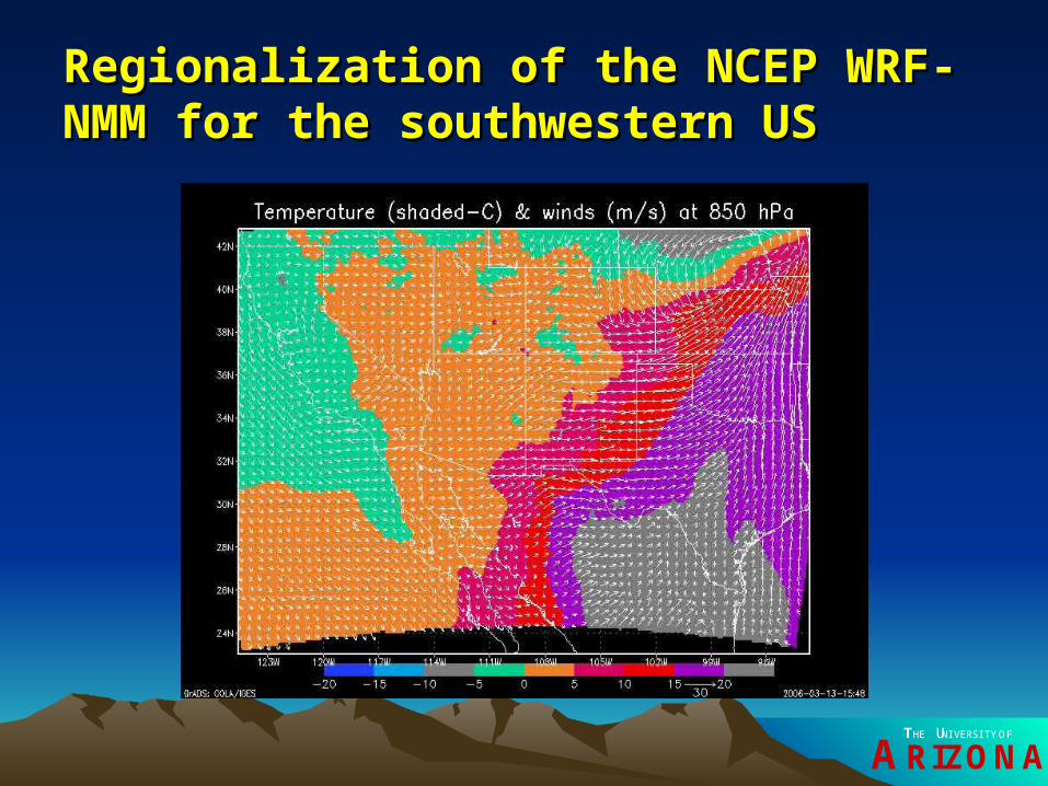
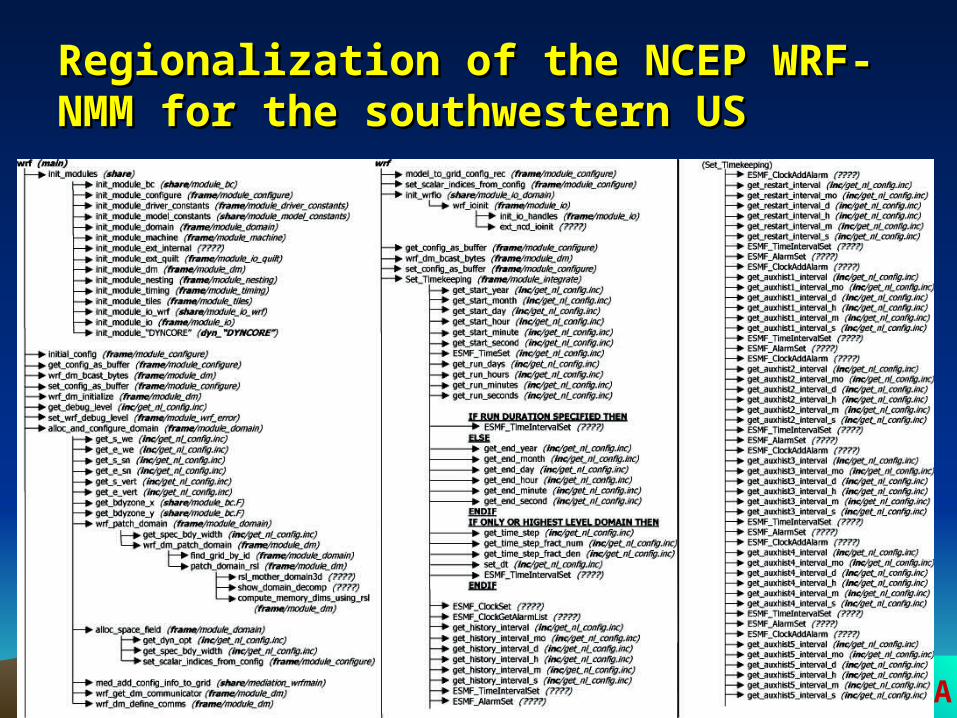
Regionalization of the NCEP WRF-NMM for Regionalization of the NCEP WRF-NMM for the southwestern USthe southwestern US

ARIZONATHE UNIVERSITY OF
Regionalization of the NCEP WRF-NMM for Regionalization of the NCEP WRF-NMM for the southwestern USthe southwestern US
• Central lat 34.02N
• Central lon -108.90
• Grid no. 151*219
• Grid spacing 15 km
ARIZONATHE UNIVERSITY OF
Regionalization of the NCEP WRF-NMM for Regionalization of the NCEP WRF-NMM for the southwestern USthe southwestern US
ARIZONATHE UNIVERSITY OF
Regionalization of the NCEP WRF-NMM for Regionalization of the NCEP WRF-NMM for the southwestern USthe southwestern US

ARIZONATHE UNIVERSITY OF
Regionalization of the NCEP WRF-NMM for Regionalization of the NCEP WRF-NMM for the southwestern USthe southwestern US

ARIZONATHE UNIVERSITY OF
Regionalization of the NCEP WRF-NMM for Regionalization of the NCEP WRF-NMM for the southwestern USthe southwestern US
ARIZONATHE UNIVERSITY OF
AcknowledgementAcknowledgement
• Marvin Landis –visualization
• Jim Koermer of Plymouth State University-met observational data and met analysis products
• weather.unisys.com-surface weather maps
• www.rnrcc.tx.us- satellite images
• US EPA-AQS PM data

ARIZONATHE UNIVERSITY OF
Working for public health!Working for public health!
(Picture by courtesy of Mike Moran)


![Dust Control Handbook for Industrial Minerals Mining … · Countess Environmental [2006]. WRAP fugitive dust handbook. WGA Contract #:30204-111. Western Governors Association, Denver,](https://img.dokumen.tips/doc/110x75/5b8584fa7f8b9ae0498e660e/dust-control-handbook-for-industrial-minerals-mining-countess-environmental.jpg)