Embed Size (px)
Citation preview

Petrology and Reservoir Paragenesis in the Sussex "B" Sandstone of the Upper Cretaceous Cody Shale, House Creek and Porcupine Fields, Powder River Basin, Wyoming
U.S. GEOLOGICAL SURVEY BULLETIN 191 7-G

AVAILABILITY OF BOOKS AND MAPS OF THE U.S. GEOLOGICAL SURVEY
Instructions on ordering publications of the U.S. Geological Survey, along with the last offerings, are given in the current-year issues of the monthly catalog "New Publications of the U.S. Geological Survey." Prices of available U.S. Geological Survey publications released prior to the current year are listed in the most recent annual "Price and Availability List." Publications that are listed in various U.S. Geological Survey catalogs (see back inside cover) but not listed in the most recent annual "Price and Availability List" are no longer available.
Prices of reports released to the open files are given in the listing "U.S. Geological Survey Open-File Reports," updated monthly, which is for sale in microfiche from the U.S. Geological Survey Books and Open-File Reports Sales, Box 25425, Denver, CO 80225.
Order U.S. Geological Survey publications by mail or over the counter from the offices given below.
BY MAIL
Books
Professional Papers, Bulletins, Water-Supply Papers, Tech niques of Water-Resources Investigations, Circulars, publications of general interest (such as leaflets, pamphlets, booklets), single copies of periodicals (Earthquakes & Volcanoes, Preliminary De termination of Epicenters), and some miscellaneous reports, includ ing some of the foregoing series that have gone out of print at the Superintendent of Documents, are obtainable by mail from
U.S. Geological Survey, Books and Open-File Report SalesBox 25425
Denver, CO 80225
Subscriptions to periodicals (Earthquakes & Volcanoes and Preliminary Determination of Epicenters) can be obtained ONLY from
Superintendent of DocumentsU.S. Government Printing Office
Washington, DC 20402
(Check or money order must be payable to Superintendent of Documents.)
Maps
For maps, address mail order to
U.S. Geological Survey, Map SalesBox 25286
Denver, CO 80225
Residents of Alaska may order maps from
U.S. Geological Survey, Map Sales101 Twelfth Ave., Box 12
Fairbanks, AK 99701
OVER THE COUNTER
Books
Books of the U.S. Geological Survey are available over the counter at the following U.S. Geological Survey offices, all of which are authorized agents of the Superintendent of Documents.
ANCHORAGE, Alaska-4230 University Dr., Rm. 101
ANCHORAGE, Alaska-605 West 4th Ave., Rm G-84
DENVER, Colorado-Federal Bldg., Rm. 169,1961 Stout St.
LAKEWOOD, Colorado-Federal Center, Bldg. 810
MENLO PARK, California-Bldg. 3, Rm. 3128,345 Middlefield Rd.
RESTON, Virginia-National Center, Rm. 1C402, 12201 Sunrise Valley Dr.
SALT LAKE CITY, Utah-Federal Bldg., Rm. 8105,125 South State St.
SAN FRANCISCO, California-Customhouse, Rm. 504, 555 Battery SL
SPOKANE, Washington-U.S. Courthouse, Rm. 678, West 920 Riverside Ave.
WASHINGTON, D.C-U.S. Department of the Interior Bldg., Rm. 2650, 1849 C St., NW.
Maps
Maps may be purchased over the counter at the U.S. Geolog ical Survey offices where books are sold (all addresses in above list) and at the following Geological Survey offices:
ROLLA, Missouri-1400 Independence Rd.
FAIRBANKS, Alaska-New Federal Building, 101 Twelfth Ave.

Chapter G
Petrology and Reservoir Paragenesis in the Sussex "B" Sandstone of the Upper Cretaceous Cody Shale, House Creek and Porcupine Fields, Powder River Basin, Wyoming
By DEBRA K. HIGLEY
A multidisciplinary approach to research studies of sedimentary rocks and their constituents and the evolution of sedimentary basins, both ancient and modern
U.S. GEOLOGICAL SURVEY BULLETIN 1917
EVOLUTION OF SEDIMENTARY BASINS POWDER RIVER BASIN
U.S. DEPARTMENT OF THE INTERIOR
MANUEL LUJAN, JR., Secretary
U.S. GEOLOGICAL SURVEY
Dallas L. Peck, Director
Any use of trade, product, or firm names in this publication is for descriptive purposes only and does not imply endorsement by the U.S. Government
UNITED STATES GOVERNMENT PRINTING OFFICE: 1992
For sale by theBooks and Open-File Reports SectionU.S. Geological SurveyFederal CenterBox 25425Denver, CO 80225
Library of Congress Cataloging-in-Publication Data
Higley, Debra K.Petrology and reservoir paragenesis in the Sussex "B" sandstone of the Upper
Cretaceous Cody Shale, House Creek and Porcupine fields, Powder River Basin, Wyoming/by Debra K. Higley.
p. cm. (Evolution of sedimentary basins Powder River Basin ; ch. G) (U.S. Geological Survey bulletin ; 1917 G)
"A multidisciplinary approach to research studies of sedimentary rocks and their constituents and the evolution of sedimentary basins, both ancient and modern."
Includes bibliographical references.1. Petroleum Geology Powder River Basin (Wyo. and Mont.). 2. Oil
fields Powder River Basin (Wyo. and Mont). 3. Sandstone Powder River Basin (Wyo. and Mont.) I. Title. II. Series. III. Series: U.S. Geological Survey bulletin ; 1917-G. QE75.B9 no. 1917-G [TN870.5] 557.3 s dc20[553.2'8'097863] 91-24130
CIP

CONTENTSAbstract Gl Introduction Gl Geologic setting G3 Sandstone diagenesis G3
Reservoir paragenesis G4Porosity relationships G5
Petrologic characteristics of sandstone fades G7 Inter-ridge facies G10
Inter-ridge sandstone and siltstone G10 Wavy-bedded inter-ridge sandstone G12
Ridge-margin and central-ridge sandstone G13 Low-energy ridge-margin sandstone G13 Central-ridge and high-energy ridge-margin sandstone G13
Chert pebble sandstone G14 Conclusions G15 Acknowledgments G15 References cited G15
FIGURES
1. Index and structure contour map of the Powder River Basin, Wyoming andMontana G2
2-3. Charts showing:2. Stratigraphic nomenclature of Upper Cretaceous and Tertiary rocks,
Powder River Basin G33. Generalized paragenetic sequence, Sussex "B" sandstone G5
4 5. SEM photomicrographs of:4. Sussex "B" sandstone porosity relationships G65. Authigenic clays, Sussex "B" sandstone G7
6. Crossplots of relationships between porosity, permeability, and cements, Sussex "B" sandstone G8
7. Thin section photomicrographs showing sandstone petrology and diagenesis G9
8. Sedimentologic, petrologic, and reservoir characteristics of Sussex "B"sandstone facies Gil
9 10. Thin section photomicrographs of:9. Compaction and cementation relationships in inter-ridge facies G12
10. Porosity reduction in low-energy ridge-margin sandstones G13
TABLES
1. Names and locations of wells sampled for petrographic analysis G42. Selected thin-section point-count data G4
Contents III


EVOLUTION OF SEDIMENTARY BASINS-POWDER RIVER BASIN
Petrology and Reservoir Paragenesis in the Sussex "B" Sandstone of the Upper Cretaceous Cody Shale, House Creek and Porcupine Fields, Powder River Basin, Wyoming
ByDebra K. Higley
Abstract
Oil is produced in the House Creek and Porcupine fields in the Powder River Basin from central-ridge and ridge-margin facies of the Sussex "B" sandstone, Sussex Sandstone Member of the Upper Cretaceous Cody Shale. Mudstone forms over lying and updip reservoir seals in these fields. Hydrocarbons are also trapped by a thin, areally discontinuous chert pebble sandstone that may represent an unconformity surface.
Macroscopic reservoir heterogeneity results from inter- bedding of reservoir sandstones with inter-ridge and low- energy ridge-margin sandstones. This interbedding forms sed- imentologic permeability boundaries that isolate and compartmentalize individual sand bodies. Ductile deforma tion of glauconite, which is concentrated in reservoir sand stone trough cross-bedding ripple laminae, results in minor permeability boundaries to fluid flow.
Microscopic heterogeneity and porosity loss in the Sussex "B" sandstone results primarily from highly variable amounts and distributions of quartz and calcite cements. Minus-cement porosity that averages 30.2 percent for non- bioturbated sandstones suggests a compactional volume decrease of 5-10 percent porosity prior to lithification. Compactional processes in the Sussex "B" sandstone are important only in bioturbated sandstone these are found in mainly inter-ridge and low-energy ridge-margin depositional environments.
Oil-producing sandstones are commonly cemented by quartz, which averages about 8 volume percent of the rock. These sandstones contain only minor amounts of carbonate cement. However, the volumetrically most important cement
Manuscript approved for publication May 3, 1991.
in non-productive Sussex "B" sandstone is calcite. Authigenic kaolinite, illite-smectite, and chlorite influence reservoir properties by occluding pore spaces and pore throats. Most porosity in reservoir sandstones is primary; however, secon dary porosity is created by dissolution of plagioclase and other unstable lithic grains and by dissolution of carbonate cements that filled pore spaces and replaced lithic grains and over growths. Microporosity is present within chert grains and clays.
INTRODUCTION
Using petrologic and sedimentologic studies, this paper characterizes the influence of sedimentologic and petrologic variations on reservoir heterogeneity in the Sus sex "B" sandstone in the House Creek and Porcupine fields, Powder River Basin, Wyoming. Effects of authigenic min erals on reservoir properties are described in detail for selected inter-ridge and ridge facies sandstones.
The House Creek and Porcupine fields are about 1 mi (1.6 km) wide and have a combined length of more than 36 mi (58 km). The fields form a major ridge system that is composed mainly of coalescing small- to medium-scale subaqueous dunes. The House Creek and Porcupine fields, and the ridge facies they outline, trend about N. 40° W., approximately parallel to basin structure contours (fig. 1).
The Sussex "B" sandstone is as much as 45 ft (14 m) thick, ranges in depth from about 7,000 to 9,000 ft (2,100-2,700 m), and is one of as many as twelve separate sandstone bodies that are located at different vertical and lateral positions within the Sussex Sandstone Member of the Upper Cretaceous Cody Shale (Anderman, 1976; Crews and
Petrology and Reservoir Paragenesis in Sussex "B" Sandstone G1

CARTER
45°
44°
43°
Sheridan
SHERIDAN
Outcrops of the LanceFormation and
Fox Hills Sandstone
Location of the Powder River Basin
107°
30 miles 30 kilometers
105°
Contour interval 500 feet
Figure 1. Powder River Basin structure map. Contours drawn on the top of the Sussex Sandstone Member of the Upper Cretaceous Cody Shale and its equivalents. Locations of the Salt Creek outcrop (large arrow) and House Creek and Porcupine fields are shown. Datum is mean sea level.
others, 1976). Oil is stratigraphically trapped in the Sussex "B" sandstone by overlying mudstone and ferroan calcite- cemented sandstone and by a lateral change from permeable sandstone to relatively impermeable mudstone. Approxi mately 21 million barrels of oil (MMBO) and 19 million
cubic feet of gas (MMCFG) have been produced from the House Creek field, and more than 3 MMBO and 5 MMCFG have been produced from all reservoirs within the Porcupine field (as of December 1989). Porcupine field production is from the Muddy Sandstone Member of the Lower
G2 Evolution of Sedimentary Basins-Powder River Basin

Ma
1.6- 5 -
24-
37.5.
55-
66-
78-
96-
ERATHEM
CENOZOIC (PART)
| MESOZOIC (PART)
SYSTEM/.QPRIFQ
TERTIARY
I CRETACEOUS (PART)
PLIOCENE
MIOCENE
OLIGOCENE
EOCENE
PALEOCENE
WIDo iLJJ :O s<
LJJ DC O
DC UJO. O.13
POWDER RIVER BASIN
WEST
White River Formation
IWasatch Fm.Wv^*v*v*'/V*V"vN'\*
S
Fort Union Fm.
Lance Fm.Fox Hills Ss.Lewis ShaleMesaverde Formation
Sussex Ss. Mem./
Shannon Ss. Mem./
CodyShale
A,
FrontierFormation
Mowry Shale
EAST
White River Formation
Wasatch Fm./\<*V*v*v**W*vVv*v*v
Fort Union Fm.
Lance Fm.Fox Hills Ss.
Pierre Shale
Niobrara Fm. VWWv^vV***vN/
Carlile ShaleGreenhorn Fm.Belle Fourche Sh.
Mowry Shale
Figure 2. Generalized stratigraphic section showing nomen clature and correlations of Upper Cretaceous and Tertiary rocks in the Powder River Basin of Wyoming and Montana. Unconformities indicated by vertical ruled pattern and (or) jagged lines.
Cretaceous Thermopolis Shale, the Sussex "B" sandstone, and the Turner Sandy Member of the Upper Cretaceous Carlile Shale (fig. 2) (Lawyer and others, 1981). The mean reservoir porosity and permeability of pay sandstones in the House Creek field are 13 percent and 15 millidarcies (md), and the thickness of perforated sandstones ranges from 2 to 32 ft (0.6-10 m) (Sabel, 1985). Reservoir porosity in the Porcupine field is 8-12 percent (Lawyer and others, 1981).
Facies assignments were determined from outcrop and core studies and by correlation of stratigraphic data to geophysical well logs. Sussex "B" core from 21 wells was described (Higley, 1988); these cores are located at the U.S. Geological Survey core library in Denver, Colorado. Cores from 10 wells located in and near the House Creek and Porcupine oil fields were sampled for petrographic analysis (table 1). Thin sections of 54 samples, X-ray diffraction analyses, and scanning electron microscope studies were used to determine reservoir paragenesis, sandstone porosity, and mineralogic constituents of the Sussex "B" sandstone in the study area.
GEOLOGIC SETTING
The Powder River Basin is a Laramide-style struc tural basin with a steeply dipping western flank and a gently dipping eastern flank. The Cody Shale, including the Sussex Sandstone Member and its equivalents, underlies most of the basin and outcrops along the western flank, west of the Lance Formation and Fox Hills Sandstone outcrops shown on figure 1. Sandstone body and basin geometry indicate that the Sussex "B" sandstone was deposited as a narrow, low-relief, marine ridge complex in a shallow, offshore marine setting within the narrow Campanian seaway (Asquith, 1970; Berg, 1975; Hobson and others, 1982). This seaway extended from the Arctic to the Gulf of Mexico.
Sussex Sandstone Member deposition may represent transgressive marine reworking by oceanic, storm, and tidal currents of residual sand sheets that were deposited during a previous progradation (Hobson and others, 1982). Berg (1975), Brenner (1978), and Hobson and others (1982) believe that the Sussex Sandstone Member was deposited more than 100 mi (160 km) east of the Upper Cretaceous Eagle Sandstone shoreline as marine topsets in a pro- gradation of marine shelf, slope, and basin sediments. Hobson and others (1982) further postulate that the sources of the sandstone for the Sussex Sandstone Member were the nearshore marine and deltaic sediments of the Eagle Sandstone. Brenner (1978) used core and well-log studies to hypothesize that Sussex Sandstone Member ridge facies were reworked and shaped by storm and tidal currents. Deposition in water as deep as 100-200 ft (30-60 m) is inferred based on Haplophragmoides and Reophax fora- miniferal tests (Berg, 1975) and on the presence of trace fossils from oxygenated water (including Skolithos, Chon- drites, Diphcraterion, and Arenicolites). Asquith (1970) inferred water depths as shallow as 50 ft (15 m) for sandstone deposition.
SANDSTONE DIAGENESIS
The Sussex "B" sandstone is a very fine to medium- grained litharenite to feldspathic litharenite (Folk, 1970). Reservoir sandstones are composed of moderately sorted to fairly well sorted subangular to subrounded grains that commonly exhibit well-developed quartz overgrowths. Included in table 2 are average volume percentages of minerals and rock fragments determined from point-count data of 54 thin sections for all sedimentary facies of the Sussex "B" sandstone in the area of the House Creek and Porcupine fields. Porosity and mineralogic determinations were derived from more than 300 point-count measure ments. Thin sections were stained for calcite, potassium feldspar, plagioclase, and iron. Mineralogical compositions were verified by X-ray diffraction and SEM analysis.
Petrology and Reservoir Paragenesis in Sussex "B" Sandstone G3
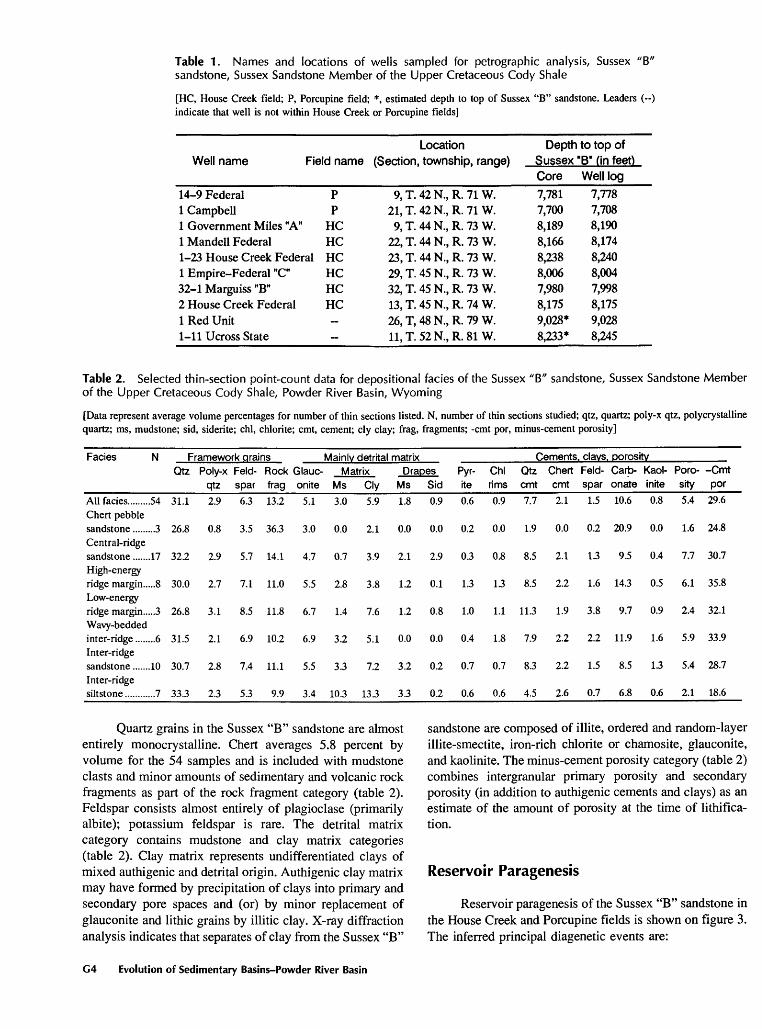
Table 1. Names and locations of wells sampled for petrographic analysis, Sussex "B" sandstone, Sussex Sandstone Member of the Upper Cretaceous Cody Shale
[HC, House Creek field; P, Porcupine field; *, estimated depth to top of Sussex "B" sandstone. Leaders (--) indicate that well is not within House Creek or Porcupine fields]
Well nameLocation
Field name (Section, township, range)Depth to top of
Sussex *B* fin feet)
14-9 Federal1 Campbell1 Government Miles "A"1 Mandell Federal1-23 House Creek Federal1 Empire-Federal "C"32-1 Marguiss "B"2 House Creek Federal1 Red Unit1-1 lUcross State
PP
HCHCHCHCHCHC--
9,T.42N.,R.71W.21,T.42N,R.71W.
9, T. 44 N., R. 73 W.22, T. 44 N., R. 73 W.23, T. 44 N., R. 73 W.29, T. 45 N., R. 73 W.32, T. 45 N., R. 73 W.13, T. 45 N., R. 74 W.26, T, 48 N., R. 79 W.11,T.52N.,R.81W.
Core7,7817,7008,1898,1668,2388,0067,9808,1759,028*8,233*
Well log7,7787,7088,1908,1748,2408,0047,9988,1759,0288,245
Table 2. Selected thin-section point-count data for depositional facies of the Sussex "B" sandstone, Sussex Sandstone Member of the Upper Cretaceous Cody Shale, Powder River Basin, Wyoming
[Data represent average volume percentages for number of thin sections listed. N, number of thin sections studied; qtz, quartz; poly-x qtz, polycrystalline quartz; ms, mudstone; sid, siderite; chl, chlorite; cmt, cement; cly clay; frag, fragments; -cmt por, minus-cement porosity]
Facies N Mainly detrital matrix Cements, clays, porosityFramework grains _______________ _____________ Qtz Poly-x Feld- Rock Glauc- Matrix Drapes Pyr- Chl Qtz Chert Feld- Carb- Kaol- Poro- -Cmt
______________qtz spar frag onite Ms Cly Ms Sid ite rims cmt cmt spar onate inite sity por
All facies.........54 31.1 2.9 6.3 13.2 5.1 3.0 5.9 1.8 0.9 0.6 0.9 7.7 2.1 1.5 10.6 0.8 5.4 29.6Chert pebblesandstone .........3 26.8 0.8 3.5 36.3 3.0 0.0 2.1 0.0 0.0 0.2 0.0 1.9 0.0 0.2 20.9 0.0 1.6 24.8Central-ridgesandstone .......17 32.2 2.9 5.7 14.1 4.7 0.7 3.9 2.1 2.9 0.3 0.8 8.5 2.1 13 9.5 0.4 7.7 30.7High-energyridge margin.....8 30.0 2.7 7.1 11.0 5.5 2.8 3.8 1.2 0.1 1.3 1.3 8.5 2.2 1.6 14.3 0.5 6.1 35.8Low-energyridge margin.....3 26.8 3.1 8.5 11.8 6.7 1.4 7.6 1.2 0.8 1.0 1.1 11.3 1.9 3.8 9.7 0.9 2.4 32.1Wavy-beddedinter-ridge ........6 31.5 2.1 6.9 10.2 6.9 3.2 5.1 0.0 0.0 0.4 1.8 7.9 2.2 2.2 11.9 1.6 5.9 33.9Inter-ridgesandstone .......10 30.7 2.8 7.4 11.1 5.5 3.3 7.2 3.2 0.2 0.7 0.7 8.3 2.2 1.5 8.5 13 5.4 28.7Inter-ridgesiltstone............7 33.3 2.3 5.3 9.9 3.4 103 13.3 3.3 0.2 0.6 0.6 4.5 2.6 0.7 6.8 0.6 2.1 18.6
Quartz grains in the Sussex "B" sandstone are almost entirely monocrystalline. Chert averages 5.8 percent by volume for the 54 samples and is included with mudstone clasts and minor amounts of sedimentary and volcanic rock fragments as part of the rock fragment category (table 2). Feldspar consists almost entirely of plagioclase (primarily albite); potassium feldspar is rare. The detrital matrix category contains mudstone and clay matrix categories (table 2). Clay matrix represents undifferentiated clays of mixed authigenic and detrital origin. Authigenic clay matrix may have formed by precipitation of clays into primary and secondary pore spaces and (or) by minor replacement of glauconite and lithic grains by illitic clay. X-ray diffraction analysis indicates that separates of clay from the Sussex "B"
sandstone are composed of illite, ordered and random-layer illite-smectite, iron-rich chlorite or chamosite, glauconite, and kaolinite. The minus-cement porosity category (table 2) combines intergranular primary porosity and secondary porosity (in addition to authigenic cements and clays) as an estimate of the amount of porosity at the time of lithifica- tion.
Reservoir Paragenesis
Reservoir paragenesis of the Sussex "B" sandstone in the House Creek and Porcupine fields is shown on figure 3. The inferred principal diagenetic events are:
G4 Evolution of Sedimentary Basins-Powder River Basin

BURIAL HISTORY EARLY MIDDLE LATE
Compaction
Quartz Cement
Carbonate Cement
Alteration of Lithics
Chlorite, Pyrite Glauconite,
Plagioclase Cement, Albitization
Oil Generation and Migration, Pyrite
Kaolinite, Illite-Smectite
( i
Figure 3. Generalized paragenetic sequence of the Upper Cretaceous Sussex "B" sandstone in the House Creek and Porcupine fields. Dashed line indicates dissolution of calcite and ferroan calcite cements.
1. Calcite precipitated during two major diagenetic events and is present primarily as poikilotopic crystals (fig. 4C). Siderite cementation occurred during the very early com- pactional history of the Sussex "B" sandstone. Dolomite and rare ankerite precipitated during the later stage of carbonate cementation and commonly occur as scattered rhombs. The average for all facies of 10.6 volume percent carbonate cement includes a mean 8.6 percent calcite and ferroan calcite and 2.0 percent dolomite and ferroan dolomite (determined from thin sections stained for calcite and iron).2. An early stage of quartz cementation is characterized by minor syntaxial overgrowths, many of which are meniscal in appearance. Early quartz precipitation is interrupted by cementation by poikilotopic and radial-fibrous calcite.3. Glauconite grains represent early diagenetic alteration of fecal pellets and biotite. The presence of glauconite, in addition to pyrite and chlorite, indicates reducing conditions in marine pore fluids.4. Pyrite as framboids and minor euhedral crystals is present within organic-rich mudstone laminae and later hydrocarbons.5. Rims of chlorite grow perpendicular to quartz grain surfaces. Chlorite crystals coat grains, are intergrown with, and may partially replace the quartz overgrowths of stage 6, below.6. Syntaxial quartz overgrowths precipitate (figs. 4, 5A). This represents the major quartz cementation event.7. Authigenic feldspar is present as plagioclase over growths on albite grains and as minor amounts of pore-
filling cement. Grains and overgrowths commonly exhibit albite twinning. Most albite appears detrital; however, chessboard twinning of some grains indicates albitization. Dissolution of plagioclase occurred during two stages: the first stage occurred prior to overgrowth formation, and the second stage may be related to changes in pore fluids that were associated with hydrocarbon generation and migra tion. Plagioclase may exhibit extensive replacement by calcite and dolomite cements; replacement by calcite occurred during both stages of carbonate cementation.8. Oil from the House Creek and Porcupine fields migrated updip and up-fracture during early Eocene to Miocene time (Nuccio, 1990; Momper and Williams, 1984). Cores of organic-rich marine shale, adjacent to the Sussex "B" sandstone, were sampled from 6 locations across the fields. Samples range in depth from 7,776 to 9,803 ft (2,370-2,988 m). Vitrinite reflectance values range from 0.51 to 0.58 percent, suggesting that hydrocarbon source rocks are only marginally mature for oil generation.9. Following the onset of oil migration, kaolinite and minor amounts of associated illite-smectite precipitated in pore spaces (figs. 4, 5).
Porosity Relationships
Porosity and permeability increase generally upward from inter-ridge to central-ridge facies, reflecting deposi- tional energy trends in the Sussex "B" sandstone. Increase in porosity is usually accompanied by an increase in
Petrology and Reservoir Paragenesis in Sussex "B" Sandstone G5

permeability, although scatter in the data is considerable (fig. 6A). Porosity relationships are complex petrology and diagenesis may vary greatly across small distances. The greatest amounts of porosity are present in central-ridge and high-energy ridge-margin facies. Lower depositional energy facies may contain moderate amounts of porosity; however, these thin, porous beds exhibit a spotty distribution and sedimentologic isolation that precludes their development as reservoir sandstones. Vertical stacking of thin beds of carbonate-cemented and non-cemented zones is common in the Sussex "B" sandstone; this may reflect isolation of cemented zones from migrating fluids that dissolved carbonate cements in other sandstone beds.
Porosity is mainly of the primary intergranular type; however, secondary porosity is present as corroded and dissolved lithic grains, and microporosity exists within chert and clays (fig. 4). Intergranular plus intragranular porosity in studied thin sections may total as much as 17.5 percent.
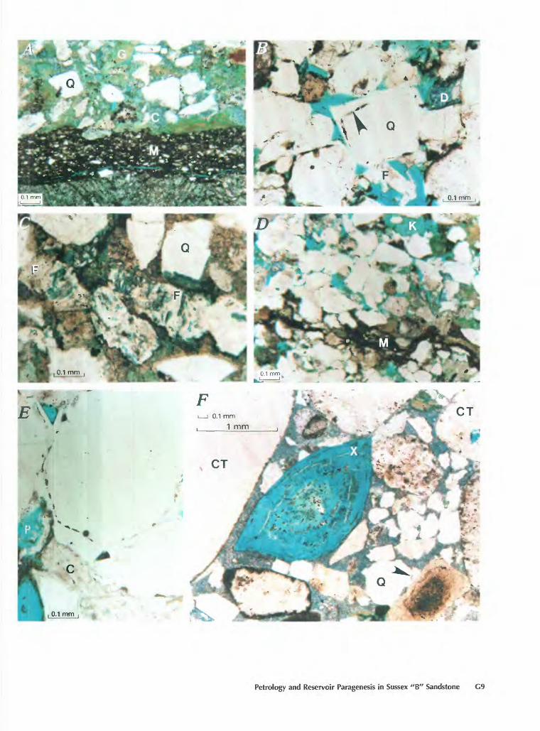
Figure 4 (above and facing column). SEM photomicrographs of: A, fine- to medium-grained trough cross-bedded sandstone from an oil-productive interval at 8,197.5 ft (2,498.6 m), No. 1 Government Miles "A" well. Sandstone has well-developed quartz overgrowths and moderate intergranular porosity (17.5 percent thin-section porosity). Porosity is mostly primary; however, secondary porosity results from dissolution of lithic grains (rim of chlorite and illitic clay (I)), and microporosity is present within clays. X is a fossil fragment. B, Close-up view of figure 4A shows a pore (P), adjacent quartz overgrowth and grain, a fossil fragment (X), and kaolinite. C, Poikilotopic calcite cement fills the pore space (P) in this inter-ridge sandstone from the No. 14-9 Federal well. Later chlorite rosettes and pyrite framboids (F) are present on calcite.
Average porosity for all studied thin sections is 5.2 percent; 3.4 percent of this is primary intergranular, and as much as 1.9 percent is secondary and intragranular porosity. Average porosity values for Sussex "B" facies are listed in table 2. Thin-section porosity values are lower than core and average reservoir porosity values for two main reasons: (1) Microporosity is not included in thin-section estimates but is measured by core analysis. The amount of microporosity may be considerable because clays comprise an average of 12 percent by volume of the Sussex "B." The percentage of microporosity should decrease up-section because the amounts of suspended-load sediment and most clays decrease upward. (2) Three-dimensional effects of thin sections influence point-count results.
Sussex "B" sediment compaction was slowed by two processes: early calcite cementation and later formation of quartz overgrowths (fig. 3). Pry or (1973) analyzed porosity and permeability within unconsolidated beach sands of the Gulf Coast and found that depositional porosity of beach sands ranges from 39 to 56 percent, decreasing rapidly with burial. Initial porosity within central-ridge facies sandstone was probably 35-40 percent. Sussex "B" sandstone samples that contain the early calcite cement have minus-cement porosity (MCP) values of as much as 50.2 percent in this
G6 Evolution of Sedimentary Basins-Powder River Basin

case, calcite cement is 46.2 volume percent. This MCP value is misleading because early calcite within some intervals is moderately to highly displacive (fig. 7A), and calcite also partly to totally replaced some lithic grains. This results in substantial overestimation of porosity at the time of early calcite cementation. Diagenesis is commonly "frozen" within units that contain pervasive early calcite cement, suggesting that some permeability is required for calcite dissolution and for precipitation of later authigenic minerals.
Two periods of quartz cementation are shown on figure 3. Early quartz cementation is characterized by scattered, minor, poorly developed overgrowths; later over growths are well-developed and commonly have grain- coating chlorite rims (figs. IB, IE). Some sandstone beds contain pervasive quartz cement (more than 12 volume percent) and display minimal evidence of prior cementation by calcite (fig. 6B). Therefore, the average 30 percent MCP in these intervals reflects porosity at the time of quartz
Figure 5 (above and facing column). SEM photomicrographs of authigenic clays in Sussex "B" sandstone. A, Chlorite rims a quartz grain in oil-productive central-ridge facies sandstone from 8,171.3 ft. (2,490.6m) depth, No. 1 Mandell Federal oil well. Quartz cement (O) overlies, and is intergrown with, chlorite. Quartz overgrowths have well-defined crystal faces that interlock and coalesce. B, Illite-smectite coats a pore; sample is from No. 1 Campbell well at a depth of 7,723.7 ft (2,354.2 m) in a planar-tabular cross-bedded ridge-margin sandstone. Close-up view is located within inset. C, Kaolinite covers a fractured quartz grain (Q) and fills porosity in a wavy-bedded inter-ridge sandstone at 8,245 ft. (2,513 m) depth in the No. 1-23 House Creek Federal well. Minor amounts of illitic clay are present as "wispy" coatings on grains and kaolinite.
cementation. Also, those intervals with the greatest porosity are generally quartz cemented and contain only minor amounts of calcite cement (fig. 6C). Dissolution of pore- filling and replacive carbonate cements near maximum burial depths restored primary porosity and created locally extensive secondary porosity.
A second stage of carbonate cementation followed precipitation of well-developed quartz and feldspar over growths (fig. IE). Samples that exhibit this stage of carbonate cementation commonly contain intermediate amounts of the quartz and later calcite cements and are shown near the center of figure 6B. These later calcite and ferroan carbonate cements are commonly poikilotopic, with minor rhombs, and may be highly replacive of feldspar grains and overgrowths, glauconite, and rock fragments.
PETROLOGIC CHARACTERISTICS OF SANDSTONE FACIES
Facies assignments are based on core, well log, and outcrop studies. They are partly based on an evaluation of the Shannon Sandstone Member (fig. 2) in the Powder River Basin (Tillman and Martinsen, 1984) and on the Sussex Sandstone Member facies descriptions of Berg (1975) (fig. 8). The Sussex "B" sandstone is generally composed of
Petrology and Reservoir Paragenesis in Sussex "B" Sandstone G7

1000
CO UJo 10 °DC
O
^ 10
t 1.0
mUJ
0.1
0.01
,..:'-:.* " --T.JKV. -. Jmy *:
». '*" %i "1 " *^t *^« " yfX'wWi * "sKKL*ifV;^ ' irtW* '^t * * .. p-jiwjsfr*-1:-:-/-"-
5 10 15 20
POROSITY, IN PERCENT25
Figure 6 (facing column). Crossplots showing porosity, per meability, and cement relationships. A, Increase in core porosity is generally accompanied by increasing permeability, although considerable scatter is present. Graph represents core porosity and permeability for 792 samples of Sussex "B" sandstone from 30 drillholes across the study area. B and C, Volume percentages of intergranular plus intragranular porosity and quartz and calcite cements were determined for 54 samples by thin-section petrology methods. Amounts of cements are highly variable, although certain trends are present. B, The central-ridge and high-energy ridge-margin reservoir facies generally contain 8 percent or greater quartz cement and highly variable amounts of calcite cement. Samples that contain large amounts of quartz cement (more than 1 2 percent) commonly have minimal calcite and ferroan calcite cement. C, Amounts of calcite cement in excess of 15 percent are generally associated with low porosity. Quartz- cemented sandstone with minor cementation by calcite exhibits the greatest porosity within these intervals, calcite cementation was minor, or porosity was restored by extensive late-stage dissolution of calcite.
25
UJ
20-
15-
10 -
5-
0-
B RESERVOIR FACIESa NON-RESERVOIR FACIES
- °f
0 10 20 30 40 50
CALCITE CEMENT, IN VOLUME PERCENT
50
(/)I- 40-^
UJ
UJ OyUJDC 30-|
Q-J 20-
10-
0 -
. C D QUARTZ CEMENT CALCITE CEMENT
a D
0° . D° n a
o"a
0 10 20
THIN-SECTION POROSITY, IN VOLUME PERCENT
Figure 7 (facing page). Photomicrographs showing para- genesis and porosity evolution in the Sussex "B" sandstone. Ferroan carbonates are stained blue. Blue epoxy fills pore spaces. Scale bars are 0.1mm. Transmitted light. A, Precipitation of "early" radial-fibrous calcite (C) results in a moderately replacive and highly displacive fabric with "floating" quartz grains (Q), minor deformation of glauconite (G) and mudstone clasts (M), and very low porosity (which is present as shrinkage cracks in mudstone and glauconite). The chevron pattern below the mudstone results from nucleation of calcite within mudstone layers and separation of laminae. This high-energy ridge-margin sandstone is at 7,723.7 ft (2,354.2 m) depth in the No. 1 Campbell well. B, Oil-stained chlorite rims are beneath well-developed quartz overgrowths (arrow) in this sandstone from 8,012.7 ft (2,442.3 m) depth, No. 1 Empire-Federal "C" well. Remnants of late dolomite (D) partly fill pores. Authigenic albite (F) is located within a secondary pore space. C, Ferroan calcite (dark blue) peripherally replaces grains and fills dissolution pores in plagioclase (F). This inter-ridge sandstone was sampled from 7,797.6 ft (2,376.7 m) depth, No. 14 9 Federal well. D, Soft-sediment deformation of glauconite and mudstone (M) that is concentrated in a ripple lamina creates a permeability boundary in this sandstone from 8,014 ft (2,443 m) depth, No. 1 Empire-Federal "C" well. Kaolinite (K) fills a secondary pore, f, Late-stage calcite (C) covers quartz overgrowths in a sandstone from 8,167 ft (2,489 m), No. 1 Federal well. Porosity includes primary (triangular pore) and dissolution (P) pores. F, Chert pebble sandstone from 7,781.8 ft (2,371.8 m) in the No. 14-9 Federal well. Grain sorting is distinctly bimodal. Quartz grains are located in ferroan calcite cement between chert pebbles (CT). Quartz overgrowths are minor (arrow) and partially replaced by calcite. Porosity is present within a chert grain and as a dissolved foraminifera test (X). Scales are 0.1 and 1.0 mm.
G8 Evolution of Sedimentary Basins-Powder River Basin
Petrology and Reservoir Paragenesis in Sussex "B" Sandstone G9

one coarsening-upward marine ridge sequence, although there may be as many as three coarsening-upward progres sions within it. The lower contact is transitional. The upper contact of the Sussex "B" sandstone grades rapidly upward into bioturbated siltstone and mudstone of inter-ridge or offshore depositional environments. Internal contacts of low-energy sandstones are sharp to gradational and non- erosional; higher energy ridge facies commonly have basal and internal scour contacts. The term bioturbated is used here to indicate sediments that contain more than 75 percent burrowing; almost all primary depositional features are destroyed by biologic activity and only relict, commonly ripple-laminated, bedding is preserved.
Inter-Ridge Facies
The Sussex "B" sandstone body includes interbedded and basal sheet sand of inter-ridge and offshore origin. This sandstone body is more than 7 mi (11 km) wide, and the thickest section is southwest of the House Creek producing area (Beaumont and others, 1980). Inter-ridge facies were probably deposited as sheet sands during periods of low- to moderate-energy oceanic and tidal currents; they may represent transgressive marine reworking of underlying nearshore and offshore marine sediments (Hobson and others, 1982). Inter-ridge strata are divided into three facies on the basis of: (1) degree of biologic activity, (2) type of sedimentary structures, and (3) differences in inferred depositional energy. Facies are generally less than 5 ft (1.5 m) thick; they are thinly bedded and are commonly interstratified. Wavy-bedded inter-ridge sandstone is distin guished from other inter-ridge sandstone by low biologic activity and predominantly wavy bedding. Biologic activity in other inter-ridge sandstone and siltstone facies may completely destroy bedforms.
Inter-ridge facies have generally low potential as reservoir rocks because of low porosity and numerous permeability boundaries; low porosity and permeability results from: (1) pervasive cementation by calcite and ferroan calcite, (2) cementation by quartz, or (3) by com paction and soft-sediment deformation. Within any interval, one of these three processes generally predominates.
Inter-Ridge Sandstone and Siltstone
Inter-ridge facies grade upward from bioturbated siltstone and shale to burrowed and bioturbated very fine grained ripple-laminated sandstone (fig. 8£). Sandstone may exhibit flaser bedding. Individual beds are several inches to 1 ft (4 30 cm) thick; they have tabular to lenticular geometry and can generally be traced more than 100 ft (30 m) across the length of the Salt Creek outcrop. Upwardly increasing depositional energy conditions are reflected by: (1) an upward increase in sandstone grain size,
(2) the upward transition from mudstone (which may exhibit "sand-starved" ripple lamination) to sandstone (which may be burrowed, with tabular bedding, and small- scale ripple laminae), to burrowed small- to medium-scale ripple-laminated bed sets, and (3) by the upward transition from a zone of mainly horizontal and back-fill burrows (Planolites, Teichichnus) to rocks that include some vertical burrows (Skolithos, Arenicolites).
Thin-section porosity of seven inter-ridge siltstone and ten inter-ridge sandstone samples averages 2.0 percent and 5.4 percent, respectively, although porosity in inter- ridge sandstone is as great as 13.8 percent. More than half of the porosity is secondary intergranular and intragranular. Pore spaces are commonly pervasively cemented by quartz or calcite. Numerous mudstone drapes between these thinly bedded sandstones are effective boundaries to fluid flow: in the absence of fractures, these boundaries hydraulically isolate these facies from central-ridge and ridge-margin sandstone facies. This isolation would aid in secondary recovery of oil where reservoir facies overlie, and are not interbedded with, inter-ridge facies. Interbedding results in barriers to vertical flow of fluids in reservoir sandstones.
Bioturbated siltstone and mudstone are the only Sussex units in which compaction was a more important process than cementation for reducing porosity; glauconite and other soft-sediment grains are commonly extensively deformed (fig. 9C). Inter-ridge siltstone facies contain the least minus-cement porosity (18.6 percent) of the units studied (table 2). Porosity at the time of deposition was less for the siltstone unit than other facies mainly because of larger amounts of suspended-load sediment and poor sorting due to biologic and depositional processes.
Figure 8 (facing page). Sedimentologic, petrologic, and reser voir characteristics of Sussex "B" sandstone facies. Core width is about 3.5 in (9 cm). A, Core photograph of chert pebble sandstone which erosionally overlies medium-grained sand stone of the central-ridge facies (arrow at contact), 7,782 ft (2,372 m) depth, No. 14-9 Federal well. B, Core photograph of trough cross-bedded medium-grained central-ridge sandstone from 8,169 ft (2,490 m) depth in the No. 1 Mandell Federal well. Large siderite (S) clasts are located on trough cross- bedding. Glauconite is concentrated in dark lineations. C, Outcrop of low-energy ridge-margin sandstone exhibits dips of 1 °-15° on trough and planar-tangential cross-bedding. Low- angle dips and lateral and vertical facies gradations into inter-ridge sandstone characterize this unit. The thin-bedded inter-ridge sandstone lenses above this unit are highly burrowed. A siderite drape marks the boundary between the ridge-margin sandstone and underlying slope-forming bio turbated sandstone and siltstone. Outcrop location is east of the Salt Creek anticline in SWV4 sec. 7, T. 40 N., R. 78 W. D, Core of wavy-bedded inter-ridge sandstone at 8,194 ft (2,498 m) depth in the No. 1 Mandell Federal well. A ripple reactivation surface is present to the right of a siderite- cemented sandstone lamina (S). f, Extensively Teichichnus burrowed inter-ridge siltstone core exhibits minor, relict ripple laminae. Core width is about 2 in (5 cm). Sample location is 8,038 ft (2,449 m) depth in the No. 1 Empire-Federal "C" well.
G10 Evolution of Sedimentary Basins-Powder River Basin

SUSSEX "B" FACIES SEDIMENTOLOGY
Chert pebble (CP) sandstone: a thin, lenticular, areally discontinuous, trough and planar-tangential bedded, very coarse grained sandstone. CP erosionally overlies ridge-facies sandstone. Sandstone may contain fossil debris.
Central-ridge (CF» and high-energy ridge-margin (HRM) sandstone: lenticular, fine to medium-grained, with moderate-angle trough crossbedding and minor planar-tabular and planar-tangential bedding. Rip-up clasts of mudstone and siderite may be present on cross- bedding. Fades have erosional contacts and contain only minor burrowing.
'-energy ridge-margin (LRM) sandstone: very fine to fine-grained, ripple- laminated, and low-angle trough and planar bedded sandstone. Contacts are gradational to erosional. LRM is interbedded with IR and commonly grades upward into HRM sandstone. LRM may contain 0-25% burrows.
Inter-ridge (IR) sandstone: Facies include wavy-bedded subfacies. Very fine to fine-grained , thinly-bedded, mainly tabular bedded sandstone. Bedforms are ripple laminated with low to extensive burrowing. Individual sandstone beds are segregated by thin mudstone drapes. Internal and bounding contacts are gradational to sharp and non- erosional.
Inter-ridae (BIR) siltstone:tabular siltstone to very fine grained sandstone. Sedimentary structures are commonly destroyed by biologic activity.
PETROLOGY
CP composition is different than other Sussex "B" fades. CP contains 32% chert granules (4% for other fades). Diagenesis is commonly frozen by early carbonate cement. Porosity is secondary, resulting mainly from dissolution of calcite, shell debris, and chert.
CR and HRM are quartz- and carbonate-cemented, glauconitic, quartzose sandstones.Oil-productive sandstone is quartz cemented (8% average) with negligible calcite; dissolution of lithics and of replacive carbonate cements restores primary porosity and generates locally extensive secondary porosity.
LRM sandstone shares similarities to IR and HRM sandstones; similar bedform types have similar petrology. Core evaluation indicates LRM facies are mainly calcite cemented.
IR sandstone contains variable but commonly pervasive amounts of quartz and calcite cement. Bioturbated sandstone exhibits extensive early porosity loss through compaction. Stacked sets of thin sandstones, which are variably cemented by carbonate and quartz, are common.
BIR is the only facies in which compactional processes predominate. BIR contains abundant ductile grains. Cements are minor.
RESERVOIR CHARACTERISTICS
The CP sandstone has low reservoir potential because it is thin, discontinuous, and completely cemented by calcite with negligible primary porosity and very minor secondary porosity. Because of the low porosity and permeability, it is a reservoir seal.
CR and HRM sandstone have good to excellent reservoir potential and would be a hydrologic flow unit. These facies have the greatest porosity and permeability. Maximum facies distribution corresponds to field outlines.
Ductile deformation of mudstone and glauconite, which are concentrated in ripple laminae, are minor barriers to fluid flow, and interbedding with low porosity and permeability inter-ridge sandstone may result in isolation and compartmentalization of sandstones.
LRM sandstone has low to moderate reservoir potential. Bioturbation and interbedding with lower depositional energy facies decreases reservoir potential. Because of the variation in bedforms, this sandstone is the most heterogeneous; trough cross-bedded units exhibit similar petrology to CR and HRM facies; ripple-laminated sandstone is similar to non-bioturbated inter-ridge facies; and bioturbated sandstone has low porosity due to compaction.
IR sandstone has low reservoir potential. Numerous thin mudstone drapes are effective permeability barriers to recovery of oil. Degree of cementation is highly variable in these units; however, core examination indicates that sandstones are commonly extensively cemented by carbonate and, to a lesser extent, quartz; this results in decrease of effective porosity and permeability.
BIR facies have very low reservoir potential due to extensive compaction and very low porosity and permeability. Interbedding with reservoir facies results in permeability boundaries to vertical flow.
Petrology and Reservoir Paragenesis in Sussex "B" Sandstone G11
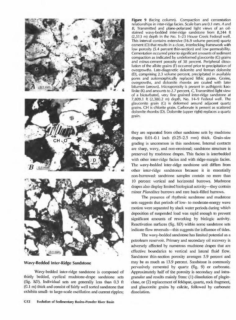
Wavy-Bedded Inter-Ridge Sandstone
Wavy-bedded inter-ridge sandstone is composed of thinly bedded, cyclical mudstone-drape sandstone sets (fig. 8£>). Individual sets are generally less than 0.3 ft (0.1 m) thick and consist of fairly well sorted sandstone that exhibits small- to large-scale oscillation and current ripples;
Figure 9 (facing column). Compaction and cementation relationships in inter-ridge facies. Scale bars are 0.1 mm. A and B, Transmitted and plane-polarized light views of an oil- stained wavy-bedded inter-ridge sandstone from 8,244 ft (2,513 m) depth in the No. 1-23 House Creek Federal well. This interval contains extensive (16.9 volume percent) quartz cement (O) that results in a close, interlocking framework with low porosity (5.4 percent thin-section) and low permeability. Cementation occurred prior to significant amounts of sediment compaction as indicated by undeformed glauconite (C) grains and minus-cement porosity of 38 percent. Peripheral disso lution of the albite grains (F) occurred prior to precipitation of overgrowths. Late-diagenetic dolomite and ferroan dolomite (D), comprising 2.3 volume percent, precipitated in available pores and automorphically replaced lithic grains. Grains, overgrowths, and dolomite rhombs are coated with later bitumen (arrows). Microporosity is present in authigenic kao- linite (K) and amounts to 2.7 percent, C, Transmitted light view of a bioturbated, very fine grained inter-ridge sandstone at 7,809.1 ft (2,380.2 m) depth, No. 14-9 Federal well. The glauconite grain (G) is deformed around adjacent quartz grains. CH is chlorite grain. Carbonate is present as scattered dolomite rhombs (D). Dolomite (upper right) replaces a quartz grain.
they are separated from other sandstone sets by mudstone drapes 0.01-0.1 inch (0.25-2.5 mm) thick. Grain-size grading is uncommon in this sandstone. Internal contacts are sharp, wavy, and non-erosional; sandstone structure is preserved by mudstone drapes. This facies is interbedded with other inter-ridge facies and with ridge-margin facies. The wavy-bedded inter-ridge sandstone unit differs from other inter-ridge sandstones because it is essentially non-burrowed: sandstone samples contain no more than 10 percent vertical and horizontal burrows. Mudstone drapes also display limited biological activity they contain minor Planolites burrows and rare back-filled burrows.
The presence of rhythmic sandstone and mudstone sets suggests that periods of low- to moderate-energy wave motion were separated by slack water periods during which deposition of suspended load was rapid enough to prevent significant amounts of reworking by biologic activity. Reactivation surfaces (fig. 8D) within some sandstone sets indicate flow reversals this suggests the influence of tides.
The wavy-bedded sandstone has limited potential as a petroleum reservoir. Primary and secondary oil recovery is adversely affected by numerous mudstone drapes that are effective boundaries to vertical and lateral fluid flow. Sandstone thin-section porosity averages 5.9 percent and may be as much as 13.9 percent. Sandstone is commonly pervasively cemented by quartz (fig. 9) or carbonate. Approximately half of the porosity is secondary and intra- granular and results mainly from: (1) dissolution of plagio- clase, or (2) replacement of feldspar, quartz, rock fragment, and glauconite grains by calcite, followed by carbonate dissolution.
G12 Evolution of Sedimentary Basins-Powder River Basin

0.1 mm , ~ Mf. J-L _, -, - i'^%1
Figure 10. Transmitted I ight photomicrographs of low-energy ridge-margin sandstone showing two processes resulting in porosity reduction. A, Ripple-laminated sandstone in the No. 1 Campbell well (7,704.3 ft depth) contains 17.4 percent quartz cement (O) that results in a volumetric decrease in porosity to 4.1 percent. F is feldspar grain. Chlorite rims (arrows) comprise 2 volume percent of this interval. Abundant clay matrix and minor dolomite rhombs (D) fill remaining pore spaces. Scale bar is 0.1 mm. B, This flaser-bedded unit is a ripple-laminated sandstone from 7,793.2 ft (2,375.4 m) in the No. 14-9 Federal well. Extensive mechanical deformation of glauconite (G) (10.3 percent by volume) reduced porosity to 4.1 percent intergranular and 20.7 percent minus-cement porosity. Mud- stone laminae (M) are oil stained. This interval probably traps hydrocarbons in the underlying perforated interval in the well. Scale bars are 1.0 and 0.1 mm.
Ridge-Margin and Central-Ridge Sandstone
Ridge-margin and central-ridge sandstones are the reservoir facies in the House Creek and Porcupine fields. These facies generally grade upward from sets of low- energy ridge-margin sandstone to high-energy ridge-margin and central-ridge sandstone. Low-energy ridge-margin sand stones include sedimentologic and petrologic characteristics
of inter-ridge and ridge facies and represent a transition zone between them. High-energy ridge-margin and central- ridge sandstones are described together because they are almost identical petrologically.
Low-Energy Ridge-Margin Sandstone
Low-energy ridge-margin sandstones have a com bined thickness of much as 8 ft (2.4 m) and consist of fine-grained trough or planar-tangential cross-beds that are interbedded with massive, wavy-bedded, and ripple- laminated sandstone (fig. 8C). Contacts between sets are generally transitional, and, partly because of erosion by higher-energy facies, the sets may be only a few inches (cm) thick. Low-energy ridge-margin sandstones have low to moderate reservoir potential. This sandstone is sedimento- logically more heterogeneous than that of the central-ridge or high-energy ridge-margin facies: individual sandstone sets are thinner and are frequently bounded by mudstone drapes this facies is interbedded with inter-ridge sand stones and commonly contains greater amounts of carbonate cement and clay matrix.
Low-energy ridge-margin sandstones are moderately to highly glauconitic (3-13 percent) with minor, small clasts of mudstone rip-up and siderite. Drapes of mudstone are 0.01-0.1 inch (0.25-2.54 mm) thick and may contain horizontal sand-filled burrows of Planolites. Sandstone generally contains less than 10 percent, vertical, U-shaped, and horizontal burrows of Arenicolites, Skolithos, Chon- drites, Diplocraterion, and Terrebellina.
Evaluation of Sussex "B" core indicates that pore spaces in non-oil-productive sandstones are commonly filled with calcite cement. Extreme ranges in amounts and types of cement are characteristic of this facies and may reflect the interbedding of low and moderate depositional energy sandstone (fig. 10).
Central-Ridge and High-Energy Ridge-Margin Sandstone
Central-ridge and high-energy ridge-margin sand stones are the primary oil reservoir facies of the Sussex "B" sandstone. High-energy ridge-margin and central-ridge facies are grouped together because of very similar petrol ogy and sedimentology: these facies form a hydrologic flow unit. High-energy ridge-margin sandstone is more hetero geneous than central-ridge sandstone because it contains more carbonate cement and exhibits greater interbedding with sandstones and siltstones of lower depositional energy.
The areal distribution of ridge facies sandstones in the House Creek field has been mapped and described by Berg (1975), Brenner (1978), and Hobson and others (1982); the distribution corresponds generally to the field outlines shown on figure 1. The central-ridge and high-energy ridge-margin facies in the House Creek and Porcupine fields
Petrology and Reservoir Paragenesis in Sussex "B" Sandstone G13

are as much as 20 ft (6 m) thick. Individual trough cross-bedded sets fine upward, are commonly less than 1 ft (0.3 m) thick, and are truncated at their upper surfaces. Sandstones exhibit small- to medium-scale trough cross- bedding with minor planar-tabular and planar-tangential bedding; dip angles on trough cross-bedding are mainly 20° to 35° (fig. 8#). These facies were deposited primarily as small- to medium-sized subaqueous dunes. Biologic activity results in as much as 10 percent horizontal burrows in mudstone drapes. Uncommon vertical burrows of Skolithos, Arenicolites, and Diplocraterion may be present near the top of the trough sets or may penetrate into central-ridge sandstones where they are overlain by lower energy sandstone units. The vertical trace fossils were formed by suspension-feeding organisms, and burrows generally dis play evidence of rapid sediment deposition. Glauconite is concentrated within discrete trough cross-bedding ripple- laminae sets (dark lines on fig. 85). Extensive soft-sediment deformation within these laminae may result in minor permeability barriers to vertical fluid flow (fig. ID). Fluid should preferentially flow parallel to the long axes of trough cross-beds. Mudstone is present mainly as drapes on trough bedding planes; suspended-load sedimentation on dunes occurred primarily during slack water periods. Also present on the trough bedding planes are mudstone rip-up clasts and siderite clasts that may be as much as 3 inches (8 cm) long and 1 inch (3 cm) wide. Core and outcrop studies indicate that sources of the clasts are siderite drapes and siderite- cemented sandstone; these are present in many of the facies located within and below the Sussex interval (fig. 8D). These siderite drapes may have been eroded by storm currents or other strong currents; the rounded clasts were subsequently deposited on subaqueous dunes. The volume percent for siderite drapes in central-ridge sandstone (table 2) is anomalously large, primarily because of preferential sampling of some intervals containing the drapes.
Central-ridge and high-energy ridge-margin facies sandstones are fine to medium grained. Grains generally exhibit long and straight or point contacts with other grains. Cementation by quartz and calcite are important porosity reduction processes in central-ridge and high-energy ridge- margin facies this is indicated by Sussex "B" sandstone average minus-cement porosity values of 30.7 and 35.8 percent, respectively (table 2). Quartz cement averages 8.5 volume percent in both facies and ranges from 0.7 to 23.2 volume percent. Thin-section porosity averages 7.7 and 6.1 percent for central-ridge and high-energy ridge-margin sandstones; this is less than the average reservoir porosity of 13 percent. Microporosity was not measured during thin- section point counting, resulting in low values relative to core porosity. Central-ridge and high-energy ridge-margin facies also average 9.5 and 14.3 volume percent carbonate cement, respectively, and oil is present mainly in those rock intervals in which calcite is absent or in which calcite dissolution has restored porosity and created secondary pore
spaces. The rare potassium feldspar grains generally are extensively corroded and are sometimes closely associated with pore-filling authigenic kaolinite. Plagioclase content ranges from 2.3 to 11.5 volume percent, and grains may exhibit extensive dissolution (fig. 7C) and minor to extensive replacement by calcite and dolomite. Secondary porosity results mainly from dissolution of: (1) plagioclase, (2) calcite that filled intragranular pore spaces and replaced feldspar and, (3), to a lesser extent, calcite that replaced rock fragments, quartz grains and overgrowths, and glauconite.
Chert Pebble Sandstone
Where present, chert pebble sandstone is the upper contact of the Sussex "B" sandstone (fig. 8A) and represents the highest depositional energy conditions of the facies studied (Hobson and others, 1982). This chert pebble sandstone facies is generally less than 1 ft (0.3 m) thick and is areally discontinuous across the House Creek and Porcupine fields. Cores from at least five of the 21 Sussex "B" wells in the area of the House Creek field and one well in the Porcupine field contain this chert unit (several of the cored sections did not include the upper contact). This sandstone is indistinguishable on well logs from underlying facies; it contains pervasive calcite cement and is not a reservoir for oil. However, where this unit is present, it acts as a seal that traps hydrocarbons in underlying reservoir sandstones.
The chert pebble sandstone exhibits distinct bimodal sorting and consists of medium-sized grains of subangular quartz and granule-sized grains of well-rounded chert that are 0.05-0.2 inch (1-5 mm) in diameter. This facies erosionally overlies central-ridge facies sandstones and is transitionally overlain by a unit that consists of offshore marine mudstone to very fine grained sandstone. The chert pebble sandstone facies exhibits small- to medium-scale trough cross-bedding and minor planar-tabular cross- bedding. Individual trough cross-sets are several inches to 1 ft (0.08-0.3 m) thick, fine upward, and have truncated upper surfaces. Glauconite, mudstone rip-up, and other soft sediment grains were winnowed from the sandstone and are concentrated within trough-laminae sets. The source of the chert is probably limestone that was replaced by chert and subsequently eroded this is indicated by inclusions of carbonate in chert, pseudomorphs after dolomite, and burrows and fossil fragments that are replaced by chert and chalcedony.
The chert pebble sandstone may have been deposited by high-energy storm currents. The sandstone may also have resulted from an event in which the pebbles were introduced by channelized flow (Berg, 1975) and reworked into the chert sandstone. However, the chert pebble sandstone probably represents a winnowed lag deposit on an unconformity surface: the unit is widely distributed across the House Creek and Porcupine fields, erosional surfaces
G14 Evolution of Sedimentary Basins-Powder River Basin

show low relief (less than 1 m), and deep channels are absent. Foraminiferal tests and bone fragments are occa sionally preserved. Also, this unit is petrologically different from other facies of the Sussex: the chert pebble sandstone consists of 32.4 percent by volume chert pebbles (rock fragment category), whereas chert grains average 4.2 per cent in the other facies. Chert grains in this unit exhibit coatings of oxidized iron (fig. 7F); this is unlike grains in the other units. Grain-to-grain contacts within this facies are point and long-straight contacts. Quartz grains incorporated from underlying central-ridge facies sandstones commonly "float" in a matrix of carbonate cement (fig. IF). Because of high depositional energy conditions, the sandstone does not contain burrows or tracks.
Porosity in the chert pebble sandstone is commonly secondary, resulting mainly from dissolution of lithic grains and fossil fragments (fig. IF}. Cementation is the major process of porosity reduction. Compactional loss of porosity results primarily from rearrangement and closer packing of lithic grains. The 24.8 percent average minus-cement porosity represents about a 5-10 percent loss of porosity from the initial depositional porosity. Initial porosity was probably less in this facies than in other facies because of bimodal sorting.
In core and thin sections, this chert pebble sandstone is completely cemented by calcite and ferroan calcite. Average calcite cement comprises 20.9 volume percent. This sandstone would have excellent porosity and perme ability and would be a reservoir facies if the calcite cement were removed. Paragenesis is commonly "frozen" because of early calcite cementation. Kaolinite and illite-smectite (which precipitated in other sandstone facies after calcite dissolution) are rare in the chert pebble sandstone facies.
CONCLUSIONS
The Sussex "B" sandstone is composed generally of a coarsening-upward sequence of inter-ridge to central-ridge sandstones; the best developed reservoir sandstones are located at the top of each sequence. Sandstones are very fine to medium-grained litharenites to feldspathic litharenites. Porosity relationships are complex and consist of primary porosity, secondary porosity, and microporosity. Porosity is commonly greatest within the high depositional energy central-ridge and ridge-margin facies: these are the reservoir sandstones of the House Creek and Porcupine fields. Reservoir properties are controlled by: (1) types and amounts of cements, (2) enhancement of porosity through dissolution of carbonate cements, (3) sedimentologic factors that influence fluid flow and the degree of sediment compaction, and (4) amounts of pore-filling and grain- coating clays. Fluid flow during oil production is slowed by the numerous permeability boundaries created by interbed- ding of inter-ridge with ridge facies sandstones and by numerous mudstone drapes.
ACKNOWLEDGMENTS
This research was supported by the Enhanced Oil Recovery project of the U.S. Geological Survey. I am especially grateful to Steve Fillingham, Dick Morrow, and Bill Walford of Woods Petroleum Corp., and William Brown and Oscar Peters of Meridian Oil Corp. for supply ing reservoir and core analysis data. This paper benefited from critical reviews by Geoff Thyne of the University of Wyoming and by Bonnie Crysdale and Christopher Schenk. Mark Pawlewicz provided vitrinite reflectance analyses and Thomas Finn provided X-ray diffraction analyses.
REFERENCES CITED
Anderman, G.G., 1976, Sussex sandstone production, Triangle U field, Campbell County, Wyoming: Wyoming Geological Association, 28th Annual Field Conference Guidebook, p. 107-113.
Asquith, D.O., 1970, Depositional topography and major marine environments, Late Cretaceous, Wyoming: American Asso ciation of Petroleum Geologists Bulletin, v. 54, no. 7, p. 1,184-1,224.
Beaumont, EA., Hobson, J.P., Jr., and Fowler, M.L., 1980, Depositional facies, geometry, and genesis of Upper Cretaceous mid-shelf sandstone, Sussex Sandstone at House Creek field, Powder River Basin, Wyoming: American Association of Petroleum Geologists Bulletin, v. 64, no. 5, p. 675.
Berg, R.L., 1975, Depositional environments of Upper Cretaceous Sussex Sandstone, House Creek field, Wyoming: American Association of Petroleum Geologists Bulletin, v. 59, no. 11, p. 2,099-2,110.
Brenner, R.L., 1978, Sussex Sandstone of Wyoming example of Cretaceous offshore sedimentation: American Association of Petroleum Geologists Bulletin, v. 62, no. 2, p. 181-200.
Crews, G.C., Barlow, J.A., Jr., and Haun, J.D., 1976, Upper Cretaceous Gammon, Shannon, and Sussex Sandstones, central Powder River Basin, Wyoming: Wyoming Geo logical Association, 28th Annual Field Conference Guidebook, p. 9-20.
Folk, R.L., 1970, Detrital sedimentary rock classification and nomenclature for use in New Zealand: New Zealand Journal of Geology and Geophysics, v. 13, p. 937-968.
Higley, D.K., 1988, Detailed descriptions of the Upper Cretaceous Sussex Sandstone in five coreholes, Powder River Basin, Wyoming: U.S. Geological Survey Open-File Report 88-420, 32 p.
Hobson, J.P., Jr., Fowler, M.L., and Beaumont, E.A., 1982, Depositional and statistical exploration models, Upper Cretaceous offshore sandstone complex, Sussex Member, House Creek field, Wyoming: American Association of Petroleum Geologists Bulletin, v. 66, no. 6, p. 689-707.
Lawyer, G., Newcomer, J., and Eger, C., eds., 1981, Powder River Basin oil and gas fields: Wyoming Geological Association, 472 p.
Momper, J.A., and Williams, J.A., 1984, Geochemical exploration in the Powder River Basin, in Demaison, G. and Morris, R.
Petrology and Reservoir Paragenesis in Sussex "B" Sandstone G15

J., eds., Petroleum geochemistry and basin evaluation: American Association of Petroleum Geologists, Memoir 35, p. 181-191.
Nuccio, V.F., 1990, Burial, thermal, and petroleum generation history of the Upper Cretaceous Steele Member of the Cody Shale (Shannon Sandstone Bed horizon), Powder River Basin, Wyoming: U.S. Geological Survey Bulletin 1917-A, 17 p.
Pryor, W.A., 1973, Permeability-porosity patterns and variations in some Holocene sand bodies: American Association of Petroleum Geologists Bulletin, v. 57, no. 1, p. 162-189.
Sabel, J.M., 1985, House Creek field; past and future, in Nelson, G. E., ed., The Cretaceous geology of Wyoming: Wyoming Geological Association, 36th Annual Field Conference Guidebook, p. 45-50.
Tillman, R.W., and Martinsen, R.S., 1984, The Shannon shelf- ridge sandstone complex, Salt Creek anticline area, Powder River Basin, Wyoming, in Tillman, R. W., and Siemers, C., eds., Siliciclastic shelf sedimentation: Society of Economic Paleontologists and Mineralogists, Special Publication No. 34, p. 85-142.
G16 Evolution of Sedimentary Basins-Powder River Basin
U.S. GOVERNMENT PRINTING OFFICE: 1992 67

SELECTED SERIES OF U.S. GEOLOGICAL SURVEY PUBLICATIONS
Periodicals
Earthquakes & Volcanoes (issued bimonthly). Preliminary Determination of Epicenters (issued monthly).
technical Books and Reports
Professional Papers are mainly comprehensive scientific reports 3f wide and lasting interest and importance to professional scientists and engineers. Included are reports on the results of resource studies and of ;opographic, hydrologic, and geologic investigations. They also include ;ollections of related papers addressing different aspects of a single sci entific topic.
Bulletins contain significant data and interpretations that are of lasting scientific interest but are generally more limited in scope or geo graphic coverage than Professional Papers. They include the results; of esource studies and of geologic and topographic investigations; as well is collections of short papers related to a specific topic.
Water-Supply Papers are comprehensive reports that present sig nificant interpretive results of hydrologic investigations of wide interest to professional geologists, hydrologists, and engineers. The series covers investigations in all phases of hydrology, including hydrology, availabil ity of water, quality of water, and use of water.
Circulars present administrative information or important scientif ic information of wide popular interest in a format designed for distribu tion at no cost to the public. Information is usually of short-term interest.
Water-Resources Investigations Reports are papers of an inter pretive nature made available to the public outside the formal USGS pub lications series. Copies are reproduced on request unlike formal USGS publications, and they are also available for public inspection at deposi tories indicated in USGS catalogs.
Open-File Reports include unpublished manuscript reports, maps, ind other material that are made available for public consultation at de positories. They are a nonpermanent form of publication that maybe cit- sd in other publications as sources of information.
Maps
Geologic Quadrangle Maps are multicolor geologic maps on to pographic bases in 7 1/2- or 15-minute quadrangle formats (scales main- [\y 1:24,000 or 1:62,500) showing bedrock, surficial, or engineering geology. Maps generally include brief texts; some maps include structure ^nd columnar sections only.
Geophysical Investigations Maps are on topographic or planimet- ric bases at various scales, they show results of surveys using geophysi- qal techniques, such as gravity, magnetic, seismic, or radioactivity, which reflect subsurface structures that are of economic or geologic signifi cance. Many maps include correlations with the geology.
Miscellaneous Investigations Series Maps are on planimetric or topographic bases of regular and irregular areas at various scales; they present a wide variety of format and subject matter. The series also in- ?ludes 7 1/2-minute quadrangle photogeologic maps on planimetric bases which show geology as interpreted from aerial photographs. The series also includes maps of Mars and the Moon.
Coal Investigations Maps are geologic maps on topographic or planimetric bases at various scales showing bedrock or surficial geology, stratigraphy, and structural relations in certain coal-resource areas.
Oil and Gas Investigations Charts show stratigraphic informa tion for certain oil and gas fields and other areas having petroleum poten tial.
Miscellaneous Field Studies Maps are multicolor or black-and- white maps on topographic or planimetric bases on quadrangle or irreg ular areas at various scales. Pre-1971 maps show bedrock geology in re lation to specific mining or mineral-deposit problems; post-1971 maps are primarily black-and-white maps on various subjects such as environ mental studies or wilderness mineral investigations.
Hydrologic Investigations Atlases are multicolored or black-and- white maps on topographic or planimetric bases presenting a wide range of geohydrologic data of both regular and irregular areas; the principal scale is 1:24,000, and regional studies are at 1:250,000 scale or smaller.
Catalogs
Permanent catalogs, as well as some others, giving comprehensive listings of U.S. Geological Survey publications are available under the conditions indicated below from the U.S. Geological Survey, Books and Open-File Reports Sales, Box 25425, Denver, CO 80225. (See latest Price and Availability List.)
"Publications of the Geological Survey, 1879-1961" may be pur chased by mail and over the counter in paperback book form and as a set microfiche.
"Publications of the Geological Survey, 1962-1970" may be pur chased by mail and over the counter in paperback book form and as a set of microfiche.
"Publications of the U.S. Geological Survey, 1971-1981" may be purchased by mail and over the counter in paperback book form (two volumes, publications listing and index) and as a set of microfiche.
Supplements for 1982, 1983, 1984, 1985, 1986, and for subse quent years since the last permanent catalog may be purchased by mail and over the counter in paperback book form.
State catalogs, "List of U.S. Geological Survey Geologic and Wa ter-Supply Reports and Maps For (State)," may be purchased by mail and over the counter in paperback booklet form only.
"Price and Availability List of U.S. Geological Survey Publica tions," issued annually, is available free of charge in paperback booklet form only.
Selected copies of a monthly catalog "New Publications of the U.S. Geological Survey" is available free of charge by mail or may be obtained over the counter in paperback booklet form only. Those wishing a free subscription to the monthly catalog "New Publications of the U.S. Geological Survey" should write to the U.S. Geological Survey, 582 Na tional Center, Reston, VA 22092.
Note.-Prices of Government publications listed in older catalogs, announcements, and publications may be incorrect Therefore, the prices charged may differ from the prices in catalogs, announcements, and pub lications.