Embed Size (px)
Citation preview

Petroleum Exploration Opportunities inPetroleum Exploration Opportunities inArea “C” -
Flemish Pass/North Central Ridge Call for Bids NL11Call for Bids NL11--0202
Dr. Michael E. Enachescu,P Geoph, P Geo
Euxinic Exploration
Euxinic Exploration On Behalf of NL DNR
November 2011
AcknowledgementsAcknowledgements• Wes Foote, David Middleton, Lori Cook,
Darrell Spurrell, Brad Kendell, Jillian Owens, Larry Hicks of the NL Department of Natural Resources;
• Ian Atkinson, Phonse Fagan;• Dianne Noseworthy of C-NLOPB;• Dave Brown, CNSOPB• S. Srivastava, Jean Claude Sibuet• Bridget Ady, Richard Whittaker of
GeoArctic• Memorial University;• GSC Atlantic; • This work could not have been
performed without valuable information provided by C-NLOPB and Government of Newfoundland and Labrador Department of Natural Resources..
= position of CFB NL11-02 Parcels
NL11-03
NL11-01 NL11-02
Enachescu, 2011

•CFB NL11-01Anticosti Basin
•CFB NL11-03Saglek Basin
•CFB NL11-02Flemish Pass/
Orphan/Central Ridge
NL CFB 2011: NL CFB 2011: Three CFB in Three CFB in
four basinsfour basins
NL
SAGLEKBASIN
Nova Scotia
Enachescu, 2011

Atlantic Canada Offshore BasinsAtlantic Canada Offshore BasinsBlue Text: Paleozoic Basins
Magenta Text: Mesozoic Basins
NL Mesozoic Basins• Laurentian• South Whale• Jeanne d’Arc• Flemish Pass• East Orphan• Hopedale• SaglekBlue writing above: Mesozoic basins with ongoing exploration
Enachescu, 2011
= Location of CFB NL11-02

•• CFB NL11CFB NL11--0202 consists of two large parcels (each one approximately 200,000 ha), located in the intermediate and deep waters of the North Central Ridge and East Orphan and Flemish Pass basins
• Call for Bids closes November 15, 2011 at 4 p.m. NL time
Area “C” - Flemish Pass/North Central Ridge: Call For Bids
Enachescu, 2011
Flemish Pass Basin
North Central Ridge
East Orphan
Basin
Atlantic Ocean

Presentation ContentPresentation Content1. Introduction2. Exploration Background3. Regional Geology of Call for Bids area4. Petroleum Geology of Call for Bids area5. Petroleum Potential Call for Bids
- NL11-02 Parcel 1- NL11-02 Parcel 2
6. Conclusions7. Conclusions
Enachescu, 2011

1. Introduction1. Introduction• Geologically, the CFB NL11-02 Area “C” - Flemish
Pass/North Central Ridge includes portions of the North Central Ridge, southern East Orphan Basin and north western Flemish Pass Basin
• The total area covered by the Call for Bids is 433,796 ha • The two parcels on offer are situated in intermediate to deep
water (ranging from 350 to 2,655 m) • Parcels 1 and 2 are located just northeast of the Jeanne d’Arc
Basin where giant oil fields were discovered. Production of oil during the first 8 months of 2011 was recorded at 268,313 bopd
• Parcels 1 and 2 are located immediately west of the 2009 Mizzen O-16 discovery and the 2005 Mizzen L-11 oil show in the Flemish Pass Basin
Enachescu, 2011

NL11NL11--02 Parcels Near Mizzen SDLs02 Parcels Near Mizzen SDLs•• CFB NL11CFB NL11--0202--01 and 01 and --02 02 parcels offered in the 2011
Call for Bids are two very large blocks located offshore Newfoundland, at the northeast tip of the Grand Banks and on its slope. Noteworthy:– The NL11-02-01 parcel is situated less than 20 km west of
the Mizzen SDLs 1047 and 1048– The NL11-02-02 parcel is situated 40 km southwest of the
Mizzen SDL 1047
• In 2010, the SDL 1047 encompassing 22,006 ha was awarded by the C-NLOPB to Statoil (65%) and Husky Oil (35%) based on the results of the Mizzen O-16 well drilled in 2009 in the previous EL 1049. A northern addition, the Mizzen SDL 1048 comprising 3,773 ha, was awarded to Statoil (65%)/Husky (35%) in early 2011
Enachescu, 2010

NL11NL11--02 Parcels Near EL02 Parcels Near EL’’ss• The closest ELs to these parcels are located
– Immediately south: EL 1112 (Statoil 65%/Husky 35%)– Immediately east: EL 1124 (Statoil 65%/Husky 35%)
surrounding the Mizzen SDLs– To the northeast: EL 1123 (Statoil 75%/Repsol 25%)– To the northwest, in the East Orphan Basin: EL 1074R
(Chevron operator 50%, EM/Imperial 30% and Shell 20%)
Enachescu, 2011
More information on this Call for Bids can be found at: http://www.cnlopb.nl.ca/news/pdfs/cfb11_02.pdf
Call for Bids NL11Call for Bids NL11--02 02 • NL11-02: Two Parcels on Offer
Call for Bids NL11-02 contains two very large parcels located in Area “C” Flemish Pass Basin (FPB)/Central Ridge offshore Newfoundland and Labrador:– NL11-02-01 comprised of 247,016 hectares (610,390 acres), located in
635-2655 m water depth– NL11-02-02 comprised of 186,780 hectares (461,546 acres), located in
350-1165 m water depth
• Call for Bids Timing: Bids for these parcels will be accepted up to November 15, 2011 at 4 p.m. NL time
• Minimum Bid: CAN $ 1,000,000 (one million) for each of NL11-02 parcels in the Central Ridge/Flemish Pass area
Enachescu, 2011

Comments on Location of ParcelsComments on Location of Parcels• C-NLOPB designation for the bid location is: Area “C” - Flemish
Pass/North Central Ridge• Geologically Parcel NL11-02-01 is located mostly inside the East
Orphan Basin and partially in the Flemish Pass Basin. Parcel NL11- 02-02 is located in the North Central Ridge and Flemish Pass Basin.
• While the posting area was designated by the C-NLOPB as Area “C” - Flemish Pass/North Central Ridge, the parcels are structurally situated in the East Orphan Basin, Flemish Pass Basin and North Central Ridge area (see Enachescu, 1987; Enachescu et al., 2005). These units are continuous as relates to structural setting and stratigraphy but can be separated based on bathymetry
• Thus, the Flemish Pass Basin occupies the area situated in water depths between 500 to about 1500 m, while the East Orphan Basin lies in water depths greater than 1500 m. The North Central Ridge occupies the Grand Banks shelf up to 500 m water depth
Enachescu, 2011

Call For Bids LocationCall For Bids Location
NL = NewfoundlandLB = LabradorGB = Grand BanksFC = Flemish CapOK = Orphan KnollJD = Jeanne d’Arc BasinFP = Flemish Pass BasinEOB = East Orphan Basin
= Approximate location of NL11-02 Parcels 1 and 2
Location of NL11-02 parcels shown on a bathymetry map of the area
GB
LB
NL
FC
EOB
OK
FP
JD
Atlantic Ocean
Labrador Sea
Enachescu, 2011

Flemish Pass BasinFlemish Pass BasinA proven petroleum basin.• This Mesozoic-Tertiary basin contains 1 discovery
well (Mizzen O-16), 1 well with a noteworthy oil show (Mizzen L-11) and one delineation well drilled in 2011 (Mizzen F-09 with results not released yet)
• Two Significant Discovery Licences for the Mizzen field were recently awarded (SDLs 1047 and 1048)
• Several other wells in the basin have intersected good reservoir and/or source rocks (e.g. Gabriel C- 60 and Baccalieu I-78)
Enachescu, 2011

Central RidgeCentral RidgeA proven petroleum area.• The Central Ridge is an intrabasinal high which is
separating the Jeanne d’Arc and Flemish Pass basins; it has two subunits the South and the North Central Ridge separated by a transfer zone
• Drilled in only a few locations, the ridge has provided both oil and gas discoveries (oil at South Tempest G- 88; gas at North Dana I-43 and Trave E-87)
• Several wells (e.g. North Dana I-43, South Tempest and Panther P-52) intersected thick source rock intervals
Enachescu, 2011

East Orphan BasinEast Orphan BasinA basin with petroleum potential.• East Orphan is an underexplored basin. Only two
wells were drilled in this large rift basin, one abandoned (Great Barasway F-66) and one with results not yet in the public domain (Lona O-55)
• A thick Late Jurassic clastic succession was intersected in Great Barasway F-66 well
• Good reservoir intervals and source rocks may have been intersected in Great Barasway F-66 but more studies are needed to confirm their quality
• Seismic correlation using modern seismic data indicates the presence of source rocks west and northwest of the Mizzen SDLs
Enachescu, 2011

Call for Bids NL11Call for Bids NL11--0202• Exploration and Production Activity. There are:
– a) two active Exploration Licences (ELs) in Flemish Pass Basin (EL 1112 and EL 1124-awarded in 2010)
– b) two ELs in Orphan Basin, one large consolidated (1074R) and most of EL 1123-awarded in 2010
– c) three ELs on the North Central Ridge: EL 1110 and EL 1111, both awarded in 2009, and the eastern part of the consolidated EL 1190R
2011 Activity: Two 3D seismic surveys and several 2D lines were recorded in the East Orphan and Flemish Pass basins and the delineation well Mizzen L-11 was drilled at the border between the two basins
• Production. There is no production in either basin or in the Central Ridge area. The closest oil production is from the White Rose oil field situated approximately 200 km to the southwest, in the Jeanne d’Arc Basin
• Strategic Environmental Assessment (SEA). The C- NLOPB has previously conducted a SEA for the Call for Bids NL11-02 area. New environmental knowledge has been accumulated during the past 12 years since the Flemish Pass and East Orphan basins ELs were awarded and geophysical, geotechnical and drilling activities were carried out in the basins
Enachescu, 2011

ObservationsObservations
Enachescu, 2011
• References introduced in this presentation are listed in associated reports and presentations posted on the website:
http://www.nr.gov.nl.ca/mines&en/oil/• Certain parts of this presentation are repeats or updates of text and
illustrations contained in the power points produced by Enachescu, 2010 and available at:
http://www.nr.gov.nl.ca/nr/invest/energy.html#offshorehttp://www.nr.gov.nl.ca/nr/invest/enachescuNL100203.pdf
• Earlier Call for Bids reports and power points concerning Flemish Pass and Orphan Basin areas are available at:
http://www.nr.gov.nl.ca/nr/invest/cfb_nl99_1.pdfhttp://www.nr.gov.nl.ca/nr/invest/cfb_nl01_1.pdfhttp://www.nr.gov.nl.ca/nr/invest/cfb_nl03_1.pdf
• Other references quoted in this presentation are available from the word wide web scientific publication sites such as: lyellcollection, searchanddiscovery, sciencedirect, cspg, etc.
2. Exploration Background2. Exploration Background
• NL Historic E&P Activity• NL Petroleum Production• Participation of Nalcor Energy• NL Mesozoic Basins Research and Exploration
Projects • Large Mesozoic Offshore Under-Explored Basins• Recent E&P Activity in Atlantic Mesozoic Basins• Northeast Newfoundland offshore Land Situation
2011
Enachescu, 2011

Wells DrilledWells DrilledExploration (Total) 231
Offshore 147Onshore 84
Delineation 52Development 170
DiscoveriesDiscoveriesOil 20Gas 7
Current HoldingsCurrent HoldingsExploration Licences (ELs)/Permits (EPs) 42Significant Discovery Licences (SDLs) 52Production Licences (PLs)/Leases 11
NL Historic E&P ActivityNL Historic E&P Activity
Enachescu, 2011
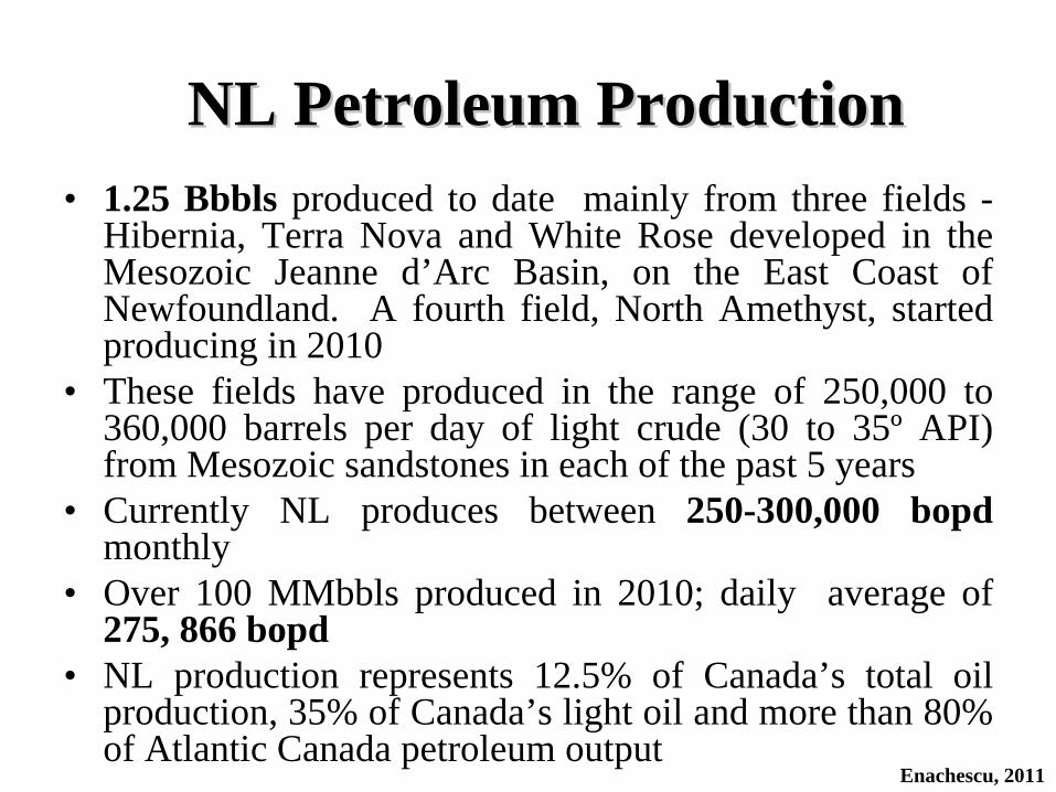
NL Petroleum ProductionNL Petroleum Production• 1.25 Bbbls produced to date mainly from three fields -
Hibernia, Terra Nova and White Rose developed in the Mesozoic Jeanne d’Arc Basin, on the East Coast of Newfoundland. A fourth field, North Amethyst, started producing in 2010
• These fields have produced in the range of 250,000 to 360,000 barrels per day of light crude (30 to 35º API) from Mesozoic sandstones in each of the past 5 years
• Currently NL produces between 250-300,000 bopd monthly
• Over 100 MMbbls produced in 2010; daily average of 275, 866 bopd
• NL production represents 12.5% of Canada’s total oil production, 35% of Canada’s light oil and more than 80% of Atlantic Canada petroleum output
Enachescu, 2011

• NL is the second largest hydrocarbon producing province in Canada
• Production to date is from the Jeanne d’Arc Basin only; more than 1.8 Bbbls proven remaining recoverable reserves/resources exists
• Jeanne d’Arc Basin developments are the only producing offshore oilfields on the Atlantic coast of North America
• A fifth large field, Hebron, estimated to contain 581 MMbbls recoverable reserves/resources (C-NLOPB) will be developed starting in 2012 with first oil expected in 2017. Additional 150 Mbbls recoverable reserves are associated with Ben Nevis/West Ben Nevis fields
• Satellite fields are now adding to production of Hibernia and White Rose oil fields
Enachescu, 2011
NL Petroleum Production (Cont.)NL Petroleum Production (Cont.)

• Legislation to create the province’s energy corporation, Nalcor Energy, wholly owned by the Government of NL http://www.nalcorenergy.com
• Through Nalcor, the Province negotiated equity positions in several offshore fields: White Rose Growth Projects (including North Amethyst, West White Rose, South White Rose Extension) (5%), Hebron (4.9%) and Hibernia Southern Extension (10%)
• On 31 May 2010 Nalcor obtained first oil production from its 5% participation in the North Amethyst field, establishing the company as an emerging provincial-owned upstream oil and gas player in the Atlantic continental margin
• The Energy Plan provided a framework for a price based Offshore Natural Gas Royalty Regime and introduced the concept of a “pioneer project”
Participation of Nalcor EnergyParticipation of Nalcor Energy
Enachescu, 2011

• During 2009, Nalcor acquired an average of 67 per cent working interest in three onshore exploration permits in the Parsons Pond area on the Great Northern Peninsula
• In 2010, Nalcor completed the drilling of two onshore exploration wells in the Parsons Pond area, Seamus and Finnegan, and completed testing of the Seamus well
• Seamus well drilled to an onshore record depth of 3,160 metres• Non-commercial natural gas was encountered in both wells• The results of drilling and testing of these wells and seismic
analysis have greatly advanced the understanding of Western NL petroleum geology
• The extensive datasets gathered from the wells can be extrapolated to several of the offshore exploration licences
• Nalcor continues to pursue other investment opportunities and supports the province’s efforts to promote exploration
Participation of Nalcor Energy (Cont.)Participation of Nalcor Energy (Cont.)
Enachescu, 2011
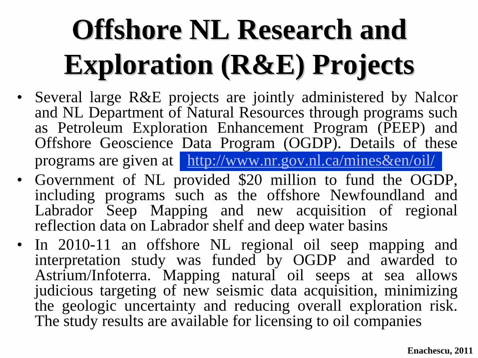
• Several large R&E projects are jointly administered by Nalcor and NL Department of Natural Resources through programs such as Petroleum Exploration Enhancement Program (PEEP) and Offshore Geoscience Data Program (OGDP). Details of these programs are given at http://www.nr.gov.nl.ca/mines&en/oil/
• Government of NL provided $20 million to fund the OGDP, including programs such as the offshore Newfoundland and Labrador Seep Mapping and new acquisition of regional reflection data on Labrador shelf and deep water basins
• In 2010-11 an offshore NL regional oil seep mapping and interpretation study was funded by OGDP and awarded to Astrium/Infoterra. Mapping natural oil seeps at sea allows judicious targeting of new seismic data acquisition, minimizing the geologic uncertainty and reducing overall exploration risk. The study results are available for licensing to oil companies
Offshore NL Research and Offshore NL Research and Exploration (R&E) ProjectsExploration (R&E) Projects
Enachescu, 2011

• A gas hydrate study involving the NL shelf, slope and deepwater was recently initiated
• A Plate Tectonic Kinematic Model for North Atlantic regions project was initiated in 2010 by Nalcor/DNR in collaboration with PIP/PAD of Ireland and awarded to GeoArctic. The model includes the Grand Banks/Western Ireland separation and Grand Banks, Flemish Pass and Orphan basin formation. The resulting study and kinematic animation will be available to funding agencies and also for licensing to oil companies
• A large-scale, multi-client seismic 2D program focused mostly on the Labrador offshore was partially funded by Nalcor through OGDP and commenced this year by a partnership of experienced global contractors (TGS in collaboration with PGS).
http://www.releases.gov.nl.ca/releases/2011/intrd/0818n07.htm
Offshore NL Research and Offshore NL Research and Exploration (R&E) Projects (Cont.)Exploration (R&E) Projects (Cont.)
Enachescu, 2011
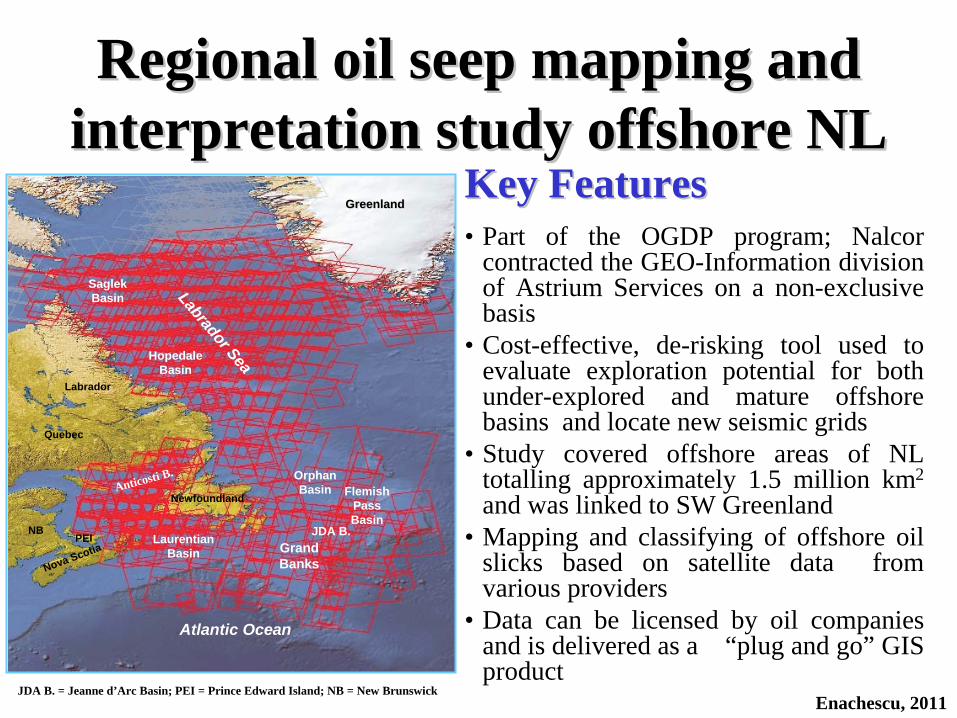
Regional oil seep mapping and Regional oil seep mapping and interpretation study offshore NLinterpretation study offshore NL
Key FeaturesKey Features• Part of the OGDP program; Nalcor
contracted the GEO-Information division of Astrium Services on a non-exclusive basis
• Cost-effective, de-risking tool used to evaluate exploration potential for both under-explored and mature offshore basins and locate new seismic grids
• Study covered offshore areas of NL totalling approximately 1.5 million km2
and was linked to SW Greenland• Mapping and classifying of offshore oil
slicks based on satellite data from various providers
• Data can be licensed by oil companies and is delivered as a “plug and go” GIS product
Newfoundland
GreenlandGreenland
Labrador
Nova Scotia
Labrador Sea
Atlantic Ocean
Grand Banks
Orphan BasinAnticosti B.
Laurentian Basin
Quebec
Flemish Pass Basin
JDA B.
Saglek Basin
Hopedale Basin
JDA B. = Jeanne d’Arc Basin; PEI = Prince Edward Island; NB = New Brunswick
PEINB
Enachescu, 2011
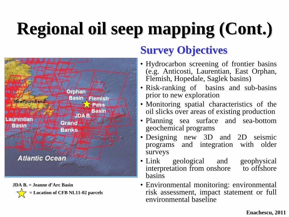
Regional oil seep mapping (Cont.)Regional oil seep mapping (Cont.)Survey ObjectivesSurvey Objectives• Hydrocarbon screening of frontier basins
(e.g. Anticosti, Laurentian, East Orphan, Flemish, Hopedale, Saglek basins)
• Risk-ranking of basins and sub-basins prior to new exploration
• Monitoring spatial characteristics of the oil slicks over areas of existing production
• Planning sea surface and sea-bottom geochemical programs
• Designing new 3D and 2D seismic programs and integration with older surveys
• Link geological and geophysical interpretation from onshore to offshore basins
• Environmental monitoring: environmental risk assessment, impact statement or full environmental baseline
JDA B. = Jeanne d’Arc Basin= Location of CFB NL11-02 parcels
Enachescu, 2011
Key FeaturesKey Features• A joint research project funded by Nalcor/DNR and Irish Shelf
Petroleum Studies Group (ISPSG - this group includes oil companies active in Western Ireland offshore and the Irish Petroleum Affair Directorate)
• To be managed and carried out by GeoArctic of Calgary• Academic and technical input from the universities, industry and
government scientists from Canada and Ireland• Based on new acquired data and survey results as well as data
donated by TGS and ION • Final product to be a kinematic animation model of plate
movement that will include the Atlantic Ocean and Labrador Sea opening
Plate Tectonic Kinematic Model Plate Tectonic Kinematic Model Project for North Atlantic RegionsProject for North Atlantic Regions
Enachescu, 2011
Project ObjectivesProject Objectives• Refit the prerift continental margins on both sides of Atlantic
minimising overlaps and gaps• Determine major controls/mechanisms for North Atlantic basin
formation and evolution, crustal stretching, rifting and uplift• Determine relationship of major basins and structural highs
between Eastern Canada and Ireland• Predict Jurassic sedimentation for Orphan, Flemish Pass, southern
Rockall, Hatton and southernmost Porcupine basins with greater confidence
• Evaluate prominent highs such as Flemish Cap and Orphan Knoll as possible sediment sources for the southern Porcupine and Rockall basins
• Evaluate potential for Palaeozoic reservoirs and source rocks in the region
Plate Tectonic Kinematic Model Project Plate Tectonic Kinematic Model Project for North Atlantic Regions (Cont.)for North Atlantic Regions (Cont.)
Enachescu, 2011

GeoArctic, 2011
• Reconstructed geological configuration of North Atlantic basins, seaways and continental fragments during Late Jurassic (after GeoArctic, 2011, provisional map)
• During Late Jurassic a rich marine source rock was deposited throughout the intra- continental basins of the North Atlantic region including the Jeanne d’Arc, Flemish Pass and East Orphan basins
Enachescu, 2011
JDB = Jeanne d’Arc Basin
JDB
Plate Tectonic Kinematic Model for Plate Tectonic Kinematic Model for North Atlantic Regions (Cont.)North Atlantic Regions (Cont.)
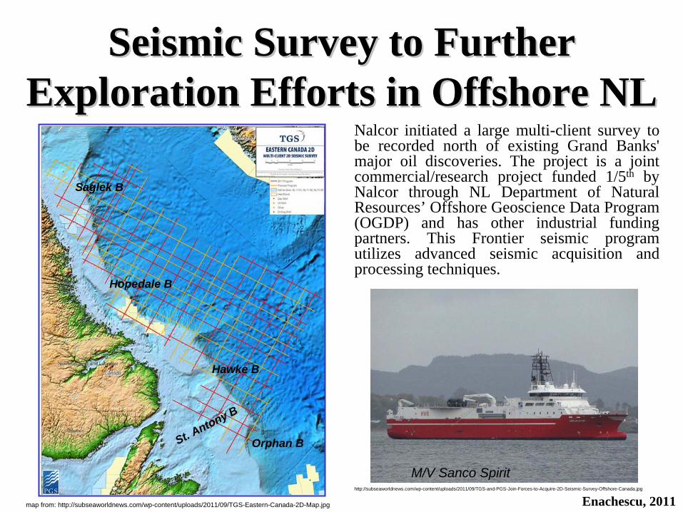
Nalcor initiated a large multi-client survey to be recorded north of existing Grand Banks' major oil discoveries. The project is a joint commercial/research project funded 1/5th by Nalcor through NL Department of Natural Resources’ Offshore Geoscience Data Program (OGDP) and has other industrial funding partners. This Frontier seismic program utilizes advanced seismic acquisition and processing techniques.
Seismic Survey to Further Seismic Survey to Further Exploration Efforts in Offshore NLExploration Efforts in Offshore NL
Enachescu, 2011
M/V Sanco Spirit
Orphan B
Hawke B
Hopedale B
Saglek B
St. Antony B
map from: http://subseaworldnews.com/wp-content/uploads/2011/09/TGS-Eastern-Canada-2D-Map.jpg
http://subseaworldnews.com/wp-content/uploads/2011/09/TGS-and-PGS-Join-Forces-to-Acquire-2D-Seismic-Survey-Offshore-Canada.jpg

Key FeaturesKey Features• Program managed and carried out by TGS in partnership with PGS, both
well known global seismic contractors, that have worked several large programs in the East Coast waters of Canada
• Survey builds on regional satellite seeps study carried out by EADS subsidiary Astrium GEO-Information Services and delivered in spring 2011 (see slides 26 and 27)
• Seismic acquisition using the Norwegian seismic ship M/V Sanco Spirit built in 2009 and contracted by TGS. This vessel possesses modern S&E, navigation and seismic equipment (see slide 31)
• Vessel will use the advanced PGS GeoStreamer®Technology that has dual- sensors (hydrophones collocated with geosensors), recording both pressure wave and particle motion which allows for better suppression of receiver ghosts and increased frequency bandwidth
• Plans are for 22,000 km multi-client 2D data to be collected during two seasons (2011-2012) with initial data to be available to clients during the fourth quarter of 2011
Seismic Survey to Further Exploration Seismic Survey to Further Exploration Efforts in Offshore NL (Cont.)Efforts in Offshore NL (Cont.)
Enachescu, 2011

Seismic Survey to Further Exploration Seismic Survey to Further Exploration Efforts in Offshore NL (Cont.)Efforts in Offshore NL (Cont.)
Project ObjectivesProject Objectives• Understand the frontier region petroleum potential and promote the
province’s offshore prospectivity in a vast area north of Grand Banks • Investigate the subsurface structure and stratigraphy on the Labrador
shelf, slope and deepwater and extend geological knowledge beyond the present 200 nautical miles exclusive economic zone (EEZ)
• Cover areas nominated in the C-NLOPB Call for Bids NL-11-03 or in vicinity of the offered blocks
• Data collection over the northern Orphan Basin, parts of Paleozoic St. Antony Basin, the poorly known Hawke Basin, Hopedale Basin where 4 ELs are active and Saglek Basins, the object of present Call For Bids offered 4 blocks
• Connect to seismic lines from the West Greenland margin where there is significant drilling activity: three wells were drilled in 2010 and an additional four well program is planned by Cairn and partners
Enachescu, 2011
Large Mesozoic UnderLarge Mesozoic Under--Explored Explored Basins in Atlantic CanadaBasins in Atlantic Canada
• Canada’s Atlantic Provinces, including Newfoundland and Labrador, were affected by the latest Wilson Cycle that was initiated with continental rifting in Triassic, and culminated with the breakup of Pangea and creation of the Atlantic Ocean
• This process also resulted in the formation of the North American continental margin that on strike, shows a shelf of variable width
• The North American Continental margin includes a series of variable size rift basins, subbasins and troughs separated by ridges starting in Florida, continuing on both onshore and offshore East Coast USA, developing offshore Nova Scotia, then passing through the Grand Banks of Newfoundland and Orphan area, changing direction into the Labrador Sea and Baffin Bay and terminating in the Arctic Ocean
• These basins show an uneven accumulation of synrift sediments and usually exhibit a thick post rift/passive margin prism of clastic and carbonate deposits
• Several northern basins (Sable, Jeanne d’Arc including central Ridge, Flemish Pass and Labrador basins) have working petroleum systems
Enachescu, 2011
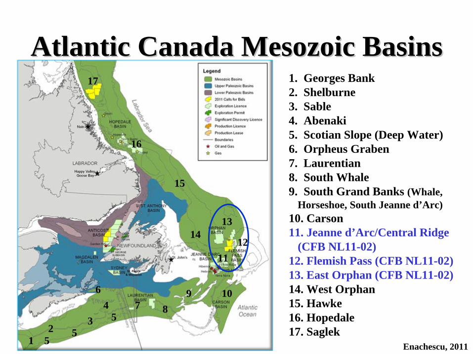
Atlantic Canada Mesozoic BasinsAtlantic Canada Mesozoic Basins1. Georges Bank2. Shelburne3. Sable4. Abenaki5. Scotian Slope (Deep Water)6. Orpheus Graben7. Laurentian8. South Whale9. South Grand Banks (Whale,
Horseshoe, South Jeanne d’Arc)10. Carson 11. Jeanne d’Arc/Central Ridge
(CFB NL11-02)12. Flemish Pass (CFB NL11-02)13. East Orphan (CFB NL11-02)14. West Orphan15. Hawke16. Hopedale17. Saglek
Enachescu, 201112
34
67 8
9 10
1112
1314
16
55
17
5
15

Large Mesozoic UnderLarge Mesozoic Under--Explored Explored Basins in Atlantic Canada (Cont.)Basins in Atlantic Canada (Cont.)
Enachescu, 2011
Nova ScotiaNova Scotia• A total of 127 exploration wells have been drilled in the Nova Scotia offshore
since 1967 resulting in 23 significant oil and gas discoveries. Since 2003, 20 wells have been drilled: 10 development/delineation and 10 exploration. A comprehensive Geoscience Project was commissioned by Nova Scotia’s Offshore Energy Technical Research Association (OETRA) and contracted to RPS Energy of the UK. The Play Fairway Analysis was finished this year and indicates a diversity of remaining and new exploration opportunities in the NS offshore and most interesting, points out the existence of an Early Jurassic Type I to II marine source rock (www.novascotiaoffshore.com)
• A description of Nova Scotia basins and comments on their petroleum potential is provided by Enachescu (2011) and posted at:
http://www.nr.gov.nl.ca/nr/invest/enachescuNL11-03.pdf
Newfoundland and LabradorNewfoundland and Labrador• The following slides contain a description of Newfoundland and Labrador
Mesozoic basins including East Orphan, Flemish Pass and the Jeanne d’Arc Basins; Central Ridge is a basement high separating the Jeanne d’Arc and Flemish Pass basin (Enachescu, 1987 and 1998)

NewfoundlandNewfoundland•• Laurentian Laurentian Basin is a typical Atlantic margin deep basin formed by extensional
tectonics and influenced by salt movements. The basin has accumulated thick Jurassic and Cretaceous sediments and was strongly canyonized during Tertiary. The basin was under a long lasting exploration moratorium due to international and provincial border disputes, both resolved in early 2000s. A dry hole, Bandol #1, was drilled during 2001 in the French waters by ExxonMobil and partners. The hydrocarbon plays are similar to those encountered on the Scotian shelf and slope and include listric fault blocks, rollover anticlines, salt cored anticlines and slope sedimentary fans. An unsuccessful exploration well, East Wolverine G-37, was drilled in early 2010, by ConocoPhillips and BHP Billiton, to test a deep-water prospect. Two deep water ELs are active in the basin. Numerous leads and prospects remain undrilled in shallow, intermediate and deep water
•• South Whale South Whale Basin was intensively explored during the late 1960s - early 1970, targeting seismically expressed salt diapirs. More than 20 wells were drilled in the basin and its vicinity and all were unsuccessful. Only a noteworthy heavy oil show was encountered in Heron H-73 well. After more than a 20 year pause, exploration was renewed in early-mid 2000s when Lewis Hill G-85 well was drilled in the central part of the basin. The well remained short of Jurassic layers, intersected good Late Cretaceous reservoirs, but failed to encounter hydrocarbons. Some deeper areas in the central and deep water parts of the basin may have preserved the Late Jurassic reservoirs and source rock interval. There is no current exploration in the basin
Large Mesozoic UnderLarge Mesozoic Under--Explored Explored Basins in Atlantic Canada (Cont.)Basins in Atlantic Canada (Cont.)
Enachescu, 2011

NewfoundlandNewfoundland•• South Grand BanksSouth Grand Banks was also explored in the earliest Grand Banks exploration
phase when about 15 wells were drilled in the Whale, Horseshoe, shelfal Carson and South Jeanne d’Arc Basin. These basins, started along an abandoned arm of the Tethys rift system, contain thick Late Triassic to early Late Jurassic formations, including thick, mobile Argo salt. The basins were elevated during the Early Cretaceous Newfoundland Transfer Zone active stage and the Avalon Uplift episode and most of its Late Jurassic reservoirs and source rocks, as well as Early Cretaceous reservoirs were eroded. These basins have low to no potential for hydrocarbons in Mesozoic rocks, but Paleozoic rocks that form the rifted basement may have potential
•• Carson Carson Basin has no ongoing exploration but there is significant petroleum potential in the deep water part of the basin. The shelfal part of the basin was severely eroded during the Avalon Uplift emplacement (Avalon Unconformity). Four wells were drilled in the basin and penetrated a section from Triassic to Neogene in age but no hydrocarbons were encountered. A recent 4D petroleum system study by Geological Survey of Canada Atlantic has indicated that hydrocarbons were generated in significant amounts. A 3D survey exists on the slope of this basin. No drilling has been carried out on the slope, where seismic data indicate presence of large structural and stratigraphic features
Large Mesozoic UnderLarge Mesozoic Under--Explored Explored Basins in Atlantic Canada (Cont.)Basins in Atlantic Canada (Cont.)
Enachescu, 2011

NewfoundlandNewfoundland•• Jeanne dJeanne d’’Arc Arc Basin is the only North American East Coast basin containing giant
producing oil fields. The fields produce light crude (30 to 35ºAPI) from Late Jurassic-Early Cretaceous sandstones. During 2010, the basin’s main fields: Hibernia, Terra Nova, White Rose and several satellites, produced at an average of 275,000 bopd rate. A true supergiant, Hibernia has produced 765 MMbbls as of the end of September 2011, with an estimated 630 MMbbls of remaining reserves. The Hebron oil field (17 to 27ºAPI), presently the largest light oil development in Canada, will have first production in 2017. Smaller fields located in the basin wait for innovative development solutions. One exploration well, Statoil’s Fiddlehead D- 83, located in EL 1101 just south of Terra Nova field, is being drilled this fall. There are 15 current ELs in the basin and vicinity that must be drilled soon. Moreover, numerous deeper structural and stratigraphic features located in the central and northern part of the basin and on its eastern flank remain to be drilled. The Late Jurassic Egret Member is a world-class source rock which may have charged several other major accumulations in this prolific basin
•• Flemish Pass Flemish Pass Basin has become the second NL Mesozoic basin to record a significant oil discovery. Mizzen O-16 well, drilled in 2009 by Statoil, tested at a rate 3774 bopd from a Late Jurassic sandstone interval and proved an oil accumulation (22ºAPI). Only 7 wells were drilled in the basin. Two large ELs adjacent to Mizzen SDLs were awarded at the 2010 Call for Bids. Mizzen F-09 delineation well was drilled in SDL 1047 this summer but results are still confidential. Two 3D surveys were carried out in the basin during 2011 by Chevron (partially in the Orphan Basin) and Statoil. There are several large undrilled structures in this intermediate deep water area where Late Jurassic source rocks were logged by several wells
Large Mesozoic UnderLarge Mesozoic Under--Explored Explored Basins in Atlantic Canada (Cont.)Basins in Atlantic Canada (Cont.)
Enachescu, 2011

NewfoundlandNewfoundland•• East Orphan East Orphan Basin (EOB), is a highly attenuated Mesozoic-Tertiary sedimentary area
situated north and northeast of the Grand Banks of Newfoundland in water depths ranging between 1500 and 3500m. This large Mesozoic sedimentary area was the focus of NL deep water exploration for the past 10 years. Large 2D and 3D seismic programs and CSEM surveys were conducted and 2 deep wells were drilled, but they were unsuccessful (Great Barasway F-66 and Lona O-55). A large consolidated EL 1074R, validated by the drilling of these wells and now in its second exploration phase, still contains large undrilled structures. According to several geodynamic models, the Late Jurassic source rocks should be present in some of the elongated troughs, seismically mapped in the basin. One of the CFB NL11-02 blocks, is located close to the Mizzen SDL and extends in the southern East Orphan Basin
•• West Orphan West Orphan Basin (WOB) formed during the Late Jurassic-Early Cretaceous extension and is a relatively younger rift basin than East Orphan Basin. The White Sail Fault Zone separates the two basins. The basin had seven dry holes in the early eighties and has not seen drilling since. While good reservoirs and very large structural traps were tested, neither significant hydrocarbon flows nor Kimmeridgian source rocks were encountered. There are thick Cretaceous and Tertiary fine clastic intervals rich in TOC that may be mature in sectors of this basin
Large Mesozoic UnderLarge Mesozoic Under--Explored Explored Basins in Atlantic Canada (Cont.)Basins in Atlantic Canada (Cont.)
Enachescu, 2011

LabradorLabradorThe Labrador margin contains two Mesozoic basins, Hopedale and Saglek, separated by the Okak Arch. The basins were initiated during the continental rifting and oceanic spreading that resulted in the separation of the Canadian north- eastern regions of Labrador and Baffin Island from Greenland, and the formation of the Labrador Sea. The basins contain basement rotated blocks and horsts covered by synrift and postrift sediments and separated by elongated troughs. The basement contains Lower Paleozoic carbonate rocks that have preserved reservoir quality. During Tertiary rift reactivation and passive margin fill, several episodes of transtension led to the formation of compression modified extensional structures
Large Mesozoic UnderLarge Mesozoic Under--Explored Explored Basins in Atlantic Canada (Cont.)Basins in Atlantic Canada (Cont.)
Enachescu, 2011

LabradorLabrador•• HopedaleHopedale Basin is a mildly explored area which contains several large gas discoveries
from the 1970s to early 1980s period. The complex Bjarni-North Bjarni gas field is estimated to contain 3Tcf in Early Cretaceous sandstones. None of the early discoveries have been developed. The basin was the object of a NL Call for Bids issued in 2007 and concluded in 2008 with the licensing of 4 large parcels (ELs 1106 to 1109). Several 2D seismic programs were conducted during 2009-2011 over these ELs but no new exploration well has been drilled yet. A large 2D multi-client seismic survey is being conducted by TGS and partners (including PGS and Nalcor) during 2011-2012 and will cover this basin and its environs. The second basinward lineament of highs, the deep ridge marking on places the slope break and the slope are practically unexplored
•• SaglekSaglek Basin is located in the northern part of the Labrador Sea, the Davis Strait area and on the southeast Baffin Island shelf and slope. The basin contains only 9 exploration wells, all drilled on the shelf during the period 1975 to 1982. One large gas discovery with NGLs (estimated between 2.3 and 3 Tcf resources) was made at Hekja O-71 in the northern part of the basin, offshore Nunavut territory. While 6 wells were drilled in the NL sector of the Saglek Basin, no significant petroleum discovery was made. Unlike the North Saglek Basin that is located within an important transfer zone affected by effusive and intrusive magmatic rocks, the South Saglek Basin is dominated by extensional tectonics and has only minor volcanics. The basin is practically unexplored east of the first lineament of basement highs
/;/;
Large Mesozoic UnderLarge Mesozoic Under--Explored Explored Basins in Atlantic Canada (Cont.)Basins in Atlantic Canada (Cont.)
Enachescu, 2011

Enachescu, 2011
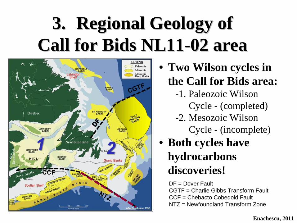
3. Regional Geology Of 3. Regional Geology Of Call For Bids NL11Call For Bids NL11--02 area02 area
• Complex Geodynamic Evolution• North Atlantic Rifting• Geologic Evolution of NL Margin
Sedimentary Basins• Recent Exploration Activity
Observation : More information on Regional and Petroleum Geology of the Call for Bids area is contained in the Enachescu (2010) presentation available from: : http://www.nr.gov.nl.ca/nr/invest/enachescuNL100203.pdf
3.3. Regional Geology of Regional Geology of Call for Bids NL11Call for Bids NL11--02 area02 area
Enachescu, 2011
DF = Dover FaultCGTF = Charlie Gibbs Transform FaultCCF = Chebacto Cobeqoid FaultNTZ = Newfoundland Transform Zone
• Two Wilson cycles in the Call for Bids area:
-1. Paleozoic Wilson Cycle - (completed)
-2. Mesozoic Wilson Cycle - (incomplete)
• Both cycles have hydrocarbons discoveries!

Complex Geodynamic EvolutionComplex Geodynamic Evolution• NL offshore basins have had a complex
geodynamic evolution including: – Repeated extension and transtension in Mesozoic,
block rotation, changes in the direction of rifting, salt tectonism, subsidence, uplift, erosion, volcanism, mantle exhumation and localized inversion (due to various causes but non plate convergence related) have created numerous hydrocarbon traps
• Several rifting stages with changes of direction followed by postrift sedimentation
• Oblique slip is a norm rather than an exception
Enachescu, 2011

Offshore NL basins were formed by intra-continental and oceanic rifting. There were four continental rifting phases in the N Atlantic region:
1. Tethys rift phase during Late Triassic to Early Jurassic
2. North Atlantic Rift phase during Late Jurassic to Berriasian
3. Labrador Sea Rift phase during Berriasian to Albian
4. Greenland/Europe rift phase during Late Cretaceous-Eocene
North Atlantic RiftingNorth Atlantic Rifting
Enachescu, 2011
Abbreviations are GL = Greenland, IB = Iberia, Af = Africa plates; SB =Saglek Basin, HB Hopedale Basin, WOB =West Orphan Basin, EOB = East Orphan Basin, JDB = Jeanne d’Arc Basin, FPB = Flemish Pass Basin, SJDB = South Jeanne d’Arc Basin, CB = Carson Basin, HS = Horseshoe Basin, WB = Whale Basin, SWB = South Whale Basin, SB = Scotian Basin, UFZ = Ungava Fault Zone CGFZ = Charlie Gibbs Fracture Zone, CBTZ = Cumberland Fault Transform Zone, NTZ = Newfoundland Transform ZoneAfter Enachescu et al. 2005;; Lowe et al., 2007
4
UFZ
Labrador
NL
= Position of Call for Bids NL11-02 parcels

Geologic Evolution of NL Margin Geologic Evolution of NL Margin Sedimentary BasinsSedimentary Basins
• Intra-continental Rifting; All basins start with an intra-continental lacustrine stage including red beds and “some” lacustrine source rocks
• Later, basins were periodically invaded by the Tethys Sea and then, the newly formed Atlantic Ocean. The oil proven basins - Jeanne D’Arc, Flemish Pass and the little explored East Orphan basins have remained intra- continental throughout their evolution
• Basins are segmented by transfer faults; 2-3 fault systems are present in the basins and ridges, corresponding with repeated changes of extensional vector direction
• Basins are abandoned branches of the Tethys, then North Atlantic rift
Enachescu, 2011

• The outer basins initiated as intra-continental, developed as intra-continental (Late Triassic to late Late Cretaceous) and only in Albo-Aptian became divergent margin basins. This is the case for Carson/Salar-Lusitania/Peniche and East Orphan/Flemish Pass/Porcupine pairs
• The outermost basins were then affected by Mantle Exhumation followed by Oceanic Rifting; Transform faults were active during these stages. As a result of transtension, large compression modified, extensional structures were formed
• Only the outermost rifts are successful rifts and they form the Canadian members of the pairs of conjugate margins basins (e.g. East Orphan /Flemish with Porcupine basins)
Geologic Evolution of NL Margin Geologic Evolution of NL Margin Sedimentary Basins (Cont.)Sedimentary Basins (Cont.)
Enachescu, 2011

• Transitional Crust emplacement took place before oceanic rifting. This crust is covered by thick post-exhumation (Mid-Cretaceous- Tertiary) sediments that might contain oil and gas accumulations (undrilled yet)
• Extensional system bounded in the north by the Dover Fault and Charlie Gibbs Transform Zone (CGTF) and in the south by a major Ocean-Continent Transform Zone (NTZ) later becoming an Ocean-Ocean Transform (Newfoundland-Gibraltar Transform)
• Intensive salt halokinetics and halotectonics; Diapirs due to gravity induced flow and salt walls (lineaments) due to extensional faulting and flow into rollover anticline and ridge cores
Geologic Evolution of NL Margin Geologic Evolution of NL Margin Sedimentary Basins (Cont.)Sedimentary Basins (Cont.)
Enachescu, 2011

• There are no or rare allochthonous salt or tow thrusts -unlike offshore Nova Scotia
• Diapiric salt extends to the North Jeanne/central Flemish Pass basins; Only stratified evaporite beds in the northern Flemish Pass/East Orphan basins
• Constrained (e.g. Jeanne d’Arc, Flemish Pass basins) and unconstrained (Laurentian, Salar basins)
• All Grand Banks and West Orphan basins have thick Tertiary cover while East Orphan Basin was a starved basin during most of Tertiary
• Individual basins/subbasins/rifts may be diachronous, with as much as ±10 MM years between forming events
Geologic Evolution of NL Margin Geologic Evolution of NL Margin Sedimentary Basins (Cont.)Sedimentary Basins (Cont.)
Enachescu, 2011
Recent Exploration Activity in Recent Exploration Activity in Call for Bids AreaCall for Bids Area
Enachescu, 2011
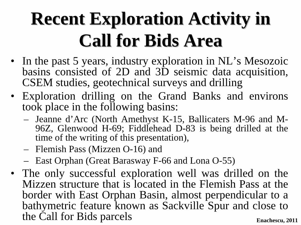
• In the past 5 years, industry exploration in NL’s Mesozoic basins consisted of 2D and 3D seismic data acquisition, CSEM studies, geotechnical surveys and drilling
• Exploration drilling on the Grand Banks and environs took place in the following basins: – Jeanne d’Arc (North Amethyst K-15, Ballicaters M-96 and M-
96Z, Glenwood H-69; Fiddlehead D-83 is being drilled at the time of the writing of this presentation),
– Flemish Pass (Mizzen O-16) and – East Orphan (Great Barasway F-66 and Lona O-55)
• The only successful exploration well was drilled on the Mizzen structure that is located in the Flemish Pass at the border with East Orphan Basin, almost perpendicular to a bathymetric feature known as Sackville Spur and close to the Call for Bids parcels

Recent Exploration Activity in Recent Exploration Activity in Call for Bids Area (Cont.)Call for Bids Area (Cont.)
Enachescu, 2011
• New exploration licences have been issued and consolidation/relinquishment of older issued ELs has taken place in East Orphan, Jeanne d'Arc/Central Ridge and Laurentian basins
• Large 3D surveys were collected in Jeanne d’Arc, Flemish Pass and East Orphan basins while basin-wide 2D grids were collected in Labrador Sea; two large 3D programs have been conducted in 2011 in the CFB NL11-02 area
• As of the fall of 2011 there are more than $ 900 million in exploration commitments to be undertaken by interest owners in NL Mesozoic basins
• The most exciting outcome of the last exploration cycle 2005-2011: A new offshore NL basin, Flemish Pass, has been proven to contain hydrocarbons in significant accumulations

4. Petroleum Geology of 4. Petroleum Geology of Call For Bids NL11Call For Bids NL11--02 Area02 Area
Enachescu, 2011
• Land Situation 2011• Recent Call for Bids Results• Exploration Results• Characteristics of Discoveries• Petroleum System (s)• Hydrocarbon Traps• Maturation and Migration• Resource Potential
Observation : More information on Regional and Petroleum Geology of the Call for Bids area is contained in the Enachescu (2010) presentation available from: http://www.nr.gov.nl.ca/nr/invest/enachescuNL100203.pdf

CFB NL11CFB NL11--02 Land Situation 201102 Land Situation 2011Exploration LicencesExploration Licences
Enachescu, 2011
1074R
1090R
1112
1111
1110
1123
1124
No ELs Area (ha) Operator
Flemish Pass1 EL 1112 55,954 Statoil2 EL 1123 201,951 Statoil3 EL 1124 125,421 Statoil
East Orphan1 EL 1074R 604,000 ExxonMobil
Central Ridge1 EL 1090R 136,395 Husky Oil2 EL 1110 138,200 Husky Oil3 EL 1111 134,227 Husky Oil
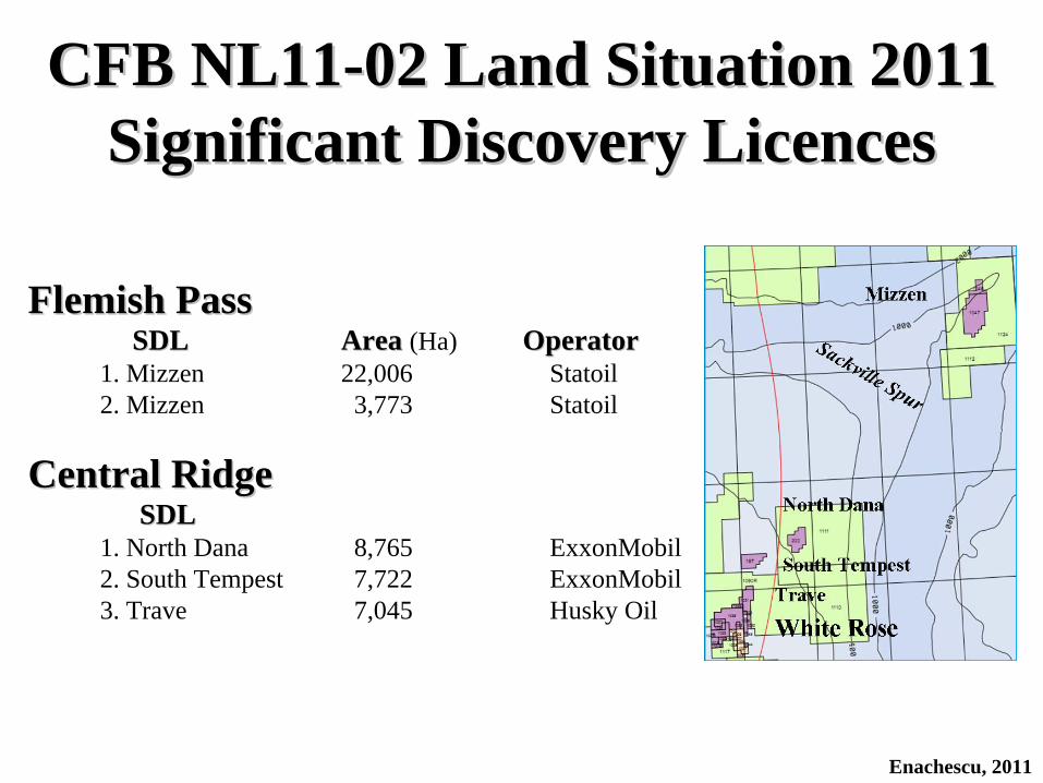
Flemish PassFlemish PassSDLSDL AreaArea (Ha) OperatorOperator
1. Mizzen 22,006 Statoil2. Mizzen 3,773 Statoil
Central RidgeCentral RidgeSDLSDL
1. North Dana 8,765 ExxonMobil2. South Tempest 7,722 ExxonMobil3. Trave 7,045 Husky Oil
CFB NL11CFB NL11--02 Land Situation 201102 Land Situation 2011Significant Discovery LicencesSignificant Discovery Licences
Enachescu, 2011
EL No. Basin Size (ha)Date
Issued Bid Size $ Operator Other Partners
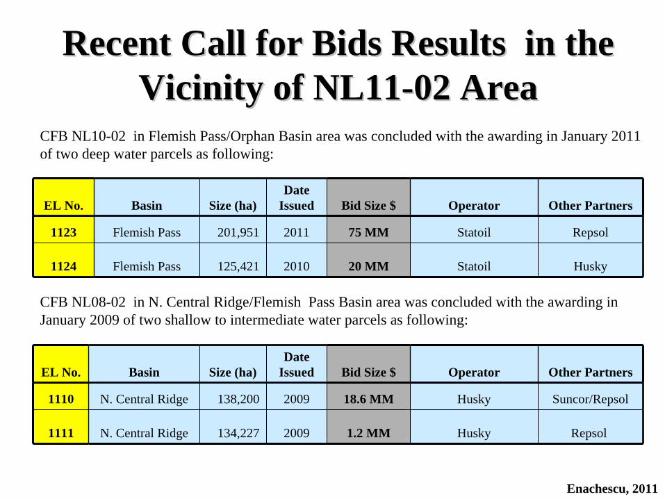
1123 Flemish Pass 201,951 2011 75 MM Statoil Repsol
1124 Flemish Pass 125,421 2010 20 MM Statoil Husky
Enachescu, 2011
Recent Call for Bids Results in the Recent Call for Bids Results in the Vicinity of NL11Vicinity of NL11--02 Area02 Area
EL No. Basin Size (ha)Date
Issued Bid Size $ Operator Other Partners
1110 N. Central Ridge 138,200 2009 18.6 MM Husky Suncor/Repsol
1111 N. Central Ridge 134,227 2009 1.2 MM Husky Repsol
CFB NL10-02 in Flemish Pass/Orphan Basin area was concluded with the awarding in January 2011 of two deep water parcels as following:
CFB NL08-02 in N. Central Ridge/Flemish Pass Basin area was concluded with the awarding in January 2009 of two shallow to intermediate water parcels as following:

CFB NL11CFB NL11--02 Area Exploration Results02 Area Exploration Results
Enachescu, 2011
No Discovery Date RecoverableGas (BCF)
Resources Oil (MMbbls)
Central Ridge 2 gas discoveries while searching for oil1 Trave H-81 1973 30 12 North Dana H-55 1974 426 113 South Tempest G-88 1981 8
Flemish Pass Basin1 Mizzen O-16 2009 N o t D i s c l o s e d
Observation: No exploration took place in the area between 1983-2003
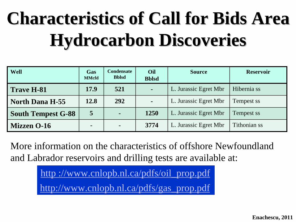
Characteristics of Call for Bids Area Characteristics of Call for Bids Area Hydrocarbon DiscoveriesHydrocarbon Discoveries
Well Gas MMcfd
Condensate Bblsd
Oil Bblsd
Source Reservoir
Trave H-81 17.9 521 - L. Jurassic Egret Mbr Hibernia ss
North Dana H-55 12.8 292 - L. Jurassic Egret Mbr Tempest ss
South Tempest G-88 5 - 1250 L. Jurassic Egret Mbr Tempest ss
Mizzen O-16 - - 3774 L. Jurassic Egret Mbr Tithonian ss
Enachescu, 2011
http ://www.cnlopb.nl.ca/pdfs/oil_prop.pdfhttp://www.cnlopb.nl.ca/pdfs/gas_prop.pdf
More information on the characteristics of offshore Newfoundland and Labrador reservoirs and drilling tests are available at:

Petroleum System(s)Petroleum System(s)• The only proven petroleum system on the Grand Banks and
environs is anchored by the Egret Member of the Rankin Formation (Late Jurassic) feeding hydrocarbons into
• Late Jurassic reservoirs such as the Voyager, Tempest, Jeanne d’Arc sandstones (ss)• Early Cretaceous reservoirs such as Hibernia, Catalina Avalon and Ben Nevis ss• Late Cretaceous reservoirs such as Fox Harbour and Otter Bay ss• Early Tertiary reservoirs such as Avondale and South Mara ss
• Older Late Jurassic shales (Callovian and Oxfordian) have also good source properties
• A possible source rock is the Albian shale (Nautilus Fm) that showed rich, marine organic content when drilled by the IODP leg 210, at a location situated just east of Flemish Cap
• Tertiary shales are yet unproven as source rocksEnachescu, 2011

Hydrocarbon Traps(s)Hydrocarbon Traps(s)• Structural
– Roll-over anticlines in front of basin bounding faults (e.g. Hibernia)– Salt core anticlines and ridges (e.g. White Rose, North Amethyst)– Rotated blocks (Hebron, Ben Nevis, North Ben Nevis)
• Combination– Onlapping sandstones on structural highs (e.g. Terra Nova)
• Stratigraphic– Channel, basin margin or basin floor fans (e.g. Springdale, Mara)
Observation: Most of the structural and combination traps on the Grand Banks are salt cored and multi-way bounded by faults. Larger traps are also dissected by several fault systems and may have multiple reservoirs. No salt induced features are in the CFB area. Large basement-cored rotated blocks are present throughout the area. The largest traps can host more than a billion barrels of oil or/and several Tcf of gas
Enachescu, 2011

Resource Potential: How Much Oil & Gas offshore NL?• More than 1.8 Bbbls proven remaining recoverable
reserves/resources exists in the Jeanne d’Arc Basin; approximately 11 Tcf of gas has been discovered offshore NL of which 6.6 Tcf of gas reside in JDB, however no gas sales to date
• Geoscience data indicate that a further 6 Bbbls and 60 Tcf undiscovered resources remain offshore Newfoundland and Labrador
• A large part of the oil resources is expected to be found in the North Jeanne d’Arc, North Central Ridge, Flemish Pass and East Orphan region
Enachescu, 2011
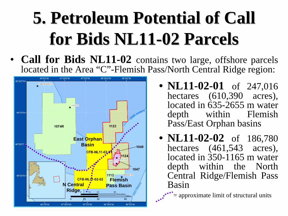
• Call for Bids NL11-02 contains two large, offshore parcels located in the Area “C”-Flemish Pass/North Central Ridge region:
• NL11-02-01 of 247,016 hectares (610,390 acres), located in 635-2655 m water depth within Flemish Pass/East Orphan basins
• NL11-02-02 of 186,780 hectares (461,543 acres), located in 350-1165 m water depth within the North Central Ridge/Flemish Pass Basin
5. Petroleum Potential of Call 5. Petroleum Potential of Call for Bids NL11for Bids NL11--02 Parcels02 Parcels
East Orphan Basin
Flemish Pass BasinN Central
Ridge= approximate limit of structural units

• The two large Call for Bids NL11-02 parcels are located on the outer shelf and slope of the Grand Banks of Newfoundland (GBN) and in the intermediate and deeper waters of Flemish Pass (FPB) and East Orphan (EOB) basins
• The parcels are in vicinity of proven hydrocarbon occurrences in the Jeanne d’Arc Basin and North Central Ridge, and just west of a new discovery in the Flemish Pass Basin
• Large structural, stratigraphic and composite traps are seen on seismic data collected in the area
Petroleum Potential of Call for Petroleum Potential of Call for Bids NL11Bids NL11--02 Parcels (Cont.)02 Parcels (Cont.)
Enachescu, 2011
Mizzen O-16 SDL
Jeanne d’Arc oil fields
EOB
FPB
GBN
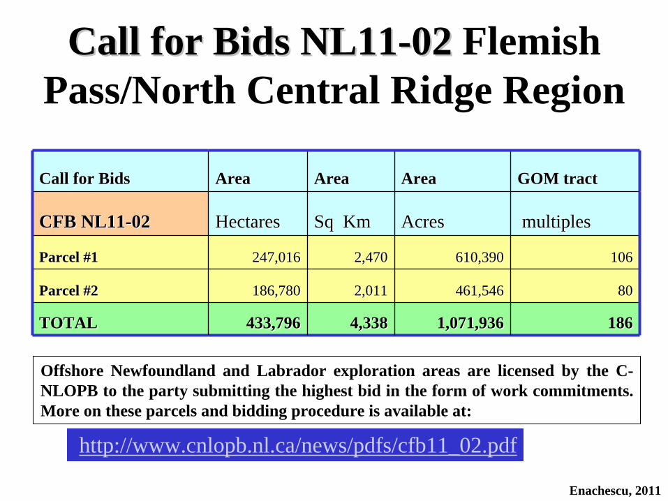
http://www.cnlopb.nl.ca/news/pdfs/cfb11_02.pdf
Call for BidsCall for Bids AreaArea AreaArea AreaArea GOM tractGOM tract
CFB NL11CFB NL11--0202 HectaresHectares Sq KmSq Km AcresAcres multiplesmultiples
Parcel #1Parcel #1 247,016247,016 2,4702,470 610,390610,390 106106
Parcel #2Parcel #2 186,780186,780 2,0112,011 461,546461,546 8080
TOTALTOTAL 433,796 433,796 4,3384,338 1,071,9361,071,936 186186
Call for Bids NL11Call for Bids NL11--02 02 Flemish Pass/North Central Ridge Region
Offshore Newfoundland and Labrador exploration areas are licensed by the C- NLOPB to the party submitting the highest bid in the form of work commitments. More on these parcels and bidding procedure is available at:
Enachescu, 2011
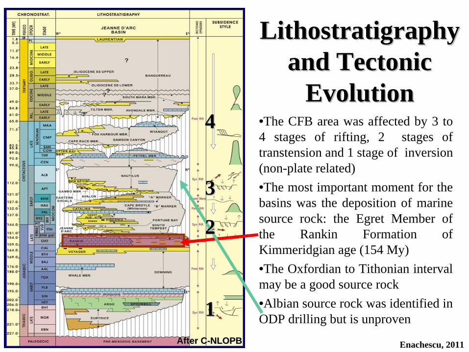
Lithostratigraphy Lithostratigraphy and Tectonic and Tectonic
EvolutionEvolution
11
33
44 •The CFB area was affected by 3 to 4 stages of rifting, 2 stages of transtension and 1 stage of inversion (non-plate related)•The most important moment for the basins was the deposition of marine source rock: the Egret Member of the Rankin Formation of Kimmeridgian age (154 My)•The Oxfordian to Tithonian interval may be a good source rock•Albian source rock was identified in ODP drilling but is unproven
After CAfter C--NLOPBNLOPB
22
Enachescu, 2011

Enachescu, 2011
• Mesozoic basins are floored by Proterozoic metamorphic rocks, and in places by Paleozoic strata and intrusive rocks. The economic basement in CFB area is the peneplained prerift basement. The Prerift basement was significantly stretched during Late Jurassic-Early Jurassic Synrift phase forming a succession of basins (grabens) and ridges (horsts). Large rotated basement blocks were successively modified by other rifting phases and became the cores of anticlinal features mapped in the area.
• Separated by uplifted blocks (e.g Central Ridge, Cumberland Belt) several basins were formed. NE-SW elongated horsts and grabens which developed during this phase have produced the structural framework of the margin
• The early Synrift phase deposits filled the incipient basins with lacustrine stages sediments including some reservoir rocks. An incursion of epicontinental Tethys Sea brought deposition of Argo salt. In the CFB area Argo salt is either thin or preserved as a stratified evaporite sequence interbeded with clastics as it does not show the intense diapirism present in the southern basins (e.g., Jeanne d’Arc, Southern Grand Banks)
TectonoTectono--Stratigraphic SummaryStratigraphic Summary
Enachescu, 2011
• Several rifting stages followed with the direction of extension changing to approximately E-W in Late Jurassic-Early Cretaceous and NW-SE in late Early Cretaceous to Late Cretaceous)
• During the Late Jurassic the Egret source rock has been deposited in a shallow sea filling the interconnected rift valleys. Older (Oxfordian) source rocks were also deposited in some of the basins and troughs
• Quality reservoir rocks were deposited during the Late Jurassic-Early Cretaceous, late Early Cretaceous, late Late Cretaceous and Early Tertiary
• As discussed by Enachescu et al. (2005) and Enachescu (2008 and 2010) the northern Flemish Pass Basin is not a distinct structural unit of the NL margin, but a higher terrace of the larger East Orphan Basin. During its evolution, including during the Late Jurassic, the Flemish Pass Basin was in communication with Jeanne d’Arc Basin and with the East Orphan Basin
• As the East Orphan and North Flemish Pass basins stratigraphy knowledge is in its infancy (due to few wells drilled and unreleased results of latest wells), the Jeanne d’Arc Lithostratigraphy Chart may be used to identify seismic stratigraphic sequences in the Call for Bids area. For simplicity only geological time are marked on the representative seismic lines used to illustrate this presentation
TectonoTectono--Stratigraphic SummaryStratigraphic Summary

= Oil Discovery
Significant Exploration WellsSignificant Exploration Wells
Enachescu, 2011
Well No
Well Name Basin TD (m)
Status
1 North Dana I-43 N Central Ridge 5304 Gas Well
2 Trave E-87 N Central Ridge 3986 Gas well
3 Panther P-15 N Central Ridge 4203 D&A
4 South Tempest N Central Ridge 4675 Oil Well
5 Baccalieu I-78 Flemish Pass 5135 D&A
6 Mizzen L-11 Flemish Pass 3823 Oil Show
7 Tuckamore B-27 Flemish Pass 2903 D&A
8 Great Barasway East Orphan 6751 D&A
9 Mizzen O-16 Flemish Pass 4474 Oil well
10 Lona O-55 East Orphan 5580 D&A
11 Mizzen F-09 Flemish Pass 3759 NR
Yellow = Exploration wells; Red = Delineation well; NR= Not ReleasedObservation: North Central Ridge wells are not shown on the map
= Gas and Condensate Discovery= Noteworthy Oil Show= D&A= Not Released yet
Atlantic Ocean
East Orphan B
Mizzen F-09
Flemish
Pass B

WellDril- led
WDm Status
Loca- tion
TD m
Ben Nevis
mAvalon
mBacca-
lieu ss m
Late Jurassic ss
m TestProdu- cer
Source rocks
South Tempest South Tempest GG--8888 19811981 158158
Aban- doned Oil
well
North North Central Central RidgeRidge 47754775 NoNo NoNo NoNo
7 intervals 7 intervals 3468 to 4117 3468 to 4117 Tempest ssTempest ss YesYes
3 intervals 3 intervals Tempest ssTempest ss YesYes
Baccalieu IBaccalieu I--7878 19851985 10931093Aban- doned
Flemish Flemish Pass BPass B 51355135 NoNo 21202120 31903190
4 intervals 4 intervals 3274 to 4550 3274 to 4550
mm NoNo NoNo YesYes
Panther PPanther P--5252 19851985 191191Aban- doned
North North Central Central RidgeRidge 42034203 NoNo NoNo NoNo
2 intervals2 intervals2969 to 3758 2969 to 3758 Tempest ssTempest ss NoNo NoNo YesYes
Mizzen LMizzen L--1111 20032003 11531153
Aban- doned Oil
Show SDL SDL 10471047 38233823 NoNo NoNo 33353335 35983598 NoNo NoNo YesYes
Great Barasway Great Barasway FF--6666 20072007 23382338
Aban- doned
200 km 200 km NWNW 67516751 NoNo NoNo PossiblePossible PossiblePossible NoNo NoNo PossiblePossible
Mizzen OMizzen O--1616 20092009 10951095
Aban- doned oil discovery
SDL SDL 10471047 37563756 NoNo NoNo NoNo
4 intervals4 intervals3202 to 36813202 to 3681Tithonian ssTithonian ss
Yes 3213 to 3224 m
1 interval 1 interval TTithonian
ss Yes
Lona OLona O--5555 20102010 26022602Aban- doned
100 km NW 55805580 No No
Not known
yet
Significant Wells Near Parcels 1 and 2Significant Wells Near Parcels 1 and 2
Enachescu, 2011
Not Released Yet
Observation: Other significant wells for the area Tuckamore, Lancaster and Gabriel in Flemish Pass Basin, North Dana on the Central Ridge have penetrated good reservoirs and source rock intervals. These wells have been discussed in previous Call for Bids presentations available from: http://www.nr.gov.nl.ca/mines&en/publications/offshore/ and http://www.nrov.nl.ca/mines&en/oil/
Significant Wells for CFB NL11Significant Wells for CFB NL11--0202• The most significant well for the area-Mizzen O-16, was drilled in 2009
approximately 20 to 50 km west of the two CFB NL11-02 parcels. The well intersected 4 sandstone intervals dated as Tithonian from 3202 to 3681 m (Jeanne d’Arc or Tempest ss equivalents). One interval between 3213 and 3224 tested heavier oil (22º API) at a rate of 3774 bopd. A delineation well Mizzen F-09 was drilled this year a few km north of O-16, but its results are still confidential
• Another important well, Mizzen L-11, drilled in 2003 on the same large synrift faulted anticline, intersected 5 m of oil pay on logs in E. Cretaceous ss (Baccalieu); two excellent reservoirs were intersected in L. Jurassic ss but were wet. Mizzen L-11 has proven that oil was generated in the Flemish Pass Basin and can form accumulation
• South Tempest G-88 is an earlier well (1981) that tested oil and gas from 3 Late Jurassic (Tempest) sandstone intervals. The highest rate was 1250 bopd of 42º API. Two other wells on the Central Ridge were successful: Trave E- 87 tested gas from Hibernia reservoir and North Dana I-43 tested gas from Tempest sandstone. Both these wells intersected Egret source rock
• Baccalieu I-78 is the closest dry hole to the CFB parcels. This well has intersected Kimmeridgian source rocks and Tithonian reservoirs
Enachescu, 2011

• The Call for Bids NL11-02 Parcels are well covered by a relatively dense 2D seismic grid. The adjacent map contains only the released data available in analogue format from C- NLOPB. Only a few seismic lines are in public domain for the northern part of Parcel 1
• Substantial more data exists in digital format and is available from oil companies and seismic contractors
• The 2D grid has a 2 to 4 km spacing in the dip direction and 4 to 8 km spacing in the strike direction
Seismic CoverageSeismic Coverage
Enachescu, 2011
NL11-02-01
NL11-02-02
L-11
O-16
F-09
O-55
I-78
P-52
G-88
I-43
B-27
C-60G-70
L-11
• As illustrated by numerous, previously published seismic sections, a thick synrift sequence (Late Triassic to early Late Cretaceous) fills the grabens and overlies the horsts and ridges in the northern part of the Grand Banks, Flemish Pass and Orphan basins (e.g., Smee, 2003; Enachescu et al., 2004 and 2005; Hardy, 2007; Hogg and Enachescu, 2007; Enachescu, 2008)
• Several representative seismic sections from the CFB area, tied to Mizzen wells, are discussed in the presentation by Enachescu ( 2010) available at:
http://www.nr.gov.nl.ca/nr/invest/enachescuNL100203.pdf• The synrift sedimentary successions are deformed by extension and
transtension, and are segmented by numerous faults; numerous rollover and basement cored anticlines are present
• The postrift sequence generally dips and thins basinward (toward the East Orphan and Flemish Pass basins), and is less deformed
• Considerable deformation of the Early Tertiary postrift sequence occurs on the slope and rise due to gravity or shale detachment tectonics
Representative Seismic SectionRepresentative Seismic Section
Enachescu, 2011

Representative Seismic SectionRepresentative Seismic Section
Enachescu, 2011
Interpreted dip seismic section C75-8 crossing the Central Ridge and Flemish Pass Basin the CFB NL11-02 area. The line interpretation shows main seismic stratigraphic successions, major faults, geodynamic stages and structural style. Seismic line source: C-NLOPB.
Post
rift
Synr
ift
PreriftBasement
Basement
• Oil company 2D digital data in CFB area is owned mainly by Suncor (inheriting Petro-Canada data base) and ExxonMobil (inheriting Mobil data base), Husky and Statoil. The various surveys recorded in the 1970s and early 1980s were used to locate and drill several shallow water wells in the North Central Ridge area and in the southern East Orphan Basin and several intermediate deep water wells in the Flemish Pass Basin
• The seismic grid that covers the CFB parcels (see slide 71) is in the public domain and therefore releasable in analogue format
• Multi-client seismic data from the same era are available from several seismic contractors. GSI of Calgary has a large grid of reprocessed multi-fold seismic data available for licensing in digital format
• GSI has collected modern seismic data in the North Grand Banks, East Orphan and Flemish Pass basins during the 1998-2003 period. Approximately 10,000 km of this data is positioned on or in vicinity of the CFB parcels
• Several large 3D surveys in the vicinity and within the CFB area have been acquired by Statoil and Chevron. Two 3D surveys were recorded during 2011
Seismic CoverageSeismic Coverage
Enachescu, 2011

Seismic InterpretationSeismic Interpretation• Regional seismic lines shown in this presentation were tied with synthetic
seismograms to several exploration wells in the Flemish Pass Basin and Central Ridge area
• The Prerift basement is hard to interpret on older data (too deep or too sketchy) and as such it was only indicated on the representative seismic sections
• Late Triassic to Quaternary successions are present in the area. Several regional unconformities are prominent (e.g. Base Tertiary, Avalon). On the illustrative seismic sections only a few markers and formations are displayed together with major faults (see slide 73)
• The Avalon Unconformity is a fair marker and allows to discriminate between the synrift and postrift sedimentary sequence
• Based on well intersections and seismic grid, the Jurassic sequence is thick. Now and then, the uppermost Jurassic rocks are eroded by the Avalon Unconformity on top of rotated blocks
• Several thick-skin, listric normal faults affect the synrift sequence. The resulting rotated blocks form anticlinal features that are exploration targets in the area
Enachescu, 2011

• Using the available seismic grid, several plays can be interpreted within the Late Jurassic to Early Tertiary basin fill in the NL11-02 Parcels 1 and 2.
• The typical play is “Structural high (Roll-over Anticline, Horst, Rotated Block, Faulted Anticline), with any of the Jeanne d ’ Arc, Hibernia, Avalon sandstones (primary target) and/or Paleocene sandstone (secondary target) sourced from Late Jurassic marine source rocks”
• In both parcels there are locations, where 3.5-5.5 Km deep wells can test the synrift and postrift sandstone plays
Seismic InterpretationSeismic Interpretation
Enachescu, 2011Line I605, Source: C-NLOPB

Three seismic lines: C75-8, 98-2203 and I605 are interpreted to illustrate the structural- stratigraphic style of the southern East Orphan Basin, Western Flemish Pass Basin and North Central Ridge and the petroleum potential of the two CFB NL11-02 parcels
Enachescu, 2011
Seismic Interpretation (Cont.)Seismic Interpretation (Cont.)
EL 1074R
East Orphan Basin
North Central Ridge
NL11-02-01
NL11-02-02
EL 1123
Flem
ish P
ass B
asin
EL 1112
EL 1124
SDL 1047
SDL 1048
EL 1111
EL 1110
SDL 200
Sackville Spur

5.1 Petroleum Potential of Call 5.1 Petroleum Potential of Call for Bids NL11for Bids NL11--02 Parcel 102 Parcel 1
Enachescu, 2011
• Parcel 1 covers 247,016 ha (610,390 acres) in the southern Orphan Basin, and northern Flemish Pass Basin just westward from ELs 1023 and 1024
• This is an intermediate to deep water parcel (635-2665 m, 1590 m average water depth) located on the Grand Banks northeastern slope and EOB
• No exploration wells have been drilled in the parcel
• The seismic horizons are interpreted using ties from the Mizzen L-11 and O-16 wells (drilled just 10 to 25 km east of the parcel) and Baccalieu I-78

Seismic Line C75Seismic Line C75--88
Interpreted dip seismic section C75-8 crossing Parcel NL11-02-01 and partially NL11-02-02. The Base Tertiary and Avalon Unconformities are prominent. A large regional Jurassic high A is cut by several faults, forming smaller horsts, grabens and rotated blocks. Leads for structural and combination traps exist in both parcels (A through H); a stratigraphic lead denoted S1 may represent a Tertiary mounded feature (seismic line source: C-NLOPB).
Enachescu, 2011
Sackville Spur
BSR
Basement
A
B
CD
EF
G
HS1

Seismic Line Seismic Line C75C75--88• This dip line C75-8 (approximately NNW-SSE) is located in the central part
of Parcel NL11-02-01, exiting the parcel to the south and entering Parcel 2• The line is positioned over the Sackville Spur bathymetric feature• The postrift sequences thicken on the Sackville Spur, where Bottom
Simulating Reflectors (BSR) indicate presence of gas hydrates in late Tertiary beds
• The basement reflector is deep, sketchy and poor quality on this data vintage• A large Jurassic regional high probably basement cored, is intersected by this
line • Deep penetrating normal faults compartment the synrift sequence and in
places also affect the lower Tertiary beds• These faults offset the predominantly clastic Late Jurassic-Cretaceous
sedimentary successions creating numerous elevated blocks, horsts and downthrown roll-overs trapping possibilities
• These possible structural leads are marked A through F in Parcel 1 and G and H in Parcel 2
• Combination and pure stratigraphic traps may exist as combination between the two major unconformities and truncated or onlapping coarse clastic beds
Enachescu, 2011

SummarySummaryStructural leads:• Large (5-20 km wide) and fault
bounded features containing Jurassic and Cretaceous beds that may include reservoirs and source rock
• Two horst-like structures marked B and E
• Two rotated blocks C and D and two roll-overs anticlines A and F
• Strike lines are needed to confirm closure of these leads
Stratigraphic leads:• Avalon and Base Tertiary sub-
unconformity or onlap type traps
Parcel NL11Parcel NL11--0202--0101
Enachescu, 2011
B, E = Possible closed horst feature in Parcel NL11-02-01
A, C, D, F = Possible closed fault block and roll-over in Parcel NL11-02-01
AB
CD E
FG
HS1
S1 = Possible stratigraphic trap

5.2 Petroleum Potential of Call 5.2 Petroleum Potential of Call for Bids NL11for Bids NL11--02 Parcel 202 Parcel 2
Enachescu, 2011
• Parcel 2 covers 186,780 ha (461,546 acres) in the south western part of the North Central Ridge and eastern Flemish Pass Basin, south of Parcel 1 and SW from the Mizzen SDLs
• This shallow to intermediate deep water parcel (350 -1165 m, 760 m average water depth) is located on the outer shelf and slope of Grand Banks. The parcel lies over the Sackville Spur bathymetric feature
• No exploration wells have been drilled in the parcel
• The seismic horizons are interpreted using ties the Mizzen L-11 and O-16 wells (drilled just 25 to 50 km east of the parcel) and Baccalieu I-78
NL11-02-02
Sackville Spur
Grand Banks
Flemish Pass B

Seismic Line 98Seismic Line 98--22032203
Interpreted dip seismic section 98-2203 crossing Parcel NL11-02-02 and un-licensed land in Flemish Pass Basin. The postrift sedimentary formations considerably thicken towards northwest over the Sackville Spur. A highly disturbed synrift sequence is segmented by several deep-penetrating faults. Drilling opportunities for structural and combination traps exist on rotated blocks, horsts and fault bounded roll-overs (I through O). Stratigraphic traps S2 and S3 are present in the postrift sequence (seismic line source: C-NLOPB). Enachescu, 2011
98-2203
I
Sackville Spur
LJ KS2
OM
N
S3
NL11-02-02
Seismic Line Seismic Line 9898--22032203• This dip line 98-2203 (NW-SE) is located in the central part of Parcel NL11-02-
02, extending southeasterly into unlicensed land• The line is positioned over the outer shelf and slope of the Grand Banks in an area
known as the Sackville Spur and Flemish Pass• The postrift sequence is thick over the Central Ridge and is thinner in the Flemish
Pass Basin. The Base Tertiary unconformity is a strong marker that plunges from the eastern boarder of the Flemish Pass Basin (one second) to the northwest into East Orphan Basin (4 seconds)
• The economic basement marker is not evident on this seismic line due to poor signal penetration
• The synrift sequence is thick. North-westerly dipping listric normal faults segment the synrift sequence into several horsts and rotated blocks in the parcel marked I through O
• The larger highs are 15 to 25 km wide but these leads need supplementary lines to be properly defined
• As the seismic line is of poor quality, no major faults are interpreted in the Late Cretaceous basin fill above the rotated blocks. However the interpreted faults may continue to the Base Tertiary extending upward the interpreted traps
• Numerous sub-unconformity traps and a two possible Tertiary fans S2 and S3 can be interpreted on this seismic line
Enachescu, 2011
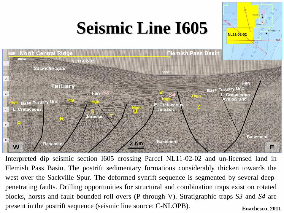
Seismic Line I605Seismic Line I605
Interpreted dip seismic section I605 crossing Parcel NL11-02-02 and un-licensed land in Flemish Pass Basin. The postrift sedimentary formations considerably thicken towards the west over the Sackville Spur. The deformed synrift sequence is segmented by several deep- penetrating faults. Drilling opportunities for structural and combination traps exist on rotated blocks, horsts and fault bounded roll-overs (P through V). Stratigraphic traps S3 and S4 are present in the postrift sequence (seismic line source: C-NLOPB). Enachescu, 2011
I605
S3
Sackville Spur
PTR
S U
V
Z
S4
BasementBasementBasement
NL11-02-02

Seismic Line Seismic Line I605I605• The seismic line I605 (W-E) is located in the southern part of Parcel NL11-02-
02, eastward into unlicensed land in Flemish Pass Basin• The line is positioned over the outer shelf and slope of the Grand Banks in an area
known Sackville Spur and Flemish Pass• The postrift sequence is thick over the Central Ridge and is thinner in the Flemish
Pass Basin. The Base Tertiary Unconformity is a strong marker that plunges from the eastern boarder of the Flemish Pass Basin (two seconds) to the northwest into East Orphan Basin (4 seconds)
• Data quality does not allow interpreting a continuous basement marker• The synrift sequence deepens towards the west• Westerly dipping listric normal faults divide the synrift sequence into several
horsts and rotated blocks that are marked P through V in Parcel 2• The larger highs are 10 to 20 km wide. All the leads shown on this line need
additional crossing lines to be confirmed• Several major faults extend into the Late Cretaceous and Tertiary successions and
can create multi-pay traps• Tertiary fans can be interpreted on the seismic line, S3 that is also visible on line
seismic 98-2203, and S4. Other stratigraphic traps may be formed at the Avalon and Base Tertiary unconformity levels
Enachescu, 2011
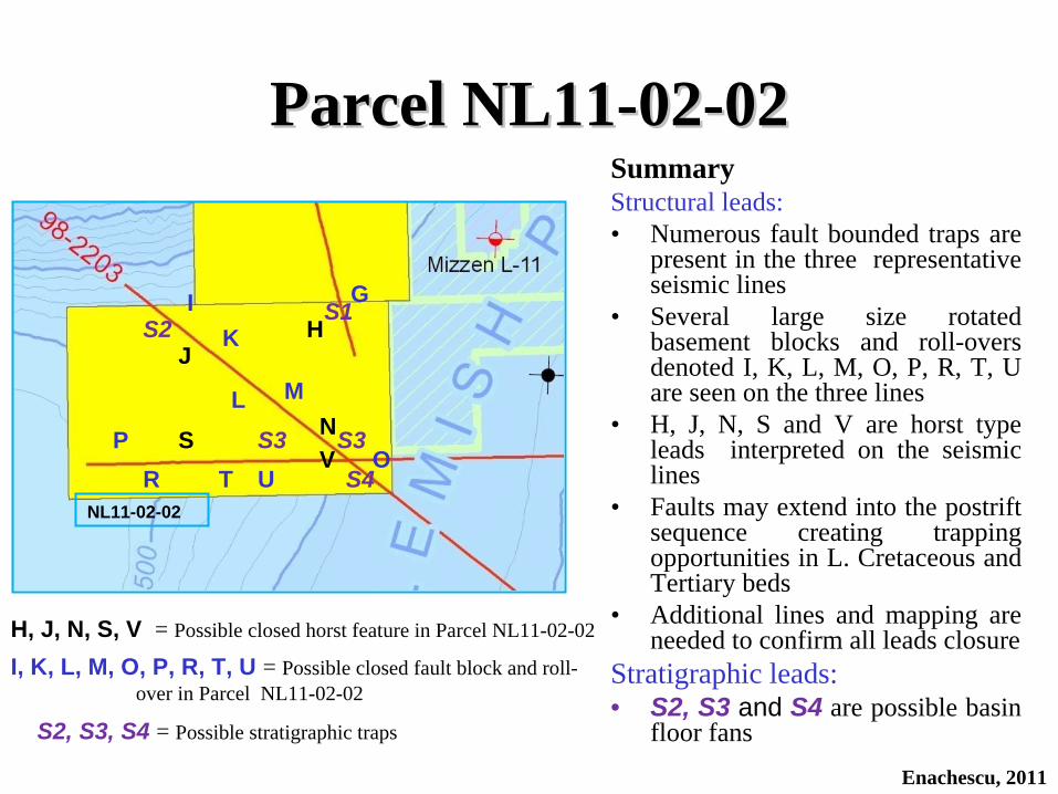
SummaryStructural leads:• Numerous fault bounded traps are
present in the three representative seismic lines
• Several large size rotated basement blocks and roll-overs denoted I, K, L, M, O, P, R, T, U are seen on the three lines
• H, J, N, S and V are horst type leads interpreted on the seismic lines
• Faults may extend into the postrift sequence creating trapping opportunities in L. Cretaceous and Tertiary beds
• Additional lines and mapping are needed to confirm all leads closure
Stratigraphic leads:• S2, S3 and S4 are possible basin
floor fans
Parcel NL11Parcel NL11--0202--0202
Enachescu, 2011
NL11-02-02
GH
S1I
H, J, N, S, V = Possible closed horst feature in Parcel NL11-02-02
I, K, L, M, O, P, R, T, U = Possible closed fault block and roll- over in Parcel NL11-02-02
J
O
K
MLN
S2
S3PR
ST U
VS3
S4
S2, S3, S4 = Possible stratigraphic traps

Comments on Seismic DataComments on Seismic Data• Seismic coverage for the two CFB NL11-02 parcels can be
purchased as digital data from vendors such as GSI, TGS, CGG or data brokers
• Older seismic data can be obtained as hard copies for inspection, for the nominal cost of reproduction, from C- NLOPB in St. John’s, NL
• Older than mid-1990s data has poor quality and was recorded with shorter than 4 km cables. Retrieving the original field data and reprocessing old lines to pre-stack depth migration is needed to better image leads in the two parcels and environs
• Access to modern digital data recorded during the past decade by GSI and TGS is necessary to confirm the identified leads (slides 81 and 87) and define drillable prospects
• 3D data may be now or become available from companies such as Chevron, Statoil and ExxonMobil that acquired data in the Flemish Pass and Orphan basins
Enachescu, 2011

• The area’s main hydrocarbon play is structural; it involves porous synrift Late Jurassic (e.g. Tempest, Jeanne d’Arc) and/or Early Cretaceous (e.g. Hibernia, Baccalieu) sandstone reservoirs trapped in large, faulted anticlines
• More than a dozen structural leads such as horsts, rotated blocks and rollover anticlines have been identified on the public domain seismic lines (slides 79, 83 and 85) crossing Parcels NL11-02-01 and -02. These leads are probably multi-way fault bounded (Mizzen-like anticline) and therefore they need to be mapped using denser, high quality, modern grids available from seismic vendors
• Several large stratigraphic plays were identified. They reside mostly in Parcel 2. These leads are Tertiary basin floor fans that also need better coverage to be adequately mapped
• There are several possible locations where a well will intersect both the potential synrift reservoirs and the stratigraphic leads
Prospects and LeadsProspects and Leads
Enachescu, 2011

• Good seals such as regional Fortune Bay, Nautilus, Dawson Canyon and Banquereau shales are present in all parcels
• The leads located in CFB Parcels 1 and 2 were mapped by companies active in the area in the 1970s and early 1980s (Mobil, Petro-Canada, Esso, Shell, Husky, etc.). Their regional seismic interpretation reports and annexed time structural maps for the area parcels are available from the C-NLOPB archive and can be inspected and copied for bid evaluation
• Main geological risks of the area’s leads and prospects are: the possibility of fault leaking, quality of the reservoir and access to quality source rock. The large size of the structural leads identified in these parcels should mitigate these risks
• If firm closures can be proven by mapping the area’s 2D and or 3D seismic coverage, each of the interpreted structural leads is capable of holding large oil and gas resources (hundreds of million to a billion barrels of oil or several Tcf of gas)
Prospects and Leads (Cont.)Prospects and Leads (Cont.)
Enachescu, 2011

• The North Grand Banks/East Orphan Basin/Flemish Pass Basin area where the NL11-02 parcels are located, is a marine exploration frontier in which only a handful of wells have been drilled. The earlier wells were drilled based on poor quality, low penetration seismic data
• Numerous hydrocarbon leads identified with old seismic data in this highly deformed area, remain to be mapped and confirmed by modern data
• No exploration has been carried out in these parcels since the early 1980s• Two gas fields and an oil field have been discovered in the North Central
Ridge in an earlier exploration phase• A significant oil discovery (size unpublished) was recorded in 2009 at the
nearby Mizzen O-16 location and delineated by the Mizzen F-09 well • Significant exploration activity is taking place on the same structural trend in
ELs 1023 and 1024• CFB NL11-02 parcels are very large when compared with a Gulf of Mexico
standard section (more than 80 times larger)• Parcels may contain multiple targets within Late Jurassic, Early Cretaceous,
Late Cretaceous and Early Tertiary sandstone reservoirs at depths between 3500-5500 m which can be tested by using drill ships
6. Discussions6. Discussions
Enachescu, 2011

• Risks exist as to fault closure, reservoir quality and source rock quality; new mapping with reprocessed and modern 2D and 3D seismic data may lower the geological risk
• The area’s structural traps can host resource estimates of hundred of million barrels of oil and/or several Tcf natural gas
• A 6-year (Period 1) +3-year (Period 2) = 9-year term Exploration Licence is set by C-NLOPB for North Central Ridge/Flemish Pass Basin (Area “C”). Licence awards are based on highest work commitment bid
• Royalty regime is well established and places offshore NL in the middle to- upper tier of world’s favorable areas for petroleum exploration and production
• Canada is one of the countries with the most stable political and financial system and has a long tradition in oil and gas exploration
• The NL Province obtains 27.5% of the nominal GDP from the oil and gas industry and is actively encouraging offshore exploration
• There is a robust regulatory regime in the offshore area including HS&E. Provincial Government encourages offshore exploration, however safety of workers and protection of environment are paramount
Discussions (Cont.)Discussions (Cont.)
Enachescu, 2011
7. Conclusions7. Conclusions• Two large parcels located offshore Newfoundland in the Area “C” - Flemish
Pass/North Central Ridge are available for licensing in the C-NLOPB’s Call for Bids NL11-02 which closes on November 15, 2011, 4 p.m. NL time
• The parcels are in a region with large extensional and transtensional traps, where previous drilling has proven good reservoirs, mature source rocks, proven migration paths and several oil and gas accumulations
• This is the second Call for Bids in the area. The first CFB in 2003, while successful, left unlicensed the presently offered parcels. Therefore the parcels have not been explored since early 1980s
• The basin contains excellent Late Jurassic source rocks which are known to generate large oil accumulations
• Parcels are located within the “Late Jurassic Source Rock Super Highway” indicated by wells and seismic correlations that connects the Grand Banks to Flemish/East Orphan basin and across the Atlantic to Porcupine Basin
• Large structural leads such as horsts, tilted blocks and rollover anticlines interpreted in the parcels 1 and 2 may have closure at several synrift reservoir levels. Closures may vary in size from 40 to 140 sq km
Enachescu, 2011

Conclusions (Cont.)Conclusions (Cont.)
Enachescu, 2011
• Relatively dense 2D seismic coverage is available in Parcels 1 and 2 to image and map petroleum traps in the synrift and postrift sequences. Exclusive 3D surveys may exist on portion of Parcels 1 and 2
• Parcels are situated in water depth varying between 350 m and 2665 m (average 1590 in Parcel 1 and 760m in Parcel 2). The leads are located at distances of 40 to 120 km from the shore line
• The A to V leads (see slides 81 and 87) defined in parcels NL11-02-01 and - 02, are situated in an underexplored basin, close to oil production in Jeanne d’Arc Basin and to NE American and Canadian markets
• Recognized risks in regard to fault seal, reservoir quality and source rock quality are mitigated by the presence of very large undrilled features
• Estimated sizes of unrisked reserves that may be contained in the identified leads are up to a billion barrels of oil or several Tcf of natural gas
• These parcels provide excellent petroleum resource prospects to any new, seasoned operator that desire an entry position in an underexplored basin with high upside, or to an existing operator willing to consolidate its leadership position in the NL hydrocarbon exploration and production industry
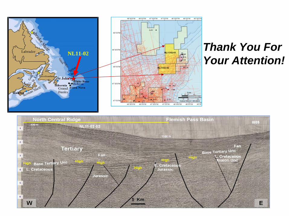
NL11-02Thank You For Your Attention!


![[Chap6102]CHAPTER 61:02 PETROLEUM … · PETROLEUM (EXPLORATION AND PRODUCTION) ARRANGEMENT OF ... Notice of intention to commence exploration or ... Commissioner for Petroleum Exploration](https://img.dokumen.tips/doc/110x75/5b7bb8197f8b9adb4c8d3af1/chap6102chapter-6102-petroleum-petroleum-exploration-and-production-arrangement.jpg)