Embed Size (px)
Citation preview
BENEFITS AND FEATURES ■ Streamline everyday workflows using
flexible, dynamically linked 3D, section, and map canvases.
■ Perform stratigraphic interpretation, contouring, map editing, and structural complexity evaluation prior to modeling.
■ Bridge the gap between seismic interpretation and modeling with the structural framework and volume-based modeling tools.
■ Gain a better understanding of trends and correlations using powerful data analysis and trend-modeling tools.
■ Use the most extensive array of algorithms in the industry to model geology as geology.
■ Enhance characterization of depositional features identified in seismic attributes with seismic sampling and geobody modeling workflows.
■ Incorporate new data using local model update, without disturbing the history-matched model away from the changed region.
■ Leverage the naturally fractured reservoirs modeling workflow, integrating all cross-domain fracture observation data.
■ Confidently estimate reserves while assessing uncertainty from all perspectives.
■ Rapidly update high-quality maps when new data is available.
■ Capture and reuse knowledge throughout the entire workflow.
Geoscientists and engineers are only able to assemble all the pieces of the subsurface puzzle in a shared software platform. With the Petrel* E&P software platform, the best technology ensures that the most complex challenges can be solved. In 3D, map, or section views, you can visualize, analyze, interpret, and edit geophysical, geological, reservoir engineering, production, and drilling data. The Petrel platform provides seamless and repeatable workflows from exploration through to production, captures your team’s geological knowledge, and manages the subsurface uncertainty. With the Petrel platform you get what you need, when you need it, in a productive environment—no barriers, no silos, no data integrity loss, and no wasted time.
Boost conventional workflows—with increased productivityTo better delineate prospects, it is important to understand geology from both regional and local perspectives. With the Petrel platform, all the conventional tools—cross sections, well correlation, reservoir summation, maps, and volumetric calculations—are accessible to you and your team in a single, integrated environment. These tools are multidisciplinary and multifunctional, allowing you to view and edit information from every angle. The Petrel platform facilitates geologists’ everyday work, going further than traditional workflows—bridging the gap between static and dynamic modeling and production geology workflows.
The multiuser interpretation environment provided by the Studio* E&P knowledge environment ensures efficient collaboration between all geoscientists and engineers in the team. In addition to receiving instant notifications on data and interpretation updates, geoscientists can retrieve and seamlessly add new data into their work. Furthermore, the Studio environment provides the geoscientist unique and unrivalled capabilities to quickly find and access any relevant data, directly within the context of their Petrel session.
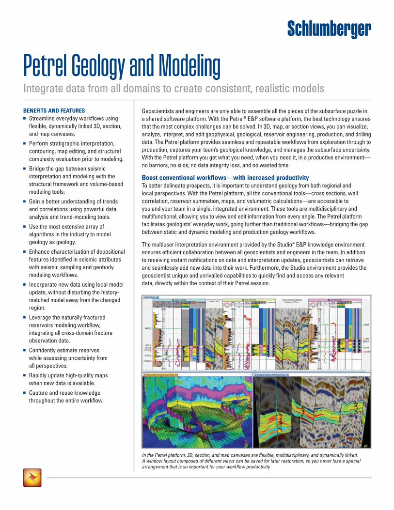
In the Petrel platform, 3D, section, and map canvases are flexible, multidisciplinary, and dynamically linked. A window layout composed of different views can be saved for later restoration, so you never lose a special arrangement that is so important for your workflow productivity.
Petrel Geology and ModelingIntegrate data from all domains to create consistent, realistic models
Petrel Geology and ModelingFundamental mapping and stratigraphic interpretationMaps are the basis for understanding regional, reservoir, and prospect level structures and characteristics. The Petrel platform enables you to generate high-quality maps at the regional or prospect scale, and update them quickly without having to change applications—display the data you want to visualize and interactively adjust the scale and style settings. Object layering hierarchy, customizable labels, and pie charts representing well data enhance reports and presentations. Vitally, if any data is modified in the project, maps are updated with minimal effort in seconds—keeping your maps live.
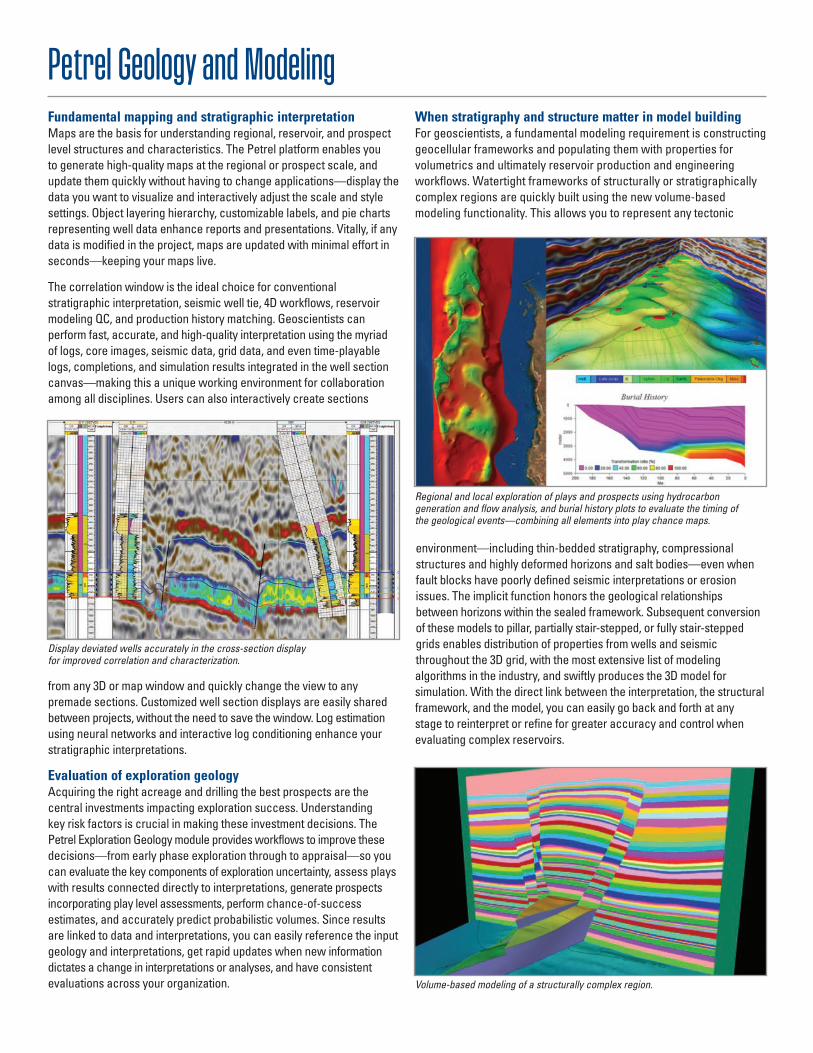
The correlation window is the ideal choice for conventional stratigraphic interpretation, seismic well tie, 4D workflows, reservoir modeling QC, and production history matching. Geoscientists can perform fast, accurate, and high-quality interpretation using the myriad of logs, core images, seismic data, grid data, and even time-playable logs, completions, and simulation results integrated in the well section canvas—making this a unique working environment for collaboration among all disciplines. Users can also interactively create sections
from any 3D or map window and quickly change the view to any premade sections. Customized well section displays are easily shared between projects, without the need to save the window. Log estimation using neural networks and interactive log conditioning enhance your stratigraphic interpretations.
Evaluation of exploration geologyAcquiring the right acreage and drilling the best prospects are the central investments impacting exploration success. Understanding key risk factors is crucial in making these investment decisions. The Petrel Exploration Geology module provides workflows to improve these decisions—from early phase exploration through to appraisal—so you can evaluate the key components of exploration uncertainty, assess plays with results connected directly to interpretations, generate prospects incorporating play level assessments, perform chance-of-success estimates, and accurately predict probabilistic volumes. Since results are linked to data and interpretations, you can easily reference the input geology and interpretations, get rapid updates when new information dictates a change in interpretations or analyses, and have consistent evaluations across your organization.
When stratigraphy and structure matter in model buildingFor geoscientists, a fundamental modeling requirement is constructing geocellular frameworks and populating them with properties for volumetrics and ultimately reservoir production and engineering workflows. Watertight frameworks of structurally or stratigraphically complex regions are quickly built using the new volume-based modeling functionality. This allows you to represent any tectonic
environment—including thin-bedded stratigraphy, compressional structures and highly deformed horizons and salt bodies—even when fault blocks have poorly defined seismic interpretations or erosion issues. The implicit function honors the geological relationships between horizons within the sealed framework. Subsequent conversion of these models to pillar, partially stair-stepped, or fully stair-stepped grids enables distribution of properties from wells and seismic throughout the 3D grid, with the most extensive list of modeling algorithms in the industry, and swiftly produces the 3D model for simulation. With the direct link between the interpretation, the structural framework, and the model, you can easily go back and forth at any stage to reinterpret or refine for greater accuracy and control when evaluating complex reservoirs.
Display deviated wells accurately in the cross-section displayfor improved correlation and characterization.
Regional and local exploration of plays and prospects using hydrocarbon generation and flow analysis, and burial history plots to evaluate the timing of the geological events—combining all elements into play chance maps.
Volume-based modeling of a structurally complex region.
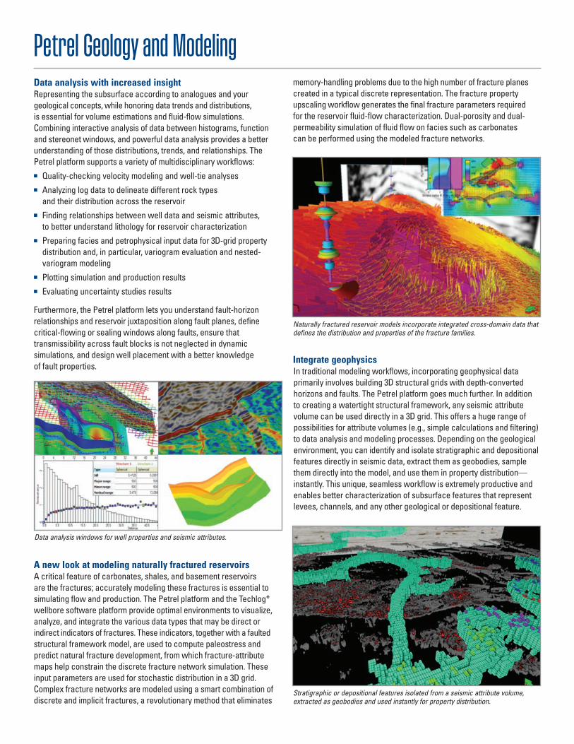
Petrel Geology and ModelingData analysis with increased insightRepresenting the subsurface according to analogues and your geological concepts, while honoring data trends and distributions, is essential for volume estimations and fluid-flow simulations. Combining interactive analysis of data between histograms, function and stereonet windows, and powerful data analysis provides a better understanding of those distributions, trends, and relationships. The Petrel platform supports a variety of multidisciplinary workflows:
■ Quality-checking velocity modeling and well-tie analyses ■ Analyzing log data to delineate different rock types
and their distribution across the reservoir ■ Finding relationships between well data and seismic attributes,
to better understand lithology for reservoir characterization ■ Preparing facies and petrophysical input data for 3D-grid property
distribution and, in particular, variogram evaluation and nested-variogram modeling
■ Plotting simulation and production results ■ Evaluating uncertainty studies results
Furthermore, the Petrel platform lets you understand fault-horizon relationships and reservoir juxtaposition along fault planes, define critical-flowing or sealing windows along faults, ensure that transmissibility across fault blocks is not neglected in dynamic simulations, and design well placement with a better knowledge of fault properties.
A new look at modeling naturally fractured reservoirsA critical feature of carbonates, shales, and basement reservoirs are the fractures; accurately modeling these fractures is essential to simulating flow and production. The Petrel platform and the Techlog* wellbore software platform provide optimal environments to visualize, analyze, and integrate the various data types that may be direct or indirect indicators of fractures. These indicators, together with a faulted structural framework model, are used to compute paleostress and predict natural fracture development, from which fracture-attribute maps help constrain the discrete fracture network simulation. These input parameters are used for stochastic distribution in a 3D grid. Complex fracture networks are modeled using a smart combination of discrete and implicit fractures, a revolutionary method that eliminates
memory-handling problems due to the high number of fracture planes created in a typical discrete representation. The fracture property upscaling workflow generates the final fracture parameters required for the reservoir fluid-flow characterization. Dual-porosity and dual-permeability simulation of fluid flow on facies such as carbonates can be performed using the modeled fracture networks.
Integrate geophysicsIn traditional modeling workflows, incorporating geophysical data primarily involves building 3D structural grids with depth-converted horizons and faults. The Petrel platform goes much further. In addition to creating a watertight structural framework, any seismic attribute volume can be used directly in a 3D grid. This offers a huge range of possibilities for attribute volumes (e.g., simple calculations and filtering) to data analysis and modeling processes. Depending on the geological environment, you can identify and isolate stratigraphic and depositional features directly in seismic data, extract them as geobodies, sample them directly into the model, and use them in property distribution—instantly. This unique, seamless workflow is extremely productive and enables better characterization of subsurface features that represent levees, channels, and any other geological or depositional feature.
Data analysis windows for well properties and seismic attributes.
Naturally fractured reservoir models incorporate integrated cross-domain data that defines the distribution and properties of the fracture families.
Stratigraphic or depositional features isolated from a seismic attribute volume, extracted as geobodies and used instantly for property distribution.
Petrel Geology and ModelingModel geology as geologyHow do you model the depositional concepts imagined by the geoscientist, while at the same time honoring all available data? With the wide variety of modeling algorithms available in the Petrel platform, you can select the appropriate algorithm based on available data and the geological environment.
For facies distribution, you choose from a list of deterministic or stochastic methods including indicator kriging, object modeling, sequential indicator simulation, truncated Gaussian simulation, and multipoint facies simulation. All stochastic methods have been revised to include servo-systems, to fine-tune the algorithms and better match target facies fractions. For better control when inserting facies objects, geometrical trend modeling enables you to generate flowline-derived azimuth properties—especially useful in guiding adaptive channels.
In areas with sparse well control, you can gain a better understanding of regional trends by correlating well information with seismic attributes—creating probability volumes to guide the spatial distribution of rock properties. For petrophysical modeling, fast kriging and Gaussian random simulations are provided, as well as traditional geostatistical algorithms. Continuous primary property distribution can combine up to five secondary properties of various types and dimensions—probability curves, maps, seismic attribute trends, and more.
Geoscientists gain a better understanding of the subsurface by building a realistic shared earth model, using all available information and expertise—with lithology fractions and reservoir connectivity that best represent the depositional system. All this leads to simulations that accurately represent the geology and support more accurate drilling and development plans.
Local model updateTo incorporate new data into a model, it is often necessary to modify the structure of your grid locally by flexing horizons and internal layers, without changing previously distributed properties. This can be performed on the entire grid—when assessing various velocity modeling scenarios—or locally inside a polygon, which is essential for well placement workflows. Gridded properties can be updated—only in the cells you want to modify—maintaining continuity with the surrounding model and ensuring your history matched model is maintained away from the updated region.
Uncertainty and optimization The uncertainty and optimization process provides powerful analysis tools to analyze sensitivities or multiple alternative scenarios throughout the entire E&P cycle.
E-mail [email protected] or contact your local Schlumberger representative to learn more.Trend-modeling processes enable better control of the distribution of rock
properties in the reservoir model.
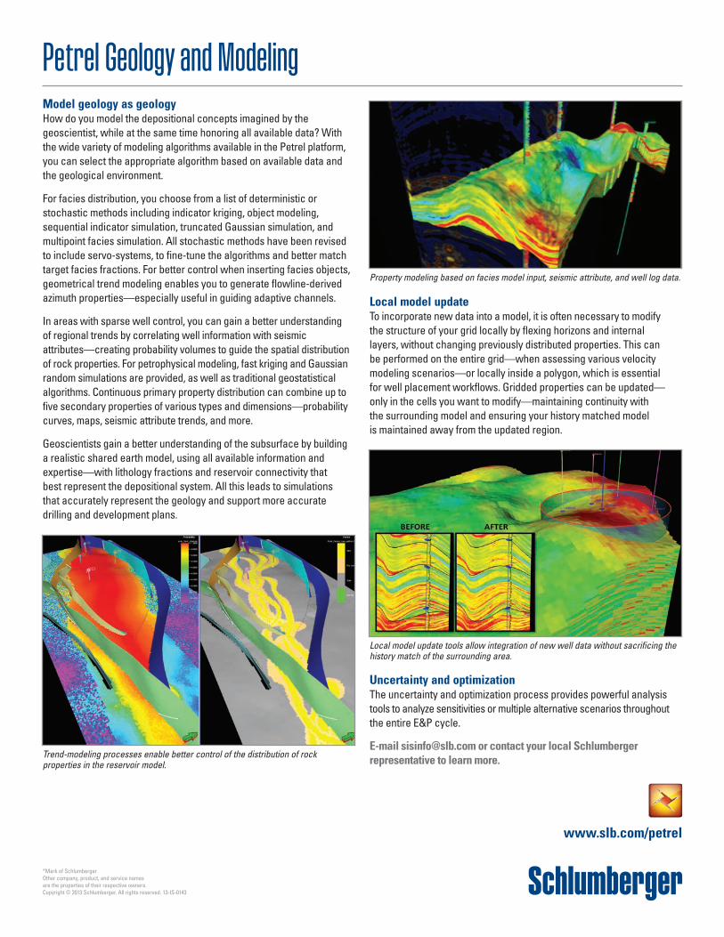
Property modeling based on facies model input, seismic attribute, and well log data.
Local model update tools allow integration of new well data without sacrificing the history match of the surrounding area.
www.slb.com/petrel
*Mark of SchlumbergerOther company, product, and service names are the properties of their respective owners.Copyright © 2013 Schlumberger. All rights reserved. 13-IS-0143