Embed Size (px)
Citation preview

Personal Wayfinding Assistance
von Falko Schmid
Dissertationzur Erlangung des Grades eines Doktors der
Ingenieurwissenschaften— Dr.-Ing. —
Vorgelegt im Fachbereich 3 (Mathematik & Informatik)der Universitat Bremen
im November 2010

Datum des Promotionskolloquiums: 14.12.2010
Gutachter: Prof. Christian Freksa, Ph.D. (Universitat Bremen)Prof. Dr.-Ing. Stephan Winter (University of Melbourne)

Zusammenfassung
Jeden Tag legen wir viele verschiedene Wege zuruck. Dabei ist es furuns kein Problem, uns in bekannten Umgebungen zurechtzufinden. Wirkennen den Weg vom Schlafzimmer zur Kuche, von unserer Wohnung zurArbeit, vom Parkplatz ins Buro, und am Ende des Arbeitstages von dortaus wieder nach Hause. All diese Wege haben wir in der Vergangenheitgelernt und finden deshalb ohne viel nachzudenken unser Ziel.
Sobald wir jedoch an die Grenzen unserer mentalen Karten stoßen undeinen uns unbekannten Ort auffinden wollen, benotigen wir Hilfe. Manch-mal fragen wir Freunde, ob sie uns den Weg beschreiben konnen, in ande-ren Fallen schauen wir auf einer Karte, wo sich dieser Ort genau befindet.Immer haufiger sind mittlerweile Mobiltelefone mit Wegfindungsassis-tenz ausgestattet. Sie sind klein und handlich, dadurch stets dabei undverfugbar, wenn sie gebraucht werden. Auf diese Weise konnen wir alsofast uberall fur jeden Ort Wegfindungsassistenz bekommen. Wahrend diegeringe Große Mobiltelefone also einerseits praktikabel macht, ist sie furdie Darstellung von Karten jedoch von großem Nachteil. Denn um dievielen geographischen Informationen verstandlich darstellen zu konnen,wird viel Platz benotigt. Doch meistens sind nicht alle in einer Karteabgebildeten Informationen notwendig, um eine bestimmte Route zu er-klaren. So ist zum Beispiel die Abbildung kleiner Parkwege fur einen Au-tofahrer in der Regel nicht relevant. Verzichtet man auf einen großen Teilder nicht benotigten Information, kann man den Karteninhalt semantischverdichten und die Karte so in vielen Fallen deutlich verkleinern, ohneauf notwendige Information verzichten zu mussen.
Eine gezielte Informationsreduktion erfordert eine genaue Kenntnisuber den Benutzer, uber die zu losende Aufgabe, und uber die Umgebung,in die diese eingebettet ist. In dieser kumulativen Dissertation entwicke-le ich ein Verfahren, welches das Vorwissen des Nutzers verwendet, umKarten an die Anforderungen mobiler Gerate mit kleinen Displays an-zupassen. Dazu kristallisiere ich grundsatzliche Fragen, die wahrend desWegfindens auftreten konnen, heraus und setze sie mit dem Vorwissendes Benutzers in Beziehung. Dieses Verfahren ermoglicht die Erzeugungvon personlicher, kontext-spezifischer Wegfindungsassistenz in Form vonKarten, die fur kleine Displays optimiert sind.
Um dies zu erreichen stelle ich algorithmische Verfahren vor, die ausTrajektorien raumliche Benutzerprofile ableiten. Die individuellen Pro-file enthalten Informationen uber die Orte, die ein Benutzer regelmaßig
i
aufsucht, und uber die Wege, die dafur genutzt werden. Mit Hilfe die-ser Daten konnen personalisierte Karten erzeugt werden, die fur teilwei-se bekannte Umgebungen geeignet sind. In diesen Karten werden nurdie unbekannten Anteile detailliert gezeigt. Die bereits bekannte Infor-mation wird vereinfacht. Dadurch konnen die Karten stark verkleinertwerden, wahrend der Informationsgehalt durch Einbindung personlichbedeutsamer Orte erhalten bleibt. Die Verstandlichkeit der individuellenWegfindungsassistenz wird dadurch gewahrleistet, dass auch die Namender Orte dem Benutzer angepasst werden. In der Arbeit wird deshalbauch die Benennungspraxis von Orten untersucht und das Potential derautomatischen Selektion und Generierung von Ortsnamen ausgelotet.
Personalisierte Karten funktionieren jedoch nur in Umgebungen, furdie der Nutzer ein gewisses Maß an Vorwissen besitzt. Befindet er sich invollig unbekannten Umgebungen, werden vollstandige Information beno-tigt. In dieser Arbeit werden Verfahren vorgestellt, die den Benutzer intypischen Situationen unterstutzen, die wahrend der Wegfindung auftre-ten konnen. Ich stelle Losungen vor, die den Erwerb von Kontext- unduberblickswissen entlang der Route vermitteln sowie die Selbstlokalisie-rung im Falle einer Desorientierung unterstutzen.
ii

Abstract
We are traveling many different routes every day. In familiar environ-ments it is easy for us to find our ways. We know our way from bedroomto kitchen, from home to work, from parking place to office, and backhome at the end of the working day. We have learned these routes in thepast and are now able to find our destination without having to thinkabout it.
As soon as we want to find a place beyond the demarcations of ourmental map, we need help. In some cases we ask our friends to explainus the way, in other cases we use a map to find out about the place. Mo-bile phones are increasingly equipped with wayfinding assistance. Thesedevices are usually at hand because they are handy and small, which en-ables us to get wayfinding assistance everywhere where we need it. Whilethe small size of mobile phones makes them handy, it is a disadvantagefor displaying maps. Geographic information requires space to be vi-sualized in order to be understandable. Typically, not all informationdisplayed in maps is necessary. An example are walking ways in parksfor car drivers, they are they are usually no relevant route options. Bynot displaying irrelevant information, it is possible to compress the mapwithout losing important information.
To reduce information purposefully, we need information about theuser, the task at hand, and the environment it is embedded in. In thiscumulative dissertation, I describe an approach that utilizes the priorknowledge of the user to adapt maps to the to the limited display optionsof mobile devices with small displays. I focus on central questions thatoccur during wayfinding and relate them to the knowledge of the user.This enables the generation of personal and context-specific wayfindingassistance in the form of maps which are optimized for small displays. Toachieve personalized assistance, I present algorithmic methods to derivespatial user profiles from trajectory data. The individual profiles containinformation about the places users regularly visit, as well as the traveledroutes between them. By means of these profiles it is possible to generatepersonalized maps for partially familiar environments. Only the unfamil-iar parts of the environment are presented in detail, the familiar parts arehighly simplified. This bears great potential to minimize the maps, whileat the same time preserving the understandability by including person-ally meaningful places as references. To ensure the understandability ofpersonalized maps, we have to make sure that the names of the places
iii

are adapted to users. In this thesis, we study the naming of places andanalyze the potential to automatically select and generate place names.
However, personalized maps only work for environments the users arepartially familiar with. If users need assistance for unfamiliar environ-ments, they require complete information. In this thesis, I further presentapproaches to support uses in typical situations which can occur duringwayfinding. I present solutions to communicate context information andsurvey knowledge along the route, as well as methods to support self-localization in case orientation is lost.
iv

Acknowledgments
I would like to express my sincere gratitude to my advisor ChristianFreksa. I am grateful for his support at every stage of my thesis and forgiving me the necessary freedom to develop my ideas. I am very thankfulfor being part of his inspiring research group. I want to thank StephanWinter for the fruitful discussions in Melbourne and for being my secondsupervisor.
I would like to thank my co-authors Aisan Kazerani, Colin Kuntzsch,Patrick Laube, Denise Peters, Benjamin Preisig, Kai-Florian Richter, andStephan Winter. It would not have been possible to write this cumulativedissertation without their contributions.
This work has been done in the project I2-[MapSpace] of the Tran-sregional Collaborative Research Center SFB/TR 8 Spatial Cognition.I want to thank the Deutsche Forschungsgemeinschaft (DFG) for thefinancial support.
I want to thank all my colleagues at the Cognitive Systems group forthe great and unique atmosphere. I have found friends and not just co-workers. In particular, I want to thank Kai-Florian Richter for being thegreatest colleague and PI one can think of.
My sincere thanks go to my proofreaders Sandra Budde, Lutz Fromm-berger, Julia Gantenberg, and Jan Frederik Sima for their last-minutecommitment. In particular, I want to thank Lutz for his dedicated andpragmatic help during the last hours before printing.
Above all, I want to express my sincere gratefulness to Eva, Justus,and Luis for their endless loving support during the last years. Withouttheir encouragement and understanding it would have been impossiblefor me to finish this work.
v

Contents
Contributing Publications viii
1 Mobile Devices for Wayfinding Support 11.1 Motivation . . . . . . . . . . . . . . . . . . . . . . . . . . 11.2 Wayfinding with Small Devices . . . . . . . . . . . . . . 2
1.2.1 Small Displays and Maps . . . . . . . . . . . . . . 31.3 Notions and Terminology . . . . . . . . . . . . . . . . . . 4
1.3.1 Wayfinding . . . . . . . . . . . . . . . . . . . . . 41.3.2 Wayfinding Assistance . . . . . . . . . . . . . . . 5
1.3.2.1 Maps . . . . . . . . . . . . . . . . . . . 61.3.2.2 Mobile Maps . . . . . . . . . . . . . . . 9
1.3.3 Map Adaptation by Context: T × E × A → R . . 101.3.3.1 T : The Tasks . . . . . . . . . . . . . . . 141.3.3.2 E: The Environment . . . . . . . . . . . 171.3.3.3 A: The Agent . . . . . . . . . . . . . . . 171.3.3.4 R: Schematic Maps . . . . . . . . . . . . 19
1.4 Research Questions and Thesis . . . . . . . . . . . . . . 211.5 Contributions . . . . . . . . . . . . . . . . . . . . . . . . 221.6 Organization of This Thesis . . . . . . . . . . . . . . . . 23
2 Extracting Places From Location Data Streams 25
3 Knowledge-based Wayfinding Maps For Small Display Cartog-raphy 35
4 Semantic Trajectory Compression 65
5 Enhancing The Accessibility of Maps With Personal Framesof Reference 73
6 In-Situ Communication and Labeling of Places 85
7 Mental Tectonics — Rendering Consistent μMaps 107
8 Route Aware Maps: Multigranular Wayfinding Assistance 127
9 Situated Local and Global Context in Mobile You-Are-HereMaps 155
vi

Contents
10 Conclusions and Outlook 16710.1 Task-Specific Results . . . . . . . . . . . . . . . . . . . . 16710.2 Environment-Specific Results . . . . . . . . . . . . . . . 16810.3 Agent-Specific Results . . . . . . . . . . . . . . . . . . . 16810.4 Representation-Specific Results . . . . . . . . . . . . . . 16910.5 Future Directions . . . . . . . . . . . . . . . . . . . . . . 169
Bibliography 171
vii

Contributing Publications
Falko Schmid and Kai-Florian Richter. Extracting places from locationdata streams. In Online Proceedings of UbiGIS 2006 - Second In-ternational Workshop on Ubiquitous Geographical Information Services.http://www.ubigis.org, 2006.
Falko Schmid. Knowledge based wayfinding maps for small display cartogra-phy. Journal of Location Based Services, 2(1):57–83, 2008.
Falko Schmid, Kai-Florian Richter, and Patrick Laube. Semantic trajectorycompression. In Niko Mamoulis, Thomas Seidl, Torben Bach Pedersen,Kristian Torp, and Ira Assent, editors, Advances in Spatial and TemporalDatabases — 11th International Symposium, SSTD 2009, volume 5644 ofLecture Notes in Computer Science, pages 411–416. Springer; Berlin, 2009.
Falko Schmid and Colin Kuntzsch. In-situ communication and labeling ofplaces. In Mike Jackson, Suchith Anand, and Georg Gartner, editors, Elec-tronic Proceedings of the 6th International Symposium on LBS and Tele-Cartography. University of Nottingham, 2009.
Falko Schmid. Enhancing the accessibility of maps with personal frames ofreference. In Julie A. Jacko, editor, 13th International Conference, HCIInternational 2009, San Diego, Proceedings Part III, volume 5612 of LectureNotes in Computer Science, pages 199–210. Springer, 2009a.
Falko Schmid. Mental tectonics - rendering consistent μmaps. In Kath-leen Stewart Hornsby, Christophe Claramunt, Michel Denis, and GerardLigozat, editors, Spatial Information Theory, 9th International Conference,COSIT 2009, volume 5756 of Lecture Notes in Computer Science, pages245–262. Springer-Verlag Berlin Heidelberg, 2009b.
Falko Schmid, Kai-Florian Richter, and Denise Peters. Route aware maps:Multigranular wayfinding assistance. Spatial Cognition and Computation,10(2):184–206, 2010a.
Falko Schmid, Colin Kuntzsch, Stephan Winter, Aisan Kazerani, and Ben-jamin Preisig. Situated local and global orientation in mobile you-are-heremaps. In MobileHCI ’10: Proceedings of the 12th international conferenceon Human computer interaction with mobile devices and services, pages83–92, New York, NY, USA, 2010b. ACM.
viii

1 Mobile Devices forWayfinding Support
This is a cumulative dissertation. It consists of eight peer-reviewed arti-cles which have been published in workshop and conference proceedings,and journals. The articles Schmid and Richter [2006], Schmid [2008],Schmid, Richter, and Laube [2009], Schmid and Kuntzsch [2009], Schmid[2009b,a], Schmid, Richter, and Peters [2010b], Schmid, Kuntzsch, Win-ter, Kazerani, and Preisig [2010a] represent the chapters 2 to 9 of thisdissertation.
1.1 Motivation
Wayfinding is one of the most elementary activities of our lives. It issuch a basic and automated activity that we do not recognize it all inour daily routines: we easily find our way from bed to kitchen, fromhome to work, from work to the supermarket, from vegetables to milk,and finally back home. But once we arrive at the demarcations of theenvironment we are familiar with, we recognize how hard it can be to finda new, yet unfamiliar place in the world. In this situation, since thereis no established route we could take without mental effort, we have toacquire this knowledge with the help of assistance.
However, we are often not entirely unfamiliar with an environment;sometimes we do not want to know all available details of the environ-ment, and sometimes we get lost on the way. This means, we are notalways interested in one general form of wayfinding support. An idealform of assistance should consider our particular requirements for thebest and most effective support for a given situation.
One key to enable tailored wayfinding support are mobile devices, suchas mobile phones. They offer a multitude of possibilities to show mapsand to retrieve information from the user and the environment. Theportability of these devices ensures that they are usually at hand whenwayfinding assistance is required. This allows the development of tailoredwayfinding assistance with a focus on the specific user and the particularsituation the user is in.
In my thesis I will demonstrate the possibilities of context-specificwayfinding support with small mobile devices. In particular, I will em-phasize the consideration of the wayfinding task and personalizing the
1

1 Mobile Devices for Wayfinding Support
assistance towards the individual user. The resulting support explicitlyaddresses the requirements the devices put on wayfinding assistance.
1.2 Wayfinding with Small Devices
Whenever we have to find our way to a given unknown place we needwayfinding support. This support can be for example another human wecan ask for directions, a map, or a wayfinding application on our mobilephone. Mobile phones have become powerful computers with the possi-bility to show maps, to compute routes to places, and to determine thecurrent location by means of e.g. GPS positioning. The combination ofthese three capabilities allows the implementation of complex wayfind-ing assistance applications. The ability to sense a user’s current locationhelps to compute and update routes to a given destination. It furthercan support the user to keep track of the route while traveling to thedestination, e.g. by visualizing the traveling progress on a map or byproviding navigation instructions. As mobile phones are designed to becarried around in nearly any situation, this means wayfinding supportcan be queried where and when it is required. It does not have to beprefabricated anymore like printed maps.
The combination of mobility and ad-hoc computation allows the user toretrieve tailored support for different stages and circumstances involvedin the wayfinding process. Traveling to a new destination consists ofseveral typical stages. Before traveling a route from A to B, the route andits relation and embedding in the environment are inspected, typically bymeans of a map with a highlighted route. Once the relation is clarified theuser is ready to travel. While following the route, users reassure if theyare still on-route or observe the progress using a map and highlightedposition obtained from the GPS receiver.
Each of the phases is driven by different questions of the user, like“Where am I now on the route?”, “Where do I have to turn next?”, or“Where is the destination with respect to places I already know?”. Eachof the questions reflect different typical tasks involved in wayfinding,namely the acquisition of survey and context information of a route, self-localization and route following. When we have precise questions, wewant to retrieve concise answers. This means, we expect the wayfindingsupport system to answer them as accurately as possible and present theinformation as comprehensible as possible.
The mobile device at hand offers a multitude of possibilities to reactto the needs of the users and assist them during the wayfinding processwith tailored answers to specific questions. For instance, a mobile phonecan be utilized to find out about the places a user knows by analyzingthe movement of the user. This learned information can be used tocommunicate the location of new place effectively: if the yet unknown
2
1.2 Wayfinding with Small Devices
place is close to the work place of the user, the visualization of the relationof both places can be enough to clarify the location at a glance.
Mobile devices are not only handy and portable, but they buy theirsmallness with essential drawbacks in display size and interaction possi-bilities. Small displays are problematic when we want to show maps in asufficient level of detail to understand a route. When the display is toosmall for showing the visual information comprehensibly, users will haveto interact with the information to fully understand it. This means, if aroute on a map cannot be shown at an appropriate scale, the user has tozoom in and out, or scroll within the map to understand it. When thedevice additionally limits the way the information can be manipulated,arriving at comprehension can be a stony path.
One solution to foster the comprehension of the wayfinding supportis to tailor the assistance not only towards the specific wayfinding task,but also to the output medium – the small mobile device. We have toconsider how we can present the required information on devices withsmall displays. Additionally we have to develop new ways to interactwith the information when the available space is still not enough.
1.2.1 Small Displays and Maps
The generality of the problem of small displays and limited interactionpossibilities becomes clear when we opt for maps as wayfinding support.The visualization of maps does not only require a high resolution, butalso a sufficient size of the display. Although streets, street names, land-marks and all other elements of maps can be drawn arbitrarily smallwithin the boundary of the resolution, the elements require a certainsize to understood by a user. If this space is not available, it is up tothe user to switch between views where for instance either the details atan intersection are in focus or the general course of the route is visible.There is no general solution to this problem — maps are generated fromgeographic information which is inherently highly constrained. It is notpossible to magnify only selected streets, because all adjacent elementswill either be occluded or dislocated. This leads straight into an incon-sistent representation of the world, and it will be hard to draw a correctconclusion from it.
Though we require information to understand and follow a route, wedo not require all information of the map covering the area of the route.For example, we usually do not need to know about small streets andparkways that are not located along the route. Beside being dispensable,this information also could be a source of distraction from the relevantinformation. If an application just draws a route on a general map, itloses the potential of highlighting it beyond coloring the route. At thesame time the map would automatically add superfluous information and
3
1 Mobile Devices for Wayfinding Support
hampers the focusing on the relevant parts of the map. This means, inthe same way we can compute routes between any pair of places, we canuse the potential of selecting only the geographic information which isnecessary to optimally support the understanding of a route, of the nextdecision to take, or of a location.
One key to identifying the important information for wayfinding assis-tance is to focus on the task at hand and to consider relevant contextualinformation. For example, when users are familiar with the environment,we can highlight only the relevant part of a route, namely the part whichis yet unknown. Rather than using the available space of the display ofa mobile phone for information that is already known to the user, wecan adumbrate familiar parts and use the remaining space for unfamiliarand new information. The resulting map can be fundamentally differentfrom a map showing all information, however, due to the reduced infor-mation it can be visualized more compactly by preserving the necessaryinformation.
1.3 Notions and Terminology
This section presents the approach of this thesis. We will define the basicterms and clarify their role for the publications presented in chapters 2to 9.
1.3.1 Wayfinding
Wayfinders have to perform a number of mental and physical tasks tonavigate to a familiar or unknown destination. They have to reason aboutspace to plan and choose a route out of several options, they have tointerpret spatial situations along the route to identify the correct branchto turn. During navigation wayfinders also have to perform very basictasks like identifying solid ground to walk securely, or avoiding to bumpinto obstacles. Concluding, navigating from A to a given B consists oftwo components: First, high-level reasoning and interpretation processesinvolved in wayfinding and second, rather basic sensory-motoric processesof locomotion, [e.g., Montello, 2005, Mallot, 1999]. In this work, we areonly interested in wayfinding, thus reasoning about and interpretationof space and spatial representations and how the involved tasks can besupported by means of wayfinding assistance.
In the scope of this thesis, wayfinding is purposeful, motivated move-ment to a specific destination which is not contained in the immedi-ate surrounding environment and is not visible from the vantage of thewayfinder. Wayfinding requires that wayfinders have a motivation tomove themselves from A to B. There are manifold reasons, for example,going to work, shopping, visiting friends, consulting a doctor, going on
4

1.3 Notions and Terminology
holiday. Wayfinding happens along a route from A to B. A route is adefined sequence of paths selected from a network of paths, such as thestreet network of a city.
The visual horizon of a wayfinder is called vista space or isovists [seeMontello, 1993, Benedikt, 1979, Batty, 2001]. When a place is beyondvista space, wayfinders cannot pilot the destination by means of basicsensory-motor coupled locomotion. This means, the information of howto navigate to the destination is not completely observable in the envi-ronment. In this situation the wayfinder requires additional informationto be able to plan a route and to reach the destination. If the place anda route are already known, the wayfinder can reason and plan with theinformation stored in the mind of the wayfinder, the so-called cognitivemap or mental map [e.g., Tolman, 1948, Tversky, 1993, Richardson et al.,1999]. If the place or a route is not known to the wayfinder, the missingspatial information has to be completed with external information: thewayfinding assistance.
1.3.2 Wayfinding Assistance
As long as origin, destination and a traversable route between them isknown to wayfinders, there is no need for assistance. In the absenceof comprehensive or sufficient information about either the origin, thedestination, or a complete route between the origin and the destination,we need assistance to find the way. This means, we need to performroute planning and navigation with the help of external assistance orbehavioral strategies [e.g., Montello, 2005, Allen, 1999, Golledge, 1992].External assistance is any form of given representation of the environ-ment which is not retrieved from the mind of the wayfinder or perceiveddirectly in the environment (such as following signage). Maps and routedirections are examples for external assistance in form of representationsof the environment and the route. Representations typically describe anenvironment on a much smaller scale than reality and are selective inwhat they communicate. For example, maps do not represent every treeand route directions do not refer to every single house along the course[e.g., MacEachren, 1995, Klippel et al., 2005a].
Assistance has to be given because perceivable cues are not assistanceper se; they are only meaningful if they are explicitly pointed to. Alandmark like a church can be highly salient, but it only serves as anelement of wayfinding assistance for a specific route if it is incorporatedby an instruction or description. It is not the sheer presence of landmarksthat makes them meaningful – but their explicit integration on a semanticlevel within assistance, [e.g., Daniel and Denis, 2006, Lovelace et al., 1999,Michon and Denis, 2001, Richter, 2008].
The purpose of wayfinding assistance is to help wayfinders to reach
5

1 Mobile Devices for Wayfinding Support
their destination by means of pointing them to helpful elements of thereal world. There are many forms of describing a route from A to B. Thevariety spans from human or computer generated route directions, hand-drawn sketch maps, city maps, digital maps on the Internet to GPSassisted turn-by-turn navigation instructions, or hybrid combinations.Beside the usual types of assistance, there are many specialized forms forpersons with special needs, like tactile or verbal assistance for visuallyimpaired people.
1.3.2.1 Maps
One of the oldest and most comprehensive forms of wayfinding assis-tance are geographic maps [e.g., Akerman and Karrow, 2007]. The mapstypically used for wayfinding are topographic maps. They visualize in-formation of geographic space which is too large to be observed directly,such as a city or country. Maps communicate information about placeswithout requiring the user to visit them.
As the scale of a map is usually much smaller than the size of entitiesin the real environment, the depicted information is highly simplified,[e.g., MacEachren, 1995]. The simplification is a result of technical re-quirements and cartographic generalization. Observations of geographicobjects, like the curvature of objects, are usually recorded with discretemethods like sequences of positioning data and capture them with in-complete information. Additionally, as the resulting map is generated ona smaller scale than the objects are in reality, measurements have to beremoved during reproduction because they cannot be distinguished any-more: due to the smaller scale, several objects are potentially mapped tothe same position, thus information gets lost. The removal of the data,or rather the selection of what is still displayed on which scale, is subjectto cartographic generalization. Depending on the purpose of the map,the human map-maker or the generating algorithm have to decide whichelements are relevant to be represented in which level of detail on a givenscale [e.g., McMaster and Shea, 1992].
Wayfinding maps typically depict street networks between distinguish-able places of a certain level of granularity linked with the chosen scale.This means, the map of the main street network between the cities of acountry does not contain small streets within the depicted cities or placeslike buildings. Instead, they show elements of the same information gran-ularity, in this case cities and links between them. A city plan on theother hand displays the street network of a city and places on the level ofe.g., buildings. As wayfinding maps contain the complete street networkon a certain scale and for a defined portion of space, they can be usedas a route planning tool between any distinguishable places contained inthe map. Wayfinding maps are general problem solvers for all possible
6

1.3 Notions and Terminology
routes between the entities on the map.
Cognitive Complexity and Visual Complexity of Maps With the in-troduction of digital maps the route planning and selection is typicallyprovided by a computer. The general street network maps are still usedto visualize the route and its course within the embedding environment.This practice does not make use of the possibilities digital maps offer: inthe same way it is possible to compute a route between any places au-tomatically, it is also possible to generate specific maps for this distinctroute.
The benefit of tailoring a map to a specific route can be found in thecomplexity of general wayfinding maps. Those maps have been designedfor all possible wayfinding problems within the defined portion of space.Maps such as city plans have been designed to ensure their generality asa problem solver. At the time of printing, it is not possible to identifybeforehand which information would be be necessary in the future for aspecific map user. Printed wayfinding maps typically contain as muchinformation as possible, as each of the depicted entities could be of inter-est to someone. For a static representation like a paper map, adding asmuch information as possible is the only solution if the assistance has tobe small , portable, and general. However, the more and the more diverseinformation a map contains, the harder it is to interpret for human users.One reason is the increase of the cognitive complexity which is linked tomental processing of relations between the visualized objects. The moreobjects are visualized on a map, the more relations have to be maintainedmentally. The second reason is the visual complexity which is linked tothe amount of different symbols on a map. The higher the diversity ofelements the higher is the chance of getting distracted by unnecessaryinformation. This is called visual clutter [e.g., Phillips, 1977, Phillipsand Noyes, 1982, Phillips, 1995, Rosenholtz et al., 2007]. In other words,there is a general conflict between the amount of information on mapsand the efficiency of understanding the information. We can resolve thisconflict by considering the query and selecting only information which isrelevant to solve the task. E.g., if a route is selected for a car, we do notneed to communicate small hiking trails in a park along the route whichare contained in the general map. The same holds for detailed streetnetwork information far away of the route: this information is not onlyirrelevant for the driver, but also a source for visual clutter.
Maps, Route Directions, and Turn-by-Turn Instructions There arerepresentations for routes that transport less information than maps. Inroute directions, a route is described as sequence of egocentric actions atdecision points and usually incorporates outstanding features like land-marks from the environment in the direct vicinity of the route [e.g., Daniel
7

1 Mobile Devices for Wayfinding Support
and Denis, 2006, Lovelace et al., 1999, Michon and Denis, 2001, Richter,2008]. Route directions trade-off their reduced complexity with a massiveloss of helpful contextual information. They do not communicate config-urational knowledge beyond features directly located along the route. Ingood route directions, this information is sufficient to navigate along aroute, but it is not enough to understand the relationship between routeand the embedding environment. Only with additional contextual infor-mation beyond the route it is possible to understand the environmentand for example to recover from navigation errors that can occur duringthe wayfinding process.
Humans have a basic desire to understand the environment we are lo-cated in. If the environment is unfamiliar or only partially familiar, theunderstanding is highly dependent on the information offered about it.Visual representations are able to communicate configurational informa-tion very efficiently. When we use maps, we can immediately see howlarge objects are relatively to each other and how they are oriented toeach other. The expression of complex spatial relations by means of ver-bal representations is a hard task and a huge number of mutual relationshave to be made explicit so that configurations can be understood. How-ever, not only the representation, but also the amount of information hasgreat influence on understanding the environment. For example, in Aslanet al. [2006], Parush et al. [2007], Ishikawa et al. [2008] it is shown thatusers of position triggered turn-by-turn instructions (like GPS-based nav-igation devices) do not trust this form of information reduced assistance.Apart from a generally reported feeling of insecureness, the participantsof the studies made more stops than map users, made larger direction es-timation errors, and drew sketch maps with poorer topological accuracy.These are strong indicators that people do not learn the environmentproperly and seem not to trust the assistance.
The reason can be found in the use case of positioning based navigationdevices: planning of a route and the guidance from current position toa destination. Users do not have to know where they are at any stageof the process, as this is completely left to the device. Users just haveto follow the instruction to turn at the next decision point. The onlyremarkable cognitive performance left to wayfinders is the recognitionof the decision point, which is in most cases within the vista of thewayfinder. Put differently, navigation is mainly reduced to the sensory-motor component locomotion, a process which does not require memorybased mental operations [Wiener and Mallot, 2003].
Arguing for maps for wayfinding assistance is not a nostalgic lookback: maps and map-like representations are the only media able tocommunicate significant spatial survey knowledge beyond a route. Evenif we can build up spatial survey knowledge from traveling a numberof routes and combining them mentally [see e.g., Ishikawa and Montello,
8
1.3 Notions and Terminology
2006], routes disappear from the mental representation, because the morewe rely on turn-by-turn directions, the less important the route and theenvironment become.
1.3.2.2 Mobile Maps
Wayfinding assistance is currently migrating to mobile devices such asmobile phones. This also includes to display maps to communicate spatialinformation. Most devices are equipped with positioning techniques suchas GPS and electronic compasses. This combination allows automaticand effortless self-localization and egocentric alignment of maps which isrelevant to easy map understanding, [e.g., Hermann et al., 2003].
However, when we visualize maps on mobile devices, we immediatelyface a hard problem: the small size of the screens that contrasts thedemands of visualizing geographic information. Geographic informationis inherently multi-relational constraint. The size and shape of entities,the distances between them, and their orientation in space are in a fragileequilibrium. When we alter only selected relations the global informationgets inconsistent. For example changing the size of a street will eitherocclude other objects on the map or introduce spatial distortion.
The constraintness of geographic data makes it difficult to visuallycompress spatial data: when we want to show a route and its spatialembedding we can do this only on a scale which is not suitable for com-prehending the decisive details of the route. When we zoom into the mapto a decision point, we cannot see the general course of the route. As aresult, users have to zoom-in and zoom-out or to scroll within the map tounderstand both the course and the relevant details. This is not only in-teraction intense and, thus, inconvenient, but also affects the knowledgeacquisition and distorts the interpretation of the information as shownby Dillemuth [2007].
There are several general solutions to the problem of accessing punc-tual information in maps or to visualize contextual information in de-tailed views like multi-resolution visualization and adaptive map gener-alization, context-in-detail visualizations, off-screen visualizations, andcontext-specific adaptation.
The most general form of adapting the map to small displays is todevelop information density metrics for them [Topfer, 1976]. The infor-mation density metric describes the number of objects which are visu-alized on a certain scale on the display. An optimized metric ensuresthe general readability of a map by limiting the number of objects for ascale level, but it does not reduce the inherent information complexity ofmaps, [e.g., Follin et al., 2004].
Fisheye lenses and variable-scale maps are capable of showing a de-tailed area within the context of the embedding map [e.g., Keahey, 1998,
9
1 Mobile Devices for Wayfinding Support
Harrie et al., 2002b,a, Yamamoto et al., 2009]. This transformation workson top of already visualized data and highlights the elements in the centerof a fisheye lens, while minimizing the scale of elements in the border re-gions of the lens. Fisheye lenses are not selective in what they highlight,which leads to a the situation that the space between elements is usu-ally in focus (for example, the areas between streets). Furthermore, theyheavily distort geographic information, especially in the border regionsof the curvature. Another approach is the so-called key-map combina-tion: this distortion free context-in-detail visualization combines a smalloverview map of a larger context area with a large detailed map [e.g.,Frigioni and Tarantino, 2003]. In this combination, the small overviewmap is usually embedded within the detailed view, which is problematicas it occludes a substantial amount of map information.
Another direction of research is the visualization of off-screen features,i.e., important elements which cannot be seen on the screen when the maphas a certain scale. These elements can be visualized by pointing from amap-view of constant scale by means of arrows, circle segments [Baud-isch and Rosenholtz, 2003], or wedges [Gustafson et al., 2008]. Thesemethods are suitable to point to distinct locations of interest, but do notoffer a solution of minimizing the visual information. Off-screen point-ers are additional information on top of a map and increase their visualcomplexity.
Lens-based highlighting, generalization, multi-scale visualizations andoff-screen visualizations are not optimized for wayfinding assistance, butfor cartographic display in general. All discussed approaches still use ageneral map with all available information as a basis to visualize andaccess specific information for a given specific route or location. Thatis, they still use the map as a general problem solver and overlay it withadditional semantics.
In the next section we will focus on using contextual information toemphasize the relevant information for a specific wayfinding situation.
1.3.3 Map Adaptation by Context: T × E × A → R
With the migration of maps and mapping services to the Internet andmobile devices, the access to geographic information became ubiquitouslyavailable. Whenever a computer is attached to the Internet or a mobilephone has the required information stored or can access a suitable service,maps can be queried in most parts of the world for most parts of theworld.
This situation offers the possibility to generate maps not only whenand where they are needed, but also to generate maps for what they areneeded. When we consider the task to be solved behind a query, wecan generate optimal assistance. As discussed in section 1.3.2.1, there is
10
1.3 Notions and Terminology
no optimal, efficient map that serves all queries. This means, we moveaway from the one general map that fits all towards the very specificmap that is only valid and helpful for a certain query within a givencontext. Turning away from the survey map as the general (wayfinding)problem solver requires careful consideration of what elements of the mapdata are necessary and which context constituents are important in themap generation process, [e.g., Klippel, 2003, Nivala and Sarjakoski, 2003,Klippel et al., 2005a, Reichenbacher, 2004].
Mobile Context One of the main advantages for assisting wayfindingtasks with mobile devices is the possibility to adapt it to the current sit-uation and the intention of the user [e.g., Dix et al., 2000, Reichenbacher,2004, Sarjakoski and Nivala, 2005]. In contrast to stationary assistance,the mobile device is always in the same spatial situation as its user. Thisenables the device to potentially access the surrounding world and inferthe motivation for usage by analyzing the behavior of the user. By rea-soning about the context of the user, a system can ideally generate themost appropriate assistance for the very moment.
There exist a number of context models for ubiquitous and mobileapplication scenarios. In most approaches context is supposed to emergefrom parameterizing a (non-exhaustive) list of factors that may play a rolein the current situation (for an overview of context models see Chen andKotz [2000]). Examples are the location of the users, their age and stresslevel, lighting conditions, mode of transportation, agenda entries, anddisplay size of the mobile device. List-based context models inevitablyhave the stain of incompleteness: there might always be something leftout of consideration which is relevant for a given task.
Context Models for Mobile Maps There are three context modelsfor the generation of mobile maps. In Nivala and Sarjakoski [2003] theauthors propose that the map should be adapted to information aboutthe location of the user to the properties of the device, the purpose ofuse, the time of usage, the physical surroundings, navigation history,the current orientation, cultural and social background of the user, aswell as abilities and personality information about the user. Nivala andSarjakoski argue that these context constituents reflect basic user needsand their consideration increases the efficiency of maps.
The second, more generic model is proposed by Reichenbacher [2004].His model is mainly arranged around the five basic user actions connectedwith maps: locating, navigating, searching, identifying, checking. Heproposes visualization guidelines for each of the actions which can becombined to solve complex tasks, or user goals as Reichenbacher termsthem. Examples are getting orientation, finding objects or persons, orgetting an overview of the closer surrounding.
11

1 Mobile Devices for Wayfinding Support
Both models use context constituents for the cartographic adaptationof maps to the mobile situation. Wayfinding is only one possible usecase and is not defined in its own context, i.e., the context models andresulting representations are not optimized for wayfinding solutions.
The TEAR Model In contrast to the more traditional context model ofNivala and Sarjakoski and the generalized action model of Reichenbacher,we take a process-oriented view of spatial context. The context modelTEAR as introduced in Freksa et al. [2007] is a spatial context model,therefore it does not treat location as one context variable among others,but defines context around spatial assistance scenarios. This qualifiesTEAR particularly as a basis for wayfinding assistance, as the repre-sented constituents and processes of TEAR directly reflect the nature ofwayfinding. In Darken and Peterson [2001] the authors point out that
... an important point is that navigation is a situated action[...]. Planning and task execution are not serial events butrather are intertwined in the context of the situation. It is notpossible nor practical to consider the task, the environment,and the navigator as separate from each other.
In TEAR, context emerges from the consequences determined by theinterplay of a small set of processes between defined constituents insteadof listing a large number of attributes and their possible values (see Fig-ure 1.1 for an illustration). The consideration of the interweaving ofthe wayfinding processes between all involved constituents enables us tomove away from maps as general problem solvers towards highly efficientrepresentations of the environment.
When we clarify the spatial task of a wayfinding process at hand (e.g.,self-localization in the real environment, setting oneself in context ofa route) and consider the agent and the specifics of the environment,we can develop generic assistance primitives. In a similar way as theaction based model of Reichenbacher allows the accumulation of usergoals from action primitives and can drive the selection and adjustmentof information displayed on a map. Reichenbacher’s action primitivesrepresent basic spatial tasks, but the context model does not adapt tothe spatial specifics of the environment and the user. An example isa user querying a route in an urban environment or in the mountainsduring hiking: depending on the actual environment the resulting maphas to contain different information, [e.g., Rehrl et al., 2007]. If the useris familiar with parts of the environment, or is using a wheelchair, themodel should consider this knowledge to plan accordingly.
Freksa et al. [2007] describe the spatial context of wayfinding assistanceby means of the four involved constituents and the processes between
12

1.3 Notions and Terminology
E R
A
T
Figure 1.1: The process-oriented context model as introduced by Freksaet al. [2007]
them. See figure 1.1 for an illustration of the model with its four basicconstituents. The TEAR model consists of the four constituents:
• T is the spatial task to be solved by the agent A in the environmentE with help from the representation R. Spatial tasks in this thesisare processes related to the superordinate wayfinding task.
• E is the environment the spatial task has to be solved in by theagent A with the help of the representation R. In this thesis, weonly consider urban environments.
• A is the agent. In the scope of this thesis the agents are humanusers. Of particular interest are users that are partially familiarwith the environment.
• R is the representation of the environment E. R can be any visual,tactile or auditive representation of an environment. In this workthe representation is a map.
What About the Externalization Modality? It is arguable whetherthe externalization modality is an additional constituent in the proposedcontext model of Freksa et al. [2007]. The choice of the medium to query,manipulate, and display the spatial information has great influence onthe dependencies between the four constituents. Especially the mobilityand location awareness, the size of the display, and the interaction pos-sibilities of different device classes (assumed the task will be solved bymeans of digital assistance) will change the way information is queriedand how it has to be represented. For instance, a stationary device suchas a desktop computer typically does not allow to localize oneself, whilea small display is not suitable for communicating the map of a city in anappropriate scale. Even if the query is the same on two devices with fun-damentally different communication properties, it will ideally not resultin the same representation. In this thesis we do not extend the context
13

1 Mobile Devices for Wayfinding Support
model with respect to the externalization modality, because we assumethe modality to be a location aware mobile device with a small screenand limited interaction possibilities (no full keyboard and no detachedmouse pointer).
The Context Model in this Thesis The focus of this thesis is mobilewayfinding assistance with maps. This means, we are interested in gen-erating maps to support a given user in an urban environment during orbefore wayfinding. The contributions in this work can be summarized byfollowing instantiation of the context model:
T × E × A → R
This means, we will consider the task T , the specifics of the environ-ment E, and the knowledge of the agent A to generate personal wayfind-ing assistance R. In the following four sections we will define and discussthe tasks of the wayfinding process we will develop assistance for. Togenerate tailored assistance for these tasks, we will further take spatialstructures from the environment, as well as the previous knowledge ofthe user into account. Finally, we will discuss the resulting assistance inthe form of schematic maps.
1.3.3.1 T : The Tasks
As discussed in section 1.3.1, wayfinders need to have a reason why theywant to move from A to B. The number of reasons is unlimited; exam-ples are going to work, shopping, visiting friends, consulting a doctor,and going on holiday. We call this the motivation for wayfinding. In ad-dition to the motivation of wayfinding, wayfinders finally need to moveto the destination. This can be done by a number of travel modalitieslike by foot, bicycle, car, bus, train, plane, etc. Both, the motivationand the travel modality can be interpreted as a wayfinding task or asa part of a wayfinding task. They can pose additional requirements forassistance or offer possibilities to further tailor assistance to the context.Wayfinders cycling during their holidays might be happy to get adviceabout detours to sights along the route, while a car-driving patient isprobably interested in the fastest way to and the closest parking lot nextto the doctor.
In this thesis, we take a rather generic view on wayfinding tasks. Thiswill allow us to develop assistance primitives, which can then serve asa basis for further context adaptation, in a similar way as cartographicapproaches introduced in section 1.3.2.2 can be applied on top of everyapproach. For this reason we have a closer look at the wayfinding processitself. Following a given route from A to B consists of several processesor tasks which are necessary to reach the destination. Depending on the
14

1.3 Notions and Terminology
view on wayfinding (e.g., different motivations, travel modalities) andthe definition of the relevant incorporated entities, there are differenttask models available.
Wayfinding Tasks Montello [2005] proposes wayfinding to be concernedwith all questions about the identification of places which are not in per-ceivable vista space, planning routes towards them, and navigating theenvironment according to the plan defined by the route. I.e., Montello’model defines wayfinding as a process of three tasks: localization, plan-ning, and following a planned route.
Lobben [2004] stresses the subtasks and cognitive processes involved inwayfinding supported by maps. The focus of this model is self-localizationand visualization as key task related to navigational map reading. Visu-alization in the sense of Lobben refers to the ability of map readers tomentally transform the two-dimensional representation (the map) into athree-dimensional representation. Based on this representation, the mapreader will build up a mental image of what can be expected along theroute to come next and what actions have to be performed at specificpoints of a route. This mental visualization is a prerequisite of self-localization at places along the route: only if a decision point can beidentified correctly, wayfinding can be successful. The fundamental dif-ference between visualization and self-localization is the identification ofspatial entities and configurations: during visualization the map-readertries to identify a place in the real world learned by means of a represen-tation, whereas during self-localization the map-reader tries to match areal world place against the entities of a map in order to determine theposition in both, the real world and the representation. In this modelpath integration is the third pillar of map-based wayfinding assistance.The ability of path integration allows wayfinders to liberate themselvesfrom external aids by relying on a mixture of gained knowledge and spec-ulation about the structure of an environment. To summarize, Lobbenemphasizes localization and wayfinding in partially familiar environmentsas key task in wayfinding.
Allen [1999] proposes a knowledge based view on wayfinding. Allenclassifies wayfinding tasks into three categories: travel with the goal ofreaching a familiar destination (e.g., commuting between home and workplace), exploratory travel with the goal of returning to a familiar point(e.g., exploring the surrounding of a hotel during holiday), and travelwith the goal of reaching a novel destination (e.g., finding a yet un-known given place). According to the three categories, Allen assigns thesix wayfinding means : oriented search (e.g., visually orienting at distallandmarks), following a marked trail (e.g. following a highway signage),piloting (e.g. following an array of landmarks in route directions), pathintegration (e.g., finding a novel way back to a hotel in an explored new
15
1 Mobile Devices for Wayfinding Support
environment), habitual locomotion (e.g., daily commuting), and cogni-tive map based locomotion solely based on the mental map.
Wiener et al. [2009] present a comprehensive taxonomy from a knowledge-based perspective on the wayfinding process. Wiener et al. classifywayfinding according to the wayfinders knowledge of the environmentand the intention. The focus of this taxonomy is wayfinding as an un-aided process, thus with no signage, maps, or navigation assistance. I.e.,wayfinding as a process between exploration under side constraints (e.g.the search for specific entities) and wayfinding with partial, structuralbackground knowledge.
Chown et al. [1995] arrange their model PLAN around what theybelieve to be the most basic component in wayfinding, landmark identi-fication. Other elements are path selection, direction selection, and ab-stract environmental overviews. Similar to the approach of Siegel andWhite [1975], they structure wayfinding as a developmental process fromlandmark recognition to route knowledge to complex mental map devel-opment. This means, the core of PLAN consists of localization, routeplanning, route following, and cognitive mapping.
Passini [1980, 1984] develops a conceptual framework of wayfindingconsisting of the processes cognitive mapping by means of direct and in-direct experience, decision making referring to the planning of routes,and decision execution referring to the actual movement. Timpf et al.[1992] propose a wayfinding model for highway networks. The authorsdescribe a similar triad, namely panning level, instructional level, and intheir case the driver level which refers in its essence to the spatial exe-cution of the plan. An integrative framework (for virtual environments)is presented in Chen and Stanney [1999]. The authors structure theirframework similarly to Passini [1980, 1984], Timpf et al. [1992] along theconstituent processes cognitive mapping, decision making, and decisionexecution.
Wiener and Mallot [2003] describe a wayfinding model from a percep-tional and mental representational point of view. Wiener and Mallotpropose a fine-to-coarse planning algorithm. They argue that wayfindingwith the cognitive map as a representation is planned and executed simul-taneously on different levels of granularities: the overall route is compiledby targets from higher hierarchical regions (e.g., anchor points as definedby Couclelis et al. [1987]), the navigational refinement is then executedin what they call focal representations. Focal representations are finerspatial units (such as vistas) that allow for planning in working memoryin contrast to planning in reference memory, which refers to the mentalmap. Every execution step is a combination of the current fine space heldin working memory and the connection to the coarse representation ofdistant locations. Wiener and Mallot’s processes “generate/update focalrepresentation” and “update ego position” refer to the localization pro-
16

1.3 Notions and Terminology
cess, “plan shortest path towards closest target” refers to route planning,and “execute single step of route plan” refers to the spatial execution asproposed in other models.
Assisted Tasks in This Work Most of the discussed wayfinding modelshave a very particular view on the wayfinding process. But as wayfind-ing consists of basic recurring tasks, the models share a similar set ofwayfinding processes. The common core processes are route planning andinspection, localization, route following, and cognitive mapping. Theseare the basic wayfinding tasks we develop support for and which we willdiscuss in sections 2-9 of this thesis.
1.3.3.2 E: The Environment
There are many different possible environments such as indoor, outdoor,urban, open space, and parks. Each environment has specifics whichcan be or have to be considered for spatial assistance. Paths in urbanenvironments typically consist of defined street networks, while hikingtrails in mountains are sometimes even hardly visible and only describableby configurations of spatial features (such as rock formations of a certainshape) along the trail. An effective and specialized assistance system hasto consider the specific features of an environment for wayfinding andorientation. In mountain environments this can be hillsides or salientrocks [see e.g., Rehrl et al., 2007], whereas in urban environments theseelements are streets and urban, man-made landmarks.
In this thesis we understand the environment as a system of percep-tual and conceptual granularities which are used during communicationabout space and are important to understand the space one is locatedin. We analyze conceptual places like home and work, districts, cities,etc. Additionally we analyze perceptual entities as point-like landmarksand region-like features such as parks to create a sense of awareness forthe structure of the environment.
1.3.3.3 A: The Agent
Agents can contribute in manifold ways to the context-model. They canput requirements and possibilities in the state of the model and influ-ence the representation substantially. Examples are physical or cogni-tive disabilities as influencing factors on the remaining constituents. Ifthe wayfinder is visually impaired, the representation has to be adaptedaccordingly, [e.g., Loomis et al., 1998]. Wayfinders in wheelchairs willbenefit from route planning that avoids obstacles like stair sets or steeproads. A survey map should inform about critical points along the route,such as missing information about accessibility to certain areas.
17
1 Mobile Devices for Wayfinding Support
A basic property of wayfinders independent from their physical abilitiesis their spatial familiarity with parts of the world. In the following sectionI will detail the understanding of spatial familiarity as a generic assistanceprimitive for this work and how it contributes to the results of the thesis.
Spatial Familiarity Spatial familiarity has great impact on wayfinding.For example route choice [Golledge, 1995, Stern and Portugali, 1999, Pa-tel et al., 2006, Srinivas and Hirtle, 2006], route directions [e.g., Lovelaceet al., 1999] and landmark selection [e.g., Gale et al., 1990a] are adaptedto the individual level familiarity with the environment. This meanswayfinders prefer routes they are familiar with and select landmarks asreferences they know and expect to be recognized.
According to Acredolo [1982], the key factors for “breeding” familiar-ity are: the amount of exposure which refers to the frequency and timespend in an environment, the type of exposure which refers to the travelmodality, direct vs. indirect experience of the environment, the charac-teristics of the observer such as the age, physical and cognitive abilities,the nature of the environment like urban, rural, indoor, outdoor, com-plex vs. structured layouts, and affective factors such as the emotionalstate or the purpose of the presence.
However, tackling the development of spatial familiarity on an individ-ual level is still rather unexplored. From a developmental perspective,the situation at hand is not trivial because the development of the men-tal map relies on multiple sources of spatial information. Each entityrepresented in the mental map has to be learned, [e.g., Tolman, 1948,Yeap and Jefferies, 2000, Montello, 1998]. Learning spatial facts doesnot necessarily imply the former physical presence at a certain place.Spatial knowledge can be acquired by multiple sources such as multi-media, fiction, discussions, route directions, and maps. Any source ofspatial information is a potential source of knowledge, [e.g., Richardsonet al., 1999, Goerger et al., 1998, Koh et al., 1999]. Spatial knowledge canbe learned from multiple sources, but it is not possible to apply the samedegree of freedom on the information learned from different sources. InGale et al. [1990b] the authors show that knowledge acquired from videocompared to knowledge acquired from direct exposure allows for sim-ilar results in landmark recognition. But the application of indirectlylearned knowledge does not scale to real life navigation. This means,learned spatial facts are not automatically available for solving tasks.
The Understanding of Spatial Familiarity in this Work In this work,the establishment of spatial familiarity is understood as a product of thefrequency of repeated traveling along routes and the visiting of places.The more often a wayfinder travels a route and/or visits a place, thebetter will be the representation of the crucial entities within the mental
18

1.3 Notions and Terminology
map. These entries are called anchor points [e.g., Couclelis et al., 1987].
When we know all necessary information to mentally plan and phys-ically reach a destination from a particular origin, we are familiar withthe environment. When we are familiar with an environment there is noneed to consult an assistant. As soon as we consult a support tool, weare only partially familiar or completely unfamiliar. Consequently, wedo not know parts or all of the crucial information.
The level of familiarity directly corresponds with the granularity of thespatial task: when we plan a route between two cities we can be familiaron the granularity of network links between them. But as soon as wewant to plan a route to a distinct address, even the direct neighborhoodcan can turn out to be as only little known: there might be a street justaround the corner we have never heard of, or an address we are not sureabout. In some cases we can infer missing information from structuralknowledge (e.g. even and odd house numbers at certain sides of a street,or zip codes for certain parts of a street), but in many cases we are simplyforced to get support. This is the demarcation of being partially familiarfrom being familiar.
1.3.3.4 R: Schematic Maps
The focus of this work is on maps as means for mobile wayfinding assis-tance. The aim is to tailor the assistance to the wayfinding task underthe consideration of the agent’s familiarity with the environment, andthe specifics of the environment.
The maps which qualify for this form of assistance are schematic maps.Schematic maps are context–specific maps with a focus on the task tosolve. In addition to the technical constraints of topographic maps, thesimplification processes of schematic maps are tailored to support cogni-tive processes of the map reader during reading, reasoning, and applica-tion of the gained knowledge. Schematic maps are task specific assistanceand intended to support the solving of a specific wayfinding problem ina specific context.
A prominent example of everyday life is wayfinding assistance in pub-lic transportation systems like underground trains. The visualizationof these networks and commuting lines is usually in form of schematicmaps. The maps are highly abstracted from the actual course of thetrains and only roughly preserve the correct spatial arrangement of thesingle stations [Berendt et al., 1998]. The focus of these maps is not themapping of the stations with their locations in the real world, but thevisualization of the sequence of stations, the topology of the network. Inthe context of wayfinding in public transportation networks this is therelevant information for the user.
Another example are LineDrive maps, which are optimized for long dis-
19
1 Mobile Devices for Wayfinding Support
tance travels by car in highway networks. Agrawala and Stolte [2001] in-troduce an activity based schematization for driving routes. This schema-tization technique addresses the situation that driving routes often in-corporate long parts where no decision is required during wayfinding. Anexample is driving driving on highways for a long time without leavingit or changing roads. When we visualize the geographic region on anaccording scale on a map, these parts can require a significant amount ofthe available limited interface space. This is contrary to the actual activ-ity and cognitive load related to these parts. This can lead to situationswhere the important parts of a route will be literally suppressed whileuncritical parts are dominant. Agrawala and Stolte propose to adapt thescale of the particular route elements to the corresponding wayfindingactivity: at turns and changes, parts of the route where activity is re-quired are illustrated in detail; parts with no required activity are highlysimplified. Agrawala and Stolte relate the distance information to theactivity required by the route and not to the geographic veridical scale.Further examples of schematic maps can be found in Zipf and Richter[2002], Klippel et al. [2005b], Richter et al. [2008].
Principles of Schematic Maps The idea of schematic maps is to iden-tify a minimal but sufficient set of information and to present it in a waysuch that mental processes and representations are supported, matched,and directed towards the correct interpretation of the represented en-vironment. Ideally only the information required to solve the task isselected to be displayed. The selected and displayed data can be furthersubject of geometry transforming operations like scaling, rotation, ortranslation. The reason for altering the information is to bring the rele-vant information into focus and to support human perception, reasoning,and the generation of mental knowledge representation by matching vi-sualizations. In other words, schematic maps are the result of the processof simplifying a spatial representation beyond technical necessity in or-der to achieve cognitive adequacy [Klippel et al., 2005a]. Schematizationcaptures the abstraction pertinent in human perception and cognitionof space in order to focus on the relevant information for a given task[Freksa, 1999]. The abstraction captured by schematization processesmay alter spatial information along several dimensions affecting mapreading on a perceptual or cognitive level, or both [Peters and Richter,2008].
Schematic maps are designed to match cognition, representation, andreasoning. This qualifies them as ideal candidates for context and taskspecific maps for mobile wayfinding assistance. The tailoring towards theindividual, an isolated task, or the specifics of an environment allows theinterpretation of geographic data such that the information is selectivebut still expressive. Put differently, the close examination of what infor-
20

1.4 Research Questions and Thesis
mation is really needed to solve a task opens the possibility to representit in a way that is beneficial for both: the human interpretation and therepresentation under constraints, as it is the case with mobile devices.
1.4 Research Questions and Thesis
In my publications submitted as a cumulative thesis I explore the possi-bilities of personal, context-specific wayfinding assistance by consideringthe constraints and specifics of devices with small displays. I concentrateon context as the interplay between a (wayfinding) task, the familiaritywith the environment of the user to be supported, and the environmentassistance is queried for. These three contextual constituents determinethe resulting assistance. In my thesis, I focus on maps as means towayfinding assistance.
The aim of the thesis is to identify computational approaches to tailorwayfinding assistance towards the individual and to support the cognitiveprocessing of the information by generating maps adequate for deviceswith small displays. More precisely, the thesis of my work is:
The consideration of context and the analysis of basicwayfinding tasks can be utilized for the generation of personalcontext- and task- specific map-based wayfinding assistancequalified for the application on small mobile devices.
In my publications I tackle this thesis from different angles. I focuson maps as wayfinding assistance and on small mobile devices as visu-alization tools. In particular, I investigate individual spatial familiar-ity as the main contextual constituent of the user in my work. In thisbranch of my work I capitalize on the acquisition of a spatial user profilefrom movement data, on the representation of the user data, and theplace naming practices of users. These three components are the basisto enable real individualized wayfinding support. They can be used togenerate personalized maps based on the historic movement of individualusers, and to label familiar places with names known to the user. Be-side the user’s individual spatial knowledge and concepts, I additionallyfocus on three important tasks of the wayfinding process: 1) acquisitionof survey knowledge, which is necessary to understand the spatial con-text of a route, 2) route following support, which is important to triggerthe correct decisions at the correct locations, 3) self-localization, whichis always required when we are lost or when we want to identify andunderstand our location with respect to the surrounding environment.
The thesis is driven by three basic questions:
1. How can we generate individually meaningful wayfinding assis-tance?
21

1 Mobile Devices for Wayfinding Support
2. How can we generate effective support for different spatial tasks(like obtaining survey knowledge, route following, or localization)?
3. And finally, how can we tailor the resulting assistance to the re-quirements put by small mobile devices?
1.5 Contributions
The answers to these questions provide several contributions in the areaof spatial cognition and mobile human-computer interaction. More pre-cisely it contributes to cognitively motivated map-based wayfinding as-sistance within the fields of small display cartography.
The contributions are threefold:
1. Individual Spatial Profiling : I developed the first parameter-free al-gorithm for on-line analysis of movement data streams. The task ofthis algorithm is to identify the individual meaningful places of indi-vidual users. Additionally I developed algorithms to compress anddecompress trajectory data efficiently for the use for personalizedspatial applications, such as personalized wayfinding assistance.
2. Personalized Wayfinding Assistance: This branch of my work buildsupon the place recognition and compression algorithms. I devel-oped a comprehensive theory for personalized wayfinding assistancewith maps on small mobile devices. In four publications I discussthe automatic generation of personalized maps, so called μMaps,covering aspects from conceptual design considerations, matchingmental and cartographic representations, and rendering algorithms.μMaps are a context-specific solution for the problem of visualizingmaps on small displays: they can be reduced to only a small partof what is required by general maps by at the same time being easyto understand. As personalized wayfinding assistance is based onpersonally meaningful places, I describe how naming informationof places can be derived from a crowd-sourcing perspective andgeographic analysis.
3. Task Specific Maps : Beside personalized maps I further developedtwo task specific maps which fit into the framework of personal-ized wayfinding assistance, but also explicitly qualify as supportfor environments where no prior knowledge exists. The so calledroute aware maps are maps to provide survey information whichis relevant for a given route. Route aware maps are a solution tocommunicate the spatial context of a route on different levels ofgranularity. They are an approach to clarify the general course ofa route by at the same time eliminating unnecessary details. The
22

1.6 Organization of This Thesis
so called YAHx maps are self-localization maps. YAHx maps arean answer to the question “Where am I?”. They solve the self-localization problem by communicating the position of a user ondifferent levels of detail. YAHx maps additionally provide novelinteraction techniques which makes them efficient for fast spatialsense making.
1.6 Organization of This Thesis
The following eight chapters contribute to different aspects of personaland context-specific wayfinding assistance within the TEAR model. Inchapter 2 I will show how prior spatial knowledge can be captured bymeans of positioning sensors. Chapter 3 presents the conceptual basisfor personalized wayfinding maps for mobile devices. The representation,simplification, and compression of spatial user profiles for personalizedwayfinding assistance is discussed in chapter 4. Chapter 5 introducesthe concept of integrating personal frames of reference for improved mapunderstanding. The naming practice of places and the possibilities ofgenerating automatic place descriptions for personalized wayfinding as-sistance is subject in chapter 6. The optimizing of personalized mapstowards mental representation of spatial knowledge, while at the sametime preserving geographic consistency is presented in chapter 7. Chapter8 presents an approach for defining and selecting spatial context acrossmultiple granularities of space for a specific route. And finally, a solutionfor successful self-localization by means of mobile You-Are-Here mapscan be found in chapter 9.
Chapter 10 we presents a summary of the results in the light of thethesis and the research questions and discusses possible branches of futuredirections of research.
23

2 Extracting Places FromLocation Data Streams
Schmid and Richter [2006]
Traditionally, wayfinding assistance assumes that users are unfamiliarwith the environment. When we have to consult a doctor we have nevervisited before, or if we want to go to a concert in a new venue we haveto find out where these places are. In many cases they are not far fromplaces we already know. If a wayfinding system knows about the placeswe know, it can guide us referring to already known references. Thisprinciple allows the generation of maps that are significantly smaller thangeneral wayfinding maps, as they ideally just have to show a place in thevicinity of the destination and indicate the remaining unknown part.
In this publication we propose an algorithm to automatically extractthe places users regularly visit from trajectories sensed by means of po-sitioning sensors. The algorithm is the first of its class which is designedto work on on-line data, in contrast to other approaches working withhistorical data. The incoming data is analyzed lightweightly by generat-ing clusters based on velocity trends. This self-adjusting principle allowsthe detection of places free from fixed parameters, the second novelty ofthe algorithm.
25


Extracting Places from Location Data Streams1
Falko Schmid and Kai-Florian Richter Transregional Collaborative Research Center
SFB/TR 8 Spatial Cognition Universität Bremen
{schmid, richter}@sfbtr8.uni-bremen.de
1 Introduction
Current wayfinding research usually addresses the question of how people navigate, orientate and how they can be supported in unfamiliar environments. This scenario is important to understand the underlying concepts of wayfinding and to identify general principles applicable in wayfinding assistance. However, in every day live we usually perform wayfinding tasks in partial (not every place and path is known) familiar environments (e.g., if we look for the address of a particular doctor, shop or agency). Recently, as the location awareness of mobile devices constantly increases, people get interested in analyzing location data to extract spatial user profiles for location based services (e.g., [1,2,3,10,11]) or diary applications [4,5,8]. But only very few contributions attack the question of how familiarity with an environment and its mental representation can be captured, represented and used for wayfinding assistance (e.g., [12]) and, to the knowledge of the authors, no available wayfinding assistance system is able to integrate previous personal environmental knowledge. All systems implicitly assume the user to be completely unfamiliar with the present environment.
This assumption does not lead to wrong results, but it disregards cognitive and representational benefits for the user. If a system knows about the “spatial signature” (a unique set of places like a user's home, his work, his grocery, his cafés where he meets his friends, the kindergarten of his kids, ...) it can use this previous knowledge as a reference frame for personalized assistance. This spatial signature can be used as a personalized configuration for navigation assistance systems, mixed reality applications (like ubiquitous gaming), profile matching and scheduling applications. Integrated in a mobile device, like a mobile phone, such an assistance system can generate location sensitive route directions and maps based on the individual reference frame: a user's meaningful places and paths between them. In the following example we assume a person working at the university of Bremen (the black dot on the map in Fig. 3). While being at home, he is looking for an unknown address close to the university. A query using Google Maps [13] results in route directions (Fig. 1) and a map displaying the route (Fig. 2). If a system integrates the previous knowledge of the user it can identify the destination to be close to his work place (the red dot in Fig. 3). The system also knows from where the user usually approaches his work (the blue line in Fig. 3). This way, the user can be presented with “lightweight” but meaningful maps (Fig. 3) and route directions referring to the user's personal landmark “workplace”, like “pass your workplace and turn left into Enrique-Schmidt-Straße”.
1 This research is carried out as part of the Transregional Collaborative Research Center SFB/TR 8 Spatial
Cognition. Funding by the Deutsche Forschungsgemeinschaft (DFG) is gratefully acknowledged.
In UbiGIS 2006 - Second International Workshop on Ubiquitous Geographical Information Services. Workshop at GIScience 2006.
27

Fig.1: Route directions for the example route
Fig.2: Overview Map Fig. 3: Route information using previous knowledge integration
The integration of previous environmental knowledge in wayfinding assistance offers several benefits:
1. Information Reduction and Implicit Reassurance: If a path from place A to place B is well known to the user, he will not need a detailed description and can rely on his previous knowledge.
2. Effective Map and Direction Generation for Mobile Devices: Directions and maps can be reduced to a fraction of “naive” results without loosing relevant information. Mobile mapping will benefit from this property: maps can be adapted by translating the degree of familiarity to the displayed level of detail. Those parts of a route, which the user has good knowledge on, can be displayed with less details (i.e. highly schematized), and parts with no or little knowledge can be displayed in detail. This transformation is related to Agrawala's activity based map transformation [6]. A straightforward approach for destinations near reference points is to simply display the reference point and the unknown part of the route (as in Fig. 3).
3. Display-free Navigation and Knowledge Acquisition: Relying on previous knowledge, users do not need to stick to displays or maps; hence, their knowledge acquistion of the environment is fostered [9]. Users are supported through regionalized navigation which relies on their well-known regions and places; this reflects cognitive adequate processing and planning of routes ([7]). Furthermore, users can acquire new environmental knowledge faster through relating new locations to previously gained knowledge.
4. Rapid Access to Maps: If maps integrate individual meaningful places, map understanding will be more intuitive (e.g., “Place A is close to Peter's house.”). Couriers, taxi drivers or emergency car drivers, i.e. people which need rapid access to spatial information, will benefit from such knowledge integration.
2 Extracting Places From Location Data Streams
28

2 Identifying Places from Location Data Streams
Crucial for integrating previous environmental knowledge is the extraction of meaningful spatio-temporal patterns from location data sets or location data streams. Usually, methods from machine learning are applied to extract this data, for example Baysean Filtering [11] or k-means [3]. Kang et al. [1] use a straightforward accumulative clustering algorithm, which considers spatial density of location data. We pursue a similar approach as it produces satisfying results; however, other than Kang et al. we do not rely on static parameters for noise and place detection. A further focus in our work is resource awareness in terms of memory consumption. In the following, we present our approach to pattern extraction.
2.1 Requirements
We address a mobile device scenario with limited computing and storage properties. We concentrate on on-the-fly analysis of location data streams. The basic idea is the same as in Kang et. al [1]: we check for each newly incoming location data from a constant stream whether it forms a cluster with the previous records. The decisive criterion for building a cluster is the consolidation of subsequent location samples within a range around a center-coordinate. The range is defined by the individual mean distance of the movements of a person.
Our aim is to model the environmental knowledge of a person at a meaningful level of detail. We are not only interested in mining places as they are defined by the authors above. As we address a wayfinding scenario we are also interested in individual reference points, like the traffic light one usually is waiting at, or the turn into a main street. This requires a high data sampling rate, a low threshold for clustering (to be able to identify minor places like junctions) and reinforcement of identified places (to ensure that artifacts and extraordinary events like unusual traffic jams do not lead to wrong results). Places are significant to users if they can assign them a label or if they couple them with recurrent activity (like always waiting at the same traffic light). We assume that people visit their meaningful major places in a certain frequency. Such visits have a recognizable longer duration as at minor places (e.g., a junction on the way to work). As a consequence, only those minor places are of significance, which have recognizable stay duration, and major places are of significance if they are regularly reinforced.
Our algorithm is designed for long term work. We assume a user to carry the location sensitive device (like a GPS enabled mobile phone) with him most of the time. Only a constant analysis of the environmental signature enables a system to really estimate individual environmental knowledge. Our algorithm constantly reinforces visited minor and major places; consequently artifacts and false positives are eliminated from the “knowledge base”.
29

2.2 The Extraction Algorithm
The location data stream based clustering algorithm IDENTIFY-PLACES illustrated in figure 5 requires a high data sampling rate. Our test data are 3 weeks of constant GPS tracking with a sampling rate of one sample per second. As an input it requires a location data stream (LS), a set of places (DB), the sampling rate (T), the overall mean distance (DIST) of all cluster unbound samples (those samples which are not member of a cluster) and a temporal lower bound threshold for place durations (DUR). LS, DB, T are system resources, DIST is a self-adjusting parameter and DUR is a pragmatic value, like 5 or 30 seconds. Clusters are only accepted if their duration is more than DUR. Data streams, like the ones we work on, often break off and restart later. These events are strong indicators for places as, for example, GPS signals usually are not received within buildings. If the distance between the last received signal and the first received signal of the new stream is below the threshold DIST and the duration is above DUR, IDENTIFY-PLACES has detected a place (steps 1 – 9). As long as we are analyzing the stream to identify a possible cluster start and no feasible start can be found, DIST is getting updated (steps 32-34). If two subsequent samples are closer than DIST, IDENTIFY-PLACES tries to cluster the next samples. The cluster center is always a weighted mean coordinate of all members of a cluster (e.g. steps 10, 23, 26). If in the next step (after the next sampling interval) the new sample is close to the centroid (steps 25-27) the sample will be added to the cluster. If the distance of the sample to the centroid is larger than DIST, the sample is rejected, the cluster is finalized by the function UPDATE-CLUSTER, and the algorithm is set to identify new clusters (steps 28-32). The update function UPDATE-CLUSTER (see figure 4), tries to update existing places with the currently identified cluster. If a corresponding place can be found (step 5), the cluster is removed from the original set and put in a list of candidates (steps 6-7). UPDATE-CLUSTER forces the elimination of artifacts by predicting the best integration assumption: it selects the candidate which builds a cluster center with the minimal distance to the optimal merging location (the unweighted mean of all candidates, steps 11-17). If a suitable candidate is identified, the new location for the merged place is computed (steps 18-19). While there are unprocessed clusters in the candidate set, the process is repeated. Finally, UPDATE-CLUSTER adds the new center and all remaining unreachable candidates to DB (steps 19-21). IDENTIFY-PLACES has implicit noise detection and handling based on the past velocity during the last n measurements: If the current sample covers an unlikely distance the sample is ignored and the current mean distance (based on the last n samples) is assumed (see steps 17-18 and 35-38). The clustering itself is not aborted, since noisy samples with extreme distances (up to several hundred kilometers) are not unusual, especially in urban canyons (low signal areas) and outdoor-indoor transitions. Usually they are either of short duration (single events or durations of some seconds) or the signal is completely lost. In the first case IDENTIFY-PLACES does not fail, in the second case it just stores the last assured state (steps 39-42). Currently, the noise detection factor is set to m times the mean distance of the last n samples (step 18). We instantiated m with n, which worked fine with our data. Unlikely acceleration (distance outliers) can be detected using a buffer of the last n records; n, the size of distanceBuffer, is a pragmatic value, like 5 or 10, depending on
2 Extracting Places From Location Data Streams
30

the sampling rate (the higher the sampling rate, the lower is n). We use on-the-fly initialization of DIST, i.e. we do not have a training phase. Due to the constant updating of DIST, initial errors will be eliminated after a few samples.
IDENTIFY-PLACES has several remarkable properties: clustering is based on the spatial density of samples. We do not have to consider temporal density, as the sampling rate is fixed. IDENTIFY-PLACES never computes or stores elements of the clusters, but only the centroids based on two subsequent samples Ci, Ci+1 ��LS. Furthermore it is adaptive to the user, as it does not rely on static parameters for place identification. It is fail-save and robust regarding noisy events and can recover from previous (erroneous) states.
Function: UPDATE-CLUSTER (DB, newC, DUR, DIST, minDUR) Input: A set DB consisting of places P (which are tuple consisting of the cluster center coordinates
C(x,y), meanDuration representing the mean duration spend at C and visits holding the total amount of visits), cluster center coordinates newC(x, y), the duration DUR spend at the cluster and a distance threshold DIST
Output: A set of places P Side-Effects: Updates places P�DB
1. if (DUR > minDUR) 2. candidateSet � � 3. newP � new P (newC, DUR, 1) 4. for each Pi �DB do 5. if (getDistance(newC, C�Pi) < DIST) 6. select and remove Pi from DB 7. candidateSet � candidateSet � Pi 8. minDist � 0 9. while (candidateSet � Ø � minDist � DIST) do 10. meanC � compute mean coordinates based on all C�Pi�candidateSet 11. minDist � DIST 12. for each Pi�candidateSet do 13. newCenter � compute visit and duration weighted mean coordinates
based on newC, C� Pi 14. tempDist � getDistance(meanC, newCenter) 15. if (tempDist < minDist) 16. minDist � tempDist 17. tempP � Pi 18. select and remove Pi � newP from candidateSet 19. newP � update newP with (newCenter, weighted mean duration of Pi and
newP, visits�Pi+visits�newP) 20. DB � DB � newP 21. DB � DB � candidateSet 22. return DB
Fig. 4: Function UPDATE-CLUSTER
3 Conclusions and Future Work
Unknown environments are a common setting in wayfinding research. However, this is an unrealistic scenario, since in every-day live we hardly find ourselves in completely unknown environments, but rather need to find unknown places in a partially known environment, like our home city.
31

Algorithm: IDENTIFY-PLACES (LS, T, DB, lastC, lastTS, DIST, DUR) Input: A Location Data-Stream LS consisting of Coordinates Ci(x, y) and corresponding Timestamps
TSi, the sampling rate T, the set DB of places P and the last assured algorithm state (lastC, lastTS), the mean overall distance between two cluster-unbound points DIST, the lower bound duration DUR for all places
Output: void Side-Effects: Will update places P�DB, DB, lastC, lastTS, DIST
1. oldC � lastC 2. startTS � lastTS 3. currC � C1from LS 4. endTS � TS1 from LS 5. clustering � false 6. distanceBuffer � initialize distanceBuffer[n] with DIST 7. noisyData � 1 8. if (distance of (oldC, currC) � DIST (duration of startTS, endTS) > DUR)) 9. clustering � true 10. clusterCenter � compute mean coordinates for oldC, currC 11. oldC � clusterCenter 12. else oldC � currC 13. startTS � endTS 14. while LS is active after next ti do 15. currC � Ci+1 from LS 16. endTS � TSi+1 from LS 17. distance � (compute distance oldC, currC)/noisyData 18. if (distance � (mean distance of current content of locationBuffer) m) 19. noisyData � 1 20. distanceBuffer � update distanceBuffer with distance 21. if (clustering = false distance < DIST) 22. clustering � true 23. clusterCenter � compute mean coordinates 24. oldC � clusterCenter 25. else if (clustering = true distance < DIST) 26. clusterCenter � compute weighted mean coord. of clusterCenter, currC 27. oldC � clusterCenter 28. else if (clustering = true distance � DIST) 29. clustering � false 30. DB � Update-Cluster(DB, clusterCenter, (endTS-startTS), DIST) 31. oldC � currC 32. else oldC � currC 33. startTS � endTS 34. DIST � update weighted mean distance of cluster-unbound coordinates
with distance 35. else noisyData � noisyData + 1 36. distanceBuffer � update distanceBuffer with current mean distance 37. if (noisyData = length[distanceBuffer]) 38. re-initialize distanceBuffer 39. if (clustering = true (endTS-startTS > DUR)) 40. DB � Update-Cluster(DB, clusterCenter, (endTS-startTS), 1, DIST) 41. lastC� currC 42. lastTS � endTS
Fig. 5: Algorithm IDENTIFY-PLACES
2 Extracting Places From Location Data Streams
32

Taking individual previous knowledge into account, wayfinding assistance systems can provide more efficient, compact, and truly adaptive support. In order to exploit this knowledge, users' familiarity with an environment needs to be captured and turned into a meaningful representation. In this paper, we present an algorithm that allows identifying places meaningful to an individual user based on constant mining of (GPS) data streams. Places are recognized by recurring patterns in the data stream; frequency based reinforcement ensures that one-time events or erroneous measurements are excluded as places in the long run, leaving only places a user visits frequently or for longer periods of time. In our current work we set up a location-sensitive P2P system, which we feed with spatial signatures as configurations for simulated spatial agents. In future this system will serve as an environment for collaborative labeling and filtering of places. Furthermore we will concentrate on the integration and extraction of cognitive plausible decision points, on-the-fly simplification and matching of trajectories and the extraction and representation of long term routines. Based on the gained previous knowledge profiles we will develop feasible means of representations such as maps or verbalization.
References
1. Kang, J.H., Welbourne W., Stewart, B., and Borriello. G. “Extracting Places from Traces of Locations.” ACM Mobile Computing and Communications Review, 9(3), July 2005.
2. Hightower, J., Consolvo, S., LaMarca, A., Smith, I., and Hughes, J. “Learning and Recognizing the Places We Go”, in Proceedings of the Seventh International Conference on Ubiquitous Computing (Ubicomp 2005), pp. 159-176, Sep. 2005
3. Ashbrook, D. & Starner. T. “Using GPS to learn significant locations and predict movement across multiple users.” Personal Ubiquitous Comput., 7(5):275—286, 2003
4. Hariharan, R. & Toyama, K. “Project Lachesis: Parsing and Modeling Location Histories.”, Lecture Notes in Computer Science, Volume 3234Pages 106 – 124, Jan 2004
5. Ito, M., Nakazawa, J., and Tokuda, H. "mPATH: An Interactive Visualization Framework for Behavior History," aina, pp. 247-252, 19th International Conference on Advanced Information Networking and Applications (AINA'05) Volume 1 (AINA papers), 2005
6. Agrawala, M. & Stolte C, “Rendering effective route maps: improving usability through generalization.” In Proc. of ACM SIGGRAPH 2001, 241–249, 2001
7. Wiener, J.M., Schnee, A. and H.A. Mallot, H.A. “Use and Interaction of Navigation Strategies in Regionalized Environments.” Journal of Environmental Psychology 24(4), 475-493, December 2004
8. Andrae, S. & Winter, S. "Summarizing GPS Trajectories by Salient Patterns." Angewandte Geoinformatik. pp.11-20. Heidelberg, Germany, 2005
9. Krüger, A. Aslan, I., and Zimmer, H. “The Effects of Mobile Pedestrian Navigation Systems on the Concurrent Acquisition of Route and Survey Knowledge”, Lecture Notes in Computer Science, Volume 3160, Pages 446 – 450, Jan 2004
10. Zhou, C., Shekar, S., and Treveen, L. “Discovering Personal Paths from Sparse GPS Traces.”, In Proc. of the JCIS 2005 Workshop on Data Mining, 2005
11.L. Liao, D. Fox, and H. Kautz. “Learning and Inferring Transportation Routines.” in Proceedings of AAAI-04 , 2004
12. Tomko, M. & Winter, S., “Recursive Construction of Granular Route Directions.” Journal of Spatial Science, 51 (1): 101-115, 2006
13. http://maps.google.com
33


3 Knowledge-based WayfindingMaps For Small DisplayCartography
Schmid [2008]
In this publication we develop the fundamental theory of μMaps. μMapsare personalized maps based on previous spatial knowledge captured bytrajectory analysis as proposed in Schmid and Richter [2006]. The aimof μMaps is to generate maps which are as minimal as possible by atthe same time presenting all relevant information to find a yet unknownplace in a partially familiar environment.
We discuss the practical and theoretical demarcations of the approachand develop the conceptual basis for the representation primitives and thealgorithmic basis for the generation of μMaps. In particular, we demon-strate that straightforward schematization techniques (such as lineariza-tion) potentially disturb the veridicality on geographic, conceptual, andactivity levels. We introduce the concept of μMizing, a schematizationtechnique that preserves veridicality on all levels. It is based on a combi-nation of generalization and scaling of links between regions representedas recursive convex hulls. We further demonstrate that the resulting mapcan be significantly smaller compared to traditional maps for assumedunfamiliar wayfinders. Additionally, we present cartographic primitivesfor μMaps in different wayfinding scenarios like trip planning, route in-spection, and navigation.
35


Journal of Location Based ServicesVol. 2, No. 1, March 2008, 57–83
Knowledge-based wayfinding maps for small display cartography
Falko Schmid*
Transregional Collaborative Research Center SFB/TR 8 Spatial Cognition, Universitat Bremen,Bremen, Germany
(Received 14 January 2008; final version received 5 May 2008; accepted 17 June 2008)
Small displays are currently gaining importance as interfaces for geographicinformation. More specifically, mobile position-aware devices, such as mobilephones equipped with globally positioning system, are increasingly used formobile wayfinding assistance. But their constrained displays are too small toreproduce conventional maps without an increasing effort for the user. Forexample, they have to zoom in and out, and to scroll through the map tounderstand the details and configurational relationships of the involved entities ofa route. This fragmentation of the information is not just inconvenient, butactually affects the cognitive processing of the given information and lowers theeffectiveness of the assistance. One way to attack this problem is to tailor maps tothe individual knowledge of a user. If an assistance system knows about the placesand paths a user knows, it can generate maps according to this information: thoseparts of a route, which the user has good knowledge of, can be displayed with lessdetail and parts with no or little knowledge can be emphasised. However, thetransformation of maps with respect to previous knowledge is a yet unexploredfield and requires new and basic considerations about map generation. In thiswork, we analyse prototypical spatial configurations, geographic veridicality andassistance scenarios. We demonstrate first prototypes of personalised maps forsmall display cartography.
Keywords: maps; personalisation; wayfinding assistance; navigation assistance;mobile cartography; schematisation
1. Introduction: wayfinding with maps in the age of turn-by-turn instructions
Wayfinding is a significant task in our lives. Recurrently, we have to find our way to anunknown destination. In such a case we typically consult a form of wayfinding assistance,like a map or a turn-by-turn navigation application (wayfinding decisions, like turning ata junction, are announced just before their execution is required). The first case, namelywayfinding maps are the subject of this article. There is a prominent question we(researchers on wayfinding maps) are regularly confronted with: why do we still focus onmaps as wayfinding aids, especially as turn-by-turn navigation assistance is on the edge ofubiquity? Most people who have experienced the ease and effectiveness of a turn-by-turnnavigation system are convinced by the contemporarity of the application: one has just totype in a destination and they will be guided effectively, fast and conveniently always with
*Email: [email protected]
ISSN 1748–9725 print/ISSN 1748–9733 online
� 2008 Taylor & Francis
DOI: 10.1080/17489720802279544
http://www.informaworld.com
Downloaded By: [Schmid, Falko] At: 10:42 9 October 2008
37

respect to one’s current position. These systems usually react to navigation errors, blocked
roads and traffic conditions and re-route the driver if required; the driver just has to
mentally lean back and follow the instructions. In contrast to that, maps appear as an
inopportune relict. Even if they are generated with respect to a particular query, this meansthat they only cover the requested geographic area and already contain a pre-computed
and highlighted route, they still require close examination: what course does the route
take, which elements along the route are significant or already known, and so forth.
During navigation, the map has to be matched against the environment and vice versa to
ensure successful wayfinding. But there is a huge positive side-effect which does not
develop with turn-by-turn assistance: people collaterally learn the environment beyond theroute and are, as a result, more independent from assistance (Richardson et al. 1999).
There are observations that people do not learn the environment similarly well when they
use turn-by-turn assistance instead of maps (Ishikawa et al. 2008). A possible explanation
is that this kind of representation does not require a close examination of the environment
anymore, and even navigation errors are immediately corrected (Burnett and Lee 2005,Parush et al. 2007). This means, if we want people to learn an environment and to navigate
independently in large parts of it, maps seem to be indispensable. We believe that maps
can be further improved to facilitate their successful parsing, understanding and use for
wayfinding, especially in the context of mobile devices and mobile navigation support.Today, wayfinding assistance is no longer limited to either paper maps or computers
with comparable large displays. We can find wayfinding support in many mobile and semi-mobile devices, like mobile phones or PDAs or car navigation systems. The visual
interfaces of all these devices are small displays. The actual sizes and resolutions of the
displays differ from very small (as usually found on mobile phones) to a more moderate
size and resolution (e.g. car navigation systems). Dillemuth (2007) has shown in her
experiments that traditional interaction (like scrolling) with large visual information (the
map) on small displays does affect knowledge processing of the information significantly.As geographic information usually requires space to be displayed properly, we have a need
to develop different forms of represention for the required geographic information (usually
in the form of maps) for these kinds of devices.A key concept can be the schematisation of the required map. Schematisation is usually
understood as the intentional distortion of a representation beyond technical needs
to achieve cognitive adequacy (Klippel et al. 2005). In the following, we will have a lookat some prominent schematisation approaches and highlight their essential cognitive
concepts.
2. Wayfinding maps: selected schematisation techniques
Agrawala and Stolte (2001) introduce an activity-based schematisation for driving routes.
It is based on the observation that driving routes often incorporate long parts where
no decision activity (like turning or changing a road) is required during wayfinding.
An example is driving for a long time on highways without leaving it or changing roads.
When we visualise the geographic region in according scale on a map, these parts can
require a significant amount of the available limited interface space. This is contrary to theactual activity and cognitive load related to these parts. As Agrawala and Stolte show in
their pictorial examples, this can lead to situations where the important parts of a route
will be literally suppressed while uncritical parts are dominant. They propose to adapt the
58 F. Schmid
Downloaded By: [Schmid, Falko] At: 10:42 9 October 2008
3 Knowledge-based Wayfinding Maps For Small Display Cartography
38

scale of the particular route elements to the corresponding wayfinding activity: a high
degree of required activity (and corresponding cognitive load) will lead to a more detailed
view of the involved entities; a low degree of required activity will lead to a highly
schematised view. As a result the distance information is no longer in a uniform scale, but
relates to the activity required by the route. The result is a route strip map which requires
significantly less display area if the route incorporates big parts with no required
wayfinding activity.Zipf and Richter (2002) introduce a different form of schematisation. They do not
primarily aim at the compression of the visual representation of a route, but to improve
the extraction and processing of the actual route and its context within a rich map, thus a
map which contains significantly more information than required. They highlight the route
by schematising and fading out map features depending on their proximity to the route.
That is, the closer a feature of the map is to the actual route the higher is its level of detail
and the intensity of its colouring; the more distant a feature is the more schematised and
uncoloured is its appearance. This concept is based on the observation that a larger spatial
context is helpful during wayfinding (in contrast to strip maps), but not all spatial regions
are of equal interest for the given task. This idea was further extended by Klippel and
Richter (2004) with the introduction of chorematic focus maps, which further improve
map understanding. Junctions and turns of the route are represented by means of
choremes (Klippel 2003), reflecting the prototypical mental representations of turns.A promising approach to information reduction that at the same time preserves the
meaning and the accessibility of geographic information is to generate maps accordingto the spatial knowledge of a user. Although they present no explicit mapping, the concept
of Srinivas and Hirtle (2007) is important to this end. They introduce the concept of
knowledge-based route chunking. Srinivas and Hirtle assume a path network encoded with
a familiarity measure for certain locations. If a specific route incorporates two or more
subsequent known segments, these are combined to one semantic unit. In their paper,
Srivinas and Hirtle show how routes and their conceptual representations can be tailored
to the knowledge of an individual by applying these chunking rules.In Patel et al. (2006), the authors introduce a similar concept but focus more on the
pictorial representation in forms of maps. Patel and co-authors refer to complete existing
known routes between landmarks and introduce a cost function to select not only the
fastest route but the route with the most well-known parts. As long as the cost for
the route does not exceed a certain ratio, the longer route is assumed to be equivalent to
the route choice that does not consider prior knowledge. An informal study shows thatusers are willing to accept longer routes if they incorporate well-known parts. Using this
known sub-route, Patel and co-authors compress route directions and render personalised
strip maps. They indicate prior knowledge by schematising the known parts of the route:
the original street course is replaced with a straight line (space needle). The space needle
does not attempt to reduce the required size for the route and the map, since it covers the
same space. But it indicates the presence of previous knowledge.
3. Personalising wayfinding assistance with individual spatial knowledge
Personalised wayfinding assistance is not a new invention but a very natural form of
support produced by humans for humans. If we ask somebody for directions, we usually
get involved in a dialog (Tomko and Winter 2006). During this conversation the
Journal of Location Based Services 59
Downloaded By: [Schmid, Falko] At: 10:42 9 October 2008
39

participants discuss familiar, unfamiliar and salient features of the route and consider thesituation and the type of transportation of the wayfinder. Resulting from this processare directions tailored to knowledge and needs of the wayfinder (which is a subset of theknowledge of the assistant). Usually, the result leaves out descriptions that are unnecessaryfor the wayfinder, i.e. those parts of the route the wayfinder knows do not need to beexplained in detail (e.g. Schmid and Richter 2006). This has two effects: first, the directionscan be significantly shorter but still contain all relevant information; second, the remainingparts and elements of the route are related to already known elements, which helps tointegrate the new facts into the existent mental map. If maps reflect this process, we canexpect them to be efficient in terms of size (as parts of the environment do not need to bedepicted in detail while other parts can be emphasised) and efficient in terms of mentalprocessing, as the information is related to existing previous knowledge.
If we want to transfer this process to an application, namely the personalisation ofmaps under the consideration of individual knowledge of an environment, then theapplication will require access to this knowledge. To enable an application to access thisparticular knowledge, it needs to be developed and represented beforehand in an effectiveway. Patel et al. (2006), and Srinivas and Hirtle (2007) propose to enter the requiredknowledge manually: i.e. users have to enter exactly those places and routes that betweenthem they actually know via a proper interface. The advantage of this approach is theavailability of verified and fully labelled data. But this method only reflects the part ofthe knowledge an individual can recall and label at that given moment. We can expect thatthe resulting data will not reflect what a person really knows about the environment.Especially all the small and apparently insignificant places like junctions, the post office,the grocery, etc., will not be considered although they can play an important role in anindividual’s segmentation of space as discussed in Schmid (2007). Furthermore, it is clear ifthe data are not maintained regularly, it will soon become obsolete.
One promising way to resolve this problem is the maintenance of a spatial user profilebased on the trajectories of an individual. Some years ago the recording of everydaytrajectories was only possible either under laboratory conditions in specially modifiedtest environments or with additional hardware, like GPS (Global Positioning System)handhelds. Currently we can record GPS-based trajectories with many everyday deviceslike mobile phones, wristwatches, or car navigation systems. These trajectories can beanalysed according to inherent patterns: the visited places and travelled paths (Ashbrookand Starner 2003, Hightower et al. 2005, Schmid and Richter 2006). This information canbe used as an input for a spatial user model which is constantly updated and maintained.The drawback in relying solely on a built-in GPS module as an input for a spatial userprofile is the potentially highly fragmented and noisy datasets we will obtain. A majorproblem is the handling of personal mobile devices, because their use is contrary to therequirements of a GPS device: they are usually not carried at places where the signalreception is optimal (e.g. on the top of the head or at the window of the tram), but injackets, trouser pockets or bags. This massively downgrades the quality of the receivedsignals; they are only occasionally outside of pockets or bags and on account of this rarelyin optimal receiving mode. A further error source lies in the mobility of the devices:they can be turned off, forgotten, stolen, lost, shared or lent. This means, they are notnecessarily there where the user is and the user is not necessarily the ‘owner’ of the userprofile. Additionally, all these devices operate with batteries and GPS is still an energyintense technology. Weak batteries are often a source for bad signals; empty batteries willresult in signal loss. Another problem with GPS is the general visibility of the satellites.
60 F. Schmid
Downloaded By: [Schmid, Falko] At: 10:42 9 October 2008
3 Knowledge-based Wayfinding Maps For Small Display Cartography
40

The quality is usually good in open areas with no extreme topography such as parks, ruralareas, etc. In densely built urban areas, the signals get reflected and distorted by thesurfaces of walls of buildings and water bodies. The signals can usually not be received ina satisfying quality within buildings and vehicles. Especially during transportation this hasimplications: if a person moves with a car, bus, tram, train . . . or subway the trajectoriesare usually of unacceptable quality or simply not available. As a result we only obtain thetransitions from one place to another, but we will miss out on the actual travelled route.
For real life applications, this means that a reliable spatial user profile cannot be solelyobtained by manually entering spatial data or by GPS trajectory analysis. We will requirethe integration of multiple spatial sensors, non-spatial sensors and manual data.Future applications will have to communicate with the ticketing system of the publictransportation to identify the travelled, untrackable routes, they will have to be able toreceive positioning information from car navigation systems, and of course they have to beable to include external spatial sources, like internet route planner queries or manuallyentered spatial data. We have to enable the plausible interweaving of all possible sources ofverifiable individual spatial knowledge to receive a clear and expressive spatial user model.Such a model should not only minimise the errors and inaccuracies introduced by sensors,but should also be able to express the mode of transportation (such as walking, car, activeor passive navigation), environmental influences (e.g. daytime dependent illumination,weather conditions, viewpoint analysis) and individual conditions (stress level, emotionalstate) related to the learning of particular spatial layouts. All these factors can massivelyinfluence the perception and, consequently, the conceptualisation of an environment.
It is important to note that spatial knowledge is built up and fed by different sourcesand senses. Knowledge is not only assembled from direct perception during locomotion,but also from external sources, like maps, from videos, photos or information gainedfrom conversations with other people. We can build concepts of the environment beforewe actually perceive it (Richardson et al. 1999). In order to give meaningful assistance,a personalised wayfinding assistance application must rely on verified data, i.e. priorknowledge for which it is assured that a user indeed possesses it. This means, personalisedwayfinding assistance is mainly interested in physically perceived knowledge, whichcontains all forms of perceptual knowledge acquisition of the surrounding environmentduring locomotion (Golledge 1992).
The utilisation of physically perceived knowledge does still not guarantee the reflectionof the actual knowledge of a user. First of all, we have to consider memory effects.Although (to the knowledge of the author) there exists no long-term study on spatialmemory, we can assume that spatial knowledge – as any learned fact – is subject to fading,forgetting, systematic and individual errors. Places and routes we have not visited andtravelled for a long time will most probably lack details when we recall them. Due tomissing evidentiary functions, we are currently not able to state which parts of theknowledge will fade to which degree. Or, vice versa, we are not able to say which elementswill be preserved to which level of detail.
Cognitive models of long-term memory usually include functionality to model loss ofmemory (which is usually equivalent to the reduced activation of neurons over time).These models are usually context specific, and once again, to the knowledge of the author,there exists no empirically supported model explicitly for spatial knowledge (e.g. Andersonet al. 2004, Schultheis et al. 2006).
We know from other areas of cognitive research that human memory is no veridicalstorage for experienced facts (e.g. Baddeley et al. 2001), and the same holds for spatial
Journal of Location Based Services 61
Downloaded By: [Schmid, Falko] At: 10:42 9 October 2008
41
knowledge as well. Research on spatial memory unfolded a range of systematic errorsrelated to spatial knowledge (see Tversky (1993), for an overview of prominent examples).A further critical influence on spatial knowledge acquisition is the level of involvementduring navigation and transportation. One can travel passively by public transportationand at the same time read a book. Doubtlessly, the acquisition of knowledge will be verylimited. As another extreme, one can navigate by paper map and instructions andpotentially learn the environment beyond physical experienced space.
The observations and particularities of human spatial knowledge acquisition raise thequestion of the validity of trajectory-based user modelling. On the one hand we have abunch of potential problem sources and effects, on the other hand we have pragmaticexperiences with places and paths we travel and visit frequently. This question and itsimplication cannot be answered easily and will clearly require user-centred and, ideally,long-term studies.
3.1. Conceptual elements of personalised wayfinding assistance
Two key units of human conceptualisation of space are places and paths. The term placehas no clear definition and is used ambiguously over a variety of publications and indifferent contexts (see Agarwal (2004) for an elaborative overview; see also Bennett andAgarwal (2007)). Observing commonsense and empirical studies lead to the interpretationthat places are regions obtained as the result of structuring the world individually intosemantic, perceptional or functional units for the purpose of spatial communication (asdiscussed in Montello (2003), Agarwal (2004), Wiener (2004), and Edwards (2007)). Fromthe perspective of an individual, places are connected to activities and vice versa mostactivities are connected to places. It is hard to identify activities beside those grounded intravelling as their main purpose (like hiking or driving over large distances), which are notdirectly connected to a kind of place. This means, in the majority of cases whenever weperform any kind of activity, we visit a place in the course of doing so. And as activitiesusually need time to be performed, we can say that a place is a conceptualised geographicalregion where an individual spends more time than in other regions. The ‘other’ regions arethe remaining parts of the physical presence, the travelled routes between the places.Consequently, there is no ‘placelessness’ since we are always physically present andultimately have to perform at least basic activities (eating, resting, sleeping, etc.) which arecovered by the concept of place. In the following, we will differentiate between a ‘route’and a ‘path’: a route is the result of the query for a way between two places A and B, a pathdescribes a known and, therefore, previously travelled route between two known places Aand B. Whenever we refer to the term ‘route’, we mean the result of a route planningprocess, a path will always describe a previously travelled route as part of the previousspatial knowledge of a person. Routes and paths can intersect each other in any possibleconfiguration.
3.1.1. Major, minor and inferred places
The question is now whether all places qualify in the same way as references inpersonalised wayfinding assistance. It is easy to see that this is not the case: there are placeswe know very well, places we can hardly remember and there are many places we are notaware of without pointing to a larger context. If we only take the perceived environmentinto account, we can differentiate between major places and minor places. Major placesare purposefully visited places, they are characterised by relatively long duration stays,
62 F. Schmid
Downloaded By: [Schmid, Falko] At: 10:42 9 October 2008
3 Knowledge-based Wayfinding Maps For Small Display Cartography
42

and people usually have an explicit name for them (home, work place, etc.). There areindications that people remember these places without frequent repetition, since thelearning usually takes place in advance: people plan their activities and visit previouslychosen places to exercise them. People usually do not visit places randomly to performunconscious activities. This means, a major place is a place with a distinct and specifiablemeaning to an individual. A major place can be labelled with respect to a particularexperience, activity, salience or function. In contrast to that, minor places are ‘collateral’places and they are not intentionally visited. Due to spatial particularities like junctions orconstruction sites, people are forced to spend time in some regions without explicitintention. If people are regularly at such a place, they start to learn it due to the inherentrecurring activity and experience. But people usually do not have an explicit name forthem. The names typically reflect the local spatial configurations (‘the junction at thepharmacy’), landmark-like particularities (‘at the crossover’) or the involved destination(‘the large junction on the way to the Uni’). A third, but not directly operational categoryof places is inferred places. Inferred places are places inferred from the structure or namingof the environment, like street names or street block conventions. For example, if a personknows that ‘Peter’s place’ is in XYZ-Street 15 and the new unknown destination is inXYZ-Street 19, they are most likely close to each other. Although the wayfinder has neverbeen to the place before, he can directly infer the relationship with existing knowledgewithout the consultation of wayfinding assistance.
Personally meaningful places are inline with the anchor-point hypothesis of Coucleliset al. (1987). According to the authors, ‘anchor-points are the most important elements ina person’s cognitive map’, thus, personally experienced places which serve as structuralfix points in the cognitive map, organisational ‘top nodes’ within each individual cognitivemap. Major, minor and inferred places can be viewed as a refinement of the term anchorpoint. Couclelis and co-authors state that ‘there appears no obvious method foridentifying individual anchor points’, which is still true for the complete set of possibleplaces of a person. But due to the activity-driven definition of places and by means oftrajectory analysis, we can identify the set of personally meaningful places which isgrounded in recurring activity. As stated above, this set will obviously not cover allpossible meaningful places, but a verifiable and utilisable subset.
3.1.2. Familiar, partially familiar and unknown environments
When we use the term environment in the context of knowledge-based wayfindingassistance, we mean the regions which are geographically relevant for an individual.An environment does not have to be limited to regions around the person’s centre of life.The understanding of environment must be driven by the knowledge corresponding to it:each region a user has knowledge on is a possible environment for him. We can say thatthe environment of an individual is the vista-space (Montello 2003) around all locationsthe individual has physically ever been to. Additionally, in the context of personalisedwayfinding assistance, we will have to answer the question how well the environment isknown. Basically there are three categories of environments, independently from the actuallevel of knowledge: there are regions which an individual has full knowledge of, regionswhere he does not know all relationships between all features and regions in which heknows nothing. In other words, we can say that a familiar environment (FE) is theenvironment where an individual knows at a particular point in time all possible placesand at least one route between each of them (full knowledge). A partially familiar
Journal of Location Based Services 63
Downloaded By: [Schmid, Falko] At: 10:42 9 October 2008
43
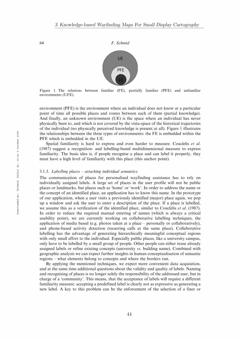
environment (PFE) is the environment where an individual does not know at a particularpoint of time all possible places and routes between each of them (partial knowledge).And finally, an unknown environment (UE) is the space where an individual has neverphysically been to, and which is not covered by the vista-space of the historical trajectoriesof the individual (no physically perceived knowledge is present at all). Figure 1 illustratesthe relationships between the three types of environments: the FE is embedded within thePFE which is embedded in the UE.
Spatial familiarity is hard to express and even harder to measure. Couclelis et al.(1987) suggest a recognition- and labelling-based multidimensional measure to expressfamiliarity. The basic idea is, if people recognise a place and can label it properly, theymust have a high level of familiarity with this place (this anchor point).
3.1.3. Labelling places – attaching individual semantics
The communication of places for personalised wayfinding assistance has to rely onindividually assigned labels. A large set of places in the user profile will not be publicplaces or landmarks, but places such as ‘home’ or ‘work’. In order to address the name orthe concept of an identified place, an application has to know this name. In the prototypeof our application, when a user visits a previously identified (major) place again, we popup a window and ask the user to enter a description of the place. If a place is labelled,we assume this as a verification of the identified place, similar to Couclelis et al. (1987).In order to reduce the required manual entering of names (which is always a criticalusability point), we are currently working on collaborative labelling techniques, theapplication of media based (e.g. photos taken at a place – personally or collaboratively),and phone-based activity detection (recurring calls at the same place). Collaborativelabelling has the advantage of generating hierarchically meaningful conceptual regionswith only small effort to the individual. Especially public places, like a university campus,only have to be labelled by a small group of people. Other people can either reuse alreadyassigned labels or refine existing concepts (university vs. building name). Combined withgeographic analysis we can expect further insights in human conceptualisation of semanticregions – what elements belong to concepts and where the borders run.
By applying the mentioned techniques, we expect more convenient data acquisition,and at the same time additional questions about the validity and quality of labels. Namingand recognising of places is no longer solely the responsibility of the addressed user, but incharge of a ‘community’. This means, that the acceptance of labels will require a differentfamiliarity measure: accepting a predefined label is clearly not as expressive as generating anew label. A key to this problem can be the enforcement of the selection of a finer or
Figure 1. The relations between familiar (FE), partially familiar (PFE) and unfamiliarenvironments (UFE).
64 F. Schmid
Downloaded By: [Schmid, Falko] At: 10:42 9 October 2008
3 Knowledge-based Wayfinding Maps For Small Display Cartography
44

coarser concept or the refinement of an existing concept. An intended selection of a label
expresses the familiarity with a place and the desired granularity connected with this place.
4. Personalised wayfinding maps – maps built around individually meaningful places
If we want to generate personalised wayfinding maps, we have to consider the basic
requirements and elements of wayfinding maps. We have to examine which elements of the
previous knowledge can replace elements of traditional maps, and how elements of the
unknown parts of the environment can be integrated in a personal frame of reference.First of all, let us have a look at the basic demands of a wayfinding map: for self-
localisation a wayfinder has to identify the surrounding environment with the map at
hand. For the unknown parts of the environment, we can rely on either established or
experimental mapping (as illustrated in Section 2). But for the known parts of the
environment and especially the transition points, i.e. those areas where familiarity ends
and unfamiliarity starts, we will have to think about a suitable form of visualcommunication. This is necessary because the reference systems of the information
changes: the unknown parts of the environment are expressed by means of geographic
mapping, whereby the known parts directly refer to mental concepts of the user. We will
have to make this change clear to avoid misinterpretations. Additionally, we will have to
consider how the actual spatial relations between the elements of the PFE and the UE can
be clarified and which information is required for successful map understanding.During navigation, a wayfinder has to identify his physical location on the map and
the surrounding environment on the map. When maps are used for pre-trip planning, i.e.
the consultation of the map before the actual travelling, a wayfinder benefits from the
meaningful integration of the route within the environment he will cross. This will help
him to integrate the queried places and the route into his prior knowledge. For both
scenarios the initial orientation, i.e. the alignment of the map with the environment is ofcrucial importance for the wayfinding success. A good map selects features that resolve
local ambiguities with carefully selected landmarks and/or structural configurations and
helps the wayfinder to identify the local configuration (‘if you see the park on your left
and the river to your right, you are oriented correctly’). For the UE, we can rely on any
available method, for the PFE and the transition areas we will need a suitable bridge
between the two frames of reference. The strongest pointers we have at hand are themajor places of the prior knowledge. As these places have a very distinct meaning for an
individual, we have very good anchor points for the indication of global and local
orientation of a route. As soon as we incorporate prior spatial knowledge we can rely on
places as references, even if no place is covered by the actual route. If we just refer to a
part of a path, we can indicate at the transition points how the route enters the path andhow the places are related to this location. If a route starts at a place, we can rely on the
knowledge about the local configuration at the place; we only have to indicate in which
direction a wayfinder has to follow the path (‘go from here as you usually go to the
university’). To foster the integration of new knowledge in existing knowledge, we have
to make sure how the route and the new place(s) are related to existing entities of the
spatial knowledge. We have to consider two basic cases: either the new place(s) and wellknown parts of the environment are in the same geographic region or they are in a
distance such that references to well-known elements are not really helpful. Of course,
different areas in the world have different concepts of scale: in dense urban areas ‘far’
Journal of Location Based Services 65
Downloaded By: [Schmid, Falko] At: 10:42 9 October 2008
45

means something else than in rural areas with a very low density of population and
larger distances between places. The selection of known references must be driven by
their closeness to a UE and the established level of knowledge connected to them. If a
person is close to well established knowledge (e.g. where they live), we can clearly
indicate the location or direction by nearby places. If the person is far from ‘everyday
knowledge’, e.g. in a holiday resort, instead of pointing to the usual surroundings we can
integrate the prominent patterns of the latest trajectories, like the way to the hotel or the
church visited 1 h ago.
5. Knowledge-based schematisation of wayfinding maps: route-path configurations,
assistance types and schematisation techniques
According to the definitions of the different kinds of environments, namely that FE and
PFE are developed by trajectories, all known parts of the environment are connected
to each other. An extreme interpretation can be that we only have three possible
configurations of routes and paths in the FE/PFE and UE (in the following we will only
refer to PFE instead of FE and PFE, as in the important properties they share the same
concepts):
. Route is contained in PFE: This means that the start and endpoint of a route is
completely contained in a combination of paths in the PFE (Figure 2).. Route overlaps PFE: This describes the scenario depicted in Figure 3. A part of the
route is addressable with a path; the other part of the route is in the UE. The part
in the PFE can, but does not have to be a known place.. Route contains PFE: A known path can be fully integrated within a route but both
ends of the route are members of the UE (Figure 4).
In reality, of course, we can expect highly fragmented records of the real trajectories due to
the particularities of the positioning devices used (like mobile phones equipped with GPS
sensors). When we feed the knowledge presentation with this data, the resulting user model
Figure 2. Elements contained in PFE.
Figure 3. Elements overlap PFE.
66 F. Schmid
Downloaded By: [Schmid, Falko] At: 10:42 9 October 2008
3 Knowledge-based Wayfinding Maps For Small Display Cartography
46

will be fragmented as well. Under realistic conditions, we will have fragmented data and
cannot expect a completely connected PFE. As a consequence, we will have to deal with
complex configurations of UE and PFE (as illustrated in Figure 5). However, the three
basic configurations are important for the identification of suitable schematisation
principles. In the following, we will focus on the particularities of each configuration and
propose suitable schematisation methods.
5.1. Optimal route detection
In this article, we assume a coherent PFE and just allow the three basic configurations
discussed previously. As we want to generate a map for a particular route with respect to
particular knowledge, the most basic step is the selection of a route from the desired point
A to point B. There are several route selection strategies, but we will only focus on the
shortest path with maximised known parts. In Patel et al. (2006), the authors only allow
complex routes between landmarks, which can result in suboptimal routes in terms of
length and time. We developed an algorithm which allows us to identify the path with
maximised familiar parts and is shortest within the PFE. This means we can identify the
shortest route with the minimal unknown elements. In this work we do not aim to compare
it with results of other route selection strategies, as we primarily aim at the treatment of
previous knowledge for map generation.At this point we do not aim to identify a plausible tradeoff between an optimal route
(under the fastest or shortest route assumption) and one integrating previous spatial
knowledge. But it is clear as soon as we spread a personalised assistance system beyond the
walls of our lab and encourage people to use the system in their real life settings, we will
require an operational measure for the route selection. People will only use a new system
if it is at least as effective as the old system it aims to replace and if they obtain an
additional feature (which can also have a better interface or easier to extract information).
Consequently, a personalised wayfinding system must be able to offer effective routes in
Figure 4. Elements contain PFE.
Figure 5. Fragmented PFE/UE configuration.
Journal of Location Based Services 67
Downloaded By: [Schmid, Falko] At: 10:42 9 October 2008
47
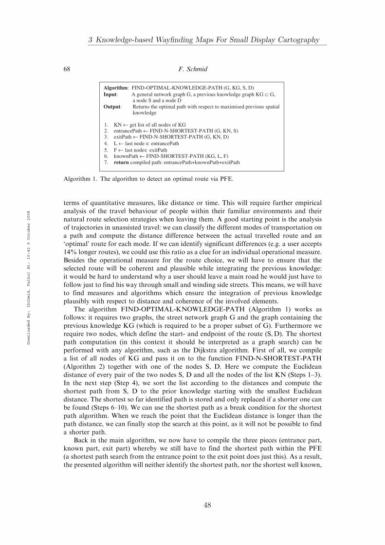
terms of quantitative measures, like distance or time. This will require further empiricalanalysis of the travel behaviour of people within their familiar environments and theirnatural route selection strategies when leaving them. A good starting point is the analysisof trajectories in unassisted travel: we can classify the different modes of transportation ona path and compute the distance difference between the actual travelled route and an‘optimal’ route for each mode. If we can identify significant differences (e.g. a user accepts14% longer routes), we could use this ratio as a clue for an individual operational measure.Besides the operational measure for the route choice, we will have to ensure that theselected route will be coherent and plausible while integrating the previous knowledge:it would be hard to understand why a user should leave a main road he would just have tofollow just to find his way through small and winding side streets. This means, we will haveto find measures and algorithms which ensure the integration of previous knowledgeplausibly with respect to distance and coherence of the involved elements.
The algorithm FIND-OPTIMAL-KNOWLEDGE-PATH (Algorithm 1) works asfollows: it requires two graphs, the street network graph G and the graph containing theprevious knowledge KG (which is required to be a proper subset of G). Furthermore werequire two nodes, which define the start- and endpoint of the route (S,D). The shortestpath computation (in this context it should be interpreted as a graph search) can beperformed with any algorithm, such as the Dijkstra algorithm. First of all, we compilea list of all nodes of KG and pass it on to the function FIND-N-SHORTEST-PATH(Algorithm 2) together with one of the nodes S, D. Here we compute the Euclideandistance of every pair of the two nodes S, D and all the nodes of the list KN (Steps 1–3).In the next step (Step 4), we sort the list according to the distances and compute theshortest path from S, D to the prior knowledge starting with the smallest Euclideandistance. The shortest so far identified path is stored and only replaced if a shorter one canbe found (Steps 6–10). We can use the shortest path as a break condition for the shortestpath algorithm. When we reach the point that the Euclidean distance is longer than thepath distance, we can finally stop the search at this point, as it will not be possible to finda shorter path.
Back in the main algorithm, we now have to compile the three pieces (entrance part,known part, exit part) whereby we still have to find the shortest path within the PFE(a shortest path search from the entrance point to the exit point does just this). As a result,the presented algorithm will neither identify the shortest path, nor the shortest well known,
Algorithm: FIND-OPTIMAL-KNOWLEDGE-PATH (G, KG, S, D)Input: A general network graph G, a previous knowledge graph KG ⊂ G,
a node S and a node DOutput: Returns the optimal path with respect to maximised previous spatial
knowledge
1. KN ← get list of all nodes of KG2. entrancePath ← FIND-N-SHORTEST-PATH (G, KN, S) 3. exitPath ← FIND-N-SHORTEST-PATH (G, KN, D)4. L ← last node ∈ entrancePath5. F ← last node∈ exitPath6. knownPath ← FIND-SHORTEST-PATH (KG, L, F)7. return compiled path: entrancePath+knownPath+exitPath
Algorithm 1. The algorithm to detect an optimal route via PFE.
68 F. Schmid
Downloaded By: [Schmid, Falko] At: 10:42 9 October 2008
3 Knowledge-based Wayfinding Maps For Small Display Cartography
48

but the path with the shortest parts within the UE and the shortest path within the PFE.The result of a query for a route between a location A and B consists of three elements:
. The starting point and a certain area around this place
. The destination and a certain area around it
. The known path which shares exactly one node with the area around the startingpoint and one with the area around the destination.
All three elements are represented as graphs. If one of these areas is contained in the PFE,they are only represented as one node.
5.2. Linearisation and l-mizing depending on route-path configurationsand assistance types
In the next step we are interested in visualising the resulting path conveniently. A stra-ightforward schematisation for a known path is its linearisation, i.e. the completeabstraction from the geometric layout as proposed by Patel and colleagues. This worksfine if the addressed path is fully contained by a route, i.e. its two places are completelyintegrated. But as soon as we only refer to parts of the path (which we explicitly allow),we face the problem that we will have to make clear where a required wayfinding actionhas to be performed. A straightforward approach is the segmentation of the known pathinto suitable sections, determined by cognitively plausible elements (such as landmarks,major junctions or places). The elements can be plotted along the linearised path withrespect to their relative distance. This involves some tricky representational problems.Let us consider the situation depicted in Figure 6: A and B are known places andconnected by the known path illustrated with the bold line. The user usually turns left fromthe main road into the street leading to B, the new place is at the extension of the mainroad. If we linearise the path as described above, we will introduce spatial (and most likelycognitive) artifacts. Figure 7 illustrates one possible arrangement of the schematised path.It indicates to turn right which is not required in the real environment, as the user only hasto follow the main road straight on. In Figure 8, we can see how this schematisation
Function: FIND-N-SHORTEST-PATH (G, KN, N)Input: A network graph G, a list of nodes KN of previous knowledge, a node NOutput: Returns the shortest path between N and a node of KN, N will be the
first node of the path.
1. for all KNi ∈ KN2. d ← compute Euclidean distances between N and KNi ∈ KN3. SN ← add (KNi, d)4. SN ← sort SN with respect to d 5. SKP ← compute shortest Path for N, KNi ∈ (KNi, d)1 in G 6. for all (KNi, d)i ∈ SN7. temp ← compute shortest Path for N, KNi ∈ (KNi, d)i in G 8. if (temp < SKP)9. SKP ← temp10. if (SKP < d ∈ (KNi, d)i+1)11. return SKP 12. return SKP
Algorithm 2. The function to identify the shortest route from the UE to the PFE.
Journal of Location Based Services 69
Downloaded By: [Schmid, Falko] At: 10:42 9 October 2008
49
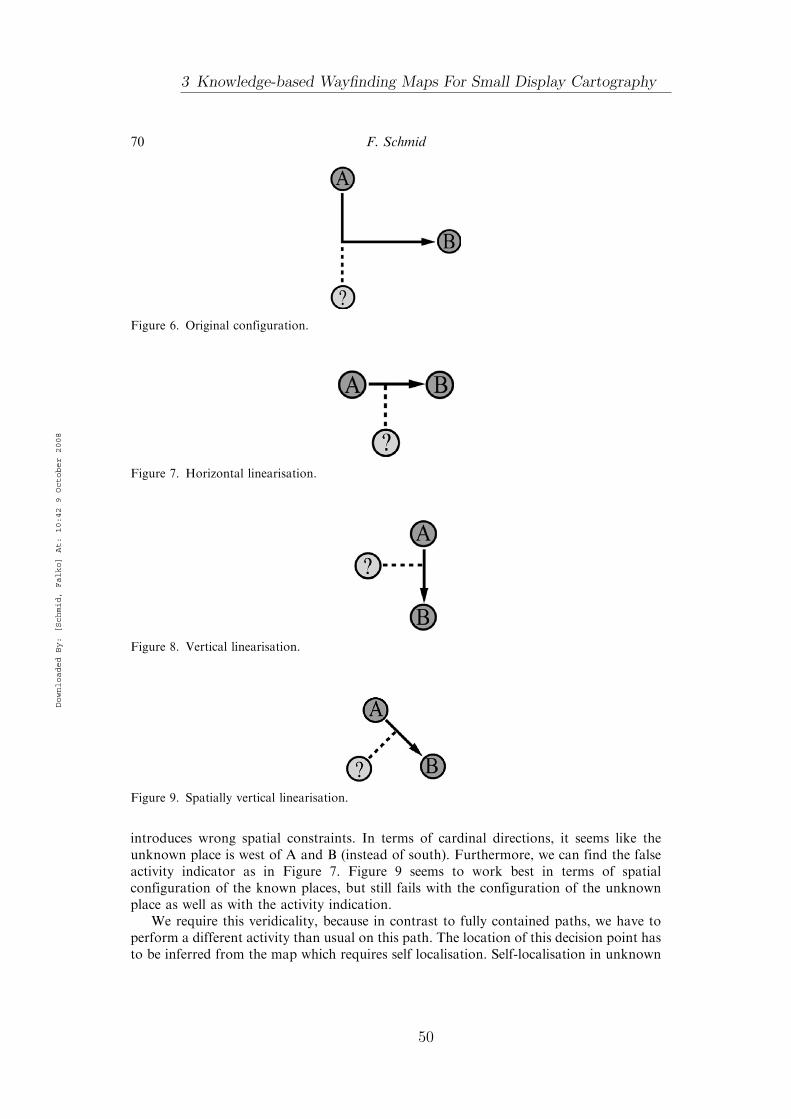
introduces wrong spatial constraints. In terms of cardinal directions, it seems like theunknown place is west of A and B (instead of south). Furthermore, we can find the falseactivity indicator as in Figure 7. Figure 9 seems to work best in terms of spatialconfiguration of the known places, but still fails with the configuration of the unknownplace as well as with the activity indication.
We require this veridicality, because in contrast to fully contained paths, we have toperform a different activity than usual on this path. The location of this decision point hasto be inferred from the map which requires self localisation. Self-localisation in unknown
Figure 6. Original configuration.
Figure 8. Vertical linearisation.
Figure 7. Horizontal linearisation.
Figure 9. Spatially vertical linearisation.
70 F. Schmid
Downloaded By: [Schmid, Falko] At: 10:42 9 October 2008
3 Knowledge-based Wayfinding Maps For Small Display Cartography
50
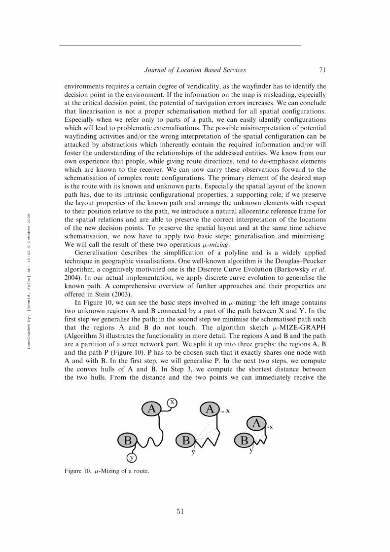
environments requires a certain degree of veridicality, as the wayfinder has to identify the
decision point in the environment. If the information on the map is misleading, especiallyat the critical decision point, the potential of navigation errors increases. We can conclude
that linearisation is not a proper schematisation method for all spatial configurations.
Especially when we refer only to parts of a path, we can easily identify configurationswhich will lead to problematic externalisations. The possible misinterpretation of potential
wayfinding activities and/or the wrong interpretation of the spatial configuration can be
attacked by abstractions which inherently contain the required information and/or willfoster the understanding of the relationships of the addressed entities. We know from our
own experience that people, while giving route directions, tend to de-emphasise elements
which are known to the receiver. We can now carry these observations forward to theschematisation of complex route configurations. The primary element of the desired map
is the route with its known and unknown parts. Especially the spatial layout of the known
path has, due to its intrinsic configurational properties, a supporting role; if we preservethe layout properties of the known path and arrange the unknown elements with respect
to their position relative to the path, we introduce a natural allocentric reference frame for
the spatial relations and are able to preserve the correct interpretation of the locationsof the new decision points. To preserve the spatial layout and at the same time achieve
schematisation, we now have to apply two basic steps: generalisation and minimising.
We will call the result of these two operations �-mizing.Generalisation describes the simplification of a polyline and is a widely applied
technique in geographic visualisations. One well-known algorithm is the Douglas–Peucker
algorithm, a cognitively motivated one is the Discrete Curve Evolution (Barkowsky et al.2004). In our actual implementation, we apply discrete curve evolution to generalise the
known path. A comprehensive overview of further approaches and their properties are
offered in Stein (2003).In Figure 10, we can see the basic steps involved in �-mizing: the left image contains
two unknown regions A and B connected by a part of the path between X and Y. In the
first step we generalise the path; in the second step we minimise the schematised path such
that the regions A and B do not touch. The algorithm sketch �-MIZE-GRAPH(Algorithm 3) illustrates the functionality in more detail. The regions A and B and the path
are a partition of a street network part. We split it up into three graphs: the regions A, B
and the path P (Figure 10). P has to be chosen such that it exactly shares one node withA and with B. In the first step, we will generalise P. In the next two steps, we compute
the convex hulls of A and B. In Step 3, we compute the shortest distance betweenthe two hulls. From the distance and the two points we can immediately receive the
Figure 10. �-Mizing of a route.
Journal of Location Based Services 71
Downloaded By: [Schmid, Falko] At: 10:42 9 October 2008
51

transition vector, which will be applied to all nodes in A in Step 6. The displacement vectorwill be shortened by a certain value to guarantee that the two regions do not touch (whichwould be the case if we would directly apply the displacement vector). In Step 8, after thetranslation of A, we just have to minimise P with the according scale factor. The minimisedpath now serves as the constraining link to the global configuration of the involvedelements. The layout of the path ensures that the unknown and known elements are ina mutually correct configuration.
The linearisation of routes is still a promising option for knowledge-basedschematisation. Patel and colleagues propose the ‘space needle’, a geographically veridicallinearisation of the known path. In Figure 11, we can see different linearisationpossibilities of the path between the places A, B and route alignment options for differentassistance scenarios. Let us assume a wayfinder travels from x to y via the path betweenA and B. We now have several possibilities to arrange the involved elements. Illustration 1depicts the original configuration of the elements, i.e. their topological relationships ina cardinal reference frame. Illustration 2 follows the concept of Patel and colleagues:the path is schematised, but the cardinal directions and the topological relations arepreserved; we also applied an additional minimisation of the Euclidean distance between Aand B. By de-emphasising the path, the unknown parts of the route are clearly emphasisedand the wayfinder is not distracted by the elements of the path. Illustration 3 shows anallocentric route perspective, where the linearised path is horizontally aligned and theunknown parts are veridically organised at the transition points. In illustration 4, we cansee a typical navigation perspective: the starting point (x) is at the bottom of the mapand the destination (y) is on the top. It is important to notice that this configurationdoes not correctly depict the exit/entrance angles at the transition points, but the
Algorithm: μ-MIZE-GRAPH (A, B, P)Input: Two graphs A, B (the two unknown regions) and a graph P (the known
path) connecting both graphs (they share a node)Output: Will return a μ-mized graph of A, B, P
1. P ← generalize P2. CA ← compute convex hull of A3. CB ← compute convex hull of B4. v ← get displacement vector between the two closest points of CA
and CB5. distVecs ← get vectors between any node of P and refPoint6. A ← translate every node in A with v-ε7. P ← scale/minimize P8. return A+B+C
Algorithm 3. �-MIZE-PATH.
Figure 11. Eight possible linearisations of the route depicted in 1; see text for details.
72 F. Schmid
Downloaded By: [Schmid, Falko] At: 10:42 9 October 2008
3 Knowledge-based Wayfinding Maps For Small Display Cartography
52
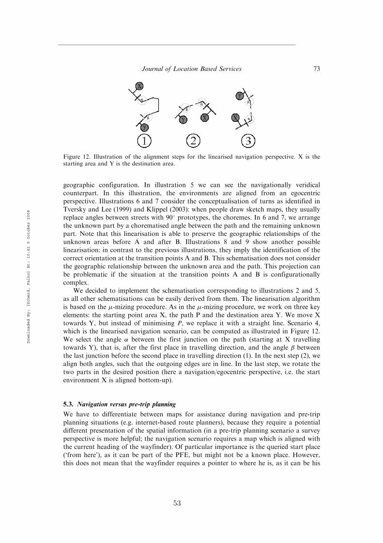
geographic configuration. In illustration 5 we can see the navigationally veridicalcounterpart. In this illustration, the environments are aligned from an egocentricperspective. Illustrations 6 and 7 consider the conceptualisation of turns as identified inTversky and Lee (1999) and Klippel (2003): when people draw sketch maps, they usuallyreplace angles between streets with 90� prototypes, the choremes. In 6 and 7, we arrangethe unknown part by a chorematised angle between the path and the remaining unknownpart. Note that this linearisation is able to preserve the geographic relationships of theunknown areas before A and after B. Illustrations 8 and 9 show another possiblelinearisation: in contrast to the previous illustrations, they imply the identification of thecorrect orientation at the transition points A and B. This schematisation does not considerthe geographic relationship between the unknown area and the path. This projection canbe problematic if the situation at the transition points A and B is configurationallycomplex.
We decided to implement the schematisation corresponding to illustrations 2 and 5,as all other schematisations can be easily derived from them. The linearisation algorithmis based on the �-mizing procedure. As in the �-mizing procedure, we work on three keyelements: the starting point area X, the path P and the destination area Y. We move Xtowards Y, but instead of minimising P, we replace it with a straight line. Scenario 4,which is the linearised navigation scenario, can be computed as illustrated in Figure 12.We select the angle � between the first junction on the path (starting at X travellingtowards Y), that is, after the first place in travelling direction, and the angle � betweenthe last junction before the second place in travelling direction (1). In the next step (2), wealign both angles, such that the outgoing edges are in line. In the last step, we rotate thetwo parts in the desired position (here a navigation/egocentric perspective, i.e. the startenvironment X is aligned bottom-up).
5.3. Navigation versus pre-trip planning
We have to differentiate between maps for assistance during navigation and pre-tripplanning situations (e.g. internet-based route planners), because they require a potentialdifferent presentation of the spatial information (in a pre-trip planning scenario a surveyperspective is more helpful; the navigation scenario requires a map which is aligned withthe current heading of the wayfinder). Of particular importance is the queried start place(‘from here’), as it can be part of the PFE, but might not be a known place. However,this does not mean that the wayfinder requires a pointer to where he is, as it can be his
Figure 12. Illustration of the alignment steps for the linearised navigation perspective. X is thestarting area and Y is the destination area.
Journal of Location Based Services 73
Downloaded By: [Schmid, Falko] At: 10:42 9 October 2008
53

current position. He probably is just interested in the transition from the PFE to the UE.The other way around, if the current position is in the UE and the queried destination isin the PFE, the user most probably wants to know where the place is located withrespect to his known places and landmarks. In the following, we will differentiatebetween those cases and illustrate different visualisations for the different assistancescenarios.
5.4. Route partially integrates path
If a route enters and exits a path not at places, it only partially integrates a path (Figure 21,configuration 4). The algorithm FIND-OPTIMAL-KNOWLEDGE-PATH allows theintegration of only parts of a known path. In Figure 13, we can see a map with knownpaths (bold lines) and a route (thin dark line) between two queried places (solid circles).The places are assumed to be at the endpoints of the paths. The transition points areindicated with white circles. Note that the route in our cases always goes via the PFE.In Figure 14, we can see an extraction of this map: only the PFE (bold lines), the route(thin line) and the four relevant places are depicted. The thin black line shows the
Figure 13. Survey map with prior knowledge and partially integrated path.
Figure 14. Extracted prior knowledge from Figure 13 and partially integrated path.
74 F. Schmid
Downloaded By: [Schmid, Falko] At: 10:42 9 October 2008
3 Knowledge-based Wayfinding Maps For Small Display Cartography
54

generalised part of the PFE of the route. Figures 15–17 show maps generated from the
situation illustrated in Figures 13 and 14, respectively. Like in all other cases where no
explicit reference point is addressed, we will have to clarify the spatial relations of the
known and unknown elements. In the maps, the arrows point to the usually travelled path
to the known places which serve as a reference for the particular query. We have chosen
arrows because of the absence of established cartographic symbols for individually known
elements like places. In Figure 15 we can see a �-mized map, in Figure 16 we can see
a linearised map (as in illustration 2 in Figure 21) and finally in Figure 17 we can see a
linearised navigation map (illustration 5, Figure 21) with the start environment at the
bottom.
5.5. Route contains path
We say a route contains a path, if both places of a path are part of the route, thus the
whole path is a sub-route of the queried route (Figure 21, illustration 3). In this case we
can assume that a wayfinder will recall the path and its entities correctly in the sense
that he will find his way from the addressed point A to point B. There have been
Figure 15. �-Map.
Figure 16. Linearised map.
Journal of Location Based Services 75
Downloaded By: [Schmid, Falko] At: 10:42 9 October 2008
55

investigations on how people describe a known way to unfamiliar travellers by meansof sketch maps (e.g. Tversky and Lee (1998, 1999)). These investigations show thatsurprisingly people remember the paths accurately. We aim at another type of support:instead of addressing an unfamiliar wayfinder, we want to address a familiar wayfinderthat has the same knowledge as the assistant. This has particular consequences for theschematisation: we can interpret the results of the mentioned studies in a way that theassistant has good knowledge of the route; there is no indication that this knowledgewill be affected by schematisation, especially if the frame of reference is clear. The keyelements are the places addressed by the path, and not the layout, which in this caseis irrelevant for the wayfinder. Figure 18 illustrates the relation of UE/PFE, Figure 19shows the generated �-map and Figure 20 depicts the linearised navigation map with thestart environment at the bottom. In both maps the places are indicated with solid dots,the circles indicate the start point and the destination of the route.
5.6. Route is contained by path
Strict linearisation has a huge drawback: due to its abstraction from the actual layout,it will not provide the spatial configuration within the environment. In the case when theroute is completely covered by a path (or multiple paths), we have to make clear where thequeried places are located within the PFE (Figure 21, illustration 1). Waller et al. (2001)showed that the relative distance between landmarks is an important property for people
Figure 17. Linearised navigation map.
Figure 18. Fully contained path.
76 F. Schmid
Downloaded By: [Schmid, Falko] At: 10:42 9 October 2008
3 Knowledge-based Wayfinding Maps For Small Display Cartography
56

during wayfinding. Note that these findings could be interpreted as to disprove ourconcepts. But we have to consider that the experimental setup was designed not to tell thesubjects about the intentionally distorted distances. Agrawala and Stolte’s (2001) usabilityresults show that people can use LineDrive maps properly, since they know about theschematisation and are able to interpret the map correctly. Furthermore, we can interpretboth findings constructively: people can still use a highly schematised map (e.g. strictlylinearised) if the relative distances between the required entities are met. This means, if wemake clear where the queried places are located within the path in terms of relative distanceto significant entities like places, landmarks or major structural elements (like main roads,junctions, etc.) we can use a linearised representation.
Figure 20. Linearised navigation map.
Figure 19. �-Map.
Figure 21. The four possible configurations between a queried route (dashed line between S, D) anda previously known path (bold line between A, B).
Journal of Location Based Services 77
Downloaded By: [Schmid, Falko] At: 10:42 9 October 2008
57

5.7. Route overlaps path
In this case one queried place is within the PFE, the other is located in the UE(see Figure 21, illustration 2 and Figure 22). This constellation requires the considerationof the different assistance types and configurations: in case the user navigates, and the startplace is within the PFE, and the user is currently within the PFE, we can assume that hewill be aware of it. This means, we only have to indicate the direction (‘go to theuniversity’) and, starting at the transition area, we have to generate a map for UE(see Figure 23, the start environment at the bottom). In the converse case, when thewayfinder is in the UE and queries an unknown location within the PFE, we will have toassist him in the UE, and we have to indicate the location of the queried place within thePFE. If the user is not navigating and queries a place within the PFE, we can infer thathe is not aware of this fact and have to indicate its respective location (see the �-map inFigure 24). The direction of the other place in the path is indicated with the black arrow.In both maps, the start place and destination of the route are depicted with the solidcircles.
6. Discussion and further work
In this article, we showed how different maps of the same geographic space can begenerated with respect to the configuration of the previous knowledge and the route,
Figure 23. �-Map with start place in the UE.
Figure 22. Route overlaps path.
78 F. Schmid
Downloaded By: [Schmid, Falko] At: 10:42 9 October 2008
3 Knowledge-based Wayfinding Maps For Small Display Cartography
58

as well as the assistance scenario. The consideration of these relationships is important
for the selection of the introduced schematisation principles linearisation and �-mizing.We have seen that the resulting maps contain significantly less information than the
corresponding survey maps and it is clear that this is a valuable property for mobilemapping. However, we did not consider how these maps can be optimised for differentlayouts and sizes of displays. Depending on the actual size of the target display we
can, for instance, determine the size of the level of detail for the �-mizing process,which includes not only the size of the path but also the size of the environment of the
start and target region. Furthermore, we can optimise the route selection according tothe route which results in the smallest map.
But will users be able to navigate with these maps? As any complex symbolic
representation, people will have to learn the meaning of the depicted elements. To testwhether the proposed schematisation will be interpreted as intended can only be shown
by a usability study. The implementation of a user study under realistic conditions is anextensive task. If we want to test �-maps partially incorporating known paths, we will
have to collect the trajectories of multiple persons for several weeks or months, and tolabel and analyse them. After the data acquisition phase, we will have to conduct
individual wayfinding tasks to test the performance of the maps. Obviously, this is a majortask, raising questions of general feasibility and privacy. On the other hand, simplifiedtests, with prior negotiation about familiar and unfamiliar parts of the environment, can
have massive influence on the results: the user profile is not built-up successively, whichmeans that an examination of paths and places does not occur as intended. Additionally,
by means of the negotiation, the subjects are clearly biased to the identified entities.A third option is testing in virtual reality. In a virtual world, we have ideal training and
test conditions: we can ensure that every user is a novice to the virtual environment. Thismeans, we can ensure the absence of a prior knowledge-based bias. Virtual worlds offer
full control over tracking, learning conditions, labelling, and finally tests with mapscovering the acquired knowledge for all possible scenarios. Besides all positive properties
of a virtual environment, we have to face their problems as well: the navigationperformance is usually affected by the involved controllers, the learning of virtual worlds
is assumed to be different – and the most important point – long-term studies are not
Figure 24. Linearised navigation map with start place in the PFE.
Journal of Location Based Services 79
Downloaded By: [Schmid, Falko] At: 10:42 9 October 2008
59
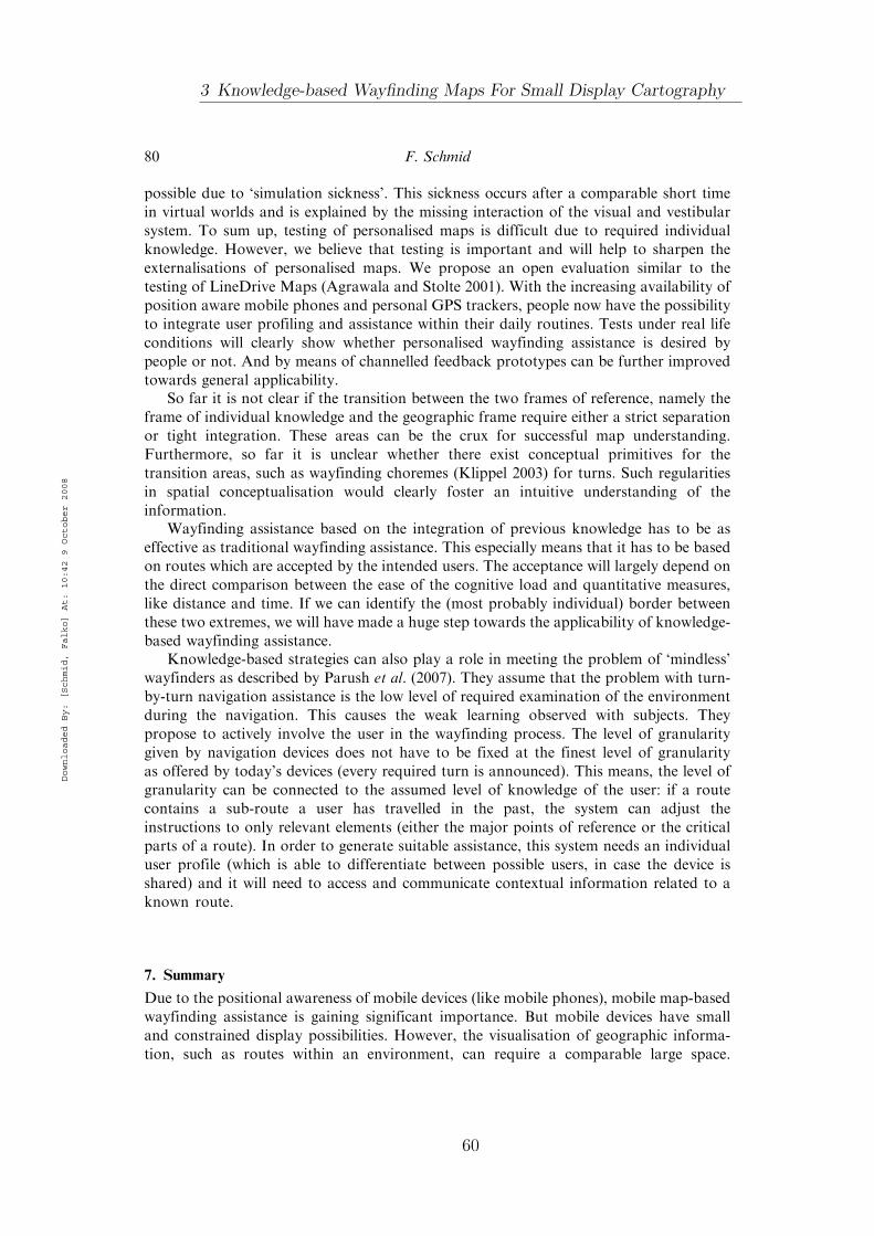
possible due to ‘simulation sickness’. This sickness occurs after a comparable short time
in virtual worlds and is explained by the missing interaction of the visual and vestibular
system. To sum up, testing of personalised maps is difficult due to required individual
knowledge. However, we believe that testing is important and will help to sharpen the
externalisations of personalised maps. We propose an open evaluation similar to the
testing of LineDrive Maps (Agrawala and Stolte 2001). With the increasing availability of
position aware mobile phones and personal GPS trackers, people now have the possibility
to integrate user profiling and assistance within their daily routines. Tests under real life
conditions will clearly show whether personalised wayfinding assistance is desired by
people or not. And by means of channelled feedback prototypes can be further improved
towards general applicability.So far it is not clear if the transition between the two frames of reference, namely the
frame of individual knowledge and the geographic frame require either a strict separation
or tight integration. These areas can be the crux for successful map understanding.
Furthermore, so far it is unclear whether there exist conceptual primitives for the
transition areas, such as wayfinding choremes (Klippel 2003) for turns. Such regularities
in spatial conceptualisation would clearly foster an intuitive understanding of the
information.Wayfinding assistance based on the integration of previous knowledge has to be as
effective as traditional wayfinding assistance. This especially means that it has to be based
on routes which are accepted by the intended users. The acceptance will largely depend on
the direct comparison between the ease of the cognitive load and quantitative measures,
like distance and time. If we can identify the (most probably individual) border between
these two extremes, we will have made a huge step towards the applicability of knowledge-
based wayfinding assistance.Knowledge-based strategies can also play a role in meeting the problem of ‘mindless’
wayfinders as described by Parush et al. (2007). They assume that the problem with turn-
by-turn navigation assistance is the low level of required examination of the environment
during the navigation. This causes the weak learning observed with subjects. They
propose to actively involve the user in the wayfinding process. The level of granularity
given by navigation devices does not have to be fixed at the finest level of granularity
as offered by today’s devices (every required turn is announced). This means, the level of
granularity can be connected to the assumed level of knowledge of the user: if a route
contains a sub-route a user has travelled in the past, the system can adjust the
instructions to only relevant elements (either the major points of reference or the critical
parts of a route). In order to generate suitable assistance, this system needs an individual
user profile (which is able to differentiate between possible users, in case the device is
shared) and it will need to access and communicate contextual information related to a
known route.
7. Summary
Due to the positional awareness of mobile devices (like mobile phones), mobile map-based
wayfinding assistance is gaining significant importance. But mobile devices have small
and constrained display possibilities. However, the visualisation of geographic informa-
tion, such as routes within an environment, can require a comparable large space.
80 F. Schmid
Downloaded By: [Schmid, Falko] At: 10:42 9 October 2008
3 Knowledge-based Wayfinding Maps For Small Display Cartography
60

This problem cannot only be attacked by scaling the information to the matching size or to
segment the information to a high degree. It has been shown that these methods
substantially affect the cognitive processing of the spatial information.One possible solution to this problem is the transformation of the geographic space
according to the knowledge a user has of this environment. In this article, we
demonstrated how prior knowledge can be used to reduce the size of maps and at the
same time to preserve the meaning for a particular user.We discussed that there is no ‘schematisation that fits all’, as the different basic
relations of the route with known and unknown parts of the environment require different
mutual referencing. Additionally, it is beneficial to adapt the schematisation to the
assistance type, like navigation or pre-trip planning. By differentiating between these two
scenarios, we were able to further simplify and compress the visual output. We discussed
the requirements of most combinations of relations between the possible relations
between familiar/unfamiliar parts and the type of assistance. Following on from these
considerations, we sketched the algorithmic basis to generate knowledge-based maps. The
integration of individual previous knowledge with the route planning process requires the
consideration of the intended strategy. We introduced an algorithm which is able to
identify a route with minimised parts within the unknown parts of the environment and an
optimal route incorporating familiar paths.
Acknowledgements
First of all, I would like to thank Colin Kuntzsch for his dedicated software development.Furthermore, I would like to thank Denise Peters for the fruitful discussions. I want to thank KlausStein for the permission to integrate parts of his generalisation software within our application.I want to thank two anonymous reviewers for their helpful and appreciated comments. This researchis carried out as part of the Transregional Collaborative Research Center SFB/TR 8 SpatialCognition. Funding by the Deutsche Forschungsgemeinschaft (DFG) is gratefully acknowledged.
References
Agrawala, M. and Stolte, C., 2001. Rendering effective route maps: improving usability through
generalization. In: Proceedings of ACM SIGGRAPH 2001. New York: ACM Press, 241–249.Agarwal, P., 2004. Contested nature of ‘place’: knowledge mapping for resolving ontological
distinctions between geographical concepts. In: M. Egenhofer, C. Freksa and M. Harvey, eds.
Third international conference, GIScience 2004. Lecture Notes in Computer Science, LNCS
3234. Berlin, Germany: Springer, 1–21.Anderson, J.R., et al., 2004. An integrated theory of the mind. Psychological Review, 111 (4),
1036–1060.Ashbrook, D. and Starner, T., 2003. Using GPS to learn significant locations and predict movement
across multiple users. Personal Ubiquitous Computing, 7 (5), 275–286.Baddeley, A., Aggelton, J.P., and Conway, M., eds., 2001. Episodic memory: New directions in
research. Oxford, UK: Oxford University Press.Barkowsky, T., Latecki, l.-J., and Richter, K.-F., 2004. Schematizing maps: simplification of
geographic shape by discrete curve evolution. In: C. Freksa, W. Brauer, C. Habel and
K.F. Wender, eds. Spatial cognition II – integrating abstract theories, empirical studies, formal
methods, and practical applications. Lecture Notes in Artificial Intelligence 1849. Berlin,
Germany: Springer, 41–53.
Journal of Location Based Services 81
Downloaded By: [Schmid, Falko] At: 10:42 9 October 2008
61

Bennet, B. and Agarwal, P., 2007. Semantic categories underlying the meaning of ‘place’.
In: S. Winter, M. Duckham, L. Kulik and B. Kuipers, eds. Spatial information theory.
Vol. 4736, Lecture Notes in Computer Science. Berlin, Germany: Springer, 78–95.
Burnett, G.E. and Lee, K., 2005. The effect of vehicle navigation systems on the formation of
cognitive maps. In: G. Underwood, ed. Traffic and transport psychology: Theory and
application. Amsterdam, Netherlands: Elsevier, 407–418.
Couclelis, H., Golledge, R.G., Gale, N., and Tobler, W., 1987. Exploring the anchor-point
hypothesis of spatial cognition. Journal of Environmental Psychology, 7 (2), 99–122.Dillemuth, J., 2007. Map size matters: difficulties of small-display map use. In: Proceedings
of the 4th International Symposium on LBS & TeleCartography, 8–10 November, Hong Kong.Edwards, G., 1997. Geocognostics – a new framework for spatial information theory. In: S.C. Hirtle
and A.U. Frank, eds. Spatial information theory: A theoretical basis for GIS. Berlin, Germany:
Springer, 455–472.Golledge, R., 1992. Place recognition and wayfinding: making sense of space. Geoforum, 23 (2),
199–214.
Hightower, J., et al., 2005. Learning and recognizing the places we go. In: Proceedings of the Seventh
International Conference on Ubiquitous Computing (Ubicomp 2005), 159–176.Ishikawa, T., et al., 2008. Wayfinding with a GPS-based mobile navigation system:
a comparison with maps and direct experience. Journal of Environmental Psychology, 28,
74–82.Klippel, A., 2003. Wayfinding Choremes. In: W. Kuhn, M.F. Worboys and S. Timpf, eds.
Spatial information theory: Foundations of geographic information science. Conference on
spatial information theory. Lecture Notes in Computer Science. Berlin, Germany: Springer,
320–334.
Klippel, A. and Richter, K.-F., 2004. Chorematic focus maps. In: G. Gartner, ed. Location
based, services and telecartography. Vol. 2004. Vienna: Technische Universitat, Wien,
39–44.
Klippel, A., et al., 2005. The cognitive reality of schematic maps. In: Liqiu Meng, Alexander Zipf
and Tumasch Reichenbacher, eds. Map-based mobile services – theories, methods and
implementations. Berlin, Germany: Springer, 57–74.Montello, D., 1993. Scale and multiple psychologies of space. In: A.U. Frank and I. Campari,
eds. Spatial information theory: A theoretical basis for GIS. Berlin, Germany: Springer,
312–321.Montello, D.R., 2003. Regions in geography: process and content. In: M. Duckham,
M.F. Goodchild and M.F. Worboys, eds. Foundations of geographic information science.
London: Taylor and Francis, 173–189.Parush, A., Ahuvia, S., and Erev, I., 2007. Degradation in spatial knowledge acquisition when using
automatic navigation systems. In: S. Winter, M. Duckham, L. Kulik and B. Kuipers, eds.
Spatial information theory. Vol. 4736. Lecture Notes in Computer Science. Berlin, Germany:
Springer.Patel, K, et al., 2006. Personalizing routes. In: Proceedings of 19th annual ACM Symposium
on User Interface Software and Technology 2006. Montreux, Switzerland: ACM Press,
187–190.Richardson, A.R., Montello, D.R., and Hegarty, M., 1999. Spatial knowledge acquisition from
maps, and from navigation in real and virtual environments. Memory and Cognition, 27,
741–750.Schmid, F. and Richter, K.-F., 2006. Extracting places from location data streams. In: A. Zipf, ed.
Workshop proceedings of UbiGIS. Munster: Germany.Schultheis, H., Barkowsky, T., and Bertel, S., 2006. LTM-C: an improved long-term
memory for cognitive architectures. In: D. Fum, F. del Missier and A. Stocco, eds.
Proceedings of the 7th international conference on cognitive modeling. Trieste (ICCM 2006).
Trieste: Edizioni Goliardiche, 274–279.
82 F. Schmid
Downloaded By: [Schmid, Falko] At: 10:42 9 October 2008
3 Knowledge-based Wayfinding Maps For Small Display Cartography
62

Srinivas, S. and Hirtle, S., 2007. Knowledge based schematization of route directions.In: T. Barkowsky, C. Freksa, M. Knauff, B. Krieg-Bruckner and B. Nebel, eds. Spatialcognition V. Berlin, Germany: Springer, 346–364.
Stein, K., 2003. Qualitative reprasentation und generalisierung von bewegungsverlaufen. Thesis (PhD).
TU Munchen, Munich, Germany.Tomko, M. and Winter, S., 2006. Recursive construction of granular route directions. Journal of
Spatial Science, 51 (1), 101–115.
Tversky, B., 1993. Cognitive maps, cognitive collages, and spatial mental models. In: A. Frank andI. Campari, eds. Spatial information theory: a theoretical basis for gis – proceedings ofCOSIT’93. Berlin: Springer, 14–24.
Tversky, B. and Lee, P.U., 1998. How space structures language. In: C. Freksa, C. Habel andK.F. Wender, eds. Spatial cognition, an interdisciplinary approach to representing andprocessing spatial knowledge. Vol. 1404, Lecture Notes in Computer Science. London:
Springer, 157–176.Tversky, B. and Lee, P.U., 1999. Pictorial and verbal tools for conveying routes. In: C. Freksa and
D.M. Mark, eds. Proceedings of the international conference on spatial information theory:Cognitive and computational foundations of geographic information. Vol. 1661, Lecture Notes in
Computer Science. London: Springer, 51–64.Waller, D., et al., 2001. Place learning in humans: the role of distance and direction information.
Spatial Cognition and Computation 2, 4, 333–354.
Wiener, J.M., 2004. Places and regions in perception, route planning, and spatial memory. Thesis(PhD). University of Tubingen. Tubingen, Germany.
Zipf, A. and Richter, K.-F., 2002. Using focus maps to ease map reading – developing smart
applications for mobile devices. KI 4/02 Special Issue Spatial Cognition, 2, 35–37.
Journal of Location Based Services 83
Downloaded By: [Schmid, Falko] At: 10:42 9 October 2008
63


4 Semantic TrajectoryCompression
Schmid, Richter, and Laube [2009]
Personalized wayfinding assistance in the form of μMaps as proposed inchapter 3 requires a spatial user profile as input. Only if a system can ac-cess information about which places and paths between them are knownto the user, a wayfinding system can generate personalized assistance.This paper describes the representational basis with a focus on space ef-ficiency. We introduce an algorithm to compress trajectories effectivelyby at the same time preserving all relevant information and preparing itfor semantic queries. We explore the benefit of utilizing spatial featuresas compression keys for trajectories. We transform a trajectory by meansof context specific route direction heuristics into a qualitative represen-tation, which is suitable for massive compression rates. At the same timewe prepare the data to allow for efficient semantic queries, e.g., queriesfor visited places and dates, by treating these entities as compressionprimitives.
65


Semantic Trajectory Compression
Falko Schmid1, Kai-Florian Richter1, and Patrick Laube2
1 Transregional Collaborative Research Center SFB/TR 8 Spatial Cognition,University of Bremen, P.O. Box 330 440, 28334 Bremen, Germany
{schmid,richter}@sfbtr8.uni-bremen.de2 Department of Geomatics, The University of Melbourne, VIC 3010, Australia
Abstract. In the light of rapidly growing repositories capturing themovement trajectories of people in spacetime, the need for trajectorycompression becomes obvious. This paper argues for semantic trajectorycompression (STC) as a means of substantially compressing the move-ment trajectories in an urban environment with acceptable informationloss. STC exploits that human urban movement and its large–scale use(LBS, navigation) is embedded in some geographic context, typically de-fined by transportation networks. STC achieves its compression rate byreplacing raw, highly redundant position information from, for example,GPS sensors with a semantic representation of the trajectory consistingof a sequence of events. The paper explains the underlying principles ofSTC and presents an example use case.
Keywords: Trajectories, Moving Objects, Semantic Description, DataCompression.
1 Motivation
Trajectories, the representation of movement by means of positioning fixes, usu-ally contain data which can be considered as highly redundant information.Movement often happens along network infrastructure, such as streets or rail-way tracks, and the significant behavior patterns, such as stops, are performedalong it as well. Especially in dense urban environments there are not many al-ternatives for reaching a certain destination other than to move along availablenetwork links. The representation and storage of trajectories by means of listsof fixes also pose questions about knowledge gain and further processing; tra-jectories are only meaningful when their spatial context is considered. Relatingtrajectories to their spatial context at an early stage will lead to improved meansof analyzing them with standardized methods in a later stage.
Figure 1b is a visualization of a stream of raw positional data (Figure 1a)produced by a tracking system (e.g. GPS). Figure 1c depicts the same movementembedded in its geographical context. An object moved through a system ofstreets to reach its destination. The actual information contained in trajectoriesis the sequence of implicitly encoded spatio-temporal events, i.e., a single datumis usually not of interest, but rather the significant information with respect to
N. Mamoulis et al. (Eds.): SSTD 2009, LNCS 5644, pp. 411–416, 2009.c© Springer-Verlag Berlin Heidelberg 2009
67

412 F. Schmid, K.-F. Richter, and P. Laube
35
36
g
B
straight
(a)
ori
(d)(b)
ori
dest
A
a
a
ggg
e
e
A
F
B
B
B
B
C
FK
DH
GK
AA
(c)
hh f
f
dest
ori
dest
(2.4 0.7 00:00)(1.7 1.0 03:43)(1.7 1.2 08:32)(1.7 1.4 15:45)(1.6 1.9 16:43)(1.7 2.1 17:45)(1.7 2.3 19:02)(1.7 2.5 20:48)(1.7 2.8 21:12)(1.6 3.1 22:53)(1.6 3.3 23:29)(1.7 3.5 24:32)(1.6 3.8 25:12)(1.7 4.1 36:07)(1.8 4.3 37:32)(1.9 4.5 38:43)(2.0 4.6 39:26)(2.1 4.9 41:16)(2.2 5.1 42:00)(2.5 5.3 43:11)(2.7 5.6 45:28)(2.4 5.9 47:19)(2.7 6.1 49:36)(3.0 6.3 52:52)(2.4 6.5 53:58)(1.3 6.7 55:21)(1.1 7.1 57:33)(0.8 7.3 58:51)(0.4 7.6 59:40)
Fig. 1. Problem overview: (a) Raw positional data; (b) trajectory in two-dimensionalspace, moving from origin to destination; (c) trajectory embedded in geographic con-text, the semantically annotated map features a train line #6 with two stations; tramlines #3 and #5 with several stops; major streets (Upper case) and minor streets (lowercase); (d) minimalist representation of the same trajectory, used for the semantic com-pression: origin, street g, street B, tram line #3, straight, destination
the movement. Significance depends on the application context, but is alwaysbased on the spatial course and the determination of events (usually stops).
Having a look at the trajectory, it becomes obvious that its course can bedescribed by referring to elements of the network without loosing relevant in-formation. The course can be expressed by the streets and tram tracks it movesalong (street g, street B, tram line #3, and straight along the streets D, G, H).This is a minimalist representation of the movement (Figure 1d). Instead of usinga large number of point coordinates, the movement can be described with ele-ments of the transportation network, annotated with the behaviorally significantelements (in this case origin, stops, and destination).
Networks as a constraining basis for movement reduce the dimensionalityof space and, thus, allow efficient indexing structures for moving objects [1].Most work focused on the geometry of the underlying networks. However, thedatabase community has acknowledged semantics—the meaningful annotationof moves with labels from the embedding environment —as being paramount forthe interpretation and analysis of raw trajectory data [2, 3]. Whereas exploit-ing semantics is a young branch in spatial database research, in spatial cognitionthe semantics of movement has long been exploited for designing better wayfind-ing instructions [4, 5]. Going a step beyond utilizing spatial infrastructure as asuitable representation, a semantic representation of the trajectory can be imple-mented that focuses on qualitative change in course and events without loosingthe conceptual information of the movement data.
4 Semantic Trajectory Compression
68

Semantic Trajectory Compression 413
2 Semantics in Trajectories
The majority of systems tracking the movement of individuals produce lists oftime-stamped position samples, so-called fixes in the form of tuples (x, y, t).Even though this is a discrete approximation of the movement behavior, it iswidely accepted to model the respective movement as a sequence of fixes, con-nected with straight line segments. In its most simple form a trajectory is a2-dimensional polygonal line connecting the fixes of a moving individual. Forexample, in Figure1, an individual has moved from location origin ori to destina-tion dest, starting at 00:00 arriving at 59:40. Figure 1a illustrates a trajectory’sraw data, Figure 1b the respective trajectory in two-dimensional space. Note theraw data column only illustrates a subset of the plotted fixes.
A map is a semantically annotated network of edges and nodes. A map rep-resents the transport network of an urban environment, featuring streets, bus,tram and train lines (see Figure 1c). In a map vertices are unambiguously de-fined, either by IDs or by (x, y) coordinate tuples. Further, edges may have alabel (street name, or bus, tram, train line). This is a n : 1-relation as severaledges can have the same label. Vertices of bus, tram, and train lines are stopsand stations; these may be labeled with the stops’ names. The labeling of edgesand vertices can extend several levels. An edge may at the same time have a lo-cal street name (e.g., “Ostertorsteinweg”), be part of a national highway system(e.g., “A7”), and be part of a bus or tram line (e.g., “Tram #3”).
3 Semantic Trajectory Compression
If movement happens in a transport network, as is usually the case in urban en-vironments, trajectories can be mapped to a map representing this environment.The mapping of fixes to vertices and edges of the transport network then allowsfor exploiting this structure to restricting a trajectory’s representation to thesignificant events. A network reduces the dimensionality of a two-dimensionalmovement space. It allows for concise positioning of a moving object throughtime-stamping along edges and at vertices, which both have unique identifiers. Ina semantically annotated map, edges and vertices can be aggregated accordingto shared labels, for example their street names or the train lines. Often, sev-eral consecutive edges represent the same street and, thus, share the same label.Tram and bus lines may extend over large sections of an urban transport net-work. Thus, the semantic annotation of the network offers a high-level referencesystem for urban spaces, which is exploited in STC.
Taking this perspective, streets and tram, bus or train lines are viewed as mo-bility channels that moving objects hop on, ride for a while, and hop off againto catch another channel that brings them closer to their destination. In termsof trajectory compression, this perspective has the advantage that only littleinformation needs to be retained for describing the movement of an individualin terms of riding such channels. For most kinds of movement storing a sequenceof the identifiers of the specific channels and hop-on and hop-off times results
69

414 F. Schmid, K.-F. Richter, and P. Laube
in a sufficient approximation of the individual’s movement through the network.At the same time, this drops a large amount of fixes, which are highly correlatedand, hence, redundant. Semantic compression of trajectories makes use of prin-ciples and methods that have been previously implemented for the generation ofcognitively motivated route descriptions (the Guard process, cf. [6]). Broadly,it is based on three steps:
1. Identify the relevant events along the trajectory. Relevant events are originand destination, as well as street intersections and public transport stops(see Figure 1c).
2. For each event, determine all possible descriptions of how movement contin-ues from here. These descriptions are egocentric direction relations (straight,left, right, etc.; in Figure 1c straight from edge D to edge G) or changes inlabels of network elements (in Figure 1c change from label street B to tramline #3) for capturing the motion continuation of an event.
3. Based on the descriptions, combine consecutive events into sequences ofevents. These sequences are termed (spatial) chunks [5]. The compressedtrajectory consists of sequences of such spatial chunks (Figure 1d).
In decompression, the aim is to reconstruct movement through an environment.In the chosen semantic approach, decompression does not restore the originaltrajectory, but rather the path through the network along with inferred time-stamps. The path contains all information on changes of direction as well asplaces along the way; each such event point is coupled with a time-stamp statingwhen in the travel behavior it occurred. Note that for all reconstructed pointsin the decompressed trajectory, i.e., those that are not original points retainedin the compressed trajectory, the time-stamp is calculated based on an assumedlinear movement behavior between start and end point of a chunk. While thistime estimation is a simplification resulting in information loss, it provides nolimitation for the targeted applications (see Section 5).
In a nutshell, the decompression algorithm iterates through the sequence ofchunks stored in the compressed trajectory. It returns a sequence of verticesthat are a geometric representation of the travelled path through the network.In more detail, beginning with the start vertex of a chunk the algorithm addsgeometric edges to the reconstructed path until the end vertex is reached. To thisend, it uses different strategies to determine which edge is to be added; thesestrategies depend on the description used for chunking. Each added vertex islinked to a time-stamp, which is calculated assuming constant movement speed,i.e., representing a fraction of time corresponding to the fraction of the distancetravelled between start and end vertex.
4 Example Use Case
Figure 2 shows an example use case of applying semantic trajectory compression.The geometric representation of the path contains 115 points in space-time (115tuples of (x, y, t)). It further comprises 52 events, i.e., 52 intersections and stops
4 Semantic Trajectory Compression
70

Semantic Trajectory Compression 415
along the way. Performing compression yields the following 6 elements as result:
((3490254.00 5882064.00 00:00) (3490057.00 5882110.00 01:12) “Bei denDrei Pfahlen”)((3490057.00 5882110.00 01:12) (3489534.00 5882241.50 04:47) “Am Hulsberg”)((3489534.00 5882241.50 04:47) (3488929.50 5882100.00 08:21) “AmSchwarzenMeer”)((3488929.50 5882100.00 08:21) (3488222.50 5882314.50 13:09) “Vor dem Steintor”)((3488222.50 5882314.50 13:09) (3487688.75 5882291.00 16:17) “Ostertorsteinweg”)((3487688.75 5882291.00 16:17) (3487544.75 5882351.00 17:21) “Am Wall”)
As can be seen, STC achieves a high compression rate. Instead of the 115 orig-inal points, it ends up with only 6 items, which corresponds to a compressionrate of 94.78%. Considering that each item in the compressed trajectory consistsof three elements, the ratio is still 18 to 115 elements or 84.35%. Decompressingthe compressed trajectory reconstructs the original path. It also keeps the time-stamps explicitly stated in the compressed trajectory. There are some differencesin the geometric representation—in this case the reconstructed path contains 3coordinates more than the original path. This can be explained with ambiguitiesin the underlying geographic data set that for some streets has individual rep-resentations of different lanes, resulting in different geometric representations.However, there is no visual or semantic difference between the original and thereconstructed path; all events of the original path are correctly reconstructed.Regarding time, the original time-stamps stored in the compressed trajectoryare retained; all other reconstructed events are annotated with estimated time-stamps assuming linear movement within a chunk.
a) b)
Fig. 2. The map shows part of the inner-city region of Bremen, Germany. a) Thedisplayed path (the bold line) runs from right to left. The dots on the path mark allevent points along the way. b) The events stored in the compressed trajectory.
5 Conclusions and Outlook
This paper presents a novel approach for compressing large volumes of trajec-tory data by exploiting the semantic embedding of movement in a geographicalcontext. Inspired by network-constrained object indexing and techniques usedin spatial cognition and wayfinding, the paper presents semantic trajectory com-pression (STC). STC matches the movement to the underlying map and aggre-gates chunks based on identical semantic descriptions. Initial experiments with aset of use case trajectories captured with volunteers in the city of Bremen serve
71

416 F. Schmid, K.-F. Richter, and P. Laube
as a proof of concept, deliver promising results for future experiments and help toidentify limitations and a road map for future work. After implementing an STCprototype, future work will focus on evaluating the STC algorithm with largeand diverse trajectory data. Extensive experiments with real, recorded trajec-tory data shall identify possible conceptual shortcomings and reveal the runtimecharacteristics of the STC algorithm for various scenarios.
As a main contribution, the paper illustrates that the embedding of humanmovement in the geographic context of an urban street network can success-fully be exploited for compressing large volumes of raw trajectory data withacceptable information loss. The reconstructed information is suited for a num-ber of applications based on individual spatial profiles which are not built upon afine-grained analysis of movement dynamics (e.g., ascending and descending ve-locity). Specifically, this holds for prior-knowledge based navigation support [7]which relies on previously visited places and traveled paths. Also, most appli-cations within the field of Location Based Services that rather rely on a cleanmodel of movement than its detailed dynamics will benefit from semanticallycompressed trajectories.
Acknowledgments
Support by the German Science Foundation (DFG) and Group of Eight / DAADAustralia Germany Joint Research Co-operation Scheme is acknowledged.
References
[1] Li, X., Lin, H.: Indexing network-constrained trajectories for connectivity-basedqueries. Int. Journal of Geographical Information Science 20(3), 303–328 (2006)
[2] Alvares, L.O., Bogorny, V., Kuijpers, B., Fernandes de Macedo, J.A., Moelans,B., Vaisman, A.: A model for enriching trajectories with semantic geographicalinformation. In: GIS 2007: Proc. of the 15th annual ACM international symposiumon Advances in GIS, pp. 1–8. ACM, New York (2007)
[3] Spaccapietra, S., Parent, C., Damiani, M.L., de Macedo, J.A., Portoa, F., Vangenot,C.: A conceptual view on trajectories. Data and Knowledge Engineering 65(1), 126–146 (2008)
[4] Tversky, B., Lee, P.U.: How space structures language. In: Freksa, C., Habel, C.,Wender, K.F. (eds.) Spatial Cognition 1998. LNCS (LNAI), vol. 1404, pp. 157–175.Springer, Heidelberg (1998)
[5] Klippel, A., Hansen, S., Richter, K.F., Winter, S.: Urban granularities – a datastructure for cognitively ergonomic route directions. GeoInformatica 13(2), 223–247 (2009)
[6] Richter, K.F.: Context-Specific Route Directions - Generation of Cognitively Mo-tivated Wayfinding Instructions. DisKI, vol. 314. IOS Press, Amsterdam (2008);also appeared as SFB/TR 8 Monographs Volume 3
[7] Schmid, F.: Knowledge based wayfinding maps for small display cartography. Jour-nal of Location Based Services 2(1), 57–83 (2008)
4 Semantic Trajectory Compression
72

5 Enhancing The Accessibilityof Maps With PersonalFrames of Reference
Schmid [2009b]
In this publication we detail considerations on the integration of per-sonally meaningful places as pillars of reference frames in μMaps. Asthose places organize existing spatial knowledge in a compact way, theyqualify as cognitive shortcuts to maps: places are the individual expe-riential key to understand schematized personalized maps. In order toallow the integration of partial routes (which facilitates the computationof near optimal routes), μMaps require the integration of places along orin the vicinity of the route. The correct selection of references is crucialfor clarifying the course of a route along an array of known places. Wediscuss the propagation of the additional rendering constraints put byadditional places within the generation process of μMaps.
73


Enhancing the Accessibility of Maps with PersonalFrames of Reference
Falko Schmid
Transregional Collaborative Research Center SFB/TR 8 Spatial Cognition, University ofBremen, P.O. Box 330 440, 28334 Bremen, Germany
Abstract. The visualization of geographic information requires large dis-plays. Even large screens can be insufficient to visualize e.g. a long routein a scale, such that all decisive elements (like streets and turns) and theirspatial context can be shown and understood at once. This is critical as thevisualization of spatial data is currently migrating to mobile devices withsmall displays. Knowledge based maps, such as �Maps are a key to the vi-sual compression of geographic information: those parts of the environmentwhich are familiar to a user are compressed while the unfamiliar parts aredisplayed in full detail. As a result �Maps consist of elements of two differentframes of reference: a personal and a geographic frame of reference. In thispaper we argue for the integration personally meaningful places in �Maps.Their role is to clarify the spatial context without increasing the visual rep-resentation and they serve as an experienced based key to different scales(the compressed and uncompressed parts of the environment) of �Maps.
1 Motivation
The visualization of complex geographic information is resource intense as it re-quires large display areas. In the wayfinding domain, even large screens can beinsufficient to visualize a route in a scale, such that all decisive elements can beshown and understood at once. Internet based route planners typically choose ascale to display displaying the complete route at once. This practice entails signif-icant interaction: users have to zoom in and out to understand the details of thecourse to follow. Beside inconvenience, [1] recently showed that the understandingof fragmented maps leads to corrupt spatial knowledge; zooming in and out of partsof the route only offers a certain view and results in fragmented mental processingand disturbed compilation. This is increasingly critical as the visualization of spa-tial data is currently migrating to mobile devices with small displays and limitedinteraction possibilities. I.e., in order to limit fragmentation and interaction, wehave to develop new visualization methods for geographic information on mobiledevices. [2] postulates task and context depended maps since general maps containtoo much information. However, not many approaches have been proposed for thewayfinding task. [3] proposed an early turn-by-turn directions approach: they donot depict the whole route, but only the crucial steps. [4] propose Halo, a methodto integrate remote locations in maps of partial views. By means of rings havingtheir center at the remote location they point to, Halo preserves a sense of spatialcontext. However, Halo cannot adapt the visualization of complex spatial data toa small screen. In [5] the authors propose a fish-eye based map transformation: thearea of interest is in the center of the fish-eye an the context is in the surrounding.Depending on the scale of the surrounding and the curvature of the lens function.The interaction with route information is still problematic, as the environment isconstantly transformed and the single views are always integrated in a differentenvironment. In [6] the authors demonstrate a method to visually compress routes
75

by schematizing parts where no activity is required (like long parts on a highway).This effective idea only works on linear information (it shortens or stretches links),but does not integrate spatial context beyond the route.
1.1 Why Maps at all?
Turn-by-turn assistance challenges maps as wayfinding aids: why should one stilluse a complex representation to extract a rather small amount of information?The strongest argument is the fact that users of GPS based turn-by-turn systemsdo not learn the environment properly ([7, 8, e.g.]). Studies showed that users ofturn-by-turn instructions made more stops than map users and direct-experienceparticipants, made larger direction estimation errors, and drew sketch maps withpoorer topological accuracy. These are strong indicators that people do not learnthe environment properly and seem not to trust the assistance. We are currently atthe edge of a technological evolution and can observe a significant change in howpeople access geographic information: cars are delivered with build in navigationdevices, geographic information is accessed via Internet services. So far it is unclearhow a possible life-long learning of the environment with rather context-free rep-resentations will affect the formation of a mental map. The so far available resultssuggest poor individual mental representations.
a) b)
Fig. 1. Generating a �Map: a) depicts the original map annotated with prior knowledge(bold magenta lines), the shortest path from S to D, and the path across previous knowl-edge. b) shows the corresponding �Map: the path across the prior knowledge is schematizedand minimized, the unfamiliar parts are visualized in detail. Note the different space re-quirements of a) and b).
1.2 The Visual Compression of Geographic Information
Independent from the type of spatial assistance we use, the support of the cognitiveprocessing of the required information has to be a priority; this is the key to un-derstand and learn our world. The ideal spatial representation is one that reducesthe cognitive efforts to an minimum, but still enables the understanding of all in-formation necessary to solve a task (e.g. wayfinding). I.e., when we cope with smallscreens, we have to visually compress the information, but at the same time pre-serve the semantic accessibility. However, due to manifold topological and concep-tual constraints, the algorithmic transformation of geographic data is a hard task;we have to preserve the consistency of all constraints between all visual elements.
5 Enhancing The Accessibility of Maps With Personal Frames ofReference
76

E.g., straightening a curvy road might disturb topological relations of other entities(e.g. wrong placements of buildings afterwards). Furthermore, a transformation doesnot automatically guarantee visual compression - this can only be achieved by taskspecific maps: only the context dependent selection of features and minimization ofconstraints allows the effective reduction of the size of a representation.
1.3 Personalized Maps
One possible solution are personalized maps like �Maps [9]. By analyzing movementsof users (with GPS), a spatial user profile is compiled. This profile consists of theplaces and paths a user regularly visits [10]. The profile is used to compute routesalong personally meaningful places and paths. �Maps then compress the familiarparts (FP) of the route and highlight unfamiliar parts (UP), see Figure 1. Theresults are visually compressed maps, which are qualified for mobile devices [9].Depending on the configuration of FP and UP of the route, �Maps can achievevery effective visual compression rates. Due to the encoded individual knowledge,�Maps still provide full semantic accessibility. �Maps are furthermore a constructivelink between turn-by-turn assistance and map-based assistance: spatial learning issupported by relating new places to existing knowledge and makes future assistancedispensable. At the same time it does not only provide route knowledge, but offersfull spatial configuration of FP and UP of the environment. However, the reducedrepresentation of �Maps requires the clarification of the spatial embedding of theroute to anchor a map unambiguously within the environment. The key is theaddressing of the intrinsic personal frame of reference of the familiar parts of aroute: personally meaningful places (e.g., ”home”, ”work”, ”friend’s place”, etc.):These places also serve as a cognitive decompression code for the minimized familiarparts of the environment; they are the key to understand the varying scales andframes of reference of �Maps, and allow to anchor �Maps correctly within the realenvironment. In the following we call the elements of the UP to be part of thegeographic frame of reference and the elements of the FP to be part of the personalframe of reference.
2 Place Selection and Visualization
�Maps relate a significant part of a route to existing knowledge, but they still needthe clarification of the relation between the FP and the UP of the route. A routeacross familiar environments does not automatically guarantee the recognition ofthe course and the scale: it is extracted, schematized, minimized, and does so farnot contain contextual information. Additionally, the user might not have traveledthe selected route in the proposed sequence before. [11] showed that people rely onrelative distance information when they learn places. They are able to find a placeeven if the distances between landmarks that are related to a place are altered. I.e.,if we preserve the relative distance between places, users are able to decode thecourse and scale of the familiar part. If we assume places to be anchor points, thusindividually meaningful landmarks ([12, e.g.]), we can utilize them as self-containedframes of references. Due to the spatial meaning of a place (a user knows how itis spatially related to the surrounding environment and to other familiar places),a pair of familiar places along a route is sufficient to clarify their mutual spatialrelations and those between the FP and UP (they are relative to the familiar placesand constrained by their sequence enforced by the route).
2.1 Spatial Disambiguation: Selection of Suitable Place References
We now have a look at the selection of suitable places for a given route. We areinterested in places that do not (significantly) increase the size of a �Map and are
77

Fig. 2. Route segmenting and place selection: The black lines illustrate a familiar part ofthe route (red and black) with the entrance and exit points E1, E2, see illustration I. IIshows only the familiar part with identified places: P1, P2, P6, P7 are located on the route,P3, P4, P5 are located near the road in the familiar environment. The off-route places arelinked on the route by means of their branch-off points in the street network (dashed graycircles). Illustration III shows the integration of the remote places in the route for theplace selection algorithm.
at the same time meaningful. Place can be located on the route (on-route places) orthey can be located near the route and are connected via paths across the FP. Wecall these places remote places and their links to the route branch-offs. If we selectplaces located on the route we do not need to add pointers to remote places, whichpotentially increase the size of the representation (see c) in Figure 5). Places aremeaningful for the specific route when they clarify the embedding of a particularroute within the environment, and when they clarify the course of the route acrossthe FP. In the following we describe the algorithm to identify suitable places for aFP.
1. In the first step we segment the FP (see illustration I in Figure 2) of a route inton parts and compile all places located on the route. See illustration II and III inFigure 2 for details. The selection of n has great influence on the resulting sizeof a map, the more segments we create, the more places we have to visualize(see Figure 5). However, as places serve as cognitive decompression codes, wehave to identify a reasonable amount of segments for a route.
2. For each segment we check if there is a place located on the route. If this is notthe case, we check at every branch along the route if there is a branch-off in afamiliar environment.(a) For every familiar branch, we follow this path and every further branch-off
as long as we reach the closest remote place. We mark every traversed edgeand place as visited to avoid loops and multiple selections of one place fromdifferent contexts. Illustration II in Figure 2 shows the selection of remoteplaces for the second segment of the FP. We do not select the same place asa reference for different FPs or for different segments in one FP, as it canentail representational conflicts (see Figure 3).
(b) If we identified a place, we insert the branching point as dedicated placesin the FP (see Illustration III in Figure 2).
3. In this step we select places according to their significance for a segment:(a) If there are places located on the route and at a significant location (a
decision point), we select it to clarify the required action (see c) in Figure5 for an example). If there are equal choices we select the place with thehighest familiarity measure. If there are still equal choices we select theplace which is located most central. If there is only one place on the routewe select it, independent from the significance.
(b) For the segments with no place at a significant location, if there are n ≥ 1places located on-route in the segment, we select places according to an
5 Enhancing The Accessibility of Maps With Personal Frames ofReference
78

even distribution amongst the neighboring segments: we select the firstpair of subsequent segments Si, Si+1 and the respective place candidatesPSi1 , ..., PSi
n and PSi+11 , , ..., P
Si+1m (see illustration III in Figure 2). Places
at significant locations are treated as fixed points. We treat them just asthe entrance and exit points E1, E2, which are naturally fixed points (theyare the transition between the geographic and the personal frame of ref-erence). To optimize the distribution of places we apply following distancemaximization:
x1 = max1
(dist(E1, PS1i ))
xi = maxi
(dist(PSii−1, P
Ski )) n > i > 1
xn+1 = dist(xn, E2) (1)
Places are under this condition selected when they maximize the distanceto the previous and the subsequent place.
a) b)
Fig. 3. Conflict due to the selection of the same remote place: the familiar parts of theroute can have individual schematizations and minimizations, the pointers to the sameplace (see a)) can be conflicting and contradicting afterwards, see b).
Figure 4 illustrates the algorithm: illustration I is the initial situation - a FP andthe elements E1, E2 and the places P1, ..., P8. P2, P6 are at significant locations andconsidered as fixed places. In illustration II we can see the segmentation of the FPinto three parts. The algorithm now selects the fixed places P2, P6 as representativesfor the first and the third segment, only the middle segment has a choice of opti-mizable places. The algorithm maximizes the distance between P2 and P3, P4, P5and betweenP6. In this case P4 is selected (see illustration III in Figure 4).
3 Visualization
Maps are visual representations of the environment, i.e. we need to visualize thepersonal frame of reference defined by the selected places. Maps are intendedto support the wayfinding process dynamically, i.e. they have to cover typical re-quirements of wayfinding assistance during all phases: the communication of surveyknowledge and the support during navigation. To support cognitively adequate, werequire specialized representations reflecting the task with matching visualizations([13, e.g.]). This does not only hold for principle configurational issues, but alsofor the incorporated symbols. Entities on maps should either follow a cartographicconvention or in case of non-existence new cartographic symbols have to be cre-ated ([14, e.g.]). Up to the knowledge of the author, there are no available symbols
79

Fig. 4. The place selection process: I shows the initial situation withe the places P2, P6
at significant locations. II shows the segmentation of the route, and III the result of theselection process
for personally meaningful places and pointers to them. It is beyond the scope ofthis work, to analyze the requirements of these new kind of visual elements. Wedecided to use a straightforward visualization: in our examples and illustrations wewill depict places as circles (illustrations) and solid dots (generated maps) and thepointers to them as lines.
3.1 Visualization of Places on the Route
The course of the FP of the route is schematized by means of the discrete curveevolution (DCE), see [15]. DCE simplifies the geometry by successively removinggeometric control points from the shape information. Applying the DCE without ex-plicitly considering the places, the coordinates of the places are no longer guaranteedto be located on the course of the route. I.e., we have to compute the schematizationof FP differently; the schematization has to consider and preserve the position ofplaces as the route is described in relation to them. In the following algorithm wesketch the positioning of places (and branches to remote places) on a schematizedpath:
1. In the first step we segment the route at the points where the selected places(or the branching points) are located. Illustration I in Figure 6 shows the initialsituation. Illustration II depicts the segmentation of the route at the placesP1, P2, P3 into self-contained units.
2. In the second step, we schematize each segment by means of the DCE (see [15]).This will transform the places into fixed points of the curve and are not removedby the DCE. This step is important as we do not consider any other constraints,required by the DCE to declare fixed points.
3. In the third step we compile all segments again to one coherent FP. This can bedone straightforwardly, as the positions of the contact points (places) are notaltered in each segment (see Illustration III in Figure 6).
3.2 Visualization of Branch-Off Places
The question now is how we can visualize places which are not located on theroute. In this case we need the differentiation between the two basic assistancetypes: communication of veridical survey knowledge and navigation support. In thefollowing, we will differentiate between the two scenarios and show some examplesfor respective Maps. Furthermore we have to propagate new local visualizationconstraints to the global map rendering.
5 Enhancing The Accessibility of Maps With Personal Frames ofReference
80

a) b)
c) d)
Fig. 5. Selecting places. a) The map of Figure 1 with the places 1, 2, 3 (bold black dots).Note the different schematization of the FP in b), c), d) due to the integration of places.b) the FP is only one single segment: place 1 is selected, as it is on-route. c) FP consistsof two segments: place 1 (first segment), and place 2 (second segment) is selected. Place2 branches off at a significant location. d, FP consists of three segments: all places areselected (each is within one of the three segments). Note the different compression rates:b) is the most compact map as it utilizes the on-route place 1. c, requires more space as itpoints to place 2 (although FP is compressed with the same ratio as b)). d) is significantlylarger, because place 3 would intersect the unfamiliar part of the map on the bottom ifwe would apply the same minimization as in b) and c). This illustrates the effect of localrendering constraints on map compression (see Section 3.2).
Reference Frame Visualization for Survey Maps Survey maps are means tovisualize the embedding of the route within the environment in a geographic veridi-cal manner. I.e., the real geographic relations amongst the elements of the route,and between the route and the surrounding environment have to be represented ac-cording to a allocentric (geographic) frame of reference. Survey maps are intendedto communicate overview information for a certain route. However, in �Maps, thefamiliar part of the route is always schematized and minimized (as otherwise nocompression could be achieved), but the configuration of all elements is not altered.The schematization of the known paths works as described in Section 3.1: the places(and the branches to remote places) serve as constrained supporting points of thefamiliar part of the route. The crucial step for the veridical visualization of remoteplaces are the paths to them: we depict the path within the familiar environmentwith the same degree of schematization and minimization as the route starting atthe branching point at the route and ending at the configurable street network depthk, which is the number of expanded vertices from the branching point towards theplace (see place 2 in Figure 5).
81

Fig. 6. Schematization with places as fixed points: illustration I shows the initial situation,II the segmentation with the places as start and endpoints of the segments, III the resultof the schematization and compilation.
Reference Frame Visualization for Navigation Maps Navigation maps areintended to support the wayfinder during the wayfinding process. As discussed in [9],the maps follow the egocentric, bottom-up approach of mobile wayfinding maps: thepart of the route which is ”in-front” of the wayfinder (in terms of travel direction),is at the top of the display, the remaining parts at the bottom. A number of studiesshowed that people encode turning actions usually as 90 degree angles ([16, 17,e.g.]). The mental representation of turning actions are termed wayfinding choremes(see [17] and Figure 7 for an illustration). Branchings to remote places are, dueto the egocentric and direct experience in the real environment mentally encodedas wayfinding choremes [17]. For this reason we depict the branch to the remoteplace by means of a choreme. We replace the real angle α with the angle α′ of therespective choreme. However, as the spatial configuration at the particular point canbe complex, the choreme holds between the segment of the route before the branchand the branch in travel direction (see Figure 7). This reflects the perception andthe expectation of the wayfinder in the FP.
a) b)
Fig. 7. The chorematization of places for the navigation perspective: a) depicts the setof wayfinding choremes. b) depicts a turn at a place within the FP (left is the initialconfiguration), on the right we see the navigation perspective of the intersection. Theintersection is rotated in travel direction and the angle α is replaced by the angle α′ of thecorresponding wayfinding choreme.
Communicating Local Rendering Constraints for Global Rendering Mapsminimize the familiar part of the route by moving the closest points of the convexhulls of the unfamiliar environment Ui, Ui+1 towards each other; so far the distance-to-keep was determined by a threshold h (see Figure 8). Now, with the integrationof places, we have additional visualization constraints: a visual intersection of theused symbols has to be avoided, thus a distance threshold k between all elementshas to be preserved. We can resolve the constraints by following procedure:
5 Enhancing The Accessibility of Maps With Personal Frames ofReference
82
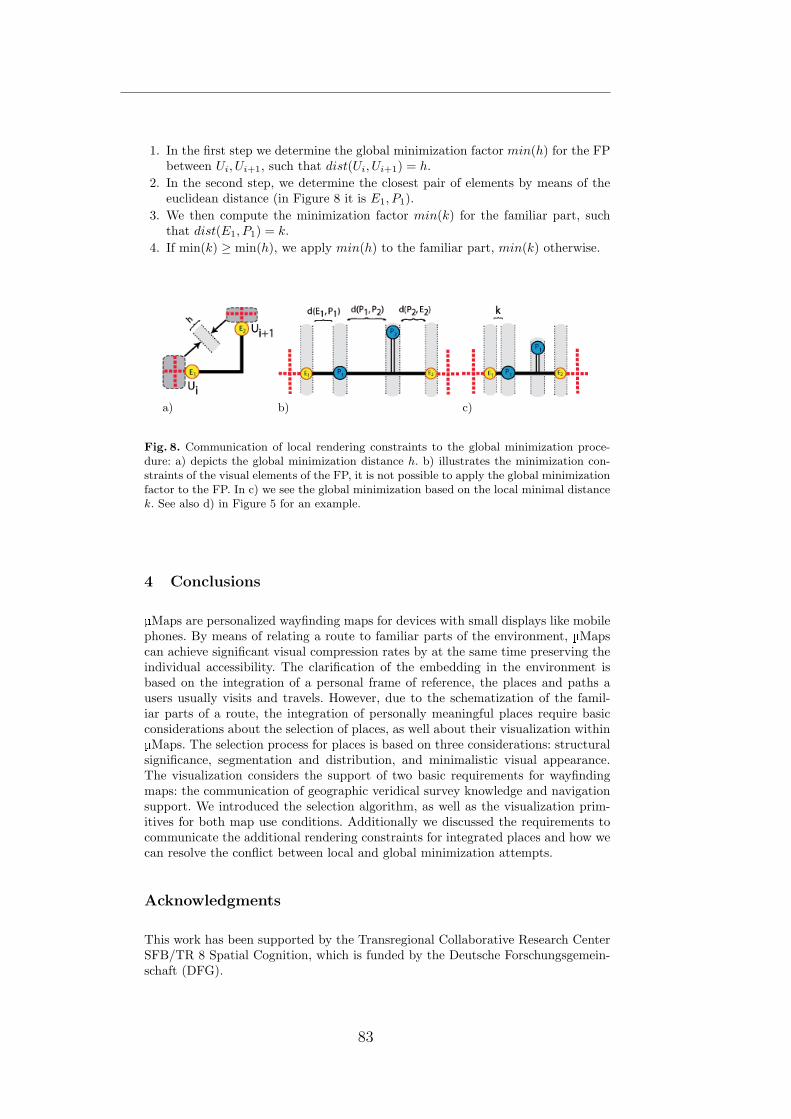
1. In the first step we determine the global minimization factor min(h) for the FPbetween Ui, Ui+1, such that dist(Ui, Ui+1) = h.
2. In the second step, we determine the closest pair of elements by means of theeuclidean distance (in Figure 8 it is E1, P1).
3. We then compute the minimization factor min(k) for the familiar part, suchthat dist(E1, P1) = k.
4. If min(k) ≥ min(h), we apply min(h) to the familiar part, min(k) otherwise.
a) b) c)
Fig. 8. Communication of local rendering constraints to the global minimization proce-dure: a) depicts the global minimization distance h. b) illustrates the minimization con-straints of the visual elements of the FP, it is not possible to apply the global minimizationfactor to the FP. In c) we see the global minimization based on the local minimal distancek. See also d) in Figure 5 for an example.
4 Conclusions
Maps are personalized wayfinding maps for devices with small displays like mobilephones. By means of relating a route to familiar parts of the environment, Mapscan achieve significant visual compression rates by at the same time preserving theindividual accessibility. The clarification of the embedding in the environment isbased on the integration of a personal frame of reference, the places and paths ausers usually visits and travels. However, due to the schematization of the famil-iar parts of a route, the integration of personally meaningful places require basicconsiderations about the selection of places, as well about their visualization withinMaps. The selection process for places is based on three considerations: structural
significance, segmentation and distribution, and minimalistic visual appearance.The visualization considers the support of two basic requirements for wayfindingmaps: the communication of geographic veridical survey knowledge and navigationsupport. We introduced the selection algorithm, as well as the visualization prim-itives for both map use conditions. Additionally we discussed the requirements tocommunicate the additional rendering constraints for integrated places and how wecan resolve the conflict between local and global minimization attempts.
Acknowledgments
This work has been supported by the Transregional Collaborative Research CenterSFB/TR 8 Spatial Cognition, which is funded by the Deutsche Forschungsgemein-schaft (DFG).
83
References
[1] Dillemuth, J.: Spatial cognition with small-display maps: Does the sum of the partsequal the whole? In: Association of American Geographers Annual Meeting, Boston(April 2008)
[2] Reichenbacher, T.: Mobile Cartography Adaptive Visualization of Geographic In-formation on Mobile Devices. PhD thesis, University of Munich, Institute of Pho-togrammetry and Cartography, Munich, Germany (2004)
[3] Rist, T., Brandmeier, P.: Customizing graphics for tiny displays of mobile devices.Personal Ubiquitous Computation 6(4) (2002) 260–268
[4] Baudisch, P., Rosenholtz, R.: Halo: a technique for visualizing off-screen objects.In: CHI ’03: Proceedings of the SIGCHI conference on Human factors in computingsystems, New York, NY, USA, ACM (2003) 481–488
[5] Harrie, L., Sarjakoski, L.T., Lehto, L.: A variable-scale map for small-display cartog-raphy. In: Proceedings of the Joint International Symposium on GeoSpatial Theory:Processing and Applications, Ottawa, Canada, July 812. (2002)
[6] Agrawala, M., Stolte, C.: Rendering effective route maps: improving usability throughgeneralization. In: SIGGRAPH. (2001) 241–249
[7] Parush, A., Ahuvia, S., Erev, I.: Degradation in spatial knowledge acquisition whenusing automatic navigation systems. In: COSIT. (2007) 238–254
[8] Ishikawa, T., Fujiwara, H., Imai, O., Okabe, A.: Wayfinding with a gps-based mo-bile navigation system: A comparison with maps and direct experience. Journal ofEnvironmental Psychology 28(1) (March 2008) 74–82
[9] Schmid, F.: Knowledge based wayfinding maps for small display cartography. Journalof Location Based Systems 2(1) (2008) 57–83
[10] Schmid, F., Richter, K.F.: Extracting places from location data streams. In: UbiGIS2006 - Second International Workshop on Ubiquitous Geographical Information Ser-vices. (2006)
[11] Waller, D., Loomis, J.M., Golledge, R.G., Beall, A.C.: Place learning in humans: Therole of distance and direction information. Spatial Cognition and Computation 2(4)(2001) 333–354
[12] Couclelis, H., Golledge, R.G., Gale, N., Tobler, W.: Exploring the anchor-point hy-pothesis of spatial cognition. Journal of Environmental Psychology 7(2) (June 1987)99–122
[13] Klippel, A., Richter, K.F., Barkowsky, T., Freksa, C.: The cognitive reality ofschematic maps. In Meng, L., Zipf, A., Reichenbacher, T., eds.: Map-based MobileServices - Theories, Methods and Implementations. Springer, Berlin (2005) 57–74
[14] MacEachren, A.M.: How maps work : representation, visualization, and design. Guil-ford Press; New York (1995)
[15] Barkowsky, T., Latecki, L.J., Richter, K.F.: Schematizing maps: Simplification ofgeographic shape by discrete curve evolution. In Freksa, C., Brauer, W., Habel, C.,Wender, K.F., eds.: Spatial Cognition II - Integrating abstract theories, empiricalstudies, formal models, and practical applications. Springer, Berlin (2000) 41 – 53
[16] Tversky, B., Lee, P.U.: Pictorial and verbal tools for conveying routes. In Freksa, C.,Mark, D.M., eds.: Spatial Information Theory, Berlin, Springer (1999) 51–64
[17] Klippel, A.: Wayfinding choremes. In Kuhn, W., Worboys, M., Timpf, S., eds.:Spatial Information Theory. Foundations of Geographic Information Science. LNCS2825, Berlin, Springer (2003) 320–334 International Conference COSIT.
5 Enhancing The Accessibility of Maps With Personal Frames ofReference
84

6 In-Situ Communication andLabeling of Places
Schmid and Kuntzsch [2009]
Places are the backbone of personalized wayfinding assistance. But onlyif a system can integrate the names of places, as known to and usedby the user, the communication between personalized assistance and theuser can be successful.
In this publication we study the labeling of places while people arepresent in the environment. We focus on two aspects: a) the labeling un-der positioning uncertainty and b) the influence of surrounding featureson the selection of place labels. The first aspect is important if we wantto allow systems to automatically resolve technical issues like positioningaccuracy problems. They can be responsible for conflicts between sensedposition and real locations during a labeling and label selection process.The second aspect is crucial for the understanding of the selection ofthe correct reference when a system proposes possible labels for a givenposition. We show that positioning accuracy issues can be resolved byharmonizing assigned labels, while the selection of references is usuallybased on visual and social saliency.
Our results show that people have a very diverse label selection for thesame portion of space. The diversity of labels can be resolved if multi-ple labels are allowed, which is a strong indicator for the harmonizationpotential of conflicting label assignment. We further show that the op-erationalization of label selection and generation is possible by applyingdifferent rules for differently structured environments.
85


In-Situ Communication and Labeling of Places
Falko Schmid1 and Colin Kuntzsch2
Transregional Collaborative Research Center SFB/TR 8 Spatial Cognition,University of Bremen, P.O. Box 330 440, 28334 Bremen, Germany
[email protected]@informatik.uni-bremen.de
Abstract. An increasing number of applications is based on the conceptof personally meaningful places detected in individual trajectory data.This class of applications will only be accepted if the individual effort oflabeling places is reduced to a minimum and the proposed place labelsare meaningful. To allow for either the automatic generation of placeconcepts and corresponding labels, or the maintenance of a collaborativeplace database, we require better understanding of how people concep-tualize their familiar environments in-situ, thus while being in the place.In this paper we present the results of an in-situ place labeling study.Our results suggest that the harmonization of diverse labels for person-ally meaningful places is possible and the operators for the automaticcomputation of place names are seizable.
1 Introduction
Place is recognized as a central concept in geographic information sciences. Theliterature on place is rich and the history of trying to tackle the essentials ofplace is long. But as soon as we want to operationalize place for applications,we recognize that there are no obvious operators we can use, even the mostbasic concepts are unclear and far from empirical evidence. For computationalpurposes, the literature on place is as unseizable as the concept itself seems tobe in general. Place is usually understood as a conceptual partitioning of space.However, there is nothing like a prototypical place or size of a place, as the par-titioning is applied on many granularities of space, from the earth and beyond toa corner in a room and below. According to Relph (1976), place consists of threecomponents: physical setting, thus the locale of a place, activities performed at aplace and the meanings of a place to the public and the individual. This stressesthe commonsense that place is not just an address or a point drawn on a map- place is always a construct created by the interplay of actual environmentalsetting, individual and public, as well as the experiences and activities estab-lished at the spatial partitioning. This theory is taken a step further towardsoperationalizability by earlier work of Lynch (1960). In his work he identifiedthe structural elements in urban environment that influence the creation of placeconcepts. In the areas of space syntax (see e.g. Hillier & Hanson (1984)) the syn-tactic construction of neighborhoods (which are assumed to cover larger regions
87

than places (see Cresswell (2004); Agarwal (2004, 2005)) is proposed by Dalton(2007). An individual perspective of place offers Seamon (via Cresswell (2004)).Seamon proposes spatio-temporal construction and anchoring of places by ”ev-eryday movement in space”, i.e. routines or habits that anchor meaning to phys-ical places. Following Seamon, places are the result of movement and activitiesperformed at locations. Although not explicitly investigating place, Hagerstrand(1970) created the foundations of time-geography as a toolkit to analyze spatio-temporal life paths, the containers of individually constructed places. With theincreasing availability of GPS sensors, researchers got more and more interestedin analyzing trajectories according to the spatio-temporal patterns as suggestedby Seamon and Hagerstrand. Especially in the fields of Location Based Servicesthere are many application scenarios grounded in a personal experience of space.Marmasse (1999) propose a place detection to prompt users with location basedTo-Do lists. Ashbrook & Starner (2003) propose a place detection algorithm toforecast future locations based on past place visits. Liao et al. (2007) developeda framework to infer routines from GPS data to support cognitively impairedpersons in public transportation systems. Bicocchi et al. (2007) develops an au-tomated travel diaries. In Schmid & Richter (2006), we developed a fine grainedplace detection algorithm for familiarity estimation for personalized wayfindingassistance (Schmid (2008)). These examples stress the need to detect ”person-ally meaningful places” to create personalized Location Based Services. Theyusually propose that users have to label the detected place accordingly. High-tower (2003) proposes to automatically generate labels for places, as manualapproaches would not scale. Both positions are critical for applications: manuallabeling will under circumstances not scale (as not every possible place will belabeled) and the assigned labels will not be meaningful to everybody. When wehave a look at studies about spatial communication, we can notice the strongdependency from intention, mutual level of familiarity, and context on the choiceof labels. In Weilenmann & Leuchovius (2004) the authors report on a study ofanalyzing mobile phone calls with respect to spatial communication. E.g., to de-scribe their current location, subjects chose different levels of granularities andreferred entities. The particular choice is depends on needs to obfuscate the reallocation or to clarify a location by a personal place of mutual knowledge (e.g. ”Iam home”, ”the place we met last time”). Duckham & Kulik (2005) propose aformal model for place obfuscation for Location Based Services, such a servicerequires transparent meaningful place names if a user needs to control the spatialextends of the obfuscation model. Weilenmann and Leuchovius also noticed, thatsubjects switched the description for the same place or made use of comparablyrough descriptors without problematic consequences.
Zhou et al. (2005a) report about a diary study of subjects keeping track ofthe places they visited. Zhou et al. identified that peoples’ communication prac-tice highly depends on the purpose of communication, the mutual familiarity orthe assumed familiarity with an area, as well as privacy issues. Although thereseems to be good understanding of what a place is and how it can be describedunambiguously on different levels of granularity, other studies show a high indi-
6 In-Situ Communication and Labeling of Places
88

vidual heterogeneity. When ever we use the term heterogeneity in this paper, ithas always to be understood as the selection of different labels for the same or asimilar place 1. In Lovelace et al. (1999) tried to identify which spatial entitiespeople refer to in familiar and unfamiliar routes. An interesting observation ofthis study was the strong heterogeneity of the addressed landmarks across thesubjects. 31 subjects mentioned 119 different landmarks along the unfamiliarroute, but only 16 had been mentioned by 30% or more of the subjects. It isworth to mention that the study took place on a university campus, a highlystructured environment with a usually common spatial vocabulary. This study isa good example for heterogenous naming of spatial entities. 2 People are usuallyable to find a common name for a place, but so far it is unclear which entitiesthey address when they describe a place in-situ (all place studies known to theauthors are ex-situ or do test multiple subjects under the same conditions) andup to which degree this process can be automated.
2 Motivation
Personalized wayfinding assistance (PWA) as introduced by Schmid (2008, 2009)requires place labels to describe routes within a personal frame of reference. PWAis based on a spatial familiarity estimation by analyzing movements of users. Byanalyzing the trajectories with the place detection approach in Schmid & Richter(2006) a spatial user profile, consisting of meaningful places and paths is com-piled. By means of the profile it computes routes along personally meaningfulplaces and paths to generate cognitively ergonomic wayfinding assistance. Inorder to generate meaningful assistance, PWA requires labels (i.e. names) andspatial concepts (e.g. spatial extends, borders, membership functions, etc.) forthe places a user visits and knows. Like in e.g. Marmasse (1999) the user willhave to enter place names up to a certain extend. But to minimize the effortfor the individual, we can either try to automatically generate place labels, aspostulated by Hightower (2003) or we can set up a collaboratively maintaineddatabase for place names. In the first case we could just compute a label as it isrequired, in the latter case previously labeled places can be offered to users vis-iting the same places. Users can then adopt, reuse, or alter a label without muchindividual interaction. However, both solutions require a deeper understandingof place naming under ambiguous conditions and with respect to different gran-ularities. When we generate user profiles with GPS sensors and mobile devices,1 As places are hard to define, the identity relation, thus the identification of the thesame place is most certainly equally hard. We assume a place to be the same place ifthe same label or concept for a place is expressed at a geographically similar positionand has a similar spatial scope.
2 However, this study is not an in-situ study, all names for landmarks have beengathered with photographs or ex-situ, when the subjects have accomplished the giventasks. Ex-situ always incorporates a certain degree of reflection, a process whereplaces are mentally pre-selected according to ”mental” salience. We can assume thatphotographs bias the selection of references, as well as the ex-situ labeling will resultin different results than asking ”Where are you at the moment?”.
89

we always have to face uncertainty. The usual positioning accuracy of mobiledevices (carried e.g in pockets) are far from unambiguity. I.e., the computedplaces are not necessarily situated at the sensed location and a label would beattached to a wrong place or queried for the wrong position. Furthermore, placesare extended spatial regions, but so far it is unclear how large these regions arein the context of ”personally meaningful places” as required by a number ofapplications. It is further unclear what labels people choose for places in theirfamiliar environment without being in an explicit communication situation. Itis unknown how homogeneous or heterogeneous the set of assigned labels acrossmultiple persons is and if they can be harmonized by a possibly higher-levelconcept of a place.
2.1 Understanding of Place
As indicated in Section 1, places exist on any scale and granularity and the se-lection of a particular concept is highly context dependent. In this paper we con-strain ourselves on places as communicable (urban) units within Location BasedServices requiring the widely used notion of ”personally meaningful places”. In-tuitively, we have an idea what such a place can be. However, computers as thebackbones of Location Based Services need operators and functions to harmo-nize heterogeneous labels for such places, in order to generate labels that aremeaningful for humans, and all this on a granularity which is plausible in thegiven application context (like PWA, diaries, meeting assistants, etc). Only if weknow more about how people conceptualize familiar places while they are in-situ(many scenarios require this condition, either for labeling of places or the loca-tion dependent communication of place knowledge) we can develop applicationsthat simulate this conceptualization and foster the semantic access to spatialinformation.
2.2 Related Work
The aimed granularity is finer than existing approaches of modeling and gener-ating places from available data. Up to the knowledge of the authors, there existno approach for the computation of place names for a dense urban environment.Grothe & Schaab (2008) propose a machine learning approach for the identi-fication of spatial footprints, thus shape approximations, for regions based onavailable Geo-tagged resources. The approach is interesting to identify conceptsof large scale geographic regions. It requires a relatively large amount of taggedmedia and consequently will work well for popular places or regions. However, forall places without tags, the approach will fail. Unfortunately, most places on thegranularity we address will not be tagged (e.g. living areas), whilst other will betagged by plenty of users (e.g. touristic places). Schockaert et al. (2005) proposean automatic method to derive fuzzy spatial footprints by consulting gazetteerswith complex phrases triggering constraint analysis including bordering regions.Twaroch et al. (2008) investigate on the mining of cognitively plausible placenames from social networks to create alternatives in gazetteers. However, these
6 In-Situ Communication and Labeling of Places
90
approaches do not investigate on places that are on the granularity of personallymeaningful places. They are either on the granularity of large geographic regions(e.g. alps), districts within cities, or few very specific (commonly known) places.None of the approaches do consider the in-situ labeling of places and how itrelates to the surrounding environment. Additionally, they to not try to foster abottom-up labeling and concept construction approach. This means it does notguide labeling constructively and is not flanked with additional analysis of theunderlying geographic structures. It is known that spatial structures influencethe conceptualization of space and it is possible to operationalize spatial prop-erties (e.g. Lynch, 1960; Hillier & Hanson, 1984). Dalton (2007) utilizes thesesyntactic properties to automatically compute regions and borders for neigh-borhoods. This is an interesting approach to predetermine spatial regions, alsoon different level of granularities. However, this is a purely syntactic approachwith no link to situated human concepts. We still do not know how people reallyrefer to it and which elements they use to anchor a concept in the environment.A synthesis of both worlds, the syntactic analysis of spatial properties and thesemantic partitioning and labeling seems to be one promising direction to takein the future.
3 The Study
From the perspective of PWA, we are interested in how people refer to placesin-situ in their familiar environment and if similar labels can be automaticallycomputed. However, we could not find evidence on how homogeneous or hetero-geneous the selection and the assignment of names for places are across multiplepersons, the possible spatial extents, and granularities of places. To move a steptowards answering these questions, we set-up an explorative study. The goal ofour study was the examination of following hypotheses:
3.1 Hypotheses
1. The location of a person clearly determines the selection of a place name.2. The labeling of places in familiar environments is homogeneous across people
and it is possible to develop computational models of place on one level ofgranularity (in our case a spatial region of the size of typical positioninguncertainty in dense urban environments).
3. Place labels allow for the computation of semantic higher-level concepts(coarser granularity of a concept of place), which can be utilized in context-aware service configuration and communication.
3.2 Design of the Study
We designed the study to gather place descriptions of subjects being presentwithin a partially familiar environment in order to get insights about where aplace is referred to as a place and in the (forced) case of ambiguous situationswhich place of the possible choices is selected.
91

Selection of Places We intended to introduce ”undefinedness” of the placesto be labeled. I.e., we wanted the participants not to label a specific entitylike a building, but an area that is plausible in an positioning context of aLocation Based Service application. 3 This allowed us to create ambiguity, withthe intention to force people to select a reference out of multiple choices. Wecovered a range of place classes:
– Places in structured environments: places usually have clear names andfunctions. We covered a large area of the Bremen University campus (regionA in Figure 1).
– Places in less structured environments: places and buildings are notclearly assigned with names or host a well-known functionality. We decidedto cover a part of the ”Technologie Park” (region B in Figure 1). In this areathere are several companies, cafes, restaurants, spin-offs, external researchinstitutes and a museum area.
– Places in natural/unstructured environments: such as places in parksor forests. A forest and recreation area is found in region C in Figure 1.Here we selected places containing either natural features (water bodies),infrastructures (bridges) or recreational objects (playground, horse stable,restaurant).
Fig. 1. The different environments within the covered region: A is the main universitycampus (structured environment), B is a part of the Technologie Park area (semi-structured environment) and C is the recreational area (unstructured environment).
3 The motivation was to simulate positioning uncertainty within urban environments:when a position is estimated by a e.g. a GPS sensor, it always introduces a certainamount of uncertainty (e.g. 50 meters). When a place is now labeled with a position-ing uncertainty of 50 meters, every entity within 50 meters can be the potentiallyreally addressed entity (if we can reduce the label to a single entity at all). If we nowadd the uncertainty to the query as well (a user queries for a place name and haslow positioning quality), the offered place name can be far from the actual locationthe user is currently at.
6 In-Situ Communication and Labeling of Places
92

3.3 Place Communication
The communication of the pre-selected places is problematic: most modalitieseither bias subjects by means of the chosen medium (like an annotated map) ordistract from the main task by applying navigation and positioning tasks. Wedecided not to use an annotated map, as we expected influence on the choiceof labels. Guiding subjects and placing them at a particular location will biasthem to label the pre-selected position.
For these reasons we designed maps without any labels and with no route tofollow. For each subsequent pair of places we designed a map with two regions,one for the current place and one for the next place to navigate to. We did notincorporate a route, as the route would determine a particular approaching of aplace. The density of the places was relatively high, such that there were onlyfew alternatives at all.
Place Visualization We used regions of different shapes and sizes, each ofthem included multiple plausible references. The diameters of the regions rangedfrom 50-100 meters (which is plausible to the positioning uncertainty of low-costGPS sensors). The subjects navigated freely inside the region and selected andlabeled those places they thought the region represents. In the following we willcall these regions place regions.
Fig. 2. Map cutouts from the place navigation map. The left map with the crosses wasthe first version of the place communication, the middle and right map the improvedversion using the place regions as place communicators. The right map contains thesubsequent place of the map in the middle.
Place Visualization Modification In the first three trials we annotated the placewith a cross, but always stated, that this cross was only marking a fuzzy location.The subjects should place themselves somewhere in the area around the crossat a location they thought they could label properly. It turned out, that thisrepresentation strongly determined the choice of labels: subjects tried to positionthemselves as accurate as possible at the location they thought the cross marked
93

and tried to label this position as exact as possible. This lead to completelyunlikely labels (”the second rightmost lantern in front of XY”’). As this problemcould be clearly observed for all place-marks and across the first three subjects,we decided to alter the map and not to use the three data sets in our analysis.The usage of regions turned out to work as intended: the subjects now navigatedfreely in the region and selected places autonomously.
Place Region Modification We had to modify one place region due to anunexpected construction place: region 7.2 (see Figure 3) had to be altered, asthe old region 7.1 was not accessible anymore.
Fig. 3. All 13 places which had to be labeled.
3.4 Subjects and Procedure
After discarding the data from the first three trials, we ran the study with 10subjects, all were either students of higher semesters or scientific staff. They havebeen familiar with the university campus for three to six years. Both students andstaff had a different background of studies and employment (computer science,law, biology, chemical engineering). The subjects walked the course of approx-imately 3.5 kilometers length in about two hours. The participants walked thecourse of approximately 3.5 km length in about 2 hours. There are variationsas each subject took a slightly different route due to the experimental setup:the subjects carried a folder containing a stack of maps, each illustrating twosubsequent regions (see figure 2). After successful navigation to the illustratedplace region they had to turn the map to see the next map with the next pairof regions. I.e., they always only knew were they have been to and what thenext region would be. They could never optimize their path according to thefuture regions and select places according to that. When our subjects entereda region, they were asked to select the label that would describe the place best
6 In-Situ Communication and Labeling of Places
94
for themselves. They had to place themselves at the position and mark it with aGPS waypoint; the conductor did the same. Each participant was tracked doubly(participant’s GPS, conductor). The participants were equipped with a mobilephone containing a GPS tracking software. The conductor had a dedicated GPSdevice and walked just alongside the subject (estimated distance < 1 meter).
Labeling and GPS Tracking At each place we asked the subjects to answera set of questions verbally. The conductor wrote the answers to files. Answershave never been corrected, no hints or feedback has been given at any point.The questions at every place asked for
– place names (multiple mentions were allowed)– neighboring places in vicinity (multiple mentions were allowed)– judgment of familiarity
After the subject completed the course and labeled all places, they had toanswer a questionnaire containing questions about
– demographic information– the subject of study/profession (determination of familiar area on the cam-
pus)– their usual travel behavior within the regions A, B, C (see Figure 1)– assumed labeling behavior depending on input modality
3.5 Limitations and Scope of the Study
We are aware that one limiting property of the study is the number of subjects,which can be considered as relatively low. However, when we think of labelingin a realistic setting, there will be only few places with a high number of labelsand a large number of places with only very few labels. Insofar, the number ofparticipants reflects something in between.
Another point is the predefinition of our place regions. However a more ”nat-ural” design of partitioning of space requires a large number of participants evenfor very few places. Our study setup allows us to simulate positioning within acertain degree of accuracy at specific locations. As discussed earlier, all of theregions contained entities of different kinds, which also can be expected to resultin according heterogeneous labels for the respective regions.
This study is a place labeling study with the aim to identify the potentialto harmonize heterogeneous place labels for locations which are potentially thesame, similar or neighbored places. From our everyday life we know that peopleuse different names for the same places or the same names for different places.This property causes sometimes some confusion, but is very helpful to talk aboutplaces in terms of regions or groups of entities. This property enables a newparadigm of place communication: moving away from the coordinates/distancebased concept towards a pre-computation of regions and names. These regionscan be addressed by the same label and is still uniquely understandable acrossgroups of persons. However, not much is known about this property so far andwe try to investigate on the first basic results covering this question.
95

4 Analysis
We received a total of 127 primary in-situ place labels (one is missing due tothe construction place, two due to undetected navigation errors) of 10 subjectsat 13 places. We call the first mention of a label for a place ”primary”, as weassume that this is the label subjects would instinctively use to describe a place(remember that we allowed multiple labels). All in all we received 175 labels ofwhich 60 were unique labels. Of those 60 different labels, 28 have been chosenonly a single time.
4.1 Homogeneity
A computational model of place, thus the automatic generation of place conceptswould ideally identify the commonsense concept of a required place. The sameholds for a bottom-up repository of place labels: only if we overcome coordinatebased labeling and move toward region based labeling, we can find commonidentifiers for places. In this section we analyze the harmonization potential ofdiverse labels within same regions. We compared the number of unique labels ineach region and computed the most common labels for each region as well. Theresults are summarized in Table 1. An overview over the of choice of alternativelabels for place regions is given in Figure 4.
I II III IV
1 7 Unibad (40%) Unibad (60%)2 5 Cartesium (70%) Cartesium (70%)3 3 Haltestelle NW1 (50%) Haltestelle NW1 (75%)4 10 MZH (50%) MZH (50%)5 5 Boulevard (50%) Mensa (60%)
6 7 3* (each 30%) 3* (each 30%)7.1 2 2* (each 50%) 2* (each 50%)7.2 6 MPI (40%) 2* (each 40%)8 9 Wiener/Fahrenheitstr. (40%) Wiener/Fahrenheitstr. (40%)9 4 Universum (100%) Universum (100%)
10 2 Haus am Walde (100%) Haus am Walde (100%)11 4 2* (each 40%) 3* (each 40%)12 5 Uni-See (80%) Uni-See (80%)13 3 2* (40%) Haus am Walde (50%)
Table 1. The table shows the agreement on labels for each region. Column I is theregion number, column II shows the diversity of unique labels from primary and alter-native choices. Column III and IV show the most common label for each region andits relative frequency among primary labels (III) and among all labels (IV). Cells withasterisks show the number of different labels of equal mentions (a complete list of labelswould be too comprehensive). Regions 3 (8 data sets), 7.1 (4 data sets) and 7.2 (5 datasets) differ from the maximum number (10) of data sets per region.
6 In-Situ Communication and Labeling of Places
96

Fig. 4. The distribution of the numbers of chosen labels during single place labelingtasks.
From Table 1 we see the high number of unique place labels for all regions.The average number of unique labels in region C (3.5) strongly differs from thosein regions A (6) and B (5.6), indicating a quantifiable measure for the densityof well-known places in a region. However, every region has either a single mostdominant label or a small set of labels common among subjects. Half of thesubjects (55%) independently selected the same label, even though they couldposition themselves inside the rather coarse place regions, which, in all cases,contained a multitude of plausible entities. Considering this amount increaseseven further to about 60% when we also consider alternative labels. 28 of all 60unique labels were only mentioned once.
4.2 Proximity
To gain insight to the influence of labeling location and the choice of labels,we measured and compared distances between the GPS location (presumablyalready including typical positioning errors of GPS) and the physical boundary(e.g. wall of a building, shore at a lake) of the primary referenced entities as wellas nearby places known to the respective subject (see Section 3.4).
Subjects in most cases placed themselves towards the referred entities. How-ever in most cases subjects did not minimize the distance between the labelinglocation and referenced entity. For each subject and each place region we com-pared the distances of the recorded labeling position for the primary label to thereferred entity with the distances to other places referred to in the secondary(alternative) labels for the place region.
13 of the 127 primary labels referred to entities outside the place regions.As they are not analyzable with respect to the place regions, we excluded themfrom this analysis. We did the same for additional 14 labels, as they referred torather unseizable concepts with no clearly computable boundaries (”South fromthe Kuhgraben heading towards Wiener Strasse”). Among the remaining 100
97

Fig. 5. The distribution of measured coordinates of labeling locations inside the 13place regions. A positioning behavior towards certain (usually also labeled) entities isobservable.
primary labels only ten labels referred to entities that were more distant thanalternative labels.
4.3 Visibility
Proximity usually implies the visibility of entities. There were only few occasionswhere referred entities were not visible at all from the respective points of view.In region 6 three subjects referred to the central university cafeteria (which itselfproved very important among subjects), while they at the same did not name alarge visible building (Studentenwohnheim) which would be assumed as highlysalient by a usual classification.
4.4 Saliency
For each region we classified spatial entities according to saliency (base area andheight, as available from our geo-data). Other spatial features where selectedaccording to their clear out-sticking from the ”background”, e.g. the lake or theplayground in the forest.
Table 2 shows the (classified) most salient entities for each place region,according to computable entities and their properties (size and height) containedin available geo-data at the time of the analysis. The symbol > expresses ”moresalient than” relation between two given entities A and B (based on valuesof height h and the base area b) Entities located outside a place region aremarked with a single asterisk. Entities on a granularity below building level wereexcluded from this view, as well as the large region-type entities. All referencesnot explicitly listed are summarized as ”others”.
The results listed in Table 2 show that the correlation between saliency andthe actually labeled entity is in some regions low. Even when we expand the
6 In-Situ Communication and Labeling of Places
98

region ID order of saliency & rate of reference
1 Sportturm (30%) > Unibad (40%) > others (30%)2 MZH (10%) > GW2 (10%), VWG (10%) >
Cartesium (60%), SFG (0%) > others (10%)3 MZH* (0%) > NW1 (0%) > others (100%)4 MZH (50%) > Glashalle (10%) > others (40%)5 Studentenwohnheim (0%) > NW1 (0%) > Library (0%) >
Glashalle (0%) > Mensa (40%) > others (60%)
6 ZHG (20%) > others (80%)7.1 MZH* (50%) > Mensa (0%) > others (50%)7.2 MPI (40%) > others (60%)8** others (100%)9 Universum (100%) > Chocoladium (0%) > GW1 (0%) > others (0%)
10 Haus am Walde (100%) > others (0%)11 Pavillon* (30%) > Stadtwaldsee (20%) > others (50%)12 Uni-See (80%) > Spielplatz (10%) > others (10%)13 Haus am Walde (40%) > Reiterhof (40%) > others (20%)
Table 2. An overview over salient spatial entities, ordered by the saliency. The ratioof the primary labels at the respective place regions are listed in brackets.
observation to the next salient entities, the number of references to not saliententities still can be considered as high. There are even examples where the mostsalient, clearly visible entities have been entirely ignored by all subjects. Figure6 shows the ratio of the selection of salient/non-salient entities for place labels.The selection of salient entities correlates with the self-reported familiarity: Thenumber of references to the most salient entity in each region increased as indi-vidual familiarity with the predefined regions decreased. Personal experience or”social saliency” seems to be dominant factors in-situ labeling.
4.5 Label Granularity
The dominant labeled entities were buildings (54,3% of all in-situ-labels). Thereason for the selection of buildings as labels is possibly due to the respectivelystructured environment of a campus, but clearly can be observed in the othertwo regions as well. This observation raises the question, if the situated concep-tualization of place in urban environments is equivalent to buildings. Of coursethis is not the general case and we observed different classes of labels:
– Sub-Building-Level: a label refers to a functional/logic unit inside a build-ing (a company inside a bureau building, a cafeteria inside a building). 7 ofthe primary 127 (5,5%) labels can be assigned to this granularity.
– Building-Level: a label refers to an entire building without addressing finerstructures. This was the dominant granularity for self-reported well-knownregions. 69 labels directly referred to buildings (54,3%).
– Transportation: 9 (7,1%) labels referred to nodes of public transportation(bus and tram stations).
99

Fig. 6. The diagram shows the numbers of references to the most salient spatial enti-ties for regions A, B and C. The interrelation between the amount of saliency-basedreferences and the structuredness of the surrounding environment is observable.
– Syntactic Level: a label refers to syntactic constructs created from a spatialrelation between entities (crossing of two streets, an open space between twoor more known places, etc). Those kind of labels can only be understoodwhen the referenced entities are already known. This level was often chosenwhen subjects estimated low familiarity with a location. 8 (6,3%) labelsreferred to entities of this category.
– Region-Level: a label refers to a region of a certain, vaguely defined spatialextent without a clearly defined borderline. Subjects only resorted to thisstrategy of labeling at place region 11, where there is no other known placeto refer to in sight. Instead of making a reference to known nearby places(e.g. ”Haus am Walde”), some subjects decided to refer to the entire forest.13 (10,2%) labels were references to regions.
– Natural Features: a label refers to natural features; in our study just waterbodies have been mentioned. 13 labels fell in this category (10,2%).
– Others: 8 (6,3%) labels referred to entities like mail boxes, sculptures, orstairs.
A noticeable observation is the high percentage of building-type labels inregion C (similar to the urban regions A and B). The presence of a single well-known spatial entity in an otherwise unstructured region seems to attract a highnumber of references and implies a high homogeneity among place labels (seeSection 4.1).
4.6 Region Blindness
Our assumption was that people at some point introduce higher-level conceptsto describe places. In Weilenmann & Leuchovius (2004) the authors report that
6 In-Situ Communication and Labeling of Places
100

Fig. 7. The diagram shows the distribution of identified classes of labels. Referencesto buildings are dominant, all other categories are used similarly often.
the selection of spatial granularity was adjusted very flexibly. Especially forrather unfamiliar regions, we expected the choice of labels like ”TechnologiePark”, ”Natural Sciences Part of Campus”, or even ”University”. But our studystrongly suggests that pure in-situ labeling of locations, thus the choice andassignment of a spatial label within the environment, is not the right modalityto gather region based or hierarchical labels. Only at few points of the experimentsubjects chose labels of coarser granularity. Rather the opposite strategy could beobserved. When subjects were in a self-reported unfamiliar region, we observedtwo dominant labeling strategies. The choice of strategy among the subjectswas consistent: every subject used either the strategy of ”place extension” or”syntactic place determination”, no subject mixed those two strategies over theplace regions.
Fig. 8. The diagrams show the distribution of label classes over regions A,B and C. Thesame legend as in Figure 7 is effective. It is noticeable that the amount of referencesto buildings does not vastly differ between the three regions.
101

– Place Extension: Subjects selected known neighboring places to describethe current place region. The choice of the place was not necessarily drivenby spatial closeness, sometimes producing references to buildings/objects faroutside the current place region (in some cases referencing buildings morethan 100m away from the current location); visibility seems to affect thechoice of the label.
– Syntactic Place Determination: The other group of subjects selectedsyntactic elements from the environment to describe the place (e.g. streetnames at junctions, bus stop names).
There are two exceptions: the entity ”Boulevard” in region A and the ”Stadt-wald” in region C (both in Figure 1. Both exceptions can be explained quitewell: the ”Boulevard” is a strongly connecting network link on the campus. Itis a campus spanning bridge-like construction that connects main facilities ofgeneral university life (Mensa/Cafeteria, library, a shopping and dining facility).It is different from other entities on the campus and seems to be recognized asa self-contained place. The ”Stadtwald” is a forest with the usual undefinednessand lack of unique structuring elements; at many points there is simply no betterway to determine one’s location than referring to the label ”Stadtwald”.
5 Discussion
Our first hypothesis assumes that the labeling location has direct influence onthe choice of the label. It is not surprising that the results in section 4.2 clearlyshow that there is a strong correlation between the position and the choice oflabels, as the referred entity in the majority of cases was the closest entity ofits class. Visibility also has a great impact on the choice of labels. Only in fewcases subjects decided to label occluded entities. 79.8% of all labels referred tothe respectively most proximate entity (see Section 4.2), 97.6% of labels referredto an entity at least partially visible (see Section 4.3). In 77.2% of all labelsboth proximity and visibility were given at the same time. The influence ofsaliency the labels resulted in less clear results, in numerous cases subjects didnot even mention the most salient feature in a region (see Section 4.4). Thiscan be explained by the individual experienec with the environment. Howeverthis finding challenges salience based landmark models (see e.g. Elias (2003);Nothegger et al. (2004); Winter (2003)): cognitive inspired place models are notnecesserily based on visual salience or structural importance, but on individualmeaningfulness of places. This property has clear functional aspects: hub-likeplaces, i.e., places where many people meet temporally (e.g. ”Cafeteria”) seemto be mentally more salient than visually salient entities. I.e., the most salientreference for a certain region might be the entity with the strongest impact onmany people’s daily routines. These results also have impact on the map offeredto a user during labeling: depending on the granularity of concepts and theextents of places we want to gather, the application has to consider the possiblevisibility situation and the established experience of a user. An application will
6 In-Situ Communication and Labeling of Places
102

have to include or highlight plausible entities in the environment to streamlineand harmonize the labeling of place regions.
Our second hypothesis assumes that place names across multiple persons forplaces of the size of ”personally meaningful places” can be harmonized. We findstrong support of this assumption from homogeneity analysis in section 4.1 -subjects are able to identify a number of different labels which sum up to acommon name for a place (for the given region). Just as in the study of Lovelaceet al. (1999), we observed that the number of different primary labels for a placeregion is in some cases high; However, although not the individually first choice,there are always alternative labels which are meaningful to most subjects andfoster the harmonization. We can also observe and support the assumption ofapplications dealing with personally meaningful places: in-situ labels often reflectindividually meaningful concepts. All subjects agreed that they would changethe labeling behavior if the input modality would be constrained. I.e., in anapplication built on user-driven place labels, we can expect a inertial labelingbehavior and as long as users can use previously defined labels for a place. Theapplication itself has either to propose plausible candidates (which we will discussin the next paragraphs), or has to induce the choice of high-level labels that aremeaningful to a potentially larger group of persons. As we have seen from thevisualization problems in the map material (see 3.3- the visualization of placeshas strong influence on the nature of labels. Depending on the kind of labels anapplication requires, it has to initiate and communicate the labeling process.
Our third hypothesis assumed that people will make use of different spatialgranularities to describe a place. However, we observed a preference for entitieswith a clearly identifiable function or name. References to buildings or placesinside buildings made up about 60% of all labels. Only about 10% of the pri-mary labels referred to region concepts often in situations where the region assuch is the only really adressable entity, e.g. the forrest instead of a bunch oftrees. Interestingly, most of the region type labels could have been derived fromexisting geo-data as well (e.g. ”Stadtwald”, ”Wiener Strasse”). Subjects nevermade attemps to disambiguate the location within the region by referring toclose known elements (e.g ”in the forest close to Haus Am Walde”). I.e., in-situlabels in familiar environments do not offer significant possibilities to deductspatial semantic hierarchies. The concept place in the sense of ”I am currentlyhere” seems only to reflect the immediate environment or the closest knownreference, usually on a granularity of clearly distinguishable entities. In an ur-ban environment it is the granularity of buildings (at least for naming places)and sometimes functional units within buildings, in a natural environment likea forest, it is the forest. In contrast to the expectation of our third hypothesis,people tend either to expand entities on the granularity of buildings, or to fallback to elements on a finer level of granularity (street names, junctions). Onlyreflected or ex-situ communication, as verbal communication with other personsor visual communication in form of maps seem to introduce the expression ofregion concepts Weilenmann & Leuchovius (2004); Montello et al. (2003). Whenwe want to retrieve human-centered hierarchical spatial information, we have to
103

facilitate the expression of them - either by dialogs or by a careful pre-selectionof possible regions. The combination of semantic and syntactic Dalton (2007)approaches is promising: there are clear correlations between the regions an-notated in maps and the structural logic of space syntax. These observationsimply two consequences: We cannot expect semantic higher-level concepts fromsituated labeling. I.e., we have to identify other sources of available informationor have to constructively facilitate the fostering of region concepts. However,spatial entities on the granularity of buildings are obviously suitable and be-havioral valid concepts for places in urban familiar environment. However, thestrong environment dependency also implies that only if we really can assigna name or a function to a building, it is a meaningful reference. In residentialareas where only few buildings with public meanings are present, street sections,natural features and the few public buildings are most likely suitable references(see Section 4.5).
6 Towards a Computational Model of Place
Applications utilizing personally meaningful places benefit from maintaining acollaborative repository of places, or from the automatic computation of placesand places labels. Our study suggests that both cases are implementable. Userscan find homogeneous names for place regions of rather large size (in our case50-100 meters) and the labeling of places is in many cases functionally seiz-able. There are many established methods to compute the isovist-visibility ofentities (see e.g. Batty (2001)) to select visible entities for a specific location(estimation), and computing the most proximate entity is relatively straight-forward. The dominant usage of building labels support straightforward placeinterpretations as postulated in various approaches and the place name studyof Zhou et al. (2005b). Zhou et al. found that people often rely on businessesto describe places, a source which is accessible via business directories. For res-idential areas we can generate labels with respect to rather structural elements(street names or nodes of public transportation). However, our subjects pre-ferred hub-like places to classically visually salient places. The harmonization ofbottom-up place labels can underly the same rationals: we can compute plau-sible areas based on visibility and proximity analysis and attach the labels tothose regions instead of coordinates. The representation of the environment hasgreat influence on the choice of labels and should be applied to foster labelingas required: the proposition of concept borders and commonsense regions but aswell as of semantic regions. We could not observe any indication of introducingregion concepts without map-like representations.
Acknowledgments
We gratefully acknowledge funding granted by the Deutsche Forschungsgemein-schaft (DFG) and the Deutscher Akademischer Austauschdienst (DAAD).
6 In-Situ Communication and Labeling of Places
104

Bibliography
Agarwal, P. (2004). Contested nature of place: Knowledge mapping for resolvingontological distinctions between geographical concepts. In M. J. Egenhofer,C. Freksa, & H. J. Miller (eds.), GIScience, vol. 3234 of Lecture Notes inComputer Science, (pp. 1–21). Springer.
Agarwal, P. (2005). Operationalising ’sense of place’ as a cognitive opera-tor for semantics in place-based ontologies. In A. G. Cohn & D. M. Mark(eds.), COSIT, vol. 3693 of Lecture Notes in Computer Science, (pp. 96–114).Springer.
Ashbrook, D. & Starner, T. (2003). Using gps to learn significant locationsand predict movement across multiple users. Personal Ubiquitous Comput.,7(5):275–286.
Batty, M. (2001). Exploring isovist fields: space and shape in architecturaland urban morphology. Environment and Planning B: Planning and Design,28(1):123–150.
Bicocchi, N., Castelli, G., Mamei, M., Rosi, A., & Zambonelli, F. (2007). Sup-porting location-aware services for mobile users with the whereabouts diary.In MOBILWARE ’08: Proceedings of the 1st international conference on MO-BILe Wireless MiddleWARE, Operating Systems, and Applications, (pp. 1–6).ICST, Brussels, Belgium, Belgium: ICST (Institute for Computer Sciences,Social-Informatics and Telecommunications Engineering).
Cresswell, T. (2004). Place: a short introduction. Wiley-Blackwell.Dalton, N. S. (2007). Is neighbourhood measurable? In Proceedings of the 6th
International Space Syntax Symposium, Istambul.Duckham, M. & Kulik, L. (2005). A formal model of obfuscation and negotiation
for location privacy. In Pervasive, (pp. 152–170).Elias, B. (2003). Extracting landmarks with data mining methods. In COSIT
2003, LNCS 2825, (pp. 398–412). Springer.Grothe, C. & Schaab, J. (2008). An evaluation of kernel density estimation and
support vector machines for automated generation of footprints for impreciseregions from geotags. In W. Stephan, K. Werner, & Krueger (eds.), Interna-tional Workshop on Computational Models of Place PLACE08, (pp. 15–28).Melbourne, Australia: University of Melbourne.
Hagerstrand, T. (1970). What about people in regional sciences? Papers inRegional Sciences, 24:7–24.
Hightower, J. (2003). From position to place. In Proceedings of The 2003 Work-shop on Location-Aware Computing, (pp. 10–12). Part of the 2003 UbiquitousComputing Conference.
Hillier, B. & Hanson, J. (1984). The social logic of space. Cambridge: CambridgeUniversity Press.
Liao, L., Patterson, D. J., Fox, D., & Kautz, H. (2007). Learning and inferringtransportation routines. Artif. Intell., 171(5-6):311–331.
105
Lovelace, K. L., Hegarty, M., & Montello, D. R. (1999). Elements of good routedirections in familiar and unfamiliar environments. In COSIT ’99: Proceedingsof the International Conference on Spatial Information Theory: Cognitive andComputational Foundations of Geographic Information Science, (pp. 65–82).London, UK: Springer-Verlag.
Lynch, K. (1960). The image of the city. Cambridge: MIT Press.Marmasse, N. (1999). commotion: a context-aware communication system. In
CHI ’99: CHI ’99 extended abstracts on Human factors in computing systems,(pp. 320–321). New York, NY, USA: ACM.
Montello, D., Goodchild, M., Gottsegen, J., & Fohl, P. (2003). Where’s down-town? behavioral methods for determining referents of vague spatial queries.Spatial Cognition and Computation, 3(2):185–204.
Nothegger, C., Winter, S., & Raubal, M. (2004). Computation of the salience offeatures. Spatial Cognition and Computation, 4:113136.
Relph, E. (1976). Place and Placelessness. Routledge Kegan & Paul.Schmid, F. (2008). Knowledge based wayfinding maps for small display cartog-
raphy. Journal of Location Based Services, 2(1):57–83.Schmid, F. (2009). Enhancing the accessibility of maps with personal frames
of reference. In J. A. Jacko (ed.), Proceedings of the 13th International Con-ference on Human-Computer Interaction, Part III: Human-Computer Inter-action. Ambient, Ubiquitous and Intelligent Interaction, vol. 5612 of LectureNotes in Computer Science. Springer; Berlin.
Schmid, F. & Richter, K.-F. (2006). Extracting places from location datastreams. In UbiGIS 2006 - Second International Workshop on UbiquitousGeographical Information Services.
Schockaert, S., De Cock, M., & Kerre, E. E. (2005). Automatic acquisition offuzzy footprints. In On the Move to Meaningful Internet Systems 2005: OTM2005 Workshops, OTM Confederated International Workshops and Posters(SeBGIS 2005), vol. 3762 of LNCS, (pp. 1077–1086).
Twaroch, F. A., Smart, P. D., & Jones, C. B. (2008). Mining the web to detectplace names. In GIR ’08: Proceeding of the 2nd international workshop onGeographic information retrieval, (pp. 43–44). New York, NY, USA: ACM.
Weilenmann, A. H. & Leuchovius, P. (2004). ”i’m waiting where we met lasttime”: exploring everyday positioning practices to inform design. In NordiCHI’04: Proceedings of the third Nordic conference on Human-computer interac-tion, (pp. 33–42). New York, NY, USA: ACM.
Winter, S. (2003). Route adaptive selection of salient features. In W. Kuhn,M. Worboys, & S. Timpf (eds.), COSIT 2003, LNCS 2825, (pp. 349–361).Berlin Heidelberg: Springer-Verlang.
Zhou, C., Ludford, P., Frankowski, D., & Terveen, L. (2005a). An experiment indiscovering personally meaningful places from location data. In CHI ’05: CHI’05 extended abstracts on Human factors in computing systems, (pp. 2029–2032). New York, NY, USA: ACM.
Zhou, C., Ludford, P., Frankowski, D., & Terveen, L. (2005b). Talking aboutplace: An experiment in how people describe places. In In Proc. Pervasive,Short Paper.
6 In-Situ Communication and Labeling of Places
106

7 Mental Tectonics —Rendering Consistent μMaps
Schmid [2009a]
This contribution to the theory of μMaps addresses representational is-sues connected to the small displays of mobile devices. In this paperwe generalize the route computation to allow the incorporation of mul-tiple knowledge fragments. In combination with the mental representa-tion based encoding of the familiar parts of the route, the introducedalgorithm can generate more compact and clearer structured μMaps, en-hancing the readability on small displays. In particular, we develop anapproach to harmonize spatial mental and geographic concepts for thegeneration of personalized wayfinding assistance in the form of μMaps.We show how unfamiliar environments can be expressed from a mental-encoding based perspective of familiar routes. We resolve the conflict ofrepresenting a route which is geographically distorted through the men-tal encoding and representation process, by at the same time preservinggeographic veridicality by means of an hybrid optimization model. Thismodel allows the flexible selection of angular representations if the devi-ation between mental encoding and real geographic relations is too large.As a result, all spatial features along the route are represented withinthe correct geographic partition while they are still expressed by mentalencoding primitives.
107


Mental Tectonics - Rendering Consistent μMaps
Falko Schmid
Transregional Collaborative Research Center SFB/TR 8 Spatial Cognition,University of Bremen, P.O. Box 330 440, 28334 Bremen, Germany
Abstract. The visualization of spatial information for wayfinding assis-tance requires a substantial amount of display area. Depending on theparticular route, even large screens can be insufficient to visualize allinformation at once and in a scale such that users can understand thespecific course of the route and its spatial context. Personalized wayfind-ing maps, such as μMaps are a possible solution for small displays: theyexplicitly consider the prior knowledge of a user with the environmentand tailor maps toward it. The resulting schematic maps require sub-stantially less space due to the knowledge based visual information re-duction. In this paper we extend and improve the underlying algorithmsof μMaps to enable efficient handling of fragmented user profiles as wellas the mapping of fragmented maps. Furthermore we introduce the con-cept of mental tectonics, a process that harmonizes mental conceptualspatial representations with entities of a geographic frame of reference.
1 Introduction
The visualization of geographic data for wayfinding assistance on limited displayresources is a demanding task: ideally we have to show the complete route on alevel of detail such that all decisive elements (e.g. involved streets, turns, startand destination, landmarks, etc.) are clearly recognizable and easy to recall.Additionally, we have to prevent visual clutter, thus unnecessary visual elementswhich are known to affect the cognitive processing of visual information [1].Depending on the area actually covered by a route (and of course dependingon the available screen size) it can be hard to display the general course of aroute and the details on street level at once. If we have the possibility to displayall information at once in a suitable scale, we still have to face the problem ofsupporting the the cognitive processing of the information, e.g. focusing on thecrucial elements of a route, which are typically decision points.
Current mapping services usually choose an output scale which ensures thecomplete coverage of the queried route on the available target display. If theroute is not comparable short and/or the available display exceptionally large,this will typically result in afterward interaction with the generated map: theuser will have to zoom-in and zoom-out either to understand the crucial detailsof the route or to understand the larger spatial context in which it is embedded.It has been shown that this interaction is problematic since both, map size
109

and completeness of geographic information is crucial for successful knowledgeacquisition and problem solving [2, 3].
A solution for these problems are schematic wayfinding maps; they visualizegeographic data explicitly for the wayfinding task by considering cognitive spa-tial representations [4, 5] and interaction principles. Two examples for schematicmaps are LineDrive Maps and Focus Maps. LineDrive Maps [6] reflect an activ-ity based schematization for routes, based on the observation that routes oftenincorporate long parts where no decision activity (like turning or changing aroad) is required. An example is driving for a long period on highways. Whenwe visualize the geographic region in accordingly scale on a map, these parts canrequire a significant amount of the available limited interface space. Agrawalaand Stolte propose to adapt the scale of the particular route elements to thecorresponding wayfinding activity: a high degree of required activity will lead toa more detailed view of the involved entities; a low degree of required activitywill lead to a highly schematized view. The result is a strip map which needs sig-nificantly less display area if the route incorporates large parts with no decisivewayfinding activity.
Focus maps, developed by Zipf and Richter introduce a different form ofschematization [7, 8]. The primary aim is not the compression of the visualrepresentation of a route, but to facilitate the extraction and processing of a routeand its context from a rich map. FocusMaps highlight the route by schematizingand fading out map features depending on their proximity to the route. I.e., thecloser a feature is to the actual route, the higher is its level of detail and theintensity of its color. This concept reflects the observation that a larger spatialcontext is helpful during wayfinding, but not all spatial regions are of equalinterest for the given task.
1.1 Why Maps at all?
In times of GPS navigation, why should we use maps at all? GPS based step-by-step instructions are known to be superior in performance [9]. However, there areincreasing indications that step-by-step assistance prevents people from learn-ing the environment; further they advance and amplify an individual feeling ofinsecurity during navigation. Studies showed that users of turn-by-turn instruc-tions made more stops than map users and direct-experience participants, madelarger direction estimation errors, and drew sketch maps with poorer topologicalaccuracy ([9, 10, e.g.]). These are strong indicators that people do not learn theenvironment properly and seem not to trust the assistance. We are currentlyat the edge of a technological evolution and can observe a significant changein how people access geographic information: cars are delivered with build innavigation devices, geographic information is accessed via Internet services. Sofar it is unclear how a possible life-long learning of the environment with rathercontext-free representations will affect the formation of a mental map.
In contrast to the negative side-effects of turn-by-turn assistance, maps en-able people to learn complex configurations of the environment and allow themto navigate without assistance once they learned it [11, e.g.]. To improve future
7 Mental Tectonics — Rendering Consistent μMaps
110

navigation assistance, we will have to reconsider the communication of routeinformation. We will have to create a sense of place, an awareness for spatialcontext beyond the route (similarly to maps) within a reduced representation.A promising approach is the combination of the effectiveness of GPS-based as-sistance and the individual enabling of map based representations. However,displaying a dot on map is not enough, as we still have to consider the visual-ization problem for geographic data on small displays.
1.2 The Difficulty of Transforming Geographic Information
A fundamental set of human activity depends on a visualization of our environ-ment. Tasks like wayfinding, spatial planning or thematic information visualiza-tion require conceptually veridical visualization of spatial information, which canrequire large display areas (just think of a detailed map of a city, a country, oreven the world). In the context of this work the term veridical has to be under-stood as geographically truthful, the correct correspondence between representedentities and the entities within a representation. This demand is increasinglyproblematic as the the access to spatial data is currently migrating to mobiledevices. I.e., we will have to adapt the visualization of geographic informationfor small screens by focusing on the specific task to be solved [12]. However, thealgorithmic transformation of geographic data is computationally a hard task.Geographic data is in a fragile equilibrium: there are many implicit and explicitconstraints which have to be considered in order to keep the results consistentwith the real world. Straightening a curvy road might disturb topological rela-tions of other entities (e.g. a building can be placed at the wrong side of theroad afterward). Altering the size of selected elements can have similar effects(a region can suddenly contain more or less elements as in the real world). Theaggregation of features or to omit features from the real world can cause seman-tic conflicts. This means, we cannot just demagnify some elements and magnifyothers – we will always have to check the consistency of all visible elements.
Mental Conceptual Consistency: At this point we have to distinguish betweenspatial/geographic consistency and mental conceptual consistency. Spatial con-sistency describes mutual configurational correctness between represented andreal entities: all constraints, e.g. topology and size have to be satisfied relativelyto each other. A survey map like a general city map is spatially consistent asit depicts all elements in their relative correct dimensions and orientations. Incontrast to that, conceptual consistency describes the mutual correspondencybetween mental concepts of constraints amongst features and the elements ofreal world. I.e., conceptual consistency allows for explicit distortion of spatialconstraints if they reflect human conceptual primitives and/or systematic dis-tortions in the mental map (for an overview see [13]): the visual representationcan be still understood as the distortions meet the conceptualization of and theexpectations of the user in the real environment. Examples for maps of thesekinds are the schematic maps discussed in Section 1.
111

a) b)
c) d)
Fig. 1. Generating a μMap: The map in a) shows the map annotated with previousknowledge (bold magenta/dark gray lines), the shortest path from S to D (red/lightgray), and the path across prior knowledge (black). In b) we see the unfamiliar segmentsof the route connected by the path across previous knowledge. In c) the prior knowledgepath is schematized. In d) the familiar, schematized path is minimized by means of theconvex hull distance, and the unfamiliar segments of the route are moved towards eachother. The final μMap in d) is significantly smaller than the original map in a).
2 Personalized Mapping with μMaps
One promising approach to effectively compress the visualization of geographicdata is to tailor maps to the individual prior spatial knowledge of an user. Theidea is following: with available technology (like GPS enabled mobile phones) itis possible to record and analyze the trajectories of an user and to constantlybuild-up a spatial user model [14, 15] consisting of the set of historically visitedpersonally meaningful places and frequently traveled paths (the prior knowledgeas referred to in the following). This user model serves as an input for the gen-eration of e.g. μMaps [16]: if a user queries a route to an unknown destination(or from an unknown origin), the route planning incorporates the prior knowl-edge and tries to compute the course of the route along known elements. μMapsonly display the unfamiliar segments of the route in full detail, the familiar seg-
7 Mental Tectonics — Rendering Consistent μMaps
112

ments are highly schematized and minimized. If a significant part of the actualroute can be directed across familiar parts of the environment, the map can becompressed to only a fraction of the size required by traditional maps. Anotherbenefit of μMaps is the abnegation of assistance where it is not required: theuser is not cluttered with unnecessary information, and new knowledge is alwaysrelated to existing knowledge (which facilitates spatial learning). The identifiedroutes are cognitively ”lightweight”: as the user knows the familiar segment ofthe route, these parts of the route do not introduce additional decision points.In the following we will use the term familiar segments when we refer to thefamiliar parts of the environment incorporated by a route; likewise we will re-fer to the unfamiliar parts as unfamiliar segments. Unfamiliar segments haveto be understood as the unfamiliar part of the route plus additional contextualinformation (e.g. parts of the street network, see Figures 1, 2, 7).
2.1 Routing Across Knowledge Fragments
a) b) c)
Fig. 2. Fragmented μMap. The map in a) shows the street network annotated withfragmented prior knowledge (magenta/dark gray), the shortest path between S and D(red/light gray), and the path across fragmented prior knowledge (black). b) shows thecorresponding μMap, c) the chorematized μMap (see Section 3.2).
Routing Across Coherent Knowledge: The current algorithmic framework forgenerating μMaps considers coherent user profiles generated from idealistic tra-jectories. I.e., it assumes complete and error-free sensory information. However,especially GPS enabled mobile devices are known for noisy and fragmented dataacquisition. Their handling is contrary to the requirements of a GPS device: theyare usually carried at places with weak signal reception, e.g. in jackets, trouserpockets, or bags. This massively reduces the quality of the received signals and
113

causes signal loss and therewith data loss. If the user moves while the device hasno reception, it will result in data-gaps in the trajectory and finally leads to thefragmentation of the captured prior knowledge. The previously proposed routesearch algorithm implemented an explicit planning strategy by trying to mini-mize the unfamiliar segments of an route and at the same time maximizing thefamiliar segments (see [16]). This implies the identification of plausible shortestpaths from the starting point toward, across, and from the prior knowledge tothe destination, by at the same time optimizing the cumulative length of theroute. This procedure ensures the overall shortest route for the given policy:maximizing the familiar parts and minimizing the visual output, ensuring thesmallest possible maps. However this procedure is costly as the familiar segmentof the route can be accessed at n points (depending on the number of topologi-cal street network vertices), which affects the length across the prior knowledge.Furthermore it does not integrate into existing routing frameworks easily. Sim-ilarly to the route search algorithm, the basic rendering algorithm was limitedto basic configurations of familiar and unfamiliar segments.
Routing Across Fragmented Knowledge: To improve the mentioned points, wedeveloped a Dijkstra [17] based algorithm, which is illustrated in the follow-ing. In the geo-data corresponding with the search for an optimal route, werequire the edges to be annotated with a familiarity measure. The annotationitself takes place during map-matching, i.e. when the positioning informationis matched with the geo-data. When the currently traveled street is identified,the corresponding topological edges of the underlying street network data areannotated as known to a certain degree. When the user now queries for a routebetween any places P1, P2, each familiar edge Ei is weighted differently to unfa-miliar edges. Instead of using the geographic distance as the crucial weight, weimplement a dynamic reduction factor d: to enforce the algorithm to enter priorknown edges, we increase d temporally up to 50% of the geographic distanceof the incorporated edges, i.e. we will virtually shorten them by the value ofd. Edges which have not been priorly visited are not altered, thus their actualgeographic lenght is used for the computation. As a result the algorithm prefersthe assumed shorter edges, if incorporating prior knowledge is an option at all.As soon as it enteres an annotated vertex, we decrease d stepwise by 10% (thus,40%, 30%, 20%) to the behavioral detour factor for in-situ route planning ofup to 10%, see [18]. Humans are no perfect route planners and select routesin complex familiar environments that are up to 10% longer than the optimalroute. The result of the dynamic shortening is a virtually deformed environment(the familiar edges are shorter), which attracts the algorithm to enter familiaredges by at the same time guaranteeing a shortest path under human behavioralroute choice heuristics. I.e., the identified route is assured in the worst case tobe only slightly longer than a route a human would select (only the first foursteps of the shortening produce longer paths). The runtime complexity of theunderlying Dijkstra is not affected as the distance modifications can be processedin linear time. An additional benefit is the implicit routing across fragmentedknowledge: if the incorporation of multiple fragments is geographically plausible,
7 Mental Tectonics — Rendering Consistent μMaps
114

the algorithm will prefer the selection of them, otherwise they will be not or onlypartially integrated (see e.g. Figure 7a).
Algorithm 1:COMP-FRAG-μMAP(G, R, dist)Input : A graph G consisting of vertices and edges of the street network,
a route R consisting of vertices in G, and the distance thresholddist ensuring that functional components will be visually separated.
Output : Will return the μMap for R
vec ← ∅1
C ← ∅2
S ← segment route R into familiar/unfamiliar segments si3
forall si ∈ S do4
if si ≡ unfamiliar then5
si ← extend street network around vertices of si ∈ G6
else7
si ← schematize(si)8
ci ← getConvexHull(si)9
C ← add(C, ci)10
forall si>1 ∈ S do11
if si ≡ familiar then12
cpre ← getConvexHull({c1∪, ...,∪ci−1} ∈ C)13
csuc ← getConvexHull({ci+1 ∪ ci+2∪, ...,∪cn} ∈ C)14
si ← scale si with the maximal possible minimization factor according15
to dist between cpre and csuc
vec ← get displacement vector for the minimization factor16
forall (sj ≡ cj ∈ S) ∨ cj ∈ csuc do17
sj , cj ← translate elements with vec × sj , vec × cj18
return {s1 ∪ ... ∪ sn} ∈ S19
2.2 Rendering Fragmented Routes
As μMaps are visual representations of the environment, we have to considerprinciple rendering issues. The rendering of μMaps across fragmented knowledgeworks in its core as follows. The familiar segments between unfamiliar segmentsof the environment are minimized by a convex hull based distance optimization:by computing a convex hull around each unfamiliar segment and minimizes thedistance between their two closest points (the unfamiliar segments are movedtowards each other, see Figure 1d). This method ensures geographic veridicality,as it preserves the spatial relationships amongst the unfamiliar segments. Wenow extend the basic algorithm, in order to treat fragmented routes, as discussed
115

a) b)
c) d)
Fig. 3. Fragmented μMizing: a) illustrates the three unfamiliar segmentssi−1, si+1, si+3 and the familiar segments si, si+2. si will be minimized, all other seg-ments are surrounded with their convex hulls. The green/light gray region is csuc. Thedashed line between the two circles is the shortest distance between cpre the convex hullof si−1 and csuc. In b) si is minimized to the distance threshold dist between cpre, csuc.In c) si+2 is minimized, the green region is cpre, csuc is the convex hull around si+3.d) illustrates the result of the fragmented minimization.
above. Figure 3 illustrates the functional core of Algorithm 1, Figure 2 showsa generated example. In the following we give a detailed description of COMP-FRAG-ROUTE, the algorithm to compute the schematization of μMaps forfragmented prior knowledge (see Algorithm 1).
The algorithm requires the street network graph G, the route R, and thedistance threshold dist, the minimal distance to be kept between all visual el-ements. We initialize the algorithm by creating a variable for the displacementvector vec, C the list of all convex hulls for the list of segments S of R.
We segment R into familiar and unfamiliar segments s0, ..., si and store themin S (steps 1-3). A segment consists of a list of vertices of R. For each si, indepen-dent if it is familiar or unfamiliar we compute the convex hull c1 and store it in C(steps 4-10). We require the convex hull to check the consistency of topologicalconstraints between the segments. Figure 3a illustrates the convex hulls as grayregions around the familiar and unfamiliar segments of the route (the convexhull of si is not shown as it is not required in this step). For each familiar si
in S we compute two complex convex hulls (steps 11-14) cpre = {c0∪, ... ∪ ci−1}and csuc = {ci+1∪, ... ∪ cn} (si and ci are to be interpreted as correspondingobjects). In Figure 3a cpre is identical with the convex hull of the unfamiliar seg-ment si−1, csuc is the illustrated yellow region. Only the corresponding convexhull c1 of the familiar segment si is not a member of either cpre or csuc. cpre
contains all convex hulls of the segments of R before the current segment si; cpre
7 Mental Tectonics — Rendering Consistent μMaps
116

the convex hulls of the remaining segments after si. When we minimize a si, wehave to ensure that no other functional element of the map is interfered. I.e., wehave to avoid touching or intersections of elements as an unwanted side-effectof the schematization. The convex hulls serve as a approximation of the shapeof the segments of the map, and dist serves as the distance-to-keep between theconvex hulls. In order to minimize si we compute the minimal possible distanceaccording to dist between the closest points between cpre, csuc. We apply theminimization factor to all elements in si and apply the corresponding displace-ment vector vec to all elements in csuc (steps 15-18) (see also Figure 1). Figure3a shows the two closest points between cpre and csuc (dashed line). Figure 3billustrates the result of the operation.
3 Mental Tectonics - Supporting Mental PrototypicalConfigurations
As denoted in 1.2, human spatial memory is not a veridical representation of thereal world (see e.g., [13]). There is a number of systematic distortions introducedby the mental conceptual processing and encoding of spatial aspects, like therepresentation of direction concepts. When people are asked to draw sketch mapsof routes or to verbalize them, they discretize the angular information to ahigh degree. Instead of drawing or verbalizing precise angles, they make useof prototypical patterns in both language and drawing. They say ”turn left”instead of ”turn for 281 ◦” or draw a 270 ◦ angle instead of the 281 ◦ angle. Itis assumed that the turn-based encoding of the environment is responsible forthis effect: when we learn an environment from navigating through it, we haveto take a series of turning at decision points (e.g. we turn ”left” or ”right” atan intersection), but at the same time we have a very limited vocabulary fordescribing these actions.
Based on these observations, Tversky an Lee proposed verbal and pictorialtoolkits for generating route directions and maps [20]. The idea behind thesetoolkits is to support the mental encoding of turns appropriately with matchingexternal representations. Klippel further formalized the mental conceptualizationof turning actions [21] with wayfinding choremes as prototypical representationsas depicted in figure 4a. In [19] the authors identified different sector models forthe mental discretization of angles at intersections into choremes. Depending ifthe situation implied communication (linguistic awareness) or not, the sectorsto organize a set of turns significantly differed (see Figure 4b).
The conceptualization of turns has direct implications on how relations be-tween entities of the environment are stored in the mental map and later recalled.When we travel along a route, we encode and store the incorporated turns bythe corresponding wayfinding choreme. When we later recall a route, we recallthe chorematized route instead of the route with real angular information. Asa consequence, all involved elements (e.g. places, streets, landmarks) will be re-arranged to be consistent with the currently processed route; the route and themental locations of its elements are then prototypically arranged.
117

a)
b)
Fig. 4. Wayfinding choremes: a) shows the seven wayfinding choremes. b) The dis-cretization sectors as described in [19], (Figure taken from [19]).
3.1 Mental Tectonics
Our goal is to visualize the familiar segments of the route as they are mentallyrepresented and to arrange the unfamiliar segments according to them. In [22] theauthors describe how to chorematize a strip map by means of using prototypicalangles at intersections instead of the real angles, the so-called chorematization.Chorematization can easily result in maps violating the real spatial relationsbetween origin and the destination; depending on the specific sequence of turns,the chorematized course of the route can be far from the real situation. How-ever, as we relate to mental concepts and communicate new knowledge (whichwill be stored in the mental map), we have to provide geographic veridicality,i.e. a truthful allocentric configuration which is consistent with the real spatialsituation. The placement of the new elements has to be carefully balanced be-tween conceptual mental arrangements and real spatial constraints – a processwe term Mental Tectonics. Otherwise the map will not meet the expectationsand will introduce substantial distortions in the mental map.
Mental Tectonics is a method to generate personally meaningful μMaps withthe aim to communicate survey knowledge. In order to facilitate the correspon-dency between the mental representation of the familiar segments, we representthe decision points along the route by means of wayfinding choremes (see Fig-ure 5). However, in contrast to strip maps, μMaps visualize multiple complexparts of an environment; those parts need to be anchored correctly within theenvironment to preserve the correct mental embedding. Otherwise, due to thespecific sequence of turns, different routes would relate the same parts of the en-vironment mutually differently to each other within the same allocentric frame
7 Mental Tectonics — Rendering Consistent μMaps
118

a) b) c)
Fig. 5. Chorematizing a μMap: illustration a) depicts the original situation. si, si+2
are familiar segments, all others are unfamiliar. b): α is replaced by the correspondingchoreme χα. c) depicts the result of the chorematization step. Note the rearrangementof all entities in the gray region.
of reference (e.g. one route relates the segment A as ”North” of B, a differentroute across the same segments A, B could relate A ”South” of B).
3.2 Computing Mental Tectonics
The computation of cognitively and at the same time geographically veridicalμMaps works as described in the following. First of all we require a sound dis-cretization function for angles at intersection. As the discretization of angles isobviously context dependent (see [19]), and as it is unclear how the availableempirical results scale to the mental encoding of familiar paths, in our imple-mentation we used a pragmatic definition of the sector model. Especially thesector for ”Straight” is in the empirical results under all conditions organizedvery strict. As this is contrary to our everyday experience where ”Straight” is amore flexible relation, we decided to extend ”Straight” to a sector of 30 ◦ (±15 ◦
around 0 ◦ (in an egocentric frame of reference), see Figure 6a for details.The algorithm requires a route R, consisting of the familiar and unfamiliar
segments and the contextual extensions of the unfamiliar segments (e.g. parts ofthe adjacent street network). Furthermore we require the set of choreme map-pings X which allow to map a given angle to a respective choreme, as wellas the error correction parameters e expressed as sectors around the bordersof the choreme sectors (see Figure 6a+b). This parameter enforces geographiccompensation at an early stage: whenever the global error plus the error of thecurrent replacement results are above or below e, we select the neighbored andalso plausible choreme to minimize the error. This method prevents the changeof the configurational concept between the unfamiliar segments (within the ego-centric reference frame of the wayfinding choremes). In our implementation weuse a sector of 25 ◦ relative to the border as , thus ±12.5 ◦ around the border.I.e., the global error is reduced to ‖χ�max‖ − e
2 (‖χ�max‖ denotes the maxi-mal angular sector of X, in our implementation the sectors of ”Half-Left” and”Half-Right”).
119

Algorithm 2:COMP-MENTAL-TECTONICS(R,X, e)Input : A route R consisting of vertices v, and the set of wayfinding
choremes mappings X, and the global error reduction parameter eOutput : The chorematized and geographically veridical R
globalErr ← 01
S ← segment route R into familiar/unfamiliar segments si2
forall si ∈ S do3
if si ≡ familiar then4
si ← schematize(si)5
forall vj ∈ si, v > 1 do6
α ← getAngle(vj−1, vj , vj+1)7
χα ← get corresponding choreme χk ∈ X8
if χα < 0 then9
χα ← ‖χα‖10
localErr ← (χα − ‖α‖)11
if localErr > 0 ∧ globalErr + localErr ≥ e then12
χα ← get χk−113
localErr ← (χα − ‖α‖)14
else if localErr < 0 ∧ globalErr + localErr ≤ e then15
χα ← get χk+116
localErr ← (χα − ‖α‖)17
globalErr ← globalErr + localError18
vec ← compute rotation and displacement vector for χα19
forall vj>1 ∈ si ∧ sk>i ∈ S do20
vj>1, sk ← vec × vj+2, vec × sk;21
return {s1 ∪ ... ∪ sn} ∈ S22
7 Mental Tectonics — Rendering Consistent μMaps
120

a) b)
c) d)
Fig. 6. Error minimization: a) the sector model with discretization borders in degreesrelative to the egocentric frame of reference; the dark gray sectors illustrate the errorcorrection parameter e around the choreme sector borders. b) if an angle is exactly theangle of the choreme χk, the error is 0. If it is larger than +e or smaller than −e theneighbored choreme χk±1 is selected to minimize the global error. c) and d) see textin section 3.2 for details.
We initialize the accumulative global error variable globalErr with 0 (we donot have a displacement error so far), we further need to keep track of the localerror, this will be represented by localErr later in the algorithm. We further splitR into its familiar and unfamiliar segments and store them in the list S (steps1-2). When we replace each angle along a route by a choreme, the accumulateddisplacement can be arbitrarily high (depending on the layout of the route): eachreplacement introduces a specific rotation and transition to the remaining parts.To tackle this problem, first of all we limit the numbers of chorematized turnsto the most significant ones in the familiar segments by schematizing the pathbefore chorematization (steps 3-5).
We now iterate through the remaining vertices vj ∈ si. We compute theegocentric angle α from the vertices vj−1, vj , vj+1. We select the correspondingchoreme χk for α and compute the local error by subtracting α from χk (steps
121

a) b) c)
Fig. 7. Corrected μMap. The map in a) shows the street network annotated withprior knowledge (magenta lines/dark gray in b/w), the shortest path between S andD (red/light gray in b/w), and the path across fragmented prior knowledge (black).Note that the computation of the route did not enforce a path via prior knowledge (seefurther Section 2.1). b) shows the corresponding chorematized μMap. The resultingmap violates geographic veridicality: the destination environment is located ”South”of the start environment (cardinal directions). c) shows the corrected but still chore-matized μMap. The destination environment is now veridically arranged ”South-East”of the start environment (cardinal directions). Note the embedded enlarged parts ofthe crucial decision points.
6-9). Note that we express the error in deviation from the actual choreme byusing absolute values for α and the choreme χα if it is smaller than 0. If theangle is exactly the angle of the choreme, the introduced error is 0. Otherwiseit is the positive or negative difference (see Figure 6a+b). If the local error is0, we apply the choreme without further checking, as the current global erroris not affected. Otherwise we select the choreme χk±1 to minimize the overallerror (local + global) effectively. + refers to the choreme in positive direction, - innegative direction (see Figure 6a+b). globalErr is updated accordingly (steps 10-14). globalErr expresses the error as the deviation from the original geographicconfiguration and uses the reference frame of the egocentric choremes to optimizeit. After replacing the choreme, we apply the actual displacement caused byreplacement of for α with χα to all concerned elements (15-16). Finally, if allsegments are treated accordingly, we return the route.
The route, or rather the map, still needs to be minimized to be a μMap.Obviously, we can nest Algorithm 2 within Algorithm 1. However the order ofthe execution is important: the chorematization should be computed prior to theminimization as the minimization requires the final layout as an input; MentalTectonics modifies the layout of the route and implicitly changes the spatialconstraints between the segments of the route.
Figure 6c and d) illustrates the compensation: in c, the top image shows theoriginal path from S to D. In the bottom illustration we see the correspond-
7 Mental Tectonics — Rendering Consistent μMaps
122

ing chorematized path (bold lines) and the original course (dashed lines). Theaccumulated error is the difference between the original edges and the chore-matized edges. The error introduced with edge 4 is larger than e, thus we se-lect the choreme that minimizes the error most effectively; in this case we select”Straight” instead of ”Half-Left” (dashed bold gray line). in d) the overlay of theroutes illustrates the effectiveness: although all edges are replaced by choremes,the geographic veridicality is preserved. D (dark circle) still meets the geographicconstraints as no change of concept of D within the cardinal and the egocentricreference frame was enforced; compare with the alternative locations (light graycircles). Figure 7a-c shows a μMap generated with and without using MentalTectonics. Compare the original situation in a), the chorematization withoutthe correction in b), and c) the geographic veridical chorematization.
4 Discussion
When μMaps route across highly fragmented prior knowledge they can (depend-ing on the route) generate a high number of familiar and unfamiliar segments.I.e., we have to identify a plausible number of fragments, and a minimum sizefor a familiar fragment. If a fragment is too small (e.g. only one street segmentbetween two intersections), visualizing it will possibly cause more cognitive loadthan concealing its existence. Each transition from an familiar segment to an un-familiar segment of a route (and vice versa) implicitly means the switch of theframe of reference: from the geographic frame of reference (unfamiliar segments)to the personal frame of reference (familiar segments). Each switch implies acertain cognitive load and will influence the effectiveness of the maps. In hisclassic publication Miller [23] proposes ”7±2” information chunks as a generalguideline for information representation, as this number demarcates a processinglimit (which is of course not applicable to all domains similarly). If we followthis proposal as a rule of thumb and interpret the familiar and unfamiliar seg-ments of the route each as chunks, we can integrate 2-3 familiar segments withinthe route. This depends on the actual configuration of familiar and unfamiliarsegments; however, as between each familiar part must be one unfamiliar part,we have either 3-5 overall fragments when we allow 2 familiar segments, or 5-7segments if we allow 3 familiar segments. The communication and processingof the change of the frame of reference can be enhanced by integrating per-sonally meaningful anchor points of the personal frame of reference within thefamiliar segments of μMaps. In [24] we demonstrate the enhanced accessibilityof personalized maps by integrating a selection of personally meaningful placesaccording to their relevance for the course of the route (places are selected whenthey are highly familiar and/or located at significant locations along the route).They serve as a key to the compressed representation of μMaps and help tounderstand the scale and the actual course of the route.
The rendering of the familiar segments of the route benefits from choremati-zation as it supports the mental processing. However, this practice can disturbgeographic relations up to a high degree. We showed that it is possible to use
123

choremes to describe the route by at the same time preserving geographic consis-tency. Our proposed approach is only a local optimization and does not considerthe global composition of angles along the route. A global approach could selectspecific decision points to control the effect of the correction.
The degree of schematization has great influence on the remaining geometryof a segment and is largely responsible for the introduced error after choremati-zation. A very strict schematization will result in a straight line, a moderate onewill keep eventually too much details. The automatic identification of a suitableparameter is a hard task, as we usually have no operationizable parameters athand. The preservation of the geographic veridicality after chorematization couldbe such a parameter: we can select the degree of schematization in dependencyof the global error after the chorematization of the schematized segments. Wefound a suitable granularity if the global chorematization error is minimized.
Further, we implemented one fixed error correction for all choremes. Thisparameter could be more adaptive to the relationships among choremes: so farwe implied that users will accept selection of a neighbored concept uniformly.However, the studies of [19] clearly show that the borders between choremes arevarying, which also indicates context dependent flexibility in accepting changesof concepts (as different conditions resulted in different discretization sectors).
5 Conclusions and Outlook
The visualization of geographic data for wayfinding assistance on small displaysis a critical task. Either the map has a very small scale and is hard to read, or theinformation is only partially visible. This leads to a substantially increased cog-nitive effort to process and to successfully understand the presented information.A possible solution are μMaps. μMaps transform the requested geographic spaceaccording to the familiarity of an individual user. The individual knowledge canbe present in inconsistent or fragmented user profiles. To cope with this problem,we need to extend the existing algorithmic framework of μMaps. We present anDijkstra based routing algorithm with dynamic weights considering human be-havioral route choice heuristics. This results in improved routing and connectsfragmented knowledge, if it is geographically and behaviorally plausible.
Based on this algorithm and potentially fragmented routes across severalfamiliar segments, we introduced a rendering algorithm to optimize the repre-sentation of a μMaps accordingly. The minimization of familiar links betweenunfamiliar parts of the environment optimizes the distance locally for every pairof configuration of familiar and unfamiliar segments. Although μMaps explicitlyaddress mental spatial concepts, they do not only have to support the mentalrepresentation and processing of familiar routes, but they have to support themutual geographic veridicality of all spatial elements as well. I.e., they have tosupport mental conceptual consistency and spatial consistency at the same time.In this paper we introduce a method we call Mental Tectonics to balance mentalconceptual configurations with geographic veridicality. This allows for relatingnew spatial knowledge to prior knowledge by integrating it in existing mental
7 Mental Tectonics — Rendering Consistent μMaps
124
layouts. Mental Tectonics qualifies as a general method to integrate chorematizedrepresentations into a geographic frame of reference.
The integration of multiple prior knowledge fragments raises the questionfor the maximal and optimal amount of familiar and unfamiliar segments in aroute. Although we can limit the number of allowed fragments pragmatically,only empirical studies will shed light on the cognitive demands and limits ofunderstanding μMaps. A question which definitively requires an answer.
The interplay of route choice, schematization and chorematization has greatinfluence on the layout of the resulting map. When the route incorporates largefamiliar segments, the applied human route choice heuristic usually allows forthe selection of different paths (as it accepts up to 10% detour, which can resultin multiple candidates). Since each route has a different layout, the selection ofthe actual path might not only dependent on a familiarity measure. Especiallyamong equal choices, we could select the path with the best layout properties.An automated adjustment of the crucial parameters of the schematization algo-rithms under the consideration of geographic veridicality and map compactnesswould additionally foster the generation of compact and at the same time acces-sible maps, which is the ultimate goal of μMaps.
Acknowledgments
This research is carried out as part of the Transregional Collaborative ResearchCenter SFB/TR 8 Spatial Cognition. Funding by the Deutsche Forschungsge-meinschaft (DFG) is gratefully acknowledged.
References
[1] Rosenholtz, R., Li, Y., Nakano, L.: Measuring visual clutter. Journal of Vision7(2) (8 2007) 1–22
[2] Dillemuth, J.: Map size matters: Difficulties of small-display map use. In: Inter-national Symposium on LBS and TeleCartography, Hong Kong (November 2007)
[3] Tan, D.S., Gergle, D., Scupelli, P., Pausch, R.: Physically large displays improveperformance on spatial tasks. ACM Trans. Comput.-Hum. Interact. 13(1) (2006)71–99
[4] Freksa, C.: Spatial aspects of task-specific wayfinding maps - a representation-theoretic perspective. In Gero, J.S., Tversky, B., eds.: Visual and Spatial Rea-soning in Design, University of Sidney, Key Centre of Design Computing andCognition (1999) 15–32
[5] Klippel, A., Richter, K.F., Barkowsky, T., Freksa, C.: The cognitive reality ofschematic maps. In Meng, L., Zipf, A., Reichenbacher, T., eds.: Map-based MobileServices - Theories, Methods and Implementations. Springer; Berlin (2005) 57–74
[6] Agrawala, M., Stolte, C.: Rendering effective route maps: Improving usabilitythrough generalization. In: SIGGRAPH 2001, Los Angeles, California, USA, ACMPress (August 2001) 241–249
[7] Zipf, A., Richter, K.F.: Using focus maps to ease map reading — developing smartapplications for mobile devices. KI Special Issue Spatial Cognition 02(4) (2002)35–37
125

[8] Richter, K.F., Peters, D., Kuhnmunch, G., Schmid, F.: What do focus mapsfocus on? In Freksa, C., Newcombe, N., Gardenfors, P., Wolfl, S., eds.: SpatialCognition VI. Volume 5248 of LNAI., Berlin, Springer (2008)
[9] Parush, A., Ahuvia, S., Erev, I.: Degradation in spatial knowledge acquisitionwhen using automatic navigation systems. In: COSIT. (2007) 238–254
[10] Ishikawa, T., Fujiwara, H., Imai, O., Okabe, A.: Wayfinding with a GPS-basedmobile navigation system: A comparison with maps and direct experience. Journalof Environmental Psychology 28 (2008) 74–82
[11] Ishikawa, T., Montello, D.R.: Spatial knowledge acquisition from direct experiencein the environment: Individual differences in the development of metric knowledgeand the integration of separately learned places. Cognitive Psychology 52 (2006)93–129
[12] Reichenbacher, T.: Mobile Cartography: Adaptive Visualization of GeographicInformation on Mobile Devices. PhD thesis, University of Munich, Munich, Ger-many (2004)
[13] Tversky, B.: Distortions in cognitive maps. Geoforum 2(23) (1992) 131 – 138[14] Schmid, F., Richter, K.F.: Extracting places from location data streams. In:
UbiGIS 2006 - Second International Workshop on UbiGIS. (2006)[15] Schmid, F.: Formulating, identifying, and analyzing individual spatial knowledge.
In: Seventh IEEE International Conference on Data Mining Workshops (ICDMW2007). Volume 0., IEEE Computer Society; Los Alamitos, CA, USA (2007) 655–660
[16] Schmid, F.: Knowledge based wayfinding maps for small display cartography.Journal of Location Based Services 2(1) (2008) 57–83
[17] Dijkstra, E.W.: A note on two problems in connexion with graphs. NumerischeMathematik 1 (1959) 269–271
[18] Wiener, J., Tenbrink, T., Henschel, J., Hoelscher, C.: Situated and prospectivepath planning: Route choice in an urban environment. In: Proceedings of theCogSci 2008, Washington. (2008, to appear)
[19] Klippel, A., Montello, D.R.: Linguistic and nonlinguistic turn direction concepts.In Winter, S., Kuipers, B., Duckham, M., , Kulik, L., eds.: COSIT 2007, Mel-bourne, Australia, Berlin, Springer (2007) 354372
[20] Tversky, B., Lee, P.U.: Pictorial and verbal tools for conveying routes. In Freksa,C., Mark, D.M., eds.: International Conference on Spatial Information Theory:Cognitive and Computational Foundations of Geographic information. LectureNotes In Computer Science 1661, London, Springer (1999) 51–64
[21] Klippel, A.: Wayfinding choremes. In Kuhn, W., Worboys, M., Timpf, S., eds.:Spatial Information Theory: Foundations of Geographic Information Science. Con-ference on Spatial Information Theory (COSIT). Lecture Notes in Computer Sci-ence, Springer; Berlin (2003) 320–334
[22] Klippel, A., Richter, K.F., Hansen, S.: Wayfinding choreme maps. In Bres, S.,Laurini, R., eds.: Visual Information and Information Systems. 8th InternationalConference, VISUAL 2005. Lecture Notes in Computer Science 3736, Springer;Berlin (2005) 94–108
[23] Miller, G.A.: The magical number seven, plus or minus two: some limits on ourcapacity for processing information. Psychological review 101(2) (1994) 343–52
[24] Schmid, F.: Enhancing the accessibility of maps with personal frames of refer-ence. In Jacko, J.A., ed.: Proceedings of the 13th International Conference onHuman-Computer Interaction, Part III: Human-Computer Interaction. Ambient,Ubiquitous and Intelligent Interaction. Volume 5612 of Lecture Notes in ComputerScience., Springer; Berlin (2009)
7 Mental Tectonics — Rendering Consistent μMaps
126

8 Route Aware Maps:Multigranular WayfindingAssistance
Schmid, Richter, and Peters [2010b]
In this publication we develop a novel schematic map to communicatemultigranular spatial knowledge for a specific route. We address theproblem of communicating all information which is required to under-stand the spatial context of a route and the course-specific properties ina cognitively comprehensive and at the same time compact representa-tion.
Route aware maps are survey maps for routes, with the purpose ofcommunicating the relevant spatial local and global context. The iden-tification of the route context is built on a thorough analysis of the envi-ronment from the perspective of the route. In dependency of the courseof the route, we select spatial regions on different levels of granularityto clarify the environmental embedding. In addition to the global con-text, we include the relevant parts of the street network and landmarks atdecision points to clarify the local context that is relevant for orientation.
Additionally we support route following by introducing the concept ofcoarse navigation: we display additionally perceivable (e.g., parks) andconceptual regions (e.g., districts) along the route. In combination withalternative routes, this information serves as a navigation aid: with thiscoarse information it is possible to navigate without additional assistanceeven if the route is lost after a navigational error.
127


SPATIAL COGNITION AND COMPUTATION, vol(issue), 1–end
Copyright c© YYYY, Lawrence Erlbaum Associates, Inc.
Route Aware Maps: Multigranular Wayfinding
Assistance
Falko SchmidKai-Florian Richter
Denise PetersSFB/TR 8 Spatial Cognition,
University of Bremen, Germany
In unfamiliar environments, people need assistance to find their way. One
predominant form of such assistance is maps. In constructing these maps,
there is a conflict between concentrating on the essential information for
wayfinding, namely the route, and providing overview information of the
environment. The former eases information extraction by reducing visual
clutter, the latter allows for reorientation in the environment even if the route
has been left. In this paper we present route aware maps, an approach that
combines the best of both (map) worlds. We argue how route information
can be embedded in its surrounding environment, i.e., the global spatial con-
text, without introducing unnecessary visual clutter. We present a construc-
tion process that results in route aware maps and detail each step of this
process. Route aware maps shall ease information extraction by focusing on
the route as the crucial piece of information and at the same time impart the
feeling of efficient and safe navigation by keeping the wayfinder in global
context. Providing a global context in route following invokes spatial aware-
ness with respect to the overall environment and, thus, decreases the (felt)
risks of making wayfinding errors.
Keywords: wayfinding assistance, schematic maps, spatial context, key hole
problem
Correspondence concerning this article should be addressed to Falko Schmid
SFB/TR 8 Spatial Cognition, P.O. Box 330 440, 28334 Bremen
129
2 SCHMID, RICHTER, PETERS
1 Introduction
To successfully navigate, wayfinders need to know which directions to turn to
at the crucial spots along their way, namely the decision points. If the environ-
ment is unfamiliar, wayfinders need assistance in taking these decisions. This
assistance needs to communicate all information that is necessary to reliably en-
able wayfinders to perform the right actions, but should refrain from providing
any excess information as this aggravates correctly interpreting the assistance (cf.
Schneider & Taylor, 1999; Baus et al., 2002; Richter & Klippel, 2005).
Likewise, there is evidence that assistance is most efficient if wayfinders feel
confident about taking the correct decisions (Ross et al., 2004; Ishikawa et al.,
2008). An important step in evoking this confidence is to keep a wayfinder in
context. Being in context here refers to wayfinders knowing (approximately)
where in an environment they are, i.e., to allowing for global orientation. Such
global orientation invokes a “sense of place” with respect to the environment at
hand. Knowing where you are in an environment allows for reorientation after a
wayfinding error, which is crucial for the confidence of being able to find the way
successfully.
In this paper, we present route aware maps, an approach to map-based assis-
tance that on the one hand focuses on the essential information for wayfinding,
namely the route, and on the other hand evokes a sense of place by intelligently
embedding this route in its global context. The paper is structured as follows: in
the next section, we will provide some more background on the conflict of fo-
cusing on essential information and keeping users in context by discussing the
properties of different types of maps. Section 3 then introduces the construction
process for route aware maps in detail. Here, we explicate the individual build-
ing blocks we combine to create route aware maps. Each building block in itself
helps to embed the provided information in a global context. Section 4 discusses
route aware maps in light of other approaches to graphical wayfinding assistance.
Section 5, finally, concludes the paper with an outlook on future work.
2 Wayfinding and Maps
Wayfinding is a daily routine for people. It is a purposive, directed, motivated
activity to follow a route from origin to destination (Golledge, 1999). According
to Montello (2005), it reflects the cognitive processes going on during navigation,
as opposed to locomotion, which covers the activities of the sensory and motor
system. A route is a behavioral pattern describing the way someone takes from
an origin to a destination; it covers a directed movement activity (Klippel, 2003;
Montello, 2005). This is opposed to a path, which corresponds to physical entities,
i.e., the segments of a network of ways, that movement has been performed on.
Wayfinding requires attention in order to be successfully performed. Still—
8 Route Aware Maps: Multigranular Wayfinding Assistance
130

ROUTE AWARE MAPS 3
like for many daily routines—for frequently recurring ways, such as the way from
your home to your work, the required level of attention will be low. No assis-
tance is needed to reach your destination. In unknown environments, however,
the required attention is high. And usually assistance is needed to successfully
find your way in these environments. Such assistance is typically provided by
verbal or graphical means, i.e., either as (spoken or written) text or as maps. The
crucial information that needs to be communicated with this assistance is what to
do at those places where there is more than one possible continuation of the route,
i.e., at the decision points (Daniel & Denis, 1998). In this paper, we focus on
maps as wayfinding assistance. Broadly, we can distinguish two types of maps:
1) strip-like maps that only present the route to take; 2) survey maps that show an
overview of the environment (cf. also Freksa, 1999).
The first type of maps provides the smallest possible set of complete route in-
formation that is needed to find your way, i.e., that is required to (re-)orient along
the route. These maps only depict the route with an indication of where the deci-
sion points are along that route. Accordingly, they have very little visual clutter
as they depict only the route. However, in case a wayfinder deviates from the de-
picted route by mistake, there is no information available to reorient as there is no
information provided that relates the route to its surrounding environment. There-
fore, once off the route, the wayfinder is lost. In terms of spatial awareness, these
maps provide knowledge on location only locally with respect to the route, but
not globally with respect to the overall environment. Essentially, today’s mobile
navigation systems work the same way. They provide information on the next ac-
tion to be performed when it is due; they hardly provide any overview information
that would allow users to reorient themselves more globally. Of course, mobile
navigation systems still provide information when the intended route has been left
by re-calculating a route and starting again.
These arguments mostly also hold for sketch maps as they are often provided
by people to indicate which way to go. These maps usually depict some salient
features encountered along the way additionally to the route (cf. Tversky & Lee,
1998, 1999). But they still do not allow for a more global orientation as the em-
bedding of the route in the environment is largely missing.
Secondly, there is the classical city map, which is nowadays often replaced by
an electronic map extracted from the Internet. These maps show an overview of
an environment by depicting information evenly distributed across the selected
area. Accordingly, such maps contain a lot of excess information and, thus, vi-
sual clutter. Extracting, understanding and keeping track of the route to take is
cognitively demanding (cf. Phillips, 1979; Rosenholtz et al., 2007). In principle,
by displaying the route as it is embedded in its environment, these maps allow
for communicating a sense of place, i.e., they provide global knowledge on one’s
location. However, this is masked by having to deal with a lot of unnecessary
information.
131
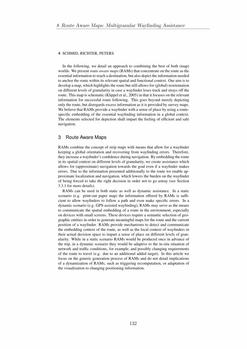
4 SCHMID, RICHTER, PETERS
In the following, we detail an approach to combining the best of both (map)
worlds. We present route aware maps (RAMs) that concentrate on the route as the
essential information to reach a destination, but also depict the information needed
to anchor the route within its relevant spatial and functional context. Our aim is to
develop a map, which highlights the route but still allows for (global) reorientation
on different levels of granularity in case a wayfinder loses track and strays off the
route. This map is schematic (Klippel et al., 2005) in that it focuses on the relevant
information for successful route following. This goes beyond merely depicting
only the route, but disregards excess information as it is provided by survey maps.
We believe that RAMs provide a wayfinder with a sense of place by using a route-
specific embedding of the essential wayfinding information in a global context.
The elements selected for depiction shall impart the feeling of efficient and safe
navigation.
3 Route Aware Maps
RAMs combine the concept of strip maps with means that allow for a wayfinder
keeping a global orientation and recovering from wayfinding errors. Therefore,
they increase a wayfinder’s confidence during navigation. By embedding the route
in its spatial context on different levels of granularity, we create assistance which
allows for (approximate) navigation towards the goal even if a wayfinder makes
errors. Due to the information presented additionally to the route we enable ap-
proximate localization and navigation, which lowers the burden on the wayfinder
of being forced to take the right decision in order not to go astray (see Section
3.3.1 for more details).
RAMs can be used in both static as well as dynamic assistance. In a static
scenario (e.g. print-out paper map) the information offered by RAMs is suffi-
cient to allow wayfinders to follow a path and even make specific errors. In a
dynamic scenario (e.g. GPS-assisted wayfinding), RAMs may serve as the means
to communicate the spatial embedding of a route in the environment, especially
on devices with small screens. These devices require a semantic selection of geo-
graphic entities in order to generate meaningful maps for the route and the current
position of a wayfinder. RAMs provide mechanisms to detect and communicate
the embedding context of the route, as well as the local context of wayfinders in
their actual decision space to impart a sense of place on different levels of gran-
ularity. While in a static scenario RAMs would be produced once in advance of
the trip, in a dynamic scenario they would be adaptive to the in-situ situation of
network and traffic conditions, for example, and possibly changing requirements
of the route to travel (e.g. due to an additional added target). In this article we
focus on the generic generation process of RAMs and do not detail implications
of a dynamization of RAMs, such as triggering recomputation, or adaptation of
the visualization to changing positioning information.
8 Route Aware Maps: Multigranular Wayfinding Assistance
132

ROUTE AWARE MAPS 5
Construction of RAMs starts with the route itself. This route between origin
and destination may be computed using any available metric, for example classical
shortest paths (Dijkstra, 1959), or cognitively motivated approaches, such as the
simplest path (Duckham & Kulik, 2003), the most reliable path (Haque et al.,
2007), or a path considering the corresponding simplest instructions (Richter &
Duckham, 2008). Then, stepwise we add additional information to the map that
results in the embedding of the route in its spatial context. More specifically, we
add information on:
• Initial and final orientation: are important for getting the wayfinder off in
the right direction and for “homing” when close to the origin (Section 3.1);
• alternative routes: may allow a wayfinder to get back on track once acci-
dentally having left the route (Section 3.2.3);
• Regions: provide an anchoring of the route in the environment (Section
3.3.1);
• Landmarks: help to disambiguate locations along the route and help to iden-
tify locations in the environment (Section 3.3.2).
In the following, we argue for adding these types of information to the basic
route information and explain how it is done.
3.1 Initial and Final Orientation
Origin and destination of a route are crucial parts for successfully finding one’s
way (e.g., Michon & Denis, 2001). At the origin, wayfinders need to initially
orient themselves in order to get off in the right direction. The destination needs
to be clearly identifiable in order to know that wayfinding has been successful.
Further, especially in dense urban areas, such as a city center, there is an increased
chance to miss crucial decisions and an increased need for reorientation near the
destination. For example, this may be caused by a complex system of one-way
streets or the need to find a parking space. Thus, it is sensible to not only guide
wayfinders exactly to the destination location, but also to enable them to freely
navigate in the nearby surroundings.
In order to support these two crucial processes, we display the environment
around origin and destination in more detail. For the origin we extend the street
network until no ambiguous situation is present any more: we expand the street
network until each option the origin is reachable from is clarified by a defined
configuration of streets (an identifiable intersection). Alternatively, if we identify a
salient element (such as a park or a river) we employ the respective element instead
to unambiguously identify this option. This first extension to the route allows a
wayfinder for matching the spatial situations perceived in the environment around
133

6 SCHMID, RICHTER, PETERS
origin and destination with that depicted on the map. For the destination region
we expand the route similarly, but with a slightly higher scope (see Figure 1).
SS
a) b)
DD
c) d)
Figure 1.: Initial and final orientation: a) Original initial surrounding, S is the
starting point; the bold dashed line shows the route; b) Embedding of the starting
point; bold solid lines shows the embedding area, thin dashed lines show inter-
sections along the route; c) Original final surrounding, D is the destination; d)
Embedding of destination (with depth 3).
More precisely, we use the following algorithm for adding information on ori-
gin and destination location:
1. We select all outgoing branches of the origin of the route and select all
which are not member of the route.
2. We expand each selected branch until we either reach an intersection or a
salient landmark. The corresponding streets are displayed on the map.
3. We select all outgoing branches of the destination.
4. Starting with each selected branch, we add all additional branches of the
street network graph up until a configurable depth k (without adding already
existing branches again). The corresponding streets are displayed on the
map.
8 Route Aware Maps: Multigranular Wayfinding Assistance
134

ROUTE AWARE MAPS 7
3.2 Along the Route: Error Analysis and Alternative Routes
As discussed earlier, wayfinding is a complex process in which errors easily occur
due to manifold reasons. Errors may happen due to the wayfinder being inat-
tentive, because the provided assistance (in form of a map) does not match with
the encountered situation in the environment in the way it has been expected, or
simply because the environmental situation itself is ambiguous and hard to un-
derstand. While it is impossible to predict every possible error that may occur
during wayfinding, in RAMs we integrate information that allows recovery from
two kinds of errors:
1. Local ambiguous or complex configuration of an intersection: based on
capturing how humans conceptualize turns at intersections (e.g., Klippel,
2003; Haque et al., 2007), we can identify how many possible choices there
are at an intersection and whether these choices potentially conflict with
each other;
2. Global ambiguous situations can originate from monotone, recurrent, cue-
less environments as they often occur in modern suburbs, for example. De-
cision points, i.e., the relevant intersections, can be easily confused with
other intersections due to the similarity in the environmental structure and
the density of intersections.
The analysis performed to identify both kinds of errors is motivated by how
humans conceptualize wayfinding situations and follows an information-theoretic
approach. Local error analysis is explained next, global error analysis in Section
3.2.2. To enable wayfinders to recover from these errors, we introduce alternative
routes as explained in Section 3.2.3.
3.2.1 Local Error Analysis
The first kind of error is tackled by analyzing the configuration of an intersection’s
branches. We employ a method we term Choreme Analysis (CA). CA is similar
to the approach of identifying the most unambiguous instructions, introduced by
Haque et al. (2007), but with a different resolution:
1. We discretize all angles formed by the incoming branch with all other branches
based on the wayfinding choreme direction model as proposed in Klippel &
Montello (2007). As a result every angle is represented as a qualitative
direction relation relative to the direction of travel.
2. According to this representation, we check if any two (or more) branches
head in the same direction and hence are represented by the same relation.
If this is the case and if they are relevant for the action to be performed
at this intersection, a potential conflict is identified (cf. also Haque et al.,
135

8 SCHMID, RICHTER, PETERS
2007; Richter & Klippel, 2005). A branch is relevant if its choreme repre-
sentation corresponds to the direction to take at the intersection, i.e., if it
is described by the same qualitative relation as the action to be performed
at this intersection (e.g., “veer right”). Figure 2 illustrates such a conflict.
Here, two outgoing branches of the intersection share the same direction
concept.
3. We compute for every detected conflicting branch an alternative route to the
destination (Section 3.2.3).
S
a) b)
Figure 2.: Local error analysis: a) Critical situation: two outgoing branches share
the same direction concept, a conflicting situation is identified; b) In more detail:
the Choreme Analysis.
3.2.2 Global Error Analysis
The second kind of errors, namely errors resulting from the recurrent, uniform
structure of an environment is analyzed in a similar fashion as the first. The aim
is to tackle two problems simultaneously. The first remains in the representa-
tion of spatial features in maps; the second in the structure of the environment.
Automatically generated maps are always data-driven representations. They use
cartographic symbols to visualize a selection of the spatial entities that exist in the
real world. Maps are selective and limited in their visual language, a key concept
differentiating them from satellite photos (e.g., MacEachren, 1995). For exam-
ple, the two images in Figure 3 show a rather monotone environment in Chicago.
When traveling along the east-west axis the streets have names and are not num-
bered. Traveling in such environments requires close attention to the perceived
8 Route Aware Maps: Multigranular Wayfinding Assistance
136
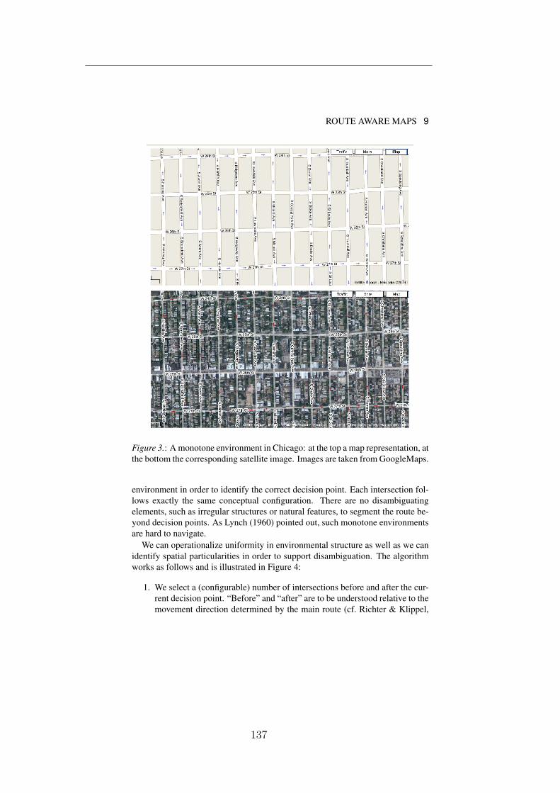
ROUTE AWARE MAPS 9
Figure 3.: A monotone environment in Chicago: at the top a map representation, at
the bottom the corresponding satellite image. Images are taken from GoogleMaps.
environment in order to identify the correct decision point. Each intersection fol-
lows exactly the same conceptual configuration. There are no disambiguating
elements, such as irregular structures or natural features, to segment the route be-
yond decision points. As Lynch (1960) pointed out, such monotone environments
are hard to navigate.
We can operationalize uniformity in environmental structure as well as we can
identify spatial particularities in order to support disambiguation. The algorithm
works as follows and is illustrated in Figure 4:
1. We select a (configurable) number of intersections before and after the cur-
rent decision point. “Before” and “after” are to be understood relative to the
movement direction determined by the main route (cf. Richter & Klippel,
137

10 SCHMID, RICHTER, PETERS
2007). In our current implementation, we select one intersection before and
one after the decision point, even though this number may depend on the
structure of the environment. Large grid environments, such as in Figure 3,
may require a larger threshold than irregular environments (the analysis of
the influence of an environment’s structure on the required threshold is part
of future work).
2. For all selected intersections, we calculate a qualitative representation of
their configuration using a choreme encoding according to the CA as de-
scribed above. However, here we are not interested in a single local con-
figuration that may be conflicting, but in the similarity across the selected
intersections’ configurations.
(a) If the number of conceptual turns at two intersections is similar we
mark the intersections as similar.
(b) If the similar intersections have a unique feature located at them,
which is not present at the other intersections marked as similar, we
select this feature to disambiguate the current intersection. Conse-
quently, we remove the similarity mark for this intersection again, as
it can be unambiguously identified in its local neighborhood by this
local feature. Disambiguating features, such as parks or water bodies,
must be perceptually unambiguous, i.e., the cartographic style used
to represent them on the map must be perceptually different from the
way all other features in the local surroundings are depicted.
3. If there still exist unresolved ambiguities, we compute an alternative route
for those intersections that are marked as similar.
3.2.3 Alternative Routes
Alternative routes (ARs) are a key concept of RAMs. They are the link to embed-
ding the main route from origin to destination in the street network. Whenever
the (local or global) error analysis identifies a possible error source on the main
route we compute an AR from the location of the possible error either back to the
main route or directly to the destination. This allows for extracting only the part
of the street network, which is structurally important for the main route. Within
the alternative routes, we do not perform any error analysis. Cognitively, these
routes define the relevant spatial context on a network level and serve as a fall-
back in case wayfinding errors have been made. Computationally, checking for
errors on ARs as well would result in a recursive progression of potential errors
that, in the worst case, would lead to displaying the complete street network and,
thus, introducing unneeded visual clutter.
8 Route Aware Maps: Multigranular Wayfinding Assistance
138

ROUTE AWARE MAPS 11
S
Park
a) b)
Figure 4.: Global error analysis: a) Similarity analysis: the intersections before
and after the decision point are identified as being similar with respect to their con-
figuration, a conflicting situation is identified; b) The situation is disambiguated
by representing landmarks (post office and park).
Calculating ARs is based on the approach of “simplest paths” introduced by
Duckham & Kulik (2003). The AR algorithm works as follows and is illustrated
in Figures 5 and 6:
1. We simulate a wayfinding error and “move” virtually off-route from the
current decision point we identified as potential error source. In case of
a local conflict, we move along a conflicting branch. In case of a global
conflict, we take that branch at the conflicting intersection that corresponds
to the branch we need to take at the actual decision point.
2. We block the branch we took. This will prevent the path search algorithm
to simply compute the route back along this branch to the main route.
3. We compute the AR itself using the algorithm for “simplest paths.” The
algorithm penalizes nodes with many outgoing branches as they are deemed
as complex; such nodes are mostly avoided. Therefore, in simplest paths
competing branches hardly ever occur.
• In every step of the simplest path algorithm we check if the current
selected node is either a node on the main route or corresponds to the
destination itself. In either case we have found a valid AR and stop.
4. The AR just found is displayed on the map.
139
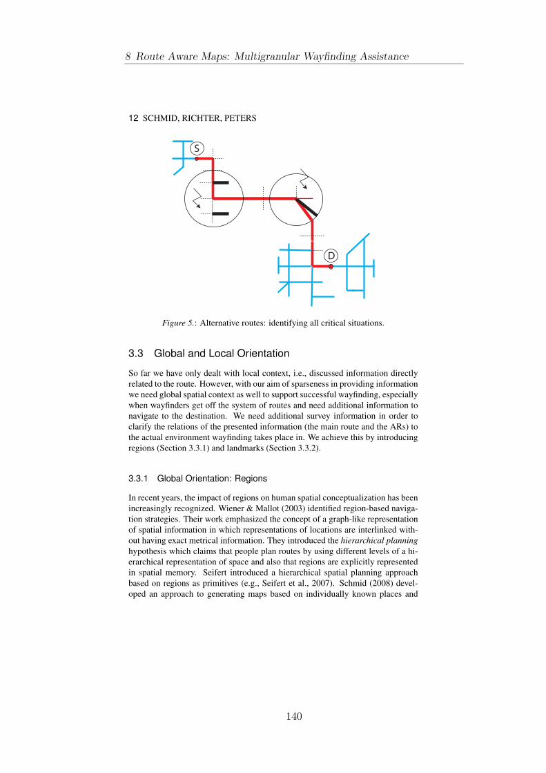
12 SCHMID, RICHTER, PETERS
D
S
Figure 5.: Alternative routes: identifying all critical situations.
3.3 Global and Local Orientation
So far we have only dealt with local context, i.e., discussed information directly
related to the route. However, with our aim of sparseness in providing information
we need global spatial context as well to support successful wayfinding, especially
when wayfinders get off the system of routes and need additional information to
navigate to the destination. We need additional survey information in order to
clarify the relations of the presented information (the main route and the ARs) to
the actual environment wayfinding takes place in. We achieve this by introducing
regions (Section 3.3.1) and landmarks (Section 3.3.2).
3.3.1 Global Orientation: Regions
In recent years, the impact of regions on human spatial conceptualization has been
increasingly recognized. Wiener & Mallot (2003) identified region-based naviga-
tion strategies. Their work emphasized the concept of a graph-like representation
of spatial information in which representations of locations are interlinked with-
out having exact metrical information. They introduced the hierarchical planninghypothesis which claims that people plan routes by using different levels of a hi-
erarchical representation of space and also that regions are explicitly represented
in spatial memory. Seifert introduced a hierarchical spatial planning approach
based on regions as primitives (e.g., Seifert et al., 2007). Schmid (2008) devel-
oped an approach to generating maps based on individually known places and
8 Route Aware Maps: Multigranular Wayfinding Assistance
140
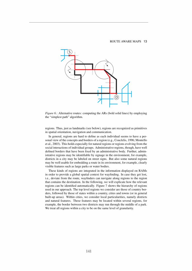
ROUTE AWARE MAPS 13
D
S
Figure 6.: Alternative routes: computing the ARs (bold solid lines) by employing
the “simplest path” algorithm.
regions. Thus, just as landmarks (see below), regions are recognized as primitives
in spatial orientation, navigation and communication.
In general, regions are hard to define as each individual seems to have a per-
sonal view of the concepts and borders of a region (e.g., Couclelis, 1996; Montello
et al., 2003). This holds especially for natural regions or regions evolving from the
social interactions of individual groups. Administrative regions, though, have well
defined borders that have been fixed by an administrative body. Further, admin-
istrative regions may be identifiable by signage in the environment, for example,
districts in a city may be labeled on street signs. But also some natural regions
may be well usable for embedding a route in its environment, for example, clearly
visible features such as large parks or water bodies.
These kinds of regions are integrated in the information displayed on RAMs
in order to provide a global spatial context for wayfinding. In case they get lost,
i.e., deviate from the route, wayfinders can navigate along regions to the region
that contains the destination. In the following, we will explicate how the relevant
regions can be identified automatically. Figure 7 shows the hierarchy of regions
used in our approach. The top level regions we consider are those of country bor-
ders, followed by those of states within a country, cities and towns (or in general
built-up areas). Within cities, we consider local particularities, namely districts
and natural features. These features may be located within several regions, for
example, the border between two districts may run through the middle of a park.
We treat all regions within a city to be on the same level of granularity.
141

14 SCHMID, RICHTER, PETERS
Countries
States
Cities(built-up areas)
Districts NaturalFeatures
Parks
Landmarks
Figure 7.: The region hierarchy as implemented in the RAM process.
Selecting these regions for integration in RAMs is a pragmatic approach in
terms of perceptibility, available data and computational efficiency. The algorithm
for determining the regions to be included is illustrated next.
Pre-Processing and Query Optimization
The aim of the region extraction algorithm is to identify all regions that are rele-
vant for the wayfinding problem. Relevant regions are those that contain parts of
the routes—be it the main route or one of the alternative routes. These are the re-
gions the wayfinders will pass through. The computation of the membership of a
route within a region is based on the points contained in the route. If a point of the
route is within a region, the region is considered relevant for the route. In terms
of geographical data, regions are usually complex polygons (in our data some of
the districts have up to 5000 geometric control points). Thus, depending on the
type of regions and the length of the route, the number of regions and points to
be checked can become very large, turning this into a computationally infeasible
approach.
Therefore, to drive computation, initially we need to determine the region which
completely contains the route. A route between Bremen and Hamburg would be
fully contained in the region “Germany;” a route within Bremen would be com-
pletely contained within the region “Bremen.” This region is the starting point for
a further refinement of the relevant regions. The encompassing region serves two
purposes: 1) only those regions that belong to a category on lower levels of the
hierarchy than the encompassing region (see Fig. 7) will be relevant for the routes,
8 Route Aware Maps: Multigranular Wayfinding Assistance
142
ROUTE AWARE MAPS 15
i.e., we can restrict our search to these levels; 2) in a similar line of argument, we
can restrict the search for regions to the spatial extend covered by the encompass-
ing region. We will treat each hierarchy level relevant for the region identification
individually.
The key idea of processing all regions that may be relevant for the RAM to be
constructed is the separation of their functional and geometric representations as
well as the utilization of the neighborhood relation between regions. To this end,
we need to do some preprocessing on the region data. For each region, we com-
pute their bounding box as this allows for a faster comparison of spatial relations
between regions. Namely, we need to test for intersection/touch and containment
of regions. Using the bounding boxes, we calculate an adjacency matrix that stores
intersection and containment of regions—a region containing another is taken to
intersect with the contained region.
With this adjacency matrix, we can now navigate efficiently through the hierar-
chy of regions, i.e., our search space. We further restrict the containment check of
route in regions by only checking for decision points, i.e., those points of a route
that coincide with an intersection. As stated before, region selection is performed
on each layer of the hierarchy individually. However, by means of the indexed
data, we can interlink the different layers to further facilitate efficient processing
of the information. The following algorithm selects relevant regions for the infor-
mation so far contained in the route aware map, namely the main route, the street
network around origin and destination, and the alternative routes (see Fig. 8).
1. We compute the bounding box of the RAM (the extend covered by main
route, origin and destination, ARs).
2. We determine the region on the lowest possible level of the hierarchy that
fully contains the bounding box of the route aware map.
3. For every route (main route and ARs) we iterate through all nodes that cor-
respond to decision points.
4. We check for containment within any of the regions of the current level
in the hierarchy. In the first pass, this is the level one below the level the
encompassing region belongs to.
• If no region contains a node of the route (not all region layers will
cover the complete area as administrative regions do) we stop the
search on this level and proceed with the next region layer at step 4.
5. If we have identified a region whose bounding box contains a node, we
check again with the actual border of the region. Nodes being on the border
of a region count as being contained as well.
(a) If the node is really contained, we select the region and add it to the
map.
143

16 SCHMID, RICHTER, PETERS
(b) If the node is not contained, we select all neighbors of the selected
region by means of the adjacency matrix. We check these neighbors
for which of them contains the node.
6. If we have processed all nodes and there are still layers of the hierarchy we
have not checked yet, we select one of these as new layer and repeat the
process from step 3 on.
D
S
City
District1
District 4
District 3
District 2
River
Park
Figure 8.: Global orientation: Embedding the route in surrounding regions.
3.3.2 Local Orientation: Landmarks
Finally, in creating RAMs local landmarks are used to anchor route information in
its surrounding environment. These landmarks serve two purposes: they help to
disambiguate intersections and they foster orientation of wayfinders. In areas that
are made up of structurally similar intersections, i.e., where the street network
is very regular (see Section 3.2.2) landmarks may make the difference it takes
to identify the intended intersection. Accordingly, for intersections identified to
be structurally similar to their surrounding intersections, we check whether some
landmarks may be used to identify them. This check is done as explained in our
previous research (e.g., Richter & Klippel, 2007; Richter, 2007), but extended
8 Route Aware Maps: Multigranular Wayfinding Assistance
144

ROUTE AWARE MAPS 17
to include depictional considerations. Additionally to ambiguity checks we have
used in our previous work, we also check whether potential landmarks would be
depicted on the map using the same cartographic style as other features in the
local surroundings, i.e., whether the feature categories they belong to are mapped
using the same color and geometry. If two different types of features are depicted
the same way (e.g., a fountain and a statue may both be depicted as a grey circle),
they are not easily distinguished on the map and, therefore, do not unambiguously
identify an intersection if both features are present in the surrounding area. In case
a landmark located at the intended intersection unambiguously discriminates this
intersection from its neighboring ones, it is included in the route aware map and,
thus, solves a potential conflict.
Local landmarks may also be used to foster orientation, similar to global ones,
i.e., those environmental features represented as regions. To this end, it is checked
whether highly salient landmarks are located along the route (such as highly vis-
ible shops or monument buildings); these are added to the RAMs. However, to
avoid visual clutter, we limit the number of landmarks added this way to only a
few key features. Checking for such landmarks, again, is based on previous work.
3.4 Example
Figures 9 and 10 illustrate the steps of compiling a RAM based on geographical
data of the city of Bremen. Figure 9a depicts the main route from origin S to
destination D running through Bremen’s inner city. Figure 9b shows the extracted
strip map, the minimalist map-based representation of the route. In Figure 9c we
disambiguate the start environment by extending the street network until the first
intersection as described in Section 3.1. In the same step, we extend the street
network around the destination (network depth of three topological nodes) and
added the river as an additional landmark according to Section 3.3.2.
Figure 10a depicts the potentially problematic parts of the route and the result-
ing alternative routes (bold dark gray underlying lines). Figure 10b depicts the
so so far compiled route (extended start and destination environments) with the
extracted alternatives routes. Finally, in Figure 10c we add those regions which
are relevant to the route (here, these are only districts as the route is contained in a
single city). This results in the route aware map assisting a wayfinder to get from
origin S to destination D.
Note that we do not display cartographic labels, such as names of streets or
districts, to emphasis the principle generation process of RAMs. For actual usage,
without this information a real anchoring of the streets, regions, and landmarks in
the global context is likely not possible.
145
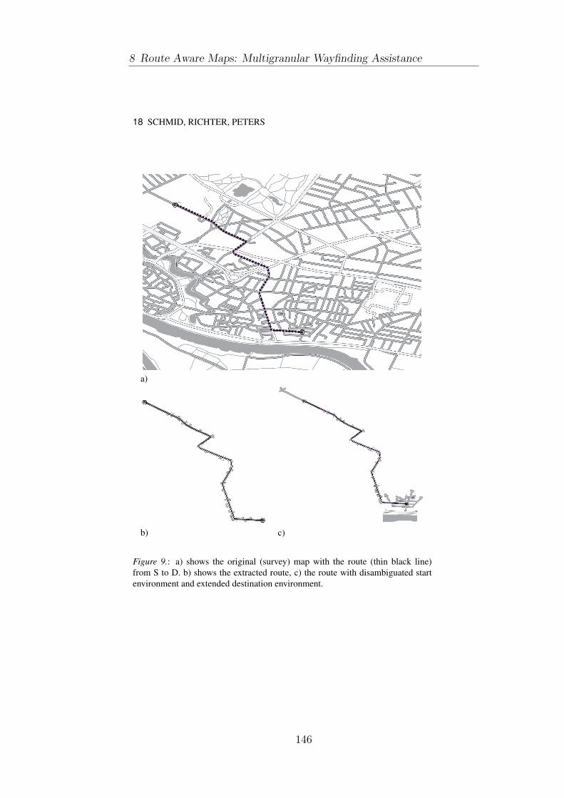
18 SCHMID, RICHTER, PETERS
a)
b) c)
Figure 9.: a) shows the original (survey) map with the route (thin black line)
from S to D. b) shows the extracted route, c) the route with disambiguated start
environment and extended destination environment.
8 Route Aware Maps: Multigranular Wayfinding Assistance
146

ROUTE AWARE MAPS 19
a)
b) c)
Figure 10.: a) shows the route in the original (survey) map with alternative routes
(bold underlying lines). b) shows the extracted alternative routes, and c) depicts
the final RAM with the relevant regions (in this case districts) for the main route
and the alternative routes.
147

20 SCHMID, RICHTER, PETERS
4 Discussion
Schematic wayfinding maps are by definition task specific representations (cf.
Klippel et al., 2005) usually incorporating a stringent feature selection. The selec-
tion of features aims at efficient assistance with low cognitive demands tailored
to a specific wayfinding task. There are different approaches to define, select,
and visualize the relevant information for a given route underlying the specific
wayfinding task, which leads to different schematization principles. In Agrawala
& Stolte (2001), for example, the authors propose LineDrive Maps, which are
based on the mental prototypical arrangements of intersections and activity based
scaling of street segments. The resulting schematic maps represent a route as
strip map with no further information on the surrounding environment and can
be considered to be a data-driven schematization. As a contrast to this reduced
representation, Focus Maps (Richter et al., 2008) use a rich representation of the
environment and highlight the crucial elements (e.g., the route) by de-emphasizing
non-relevant areas of the environment. This is achieved by a fading out of colors
and a simplification of feature geometry based on proximity to the elements in fo-
cus. Schematization in Focus Maps is based on perceptual effects as the selection
of features is mostly done via their color encoding. μ Maps (Schmid, 2008) show
only the unfamiliar parts of a route in full detail, the familiar parts are schematized
to a high degree. This kind of schematization exploits individual familiarity with
an environment.
RAMs introduce a new type of schematization by taking these approaches a
step further. They provide a multi-granular schematization since they select fea-
tures of an environment on different levels of granularity. In that, they acknowl-
edge the hierarchical representation of space by humans (e.g., Hirtle & Heidorn,
1993). They provide means to reach the overall goal—getting to the destination—
and at the same time offer information for reaching this goal on different levels
of granularity, thus offering alternatives and allow for approximate wayfinding in
case task execution fails. Thus, while being task-specific, they allow for different
executions of the task.
RAMs communicate survey knowledge dependent on the course of a particular
route. They do not show the details of the street network, especially of remote
locations in the same district, however, they communicate the configurations of
important structural and conceptual elements of the environment in relation to
the actual route. They are rather conceptual survey maps than general purpose
maps. RAMs illustrate the structure of the environment for a route similarly to
how a GPS-based wayfinding assistance system only communicates the route to
travel. They focus on the crucial parts of survey information. General purpose
survey maps on the other hand offer all information of a defined region as equally
important.
However, the selection of, for example, regions also depends on the network
incorporated by the route. If a route incorporates a longer part across a highway,
8 Route Aware Maps: Multigranular Wayfinding Assistance
148

ROUTE AWARE MAPS 21
the context of that part is different to the context of a part of a route within an
inner city environment. While driving along a highway, we are most likely not
interested in every district of a city we pass or potentially cross. The selection of
the contextual information for such routes would benefit from additional consid-
erations of coherent parts of the route with respect to the utilized transportation
link. Thus, in generating RAMs, the (conceptual) scale of covered route segments
should be considered as well and the construction process should be accordingly
adapted—this might include activity-based scaling similar to Agrawala & Stolte
(2001).
5 Conclusions
In this paper, we have presented an approach to map-based wayfinding assistance
that we term route aware maps. These maps are designed to present all informa-
tion that is needed to successfully reach a destination while aiming at sparseness
in the display of that information. It combines the best of strip maps, which only
present information on the route itself, with survey maps, which distribute infor-
mation uniformly across the chosen area.
Next to the actual route from origin to destination, RAMs present the area
around origin and destination in more detail to keep the wayfinders oriented at
these crucial spots. The maps also integrate alternative routes at those points along
the route where wayfinding errors likely occur due to the (local or global) ambi-
guity in the structure of the environment. Furthermore, RAMs embed the route
in its global spatial context. To this end, those regions relevant for the route are
identified and displayed allowing for approximate navigation using region infor-
mation in case the route has been accidentally left; key local landmarks are shown
as well and further the anchoring of the route within the environment. We take an
information- and representation-theoretic approach to identifying this additional
information that is required for successful navigation. We have detailed the con-
struction process for route aware maps, stating algorithms for all intermediate
steps, and discussed an example map.
We believe that route aware maps as they have been presented in this paper are
a promising approach for solving two (related) problems in map-based naviga-
tion assistance: 1) provision of focused, easy to access assistance that still allows
for error recovery; 2) the key-hole problem. The latter describes the problem of
presenting local information in its global context such that users can easily relate
both; it is especially crucial for the small displays of mobile devices. Thus, RAMs
are not only more reliable in a given wayfinding situation, they may also help to
overcome a major problem of today’s assistance systems, namely that users do not
really understand the spatial situation they are in and hardly remember anything
of the route after reaching the destination as shown, for example, by Parush et al.
(2007) and Ishikawa et al. (2008).
149

22 SCHMID, RICHTER, PETERS
In the near future, we plan to test the performance of RAMs in empirical
wayfinding studies in which we will compare the wayfinding performance of hu-
man subjects using route aware maps in real world navigation tasks with partic-
ipants using ‘classical’ street-maps. We will also explore scale-dependent con-
struction of RAMs and check whether additional salient objects should be in-
cluded in the maps, for example, major roads that may provide additional global
orientation, such as highways.
Acknowledgments
This work has been supported by the Transregional Collaborative Research Center
SFB/TR 8 Spatial Cognition, which is funded by the Deutsche Forschungsgemein-
schaft (DFG). We like to thank the participants of the ‘You-Are-Here Maps’ work-
shop at Spatial Cognition 2008 and three anonymous reviewers for their valuable
feedback on our work.
References
Agrawala, M., & Stolte, C. (2001). Rendering effective route maps: Improving
usability through generalization. In SIGGRAPH 2001, (pp. 241–249). Los An-
geles, California, USA: ACM Press.
Baus, J., Kruger, A., & Wahlster, W. (2002). A resource-adaptive mobile navi-
gation system. In IUI ’02: Proceedings of the 7th international conference onIntelligent user interfaces, (pp. 15–22). New York, NY, USA: ACM Press.
Couclelis, H. (1996). A typology of geographic entities with ill-defined bound-
aries. In P. A. Burrough, & A. U. Frank (Eds.) Geographic Objects with Inde-terminate Boundaries, (pp. (45–55). London: Taylor & Francis.
Daniel, M.-P., & Denis, M. (1998). Spatial descriptions as navigational aids: A
cognitive analysis of route directions. Kognitionswissenschaft, 7, 45–52.
Dijkstra, E. (1959). A note on two problems in connexion with graphs. Nu-merische Mathematik, 1, 269–271.
Duckham, M., & Kulik, L. (2003). ”Simplest” paths: Automated route selection
for navigation. In W. Kuhn, M. Worboys, & S. Timpf (Eds.) Spatial Informa-tion Theory. Foundations of Geographic Information Science, LNCS 2825, (pp.
169–185). Berlin: Springer. International Conference COSIT.
Freksa, C. (1999). Spatial aspects of task-specific wayfinding maps - a
representation-theoretic perspective. In J. S. Gero, & B. Tversky (Eds.) Visualand Spatial Reasoning in Design, (pp. 15–32). University of Sidney.
8 Route Aware Maps: Multigranular Wayfinding Assistance
150

ROUTE AWARE MAPS 23
Golledge, R. G. (1999). Wayfinding Behavior — Cognitive Mapping and OtherSpatial Processes. Baltimore, USA: John Hopkins University Press.
Haque, S., Kulik, L., & Klippel, A. (2007). Algorithms for reliable navigation
and wayfinding. In T. Barkowsky, M. Knauff, G. Ligozat, & D. R. Montello
(Eds.) Spatial Cognition V - Reasoning, Action, Interaction, LNCS4387, (pp.
308–326). Berlin: Springer.
Hirtle, S. C., & Heidorn, P. B. (1993). The structure of cognitive maps: Repre-
sentations and processes. In T. Garling, & R. Golledge (Eds.) Behaviour andEnvironment: Psychological and Geographical Approaches, chap. 7, (pp. 170–
192). Amsterdam, North-Holland: Elsevier Science Publishers.
Ishikawa, T., Fujiwara, H., Imai, O., & Okabe, A. (2008). Wayfinding with a
GPS-based mobile navigation system: A comparison with maps and direct ex-
perience. Journal of Environmental Psychology, 28, 74–82.
Klippel, A. (2003). Wayfinding choremes. In W. Kuhn, M. Worboys, & S. Timpf
(Eds.) Spatial Information Theory. Foundations of Geographic Information Sci-ence, LNCS 2825, (pp. 320–334). Berlin: Springer. International Conference
COSIT.
Klippel, A., & Montello, D. R. (2007). Linguistic and nonlinguistic turn direction
concepts. In S. Winter, M. Duckham, L. Kulik, & B. Kuipers (Eds.) Spatial In-formation Theory, LNCS 4736, (pp. 354–372). Berlin: Springer. International
Conference COSIT.
Klippel, A., Richter, K.-F., Barkowsky, T., & Freksa, C. (2005). The cognitive
reality of schematic maps. In L. Meng, A. Zipf, & T. Reichenbacher (Eds.)
Map-based Mobile Services - Theories, Methods and Implementations, (pp. 57–
74). Berlin: Springer.
Lynch, K. (1960). The Image of the city. MIT Press.
MacEachren, A. M. (1995). How maps work : representation, visualization, anddesign. Guilford Press; New York.
Michon, P.-E., & Denis, M. (2001). When and why are visual landmarks used
in giving directions? In D. R. Montello (Ed.) Spatial Information Theory.Cognitive and Computational Foundations of Geopraphic Information Science,
LNCS 2205, (pp. 400–414). Berlin: Springer. International Conference COSIT.
Montello, D., Goodchild, M., Gottsegen, J., & Fohl, P. (2003). Where’s down-
town? behavioral methods for determining referents of vague spatial queries.
Spatial Cognition and Computation, 3(2), 185–204.
151
24 SCHMID, RICHTER, PETERS
Montello, D. R. (2005). Navigation. In P. Shah, & A. Miyake (Eds.) Handbookof Visuospatial Thinking, (pp. 257–294). Cambridge: Cambridge University
Press.
Parush, A., Ahuvia, S., & Erev, I. (2007). Degradation in spatial knowledge acqui-
sition when using automatic navigation systems. In S. Winter, M. Duckham,
L. Kulik, & B. Kuipers (Eds.) Spatial Information Theory, LNCS 4736, (pp.
238–254). Berlin: Springer.
Phillips, R. J. (1979). Making maps easy to read: A summary of research. In P. A.
Koler, M. E. Wrolstad, & H. Bouma (Eds.) Processing of Visual Language,
vol. 1, (pp. 165–174). New York: Plenum Press.
Richter, K.-F. (2007). A uniform handling of different landmark types in route
directions. In S. Winter, M. Duckham, L. Kulik, & B. Kuipers (Eds.) SpatialInformation Theory, LNCS 4736, (pp. 373–389). Springer; Berlin. International
Conference COSIT.
Richter, K.-F., & Duckham, M. (2008). Simplest instructions: Finding easy-to-
describe routes for navigation. In T. J. Cova, H. J. Miller, K. Beard, A. U. Frank,
& M. F. Goodchild (Eds.) Geographic Information Science - 5th InternationalConference, GIScience 2008, LNCS 5266, (pp. 274–289). Springer; Berlin.
Richter, K.-F., & Klippel, A. (2005). A model for context-specific route directions.
In C. Freksa, M. Knauff, B. Krieg-Bruckner, B. Nebel, & T. Barkowsky (Eds.)
Spatial Cognition IV. Reasoning, Action, Interaction: International ConferenceSpatial Cognition 2004, LNAI 3343, (pp. 58–78). Berlin: Springer.
Richter, K.-F., & Klippel, A. (2007). Before or after: Prepositions in spatially
constrained systems. In T. Barkowsky, M. Knauff, G. Ligozat, & D. R. Montello
(Eds.) Spatial Cognition V - Reasoning, Action, Interaction, LNAI 4387, (pp.
453–469). Berlin: Springer.
Richter, K.-F., Peters, D., Kuhnmunch, G., & Schmid, F. (2008). What do focus
maps focus on? In C. Freksa, N. Newcombe, P. Gardenfors, & S. Wolfl (Eds.)
Spatial Cognition VI - Learning, Reasoning, and Talking about Space, LNAI
5248, (pp. 154–170). Berlin: Springer.
Rosenholtz, R., Li, Y., & Nakano, L. (2007). Measuring visual clutter. Journal ofVision, 7(2), 1–22.
Ross, T., May, A., & Thompson, S. (2004). The use of landmarks in pedestrian
navigation instructions and the effects of context. In S. Brewster, & M. Dunlop
(Eds.) Mobile Computer Interaction – MobileHCI 2004, LNCS 3160, (pp. 300–
304). Berlin: Springer.
8 Route Aware Maps: Multigranular Wayfinding Assistance
152

ROUTE AWARE MAPS 25
Schmid, F. (2008). Knowledge based wayfinding maps for small display cartog-
raphy. Journal of Location Based Services, 2(1), 57–83.
Schneider, L. F., & Taylor, H. A. (1999). How to get there from here? Mental
representations of route descriptions. Applied Cognitive Psychology, 13, 415–
441.
Seifert, I., Barkowsky, T., & Freksa, C. (2007). Region-based representation
for assistance with spatio-temporal planning in unfamiliar environments. In
G. Gartner, W. Cartwright, & P. Peterson, M. (Eds.) Location Based Servicesand TeleCartography, (pp. 179–191). Berlin: Springer.
Tversky, B., & Lee, P. U. (1998). How space structures language. In C. Freksa,
C. Habel, & K. F. Wender (Eds.) Spatial Cognition: An Interdisciplinary Ap-proach to Representing and Processing Spatial Knowledge, (pp. 157–175).
Berlin: Springer. LNAI 1404.
Tversky, B., & Lee, P. U. (1999). Pictorial and verbal tools for conveying routes.
In C. Freksa, & D. M. Mark (Eds.) Spatial Information Theory, (pp. 51–64).
Berlin: Springer.
Wiener, J., & Mallot, H. (2003). ’Fine-to-coarse’ route planning and navigation in
regionalized environments. Spatial Cognition and Computation, 3(4), 331–358.
153


9 Situated Local and GlobalContext in MobileYou-Are-Here Maps
Schmid, Kuntzsch, Winter, Kazerani, andPreisig [2010a]
In this paper we demonstrate the effectiveness of the coupling of interac-tion primitives with the semantics of a representation. This publicationattacks the self-localization task of the wayfinding process: we developso-called Y AHx maps to support fast and reliable self-localization inunfamiliar environments.
Self-localization is assisted by a system of cognitive and computationalprinciples, as well as semantic interaction primitives. The algorithmiccore of the Y AHx is a complex analysis of the environment surroundingthe user. We develop a method to identify global references which arerelevant orientation clues. We use them as a stable frame of referenceto support geographic self-localization. We apply methods to analyzethe relevant parts of the street network to reduce visual complexity byat the same time preserving correct mental processing of the presentedinformation.
In detail, we develop a trajectory based localization and map alignmentapproach instead of a pure positioning and compass based method. Byorienting the map with respect to the trajectory and not by currentcompass information, we segment the environment into ”the area onecomes from” and the remaining part, which is a cognitive shortcut to theinterpretation and alignment of the map. Additionally, we use a stableand egocentric frame of reference with salient landmarks on differentlevels of granularity. Finally, we develop the concept of reference adaptivezooming, a method to rapidly adjust the scale of the map to semanticmeaningful zoom levels with minimal interaction.
In user studies we evaluate the effectiveness of our approach and showthat the overall performance of the map combined with interaction issuperior to traditional approaches.
155


Situated Local and Global Orientationin Mobile You-Are-Here Maps
Falko SchmidSFB/TR8 Spatial Cognition
P.O. Box 330 44028334 Bremen, [email protected]
bremen.de
Colin KuntzschSFB/TR8 Spatial Cognition
P.O. Box 330 44028334 Bremen, Germany
Stephan WinterDepartment of GeomaticsUniversity of MelbourneVictoria, 3010, Australia
Aisan KazeraniDepartment of GeomaticsUniversity of MelbourneVictoria, 3010, Australia
Benjamin PreisigSchool of Geoinformation
University of Applied ScienceEuropastrasse 4
9524 Villach, AustriaBenjamin.Preisig@alumni.
fh-kaernten.ac.at
ABSTRACTThis paper presents a novel solution to the focus-and-context prob-lem of mobile maps provided for local and global orientation. Oursolution is inspired by the design principles of static You-Are-Heremaps and realizes principles of human spatial cognition to enableefficient communication of location information. We further pro-pose selective interaction with the presented information to im-prove the speed and accuracy of interpretation of the geographicinformation. Tests show strong evidence for the cognitive and in-teraction efficiency of the resulting maps, as users were faster andmore accurate than with conventional mobile maps.
Categories and Subject Descriptors: H.5.2 [Information Inter-faces and Presentation]: User Interfaces — Graphical User Inter-faces
General Terms: Algorithms, Experimentation, Human Factors,Measurement, Performance, Reliability.
Keywords: You-Are-Here Maps, Location-Based Services, Spa-tial Cognition, Detail-in-Context, Focus and Context, Localization,Spatial Awareness.
1. INTRODUCTIONTraditionally, You-Are-Here maps (YAH maps) are static maps
of an environment, showing a you-are-here symbol and being dis-played stationary in the environment to support local orientation,answering the question: “Where am I?”. Examples can be found,e.g., in parks, stations, or malls. These YAH maps are well-studiedconcerning principles of human spatial cognition, e.g. [13, 16].
This paper aims for generating a mobile equivalent to traditionalYAH maps, i.e., situated YAH maps that are ubiquitously avail-able on demand and meaningful for local orientation even from thesmall displays of mobile devices.
For many location-based services, visualizing the current loca-tion of a user has ever been a basic functionality. However, theprevalent techniques are content with illustrating a dot on a small-
Copyright is held by the author/owner(s).MobileHCI’10, September 7–10, 2010, Lisbon, Portugal.ACM 978-1-60558-835-3/10/09.
display map of a typically predefined scale, e.g., to show everythingin 100 meters around the estimated position. More advanced tech-niques, addressing the focus-and-context issue on small displaysmore carefully, are discussed below. None of them draws explicitlyfrom the principles of YAH map design, or the underlying princi-ples of human spatial cognition.
We will consider the design principles of traditional YAH maps,namely local and global orientation, alignment to the user’s ref-erence frame, selection of relevant information, and adaptation topositioning uncertainty, when we develop a conceptual model andmethods to generate these mobile YAH maps. We will call thesemaps YAHx maps from here on.
Local and global orientation. A stationary, e.g., wall-mountedYAH map provides a context-dependent global orientation with afocus on “you are here”. In contrast, most mobile services providea map on the small display. To answer the question “Where amI?" requires the user to integrate multiple views of varying scales,switching between zoom levels. In contrast, a YAHx map shouldaddress the focus-and-context problem: provide in a single viewlocal orientation and the context of a larger environment at the sametime. Several techniques for this problem were suggested, but webelieve that they can be significantly improved by an additionalcriterion of relevance.
Relevance. YAHx maps must be designed for fast and reliableinformation conveyance, i.e., the map representation of the envi-ronment has to concentrate on relevant information. Relevance is amatter of distance, such that methods are required to describe thedirectly perceivable surrounding in detail, but the embedding of thissurrounding with increasing selectivity.
Positioning uncertainty. Wall-mounted YAH maps do not haveany positioning uncertainty, but mobile YAHx maps have to ad-dress the uncertainty of the various mobile positioning methods toreduce the potential of misapprehension to a minimum. Noise andconsequently positioning uncertainty will probably remain an is-sue for mobile services, such that the typical dot on a map can begrossly misleading.
83
157

In the rest of this paper we develop a novel way of generatingYAHx maps and their interaction functionality, addressing the is-sues discussed above by:
• considering location based on human perception and cogni-tion, i.e., with high level of detail for everything that is near,and coarse information about what is far;
• adapting the base level of detail to the certainty about thecurrent position, according to rules of relevance;
• allowing for fast and precise interaction with the underly-ing map to further determine the context of one’s location bymeans of a larger spatial scope.
2. BACKGROUND AND RELATED WORKThis section collects the relevant work about communicating in
varying degrees of granularity, and linking granularity to position-ing uncertainty.
2.1 YAH mapsYAH maps serve the purpose of orientation for people in an un-
familiar environment. Accordingly, YAH maps are characterizedby a YAH mark. They must follow two cognitive principles foreffectiveness, alignment and structure matching with the environ-ment, from which the criteria for their placement and design can bederived [13]. These criteria follow from the specific task of YAHmaps, and have to be applied in addition to the rules of effectivegeneral map design (e.g., [10]). The criteria are, in short: com-pleteness (they must contain all the information that is necessaryto fulfill the given task, local orientation), syntactic clarity (all therelevant graphic features for a given task need to be easily percep-tible and identifiable, and visual clutter needs to be avoided), andsemantic clarity (all the symbols and map features need to be easilyimbued with meaning in an unambiguous and consistent manner).
2.2 Small Display CartographySmall display cartography has developed several approaches to
cope with the problem of visualizing geographic information onsmall displays with sufficient level of detail. Approaches suggestedso far are variable-scale maps, variable-focus maps, generalizedand selective maps, and visualization of off-screen features. Variable-scale maps are suggested to address the focus-and-context problem[9]: They apply fisheye lenses to show an area detailed in the con-text of the embedding map. These transformations heavily distortthe geographic information, especially in the border regions of thecurvature. Also, this kind of mapping is translation- and rotation-sensitive, i.e., attached with heavy updating costs if the mobile userturns or moves. Variable-focus maps are designed to focus the mapreader’s attention to relevant parts of the map [28]. In the processof generating these maps two steps are involved, the selection ofthe relevant region, and the map manipulation to focus the atten-tion on the relevant region. Typically the selected region is visuallydistinguished by parameters such as saturation or granularity. I.e.,focus maps select, but they do not vary scale, and are still limited inproviding global orientation by the small display. Generalizationand selection was proposed in the context of route maps. Sketchmaps neglect any map content that is not considered relevant, andapply rules of salience and relevance to draw a map of inhomo-geneous scale [1]. Applying sketches for YAHx maps has not yetbeen suggested. Personalization of maps with respect to the indi-vidual previous spatial knowledge of users have been suggested in[20, 21]. For these maps, the generation algorithms consider rout-ing across familiar parts of the environment. If this is possible, the
resulting μMaps will not show details for the familiar regions, andfinally the resulting maps can be significantly smaller compared toconventional maps. Off-screen features can be visualized by point-ing from a map-view of constant scale to off-screen locations bymeans of arrows, circle segments [2], or wedges [6]. The lattermethods are typically applied with no text labels, i.e., applicableonly where features of the same type are to be visualized. Withtheir inability to distinguish between different feature types theyare not suited to provide a global orientation. Global informationis provided by a map inlet showing the global orientation at smallscale, while the main map serves the local orientation at large scale,or alternatively, by multiple maps of various scales, requiring userinteraction to zoom in and out. An example for the latter is sectoralzoom [19]. In [22] the authors describe a system to transform lo-cal, stationary YAH into mobile YAH maps. By means of a mobilephone with GPS and camera, they turn a photo of the stationaryYAH map into a mobile, navigatable map. However, this approachdoes naturally not transform the geographic information into a suit-able mobile representation, as it is based on photos of printed maps.A combination of variable scale, variable focus and generalizationand selection was recently presented as ‘focus plus glue plus con-text’, extending the current focus-and-context paradigm for ‘glue’[27]. We will develop another alternative in the next section, us-ing elements of variable focus, generalization and selection, andvisualization of off-screen features. We deliberately leave variablescale out, since this approach has never proven to help users build-ing proper cognitive representations of their environment. Our al-ternative approach is based on spatial hierarchies and relevance, ascognitive principles. Cognitive spatial representations have a hier-archical structure, and that cognitive spatial reasoning is hierarchic[7]. Correspondingly, human verbal place descriptions are hierar-chical [17], either coarse-to-fine or fine-to-coarse, and they adaptto position uncertainty by choosing an appropriate base granular-ity [25]. This paper will translate these principles into a graphicexpression of a YAHx place description.
3. A CONCEPTUAL MODEL OF YAHx
MAPS
3.1 RequirementsYAHx maps can be requested by people everywhere in an ad-
hoc manner. Thus the design of YAHx maps has to catch up withthe variety of environments a person can be in, and the variety oflocations and orientations the person can have within this environ-ment. These considerations suggest two guiding principles for theprovision of YAHx maps: an awareness of the local and globalsituation (situatedness), and an awareness of the body of the per-son and its physical and perceptual relations to the environment(embodiment). These principles are subsumed as location context.YAHx maps also depend on the position uncertainty, suggesting alink with the granularity of the provided information, subsumed asposition context.
In this paper other contextual aspects are explicitly excluded,such as the individual person’s interests or tasks, the personal con-text. These aspects are excluded by traditional YAH maps as well,which also do not adapt to individual users.
3.2 Location contextFigure 1 shows a sketch of a conceptual model of feature selec-
tion and presentation. It realizes principles relating to the identifiedrequirements and is based on Montello’s distinction of vista, en-vironmental and geographic spaces [15]—which we can associate
84
9 Situated Local and Global Context in Mobile You-Are-Here Maps
158

Figure 1: The three levels of detail in a visual You-Are-Here(YAH) presentation on a mobile display: survey information inthe immediate neighborhood of a person, route information toselected landmarks in a larger neighborhood, and pointing tolandmarks beyond that horizon.
with Worboys’ three-valued nearness relation of ‘near’, ‘not near,not far’, and ‘far’ [26]—and Siegel and White’s distinction of land-mark, route and survey knowledge [23]. Correspondingly, in YAHx
maps situatedness can be realized by three levels of selectivity.Vista space is the space that can be seen from a single viewpoint.
It is either bound by physical barriers (e.g., in build environmentsor urban environments) or by a threshold distance of clear visibil-ity (e.g., in open environments such as at sea or on open plains).Vista space is a conservative and user-context-free approximationof what is near from the position of the user or their mobile device,the conceptual model assumes that at this level all (visible) featuresin the environment are relevant, and calls for survey information.
Environmental space is learned by locomotion and integration.Still related to the body of the user, although by movement oppor-tunities rather than by sight, the conceptual model translates envi-ronmental space into ‘not near and not far’ and suggests to presentthe links from vista space to far environment: (i) YAH maps areregularly used for wayfinding in complex environments, and (ii)routes in this range of distances still can be presented on small dis-play maps. A formal parameter to limit this area autonomously forany type of environment could be a set threshold of what is com-fortably reachable by locomotion, e.g., by foot.
Geographical space is learned from symbolic representations.Least based on the actual position or possibilities for locomotion,the conceptual model associates geographical space with ‘far’, andprovides information in this area most selectively, only by promi-nence. Presenting only landmarks in this area facilitates global ori-entation by directions to landmarks. Detailed survey or route infor-mation at this level would only form visual clutter, and reduce theability or efficiency of self-orientation.
In this conceptual model, nearness and prominence are antag-onists. Near features are always presented, independent of theirprominence. Routes are presented selectively, by their significanceto facilitate movement from the current position to other destina-tions. Far features are only presented if they are prominent land-marks. I.e., the conceptual model requires strategies to identifysignificant links and prominent features in the environment.
Embodiment is further realized by map alignment to the ego-centric reference frame of the user. Reference frames describe therelationships between spatial entities with respect to a potential ob-server [11]. In egocentric reference frames relationships are de-scribed with respect to the location, heading, and bearing of anobserver—in our case the user of a YAHx map. It has been shownthat reasoning with maps that do not correspond with the orienta-
tion of the map user is a cognitively demanding and error-pronetask, as the user has to mentally rotate the representation to achievea mental match of the two information sources, the real and the rep-resented environment [13]. I.e., to support an intuitive understand-ing of the spatial configuration of an environment for orientation,YAH maps have to show a representation that matches the currentorientation of the map user.
However, there are two ways of orientation: one by the trajectoryof the map reader—their general heading—and one by the cur-rent orientation of the mobile device—their implied actual head-ing. The general heading demarcates the environment into a front,the part of the environment not yet traversed, and a back, the partof the environment already traversed (in terms of near past events),a left and right (Figure 2). It is reasonable to assume that users willrecognize the part they have already traversed on the map and inthe real environment as they usually know where they come from.The general heading provides a stable map representation for anegocentric sector model. In comparison, using the actual heading,a widely used method in GPS assisted navigation devices when themap turns according to the compass information, map generation issubject to constant rotation and reassignment of references for thefour egocentric sectors. Also, the available built-in compasses usu-ally only work reliable while the user is constantly moving. When-ever users stand still and slowly turn around their axis (which is atypical behavior when we want to self-localize ourselves within theenvironment around us), the information can be arbitrarily wrong.Not least, the cognitive processing of highly dynamic spatial repre-sentations can be expected to be hard.
Left
Front
Right
Back
YAH
Visible Map Areas (SLZ, NCZ)
a)
b)
c)
f )
e)d)
Unvisible Geographic Area (GEZ)
Figure 2: Egocentric embodiment: the surrounding environ-ment is segmented in sectors for front, back, left, right. Thedetails for the selection of the global references are describedin Section 4.4.
3.3 Position contextPrior suggestions to deal with the uncertainty of positioning are
about varying the radius of the dot on YAH maps, or alternatively,varying the scale of the underlying map accordingly [8]. Bothmethods are quantitative, controlled by the standard deviation ofpositioning. However, we believe that this information should becognitively more intuitive, and hence, qualitative. The above modelfor location context already provides means to replace the positionuncertainty by a meaningful spatial location: vista space. Vistaspace can be interpreted to communicate YAH information graph-ically on maps: features bounding vista space together with theirrelation to the map user can form this YAH information; i.e., only
85
159

those features that can be seen by the user from the estimated po-sition are actually relevant for orienting in the direct environmentand necessary for being displayed in detail.
4. GENERATION OF YAHx MAPSIn this section we detail the automatic generation process and the
operationalization of the theoretic considerations for YAHx mapsaccording to the conceptual model. For every map the actual po-sition and its uncertainty, the near-past trajectory, and the spatialreferences of the embedding environment are considered. YAHx
maps will support self-localization, network-connectivity identifi-cation, as well as the determination of the global embedding of thedepicted area. Additionally a semantic-selective interaction primi-tive will be introduced, a reference-adaptive zoom-function.
Realizing the concepts of Figure 1, YAHx maps consist of threecontext zones (Figure 3):
Self-Localization Zone (SLZ): This zone, realizing the ‘near’zone of self-locating in Figure 1, depicts the complete street net-work and the last part of the latest trajectory. Streets are labeledselectively to avoid clutter on the small display. Streets are labeledif they are (a) along the trajectory, (b) likely to be in the directsurrounding of the user, based on the observed position (keepingin mind that positioning information is uncertain), or (c) of highcentrality (based on edge betweenness, which is explained below).Furthermore points of interest can be included to enable fast recog-nition of the direct surrounding.
Network-Connectivity Zone (NCZ): This zone, realizing the ‘notnear, not far’ zone in Figure 1, relates the SLZ to the network linksof the larger street network. In the NCZ only those streets that havea high centrality are depicted, addressing small-display problemsas well as relevance principles. This zone starts at the SLZ, has thesame scale and covers the rest of the display.
Global-Embedding Zone (GEZ): The GEZ, realizing the ‘far’zone of pointing in Figure 1, is outside of the display. But thepointing information to what is beyond the display is brought back(Figure 3a): Text labels referring to remote landmarks are listed atthe four sides of the display, corresponding to the four sectors ofthe egocentric reference frame imposed on the current heading oftravel. This way, pointing is generalized to categorical directions,addressing cognitive load in combination with (usually) spatiallyextended landmarks. The scale of the YAHx map is chosen adap-tively to the uncertainty of the positioning.
SLZ
NCZGEZ: Front
GEZ: Back
GEZ
: Lef
t
GEZ
: Rig
ht
rs rr'
SLZ
v0
NCZ
v1
v2v5 v4
v3
v6
e1
e 0
e3e 2
e4
e5
v7
e 6
e7
a) b)
Figure 3: (a) Zones, and (b) the extension of the street networkin NCZ.
4.1 Determination of the OrientationA basic requirement of a YAHx map is its inherent orientation
matching: what is in front of the user has to be on top of the map,left/right elements on the left/right part of the map, and the envi-ronment behind the user on the bottom of the map. Usually thedetermination of orientation is implemented with compass infor-mation. However, for reasons discussed above the general headingis preferable due to providing more stable map views. The headingis computed from the map-matched trajectory of the user as input,i.e., taking the last traversed street segment before the query. Thisstreet segment points to what is ahead of the user, and the map isoriented accordingly. For a reliable map matching the positioning isrequired with sufficient frequency and an uncertainty smaller thanthe density of street segments.
4.2 Determination of ScaleThe scale of the YAHx map is determined by the uncertainty
of the positioning information. The scale of the SLZ is chosensuch that all possible addressed locations are depicted: if the un-certainty (σxy) is a number of meters, the radius r of the SLZ (seeFigure 3) is set accordingly. Practically, SLZ is not strictly de-fined by a circle, but by network distance, including all verticesv1, vj reachable from an edge ek within the radius r around the es-timated position. Figure 3b illustrates this process: r correspondswith the positioning uncertainty, thus everything inside the circleof r natively belongs to the SLZ (v0, v1, v2, v4). However, theedges e0, e4, e5, e6, e7 connect the vertices v3, v5, v6, v7 with theelements of the SLZ. I.e., r is extended to r′, r′ being the largestdistance of these vertices from the current position, to include thoseentities as well. The reason for this procedure is to cover the im-mediate reachability and visibility of the possible network space:all elements in the SLZ can potentially be reached or seen. Usingthese demarcation entities is a realization of vista space, such thatat least the next junction is visible. The scale of the YAHx map isnow chosen such that the SLZ preserves a minimal distance s to theborder of the display, see Figure 3a.
4.3 Street Network SimplificationIn the SLZ the level of detail of the street network reflects the
originally available granularity from the data set. This is achievedby selecting vertices in a radius r around the current position of theuser (see Algorithm 1, steps 5-7). The original SLZ now consistsof both edges with both adjacent vertices inside r and edges withonly one adjacent vertex inside r. The latter case leads to the ex-pansion of the SLZ into radius r′ (steps 8-12). The value of radiusr′ is the maximum among distances of vertices added to SLZ inthis process from the YAHx map center p. However, street networkinformation requires a lot of space and is proven to introduce a sig-nificant amount of visual clutter (e.g., [18]). Thus the original streetnetwork graph G needs to be reduced to a sub-graph G′ in order toreduce the visual clutter in the outlying parts of the map. As thetask at hand is self-orientation, not the identification of a particularstreet or route, we can remove those streets in the NCZ which arenot important to be visualized (as they are not necessary to describethe general structure of the street network). Only streets with a cen-trality measure above a certain threshold t are depicted, i.e., streetsthat are prominent and support the street network structurally (steps13-17). As a consequence, we receive a thinned out street networkG′ which contains all necessary information for gaining configura-tional survey knowledge, but has significantly improved cognitiveprocessing properties due to reduced detail.
Betweenness is a prominent measures of centrality [4]. Edgebetweenness is a generalization of betweenness centrality to edges
86
9 Situated Local and Global Context in Mobile You-Are-Here Maps
160

Algorithm 1:COMPUTE-STREET-NETWORK(G, p, r, t)
Input : A street-network graph G consisting of edges E andvertices V . p is the position/coordinate of the xYAH-Mapcenter and r the radius of the SLZ, taking into account thepositioning. t is an in-betweenness threshold and has to beexceeded by a street outside of the SLZ such that it isincluded in the NCZ.
Output : Returns G′, a sub-graph of G consisting of all streetsinside the SLZ using the extended SLZ radius r′ and aselection of streets outside r′ around p depending on thein-betweenness values of the streets.
G′← empty graph of a set of vertices V ′ and a set of edges E′.1root← a copy of the vertex from G closest to position p.2E′← {root}3V ′′← an empty list to be filled with the vertices contained inside4radius r SLZ.forall vi ∈ V do5
if getDistance(getPosition(vi), p) < r then6V ′′← V ′′∪{vi}7
forall vi ∈ V ′′ do8forall ei ∈ E with vertices vj , vk do9
V ′← V ′∪{vj}, if vj /∈ V ′10V ′← V ′∪{vk}, if vk /∈ V ′11E′← E′∪{ei}, if ei /∈ E′12
forall ei between vertices vj , vk with ei ∈ E and ei /∈ E′ do13if getInBetweenness(ei) > t then14
V ′← V ′∪{vj}, if vj /∈ V ′15V ′← V ′∪{vk}, if vk /∈ V ′16E′← E′∪{ei}17
return G′18
(here: street segments), and defines centrality in terms of the degreeto which an edge falls on the shortest path between nodes. In agraph G(V, E) consisting of vertices V and edges E, let |SPjk|denote the number of shortest paths between vertices j, k ∈ V , and|SPjk(e)| the number of shortest paths from j to k containing theedge e ∈ E. Edge betweenness of the edge e is defined as follows:
Ce =∑j,kj �=k
|SPjk(e)||SPjk| (1)
Computations of edge betweenness can be performed for exam-ple within the space syntax software Mindwalk [3]. In the presentcontext the edge betweenness of street segments is further pro-cessed, computing the betweenness of streets. In order to identifystreets, here the Gestalt principle of good continuation is utilized[24]. Street segments are joined according to the Gestalt princi-ple if they have small deflection angles. The threshold is chosenbased on what people perceive as straight [12]. Once streets areformed the edge betweenness of their segments can be aggregatedto a betweenness centrality of the street.
4.4 Determination of Global ReferencesThe GEZ points to remote landmarks that define the contextual
frame of reference for a particular “where am I?” query form anegocentric perspective. Their automatic selection is based on twoprinciples. Firstly, they have to express the global layout of an en-vironment, e.g., a city [14]. Examples are rivers that wind througha city or larger parks that define the topography. Secondly, theymust be still meaningful in the local context, thus we refer only torelatively close elements in a particular direction.
These kinds of structural landmarks are typically spatially ex-
Algorithm 2:COMPUTE-REFERENCE(R, p, v, sector)
Input : A list R of candidates for orientation references, theposition of the user p and the vector v denoting theorientation, sector, the current direction sector (front,back, left, right).
Output : Returns an element from R as a reference for thedirection sector.
bestCandidate← r1 ∈ R1maxQuality←−12currQuality← 13forall ri ∈ R do4
currQuality← currQuality ∗ fdist(getDistance(p,5getReferencePoint(ri)))currQuality← currQuality ∗ fsize(getArea(ri))6cardAngle← compute angle of the current cardinal direction7from the orientation vector v and the cardinal direction angleconstant. front direction equals the direction of the currentorientation, left and right directions run orthogonal (+/− 90◦) tothe current orientation, back direction equals the opposite(+180◦) direction of current orientation. (Vector angles are givenin relation to a fixed axis in the coordinate system.)referenceAngle← compute angle of the vector between p and8reference point of ri (getReferencePoint(ri)).currQuality←9currQuality ∗ fangle(getAngle(cardAngle,referenceAngle))currQuality← currQuality ∗ ftype(getType(ri))10if currQuality > maxQuality then11
bestCandidate← ri12maxQuality← currQuality13
return bestCandidate14
tended with rather arbitrary shape. In contrast to that, points of in-terest (POIs) are easier to direct to (as they are point-like entities).However, we explicitly exclude POIs as references in the GEZ: al-though in some cases POIs are also strong global landmarks (e.g.,the Eiffel tower in Paris), the majority do not qualify as global di-rection indicators (a gas station, a branch of fast food restaurant,or a shop). They are only relevant in the SLZ, to enable the betterdetermination of the real location.
Preprocessing of entities.Before selecting suitable entities, a definition of which entities
make up good references in a dataset is needed. For this purposewe defined a pragmatic hierarchy of entities that we felt is suitablefor a large number of urban environments. This hierarchy is givenby rivers, then parks, and then water bodies. For each candidateentity the bounding box and a reference point (balance point ofthe bounding box) are computed. This reference point is crucial toaddress the entity in the selection phase.
Selection of entities.For each of the four direction sectors (front, back, left, right) for
the given query location all candidates are analyzed regarding theirsuitability as references for global orientation. Each reference can-didate entity ri ∈ R possesses a number of quantifiable propertiesp1...pn influencing its overall quality/usability in this context. Thisleads to a weight-based model for candidate selection: for eachproperty pi we define a quantification function 0 ≤ fi ≤ 1. Wecan now calculate the overall quality Q of an entity e as follows(see Algorithm 2), steps 5, 6, 9, 10):
87
161

Q(e) =∏
i=1..n
fi(pi(e)) (2)
In the implementation of the YAHx maps, we use the following setsof properties and quantification functions illustrated in the func-tions 3, 5, 6, and 4.
fdist(d) =
{r′d
,0,
d ≥ r′
d < r′ (3)
Function 3 rates entities according to their distance d of their ref-erence point to the center of the SLZ. This function guarantees theselection of entities which are meaningful in a local context: whentwo entities have similar properties, the closer entity is selected. Toenable the integration of global references, that define a relevantpart context-in-detail component of YAHx maps, it is necessary toexclude all entities inside the SLZ radius r′ from the list of can-didates to guarantee a consistent reference model. Otherwise wewould point to references already included in the view.
fsize(A) =
{1,
AAmax
,A ≥ Amax
A < Amax(4)
Function 4 rates entities according to the size of their area A, as-suming a correlation between the size of a entity and its promi-nence. An upper limit Amax is introduced to control the overallquality; it is used to regulate the behavior of the reference selectionprocess: a small Amax increases the effects of the distance and an-gle quantification function, while a big value for Amax leads to apreference for big, usually natural features such as forests, rivers,or coastal lines.
fangle(α) =
{cos(2α),0,
|α| ≤ 45◦|α| > 45◦ (5)
Function 5 rates entities according to their angle α between a ref-erence point and the cardinal direction axis (cardinal directions arerelative to the current orientation of the user, see steps 7-9 in Al-gorithm 2). The angle between the entity reference point and thecardinal direction axis defines the quality of the direction concept:ideally the reference direction is aligned to the cardinal directionaxis, as this defines a clear frame of reference. Figure 2 illustratesthe concept of distance and angularity: in the right sector referenceb is selected as it is closer and has less deviation from the idealdirection axis (see also Figure 4). A pure hierarchical approachwould select the river (c, d).
ftype(T ) =
⎧⎨⎩1.0,0.8,0.5,
T = ”river”T = ”park/forest”T = ”water”
(6)
Function 6 rates the entity according to the hierarchy we imple-mented in the generation process. Although, there exist counter-examples (e.g., Venice in Italy), rivers are usually strong globallandmarks for cities. The same accounts for large parks, and largewater bodies such as lakes. Those references are usually well-known to both, familiar and unfamiliar users as they are easilyrecognizable on maps and are often used as references in spatialcommunication.
4.5 Fast Interaction with Adaptive ZoomingA solution to the self-localization problem does not just imply
a specialized representation, but also entails the development ofa supporting interaction primitive. It is likely that users will notalways recognize the offered global references, either they simplydo not know them, or the selection process picked a landmark a
a)
YAH b)
e)
f ) YAHf ) YAH
a) b) c)
Figure 4: Reference-adaptive zooming. (a) The YAHx map forFigure 2: the selected references are labeled on the correspond-ing sides of the screen. (b) When the key ‘6’ is pressed, thezoom function adapts to include feature b. (c) When key ‘5’ ispressed, the zoom adapts to include all features referred to in(a).
person would not use. This is a general problem of automation ofsuch processes: Although in the general case good results can beexpected, in the particular case such approach can fail due to themissing semantic background knowledge.
In order to allow for requests for more information on unrec-ognized references, a method developed from [19] is suggested.Robbins et al. propose a zoom function based on discrete, recursivegrid zones mapped to the keyboard of a mobile phone: each num-ber represents a grid cell of the map on the display; by pressinga number, the corresponding area of the map is enlarged to fit thescreen. However, this intuitive zoom function is not goal-directed,i.e., cannot guarantee relevant information. A modification, how-ever, matches the specific requirements of YAHx maps: a mappingbetween the keys of a mobile device and the global references ofthe GEZ. The key ‘2’ refers to the reference(s) of the back-sector,‘9’ to the front-sector, ‘4’ to left, and ‘6’ to right. Whenever oneof these keys is pressed, the zoom is adjusted such that the SLZ,the NCZ, and the selected reference can be seen on the screen.In addition to that, when key ‘5’ is pressed, the zoom is adjustedsuch that all references can be seen together on the screen. If ‘5’is pressed twice, the original YAHx map is shown again. Figure 4illustrates this concept. Although we implemented this concept forkeys, it can be straightforwardly implemented for touchscreens aswell: e.g., the zoom could be adjusted to the respective referenceby pointing on it.
4.6 The YAHx Map Generation ProcessConcluding, the YAHx map creation process consists of three
different tasks as presented in Algorithm 3: street network simpli-fication, global reference selection for all egocentric cardinal di-rection sectors, and the final visualization of the map in relation tothe users trajectory. Based on the user’s trajectory, we compute theposition p and the current orientation vector v (steps 1-3) as inputparameters for Algorithm 1 (step 4). A given list of entities eligi-ble for the selection of one global reference for a sector is then thebasis for Algorithm 2 (steps 5-8). The visualization considers thedesign principles described in 4.1 and 4.2 (steps 9-11), resulting inan output as illustrated in 5.
4.7 ExampleFigures 5a) and b) show an example for the YAHx maps used
in the experiment described in Section 5. Figure 5a) shows theYAHx view as initially presented, based on the map-matched tra-jectory; the reference entities in the four cardinal directions (front,back, left, right) are selected and addressed by their labels. The
88
9 Situated Local and Global Context in Mobile You-Are-Here Maps
162

Algorithm 3:VISUALIZE-YAHx (G, R, trajectory, r, t)
Input : A street-network graph G, a list R of candidates fororientation references, trajectory an ordered set ofcoordinates representing the historical movement of theuser. r is the radius of the SLZ, taking into account thepositioning uncertainty. t is an in-betweenness thresholdand has to be exceeded by a street outside of the SLZ suchthat it is included in the NCZ.
Output : A visualization of the YAHxMap (e.g. a canvas filledwith graphical elements).
p← position of last trajectory point pn1p′← position of second-to-last trajectory point pn−12v← vector from p′ to p3G′← COMPUTE-STREET-NETWORK(G, p, r, t)4refFront← COMPUTE-REFERENCE(R, p, v, FRONT)5refLeft← COMPUTE-REFERENCE(R, p, v, LEFT)6refRight← COMPUTE-REFERENCE(R, p, v, RIGHT)7refBack← COMPUTE-REFERENCE(R, p, v, BACK)8orientation← compute the angle of v with the fixed axis of the9reference system.visualization← visualize the street network G′ with center in p,10rotated by −orientation, zoom to include all of the SLZ with radiusr in the viewport.visualization← label cardinal directions with names of11refFront, refLeft, refRight, refBack accordingly.return visualization12
‘front’ direction is orientated towards the top of the display. Thechosen zoom level allows the entire SLZ (expanded to radius r′) tobe displayed at once. Figure 5b) demonstrates the adaptive zoomfor global orientation: the display zoom level adapts to the mostdistant reference entity to allow for an easy overview. Outside SLZthe street network is simplified and reduced to the most importantstreets (based on in-betweenness). Figures 5c) and d) show thesame locations as displayed in the conventional maps. For betterreadability the street labels are disabled in all figures (see Figure 6for a map part with displayed street labels).
5. EXPERIMENT AND RESULTSTo evaluate this approach to YAHx maps, a user study with 10
participants was made (6 male, 4 female, mean age 31.2). Par-ticipants had diverse professional backgrounds (computer sciencestudents, biologists, law students, psychologists).
5.1 DesignSuccessful and measurable self-localization with respect to a vir-
tual or real location consists of two parts: the accurate identifica-tion of the location on a representation (the map) and the correctinterpretation of the heading (orientation), i.e. how one is orientedwithin the environment. To test these variables, participants of thestudy were presented three different maps:
Map A, a north-up oriented reference map, was presented on alarge 24” screen and used by all participants in both groups. Thismap was a web map well-known and frequently used by all partic-ipants (GoogleMaps [5]). The purpose of this map was the initialexploration and the indication of the correct position and orienta-tion as a result from the self-localization task. The self-localizationitself task was performed with the maps B1, B2 as described below.
Map B1, the YAHx map was shown on a 13” screen, but in thesize and resolution of a current typical smart phone (480×320 pix-els). B1 offered the full range of cognitively motivated genera-tion (three geographic zones, egocentric alignment), reference se-lection, and interaction (reference adaptive zooming) possibilities,
a) b)
c) d)
Figure 5: An example for the maps used in the experiment. a)and b) are YAHx maps used the experiment under map condi-tion B1; c) and d) are the corresponding conventional mapsof condition B2 (see Section 5.1). a) shows the initial viewof the location to be identified (SLZ and NCZ). b) shows thereference-adaptive zoom with the strongly simplified street net-work around the SLZ, which is depicted in a). c) is the con-ventional map of the same environment as in a) but without thereference information. d) shows the complete underlying dataincluding the complete street network from which the YAHx
was computed.
Figure 6: Example of the cartographic style of the maps usedin the experiment. In the experiment the street labeling wasturned on, in contrast to the examples of Figure 5.
89
163

as described in previous sections. Figures 5 a) and b) show an ex-ample YAHx map from Melbourne as used in the experiment. Inthe experiment all labeling was displayed (see Figure 6).
Map B2, the conventional mobile map, was used in the controlgroup, i.e. this map did not have the described features of the YAHx
maps. However, the map was identical in the cartographic styles aswell as in the behavior in the common functionality (discrete step-wise zooming and panning). Additionally and exactly as the YAHx
map, B2 was egocentrically aligned; the reason for using this align-ment is to avoid a bias effect due to the identical orientation of thereference map A and the maps used in the self-localization task.The same orientation would allow to just match structures of theenvironment (e.g. the street network in combination with salientfeatures) without aware examination and reasoning about spatialconfigurations. Just as B1, this map (B2) was also shown on a13” screen, but in the size and resolution of a current typical smartphone (480×320 pixels). Figures 5 c) and d) show an example con-ventional map from Melbourne as used in the experiment. In theexperiment all labeling was displayed (see Figure 6).
The participants were randomly split into two groups: five par-ticipants had the combination B1 and A (YAHx and north-up ref-erence map), five participants had the combination B2 and A (con-ventional egocentric mobile map and north-up reference map). The10 participants altogether performed 90 self-localization tasks (45YAHx localizations and 45 conventional localizations).
5.2 TaskEach participant had to self-localize oneself on 9 mobile maps
of three cities (Bremen in Germany, Melbourne in Australia, andVienna in Austria), i.e. three maps for each city. All 9 locationswhere identical across all participants and in both conditions (B1,B2). In a questionnaire beforehand of the study, the participantsself-reported their familiarity with the three cities (0: unfamiliar,10: very familiar). All participants have been familiar with Bremen(mean 6.5), unfamiliar with Melbourne (mean 0), and unfamiliarwith Vienna (mean 0.4; only one participant reported a slight fa-miliarity of 4). Additionally the participants were asked whetherthey had experience using maps on mobile devices. Only 1 of the10 participants regularly used mobile maps, but the experience hadno significant advantage in the experiment.
5.3 ProcedureAs explained above, a commonly accepted measure for success-
ful (virtual or real) self-localization is the identification of the cor-rect location on a map and the accurate indication of the orienta-tion. In a nutshell, this was the task the participants had to perform:learning an environment with map A, being positioned at a virtuallocation in either map B1 (YAHx condition) or B2 (conventionalcondition), and finally localizing themselves (accurate localizationand orienting) on A without seeing B1, B2 at the same time. Ais a fundamentally different map (cartographic style, north up vs.egocentric alignment, interaction) than B1, B2. This fact is impor-tant as it forces the participants to recall the location by means ofcomplex configurations from memory and perform costly cognitiveprocesses (like mental rotations of spatial entities) without directcomparison of the maps. The accuracy of the mental effort of thistask reflects the efficiency of the offered representation. In additionto the two basic parameters (accurate localization and orienting),we further measured the time and the number of interactions re-quired by the participants to arrive at the self-localization. Priorto the experiment, all participants were informed about the self-localization task they would have to perform, and the involved timeconstraints. They were introduced to the map styles and were al-
lowed as much time as they needed to learn the interaction with oursystem. Both groups (B1, B2) were instructed with the basic inter-action possibilities (zooming in and out, panning to four sides withthe arrow keys). The YAHx group (B1) was further instructed withthe interpretation of the references of the GEZ and the reference-adaptive zoom functionality. The conductor was present throughall phases of the experiment. After the participants of the YAHx
group completed all 9 self-localization tasks, we asked them if theyliked the concept of the GEZ references and the interaction withthe reference-adaptive zoom, and how they used the references tolocalize themselves in A. Additionally we asked them if they rec-ognized that the street network was not displayed in full detail. Inmore detail the experiment procedure was this:
In the first step the participants had 2 minutes to learn the layoutof those cities they had no experience with (Melbourne and Vienna)with map A on the large screen. They were pointed to the potentialarea of the self-localization tasks and instructed to try to gather asmuch of the information as possible they thought would help themafterwards to localize themselves reliably. After the 2 minutes, thescreen was turned off.
In the second step depending on the group they were assignedto, the participants were presented either a YAHx map (B1) or theconventional map B2 on the smaller screen. The participants hadup to 5 minutes to perform as much interaction (YAHx : zooming,panning, reference adaptive zooming; conventional map: zoom-ing, panning) with the respective map until they indicated that theycould successfully localize themselves on A. During this task, ev-ery single interaction with the map as well as the time required untilthe indication of self-localization was recorded.
In the third step the small screen was turned off, and the screenwith A was turned on again. Now only using map A, the partici-pants had now 2 minutes to identify the assumed correct locationand orientation as previously displayed via the maps B1, B2 in steptwo. If they were not able to identify the location within the giventime, they had 5 seconds to determine an approximate position onthe map with the orientation they thought would be the correct one.Each indication of location and orientation was recorded and thedeviation from the location on the maps of B1 or B2 was computed.The deviation between real and indicated location was rounded to10 meters preciseness, the deviation in angle was discretized in 10◦
steps. We also recorded the required time to identify the location.
5.4 ResultsOur results clearly show that YAHx maps outperform the con-
ventional mobile maps in every analyzed aspect (accuracy of posi-tioning and orientation, number of required interactions, speed ofself-localization), or show equal performance.
5.4.1 Positioning and OrientationFor accurate positioning it is necessary to analyze the deviation
from the correct position and the correct orientation in B1 or B2
with respect to the indicated location and orientation in A. Table 1shows clear evidence that YAHx maps support more accurate posi-tioning for both parameters.
5.4.2 Interaction and Self-Localization TimeAlso orientation, the second subtask of self-localization, shows
better performance when YAHx maps are used. Figure 8 showsthat the participants with YAHx maps only required 43%-34% ofthe interaction. This is an important property, as especially the in-teraction with information on small, mobile devices is known to befrustrating if it is not effective. Additionally, the self-localizationtime, i.e., the time required to identify the location with B1 (the
90
9 Situated Local and Global Context in Mobile You-Are-Here Maps
164

Melbourne Bremen ViennaYAHx conv. YAHx conv. YAHx conv.
O 9 49 8 13 8 41
P 562 461 0 26 246 320
Table 1: Positioning and Orientation Accuracy: Both, the meanaccuracy of positioning (P) and orientation (O) across all par-ticipants and maps for each condition (YAHx and conventional,denoted as ‘conv.’) are expressed as the deviation from the cor-rect position/orientation. The accuracy of P is denoted in me-ters, O in angular degrees. The smaller the numbers, the betterthe performance; the ideal performance is 0, thus no deviationat all. All results are rounded.
Figure 7: Self-localization times. The mean time required toidentify the location on B1, B2 in seconds.
YAHx map) is only 61%-36% of the self-localization time requiredwith B1 (conventional map), (see Figure 7). And finally, the iden-tification of the correct location on A, thus the confirmation of thecorrect interpretation of B1 or B2 only required 63%-46% of thetime (Figure 9) compared to reading the conventional mobile mapwithout the YAHx design and interaction principles. YAHx mapsseem to be especially effective in unfamiliar environments, the sce-nario we addressed in our initial motivation for the development ofYAHx maps. But even in the familiar condition they are clearlyfaster and more precise in all respects.
All participants of the YAHx condition stressed that they likedthe concept of the references and the selection of them. All stated
Figure 8: Numbers of interactions required. The mean inter-action steps required to identify the location on B1, B2.
Figure 9: Times to orient on the reference map. The mean timerequired to point to the location presented on B1, B2 on thereference map A in seconds.
that it helped them to identify the location and to determine the cor-rect orientation. All participants made heavy use of the reference-adaptive zooming. The usual self-localization pattern was to zoom-out to see all selected references, and to zoom-in again to see theinitial view. This combination was usually repeated twice until theparticipants seemed to identify the area of the location. Afterwardsthey typically zoomed-out one or two steps, until they recognizeda distinct layout pattern (combination of major streets, natural fea-tures) that further narrowed the target area. After completing thispattern, they indicated that they identified the location and tried topoint to it on the map. Only in 2 of 45 cases participants chose touse zoom to a distinct reference.
6. DISCUSSIONThe experiment clearly demonstrated that the introduction of
global references within a local context, thus the integration of in-formation on different levels of granularities, has an enormous ef-fect on the performance to identify the local view within its embed-ding environment. The offered corresponding interaction by meansof the reference-adaptive zoom function clearly minimized the re-quired number of interactions and helped the participants to un-derstand their location within a global context. However, althoughthe adaptive zoom was anticipated by all participants, they onlyused the function to show all references at once. Complementaryto this function, they developed the strategy to determine the cor-rect partition of space around the location by zooming out as far asnecessary to have a configuration that is unique and recognizable inthe larger spatial context. The participants reported that they werelooking for major streets and combinations of major streets withnatural features (such as parks or water bodies). As this heuristicwas observable across all participants in the YAHx condition, thisstrategy could also be supported by a matching interaction primi-tive: a zoom adaptation to a unique structural configuration on aslightly larger scale than the initial YAHx view.
Although all participants explicitly stated that they like the globalreferences and the reference-adaptive zoom, they also stated thatespecially the integration of major public transportation hubs (suchas railway and underground stations) would additionally improvethe recognition of the correct location.
An interesting finding of our study was that only one participantrecognized the truncation of the street network by means of the in-betweenness measure. The localization was not affected by reduc-ing the detailedness of the street network, although the differenceis visually significant (compare Figures 5 b) and d)). Presumably
91
165
(although not explicitly tested) the reduced complexity of the map(especially on larger scales) supported the cognitive processing ofthe information and helped to focus on the relevant structural infor-mation.
7. CONCLUSIONS AND FUTURE WORKIn unfamiliar environments, self-localization is an important task.
Although it is now possible to ubiquitously position ourselves ona map (e.g., by means of GPS), this does not automatically im-ply the understanding of the location within the real world suchthat the own location can be interpreted with respect to the embed-ding environment. Mobile devices used for GPS-based positioning,have small screens, which are known to be problematic in visual-izing geographic information. Providing the information for localand global orientation requires either a large display or a more in-telligent approach to visualization. This paper develops such anapproach, based on cognitive principles.
The communication of the environment surrounding the user ide-ally should reflect the orientation of the user, i.e., it is purpose-ful to generate an egocentric perspective to address the environ-ment. Inspired by the design principles of static YAH maps, wepresented our approach to automatically generate situated, embod-ied and ubiquitous YAH maps (YAHx maps). These maps describethe environment from an egocentric perspective and on differentlevels of granularity and selectivity. We defined three zones, forself-localization, for linking to the surrounding street network, andfor the identification of the relation to global references of the envi-ronment. Additionally we offered a reference-adaptive zoom func-tionality to directly address the selected references intuitively andto adapt the scale of the zoom respectively.
In a self-localization study we evaluated the performance of theYAHx maps and demonstrated their significant advantages overconventional approaches for location communication: our partic-ipants were able to localize themselves faster and more accurately.The offered representation and the corresponding interaction werehighly appreciated by all participants and rated as a great supportto identify the location in context.
In future work, we will investigate on further interaction primi-tives, such as the adaptation of the zoom level towards the first sig-nificant configuration, to shortcut the interaction heuristic observedduring the experiment. Also a direct comparison with variable-scale maps or variable-focus maps is of interest. Existing methodsfor landmark identification and ranking can be considered to auto-mate the input in the presented algorithms.
AcknowledgmentsThis research has been carried out as part of the TransregionalCollaborative Research Center SFB/TR 8 Spatial Cognition, andunder the Australian Research Council’s Discovery Projects fund-ing scheme (project number 0878119). Funding of the DeutscheForschungsgemeinschaft (DFG), the Deutscher Akademischer Aus-tausch Dienst (DAAD), and the Australian Research Council isgratefully acknowledged.
8. REFERENCES[1] M. Agrawala and C. Stolte. Rendering effective route maps: Improving
usability through generalization. In SIGGRAPH 2001, pages 241–250, LosAngeles, CA, 2001. ACM.
[2] P. Baudisch and R. Rosenholtz. Halo: A technique for visualizing off-screenlocations. In CHI 2003, pages 481–488, Ft. Lauderdale, Florida, 2003. ACMSIGCHI.
[3] L. Figueiredo. Mindwalk: A java based software for spatial analysis. Technicalreport, unpublished paper, 2005.
[4] L. C. Freeman. Centrality in social networks: Conceptual clarification. SocialNetworks, 1(3):215–239, 1979.
[5] GoogleMaps. http://maps.google.com.
[6] S. Gustafson, P. Baudisch, C. Gutwin, and P. Irani. Wedge: Clutter-freevisualization of off-screen locations. In CHI 2008, pages 787–796, Florence,Italy, 2008. ACM SIGCHI.
[7] S. C. Hirtle and J. Jonides. Evidence of hierarchies in cognitive maps. Memoryand Cognition, 13(3):208–217, 1985.
[8] S. J. Hope and G. J. Hunter. Testing the effects of positional uncertainty onspatial decision-making. International Journal of Geographical InformationScience, 21(6):645–665, 2007.
[9] A. T. Keahey. The generalized detail-in-context problem. In J. Hollan, J. Dill,and G. Wills, editors, Proceedings of the IEEE Symposium on InformationVisualization, pages 44–51, North Carolina, 1998. IEEE Computer Society.
[10] J. S. Keates. Understanding Maps. Longman, London, 2nd edition edition,1996.
[11] R. L. Klatzky. Allocentric and egocentric spatial representations: Definitions,distinctions, and interconnections. In C. Freksa, C. Habel, and K. F. Wender,editors, Spatial Cognition, volume 1404 of Lecture Notes in ArtificialIntelligence, pages 1–17. Springer, Berlin, 1998.
[12] A. Klippel, C. Dewey, M. Knauff, K.-F. Richter, D. R. Montello, C. Freksa,and E.-A. Loeliger. Direction concepts in wayfinding assistance systems. InJ. Baus, C. Kray, and R. Porzel, editors, Workshop on Artificial Intelligence inMobile Systems 2004 (AIMS 2004), Nottingham, UK.
[13] M. Levine. You-Are-Here Maps. Psychological considerations. Environmentand Behaviour, 14:221–237, 1982.
[14] K. Lynch. The Image of the City. The MIT Press, Cambridge, MA, 1960.
[15] D. R. Montello. Scale and Multiple Psychologies of Space. In A. U. Frank andI. Campari, editors, Spatial Information Theory, volume 716 of Lecture Notesin Computer Science, pages 312–321. Springer, Berlin, 1993.
[16] D. R. Montello. You are where? The function and frustration of you-are-here(YAH) maps. In A. Klippel and S. C. Hirtle, editors, Workshop onYou-Are-Here Maps in conjunction with Spatial Cognition 2008, pages 21–27,Freiburg, Germany, 2008. SFB/TR8.
[17] I. Paraboni, K. v. Deemter, and J. Masthoff. Generating referring expressions:Making referents easy to identify. Computational Linguistics, 33(2):229–254,2007.
[18] K.-F. Richter, D. Peters, G. Kuhnmünch, and F. Schmid. What do focus mapsfocus on? In C. Freksa, N. S. Newcombe, P. Gärdenfors, and S. Wölfl, editors,Spatial Cognition VI, volume 5248 of Lecture Notes in Artificial Intelligence,pages 154–170. Springer, Berlin, 2008.
[19] D. C. Robbins, E. Cutrell, R. Sarin, and E. Horvitz. Zonezoom: Mapnavigation for smartphones with recursive view segmentation. In M. F.Costabile, editor, Proceedings of the Working Conference on Advanced VisualInterfaces (AVI), pages 231–234, Gallipoli, Italy, 2004. ACM Press.
[20] F. Schmid. Knowledge-based wayfinding maps for small display cartography.Journal of Location Based Services, 2(1):57–83, 2008.
[21] F. Schmid. Mental tectonics - rendering consistent μMaps. In K. S. Hornsby,C. Claramunt, M. Denis, and G. Ligozat, editors, Spatial Information Theory,9th International Conference, COSIT 2009, volume 5756 of Lecture Notes inComputer Science, pages 245–262. Springer-Verlag Berlin Heidelberg, 2009.
[22] J. Schöning, K. Cheverst, M. Löchtefeld, A. Krüger, M. Rohs, and F. Taher.Photomap: Using spontaneously taken images of public maps for pedestriannavigation tasks on mobile devices. In Proceedings of the 11th InternationalConference on Human-Computer Interaction with Mobile Devices andService. MobileHCI-2009, Bonn, Germany. ACM, 2009.
[23] A. W. Siegel and S. H. White. The development of spatial representations oflarge-scale environments. In H. W. Reese, editor, Advances in ChildDevelopment and Behavior, volume 10, pages 9–55. Academic Press, NewYork, 1975.
[24] R. C. Thomson and R. Brooks. Exploiting perceptual grouping for mapanalysis, understanding and generalization: The case of road and rivernetworks. In Y. B. Kwon and D. Blostein, editors, Graphics Recognition:Algorithms and Applications, volume 2390 of Lecture Notes in ComputerScience, pages 141–150. Springer, Berlin, 2002.
[25] M. Tomko and S. Winter. Pragmatic construction of destination descriptionsfor urban environments. Spatial Cognition and Computation, 9(1):1–29, 2009.
[26] M. F. Worboys. Nearness relations in environmental space. InternationalJournal of Geographical Information Science, 15(7):633–652, 2001.
[27] D. Yamamoto, S. Ozeki, and N. Takahashi. Focus+glue+context: An improvedfisheye approach for web map services. In D. Agrawal, W. G. Aref, C.-T. Lu,M. F. Mokbel, P. Scheuermann, C. Shahabi, and O. Wolfson, editors, 17thACM SIGSPATIAL GIS Conference, pages 101–110, Seattle, WA, 2009. ACMPress.
[28] A. Zipf and K.-F. Richter. Using focus maps to ease map reading. KünstlicheIntelligenz, 16(4):35–37, 2002.
92
9 Situated Local and Global Context in Mobile You-Are-Here Maps
166

10 Conclusions and Outlook
In this thesis, we developed a theory for map-based, context-specificwayfinding assistance tailored for mobile devices. As mobile devices arenot suited to reproduce traditional maps, their usage requires the recon-sideration of maps as supporting tools. Maps on mobile devices have tobe smaller and communicate the relevant information more efficiently.
The approach we take in this thesis is to tailor maps to the context ofthe wayfinding situation. By analyzing all involved constituents of thewayfinding process we decided to align the requirements of wayfindingsupport with the spatial context model TEAR, introduced in section1.3.3. This model emphasizes the role of task, environment, and agentfor map based support. The clarification of what task has to be supportedin which environment for which user helps to generate optimal assistance.
In the following sections we will discuss how this work meets the thesisand how it answers the research questions formulated in section 1.4. Wewill discuss the respective results along the constituents of the TEARmodel.
10.1 Task-Specific Results
We showed that wayfinding is not a coherent process, but consists ofrecurring tasks. These tasks reflect basic spatial queries and are the basisfor the task-specific part of the assistance. We identified route planningand inspection, localization, route following and cognitive mapping aswayfinding primitives.
These tasks supported in manifold ways. In the theory of μMaps, intro-duced in chapters 1, 3, 5, and 7, we developed concepts for all wayfindingtasks. μMaps can be generated for the planning and inspection phaseof a route as well as for in-situ navigation. μMaps inherently contributeto cognitive mapping as they are build upon previous spatial knowledge.In chapter 8, we developed a dedicated approach for gathering surveyknowledge with Route Aware Maps. In chapter 9 we described a solu-tion for rapid and robust self-localization by means of Y AHx maps.
Y AHx maps are in particular an answer to the question for support ofspatial tasks. Y AHx maps are dedicated to support the self-localizationtask. The query for assistance can arise from an isolated situation, forexample, if a wayfinder is lost in an unfamiliar environment. The need
167

10 Conclusions and Outlook
for assistance during self-localization can also be a part of a superordi-nate wayfinding process, for example when a wayfinder has to identify adecision point of the route. In chapter 9, we demonstrated how a rigorousanalysis of the requirements of an isolated wayfinding task is the basisfor efficient assistance. The task-specifics of the developed assistance arealso part of the answer to the question for tailoring assistance to smalldevices. The more we focus on the isolated task, the better we knowabout the required information to solve it. Y AHx maps are the bestanswer how concentrating on relevant information enables us to tailorassistance towards mobile devices.
10.2 Environment-Specific Results
The environment has great influence on the information that needs tobe presented to make wayfinding assistance understandable. In chapters8 and 9 we described how the spatial properties of the environment canbe used to clarify routes and locations within it. According to the task,we selected references on multiple granularities of space and used themas crucial communication units to enable the wayfinder to understanda given situation. In chapter 4, we detailed how environmental featurescan be utilized to support not only the user, but also the assistancesystem. We used street network information to represent and compresstrajectories to prepare them for the integration of assistance.
10.3 Agent-Specific Results
The wayfinder, as the recipient of the assistance, offers additional possi-bilities to optimize wayfinding assistance. When wayfinders are partiallyfamiliar with the environment, assistance only has to point to the yet un-known parts of the environment and how it relates to known parts. Thetheory of μMaps found in chapters 1, 2, 5, 6, and 7, is a comprehensiveapproach to tailor maps towards the individual prior knowledge of users.
μMaps are the answer to the question for individually meaningfulwayfinding assistance. In this branch of the work, we demonstrated howthe knowledge about a user’s prior knowledge is crucial to identify theminimally required set of information to generate meaningful assistance.To be able to generate personally meaningful assistance, the system hasto analyze the spatial behavior of users. We developed approaches toidentify and represent personally meaningful places from positioning sen-sors. In addition to the input data for personalized assistance, we stud-ied how a system has to communicate this very individual data. Thecombination of individual spatial profiling, communication practices andcartographic representations results in individually meaningful assistance
168

10.4 Representation-Specific Results
as proposed in this work.
10.4 Representation-Specific Results
The main part of the thesis is dedicated to the development of context-specific maps as wayfinding assistance on mobile devices. In chapters 3,5, 7 we developed the theory of μMaps. These maps consider the task,the environment, but especially the knowledge of the user to communi-cate routes efficiently. For unfamiliar environments, we developed RouteAware Maps for route planning and inspection as found in chapter 8, aswell as Y AHx maps for self-localization as described in chapter 9.
The consideration of tasks-specifics and agent-specifics contributes tothe development of efficient support for an isolated task and the individ-ual user. However, only when this specific knowledge is applied in anexternalization, we can generate wayfinding assistance. In this work wedemonstrated how Route Aware Maps, μMaps and Y AHx maps answerthe question for qualified support for mobile devices.
10.5 Future Directions
This work concentrates on context-specific wayfinding assistance. Wayfind-ing is a highly dynamic process, and the more we tailor assistance towardsisolated context instantiations, the more it has to reflect and cope withthe dynamics posed by wayfinding itself.
With the exception of chapter 9, the work introduced in this thesis israther static. This affects several aspects of the process from queryingassistance, manipulation of entities in the representation, expression ofrequest for different or modified data, to the specification of queries byinteracting with the map.
Users want and need to interact with the map in different ways: search-ing for meaningful features, expressing queries in easy ways, or applyinggestures to modify the scale, granularity or result visualized by a map.Intuitive interaction primitives are an important facet to successfullycompete with the easiness of navigation systems: we will have to of-fer the possibility to express complex queries with no effort. In chapter9 we demonstrated how useful carefully developed interaction methodsare. Users are able to interact with the map in a goal driven way, whichdrastically reduces the amount of time and number of interactions whileimproving the performance.
This branch of future research will have to cope with the identificationof user needs for a specific form of assistance. For instance, when a userdoes not recognize a place integrated in a μMap, the system is confrontedwith the requirement to offer a suitable alternative reference. However,
169

10 Conclusions and Outlook
the design of the corresponding interaction primitive has to be clear, in-tuitive and goal-driven. As the interaction is currently moving more andmore towards touch and multi-touch technologies, we can eventually bor-row established semantics from other application contexts. An exampleis the wiping of elements to proceed to the subsequent one. However, aswe are dealing with complex spatial information and not a set of photoswe want to browse through, the exchange of an place in a μMap willusually effect the configuration of the entities of the map itself.
In such a case, the alteration of the map could result in a globallydifferent route and consequently a different map. In order to keep theuser in the context of the current map, the alteration should ideally onlychange local information. This requires the consideration of two branchesof future work: the first are partially updatable data models and algo-rithms working on them, the second branch is related to the conceptualcognitive aspect of dynamic maps. In order to keep the dynamic mapunderstandable we require the map to be conceptually stable. We canachieve this stability by means of stable local and global frames of refer-ences as introduced in chapter 9. In this work we defined and selected aframe of reference for a single location and by utilizing the trajectory ofthe user as an additional source of information.
In the same way users do not want to interact intensively with ap-plications to receive the best information, they will not be interested infinding out about the proper form of assistance for the task or context athand. The assistants have to be sensitive to the relevant constituents andinfer the best possible type of assistance based on ad-hoc context analy-sis. This also requires models for hybrid map usage employing the localand global frames of reference. These frames can serve as a mediatorbetween different types of maps by keeping the elements, that the userscan orient themselves with – constant over multiple maps and views.
170
Bibliography
L. P. Acredolo. The familiarity factor in spatial research. New Directionsfor Child and Adolescent Development, (15):19 – 30, 1982.
M. Agrawala and C. Stolte. Rendering effective route maps: improvingusability through generalization. In SIGGRAPH, pages 241–249, 2001.
J. R. Akerman and R. W. Karrow. Maps: Finding our Place in theWorld. The University of Chicago Press; Chicago and London, 2007.
G. L. Allen. Spatial abilities, cognitive maps, and wayfinding. In R. G.Golledge, editor, Wayfinding Behavior: Cognitive Mapping and OtherSpatial Processes, pages 46–80. Baltimore MD: John Hopkins Press,1999.
I. Aslan, M. Schwalm, J. Baus, A. Kruger, and T. Schwartz. Acquisi-tion of spatial knowledge in location aware mobile pedestrian naviga-tion systems. In MobileHCI ’06: Proceedings of the 8th conference onHuman-computer interaction with mobile devices and services, pages105–108, New York, NY, USA, 2006. ACM.
M. Batty. Exploring isovist fields: space and shape in architectural andurban morphology. Environment and Planning B, 28:123 150, 2001.
P. Baudisch and R. Rosenholtz. Halo: A technique for visualizing off-screen locations. In CHI 2003, pages 481–488, Ft. Lauderdale, Florida,2003. ACM SIGCHI.
M. L. Benedikt. To take hold of space: isovists and isovist fields. Envi-ronment and Planning B, 6:47 65, 1979.
B. Berendt, R. Rauh, and T. Barkowsky. Visualisierung, multimedi-ale Dokumente, Internetstrukturen, chapter Spatial thinking with ge-ographic maps: an empirical study, pages 63–73. Wurzburg: ERGONVerlag, 1998.
G. Chen and D. Kotz. A survey of context-aware mobile computingresearch. Technical report, Dartmouth Computer Science TechnicalReport TR2000-381, Dartmouth College, Hanover, NH, USA, 2000.
171

Bibliography
J. L. Chen and K. M. Stanney. A theoretical model of wayfinding in vir-tual environments: Proposed strategies for navigational aiding. Pres-ence: Teleoper. Virtual Environ., 8(6):671–685, 1999.
E. Chown, S. Kaplan, and D. Kortenkamp. Prototypes, location, and as-sociative networks (plan): Towards a unified theory of cognitive map-ping. Cognitive Science, 19(1):364–213, 1995.
H. Couclelis, R. G. Golledge, N. Gale, and W. Tobler. Exploring theanchor-point hypothesis of spatial cognition. Journal of EnvironmentalPsychology, 7(2):99–122, June 1987.
M.-P. Daniel and M. Denis. Spatial descriptions as navigational aids:A cognitive analysis of route directions. Kognitionswissenschaft, 7(1):45–53, 2006.
R. P. Darken and B. Peterson. Spatial Orientation, Wayfinding, andRepresentation, chapter 28. Lawrence Erlbaum Associates Inc., 2001.
J. Dillemuth. Map size matters: Difficulties of small-display map use. InInernational Symposium on Location Based Services & TeleCartogra-phyg, Hong Kong, November 2007.
A. Dix, T. Rodden, N. Davies, J. Trevor, A. Friday, and K. Palfreyman.Exploiting space and location as a design framework for interactivemobile systems. ACM Transaction of Computer-Human Interaction, 7(3):285–321, 2000.
J.-M. Follin, A. Bouju, F. Bertrand, and P. Boursier. Visualization ofmulti-resolution spatial data in mobile system. In Proceedings of theInternational Workshop on Ubiquitous GIS, UbiGIS 2004, 2004.
C. Freksa. Spatial aspects of task-specific wayfinding maps. In J. Geroand B. Tversky, editors, Visual and Spatial Reasoning in Design, pages15–32. Key Centre of Design Computing and Cognition; University ofSydney, 1999.
C. Freksa, A. Klippel, and S. Winter. A cognitive perspective on spatialcontext. In A. G. Cohn, C. Freksa, and B. Nebel, editors, Spatialcognition: Specialization and integration. Dagstuhl: Dagstuhl SeminarProceedings. No. 05491, 2007.
D. Frigioni and L. Tarantino. Multiple zooming in geographic maps. Dataand Knowledge Engineering, 47(2):207 – 236, 2003.
N. Gale, R. G. Golledge, W. C. Halperin, and H. Couclelis. Explor-ing spatial familiarity. The Professional Geographer, 42(3):299 – 313,1990a.
172

Bibliography
N. Gale, R. G. Golledge, J. W. Pellegrino, and S. Doherty. The acquisi-tion and integration of route knowledge in an unfamiliar neighborhood.Journal of Environmental Psychology, 10(1):3 – 25, 1990b.
S. R. Goerger, R. P. Darken, M. A. Boyd, T. A. Gagnon, S. W. Liles,J. A. Sullivan, and J. P. Lawson. Spatial knowledge acquisition frommaps and virtual environments in complex architectural spaces, 1998.
R. Golledge. Path selection and route preference in human navigation:A progress report. Technical report, University of California, Trans-portation Center, No. 277, 1995.
R. G. Golledge. Place recognition and wayfinding: Making sense of space.Geoforum, 23(2):199–214, 1992.
S. Gustafson, P. Baudisch, C. Gutwin, and P. Irani. Wedge: Clutter-free visualization of off-screen locations. In CHI 2008, pages 787–796,Florence, Italy, 2008. ACM SIGCHI.
L. Harrie, L. T. Sarjakoski, and L. Lehto. A mapping function forvariable-scale maps in small-display cartography. Journal of GeospatialEngineering, 4(2):111–123, 2002a.
L. Harrie, L. T. Sarjakoski, and L. Lehto. A variable-scale map forsmall display cartography. In Proceedings of the Joint InternationalSymposium on GeoSpatial Theory, Processing and Applications 2002,Ottawa, Canada, 2002b.
F. Hermann, G. Bieber, and A. Duesterhoeft. Egocentric maps on mobiledevices. In Proceedings of the 4th International Workshop on MobileComputing, IMC 2003, pages 32–37. Stuttgart: IRB Verlag, 2003.
T. Ishikawa and D. R. Montello. Spatial knowledge acquisition from di-rect experience in the environment: Individual differences in the devel-opment of metric knowledge and the integration of separately learnedplaces. Cognitive Psychology, 52:93–129, 2006.
T. Ishikawa, H. Fujiwara, O. Imai, and A. Okabe. Wayfinding with a gps-based mobile navigation system: A comparison with maps and directexperience. Journal of Environmental Psychology, 28(1):74 – 82, 2008.
A. T. Keahey. The generalized detail-in-context problem. In J. Hollan,J. Dill, and G. Wills, editors, Proceedings of the IEEE Symposium onInformation Visualization, pages 44–51, North Carolina, 1998. IEEEComputer Society.
173

Bibliography
A. Klippel. Wayfinding choremes. In W. Kuhn, M. Worboys, andS. Timpf, editors, Spatial Information Theory: Foundations of Geo-graphic Information Science. Conference on Spatial Information The-ory (COSIT), Lecture Notes in Computer Science, pages 320–334.Springer; Berlin, 2003.
A. Klippel, K.-F. Richter, T. Barkowsky, and C. Freksa. The cognitivereality of schematic maps. In L. Meng, A. Zipf, and T. Reichenbacher,editors, Map-based Mobile Services - Theories, Methods and Implemen-tations, pages 57–74. Springer; Berlin, 2005a.
A. Klippel, K.-F. Richter, and S. Hansen. Wayfinding choreme maps. InS. Bres and R. Laurini, editors, Visual Information and InformationSystems. 8th International Conference, VISUAL 2005, Lecture Notesin Computer Science 3736, pages 94–108. Springer; Berlin, 2005b.
G. Koh, T. E. v. Wiegand, R. L. Garnett, N. I. Durlach, and B. Shinn-Cunningham. Use of virtual environments for acquiring configurationalknowledge about specific real-world spaces: I. preliminary experiment.Presence: Teleoper. Virtual Environ., 8(6):632–656, 1999.
A. K. Lobben. Tasks, strategies, and cognitive processes associated withnavigational map reading: A review perspective*. The ProfessionalGeographer, 52(2):270–281, 2004.
J. M. Loomis, R. G. Golledge, and R. L. Klatzky. Navigation system forthe blind: Auditory display modes and guidance. Presence: Teleoper-ators and Virtual Environments, 7(2):193–203, 1998.
K. L. Lovelace, M. Hegarty, and D. R. Montello. Elements of goodroute directions in familiar and unfamiliar environments. In COSIT’99: Proceedings of the International Conference on Spatial Informa-tion Theory: Cognitive and Computational Foundations of GeographicInformation Science, pages 65–82, London, UK, 1999. Springer-Verlag.
A. M. MacEachren. How maps work : representation, visualization, anddesign. Guilford Press; New York, 1995.
H. Mallot. Spatial cognition: Behavioral competences, neural mech-anisms, and evolutionary scaling. Kognitionswissenschaft, 8:40–48,1999.
R. B. McMaster and K. S. Shea. Generalization in Digital Cartography.Association of American Geographers, Washington D.C., USA, 1992.
P.-E. Michon and M. Denis. When and why are visual landmarks usedin giving directions? In D. R. Montello, editor, Spatial Information
174

Bibliography
Theory. Cognitive and Computational Foundations of Geopraphic In-formation Science, LNCS 2205, pages 400–414, Berlin, 2001. Springer.
D. R. Montello. Scale and multiple psychologies of space. In A. U. Frankand I. Campari, editors, Spatial Information Theory, volume 716 ofLecture Notes in Computer Science, pages 312–321. Springer, Berlin,1993.
D. R. Montello. A new framework for understanding the acquisition ofspatial knowledge in large-scale environments. In M. J. Egenhofer andR. G. Golledge, editors, Spatial and temporal reasoning in geographicinformation systems, pages 143–154. Oxford University Press; NewYork, 1998.
D. R. Montello. Navigation. In A. M. P. Shah, editor, The Cambridgehandbook of visuospatial thinking, pages 257–294. Cambridge Univer-sity Press, 2005.
A.-M. Nivala and L. T. Sarjakoski. Need for context-aware topographicmaps in mobile devices. In Proceedings of ScanGIS 2003, Espoo, Fin-land, pages 15–29, 2003.
A. Parush, S. Ahuvia, and I. Erev. Degradation in spatial knowledgeacquisition when using automatic navigation systems. In COSIT, pages238–254, 2007.
R. Passini. Wayfinding; a conceptual framework. Man-EnvironmentSystems, 10(1):22–30, 1980.
R. Passini. Spatial representations, a wayfinding perspective. Journal ofEnvironmental Psychology, 4(2):153 – 164, 1984.
K. Patel, M. Y. Chen, I. Smith, and J. A. Landay. Personalizing routes.In UIST ’06: Proceedings of the 19th annual ACM symposium on Userinterface software and technology, pages 187–190. ACM Press, 2006.
D. Peters and K.-F. Richter. Taking off to the third dimension - schema-tization of virtual environments. International Journal of Spatial DataInfrastructures Research, 3:20–37, 2008.
R. Phillips. Searching for names in two city street maps. Applied Er-gonomics, 8(2):73–77, 1977.
R. Phillips. Making maps easy to read: A summary of research. InP. Koler, M. Wrolstad, and H. Bouma, editors, Processing of visuallanguage. Vol. 1, pages 165–174. Plenum Press, New York, 1995.
175
Bibliography
R. Phillips and E. Noyes. An investigation of visual clutter in the topo-graphic base of a geological map. Cartographic Journal, 19(2):122132,1982.
K. Rehrl, S. Leitinger, and G. Gartner. The semway project - towardssemantic navigation systems. In In Proceedings of the 4th InternationalSymposium on LBS & TeleCartography, Hong Kong, 2007.
T. Reichenbacher. Mobile Cartography Adaptive Visualisation of Geo-graphic Information on Mobile Devices. University of Munich, Instituteof Photogrammetry and Cartography, Munich, Germany, 2004.
A. E. Richardson, D. R. Montello, and M. Hegarty. Spatial knowledgeacquisition from maps and from navigation in real and virtual envi-ronments. Memory and Cognition, 27(4):741–750, 1999.
K.-F. Richter. Context-Specific Route Directions - Generation of Cogni-tively Motivated Wayfinding Instructions, volume DisKi 314 / SFB/TR8 Monographs Volume 3. IOS Press; Amsterdam, 2008.
K.-F. Richter, D. Peters, G. Kuhnmunch, and F. Schmid. What dofocus maps focus on? In C. Freksa, N. Newcombe, P. Gardenfors,and S. Wolfl, editors, Spatial Cognition VI - Learning, Reasoning, andTalking about Space, LNAI 5248, pages 154–170. Springer; Berlin, 2008.
R. Rosenholtz, Y. Li, and L. Nakano. Measuring visual clutter. J. Vis.,7(2):1–22, 8 2007. ISSN 1534-7362.
L. T. Sarjakoski and A. M. Nivala. Adaptation to context - a way toimprove the usability of mobile maps. In L. Meng, A. Zipf, and T. Re-ichenbacher, editors, Map-based Mobile Services - Theories, Methodsand Implementations, pages 107–123. Springer, 2005.
F. Schmid. Knowledge based wayfinding maps for small display cartog-raphy. Journal of Location Based Services, 2(1):57–83, 2008.
F. Schmid. Mental tectonics - rendering consistent μmaps. In K. S.Hornsby, C. Claramunt, M. Denis, and G. Ligozat, editors, Spatial In-formation Theory, 9th International Conference, COSIT 2009, volume5756 of Lecture Notes in Computer Science, pages 245–262. Springer-Verlag Berlin Heidelberg, 2009a.
F. Schmid. Enhancing the accessibility of maps with personal frames ofreference. In J. A. Jacko, editor, 13th International Conference, HCIInternational 2009, San Diego, Proceedings Part III, volume 5612 ofLecture Notes in Computer Science, pages 199–210. Springer, 2009b.
176

Bibliography
F. Schmid and C. Kuntzsch. In-situ communication and labeling ofplaces. In M. Jackson, S. Anand, and G. Gartner, editors, Proceed-ings of the 6th International Symposium on LBS and TeleCartography.University of Nottingham, 2009.
F. Schmid and K.-F. Richter. Extracting places from location datastreams. In UbiGIS 2006 - Second International Workshop on Ubiqui-tous Geographical Information Services, 2006.
F. Schmid, K.-F. Richter, and P. Laube. Semantic trajectory compres-sion. In N. Mamoulis, T. Seidl, T. B. Pedersen, K. Torp, and I. Assent,editors, Advances in Spatial and Temporal Databases — 11th Inter-national Symposium, SSTD 2009, volume 5644 of Lecture Notes inComputer Science, pages 411–416. Springer; Berlin, 2009.
F. Schmid, C. Kuntzsch, S. Winter, A. Kazerani, and B. Preisig. Sit-uated local and global orientation in mobile you-are-here maps. InMobileHCI ’10: Proceedings of the 12th international conference onHuman computer interaction with mobile devices and services, pages83–92, New York, NY, USA, 2010a. ACM.
F. Schmid, K.-F. Richter, and D. Peters. Route aware maps: Multigran-ular wayfinding assistance. Spatial Cognition and Computation, 10(2):184–206, 2010b.
A. W. Siegel and S. H. White. The development of spatial representationsof large-scale environments. In H. W. Reese, editor, Advances in childdevelopment and behavior, pages 9–55. Academic Press; New York,1975.
S. Srinivas and S. C. Hirtle. Knowledge based schematization of route di-rections. In T. Barkowsky, M. Knauff, G. Ligozat, and D. R. Montello,editors, Spatial Cognition, volume 4387 of Lecture Notes in ComputerScience, pages 346–364. Springer, 2006.
E. Stern and J. Portugali. Environmental cognition and decision mak-ing in urban navigation. In R. G. Golledge, editor, Spatial Abilities,Cognitive Maps, and Wayfinding, pages 99–119. Baltimore MD: JohnHopkins Press, 1999.
S. Timpf, G. S. Volta, D. W. Pollock, and M. J. Egenhofer. A con-ceptual model of wayfinding using multiple levels of abstraction. InProceedings of the International Conference GIS - From Space to Ter-ritory: Theories and Methods of Spatio-Temporal Reasoning on Theo-ries and Methods of Spatio-Temporal Reasoning in Geographic Space,pages 348–367, London, UK, 1992. Springer-Verlag.
177

Bibliography
E. C. Tolman. Cognitive maps in rats and men. Psychol. Rev., 55(4):189– 208, 1948.
F. Topfer. Ein auswahlprogramm fur punktformige objekte. Vermes-sungstechnik, 11(24):417–420, 1976.
B. Tversky. Cognitive maps, cognitive collages, and spatial mental mod-els. In Spatial Information Theory: A Theoretical Basis for GIS –Proceedings of COSIT’93, pages 14–24, Berlin, 1993. Springer.
J. M. Wiener and H. A. Mallot. ‘Fine-to-coarse’ route planning andnavigation in regionalized environments. Spatial Cognition and Com-putation, 3(4):331–358, 2003.
J. M. Wiener, S. J. Buecher, and C. Hoelscher. Taxonomy of humanwayfinding tasks: A knowledge-based approach. Spatial Cognition andComputation: An Interdisciplinary Journal, 9(2):152–165, 2009.
D. Yamamoto, S. Ozeki, and N. Takahashi. Focus+glue+context: Animproved fisheye approach for web map services. In D. Agrawal,W. G. Aref, C.-T. Lu, M. F. Mokbel, P. Scheuermann, C. Shahabi,and O. Wolfson, editors, 17th ACM SIGSPATIAL GIS Conference,pages 101–110, Seattle, WA, 2009. ACM Press.
W. K. Yeap and M. E. Jefferies. On early cognitive mapping. SpatialCognition and Computation, 2(2):85–116, 2000.
A. Zipf and K.-F. Richter. Using focus maps to ease map reading —developing smart applications for mobile devices. KI Special IssueSpatial Cognition, 02(4):35–37, 2002.
178