Embed Size (px)
Citation preview

PERIMETER INTRUSION
DETECTION SYSTEMS (PIDS)
CommandSpace Technologies & Concept of Operations 9 December 2008

EXECUTIVE SUMMARY
Positive surveillance and control of the battlespace around military facilities is critical to maintain the
proper function and safety of personnel, as well as the mission of the facility. The varied and rugged terrain
found in many current conflict zones provides a unique challenge to any surveillance and security system.
The application of proven surveillance technologies, paired with the appropriate data fusion, infrastructure
and concept of operations, are required to provide the necessary situational awareness of the facility and its
surroundings.
Surveillance and security systems that give military operators the ability to See First, Understand First and
Act First provide a significant leap forward from currently available installations. Implementation of
CommandSpace integrated systems from ICx Technologies immediately provides this leap in capability.
Once the problems of surveillance and security are segmented into three operational objectives, the
potential solutions to integrated security requirements become easier to deal with and understand. In order
to See First, Understand First and Act First, appropriate technologies must be applied to each task.
The technologies that allow one to See First are ground surveillance radar systems, unattended ground
sensors and traditional intrusion detection sensors. The next technologies required are those that give an
operator the ability to Understand First.
These would be multi-spectral cameras
paired with simple video analytics giving
operators the ability to verify and identify
potential targets. Finally, the ability to
Act First is supported by command-and-
control systems that leverage the fusion
of all available sensor data into actionable
information that is displayed in a Common
Operating Picture (COP). A COP displaying
real-time, actionable information can put
first responders in the right place at the
right time to prevent or forestall
detrimental actions at the facility. The required capabilities and technologies put information directly into
the hands of the decision makers and first responders, when ever and where ever they are in the facility.
Some technologies may also have the ability to not only detect and assess a threat, but to actually respond to
the threat immediately with non-lethal force.
A description of individual technologies and their capabilities is below. These technologies afford radical
results in the area of force multiplication. By shifting the traditional sentry approach away from extensive
deployment of personnel — either in vehicles or on foot — to the selective, targeted use of fewer people
complemented by information from radars and cameras, the field commander is able to have greater
numbers of other specialties critical to the mission.
SEE FIRST
GROUND SURVEILLANCE RADAR
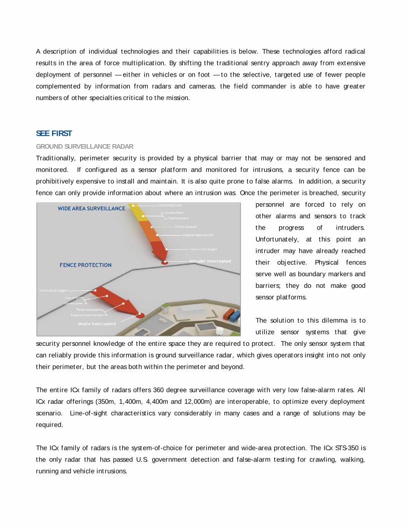
Traditionally, perimeter security is provided by a physical barrier that may or may not be sensored and
monitored. If configured as a sensor platform and monitored for intrusions, a security fence can be
prohibitively expensive to install and maintain. It is also quite prone to false alarms. In addition, a security
fence can only provide information about where an intrusion was. Once the perimeter is breached, security
personnel are forced to rely on
other alarms and sensors to track
the progress of intruders.
Unfortunately, at this point an
intruder may have already reached
their objective. Physical fences
serve well as boundary markers and
barriers; they do not make good
sensor platforms.
The solution to this dilemma is to
utilize sensor systems that give
security personnel knowledge of the entire space they are required to protect. The only sensor system that
can reliably provide this information is ground surveillance radar, which gives operators insight into not only
their perimeter, but the areas both within the perimeter and beyond.
The entire ICx family of radars offers 360 degree surveillance coverage with very low false-alarm rates. All
ICx radar offerings (350m, 1,400m, 4,400m and 12,000m) are interoperable, to optimize every deployment
scenario. Line-of-sight characteristics vary considerably in many cases and a range of solutions may be
required.
The ICx family of radars is the system-of-choice for perimeter and wide-area protection. The ICx STS-350 is
the only radar that has passed U.S. government detection and false-alarm testing for crawling, walking,
running and vehicle intrusions.

STS-12000 GROUND SURVEILLANCE RADAR
The ICx STS-12000 long range radar is the all-weather, round-the-clock, unmanned solution for 360 degree
situational awareness; against personnel it sees out to 10,000 meters and sees light-truck types of vehicles
out to a 12,000 meters radius from the radar. Deployed as a fixed installation or mounted one of the ICx
mobile platforms for portable operations, it uses personnel-safe, low-power technology to sense people
walking or running in any direction relative to the radar, as well as seeing vehicles traveling at all speeds
from slow to an excess of 70mph. All ICx radars maintain a
range accuracy of 3 meters or better at maximum range and
an angular accuracy of less than 1 degree. The STS–12000
has a terrain-following elevation profile of plus/minus 15
degrees. This performance is for both land and water areas.
A key capability that the radar embodies is the continuous
updating of new or changing activities, which provides
commanders real-time situational awareness within and
beyond the area of operation. Any new activity sounds an
audible alarm at the control station. These alarms alert the
monitoring personnel without their need to constantly view
the display.
The STS-12000 radar feeds the radar data to the command
post where it is displayed on the command and control
screen. Multiple STS-12000 radars work in networks that can
also include the STS-4400, STS-1400 and STS-350 radars as gap fillers. Data from all the radars in the
network are displayed and controlled from a single view on the Resolution software. The screen shows the
precise locations of the suspected intruders, their direction and speed and a record of their tracks. The
resulting alarm provides instantaneous annunciation warning on the screen and an audible tone to anyone
within hearing distance that a potential intrusion event is occurring, and immediate appropriate action is
initiated.
STS-4400 GROUND SURVEILLANCE RADAR
The STS-4400 in single or multiple unit deployment provides human (walking) detection at 4000 meters and
vehicle detection at 4400 meters. Crawlers are detected to more than 200 meters in 4-inch grass and to
more than 300 meters over smooth desert, concrete, etc. The radar can be set up and running in several
minutes. In operation, the STS-4400 radar creates a high-resolution radar map over an area of 360 degrees.
Targets are detected by the changes they cause to the “clutter map.” This method detects moving

objects/people at very low speed and in any direction, typically within 5 seconds or 6 meters of
displacement. The STS-4400 can detect and track up to 32 targets simultaneously.
Once setup is complete, the operator establishes detection and alarm areas. Any target that enters a
detection area is tracked. Any target that enters an alarm area raises an alarm and, according to the
configuration, steers one or more cameras onto the target for visual tracking, assessment and planned
response. The operator can assign priorities to specific alarm areas with those areas closest to the perimeter
typically set with highest priority.
STS-1400 GROUND SURVEILLANCE RADAR
The STS-1400 is a low-cost, low-power, high-resolution, continuous-scan, microwave-radar sensor. With all
weather, all light-level capability and high resolution (0.6 meter range resolution), the STS-1400 can detect
crawlers as far away as 200 meters, personnel at 1000 meters, and
vehicles at 1400 meters. Every second, the STS-1400 will monitor and
update more than 6 square kilometers (2.3 square miles). Up to four
remotely stationed radar sensors can be networked to a single central
radar server. For arrays of more than four radars, the outputs of
multiple servers can be used together. The data may be displayed at
multiple consoles via Ethernet TCP/IP access. It is a highly accurate
radar sensor with less than three false alarms in a 24-hour period.
STS-350 GROUND SURVEILLANCE RADAR
The STS-350 provides a rapidly deployable, portable or fixed radar option that can be used in a variety of
roles such as: mobile deployments; critical radar coverage between long-range radar emplacements; and
installation/tower self-protection. The STS-350 is an all weather, all light-level
system with high-range resolution (0.5 meter range resolution), the STS-350 can detect
crawlers as far away as 200 meters, personnel at 300 meters, and vehicles at 350
meters. Every second, the STS-350 will monitor and update more than 385,000 square
meters. Up to eight remotely stationed radar sensors can be networked to a single
central radar server. The data may be displayed at multiple consoles via Ethernet
TCP/IP access. It is a highly accurate, government-tested radar sensor with less than
three false alarms in a 24 hour period.
UNATTENDED GROUND SENSORS
Other intrusion detection sensors can be integrated into the battlefield surveillance and security system.
Existing alarms, fence sensors, unattended ground sensors (UGS) and legacy alarm points can be used as part
of a System of Systems approach.

UNDERSTAND FIRST
MULTIBAND SURVEILLANCE CAMERAS
ICx imaging solutions are currently deployed throughout the world, including in conflict theaters for base and
asset protection. They are also found at scores of nuclear facilities to compliment existing security systems;
they are at numerous ports, airfields, and offshore oil platforms, as well as critical infrastructure.
The ICx family of thermal cameras offers continuous zoom, CCD pan-and-tilt imaging and integrated thermal
and EO images called VisionSense. ICx cameras provide 24-hour
surveillance using high-performance cooled and uncoiled thermal imagers.
The DefendIR uncooled cameras are highly modular and configurable with
different lenses, sensors and controllers to match mission requirements.
An optional high-lumen spotlight is also available for illuminating and
deterring incursions.
The ICx family of thermal cameras offers best-in-class continuous, optical zoom capabilities, integrated CCTV
with stabilized pan-and-tilt for superior image quality and presentation. A proprietary feature of all ICx EO
systems is the VisionSense display function. This allows thermal and CCTV images to be viewed
simultaneously in a single overlapping image. This feature is particularly effective when viewing objects that
have similar thermal contrast to the background temperature.
Also available are long-range, high-performance Orion camera systems. Orion is a high-resolution, cooled
thermal imager with continuous optical zoom, pan-and-tilt, CCTV and laser range-finder integration options
with a long life. Both the DefendIR and Orion integrate seamlessly with radars to provide slew-to-cue
capabilities with proven results in multiple deployments.
DEFENDIR UNCOOLED, DUAL BAND THERMAL IMAGER
The DefendIR is an industry-leading, mid-range thermal imager that can see in complete darkness and
through a multitude of environmental conditions including smoke, rain, snow, dust, and dense fog. The
DefendIR is based on forward looking infrared (FLIR) technology. Through the innovative use of VisionSense,
which combines video feeds from both a visible light (CCD) camera and an infrared camera, the user can mix
and merge the two visual sources. This generates the ability to penetrate glare, as well as to see through
windows, glass or water. Featuring a sleek integrated pan-and-tilt design, the camera is capable of
continuous 360 degree panning and a +/- 80 degree tilt withstanding temperatures ranging from 40o to +60oC.
It supports most protocols used in commercial and military applications, and can be easily integrated into
existing fiber, wireless or IP networks. Offering 15 lens and detector combinations, each camera can be
customized to meet detailed range-performance requirements.

ORION COOLED THERMAL IMAGER
The Orion is a long-range “cooled” camera utilizing the same FLIR technology developed for the U.S.
military. The Orion camera is ideal for both day and night perimeter security. It offers the best range
performance in its class, boasting a 100mm to 550mm continuous
optical-zoom lens. Featuring an integrated, stabilized pan-and-tilt
design, the camera is capable of continuous 360 degree panning and
can withstand temperatures ranging from -40ºC to +60ºC. The Orion
has a rugged housing which is environmentally sealed to meet both
NEMA 4 and IP65 specifications.
Requiring only four screws and one cable, ICx cameras install with little effort. Their light weight and small
power draw add to the ease of installation, use and to the mobility of the system. ICx cameras are field-
tested and in use in operating environments ranging from current conflict theaters, to maritime facilities,
airfields, ports, and nuclear facilities.
Like its “uncooled” counterparts, the Orion easy integrates with existing security systems and technologies.
It supports most protocols used in commercial and military applications and can be integrated with fiber,
wireless, or IP networks. The Orion also interfaces with radar, VMD, UGS (Unattended Ground Sensors) or
other trigger devices to provide a slew-to-cue solution.
ACT FIRST
COMMAND AND CONTROL
The proposed system will be controlled from a central command center through the use of an adaptable and
scalable command-and-control software suite called Resolution™, which is integrated seamlessly with radars
and cameras and video analytics. The Resolution command-and-control system receives sensor data and
video from the surveillance sensors and overlays alarm information directly onto a geosynchronous map of
the surrounding area. Resolution enables users in a command center to remotely control and visualize the
radar tracks and camera output. The flexible and configurable design of our towers, sensors and software
allow ease of integration with a wide array of new and legacy surveillance equipment. Our solutions have
the versatility to be scalable as threats and required coverage expands.
Resolution from ICx is a flexible video-display platform that can be deployed to manage the command-and-
control security infrastructure for critical facilities as well as for enterprise-wide video systems. Its
architecture supports multiple users, complex privilege hierarchies, and hundreds of sensors and output
devices.

Resolution can be deployed using a video display wall or as a stand-alone terminal display. Resolution
provides ease of control for multiple cameras, alarms and event management, recorders and situation
awareness sensors. It is scalable and compatible with legacy and new equipment – simultaneously controlling
analog and IP inputs. Resolution supports the seamless integration of new and existing assets to support the
larger common operating picture (COP). Resolution can also display radar track data as provided by ICx
radars. This track data can be used to “slew-to-cue” associated video cameras providing the operator near
instantaneous assessment of targets.
The Resolution software platform is able to “plug-and-play” with more than 200 different models of
surveillance cameras and with all ICx radars. Off-the-shelf drivers are available for analog- or digital-camera
technology, standard GPS tracking systems and GIS software packages. Resolution can also be configured to
provide “hierarchical” C2 nodes with a “common operational picture.”
An integrated surveillance system can provide both primary and backup surveillance command stations.
Resolution command and control software seamlessly interconnects each command node in the control
system with the surveillance sensor network. The intuitive
graphics interface allows operators to manage sensor inputs,
conduct analysis and control the sensor network.
Geospatial maps can be imported from any source and
geo-referenced to the geography. Each command station of
this sort would contain, at a minimum, a Resolution Security
Client, Resolution Device Driver Server and a Network Video
Recorder. Recording for the facility would be available at
the primary command post. This ensures that video is
archived at the lowest possible level preventing a catastrophic loss of data. All of these command nodes can
be networked with standard Gigabit-Ethernet networks or wireless IP networks. Remote systems can be
connected in either fashion via internet protocol.
During operations, targets are acquired by the ground surveillance system, ground operators are notified by
alarm, and intruder tracks are displayed on the operator’s console. Intruder information, geo-location,
speed, and heading are displayed with the tracks. Simultaneously, intruder-location information is
transmitted to the surveillance camera. The camera slews to the target and displays an image of the target.
At this point the operator can decide if, in fact, the target is friendly or unknown and requiring more
information. Or, it could be hostile. The target can be classified by the operator as “friend or foe” and the
target’s track information will display this classification.

System alarms are recorded in the Resolution database. Images associated with those alarms can be
retrieved and replayed by operators as needed. Further, “alarm zones” can be established through
Resolution that display intruder alerts associated with those zones. These zones are completely configurable
and business rules can be established to “turn zones on or off based on time of day”. The zones can be easily
reset by operators to reflect changes in the environment and operational changes.
Resolution is widely deployed to manage the command-and-control security infrastructure for critical
military and government facilities as well as municipalities and state-wide transportation systems. Its
architecture supports multiple users, complex privilege hierarchies, and hundreds of sensors and output
devices.
NON-LETHAL RESPONSE
ICx offers cameras that integrate two or three spectrums of light for imaging, detection and warning. The
Illuminator camera includes a CCD color camera and a 12-million candlepower, strobe-capable spotlight. The
Both system can be controlled through the Resolution interface. In operation, the Illuminator can be cued to
a target by radar or analytics, the target verified via the lowlight CCD camera and pinpointed/warned via the
spotlight. The spotlight can also be set in a strobe mode that can interrupt suspicious activities when trained
on the target.
INTEGRATED SYSTEMS
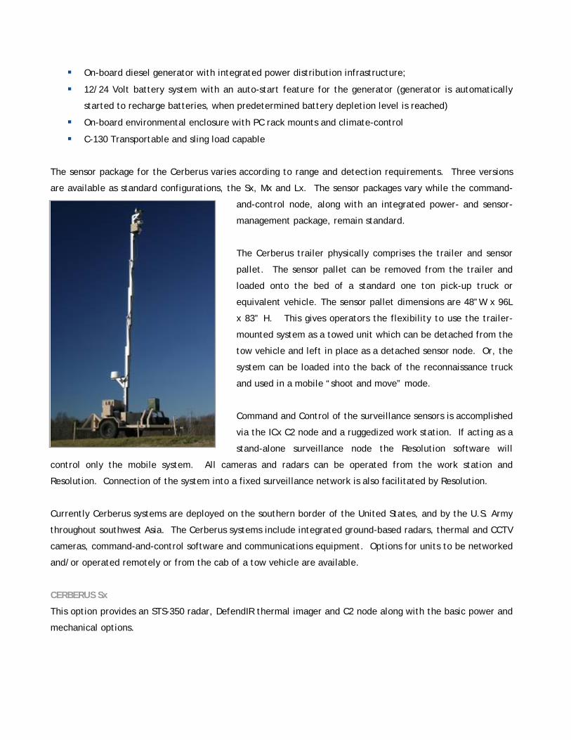
CERBERUS™ - SELF CONTAINED MOBILE SURVEILLANCE PLATFORMS
Cerberus is an unmanned, mobile surveillance platform, autonomously powered and ideal for applications in
which rapid deployment is mission critical. Cerberus is designed to address perimeter, border, and point
surveillance applications, primarily with regard to force and asset protection. The combination of
relocatable, wide-area surveillance along with agile command-and-control capabilities make the Cerberus a
force multiplier. The inherent flexibility and portability of Cerberus allows its adaptation to a wide range of
sensors and command and control options, depending upon mission requirements. Rugged, dependable and
supportable, the Cerberus platform is always ready to provide operators the ability to “See First – Understand
First – Act First” under any situation.
Each system comprises the following:
Aluminum trailer that can be towed by a standard lightweight or half-ton pickup truck, or military
equivalent
“Skid mount” pallet option for truck bed integration
Variable height and design sensor mast
On-board ICx C2 Node providing sensor connectivity, communications and power management
On-board diesel generator with integrated power distribution infrastructure;
12/24 Volt battery system with an auto-start feature for the generator (generator is automatically
started to recharge batteries, when predetermined battery depletion level is reached)
On-board environmental enclosure with PC rack mounts and climate-control
C-130 Transportable and sling load capable
The sensor package for the Cerberus varies according to range and detection requirements. Three versions
are available as standard configurations, the Sx, Mx and Lx. The sensor packages vary while the command-
and-control node, along with an integrated power- and sensor-
management package, remain standard.
The Cerberus trailer physically comprises the trailer and sensor
pallet. The sensor pallet can be removed from the trailer and
loaded onto the bed of a standard one ton pick-up truck or
equivalent vehicle. The sensor pallet dimensions are 48”W x 96L
x 83” H. This gives operators the flexibility to use the trailer-
mounted system as a towed unit which can be detached from the
tow vehicle and left in place as a detached sensor node. Or, the
system can be loaded into the back of the reconnaissance truck
and used in a mobile “shoot and move” mode.
Command and Control of the surveillance sensors is accomplished
via the ICx C2 node and a ruggedized work station. If acting as a
stand-alone surveillance node the Resolution software will
control only the mobile system. All cameras and radars can be operated from the work station and
Resolution. Connection of the system into a fixed surveillance network is also facilitated by Resolution.
Currently Cerberus systems are deployed on the southern border of the United States, and by the U.S. Army
throughout southwest Asia. The Cerberus systems include integrated ground-based radars, thermal and CCTV
cameras, command-and-control software and communications equipment. Options for units to be networked
and/or operated remotely or from the cab of a tow vehicle are available.
CERBERUS Sx
This option provides an STS-350 radar, DefendIR thermal imager and C2 node along with the basic power and
mechanical options.

CERBERUS Mx
This option provides an STS-1400 radar, DefendIR thermal imager and C2 node along with the basic power
and mechanical options.
CERBERUS Lx
This option provides a third-party, 30,000m pulse Doppler radar, Orion thermal imager and C2 node along
with the basic power and mechanical options.
100’ COMMUNICATIONS AND SURVEILLANCE TOWER
In order to provide the proper line of sight for communications and data transfer a mobile self-guyed 100’
tower is available. The system is easily transportable and takes up a small geographic footprint. The tower
system can be configured to stage communications antennas and cameras as needed. The self-guyed system
doesn’t require a pad and can be set up by three people in less than two hours.
NOTIONAL REMOTE BASE SECURITY SYSTEM
The implementation of an ICx CommandSpace solution for a notional (2 x 3km perimeter) remote forward
base is outlined below. Assumptions about power and communications follows:
Assumptions:
2Km x 3Km perimeter facility for Medium Size Base
700m x 700m Perimeter facility for Small forward Base
Level desert terrain/Mountainous terrain
Anticipated threat vectors – land infiltration on foot or by small vehicle (compact truck, motorcycle)
Physical barrier around base (concertina and or fence)
Line of sight available (10Km)
Dedicated defense forces Hardline IP communications (Fast Ethernet)
One central Base Defense Operations Center (BDOC)
110/220V power available
“Total knowledge” of the entire battlespace is difficult if not impossible to achieve with traditional
surveillance technology. Semi-experienced adversaries with superior knowledge of the terrain can easily
defeat sensors that are placed “on” the perimeter of the facility. Sensors that are able to reach beyond the
physical perimeter and detect intruders have the capacity to raise alarms well prior to the intruders reaching
the perimeter. This is critical because distance from the perimeter equals the time available to direct forces
to intercept or neutralize. More distance from the target equates to more time to intercept and possibly
prevent an attack. A combination of ground surveillance radars, mobile surveillance towers, EO and IR

imaging systems working together can provide a significantly “hardened” perimeter and battlefield oversight
that will serve to enhance overall Force Protection.
REMOTE SEMI-FIXED SITE- LARGE BASE
In the attached figure we assume the use of two STS-12000s on a portable platform, two Orion cooled
thermal imagers, connected with the Resolution VMS Command and Control system. The Resolution VMS
system is configured for two control nodes that
can be co-located or remotely located within
the forward site.
While a single STS-12000 mounted on a fixed
tower is feasible it gives no redundancy nor
does it allow for any variability in terrain
features. Frequently our customers integrate
the shorter range radars into the solution to
make up for gaps in radar coverage based on
terrain.
Mounting the 12000s on trailer systems gives the users flexibility in concept of operations. Set-up time is
approximately two hours depending on existing infrastructure.
The approximate price of the shown hardware configuration is $1.2 million. A more detailed price sheet is
attached. Pricing will vary according to the actual equipment selected.
REMOTE SEMI-FIXED SITE –SMALL BASE
In this senario the site is protected by a
combination of small, short-range radars,
cameras, mobile surveillance units and
unmanned surveillance towers. Any of these
systems can be mixed and matched to allow for
maximum flexibility in the concept of
operations, and for total system effectiveness.
In the diagram we are specifying the use of four
STS-350s, matched DefendIRs, and a Cerberus
camera tower mounting an Orion. We have also
used the STS-350/DefendIR in a mobile

surveillance mode. This is accomplished by putting the STS-350 on the back of a
utility vehicle, including an integrated IR camera and a C2 station.
The approximate price of the shown hardwired configuration is approximately
$1.7 million, not including the utility vehicle. Pricing will vary according to the
actual equipment selected.
To request a copy of the full report, or to discuss a site assessment and system design, please contact:
Ian Steele, Project Manager
PBA Engineering
250.388.7222
Mike Mostow, VP, Sales Operations
ICx Technologies, Inc.
703.678.2111
©2009 ICx Technologies.


