Embed Size (px)
Citation preview
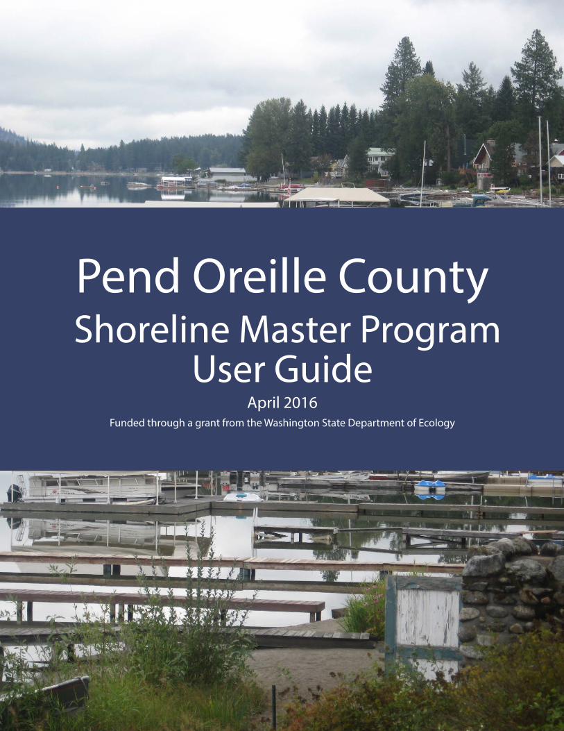
Pend Oreille County Shoreline Master Program
User GuideApril 2016
Funded through a grant from the Washington State Department of Ecology

TABLE OF CONTENTS
1 Shoreline Master Program Overview 1
2 Frequently Asked Questions 2
3 Focus Topics 4Agriculture 4Docks (Private Non-commercial) 6Riparian and Wetland Buffers 9Existing Use/Expansion 14Vegetation Management 18
4 Shoreline Permit Process 19When Is a Shoreline Permit Required? 19Shoreline Permit Application Requirements 21Shoreline Permit Review Steps 21How Long Does a Shoreline Permit Take? 21Other Permits Required 22
Appendices 24Appendix A: Shoreline Use and Modification Table 24Appendix B: Pend Oreille County Native Plants List 30
List of TablesTable 1 Agricultural Use and Development Standards Summary 5
Table 2 Approval Requirements for Docks 6
Table 3 Design Requirements for New Docks 7
Table 4 Standard Riparian Buffer Widths 9
Table 5 Criteria for Modified Buffer Widths 10
Table 6 Wetland Buffer Widths 13
Table 7 Existing Uses and Expansions 14
Table 8 Ongoing Vegetation Maintenance and Management Standards 17
List of FiguresFigure 1 Dock (Plan View) 8
Figure 2 Modified Riparian Buffers 11
Figure 3 Modified Riparian Buffers: In-fill Development 12
Figure 4 Existing Use – Expansion 16
Figure 5 Shoreline Permit Review Timeline 23

Pend Oreille County Shoreline Master Program User Guide 1
Shoreline Master Program Overview
The shorelines in Washington State are protected by the Washington State Shoreline Management Act (SMA) of 1971. The law strives to achieve responsible shoreline use and development, environmental protection, and public access. Local governments develop Shoreline Management Programs (SMPs) based on the law and state guidance, and the state ensures local SMPs consider statewide public interests.
In compliance with the SMA and 2003 SMP Guidelines, Pend Oreille County (County) adopted an SMP update in 2012 (and a limited SMP amendment in 2015), tailored to the local environment and to existing and future planned development patterns within the County’s shorelines. The purpose of the SMP is to promote the health, safety, and general welfare of the community and manage the shorelines in a positive, effective, balanced, and equitable manner, while maintaining a healthy shoreline environment.
Using This GuideThis guide includes tables, diagrams, and illustrations that help explain five of the most common topics of interest: 1) agriculture; 2) docks; 3) riparian and wetland buffers; 4) existing use/expansion; and 5) vegetation management. This SMP User Guide should be used along with shoreline regulations included in the County’s updated SMP.
Shoreline Master Program Overview1
Photograph by Washington State Department of Ecology

Pend Oreille County Shoreline Master Program User Guide
Frequently Asked Questions
2
What is an SMP and why does the County have one?The SMP is a combination of planning and regulatory documents that guide shoreline development. Local governments are required to prepare SMPs based on state laws and rules. Key principles of the SMP include striking a balance among environmental protection, public access, and water-oriented uses and achieving no net loss of ecological functions, with conditions at the time of SMP update (2010) serving as the baseline.
Does the SMP apply to my property?The SMP applies to all new development that occurs within 200 feet of the ordinary high water mark (OHWM) of the County’s shorelines and within its associated wetlands. Legally existing structures
and uses may continue. If existing structures are being changed, they will be subject to the existing development provisions of the SMP. For more information on how changes to existing structures are affected by the SMP, see Focus Topic: Existing Use/Expansion.
How does the County’s SMP apply to agriculture? A 2002 state law requires that when local shoreline programs are updated, the new standards, setbacks, and buffers do not apply retroactively to existing agricultural development. Updated SMP requirements will, however, apply to new agricultural activities located in shoreline areas and where agricultural activities are converted to other uses. See Focus Topic: Agriculture for more details.
Frequently Asked Questions2
Photograph by Washington State Department of Ecology

Pend Oreille County Shoreline Master Program User Guide
Frequently Asked Questions
3
Will the SMP Impact My Home?Under the provisions of the SMP, existing single-family homes are not affected. New development on your property will need to meet the SMP requirements. For more information on this topic, visit http://www.ecy.wa.gov/programs/sea/sma/st_guide/administration/exemptions/sfr.html.
What is No Net Loss of Ecological or Environmental Functions?The new environmental protection standard under the SMA for the updated SMP is, “no net loss of shoreline ecological functions.” These functions are the elements in the environment that provide habitat for fish and wildlife, protect water quality, and enhance flows in streams and lakes. These baseline conditions were documented in the Pend Oreille County Shoreline Characterization Report (2010), and this description of conditions is what no net loss will be measured against. Protection of these functions is accomplished by avoiding, minimizing, or mitigating impacts to ecological functions that result from new shoreline development (http://www.ecy.wa.gov/programs/sea/shorelines/smp/faqs.html).
Pend Oreille County Shoreline Master Program User Guide
Agriculture
4
New Agricultural Uses and DevelopmentsAgricultural use and development provisions in the SMP apply to new agricultural activities, including new agricultural activities on non-agricultural areas in shorelands and expansion of agricultural activities on non-agricultural areas in shorelands. Agricultural lands are defined as those shoreland areas on which agriculture activities are conducted.
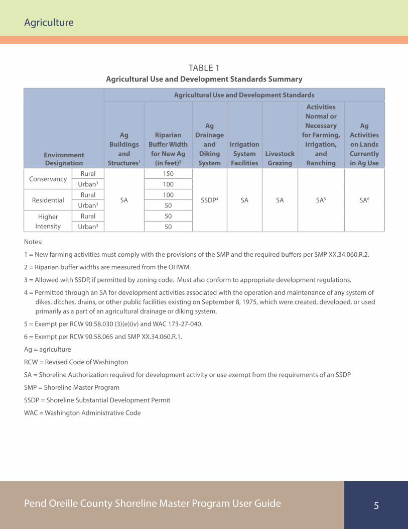
A summary of permit and development requirements for agricultural development and uses is summarized in Table 1. See Appendix A for the complete Shoreline Table of Permitted Uses and Footnotes from the County’s SMP.
Existing Agricultural Lands and Uses Within Shoreline Jurisdiction SMP provisions do not modify or limit existing agricultural uses and activities occurring on agricultural lands, including, but not limited to, the following uses and activities:
• Producing, breeding, or increasing agricultural products
• Rotating and changing agricultural crops
• Allowing land used for agricultural activities to lie fallow, in which it is plowed and tilled but left unseeded
• Allowing land used for agricultural activities to lie dormant as a result of adverse agricultural market conditions
• Allowing land used for agricultural activities to lie dormant because the land is enrolled in a local, state, or federal conservation program, or the land is subject to a conservation easement
• Conducting agricultural operations
• Maintaining, repairing, and replacing agricultural equipment
• Maintaining, repairing, and replacing agricultural facilities, provided that the replacement facility is no closer to the shoreline than the original facility
• Maintaining agricultural lands under production or cultivation
Property owners are strongly encouraged to adopt voluntary measures to minimize adverse environmental consequences associated with farming activities, particularly measures to limit the access of livestock to jurisdictional shorelines and associated wetlands.
Focus TopicsAgriculture
3
Pend Oreille County Shoreline Master Program User Guide
Agriculture
5
TABLE 1Agricultural Use and Development Standards Summary
Environment Designation
Agricultural Use and Development Standards
Ag Buildings
and Structures1
Riparian Buffer Width for New Ag
(in feet)2
Ag Drainage
and Diking System
Irrigation System
FacilitiesLivestock Grazing
Activities Normal or Necessary
for Farming, Irrigation,
and Ranching
Ag Activities on Lands Currently in Ag Use
ConservancyRural
SA
150
SSDP4 SA SA SA5 SA6
Urban3 100
ResidentialRural 100
Urban3 50
Higher Intensity
Rural 50
Urban3 50
Notes:
1 = New farming activities must comply with the provisions of the SMP and the required buffers per SMP XX.34.060.R.2.
2 = Riparian buffer widths are measured from the OHWM.
3 = Allowed with SSDP, if permitted by zoning code. Must also conform to appropriate development regulations.
4 = Permitted through an SA for development activities associated with the operation and maintenance of any system of dikes, ditches, drains, or other public facilities existing on September 8, 1975, which were created, developed, or used primarily as a part of an agricultural drainage or diking system.
5 = Exempt per RCW 90.58.030 (3)(e)(iv) and WAC 173-27-040.
6 = Exempt per RCW 90.58.065 and SMP XX.34.060.R.1.
Ag = agriculture
RCW = Revised Code of Washington
SA = Shoreline Authorization required for development activity or use exempt from the requirements of an SSDP
SMP = Shoreline Master Program
SSDP = Shoreline Substantial Development Permit
WAC = Washington Administrative Code
Pend Oreille County Shoreline Master Program User Guide
Docks
6
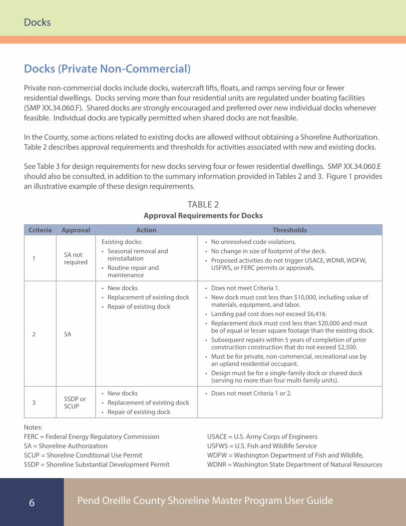
TABLE 2Approval Requirements for Docks
Criteria Approval Action Thresholds
1 SA not required
Existing docks:• Seasonal removal and
reinstallation• Routine repair and
maintenance
• No unresolved code violations.• No change in size of footprint of the deck.• Proposed activities do not trigger USACE, WDNR, WDFW,
USFWS, or FERC permits or approvals.
2 SA
• New docks • Replacement of existing dock• Repair of existing dock
• Does not meet Criteria 1.• New dock must cost less than $10,000, including value of
materials, equipment, and labor.• Landing pad cost does not exceed $6,416.• Replacement dock must cost less than $20,000 and must
be of equal or lesser square footage than the existing dock.• Subsequent repairs within 5 years of completion of prior
construction construction that do not exceed $2,500.• Must be for private, non-commercial, recreational use by
an upland residential occupant.• Design must be for a single-family dock or shared dock
(serving no more than four multi-family units).
3 SSDP or SCUP
• New docks• Replacement of existing dock• Repair of existing dock
• Does not meet Criteria 1 or 2.
Notes: FERC = Federal Energy Regulatory Commission SA = Shoreline Authorization SCUP = Shoreline Conditional Use Permit SSDP = Shoreline Substantial Development Permit
USACE = U.S. Army Corps of Engineers USFWS = U.S. Fish and Wildlife Service WDFW = Washington Department of Fish and Wildlife, WDNR = Washington State Department of Natural Resources
Docks (Private Non-Commercial)Private non-commercial docks include docks, watercraft lifts, floats, and ramps serving four or fewer residential dwellings. Docks serving more than four residential units are regulated under boating facilities (SMP XX.34.060.F). Shared docks are strongly encouraged and preferred over new individual docks whenever feasible. Individual docks are typically permitted when shared docks are not feasible.
In the County, some actions related to existing docks are allowed without obtaining a Shoreline Authorization. Table 2 describes approval requirements and thresholds for activities associated with new and existing docks.
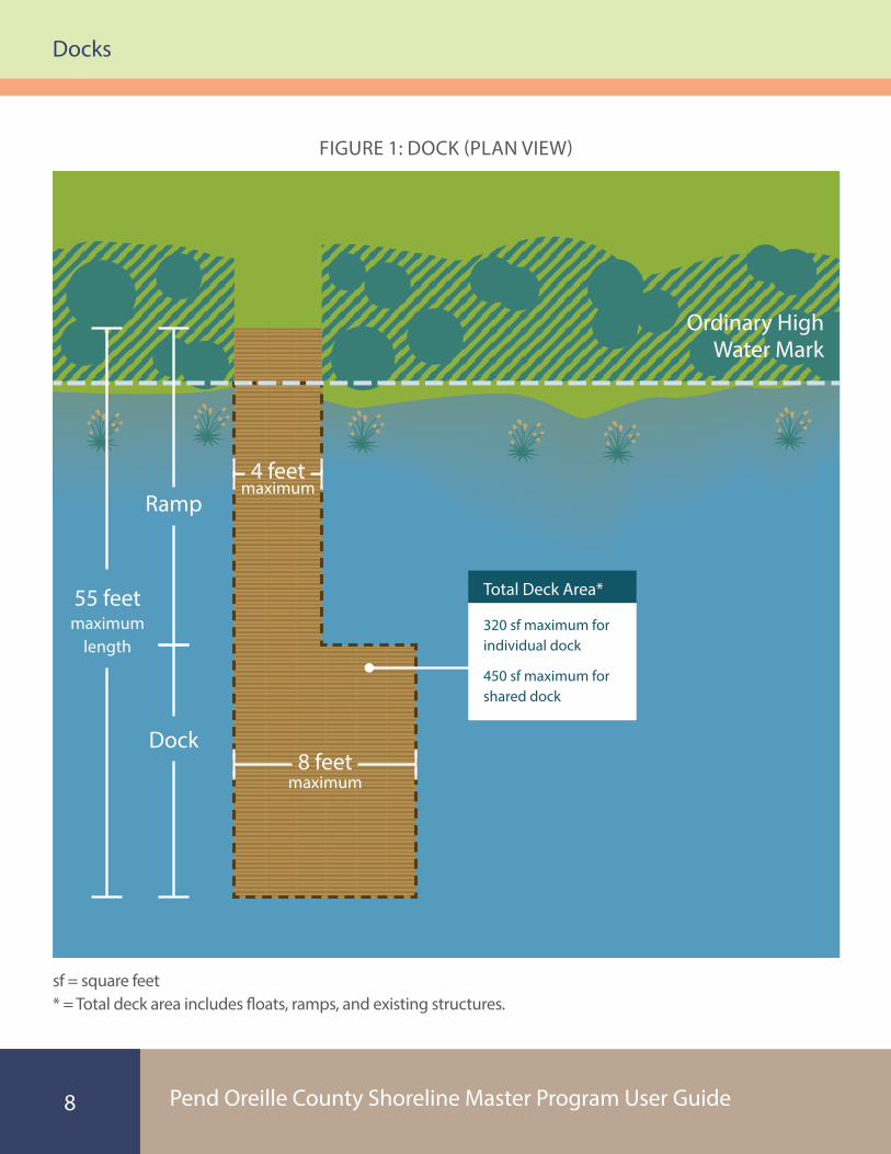
See Table 3 for design requirements for new docks serving four or fewer residential dwellings. SMP XX.34.060.E should also be consulted, in addition to the summary information provided in Tables 2 and 3. Figure 1 provides an illustrative example of these design requirements.

Pend Oreille County Shoreline Master Program User Guide
Docks
7
TABLE 3Design Requirements for New Docks
Design Requirement Individual Dock Joint-Use DockWidth
Piers and Floats 8 feet maximumRamps 4 feet maximum
Length Maximum of 55 feet waterward of OHWM1
Floats 1 float maximum 2 floats maximum
Total Deck Area (includes floats, ramps, and existing structures)
320-square-foot maximum (450-square-foot maximum where
greater lengths are authorized)450 square feet maximum
Watercraft Lifts (uncovered) 1 2
Materials
• Grating or clear translucent material shall cover the entire surface area of the pier, ramp, and/or float. The open area of grating shall be at least 60%. For floats, functional grating shall cover no less than 50% of the float.2
• Flotation materials must be encapsulated.• The use of tires is prohibited above or below water.• The use of treated wood is prohibited.• No paint, stain, preservative, or other protective coating application shall be
applied to below-water parts of the structure or shall occur while the structure is in or over the waterbody.
Other Design Requirements
• No other structure or shading objects shall be constructed or installed on any overwater structure.
• Floats must be located in water deep enough to keep the structure from grounding, or float stoppers must be installed so that the float does not rest on the substrate at any time.
• Only open-pile pier construction is authorized.• Only low-voltage solar or battery-powered lighting may be permitted.• When feasible, docks shall be secured with piling or soil anchor screws.
Additional Standards
• Requirements in the USACE RGP 7 shall apply to all docks within the County, unless otherwise noted.2
• All standards set forth by WDFW and WDNR shall be met.• See SMP XX.36.060.E for complete description of design standards.
Notes: 1 = A greater length may be authorized, up to the minimum length necessary, to reach water of sufficient depth for safe boat moorage at the waterward end of the structure.
2 = USACE RGP 7 permit can be found on the County’s website (http://pendoreilleco.org/wp-content/uploads/2015/07/RGP-7_Text_Final.pdf ).
OHWM = ordinary high water mark
RGP 7 = Regional General Permit 7
SMP = Shoreline Master Program
USACE = U.S. Army Corps of Engineers
WDFW = Washington Department of Fish and Wildlife
WDNR = Washington State Department of Natural Resources
Pend Oreille County Shoreline Master Program User Guide
Docks
8
Dock (Plan View)
maximum
maximum
Ramp4 feet
55 feet maximum
length
Dock
Ordinary High Water Mark
8 feet
320 sf maximum for individual dock
450 sf maximum for shared dock
sf = square feet* = Total deck area includes �oats, ramps, and existing structures.
Total Deck Area*
FIGURE 1: DOCK (PLAN VIEW)

Pend Oreille County Shoreline Master Program User Guide
Riparian and Wetland Buffers
9
Riparian and Wetland BuffersBuffers are established to protect and maintain ecological functions (e.g., fish and wildlife habitat and water quality protection) next to a stream, lake, or wetland, providing separation from development and land uses that could impact these functions. Building setbacks separate structures from buffers by adding additional distance between buffers and the associated higher intensity development to further prevent buffer impacts.
Unless otherwise allowed in the SMP, all structures and activities shall be located outside of fish
and wildlife, stream or wetland, or erosion and landslide buffers.
Riparian BuffersRiparian buffer widths may be accompanied by stormwater management measures, as applicable. Buffers are measured on the horizontal plane, from the OHWM, or from the top of bank if the OHWM cannot be identified. Standard riparian buffer widths are summarized in Table 4.
TABLE 4Standard Riparian Buffer Widths
Environment Designation
Buffer Widths by Water Type (in feet)
Type S Type F Type NP Type NS Type UNatural 200
200 150 150Must be
evaluated in application
ConservancyRural 150
Urban 100
ResidentialRural 100
Urban 50
Higher IntensityRural 50
Urban 50
Notes:
F = Fish Bearing
NP = Non-fish bearing-perennial
NS = Non-fish bearing-seasonal
S = Shorelines of the State
U = Unknown, not typed

Pend Oreille County Shoreline Master Program User Guide
Riparian and Wetland Buffers
10
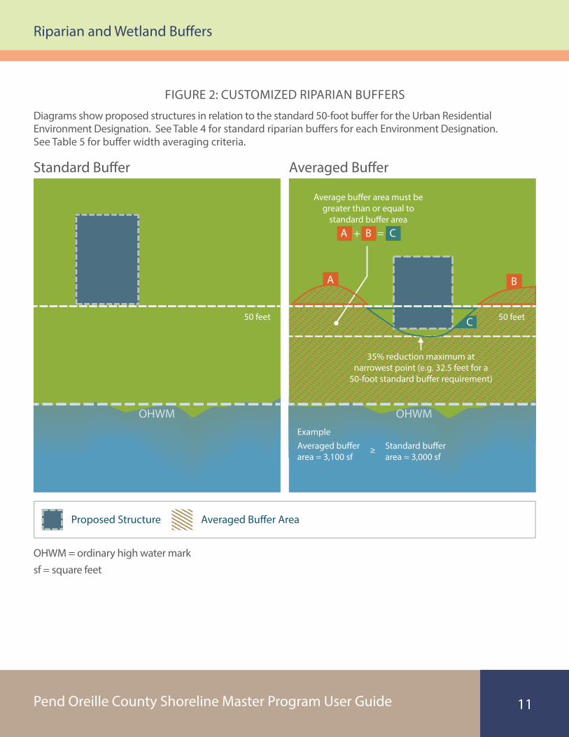
Customized Buffer WidthsApplicants, with the assistance of a qualified professional such as a wetlands biologist, may submit plans for customized buffers for review and approval. Riparian buffers may be customized as described in Table 5 and shown in Figures 2 and 3.
Criteria are also provided in SMP for new single-family residences on lots whose dimensions do not allow a residence to be constructed outside of the standard shoreline buffer, so that they may be permitted without a variance (see SMP XX.34.060.A.2.c).
TABLE 5Criteria for Customized Buffer Widths
Modified Buffer Type Criteria
Buffer Width Averaging – See SMP XX.34.060.A.2.a for additional criteria
Total averaged buffer area ≥ Standard buffer area
And
Minimum buffer width (at narrowest point)
≥35% of standard buffer
width
In-fill Development – Reduced standard shoreline buffers may be allowed for a new single-family residence and appurtenant structures in accordance with the following criteria in SMP XX.34.060.A.2.b, summarized below and in Figure 3.
Single-family residences within 150 feet on either side of proposed residence in an existing plat, the buffer shall be the greater of:
1. A common line drawn between the nearest corners of the nearest residence; or
2. A common line calculated by the average of the nearest residences’ existing buffer.
Where there is only a residence located within 150 feet on one side of the proposed residence in an existing plat, the standard buffer shall be the greater of:
1. A common line drawn between nearest corner of the nearest residence and the nearest point of the standard buffer on the adjacent vacant lot; or
2. A common line calculated by the average of the nearest residence’s setback and the standard buffer for the adjacent vacant lot.
Note:
1 = See SMP XX.34.060.A.2.a.5 for a scenario where the maximum buffer width reduction may be exceeded.
Pend Oreille County Shoreline Master Program User Guide
Riparian and Wetland Buffers
11
Modi�ed Riparian Bu�ers
Standard Bu�er Averaged Bu�er
Diagrams show proposed structures in relation to the standard 50-foot bu�er for the Urban Residential Environment Designation. See Table 4 for standard riparian bu�ers for each Environment Designation. See Table 5 for bu�er width averaging criteria.
OHWM = ordinary high water marksf = square feet
OHWM OHWM
Average bu�er area must be greater than or equal to
standard bu�er area
Averaged Bu�er AreaProposed Structure
35% reduction maximum at narrowest point (e.g. 32.5 feet for a
50-foot standard bu�er requirement)
ExampleAveraged bu�er area = 3,100 sf
Standard bu�er area = 3,000 sf
≥
50 feet 50 feet
A
A + =B C
B
C
FIGURE 2: CUSTOMIZED RIPARIAN BUFFERS

Pend Oreille County Shoreline Master Program User Guide
Riparian and Wetland Buffers
12
FIGURE 3: CUSTOMIZED RIPARIAN BUFFERS (IN-FILL DEVELOPMENT)Modi�ed Riparian Bu�ers: In-Fill development (Existing residences are within 150 feet of proposed residence)
Common Line Setbacks
Common Line Setbacks with Vacant Lot
Common Line Setback
OHWM = ordinary high water mark
OHWM
OHWM
Common line setback (residence on both sides):
Bu�er shall be the greater of:
1. A common line drawn between the nearest corners of the nearest residence; or
2. A common line calculated by the average of the nearest residences’ existing bu�er.
Common line setback (residence on one side):
Bu�er shall be the greater of:
1. A common line drawn between the nearest corner of the nearest residence and the nearest point of the standard bu�er on the adjacent vacant lot; or
2. A common line calculated by the average of the nearest residence’s setback and the standard bu�er for the adjacent vacant lot.
50 feet
50 feet
Existing Non-conforming
House
Vacant Lot
Existing Non-conforming
House
Existing Non-conforming
HouseProposed Structure
Proposed Structure
Common Line Setback
Diagrams show proposed structures in relation to the standard 50 foot buffer for the Urban Residential Environment Designation. Existing residences are within 150 feet of proposed residence.

Pend Oreille County Shoreline Master Program User Guide
Riparian and Wetland Buffers
13
Wetland BuffersWetland buffer widths are based on the wetland category, intensity of impacts, and wetland functions or special characteristics. The range of wetland buffer widths is summarized in Table 6. See SMP XX.36.040.G for specific buffers widths by intensity of impacts.
Standard buffer widths may be reduced on a case-by-case basis based on a wetland report that documents no net loss of ecological functions or values, provided that wetland buffers may be reduced by no more than 25% of the standard buffer width (SMP XX.36.040.G.4).
TABLE 6Wetland Buffer Widths
Wetland Category Buffer Width
Category IV 25 to 50 feet
Category III 75 to 150 feet
Category II 100 to 200 feet
Category I 125 to 250 feet
Note:
Buffer width range is based on wetland habitat functions and characteristics and impact of proposed land use.

Pend Oreille County Shoreline Master Program User Guide
Existing Use/Expansion
14
Existing Use/ExpansionExisting, legally established structures and uses are allowed to continue even though, in some cases, these structures might not meet the updated SMP regulations. These structures and uses can continue to exist, be used, maintained, and repaired. This is the case even if the updated SMP regulations would not allow new uses or development to be configured or built exactly as the existing uses or structures. There are also some different ways to address continuance and expansion of buildings, structures, and uses that do not quite meet the new SMP regulations.
A general summary of continued existing uses and expansions is provided in Table 7. The SMP shall be consulted for specific conditions and criteria. Additional mitigation may be required through the critical areas review process. See Figure 4 for examples of structural expansions.
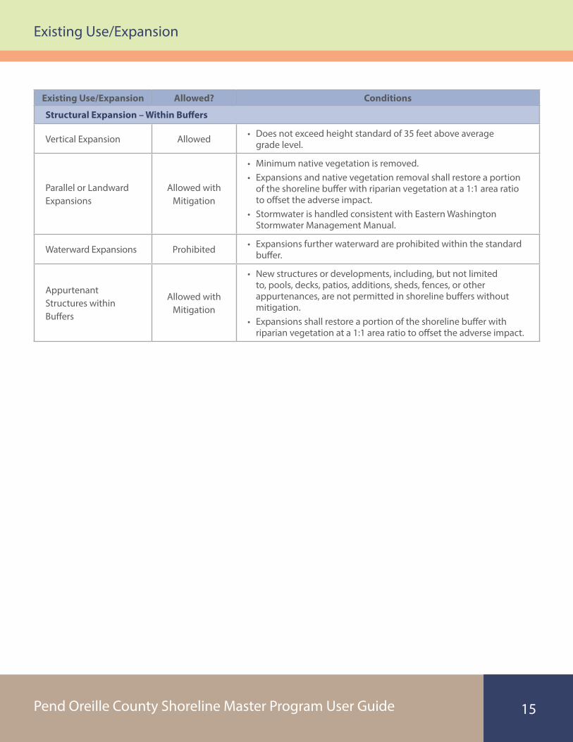
TABLE 7Existing Uses and Expansions
General non-conforming use provision – SMP XX.34.070.A.4
Non-residential structures used for a conforming use may be maintained, repaired, enlarged, or expanded provided that enlargement does not increase the extent of non-conformity by further encroaching upon or extending into areas where construction or use is no longer permissible.
General residential structures provision – SMP XX.34.070.A.1
Residential structures and appurtenant structures that were legally established and are used for a conforming use, but that do not meet current standards for the following, shall be considered a conforming structure: setbacks; buffers; height; or density.
Existing Use/Expansion Allowed? Conditions
Continued Use – SMP XX.34.070.A.1
Residential structures and appurtenances
Yes
• Existing uses may continue, including maintenance, repairs, and operation within shoreline jurisdiction and shoreline buffers.
• Expansions are allowed consistent with provisions for no net loss, and Pend Oreille County Development Regulations.
Pend Oreille County Shoreline Master Program User Guide
Existing Use/Expansion
15
Existing Use/Expansion Allowed? Conditions
Structural Expansion – Within Buffers
Vertical Expansion Allowed • Does not exceed height standard of 35 feet above average grade level.
Parallel or Landward Expansions
Allowed with Mitigation
• Minimum native vegetation is removed.• Expansions and native vegetation removal shall restore a portion
of the shoreline buffer with riparian vegetation at a 1:1 area ratio to offset the adverse impact.
• Stormwater is handled consistent with Eastern Washington Stormwater Management Manual.
Waterward Expansions Prohibited • Expansions further waterward are prohibited within the standard buffer.
Appurtenant Structures within Buffers
Allowed with Mitigation
• New structures or developments, including, but not limited to, pools, decks, patios, additions, sheds, fences, or other appurtenances, are not permitted in shoreline buffers without mitigation.
• Expansions shall restore a portion of the shoreline buffer with riparian vegetation at a 1:1 area ratio to offset the adverse impact.

Pend Oreille County Shoreline Master Program User Guide
Existing Use/Expansion
16
Existing Use – Expansion
Outside of Bu�ers Within Bu�er – Lateral Within Bu�ers – Landward
OHWM = ordinary high water mark
The following diagrams show proposed expansions in relation to the standard 50-foot bu�er for the Urban Residential Environmental Designation. Lateral and landward expansions may also be allowed with mitigation (see Table 7 for additional discussion).
Expansions and native vegetation removal shall restore a portion of the shoreline bu�er with riparian vegetation at a 1:1 ratio.
50 feet
OHWM
Proposed StructureExisting Structure Vegetation Enhancement Area
50 feet
50 feet
Vegetation Enhancement at 1:1
Vegetation Enhancement at 1:1
OHWM OHWM
FIGURE 4: EXISTING USE – EXPANSION
Pend Oreille County Shoreline Master Program User Guide
Vegetation Management
17
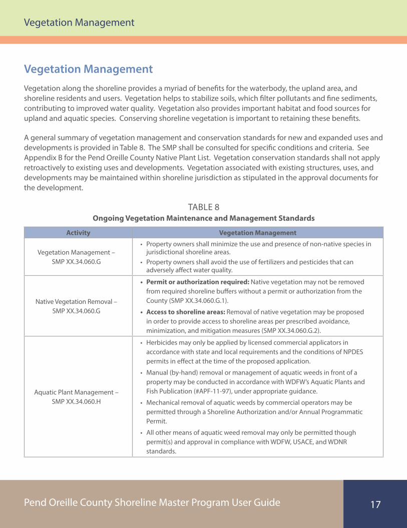
Vegetation ManagementVegetation along the shoreline provides a myriad of benefits for the waterbody, the upland area, and shoreline residents and users. Vegetation helps to stabilize soils, which filter pollutants and fine sediments, contributing to improved water quality. Vegetation also provides important habitat and food sources for upland and aquatic species. Conserving shoreline vegetation is important to retaining these benefits.
A general summary of vegetation management and conservation standards for new and expanded uses and developments is provided in Table 8. The SMP shall be consulted for specific conditions and criteria. See Appendix B for the Pend Oreille County Native Plant List. Vegetation conservation standards shall not apply retroactively to existing uses and developments. Vegetation associated with existing structures, uses, and developments may be maintained within shoreline jurisdiction as stipulated in the approval documents for the development.
TABLE 8Ongoing Vegetation Maintenance and Management Standards
Activity Vegetation Management
Vegetation Management – SMP XX.34.060.G
• Property owners shall minimize the use and presence of non-native species in jurisdictional shoreline areas.
• Property owners shall avoid the use of fertilizers and pesticides that can adversely affect water quality.
Native Vegetation Removal – SMP XX.34.060.G
• Permit or authorization required: Native vegetation may not be removed from required shoreline buffers without a permit or authorization from the County (SMP XX.34.060.G.1).
• Access to shoreline areas: Removal of native vegetation may be proposed in order to provide access to shoreline areas per prescribed avoidance, minimization, and mitigation measures (SMP XX.34.060.G.2).
Aquatic Plant Management – SMP XX.34.060.H
• Herbicides may only be applied by licensed commercial applicators in accordance with state and local requirements and the conditions of NPDES permits in effect at the time of the proposed application.
• Manual (by-hand) removal or management of aquatic weeds in front of a property may be conducted in accordance with WDFW’s Aquatic Plants and Fish Publication (#APF-11-97), under appropriate guidance.
• Mechanical removal of aquatic weeds by commercial operators may be permitted through a Shoreline Authorization and/or Annual Programmatic Permit.
• All other means of aquatic weed removal may only be permitted though permit(s) and approval in compliance with WDFW, USACE, and WDNR standards.

Pend Oreille County Shoreline Master Program User Guide
Vegetation Management
18
Activity Vegetation Management
Clearing and Grading within Shoreline Jurisdiction –
SMP XX.34.060.I.3
• Applications for a Clearing and Grading Permit shall include a Revegetation Plan that features no net loss of ecological function.
• Applicants are encouraged to contact the Pend Oreille County Community Development Department to discuss conceptual plans before preparing detailed application materials.
Wetland Buffers – SMP XX.36.040
• Removal of non-native invasive plan species for wetland buffer enhancement is permitted and shall be restricted to hand removal.
• Revegetation with appropriate native species (see Appendix B) at natural densities is allowed in conjunction with invasive plant species removal.
Fish and Wildlife Habitat Conservation Area Buffers –
SMP XX.36.060
• Critically important vegetation and/or priority habitat features, such as snags and downed wood, should be preserved.
• Buffers shall consist of an undisturbed area of native vegetation or areas identified for restoration established to protect the integrity, functions, and values of the affected habitat.
• Riparian habitat areas should retain their natural vegetative condition, unless specifically authorized by the County.
Note:
County = Pend Oreille County
NPDES = National Pollutant Discharge Elimination System
SMP = Shoreline Master Program
USACE = U.S. Army Corps of Engineers
WDFW = Washington Department of Fish and Wildlife
WDNR = Washington State Department of Natural Resources

Pend Oreille County Shoreline Master Program User Guide
Shoreline Permit Process
19
Shoreline Permit Process4
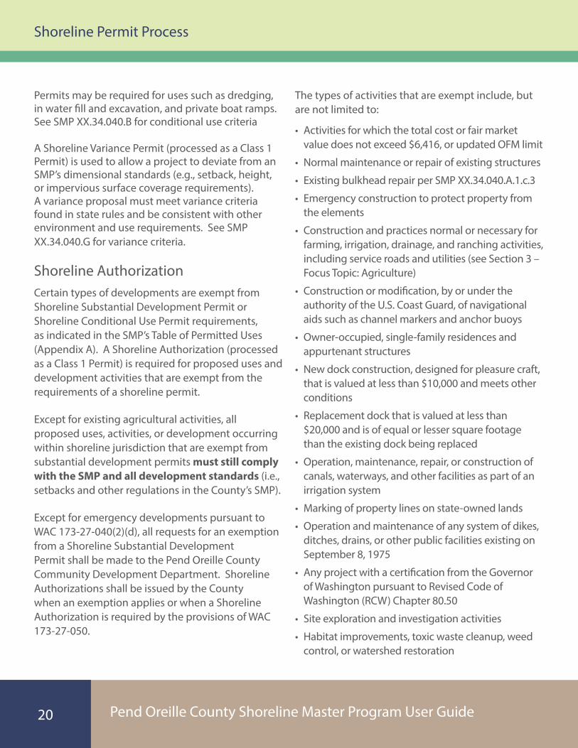
When Is a Shoreline Permit Required?All proposed uses, activities, or development occurring within shoreline jurisdiction must meet the requirements of federal, state, and local laws and the County’s SMP, whether or not a shoreline permit or other form of authorization is required. Permits help the County track development and uses in the shoreline to make sure the program requirements are being met.
The following list comprises the types of shoreline permits: Shoreline Substantial Development Permit; Shoreline Conditional Use Permit; Shoreline Variance Permit; and Shoreline Authorization/Exemption.
Typical Activities Requiring a Shoreline PermitA Shoreline Substantial Development Permit (processed as a Class 1 Permit) is typically required for a project that proposes to undertake a substantial development within the shoreline jurisdiction. A substantial development is any development of which the total cost or fair market value exceeds $6,416 or as adjusted by the State Office of Financial Management (OFM), or any development which materially interferes with the normal public use of the water or shorelines of the state.
A Shoreline Conditional Use Permit (processed as a Class 1 Permit) is needed if a proposed use is listed as a conditional use in SMP Table B (see Appendix A) or if the SMP does not address the use. Conditional Use
Photograph by Washington State Department of Ecology
Pend Oreille County Shoreline Master Program User Guide
Shoreline Permit Process
20
Permits may be required for uses such as dredging, in water fill and excavation, and private boat ramps. See SMP XX.34.040.B for conditional use criteria
A Shoreline Variance Permit (processed as a Class 1 Permit) is used to allow a project to deviate from an SMP’s dimensional standards (e.g., setback, height, or impervious surface coverage requirements). A variance proposal must meet variance criteria found in state rules and be consistent with other environment and use requirements. See SMP XX.34.040.G for variance criteria.
Shoreline AuthorizationCertain types of developments are exempt from Shoreline Substantial Development Permit or Shoreline Conditional Use Permit requirements, as indicated in the SMP’s Table of Permitted Uses (Appendix A). A Shoreline Authorization (processed as a Class 1 Permit) is required for proposed uses and development activities that are exempt from the requirements of a shoreline permit.
Except for existing agricultural activities, all proposed uses, activities, or development occurring within shoreline jurisdiction that are exempt from substantial development permits must still comply with the SMP and all development standards (i.e., setbacks and other regulations in the County’s SMP).
Except for emergency developments pursuant to WAC 173-27-040(2)(d), all requests for an exemption from a Shoreline Substantial Development Permit shall be made to the Pend Oreille County Community Development Department. Shoreline Authorizations shall be issued by the County when an exemption applies or when a Shoreline Authorization is required by the provisions of WAC 173-27-050.
The types of activities that are exempt include, but are not limited to:
• Activities for which the total cost or fair market value does not exceed $6,416, or updated OFM limit
• Normal maintenance or repair of existing structures
• Existing bulkhead repair per SMP XX.34.040.A.1.c.3
• Emergency construction to protect property from the elements
• Construction and practices normal or necessary for farming, irrigation, drainage, and ranching activities, including service roads and utilities (see Section 3 – Focus Topic: Agriculture)
• Construction or modification, by or under the authority of the U.S. Coast Guard, of navigational aids such as channel markers and anchor buoys
• Owner-occupied, single-family residences and appurtenant structures
• New dock construction, designed for pleasure craft, that is valued at less than $10,000 and meets other conditions
• Replacement dock that is valued at less than $20,000 and is of equal or lesser square footage than the existing dock being replaced
• Operation, maintenance, repair, or construction of canals, waterways, and other facilities as part of an irrigation system
• Marking of property lines on state-owned lands
• Operation and maintenance of any system of dikes, ditches, drains, or other public facilities existing on September 8, 1975
• Any project with a certification from the Governor of Washington pursuant to Revised Code of Washington (RCW) Chapter 80.50
• Site exploration and investigation activities
• Habitat improvements, toxic waste cleanup, weed control, or watershed restoration

Pend Oreille County Shoreline Master Program User Guide
Shoreline Permit Process
21
Shoreline Permit Application RequirementsIt is the goal of the County to integrate the processing of required permits or approvals for development activities or uses proposed for jurisdictional shorelines with other permits and approvals that may be required. In order to streamline this process, the County has adopted the Joint Aquatic Resources Permit Application (JARPA) form for shoreline projects within the County.
The County planning staff can provide application materials and assist with the process. In addition to the County application, other state and federal application may be required. Visit the County’s Shoreline Activities Information website for access to JARPA forms at: http://pendoreilleco.org/your-government/community-development/shoreline-activities-information-and-permits/
Additional, specific information may be required depending on the nature of the proposal and the presence of sensitive ecological features or issues related to compliance with other County requirements and the provisions of the SMP.
Shoreline Permit Review StepsApplications for Shoreline Substantial Developments, Conditional Uses, Variances, and Shoreline Authorizations are processed under Class 1 permit procedures. Class 1 permit applications involve administrative action by the Community Development Director, consisting of the following components:
(1) Completeness review and Issuance of a Determination of Completeness
(2) Distribution of Notice of Application (not required for the Shoreline Authorization review), and legal notice in paper record
(3) Issuance of a Determination of Consistency
(4) Notification to the Applicant of approval or denial of the application
How Long Does a Shoreline Permit Take?Shoreline permits are generally processed within 120 days of determination of a complete application. Additional time for the Washington State Department of Ecology review process and appeal period are required as summarized in Figure 5.

Pend Oreille County Shoreline Master Program User Guide
Shoreline Permit Process
22
FIGURE 5Shoreline Permit Review Timeline
Local Review – Class 1 Permit
Ecology – Review/Appeal Period
Within 120 days
Appeal Period: 21 days
Review: Within 30 days Appeal Period: 21 days
Appeal period ends 21 days from the date that Ecology receives the local government’s decision.
Ecology shall review permit within 30 days of the date of submittal by the County pursuant to WAC 173-27-110.
Appeal period ends 21 days from the date that Ecology’s decision is transmitted to the local government.
Substantial Development Permit
Conditional Use Permit or Variance
The Washington State Department of Ecology also reviews Shoreline Authorizations (exemptions) that require federal permits under Section 10 of the Rivers and Harbors Act of 1899 and Section 404 of the Federal Water Pollution Control Act of 1972. The Washington State Department of Ecology reviews these exemptions and must concur that the exemption is appropriate.
Other Permits RequiredThe Shoreline Substantial Development Permit does not take the place of any other required permit or review. A project or development may also require:
• Building or grading permit
• Variance or Conditional Use permit
• Washington State Department of Ecology Water Quality Certification
• Hydraulic Project Approval
• Lease from the Washington State Department of Natural Resources
• Federal U.S. Army Corps of Engineers permit for work in navigable waters of the United States
Pend Oreille County Shoreline Master Program User Guide
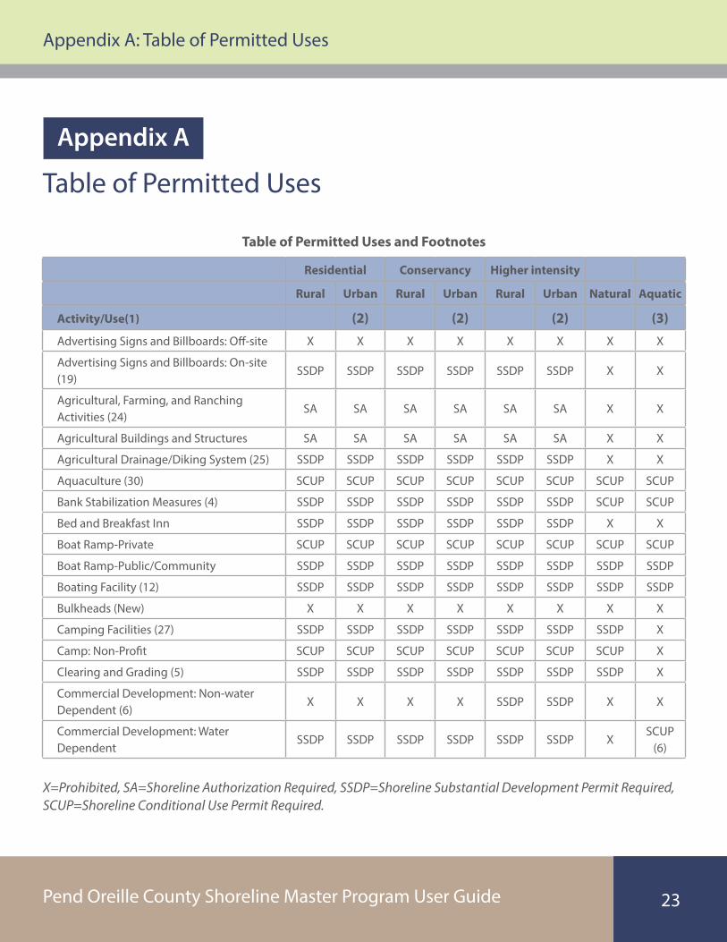
Appendix A: Table of Permitted Uses
23
X=Prohibited, SA=Shoreline Authorization Required, SSDP=Shoreline Substantial Development Permit Required, SCUP=Shoreline Conditional Use Permit Required.
Table of Permitted Uses
Table of Permitted Uses and Footnotes
Residential Conservancy Higher intensity
Rural Urban Rural Urban Rural Urban Natural Aquatic
Activity/Use(1) (2) (2) (2) (3)
Advertising Signs and Billboards: Off-site X X X X X X X X
Advertising Signs and Billboards: On-site (19)
SSDP SSDP SSDP SSDP SSDP SSDP X X
Agricultural, Farming, and Ranching Activities (24)
SA SA SA SA SA SA X X
Agricultural Buildings and Structures SA SA SA SA SA SA X X
Agricultural Drainage/Diking System (25) SSDP SSDP SSDP SSDP SSDP SSDP X X
Aquaculture (30) SCUP SCUP SCUP SCUP SCUP SCUP SCUP SCUP
Bank Stabilization Measures (4) SSDP SSDP SSDP SSDP SSDP SSDP SCUP SCUP
Bed and Breakfast Inn SSDP SSDP SSDP SSDP SSDP SSDP X X
Boat Ramp-Private SCUP SCUP SCUP SCUP SCUP SCUP SCUP SCUP
Boat Ramp-Public/Community SSDP SSDP SSDP SSDP SSDP SSDP SSDP SSDP
Boating Facility (12) SSDP SSDP SSDP SSDP SSDP SSDP SSDP SSDP
Bulkheads (New) X X X X X X X X
Camping Facilities (27) SSDP SSDP SSDP SSDP SSDP SSDP SSDP X
Camp: Non-Profit SCUP SCUP SCUP SCUP SCUP SCUP SCUP X
Clearing and Grading (5) SSDP SSDP SSDP SSDP SSDP SSDP SSDP X
Commercial Development: Non-water Dependent (6)
X X X X SSDP SSDP X X
Commercial Development: Water Dependent
SSDP SSDP SSDP SSDP SSDP SSDP XSCUP
(6)
Appendix A
Pend Oreille County Shoreline Master Program User Guide
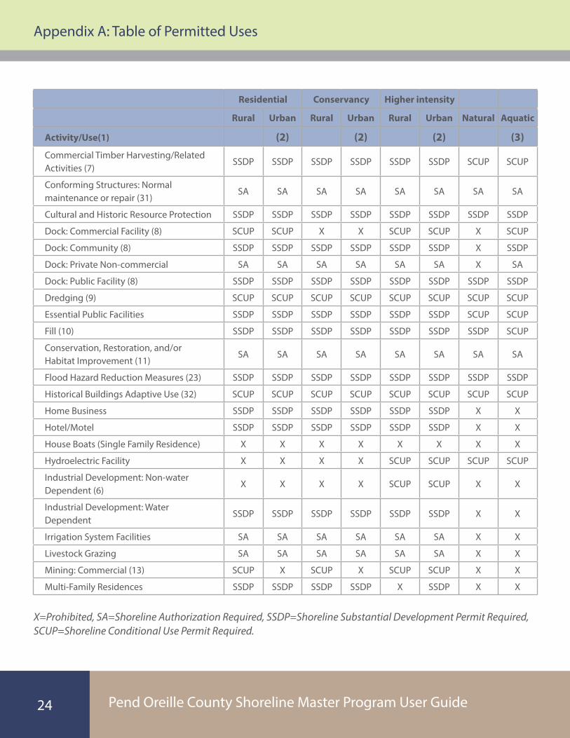
Appendix A: Table of Permitted Uses
24
Residential Conservancy Higher intensity
Rural Urban Rural Urban Rural Urban Natural Aquatic
Activity/Use(1) (2) (2) (2) (3)
Commercial Timber Harvesting/Related Activities (7)
SSDP SSDP SSDP SSDP SSDP SSDP SCUP SCUP
Conforming Structures: Normal maintenance or repair (31)
SA SA SA SA SA SA SA SA
Cultural and Historic Resource Protection SSDP SSDP SSDP SSDP SSDP SSDP SSDP SSDP
Dock: Commercial Facility (8) SCUP SCUP X X SCUP SCUP X SCUP
Dock: Community (8) SSDP SSDP SSDP SSDP SSDP SSDP X SSDP
Dock: Private Non-commercial SA SA SA SA SA SA X SA
Dock: Public Facility (8) SSDP SSDP SSDP SSDP SSDP SSDP SSDP SSDP
Dredging (9) SCUP SCUP SCUP SCUP SCUP SCUP SCUP SCUP
Essential Public Facilities SSDP SSDP SSDP SSDP SSDP SSDP SCUP SCUP
Fill (10) SSDP SSDP SSDP SSDP SSDP SSDP SSDP SCUP
Conservation, Restoration, and/or Habitat Improvement (11)
SA SA SA SA SA SA SA SA
Flood Hazard Reduction Measures (23) SSDP SSDP SSDP SSDP SSDP SSDP SSDP SSDP
Historical Buildings Adaptive Use (32) SCUP SCUP SCUP SCUP SCUP SCUP SCUP SCUP
Home Business SSDP SSDP SSDP SSDP SSDP SSDP X X
Hotel/Motel SSDP SSDP SSDP SSDP SSDP SSDP X X
House Boats (Single Family Residence) X X X X X X X X
Hydroelectric Facility X X X X SCUP SCUP SCUP SCUP
Industrial Development: Non-water Dependent (6)
X X X X SCUP SCUP X X
Industrial Development: Water Dependent
SSDP SSDP SSDP SSDP SSDP SSDP X X
Irrigation System Facilities SA SA SA SA SA SA X X
Livestock Grazing SA SA SA SA SA SA X X
Mining: Commercial (13) SCUP X SCUP X SCUP SCUP X X
Multi-Family Residences SSDP SSDP SSDP SSDP X SSDP X X
X=Prohibited, SA=Shoreline Authorization Required, SSDP=Shoreline Substantial Development Permit Required, SCUP=Shoreline Conditional Use Permit Required.

Pend Oreille County Shoreline Master Program User Guide
Appendix A: Table of Permitted Uses
25
Residential Conservancy Higher intensity
Rural Urban Rural Urban Rural Urban Natural Aquatic
Activity/Use(1) (2) (2) (2) (3)
Navigational Aids and moorage buoys (21)
SA SA SA SA SA SA SA SA
Non-classified Uses (14) SCUP SCUP SCUP SCUP SCUP SCUP SCUP SCUP
Non- Conforming Structures: Maintenance, Repair, or Expansion (15)
SA SA SA SA SA SA SA SA
Noxious Weed/Nuisance Plant Management (16)
SA SA SA SA SA SA SA SA
Parking Lots (17) SSDP SSDP SSDP SSDP SSDP SSDP SCUP X
Public Access Facilities SSDP SSDP SSDP SSDP SSDP SSDP SSDP SSDP
Recreation: Non-water Dependent (6)(26) SCUP SCUP SCUP SCUP SCUP SCUP X SC
Recreation: Water Dependent (26)(27) SSDP SSDP SSDP SSDP SSDP SSDP SSDP SSDP
Resorts: Master Planned SSDP SSDP SCUP SCUP SSDP SSDP X X
Resorts: Other SSDP SSDP X X SSDP SSDP X X
Roads and Bridges SSDP SSDP SSDP SSDP SSDP SSDP SSDP SSDP
RV Parks SSDP SSDP X X SSDP SSDP X X
RV Resorts SSDP SSDP X X SSDP SSDP X X
Scientific, historical, cultural, educational research uses, and low-intensity water oriented recreation uses.
SSDP SSDP SSDP SSDP SSDP SSDPSSDP (22)
SSDP
Sewage Treatment Facilities SSDP SSDP SCUP SCUP SSDP SSDP X X
Signs (19) SSDP SSDP SSDP SSDP SSDP SSDP SSDP SSDP
Single Family Residence/Accessory Structures (18)(29)
SA SA SA SA SA SA SCUP X
Solid Waste Facilities X X X X X X X X
Telecommunication Facilities SSDP SSDP SSDP SSDP SSDP SSDP X X
Tram/Funicular SSDP SSDP SSDP SSDP SSDP SSDP SCUP SCUP
Utilities (28) SSDP SSDP SSDP SSDP SSDP SSDP SCUP SCUP
Vacation Rentals (20) SSDP SSDP SSDP SSDP SSDP SSDP X X
X=Prohibited, SA=Shoreline Authorization Required, SSDP=Shoreline Substantial Development Permit Required, SCUP=Shoreline Conditional Use Permit Required.
Pend Oreille County Shoreline Master Program User Guide
Appendix A: Table of Permitted Uses
26
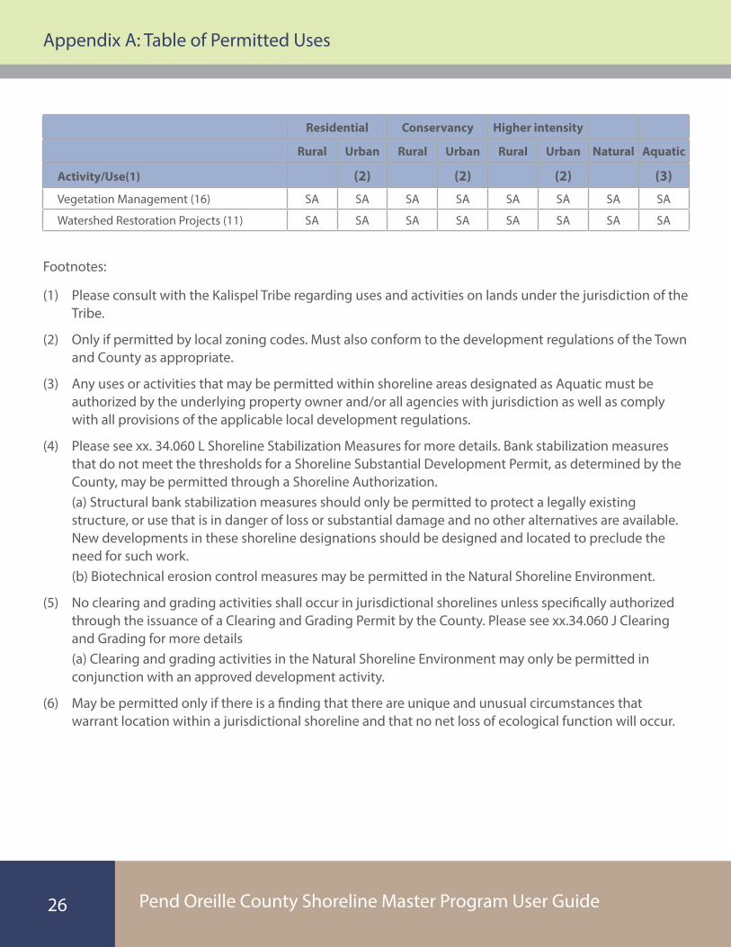
Footnotes:
(1) Please consult with the Kalispel Tribe regarding uses and activities on lands under the jurisdiction of the Tribe.
(2) Only if permitted by local zoning codes. Must also conform to the development regulations of the Town and County as appropriate.
(3) Any uses or activities that may be permitted within shoreline areas designated as Aquatic must be authorized by the underlying property owner and/or all agencies with jurisdiction as well as comply with all provisions of the applicable local development regulations.
(4) Please see xx. 34.060 L Shoreline Stabilization Measures for more details. Bank stabilization measures that do not meet the thresholds for a Shoreline Substantial Development Permit, as determined by the County, may be permitted through a Shoreline Authorization. (a) Structural bank stabilization measures should only be permitted to protect a legally existing structure, or use that is in danger of loss or substantial damage and no other alternatives are available. New developments in these shoreline designations should be designed and located to preclude the need for such work. (b) Biotechnical erosion control measures may be permitted in the Natural Shoreline Environment.
(5) No clearing and grading activities shall occur in jurisdictional shorelines unless specifically authorized through the issuance of a Clearing and Grading Permit by the County. Please see xx.34.060 J Clearing and Grading for more details (a) Clearing and grading activities in the Natural Shoreline Environment may only be permitted in conjunction with an approved development activity.
(6) May be permitted only if there is a finding that there are unique and unusual circumstances that warrant location within a jurisdictional shoreline and that no net loss of ecological function will occur.
Residential Conservancy Higher intensity
Rural Urban Rural Urban Rural Urban Natural Aquatic
Activity/Use(1) (2) (2) (2) (3)
Vegetation Management (16) SA SA SA SA SA SA SA SA
Watershed Restoration Projects (11) SA SA SA SA SA SA SA SA

Pend Oreille County Shoreline Master Program User Guide
Appendix A: Table of Permitted Uses
27
(7) All commercial timber harvesting must conform to Washington State Department of Natural Resource standards and the provisions of Pend Oreille County Development Regulations XX.40. Also see xx.34.060 R Timber Harvesting for more details. (a) Commercial timber harvesting within Shorelines of Statewide Significance may only be approved through the issuance of a SCUP in accordance with the provisions of the Shoreline Management Act, RCW 90.58.
(8) See xx.34.060 F Docks for more details. Docks certified to cost less than the State financial threshold ($20,000) may be permitted through a Shoreline Authorization from the County (SA) based on a finding such activity will not materially interfere with normal public use of the water or Shorelines of the State.
(9) Dredging may only be permitted in accordance with Washington State Department of Natural Resources and with U.S. Army Corps
(10) May be permitted only in conjunction with an approved flood proofing activity or bank stabilization project or with the conditions of approval of a federally-licensed dam. (a) Fill waterward of the ordinary high water mark may only be allowed when necessary to support the uses identified in WAC 173-26-231(3)(c).
(11) Must be designated as a conservation, restoration, and/or habitat improvement activity by the County, the Federal Energy Regulatory Commission, the Washington State Department of Fish and Wildlife, or other state or federal natural resource agency in accordance with the provisions of WAC 173-27-040(2)o.
(12) Please see Chapter xx.34.060 G Boating Facilities for more details.
(13) All mining activities must comply with Washington State Department of Natural Resource standards. Please see Chapter xx.34.060 N Mining for more details.
(14) May be permitted through an administrative code interpretation if found to be consistent with other uses identified in this Table. Other uses may be permitted though the issuance of a SCUP in conformance with the standards applicable in the Conservancy designation or through an amendment to the SMP.
(15) Please see Chapter xx.34.070 Non-conforming Uses and Structures for more details.
(16) Please see Chapter xx. 34.060 H Vegetation Management and I Aquatic Plant Management for more details.
(17) May be permitted as an accessory use only outside of required buffers.
Pend Oreille County Shoreline Master Program User Guide
Appendix A: Table of Permitted Uses
28
(18) Single family residences shall include associated on-site utilities such as sanitary sewers, septic-systems, wells and domestic water hook-ups, propane, electrical service, telephone lines, internet, and/or cable TV. (a) For purposes of this Chapter, “appurtenant structures” means garages, sheds, and other legally established accessory structures. “Appurtenant structures” does not include bulkheads and other shoreline modifications or over-water structures. (b) Septic drainfields must comply with all requirements of the Northeast Tri-County Health District and should not be located in required buffers unless no other feasible alternative exists as determined by the Health District.
(19) Please see Chapter xx.34.060 O Signs for more details.
(20) All vacation rentals must also comply with the provisions of Chapter XX.70. (a) The construction of a new vacation rental must be approved through the issuance of a SSDP. (b) The conversion of an existing single family residence to a vacation rental may be approved through the issuance of a SA.
(21) Must comply with all applicable local, state, and federal regulations, including but not limited to U.S. Coast Guard rules.
(22) May be permitted subject to conditions and may be denied based on a finding that the proposed use would degrade ecological functions or the natural character of the shoreline.
(23) New structural flood hazard reduction measures may be permitted in jurisdictional shorelines only when it can be demonstrated by a scientific and engineering analysis that they are necessary to protect existing development, that nonstructural measures are not feasible, that impacts on ecological functions and priority species and habitats can be successfully mitigated so as to assure no net loss, and that appropriate vegetation conservation actions are undertaken consistent with the provisions of the Washington Administrative Code. (a) New structural public flood hazard measures such as dikes and levees, may be required to dedicate and improve public access pathways unless such improvements would cause unavoidable health and safety hazards, inherent and unavoidable security problems, unacceptable and unmitigable significant ecological impacts, unavoidable conflicts with the proposed use, and/or a cost that is disproportionate and unreasonable to the total long-term cost of the development.
(24) Construction and practices normal or necessary for farming, irrigation, and ranching activities, including agricultural service roads and utilities on shorelands, and the construction and maintenance of irrigation structures including but not limited to head gates, pumping facilities, and irrigation channels. A feedlot of any size, all processing plants, other activities of a commercial nature, alteration of the contour of the shorelands by leveling or filling other than that which results from normal cultivation, shall not be considered normal or necessary farming or ranching activities and may be permitted only through the issuance of a SSDP.
Pend Oreille County Shoreline Master Program User Guide
Appendix A: Table of Permitted Uses
29
(25) Development activities associated with the operation and maintenance of any system of dikes, ditches, drains, or other public facilities existing on September 8, 1975, which were created, developed or used primarily as a part of an agricultural drainage or diking system may be permitted through a shoreline authorization.
(26) Includes commercial and public recreation facilities.
(27) Only public camping and recreation facilities may be permitted in Natural Shoreline Areas, subject to a determination by the County that the proposed project is a low-impact design that will result in no net loss of ecological function.
(28) Please see Chapter xx.34.060 W Utilities for more details.
(29) Residential structures and appurtenant structures that were legally established and are used for a conforming use, but that do not meet current standards for setbacks, buffers, height or density shall be considered conforming structures. (a) The redevelopment, expansion, or replacement of a residential structure may be permitted if it is otherwise consistent with the provisions of the County Development Regulations and this Master Program, including the requirement for no net loss of shoreline ecological functions.
(30) Sponsors of proposed new aquaculture activities are encouraged to consult with the Washington State Departments of Ecology, Fish and Wildlife, and Natural Resources before submitting an application. In addition to permits from the County, an HPA from WDFW may be required, as well as other permits and approvals from agencies with jurisdiction.
(31) Legally established residential and appurtenant structures in place on the date of adoption of this updated Shoreline Master Program shall be considered legal conforming uses and structures for purposes of implementing these shoreline regulations.
(32) Buildings must be identified on the State Historic Register.
Pend Oreille County Shoreline Master Program User Guide
Appendix B: Pend Oreille County Native Plants List
30
Pend Oreille County Native Plants List All listed plants have wildlife habitat value (i.e. food, cover, nesting site or shelter). Plants may have more than one common name; list provides both common and scientific name for each species to help with identification. Planting site will dictate species selection. List is not inclusive.
Soil: Saturated Wet (including seasonal inundation) Moist Well-drained Dry
Light: Full Sun Partial Sun Shade
Willow (Salix spp.) Max. Ht. 9’- 45’ Med. to Fast Growing ~ Wide Spread Root System
Black hawthorn (Crataegus douglasiz) Max Ht. 20’ Thicket Fonning - Deep Root System
Black cottonwood (Populus trichocarpa) Max. Ht. 120’ Fast Growing - Fibrous Roots
Red-osier dogwood (Cornus stolonifera) Max. Ht. 20’ Fast Growing - Spreading
Douglas spirea (Spiraea douglasii) Max. Ht. 7’ Thicket Fonning - Rhizome
Dwarf birch (Betula glandulosa) (a.k.a. bog birch) Usually less than 10’ Small shrub/tree
Bulrush species (Scirpus spp.) Max. Ht. 2’-5’ Perennial Rhizome - Spreading
Sedge species (Carex spp.) Max. Ht. 1 ‘-4’ Spreading
Rush species (Juncus spp.) Max. Ht. 1’-4’ Spreading
Spike-rushes (Eleocharis spp.) Max. Ht. 3’ Spreading
Common snowberry (Symphoricarpos alb us) Max. Ht. 4’ Rhizome
Beaked hazelnut (Corylus corn uta) Max. Ht. 15’ Suckering - Native Nut
Alder species (Alnus spp.) Max. Ht. 10’-40’ Nitrogen Fixing Root Nodules
Serviceberry (Amelanchier alnifolia) Max. Ht. 20’ Spreading and Deep Roots - Berries
Chokecherry (Prunus virginiana) Max. Ht. 20’ Fast Growing - Berries
Russet buffaloberry (Shepherdia canadensis) Max. Ht. 7’ Nitrogen Fixing - Berries
Nootka rose (Rosa nutkana) Max. Ht. 7’ Soil Binding Characteristics - Edible flowers/Hips
Appendix B
Pend Oreille County Shoreline Master Program User Guide
Appendix B: Pend Oreille County Native Plants List
31
Cascara (Rhamnus purshiana) Max. Ht. 30’ Fonns Groves - Wildlife Berries
Highbush cranberry (Viburnum opulus L. var. americanum, V. edule) Color - Berries
Mockorange (Philadelphus lewisii) Max Ht. 15’ Fibrous Root System - Fragrant
Oceanspray (Holodiscus discolor) Max. Ht. 13’ Spreading Root System - Dry Slopes
Black twin berry (Lonicera involucrata) Max. Ht. 10’ Spreading Root System
Blue elderberry (Sambucus cerulea) Max. Ht. Strong Fibrous Root System - Berries
Thimbleberry (Rubus parvijlorus) Max. Ht. 10’ Thicket Fonning - Berries
Douglas maple (Acer glabrum var. douglasii) Max. Ht. 30’ Hardy - Fall Color
Oregon grape species (Mahonia spp.) Max. Ht. 1’-7’ Evergreen Rhizome- Berries
Kinnikinnick (Arctostaphylos uva-ursi) Max. Ht. 8” Evergreen Groundcover - Berries
Western red cedar (Thuja plicata) Max. Ht. 180’
Ponderosa pine (Pinus ponderosa) Max. Ht. 140’
Quaking aspen (Populus tremuloides) Max. Ht. 85’ Extensive Clone System
Western larch (Larix occidentalis) Max. Ht. 200’
Pinegrass (Calamagrostis rubescens) Rhizome - Perennial Bunchgrass
Idaho fescue (Festuca idahoensis) Rhizome - Perennial Bunchgrass
Junegrass (Koeleria macrantha) Tufted Perennial
Yarrow (Achillea millejolium) Max. Ht. 4”-39” Perennial Wildflower - Rhizome
Goldenrod (Solidago canadensis) Max. Ht. 2’-4’ Perennial Wildflower - Rhizome
Pearly everlasting (Anaphalis margaritacea) Max. Ht. 2’ Perennial Wildflower
Silky lupine (Lupinus sericeus) Max. Ht. 1’-2’ Perennial Wildflower
Shrubby penstemon (Penstemonfruticosus) Max. Ht. 1 ‘-2’ Perennial Wildflower
Marsh cinquefoil (Potentilla palustris) Perennial WildflowerlReddish-purple -Rhizome

Pend Oreille County Shoreline Master Program User GuideProduced by Anchor QEA, LLC, for Pend Oreille County Funded through a grant from the Washington State Department of Ecology
Pend Oreille CountyCommunity Development Department
625 West 4th StreetNewport, Washington 98033
(509) 447-4821


![Thurston County Agricultural Land Pocket Gopher Evaluation · [THURSTON COUNTY AGRICULTURAL LAND POCKET GOPHER EVALUATION] March 30, 2014 3 Thurston County Agricultural Land Pocket](https://img.dokumen.tips/doc/110x75/5b00b2377f8b9a256b90627a/thurston-county-agricultural-land-pocket-gopher-evaluation-thurston-county-agricultural.jpg)