Embed Size (px)
Citation preview

PEDESTRIAN, TRAFFIC &
TRANSPORT MANAGEMENT PLAN
PROJECT: ROYAL RANDWICK RACECOURSE
CLIENT: AUSTRALIAN TURF CLUB
LOCAL COUNCIL: RANDWICK CITY COUNCIL
VERSION: 1
Page 2 of 34
DOCUMENT CONTROL Pedestrian and Traffic Management Plan: Royal Randwick Racecourse
Issue Date Issue Details Author For the attention of
1 02/04/2020 Draft CK Australian Turf Club
AUTHOR CREDNTIALS Christopher Kocovski, Transport NSW RMS Card No: 0052255719 (Prepare a Work Zone
Traffic Management Plan).
CONTACT Christopher Kocovski 0490 044 191 02 9798 2319 [email protected]
COMMERCIAL IN CONFIDENCE The information contained in this document, including any intellectual property arising from designs developed and documents created, is confidential and property of Intact Solutions. This document may only be used by the person/organisation to whom it is addressed for the stated purpose for which it is provided and must not be imparted to or reproduced, in whole or in part, by any third person without the prior written approval of Intact Solutions authorised representatives. Intact Solutions reserve all legal rights and remedies in relation to any infringement of its rights in respect of its intellectual property and/or confidential information.
© 2020

Page 3 of 34
Table of Contents
1. INTRODUCTION ........................................................................................................... 5 1.1 PROJECT SUMMARY ............................................................................................................. 5
1.2 CONSIDERATIONS ................................................................................................................. 5
2. TRAFFIC MANAGEMENT PLAN OBJECTIVES .......................................................... 6 3. KEY STAKEHOLDERS AND CONTACTS ................................................................... 6 4. LOCATION ................................................................................................................... 7
4.1 ROYAL RANDWICK RACECOURSE ................................................................................... 7
4.2 ROAD HERIRARCHY .............................................................................................................. 9
5. OPERATING POSTURES ............................................................................................ 10 6. RISK MANAGEMENT .................................................................................................. 11
6.1 WORK, HEALTH & SAFETY – TRAFFIC CONTROL ...................................................... 11
6.2 TABLE 1 & 2 – CONSEQUENCE & LIKELIHOOD ........................................................... 13
6.3 TABLE 3 – RISK ASSESSMENT MATRIX ........................................................................ 14
6.4 TABLE 4 – RISK ASSESSMENT MANAGEMENT REPONSE ...................................... 14
6.5 SCOPE OF THE ASSESSMENT......................................................................................... 14
6.6 TABLE 5 – RISK ANALYSYIS & TREATMENT REGISTER ........................................... 15
7. TRAFFIC & TRANSPORT MANAGEMENT ................................................................. 17 7.1 ROUTES & LOCATIONS ...................................................................................................... 17
7.2 VEHICLE ROUTE RESTRICTIONS .................................................................................... 17
7.3 PEDESTRIAN ROUTE RESTRICTIONS ........................................................................... 18
7.4 PARKING ................................................................................................................................. 18
7.5 HEAVY RAIL ........................................................................................................................... 18
7.6 LIGHT RAIL ............................................................................................................................. 19
7.7 BUS SERVICES ..................................................................................................................... 20
7.8 PRIVATE COACHES (OVER 3.4M HIGH) / MINI BUS (UNDER 3.4M HIGH)............. 20
7.9 POINT TO POINT SERVICES ............................................................................................. 21
7.10 HELICOPTERS .................................................................................................................... 21
7.11 ACTIVE TRANSPORT ........................................................................................................ 21
7.12 CONSTRUCTION, TRAFFIC CALMING & TRAFFIC GENERATING
DEVELOPEMENTS ...................................................................................................................... 23
7.13 NSW POLICE ....................................................................................................................... 23
7.14 NSW FIRE & RESCUE AND NSW AMBULANCE ......................................................... 23
7.15 CONTINGENCY PLANS ..................................................................................................... 24
7.16 HEAVY VEHICLE IMPACTS .............................................................................................. 25
7.17 SPECIAL EVENT CLEARWAYS ....................................................................................... 25
7.18 ROAD CLOSURES .............................................................................................................. 25
7.19 RMS AUTHORISED TRAFFIC CONTROLLERS ........................................................... 25
7.20 LIGHT PHASING TECHNICIANS ..................................................................................... 25
7.21 TAXI COUNCIL COMMISSIONAIRES ............................................................................. 25
7.22 POINT TO POINT TRANSPORT COMPLIANCE OFFICERS ...................................... 25
8. MINIMISING IMPACT ................................................................................................... 25 8.1 ACCESS FOR LOCAL RESIDENTS, BUSINESSES, HOSPITALS & EMERGENCY
VEHICLES ..................................................................................................................................... 25
8.2 ADVERTISING TRAFFIC AND TRANSPORT ARRANGEMENTS ................................ 26
8.3 PERMANENT VARIABLE MESSAGE SIGNS [PVMS] .................................................... 26
8.4 PORTABLE VARIABLE MESSAGE SIGNS [VMS] .......................................................... 26

Page 4 of 34
8.5 WAYFINDING ......................................................................................................................... 30
8.6 TRAFFIC IMPACT ASSESSMENT ..................................................................................... 30
9. AUSTRALIAN TURF CLUB PARKING PASSES ......................................................... 32 10. OPERATING POSTURES OVERVIEW ...................................................................... 34

Page 5 of 34
1. INTRODUCTION
1.1 PROJECT SUMMARY
Intact Solutions has been engaged by the Australian Turf Club to prepare a Pedestrian and
Traffic Management Plan for various operating postures (modes) at the Royal Randwick
Racecourse precinct.
Figure 1 – Royal Randwick Racecourse Site
1.2 CONSIDERATIONS
- The document should remain in draft until further testing and consultation with
stakeholders can take place; specifically, after the current COVID19 environment
and Government restrictions are lifted on places of mass gathering congregation
and social distancing.
- The document considers pedestrian, traffic and transport factors relating to the new
Winx stand. The Winx stand development is not proposed to increase patron
capacity across the Randwick Racecourse precinct, rather just to provide additional
covered amenity for the existing patrons.

Page 6 of 34
2. TRAFFIC MANAGEMENT PLAN OBJECTIVES
The pedestrian, traffic and transport management measures presented within this report
has been prepared in accordance with the requirements of the Guide to Traffic and
Transport Management for Special Events, which is published on the RMS website.
The guide presents the following four primary objectives:
- Ensure the safe separation of event patrons, participants and volunteers from traffic
- Manage the reduced capacity of the road system
- Minimise the traffic impact on the non-event community and the emergency
services
- Minimise costs
To achieve the above objectives, the Pedestrian and Traffic Management Plan will:
- Ensure that delays and traffic congestion are kept to a minimum and within
acceptable levels;
- Encourage the use of public transport to the precinct and major events;
- Deliver a better customer experience;
- Ensure that all needs of road users, motorists, pedestrians, cyclists, public transport
passengers and people with disabilities are accommodated.
3. KEY STAKEHOLDERS AND CONTACTS
NAME CONTACT DETAILS ORGANISATION
Adam Smith 0422 271 555
Australian Turf Club
Adam Perkins 0467 898 282
Australian Turf Club
Andrew Sturday 0403 784 191
Transport for NSW
Corinne Dawes
(02) 9349 9299 [email protected]
NSW Police
Gary Colston 0437 503 087
Australian Turf Club
Heather Gavriel 0424 366 714
Transport for NSW
John Flanigan 0439 613 589
Randwick City
Council
Ray Carroll 0411 407 425 STA – Sydney Buses
Traffic
Management
Centre
131 700 Transport for NSW
Taxi Control
Room
9020 2325 NSW Taxi Council

Page 7 of 34
4. LOCATION
4.1 ROYAL RANDWICK RACECOURSE
Royal Randwick Racecourse is a racecourse for horse racing located in the Eastern
Suburbs of Sydney, New South Wales. Randwick Racecourse is Crown Land leased to
the Australian Turf Club and known to many Sydney racegoers as headquarters. The
racecourse is located about six kilometres from the Sydney Central Business District in the
suburb of Randwick. The course proper has a circumference of 2224m with a home straight
of 410m.
On occasion, the Royal Randwick Racecourse may hold concerts or music festivals which
do not fit the typical race day event. These events may have a different demographic of
patrons and larger crowds, with origin points widely spread across Sydney. Concerts or
music festivals will usually have a set start time, meaning crowd arrival will be
concentrated. This differs from a typical race day where arrival times may be spread across
the day.
Bound by Avoca Street to the East, Alison Road to the North, High Street to the south and
Anzac Parade running North South through its core, the precinct is well serviced by the
road network.
Vehicular entry points to the Randwick Racecourse precinct are located on Alison Rd,
Ascot St, High St and Wansey Rd. Further location information is located on the precinct
map on the next page.
Figure 2 – Winx Stand Artistic View

Figure 2 – Royal Randwick Racecourse Precinct Map

4.2 ROAD HERIRARCHY
Within the Randwick Racecourse precinct, Avoca Street and Alison Road are State Roads,
Darley Road and Doncaster Road are Regional Roads and High Street is a Local Road.
Other landowners include Centennial Park and Moore Park Trust owners of Centennial
Parklands and Transdev owners of the Light Rail corridor.
Figure 3 – Road Hierarchy
The NSW administration road hierarchy, illustrated in figure 3 consists of the following road
classifications, which align with the generic road hierarchy as follows:
- State Roads (Freeways and Primary Arterials (RMS Managed)
- Regional Roads (Secondary or sub arterials (Council Managed, Part funded by the
State)
- Local Roads (Collection and local access roads (Council Managed)
Page 10 of 34
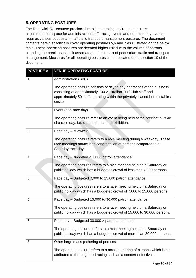
5. OPERATING POSTURES
The Randwick Racecourse precinct due to its operating environment across
accommodation space for administration staff, racing events and non-race day events
requires various pedestrian, traffic and transport management postures. The document
contents herein specifically cover operating postures 5,6 and 7 as illustrated on the below
table. These operating postures are deemed higher risk due to the volume of patrons
attending the precinct and risk associated to the impact of pedestrian, traffic and transport
management. Measures for all operating postures can be located under section 10 of the
document.
POSTURE # VENUE OPERATING POSTURE
1 Administration (BAU)
The operating posture consists of day to day operations of the business
consisting of approximately 100 Australian Turf Club staff and
approximately 50 staff operating within the privately leased horse stables
onsite.
2 Event (non-race day)
The operating posture refer to an event being held at the precinct outside
of a race day. i.e. school formal and exhibition.
3 Race day – Midweek
The operating posture refers to a race meeting during a weekday. These
race meetings attract less congregation of persons compared to a
Saturday race day.
4 Race day - Budgeted < 7,000 patron attendance
The operating postures refers to a race meeting held on a Saturday or
public holiday which has a budgeted crowd of less than 7,000 persons.
5 Race day – Budgeted 7,000 to 15,000 patron attendance
The operating postures refers to a race meeting held on a Saturday or
public holiday which has a budgeted crowd of 7,000 to 15,000 persons.
6 Race day – Budgeted 15,000 to 30,000 patron attendance
The operating postures refers to a race meeting held on a Saturday or
public holiday which has a budgeted crowd of 15,000 to 30,000 persons.
7 Race day – Budgeted 30,000 > patron attendance
The operating postures refers to a race meeting held on a Saturday or
public holiday which has a budgeted crowd of more than 30,000 persons.
8 Other large mass gathering of persons
The operating posture refers to a mass gathering of persons which is not
attributed to thoroughbred racing such as a concert or festival.

Page 11 of 34
6. RISK MANAGEMENT
6.1 WORK, HEALTH & SAFETY – TRAFFIC CONTROL
A risk management approach is an integral part of the planning for any pedestrian and
traffic management planning activity. The risk identification, assessment and control
processes are a legal obligation (as per the WHS Act and Regulations 2011) and should be
aligned with AS/NZS ISO 31000 – Risk Management and the Code of Practice ‘How to
Manage Work Health & Safety Risks’.
The Australian Turf Club are the event organisers (as per RMS Guide to Traffic & Transport
management for Special Events) and the risk managers for event operations. They shall
ensure that the risk management methodology and culture are applied throughout all
stages and aspects of the event activities. Intact Solutions accepts the Traffic Management
Plan (TMP) and associated Traffic Control Plans (TCP) as traffic risk control measures but
notes that TCPs and the TMP alone cannot entirely substitute a thorough AS/NZS ISO
31000-based event/activity Risk Assessment.
The TMP and associated TCPs within this document are designed by Christopher Kocovski
– Prepare a Work Zone Traffic Management Plan Card No: 0052255719 and are based on
references from RMS Guide to Transport & Management for Special Events and RMS
Traffic Control at Worksites Manual. The Australian Turf Club and Intact Solutions will
undertake pro-active consultation with key stakeholders in order to assess traffic risk and
develop this plan further if required.
Throughout the risk management process, the document will link activities to the Australian
Standard (AS/NZS 31000:2009). The standard provides a systematic approach to the Risk
Management.
Treatment of the risks associated with hazards identified will involve appropriately selecting
a treatment option as indicated below. The Hierarchy of Hazard Controls is recommended

Page 12 of 34
as the best-practice approach to addressing the sources of safety risks. When a hazard is
identified it shall be:
1. Eliminated (designed out, completely eliminated),
2. Substituted (i.e. if a hazardous work practice exists it should be replaced with non-
hazardous or less hazardous work practice),
3. Isolated (if nothing could be done in short term the hazard should be isolated so it does
not impose a risk to a person),
4. Controlled through engineering methods (guarded away using covers etc.),
5. Controlled through Administrative means (procedures/practices, inductions, instructions,
workplace training etc.),
6. Persons protected by PPE (Personal Protective Equipment).
The controls should be used in order as indicated - starting from Eliminate as the best
approach and then working down the options. A combination of hazard controls from the list
above could be used to address any one hazard at one time. A hazard control on its own is
not exhaustive and can be used in a combination with one or more other controls.

Page 13 of 34
6.2 TABLE 1 & 2 – CONSEQUENCE & LIKELIHOOD
Table 1 and 2 sets out (a) the five (5) descriptors to be used to measure the consequence of the
identified risks to the organisation, and (b) the five (5) descriptors to be used to measure the
likelihood of the risk occurring.
Table 1 CONSEQUENCE
Level Descriptor Description
1 Insignificant No injuries, no or minimal disruption to operations, low financial loss
2 Minor No or minimal injuries, minimal to minor disruption to operations, minor financial loss
3 Moderate Minimal deaths and injuries, short to midterm loss of operations, moderate financial loss, minor to moderate destruction of structure
4 Major Mass deaths and injuries, mid to long term loss of operations, major financial loss, major destruction of structure
5 Catastrophic Mass deaths and injuries, total loss of operations, significant financial loss, significant or total destruction of structure
Table 2 LIKELIHOOD
Level Descriptor Description
5 Almost Certain Is expected to occur in most circumstances (e.g. >90% chance)
4 Likely Will probably occur in most circumstances (e.g. between 50% and 90% chance)
3 Possible Might occur at some time (e.g. between 10% and 50% chance)
2 Unlikely Could occur at some time (e.g. between 3% and 10% chance)
1 Rare May occur only in exceptional circumstances (e.g. <3% chance)

Page 14 of 34
6.3 TABLE 3 – RISK ASSESSMENT MATRIX
Table 3 sets out the consequences and likelihood of risks then combines them to produce the
level of each risk.
LIKELIHOOD CONSEQUENCES
1 - Insignificant 2 - Minor 3 – Moderate 4 - Major 5 - Catastrophic
1 – Rare 2 3 4 5 6
2 – Unlikely 3 4 5 6 7
3 – Moderate 4 5 6 7 8
4 – Likely 5 6 7 8 9
5 – Almost Certain 6 7 8 9 10
6.4 TABLE 4 – RISK ASSESSMENT MANAGEMENT REPONSE
A risk rating determined to be higher than a “low” or a “moderate” level should result in senior
management assessing the viability of implementing the suggested additional control measures.
Even where a residual risk of a “low” or moderate” level exists, senior management should
evaluate (where it is viable), to further reduce the likelihood or consequences of that stated risk.
RISK SCORE RISK LEVEL RISK RESPONSE
2 – 4 Low Manage through routine procedures.
5 – 6 Moderate Specific procedures and monitoring required, specify management responsibility.
7 – 8 High Action plan required, specific senior management attention and specify responsibility.
9 – 10 Extreme Immediate action required, senior management required with detailed plan management responsivity noted.
6.5 SCOPE OF THE ASSESSMENT
The assessment is limited to traffic operational risks affecting WHS and Public safety within
the following sources:
- Traffic-related Workplace Health & Safety and Public/Guest Safety
- Traffic-related Public Liability
Disaster scenarios - risks where fatalities are possible and that may require particular emergency
response plans: Major Structural collapse, Fire and/or Explosion, Extreme weather and an act of
Terrorism.

Page 15 of 34
6.6 TABLE 5 – RISK ANALYSYIS & TREATMENT REGISTER
# HAZARD RISK CURRENT CONTROL MEASURES RESIDUAL RISK
RESPONSIBILTY
LIK
EL
IHO
OD
CO
NS
EQ
UE
NC
E
RIS
K R
AT
ING
LIK
EL
IHO
OD
CO
NS
EQ
UE
NC
E
RIS
K R
AT
ING
1 Vehicle / pedestrian interaction
Injury to person Collison
1.Car park shared zone speed limits. 2.Adequate
personnel are rostered in order to vulnerable
areas where persons on foot may interact with
vehicles. 3. Pedestrian passage entry / exit points
in use.
2 Traffic controller / vehicle interaction
Injury to person Collison
1.Traffic Manager to ensure all traffic controllers
wear appropriate traffic safety vests (Australian
Standard - AS day/night use rated). 2.Traffic
Manager to ensure all traffic controllers wear rigid,
non-slip footwear. 3.The use of the traffic patrol
vehicle as cover while applying/removing traffic
control equipment.
3 Vehicle / vehicle interaction
Injury to person Collison
1.Contact emergency services on 000 or notify onsite user pay Police as required.

Page 16 of 34
4 Traffic jam in surrounding area
Driver aggression due to delays Pedestrian / vehicle interaction Vehicle breakdown
1.Regular checks of surrounding roadways on
event day by Traffic Manager. 2.Adequate signs,
devices and staff are available to implement
contingency actions (if required). 3. Live
performances scheduled on large carnival days to
reduce rapid egress of patrons.
5 Overcrowding near Royal Randwick Light Rail stop crossing causes congestion and safety management concern for patrons.
Injury to passengers Customer dissatisfaction
1.Transdev and Transport for NSW incident
response plan actions. 2. Consistent patron
messaging with the Australian Turf Club. 3.
Australian Turf Club messaging within Randwick
Racecourse precinct. 4. Live performances
scheduled on large carnival days to reduce rapid
egress of patrons.
6 Light Rail unplanned services disruption
Network operations/infrastructure incident
Overcrowding of platform
1.Transdev and Transport for NSW incident
response plan actions. 2. Consistent patron
messaging with the Australian Turf Club. 3.
Australian Turf Club messaging within Randwick
Racecourse precinct.
7 Medical emergency
Impact on health of patrons
1.Onsite first aid personnel to attend incident
location as required. 2. Contact emergency
services on 000 for life critical matters.
8 Uneven surfaces - Slips, trips, falls
Injury to person Delay to crowd movements
1.Management precinct inspection prior to patron
arrival. 2.Onsite first aid personnel to attend
incident location as required.
Note: This assessment excludes the following sources of risk: Economic, Financial, Reputation and Legal.

Page 17 of 34
7. TRAFFIC & TRANSPORT MANAGEMENT
7.1 ROUTES & LOCATIONS
Figure 4 – Randwick Racecourse Precinct Transport Map
7.2 VEHICLE ROUTE RESTRICTIONS
LOCATION RESTRICTIONS
High St The High St vehicle tunnel between 03:00 to approximately 08:30hrs is restricted to horses and riders only. 08:30 to approximately 20:30hrs the tunnel is restricted to vehicular traffic only.
Ascot St The Ascot St taxi rank is restricted to taxi vehicles only after 15:00hrs on race days.
Page 18 of 34
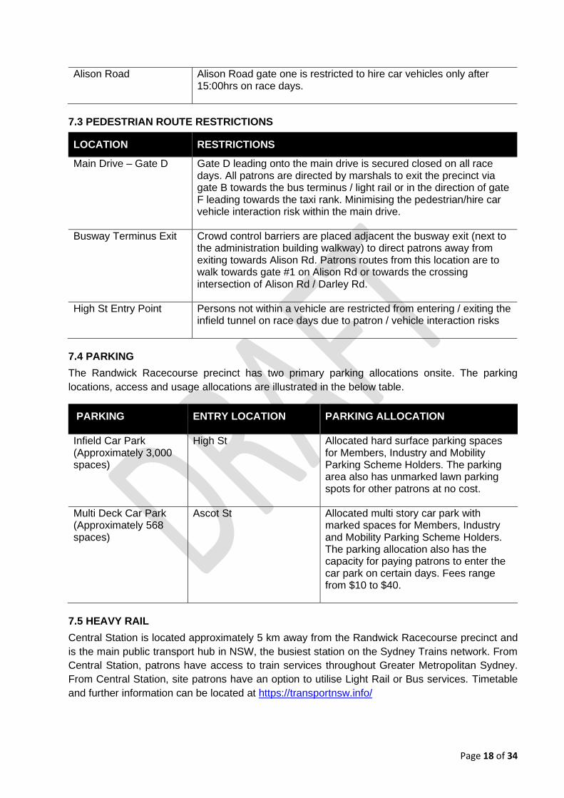
Alison Road Alison Road gate one is restricted to hire car vehicles only after 15:00hrs on race days.
7.3 PEDESTRIAN ROUTE RESTRICTIONS
LOCATION RESTRICTIONS
Main Drive – Gate D Gate D leading onto the main drive is secured closed on all race days. All patrons are directed by marshals to exit the precinct via gate B towards the bus terminus / light rail or in the direction of gate F leading towards the taxi rank. Minimising the pedestrian/hire car vehicle interaction risk within the main drive.
Busway Terminus Exit Crowd control barriers are placed adjacent the busway exit (next to the administration building walkway) to direct patrons away from exiting towards Alison Rd. Patrons routes from this location are to walk towards gate #1 on Alison Rd or towards the crossing intersection of Alison Rd / Darley Rd.
High St Entry Point Persons not within a vehicle are restricted from entering / exiting the infield tunnel on race days due to patron / vehicle interaction risks
7.4 PARKING
The Randwick Racecourse precinct has two primary parking allocations onsite. The parking
locations, access and usage allocations are illustrated in the below table.
PARKING ENTRY LOCATION
PARKING ALLOCATION
Infield Car Park (Approximately 3,000 spaces)
High St
Allocated hard surface parking spaces for Members, Industry and Mobility Parking Scheme Holders. The parking area also has unmarked lawn parking spots for other patrons at no cost.
Multi Deck Car Park (Approximately 568 spaces)
Ascot St
Allocated multi story car park with marked spaces for Members, Industry and Mobility Parking Scheme Holders. The parking allocation also has the capacity for paying patrons to enter the car park on certain days. Fees range from $10 to $40.
7.5 HEAVY RAIL
Central Station is located approximately 5 km away from the Randwick Racecourse precinct and
is the main public transport hub in NSW, the busiest station on the Sydney Trains network. From
Central Station, patrons have access to train services throughout Greater Metropolitan Sydney.
From Central Station, site patrons have an option to utilise Light Rail or Bus services. Timetable
and further information can be located at https://transportnsw.info/

Page 19 of 34
7.6 LIGHT RAIL
The CBD & South East Light Rail network, comprising of; L2 Randwick Line running in both
directions between Circular Quay and Randwick via Central Station; and L3 Kingsford Line
operating in both directions between Circular Quay and Juniors Kingsford via Central Station.
The Randwick Racecourse precinct is surrounded by light rail stops for site patrons to use. Royal
Randwick light rail stop is primarily the main stop for patron use due to the proximity to the site.
Kensington and Wansey Road light rail stops are also in close walking proximity for patron use.
The daily operating hours of light rail services are: - First service = start at approximately 05:00 - Last service = finish at approximately 01:00 (the following day)
On event days where event patronage exceeds 5,000 but is below 30,000 additional light rail
services (above the regular services) from Chalmers Street, Haymarket will be available to patrons
for events. The additional services will run as an ‘express shuttle’, meaning that the light rail vehicle
will not stop along the route between Chalmers Street, Haymarket and Royal Randwick stop at
Randwick. At ingress the ‘express shuttle’ will begin running 45 minutes prior to the event start time
and finish running 15 minutes after the event start time. On egress the ‘express shuttle’ will begin
running 15 minutes prior to the event finish time, running for a total of 60 minutes.
On event days where event patronage exceeds 30,000 additional light rail services (above the
regular services) from Chalmers Street, Haymarket will be available to patrons for 75 minutes on
ingress and 90 minutes on egress. At ingress the ‘express shuttle’ will begin running 60 minutes
prior to the event start time and finish running 15 minutes after the event start time. On egress the
‘express shuttle’ will begin running 30 minutes prior to the event finish time, running for a total of
90 minutes.
Light Rail services frequency will only be uplifted during two (2) time periods as indicated in the
below table.
Royal Randwick
Racecourse Special Event
Level
‘Bump- in’ (i.e. around start
of event)
‘Bump-out’ (i.e. around end
of event)
Low to Medium 7-8 minutes for 60 minutes 5 minutes for 60 minutes
High 5 minutes for 75 minutes 5 minutes for 90 minutes
During bump-in the main objective will be to manage the increased number of light rail passengers waiting to board a light rail service at Central, Chalmers Street Light Rail stop to an event in Randwick. Note: A tram travels in a loop between Central Chalmers Street – Royal Randwick – Central Chalmers Street in 30-40 minutes (dwell and layover time included).
During bump-out the main objective will be to manage the increased number of light rail passengers
waiting to board a light rail service at Royal Randwick Light Rail stop to return to Central, Chalmers
Street, other CBD stops, east to Randwick or south to Kensington.
Resourcing and management responsibility of the light rail stop is facilitated and managed by
Transport for NSW through a partnership with Trans Dev.

Page 20 of 34
The Australian Turf Club would like to work with Transport for NSW on a strategy which encourages
patrons to use the Kensington light rail stop as it is within walking distance of the Randwick
Racecourse precinct. Further use of the Kensington light rail stop would reduce the patron usage
of the Royal Randwick stop during peak egress periods.
Figure 5 – Light Rail Map
7.7 BUS SERVICES
The Randwick Racecourse precinct is well served by Eastern Suburb bus services, with the nearest
stop at Alison Road, Randwick. This stop is located directly in front of the main gates of the
Randwick Racecourse. Services include 338, 339, 372, 373, 374, 376, 377 and M50. Other
important routes that service the Randwick precinct include regular bus routes on Anzac Parade
that provide connections between La Perouse/Maroubra/Kensington and the city. Further
information is available at https://transportnsw.info/
Special event buses are managed by Transport for NSW for during budgeted crowds of 30,000 +
patrons to/from an event and the nearest public transport hub, Central Station. Carnival race
days the Australian Turf Club offer integrated ticketing, with the public transport fare included in
the event ticket price. Integrated ticketing for special events encourages greater patronage to
events by public transport, reducing the reliance on car travel and improve operational efficiency.
7.8 PRIVATE COACHES (OVER 3.4M HIGH) / MINI BUS (UNDER 3.4M HIGH)
Coaches can be either pre-booked by the event organiser or by an event patron with a large
group of attendees. A coach can hold anywhere from 28 to 71 passengers, depending on the
hire company and the vehicle. Mini buses can seat 21 passengers, depending on the hire
company and vehicle.
Coaches and mini buses can set down passengers within the busway terminus on Alison Road.
Mini-buses under 3.4m high are to use the infield car park for all patron pick-ups and parking.
Designated pick-up area for private coaches over 3.4m high is located on the Eastern Side of
Darley Road, outside TAFE NSW Randwick.

Page 21 of 34
7.9 POINT TO POINT SERVICES
Point-to-point transport provides flexible, convenient options for patrons to get from A to B for a
fare, via the most direct route or route that the event patron chooses at a time that suits them.
Point-to-point transport includes taxis, tourist coach services, hire cars, rideshare services (Uber,
Ola and other) and other vehicles with12 seats or less (including the driver).
Taxi services are the only point-to-point transport which can carry out rank and hail services. At
the Royal Randwick racecourse precinct there is a dedicated taxi rank to set down and pick up for
passengers. The taxi rank is accessed via Ascot St.
Hire Car services are a pre-booked service by the user where set down occurs within designated
area of the taxi rank, located off Ascot St. Pick up (after 3pm) occurs within the main drive, located
off Alison Road – gate one. Stretch limousines are not permitted to access the taxi rank and main
drive and are directed to the infield car park by marshals. The restriction is applied due to the
reduced turning circles available onsite at times.
Rideshare services are a pre-booked service by the user where pick-up and set down usually
occurs at a location chosen by the user. During ingress and egress of major events (carnival days),
rideshare services will be restricted by a technology driven ‘geo-fence’ within the vicinity of the
Randwick Racecourse precinct. The ‘geo-fence’ will operate on events to prevent users within the
exclusion zone from hailing ridesharing services. Rideshare users will instead be directed by the
relevant app to first walk outside the exclusion area before being able to order a rideshare vehicle.
This will ensure ridesharing services will not adversely impact traffic or pedestrian movements in
the vicinity of the Randwick Racecourse precinct during ingress and the intensive post-event
egress period. The extents of the “geo-fence” covers Alison Road, Darley Road and High Street.
Rideshare patrons are currently directed by their rideshare apps to proceed to pick-up locations in
Doncaster Avenue and King Street, depending on their destination.
Other vehicles with 12 seats or less (including the driver) are a pre-booked service by the user.
The vehicle hire company may contact the event manager at the ATC to organise a space for
patron set down and pick-up. In the event that they do not pre-arrange coach arrival at the Royal
Randwick Racecourse, coach services will use the allocated space on Alison Road west of
Doncaster Avenue where a clearway is set-up specifically for coaches.
7.10 HELICOPTERS
Patrons using helicopters to attend the Randwick Racecourse precinct need to contact (02) 9637
4455 to book landings and departures.
7.11 ACTIVE TRANSPORT
The Randwick Racecourse precinct is well established with pedestrian infrastructure and footpaths
along all the streets in the vicinity. As such, walking trips between the racecourse and the local
resident precinct or nearby public transport facilities is readily achievable.
As a major event precinct, regularly catering to large crowds, walking access to the Randwick
Racecourse precinct would be focused on patrons who may live in close proximity to the
racecourse. Event patrons may also walk from background bus and light rail services such as from
Kingsford, ES Marks Light Rail stop, where patrons will walk from Anzac Parade. Other locations
may include from Randwick where there are connections with background buses from the Eastern
Suburbs.

Page 22 of 34
Figure 6 – Walking Routes Map
The Randwick Racecourse precinct is located adjacent to the Centennial Parklands which boasts
a height of cycling activity. With numerous shared paths and safe cycling routes in the Randwick
precinct, cycling is an attractive activity especially in the warmer months.
Figure 7 – Cycling Routes Map

Page 23 of 34
7.12 CONSTRUCTION, TRAFFIC CALMING & TRAFFIC GENERATING DEVELOPEMENTS
Construction, traffic calming, and traffic generating developments will need to be continually reviewed with relevant precinct stakeholders. At this stage there have been no major traffic generators - no significant council construction, development, demolition works in progress and no large-scale events in the area which would have an adverse effect on the Randwick Racecourse precinct.
7.13 NSW POLICE
NSW Police officers under a user pay scheme are deployed for all race days with the budgeted attendance of 7,000 + patrons. Deployment positions covered by NSW Police relating to pedestrian, traffic and transport management are;
- Alison Rd / Darley Road Intersection - Alison Road / Gate 1 Intersection - Ascot St Roundabout - High St (large carnival days)
7.14 NSW FIRE & RESCUE AND NSW AMBULANCE
Emergency services such as NSW Ambulance and Fire & Rescue access routes are available at the Randwick Racecourse precinct and are of width ≥3.5m.

Page 24 of 34
7.15 CONTINGENCY PLANS
The following contingency responses are proposed given various scenarios.
SCENARIO CONTINGENCY RESPONSE RESPONSIBILITY
Total failure of all VMS Traffic marshals to be deployed at points to direct traffic if deemed necessary.
ATC
Heavy rain causing patron vehicles to
bog down at the infield car park
Engagement of a tow truck company or onsite tractors to assist where suitable.
ATC
Royal Randwick Racecourse
parking full (partial)
Traffic control and parking attendants deployed at gates to direct patrons to nearest available parking areas. VMS notification to all patrons of circumstances.
ATC
All car parks full ATC communicate to TMC and ask for directional messages to be
included in RMS live traffic notices.
ATC/
Transport NSW – TMC
Unplanned disruption to transport arrangements
Australian Turf Club and TMC to work collaboratively to ensure all public communications align without conflicting customer messages.
ATC/
Transport NSW – TMC
Mass egress of vehicles from the multi storey car park, taxi rank and patron foot traffic onto Ascot St.
Direct all vehicular traffic exiting the multi storey car park through the
rear of the venue (black gates) and out onto Bowral lane to Doncaster Ave. Deployment of this contingency response could elevate
up to 568 vehicles exiting onto Ascot St. Stop/Slow traffic control scheme should be considered on Doncaster for the safe egress of vehicles.
ATC

Page 25 of 34
7.16 HEAVY VEHICLE IMPACTS
Intact Solutions does not envisage that the proposed traffic control arrangements will significantly impact heavy vehicle traffic in the local community due to the day of week and timing of events.
7.17 SPECIAL EVENT CLEARWAYS
Event day special event clearways are enforced to provide capacity on the road network. Notably, High Street (northern kerb) between Wansey Road and Anzac Parade, Ascot Street between the Randwick Racecourse entrance and Doncaster Avenue, Darley Road between the Centennial Parklands Randwick Gates and Alison Road and Alison Road between Doncaster Avenue and Anzac Parade have enforced clearways. These clearways are enforced between 10am and 7pm.
7.18 ROAD CLOSURES
Road closures are not proposed around the Randwick Racecourse precinct.
7.19 RMS AUTHORISED TRAFFIC CONTROLLERS
Traffic controllers are deployed during events which have a budgeted crowd of 7,000 + patrons’ attendance. The traffic controllers are deployed to carry out access control /motorist guidance duties at strategic access locations to the Randwick Racecourse precinct. The areas covered by traffic controllers are High St infield tunnel, Alison Rd bus terminus, Ascot St taxi rank and Alison Rd gate one. Traffic controllers are not deployed to carry out stop/slow scheme or altering roadway conditions.
7.20 LIGHT PHASING TECHNICIANS
Light phasing technicians are not deployed for traffic, transport and pedestrian management requirements. During large carnival race days in consultation with the NSW Police and Transport for NSW event mode light phasing patterns are activated at the Alison Rd / Darley Rd intersection to increase the patron throughput. At High St / Racecourse entry intersection and High St/ Anzac Pde event phasing is also activated during egress to increase the vehicular throughput leaving the infield car park.
7.21 TAXI COUNCIL COMMISSIONAIRES
The NSW Taxi Council provide two Taxi Commissionaires which are located at the taxi rank for all large carnival race days. The Taxi Commissionaires assist with the management of the taxi rank, patron management and directional advice to taxi drivers.
7.22 POINT TO POINT TRANSPORT COMPLIANCE OFFICERS
Point to point transport compliance officers are requested by the Australian Turf Club to attend the Randwick Racecourse precinct during all large carnival days. Point to point compliance officers undertake random vehicle inspections and ensure relevant transport guidelines are adhered to by drivers and service users.
8. MINIMISING IMPACT
8.1 ACCESS FOR LOCAL RESIDENTS, BUSINESSES, HOSPITALS & EMERGENCY
VEHICLES
Access for local residents and businesses will not be restricted. Access to the precinct will be available for emergency service vehicles at all times.

Page 26 of 34
8.2 ADVERTISING TRAFFIC AND TRANSPORT ARRANGEMENTS
The Australian Turf Club and Transport for NSW collaborate to prepare communication material for events. Transport for NSW has a ‘Getting to events’ webpage https://transportnsw.info/events This website provides information on traffic and transport for events across NSW. Key information includes:
- Day, date, location and time of event
- Promotion and benefits of public transport
- Promotion of park and ride, if operating
- A link to plan your trip to the event via public transport
- Various transport options including Metro, Train, Light Rail, Bus, Ferry
- Opal ticketing information
- A link to ‘Live Traffic NSW’, if you choose to drive
The Australian Turf Club also publishes transport options on their official website, which is available for patron viewing and planning. Webpage https://www.australianturfclub.com.au/royal-randwick/royal-randwick-transport/
8.3 PERMANENT VARIABLE MESSAGE SIGNS [PVMS]
The use of PVMS is supported subject to Transport for NSW endorsement and approval.
8.4 PORTABLE VARIABLE MESSAGE SIGNS [VMS]
Variable Message Signs are critical for the flawless operation of traffic and pedestrian management. The VMS allocation is proposed and is subject to change as operational requirements arise. The following table summarises the VMS schedule.
VMS #1 Alison Road @ Main Gate (footpath near light pole)
VMS 1 - Msg 1
Frame 1
(3 sec.)
P A R K I N G
Deployment Dates - TBC
06:00 – 15:30
V I A
H I G H S T
Frame 2
(3 sec.)
N O D R O P
O F F H E R E
VMS 1 - Msg 2
Frame 1
(3 sec.)
C A U T I O N
Deployment Dates - TBC
15:30 – 20:00
S L O W
D O W N
Frame 2
(3 sec.)
N O
P I C K U P
H E R E

Page 27 of 34
VMS #2 Anzac Parade & Abbotsford St – Side of road/footpath
VMS 2 - Msg 1
Frame 1
(3 sec.)
T A X I R A N K
Deployment Dates - TBC
06:00 – 15:30
V I A
A S C O T S T
Frame 2
(3 sec.)
P A R K I N G
V I A
H I G H S T
VMS 2 - Msg 2
Frame 1
(3 sec.)
P A R K I N G
Deployment Dates - TBC
15:30 – 20:00
V I A
A S C O T S T
Frame 2
(3 sec.)
C A U T I O N
S L O W
D O W N
VMS #3 Anzac Parade & Ascot Street – side of road/footpath
VMS 3 - Msg 1
Frame 1
(3 sec.)
T A X I
Deployment Dates - TBC
06:00 – 15:30
R A N K
< < < < < < < <
Frame 2
(3 sec.)
C A U T I O N
S L O W
D O W N
VMS 3 - Msg 2
Frame 1
(3 sec.)
T A X I
Deployment Dates - TBC
15:30 – 20:00
R A N K
< < < < < < < <
Frame 2
(3 sec.)
C A U T I O N
S L O W
D O W N

Page 28 of 34
VMS #4 Intersection of Darley Rd & Alison Rd (entrance to new busway)
VMS 4 - Msg 1
Frame 1
(3 sec.)
S T A B U S
Deployment Dates - TBC
06:00 – 15:30
D R O P O F F
& P I C K U P
Frame 2
(3 sec.)
P R I V A T E
B U S D R O P
O F F O N L Y
VMS 4 - Msg 2
Frame 1
(3 sec.)
S T A B U S
Deployment Dates - TBC
15:30 – 20:00
D R O P O F F
& P I C K U P
Frame 2
(3 sec.)
N O P A R T Y
B U S
P I C K U P
VMS #5 Intersection of Alison Road & Wansey Road (SE side of intersection)
VMS 5 - Msg 1
Frame 1
(3 sec.)
R A N D W I C K
Deployment Dates - TBC
06:00 – 15:30
R A C E D A Y
Frame 2
(3 sec.)
N O D R O P
O F F P A S T
T H I S
P O I N T
VMS 5 - Msg 2
Frame 1
(3 sec.)
R A N D W I C K
Deployment Dates - TBC
15:30 – 20:00
R A C E D A Y
Frame 2
(3 sec.)
C A U T I O N
S L O W
D O W N

Page 29 of 34
VMS #6 Rose Garden Lawn (Internal)
B U S E S
Deployment Dates - TBC
15:30 – 20:00
> > > > > > > >
> > > > > > > >
Frame 2
(3 sec.)
L I G H T
R A I L
> > > > > > > >
Frame 3
(3 sec.)
T A X I
R A N K
< < < < < < < <
VMS #7 Gate E (Internal)
Frame 1
(3 sec.)
B U S E S T O
Deployment Dates - TBC
15:30 – 20:00
C E N T R A L
> > > > > > > >
Frame 2
(3 sec.)
L I G H T
R A I L
> > > > > > > >
Frame 3
(3 sec.)
T A X I R A N K
A S C O T S T
< < < < < < < <
Page 30 of 34
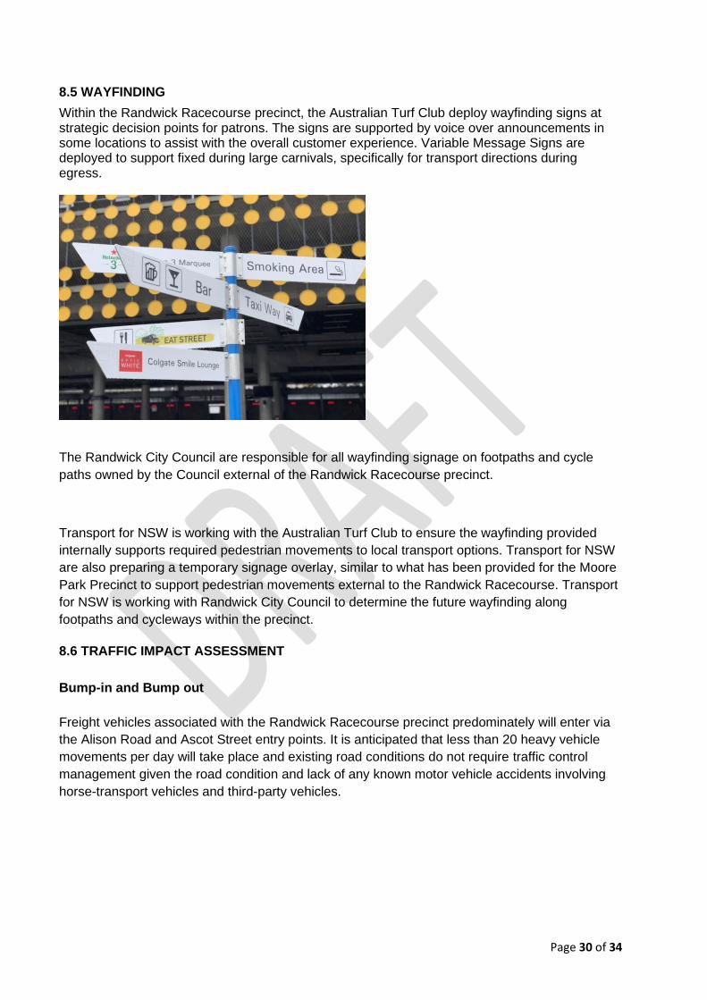
8.5 WAYFINDING
Within the Randwick Racecourse precinct, the Australian Turf Club deploy wayfinding signs at strategic decision points for patrons. The signs are supported by voice over announcements in some locations to assist with the overall customer experience. Variable Message Signs are deployed to support fixed during large carnivals, specifically for transport directions during egress.
The Randwick City Council are responsible for all wayfinding signage on footpaths and cycle
paths owned by the Council external of the Randwick Racecourse precinct.
Transport for NSW is working with the Australian Turf Club to ensure the wayfinding provided
internally supports required pedestrian movements to local transport options. Transport for NSW
are also preparing a temporary signage overlay, similar to what has been provided for the Moore
Park Precinct to support pedestrian movements external to the Randwick Racecourse. Transport
for NSW is working with Randwick City Council to determine the future wayfinding along
footpaths and cycleways within the precinct.
8.6 TRAFFIC IMPACT ASSESSMENT
Bump-in and Bump out
Freight vehicles associated with the Randwick Racecourse precinct predominately will enter via
the Alison Road and Ascot Street entry points. It is anticipated that less than 20 heavy vehicle
movements per day will take place and existing road conditions do not require traffic control
management given the road condition and lack of any known motor vehicle accidents involving
horse-transport vehicles and third-party vehicles.

Page 31 of 34
Event Day
The subject roads exposed to main event day traffic impacts are:
- Alison Road – main thoroughfare to adjoining roads
- High St – patron vehicles entering and exiting the Randwick Racecourse precinct
- Ascot St – vehicle entering to access the multi-story car park, hire car drop off, ride share
drop off and taxi drop off and collection.
A: Alison Road is the main patron thoroughfare and some queuing is anticipated. The bus way
entry and exit points are situated along Alison Road and the venues main drive (Gate 1). This
road is long enough and sign-posted to accommodate ‘stacking’ of some 120 + cars in both
eastern and western / southern legs adjacent the Racecourse premises. This allows for minor
delays to be handled without impact on main roads leading of Alison Road or substantial effect
on the local community.
B: Delays on High St have proven to be very short on previous years (e.g. 3min. at a time). High
St is subject to additional vehicular movement due to the infield entry point being the main
thoroughfare for vehicular entry and exit. Special event clearways and event phasing light
patterns are deployed on large carnival days to assist with minimising stationary queuing.
C: Ascot St during event ingress have proven to be short with minimal queuing of vehicles.
During egress due to the surge of patron movement it is expected some queuing will occur,
particularly on large carnival days. Special event clearways are deployed to support a clear
delineation of pedestrians and vehicles. During carnival periods it will also be considered after
further consultation that all vehicles exiting the multi-story car park (up to 568 car spots) are
directed to leave via Bowral lane instead of Ascot St.

Page 32 of 34
9. AUSTRALIAN TURF CLUB PARKING PASSES

Page 33 of 34

Page 34 of 34
10. OPERATING POSTURES OVERVIEW
Item Posture #1
Administration
#2 Event (non-
raceday)
#3 Raceday -
Midweek
#4 Raceday -
Budgeted
<7,000 patrons
attendance
#5 Raceday -
Budgeted 7,000
to 15,000
patrons
attendance
#6 Raceday -
Budgeted
15,000 to
30,000 patrons
attendance
#7 Raceday -
Budgeted
30,000 >
patrons
attendance
#8 Other large
mass
gatherings
Bus
STA Buses
Schedule
STA Buses
Schedule
STA Buses
Schedule
STA Buses
Schedule
STA Buses
Schedule.
Private buses
drop off at the
busway
terminus
STA Buses
Schedule.
Private buses
drop off at the
busway terminus
STA Buses
Schedule.
Private buses
drop off at the
busway
terminusSpecial
Event Buses
Deployed
Hire Car
Self Manage -
Main Drive
Self Manage -
Main Drive
Self Manage -
Main Drive
Yes - Drop off at
Taxi Rank &
Pickup from
Main Drive
(after 3pm)
Yes - Drop off at
Taxi Rank &
Pickup from
Main Drive
(after 3pm)
Yes - Drop off at
Taxi Rank &
Pickup from
Main Drive
(after 3pm)
Yes - Drop off
at Taxi Rank &
Pickup from
Main Drive
(after 3pm)
Lightrail
Light Rail
Transport
Schedule
Light Rail
Transport
Schedule
Light Rail
Transport
Schedule
Light Rail
Transport
Schedule
Light Rail
Transport
Schedule
Light Rail
Transport
Schedule
Light Rail
Transport
Schedule
Other vehicles with 12 seats or less that
provide passenger transport services for a fee Yes - Main Drive Yes - Main Drive Yes - Main Drive
Yes - Stretch
Limousine
Pickup/Drop off
at Infield
Yes - Stretch
Limousine
Pickup/Drop off
at Infield
Yes - Stretch
Limousine
Pickup/Drop off
at Infield
Yes - Stretch
Limousine
Pickup/Drop off
at Infield
Rideshare Yes - Main Drive Yes - Main Drive Yes - Main Drive
Yes - Drop off at
Taxi and Collect
from
surrounding
roadways
Yes - Drop off at
Taxi and Collect
from
surrounding
roadways
(rideshare GEO
fence activated)
Yes - Drop off at
Taxi and Collect
from
surrounding
roadways
(rideshare GEO
fence activated)
Yes - Drop off
at Taxi and
Collect from
surrounding
roadways
(rideshare GEO
fence activated)
Taxi Yes - Main Drive Yes - Main Drive Yes - Taxi Rank Yes - Taxi Rank Yes - Taxi Rank Yes - Taxi Rank Yes - Taxi Rank
Car Park / Venue Attendants None Yes Yes Yes Yes Yes Yes
NSW Police Userpay (Pedestrian & Traffic
Management) None None None None
Yes (Carnival
Racedays Only) Yes Yes
Point to Point Compliance Officers None None None None
Yes (Carnival
Racedays Only) Yes Yes
RMS Authorised Traffic Controllers None None None None Yes Yes Yes
Taxi Council Commissionaires None None None None
Yes (Carnival
Racedays Only) Yes Yes
NSW Police Userpay (Pedestrian & Traffic
Management) None None None None Yes Yes Yes
Permament Variable Message Signs None None None None None Yes Yes
Portable Variable Message Signs None None None None
Yes (Carnival
Racedays Only) Yes Yes
Road/Lane Occupancy (RMS ROL or Council None None None None None None None
Special Event Clearways None None None None None Yes Yes
TMC Traffic Light Phasing None None None None None Yes Yes
Transport
Pedestrian & Traffic
Management -
Equipment &
Services
Even
t Sp
ecif
ic A
rran
gem
ents
Pedestrian & Traffic
Management -
Personnel