Embed Size (px)
Citation preview

April 2008Version 1.4
TOWARDS A MORE
SUSTAINABLE REGION
D1
6-0
60
27-O
G
PEDESTRIAN & CYCLING
MASTER PLAN STUDY
F I N A L R E P O R T

iMMM GROUP LIMITED | GO FOR GREEN | DECIMA | APRIL 2008 | FINAL REPORT
ACKNOWLEDGEMENTS
EXECUTIVE SUMMARY
CHAPTER 1 INTRODUCTION ...............................................................................................................................1-11.1 WHAT IS A MASTER PLAN? ..................................................................................................................................1-3
1.2 THE STUDY PROCESS ...........................................................................................................................................1-4
1.3 ORGANIZATION OF THE STUDY REPORT ................................................................................................................1-6
CHAPTER 2 WHY A REGIONAL PEDESTRIAN AND CYCLING PLAN IS NEEDED ....................................................2-12.1 SUPPORTS TRANSPORTATION CHOICES FOR A GROWING REGION.......................................................................2-1
2.2 INCREASING DEMAND FOR PEDESTRIAN AND CYCLING INFRASTRUCTURE .........................................................2-22.2.1 DECIMA RESEARCH .........................................................................................................................................2-22.2.2 WEB BASED WALKABILITY AND BIKEABILITY OUTREACH SURVEY ..................................................................................2-42.2.3 RESPONDING TO WHAT YORK REGION RESIDENTS HAVE ASKED FOR .............................................................................2-8
2.3 BENEFITS TO WALKING AND CYCLING ..................................................................................................................2-8
2.4 SUPPORTS REGIONAL PUBLIC TRANSIT .............................................................................................................2-12
2.5 A NEED FOR COORDINATION ...............................................................................................................................2-13
2.6 BUSINESS CASE FOR INVESTING IN PEDESTRIAN AND CYCLING INFRASTRUCTURE ..........................................2-13
CHAPTER 3 TOWARDS A MORE SUSTAINABLE REGION .....................................................................................3-13.1 MOVING TOWARDS SUSTAINABLE TRANSPORTATION ..........................................................................................3-1
3.2 POLICIES AND INITIATIVES OF OTHER JURISDICTIONS ..........................................................................................3-5
3.3 A VISION FOR WALKING AND CYCLING IN YORK REGION ......................................................................................3-9
3.4 GOALS ................................................................................................................................................................3-10
CHAPTER 4 OUTREACH ......................................................................................................................................4-14.1 EDUCATION ..........................................................................................................................................................4-1
TABLE OF CONTENTS
ii
YORK REGION | PEDESTRIAN & CYCLING MASTER PLAN STUDY | TABLE OF CONTENTS | FINAL REPORT
4.1.1 BICYCLE EDUCATION INFORMATION .......................................................................................................................4-14.1.2 FUNDING AND DELIVERY OF BICYCLE EDUCATION PROGRAMS .......................................................................................4-34.1.3 FOCUSED SAFETY CAMPAIGNS ............................................................................................................................4-44.1.4 RESPONSE PROCESS TO COLLISIONS ....................................................................................................................4-54.1.5 CYCLING, WALKING AND CHILDREN .....................................................................................................................4-64.1.6 ACTIVE AND SAFE ROUTES TO SCHOOL .................................................................................................................4-94.1.7 ENFORCEMENT OBJECTIVES ...............................................................................................................................4-9
4.2 ENCOURAGEMENT AND PROMOTION ..................................................................................................................4-104.2.1 PUBLIC ADVISORY COMMITTEE .........................................................................................................................4-104.2.2 END-OF-TRIP FACILITIES .................................................................................................................................4-104.2.3 LEADERSHIP BY EXAMPLE ...............................................................................................................................4-114.2.4 INTERMODAL CONNECTIONS .............................................................................................................................4-114.2.5 CYCLING MAPS ...........................................................................................................................................4-134.2.6 BICYCLE USER GROUPS .................................................................................................................................4-134.2.7 WORK WITH OTHERS ...................................................................................................................................4-144.2.8 TOURISM ...................................................................................................................................................4-18
4.3 MOVING FORWARD .............................................................................................................................................4-20
CHAPTER 5 IMPROVING FACILITIES FOR WALKING AND CYCLING IN YORK REGION ..........................................5-15.1 REGIONAL PEDESTRIAN SYSTEM..........................................................................................................................5-1
5.2 CYCLING FACILITY TYPES ....................................................................................................................................5-25.2.1 MULTI-USE TRAILS.........................................................................................................................................5-25.2.2 PAVED SHOULDER / BIKE LANE ..........................................................................................................................5-45.2.3 SIGNED-ONLY ROUTE ......................................................................................................................................5-4
5.3 NETWORK AND SYSTEM DEVELOPMENT APPROACH ...........................................................................................5-55.3.1 ROUTE SELECTION PRINCIPLES ...........................................................................................................................5-55.3.2 REVIEW AND UPDATE INVENTORY OF EXISTING CONDITIONS .........................................................................................5-65.3.3 IDENTIFY MAJOR ATTRACTIONS AND DESTINATIONS ...................................................................................................5-75.3.4 IDENTIFY BARRIERS TO WALKING AND CYCLING .......................................................................................................5-75.3.5 EXISTING CONTEXT .........................................................................................................................................5-85.3.6 CANDIDATE ROUTE EVALUATION CRITERIA ..............................................................................................................5-85.3.7 CANDIDATE ROUTES ........................................................................................................................................5-8

iiiMMM GROUP LIMITED | GO FOR GREEN | DECIMA | APRIL 2008 | FINAL REPORT
5.4 IMPROVING CONDITIONS FOR WALKING IN THE REGION ....................................................................................5-115.4.1 COMPLETE MISSING SIDEWALK LINKS ................................................................................................................5-115.4.2 IMPROVE URBAN DESIGN AND STREETSCAPING IN PEDESTRIAN ZONES ..........................................................................5-125.4.3 IMPROVE PEDESTRIAN CONNECTIVITY AND ACCESSIBILITY ..........................................................................................5-125.4.4 PROPOSED PEDESTRIAN SYSTEM ......................................................................................................................5-15
5.5 THE REGIONAL CYCLING NETWORK ...................................................................................................................5-155.5.1 NETWORK OPPORTUNITIES ..............................................................................................................................5-19
5.6 RECOMMENDED ACTIONS ..................................................................................................................................5-23
CHAPTER 6 IMPLEMENTATION STRATEGY ..........................................................................................................6-16.1 TEN-YEAR IMPLEMENTATION PLAN AND LONGER TERM STRATEGY ....................................................................6-1
6.2 INFRASTRUCTURE PRIORITIES .............................................................................................................................6-26.2.1 PEDESTRIAN .................................................................................................................................................6-36.2.2 CYCLING ......................................................................................................................................................6-36.2.3 LONG TERM STRATEGY FOR PEDESTRIAN AND CYCLING ..............................................................................................6-7
6.3 OUTREACH PRIORITIES .........................................................................................................................................6-7
6-4 IMPLEMENTING ON-ROAD CYCLING FACILITIES AND THE CLASS EA PROCESS IN ONTARIO ..............................6-10
6.5 PLANNING AND DESIGN GUIDELINES ..................................................................................................................6-11
6.6 INTEGRATING THE PEDESTRIAN AND CYCLING MASTER PLAN WITH SMART COMMUTE (TDM) AND OTHER REGIONAL SERVICES AND PROGRAMS ...........................................................................................6-12
6.7 IMPLEMENTING THE MASTER PLAN ...................................................................................................................6-126.7.1 PEDESTRIAN AND CYCLING PUBLIC ADVISORY COMMITTEE ........................................................................................6-136.7.2 PEDESTRIAN/CYCLING COORDINATOR ..................................................................................................................6-136.7.3 ESTABLISH AN INTER-MUNICIPAL WORKING GROUP ................................................................................................6-146.7.4 IMPLEMENTATION STRUCTURE ...........................................................................................................................6-146.7.5 THE IMPLEMENTATION PROCESS TOOL ................................................................................................................6-14
6.8 FUNDING THE PLAN (NETWORK AND PROGRAM) ................................................................................6-196.8.1 WHAT IS THE INVESTMENT? ............................................................................................................................6-206.8.2 WHERE WILL THE MONEY COME FROM? ............................................................................................................6-24
6.9 WHY SHOULD THE REGION MAKE THE INVESTMENT? .........................................................................6-25
6.10 RECOMMENDED IMPLEMENTATION SCHEDULE ............................................................................................6-26

iv
YORK REGION | PEDESTRIAN & CYCLING MASTER PLAN STUDY | TABLE OF CONTENTS | FINAL REPORT
6.11 LIABILITY AND RISK MANAGEMENT .....................................................................................................6-31
6.12 EVALUATING THE PCMP .......................................................................................................................6-32
6.13 NEXT STEPS ........................................................................................................................................................6-33
LIST OF TABLESEX-1 PROPOSED LENGTH OF REGIONAL PEDESTRIAN AND CYCLING NETWORK BY FACILITY
TYPE AND IMPLEMENTATION PHASE ................................................................................................................................. EX-6
EX-2 RECOMMENDED ACTIONS ........................................................................................................................................... EX-11
4-1 CHILD-AND-YOUTH-FRIENDLY LAND-USE AND TRANSPORT PLANNING GUIDELINES ..........................................................................4-7
5-1 ROUTE EVALUATION CRITERIA .........................................................................................................................................5-9
5-2 PROPOSED MISSING SIDEWALK LINKS ON REGIONAL ROADS BY TYPE AND JURISDICTION ................................................................5-16
5-3 PROPOSED LENGTH OF REGIONAL CYCLING NETWORK BY FACILITY TYPE AND JURISDICTION .............................................................5-18
6-1 TEN-YEAR IMPLEMENTATION AND INVESTMENT PLAN .............................................................................................................6-22
6-2 PROPOSED LENGTH OF REGIONAL PEDESTRIAN AND CYCLING NETWORK BY FACILITY TYPE AND IMPLEMENTATION PHASE .................................................................................................................................6-23
6-3 RECOMMENDED ACTIONS .............................................................................................................................................6-27
6-4 PERFORMANCE MEASURES ...........................................................................................................................................6-34
LIST OF FIGURESEX-1 PROPOSED PEDESTRIAN SYSTEM IMPLEMENTATION SCHEDULE
PHASE 1 AND PHASE 2 .............................................................................................................................................. EX-8
EX-2 PROPOSED CYCLING NETWORK IMPLEMENTATION SCHEDULE PHASE 1 ....................................................................................... EX-9
EX-3 PROPOSED CYCLING NETWORK IMPLEMENTATION SCHEDULE PHASE 2 ..................................................................................... EX-10
2-1 DESTINATION OF YORK REGION COMMUTERS .......................................................................................................................2-2
2-2 DO DRIVERS BEHAVE WELL WHEN YOU CYCLE ...................................................................................................................2-3
2-3 HOW CHILDREN GET TO SCHOOL IN YORK REGION ................................................................................................................2-3
2-4 SURFACE TYPE PREFERENCE ...........................................................................................................................................2-5
2-5 WALKING CONDITIONS ..................................................................................................................................................2-5
2-6 DRIVER BEHAVIOUR .....................................................................................................................................................2-6
2-7 CYCLING CONDITIONS ...................................................................................................................................................2-6
2-8 CYCLING SAFETY .........................................................................................................................................................2-7

vMMM GROUP LIMITED | GO FOR GREEN | DECIMA | APRIL 2008 | FINAL REPORT
2-9 DRIVER BEHAVIOUR .....................................................................................................................................................2-7
5-1 MULTI-USE PATH ........................................................................................................................................................5-2
5-2 EXAMPLE OF AN URBAN ROAD CROSS SECTION WITH 1.5 M BIKE LANES ....................................................................................5-3
5-3 TYPICAL BIKE LANE WITH AND WITHOUT ON-STREET PARKING ................................................................................................5-4
5-4 TYPICAL PAVED SHOULDER ............................................................................................................................................5-4
5-5 SIGNED-ONLY CYCLING ROUTE ALONG A WIDE CURB LANE .....................................................................................................5-5
5-6 NETWORK DEVELOPMENT ROUTES ..................................................................................................................................5-10
5-7 YORK REGION PEDESTRIAN SYSTEM STRATEGY ..................................................................................................................5-13
5-8 PROMOTING SUSTAINABLE TRANSPORTATION THROUGH SITE DESIGN .........................................................................................5-14
5-9 PROPOSED CYCLING NETWORK ......................................................................................................................................5-17
5-10 PROPOSED LAKE-TO-LAKE ROUTE..................................................................................................................................5-21
5-11 ILLUSTRATED CONCEPT OF THE PROPOSED TERRY FOX BIKEWAY ..............................................................................................5-23
5-12 PROPOSED TERRY FOX BIKEWAY ROUTE ..........................................................................................................................5-23
6-1 PHASE 1 AND PHASE 2 PEDESTRIAN SYSTEM IMPLEMENTATION SCHEDULE ...................................................................................6-4
6-2 PHASE 1 CYCLING NETWORK IMPLEMENTATION SCHEDULE, YEAR 0-5 ........................................................................................6-5
6-3 PHASE 2 CYCLING NETWORK IMPLEMENTATION SCHEDULE, YEAR 6-10 ......................................................................................6-6
6-4 PROPOSED PEDESTRIAN SYSTEM IMPLEMENTATION SCHEDULE PHASE 3 .......................................................................................6-8
6-5 PROPOSED CYCLING NETWORK IMPLEMENTATION SCHEDULE PHASE 3 .........................................................................................6-9
6-6 IMPLEMENTATION STRUCTURE ........................................................................................................................................6-15
6-7 NETWORK IMPLEMENTATION PROCESS ..............................................................................................................................6-17
LIST OF APPENDICES APPENDIX A - PROPOSED PEDESTRIAN AND CYCLING NETWORK
APPENDIX B - INVESTMENT DETAILS
ADDITIONAL DOCUMENTATION (PROVIDED SEPARATELY) APPENDIX C - PLANNING AND DESIGN GUIDELINES
APPENDIX D - PROJECT RECORD

YORK REGION | PEDESTRIAN & CYCLING MASTER PLAN STUDY | TABLE OF CONTENTS | FINAL REPORT
MIC
HAEL
HAY
NES
Active Transportation Workshop, June 2006

A-1MMM Group LiMited | Go for Green | deciMa | apriL 2008 | finaL report
the region of York pedestrian and cycling Master plan Study team would like to express their appreciation to the following key people and organizations that contributed to the development of this York region pedestrian and cycling Master plan.
Regional Staff Study Steering Committee
Bryan tuckey planning and development Services department
paul May infrastructure planning planning and development Services department
Loy cheah infrastructure planning planning and development Services department
richard Hui infrastructure planning planning and development Services department
eric Gupta infrastructure planning planning and development Services department
rosa ruffolo infrastructure planning planning and development Services department
dino Basso roads transportation Services department
Sean Woods roads transportation Services department
carmen Hui roads transportation Services department
Melanie Shaw transit transportation Services department
Laura-atkins paul Long range planning planning and development Services department
Heather Konefat community planning planning and development Services department
paul Belton community planning planning and development Services department
Vicki Morley Healthy Lifestyles division, public Health Branch community and Health Services department
Helen doyle Health protection division, public Health Branch community and Health Services department
chris Bullen regional police Services
acKnoWLedGeMentS

A-2
YorK reGion | pedeStrian & cYcLinG MaSter pLan StudY | acKnoWLedGeMentS | finaL report
Technical Advisory Committee
Karyn Stone town of Georgina
Brock Mcdonald town of Georgina
Velvet ross town of Georgina
cindy Wackett town of newmarket
Mark agnoletto town of newmarket
Lorenzo Mele town of Markham
Sabbir Saiyed town of Markham
Marcel Lanteigne town of richmond Hill
George flint town of richmond Hill
tracey Steele town of richmond Hill
rick Leclair town of east Gwillimbury
Gary Shropshire town of east Gwillimbury
david atkins town of aurora
andrew Mcneely town of Whitchurch-Stouffville
paul Whitehouse town of Whitchurch-Stouffville
aaron Hershoff city of Vaughan
catherine purcell township of King
Jessica peake York district School Board
Jane ross York district School Board
dawn adams York district School Board
Giovanna de Girolamo catholic district School Board
Michael Bender toronto region conservation authority
april Mathes toronto region conservation authority
tom Hogenbirk Lake Simcoe region conservation authority
Public Advisory Committee
dwight richardson (chair)
peter rusch (Vice-chair)
Graham Bonesteel
Bill coffman
robert Hunn
Jeroen Louwers
Barbara Montgomery
ian parsons
debra Scott
Harold Sellers
chuck Suikki
ingrid Szeptycki
Jane twinney
Klaus Wehrenberg
darryl Young

A-3MMM Group LiMited | Go for Green | deciMa | apriL 2008 | finaL report
Consultant Team
MMM Group Limited
dave McLaughlin project Manager
dave richardson Senior traffic engineering advisor
Bob Koziol Senior road design advisor
Mark inglis Landscape architect
ranjit Gill transportation designer
robert Grimwood project engineer
tammy dow transportation engineer
pam foster transportation planner
Joanne McLaughlin Graphic designer
Go For Green
Michael Haynes national active transportation coordinator
Decima Research Inc.
cary Brown Senior consultant
the York region pedestrian and cycling Master plan Study is the product of the hard work and effort of those listed above, as well as many others. We would like to thank the members of the public who gave of their time and energy in the development of this planning Study, especially those who participated in the public meetings and workshops, and the many others who provided written or verbal input to the study team.
on behalf of the study team and all those who contributed to this Master plan, it is our hope that the York region pedestrian and cycling Master plan provides York region and its partners with the tools necessary to improve conditions for walking and cycling and supports the region’s continued efforts “towards a More Sustainable region”.

YorK reGion | pedeStrian & cYcLinG MaSter pLan StudY | acKnoWLedGeMentS | finaL report
Active Transportation Workshop, June 2006
MM
M G
roup

EX-1MMM Group LIMITED | Go for GrEEn | DEcIMa | aprIL 2008 | fInaL rEporT
The regional Municipality of York is committed to implementing Vision 2026, a regional Strategic plan adopted by regional council in 2005 that embodies a comprehensive strategy built upon accepted sustainable development principles to achieve a more sustainable region. This means making smarter decisions about our lifestyle and health, growth management, community design, infrastructure and financial responsibilities that better integrate the economy, environment and community. With regard to moving people, it means assigning more priority to walking, cycling, public transit and car pooling and thereby providing a more balanced transportation system that places less emphasis on single occupant motor vehicle trips while reducing emissions of air pollutants and greenhouse gases. It means leaving our communities in a healthy state for our children and grandchildren.
The region has already built a strong foundation for sustainability through many key initiatives over the past years including:
a regional official plan based on the themes of natural �environment, economic vitality and healthy communities;
The Greening Strategy and Land Securement Initiative; �
Water for Tomorrow program; �
conventional public Transit (YrT) and rapid Transit (Viva); �
corporate clean air Task force; and �
a minimum LEED Silver Standard for new regional �facilities.
Most recently, the region has embarked on an update to the Transportation Master plan as well as other Infrastructure Master plans, is undertaking a review of the regional official plan, completed a York region Sustainability Strategy, and prepared this regional pedestrian and cycling Master plan.
The York region pedestrian and cycling Master plan (pcMp) is intended to guide the regional Municipality of York as it works with local municipalities over the next 25 years and beyond to implement a comprehensive pedestrian system and on and off-road region-wide cycling network. The pcMp also includes a set of supporting policies and programs to promote walking and cycling in the region.
The pcMp is founded on extensive consultation with the region’s partners and stakeholders, including staff at the regional and local municipal levels, and the general public. The purpose of the pcMp is to build upon the existing network of on and off-road pedestrian and cycling facilities as well as supporting programs in York region. This will help to improve walking and cycling conditions and encourage more people to walk and cycle more often.
The pcMp consists of a number of key components that are designed to work together to facilitate implementation. These include:
a recommended network of on and off-road pedestrian �and cycling facilities. These will cross jurisdictions, link local municipalities and key attractions, while encouraging
ExEcuTIVE SuMMarY
The York region pedestrian and
cycling Master plan (pcMp) is
intended to guide the regional
Municipality of York as it works
with local municipalities over
the next 25 years and beyond
to implement a comprehensive
pedestrian system and on and
off-road region-wide cycling
network.

EX-2
YorK rEGIon | pEDESTrIan & cYcLInG MaSTEr pLan STuDY | ExEcuTIVE SuMMarY | fInaL rEporT
utilitarian, leisure, recreational, and touring pedestrian and cycling trips;
comprehensive planning and design guidelines to equip �staff with the necessary tools to implement the network so that facilities can be designed in a way that minimizes risk to pedestrians and cyclists, as well as motorists;
policy and program suggestions on how to increase the level �of walking and cycling in York region;
a proposed organizational structure to administer the pcMp �and to introduce a process for planning, designing and implementing pedestrian and cycling facilities in the region; and
an implementation strategy that identifies priorities and �required investments, sets out a fiscally sound approach to implementation, and provides a pedestrian and cycling network implementation process that can be integrated into annual service, capital investment and delivery programs.
The pcMp goes beyond simply identifying routes and recommending policies. It provides the steps and tools necessary for the region and its partners to implement and maintain the pcMp.
Vision
The Vision is based on the principle of assigning more priority to walking, cycling, public transit, carpooling and transportation demand management initiatives. This will provide a more balanced and sustainable transportation system that places less emphasis on single occupant motor vehicle trips and assists in reducing each individual’s carbon footprint.
The “Vision” for the York region pedestrian and cycling Master plan is to create a pedestrian and cycling supportive environment that encourages both utilitarian and recreational travel by walking, cycling and using public transit through:
Established promotional and educational policies and �programs including a marketing strategy;
a continuous system of sidewalks on regional and local �roads as well as a designated regional-scale network of cycling facilities; and
a regional-scale network integrated with local municipal �pedestrian and cycling infrastructure and public transit service that connects communities and people of all ages with where they live, work and want to go.
Goals
The primary goals of the pcMp study are to:
Develop an understanding of the elements that affect walking �and cycling in York region;
provide a range of alternative transportation choices that �will benefit residents, employees and visitors in York region by improving public health and air quality while reducing dependence on the private automobile;
Improve conditions for walking and cycling for people of all �ages through the provision of a continuous pedestrian sidewalk and trail system and regional-scale cycling network;
Integrate the improved sidewalk system on regional roads �and proposed cycling network with regional transit; and
Encourage people to walk and cycle more often for utilitarian, �recreational and health purposes.
pedestrians and cyclists first:
The Vision is based on the
principle of assigning more
priority to walking, cycling,
public transit, carpooling
and transportation demand
management initiatives.

EX-3MMM Group LIMITED | Go for GrEEn | DEcIMa | aprIL 2008 | fInaL rEporT
Approach
The York region pedestrian and cycling Master plan was initiated in 2006. MMM Group in association with Go for Green and Decima research Inc. were retained by the region to develop a region-wide comprehensive pedestrian and cycling plan that could link existing facilities and identify future connections. The study approach that led to the development of the pcMp included the following phases:
understanding Walking and cycling in York region �
assessing Existing conditions �
Developing an appropriate pedestrian and cycling network �
reviewing and assessing policies and programs �
Establishing an Implementation Strategy �
preparing and Documenting the York region pedestrian and �cycling Master plan
Consultation
a public consultation Strategy was developed at the outset of this study and confirmed with regional staff. The strategy was created to ensure that a process was in place over the three phases of the study to actively engage stakeholders and the public and foster an understanding of the project.
over the course of the study, a series of newsletters were issued to keep the public informed about the status of the pcMp. These newsletters were made available during public consultation activities and posted on York region’s website.
The Need for a Pedestrian and Cycling Plan in York Region
The regional Municipality of York is one of canada’s fastest growing communities. currently, York region is growing at a rate of 30,000 to 35,000 new residents per year, and expects to reach a population of 1.5 million by 2031. The region is creating new jobs at an even faster pace. With more than 380,000 people currently working in the region, this number is expected to more than double by 2031. With this growth, the safe, efficient and reliable movement of people and goods will become increasingly more important and challenging. In order to meet these challenges and to support a more sustainable region, York is actively taking steps to move more people by public transit, carpooling, on foot and by bicycle and thus shift the focus away from single occupant motor vehicles to more sustainable travel modes. Significant investments in expanding York region Transit (YrT) service and the rollout of the first phase of the region’s successful Viva bus rapid transit (BrT) service are evidence of York region’s resolve to offer a more sustainable and balanced transportation system.
Network Development
Pedestrian System
The proposed regional pedestrian system will consist primarily of sidewalks on regional roads and linear off-road multi-use trails. The pedestrian component of the pcMp has focused on identifying missing sidewalk links on regional roads in urban areas as well as identifying pedestrian “zones” where enhanced pedestrian infrastructure should be provided. These initiatives are consistent with policies in the region’s official plan, Transportation Master plan and Transit oriented Development Guidelines. The range, type and density of recommended pedestrian infrastructure will vary depending on the location, density and range of land uses
In order to support a more
sustainable region, York is
actively taking steps to move
more people by public transit,
carpooling, on foot and by
bicycle and thus shift the focus
away from single occupant
motor vehicles to more
sustainable travel modes.
EX-4
YorK rEGIon | pEDESTrIan & cYcLInG MaSTEr pLan STuDY | ExEcuTIVE SuMMarY | fInaL rEporT
within each zone and implementation will be done cooperatively with local municipalities, as they have jurisdiction.
Improving conditions for walking is more than just creating a network of connecting pedestrian facilities such as sidewalks and pathways. although these facilities are important, the essential element is to create a system that “engages” pedestrians and makes them feel comfortable when using it, rather than a system that treats pedestrians as an after-thought. The concept of “every street should be viewed as a pedestrian street” is a notion that should be adopted as part of the pcMp. The goals are to improve the environment for pedestrians of all age levels, create a system that is accessible for all types of users and encourage people to walk more often.
Cycling Network
The cycling network is proposed to consist of on-road bike lanes and paved shoulders, signed-only cycling routes and multi-use trails in the boulevard of a road’s right-of-way or through linear green space. Each of these facilities has its own set of minimum design parameters that should guide implementation. all designated cycling routes proposed in the pcMp consist of one or more of these cycling facilities. In some cases, a cycling route may consist of different facility types due to changing road geometry, motor vehicle traffic-speeds or volumes or when a road changes from an urban to rural cross-section.
The proposed regional cycling network builds upon and connects local municipal cycling networks and major trail systems, links urban and rural centres as well as key attractions in the region and creates a regional spine that will facilitate transportation by bicycle for both utilitarian and recreational purposes and support the use of public transit. In addition, parts of the network are
destinations for cyclists and pedestrians, such as the Lake Simcoe to Lake ontario route.
Planning and Design Guidelines
The pcMp includes planning and Design Guidelines, provided under separate cover in a Technical appendix (appendix c), that are intended to guide the region, local municipalities and other partners in the development of a regional pedestrian system and cycling network. The guidelines contain detailed information and recommendations regarding typical planning and design guidelines as well as pedestrian system and cycling network solutions.
The guidelines are intended as a general reference for cycling network planners and designers. The guidelines should always be used along with good engineering judgment in their application.
Outreach
pedestrian and cycling infrastructure such as sidewalks, bike lanes, signed routes, multi-use trails and bike racks or lockers are important components of a pedestrian and cycling plan. However, facilities alone will not produce and support a successful pedestrian and cycling community. Many of the comments received through the consultation process for the pcMp emphasized this point. a more comprehensive effort is needed to convince people that walking and cycling are feasible, safe and desirable alternatives to the automobile for short distance trips.
The proposed strategic framework in the pcMp for the development, management and delivery of pedestrian and cycling programming and outreach support services suggests the implementation of new programs and the continuation of
The concept of “every street
should be viewed as a
pedestrian street” is a notion
that should be adopted as part
of the pcMp.

EX-5MMM Group LIMITED | Go for GrEEn | DEcIMa | aprIL 2008 | fInaL rEporT
existing pedestrian and cycling initiatives in areas of education, encouragement, promotion and enforcement.
Implementation – A Ten-year Plan
The pcMp has been designed to be flexible so the region and its partners can adapt to changes, constraints, available budget resources and opportunities as they arise.
The success of the pcMp will be measured in part by the ease with which it can be implemented. Ease of implementation can be measured by five criteria:
1 The quality and clarity of the pcMp in terms of its vision, the principles and goals that guide it, and the set of recommendations that provide the strategy to achieve the plan;
2 a practical strategy that identifies a recommended approach, including guidelines to implement the pcMp, and addresses priorities and phasing;
3 an administrative structure responsible for implementing all components of the pcMp, as well as for coordinating multi-departmental and jurisdictional resources, including funding commitments;
4 funding by regional and local councils and their partners for the entire pcMp within the specified timeframe; and
5 Monitoring of the pcMp to assess implementation results and to serve as feedback to refine on-going implementation.
The pedestrian and cycling Master plan is a long-term (25 year) strategy that consists of three phases. The first two phases form a recommended Ten-year Implementation plan, and include both infrastructure and program initiatives and associated costs. The
Ten-year plan is intended to coincide with the region’s 10-year capital roads program, and be updated accordingly.
The third phase of the plan forms a longer-term strategy (year 10 to 25). It has not been costed and is presented as a concept for information only and to inform long-term planning initiatives by regional staff. In the future, when the pcMp is updated every five years, elements of the long-term strategy would be reviewed and if confirmed, would be incorporated into an updated Ten-year Implementation plan.
Table EX-1 summarizes the number of kilometres for both existing and planned pedestrian and cycling routes by phase and facility type. for on-road facilities in Table Ex-1, the distance shown represents the length of the road with two-way bike facilities. The distances shown represent only bikeway facilities that currently exist on parts of the draft route network that have been proposed for the region. roads yet to be built were not taken into consideration when developing the network. The distances for multi-use trails in regional road right-of-ways have been assigned to the local municipality or agency/organization in which the trail exists or is proposed. a portion of the distance identified for paved shoulder routes are on roads with at least 1.2 metres of existing paved shoulders. as an interim solution, these routes could be designated as a paved shoulder bikeway by adding signage. The table also identifies the oak ridges Trail, which is primarily an unpaved pedestrian hiking trail that varies in width. facilities shown on the Draft regional cycling network Map that are within the city of Toronto or region of Durham are identified as surrounding areas.
Figure EX-1 indicates the proposed pedestrian facilities to be implemented during phase 1 and phase 2 of the pcMp. Figure EX-2 depicts existing on and off-road cycling facilities that form

EX-6
YorK rEGIon | pEDESTrIan & cYcLInG MaSTEr pLan STuDY | ExEcuTIVE SuMMarY | fInaL rEporT
EX-7MMM Group LIMITED | Go for GrEEn | DEcIMa | aprIL 2008 | fInaL rEporT
part of the regional network, as well as proposed routes and associated facility types that should be implemented in phase 1. Figure EX-3 shows proposed new cycling routes and facilities for phase 2, and assumes implementation of the phase 1 priorities.
What is the Investment?
It is estimated that the total investment to implement new programs and infrastructure and maintain the network is about $44,476,000 over the next 10+ years. This cost consists of approximately $40,282,000 for the proposed network, $944,000 for off-trail maintenance and $3,250,000 for updates, outreach and programs. out of the total investment of the Ten-year plan, $28,229,000 or 63.5% is estimated to be York region’s share of the Ten-year Implementation plan. The remaining $16,247,000 or 36.5% would be the responsibility of local municipalities and the province.
costs include on-going funding related to implementing the pcMp, preparing the annual progress report, delivering safety, education and promotional programs, performing network and infrastructure maintenance, staff resources, management and administration.
Recommendations
Table EX-2 lists the recommendations included in the pcMp and outlines the implementation schedule for each recommendation, as well as associated network and program costs for the Ten-year Implementation plan.
The pcMp is a product of extensive study and consultation. The plan provides a strong direction and framework that is intended to guide York region over the next 10 years and beyond as it works
with local municipalities to implement the proposed pedestrian system and cycling network, policies and programs.
Next Steps
There are a number of immediate steps that York region should take in 2008 to advance the pcMp:
copies of the pcMp should be provided to all regional �Departments including the regional police Service.
York region should issue a copy of the pcMp to all local �municipalities, the public advisory committee, and the ontario Ministry of Transportation, school boards, and conservation authorities for information and as input to their long range planning initiatives.
Starting in 2008, the regional Transportation Services �Department should begin to implement the region’s share of the network recommendations as part of all future road projects in the region.
The planning Department, led by the pedestrian/cycling �coordinator, should establish the inter-municipal working group in 2008 and work with the community and Health Services Department, regional police, school boards and other stakeholders to expand pedestrian and cycling supportive programs and education initiatives.

EX-8
YorK rEGIon | pEDESTrIan & cYcLInG MaSTEr pLan STuDY | ExEcuTIVE SuMMarY | fInaL rEporT
Figure EX-1
Viva bus stop
An ideal pedestrian environment is accessible to various modes of transportation and user groups.
York
reg
ion
York
reg
ion

EX-9MMM Group LIMITED | Go for GrEEn | DEcIMa | aprIL 2008 | fInaL rEporT
Figure EX-2
Signed-only cycling route along a wide curb lane
Typical paved shoulder
Multi-use path
MM
M g
roup
MM
M g
roup
MM
M g
roup
MM
M g
roup

EX-10
YorK rEGIon | pEDESTrIan & cYcLInG MaSTEr pLan STuDY | ExEcuTIVE SuMMarY | fInaL rEporT
Figure EX-3
in-boulevard multi-use trail in newmarket
Concept drawing of a regional road
rural road with paved shouldersMM
M g
roup
MM
M g
roup
MM
M g
roup
York
reg
ion

EX-11MMM Group LIMITED | Go for GrEEn | DEcIMa | aprIL 2008 | fInaL rEporT
TAble eX-2: reCoMMenDeD ACTionS
RECOmmENDED ACTIONS ImPlEmENTATION SChEDulE INVESTmENT
Implementation phase continued in this phase PhASE 1 (0-5)
PhASE 2 (6-10)
Chapter 4 - OuTREACh
4-1 Develop and implement a communication strategy for the creation and distribution of cycling information Existing resources
4-2 partner with local municipalities, agencies and other groups to educate residents on the benefits of cycling and walking Existing resources
4-3 consider adapting existing material developed by other municipalities to educate users, rather than developing new original material at increased cost to York region $50,000 $50,000 $100,000
4-4 Ensure information is presented in a language and style appropriate for the age group being targeted, such as children and seniors Existing resources
4-5 provide a wide range of cycling and walking information topics on the region’s website, including references to other cycling and walking websites Existing resources
4-6 Develop a way-finding and information signing strategy and supporting design guidelines and then install appropriate signing as facilities are implemented $50,000 $200,000 $250,000
4-7 Introduce a road and pathway Safety ambassador program similar to that initiated in the city of Toronto, which uses a number of private/public supporters to hire and train “ambassadors” during the cycling season $1,000,000 $1,000,000
4-8 Support the implementation of programs similar to the “Bike Bus program” to increase cycling awareness and education Existing resources
4-9 allocate a portion of the region’s programming investment to support pedestrian and cycling education programs See recommended actions 6-1 & 6-2
4-10 continue to administer a safe-cycling skills program for all ages such as the nationally accredited can-BIKE course See recommended action 4-37
4-11 promote proper multi-use trail etiquette through education and the provision of clear signing and pavement markings on trails Existing resources
4-12 revise existing safety campaigns to specifically target pedestrians, cyclists and motorists Existing resources
4-13 York regional police should establish a process to review cycling facility and collision data on an on-going basis and recommend improvements relating to education, enforcement and infrastructure priorities to improve bike safety Existing resources
4-14 Ensure that the collision reporting process is clear by posting information on the region’s website Existing resources
4-15 Expand education programs to encourage children to use sustainable modes of transportation, such as walking, cycling and public transit, and reduce their auto-dependency See recommended action 4.37
4-16 continue to fund programs such as the community Safety Village to educate children and parents on road safety practices including cycling and walking Existing resources
4-17 continue to work with York regional police to provide patrols of the pedestrian and Bicycle network to enforce proper operating rules to pedestrians, cyclists and motorists alike Existing resources
4-18 Increase the number of officers using bicycles and patrol trails as part of a community policing approach TBD

EX-12
YorK rEGIon | pEDESTrIan & cYcLInG MaSTEr pLan STuDY | ExEcuTIVE SuMMarY | fInaL rEporT
RECOmmENDED ACTIONS ImPlEmENTATION SChEDulE INVESTmENT
Implementation phase continued in this phase PhASE 1 (0-5)
PhASE 2 (6-10)
4-19 Include pedestrian and cycling safety material in training programs for driver examinations, police recruits, fleet/transit operators and other officials Existing resources
4-20 request provincial funding for pedestrian and bicycle safety and promotional programs to assist the region in its efforts to promote walking and cycling, and educate all road users with the objective of reducing cycling collisions Existing resources
4-21 The public advisory committee should continue throughout the implementation of the pedestrian and cycling Master plan to continue to provide comments and guidance See recommended action 6-5
4-22 Encourage public and private sector land and building owners to provide “trip-end” facilities such as benches, shelters and secure parking for cyclists and pedestrians at major employment, educational, commercial and other nodes that people frequent throughout the region Existing resources
4-23 Encourage public and private sector land and building owners to adopt a requirement for the supply of bicycle lockers and/or bicycle racks for all new multi-unit residential building sites and retail/commercial centre sites Existing resources
4-24 Develop an approach that would encourage more regional employees to cycle to work Existing resources
4-25 Support the concept of tax incentives to encourage cycling use in the region Existing resources
4-26 contact Go Transit to investigate the feasibility of Go Transit implementing a bike racks on buses program on some of their fleet Existing resources
4-27 Improve the integration of cycling with transit by encouraging YrT to implement a bicycle racks on buses program and improve bicycle parking and pedestrian and bicycle access at major transit stops and terminals $100,000 $100,000 $200,000
4-28 Work with local municipalities to investigate the opportunity for “Drive and Bike” lots along the periphery of central business districts and/or along primary cycling routes Existing resources
4-29 Investigate what other jurisdictions have learned in developing their own cycling maps Existing resources
4-30 produce a user-friendly regional cycling Map by 2009 and update it every one to two years $70,000 $55,000 $125,000
4-31 provide pedestrian and cycling network maps at various public venues and update them on an annual basis, highlighting new routes $25,000 $25,000
4-32 Work with local municipalities, Boards of Trade, and employers to encourage the creation of Bicycle user Groups. Smart commute could assist with the development and organization of these workplace groups Existing resources
4-33 continue to work with regional police Services to further educate and enforce safe walking and cycling Existing resources
4-34 continue to work with school boards to provide elementary grade children with bicycle information and support cycling becoming an integral part of life and school Existing resources
4-35 collaborate with local municipalities as municipal cycling plans are implemented Existing resources
4-36 Encourage the MTo to provide additional cycling safety information and content in all driver-training handbooks Existing resources
4-37 promote walking and cycling as part of a healthy, active lifestyle $125,000 $125,000 $250,000
4-38 Work with the Ministry of Health promotion and the York region community and Health Services Department to improve conditions for walking and cycling in York region Existing resources

EX-13MMM Group LIMITED | Go for GrEEn | DEcIMa | aprIL 2008 | fInaL rEporT
RECOmmENDED ACTIONS ImPlEmENTATION SChEDulE INVESTmENT
Implementation phase continued in this phase PhASE 1 (0-5)
PhASE 2 (6-10)
4-39 Implement a regional can-BIKE program $200,000 $200,000
4-40 Work with local tourism industries, the private sector and other tourism stakeholders to promote York region as a walking and cycling destination for tourists, visitors and vacationers, promoting the pedestrian and cycling-friendly nature of the region with its many attractions, pedestrian and cycling facilities and support services Existing resources
SuBTOTAl $395,000 $1,755,000 $2,150,000
Chapter 5 - INFRASTRuCTuRE
5-1Develop the pedestrian system and cycling network as identified in the York region pcMp, including on-road routes, off-road routes, and multi-use pathways, for both utilitarian and recreational trip purposes. Improve and expand upon this network and add missing links through opportunities offered by unopened road allowances, hydro rights-of-way, existing or abandoned rail corridors, open green-space development and future roadway improvements
See recommended action 6-1
5-2 Enable the pcMp to be flexible to accommodate route revisions or changes in facility types, provided that continuity and functionality of the route is maintained in the same general location Existing resources
5-3York region should work to encourage pedestrian and cycling friendly streetscaping, urban design and pedestrian-oriented land development through the proposed Inter-Municipal Working Group as well as the Municipal Streetscape partnership policy, the Municipal pedestrian and cycling partnership policy and through planning/design studies and development review where the region and local municipalities and conservation authorities together have a role
Existing resources
5-4 consider transportation operational measures as part of transportation system management to support safe and convenient cycling Existing resources
5-5 apply prevailing, recognized and best available guidelines and standards in the planning, design, construction, maintenance and operations of pedestrian and cycling facilities Existing resources
5-6 complete missing sidewalks on regional and local roads and improve connections to pedestrian destinations Included in recommended action 6-1
5-7 Designate some roads with low or moderate traffic volumes as an existing component of the cycling network by simply adding signage Included in recommended action 6-1
5-8 The region, local municipalities and the development industry should apply the Institute of Transportation Engineers (ITE) recommended practices for the application site design guidelines that promote sustainable transportation through site design Existing resources
5-9 Investigate and establish a position and a process for working with local municipalities and interest groups who wish to designate a specific section of the regional pedestrian and cycling network as a recreational destination Existing resources
Chapter 6 - ImPlEmENTATION STRATEGY
6-1 adopt the ten-year pedestrian and cycling network implementation plan and include it as a schedule in the regional official plan $20,032,000
$21,194,000
$41,226,000
6-2 adopt and implement the outreach plan described in chapter 4 as noted
6-3 Have regard to the pedestrian and cycling planning and Design Guidelines when implementing the pcMp Existing resources
6-4 continue to promote the Smart commute strategy, the 20/20 The Way to clean air program, the active and Safe routes to School program and other programs that encourage other forms of transportation, and integrate these with the objectives and recommendations of the pcMp Existing resources

EX-14
YorK rEGIon | pEDESTrIan & cYcLInG MaSTEr pLan STuDY | ExEcuTIVE SuMMarY | fInaL rEporT
RECOmmENDED ACTIONS ImPlEmENTATION SChEDulE INVESTmENT
Implementation phase continued in this phase PhASE 1 (0-5)
PhASE 2 (6-10)
6-5 continue the pedestrian and cycling public advisory committee $50,000 $50,000 $100,000
6-6 Establish a pedestrian/cycling coordinator position $500,000 $500,000 $1,000,000 - 100,000/yr x10
6-7 Establish an inter-municipal working group led by the pedestrian/cycling coordinator Existing resources
6-8 review the pcMp when regional road or other capital infrastructure projects are identified or scheduled Existing resources
6-9 review the proposed five-part process tool for guiding the implementation of pedestrian and cycling network facilities in York region and adapt it as necessary Existing resources
6-10 Work in conjunction with local municipalities to develop segments of the regional network that are under local municipal ownership Existing resources
6-11 The regional official plan should be updated to include as a schedule the pedestrian and cycling network improvements proposed in the pcMp Existing resources
6-12 commit annually to on-going funding for the pcMp and its supporting implementation strategy See recommended action 6-1
6-13 Implement the proposed pedestrian and cycling Master plan Municipal partnership program1 $2,500,000
$2,500,000
$5,000,000 - 500,000/yr x10
6-14 Seek out cost sharing opportunities and other sources of revenue from partners in York region as well as the provincial and federal Governments Existing resources
6-15 coordinate cycling and pedestrian network implementation with the region’s Transportation Services Department ten-year capital budget and forecast See recommended action 6-1
6-16 Identify the annual implementation budget for the pcMp in the pedestrian/ cycling coordinator’s annual report Existing resources
6-17 revise the regional Dc by-law and provide a line item that permits the use of Dc funds for providing and improving cycling facilities in regional road rights–of–ways Existing resources
6-18 Implement the recommended actions identified in the pcMp as per the suggested schedule set out in Table 6-3 of the plan contingent on available capital funding and regional council’s authorization TBD
6-19 consider the pcMp performance measures to evaluate the implementation of the pcMp at five-year intervals Existing resources
SuBTOTAl $20,582,000 $21,744,000 $42,326,000
TOTAl $20,977,000 $23,499,000 $44,476,000
1 - Municipal partnership cost included in 6-1 and is provided here for information only

MMM Group LIMITED | Go for GrEEn | DEcIMa | aprIL 2008 | fInaL rEporT

YorK rEGIon | pEDESTrIan & cYcLInG MaSTEr pLan STuDY | ExEcuTIVE SuMMarY | fInaL rEporT
“a regional-scale network integrated with local municipal pedestrian and
cycling infrastructure and public transit service that connects communities
and people of all ages with where they live, work and want to go.”
York
reg
ion

1-1MMM Group LiMited | Go for Green | deciMa | apriL 2008 | finaL report
the regional Municipality of York is committed to implementing Vision 2026, a regional Strategic plan adopted by regional council that embodies a comprehensive strategy built upon accepted sustainable development principles to achieve a more sustainable region. Building upon Vision 2026, regional council adopted in november 2007 York region’s Sustainability Strategy which is a framework for making smarter decisions about growth management and all municipal responsibilities that better integrate the economy, environment and community. Sustainability is about achieving a state of well-being. the region’s goal is to improve the quality of life and health of residents and employees and support overall independence and personal development by planning and developing healthy and strong communities. With regard to moving people, sustainability means assigning more priority to walking, cycling, public transit and carpooling and thereby providing a more balanced transportation system that places less emphasis on single occupant motor vehicle trips while reducing emissions of air pollutants and greenhouse gases. it means leaving our communities in a healthy state for our children and grandchildren. one of the key action areas of the Sustainability Strategy is preparing and adopting a York region pedestrian and cycling Master plan to promote an active transportation system and lifestyle.
the pedestrian and cycling Master plan (pcMp) is intended to be one part of a series of initiatives by York region aimed at improving the quality of life of residents and moving towards becoming a more sustainable region. although the pcMp is not
a trails master plan, it does include some off-road segments, such as in-boulevard trails in road rights-of-way and separate trails in greenways, utility corridors or parks/valley lands, as part of the overall network. York region recognizes that walking/hiking and cycling are among some of the most popular and fastest growing activities for residents. people are recognizing the importance of natural heritage experiences to their quality of life and are associating their measure of fitness and improved health with active recreation and active transportation. Given the benefits of a region wide trail system that provides corridors that are largely free of barriers, that are dedicated to active transportation, and that lead through greenways wherever possible and can connect the region’s natural Heritage System to existing and future regional, provincial, and national level trails, a separate study was initiated by York region in late 2007.
the natural Heritage trails concept Study is expected, among other goals, to determine the role of the region in regional trail planning and development; develop a set of objectives to guide the study as well as appropriate trail route selection criteria for new trails; and identify potential trail corridors which may be investigated in further studies if directed by regional council. this study will complement the pcMp by examining opportunities to connect local municipal trail systems and natural corridors, which may ultimately form part of a regional active transportation network, particularly for those users who prefer off-road facilities. the natural Heritage trails concept Study is anticipated to be completed by the end of 2008.
introductionChapter 1
one of the key action areas of
the Sustainability Strategy is
preparing and adopting a York
region pedestrian and cycling
Master plan to promote an
active transportation system
and lifestyle.

1-2
YorK reGion | pedeStrian & cYcLinG MaSter pLan StudY | introduction | finaL report
the region has already built a strong foundation for sustainability through many key initiatives including:
a regional official plan based on the themes of natural �environment, economic vitality and healthy communities;
the Greening Strategy and Land Securement initiative; �
Water for tomorrow program; �
conventional public transit (Yrt) and rapid transit (Viva); �
corporate clean air task force; and �
a minimum Leed Silver Standard for new regional �facilities.
in 2007, the region embarked on an update of its transportation Master plan as well as other infrastructure Master plans, is undertaking a review of the regional official plan, has approved a York region Sustainability Strategy, and in 2008 prepared this regional pedestrian and cycling Master plan.
the York region pedestrian and cycling Master plan (pcMp) is envisioned as a ten-year implementation plan as well as a longer term (10 to 25 year) strategy. it is intended to guide the region as it works with local municipalities, conservation authorities, the pedestrian and cycling public advisory committee, other stakeholder groups and the public to implement a comprehensive on and off-road region-wide pedestrian and cycling network as well as a set of supporting policies and programs to promote active transportation in the region. the pcMp builds upon existing and previously proposed pedestrian and cycling infrastructure and outreach programs at both the regional and local municipal levels. the plan is designed to be consistent with and support current regional, local municipal, federal and provincial policies as they relate to sustainable land development and transportation.
the pcMp is founded on extensive consultation with the region’s partners and stakeholders, including staff at the regional and local municipal levels. it is designed to improve walking and cycling conditions in order to encourage people to walk and cycle more often. the plan has been designed to be flexible so it can evolve over time and take advantage of opportunities that may not have been anticipated at the time it was prepared.
the pcMp consists of a number of key components that are designed to work together to facilitate the successful implementation of the plan. these include:
a recommended network of on and off-road pedestrian and �cycling facilities. these facilities will cross jurisdictions, link local municipalities and key attractions, while encouraging utilitarian, leisure, recreational, and touring pedestrian and cycling trips as well as transit use;
comprehensive planning and design guidelines to equip �staff with the tools necessary to implement the network so that facilities can be designed in a way that minimizes risk to pedestrians and cyclists, as well as motorists and is consistent with best practices from across north america;
policy and program suggestions on how to increase the level �of walking and cycling in York region;
a proposed organizational structure to administer the pcMp �and a process for planning, designing and implementing pedestrian and cycling facilities in the region; and
an implementation strategy that identifies priorities and costs, �sets out a fiscally sound approach to implementation, and provides a pedestrian and cycling network implementation process that can be integrated into annual service, capital investment and delivery programs at York region.
the pedestrian and cycling
Master plan presented in this
report, including the ten-
year implementation plan, is
consistent with and supportive
of efforts to make York region
more sustainable and will assist
in improving the quality of life
of its residents.
the York region pedestrian and
cycling Master plan (pcMp)
is envisioned as a ten-year
implementation plan as well as
a longer term (10 to 25 year)
strategy.

1-3MMM Group LiMited | Go for Green | deciMa | apriL 2008 | finaL report
the pcMp goes beyond simply identifying routes and recommending policies. it provides the steps and tools necessary for the region and its partners to implement the pcMp. it addresses the importance of sustainability, particularly sustainable transportation, and further supports York region’s leadership role in developing “a More Sustainable region”. Sustainability is commonly defined as the ability of the current generation to meet its needs without compromising the ability of future generations to meet their own. York region continues to apply sustainable practices to regional infrastructure decisions, including roads, transit, and water/sewer infrastructure. the region supports sustainable land use and urban design strategies and practices, many of which are set out in the region’s “planning for tomorrow” strategy, Vision 2026 and Sustainability Strategy (2007). the pedestrian and cycling Master plan presented in this report, including the ten-year implementation plan, is consistent with and supportive of efforts to make York region more sustainable and will assist in improving the quality of life of its residents.
1.1 What is a Master Plan?
Master plans are long-range plans that integrate infrastructure requirements for existing and future land use with environmental assessment principles. these plans examine the entire infrastructure system as a group of related projects, or an overall system, in order to strategically plan out the future needs of the region. the York region pcMp study and consultation approach was designed to generally comply with phases 1 and 2 of the Municipal engineers association Municipal class environmental assessment process (June 2000) prescribed by the ontario Ministry of the environment.
the pcMp is framed by a vision as well as goals, objectives, recommended actions, and performance measures. each of these are introduced and described in subsequent chapters. an explanation of these terms is presented below.
A Vision statement articulates what we want York region to be in the future (i.e. pedestrian and cycling friendly) and is the desired product of the goals, objectives, and recommended actions set out in the Master plan. achieving the vision will require the efforts of many agencies, organizations and individuals throughout the region.
Goals are broad statements that refine the vision into specific objectives.
Objectives are broad, but begin to identify specific strategies and actions for accomplishing the vision and goals.
Recommended actions are specific activities that should be undertaken not only by the region, but also by the region’s partners in order to achieve the objectives. actions typically have a specific timeframe and are usually assigned to a specific agency, organization, municipality, division or section.
Performance measures provide a method of measuring how the actions are fostering progress towards reaching the goals and objectives of the plan. they can be used to measure progress at one specific point in time or can be used annually, biannually, or some other regular time frame to provide ongoing information on what progress is being made. they typically require the establishment of some initial benchmark against which future changes can be viewed.
the purpose of this Master plan Study is to improve conditions for walking and cycling in York region by creating a cycling network
the purpose of this Master plan
Study is to improve conditions
for walking and cycling in York
region by creating a cycling
network of on and off-road
facilities, identifying missing
sidewalk links on regional
roads, and recommending a
strategy for improvements to
encourage greater use of both
travel modes.

1-4
YorK reGion | pedeStrian & cYcLinG MaSter pLan StudY | introduction | finaL report
of on and off-road facilities, identifying missing sidewalk links on regional roads, and recommending a strategy for improvements to encourage greater use of both travel modes. the primary objectives of the pcMp study were to:
consult with and engage staff, stakeholders and the public at �key stages of the plan development;
establish a vision for walking and cycling in York region; �
examine indicators of existing pedestrian and cycling demand �using public opinion surveys and other research data;
identify barriers and constraints to walking and cycling and �suggest solutions;
identify a continuous and connected cycling network and �pedestrian system in urban and rural areas of the region;
establish or amend existing policies; �
develop programs to encourage walking and cycling; �
develop a comprehensive and feasible implementation �strategy;
recommend education, enforcement and promotion policies �and supporting implementation strategies;
estimate the cost of network and program improvements, �recommend short, medium and long term priorities as well as maintenance and monitoring strategies;
identify implementation responsibilities and appropriate �partnerships to reduce costs and support implementation; and
identify performance measures. �
the Master plan documented in this report is the product of an extensive study and set of tasks that satisfies each of these objectives.
1.2 the study Process
the York region pedestrian and cycling Master plan was initiated in 2006. MMM Group Limited in association with Go for Green and decima research inc. were retained by the region to develop a region-wide comprehensive pedestrian and cycling plan that could link existing facilities and identify future connections.
the approach to the pcMp was to meet the specific objectives established in the terms of reference and reflect the planning initiatives of York region and local municipalities. this approach was based on the need to integrate the existing local municipal pedestrian and cycling networks, provide new routes in regional road right-of-ways, and recommend a coordinated policy and implementation framework that the region and local municipalities could work within to achieve the common goal of improving conditions for walking and cycling.
a key part of the approach was the development of an integrated cycling network and improved pedestrian system. the network approach included two key components that can best be described as distinct layers that together form a single integrated pedestrian and cycling plan. the components included:
a pedestrian system planning approach that identified �missing sidewalk and trail links on regional roads or lands under other jurisdiction (including Hydro one, conservation authority and provincial lands). it reviewed local municipal sidewalk programs and policies to evaluate how they can be better coordinated with regional capital works projects; and
an on and off-road designated cycling network that integrated �and built upon local municipal cycling plans and facilities, connected communities and key destinations, promoted utilitarian and commuting trips and supported public transit.

1-5MMM Group LiMited | Go for Green | deciMa | apriL 2008 | finaL report
facilities included signed-only on-road routes, bike lanes, and signed bike routes along paved shoulders on rural roads, signed routes in wide curb lanes, boulevard multi-use trails, and off-road multi-use trails.
the study approach that led to the development of the pcMp included the following phases:
Understanding Walking and Cycling in York Region – this phase included the development of a comprehensive background working paper to understand pedestrian and cycling initiatives undertaken by the various municipalities of York and to understand existing conditions in the region. public and stakeholder consultation was also conducted in this phase. a key component included the development and execution of a region-wide statistically valid public opinion survey designed by decima research inc. to identify pedestrian and cycling profiles in York region.
Assessing Existing Conditions – an extensive inventory of existing on and off-road pedestrian and cycling facilities was undertaken by digitally mapping existing and planned routes, paths, major attractions and destinations. once this information was compiled, real and perceived barriers to walking and cycling were identified.
Developing an Appropriate Pedestrian and Cycling Network – this phase involved establishing a vision for the network, then identifying, evaluating, ground proofing and selecting walking and cycling routes and suitable facility types. through field investigations of regional roads, local roads and off-road corridors, data was collected for use in assessing candidate routes. this involved a significant level of consultation with the public and stakeholders, as well as regional and local municipal staff.
Reviewing and Assessing Policies and Programs – this involved a review of existing programs and policies from previous pedestrian and cycling studies completed in York region and surrounding municipalities. these policies and programs included recommendations related to safety, education, promotion, cycling and transit, bicycle parking and the concept of bicycle-friendly streets.
Establishing an Implementation Strategy – this phase of the study focused on assessing the role of participants that are involved in making decisions regarding pedestrian systems, the cycling network and program implementation, as well as the supporting financial frameworks. from this exercise a number of enhancements were identified. an improved structure was then developed along with a set of supporting recommendations intended to better integrate and facilitate the planning, design and implementation of pedestrian and cycling facilities and related programs in York region.
Preparing and Documenting the York Region Pedestrian and Cycling Master Plan - documenting the plan and the associated implementation strategy involved synthesizing all the work that had been done as part of the study into a concise, informative and prescriptive ten-year plan and a longer term implementation strategy to improve the state of walking and cycling throughout the region.
Public and Stakeholder Consultation – a public consultation Strategy was developed at the outset of the Master plan Study and confirmed with regional staff. the strategy was created to ensure that a process was in place over the three phases of the study to actively engage stakeholders and the public and foster an
the York region pedestrian
and cycling Master plan has
been designed to be a living
document that is flexible and
capable of evolving over time.

1-6
YorK reGion | pedeStrian & cYcLinG MaSter pLan StudY | introduction | finaL report
understanding of the project. the public consultation component included:
Meetings with regional, local staff and stakeholders; �
creating and collaborating with a technical advisory �committee (tac) consisting of members of regional and local municipal staff and relevant stakeholder groups such as conservation authorities, school boards and walking and cycling groups;
creating and working with a public advisory committee �(pac) consisting of local residents;
the development of a stakeholder mailing list and an email �contact list;
a public opinion research paper completed by decima �research inc. which identified current public opinions towards walking, cycling and active transportation in York region;
three series of public open houses; �
delivery of on-line “walkability” and “bikeability” surveys to �gather public opinions on walking and cycling conditions in York region;
conducting an active transportation Workshop hosted by �Go for Green for regional and Local municipal staff as well as stakeholders, with the purpose of discussing the benefits of active transportation (at) and developing recommended policy actions and infrastructure improvements to enhance conditions for at throughout York region; and
publishing project newsletters to keep the public informed �on the development and progress of the plan.
a copy of consultation material along with a summary of public and stakeholder comments is provided in a separately bound appendix d.
1.3 organization of the study rePort
the York region pedestrian and cycling Master plan has been designed to be a living document that is flexible and capable of evolving over time. it is intended to maintain and enhance existing programs and infrastructure, while guiding the development and implementation of new pedestrian and cycling facilities and programs. implementation of the pcMp is aimed at encouraging people to leave their motor vehicles at home and to walk or use their bicycles, especially for utilitarian purposes.
the pcMp Study report includes the following chapters, which detail each of these key principles. the objectives and recommendations associated with guiding principles provide direction as to how each milestone of the plan can be established.
Chapter 1 explains reasons for preparing a pedestrian and cycling Master plan for the region.
Chapter 2 provides information on the transportation, health, environmental and economic benefits of walking and cycling for the region.
Chapter 3 addresses the federal, provincial, regional and local municipal policies that affect pedestrian and cycling activities in York region. this chapter also discusses the vision and goals for the pcMp.
Chapter 4 details the strategic framework of outreach support services for the pcMp. the recommended framework addressing

1-7MMM Group LiMited | Go for Green | deciMa | apriL 2008 | finaL report
the need for the continuation and improvement of pedestrian and cycling initiatives in the areas of education, encouragement and promotion, and enforcement are detailed in this chapter.
Chapter 5 establishes an important milestone of the pcMp – a regional pedestrian and cycling network, and discusses how this network was developed.
Chapter 6 provides the implementation strategy. this chapter defines the role of the region in implementing the pcMp. it also recommends the schedule and funding of the plan.
Appendix A includes a series of maps that illustrate the network development approach and route alternatives (figures a1-a4). in addition, maps of the recommended network plan for the entire region and by each local municipality are provided.
Appendix B provides a list of unit prices and network implementation costs for both phase 1 and 2 by jurisdiction.
Appendix C and Appendix D provide additional documentation in the form of planning & design Guidelines and a project record respectively. these supplementary volumes are provided separately from the pcMp Study report.

YorK reGion | pedeStrian & cYcLinG MaSter pLan StudY | introduction | finaL report
Pedestrians on Queensway south in georgina
MM
M g
rouP

2-1MMM Group LIMITED | Go for GrEEn | DEcIMa | aprIL 2008 | fInaL rEporT
The regional Municipality of York is one of canada’s fastest growing communities. currently, York region’s population is approximately 983,000 (December 2007), is growing at a rate of 30,000 to 35,000 new residents per year, and is expected to reach a population of 1.5 million by 2031. The region is creating new jobs at an even faster pace. With more than 380,000 people currently working in the region, this number is expected to more than double by 2031. With this growth, the safe, efficient and reliable movement of people and goods will become increasingly more important and challenging. In order to meet these challenges and to support a more sustainable region, York is actively taking steps to move more people by public transit, carpooling, on foot and by bicycle, thus shifting the focus away from single occupant motor vehicles to more sustainable travel modes. Significant investments in expanding York region Transit (YrT) service and the rollout of the first phase of the region’s successful Viva bus rapid transit (BrT) service, are evidence of York region’s resolve to offer a more sustainable and balanced transportation system.
The region also recognizes that every transit trip begins with some form of a walking or cycling trip and that an increasing number of York region residents are choosing to walk and cycle to work, school or for recreation, for economic, environmental and health reasons. public opinion research clearly indicates that more people would walk and cycle more often if a connected system of on and off road pedestrian and cycling facilities were provided. as a result, York region has determined a need exists to develop a pedestrian and cycling Master plan that can guide
the region in improving conditions for walking and cycling in York region and encourage transit use.
2.1 SupportS tranSportation choiceS for a GrowinG reGion
York region recognizes that transportation systems will need to be adapted as population increases. In response to this, the region has developed the Smart commute Initiative, which provides a set of regional and local transportation demand management (TDM) measures to reduce auto-dependency and support the following objectives:
Improve alternatives to single-occupant vehicle (SoV) use; �
Encourage use of less-congested travel times and routes; �and
Enable reductions in trip volumes and lengths. �
The Smart commute Initiative includes the establishment of GTa-wide carpooling/ride-matching, vanpooling and car sharing programs and the creation of a network of Transportation Management associations (TMas) throughout the GTa.
TMas are organizations aimed at providing sustainable transportation solutions and improved mobility and accessibility. TMas provide a framework from which TDM programs are promoted, applied and managed. The central objective of the TDM program is to change travel behaviour by reducing single-occupant vehicle trips. This is achieved by promoting a variety of
WhY a rEGIonaL pEDESTrIan anD cYcLInG pLan IS nEEDED
Chapter 2
York is actively taking steps to
move more people by public
transit, carpooling, on foot
and by bicycle, thus shifting
the focus away from single
occupant motor vehicles to
more sustainable travel modes.

2-2
YorK rEGIon | pEDESTrIan & cYcLInG MaSTEr pLan STuDY | WhY a rEGIonaL pEDESTrIan anD cYcLInG pLan IS nEEDED | fInaL rEporT
transportation services that encourage more efficient use of the existing transportation infrastructure and services, and includes encouraging more people to walk and cycle, especially for trips within regional and Local centres.
2.2 increaSinG DemanD for peDeStrian anD cyclinG infraStructure
public opinion research consisting of statistically valid data collected from York region residents in 2000 as part of the Transportation Master plan study, and more recently in 2005 as part of the York region supplement to the Smart commute Survey (Decima research, 2005, 2006 and walkability) was collected and reviewed. a key component of the York region pedestrian and cycling Master plan study was to prepare a “Synthesis” paper that summarizes the public opinion research from existing sources of information.
2.2.1 Decima ReseaRch
Decima research Inc., a member of the pcMp study team, prepared a report entitled, “Increasing active Transportation in York region, May 2006”, which is available on the York region web site at www.york.ca and is provided in a separately bound technical appendix (appendix D). The Decima report “profiles active transportation in York region and suggests mechanisms to increase its activity based on actions taken by other jurisdictions”1. It states, “active Transportation can be defined as any human-powered form of transportation. for the purposes of this report, the scope of this term will focus on cycling and walking”2. The
1 Decima research, “Increasing active Transportation in York region, Draft report”, May 2006
2 Ibid
objective of the Decima report was to provide the necessary background information, which will allow York region to take important steps that will promote active transportation among its residents.
York region residents are currently dependent on their automobiles. During a typical weekday morning commute, eight-in-ten residents travel by automobile with fewer than one-in-ten commuting by walking or cycling. York region residents travel to work within regional boundaries (41%), commute to Toronto (51%), or travel to neighbouring regions3.
Figure 2-1
Source: Smart commute association - commuter attitudes Survey (nov. 2005)
utilitarian cyclists are categorized as those who cycle to work, to school, to run errands, to go shopping, etc. Based on Decima’s studies of other communities, they estimate that one-fifth of York region residents can be classified as utilitarian cyclists. recreational cyclists are those who ride a bicycle for recreational and fitness purposes. Based on Decima’s studies of other communities, they estimate that one-half of York region residents can be classified as recreational cyclists.
3 Ibid
York region has strong
opportunities to affect
change and increase active
transportation.
“active Transportation can be
defined as any human-powered
form of transportation.”

2-3MMM Group LIMITED | Go for GrEEn | DEcIMa | aprIL 2008 | fInaL rEporT
Bicycle Lane Safety
In every municipality studied, cyclists cite the need to improve access to safe and secure on-road bike lanes and off-road bike paths. In addition, cyclists become more comfortable on major roads if there is a separate bike lane or at least a wide curb lane where they have a “safety zone” from vehicles.
Figure 2-2
Source: city of Vaughan – on and off-road trail user Survey (may 2003)
as noted above, many commuters are deterred from cycling because they perceive road conditions to be less than ideal for their safety and security. Improving access to bike lanes and bike paths and widening road shoulders is a vital way in which York region can provide a cycling-friendly environment.
an additional consideration for York region is offering ongoing education of cyclists and motorists so that awareness and mutual respect is built. By providing improved access for cyclists to awareness and respect programs, York region can put into place
two important ingredients that will encourage more residents to consider active transportation.
Distance and travel time are the primary constraints preventing recreational cyclists from commuting to work and school by bicycle. Evidence from across canada suggests that the average one-way distance travelled by those who commute to work is 7.5 km. according to the data collected by the federation of canadian Municipalities, the median commuting distance for York region residents is approximately 12 km, which is among the highest in canada. This finding is particularly relevant, since 51% of York region residents commute to Toronto.
In York region, almost four-in-ten children walk or cycle to school, which is more than any other mode of transportation. programs like the “Walking School Bus” and “Safe routes to Schools” are proof that walking and cycling are popular among children. however, many parents are concerned that the volume of traffic in the region presents a safety issue.
Figure 2-3
Source: york region transportation master plan/environics research Group - a Survey of residents’ attitudes (oct. 2000)
Improving access to bike lanes
and bike paths and widening
road shoulders is a vital way in
which York region can provide
a cycling-friendly environment.
2-4
YorK rEGIon | pEDESTrIan & cYcLInG MaSTEr pLan STuDY | WhY a rEGIonaL pEDESTrIan anD cYcLInG pLan IS nEEDED | fInaL rEporT
as York region notes in its 2004 Transportation fact Book:4 “Sidewalks are essential to encourage walking to school, to support efforts to reduce obesity and to improve the fitness levels of today’s youth.” The report goes on to cite roadside landscaping and proper lighting as factors that lead to increases in both pedestrian safety and activity. a survey of Vaughan residents found that one-in-five pedestrians claim to be inconvenienced by sidewalks and paths that start and end abruptly.5
according to the 2004 Transportation fact Book, York region currently provides 394 linear kilometres of sidewalks along regional roads. “only 50 percent of regional roads in the existing settlement areas currently have sidewalks, while only 47 percent of transit routes on regional roads have sidewalks.”
2.2.2 Web baseD Walkability anD bikeability OutReach suRvey
as part of the York region pedestrian and cycling Master plan, “Walkability” and “Bikeability” surveys were developed and provided on-line at www.york.ca. Surveys were also available at two public open houses, held in May and october, 2006.
These surveys are not statistically valid. The purpose of these two user surveys was to gain a better understanding of public attitudes towards walking and cycling issues within York region.
Specifically, the surveys were used to:
Determine user characteristics of both pedestrians and �cyclists;
4 York region 2004 Transportation fact Book, published June 2005
5 Decima research, Increasing active Transportation in York region, fact Book, May 2006
Estimate the frequency and purpose of walking and cycling �trips;
Determine the types of improvements sought by pedestrians �and cyclists; and
promote and raise awareness of walking and cycling in York �region.
The results outlined below are based on 32 walkability and 102 bikeability surveys.
2.2.2.1 General findings
The majority of pedestrians walk for recreational purposes, accounting for approximately 72% of users. of the total cyclists surveyed, 55% cycle for commuter purposes, showing a nearly 50/50 split between recreational and commuter cyclists in York region.
of the total pedestrians surveyed, 38% were male, and 62% were female. Males accounted for 67% of the total cyclists surveyed.
Walking and cycling are most popular with the 35 to 44 age group, accounting for 46% of cyclists and 34% of pedestrians surveyed. 16% of the pedestrians surveyed were in the 25 to 34 age group and 23% of the cyclists surveyed were aged 45 to 54.
The top choice of surface type for pedestrians is stone/dust surfaces (41%), while the top choice for cyclists is asphalt surfaces (46%) as illustrated in figure 2-4.

2-5MMM Group LIMITED | Go for GrEEn | DEcIMa | aprIL 2008 | fInaL rEporT
Figure 2-4Surface Type Preference
Source: york region pcmp - web Based walkability and Bikeability outreach Survey (may/oct. 2006)
2.2.2.2 walking
as illustrated in figure 2-5, only 11% of respondents indicated that they had a pleasant walk. respondents indicated that more litter bins and benches (21%) and more landscaping (17%) were required and that sidewalks were not well lit (14%).
Figure 2-5Walking Conditions
Source: york region pcmp - web Based walkability and Bikeability outreach Survey (may/oct. 2006)
a quarter of the respondents generally felt confident when crossing streets at signalized intersections. Some of the concerns of crossing at intersections include waiting too long at traffic signals (28%), needing more marked crossings and traffic signals (13%), roads are too wide (11%) and curbs or ramps need repair (11%).
Valleys and open space pathways were readily available to pedestrians. The results show that 45% of the total pedestrian respondents live less than a 10 minute walk from a valley or open space pathway. an additional 19% of respondents either don’t know the distance or do not know where the nearest trail is to them.
half of the respondents (50%) walk 2 to 4 days per week and another 47% walk 5 to 7 days per week on the sidewalks and trails in York region.
pathways were viewed as spacious and comfortable for walking by 29% of those surveyed. another 24% of respondents indicated that they were inconvenienced by no sidewalk, paths or shoulders along their route, followed by 17% indicating that sidewalks or paths started and ended abruptly.
as illustrated in figure 2-6, only 17% of respondents felt that drivers behaved well when they were walking along streets. The results show that respondents felt that drivers drove too fast (25%), they speed up while approaching intersections (20%), and do not yield to people crossing the street (15%).

2-6
YorK rEGIon | pEDESTrIan & cYcLInG MaSTEr pLan STuDY | WhY a rEGIonaL pEDESTrIan anD cYcLInG pLan IS nEEDED | fInaL rEporT
Figure 2-6Driver Behaviour
Source: york region pcmp - web Based walkability and Bikeability outreach Survey (may/oct. 2006)
The following were the top five suggested improvements for walking in York region:
Improve connections between neighbourhoods; �
add destinations to walk to; �
add street trees; �
create interesting places to see on-route; and �
add or widen trails in open spaces. �
2.2.2.3 cycling
only 19% of respondents indicated that it is generally easy to cycle in York region. The majority of respondents reported difficulties. 21% indicated it was hard to find a direct route, another 20% said there was no safe place to leave a bike at their destination, 14% had no way to take their bike on a bus or train and 13% indicated that there are no maps, signs or road markings, as illustrated in figure 2-7.
Figure 2-7Cycling Conditions
Source: york region pcmp - web Based walkability and Bikability outreach Survey (may/oct. 2006)
cycling is a very popular activity during good weather months in York region. The results show that 16% of cyclists surveyed cycle every day during good weather months. an additional 42% said they cycle 15 or more days per month during good weather months. another 37% state that they cycle five to ten day per month during good weather months.
The majority of respondents are generally comfortable riding through signalized intersections. 23% of respondents indicated that there was no signal change for cyclists, and an additional 18% of respondents stated they had to wait too long for the signals to change.
The following are the primary concerns of cyclists:
1. Safety: only 2% of the cyclists surveyed felt they had a safe place to cycle on streets, when sharing the road with motorists. respondents complained about heavy / fast moving traffic (26%), no space for cyclists (23%), bike lane or shoulder disappeared (16%) and too many trucks / buses (14%), as illustrated in figure 2-8.

2-7MMM Group LIMITED | Go for GrEEn | DEcIMa | aprIL 2008 | fInaL rEporT
Figure 2-7Cycling Conditions
Source: york region pcmp - web Based walkability and Bikability outreach Survey (may/oct. 2006)
cycling is a very popular activity during good weather months in York region. The results show that 16% of cyclists surveyed cycle every day during good weather months. an additional 42% said they cycle 15 or more days per month during good weather months. another 37% state that they cycle five to ten day per month during good weather months.
The majority of respondents are generally comfortable riding through signalized intersections. 23% of respondents indicated that there was no signal change for cyclists, and an additional 18% of respondents stated they had to wait too long for the signals to change.
The following are the primary concerns of cyclists:
1. Safety: only 2% of the cyclists surveyed felt they had a safe place to cycle on streets, when sharing the road with motorists. respondents complained about heavy / fast moving traffic (26%), no space for cyclists (23%), bike lane or shoulder disappeared (16%) and too many trucks / buses (14%), as illustrated in figure 2-8.
Figure 2-8Cycling Safety
Source: york region pcmp - web Based walkability and Bikeability outreach Survey (may/oct. 2006)
only 10% of the cyclists surveyed felt they had a safe place to cycle on open space trails and paths, where motor vehicles are not allowed. respondents complained that the path did not go where they wanted it to go (23%), the path intersects with difficult to cross roads (17%), the path surface is too rough (15%), and the path ended abruptly (15%).
only 3% of the respondents felt that drivers behaved well when they were cycling on the street. respondents complained that drivers passed to close (30%), drove too fast (20%), cut them off (14%), did not signal (12%) and harassed them (12%), as illustrated in figure 2-9.
2. Maintenance: only 6% of respondents felt comfortable with on and off road surfaces. The remainder complained about cracked / broken pavement (23%), potholes (19%), debris (19%), and uneven surface or gaps (17%).
3. Better facilities: The following were the top seven suggested improvements for cycling in York region:
Figure 2-9Driver Behaviour
Source: york region pcmp - web Based walkability and Bikeability outreach Survey (may/oct. 2006)
add on-street bike lanes; �
repair potholes and broken pavement on roads; �
add or widen bike paths and trails off-street; �
Decrease auto traffic; �
Introduce shower/change facilities at work; �
add secure bike parking (lockers); and �
provide bike racks at key stops/destinations. �
2.2.2.4 findings
The majority of pedestrians and cyclists indicated that conditions for walking and cycling in York region need to be improved.
respondents provided the following suggestions:
provide education and enforcement programs for cyclists, �pedestrians and motorists;
Mark routes with attractive signage and rest areas welcoming �all users;
2-8
YorK rEGIon | pEDESTrIan & cYcLInG MaSTEr pLan STuDY | WhY a rEGIonaL pEDESTrIan anD cYcLInG pLan IS nEEDED | fInaL rEporT
Develop ‘Share the road’ campaigns to increase public �awareness of cycling as a mode of transportation;
provide cycling and walking route maps; �
provide connections to major destinations (shopping centres, �libraries, etc.) with ample and secure bicycle parking on site; and
provide better connections through residential �neighbourhoods, on open space trails and on-street networks.
a report summarizing the findings of the “Walkability” and “Bikeability” Surveys is provided in appendix D.
2.2.3 RespOnDing tO What yORk RegiOn ResiDents have askeD FOR
York region has strong opportunities to affect change and increase active transportation. More importantly, taking advantage of these opportunities now will pay off over the long term as York region grows and becomes more densely populated. There are innovative measures that York region can undertake to encourage more residents to integrate cycling and walking into their daily lives. These initiatives include:
Infrastructure initiatives such as bicycle lanes, paved shoulder �bikeways, sidewalks, and walking trails, plus widened curb lanes and shoulders;
active promotion and facilitation of these activities by �building walking trails and cycling paths and lanes;
commitment to integrating local municipal cycling and �walking plans;
on-going education of motorists to build awareness and �respect for cyclists;
Incorporating cycling-friendly road design and maintenance �measures;
availability of cycling facilities such as bicycle parking and �access to showers;
Integration of cycling and public transit throughout York �region;
Delivery of youth and adult cycling education programs; �and
Building resident awareness of the location and accessibility �of walking trails and cycling paths and lanes.
York region has to provide the necessary infrastructure that will make cycling and walking activities pleasurable and convenient for residents. once the infrastructure is in place, building awareness and providing consistent marketing, promotion and on-going support becomes paramount. By providing an environment favourable to cycling and walking, York region can positively impact residents’ health and fitness, address increased traffic concerns, and foster civic pride.
2.3 BenefitS to walkinG anD cyclinG
Walking and cycling provide significant environmental, health and economic benefits. Municipalities in southern ontario and throughout north america are implementing initiatives to promote and encourage walking and cycling as a feasible alternative to the private automobile for short-distance trips and as a method of promoting a more active and healthy lifestyle.
Municipalities in southern
ontario and throughout north
america are implementing
initiatives to promote and
encourage walking and cycling
as a feasible alternative to the
private automobile for short-
distance trips and as a method
of promoting a more active and
healthy lifestyle.

2-9MMM Group LIMITED | Go for GrEEn | DEcIMa | aprIL 2008 | fInaL rEporT
Recreation, Health and Fitness Benefits
Walking and cycling provide an enjoyable, convenient and affordable means of exercise and recreation. The most effective fitness routines are moderate in intensity, individualized and incorporated into our daily activities.
In 2001, approximately $2.8 billion was spent on health care due to physical inactivity in canada, which could be reduced by $280 million if physical activity was increased by 10%.6 our health system is shifting from protecting people from hazards in the environment to developing healthy environments in which people can live. Evidence suggests that improved cycling facilities leads to increased bicycle use. Increased physical activity such as walking, cycling and other trail related activities could help to reduce the risk of coronary heart disease, premature death, high blood pressure, obesity, adult-onset diabetes, depression and colon cancer. a more active population can reduce the cost of medical care, decrease workplace absenteeism, and maintain the independence of older adults.
There are other health benefits in addition to the physical gains. cycling can enhance one’s mental outlook and well-being, improve self-image, social relationships and increase self-reliance by instilling a sense of independence and freedom. These can contribute to healthier and happier personal relationships, and improve work and school productivity.
Improving active transportation methods such as walking and cycling and reducing automobile traffic can help make communities more livable by creating an environment that is pleasant and safe without noise and pollution, such as greenhouse
6 The Business case for active Transportation, The Economic Benefits of Walking and cycling; Section 4.7.2; Go for Green, March 2004
gases. This can help to encourage more social interaction within a neighbourhood and create a stronger sense of community. cycling can provide a form of mobility for people who do not have regular access to an automobile and live in communities with limited transportation alternatives.
Trail projects can help to foster partnerships among individuals, government, local business and interest groups. There are many examples of successful private and public-sector partnerships that have developed as a result of the development of trails across the country, such as the chrysler Greenway through Essex county, near the city of Windsor and the oak ridges Moraine Trail that passes through York region.
Making an investment to include active transportation modes such as walking and cycling into daily commuting habits and errands can help to promote a healthy and active lifestyle for York region residents.
Transportation Benefits
Walking and cycling are both popular recreational activities and a means of transportation that are efficient, affordable and accessible. They are the most energy efficient mode of transportation and generate no pollution. The transportation benefits of walking and cycling include reduced road congestion and maintenance costs, less costly infrastructure, increased road safety and decreased user costs. for distances up to 10 km in urban areas, cycling is the fastest of all modes from door to door.
canadians make an average of 2,000 car trips per year over distances less than 3 km. Surveys show that 66% of canadians would like to cycle more than they presently do. Seven in ten canadians say they would cycle to work if there “were a dedicated
The transportation benefits of
walking and cycling include
reduced road congestion and
maintenance costs, less costly
infrastructure, increased road
safety and decreased user
costs.

2-10
YorK rEGIon | pEDESTrIan & cYcLInG MaSTEr pLan STuDY | WhY a rEGIonaL pEDESTrIan anD cYcLInG pLan IS nEEDED | fInaL rEporT
lane which would take me to my workplace in less than 30 minutes at a comfortable pace”.7 These facts clearly demonstrate the potential for increasing the number of trips by bicycle.
In Edmonton, a survey of 2400 cyclists in 1989 found that 75% of reported bicycle trips were for utilitarian reasons. almost 20% of the cyclists surveyed rode all year round, indicating that winter cycling is viable.
The addition of even a small volume of traffic to a congested road can create enormous delays for all users. In fact, at capacity conditions, increasing traffic by 5% can reduce speeds by up to 25%. congestion costs in ontario were estimated to be $6.4 billion annually and could grow by an additional $7 billion annually by 2021 without increased investment in alternative modes of transportation.8 Shifting a little traffic off busy roads can create surprisingly large time savings for individuals as well as for time-sensitive commercial vehicles.9
Typical roadway funding requirements include maintenance costs, safety and enhancement costs plus the addition of roadway capacity through lane widenings or additions. furthermore, the costs for road construction, reconstruction and maintenance are usually paid for by road users through gas taxes. an emphasis on walking, cycling and other active transportation modes can result in a reduction in roadway costs since bicycles are lightweight vehicles that take up little space and cause little wear and tear on a road surface.
7 ontario Trails Strategy, Ministry of health promotion, 2005, province of ontario
8 Transportation Demand Management Strategy, city of ottawa
9 Transportation Demand Management Strategy, city of ottawa, Travelwise, Transportation, utilities and public Works, april 2003
road improvements to increase the safety of pedestrians and cyclists can and should enhance the safety of other road users. for example, the u.S. federal highway administration reports that paved shoulders on two-lane, rural roads have been shown to reduce run-off-the-road, head-on and sideswipe collisions by 30 to 40%. In addition, many municipalities have found that paved shoulders reduce maintenance costs related to shoulder deterioration, grading and snow ploughing.
a roadway can carry 7 to 12 times as many people per lane per hour by bicycle compared to that of motor vehicles in urban areas operating at similar speeds.10 It is also much cheaper to provide paved shoulders on a road for cyclists than to provide two additional motor vehicle travel lanes. a small portion of a city’s transportation budget can be used to facilitate high levels of bicycle use.
a reduction in car use results in a reduction in the amount of parking spaces required. parking is a significant cost of operating an automobile. Encouraging more people to walk and cycle to work could lead to a reduction in the number of parking spaces required at a place of employment. Bicycle parking facilities could be provided in an existing surface or underground parking lot with no additional parking lot expansion required.
Health and Environmental Benefits
Walking and cycling are energy-efficient, non-polluting modes of travel. Short distance, motor vehicle trips are the least fuel-efficient and generate the most pollution per kilometre. These trips have the greatest potential of being replaced by walking or cycling trips and integrated walking-transit and cycling-transit
10 Ibid
for distances up to 10 km in
urban areas, cycling is the
fastest of all modes from door
to door.

2-11MMM Group LIMITED | Go for GrEEn | DEcIMa | aprIL 2008 | fInaL rEporT
trips. Shifting to these modes can mitigate global climate change, local air pollution, photochemical smog, acid rain, water pollution and hydrologic disruptions, land use and noise pollution.
reducing the amount of vehicles on the road reduces the number of pollutants that are emitted into the atmosphere by motor vehicles. climate change is another problem that can be mitigated by encouraging drivers to use other modes, or to travel outside rush hours. Motor vehicles, roads and parking facilities are major sources of water pollution and hydrologic disruptions due to such factors as road de-icing, air pollution settlement, roadside herbicides, road construction along shorelines, and increased impervious surfaces.
noise refers to unwanted sound and vibration. Motor vehicles generate various types of unwanted noise that cause disturbance and discomfort to residents. This includes engine acceleration, tire/road contact, braking, horns and vehicle theft alarms. Bicycles make little or no noise, and are not disruptive to communities from a noise perspective.
automobile dependent communities require more land for road rights-of-way and parking than communities that are not as reliant on the automobile. Making communities less auto-dependant by providing infrastructure for alternative transportation modes, such as walking and cycling, can reduce the amount of land required to construct new communities, thus creating more compact subdivisions that are easier to manage from a transportation perspective.
Economic Benefits
a study published by Go for Green in March of 2004 establishes a convincing Business case for active Transportation in the report
entitled “The Economic Benefits of Walking and cycling”.11 These benefits include:
reduction in road construction, repair and maintenance �costs;
reduction in costs due to air pollutants and greenhouse gas �emissions;
reduction in health care costs due to increased physical �activity and reduced respiratory and cardiac disease;
reduction in fuel, repair and maintenance costs to users; �
reduction of costs due to increased road safety; �
reduction in external costs due to traffic congestion; �
reduction in parking subsidies; �
reduction of costs due to air pollution; �
reduction of costs due to water pollution; �
The positive economic impact of bicycle tourism; �
The positive economic impact of bicycle sales and �manufacturing;
Increased property values along greenways and trails; and �
Increased productivity and a reduction of sick days and �injuries in the workplace.
There is ample evidence that on and off-road trails provide significant economic benefits for adjacent landowners and local businesses. Trails provide benefits to the local economy during both construction and operation. Trail construction results in direct benefits such as jobs, including the supply and installation of materials. following
11 The Business case for active Transportation, Go for Green, Better Environmentally Sound Transportation - BEST, March 2004
Making communities less
auto-dependant by providing
infrastructure for alternative
transportation modes, such as
walking and cycling, can reduce
the amount of land required to
construct new communities,
thus creating more compact
subdivisions that are easier to
manage from a transportation
perspective.

2-12
YorK rEGIon | pEDESTrIan & cYcLInG MaSTEr pLan STuDY | WhY a rEGIonaL pEDESTrIan anD cYcLInG pLan IS nEEDED | fInaL rEporT
construction, benefits emerge in the form of expenditures by trail users. a few examples include:
The adanac Bikeway in Vancouver was completed in 1993 �and bicycle volumes increased 225% during the period from 1992 to 1996;
Trails in new Brunswick employ around 1500 people for an �average of six months per year;
70% of Bruce Trail users cite the trail as the main reason for �visiting the area, and they spend an average of about $20.00 per user per visit within a 10 km corridor on either side of the trail;
annual expenditures linked to La route Verte rose to $95.4 �million in 2000, representing 2,000 jobs and $15.1 million and $11.9 million for the governments of Quebec and canada, respectively;
In 2002, Quebec hosted 190,000 bicycle tourists who spend �an average of $112 per day and an average of 6.5 nights compared to $52 per day and an average of 3.1 nights spent by other tourists; and
In ontario, the Eastern ontario Trails alliance estimated that �at the end of a ten year build-out period, 320 km of their system, constructed at a cost of $5.4 million, will generate approximately $36 million in annual economic benefits in the communities through which it passes, and create/sustain over 1,100 jobs.
Trails systems can have varied levels of attraction for tourists. They can be travel destinations in themselves, encouraging visitors to extend their stay in the area or enhancing business and pleasure visits. By increasing the level of tourist draw, travelers can be
expected to stay longer, resulting in an additional night’s lodging and meals, a major direct new benefit to local businesses.
a 1997 survey of canadian tourists active in the outdoors showed that 30% of ontario tourists cycled on at least one occasion while on vacation. The ontario Ministry of Transportation reported that touring cyclists spend an average of $130 per day in ontario, and bicycle retail and tourist industry contributes to a minimum of $150 million a year to the ontario economy. Bed and breakfast operators between ottawa and Kingston report that the majority of their business is from touring cyclists. cyclists in Vermont spend an average of $180 u.S. per day, the same amount expected of someone traveling by car.
Bicycle manufacture, sales and repairs, as well as bicycle tourism, recreation and delivery services contribute to the economy with little to no public investment or subsidy. In 2002, canadian households spend an average of $42 on bicycles, parts and accessories for a total of approximately $500 million.12
2.4 SupportS reGional puBlic tranSit
With population growth in mind, York region has taken several steps towards improving regional public transit. York region Transit (YrT) and the bus rapid transit system Viva are now both operating to serve the region’s residents and employees. residents and employees are more likely to take public transit when accessing transit is convenient. Improving walking and cycling conditions in the region and integrating walking and cycling facilities with transit will encourage more residents and employees to choose transit.
12 The Business case for active Transportation, Better Environmentally Sound Transportation - BEST, Go for Green, March 2004. Section 4.5.4, pg. 24
Trails provide benefits to the
local economy during both
construction and operation.
The region is able to provide
more collective oversight
and linkages between various
stakeholders than if local
municipalities were to be solely
responsible for implementing a
pcMp.

2-13MMM Group LIMITED | Go for GrEEn | DEcIMa | aprIL 2008 | fInaL rEporT
2.5 a neeD for coorDination
The pedestrian and cycling Master plan is an important undertaking. While all nine local municipalities are included in the pcMp, the region is responsible for coordinating its development and leading its implementation. The region is in a position to work with local municipalities and conservation authorities as well as community and health Services, regional police Services and school boards to ensure the objectives of the pcMp are properly addressed, and that outreach extends to as many residents as possible. The region can also ensure that pedestrian and cycling friendly land development occurs, and in a manner that respects the natural heritage of the region. The region is able to provide more collective oversight and linkages between various stakeholders than if local municipalities were to be solely responsible for implementing a pcMp.
2.6 BuSineSS caSe for inVeStinG in peDeStrian anD cyclinG infraStructure
This chapter supports a business case on why York region should invest in pedestrian and cycling infrastructure and supporting programs. Implementing the pcMp will provide the region with numerous health, transportation, environmental and economic benefits, as indicated in this chapter. additionally, the pcMp will support regional public transit, and the region’s Smart commute initiative, further strengthening the case for implementing a pcMp.

YorK rEGIon | pEDESTrIan & cYcLInG MaSTEr pLan STuDY | WhY a rEGIonaL pEDESTrIan anD cYcLInG pLan IS nEEDED | fInaL rEporT
public open house no. 1
mm
m G
roup
3-1MMM Group LIMITED | Go for GrEEn | DEcIMa | aprIL 2008 | fInaL rEporT
3.1 Moving Towards susTainable TransporTaTion
York region is actively undertaking initiatives to improve regional transportation. In addition to the Transportation Master plan update, the region has also begun its Viva initiative, and plans for a subway extension to the Vaughan corporate centre. These plans and initiatives demonstrate the region’s on-going commitment to sustainable transportation. This chapter summarizes some of York region’s key sustainable initiatives as well as identifies and describes policies and initiatives of other jurisdictions (federal, provincial, municipal) that support the provision of pedestrian and cycling friendly communities.
Regional Official Plan
The York region official plan (rop) is a set of policies intended to help guide economic, environmental and community-building decisions affecting the use of land to 2026. The rop provides two objectives that are related to cycling and walking:
To ensure that roads are improved in a manner that is �supportive of all modes of transportation including walking, cycling, automobile, transit and truck and that minimizes conflicts between these different modes; and
To promote and facilitate walking, cycling and trails. �
York Region’s Vision 2026 strategy
York region’s Strategic plan (Vision 2026) acts as a blueprint for York by outlining key areas of focus and providing the framework for more detailed plans that will be undertaken by the region.
The vision statement for Vision 2026 is: “York region: creating Strong, caring and Safe communities”. This vision statement is supported by eight goals, each of which are further supported by a number of action areas. The action areas related to cycling and walking, which are intended to be the focus of municipalities in York region, include:
Encouraging pedestrian-friendly and transit-oriented �neighbourhoods;
promoting alternative transportation methods that improve �air quality, such as public transit and cycling;
Supporting the efficient movement of people and goods in �the region through transportation enhancements;
Ensuring mobility through accessible and affordable �transportation;
Encouraging the development of compact communities �where people can walk to services; and
providing for alternative forms of transportation such as �walking and cycling.
The pedestrian and cycling Master plan documented in this study report is consistent with York region’s vision 2026 Strategy.
TowarDS a MorE SuSTaInabLE rEGIonChapter 3
The region has demonstrated
on-going commitment to
sustainable transportation.
The vision statement for Vision
2026 is: “York region: creating
Strong, caring and Safe
communities”.
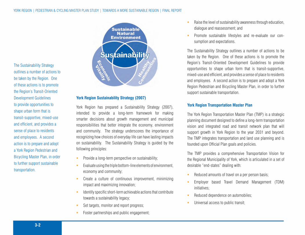
3-2
YorK rEGIon | pEDESTrIan & cYcLInG MaSTEr pLan STuDY | TowarDS a MorE SuSTaInabLE rEGIon | fInaL rEporT
York Region Sustainability Strategy (2007)
York region has prepared a Sustainability Strategy (2007), intended to provide a long-term framework for making smarter decisions about growth management and municipal responsibilities that better integrate the economy, environment and community. The strategy underscores the importance of recognizing how choices of everyday life can have lasting impacts on sustainability. The Sustainability Strategy is guided by the following principles:
provide a long-term perspective on sustainability; �
Evaluate using the triple bottom-line elements of environment, �economy and community;
create a culture of continuous improvement, minimizing �impact and maximizing innovation;
Identify specific short-term achievable actions that contribute �towards a sustainability legacy;
Set targets, monitor and report progress; �
foster partnerships and public engagement; �
raise the level of sustainability awareness through education, �dialogue and reassessment; and
promote sustainable lifestyles and re-evaluate our con- �sumption and expectations.
The Sustainability Strategy outlines a number of actions to be taken by the region. one of these actions is to promote the region’s Transit-oriented Development Guidelines to provide opportunities to shape urban form that is transit-supportive, mixed-use and efficient, and provides a sense of place to residents and employees. a second action is to prepare and adopt a York region pedestrian and bicycling Master plan, in order to further support sustainable transportation.
York Region Transportation Master Plan
The York region Transportation Master plan (TMp) is a strategic planning document designed to define a long-term transportation vision and integrated road and transit network plan that will support growth in York region to the year 2031 and beyond. The TMp integrates transportation and land use planning and is founded upon official plan goals and policies.
The TMp provides a comprehensive Transportation Vision for the regional Municipality of York, which is articulated in a set of desirable “end-states” dealing with:
reduced amounts of travel on a per person basis; �
Employer based Travel Demand Management (TDM) �initiatives;
reduced dependence on automobiles; �
universal access to public transit; �
The Sustainability Strategy
outlines a number of actions to
be taken by the region. one
of these actions is to promote
the region’s Transit-oriented
Development Guidelines
to provide opportunities to
shape urban form that is
transit-supportive, mixed-use
and efficient, and provides a
sense of place to residents
and employees. a second
action is to prepare and adopt
a York region pedestrian and
bicycling Master plan, in order
to further support sustainable
transportation.

3-3MMM Group LIMITED | Go for GrEEn | DEcIMa | aprIL 2008 | fInaL rEporT
Integrated transit services and fares among Go, TTc and �other GTa transit operators serving York region;
Transit accessible human services; �
Efficient and safe movement of goods, �
Efficiently used infrastructure; infrastructure in a “state of �good repair”;
Strong protection for the environment; �
adequate and dedicated long term funding sources; and �
Effective public consultation. �
Towards Great Regional Streets (TGRS)
In 2006 regional council adopted a new regional road Standard for six-lane roads that resulted from a comprehensive study titled “Towards Great regional Streets – a path to Improvement”. The new standard is intended to be applied to roads that have been identified in the region’s 10-year capital plan for widening to six lanes to accommodate improved transit service, on-road cycling as well as improved streetscaping and responds to the transportation demands of a rapidly growing region.
The TGrS study investigated a number of issues including road rights-of-way, high occupancy vehicle (HoV) lanes, access control, costs, bike facilities on regional roads and street tree health. The standard recommended by regional staff and since adopted by regional council calls for a road right-of-way with two all-purpose travel lanes at 3.3 m, an HoV lane at 3.5 m and a dedicated cycling lane at 1.5 m per direction. The timing of when or if to implement the HoV and cycling components of the approved cross-section would be tied to an approved HoV strategy and the
pedestrian and cycling Master plan. The approach adopted by council is to fund and implement a “convertible” six-lane cross-section standard that would allow for the implementation of HoV and bike lanes by simply adjusting or adding pavement markings and signing.
The recommended pedestrian and cycling routes and facilities presented in chapter 5.0 of the pedestrian and cycling Master plan incorporate the findings of the Towards Great regional Streets Study.
In 2006, York region introduced the Municipal Streetscape partnership policy (MSpp) as an addition to York region’s streetscaping current practices and to provide a framework for structuring staff recommendations to regional council with respect to future requests from local municipalities.
The MSpp operates by York region first approving a fixed amount of funding to be provided on an annual basis. Local municipalities then complete design studies for streetscape improvement projects on regional roads. The municipalities must commit a portion of the funding required for each project prior to seeking financial assistance from York region. The local municipalities prepare applications to York region and submit these applications by the established annual deadline. finally, the ‘York region Streetscape review Team’ evaluates each application and recommends qualifying applications for funding as part of the roads capital budget for the coming year.
The standard recommended
by regional staff and since
adopted by regional council
calls for a road right-of-way
with two all-purpose travel
lanes at 3.3 m, an HoV lane at
3.5 m and a dedicated cycling
lane at 1.5 m per direction.

3-4
YorK rEGIon | pEDESTrIan & cYcLInG MaSTEr pLan STuDY | TowarDS a MorE SuSTaInabLE rEGIon | fInaL rEporT
York Region’s Greening and Land Securement Strategies
The regional official plan in the early 1990’s established a linked greenlands concept for the region. In 2001, regional council adopted the regional Greenlands property Securement Strategy and has funded this program at $1.25 million a year and has established the Securement coordination committee to help coordinate securement efforts among the region’s partners to most effectively leverage resources.
York region’s Greening Strategy helps ensure the region’s natural environment is healthy for current and future generations. The Strategy provides a context for regional Decision making that affects the natural environment. It focuses on coordinating regional initiatives and agency and private sector partnership efforts to improve our environment.
The Greening Strategy’s action areas include:
1. Information Management
2. naturalization and rehabilitation
3. Securement of priority Greenlands
4. Education and promotion
5. regional operations
6. Legislation
7. urban forest
8. Green partnerships
9. Monitoring results
York region’s commitment to land securement continues to grow. Historically land securement was considered the direct purchase of land. Today, the public’s commitment to, and support of, the environment is being demonstrated through charitable actions including donating conservation easements and land. The region’s Greening and Securement Strategies proactively pursue these opportunities to protect a healthy and natural heritage system for current and future generations.
Municipal Pedestrian and Cycling Partnership Policy
The Municipal pedestrian and cycling partnership policy (pcpp) has been identified to help local municipalities and York region work together with regard to cost sharing for pedestrian and cycling infrastructure. although many of the local municipal plans provide policies, guidelines, design standards and implementation measures for the development of both on-road and off-road local cycling and pedestrian networks, their plans do not specifically address the need for an integrated network throughout the region because it is not within their mandate. In some cases, the projects proposed by the local municipalities support the goals of our official plan and Vision 2026, however the current policy does not provide the flexibility for York region to participate financially in these projects. The intent of the pcpp is to provide a framework and policy for requests from
York region’s Greening
Strategy helps ensure the
region’s natural environment
is healthy for current and future
generations. The Strategy
provides a context for regional
Decision making that affects the
natural environment. It focuses
on coordinating regional
initiatives and agency and
private sector partnership efforts
to improve our environment.
3-5MMM Group LIMITED | Go for GrEEn | DEcIMa | aprIL 2008 | fInaL rEporT
the local municipalities and other stakeholders with regard to funding municipal, conservation authorities and other agencies pedestrian and cycling infrastructure when these priorities match regional priorities. This program is strictly for funding the capital expenditure of pedestrian and cycling facilities and not for ongoing operating maintenance cost of the same facilities. retrofitting of regional roads to accommodate bike lanes may be incorporated as part of this program.
3.2 policies and iniTiaTives of oTher JurisdicTions
Several key federal, provincial, and Local Municipal policies provide additional support to sustainable transportation in the region and support the provision of pedestrian and cycling friendly land development in existing settlement areas. Highlights of these policies are presented below.
Federal
Transport Canada
Transport canada released a report in 2005 titled “Strategies for Sustainable Transportation planning: a review of practices and options”. The purpose of this report was to provide a foundation on which to build a set of guidelines for incorporating sustainable transportation principles into municipal transportation plans.1 Some of these principles include the creation of policies related to walking and cycling that can be used to develop effective, implementable transportation plans that promote sustainable transportation on a federal level. Some relevant strategies and
1 Strategies for Sustainable Transportation planning: a review of practices and options, Transport canada, 2005
policies, including the focus-area of sustainable transportation under which they fall are listed below:
Integration with Land Use Planning
Encourage desirable land use form and design (e.g. compact, �mixed-use, pedestrian/bike-friendly) through transportation plan policies.
Environmental Health
Identify strategies to mitigate the air impacts of transportation �activities.
Identify strategies to mitigate noise impacts of transportation �activities.
Identify ways that transportation systems influence the �achievement of the community’s economic or social objectives. provide support in the plan’s strategic directions.
recognize the importance of ensuring access to opportunity �for disabled and low-income persons, recent immigrants, youth and the elderly. Set goals and objectives for reducing the need to travel, improving transit mobility, and preserving minimum levels of service on roadways. Identify related strategies.
address the transportation needs of persons with disabilities, �notably with regard to public transit service and barrier-free design in public rights-of-way.
recognize the public health impacts of transportation activity �arising through road safety, pollution and physical activity levels. Identify effective strategies to strengthen positive impacts and lessen negative ones.
Several key federal, provincial,
and Local Municipal policies
provide additional support
to sustainable transportation
in the region and support
the provision of pedestrian
and cycling friendly land
development in existing
settlement areas.

3-6
YorK rEGIon | pEDESTrIan & cYcLInG MaSTEr pLan STuDY | TowarDS a MorE SuSTaInabLE rEGIon | fInaL rEporT
recognize the impact of transportation-related death and �injury on quality of life and the economy. Set goals and objectives for multimodal road safety. Identify effective road safety strategies.
Modal Sustainability
Identify strategies, policies, facilities and services to �increase walking, cycling, other active transportation, transit, ridesharing and teleworking.
recognize synergies and tensions among different modes �(e.g. potential for multimodal cycling-transit trips, potential for modal shift from transit to ridesharing). address possible implications for transportation objectives.
Include objectives, strategies, policies, facilities and services �to make transit operations more sustainable.
The publishing of this document and the recommended policies and strategies identified within it illustrate the federal initiatives currently being undertaken to develop national standards and practices and improve conditions for walking and cycling across canada.
Provincial
Bill 51 – (January 2007) Planning Reform
bill 51 was approved and came in force in January of 2007 and reforms the planning act, which provides the legislative framework for land use planning in ontario. bill 51 incorporates changes to the planning process that are intended to support intensification, sustainable development and protection of green space by giving municipalities greater powers, flexibility and tools to use land, resources and infrastructure more efficiently. bill 51 corresponds
with ontario’s recent policy shift towards sustainable land use development and planning. for instance, it permits municipalities to require environmental sustainability design requirements for both individual buildings and entire neighbourhoods. It also adds sustainable development as a provincial interest in the provincial policy Statement.
Provincial Policy Statement
The provincial policy Statement (ppS) sets the foundation for regulating land use and development within the province and supports provincial goals. The ppS provides for appropriate development and protects resources of provincial interest. The vision of the land use planning system in the ppS is that the “long-term prosperity and social well-being of ontarians depend on maintaining strong communities, a clean healthy environment and a strong economy”2.
The ppS promotes transportation choices that facilitate pedestrian and cycling mobility and other modes of travel. The term “transportation systems” under the ppS means a system consisting of corridors and rights-of-way for the movement of people and goods and the associated transportation facilities, which include cycling lanes and park’n’ride lots. policies pertaining to transportation, such as cycling, pedestrians and transit are dispersed throughout the ppS.
Municipal Act (as amended, 2007)
The Municipal act gives municipalities a broad new flexibility to deal with local circumstances, and to react quickly to local, economic, environmental or social changes. It recognizes municipalities as responsible, accountable governments with
2 provincial policy Statement, Ministry of affairs and Housing, 2005
The ppS promotes trans-
portation choices that facilitate
pedestrian and cycling mobility
and other modes of travel..

3-7MMM Group LIMITED | Go for GrEEn | DEcIMa | aprIL 2008 | fInaL rEporT
respect to matters with their jurisdiction3. The Municipal act provides policies relating to the municipalities’ jurisdiction over municipal highways and the maintenance of those highways, which has an impact on cycling.
Highway Traffic Act
bicycles are defined as a vehicle in the Highway Traffic act (HTa), and can operate on public roadways with the same rights and responsibilities as motor vehicles. However, bicycles are not permitted on controlled access freeways such as the 400 series highways and any roadway where bicycle use is restricted by municipal by-laws. The Highway Traffic act contains a number of policies relating to bicycles, including bicycle lanes on municipal roadways, vehicles meeting bicycles, bicycles overtaken, and regulating or prohibiting bicycles on highways.
Growth Plan for the Greater Golden Horseshoe
The Growth plan for the Greater Golden Horseshoe was adopted in June 2006 under the provisions of the proposed places to Grow act, 2005. This act implements the province’s vision for developing stronger communities and managing the growth within those communities. The Growth plan generally takes precedence over the ppS and municipal official plans. The province requires municipalities to take into consideration the policies and directives of the Growth plan in their planning activities. with respect to pedestrian and cycling, the Growth plan envisions that “an integrated transportation network will allow people choices for easy travel both within and between urban centres throughout the region. public transit will be fast, convenient and affordable. automobiles, while still a significant means of transport, will
3 Ministry of affairs and Housing: www.mah.gov.on.ca/userfiles/HTML/ mts_1_7748_.html
be only one of a variety of effective and well-used choices for transportation. walking and cycling will be practical elements of our urban transportation systems. a healthy natural environment with clean air, land and water will characterize the Greater Golden Horseshoe”4.
The Growth plan provides broad-level policies that direct more sustainable growth and development in the Greater Golden Horseshoe and specific targets for implementation among municipalities.
Greenbelt Plan
ontario’s Greenbelt plan works complementary with the Growth plan for the Greater Golden Horseshoe by providing clear direction as to what areas should be protected from growth in ontario. It builds upon the policy framework established in the provincial policy Statement, and includes the lands and builds upon the ecological protection provided by the oak ridges Moraine conservation plan and the niagara Escarpment plan, as well as supports and complements the parkway belt west plan and the rouge park Management plans.
The vision of the greenbelt presented in the plan is to provide for a diverse range of economic and social activities associated with rural communities, agriculture, tourism, recreation and resource uses. The culture, recreation and Tourism goals for ontario provided by the Greenbelt plan related to cycling and pedestrian movement include:
provision of a wide range of publicly accessible built and �natural settings for recreation including facilities, parklands,
4 places to Grow, Growth plan for the Greater Golden Horseshoe, province of ontario, June 2006
with respect to pedestrian
and cycling, the Growth plan
envisions that “an integrated
transportation network will allow
people choices for easy travel
both within and between urban
centres throughout the region.
3-8
YorK rEGIon | pEDESTrIan & cYcLInG MaSTEr pLan STuDY | TowarDS a MorE SuSTaInabLE rEGIon | fInaL rEporT
open space areas, trails and water-based shoreline uses that support hiking, angling and other recreational activities; and
Enabling continued opportunities for sustainable tourism �development.
Oak Ridges Moraine Conservation Plan
The Government of ontario has set a clear policy framework for the protection of the oak ridges Moraine through the oak ridges Moraine conversation act, 2001 and the oak ridges Moraine conservation plan (orMcp). Municipal planning decisions must conform to the plan, which takes precedence over municipal official plans. The orMcp builds on the efforts of the regions of Durham, peel and York, the conservation coalition, Moraine area municipalities and key stakeholders, to provide clarity and certainty with respect with the long-term protection and management of the oak ridges Moraine.
Two of the objectives of the orMcp pertaining to trails and recreation include:
providing for a continuous recreational trail through the �oak ridges Moraine area that is accessible to all including persons with disabilities; and
providing for other public recreational access to the oak �ridges Moraine area.
Greater Toronto Transportation Authority (GTTA also known as Metrolinx)
In 2006 the province of ontario established the Greater Toronto Transportation authority (GTTa) with a mandate to improve the coordination and integration of all modes of transportation in the region. one of the first priorities for the GTTa is to prepare a regional Transportation plan (rTp) for the Greater Toronto area and
Hamilton. The objective of this study is to develop an integrated regional Transportation plan for local transit, Go Transit and roads for the GTa and Hamilton. “The GTTa is going to look at all the different ways people and goods move across the GTTa, and suggest ways things can move better. This isn’t just about trains, buses and cars. The GTTa will consider the other ways people get around, like on bicycle trails and on foot.” In addition to the rTp the GTTa is expected to produce an investment strategy to identify potential revenue sources to fund the regional Transportation plan. The plan will likely have ideas that require funding. The GTTa will determine the costs of the various elements in the regional Transportation plan, and propose how to pay for them.
on august 24th, 2007 the GTTa board of Directors announced moving forward on its vision for a seamless, integrated transportation system, and identified seven proposed projects to quickly improve service for commuters in the Greater Toronto and Hamilton area. among the seven “quick hit” projects was the following proposal to fund bicycle promotion initiatives
“ bicycle promotion Initiatives $2.1 million to $3.2 million for safe/secure bike storage Installation of 1,000 new safe, secure, weather-proof bicycle storage spaces at strategic locations across the Go Transit inter-regional network, to complement current bicycle storage initiatives by Go Transit and the city of Toronto, city of burlington, and city of Hamilton. $1.0 million to $1.8 million for expanded bike/bus rack program
In a move toward the goal of 100 per cent bicycle accessibility for all bus routes, bicycle-carrying devices will be installed on 1,000 new-order and existing municipal transit vehicles.”
(Source: http://www.gtta.com/en/news/070824.htm)
pedestrians and cyclists first:
The Vision is based on the
principle of assigning more
priority to walking, cycling,
public transit, car pooling
and transportation demand
management initiatives.

3-9MMM Group LIMITED | Go for GrEEn | DEcIMa | aprIL 2008 | fInaL rEporT
a vision for the Master plan
was developed with input from
regional staff, stakeholders
and the public. The purpose
of the vision is to guide York
region through the framework
and implementation of the
pedestrian and cycling Master
plan.
The august 2007 announcement is clear evidence that opportunities exist for York region to partner with the GTTa and the province to fund pedestrian and cycling infrastructure and programming improvements.
with nine transit systems handling over 518 million annual passenger trips and more than two million vehicles on GTa and Hamilton roads, the province expects that the GTTa will play a vital role in developing a plan to tackle congestion and coordinate and improve transit systems across the Toronto region.
Local Municipal
Official Plans
In the regional Municipality of York, there are cycling, pedestrian, transit and alternative modes of transportation policies provided by the official plans of local municipalities.
The municipal official plans of the nine local municipalities were examined in preparing the York region pedestrian and cycling Master plan.
Bicycle Plans
Municipalities within York region are creating or have established their own pedestrian and cycling Master plans, including most recently the city of Vaughan (2007) and Town of Markham (2007). Initiatives like these illustrate the efforts currently being undertaken by various local municipalities within York region to promote and enhance conditions for both walking and cycling and encourage a more active and healthy lifestyle for residents and employees in York region.
3.3 a vision for walking and cycling in york region
a vision for the Master plan was developed with input from regional staff, stakeholders and the public and is designed to support and complement sustainable land development and pedestrian cycling supportive policies and initiatives of York region.
The Vision is based on the principle of assigning more priority to walking, cycling, public transit, car pooling and transportation demand management initiatives. This will provide a more balanced and sustainable transportation system that places less emphasis on single occupant motor vehicle trips and assists in reducing each individual’s carbon footprint.
The “Vision” for the York region pedestrian and cycling Master plan is “a pedestrian and cycling supportive environment that encourages both utilitarian and recreational travel by walking, cycling and using public transit through:
Establishing promotional and educational policies and �programs including a marketing strategy;
a continuous system of sidewalks on regional and local �roads as well as a designated regional-scale network of cycling facilities; and
a regional-scale network integrated with local municipal �pedestrian and cycling infrastructure and public transit service that connects communities and people of all ages with where they live, work and want to go.”
To help achieve the vision, a number of goals were developed. These goals are outlined in the following section.
3-10
YorK rEGIon | pEDESTrIan & cYcLInG MaSTEr pLan STuDY | TowarDS a MorE SuSTaInabLE rEGIon | fInaL rEporT
3.4 goals
The comprehensive regional-scale pedestrian and cycling Master plan that follows creates a connected cycling network of on and off-road facilities, identifies missing links in existing pedestrian systems, and recommends a strategy for improvements to encourage greater use of both travel modes. The primary goals of this Master plan study are to:
Develop an understanding of the elements that affect walking �and cycling in York region;
provide a range of alternative transportation choices that �will benefit residents, employees and visitors in York region by improving public health and air quality while reducing dependence on the private automobile;
Improve conditions for walking and cycling for people of �all ages through the provision of a continuous pedestrian sidewalk system and regional-scale cycling network;
Integrate the improved sidewalk system and proposed �cycling network with regional transit; and
Encourage more people to walk and cycle more often for �utilitarian, recreational and health purposes.
while the preceding chapters have described what a Master plan is and why such a plan is needed for York region, the following chapters detail specific elements of the plan, including sections on outreach, improving conditions for walking and cycling, and recommends a Ten-year Implementation plan and identifies the costs to implement the plan.

MMM Group LIMITED | Go for GrEEn | DEcIMa | aprIL 2008 | fInaL rEporT

YorK rEGIon | pEDESTrIan & cYcLInG MaSTEr pLan STuDY | TowarDS a MorE SuSTaInabLE rEGIon | fInaL rEporT
can-bike Training
ciTy
of
Toro
nTo

4-1MMM Group LIMITED | Go for GrEEn | DEcIMa | aprIL 2008 | fInaL rEporT
By adopting the pedestrian and cycling Master plan and its recommendations, York region has the opportunity to create a more pedestrian and cycling friendly environment for all of its residents. Infrastructure such as sidewalks, trails, bike lanes, benches, pavement markings and sign treatments are all components of this Master plan, and will assist in creating this supportive environment. However, facilities alone will not produce this walking and cycling friendly situation. York region should expand upon its leadership role and work with local municipalities and other levels of government to develop and implement an expanded outreach program to help educate residents about the importance of improving air quality and reducing greenhouse gas emissions, pedestrian and cycling safety, and to encourage residents to walk and cycle more often for both utilitarian and recreational purposes.
The framework set out in this chapter recommends the implementation of new programs and the continuation of existing initiatives in the areas of education, encouragement and promotion. These programs will support the many benefits of walking and cycling, and will help achieve the walking and cycling goals in York region’s Vision 2026, York region’s official plan, the Transportation Master plan and this pedestrian and cycling Master plan. a key objective of the outreach strategy in this plan is to develop and enhance educational programs that are targeted to existing and future pedestrians and cyclists.
4.1 Education
Education is one of the most important components of this plan. pedestrian and cycling network users need to be educated to understand on and off-road operating procedures to support a safe and inviting environment for walking and cycling in the region. The objectives for education in the York region pedestrian and cycling Master plan are as follows:
4a: Educate pedestrians and cyclists on safe operating procedures on multi-use pathways and within road rights-of-way;
4b: Enhance and support walking and cycling advocacy, advisory and information groups and programs; and
4c: adequately fund existing and proposed pedestrian and cycling programs developed by the region or in partnership with other public and private sector partners.
The following subsections outline methods of achieving the overall objectives of education for the York region pedestrian and cycling Master plan.
4.1.1 Bicycle education information
Making cycling information readily available is a key educational strategy. The region of York should consider the implementation of bicycle education programs and partner with other groups, local municipalities, and agencies to educate residents on walking and cycling. York region could follow the example of citizens for Safe cycling (cfSc), a volunteer group in ottawa, which in
ouTrEacHChapter 4
York region has the opportunity
to create a more pedestrian and
cycling friendly environment for
all of its residents.
children should be taught safe cycling skills
MM
M G
roup
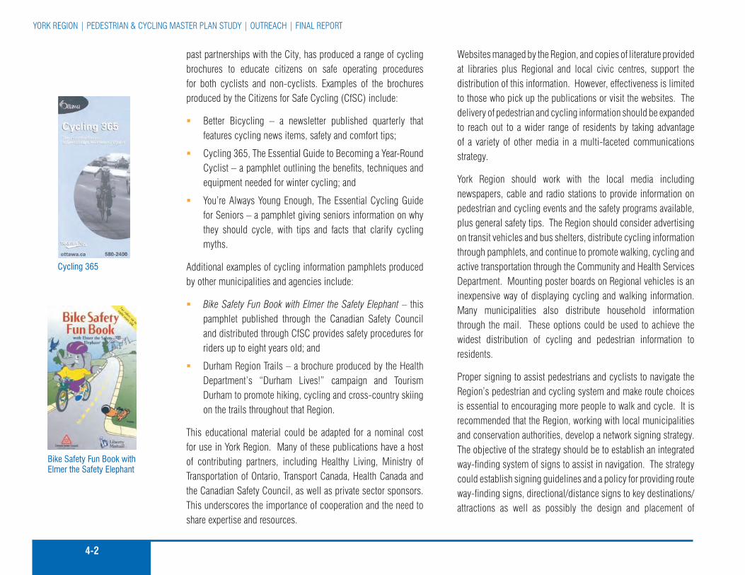
4-2
YorK rEGIon | pEDESTrIan & cYcLInG MaSTEr pLan STuDY | ouTrEacH | fInaL rEporT
past partnerships with the city, has produced a range of cycling brochures to educate citizens on safe operating procedures for both cyclists and non-cyclists. Examples of the brochures produced by the citizens for Safe cycling (cfSc) include:
Better Bicycling – a newsletter published quarterly that �features cycling news items, safety and comfort tips;
cycling 365, The Essential Guide to Becoming a Year-round �cyclist – a pamphlet outlining the benefits, techniques and equipment needed for winter cycling; and
You’re always Young Enough, The Essential cycling Guide �for Seniors – a pamphlet giving seniors information on why they should cycle, with tips and facts that clarify cycling myths.
additional examples of cycling information pamphlets produced by other municipalities and agencies include:
Bike Safety Fun Book with Elmer the Safety Elephant � – this pamphlet published through the canadian Safety council and distributed through cfSc provides safety procedures for riders up to eight years old; and
Durham region Trails – a brochure produced by the Health �Department’s “Durham Lives!” campaign and Tourism Durham to promote hiking, cycling and cross-country skiing on the trails throughout that region.
This educational material could be adapted for a nominal cost for use in York region. Many of these publications have a host of contributing partners, including Healthy Living, Ministry of Transportation of ontario, Transport canada, Health canada and the canadian Safety council, as well as private sector sponsors. This underscores the importance of cooperation and the need to share expertise and resources.
Websites managed by the region, and copies of literature provided at libraries plus regional and local civic centres, support the distribution of this information. However, effectiveness is limited to those who pick up the publications or visit the websites. The delivery of pedestrian and cycling information should be expanded to reach out to a wider range of residents by taking advantage of a variety of other media in a multi-faceted communications strategy.
York region should work with the local media including newspapers, cable and radio stations to provide information on pedestrian and cycling events and the safety programs available, plus general safety tips. The region should consider advertising on transit vehicles and bus shelters, distribute cycling information through pamphlets, and continue to promote walking, cycling and active transportation through the community and Health Services Department. Mounting poster boards on regional vehicles is an inexpensive way of displaying cycling and walking information. Many municipalities also distribute household information through the mail. These options could be used to achieve the widest distribution of cycling and pedestrian information to residents.
proper signing to assist pedestrians and cyclists to navigate the region’s pedestrian and cycling system and make route choices is essential to encouraging more people to walk and cycle. It is recommended that the region, working with local municipalities and conservation authorities, develop a network signing strategy. The objective of the strategy should be to establish an integrated way-finding system of signs to assist in navigation. The strategy could establish signing guidelines and a policy for providing route way-finding signs, directional/distance signs to key destinations/attractions as well as possibly the design and placement of
Bike Safety Fun Book with Elmer the Safety Elephant
cycling 365

4-3MMM Group LIMITED | Go for GrEEn | DEcIMa | aprIL 2008 | fInaL rEporT
information signs regarding natural and/or cultural features on a particular route. all of this information could be linked to a network map published by the region and possibly combined with local municipal network information to support use of the network and promote walking and cycling in York region.
Information outlining the numerous benefits of cycling and walking can encourage the public to walk and cycle more often. The publications previously noted in this chapter identify health, environmental, economic, and community attributes of cycling. These benefits are an important educational and promotional element that should be developed and advertised both on their own and integrated within other existing regional publications, reports and events. new opportunities to market the many benefits of cycling and walking are being provided through increasing public and private sector interest and new research directed at environmental, health and resource issues such as air quality, climate change, active living and use of fuel taxes.
Recommended Actions:
4-1 Develop and implement a communication strategy for the creation and distribution of cycling information.
4-2 partner with local municipalities, agencies and other groups to educate residents on the benefits of cycling and walking.
4-3 consider adapting existing material developed by other municipalities to educate users, rather than developing new original material at increased cost to York region.
4-4 Ensure information is presented in a language and style appropriate for the age group being targeted, such as children and seniors.
4-5 provide a wide range of cycling and walking information topics on the region’s website, including references to other cycling and walking websites.
4-6 Develop a way-finding and information signing strategy and supporting design guidelines and then install appropriate signing as facilities are implemented.
4.1.2 funding and delivery of Bicycle education Programs
funding bicycle and pedestrian education programs is an ever-increasing challenge due to limited resources and a heightened public concern over safety. The region should seek new ways to develop and deliver bicycle and pedestrian safety education initiatives.
Some municipalities have established a public / private Bicycle Safety partnership that attempts to promote fresh ideas and funding sources. a number of stakeholders, such as police, educators, insurance companies, bicycle manufacturers and health care professionals with a common interest in cycling safety, have been invited to work together to produce safety programs.
The road and Trail Safety ambassador program is an initiative that has been active in Toronto since 1977. a similar program could be implemented in York region. The program in Toronto uses a number of public / private supporters, which in the past have included Human resources Development canada, Ministry of Transportation, friends of the Environment foundation, Bell Mobility, Scotchlite and Mountain Equipment co-op, to hire and train a number of “ambassadors” for the cycling season. The ambassadors provide training, which covers all aspects of safe and responsible road and trail use for cyclists as well as
advertisement for Bike to Work Week on a transit shelter in the city of toronto
city
of t
oron
to

4-4
YorK rEGIon | pEDESTrIan & cYcLInG MaSTEr pLan STuDY | ouTrEacH | fInaL rEporT
pedestrians, in-line skaters and motorists. The ambassadors have participated in the following four approaches to increase safety in a community:
community Events – addresses community needs for road �and trail safety information;
can-BIKE – provides a set of effective cycling courses �designed for all ages and skill levels;
O.A.S.I.S. � (off-road, awareness, Safety, Information, Stop) – provides an off-road and environmental awareness program; and
S.P.A.C.E. � (Safety, prevention, awareness, courtesy, Education) – offers a selective traffic education program for all road users.
another innovative approach to bicycle safety delivery is the “Bike Bus program”.1 This idea is similar to a Library Bookmobile, where a mobile trailer, truck or bus could be stocked with bicycles, helmets and teaching materials and staffed by can-BIKE instructors and / or Safety ambassadors. It is then available for community events, bicycle rodeos, staff training sessions and could work cooperatively with School Boards for student safety courses.
Recommended Actions:
4-7 Introduce a road and pathway Safety ambassador program similar to that initiated in the city of Toronto, which uses a number of public/private supporters to hire and train “ambassadors” during the cycling season.
1 2001 Toronto Bike plan
4-8 Support the implementation of programs similar to the “Bike Bus program” to increase cycling awareness and education.
4-9 allocate a portion of the region’s programming investment to support pedestrian and cycling education programs.
4-10 continue to administer a safe-cycling skills program for all ages such as the nationally accredited can-BIKE course.
4.1.3 focused safety camPaigns
The reduction of cycling injuries and fatalities is an important goal of education initiatives. according to a study conducted by the canadian Institute of Health Information, cycling puts more people in the hospital than any other summer activity in ontario.2 Dr. Jim cairns, ontario’s deputy chief coroner, and an avid cyclist, believes it is a matter of educating cyclists on how to ride properly and educating the public that a cyclist riding properly is entitled to ride on the road.3
The safety of children is a specific concern. The ontario Trauma registry reports that children aged 5 to 14 are most likely to incur injuries while cycling. Most of these incidents occur less than six blocks from home, and are the result of mid-block entry into a street, swerving into the path of a motor vehicle or another cyclist, and falls.
Safety is also a concern on multi-use trails, where cyclists, in-line skaters and pedestrians are all sharing space. In order to reduce collisions between various trail users, the region should provide information on proper trail use and etiquette. This information could be provided through pamphlets, advertisements, on
2 cycling Most risky Summer fun, Toronto Star, august 12, 2004
3 Ibid.
The safety of children is a
specific concern. The ontario
Trauma registry reports that
children aged 5 to 14 are most
likely to incur injuries while
cycling.
Regional niagara Bicycling committee’s trail Etiquette brochure
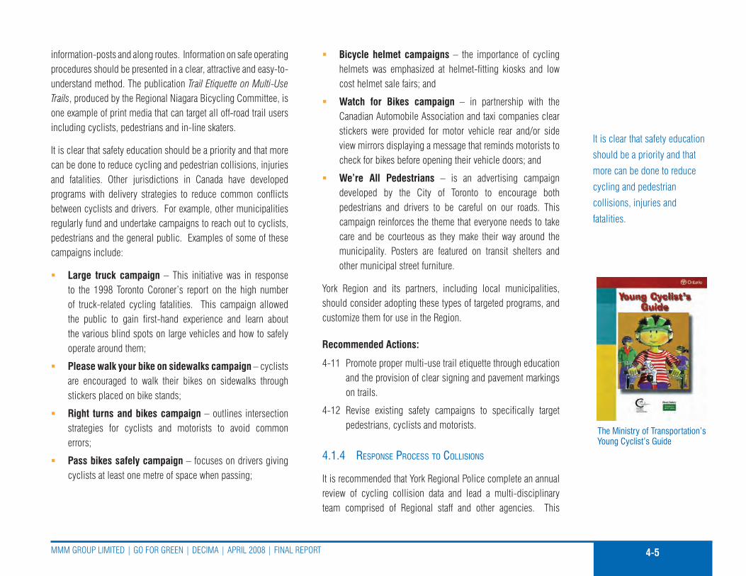
4-5MMM Group LIMITED | Go for GrEEn | DEcIMa | aprIL 2008 | fInaL rEporT
information-posts and along routes. Information on safe operating procedures should be presented in a clear, attractive and easy-to-understand method. The publication Trail Etiquette on Multi-Use Trails, produced by the regional niagara Bicycling committee, is one example of print media that can target all off-road trail users including cyclists, pedestrians and in-line skaters.
It is clear that safety education should be a priority and that more can be done to reduce cycling and pedestrian collisions, injuries and fatalities. other jurisdictions in canada have developed programs with delivery strategies to reduce common conflicts between cyclists and drivers. for example, other municipalities regularly fund and undertake campaigns to reach out to cyclists, pedestrians and the general public. Examples of some of these campaigns include:
Large truck campaign � – This initiative was in response to the 1998 Toronto coroner’s report on the high number of truck-related cycling fatalities. This campaign allowed the public to gain first-hand experience and learn about the various blind spots on large vehicles and how to safely operate around them;
Please walk your bike on sidewalks campaign � – cyclists are encouraged to walk their bikes on sidewalks through stickers placed on bike stands;
Right turns and bikes campaign � – outlines intersection strategies for cyclists and motorists to avoid common errors;
Pass bikes safely campaign � – focuses on drivers giving cyclists at least one metre of space when passing;
Bicycle helmet campaigns � – the importance of cycling helmets was emphasized at helmet-fitting kiosks and low cost helmet sale fairs; and
Watch for Bikes campaign � – in partnership with the canadian automobile association and taxi companies clear stickers were provided for motor vehicle rear and/or side view mirrors displaying a message that reminds motorists to check for bikes before opening their vehicle doors; and
We’re All Pedestrians � – is an advertising campaign developed by the city of Toronto to encourage both pedestrians and drivers to be careful on our roads. This campaign reinforces the theme that everyone needs to take care and be courteous as they make their way around the municipality. posters are featured on transit shelters and other municipal street furniture.
York region and its partners, including local municipalities, should consider adopting these types of targeted programs, and customize them for use in the region.
Recommended Actions:
4-11 promote proper multi-use trail etiquette through education and the provision of clear signing and pavement markings on trails.
4-12 revise existing safety campaigns to specifically target pedestrians, cyclists and motorists.
4.1.4 resPonse Process to collisions
It is recommended that York regional police complete an annual review of cycling collision data and lead a multi-disciplinary team comprised of regional staff and other agencies. This
the Ministry of transportation’s Young cyclist’s Guide
It is clear that safety education
should be a priority and that
more can be done to reduce
cycling and pedestrian
collisions, injuries and
fatalities.

4-6
YorK rEGIon | pEDESTrIan & cYcLInG MaSTEr pLan STuDY | ouTrEacH | fInaL rEporT
structure can provide a response process to bicycle incidents that would produce meaningful preventive measures to help avoid future incidents. The process would complement other injury prevention programs by responding to cycling collisions in a way that mitigates their contributing factors.
Three elements are critical to the success of the process. accurate and comprehensive information from police reports, cyclists, pedestrians, hospitals and other sources is important to establish a meaningful set of base data. cyclists and pedestrians should also be encouraged to report concerns about road safety and materials that should be provided to assist cyclists involved in collisions. This could be done partly through the proposed cycling resource and information page on the region’s website. The analysis of the data should be undertaken with the intent to identify improvements to infrastructure, education, enforcement or other related programs. finally, implementation of the improvements must occur with information provided to cyclists and pedestrians.
The review would also serve as an information exchange and cooperative mechanism between groups to identify trends and safety solutions for cycling. researchers estimate that more than 80% of bicycle crashes go unreported to police.4 Investigating officers could extend an extra effort to collect complete information from cyclists and motorists in collisions. This would impart the serious nature of the incident to all parties and would also assist in the accurate analysis of the data.
cyclists and pedestrians also need clear information and direction on what to do when a collision occurs. confusion may exist over
4 Stutts, J.c., and W. Hunter, 1998. police reporting of pedestrians and cyclists Treated In Hospital Emergency rooms. proceeds of the Transportation research Board’s 77th annual Meeting on pedestrian/Bicycle Safety, January 11-15, 1998.
where a cyclist or pedestrian should report a collision, or there may be difficulty dealing with insurance companies. The region might consider providing a Question and answer section on the cycling and pedestrian website to address this need.
Recommended Actions:
4-13 York regional police should establish a process to review cycling fatality and collision data on an on-going basis and recommend improvements relating to education, enforcement and infrastructure priorities to improve bike safety.
4-14 Ensure that the collision reporting process is clear by posting information on the region’s website.
4.1.5 cycling, Walking and children
The mobility needs of children are often overlooked in transportation planning. Efforts should be undertaken to encourage children to use sustainable modes of transportation such as walking, cycling and public transit, and reduce their auto-dependency (through their parents) so they may be more inclined to do so when they are adults. The university of Winnipeg based centre for Sustainable Transportation has recently studied these issues, and recently produced child-and-Youth-friendly Land use Transport planning Guidelines for ontario. The Guidelines document provides reasons as to why land-use and transport planning should be made more child-and-youth-friendly, sets out 27 guidelines that could be applied in the course of a municipality or other agency becoming more child-and-youth-friendly, and provides a discussion of implementation issues.
The 27 Guidelines listed are divided into 6 categories. These guidelines are presented in Table 4-1.
children enjoying cycling and walking
York Region’s community Safety Village
MM
M G
Roup
MM
M G
Roup

4-7MMM Group LIMITED | Go for GrEEn | DEcIMa | aprIL 2008 | fInaL rEporT
taBLE 4-1: chiLd-and-Youth-FRiEndLY Land-uSE and tRanSpoRt pLanninG GuidELinES
CATegoRy guideLine
Putting children and youth first
1.In transport and land-use planning, the needs of children and youth should receive as much priority as the needs of people of other ages and the requirements of business
2.Within each municipality designate a staff member (and perhaps also a council member) as responsible for bringing a children’s perspective to transport and land-use planning issues
3.as may be appropriate, establish or adapt one or more forums for children and youth to provide input as to the application of these guidelines
Providing for children and youth as pedestrians
4. Identify where children and youth want to go or need to go and, to the extent possible, provide ways of getting there by foot
5. Explore pedestrian routes used or to be used by children to ensure that they are as usable by them as possible
6. Explore pedestrian routes to be used by children to ensure that they are as safe for them as possible
7. for younger children, arrange walking buses and other means of supervision
8.Separate sidewalks used by children and youth from heavily trafficked roads, particularly where traffic moves slowly or vehicles are stationary with engines idling for long periods
9. Ensure that sidewalks are always cleared of snow
Providing for children and youth as cyclists
10. for children and youth, ensure that destinations that cannot be a walk away are no more than a bicycle ride away
11. for younger children, ensure that sidewalks are suitable for their tricycles and bicycles
12. for destinations to be reached by bicycle, provide separate bicycle paths, and install bicycle lanes on regular roads only as a last resort
13 Ensure that bicycle riders are well provided for at intersections and have sufficient priority for forward movement
The university of Winnipeg
based centre for Sustainable
Transportation has recently
studied these issues, and
recently produced child-
and-Youth-friendly Land use
Transport planning Guidelines
for ontario.

4-8
YorK rEGIon | pEDESTrIan & cYcLInG MaSTEr pLan STuDY | ouTrEacH | fInaL rEporT
taBLE 4-1: chiLd-and-Youth-FRiEndLY Land-uSE and tRanSpoRt pLanninG GuidELinES
CATegoRy guideLine
14. at destinations, provide secure, convenient bicycle parking
15. Encourage the carriage of very young children by bicycle, in appropriate seats or attachments
Providing for children and youth as transit and school-bus users
16. Ensure that every part of a transit system is safe and welcoming to a child, and affordable
17. avoid transfers by routing vehicles where children want to and need to go; make transfers easy where necessary
18. Keep fares for children low, so as to encourage their use of transit systems, with or without supervision
19.Examine every aspect of the system from the perspective of a parent with a children in a stroller, and make adjustments to meet such a traveller’s needs
20. reduce the time children spend in school buses to a maximum of no more than 40 minutes per day
Concerning children and youth in automobiles
21.Where destinations cannot be reached by foot, bicycle or transit, ensure nevertheless that they are as near as possible to reduce in-car time
22. When children must travel in vehicles, act to avoid poor in-vehicle air quality
23. Drive slowly, to be safe and to facilitate an interest in the passing show
Reducing transport’s adverse impacts on children and youth
24. Take all possible steps to reduce amounts of road traffic generally
25. In urban areas, post and enforce much lower speed limits
26. use low-emission rather than regular diesel vehicles for urban transit or, where possible, electric vehicles
27.Where possible, encourage use of rail for freight, and use of electric vehicles, including hybrid vehicles, where road freight must be used

4-9MMM Group LIMITED | Go for GrEEn | DEcIMa | aprIL 2008 | fInaL rEporT
The key to marketing change is in the school system, and can be accomplished by involving parent councils in efforts to increase children’s active transportation, educating developers, educating teachers and early childhood educators, and educating planning and engineering through workshops, newsletters and presentations.
The recommended cycling network and pedestrian system for York region, as outlined in the pedestrian and cycling Master plan, has been developed with the needs of child cyclists and pedestrians as a key consideration. programs such as the community Safety Village, which is operated by the York regional police, are instrumental in educating children on the proper safety practices, and encourages children to feel comfortable using all types of cycling and pedestrian facilities.
Recommended Actions:
4-15 Expand education programs to encourage children to use sustainable modes of transportation, such as walking, cycling and public transit, and reduce their auto-dependency.
4-16 continue to fund programs such as the community Safety Village to educate children and parents on road safety practices including cycling and walking.
4.1.6 active and safe routes to school
active & Safe routes to School is a program being undertaken in communities around the world. This initiative promotes the use of active and efficient transportation for the daily trip to school, such as walking and biking, while addressing health and traffic safety issues and taking action on air pollution and climate change. The active & Safe routes to School program
is currently being delivered by York region’s community and Health Services Department and planning and Development Services Department in partnership with the Green communities association, York regional police, York region District School Board, York catholic District School Board, the Town of Markham, the Town of richmond Hill, the Town of newmarket, and Windfall Ecology centre.
4.1.7 enforcement oBjectives
Enforcement is key to pedestrian and cycling safety with the principle objective of reducing incidents causing property damage, injury and death. Enforcement should be applied to on and off-road segments of the proposed pedestrian and cycling network.
This can be accomplished through the following recommended actions.
Recommended Actions:
4-17 continue to work with York regional police to provide patrols of the pedestrian and Bicycle network to enforce proper operating rules to pedestrians, cyclists and motorists alike.
4-18 Increase the number of officers using bicycles, and patrol trails as part of a community policing approach.
4-19 Include pedestrian and cycling safety material in training programs for driver examiners, police recruits, fleet/transit operators and other officials.
4-20 request provincial funding for pedestrian and bicycle safety and promotional programs to assist the region in its efforts
people will only consider
walking and cycling for
recreational or utilitarian
purposes if it is convenient,
safe and comfortable.
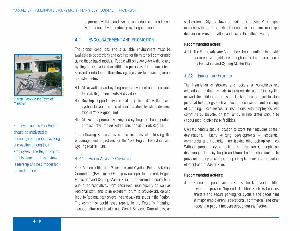
4-10
YorK rEGIon | pEDESTrIan & cYcLInG MaSTEr pLan STuDY | ouTrEacH | fInaL rEporT
Employers across York region
should be motivated to
encourage and support walking
and cycling among their
employees. The region cannot
do this alone, but it can show
leadership and be a model for
others to follow.
to promote walking and cycling, and educate all road users with the objective of reducing cycling collisions.
4.2 EncouRaGEMEnt and pRoMotion
The proper conditions and a suitable environment must be available to pedestrians and cyclists for them to feel comfortable using these travel modes. people will only consider walking and cycling for recreational or utilitarian purposes if it is convenient, safe and comfortable. The following objectives for encouragement are listed below:
4d: Make walking and cycling more convenient and accessible for York region residents and visitors;
4e: Develop support services that help to make walking and cycling feasible modes of transportation for short distance trips in York region; and
4f: Market and promote walking and cycling and the integration of these travel modes with public transit in York region.
The following subsections outline methods of achieving the encouragement objectives for the York region pedestrian and cycling Master plan.
4.2.1 PuBlic advisory committee
York region initiated a pedestrian and cycling public advisory committee (pac) in 2006 to provide input to the York region pedestrian and cycling Master plan. The committee consists of public representatives from each local municipality as well as regional staff, and is an excellent forum to provide advice and input to regional staff on cycling and walking issues in the region. The committee could issue reports to the region’s planning, Transportation and Health and Social Services committees, as
well as local city and Town councils, and provide York region residents with a forum and direct connection to influence municipal decision-makers on matters and issues that effect cycling.
Recommended Action:
4-21 The public advisory committee should continue to provide comments and guidance throughout the implementation of the pedestrian and cycling Master plan.
4.2.2 end-of-triP facilities
The installation of showers and lockers at workplaces and educational institutions help to promote the use of the cycling network for utilitarian purposes. Lockers can be used to store personal belongings such as cycling accessories and a change of clothing. Businesses or institutions with employees who commute by bicycle, on foot, or by in-line skates should be encouraged to offer these facilities.
cyclists need a secure location to store their bicycles at their destinations. Many existing developments – residential, commercial and industrial – are lacking bike lock-up facilities. Without proper bicycle lockers or bike racks, people are discouraged from cycling to and from these destinations. The provision of bicycle storage and parking facilities is an important element of the Master plan.
Recommended Actions:
4-22 Encourage public and private sector land and building owners to provide “trip-end” facilities such as benches, shelters and secure parking for cyclists and pedestrians at major employment, educational, commercial and other nodes that people frequent throughout the region.
Bicycle Racks in the town of Markham
toW
n oF
MaR
khaM

4-11MMM Group LIMITED | Go for GrEEn | DEcIMa | aprIL 2008 | fInaL rEporT
4-23 Encourage public and private sector land and building owners to adopt a requirement for the supply of bicycle lockers and/or bicycle racks for all new multi-unit residential building sites and retail/commercial centre sites.
4.2.3 leadershiP By examPle
Employers across York region should be motivated to encourage and support walking and cycling among their employees. The region cannot do this alone, but it can show leadership and be a model for others to follow.
a comprehensive approach should also be adopted that would ensure a more complete application of support facilities to encourage regional and local municipal employees to cycle or walk to work where feasible. Some of these measures include:
Encourage the private sector to partner with the region and �local municipalities to develop a Bikeshare program. This program can be convenient and economical for anyone who makes frequent trips around the region. Members of Bikeshare can borrow a bike for up to three days. Bikeshare hubs are connected by an online database, which allows members to use any one of the numerous destinations or pick up points;
create an incentive program and develop contests for �employees who cycle, walk or take transit to work, perhaps based around car-free commute days, clean air Day or Earth Week;
organize a bicycle mentoring program that allows employees �who want to cycle to work to find a colleague with whom they can ride;
Make can-BIKE courses available to all regional and local �municipal staff; and
Incorporate trip end facilities within building lease �negotiations.
The canadian government has already taken steps to promote public transit use by introducing tax credits to transit users. Most recently, the government has announced a plan to provide tax credits to those who purchase more fuel-efficient automobiles.
York region could consider supporting the concept of tax incentives by communicating this support through the federation of canadian Municipalities and the federal Government of canada.
Recommended Actions:
4-24 Develop an approach that would encourage more regional employees to cycle to work.
4-25 Support the concept of tax incentives to encourage cycling use in the region.
4.2.4 intermodal connections
The option of cycling must be convenient in order to attract potential cyclists. The implementation of cycling infrastructure can help to achieve this, since a lack of designated cycling facilities deters many would-be cyclists from riding. Many residents who might consider cycling to a destination will need to combine their cycling trip with another travel mode for the same trip. This is where intermodal connections become important. Intermodal connections are points throughout a network where various transportation modes connect and are convenient to transfer between modes. Intermodal connections in the region
Intermodal connections are
points throughout a network
where various transportation
modes connect and are
convenient to transfer between
modes.
a “Swerve” bicycle rack
dERo
Bik
E Ra
ck c
oMpa
nY

4-12
YorK rEGIon | pEDESTrIan & cYcLInG MaSTEr pLan STuDY | ouTrEacH | fInaL rEporT
include automobile-transit connections, such as park and rides, transit terminals and Go Stations.
Cycling/Pedestrian-Transit Connections
cycling/pedestrian-Transit connections are vital in order to increase bicycle use and walking, especially for utilitarian trips. cycling-Transit connections allow cyclists to ride their bike to a transit stop or station, attach it to a bus-mounted bike rack, travel to their stop, disembark and continue on their bicycle or on foot to their final destination. These connections are important since many York region residents do not live within a suitable cycling or walking distance to their place of work, but may be more inclined to cycle or walk part of the way if they can combine the trip with public transit. Go Transit currently allows riders to carry their bicycles on all off-peak Go Trains plus peak hour trains not operating in the peak direction. at present, bicycles cannot be carried on Go Buses and bike racks are not yet provided on York region Transit vehicles although a pilot project is in the works. riders are permitted to carry their bikes on YrT and Viva buses during off peak periods.
York region Transit has adopted the “Swerve rack” as its standard bicycle rack for transit stops. The racks are being installed according to a colour scheme – blue for Viva stops, black for heritage areas and galvanized steel for other locations. The Swerve racks are intended to facilitate cycling-transit connections by providing a standardized and characteristic bike lockup location for cyclists accessing YrT and Viva services throughout York region.
Methods of providing cycling-transit connections should include:
The implementation of bike racks on YrT, Viva and Go �Buses;
The provision of “secure” bicycle parking at major transit �stops, nodes and terminals; and
Designated areas within transit vehicles, such as Go Trains, �to store bicycles.
Investing in cycling and pedestrian infrastructure will also support public transit ridership. combining cycling and pedestrian facilities with transit can also help to make virtually every major destination throughout the region accessible by bicycle or on foot. It is recommended that the region explore the option of providing bicycle racks on all regional transit vehicles and expand the provision of secure bicycle parking at major transit stops and terminals. Examples of secure bicycle parking are provided in the planning and Design Guidelines.
Automobile-Cycling Connections
Many recreational cyclists throughout Southern ontario mount their bicycles onto their automobiles and drive to a destination where they embark on a recreational bike ride. commuters, who work in urban centres where parking may be expensive or not readily available, could also adopt this practice. The provision of “Drive and Bike” lots along the periphery of central business districts and along major cycling routes which provide direct connections to major destinations could encourage residents to consider this combined travel mode more often.
Recommended Actions:
4-26 contact Go Transit to investigate the feasibility of Go Transit implementing a bike racks on buses program on some of their fleet.
cycling maps are excellent
promotional tools and are
essential for informing
individuals of travel choices and
the opportunities for cycling.
city of ottawa cycling Map

4-13MMM Group LIMITED | Go for GrEEn | DEcIMa | aprIL 2008 | fInaL rEporT
4-27 Improve the integration of cycling with transit by encouraging YrT and Viva to implement bicycle racks on buses program and improve bicycle parking and pedestrian and bicycle access at major transit stops, Viva stations and terminals.
4-28 Work with local municipalities to investigate the opportunity for “Drive and Bike” lots along the periphery of central business districts and along primary cycling routes.
4.2.5 cycling maPs
cycling maps are excellent promotional tools and are essential for informing individuals of travel choices and the opportunities for cycling. The region should investigate what other jurisdictions have learned in developing similar maps. for example, the regional Municipality of niagara has recently produced a high quality and popular Regional Niagara Bicycling Map. This map represents a departure from the usual cycling map. In addition to illustrating existing network bike facilities, it shows roads that are bicycle friendly (paved and low traffic volume) with added features such as busy and gravel roads, grades, services and key attractions. The end result is a network of on and off-road routes and existing cycling facilities. It also provides users with information on other roads not part of the current network. With this type of information, cyclists of all ages, skill and comfort levels can choose their preferred route prior to embarking on their trip. other cycling maps that could be used as a model for the development of York region’s cycling Map include the city of Toronto cycling Map, and the city of ottawa cycling Map.
The region, with assistance from its partners including a reconstituted pedestrian and cycling public advisory committee, should aim to produce a user-friendly regional cycling Map by
2009 and update it every one to two years thereafter. The region should consider offering these maps to the public at a nominal fee to generate revenue that can then be reinvested in future map editions and used to fund educational initiatives. The current city of ottawa map has a suggested price of $2.00 while Toronto provides maps free of charge.
Recommended Actions:
4-29 Investigate what other jurisdictions have learned in developing their own cycling maps.
4-30 produce a user-friendly regional cycling Map by 2009 and update it every one to two years.
4-31 provide pedestrian and cycling network maps at various public venues and update them every one to two years, highlighting new routes.
4.2.6 Bicycle user grouPs
Bicycle user Groups, or BuGs, are another promotional initiative that can support and encourage utilitarian cycling. The development of BuGs has been successful in many municipalities and is recommended for York region and its local municipalities.
a very good example of a BuG manual was produced by the citizens for Safe cycling (cfSc) in the city of ottawa titled BuGs at Work, a Bicycle user Group Guide and was published in 2002. This guide is available on the cfSc website (www.safecycling.ca) and serves as an excellent resource to facilitate commuting by bike. The city of Toronto has also published a guide on how to establish a BuG and encourage people to participate.
York Regions take a hike Guide
Bicycle user Groups, or BuGs, are another promotional initiative that can support and encourage utilitarian cycling.

4-14
YorK rEGIon | pEDESTrIan & cYcLInG MaSTEr pLan STuDY | ouTrEacH | fInaL rEporT
The region should work with local municipalities, Boards of Trade, chambers of commerce and employers, and could build upon the region’s successful Smart commute initiatives, to encourage the creation of BuGs. These useful workplace groups could be developed and organized with the assistance of Smart commute to provide a network that would link one BuG to another.
The proposed Bicycle users Group network could eventually be established and linked through a web-based directory for formally registered BuGs, with communications provided through a bulletin board or “chat” network as well as print and personal communications. programs sponsored by the region and local municipalities could be phased in over a number of years after completing research and development of the concept, implementation and finally launching the network.
Recommended Action:
4-32 Work with local municipalities, Boards of Trade, and employers to encourage the creation of Bicycle user Groups. Smart commute could assist with the development and organization of these workplace groups.
4.2.7 Work With others
The region will need the cooperation of outside agencies, volunteer groups and individuals to achieve the positive results expected from bicycle and pedestrian education, and to meet the targets set to increase the number of cycling and pedestrian trips as per the overall goal of this plan. preceding sections have established the need to work with partners that have similar mandates. This will help ensure consistent messages, avoid duplication and offer benefits from economies of scale.
all participants and partners are important and can bring helpful ideas and resources to the table. The region should actively reach out and consult with internal and external organizations such as the York regional police, School Boards, the Ministry of Transportation of ontario, Ministry of Health promotion, Transport canada, canada Safety council, and others to support a safe bicycle and pedestrian-friendly environment.
york Regional Police
as the region implements more cycling initiatives in the future, regional police Services should be asked to expand their current efforts to educate and enforce safe cycling. York regional police are already active in promoting a safe walking and cycling community. Each district in York region has a community oriented response or “cor” unit. These units use officers on bicycles during the cycling season to undertake traffic enforcement, patrol major events and patrol parks at night along with local municipal by-law officers. This unit completed 14,000 foot patrol hours, and 119 bike patrol days in the region. There are also Street Beat officers that present safety information at secondary schools as part of an education program. York regional police also operate the community Safety Village, where bicycle information sessions are geared towards younger children.
York regional police provide helpful information and links to existing programs on their website (www.police.york.on.ca). York regional police have initiated a program called “Safe Streets, nice neighbourhoods”, designed to engage local municipalities to work together to make road safety a priority. They also operate the Save-a-Life program, a road safety program with the objective of saving lives and improving the quality of life for citizens of York region. The Save-a-Life program consists of three key
a police Bicycle patrol is
an effective community-
based policing initiative with
environmental, economic and
role model benefits.
‘Share the Road’ sign
toW
n oF
MaR
khaM
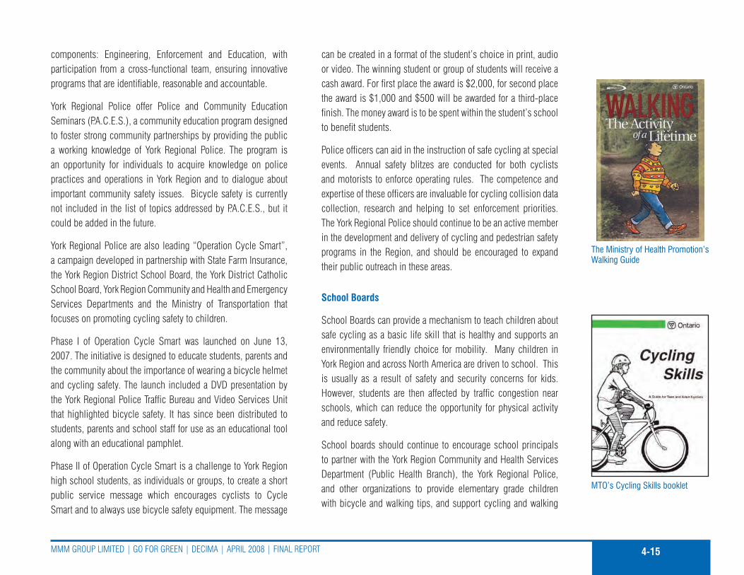
4-15MMM Group LIMITED | Go for GrEEn | DEcIMa | aprIL 2008 | fInaL rEporT
components: Engineering, Enforcement and Education, with participation from a cross-functional team, ensuring innovative programs that are identifiable, reasonable and accountable.
York regional police offer police and community Education Seminars (p.a.c.E.S.), a community education program designed to foster strong community partnerships by providing the public a working knowledge of York regional police. The program is an opportunity for individuals to acquire knowledge on police practices and operations in York region and to dialogue about important community safety issues. Bicycle safety is currently not included in the list of topics addressed by p.a.c.E.S., but it could be added in the future.
York regional police are also leading “operation cycle Smart”, a campaign developed in partnership with State farm Insurance, the York region District School Board, the York District catholic School Board, York region community and Health and Emergency Services Departments and the Ministry of Transportation that focuses on promoting cycling safety to children.
phase I of operation cycle Smart was launched on June 13, 2007. The initiative is designed to educate students, parents and the community about the importance of wearing a bicycle helmet and cycling safety. The launch included a DVD presentation by the York regional police Traffic Bureau and Video Services unit that highlighted bicycle safety. It has since been distributed to students, parents and school staff for use as an educational tool along with an educational pamphlet.
phase II of operation cycle Smart is a challenge to York region high school students, as individuals or groups, to create a short public service message which encourages cyclists to cycle Smart and to always use bicycle safety equipment. The message
can be created in a format of the student’s choice in print, audio or video. The winning student or group of students will receive a cash award. for first place the award is $2,000, for second place the award is $1,000 and $500 will be awarded for a third-place finish. The money award is to be spent within the student’s school to benefit students.
police officers can aid in the instruction of safe cycling at special events. annual safety blitzes are conducted for both cyclists and motorists to enforce operating rules. The competence and expertise of these officers are invaluable for cycling collision data collection, research and helping to set enforcement priorities. The York regional police should continue to be an active member in the development and delivery of cycling and pedestrian safety programs in the region, and should be encouraged to expand their public outreach in these areas.
School Boards
School Boards can provide a mechanism to teach children about safe cycling as a basic life skill that is healthy and supports an environmentally friendly choice for mobility. Many children in York region and across north america are driven to school. This is usually as a result of safety and security concerns for kids. However, students are then affected by traffic congestion near schools, which can reduce the opportunity for physical activity and reduce safety.
School boards should continue to encourage school principals to partner with the York region community and Health Services Department (public Health Branch), the York regional police, and other organizations to provide elementary grade children with bicycle and walking tips, and support cycling and walking
Mto’s cycling Skills booklet
the Ministry of health promotion’s Walking Guide

4-16
YorK rEGIon | pEDESTrIan & cYcLInG MaSTEr pLan STuDY | ouTrEacH | fInaL rEporT
becoming a more integral part of life and school. Examples of these initiatives could include:
Developing a plan to offer kids can-BIKE safety courses for �school-aged children;
Incorporating cycling into physical education curricula; �
providing targeted safety material such as the requirement �for bicycle helmets;
providing parents advisory Groups with bicycle safety �training;
organizing a “safe bike to school” program; and �
Include school board participation on bike safety groups. �
a Bike to School program has the potential to provide multiple benefits and capitalize on a number of on-going initiatives. Benefits, such as environmental, health, learning, and congestion relief from this initiative could be realized from a Bike to School program customized for York region students.
york Region Community and Health Services department
York region public Health Branch serves residents of the region by providing them with a variety of health promotion initiatives that encourage the adoption of health behaviours. The Healthy Lifestyles Division offers a number of best practice population health programs related to the prevention of chronic diseases and injuries for community members across the region. The active communities program provides consultation, education and support to community partners and members on best practice strategies that promote active transportation and disseminate messages on the health benefits of walking and cycling.
The Injury prevention and Seniors program of York region community and Health Services provides a collaborative and comprehensive approach to both pedestrian and cycling safety for children, teens and adults. a number of active community partnerships with York regional police (cycle Smart), The community Safety Village of York region and Safe Kids canada, provide messaging, community events and print materials to educate York region residents on the proper use of helmets and safe cycling and walking practices. curriculum resources such as THInK fIrST and rISKWaTcH which feature bike and pedestrian safety are provided to York region schools through the Healthy Schools program. a variety of written resources on cycling and pedestrian safety are also available for all ages.
The Healthy Lifestyles Division offers a number of fact sheets on bicycle safety, including:
Cycling safety � – pamphlet with information on helmet use, the Highway Traffic act, and tips for safe riding
Parents – Did You Know? Biking and Child Carriers � – points to consider for parents using a child carrier with their bike
Parents – Did You Know? Bike Safety Information � – outlines general bike safety information including development of children (why they are more likely to be injured)
Parents – Did You Know? Bike Helmet Information � – includes tips on how to get a proper helmet fit and when to replace a helmet
The York region community and Health Services Department also offers a one-hour Bicycle Safety Workshop for elementary school students. These programs should continue, and should be distributed to more students throughout the region. They
canada’s physical activity Guide promotes an active lifestyle

4-17MMM Group LIMITED | Go for GrEEn | DEcIMa | aprIL 2008 | fInaL rEporT
should also be taught in conjunction with additional programs, such as can-BIKE.
The Health protection Division delivers the ‘20/20 The Way to clean air’ program - a public education campaign that encourages individuals to reduce energy use by 20% at home and on the road. The campaign promotes walking, cycling and other modes of transportation that reduce emissions of air pollutants and greenhouse gases. Delivered by health units across the GTa, 20/20 reached approximately 12,000 households in 2006, achieving on average 2.6 tonnes of emission reductions.
Local Municipalities
The region must work with local municipalities as municipal cycling plans are implemented. not only is this important to ensure consistency in design as well as the provision of logical connections between systems, but this partnership is also important from an outreach point of view. Many of the recommended programs are best provided at a local municipal level. It is important that programs are coordinated between the region and Local municipalities for the successful implementation of the pcMp.
Ministry of Transportation (MTo)
The Ministry of Transportation of ontario (MTo) is the custodian of the province’s Bicycle policy last updated in 1992, as well as the Draft ontario Bikeways planning and Design Guidelines (1996). MTo also administers the Highway Traffic act (HTa), which legally identifies the bicycle as a vehicle, with cyclists having the same rights and duties on the road as motorists. The provincial government, therefore, has great influence over the present status and future potential for cycling in the province.
The Ministry was urged by a 1998 coroner’s report to take the lead role in improving bicycle safety and encouraging greater use of bicycles. The establishment of an “expert review process” involving municipal and other stakeholders was proposed to recommend changes to the HTa and Municipal By-Laws to make them consistent, understandable and easier to enforce with respect to cycling. In addition, it was recommended that MTo provide additional cycling safety information and content in all driver-training handbooks. Driving examiners should also have practical training in safe cycling can-BIKE courses.
The Ministry should take the leadership role in facilitating the communication of information on cycling issues throughout the province. In order to resume this role, the Ministry needs to revisit its 1992 Bicycle policy and update it as necessary to clarify its role to municipalities. current policies, facility designs and safety information would all assist in creating a standardized approach that municipalities in the province could use as a guide. Municipalities that do not have the resources to do their own research would benefit from obtaining this information. a good example already being taken by the Ministry is the recently updated cycling Skills booklet for teen and adult cyclists. The Ministry of Transportation also produces the Young cyclist’s Guide in cooperation with the ontario cycling association. The region of York should work with MTo as it proceeds with cycling initiatives and produces cycling information packages.
Ministry of Health Promotion
The Ministry of Health promotion was created in 2005 with a mandate to help ontarians lead healthier lives by delivering programs that promote healthy choices and healthy lifestyles. one of the Ministry’s Sports and recreation initiatives is the
The Ministry should take the
leadership role in facilitating the
communication of information
on cycling issues throughout
the province. In order to
resume this role, the Ministry
needs to revisit its 1992
Bicycle policy and update it as
necessary to clarify its role to
municipalities.

4-18
YorK rEGIon | pEDESTrIan & cYcLInG MaSTEr pLan STuDY | ouTrEacH | fInaL rEporT
ontario Trails Strategy, which provides a plan for developing and promoting a network of recreational-use trails throughout ontario. York region should work with the Ministry to collaborate on planning trail networks within York region, and providing connections to other municipalities.
The Ministry of Health promotion endorses canada’s physical activity Guide to Healthy active Living. This Guide promotes active transportation, such as walking and cycling, as part of healthy living. This physical activity reduces the risk of premature death, heart disease, obesity, high blood pressure and many other diseases and disorders. York region should continue efforts to endorse walking and cycling as part of a healthy lifestyle in its promotional material.
Cycling organizations
There are several cycling organizations in ontario, such as the cycle ontario alliance and the ontario cycling association. York region can use these organizations as resources for developing a strong outreach program for its residents. The ontario cycling association, for example, offers a number of education programs to teach cycling safety, such as SprocKIDS and can-BIKE. SprocKIDS is a program that teaches students basic maintenance and care of their bikes, and provides guidance in safety, health, nutrition and fitness. It also provides a social network for children to come together and learn about cycling. This program is designed to be used in recreation centres, schools, and bicycle clubs. can-BIKE is a program customized for children, teens and adults. It is a safe cycling skills program, and has become the standard for bicycle education in ontario. These programs should be offered as part of York region’s outreach initiatives.
Recommended Actions:
4-33 continue to work with regional police Services to further educate and enforce safe walking and cycling.
4-34 continue to work with school boards to provide elementary grade children with bicycle information, and support the initiative to have cycling become an integral part of life and school.
4-35 collaborate with local municipalities as municipal cycling plans are implemented.
4-36 Encourage the MTo to provide additional cycling safety information and content in all driver-training handbooks.
4-37 promote walking and cycling as part of a healthy, active lifestyle.
4-38 Work with the Ministry of Health promotion and the York region community and Services Department to improve conditions for walking and cycling in York region.
4-39 Implement a regional can-BIKE program.
4.2.8 tourism
Tourism is a huge economic engine, and cycling and hiking can play an important contributing role. York region already has many kilometres of existing off-road trails, which could be promoted as destinations for cycling and hiking tourists. There is ample proof that cycling can attract tourists and provide an economic return on investments. cycling is a major recreational activity in the united States, where people spend $3.1 billion on cycling every year.5 Many jurisdictions actively market their cycling infrastructure and services as part of a tourism package including Toronto, Vancouver, niagara region and Quebec as
5 Mountain Bike, 2000
Ontario Cycling Association
Cycle Ontario Alliance

4-19MMM Group LIMITED | Go for GrEEn | DEcIMa | aprIL 2008 | fInaL rEporT
well as numerous american States such as Vermont, Maine and Wisconsin.
Velo Quebec includes a tour group that actively promotes cycling tourism in Quebec. a May 10, 2004 press release from Velo Quebec underlined the Quebec government’s commitment to La route Verte, which is nearing its 4,300 km planned length. Expenditures of $7.5 million have been announced from that province to support expansion and maintenance of this bicycle network. In 1988, it was estimated that $88.5 million would be required to complete the network.6 Economic spin-offs of $95 million per year are generated from La route Verte cycling network, including $15 million in provincial taxes.
Similarly, the regional Municipality of niagara and its tourism arm (the niagara Economic Development corporation), incorporates cycling into its tourism strategy. cycling is seen as a popular and marketable activity that offers a pleasant way to see and experience the region’s attractions. It is also a means of enticing the “day-tripper” to spend additional time and money, which may include an overnight stay in the area. The 2003 regional niagara Bikeways Master plan provides a 20-year blueprint to support cycling at a cost of $70 million. It concludes that cycling tourism is, and will continue to be, a significant contributor to the niagara region economy. Direct expenditures from cycling tourists in niagara region were approximately $164 million in 2002, or 12% of the total tourism expenditures. This is projected to grow to $237 million or 13% of the total tourism expenditures over the next 20 years. The spin-offs created by these direct expenditures are significant. a total of 4,900 direct and indirect jobs in that region in 2002 were due to the expenditures of cycling tourists. In 20 years, this number is projected to increase to approximately
6 La route Verte newsletter, June 1998
7,000. The Regional Niagara Bicycling Map represents an initiative that combines cycling services and information with tourist attractions as a means of promoting cycling tourism.
Marketing York region as a cycling and hiking destination will serve to complement the policies and strategic directions outlined in this plan and encourage more cycling and walking in the region. It will be important to attract pedestrian and cycling tourists and guide them to routes that will ensure a positive experience which results in good referrals and return visits. The target audience for cyclists should include recreational cycling, mountain biking and overnight tours. The marketing plan must reach out to cyclists and pedestrians of all skill levels and ages. partnerships will also be critical in formulating a successful tourism program. The private sector should be encouraged to participate in the form of cycling and hiking tour operators, accommodation and service providers to help provide expertise and funding for a complete package of services for visitors. This will mean developing integrated bike route and transit connections. Good bicycle and pedestrian access to rail, bus and air terminals, and urging supportive accommodation policies on these modes is also important.
a plan to market cycling and hiking tourism should:
compile base data to quantify, characterize and monitor �cycling tourists and to help identify appropriate marketing strategies;
Generate interest in the cycling and hiking opportunities in �York region;
provide information about cycling and hiking services, clubs, �organizations and resources to help tourists plan cycling vacations;
Marketing York region as a
cycling destination will serve
to compliment the policies and
strategic directions outlined in
this plan and encourage more
cycling and walking in the
region.

4-20
YorK rEGIon | pEDESTrIan & cYcLInG MaSTEr pLan STuDY | ouTrEacH | fInaL rEporT
promote cycling and walking throughout the region, and �direct cyclists and pedestrians to areas where facilities result in a positive experience;
obtain private sector commitments and partnerships to �invest in making York region a tourist destination for active transportation; and
Develop good inter-city cycling and pedestrian connections �with regional bicycle routes, sidewalks and trails, inter-city terminals and on-board accommodations for bicycles.
Recommended Action:
4-40 Work with local tourism industries, the private sector and other tourism stakeholders to promote York region as a walking and cycling destination for tourists, visitors and vacationers, promoting the pedestrian and cycling-friendly nature of the region with its many attractions, pedestrian and cycling facilities and support services as part of the region’s marketing plan.
4.3 MoVinG FoRWaRd
The implementation of the York region pedestrian and cycling Master plan should be supported by a comprehensive and proactive outreach program. The preceding sections of this chapter have emphasized the importance of York region taking a leadership role in the development of such a program to educate residents, and to promote walking and cycling in the region. To create a successful outreach program, York region should continue to reach out to local municipalities and agencies to offer high quality outreach programs and services to York region residents. This approach with York region in a leadership role will provide the strongest means for information to be received.
The implementation of the
York region pedestrian and
cycling Master plan should be
supported by a comprehensive
and proactive outreach program.

MMM Group LIMITED | Go for GrEEn | DEcIMa | aprIL 2008 | fInaL rEporT

YorK rEGIon | pEDESTrIan & cYcLInG MaSTEr pLan STuDY | ouTrEacH | fInaL rEporT
Mic
haEL
haY
nES
York Region active transportation Workshop tour, June 2006
5-1MMM Group LIMITED | Go for GrEEn | DEcIMa | aprIL 2008 | fInaL rEporT
pedestrian and cycling facilities, whether they are located in boulevards, on streets or within green space corridors should reflect and accommodate residents’ needs and desires. This will encourage more people to walk and cycle in York region.
The two primary goals of the York region pedestrian and cycling Master plan Study (pcMp) are to improve conditions for walking and provide a comprehensive cycling network in both the urban and rural areas. This chapter presents the proposed long term pedestrian system and cycling network strategy. It identifies the types of cycling facilities envisioned for the network, suggests locations where missing sidewalk links on regional roads should be completed, recommends other strategies for improving conditions for walking in York region, and details the steps through which the proposed network was developed.
The proposed pedestrian and cycling network is planned as an integrated system of on-road and off-road facilities that implement the vision, goals and objectives of the pedestrian and cycling Master plan (pcMp).
The primary objectives of the York region pedestrian and cycling Master plan, as it relates to infrastructure, include the following:
To promote the safe and comfortable year round operation �of pedestrian and cycling routes through design, signage, enforcement and maintenance;
To identify a continuous and connected regional-scale �cycling network and enhanced pedestrian system that
can build upon and connect existing and proposed local municipal routes and facilities that support walking, cycling and the use of public transit;
To identify missing sidewalk links on regional roads in �urban areas and recommend strategies to improve on and off-road pedestrian connections to transit stops and terminals, employment centres, schools, recreational/leisure and commercial destinations; and
To encourage people to walk and cycle more often for both �utilitarian and recreation/health purposes.
5.1 regional PeDeSTrian SYSTeM
The proposed regional pedestrian system will consist primarily of sidewalks on regional roads and linear off-road multi-use trails. The pedestrian component of this Master plan Study has focused on identifying missing sidewalk links on regional roads in urban areas as well as identifying pedestrian “zones” where enhanced pedestrian infrastructure should be provided consistent with policies in the region’s official plan, Transportation Master plan and Transit oriented Development Guidelines. The range, type and density of recommended pedestrian infrastructure will vary depending on the location, density and range of land uses within each zone and implementation will be dependent on local municipalities as they have jurisdiction.
although local municipalities are responsible for implementing sidewalks, trails and encouraging pedestrian friendly land
IMprovInG facILITIES for WaLkInG anD cYcLInG In York rEGIon
Chapter 5
although local municipalities
are responsible for
implementing sidewalks, trails
and encouraging pedestrian
friendly land development, the
region also has a significant
interest in improving conditions
for walking and cycling in York
region.
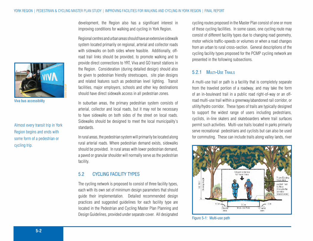
5-2
York rEGIon | pEDESTrIan & cYcLInG MaSTEr pLan STuDY | IMprovInG facILITIES for WaLkInG anD cYcLInG In York rEGIon | fInaL rEporT
development, the region also has a significant interest in improving conditions for walking and cycling in York region.
regional centres and urban areas should have an extensive sidewalk system located primarily on regional, arterial and collector roads with sidewalks on both sides where feasible. additionally, off-road trail links should be provided, to promote walking and to provide direct connections to YrT, viva and Go transit stations in the region. consideration (during detailed design) should also be given to pedestrian friendly streetscapes, site plan designs and related features such as pedestrian level lighting. Transit facilities, major employers, schools and other key destinations should have direct sidewalk access in all pedestrian zones.
In suburban areas, the primary pedestrian system consists of arterial, collector and local roads, but it may not be necessary to have sidewalks on both sides of the street on local roads. Sidewalks should be designed to meet the local municipality’s standards.
In rural areas, the pedestrian system will primarily be located along rural arterial roads. Where pedestrian demand exists, sidewalks should be provided. In rural areas with lower pedestrian demand, a paved or granular shoulder will normally serve as the pedestrian facility.
5.2 CYCling faCiliTY TYPeS
The cycling network is proposed to consist of three facility types, each with its own set of minimum design parameters that should guide their implementation. Detailed recommended design practices and suggested guidelines for each facility type are located in the pedestrian and cycling Master plan planning and Design Guidelines, provided under separate cover. all designated
cycling routes proposed in the Master plan consist of one or more of these cycling facilities. In some cases, one cycling route may consist of different facility types due to changing road geometry, motor vehicle traffic-speeds or volumes or when a road changes from an urban to rural cross-section. General descriptions of the cycling facility types proposed for the pcMp cycling network are presented in the following subsections.
5.2.1 Multi-use trails
a multi-use trail or path is a facility that is completely separate from the traveled portion of a roadway, and may take the form of an in-boulevard trail in a public road right-of-way or an off-road multi-use trail within a greenway/abandoned rail corridor, or utility/hydro corridor. These types of trails are typically designed to support the widest range of users including pedestrians, cyclists, in-line skaters and skateboarders where trail surfaces permit such activities. Multi-use trails located in parks primarily serve recreational pedestrians and cyclists but can also be used for commuting. These can include trails along valley lands, river
figure 5-1: Multi-use path
almost every transit trip in York
region begins and ends with
some form of a pedestrian or
cycling trip.
Viva bus accessibility
MM
M g
rouP

5-3MMM Group LIMITED | Go for GrEEn | DEcIMa | aprIL 2008 | fInaL rEporT
figure 5-2: example of an urban road cross section with 1.5 m bike lanesSource: Towards greater regional Streets - a Pathway to improvement Study; (Draft report 2006)

5-4
York rEGIon | pEDESTrIan & cYcLInG MaSTEr pLan STuDY | IMprovInG facILITIES for WaLkInG anD cYcLInG In York rEGIon | fInaL rEporT
and canal corridors, active or abandoned rail lines, hydro corridors and other linear routes that serve the needs of both recreational and utilitarian cyclists. Multi-use trails that form part of the proposed regional network should include appropriate signing to inform users that this trail segment is also part of the regional system.
5.2.2 Paved shoulder / Bike lane
a paved shoulder/bike lane is a facility located in the traveled portion of the roadway and is designed for one-way bicycle traffic. Bike lanes are typically located on urban streets. paved shoulders are often used to accommodate cyclists on rural road cross-sections. Even when paved shoulders or bike lanes are provided, cyclists are not required to use them. Because a bicycle is considered a “vehicle” under the Highway Traffic act, cyclists are legally permitted to travel with mixed traffic in a standard motor vehicle travel lane.
figure 5-3: Typical bike lane with and without on-street parking
Bike lanes and paved shoulder bikeways are normally denoted by pavement markings and signage that identifies the facility as part of the regional network.
The bike lane marking through bus stop zones should be a dash with a broken line consistent with the Transportation association of canada (Tac) Bikeway Traffic control Guidelines. current legislation requires vehicles to yield to buses, as indicated by markings on the rear of all buses.
figure 5-4: Typical paved shoulder
5.2.3 signed-only route
a signed-only route is an on-road bicycle route denoted with bicycle route signage and optional sharrow pavement markings and requires no other physical changes to the roadway. cyclists share the pavement and travel lane with motor vehicles. There are no special lane designations. The purpose of designating a signed-only bicycle route is to promote a road for cycling because it is deemed to be well suited for cycling and/or because it provides an important connection to where cyclists want to travel.
a bicycle is considered a
“vehicle” under the Highway
Traffic act.
rural road with paved shoulders
in-boulevard multi-use trail in newmarket
MM
M g
rouP
MM
M g
rouP

5-5MMM Group LIMITED | Go for GrEEn | DEcIMa | aprIL 2008 | fInaL rEporT
In urban areas on multi-lane roads, or where traffic volumes exceed the suggested thresholds for a signed-only route and where a bike lane is not feasible, a wide curb lane is often implemented. In rural areas, an edge line and paved shoulder is preferred. Edge lines located less than 1.2 m from the edge of pavement are not recommended on urban roads with curbs due to the risk of cyclists striking the curb and “bouncing” back into the motor vehicle travel lane and potentially colliding with a motorist. Existing urban cross-section roads with edge lines less than 1.2 m from the face of curb should not be signed as bike lanes. Should a cycling route be preferred on this type of road, consideration should be given to providing a signed-only route.
Signed-only cycling routes can be located on roads with standard curb lane widths or wide curb lane widths. In this situation, the travel lane is still shared by motorists and cyclists.
figure 5.5: Signed-only cycling route along a wide curb lane
5.3 neTwork anD SYSTeM DeVeloPMenT aPProaCh
The approach to developing the recommended pedestrian system and cycling network involved a number of iterative steps:
1. Developed a set of route selection principles;
2. reviewed and updated the region’s inventory of existing conditions;
3. Identified major attractions and destinations;
4. Identified barriers to walking and cycling;
5. Mapped existing conditions;
6. Developed a more detailed set of route evaluation criteria to guide the selection of candidate cycling routes and identify areas where pedestrian improvements should be considered; and
7. Identified, field investigated and assessed a set of candidate routes and then reviewed these with both the public and stakeholders.
The following sub-sections describe each of these steps.
5.3.1 route selection PrinciPles
The following is a list of guiding principles that were used to develop the York region pedestrian and cycling Master plan. These principles were reviewed and confirmed by the study team based on observations of existing conditions, input obtained from public consultation and from the review of the background documents. Bicycle route Marker sign
Source: TaC, Bicycle route Traffic Control guidelines, 1998
example of a signed-only cycling route
a signed-only route is an
on-road bicycle route denoted
strictly with bicycle route
signage and requires no
other physical changes to the
roadway.
MM
M g
rouP

5-6
York rEGIon | pEDESTrIan & cYcLInG MaSTEr pLan STuDY | IMprovInG facILITIES for WaLkInG anD cYcLInG In York rEGIon | fInaL rEporT
Attractive and Scenic: � cycling and pedestrian routes should take advantage of attractive and scenic areas, views and vistas and promote natural and cultural heritage.
Diverse Experience: � The pedestrian system and the cycling network should provide a diverse on and off-road walking and cycling experience.
Visible: � The pedestrian and cycling routes should be a visible component of the transportation system.
Direct / Connected: � all routes should be connected to form an overall pedestrian system and cycling network.
Easily Accessible: � pedestrian and cycling routes should be easily accessible from local neighbourhoods within the region, and every effort should be made to integrate these routes with local area networks.
Reduce Risk: � The system should be designed to improve the safety of all users. The confidence and acceptance of the network can be instilled in users by reducing real and perceived risks.
Destinations: � pedestrian and cycling routes should provide access to major destinations in the region including natural, cultural and service facilities, as well as routes to schools, community and neighbourhood parks and shopping facilities.
New Rights-of-Way: � new rights-of-way should be designed where feasible to accommodate both pedestrians and cyclists.
Integration with other modes: � The pedestrian system and the cycling network should be integrated with other modes of transportation, particularly public transit. routes should be selected to provide access to transit stops and stations.
Broad Based: � The cycling network should appeal to a range of cycling abilities and interests. This requires the design of a variety of route types.
Supporting Services and Facilities: � Supportive services and facilities such as benches and bicycle parking should be available along routes and at destinations. routes should be selected that provide opportunities to develop supporting facilities.
Sustainable: � cycling and pedestrian routes should protect and enhance natural heritage wherever possible. route design and planning should not only take into consideration minimized environmental disturbance, but also future use of trails with a mind to minimizing disturbance of the environment through design and signage.
5.3.2 review and uPdate inventory of existing conditions
The next phase in developing the draft network plan involved preparing an inventory of existing and previously proposed on and off-road cycling and pedestrian facilities in the region. This was crucial in order to understand where and what types of facilities currently exist in the region, regardless of jurisdiction.
This task entailed reviewing the regional official plan, the York region Transportation Master plan as well as Local Municipal planning documents. Information was also assembled from the region’s existing trail maps, as well as from discussions with regional and Local Municipal staff and other stakeholders.
regional staff provided the study team with a digital Geographic Information System (GIS) database as well as digital ortho (aerial) photography of the entire region. Information from these and other sources provided the study team with information that
a pedestrian friendly streetscape, Main Street, Town of newmarket
pedestrian and cycling routes
should be easily accessible
from local neighbourhoods
within the region, and every
effort should be made to
integrate these routes with local
area networks.
York
reg
ion

5-7MMM Group LIMITED | Go for GrEEn | DEcIMa | aprIL 2008 | fInaL rEporT
included a current inventory of sidewalks on regional roads (2004 data), average annual Daily Traffic (aaDT) volume data and posted speed limits for regional roads, where data was available.
all the information available regarding existing or planned pedestrian and cycling facilities was then consolidated and used to prepare inventory maps. The Technical advisory committee, as well as regional and Local Municipal staff, reviewed these maps.
5.3.3 identify Major attractions and destinations
Major cycling attractions and destinations in the region were identified with input from the Technical Steering committee and other stakeholders. This stage identified some of the key recreational, commuter and utilitarian destinations for pedestrians and cyclists in the region. These generally include all settlement areas, tourist attractions, colleges, major employment centres, civic centres including libraries, major retail centres or shopping districts and recreational facilities. In addition, major land uses and natural areas such as parks and conservation areas, public lands, water bodies, prominent vistas, roads, residential areas, publicly accessible wood lots and wetlands were included.
The inventory of major cycling attractions and destinations in York region was then used in association with the other route selection criteria to assess and confirm existing or proposed pedestrian and cycling routes, and to identify areas where improved pedestrian and cycling access and facilities may be warranted.
5.3.4 identify Barriers to walking and cycling
In developing a cycling network and identifying missing sidewalk links, it is important to first understand the nature of perceived or real barriers to walking and cycling. This is especially true for York region because of the myriad of natural features and infrastructure elements that impact transportation route and travel mode choices.
There are both primary and secondary barriers to walking and cycling in York region. primary barriers include the 400 series highways, railways, rivers, wetlands, ravines and long travel distances. Secondary barriers are those that tend to discourage cycling for all but the most experienced riders, and include major regional and local arterial and collector roads, mid-block crossings of major roadways, and trails with difficult terrain.
The purpose of this step in developing the cycling network and identifying missing sidewalk links was to confirm the location of major barriers so that opportunities to overcome them could be investigated in the route selection stage. This step also considered accessibility issues for persons with disabilities.
Identifying major barriers enabled the study team to develop a recommended cycling network for the region that encourages use by moderately experienced riders and touring cyclists, not just highly experienced riders. The planning and Design Guidelines developed as part of this study provide the tools necessary for regional and local municipal staff to implement a region wide pedestrian system and cycling network that can be enjoyed by users of all ages and experience levels.
In developing a cycling network
and identifying missing
sidewalk links, it is important
to first understand the nature
of perceived or real barriers to
walking and cycling.

5-8
York rEGIon | pEDESTrIan & cYcLInG MaSTEr pLan STuDY | IMprovInG facILITIES for WaLkInG anD cYcLInG In York rEGIon | fInaL rEporT
5.3.5 existing context
all of the existing and previously proposed on and off-road cycling facilities as well as major attractions and destinations were compiled and digitally mapped. figures a1 and a2 in appendix a illustrate the existing context upon which this plan has been based.
5.3.6 candidate route evaluation criteria
following the review of existing and previously proposed cycling routes throughout the region, the study team selected a series of candidate routes that best connected attractions and destinations throughout the region and were deemed to be suitable as part of a logical, continuous and connected regional cycling network. The candidate routes selected then had to be checked for their suitability in the field. This required the need for route evaluation criteria to assess each candidate route.
route evaluation criteria were developed with input from the Steering committee and public based on the route selection principles. Table 5-1 outlines the criteria used to assist the team as they investigated candidate routes for possible inclusion in the network plan. additional evaluation criteria may be required at the design/implementation phase (see section 6.7.5)
5.3.7 candidate routes
a set of on and off-road candidate routes were identified and mapped using the information collected as part of this study. This task also included input from the Technical advisory committee as well as the route selection principles and criteria, regional and Local Municipal staff and the public through the study’s formal public consultation process.
The candidate routes were further refined based on public input received following a public open House held in october, 2006 as well as comments received from local municipal staff and stakeholders. Some route alternatives were removed or added based on comments received.
The refined candidate route alternatives were then investigated in the field to confirm their suitability for inclusion into the proposed pedestrian system and cycling network. route selection was generally based on the application of the criteria, the experience of the team, observations made in the field, as well as consideration of information such as missing sidewalk links, traffic volumes, road and rights-of-way width, distance from key destinations and the nearest proposed route, and the cost effectiveness of implementing the preferred pedestrian and/or cycling facility. potential cycling routes were further screened and those considered less desirable compared to a parallel route were then eliminated from further consideration. routes that were thought by the study team to best satisfy the criteria formed the proposed draft regional pedestrian system and cycling network.
The pedestrian system component of the study focused on missing links in the sidewalk system on regional roads as well as developing a set of pedestrian supportive actions and guidelines for both the region and Local Municipalities.
figure a3 in appendix a illustrates the candidate route alternatives. Figure 5-6 illustrates how some of the various attributes and map layers can be viewed and also demonstrates that the York region pedestrian cycling Master plan is the result of a number of layers of information that have been compiled and developed in a particular sequence through the network development process.
field investigating a candidate route
route selection was generally
based on the application of the
criteria, the experience of the
team, observations made in the
field, as well as consideration
of information such as missing
sidewalk links, traffic volumes,
road and rights-of-way width,
distance from key destinations
and the nearest proposed route,
and the cost effectiveness of
implementing the preferred
pedestrian and/or cycling
facility.
MM
M g
rouP

5-9MMM Group LIMITED | Go for GrEEn | DEcIMa | aprIL 2008 | fInaL rEporT
FACTOR EVALUATION CRITERIA
Safety
are there numerous mid-block or railway track crossings? �
Is there a high volume of automobiles, trucks and transit vehicles? �
Is there sufficient right-of-way width to accommodate bike lanes, boulevard �
pathways and/or sidewalks?
Does the route provide a safe crossing of major barriers? �
are there poor sight-lines? �
What is the posted speed limit of the route, if applicable? �
can the route accommodate the preferred facility type? �
connectivity/ access
Does the route provide a vital connection to existing routes and trails? �
Does the route provide direct access to major destinations and connect �
major nodes (including transit nodes) throughout the region?
Does the route connect to municipal networks, supporting services and �
facilities?
convenience
Is the route impeded by numerous stop signs? �
Is the route impeded by numerous closely spaced traffic control signals? �
Is the route part of the “Spine” network? �
Does the route provide a direct path to the destination? �
attractiveness
Does the route provide access to region’s scenic routes, vistas and �
destinations?
Is the route highly visible? �
Does the route provide diversity of experience? �
cost
Is the route the most cost-effective solution? �
Is there the ability to reduce costs by combining route development with �
existing road works?
route alignment
Is the location suitable with respect to adjoining land uses and �
environmental considerations?
How can existing barriers be overcome? �
Is the road right-of-way width sufficient to accommodate cycling facilities, �
or does the roadway require widening?
TaBle 5-1: rouTe eValuaTion CriTeria
This figure illustrates the on and off-road route selection and evaluation criteria that were applied in the field to assist the team as they investigated candidate routes for inclusion in the draft network plan.

5-10
York rEGIon | pEDESTrIan & cYcLInG MaSTEr pLan STuDY | IMprovInG facILITIES for WaLkInG anD cYcLInG In York rEGIon | fInaL rEporT
Figure 5-6: Network Development RoutesThis figure illustrates the network development approach which consisted of:
reviewing and updating the region’s inventory of existing �conditions;considering key destinations and barriers to walking and cycling �and connections to public transit;Developing a set of candidate routes and field investigating and �assessing each; and Developing a draft cycling network and pedestrian System plan. �

5-11MMM Group LIMITED | Go for GrEEn | DEcIMa | aprIL 2008 | fInaL rEporT
5.4 iMProVing ConDiTionS for walking in The region
Improving conditions for walking is more than just creating a network of connecting pedestrian facilities such as sidewalks and pathways. although these facilities are important, the essential element is to create a system that “engages” pedestrians and makes them feel comfortable when using it, rather than a system that treats pedestrians as an after-thought. The concept of “every street should be viewed as a pedestrian street” is a notion that should be adopted as part of this plan. The goals are to improve the environment for pedestrians of all age levels, create a system that is accessible for all types of users and encourage more people to walk more often.
The primary objectives of the pedestrian component of the York region pedestrian and cycling Master plan include the following:
To improve sidewalks on regional roads and pedestrian �infrastructure connections to public transit stops and transit stations;
To encourage and support pedestrian friendly urban design �and streetscaping; and
To improve pedestrian connectivity and accessibility. �
York region’s Transit oriented Development Guidelines adopted in 2006 reinforce the need to have pedestrian walkways and connections to transit that accommodate people with disabilities, and promote safety for users.
5.4.1 coMPlete Missing sidewalk links
a key step necessary to help improve conditions for walking in York region is to complete missing links in the existing sidewalk system on both regional and local municipal roads. Sidewalks serve as the foundation of York region’s pedestrian system and need to be continuous so they can connect people to where they want to go. Missing links act as barriers and can discourage walking. This is especially critical in urban areas (i.e. pedestrian Zones) in the region.
a comprehensive and connected sidewalk system is also critical to supporting public transit ridership. Since almost every transit trip begins and ends with some form of a pedestrian trip, these two travel modes should be viewed as being mutually dependant upon one another. as the jurisdiction responsible for public transit, York region has a vested interest in encouraging local municipalities to complete and expand the sidewalk system wherever possible.
as part of the Master plan Study, York region’s inventory of sidewalks on regional roads was reviewed, and missing links were identified. In some location sidewalks are only located on one side of a road, while in other locations there are no sidewalks. Locations where transit stop hubs had no connecting sidewalks were given careful attention as part of this review.
a set of candidate sidewalk improvements were identified and investigated in the field after they were first presented to the public and stakeholders at a public open house in october of 2006. figure a4 in appendix a illustrates the initial set of candidate sidewalk improvements presented at the open house in october of 2006. Input received from the public combined with observations made in the field were used to map priority
an ideal pedestrian environment is accessible to various modes of transportation and user groups.
Benches and patios should be provided along pedestrian corridors, especially at major junctions between other pedestrian routes and at major attractions and destinations.
York
reg
ion
York
reg
ion
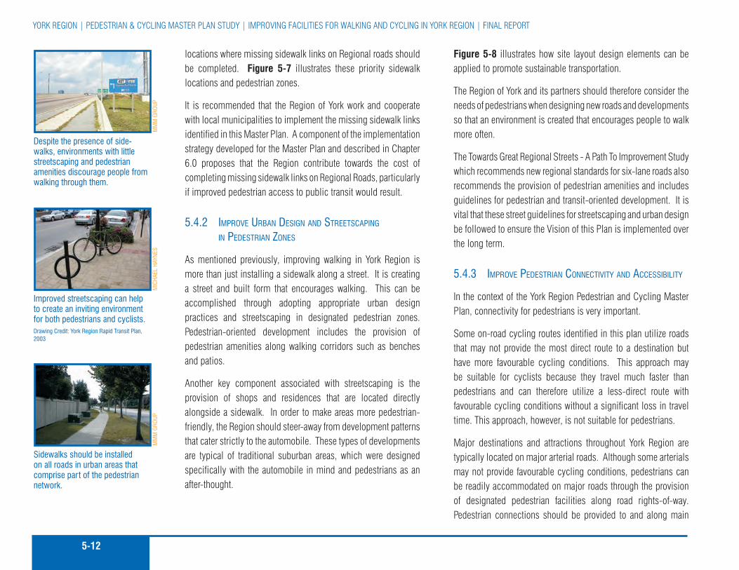
5-12
York rEGIon | pEDESTrIan & cYcLInG MaSTEr pLan STuDY | IMprovInG facILITIES for WaLkInG anD cYcLInG In York rEGIon | fInaL rEporT
locations where missing sidewalk links on regional roads should be completed. Figure 5-7 illustrates these priority sidewalk locations and pedestrian zones.
It is recommended that the region of York work and cooperate with local municipalities to implement the missing sidewalk links identified in this Master plan. a component of the implementation strategy developed for the Master plan and described in chapter 6.0 proposes that the region contribute towards the cost of completing missing sidewalk links on regional roads, particularly if improved pedestrian access to public transit would result.
5.4.2 iMProve urBan design and streetscaPing in Pedestrian Zones
as mentioned previously, improving walking in York region is more than just installing a sidewalk along a street. It is creating a street and built form that encourages walking. This can be accomplished through adopting appropriate urban design practices and streetscaping in designated pedestrian zones. pedestrian-oriented development includes the provision of pedestrian amenities along walking corridors such as benches and patios.
another key component associated with streetscaping is the provision of shops and residences that are located directly alongside a sidewalk. In order to make areas more pedestrian-friendly, the region should steer-away from development patterns that cater strictly to the automobile. These types of developments are typical of traditional suburban areas, which were designed specifically with the automobile in mind and pedestrians as an after-thought.
Figure 5-8 illustrates how site layout design elements can be applied to promote sustainable transportation.
The region of York and its partners should therefore consider the needs of pedestrians when designing new roads and developments so that an environment is created that encourages people to walk more often.
The Towards Great regional Streets - a path To Improvement Study which recommends new regional standards for six-lane roads also recommends the provision of pedestrian amenities and includes guidelines for pedestrian and transit-oriented development. It is vital that these street guidelines for streetscaping and urban design be followed to ensure the vision of this plan is implemented over the long term.
5.4.3 iMProve Pedestrian connectivity and accessiBility
In the context of the York region pedestrian and cycling Master plan, connectivity for pedestrians is very important.
Some on-road cycling routes identified in this plan utilize roads that may not provide the most direct route to a destination but have more favourable cycling conditions. This approach may be suitable for cyclists because they travel much faster than pedestrians and can therefore utilize a less-direct route with favourable cycling conditions without a significant loss in travel time. This approach, however, is not suitable for pedestrians.
Major destinations and attractions throughout York region are typically located on major arterial roads. although some arterials may not provide favourable cycling conditions, pedestrians can be readily accommodated on major roads through the provision of designated pedestrian facilities along road rights-of-way. pedestrian connections should be provided to and along main
Despite the presence of side-walks, environments with little streetscaping and pedestrian amenities discourage people from walking through them.
improved streetscaping can help to create an inviting environment for both pedestrians and cyclists. Drawing Credit: York region rapid Transit Plan, 2003
Sidewalks should be installed on all roads in urban areas that comprise part of the pedestrian network.
MiC
hael
haY
neS
MM
M g
rouP
MM
M g
rouP

5-13MMM Group LIMITED | Go for GrEEn | DEcIMa | aprIL 2008 | fInaL rEporT
Figure 5-7: York Region Pedestrian System StrategyThis figure illustrates the priority locations to complete missing sidewalk links and pedestrian zones where expanded pedestrian infrastructure should be encouraged.
Sidewalks are the foundation of the region’s Pedestrian System
MiC
hael
haY
neS
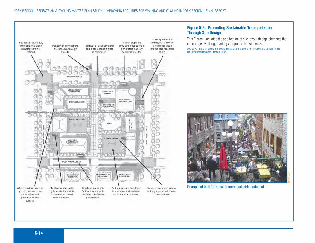
5-14
York rEGIon | pEDESTrIan & cYcLInG MaSTEr pLan STuDY | IMprovInG facILITIES for WaLkInG anD cYcLInG In York rEGIon | fInaL rEporT
Figure 5-8: Promoting Sustainable Transportation Through Site DesignThis figure illustrates the application of site layout design elements that encourages walking, cycling and public transit access.Source: CiTe and iBi group; Promoting Sustainable Transportation Through Site Design: an iTe Proposal recommended Practice; 2004
example of built form that is more pedestrian oriented
iBi g
rouP

5-15MMM Group LIMITED | Go for GrEEn | DEcIMa | aprIL 2008 | fInaL rEporT
roads because that is typically where pedestrians want to go to access destinations such as shopping malls, plazas, theatres, businesses and transit stops.
on major arterial roads with heavier traffic volumes, pedestrian amenities such as barriers and landscaped boulevards can help make walking conditions more pleasant for pedestrians. The planning and Design Guidelines details numerous pedestrian amenities that can be considered to improve the pedestrian environment and improve walking conditions for pedestrians along all roads in the region.
Whenever possible, direct pedestrian connections should be provided to link major destinations and attractions throughout the region, as well as to provide pedestrian connectivity throughout the network itself.
pedestrian facilities, particularly sidewalks and connecting off-road trails in subdivisions, are crucial to providing an effective alternative to the private (single occupant) automobile for trips to and from schools, recreation facilities, community and regional shopping areas, commercial and employment nodes, bus terminals and transit hubs. The recommended distance from these destinations to public transit stops and hubs should be between 200-500 metres, in accordance with York region’s Transit-oriented Development Guidelines.
as previously noted, pedestrian connectivity includes pedestrian connections to other travel modes, specifically public transit. Every transit trip requires a walking trip to some extent. Therefore, appropriate connections to transit facilities such as bus stops and transit terminals should be provided and viewed as implementation priorities by the region. connectivity to transit should also include cyclists and the provision of cycling facilities.
The recently implemented viva bus rapid transit network provides bicycle parking facilities at all of its stops.
5.4.4 ProPosed Pedestrian systeM
When the priority missing sidewalk links are completed, the pedestrian system should include more than 680 linear kilometres of sidewalks on regional roads. This will consist of a total of 115 linear km of new sidewalks on one side of the road and 82 linear km of new sidewalks on both sides of the road. of the total 683 linear km of sidewalks, 486 linear km exist today.
Table 5-2 identifies the number of kilometres for both existing sidewalks and proposed sidewalk links by type and ownership by jurisdiction.
5.5 The regional CYCling neTwork
The primary objective of the cycling component of the York region pedestrian and cycling Master plan is:
To identify a continuous and connected regional-scale �cycling network that builds upon, connects and supports existing and planned local municipal routes and facilities, cycling as a utilitarian and recreational activity, and public transit use.
York region’s proposed cycling network should also be viewed as part of a Greater Toronto area (GTa) cycling system. regional and municipal boundaries are usually invisible to pedestrians and cyclists. However, a municipal boundary can sometimes become the “end of the road”, simply because a proper cycling or pedestrian connection has not been made to the neighbouring region or municipality. In developing this Master plan every effort
almost every transit trip begins and ends with a pedestrian trip
The planning and Design
Guidelines details numerous
pedestrian amenities that can
be considered to improve the
pedestrian environment and
improve walking conditions for
pedestrians along all roads in
the region.
York
reg
ion
York
reg
ion

5-16
York rEGIon | pEDESTrIan & cYcLInG MaSTEr pLan STuDY | IMprovInG facILITIES for WaLkInG anD cYcLInG In York rEGIon | fInaL rEporT

5-17MMM Group LIMITED | Go for GrEEn | DEcIMa | aprIL 2008 | fInaL rEporT
Figure 5-9: Proposed Cycling NetworkThis figure illustrates the recommended route alignment and facility types for the regional cycling network.

5-18
York rEGIon | pEDESTrIan & cYcLInG MaSTEr pLan STuDY | IMprovInG facILITIES for WaLkInG anD cYcLInG In York rEGIon | fInaL rEporT

5-19MMM Group LIMITED | Go for GrEEn | DEcIMa | aprIL 2008 | fInaL rEporT
has been made to connect to local municipalities in the region as well as all surrounding municipalities.
Figure 5-9 presents the proposed cycling network, including the recommended facility types. although some of the routes proposed utilize existing or previously proposed local municipal routes, the majority of the network utilizes regional roads. a full size plot of figure 5-9 is provided in appendix a. figures a5a to 5i, located in appendix a, illustrate the cycling network identified in figure 5-9, but are presented by each local municipality in the region.
over the next 25+ years, and if implemented as proposed in chapter 6.0 (The Implementation Strategy), the recommended cycling network could include approximately 1,244 kilometres of designated cycling facilities, consisting of a total of 1,035 km of designated on-road facilities and 209 km of off-road cycling routes. of the total 1,035 km of on-road regional network cycling facilities, 45 km exist today, 805 km would consist of a combination of on-road bike lanes or paved shoulders and the remaining 185 km would be signed-only routes, which would only require the addition of bicycle route signing.
Many regional roads currently have paved shoulders that range from 0.75 m to 1.5 m in width. The preferred shoulder width for a road with moderate to high peak period traffic volumes and an 80 km/hr posted speed limit is 1.5 m to 2.0 m in width. However, cyclists are currently using many of these roads with existing paved shoulders that are below the preferred width. The region should designate some of these roads with low or moderate traffic volumes as an existing component of the cycling network by simply adding signage. When the road is scheduled for resurfacing or construction, the preferred shoulder width of 1.5 to 2.0 m should be provided.
Table 5-3 summarizes the number of kilometres for both existing and planned cycling routes by facility type and ownership by jurisdiction.
5.5.1 network oPPortunities
The proposed regional cycling network builds upon and connects local municipal cycling networks and major trail systems, links urban and rural centres as well as key attractions in the region and creates a regional spine that will facilitate transportation by bicycle for both utilitarian and recreational purposes and support the use of public transit. In addition, parts of the network are destinations for cyclists and pedestrians. Examples of two of these include the Lake Simcoe to Lake ontario route and the Terry fox Bikeway concept.
Proposed Lake Simcoe to Lake Ontario Route
In developing the proposed network plan, members of the study team and the public suggested the network should include a linear on and off-road connection from Lake Simcoe at the northern edge of the region of York through the city of Toronto to Lake ontario in the south. The alignment proposed in the Master plan utilizes existing and proposed off-road sections as well as a number of roads to complete the Lake-to-Lake route, and presents an opportunity to promote watershed tourism.
on-road segments of the Lake-to-Lake route in this Master plan are proposed to consist primarily of bike lanes and sidewalks on urban cross-section roads, paved shoulders and signed-only routes on rural cross-section roads and a few existing in-boulevard multi-use trails (e.g. vandorf Sideroad west of Bayview avenue in aurora).
York region roads are regularly used by cycling clubs
MM
M g
rouP
5-20
York rEGIon | pEDESTrIan & cYcLInG MaSTEr pLan STuDY | IMprovInG facILITIES for WaLkInG anD cYcLInG In York rEGIon | fInaL rEporT
recognizing that the Lake-to-Lake route is envisioned as a major recreational “regional-trail” and is expected to be a major destination and amenity for all York region residents, the region may want to consider “upgrading” the proposed facility type on the on-road sections by providing an in-boulevard multi-use trail on one side of the road in place of a sidewalk. for example, one section of Leslie Street from just north of 16th avenue north to Elgin Mills road currently has a single sidewalk on the west side of the road. When lands along the east side of Leslie Street in this area are developed, the region, working with the Town of richmond Hill, could request that developers provide a 3.0 m asphalt multi-use trail in place of a sidewalk in the boulevard. assuming sufficient right-of-way exists, the cost to construct an asphalt multi-use trail is comparable to a concrete sidewalk.
To the south, Leslie Street from 16th avenue south to John Street (where an existing off-road trail begins) is a five lane roadway with sidewalks on both sides of the road. If this section of Leslie Street is widened in the future, the region could consider implementing a multi-use trail in the boulevard in place of one sidewalk, instead of adding bike lanes. If Leslie is not to be widened in the foreseeable future, another option might be to implement a multi-use trail in the boulevard by converting one of the existing sidewalks by simply paving over the sidewalk and adding some additional width.
To the north, Leslie Street from Elgin Mills to vandorf sideroad is a rural cross-section road with moderate to low traffic volumes and truck traffic, except during the morning and afternoon peak commuting hours. This section of the route should remain on road utilizing paved shoulders where feasible. In the future, if this segment of the road is ever widened, consideration should be given to upgrading to a multi-use trail on one side of the road.
another possible option might be for the region to investigate, as part of a future study to develop a regional natural Heritage Trails Master plan, the opportunity to shift part of the on-road segment to existing or previously proposed trail segments along natural corridors. The work completed for the pedestrian and cycling Master plan Study concluded that Leslie Street was the most direct and best connected corridor for the proposed Lake-to-Lake route.
The route concept for the Lake-to-Lake route is outlined below:
The route could start at Lake Simcoe at the north end of Lake �Drive;
West on ravenshoe road to its end where a new multi-use �trail/boardwalk would continue south along the east side of the Holland river East Branch to Queensville Sideroad West. The alignment for the off-road part of this segment will need to be reviewed and confirmed by the Lake Simcoe region conservation authority;
The route would join the existing Simcoe Trail from �Queensville Sideroad east to connect to the existing Holland river Trail to rogers reservoir;
from rogers reservoir, the route would continue south �along the nokiidaa Trail, cross Green Lane and continue south through newmarket;
South through newmarket on the Tom Taylor Trail through �Mulock Drive to Yonge Street just north of St. Johns Sideroad;
Jog on-road for a short distance and then pick-up the Holland �river trail (part of nokiidaa System) in aurora just west of Industrial parkway and continue south to vandorf Sideroad;
Jog on-road west to Leslie Street and then continue south on �Leslie Street to John Street in the Town of Markham;
Lake-to-Lake route:
In developing the proposed
network plan, members of
the study team and the public
suggested the network should
include a linear on and off-road
connection from Lake Simcoe
at the northern edge of the
region of York through the city
of Toronto to Lake ontario in the
south.
MM
M g
rouP
MM
M g
rouP

5-21MMM Group LIMITED | Go for GrEEn | DEcIMa | aprIL 2008 | fInaL rEporT
continue south both on and off-road along the East Don river �parkland and trail corridor to Don Mills road where it could jog down to York Mills road
Head west to the new Leaside Spur multi-use trail being �constructed this year by the city of Toronto that will start just west of Leslie Street; and
Take the Leaside Spur trail south to the intersection of �Lawrence avenue at Leslie Street where the route would then connect with the existing Don valley Trail in Wilket creek park (Edwards Gardens). This trail continues south along the Don valley to Lake ontario.
Figure 5-10 identifies the proposed Lake Simcoe to Lake ontario (Lake to Lake) route concept. If implemented as proposed, the Lake-to-Lake segment in York region could span approximately 92 kms.
a recommended network implementation strategy, including a schedule for implementing the first 10 years of the Master plan strategy is provided in chapter 6.0 of this study.
figure 5-10: Proposed lake-to-lake route - 92 kms
York Region

5-22
York rEGIon | pEDESTrIan & cYcLInG MaSTEr pLan STuDY | IMprovInG facILITIES for WaLkInG anD cYcLInG In York rEGIon | fInaL rEporT
Recreational Circle Routes
The proposed York region cycling network component of the plan will allow both pedestrians and cyclists the opportunity to combine network segments to form numerous “loops” for recreational and fitness purposes. one example of this opportunity to create a recreational loop is from a proposal submitted to York region as input to the pedestrian and cycling Master plan Study on behalf of on-road cycling clubs. The proposal calls for the creation and designation of a permanent on-road cycling circle route in York region and includes the suggestion that it be named the Terry fox Bikeway.
Terry Fox Bikeway �
The concept of the Terry fox Bikeway was first developed by Joe Doria, a resident of York region, and has since been endorsed by the Terry fox foundation, D’ornellas racing Team, newmarket Eagles cycling club and the Toronto Bicycling network. The concept for the Terry fox Bikeway is to develop an on-road loop in York region for road cycling enthusiasts. The proposal was formally submitted to the region in January of 2007, was reviewed by the Master plan study team, and has been considered in the development of the draft network. The route concept for the Terry fox Bikeway is outlined below:
“The Terry fox Bikeway would officially start at or near the Markham fairgrounds (Elgin Mills road and Mccowan road) and encompass the following roads: Mccowan road, Elgin Mills road, St. John’s Side road and Warden avenue. Somewhere along the Terry fox Bikeway a park and parking lot would be built as a general meeting place to attract cyclists from York region and surrounding municipalities. The properties around the Markham
fairgrounds would be an ideal location for a dedicated park and parking facilities.”1
Figure 5-11 was part of Mr. Doria’s submission to the region and illustrates a concept for the Terry fox Bikeway. If implemented as proposed, the Terry fox Bikeway loop would be approximately 38 km in length.
Figure 5-12 illustrates the location of the proposed route.
although the Terry fox Bikeway circle route concept is not specifically identified by name in the region’s proposed network plan, the roads that are proposed by Joe Doria to form this circle route have been included as part of the region’s long term network strategy.
It is recommended that following adoption of the pedestrian and cycling Master plan that York region staff investigate and establish a position and a process for working with local municipalities and interest groups who wish to designate a specific section of the regional pedestrian and cycling network as a recreational destination.
1 Terry fox Bikeway, January 2007, Joe Doria, p. Eng.
The concept for the Terry fox
Bikeway is to develop an on-
road loop in York region for
road cycling enthusiasts.

5-23MMM Group LIMITED | Go for GrEEn | DEcIMa | aprIL 2008 | fInaL rEporT
figure 5-11: illustrated concept of the Proposed Terry fox BikewaySource: Joe Doria, Terry fox Bikeway implementation Proposal for the York region Pedestrian & Cycling Master Plan to 2026, January 2007
figure 5-12 Proposed Terry fox Bikeway route - 38 kms
5.6 reCoMMenDeD aCTionS
The following actions are recommended to support improving conditions for walking and cycling in York region.
5-1 Develop the pedestrian system and cycling network as identified in the York region pedestrian and cycling Master plan, including on-road routes, off-road routes, and multi-use pathways, for both utilitarian and recreational trip purposes. Improve and expand upon this network and add missing links through opportunities offered by unopened road allowances, hydro rights-of-way, existing or abandoned rail corridors, open green-space development and future roadway improvements;
5-2 Enable the plan to be flexible to accommodate route revisions or changes in facility types, provided that continuity and functionality of the route is maintained in the same general location;
5-3 York region should work to encourage pedestrian and cycling friendly streetscaping, urban design and pedestrian-oriented land development through the proposed Inter-Municipal Working Group as well as the Municipal Streetscape partnership policy, the Municipal pedestrian and cycling partnership policy and through planning/design studies and development review where the region and local municipalities and conservation authorities together have a role;
5-4 consider transportation operational measures as part of transportation system management to support safe and convenient cycling. These measures may include, but are not limited to:
- Exemptions from turn prohibitions for cyclists;

5-24
York rEGIon | pEDESTrIan & cYcLInG MaSTEr pLan STuDY | IMprovInG facILITIES for WaLkInG anD cYcLInG In York rEGIon | fInaL rEporT
- Bicycle detection at intersections;
- Management of loading zones and street parking to minimize disruption to cyclists and pedestrians; and
- Enforcing speed limits on roadways where observed speeds exceed acceptable levels.
5-5 apply prevailing, recognized and best available guidelines and standards in the planning, design, construction, maintenance and operations of pedestrian and cycling facilities such as those documented under separate cover to as part of this study;
5-6 complete missing sidewalks on regional and local roads and improve connections to pedestrian destinations such as shopping malls, plazas, theatres, businesses and transit stops and terminals;
5-7 Designate some roads with low or moderate traffic volumes as an existing component of the cycling network by simply adding signage;
5-8 The region, Local Municipalities and the Development Industry should apply the Institute of Transportation Engineers (ITE) recommended practices for the application site design guidelines that “promote Sustainable Transportation Through Site Design”.2
5-9 Investigate and establish a position and a process for working with local municipalities and interest groups who wish to designate a specific section of the regional pedestrian and cycling network as a recreational destination.
The proposed cycling network, missing sidewalk links and pedestrian zones set out in this “network” component of the
2 promoting Sustainable Transportation Through Site Design: an ITE proposed recommended practice, canadian Institute of Transportation Engineers, 2004.
pedestrian and cycling Master plan together form part of the long term strategy to improve conditions for walking and cycling in York region. although it will take time, coordination and resources to implement and to realize results, it will “Move York Towards Becoming a More Sustainable region” and will improve the quality of life of all its residents.
a comprehensive strategy to guide the implementation of this Master plan and performance Measures for each of the recommended actions are provided in chapter 6.0 of this study.
Cycling is for all ages
walking is for all ages
MM
M g
rouP
MM
M g
rouP

MMM Group LIMITED | Go for GrEEn | DEcIMa | aprIL 2008 | fInaL rEporT

York rEGIon | pEDESTrIan & cYcLInG MaSTEr pLan STuDY | IMprovInG facILITIES for WaLkInG anD cYcLInG In York rEGIon | fInaL rEporT
newmarket Main Street
York
reg
ion
6-1MMM Group LIMITED | Go for GrEEn | DEcIMa | aprIL 2008 | fInaL rEporT
The York region pedestrian and cycling Master plan (pcMp) should be adopted by regional council and assumed as the region’s long-term strategy for improving conditions for walking and cycling in York region. The pcMp has been designed to be flexible so the region and its partners can adapt to changes, constraints, available budget resources and opportunities as they arise.
This chapter outlines a clear strategy for implementing the recommendations of the pcMp. The recommended implementation strategy includes a ten-year implementation plan and a longer-term strategy (year 10 to 25+). It defines a recommended process, management structure and a set of steps considered necessary for implementation. It also estimates costs for the various infrastructure and programming recommendations that fall within the Ten-year plan.
The success of the pcMp will be measured in part by the ease with which it can be implemented. Ease of implementation can be measured by five criteria:
The quality and clarity of the pcMp in terms of its vision, �the principles and goals that guide it, and the set of recommendations that provide the strategy to achieve the plan;
a practical strategy that identifies a recommended approach, �including guidelines to implement the pcMp, and addresses priorities and phasing;
an administrative structure responsible for implementing all �components of the pcMp, as well as for coordinating multi-departmental and jurisdictional resources, including funding commitments;
funding by regional and local councils and their partners �for the entire pcMp within the specified timeframe; and
Monitoring of the pcMp to assess implementation results and �to serve as feedback to refine on-going implementation.
The preceding chapters of the pcMp establish a concise proposed plan that is based on a vision, goals, and a set of supporting guidelines and recommendations.
The objective of this implementation chapter is to present a comprehensive and concise Ten-year Implementation plan and Longer-term strategy that provides York region with the guidance necessary to implement the pcMp.
6.1 Ten-Year ImplemenTaTIon plan and longer Term STraTegY
The pedestrian and cycling Master plan is a long-term (25 year) strategy that consists of three phases. The first two phases form the Ten-year Implementation plan outlined in this chapter, and include both infrastructure and program initiatives and associated costs. The Ten-year plan is intended to be integrated with the region’s 10-year capital roads program, and complement the work already scheduled.
IMpLEMEnTaTIon sTraTEGYChapter 6
The pcMp has been designed
to be flexible so the region
and its partners can adapt
to changes, constraints,
available budget resources and
opportunities as they arise.

6-2
YorK rEGIon | pEDEsTrIan & cYcLInG MasTEr pLan sTuDY | IMpLEMEnTaTIon sTraTEGY | fInaL rEporT
The third phase, which forms the longer-term strategy, has not been costed and is presented as a concept at this time for information and as input to long-term planning initiatives by regional staff. In the future when the pcMp is updated (recommended every five years), elements of the long-term strategy will be reviewed and if confirmed, should be incorporated into an updated Ten-year Implementation plan.
6.2 InfraSTrucTure prIorITIeS
chapter 5.0 of this Master plan identified longer-term pedestrian and cycling infrastructure improvements. This chapter recommends an implementation (phasing) strategy. The approach used to prioritize the proposed pedestrian and cycling infrastructure component of the pcMp included consideration of a set of planning and design best practices compiled as part of this study and documented as a stand alone technical appendix. Infrastructure priorities were assigned based on a logical build out of the network over time, field observations and application of the following phasing criteria:
connect to existing local municipal pedestrian and cycling �facilities.
focus on developing a network spine in the short-term that �connects the region through major east-west and north-south links and along corridors with transit.
provide facilities at important crossings of pedestrian and �cycling barriers when feasible, including watercourses, highways, and mid-block road crossings.
focus on improved access to the proposed network. �
schedule implementation with planned regional and local �municipal capital road and servicing projects.
If roadway platform width is sufficient but existing pavement �width is inadequate, schedule implementation at the same time road resurfacing occurs.
some rural regional roads may be suitable for interim �bikeway solutions. for example, some roads with moderate to low volumes and good sight lines may be signed as a cycling route and, where possible, additional paved shoulder width and edge lines added in the future when the roads are scheduled to be resurfaced.
Where platform width is not sufficient to accommodate the �recommended facility type, and implementing a signed route as an interim solution is not recommended because of roadway characteristics, the route should be identified as a longer term priority tied to roadway reconstruction.
If pavement width is adequate and implementation is related �to adding edge lines to define a paved shoulder, coordinate implementation with the region’s pavement marking program.
all regional roads proposed for a pedestrian or cycling �facility and identified in the region’s ten-year capital roads forecast should be implemented in phase 1 or 2 (2007 -2017).
all roads proposed for a signed-only route, whether these �roads are proposed for road improvements or not, should be implemented in phase 1. This includes roads under both regional and local municipal jurisdiction.
Implementation priorities for signed routes should be based �on connecting communities, key local destinations, and establishing connected loops.
acquiring additional land to expand a road right-of-way for �the sole purpose of implementing a recommended cycling
The approach used to prioritize
the proposed pedestrian
and cycling infrastructure
component of the pcMp
included consideration of a set
of planning and design best
practices compiled as part of
this study.

6-3MMM Group LIMITED | Go for GrEEn | DEcIMa | aprIL 2008 | fInaL rEporT
facility is not necessarily the best and most efficient use of public funds, but may be the only long term option if no other alternative emerges.
Missing sidewalk links on regional roads should be �prioritized based on connection to transit stops and nodes, connecting to schools, recreation centres and employment nodes.
6.2.1 Pedestrian
The proposed regional pedestrian system identified in this Master plan will consist primarily of sidewalks on regional roads and linear off-road multi-use trails that span and connect local municipalities. The pedestrian component of the pcMp focuses on eliminating missing sidewalk links on regional roads in urban areas and identifying pedestrian zones. pedestrian zones in York region are identified in chapter 5.0 (figure 5-2) and generally encompass regional and local municipal centres, core urban areas and adjacent residential subdivisions. The Master plan includes a series of recommendations that propose that the region, working with local municipalities and developers, adopt pedestrian friendly urban design and streetscaping practices and encourage built forms and subdivision designs that support walking for both utilitarian and recreational purposes.
Figure 6-1 indicates the proposed pedestrian facilities (missing sidewalk links on regional roads) to be implemented during phase 1 and phase 2 of the pcMp.
6.2.2 CyCling
Figure 6-2 depicts existing on and off-road cycling facilities that form part of the regional network, as well as proposed new routes and associated facility types that should be implemented in phase 1. Figure 6-3 shows proposed new routes and facilities for phase 2, and assumes implementation of the phase 1 priorities.
a number of route segments proposed for implementation in phase 1 are shown as signed only routes in the short term in figure 6-3 even though the preferred facility type for these segments may be a paved shoulder cycling facility type. By way of explanation, there are many locations where a preferred cycling facility type cannot physically be implemented without the particular roadway being reconstructed or resurfaced. However, these road improvements are not yet scheduled nor will they likely be in the next 10 years. This means the preferred cycling facility type will not be implemented in phase 1, and will have to wait until the particular road segment comes up for reconstruction or resurfacing. However, an interim solution is proposed.
for some rural cross-section roads, the current roadway characteristics, such as the average annual daily traffic volume (aaDT) and commercial vehicle percentage, are not expected to exceed the maximum threshold for a signed only route in the foreseeable future. Many of these roads have 1.2 metres paved shoulders and are currently being used by cyclists today. In these situations, a great opportunity exists for the region to provide more of the cycling network sooner, and at a moderate cost through the installation of signing only. In time, as these same roads are reconstructed or resurfaced, the region should then upgrade the facility to the desired cycling facility design (e.g. 1.5 to 2.0 m on roads with posted speed limits of 80 km/h).
The Master plan includes a
series of recommendations
that propose that the
region, working with local
municipalities and developers,
adapt pedestrian friendly urban
design and streetscaping
practices and encourage built
forms and subdivision designs
that support walking for both
utilitarian and recreational
purposes.
The pedestrian component
of the pcMp focuses on
eliminating missing sidewalk
links on regional roads in urban
areas and identifying pedestrian
zones.

6-4
YorK rEGIon | pEDEsTrIan & cYcLInG MasTEr pLan sTuDY | IMpLEMEnTaTIon sTraTEGY | fInaL rEporT
Figure 6-1: Phase 1 and 2 Pedestrian System Implementation Schedule, Year 0 – 10network components include:Phase 1
Extend the sidewalk north and south in stouffville to fully serve the �community’s urban area;complete missing regional pedestrian links in Markham along �Kennedy road, 9th Line, Highway 7, 16th avenue, and Major Mackenzie Drive (see next point below);Implement the first segments of the multi-use trail along Major �Mackenzie Drive in Markham to serve both cyclists and pedestrians;complete missing regional pedestrian links in Vaughan along Major �Mackenzie Drive, Weston road, and Teston road; andprovide a new sidewalk along Bathurst street between st. John’s �sideroad and Bloomington road, and across Bloomington road to Yonge street
Phase 2provide missing pedestrian connections in the urban areas of �Vaughan along Keele street and Langstaff road;complete the pedestrian network within the richmond Hill pedestrian �zone by providing a sidewalk along Bayview avenue between Elgin Mills road and 19th avenue;provide a pedestrian link across Highway 404 along Major Mackenzie �Drive; andcomplete and extend the sidewalk facility on Leslie street south of �Davis Drive.
Table 6-1 breaks down the proposed network component cost of the pcMp. This table identifies the associated cost by jurisdiction and implementation priority.
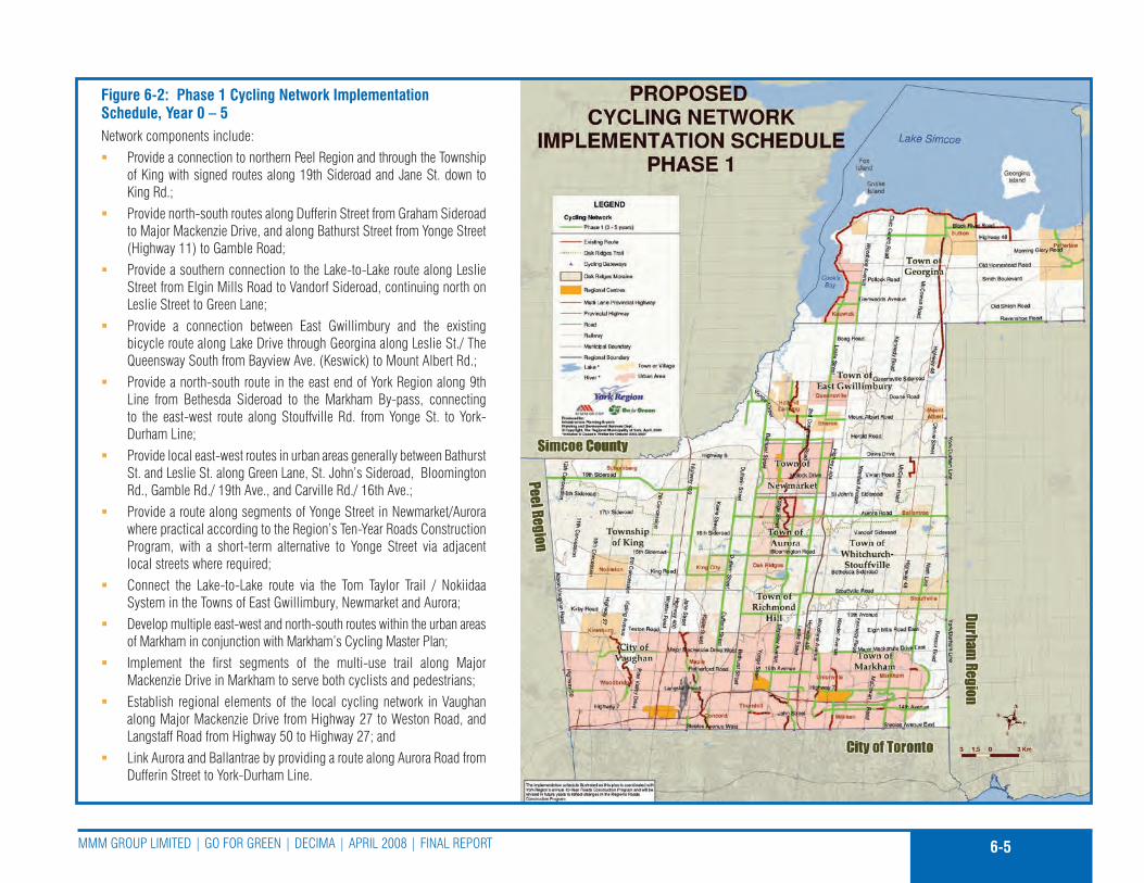
6-5MMM Group LIMITED | Go for GrEEn | DEcIMa | aprIL 2008 | fInaL rEporT
Figure 6-2: Phase 1 Cycling Network Implementation Schedule, Year 0 – 5network components include:
provide a connection to northern peel region and through the Township �of King with signed routes along 19th sideroad and Jane st. down to King rd.;provide north-south routes along Dufferin street from Graham sideroad �to Major Mackenzie Drive, and along Bathurst street from Yonge street (Highway 11) to Gamble road;provide a southern connection to the Lake-to-Lake route along Leslie �street from Elgin Mills road to Vandorf sideroad, continuing north on Leslie street to Green Lane;provide a connection between East Gwillimbury and the existing �bicycle route along Lake Drive through Georgina along Leslie st./ The Queensway south from Bayview ave. (Keswick) to Mount albert rd.;provide a north-south route in the east end of York region along 9th �Line from Bethesda sideroad to the Markham By-pass, connecting to the east-west route along stouffville rd. from Yonge st. to York-Durham Line;provide local east-west routes in urban areas generally between Bathurst �st. and Leslie st. along Green Lane, st. John’s sideroad, Bloomington rd., Gamble rd./ 19th ave., and carville rd./ 16th ave.;provide a route along segments of Yonge street in newmarket/aurora �where practical according to the region’s Ten-Year roads construction program, with a short-term alternative to Yonge street via adjacent local streets where required;connect the Lake-to-Lake route via the Tom Taylor Trail / nokiidaa �system in the Towns of East Gwillimbury, newmarket and aurora;Develop multiple east-west and north-south routes within the urban areas �of Markham in conjunction with Markham’s cycling Master plan;Implement the first segments of the multi-use trail along Major �Mackenzie Drive in Markham to serve both cyclists and pedestrians;Establish regional elements of the local cycling network in Vaughan �along Major Mackenzie Drive from Highway 27 to Weston road, and Langstaff road from Highway 50 to Highway 27; andLink aurora and Ballantrae by providing a route along aurora road from �Dufferin street to York-Durham Line.
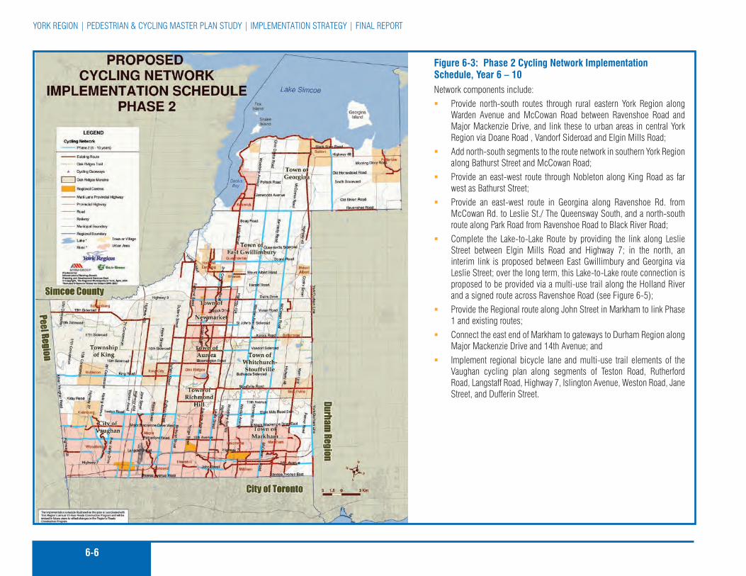
6-6
YorK rEGIon | pEDEsTrIan & cYcLInG MasTEr pLan sTuDY | IMpLEMEnTaTIon sTraTEGY | fInaL rEporT
Figure 6-3: Phase 2 Cycling Network Implementation Schedule, Year 6 – 10network components include:
provide north-south routes through rural eastern York region along �Warden avenue and Mccowan road between ravenshoe road and Major Mackenzie Drive, and link these to urban areas in central York region via Doane road , Vandorf sideroad and Elgin Mills road;add north-south segments to the route network in southern York region �along Bathurst street and Mccowan road;provide an east-west route through nobleton along King road as far �west as Bathurst street;provide an east-west route in Georgina along ravenshoe rd. from �Mccowan rd. to Leslie st./ The Queensway south, and a north-south route along park road from ravenshoe road to Black river road;complete the Lake-to-Lake route by providing the link along Leslie �street between Elgin Mills road and Highway 7; in the north, an interim link is proposed between East Gwillimbury and Georgina via Leslie street; over the long term, this Lake-to-Lake route connection is proposed to be provided via a multi-use trail along the Holland river and a signed route across ravenshoe road (see figure 6-5);provide the regional route along John street in Markham to link phase �1 and existing routes;connect the east end of Markham to gateways to Durham region along �Major Mackenzie Drive and 14th avenue; andImplement regional bicycle lane and multi-use trail elements of the �Vaughan cycling plan along segments of Teston road, rutherford road, Langstaff road, Highway 7, Islington avenue, Weston road, Jane street, and Dufferin street.
6-7MMM Group LIMITED | Go for GrEEn | DEcIMa | aprIL 2008 | fInaL rEporT
This approach is also consistent with the current practice of paving part of a shoulder to extend the life cycle of the road surface and offers the added benefit of making regional roads more pedestrian and cycling friendly. In addition, whether designated as part of the pedestrian and cycling network or not, York region should also try to provide at least 1.5 m paved shoulders on all new or reconstructed rural cross-section regional roads when the opportunity arises.
as already noted, the pedestrian and cycling Master plan is designed to be flexible so it can evolve over time. This means that implementation priorities, including those identified in figures 6-1 through 6-4, may change. Therefore, it is important to monitor the implementation of the plan and to update the priorities on an annual basis or as capital roads projects are scheduled. a recommended approach to administer the pcMp and to monitor its implementation is provided in section 6.6.
6.2.3 long term strategy for Pedestrian and CyCling
Figures 6-4 and 6-5 depict the long-term implementation strategy for both pedestrian and cycling networks, and assume the facilities recommended in phases 1 and 2 have been developed.
routes and facilities identified in the longer term strategy (year 10 through year 25+) are presented for information only and will need to be reviewed and if confirmed then costed and prioritized as part of a future update to the pcMp.
Recommended Action:
6-1 adopt the ten-year pedestrian and cycling network implementation plan and include it as a schedule in the region’s official plan
6.3 ouTreach prIorITIeS
outreach is an important element of the pcMp and it is recommended that York region adopt and implement the outreach plan outlined in chapter 4. This plan will help educate residents about pedestrian and cycling safety and encourage residents to walk and cycle more often for both utilitarian and recreational purposes. section 6.10 outlines the implementation timeframe for all outreach recommendations proposed in this Master plan.
Recommended Action:
6-2 adopt and implement the outreach plan described in chapter 4
It is important to monitor the
implementation of the plan and
to update the priorities on an
annual basis or as capital roads
projects are scheduled.
This plan will help educate
residents about pedestrian and
cycling safety and encourage
residents to walk and cycle
more often for both utilitarian
and recreational purposes.
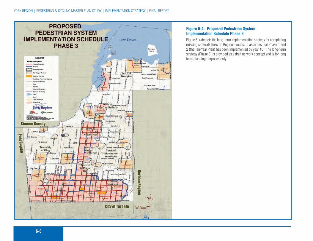
6-8
YorK rEGIon | pEDEsTrIan & cYcLInG MasTEr pLan sTuDY | IMpLEMEnTaTIon sTraTEGY | fInaL rEporT
Figure 6-4: Proposed Pedestrian System Implementation Schedule Phase 3figure 6-4 depicts the long-term implementation strategy for completing missing sidewalk links on regional roads. It assumes that phase 1 and 2 (the Ten-Year plan) has been implemented by year 10. The long-term strategy (phase 3) is provided as a draft network concept and is for long term planning purposes only.

6-9MMM Group LIMITED | Go for GrEEn | DEcIMa | aprIL 2008 | fInaL rEporT
Figure 6-5: Proposed Cycling Network Implementation Schedule Phase 3 figure 6-5 illustrates the long-term (year 11 to 25+) implementation strategy for completing the ultimate route network. It assumes that phase 1 and 2 (the Ten-Year plan) has been implemented by year 10. The long-term strategy (phase 3) is provided as a draft network concept and is for long term planning purposes only.

6-10
YorK rEGIon | pEDEsTrIan & cYcLInG MasTEr pLan sTuDY | IMpLEMEnTaTIon sTraTEGY | fInaL rEporT
6.4 ImplemenTIng on-road cYclIng facIlITIeS and The claSS ea proceSS In onTarIo
In ontario, the Municipal Engineers association (MEa) class Environmental assessment Document applies to municipal infrastructure projects including roads, water and wastewater projects . recognizing projects undertaken by municipalities can vary in their environmental impact, such projects are classified in this class Ea in terms of schedules:
Schedule A
Generally includes normal or emergency operational and �maintenance activities; and
The environmental effects of these activities are usually �minimal and, therefore, these projects are pre-approved.
Schedule B
Generally includes improvements and minor expansions to �existing facilities; and
There is the potential for some adverse environmental �impacts and therefore the proponent is required to proceed through a screening process including consultation with those who may be affected.
Schedule C
Generally includes the construction of new facilities and �major expansions to existing facilities; and
These projects proceed through the environmental �assessment planning process outlined in the class Ea.
although implementing a signed-only bike route requires the installation of bike route signs at strategic locations and no other physical improvements to the road right-of-way are required, retrofitting an existing road to add bike lanes or wide curb lanes may require some form of change. This may be limited to the addition of new pavement marking and signing, remarking part or all of an existing road to ‘fit in’ bike lanes or wide curb lanes, or widening the paved surface of the roadway to accommodate the proposed cycling facility.
The preferred approach to retrofitting an existing road to accommodate on-road cycling facilities (bike lane, paved shoulder, wide curb lane or signed-only route) is to adjust existing pavement markings and/or signing, and not widen a roadway. However, for some projects a need exists to widen the paved surface of a roadway slightly to add a bike lane or paved shoulder. This widening can often be secured by shifting curbs slightly or adding paved shoulders at the time a road is reconstructed or rehabilitated. The issue for Municipalities in ontario is whether widening a road for the purpose of adding bike lanes or paved shoulders is an operational improvement and therefore a pre-approved (schedule a) project according to the MEa class Ea Document or would the ministry of Environment require a more involved schedule B or schedule c assessment and planning process.
according to discussions with a Toronto area special project officer of the Ministry of Environment, the provision of bicycle lanes and paths are included in the MEa class Ea document under Item 3 of appendix 1 – project schedules Municipal road projects and that “construction or operation of sidewalks or bicycle paths within existing rights-of-ways” are considered schedule a projects with no specified project cost limit . In
6-11MMM Group LIMITED | Go for GrEEn | DEcIMa | aprIL 2008 | fInaL rEporT
addition, it does not matter if the bicycle path or lane is on or off the paved portion of the road right-of-way. Ministry staff also advised that project Descriptions 19 and 20 in appendix 1 of the MEa class Ea Document are intended to refer to the construction or reconstruction of linear paved facilities and related facilities (e.g. adding or reducing lanes) for “motor” vehicles including transit vehicles, and not bicycles or bicycle facilities. However, if adding a cycling facility will negatively impact the natural environment or additional road right-of-way is required or if an existing motor vehicle travel lane is proposed to be eliminated in order to provide a proposed bike facility, a schedule B or c class Ea planning process should be considered. additionally, if off-road components of the pedestrian and cycling network fall on lands owned or regulated by the Toronto region conservation authority (Trca) or the Lake simcoe region conservation authority (Lsrca), a schedule B or c Ea may be required based on the feasibility assessment of the conservation authorities.
In addition, Trca has a Level III agreement with fisheries and oceans canada (Dfo), which means Trca staff review projects on behalf of Dfo at the detailed design stage. any proposed works within the riparian zones of watercourses and seasonally flooded lands will be reviewed for potential Harmful alteration, Disruption or Destruction (HaDD) of fish habitat under the federal fisheries act. section 32(1) of the fisheries act prohibits the Harmful alteration, Disruption or Destruction of fish and fish habitat, unless authorized by Dfo. If in-stream works are required, the project may need authorization from Dfo. In in-stream works are not required and physical impacts on fish habitat can be mitigated by specific project design and construction procedures, then authorization from Dfo would not be required, and the authority would provide a Letter of advice on behalf of Dfo. The Letter of advice would outline specific mitigating measures that would
have to be implemented to minimize potential impacts to fish and fish habitat.
If any project is proposed on Trca property, approval from Trca, the Ministry of natural resources (Mnr) and the Ministry of culture (Moc) will be required. for projects proposed to be constructed on Trca property, in whole or in part, Trca should be consulted as soon as possible to confirm Trca property requirements as the process can take upwards of 18 months. furthermore, following the completion of an Ea, or if the file is deemed a schedule a, an ontario regulation 166/06 – Development, Interference with Wetlands and alterations to shorelines and Watercourses permit may be required from Trca. additional information – to be confirmed with Trca – may also be required at the detailed design stage. Trail design may be required to be consistent with the Trca’s Valley and stream corridor Management program and Trail planning and Design Guidelines (MTrca 1991, and amendments).
6.5 plannIng and deSIgn guIdelIneS
When implementing designated on and off-road cycling facilities, the planning and Design Guidelines developed for the pcMp should be referred to for guidelines on implementation procedures and practices. The planning and Design Guidelines document (separately bound Technical appendix c) was prepared to assist the region and other local partners in the development and implementation of the pcMp. It contains recommended planning and design guidelines as well as pedestrian and cycling facility implementation solutions. The guidelines are intended to provide technical guidance to the region and other partners in the expansion, implementation and maintenance of a region-wide pedestrian and cycling network.
The guidelines are intended to
provide technical guidance to
the region and other partners in
the expansion, implementation
and maintenance of a region-
wide pedestrian and cycling
network.

6-12
YorK rEGIon | pEDEsTrIan & cYcLInG MasTEr pLan sTuDY | IMpLEMEnTaTIon sTraTEGY | fInaL rEporT
These guidelines are intended as a general reference for pedestrian and cycling network planners and designers in the region. They are a compilation of guidelines from a variety of sources, and are believed to represent “best practices” in pedestrian and bicycle route and facility planning and design in canada and the united states. They contain general information about pedestrian and cyclists, their abilities and their needs from a network planning and design point of view. The guidelines are not meant to be inclusive of all design considerations and standards. rather, they are a carefully selected set of currently accepted design practices in north america and should be treated as a reference to be consulted during the development and construction of the pedestrian and cycling network. These guidelines should not over-ride good engineering and fiscal judgement by the region’s professional staff. In addition, they should be reviewed at least every five years.
Recommended Action:
6-3 Have regard to the pedestrian and cycling planning and Design Guidelines when implementing the pcMp
6.6 InTegraTIng The pedeSTrIan and cYclIng maSTer plan wITh SmarT commuTe (Tdm) and oTher regIonal ServIceS and programS
York region’s Smart Commute Initiative includes a series of regional and local transportation demand management (TDM) measures designed to reduce auto dependency by improving alternatives to single-occupant vehicle use, encouraging use of less-congested travel times and routes, and enabling reductions in trip volumes and lengths.
The smart commute strategy should have regard to the region’s pedestrian and cycling Master plan and integrate walking and cycling with other services such as transit service, land use planning, and social programs. for smart commute and social programs, as with environmental issues, there are key public health concerns that have strong synergies with the region’s smart commute strategy framework. The promotion of cardiovascular and respiratory health and physical activity can integrate positive smart commute messages such as encouraging walking and cycling as an excellent mode of exercise and an inexpensive method of travel. Both the region’s smart commute and public health efforts undertaken in the future will rely extensively on outreach to get their messages across, and opportunities to share resources or jointly develop new channels of communication may offer mutual benefit. The region’s recreation programs are another valuable channel to support walking and cycling and smart commute programs, through such means as the delivery of cycling skills courses.
Recommended Action:
6-4 continue to promote the smart commute strategy, the 20/20 The Way to cleanair program, the active and safe routes to school program and other programs that encourage other forms of transportation, and integrate these with the objectives and recommendations of the pcMp.
6.7 ImplemenTIng The maSTer plan
people and leadership are the keys to setting the implementation of the pcMp in motion. The formal relationships between individuals and organizations and their operational practices are important factors in determining whether a cycling initiative
people and leadership
are the keys to setting the
implementation of the pcMp in
motion.
The smart commute strategy
should have regard to the
region’s pedestrian and cycling
Master plan and integrate
walking and cycling with other
services such as transit service,
land use planning, and social
programs.
6-13MMM Group LIMITED | Go for GrEEn | DEcIMa | aprIL 2008 | fInaL rEporT
will proceed and be successful. Maximizing participation and removing obstacles to the flow of information between participants are two of the main objectives in managing implementation.
The pcMp is more than a proposed network of on and off-road pedestrian and cycling facilities. It is a plan that includes a set of recommendations to promote safe walking and cycling in York region and to recognize and share in the economic, health and quality of life benefits that these forms of transportation can offer.
While York region staff will oversee the implementation of the pcMp, they will require ongoing support from and communication with local municipalities. The region will look to local municipalities for staff input on progress, and cooperative funding on joint projects as they arise. The successful implementation of the pcMp will require a strong working relationship between regional and local municipal staff as well as conservation authorities, developers and the public.
6.7.1 Pedestrian and CyCling PubliC advisory Committee
The region of York established a pedestrian and cycling public advisory committee in 2006 to provide input and assist in the development of this Master plan. The public advisory committee (pac) included public representation from each of the nine local municipalities in York region.
It is recommended that regional council establish a regional pedestrian and cycling committee (similar to the study advisory committee but with a revised terms of reference) to assist regional staff in the implementation of the pcMp and to advise regional council on pedestrian and cycling issues in York region.
6.7.2 Pedestrian/CyCling Coordinator
York region should establish a pedestrian/cycling coordinator position. This position is proposed to be located in the Transportation planning department and assigned responsibility to oversee the implementation of the pcMp. The pedestrian/cycling coordinator could work with the pedestrian and cycling advisory committee, York region community and Health services Department, local municipalities, school boards, conservation authorities and other partners. since the coordinator position is envisioned as a new staff position, no additional funding resources are anticipated beyond a commitment of staff time.
reporting to the Manager, Transportation planning, Infrastructure planning Branch, planning and Development services Department, the pedestrian/cycling coordinator would manage and guide the implementation of the pcMp by coordinating staff resources and responsibilities, budgeting, program development and delivery as well as the preparation of annual budgets and progress reports for participating departments.
annual progress reports are recommended for presentation to both the planning and Transportation committees and the public advisory committee. These reports should outline the progress made towards achieving the primary goals of the plan, and should measure the success in implementing the proposed pedestrian and cycling network and other recommendations through the application of the performance measures outlined in section 6.12 of the pcMp. annual reports should identify changes in direction and priorities for the upcoming year, and identify budget requests. The implementation program for each year, including the specific routes and programs to be implemented or funded, will be presented to regional council for consideration during the preparation and review of the annual departmental budgets.
The pcMp is more than
a proposed network of on
and off-road pedestrian and
cycling facilities. It is a
plan that includes a set of
recommendations to promote
safe walking and cycling in York
region and to recognize and
share in the economic, health
and quality of life benefits that
these forms of transportation
can offer.

6-14
YorK rEGIon | pEDEsTrIan & cYcLInG MasTEr pLan sTuDY | IMpLEMEnTaTIon sTraTEGY | fInaL rEporT
The pcMp is not intended to
be a static document. The
timing and details related to
implementation, particularly
the location of recommended
routes and pedestrian and
cycling facility types should
evolve through community
consultation and technical
review when appropriate.
6.7.3 establish an inter-muniCiPal Working grouP
In order to facilitate more open and ongoing communication between regional and local municipal staff, it is recommended that an informal inter-municipal working group led by the pedestrian/cycling coordinator be formed. This working group, modelled after York region’s Greening strategy and Land securement partnership, should have staff representation from each of the local municipalities and conservation authorities as well as the regional planning, Health and Transportation Departments, regional police service and school boards. It should meet quarterly to discuss actions related to coordinating the development of pedestrian and cycling facilities throughout the region and to keep everyone up-to-date on local initiatives. This forum can provide the opportunity to discuss route planning, implementation, design standards and permit the region to present and discuss its pedestrian and cycling implementation plans for the upcoming year. With the exception of staff resources, no new funding is required to establish the Working Group.
6.7.4 imPlementation struCture
an efficient reporting and implementation structure is vital to ensure that the decision-making process associated with the implementation of the pcMp is managed and all relevant regional and local municipal departments are appropriately engaged. a suggested structure for managing and implementing the pcMp is illustrated in Figure 6-6. The core of the proposed structure consists of Transportation planning (planning) and roads (Transportation services), as well as the proposed pedestrian/cycling coordinator and the pedestrian and cycling public advisory committee.
The core group of this recommended reporting structure would oversee and make recommendations regarding funding and priorities associated with the pcMp, as well as other regional initiatives, as assigned. all reporting from the group would be as indicated in figure 6-6.
6.7.5 the imPlementation ProCess tool
The pcMp is not intended to be a static document. The timing and details related to implementation, particularly the location of recommended routes and pedestrian and cycling facility types should evolve through community consultation and technical review when appropriate. at the same time, however, the extensive community and stakeholder effort that established the overall direction for the pcMp should be respected.
It should also be recognized that pedestrian and cycling network and priorities recommended in the pcMp might evolve through the environmental assessment, planning and capital budget processes.
central to the proposed implementation process tool is a proposed guideline that would require that the pcMp be reviewed and given consideration when regional road or other capital infrastructure projects are identified or scheduled. This should include the region’s asset management program for reconstructing or resurfacing roads, as well as any investigation of potential new road alignments or the reuse and/or selling of abandoned rail and utility corridors. The objective is to ensure that regional assets, particularly roads designated in the pcMp for future pedestrian and cycling routes, are given due regard when planning, designing and budgeting larger capital roads projects. This step should also apply to regional planning studies or studies initiated by other jurisdictions, and in which the region is a partner. Without this
an efficient reporting and
implementation structure is vital
to ensure that the decision-
making process associated
with the implementation of
the pcMp is managed and all
relevant regional and local
municipal departments are
appropriately engaged.

6-15MMM Group LIMITED | Go for GrEEn | DEcIMa | aprIL 2008 | fInaL rEporT
Figure 6-6Implementation
Structure

6-16
YorK rEGIon | pEDEsTrIan & cYcLInG MasTEr pLan sTuDY | IMpLEMEnTaTIon sTraTEGY | fInaL rEporT
step, network opportunities could be lost and cost efficiencies not realized.
Building upon this central recommendation, Figure 6-7 outlines a proposed process tool for guiding the implementation of pedestrian and cycling network facilities in York region. It is recommended that regional staff review this tool and adapt it as necessary to suit their needs.
The process comprises five parts and is a step-by-step mechanism to confirm the feasibility of each route recommended in this report at the time implementation is proposed. It will assist regional staff from affected departments to work together, to share information and to facilitate the implementation of the pcMp. changes to policies and the network should also be considered through the regional official plan, and Transportation Master plan reviews conducted every five years.
for segments of the proposed regional pedestrian and cycling network that are under local municipal ownership, the region should work in conjunction with local municipalities and strive to apply the same network implementation process.
Each part of the network implementation process is described in the following sections.
Part I: Preliminary Review
The first step in implementing segments of the pcMp is to identify and communicate opportunities. as part of the pcMp, all regional and local road projects scheduled for consideration in York region, including the capital roads forecast, should be monitored. When a project involving a corridor or road proposed for a pedestrian or cycling route identified in the pcMp is advanced to the planning stage, or an opportunity to establish a new route
not identified in the pcMp comes forward, the pedestrian/cycling coordinator should undertake a part 1 preliminary review. This review should:
Identify the jurisdictions involved in a project; �
compare the timing of the project to the short and long term �implementation priorities identified in the pcMp;
assess whether the nature of the project may permit �implementation of the preferred pedestrian or cycling facility type in a cost effective manner; and
Inform the project lead and affected departments whether or �not a feasibility assessment should be undertaken to confirm the feasibility and costs for implementing the proposed cycling route as part of the subject project.
The key aspect of this initial part is communication. staff from various departments should report all upcoming projects that may involve or impact a cycling facility designated in the pcMp. from this point forward, the pedestrian/cycling coordinator would be expected to work through the remaining three parts of the implementation process with various departments at the regional and local level as appropriate.
Part II: Feasibility Assessment
If a pedestrian or cycling project is confirmed through the preliminary review process (part I), the pedestrian/cycling coordinator should lead regional staff in undertaking a feasibility assessment. This should be a brief study and include the following steps:
confirm the feasibility of the route based on a review of the �pcMp and supporting route selection and planning and design criteria, as well as other relevant information.

6-17MMM Group LIMITED | Go for GrEEn | DEcIMa | aprIL 2008 | fInaL rEporT

6-18
YorK rEGIon | pEDEsTrIan & cYcLInG MasTEr pLan sTuDY | IMpLEMEnTaTIon sTraTEGY | fInaL rEporT
collect or confirm current roadway characteristic information �including aaDT volumes, collision data and the commercial vehicle percentage.
conduct a field check for both on and off-road route segments �to identify any other issues that should be considered and to measure sight line distances (if applicable).
undertake a functional design for the on or off-road cycling �facility segment and estimate implementation costs, including construction and signing.
prepare a cost/benefit analysis statement. This “statement” �should comment on the following:
The timing for implementing the proposed pedestrian or �cycling facility;
costs and efficiencies achieved; �
Identify any less costly alternatives and how they may fit �within the overall pedestrian and cycling network plan;
provide recommendation on how to proceed; and �
submit the feasibility assessment to the coordinator, �and then to the commissioners of planning and Transportation for approval.
This process typically takes place in conjunction with, or as input to, a roadway or public works class Ea or functional design process whereby design alternatives are prepared. The design for the pedestrian and cycling portion of the facility should be in accordance with regional planning & Design Guidelines, as well as other relevant provincial and national design standards.
priority consideration should be given to situations where there is a clear community demand for pedestrian and cycling facilities. If site-specific circumstances prevent a facility from being constructed in association with a particular improvement project
being considered, other nearby parallel routes on both regional and local roads should be closely examined at this time for their suitability.
Part III: Detailed Design, Tender and Implementation
once approval has been obtained to implement a pedestrian and/or cycling route segment, the necessary detailed design should be completed. This step is typically done as part of the detailed design for the primary capital roads project, such as a road widening and does not require additional resources. This third part of the process should also include confirming details with regard to partners (if any) and cost sharing. The project should then be scheduled into the region’s capital roads program and suitable budget allocated. The final step involves tendering the project (if not undertaken by the region in-house) and then construction / implementation.
It is also possible that following detailed design the decision is made not to proceed with the facility or preferred facility type because of the cost or other constraints that arise through the detailed design process. If this occurs, the network should be updated and an alternative route should be proposed.
Part IV: Monitoring Phase
once pedestrian and cycling facilities have been constructed, their design and use should be monitored to ensure they function in the manner intended. When necessary, the facilities should also be upgraded and maintained to ensure continued safe use by cyclists. Monitoring should also ensure that the cycling design guidelines are current. This step will involve collecting data to assist in the monitoring task.
priority consideration should be
given to situations where there
is a clear community demand
for pedestrian and cycling
facilities.

6-19MMM Group LIMITED | Go for GrEEn | DEcIMa | aprIL 2008 | fInaL rEporT
Part V: Regional Official Plan
The fifth part of the implementation process includes updating the regional official plan to account for changes in policy and network routes.
6.7.5.1 The network management asset Tool
The proposed pedestrian and cycling network for the pcMp was developed using York region’s Geographic Information system (GIs) base. This digital GIs based network map provided to the region as part of the pcMp can also be used as a pedestrian and cycling facility management tool. a database is associated with the map information and includes a number of different attributes. for example, the network has been divided into segments, each specifying a length of the segment and the cycling facility type proposed, as well as whether the segment is recommended as a short-term or long-term priority.
During the implementation process, regional staff can use this tool to assist in confirming the feasibility of pedestrian and cycling routes and facilities and the proposed schedule (short or long-term) for implementation. The GIs Tool can also be used to track and document new segments as they are implemented. updating the facilities component of the pcMp on a regular basis will significantly reduce the effort and cost to update the entire pcMp recommended every five years. If the region chooses, this GIs information could also be posted on the region’s website in an interactive map format. This would be useful to the public and developers and would also serve as a ‘quick reference’ for some regional staff that may not have direct access to the region’s GIs database.
Recommended Actions:
6-5 continue the pedestrian and cycling public advisory committee
6-6 Establish a pedestrian/cycling coordinator position
6-7 Establish an inter-municipal working group led by the pedestrian/cycling coordinator
6-8 review the pcMp when regional road or other capital infrastructure projects are identified or scheduled
6-9 review the proposed five-part process tool for guiding the implementation of pedestrian and cycling network facilities in York region and adapt it as necessary
6-10 Work in conjunction with local municipalities to develop segments of the regional network that are under local municipal ownership
6-11 The regional official plan should be updated to include as a schedule the pedestrian and cycling network improvements proposed in the pcMp. It is recommended that the pcMp be updated every five years, and updates be included in the regional official plan. all regional infrastructure projects should give consideration to recommended and proposed routes in the region’s pcMp.
6.8 fundIng The plan (neTwork and program)
To successfully implement the proposed pedestrian and cycling Master plan, regional council should commit annually to on-going funding for the pcMp and its supporting implementation strategy. The region should seek out other sources of revenue from its partners in York region as well as the provincial and federal Governments.
To successfully implement
the proposed pedestrian and
cycling Master plan, regional
council should be requested to
commit annually to on-going
funding for the pcMp and its
supporting implementation
strategy.
It is recommended that the
region consider a cost-sharing
strategy to encourage the
implementation of proposed
regional network segments
on lands not owned by York
region.

6-20
YorK rEGIon | pEDEsTrIan & cYcLInG MasTEr pLan sTuDY | IMpLEMEnTaTIon sTraTEGY | fInaL rEporT
a portion of the proposed pedestrian and cycling network falls on roads and lands under local municipalities and other jurisdictions. It is recommended that the region consider a cost-sharing strategy to encourage the implementation of proposed regional network segments on lands not owned by York region. The region should also develop cost-sharing with local municipalities, trail groups and agencies such as Hydro one and local conservation authorities when implementing segments of the regional network that are not under regional ownership.
The pcMp is an integrated body of components, and requires a strategic approach for implementation and a funding commitment. focusing efforts on individual elements of the pcMp in isolation of the others will not result in the level of success that the pcMp has been designed to achieve. for example, funding a new paved shoulder facility in the short-term but not the development and delivery of programming or promotional campaigns, is not an efficient or recommended strategy.
The public input received during the preparation of the pcMp indicate that both residents and visitors to York region support improving pedestrian and cycling facilities and programs to promote these activities in the region and to reduce the use of single occupant automobiles. regional council’s leadership in adopting this Master plan will directly improve the livability of communities in York region and support the objectives of the region’s official plan, Transportation Master plan and York region’s sustainability strategy (2007).
The region should implement its proposed pedestrian and cycling Master plan Municipal partnership program. This proposed program is designed to assist local municipalities and conservation authorities in implementing pedestrian and cycling facilities that support a regional scale network. This program will
allow integration with local municipal/conservation authorities’ pedestrian and cycling plans, including public transit service that connects communities and people of all ages with places of interest. The intent of the pedestrian and cycling partnership program is to provide a framework and policy requests from the local municipalities with regard to funding municipal/conservation authorities’ pedestrian and cycling infrastructure when these priorities match regional priorities.
This program is strictly for funding capital expenditure of pedestrian and cycling facilities and not for ongoing operating and maintenance cost of the same facilities. It should be noted that the majority of the construction of on-street bike lanes on the regional roads would be incorporated as part of the road construction/resurfacing program and not via the program recommended in this report. However, retrofitting of regional roads to accommodate bike lanes may be incorporated as part of this program.
6.8.1 What is the investment?
The pcMp is both an infrastructure and operations plan. Therefore, it requires infrastructure, program development and operations funding to ensure successful implementation and monitoring. for example, some of the cycling routes outlined in the pcMp, especially on-road paved shoulder bikeways, require little improvement beyond a change in pavement markings and signage. These types of improvements as well as maintenance of the on-road network should be included in the region’s public works capital budget and forecasts.
operations costs include on-going funding related to implementing the pcMp, preparing the annual progress report, delivering safety, education and promotional programs, and performing network and
The pcMp requires
infrastructure, program
development and operations
funding to ensure successful
implementation and monitoring.
The public input received
during the preparation of
the pcMp indicate that both
residents and visitors to York
region support improving
pedestrian and cycling facilities
and programs to promote these
activities in the region and
to reduce the use of single
occupant automobiles.

6-21MMM Group LIMITED | Go for GrEEn | DEcIMa | aprIL 2008 | fInaL rEporT
infrastructure maintenance. This also includes staff resources, as well as management and administration.
The incremental cost to maintain (including winter maintenance) bike lanes, paved shoulders and sidewalks is considered negligible compared to standard annual road and sidewalk maintenance budgets. our understanding and experience is that most municipalities absorb any additional cost associated with maintaining these facilities in annual road and asset maintenance budgets. Therefore, no additional cost has been assumed in this pedestrian and cycling Master plan for these facility types.
Maintenance of mature off-road multi-use trails, particularly in greenways and parks can cost from $4,000 to $6,000 per linear kilometer of trail (3.5 m wide), depending on the level of service standard of a municipality. annual maintenance for trails is typically the responsibility of local municipalities and can include drainage and storm channel maintenance, sweeping, clearing of debris, trash removal, weed control and vegetation management, mowing of grass along shoulders, minor surface repairs, repairs to trail fixtures (benches, signs) and other general repairs. costs also can vary depending on whether the trail is in a road boulevard or in a linear greenway or park. new off-road trails also typically have lower maintenance costs in the first 10 years. Therefore, the pcMp has assumed a maintenance budget based on 60.5 km of new proposed multi-use trails and a unit price of $2,000 / km /year of new trail. This equates to a maintenance cost of $944,000 over ten years, which has been included as a line item in Table 6-1. a detailed cost breakdown by local municipality can be found in appendix B.
It is estimated that the total investment to implement new programs and infrastructure and maintain the network is about $44,476,000 over the next 10+ years. This cost consists of
approximately $40,282,000 for the proposed network, $944,000 for off-trail maintenance and $3,250,000 for updates, outreach and programs. out of the total investment of the Ten-year plan, $28,229,000 or 63.5% is estimated to be York region’s share of the Ten-year Implementation plan. The remaining $16,247,000 or 36.5% would be the responsibility of local municipalities and the province.
Table 6-1 identifies the proposed Ten-year Implementation plan cost by municipality and implementation phase. Tables B1 and B2 in appendix B provides a detailed cost breakdown by facility type and implementation phase.
Table 6-2 identifies the distance in kilometres of pedestrian and cycling network components by implementation phase.
With regard to the cost of proposed regional network facilities on local municipal roads or lands, it should be noted that many of the same segments have already been proposed by local municipalities in their own pedestrian and cycling Master plans. Therefore, a portion of the cost to implement the suggested regional pedestrian and cycling network links on local roads should have already been estimated in the past, though they may not have been budgeted or scheduled for implementation by these municipalities.
The network cost of $44.5 million is a conservative estimate and is based on stand-alone unit prices. However, it is assumed that on-road components of the network will typically be included as part of the same tender for a road resurfacing or reconstruction project. Therefore, through economies of scale, the construction cost charged to the region by a contractor should be less.
for on-road facilities in Table 6-2, the distance shown represents the length of the road with two-way bike facilities on it. The
It is estimated that the total
investment to implement new
programs and infrastructure and
maintain the network is about
$44,476,000 over the next 10+
years.
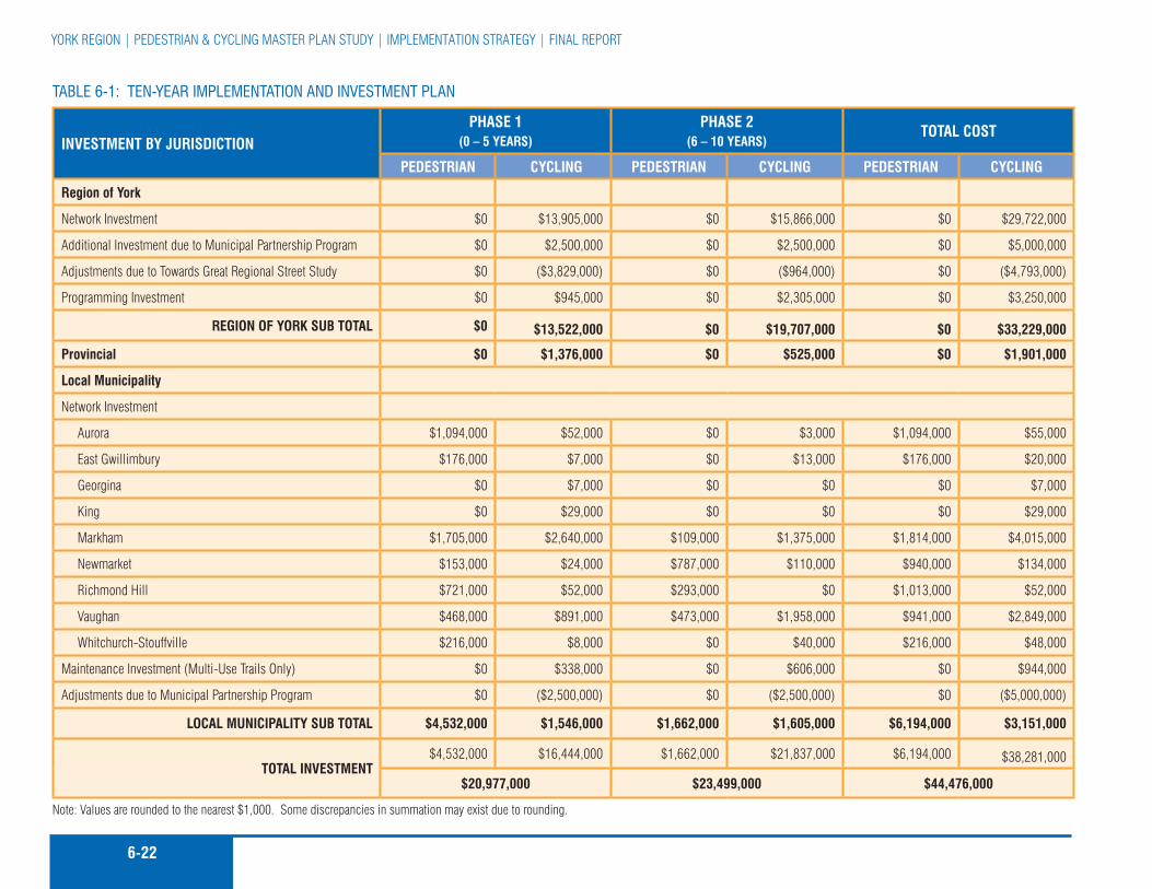
6-22
YorK rEGIon | pEDEsTrIan & cYcLInG MasTEr pLan sTuDY | IMpLEMEnTaTIon sTraTEGY | fInaL rEporT
TaBle 6-1: Ten-Year ImplemenTaTIon and InveSTmenT plan
INVeSTMeNT BY JuRISDICTIONPhASe 1
(0 – 5 YeARS)PhASe 2
(6 – 10 YeARS)TOTAl COST
PeDeSTRIAN CYClINg PeDeSTRIAN CYClINg PeDeSTRIAN CYClINg
Region of York
network Investment $0 $13,905,000 $0 $15,866,000 $0 $29,722,000
additional Investment due to Municipal partnership program $0 $2,500,000 $0 $2,500,000 $0 $5,000,000
adjustments due to Towards Great regional street study $0 ($3,829,000) $0 ($964,000) $0 ($4,793,000)
programming Investment $0 $945,000 $0 $2,305,000 $0 $3,250,000
RegION OF YORK SuB TOTAl $0 $13,522,000 $0 $19,707,000 $0 $33,229,000
Provincial $0 $1,376,000 $0 $525,000 $0 $1,901,000
local Municipality
network Investment
aurora $1,094,000 $52,000 $0 $3,000 $1,094,000 $55,000
East Gwillimbury $176,000 $7,000 $0 $13,000 $176,000 $20,000
Georgina $0 $7,000 $0 $0 $0 $7,000
King $0 $29,000 $0 $0 $0 $29,000
Markham $1,705,000 $2,640,000 $109,000 $1,375,000 $1,814,000 $4,015,000
newmarket $153,000 $24,000 $787,000 $110,000 $940,000 $134,000
richmond Hill $721,000 $52,000 $293,000 $0 $1,013,000 $52,000
Vaughan $468,000 $891,000 $473,000 $1,958,000 $941,000 $2,849,000
Whitchurch-stouffville $216,000 $8,000 $0 $40,000 $216,000 $48,000
Maintenance Investment (Multi-use Trails only) $0 $338,000 $0 $606,000 $0 $944,000
adjustments due to Municipal partnership program $0 ($2,500,000) $0 ($2,500,000) $0 ($5,000,000)
lOCAl MuNICIPAlITY SuB TOTAl $4,532,000 $1,546,000 $1,662,000 $1,605,000 $6,194,000 $3,151,000
TOTAl INVeSTMeNT $4,532,000 $16,444,000 $1,662,000 $21,837,000 $6,194,000 $38,281,000
$20,977,000 $23,499,000 $44,476,000
note: Values are rounded to the nearest $1,000. some discrepancies in summation may exist due to rounding.

6-23MMM Group LIMITED | Go for GrEEn | DEcIMa | aprIL 2008 | fInaL rEporT

6-24
YorK rEGIon | pEDEsTrIan & cYcLInG MasTEr pLan sTuDY | IMpLEMEnTaTIon sTraTEGY | fInaL rEporT
distances shown represent only bikeway facilities that currently exist on parts of the route network that have been proposed for the region of York. roads yet to be built were not taken into consideration when developing the network. The distances for multi-use trails in regional road right-of-ways have been assigned to the local municipality or agency/organization in which the trail exists or is proposed. a portion of the distance identified for paved shoulder routes are on roads with at least 1.2 m existing paved shoulders. as as interim solution, these routes could be designated as a paved shoulder bikeway by adding signage. The table also identifies the oak ridges Trail, which is primarily an unpaved pedestrian hiking trail that varies in width. facilities shown on the proposed regional cycling network that are within the city of Toronto or region of Durham are identified as surrounding areas.
6.8.2 Where Will the money Come from?
The annual implementation budget for the pcMp should be identified in the pedestrian/cycling coordinator’s annual report and be based on implementation objectives and opportunities for the coming year. It is expected that the majority of pcMp capital costs related to proposed on-road facilities will be identified and included as component costs within planned roadway reconstruction or resurfacing projects, or other regional public works projects.
funding of the pcMp will require access to Development charge (Dc) funds, the general tax base and a portion of federal/provincial gas tax funds. The regional Dc by-law should be revised and a line item included that permits the use of Dc funds for improving regional road right-of-ways to better accommodate alternative transportation modes, including walking, cycling
and public transit use. such improvements are also justified to efficiently increase the person–trip capacity of existing roads to accommodate development growth while reducing the reliance on single occupant automobiles to accommodate growth.
Growth should fund proposed pedestrian and cycling facilities on new collector and residential roads in new development areas in the same way sidewalks are provided. although funding sidewalks falls under local municipal jurisdiction, the region may consider cost sharing opportunities to eliminate missing links and to support achieving regional transit use initiatives.
To assist in reducing taxpayer costs, York region should also pursue outside funding opportunities. It is the experience of the consulting team that funding sources made available over the last few years for cycling and trail related projects is at or near an all time high, likely due to the enormous popularity of on and off-road cycling facilities and trails today. It is expected that this trend will continue. outside funding opportunities may include:
Gas Tax; �
The canada-ontario Infrastructure program; �
federation of canadian Municipalities Green Municipal �fund;
The federal Government’s Transportation showcase �program;
ontario Trillium foundation that was recently expanded in �response to the money collected throughout the province by casinos;
Human resources Development canada program that enables �personnel positions to be made available to various groups and organizations. for example, the ontario Trails council has been able to hire two people under this program;
although funding sidewalks
falls under local municipal
jurisdiction, the region
may consider cost sharing
opportunities to eliminate
missing links and to support
achieving regional transit use
initiatives.
The annual implementation
budget for the pcMp should
be identified in the pedestrian/
cycling coordinator’s annual
report and be based on
implementation objectives and
opportunities for the coming
year.
6-25MMM Group LIMITED | Go for GrEEn | DEcIMa | aprIL 2008 | fInaL rEporT
corporate Environmental funds such as shell and Mountain �Equipment co-op that tend to fund small, labour-intensive projects where materials or logistical support is required;
corporate Donations may consist of money or services in- �kind, and have been contributed by a number of large and small corporations over the years;
potential future funding from the ontario Trails strategy; �
service clubs such as the Lions, rotary and optimists have �assisted with a number of high visibility projects at the community level; and
private citizen donations/bequeaths. �
Recommended Actions:
6-12 commit annually to on-going funding for the pcMp and its supporting implementation strategy
6-13 Implement the proposed pedestrian and cycling Master plan Municipal partnership program
6-14 seek out cost sharing opportunities and other sources of revenue from partners in York region as well as the provincial and federal Governments
6-15 coordinate cycling and pedestrian network implementation with the region’s Transportation services Department ten-year capital budget and forecast
6-16 Identify the annual implementation budget for the pcMp in the pedestrian/ cycling coordinator’s annual report
6-17 revise the regional Dc by-law and provide a line item that permits the use of Dc funds for providing and improving cycling facilities in regional road rights–of–ways
6.9 whY Should The regIon make The InveSTmenT?
There are a number of transportation, economic, environmental and social benefits that emphasize why York region’s commitment to the pcMp is so important.
Transportation Benefits
reduction in Traffic congestion: encouraging more people �to cycle, especially for utilitarian purposes, would result in taking more cars off the road during peak hours, helping to reduce traffic congestion; and
Increased physical activity: Making an investment to include �active transportation modes such as walking and cycling into daily commuting habits and errands can help promote a healthy and active lifestyle for York region’s residents.
economic Benefits
roadway cost savings: typical roadway costs include �maintenance costs, safety and enhancement costs and the addition of roadway capacity through lane widenings or additions. furthermore, the costs for road construction, reconstruction and maintenance are usually paid for by road users through gas taxes, development charges and property taxes. an emphasis on cycling can result in a reduction in roadway costs as bicycles are lightweight vehicles that take up little space and cause little damage to a road surface.
a roadway can carry 7 to 12 times as many people per �metre of lane per hour by bicycle compared to that of motor vehicles in urban areas operating at similar speeds. It is also much cheaper to provide paved shoulders on a road for
reducing the amount of
vehicles on the road will reduce
the number of hazardous
pollutants that are emitted
into the atmosphere by motor
vehicles.

6-26
YorK rEGIon | pEDEsTrIan & cYcLInG MasTEr pLan sTuDY | IMpLEMEnTaTIon sTraTEGY | fInaL rEporT
cyclists, than to provide two additional motor vehicle travel lanes (MTo 1992).
parking cost reduction: a reduction in car use results in �a reduction in the amount of parking spaces required. parking is a significant cost of operating an automobile. Encouraging more people to walk or cycle to work could lead to a reduction in the number of parking spaces required at a place of employment. Bicycle parking facilities could be provided in an existing surface or underground parking lot with no additional parking lot expansion required. The cost of providing additional parking spaces for an automobile at a surface parking lot is about $3,000 per stall or $16,000 to $20,000 per stall in an underground parking garage.
environmental Benefits
reduction in air pollution: reducing the amount of vehicles �on the road will reduce the amount of air pollutants and greenhouse gases that are emitted into the atmosphere by motor vehicles. Bicycles emit no emissions.
noise reduction: Motor vehicles cause various types of �unwanted noises that cause disturbances and discomfort to residents. This includes noise for engine acceleration, tire/road contact, braking, horns and car alarms. Bicycles make little noise and are not disruptive to communities from a noise perspective.
Land use: automobile-dependent communities require more �land for road rights-of-way and parking than communities that are not as reliant on the automobile. Making communities less automobile-dependent by providing infrastructure for alternate transportation modes can reduce the amount of space required for new communities.
Social Benefits
Increased mobility: Walking and cycling can provide forms �of mobility for people who do not have regular access to an automobile and live in communities with limited transportation alternatives.
Improved livability: Improving active transportation methods �and reducing automobile traffic can help to make communities more “livable” by creating an environment that is pleasant and safe without noise and pollution. This can help to encourage more social interaction within a neighbourhood and create a stronger sense of community.
In addition to these important benefits, the costs of the pcMp can be justified as part of the cost of providing a more sustainable balanced and efficient transportation system in York region.
6.10 recommended ImplemenTaTIon Schedule
Table 6-3 outlines the implementation schedule for each recommendation in the pcMp. It lists the recommendations in the order presented in the report, and identifies the phase in which they are proposed for implementation. Table 6-3 also provides cost estimates by recommendation and each principle area of the pcMp thereby outlining a critical path for implementation. The cost estimates provided are based on part on a unit cost schedule and on the study team’s knowledge of the resources required to implement a plan of this type in other jurisdictions in north america.
The order and timing of priorities set out in Table 6-3 are intended as an initial guide for implementation. The schedule should be reviewed and updated as part of an annual progress report by
collecting data to monitor
the different and changing
aspects of pedestrian and
cyclist behaviour will assist in
evaluating the effectiveness and
overall contribution of various
activities to achieve the stated
vision and goals of this plan.
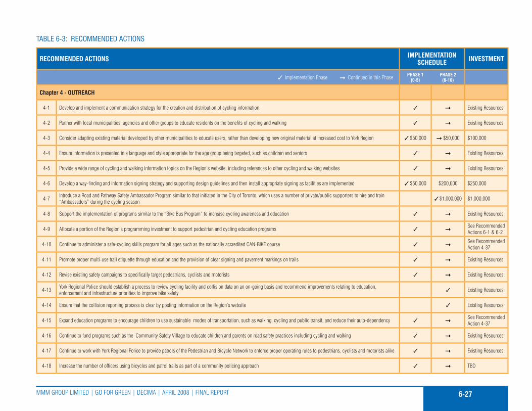
6-27MMM Group LIMITED | Go for GrEEn | DEcIMa | aprIL 2008 | fInaL rEporT
TaBle 6-3: recommended acTIonS
ReCOMMeNDeD ACTIONS IMPleMeNTATION SCheDule INVeSTMeNT
Implementation phase continued in this phase PhASe 1 (0-5)
PhASe 2 (6-10)
Chapter 4 - OuTReACh
4-1 Develop and implement a communication strategy for the creation and distribution of cycling information Existing resources
4-2 partner with local municipalities, agencies and other groups to educate residents on the benefits of cycling and walking Existing resources
4-3 consider adapting existing material developed by other municipalities to educate users, rather than developing new original material at increased cost to York region $50,000 $50,000 $100,000
4-4 Ensure information is presented in a language and style appropriate for the age group being targeted, such as children and seniors Existing resources
4-5 provide a wide range of cycling and walking information topics on the region’s website, including references to other cycling and walking websites Existing resources
4-6 Develop a way-finding and information signing strategy and supporting design guidelines and then install appropriate signing as facilities are implemented $50,000 $200,000 $250,000
4-7 Introduce a road and pathway safety ambassador program similar to that initiated in the city of Toronto, which uses a number of private/public supporters to hire and train “ambassadors” during the cycling season $1,000,000 $1,000,000
4-8 support the implementation of programs similar to the “Bike Bus program” to increase cycling awareness and education Existing resources
4-9 allocate a portion of the region’s programming investment to support pedestrian and cycling education programs see recommended actions 6-1 & 6-2
4-10 continue to administer a safe-cycling skills program for all ages such as the nationally accredited can-BIKE course see recommended action 4-37
4-11 promote proper multi-use trail etiquette through education and the provision of clear signing and pavement markings on trails Existing resources
4-12 revise existing safety campaigns to specifically target pedestrians, cyclists and motorists Existing resources
4-13 York regional police should establish a process to review cycling facility and collision data on an on-going basis and recommend improvements relating to education, enforcement and infrastructure priorities to improve bike safety Existing resources
4-14 Ensure that the collision reporting process is clear by posting information on the region’s website Existing resources
4-15 Expand education programs to encourage children to use sustainable modes of transportation, such as walking, cycling and public transit, and reduce their auto-dependency see recommended action 4-37
4-16 continue to fund programs such as the community safety Village to educate children and parents on road safety practices including cycling and walking Existing resources
4-17 continue to work with York regional police to provide patrols of the pedestrian and Bicycle network to enforce proper operating rules to pedestrians, cyclists and motorists alike Existing resources
4-18 Increase the number of officers using bicycles and patrol trails as part of a community policing approach TBD

6-28
YorK rEGIon | pEDEsTrIan & cYcLInG MasTEr pLan sTuDY | IMpLEMEnTaTIon sTraTEGY | fInaL rEporT
ReCOMMeNDeD ACTIONS IMPleMeNTATION SCheDule INVeSTMeNT
Implementation phase continued in this phase PhASe 1 (0-5)
PhASe 2 (6-10)
4-19 Include pedestrian and cycling safety material in training programs for driver examinations, police recruits, fleet/transit operators and other officials Existing resources
4-20 request provincial funding for pedestrian and bicycle safety and promotional programs to assist the region in its efforts to promote walking and cycling, and educate all road users with the objective of reducing cycling collisions Existing resources
4-21 The public advisory committee should continue throughout the implementation of the pedestrian and cycling Master plan to continue to provide comments and guidance see recommended action 6-5
4-22 Encourage public and private sector land and building owners to provide “trip-end” facilities such as benches, shelters and secure parking for cyclists and pedestrians at major employment, educational, commercial and other nodes that people frequent throughout the region Existing resources
4-23 Encourage public and private sector land and building owners to adopt a requirement for the supply of bicycle lockers and/or bicycle racks for all new multi-unit residential building sites and retail/commercial centre sites Existing resources
4-24 Develop an approach that would encourage more regional employees to cycle to work Existing resources
4-25 support the concept of tax incentives to encourage cycling use in the region Existing resources
4-26 contact Go Transit to investigate the feasibility of Go Transit implementing a bike racks on buses program on some of their fleet Existing resources
4-27 Improve the integration of cycling with transit by encouraging YrT to implement a bicycle racks on buses program and improve bicycle parking and pedestrian and bicycle access at major transit stops and terminals $100,000 $100,000 $200,000
4-28 Work with local municipalities to investigate the opportunity for “Drive and Bike” lots along the periphery of central business districts and/or along primary cycling routes Existing resources
4-29 Investigate what other jurisdictions have learned in developing their own cycling maps Existing resources
4-30 produce a user-friendly regional cycling Map by 2009 and update it every one to two years $70,000 $55,000 $125,000
4-31 provide pedestrian and cycling network maps at various public venues and update them on an annual basis, highlighting new routes $25,000 $25,000
4-32 Work with local municipalities, Boards of Trade, and employers to encourage the creation of Bicycle user Groups. smart commute could assist with the development and organization of these workplace groups Existing resources
4-33 continue to work with regional police services to further educate and enforce safe walking and cycling Existing resources
4-34 continue to work with school boards to provide elementary grade children with bicycle information and support cycling becoming an integral part of life and school Existing resources
4-35 collaborate with local municipalities as municipal cycling plans are implemented Existing resources
4-36 Encourage the MTo to provide additional cycling safety information and content in all driver-training handbooks Existing resources
4-37 promote walking and cycling as part of a healthy, active lifestyle $125,000 $125,000 $250,000
4-38 Work with the Ministry of Health promotion and the York region community and Health services Department to improve conditions for walking and cycling in York region Existing resources
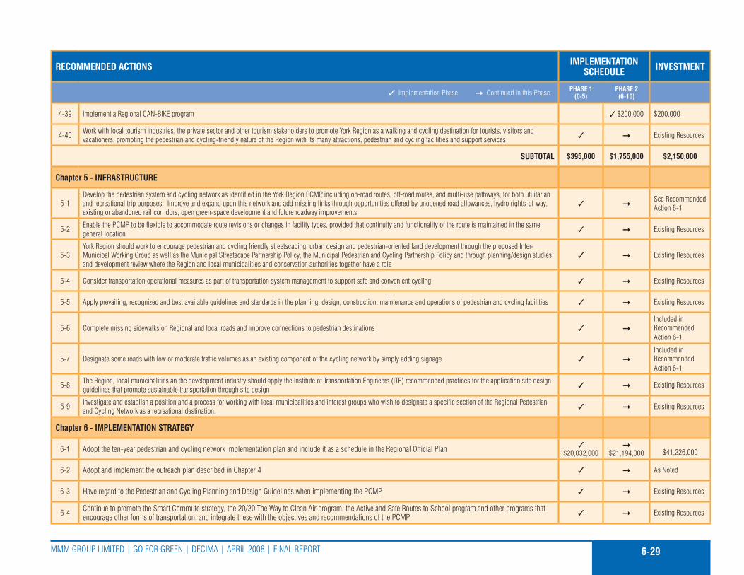
6-29MMM Group LIMITED | Go for GrEEn | DEcIMa | aprIL 2008 | fInaL rEporT
ReCOMMeNDeD ACTIONS IMPleMeNTATION SCheDule INVeSTMeNT
Implementation phase continued in this phase PhASe 1 (0-5)
PhASe 2 (6-10)
4-39 Implement a regional can-BIKE program $200,000 $200,000
4-40 Work with local tourism industries, the private sector and other tourism stakeholders to promote York region as a walking and cycling destination for tourists, visitors and vacationers, promoting the pedestrian and cycling-friendly nature of the region with its many attractions, pedestrian and cycling facilities and support services Existing resources
SuBTOTAl $395,000 $1,755,000 $2,150,000
Chapter 5 - INFRASTRuCTuRe
5-1Develop the pedestrian system and cycling network as identified in the York region pcMp, including on-road routes, off-road routes, and multi-use pathways, for both utilitarian and recreational trip purposes. Improve and expand upon this network and add missing links through opportunities offered by unopened road allowances, hydro rights-of-way, existing or abandoned rail corridors, open green-space development and future roadway improvements
see recommended action 6-1
5-2 Enable the pcMp to be flexible to accommodate route revisions or changes in facility types, provided that continuity and functionality of the route is maintained in the same general location Existing resources
5-3York region should work to encourage pedestrian and cycling friendly streetscaping, urban design and pedestrian-oriented land development through the proposed Inter-Municipal Working Group as well as the Municipal streetscape partnership policy, the Municipal pedestrian and cycling partnership policy and through planning/design studies and development review where the region and local municipalities and conservation authorities together have a role
Existing resources
5-4 consider transportation operational measures as part of transportation system management to support safe and convenient cycling Existing resources
5-5 apply prevailing, recognized and best available guidelines and standards in the planning, design, construction, maintenance and operations of pedestrian and cycling facilities Existing resources
5-6 complete missing sidewalks on regional and local roads and improve connections to pedestrian destinations Included in recommended action 6-1
5-7 Designate some roads with low or moderate traffic volumes as an existing component of the cycling network by simply adding signage Included in recommended action 6-1
5-8 The region, local municipalities an the development industry should apply the Institute of Transportation Engineers (ITE) recommended practices for the application site design guidelines that promote sustainable transportation through site design Existing resources
5-9 Investigate and establish a position and a process for working with local municipalities and interest groups who wish to designate a specific section of the regional pedestrian and cycling network as a recreational destination. Existing resources
Chapter 6 - IMPleMeNTATION STRATegY
6-1 adopt the ten-year pedestrian and cycling network implementation plan and include it as a schedule in the regional official plan $20,032,000
$21,194,000
$41,226,000
6-2 adopt and implement the outreach plan described in chapter 4 as noted
6-3 Have regard to the pedestrian and cycling planning and Design Guidelines when implementing the pcMp Existing resources
6-4 continue to promote the smart commute strategy, the 20/20 The Way to clean air program, the active and safe routes to school program and other programs that encourage other forms of transportation, and integrate these with the objectives and recommendations of the pcMp Existing resources

6-30
YorK rEGIon | pEDEsTrIan & cYcLInG MasTEr pLan sTuDY | IMpLEMEnTaTIon sTraTEGY | fInaL rEporT
ReCOMMeNDeD ACTIONS IMPleMeNTATION SCheDule INVeSTMeNT
Implementation phase continued in this phase PhASe 1 (0-5)
PhASe 2 (6-10)
6-5 continue the pedestrian and cycling public advisory committee $50,000 $50,000 $100,000
6-6 Establish a pedestrian/cycling coordinator position $500,000 $500,000 $1,000,000 - 100,000/yr x10
6-7 Establish an inter-municipal working group led by the pedestrian/cycling coordinator Existing resources
6-8 review the pcMp when regional road or other capital infrastructure projects are identified or scheduled Existing resources
6-9 review the proposed five-part process tool for guiding the implementation of pedestrian and cycling network facilities in York region and adapt it as necessary Existing resources
6-10 Work in conjunction with local municipalities to develop segments of the regional network that are under local municipal ownership Existing resources
6-11 The regional official plan should be updated to include as a schedule the pedestrian and cycling network improvements proposed in the pcMp Existing resources
6-12 commit annually to on-going funding for the pcMp and its supporting implementation strategy see recommended action 6-1
6-13 Implement the proposed pedestrian and cycling Master plan Municipal partnership program1 $2,500,000
$2,500,000
$5,000,000 - 500,000/yr x10
6-14 seek out cost sharing opportunities and other sources of revenue from partners in York region as well as the provincial and federal Governments Existing resources
6-15 coordinate cycling and pedestrian network implementation with the region’s Transportation services Department ten-year capital budget and forecast see recommended action 6-1
6-16 Identify the annual implementation budget for the pcMp in the pedestrian/ cycling coordinator’s annual report Existing resources
6-17 revise the regional Dc by-law and provide a line item that permits the use of Dc funds for providing and improving cycling facilities in regional road rights–of–ways Existing resources
6-18 Implement the recommended actions identified in the pcMp as per the suggested schedule set out in Table 6-3 of the plan contingent on available capital funding and regional council’s authorization TBD
6-19 consider the pcMp performance measures to evaluate the implementation of the pcMp at five-year intervals Existing resources
SuBTOTAl $20,582,000 $21,744,000 $42,326,000
TOTAl $20,977,000 $23,499,000 $44,476,000
1 - Municipal partnership cost included in 6-1 and is provided here for information only
6-31MMM Group LIMITED | Go for GrEEn | DEcIMa | aprIL 2008 | fInaL rEporT
regional staff (pedestrian/cycling coordinator) that would include infrastructure and programming priorities for the upcoming year. Therefore, as the pcMp evolves it will need to adapt to change. This may be in response to opportunities that emerge or because of input derived from the on going monitoring and evaluation of the pcMp.
If the region’s current population of 983,000 residents (2007 estimate) and taxpayers, were to pay the entire cost of the recommended ten-year Implementation plan up-front today, the cost per person would be equivalent to approximately $40 - $50 or $4.00 to $5.00 per year over 10 years. as the population increases over the next ten+ years the annual cost per person to implement the first ten years of pcMp will be reduced, even after taking inflation into account.
6.11 lIaBIlITY and rISk managemenT
Exposures to potential lawsuits, and concerns from private landowners who grant easements or who are located adjacent to off-road pedestrian and cycling facilities are liability concerns for the pcMp.
Bike lanes, paved shoulder bikeways and signed only routes generally fall into the same liability pattern as roadways and sidewalks, meaning that the region becomes liable only if the facility is improperly designed, constructed, or maintained.
Even though multi-use trails are separated from the roadway, they still legally fall under the definition of a “highway”, since bicycles are legally defined as vehicles. This is an important point because it means that cycling facilities are covered under many of the same basic immunities as other highways. It also illustrates the importance of adhering to design and construction guidelines,
as this will provide the greatest legal protection. aside from proper design and operation of pedestrian and cycling facilities, York region should address potential hazards associated with these facilities including accidents, theft, vandalism, and other problems. This becomes much more acute when these facilities are located along waterways and residential backyard fences.
The following methods of reducing risk are proposed for York region to help minimize the liability associated with providing designated pedestrian and cycling facilities:
Improve the physical environment, increase pubic awareness �of the rights and obligations of cyclists and pedestrians and improve access to educational programs in order to reduce the likelihood of accidents occurring and lawsuits being initiated by injured parties;
select, design and designate facilities in compliance with �the highest prevailing standards. regulatory signs, as identified by the MTo Manual of uniform Traffic control Devices, should be used to indicate the applicability of legal requirements that might not otherwise be apparent;
Design concept(s) should comply with all applicable laws �and regulations (e.g. ontario Highway Traffic act and current regional and municipal legislation);
Maintenance operations should conform to acceptable �standards. If a hazard cannot be removed, it must be isolated with barriers or notified by clear warning signage;
Monitor on a regular basis the physical conditions and �operations of roadways and pathway facilities. all reports of hazardous conditions received from cyclists, pedestrians, police or others should be promptly and thoroughly investigated;

6-32
YorK rEGIon | pEDEsTrIan & cYcLInG MasTEr pLan sTuDY | IMpLEMEnTaTIon sTraTEGY | fInaL rEporT
Keep written records of monitoring and maintenance �activities;
avoid describing or promoting routes or pathways as “safe” �or “safer” than alternatives. It appears preferable for facility users to assess their capabilities themselves and govern their choices accordingly, which is the prevailing situation; and
Maintain proper insurance coverage as a safeguard against �having to draw payment for damages from the public treasury.
6.12 evaluaTIng The pcmp
Implementation of the pcMp is expected to begin in 2008. Implementation of the region-wide pedestrian and cycling network infrastructure should be phased on an annual basis in accordance with available capital funding, and as authorized by regional council.
collecting data to evaluate the different and changing aspects of pedestrian and cyclist behaviour will assist in evaluating the effectiveness and overall contribution of various activities to achieve the stated vision and goals of this plan.
This data collection should begin in 2008 and build upon the various pcMp initiatives, such as the public attitude surveys. The data will establish a benchmark with which to compare later data as the pcMp is implemented.
The data collection will be used to:
confirm the overall direction and implementation of the �pcMp;
confirm statistics on the number and type of cyclists; �
Verify the route selection process; and �
Identify the supply and demand for bicycle parking. �
over time, the evaluation system should identify changes in route preference to assist in determining where to implement changes to “hard and soft” pedestrian and cycling infrastructure.
The results of this assessment may be used to determine the success of implementing various types of cycling facilities. However, caution must be used in relying on an immediate response to a given improvement. an extended timeframe should be established to ensure that cycling awareness initiatives are in place to assist in changing travel patterns and habits.
assessing the impact and costs of a pedestrian and cycling program should be based on information such as:
origin/destination counts; �
screenline counts on a finer scale that are appropriate to �cycling travel patterns; and
Intersection counts to coincide with routes on which �improvements are proposed, and also on parallel routes.
This information should be collected every two years and during the cycling season.
Data collected through evaluation/monitoring programs along with information collected through on-going public consultation exercises, such as user surveys and public attitude surveys conducted every five years, will inform and thus assist in the preparation of the list of annual priorities and assisting measuring the performance of the plan.
6-33MMM Group LIMITED | Go for GrEEn | DEcIMa | aprIL 2008 | fInaL rEporT
a component of measuring
the implementation of the plan
and its success in meeting
objectives is to establish
performance measures and
targets.
a component of measuring the implementation of the plan and its success in meeting objectives is to establish performance measures and targets.
Table 6-4 identifies a set of outreach and infrastructure performances measures, and targets by phase. It is recommended that an assessment of these performance measures be included as part of the recommended five-year update to the Master plan.
The goals outlined in chapter 3, which were designed to guide the pcMp, will also act as measure to evaluate the plan. Each of the goals should be accomplished in implementing the pcMp. These goals are to:
Develop an understanding of the elements that affect walking �and cycling in York region;
provide a range of alternative transportation choices that �will benefit residents, employees and visitors in York region by improving public health and air quality while reducing dependence on the private automobile;
Improve conditions for walking and cycling for people of �all ages through the provision of a continuous pedestrian sidewalk system and regional-scale cycling network;
Integrate the improved sidewalk system and proposed �cycling network with regional transit; and
Encourage more people to walk and cycle more often for �utilitarian, recreational and health purposes.
Recommended Actions:
6-18 Implement the recommended actions identified in the pcMp as per the suggested schedule set out in Table 6-3 of the plan contingent on available capital funding and regional council’s authorization
6-19 consider the pcMp performance measures to evaluate the implementation of the pcMp at five-year intervals
6.13 nexT STepS
There are a number of immediate steps that York region should take in 2008 to advance the pcMp:
copies of the pcMp should be provided to all regional �Departments including the regional police service.
York region should issue a copy of the pcMp to all local �municipalities, the public advisory committee, the ontario Ministry of Transportation, school boards, and conservation authorities for information and as input to their long range planning initiatives.
starting in 2008, the regional Transportation services �Department should consider and, if feasible, begin to implement the region’s share of the network recommend-ations as part of all future road projects in the region.
The planning Department, led by the pedestrian/cycling �coordinator, should establish the inter-municipal working group in 2008 and work with regional community and Health services, regional police, school boards, conservation authorities and other stakeholders to expand pedestrian and cycling supportive programs and education initiatives.

6-34
YorK rEGIon | pEDEsTrIan & cYcLInG MasTEr pLan sTuDY | IMpLEMEnTaTIon sTraTEGY | fInaL rEporT
TaBle 6-4: performance meaSureS
ChAPTeR PeRFORMANCe MeASuReexISTINg
BeNChMARKSTARgeT
PhASe 1 PhASe 2
outreach
number of schools and students participating in pedestrian or bicycle safety education programs or events TBD – regional Health TBD TBD
percentage of children that walk or bike to school in York region 38% (02TMp) 42% 50%
regional funding allocated for funding pcMp outreach initiatives TBD pcMp pcMp
percentage of reported pedestrian and bicycle collisions per 1000 population in York region TBD – regional police reduction reduction
percent of all York region residents who commute to work primarily by walking or cycling in regional centres 3% 2005 smart commute 3.5% 4.25%
percent of all workers who commute by a combination of sustainable travel modes (walking, cycling and transit) 23% 2005 smart commute 25% 30%
number of minutes per day the average York region resident spends walking (includes walking to transit) 30 – public attitude survey 40 50
number of minutes per day the average York region resident spends cycling (utilitarian and recreational) TBD – public attitude survey TBD TBD
Infrastructure
amount of regional funding allocated for funding pcMp infrastructure and program initiatives n/a $11,022,000 $17,207,000
Kilometres of new bike lane implemented as per the pcMp n/a 75.6 km 87.7 km
Kilometres of paved shoulder bikeways implemented as per the pcMp n/a 184.7 km 110.6 km
Kilometres of new signed-only bike routes as per the pcMp n/a 84.8 km 38.9 km
number of bikes per year using bike racks on buses program n/a TBD TBD
Kilometres of new off-road multi-use trails implemented as per the pcMp n/a 33.8 km 26.7 km
Kilometres of linear sidewalks on regional roads 486 km TBD TBD
Kilometres of completed missing sidewalk links on regional roads as per pcMp n/a 45.3 km 16.6 km
number of new bicycle parking spots implemented n/a TBD TBD


![1] Bike & Pedestrian Master Plan](https://img.dokumen.tips/doc/110x75/616a282011a7b741a34f6af9/1-bike-amp-pedestrian-master-plan.jpg)