Embed Size (px)
Citation preview
1
PEDESTRIAN & BICYCLE MOBILITY NEW EGYPT | SUMMARY REPORT June 22, 2011 – Final Report
MASER CONSULTING, PA:
David G. Roberts, AICP/PP, LLA, Gustavo DeBlasio, ASLA
Christina Symanski, ASLA
CH PLANNING, LTD:
Oliver Carley, AICP, PP Jeannette Brugger, AICP, PP
John Madera, AICP

Ocean County Subregional Study PEDESTRIAN & BICYCLE MOBILITY – NEW EGYPT
2
Contents
Executive Summary......................................................... 3
Study Purpose ............................................................... 5
The Bicycle Pathway Plan.................................................. 6
Study Process ................................................................ 8
Existing Conditions, Obstacles & Design Recommendations ........10
Existing Conditions & Obstacles ......................................10
Phase 1, Segment A ..................................................10
Phase 1, Segment B ..................................................11
Phase 1, Segment C ..................................................12
Phase 2, Segment A ..................................................14
Phase 2, Segment B ..................................................15
Phase 2, Segment C ..................................................16
Bike Path Design Features .............................................23
Connection to the Union Transportation Trail .....................23
Preferred Alternative ..................................................24
Implementation ............................................................25
APPENDIX ....................................................................27
PRESENTATION: SECOND PUBLIC OPEN HOUSE – PLUMSTED MUNICIPAL BUILDING, FEBRUARY 17, 2011..........................27
This report has been prepared as part of the North Jersey Transportation Planning Authority’s Subregional Study Program with financing by the Federal Transit Administration and the Federal Highway Administration of the U.S. Department of Transportation. This document is disseminated under the sponsorship of the U.S. Department of Transportation in the interest of information exchange. The NJTPA and Ocean County are solely responsible for its contents.

Ocean County Subregional Study PEDESTRIAN & BICYCLE MOBILITY – NEW EGYPT
3
Downtown New Egypt
New Egypt Town Center
ENVIRONS
Fort Dix Military Reservation
Plumsted Township
Downtown New Egypt
New Egypt Town Center
ENVIRONS
Fort Dix Military Reservation
Plumsted Township
Downtown New Egypt
New Egypt Town Center
ENVIRONS
Fort Dix Military Reservation
Plumsted Township
Executive Summary
This portion of the Ocean County Subregional Study involving New Egypt determines the design feasibility for the development of a multipurpose trail/bike path linking downtown New Egypt with the civic complex on Evergreen Road and ultimately linking up with the southerly segment of the Union Transportation Trail (UTT), which was completed by the Monmouth County Park System and opened to the public in 2010. A secondary purpose of the New Egypt component of the SSP was to examine the feasibility of a conceptual design for excess right-of-way in Lakeview Drive to improve the efficiency of public and private parking, while enhancing the adjacent water’s edge of Oakford Lake Park, possibly to include a new boat launch.
The Township of Plumsted has been engaged for the past several years in the Plan Endorsement process with the New Jersey State Planning Commission. An Action Plan and Memorandum of Understanding (MOU) with the Township was approved by the Commission on September 16, 2009. One of the Action Items was the development and adoption of a Circulation Plan Element modeled after the Mobility and Community Form approach promoted by the NJDOT. The Township received a Smart Future Grant and used the funds to develop and adopt the Circulation Plan Element in 2010. The Circulation Plan Element includes both a Pedestrian Pathway Plan, focused on Downtown New Egypt, and a Bicycle Pathway Plan, which covers the northern half of the Township outside of the Fort Dix portion of Joint Base New Jersey (see Figure 1).
This Summary Report provides the details of both the Phase 1 and Phase 2 New Egypt Bike Path, which is a Class 1 (off road) path component of the proposed Bicycle Pathway Plan. The New Egypt
Bike Path is proposed to follow the former right-of-way of the Pemberton & Hightstown Railroad, a short line right-of-way established in 1864 to provide dairies and farms access to larger railroads at junctions in Pemberton (Burlington County) and
Figure 1: This graphic, taken from the 2010 Plumsted Circulation Element of the Master Plan, illustrates the geographic relationship of Downtown New Egypt with the Town Center and the half of the Township north of Fort Dix portion of Joint Base New Jersey

Ocean County Subregional Study PEDESTRIAN & BICYCLE MOBILITY – NEW EGYPT
4
Hightstown (Mercer County). The railroad began operating in 1868, traveling through Hornerstown, Cream Ridge, Davis, Imlaystown and Sharon in Upper Freehold Township before crossing through Plumsted Township with a station on Evergreen Road in New Egypt and then crossing through North Hanover in Burlington County on its way to Pemberton. Passenger service ceased in 1931, but freight service continued on sections of the line until 1977. The right-of-way was acquired by Jersey Central Power & Light (JCP&L) in 1998.1
Negotiations between the Township and JCP&L for an easement for the use of the right-of-way for a multipurpose trail are ongoing and a formal agreement was under review by the Township Committee at the time of the preparation of this Summary Report.
The portion of the former rail right-of-way that runs through Monmouth County is called the Union Transportation Trail (UTT) and the Monmouth County Parks System completed construction on the southernmost segment of approximately two miles in length in 2010 (see Figure 2).
This Summary Report recommends a preferred alternative for connecting Phase 2 of the New Egypt Bike Path to the UTT, which is to tunnel under the roadbed of County Road 537 using pre-cast concrete box culvert sections. This preferred alternative would be subject to more detailed engineering feasibility and cost estimates. The other alternatives reviewed between Ocean County’s project team and the Monmouth County Park System UTT project manager were:
1 Monmouth County Parks System website: (www.monmouthcountyparks.com)
1. Elevate the grade on both sides of the road to enable a grade crossing of County Route 537;
2. Acquire easements through private property to connect the New Egypt Bike Path to Millstream Road for a grade crossing at CR 537.
Both of these alternatives involve grade crossings at Route 537 that are undesirable from a safety point of view because of the speeds and sightlines on CR 537.
Figure 2: Map of the UTT from the Monmouth County Parks System website, showing the completed two mile segment in the solid blue line.

Ocean County Subregional Study PEDESTRIAN & BICYCLE MOBILITY – NEW EGYPT
5
Study Purpose
The purpose of the New Egypt component of the Ocean County Subregional Study Program with the NJTPA is to advance the development of the first multipurpose trail in the Township and the implementation of the first segment of the Township’s Bicycle Pathway Plan. The Study takes the recommendations of the 2010 Circulation Element of the Plumsted Master Plan and provides a conceptual design based on field investigation and an identification of obstacles along the entire two mile length of the combined Phase 1 and Phase 2 segments of the New Egypt Bike Path.
The right-of-way of the former Pemberton-Hightstown Railroad, now owned by JCP&L and utilized as a utility corridor with the original wooden poles that once served the rail line, passes through the rear of downtown New Egypt, separating the rear of commercial properties on the north side of Main Street from several residential stub streets off of Meadowbrook Lane. It once was bridged over the Crosswicks Creek by a wood timber bridge, which no longer remains, and crossed Evergreen Road adjacent to Kovac’s Corner Bar and Grill and Brite Lumber. It then passed through a residential area before crossing Bright Road and passing behind the education/civic complex to County Road 537 (see Figure 3).
The most challenging obstacle to the construction of the Phase 1 Bike Path (between Jacobstown Road and the education/civic complex) is bridging the Crosswicks Creek. The most challenging obstacle to the Phase 2 Bike Path is getting across County Road 537 to link up with the UTT.
Figure 3: This Land Use Map shows the Phase 1 and Phase 2 Bike Path in dashed red and blue lines respectively, with the red shaded areas representing Downtown New Egypt and the large blue shaded area representing the educational/civic complex.
Ocean County Subregional Study PEDESTRIAN & BICYCLE MOBILITY – NEW EGYPT
6
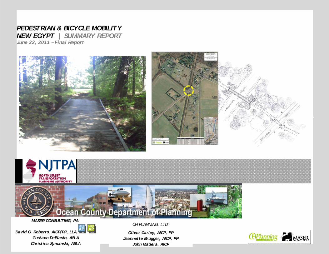
The Bicycle Pathway Plan
The 2010 Plumsted Master Plan Circulation Element places emphasis on maximizing the opportunities for alternative modes of bicycle, pedestrian and transit mobility within the Township, with emphasis on NJDOT’s “Complete Streets” and “Mobility and Community Form” guidelines. This will be done with a network of pedestrian pathways connecting parking lots within the downtown, some along public right-or-ways and some through easements through private property, with wayfinding directional signage to the variety of destinations of interest. Leaving the core of the Downtown, the non-vehicular pathways would pickup with Class II bicycle lanes along existing shoulders of County roads that fan out to signed bicycle routes on County Routes 537 running east and 539 running south.
The Plumsted Bicycle Pathway Plan consists of Class III Bicycle Routes (County Roads 537 and 528 running east and west; County Road 539 running north and south); Class II Bike Lanes (Bicycle Route signage and unmarked but lined bike lanes) along secondary County Roads such as Archertown Road and West Colliers Mills Road (County Road 640), and Township roads such as Evergreen Road, Brindletown Road, Long Swamp Road and Colliers Mill Road; and a Class I (off road) bike path/multipurpose trail along the JCP&L right-of-way along a former rail line between Jacobstown Road, crossing the Crosswicks Creek and Evergreen Road, connecting to the rear of New Egypt High School. A second phase of the New Egypt Bike Path would extend to Route 537 for potential future linkage to the Monmouth County Park System’s recently constructed “Union Transportation Trail” (UTT) multipurpose trail along the same right-of-way (see Figure 4).
TYPES OF BIKE PATHS:
Class I The Class I bike path provides a completely separated right of way for the exclusive use of bicycles and pedestrians with cross-flow traffic minimized. The trails are marked and landscaped. Fencing encourages use of designated access points and prominent signed crosswalks mark intersections with roadways.
Class II Class II bike paths provide a striped lane for one-way bike travel on a street or highway. Bike lanes are marked with signs and/or pavement markings. Existing County roads with wide shoulders leading to downtown New Egypt would be likely candidates.
Class III Class III bike routes provide for shared use with pedestrian or motor vehicle traffic, with marked with signs for identification purpose.

Ocean County Subregional Study PEDESTRIAN & BICYCLE MOBILITY – NEW EGYPT
7
Figure 4: The Bicycle Pathway Plan from the 2009 Plumsted Master Plan Circulation Element (adopted in 2010) recommends a network of Class 2 and 3 Bike Routes using the shoulders of County roads leading to Downtown New Egypt, where the New Egypt Bike

Ocean County Subregional Study PEDESTRIAN & BICYCLE MOBILITY – NEW EGYPT
8
Study Process
The Maser study team began by reviewing previously completed studies and plans for the area and developed base maps for segments of both the Phase 1 and Phase 2 Bike Paths. The segmented base maps were then used by a field team consisting of the Maser project manager, landscape architect and environmental scientist when they visited the site on two occasions to walk the route, note surrounding land uses, views, natural features and identify obstacles and environmental constraints.
The study team then laid out a ten foot wide path in a serpentine design on a set of conceptual plans. Small seating areas were identified along the entire route and drawn on the plans, with priority give to places with existing paths on adjacent properties intersected with the proposed Bike Path.
The Maser design team then researched solutions to the obstacles identified in the site work and met with the Monmouth County Park System project manager of the UTT to identify alternative solutions for connecting the New Egypt Bike Path to the UTT.
Finally, the Maser project manager coordinated and facilitated a Public Open House meeting at the Plumsted Municipal Building on Evergreen Road. Several sets of the conceptual plans were on hand for public inspection at the Open House. The presentation given at the Open House is included in the Appendix of this Summary Report.
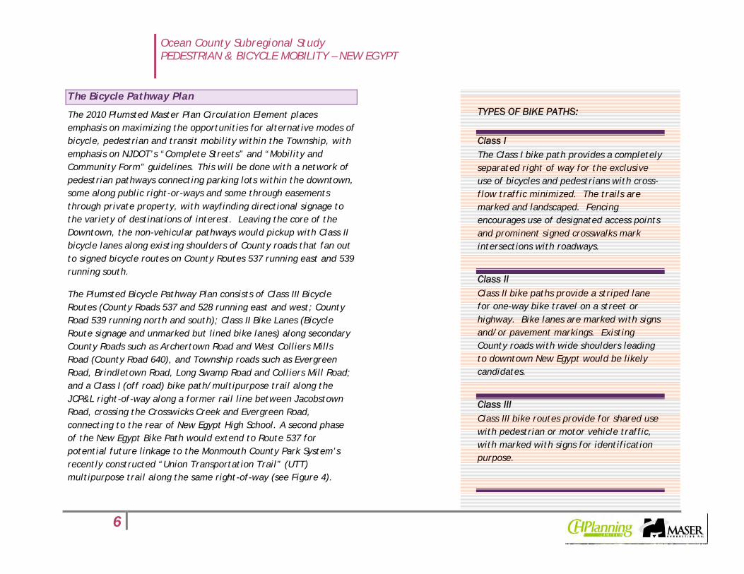
The Phase 1 and Phase 2 components of the Bike Path are depicted in Figure 5. Enlarged parcel map versions of each Phase are shown in Figures 6 and 7 on the following page.
Figure 5: New Egypt Bike Path - preliminary delineation of Phase 1 and Phase 2 path segments.
Ocean County Subregional Study PEDESTRIAN & BICYCLE MOBILITY – NEW EGYPT
9
Figure 6: Phase 1 Bike Path - Jacobstown Road to High School/Civic Complex Figure 7: Phase 2 Bike Path - High School/Civic Complex to UTT

Ocean County Subregional Study PEDESTRIAN & BICYCLE MOBILITY – NEW EGYPT
10
Existing Conditions, Obstacles & Design Recommendations
This section will describe the existing conditions of the various segments of the Phase 1 and Phase 2 Bike Paths and point out obstacles and proposed design solutions.
Existing Conditions & Obstacles
Phase 1, Segment A - This segment extends from the point of beginning for the Phase 1 Bike Path at Jacobstown Road to the crossing at Evergreen Road just to the north of Brite Lumber.
There are a number of existing walking paths that have been worn into the cleared portions of the right-of-way along this segment suggesting frequent use by residents along Meadowbrook Lane and its stub streets (Platt Street, 5th Street and Miron Street) to get to the CVS pharmacy on Jacobstown Road and the New Egypt Market on Main Street. However, much of the remainder of the right-of-way to the west and east of these footpaths is overgrown with thick understory vegetation.
Seteg ffff fff f
Figure 8: Phase 1, Segment A has footpaths worn through the vegetation in some spots (top), which serve as short cuts for residents living in the Meadowbrook Lane neighborhood (bottom)

Ocean County Subregional Study PEDESTRIAN & BICYCLE MOBILITY – NEW EGYPT
11
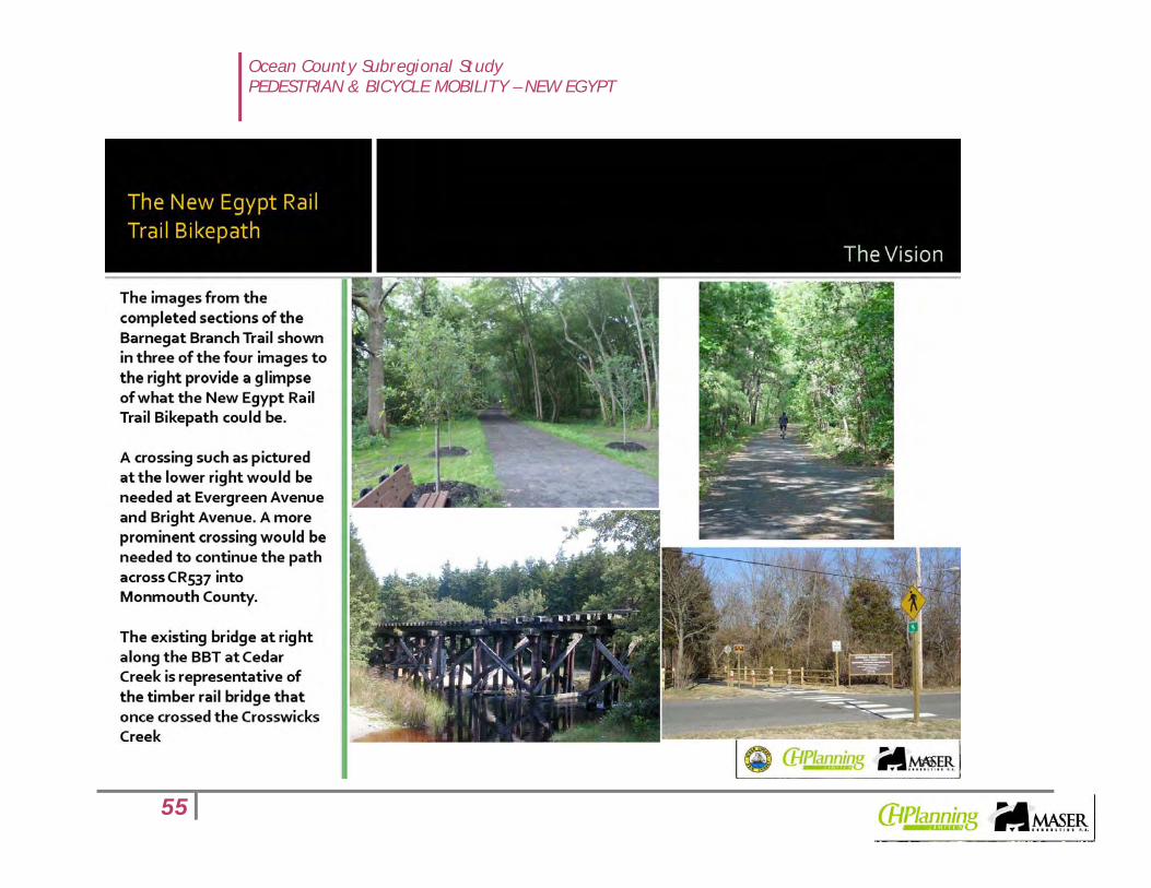
The most significant obstacle in Phase 1, Segment A is the Crosswicks Creek. The only remnants of the timber bridge that once spanned the creek are a timber abutment on the west bank of the creek and the timber posts that were sawed off at the water line (see Figure 9).
Figure 9: The Crosswicks Creek is shown here at the point where the timber rail bridge once spanned it. The pile stumps can be seen just above the water line. The required span is estimated to be 86 feet.
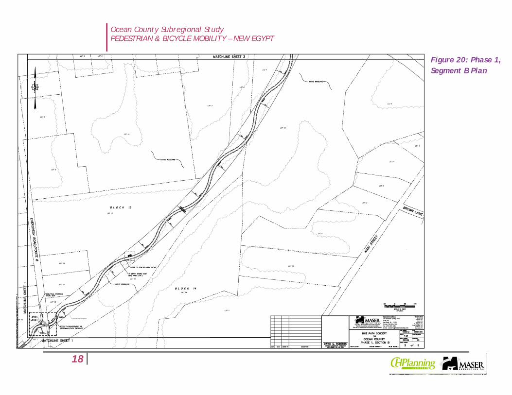
Phase 1, Segment B – This segment of Phase 1 Bike Path would continue from the crossing at Evergreen Road to the crossing at Bright Road. The right-of-way along this segment runs parallel to a stream corridor that meanders through a stand of native woodland. The proposed serpentine trail alignment has been shaped to follow the edge of the native woodland along this segment.

Ocean County Subregional Study PEDESTRIAN & BICYCLE MOBILITY – NEW EGYPT
12
Figure 10: Phase 1, Segment B begins alongside Brite Lumber and crosses through a residential area to Bright Road. The only remnants (rail ties and a structure) of the former railroad were observed in the wooded area to the right.
Figure 11: Phase 1, Segment B is one of the easier areas of the right-of-way to traverse on foot, as the vegetation was not as thick and difficult as most other areas.
Phase 1, Segment C extends from Bright Road to the rear of the New Egypt High School property where it would connect with the Cross Country trails that lead over a ten foot wide wood plank bridge to the soccer fields behind the school (see Figure 12).
Along this stretch of the right-of-way there are areas where the center is considerably higher in elevation than the edges and in many places is overgrown with understory vegetation (see Figure 13). The most significant obstacle in this segment is what was identified as a “wash out” by a stream crossing the right-of-way

Ocean County Subregional Study PEDESTRIAN & BICYCLE MOBILITY – NEW EGYPT
13
(see yellow circle in aerial key map above), causing a gap that will need to be bridged as part of the construction of the Phase 1 Bike Path (see Figure 14).
Figure 12: View of cross-country trail entrance from rear of soccer field behind New Egypt High School.
Figure 13: Phase 1, Segment C is mounded in the center of the R.O.W.
Figure 14: The stream visible in the lower left corner of this image (see yellow circle) cuts through the mounded portion of the R.O.W and will need to be bridged in order to connect with the High School's cross country trail.
In the short term, the prioritization of Segments B and C of the Phase 1 Bike Path would enable the Township to utilize the new parking area adjacent to the recently completed Volunteer Park as a trail head to access the Segment B portion of the Bike Path at Evergreen Road and bridge the overwash area to link up with the cross country path behind the education/civic complex. This portion of the Phase 1 Bike Path is still accessible from downtown

Ocean County Subregional Study PEDESTRIAN & BICYCLE MOBILITY – NEW EGYPT
14
New Egypt and would not require the difficult bridging of the Crosswicks Creek.
Phase 2, Segment A Is the first portion of the Phase 2 Bike Path that would continue behind the education/civic complex on Evergreen Road to ultimately link up with the UTT in Monmouth County on the other side of County Road 537. This stretch of right-of-way runs along a wooded area behind the school recreation fields to the west and along the rear yards of small farms and farmettes that front on High Bridge Road to the east.
Figure 15: A view facing north along Segment A of the Phase 2 Bike Path showing the line of woodland along both sides.
Segment A has no obstacles of note and is one of the most passable areas of the right-of-way along the entire Phase 1 and Phase 2 Bike Path route. With the successful resolution of an agreement between the Township and JCP&L to allow public access, this Segment could easily be used for pedestrian access, equestrian use or even as an extension of the cross country trail behind the education/civic complex.

Ocean County Subregional Study PEDESTRIAN & BICYCLE MOBILITY – NEW EGYPT
15
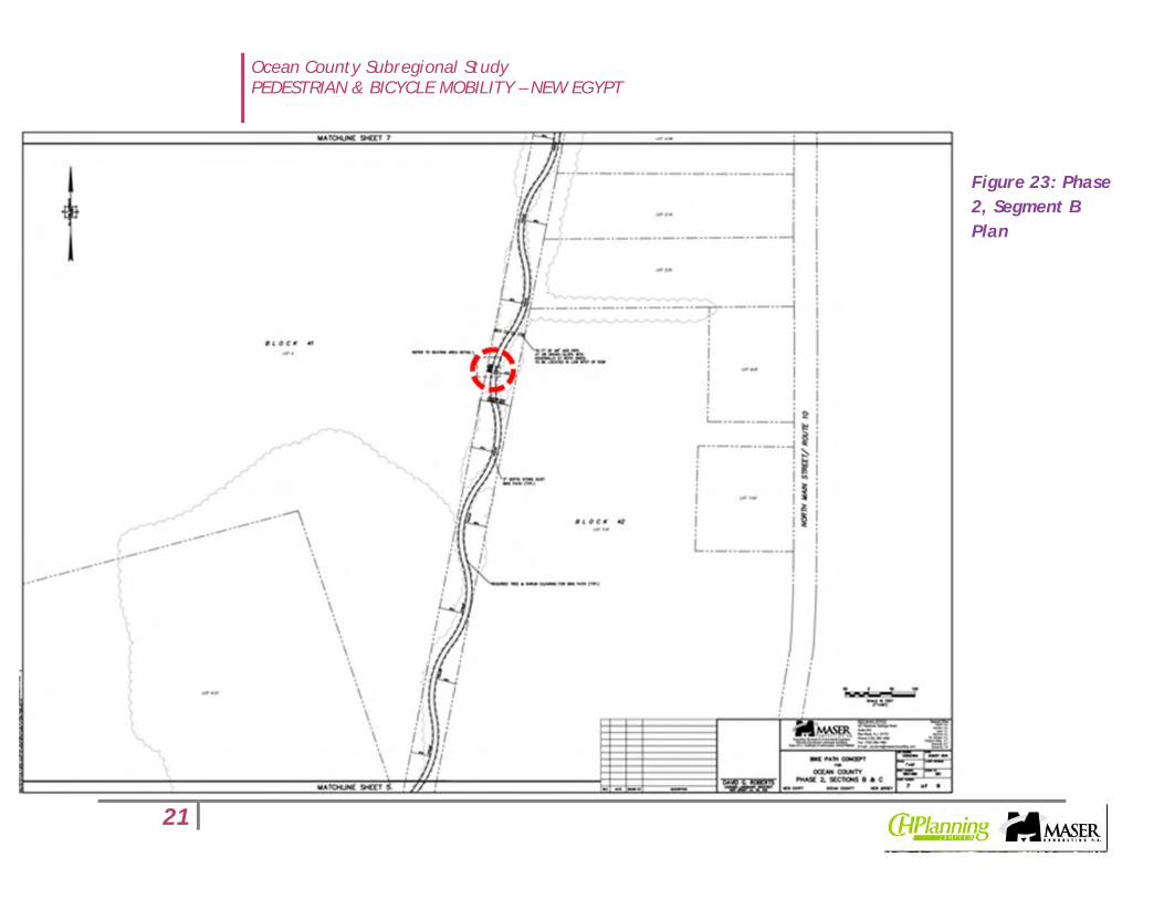
Phase 2, Segment B is the middle segment of the Phase 2 Bike Path and emerges from the wooded area directly east of the Plumsted Industrial Park with cultivated farmland on both sides. One minor obstacle is a small stream that crosses the right-of-way (see yellow circle in aerial map above) that can be overcome with a simple storm culvert.
As with Segment A, Segment B of the Phase 2 Bike Path offers views of the rural countryside typical of this part of Ocean and Monmouth Counties. While these views are offered as “glimpses”
through the wooded area in Segment A, there are more open vistas along Segment B.
Figure 16: Birds Eye view of Phase 2, Segment B showing its location relative to the Plumsted Industrial Park, facing west from High Bridge Rd.
Figure 17: Views of the rural landscape in Segment B are the best along the entire Phase 1 and Phase 2 Bike Path route. This view is from the right-of-way facing east towards High Bridge Road.

Ocean County Subregional Study PEDESTRIAN & BICYCLE MOBILITY – NEW EGYPT
16
It is noteworthy that the entire length of the Phase 2 Bike Path is a straight reach without any roadway crossings until its terminus at County Road 537. Other than the minor storm culvert referenced earlier, Phase 2 would be the less expensive section to construct except for the connection to the UTT.
Phase 2, Segment C is the last of the Phase 2 Bike Path between the education/civic complex on Evergreen Road and the terminus of the New Egypt Bike Path at County Road 537 about 400 feet west of its intersection with High Bridge Road.
This last segment is also relatively easily traversed on foot and offers the potential for almost immediate public use, except that it is essentially a dead end when it reaches County Road 537.
Figure 18: The view of the terminus of the Phase 2 Bike Path right-of-way from the north side of County Road 537 (bottom) and south side (top) show the elevation obstacle that makes the raised roadway a barrier between the proposed Bike Path and the UTT.

Ocean County Subregional Study PEDESTRIAN & BICYCLE MOBILITY – NEW EGYPT
17
Figure 19: Phase 1, Segment A Plan
Ocean County Subregional Study PEDESTRIAN & BICYCLE MOBILITY – NEW EGYPT
18
Figure 20: Phase 1, Segment B Plan

Ocean County Subregional Study PEDESTRIAN & BICYCLE MOBILITY – NEW EGYPT
19
Figure 21: Phase 1, Segment C Plan

Ocean County Subregional Study PEDESTRIAN & BICYCLE MOBILITY – NEW EGYPT
20
Figure 22: Phase 2, Segment A Plan
Ocean County Subregional Study PEDESTRIAN & BICYCLE MOBILITY – NEW EGYPT
21
Figure 23: Phase 2, Segment B Plan

Ocean County Subregional Study PEDESTRIAN & BICYCLE MOBILITY – NEW EGYPT
22
Figure 24: Phase 2, Segment C Plan - Connection to UTT

Ocean County Subregional Study PEDESTRIAN & BICYCLE MOBILITY – NEW EGYPT
23
Bike Path Design Features
The conceptual design plans in Figures 18 through 23 above indicate several design features that are accessory to the construction of a ten foot wide multipurpose path of two miles in length. The detail sheet (Sheet 9) of the conceptual plans provides details for path construction, road crossings, seating along the trail
and signage. These details assume the same type of construction as has been used by Ocean County in the construction of their Barnegat Branch Trail, which consists of a compacted subgrade, a filter fabric and 3 inches of stone dust for dry areas, with an additional 3 inch layer of dense graded aggregate (DGA) between the filter fabric and stone dust for wet areas (see Figure 24) to
provide for a permeable pavement.
Connection to the Union Transportation Trail
Beyond the design issues and obstacles evaluated in the conceptual planning for the Phase 1 and Phase 2 Bike Path, the scope of this Study includes an evaluation of alternative solutions for connecting the New Egypt Bike Path with the Union Transportation Trail. As described and
illustrated in the discussion of Phase 2, Segment C, the challenges to connecting the two portions of the former Pemberton-Hightstown Railroad right-of-way is the elevation change at County Road 537. The road was once elevated further over a tunnel used by the passenger and freight trains that once used the railroad. After the railroad was abandoned and the rails removed, the tunnel was also removed and the road lowered to improve sight lines. However, the elevation of the road remains approximately ten feet above the elevation of the right-of-way on either side of it.
Figure 25: Bike Path Design Details

Ocean County Subregional Study PEDESTRIAN & BICYCLE MOBILITY – NEW EGYPT
24
The Maser project team and representatives of Ocean County, Plumsted Township and the Monmouth County Parks System met to review the plans of both the New Egypt Bike Path and the UTT and determined that the three alternative solutions for linking them would be as follows:
1. Elevate the grade on both sides of the road to enable a grade crossing of County Route 537;
2. Install precast concrete box culvert sections under County
Route 537;
3. Acquire easements through private property to connect
the New Egypt Bike Path to Millstream Road for a grade crossing at CR 537.
Preferred Alternative
Pending a final determination on relative cost feasibility of the three alternatives, the study team recommends Alternative 2 as the preferred long term solution to linking the New Egypt Bike Path and the UTT for the following reasons:
• Tunneling under the road bed would have less impact on drainage patterns and wildlife habitat than bringing in the quantities of fill that would be necessary to maintain suitable grades for trail use (Alternative 1). It is noted, however, that the County Engineer’s office has prepared a cost estimate that most likely would entail complete excavation of the CR537 road bed wide enough for a substructure consisting of a reinforced concrete footing and cast-in-place piles. This method could involve comparable disturbance as Alternative 1 and, if a pre-fabricated ramp system could be substituted for earthen fill, the disturbance impacts of Alternative 1 could be reduced enough for it to become the preferred alternative;
• Tunneling under the road bed would enable the link between the two trails to be seemless and avoid the dangerous crossing locations required for Alternatives 1 and 3. Alternative 2 would clearly be the preferred alternative for purposes of safety and convenience for users of the trail system;

Ocean County Subregional Study PEDESTRIAN & BICYCLE MOBILITY – NEW EGYPT
25
Figure 26: This image shows the potential benefits of tunneling under CR
537 to link the New Egypt Bike Path with the UTT
• A very preliminary construction cost estimate for tunneling
under CR537 and installing precast concrete box culvert sections (see Figure 26) was calculated at $1,400 per linear foot for a length of 75 feet, or $105,000. However, the County Engineer’s office developed a more detailed cost estimate based upon a substructure of a reinforced concrete footing supported by cast-in-place concrete piles at approximately $1,000,000 ($845,649). Alternative 1 would involve the purchase, delivery grading and compaction of significant fill and Alternative 3 would involve the purchase of easements through property at least to connect the trail to High Bridge Road and the construction of grade crossings at Millstream and Route 537 in order to reach the UTT.
Figure 27: The installation of precast concrete box culverts of 10 feet in height and 13 feet in width can be done under the road bed, but may require the tunnel grade to be lower than the trail grade and entail drainage design that could increase costs.
Implementation
Implementation of the New Egypt Bike Path and its connection to the UTT is expected to be done in phases. Plumsted Township has already taken the first step by engaging JCP&L in negotiating an easement agreement to enable public access on the right-of-way. Initially, it is expected that the Township will clear a continuous path, expected to be 10 feet in width, through the overgrown portions of the right-of-way to enable its use by hikers and equestrians, with possible limited use by cyclists, depending on the surface. The most likely first section would be Phase 1, Segments B and C, although the obstacle identified in Segment C would still have to be overcome in order to reach the connection with the cross country trail behind the education/civic complex.

Ocean County Subregional Study PEDESTRIAN & BICYCLE MOBILITY – NEW EGYPT
26
This Segment can be served by the parking lot adjacent to Volunteer Park.
The most likely second phase of development would be to construct a permanent surface on the path created on the Phase 1, Segment B and C right-of-way to create a fully developed Bike Path connecting Evergreen Road with the cross country trails, which then also enable the use of the parking at the Township and school facilities along Evergreen Road for access to the Bike Path.
The next phase of the Bike Path to be implemented should be the entire Phase 2 stretch and the connection to the UTT. It is recommended that the County continue to engage the Monmouth County Park System to work collaboratively on solutions to connecting the New Egypt Bikepath to the UTT. The Monmouth County Park System has expressed its desire to be involved in the implementation and assist Plumsted Township and Ocean County in pursuing a direct connection between the two trails.
The last phase of the Bike Path should be Phase 1, Segment A, as the cost of construction of the bridge over the Crosswicks Creek will likely be as high or higher than the cost of installing a box culvert tunnel under County Road 537. This Segment, however, will offer the best direct connections to business in downtown New Egypt, as none of the other Segments directly abut commercial properties.
The Implementation Matrix in Figure 5 projects out the sequence described above, with some overlap shown as the projects begun in Year 1 are being completed in Year 2 and the projects beginning in Year 2 are carried over into construction in Year 3. The Matrix suggests that Year 2 would be the busiest, with either design or construction activities involving all of the Segments except the
first Segment (1A) between Jacobstown Road and the Crosswicks Creek.
NEW EGYPT BIKE PATH – IMPLEMENTATION MATRIX Phase Segment Year 1 Year 2 Year 3 Year 4
1 A
B
C
2 A
B
C
Figure 28: Implementation Matrix

Ocean County Subregional Study PEDESTRIAN & BICYCLE MOBILITY – NEW EGYPT
27
APPENDIX
PRESENTATION: SECOND PUBLIC OPEN HOUSE – PLUMSTED MUNICIPAL BUILDING, FEBRUARY 17, 2011

Ocean County Subregional Study PEDESTRIAN & BICYCLE MOBILITY – NEW EGYPT
28

Ocean County Subregional Study PEDESTRIAN & BICYCLE MOBILITY – NEW EGYPT
29

Ocean County Subregional Study PEDESTRIAN & BICYCLE MOBILITY – NEW EGYPT
30
Ocean County Subregional Study PEDESTRIAN & BICYCLE MOBILITY – NEW EGYPT
31

Ocean County Subregional Study PEDESTRIAN & BICYCLE MOBILITY – NEW EGYPT
32

Ocean County Subregional Study PEDESTRIAN & BICYCLE MOBILITY – NEW EGYPT
33

Ocean County Subregional Study PEDESTRIAN & BICYCLE MOBILITY – NEW EGYPT
34
Ocean County Subregional Study PEDESTRIAN & BICYCLE MOBILITY – NEW EGYPT
35

Ocean County Subregional Study PEDESTRIAN & BICYCLE MOBILITY – NEW EGYPT
36

Ocean County Subregional Study PEDESTRIAN & BICYCLE MOBILITY – NEW EGYPT
37

Ocean County Subregional Study PEDESTRIAN & BICYCLE MOBILITY – NEW EGYPT
38

Ocean County Subregional Study PEDESTRIAN & BICYCLE MOBILITY – NEW EGYPT
39

Ocean County Subregional Study PEDESTRIAN & BICYCLE MOBILITY – NEW EGYPT
40

Ocean County Subregional Study PEDESTRIAN & BICYCLE MOBILITY – NEW EGYPT
41

Ocean County Subregional Study PEDESTRIAN & BICYCLE MOBILITY – NEW EGYPT
42

Ocean County Subregional Study PEDESTRIAN & BICYCLE MOBILITY – NEW EGYPT
43

Ocean County Subregional Study PEDESTRIAN & BICYCLE MOBILITY – NEW EGYPT
44

Ocean County Subregional Study PEDESTRIAN & BICYCLE MOBILITY – NEW EGYPT
45
Ocean County Subregional Study PEDESTRIAN & BICYCLE MOBILITY – NEW EGYPT
46

Ocean County Subregional Study PEDESTRIAN & BICYCLE MOBILITY – NEW EGYPT
47

Ocean County Subregional Study PEDESTRIAN & BICYCLE MOBILITY – NEW EGYPT
48

Ocean County Subregional Study PEDESTRIAN & BICYCLE MOBILITY – NEW EGYPT
49
Ocean County Subregional Study PEDESTRIAN & BICYCLE MOBILITY – NEW EGYPT
50

Ocean County Subregional Study PEDESTRIAN & BICYCLE MOBILITY – NEW EGYPT
51

Ocean County Subregional Study PEDESTRIAN & BICYCLE MOBILITY – NEW EGYPT
52

Ocean County Subregional Study PEDESTRIAN & BICYCLE MOBILITY – NEW EGYPT
53

Ocean County Subregional Study PEDESTRIAN & BICYCLE MOBILITY – NEW EGYPT
54
Ocean County Subregional Study PEDESTRIAN & BICYCLE MOBILITY – NEW EGYPT
55

Ocean County Subregional Study PEDESTRIAN & BICYCLE MOBILITY – NEW EGYPT
56

Ocean County Subregional Study PEDESTRIAN & BICYCLE MOBILITY – NEW EGYPT
57

Ocean County Subregional Study PEDESTRIAN & BICYCLE MOBILITY – NEW EGYPT
58

Ocean County Subregional Study PEDESTRIAN & BICYCLE MOBILITY – NEW EGYPT
59

Ocean County Subregional Study PEDESTRIAN & BICYCLE MOBILITY – NEW EGYPT
60