Embed Size (px)
Citation preview

SESSMENT REPORT
on
DRILL HOLE PM 98-l
PAUL-MIKE PROPERTY
Lewis Creek Area Fort Steele Mining Division
NT’S 82 G/l2 & G/13
Latitude 49” 45’ N Longitude 115” 43’ W
bY
Peter Klewchuk, P.Geo.
June, 1999

1.00
2.00
3.00
4.00
5.00
6.00
7.00
8.00
TABLE OF CONTENTS
Page
1
3
DRILLING SUMMARY
INTRODUCTION
2.10 Location and Access 2.20. Property 2,30 Physiography 2.40 History 2.50 Scope of Present Program
GEOLOGY 3.10 Regional Geology 3.20 Property Geology
6 6 9
DIAMONDDRILLING
GEOCHEMISTRY
CONCLUSIONS
STATE= OF COSTS
REFERENCES
9
13
15
15
16
APPENDIX I LIST of CLAIMS Following p. I6 APPENDIxll DRILL LOG DDH PM 98-l ‘C
APPENDIxILl GEOCHEWKXL ANALYSES cc
LIST OF ILLUSTRATIONS
Paul-Mike Property location map 4
Figure 2 Paul-Mike property claim map
Figure 3 Geology of Paul-Mike claims
Figure 4 Geologic Cross-section showing DDH PM 98-l
5
7
10

1.00 DRILLING SUMMARY Page 1
Drill hole PM 98-1 tested a seismic anomaly on the Paul-Mike claim group during the period August 1998-February 1999. The drill hole is located on the eastern side of the Rocky Mountain Trench, approximately 22 km east of the world class SEDEX zinc-lead-silver Sullivan orebody at Kimberiey, B.C.
Drill hole PM 98-l was collared with a water well drill owned by Owen’s Drilling of Cranbrook, B.C. who completed the following: 0-400Rl122m : 12” / 30.5 cm ID casing
O-740 ft / 225.6 m : 10” / 25.4 cm ID casing O-1015 ft / 309.5 m : 8” / 20.3 cm ID casing
Drilled a separate 225 A / 68.6 m water well 4 m NE of DDH PM 98-l to provide a water supply for rotary and diamond drilling.
Hi-Rate Drilling Ltd of Stettler, Alberta then drilled to 1790 ft / 545.7 m and cased to 1247 ft / 380.2 m with 6” / 15.24 cm ID casing. Samples were collected every 5 feet / 1.5 m. 1247 feet to 1790 feet was left as open hole due to caving but was cemented below the 6” casing.
SDS Drilling Ltd. of Calgary, Alberta cleaned the hole and drilled to 2034.6 feet / 620.3 m with 6 l/8” / 15.6 cm tools. Samples were collected every 5 feet / 1.5 m in the new hole. The lowermost -7.1 m was drilled in bedrock. SDS set HW casing to 620.3 m.
Diamond drilling was conducted by Midwest Drilling Ltd. of Winnipeg, Manitoba; they cored with HQ tools to 73 1.4 m and with NQ tools to the final depth of 1529.6 m.
Summary Drill Log:
O-6 13.2m
613.2-620.3
620.3-753.9
753.9-820.0
820.0-842.0
842.0-849.0
Overburden
Triconed in bedrock; no core.
CRESTON Fm Green siltstone and silty argillite, minor quart&e.
GABBRO
CRESTON FM
MAJOR FAULT ZONE, flat-lying, separates Creston and Aldridge Formations. Apparent vertical displacement is in the order of 3000 meters.
849.0-937.3 MIDDLE ALDRIDGE Fm Medium and dark gray siltstone, silty argillite and minor quartz wacke.
937.3-956.0 Felsic Dike

?==- 956.0-1331.5
Page 2
MIDDLE AJLDRIDGE Fm 956-10 10 m is gray siltstone, calcareous siltstone, and quartz wacke, 10 IO- 133 1.5 m is dark blue-gray to black pyritic argillite, locally geochemically anomalous in Pb, Zn, and Cu.
133 1.5- 1529.6 FORT STEELE Fm ‘White’ quartz&es and siltstone, mixed with dark gray argillite
Almost all of the rock cored is very badly fractured and faulted with numerous zones of fault breccia and gouge. This very broken ground is reflected in the extensive core loss which was experienced throughout the drilling. Most of the fracturing is at a high angle to the vertical drill hole and is evidently related to the low-angle fault which separates the‘creston and AIdridge Formations at 842-849 m in the hole.
The most competent units cored are the gabbro within the Creston Formation, and the Fort Steele Formation.
The dark gray to black pyritic argillite which occurs at the base of the middle Aldridge
- Formation is anomalous in copper, lead, zinc and silver.

Page 3
2.00 INTRODUCTION
2.10 Location and Access
The Paul-Mike property is located in southeastern British Columbia in the Fort SteeIe Mining Division, approximately 22 km east of the Sullivan orebody at Kimberley, B.C., and 25 km north of Cranbrook. The claims are centered approximately at 49” 45’ N latitude and 115” 43’ W longitude, on reference maps NTS 826/12 and G/l3 (Fig. 1).
Access to the claims is provided by paved Highway 93/95 from either Kimberley or Cranbrook. Numerous secondary roads provide additional access to various parts of the claim group.
2.20 Property
The Paul-Mike property includes the Paul, Mike, King, Flat and Mikey #I Fraction mineral claims, owned 100% by Dia Met Minerals Ltd of Kelowna, B.C. (Fig.2). At the time of drilling, the block included 287 claim units in 21 four-post claims, 55 two-post claims and one fractional claim for a total of 343 ciaim units. Appendix 1 is a complete listing of the claims held at the time of drilling and their expiration dates following application of the 1998-99 work for assessment.
2.30 Physiography
The Paul-Mike property is situated at an elevation of about 900 m on the immediate east side of the Rocky Mountain Trench, on the westernmost flank of the Hughes Range of the Rocky Mountains. The claims cover an area of relatively low local relief, straddling the Kootenay River, and mainly south of Lewis Creek. Flat to hummocky terrain is common in the claim area and bedrock is present only on the extreme eastern edge of the property.
The mixed forest cover is typica of the Rocky Mountain Trench in southeastern B.C. and includes Ponderosa and Lodgepole Pine, Douglas Fir and Western Larch Parts of the claim block have been recently logged.
2.40 History
The Paul-Mike claims were originaly staked in the early 1980’s. Exploration activity on the claims is documented in a number of Assessment Reports, eg. #‘s 10,289, 11,612, 13,689, 14,835 & 22,258.
Limited other exploration activity has taken place near the Paul-Mike property in recent years. In


Page 6
1970 Texas Gulf Sulfur staked a 32 unit claim block north of the Paul-Mike property and conducted geological mapping and took 75 soil samples (Gifford, 1971, AR 3092). hr 1992 INCO Exploration staked a larger claim block called the ‘Lewis Creek Property’, also north of the Paul-Mike ground. INCO was interested in copper mineralization and their work included geological mapping and a large soil sampling grid. INCO’s work is reported on by Rawick and Rush, 1994 (AR 23,115).
2.50 Scope of Present Program
In 1998 and early 1999 an exploration diamond drill hole was completed on the Paul-Mike claims to test a geophysical anomaly obtained during an earlier seismic survey.
3.00 GEOLOGY
3. I 0 Regional Geology
The Paul-Mike property is situated on the east side of the Rocky Mountain Trench, within the Femie (West Half) map sheet (Leech, 1960) and is also included in BCMEMPR Preliminary Map 36 by Trygve Hoy: Geology of the Estella - Kootenay Ring Area, Hughes Range, Southeastern British Columbia (1979). A portion of this map which covers the area of the Paul- Mike claims is reproduced here as Figure 3.
The Paul-Mike claim group is on the eastern margin of the Purcell Anticlinorium “a generally north-plunging structure that is cored by the Middle Proterozoic Purcell Super-group and the late Proterozoic Windermere Supergroup, and flanked by Paleozoic miogeoclinal rocks. . . . The anticlinorium is cut by prominent northeast trending faults, including the Moyie and St. Mary faults and its eastern edge by north trending, west-side down normal faults, such as the Gold Creek and Rocky Mountain Trench faults.” Hoy et al, 1995.
The lowest member of the Purcell Supergroup is the Aldridge Formation, a thick succession of fine-grained, medium to dark gray siliciclastic rocks, mformally divided into a lower, middle and upper division. The lower Aldridge near Kimberley consists of at least (base not exposed) 600 m of thin and medium bedded siltstone, argiflite and minor quartz wacke; the middle Aldridge consists of about 1800 m of turbidites, fine and medium grained quartzwackes mixed with thinner bedded siltstones and argillites; and the upper Aldridge is about 300 m of thin and medium bedded, rusty-weathering siltstones and argillites which are gradational to the overlying shallow water Creston Formation. The Creston Formation consists of up to 2000 m of gray-green and maroon siltstone and argillite and white and maroon quartzites.
The Creston, Aldridge and Fort Steele Formations are intruded by gabbroic sills and dikes of the


Province of Britii Columbia Ministry of Energy, Mines and Petroleum Resources
PRELIMIi’iARY MAP 36
GEOLOGY OF THE ESTELLA-KOOTENAY KING AREA
HUGHES RANGE
SOUTHEASTERN BRITISH COLUMBIA
(NTS 82G/ll, 12,13,14)
GEOLOGY BY TRYGVE HtjY, 1976-1978
LEGEND
CR ETACEOUS
prq QUARTZ MONZONITE, SYENITE
HADRYNIAN/HELIKIAN
PURCELL SUPERGROUP
m PURCELL SILLS AND DYKES
ICI CRESTON FORMATION: GREEN AND PURPLE ARGILLITE AND SILTSTONE.
WHITE AND GREEN QUARTZITE; MINOR DARK ARGILLITE
ALDRIDGE FORMATION
I DARK GREY FINELY LAMINATED ARGILLITE; MINOR SILTSTONE
pi--l DARK GREY ARGILLITE WITH LENTICULAR BEDDING
ccl QUARTZITE, SILTSTONE; INTERLAYERED WITH DARK ARGILLITE
I\ FINELY LAMINATED ARGILLITE, SILTSTONE; MlNOk DOLOMITE, QUARTZITE
f MEDIUM TO DARK GREY SILTSTONE, ARGILLITE
e THICK-BEDDED QUARTZITE; MINOR CONGLOMERATE
d BUFF-COLOURED DOLOMITIC SILTSTONE, DOLOMITIC ARGILLITE; ABUN-
DANT LENTICULAR BEDDING AND RIPPLE CROSSBEDDING
C GREY SILTSTONE, ARGILLITE: TAN SILTSTONE, BLACK GRAPHITIC
ARGILLITE
b SILTY DOLOMITE, DOLOMITIC SILTSTONE; MINOR LIMESTONE
a GREY TO BLACK SILTSTONE AND ARGILLITE
FORT STEELE FORMATION: WHITE CROSSBEDDED
SILTSTONE, ARGILLITE
SYMBOLS
QUARTZITE, MUD-CRACKED
GEOLOGICAL CONTACT: DEFINED, APPROXIMATE, ASSUMED .......................
/ 4,’
FAULT: DEFINED, APPROXIMATE, ASSUMED +,
........................ ./ 60
ANTICLINE -AXIAL SURFACE ................................. /.A.--
BEDDjNG (So): VERTICAL, INCLINED, OVERTURNED .................. f/p/
FOLIATION, CLEAVAGE (S,) ...................................... g
LlNEATlON (So - S, INTERSECTION) ................................. /’
FOLDAXIS .................................................. ti
MINERAL DEPOSIT ............................................. !? .....
LIMITS OF’ OUTCROP (OR MAPPING) ............................ :.... ::::;.;
Legend for Figure 3

Page 8
Moyie Intrusions. They consist mainly of medium grained amphibole and plagioclase.
The Sullivan orebody at Kimberley, 22 km .west of DDH PM 98-1, is a world-class SEDEX Zn- Pb-Ag deposit originally comprised of about 160 million tonnes of approximately 6% Pb, 6% Zn and 67 grams Ag per tonne. This deposit occurs at the top of the lower AIdridge Formation. A Sullivan-equivalent orebody is the primary exploration target in the Aldridge Formation and is the target on the Paul-Mike claims. The lower-middle Aldridge contact (LMC) is considered the prime stratigraphy for such exploration.
The Sullivan orebody is cut at its northern edge by the Kimberley Fault, an east-west trending structure with approximately 3000 meters of north side down apparent vertical displacement in the vicinity of the orebody. This fault is considered by many workers to have had an influence on the deposition of the Sullivan orebody.
East of the Rocky Mountain Trench, in the western Rocky Mountains, the oldest rocks are of the Fort Steele Formation, comprised of at least 2000 m (base not exposed) of coarse to finer grained white quart&es, gray siltstones and black argillites. Hoy (1979) interprets the Fort Steele Formation at the base of the exposed Purcell sequence to predominantly be braided fluvial deposits derived from a source area to the south.
A transitional contact exists between the Fort Steele Formation and the overlying middle Aldridge Formation. The Fort Steele Formation is considered to be the facies equivalent of the lower part of the Aldridge Formation of the Purcell Mountains_ The basal middle Aldridge unit in the Rocky Mountains immediately east of the Paul-Mike claims is a pyritic ‘black mudstone’ of about 200-300 m thickness which is at least locally anomalous in Cu, Pb, Zn & Ag, and this unit is conceivably equivalent stratigraphically to the LMC of the Purcell Mountains.
Both the Fort Steele and Aldridge Formations are intruded by gabbroic sills and dikes of the Moyie Intrusions. They consist mainly of medium grained amphibole and plagioclase.
The structure of the Estella - Kootenay King area is dominated by a large, open, recumbent anticline (Hoy, 1979; Fig. 3). Its axial plane dips to the west and bedding in its upper limb, in the western part of the area dips to the west. The east side of the Paul-Mike claims overlies the western limb of the anticline; on the west side of the claims, extensive glacial debris overlies the bedrock (Fig. 4).
The Rocky Mountain Trench is a large valley that was carved down by Pleistocene ice almost to present sea level. During the waning stages of glaciation it was filled with glacio-fluvial sediments to a depth of more than 600 meters.
The extensive glacio-fluvial deposits within the Rocky Mountain Trench apparently cover the zone of transition between the LMC of the Purcells and the equivalent stratigraphy in the Rockies.

Page 9
3.20 Property Geology
The Paul-Mike claims cover a portion of the eastern side of the Rocky Mountain trench. A thick layer of glacial debris underlies most of the claim block with bedrock exposed only on the eastern edge of the property. This bedrock is of the Fort Steele Formation; predominantly white to gray quartzite, lesser gray siltstone and minor gray to black argillite.
Bedding in the Fort Steele Formation along the east edge of the property dips gently westward.
The Rocky Mountain Trench Fault underlies the Paul-Mike property along the western edge of the Rocky Mountains, somewhere just west of the exposed Fort Steele Formation; it’s surface trace is covered by glacial debris.
The eastern extension of the Kimberley Fault, which cuts the northern margin cf the Sullivan orebody, is not clearly defined in the Paul-Mike area. The Lewis Creek Fault which crosses the northern portion of the Paul-Mike claims may be correlative with the Kimberley Fault. Three other east-west oriented faults defmed in part by Hoy (1979) in the general Estella-Kootenay King area (Fig. 3), might also be considered candidates.


Page 1 I
Owens also drilled a separate 225 ft / 68.6 m water well 4 m NE of DDH PM 98-l to provide a water supply for rotary and diamond drilling.
1015 ft / 309.5 m to 1790 ft / 545.7 m Hi-Rate Drilling Ltd cased to 1247 ft / 380.2 m with 6” / 15.24 cm ID casing Stettler, Alberta
1790 fi / 545.7 m to 2034.6 feet / 620.3 m The lowermost -7.1 m was drilled in bedrock. Set HW casing to 620.3 m
SDS Drilling Ltd. Calgary, Alberta
Bedrock Diamond Drilling
620.3 m to 73 1.4 m HQ 731.4 m to 1529.6 m NQ
Midwest Drilling Ltd. Winnipeg, Manitoba
Diamond drilling started October 11,1998 and was completed January 29, 1999. The first bedrock encountered was a thin bedded green argillite and siltstone unit with one local occurrence of maroon bands. The core is quite broken, with extensive fault breccia and gouge and considerable core loss, hindering a geological interpretation. Nevertheless, this lithology is most compatible with the Middle Proterozoic Creston Formation, and is probably part of the upper Creston.
A gabbro, interpreted to be a sill included within the Creston Formation, was cored from 753.9 to 820.0 m. This gabbro is a relatively competent unit with generally good core recovery although there are numerous zones of broken core and scattered narrow bands of fault gouge and/or breccia. The relatively competent nature of this gabbro and its possible occurrence as a fault-bounded unit support it being the cause of the seismic anomaly.
A major, flat-lying fault (the ‘Paul-Mike Fault’) occurs at 842-849 m, separating the Creston Formation hrn thin and medium bedded, distinctly darker gray colored siltstones and quartz wackes of the middle Aldridge Formation_ Deformation fabric within the fault zone ranges from 60 to 90’ to the core axis, implying a dip of 0 to 30’. The normal stratigraphic separation between the interpreted upper Creston Formation and the middle Aldridge Formation is in the order of 3000 m. This structure is not evident on surface and in fact may be entirely covered by glacial debris within the Rocky Mountain Trench.
The relatively ff at deformational fabric seen in the Paul-Mike Fault persists through most of the core drilled, both above and below the fault zone, indicating a wide zone of peripheral deformation.
Middle Aldridge Formation siltstone, quartz wacke and argillite were encountered below the fault zone to 1010 m, with one included felsic dike from 937.3 to 956 m. This type of intrusive is not uncommon within the Rocky Mountains east of the Paul-Mike claims.

Page 12
From 1010 to 133 1.5 m a thin bedded, dark blue-gray to black pyritic argillite was encountered, along with minor siltstone and quartz wacke. This unit is equivalent to the lowest member of the middle Aldridge Formation as mapped by Hoy (1979) in the Rocky Mountains to the east (designated as unit Ala by Hoy; Fig. 3). Minor base metal mineralization including spha.lerite, galena and chalcopyrite were observed in the core, and subsequent geochemical analyses of both the core and sludge samples of drill cuttings support the geochemically anomalous nature of the unit. This metalliferous lithology may be the lateral equivalent of the lower-middle Aidridge contact (LMC; Sullivan stratigraphy), in the Purcell Mountains to the west.
The upper part of the Fort Steele Formation is interpreted to occur at 133 1.5 m, where gray s&tones and quartzites become apparent. These more siliceous beds are mixed with black argillite sections, with one thicker band of black argillite at 1397.2 to 1407.3 m (with minor PbS and Cpy). With depth, thicker quartzites become more common.
Two narrow gabbro dikes (bedding sub-parallel?) were encountered from 1495.4 to 1497.8 m.
Final depth of the hole was 1529.6 m, ending in fairIy massive light gray quartzites.
A summary drill log follows:
O-613.2m Overburden
613.2-620.3 Triconed in bedrock; no core.
6220.3-753.9 CRESTON Fm Green thin bedded and laminated siltstone and silty argillite, minor quart&e. A few maroon colored beds.
753.9-820.0 GABBRO
820.0-842.0
842.0-849.0
CRESTON Fm
MAJOR FAULT ZONE, flat-lying, separates Creston and Aldridge Formations. Apparent vertical displacement is in the order of 3000 meters.
849-o-937.3
937.3-956-O
956.0-1331.5
MIDDLE ALDRLDGE Fm Medium to dark gray siltstone, silty argilliiC+ and
Felsic Dike
MIDDLE ALDRIDGE Fm 956- 10 10 m is gray siltstone, calcareous siltstone, and quartz wacke, 1010-133 1.5 m is dark blue-gray to black pyritic argillite, locally geochemically anomalous in Pb, Zn, and Cu.
Dark green, quite massive, medium to coarse grained, somewhat finer grained near contacts.
minor quartz wacke.

Page 13
1331.5-1529.6 FORT STEELE Fm ‘White’ quartzites and siltstone, mixed with dark gray argillite.
Five dip tests were taken in the hole:
Depth Uncorrected Dip
615 m -85” 704 m -78” 888 m -82” 1115.m -86” 1480 m -80”
A complete drill log is provided as Appendix II
5.00 GEOCHEMISTRY
Samples were collected from DDH PM 98-l from both core and drill cuttings. Representative grab samples of core were collected between 616 and 817.5 m; continuous core sampling was conducted from 10 19 m to 1433 m and sludge samples of the drill cuttings were collected from 1280 m to the end of the hole. Core was sampled by G.M.Rodgers, P.Eng., who managed the drill program above bedrock. Sludge samples were taken by the drill crew.
The representative grab samples were analyzed by the ICP method for 33 elements; the other core samples and the sludge samples were analyzed by the ICP method for 33 elements and by the AA method for selected elements. Complete analytical results are provided in Appendix III.
All geochemicaf analyses were done by Acme Analytical Laboratories Ltd. of 852 East Hastings Street, Vancouver, B.C.
Grab Samples
A suite of eleven ‘grab’ samples were taken in the upper part of the hole between 6 16 and 8 17.5 m as a check for possible anomalous metals that were not observed during logging of the core.
The 33 element ICP analyses for these samples is provided in Appendix III a.

^. .-. . .I-I ..~_ . _ _ .i_i.__._ I..idL___eLaLPa
Page 14
Maximum values for some selected elements is:
Element Max. Value cu 277 ppm Pb 85,ppm Zn 143 ppm
Ag 2.6 ppm As 64 PP* Au 17 PPb
Continuous Core SampIing
Diamond drill core was sampled in.3 m intervals continuously from 1019 to 1433 m. Samples were analyzed by both ICP for 33 elements and AA for Cu, Pb, Zn, Mn, Na and boron. Complete analytical results for this core are provided in Appendix III b. A high number of samples are strongly anomalous, with maximum values being:
Cu Pb Zn Mn Na B ICP 323 1113 3289 1339 2.62 -
198 1180 3350 1081 1.72 147
Na is %; other values are ppm
There is generally good correlation between ICP and AA results.
Sludge Sampling
Because of the considerable core loss being experienced during drilling of hole PM 98-1, sludge sampies were collected of the drill cuttings to provide a geochemical record. Sampling started at 1280 m and continued to the bottom of the hole. Samples were taken every 3 m and were analyzed by both ICP and AA methods. ICP analyses were for 33 elements, AA analyses were for Cy Pb, Zn, Mn, Na, and boron. Complete analytical results for sludge samples are provided in Appendix Ill c.
-
Given the depth of the hole and the mixing of the drill cuttings in the drilling ff uid as it is pumped to surface, analytical values for sludge samples tend to be subdued. Anomalous values were detected for base metals, with the highest values being:
Cu Pb Zn Mn Na B ICP 277 150 209 844 1.59 - AA 320 330 220 1160 2.32 130

Page 15
The anomalous values of sludge samples tend to confirm the anomalous nature of the pyritic black mudstone unit which occurs here at the base of the middle Aldridge Formation. There is no obvious indication of higher grade mineralization having been encountered in the hole but lost during the drilling process due to very broken ground.
6.00 CONCLUSIONS
1. Drill hole PM 98-I successfuhy tested stratigraphy at the base of the middle Aldridge Formation on the Paul-Mike claims.
2. A major low-angle fault which separates Creston Formation from underlying middle Aldridge Formation has an apparent vertical displacement in the order of 3000 m. The surface trace of this fault may be entirely covered by overburden in the Rocky Mountain Trench.
3. The north trending Rocky Mountain Trench Fault occurs east of drill hole PM 9S- 1 but west of outcropping Fort Steele Formation that is 3 kilometers to the east. Evidence from DDH PM 98-l suggests vertical displacement on this fault is also in the order of 3000 m.
4. Very thick overburden and structural complexities along with very broken ground conditions are significant impediments to further drill testing of this favorable stratigraphy on the claim block.
7.00 STATEMENT. OF COSTS
Overburden Drilling Owens Drilling, Cranbrook, B.C. $98,253 Hi Rate Drilling, Stettler, Alberta 91,787 SDS Drilling, Calgary, Alberta 43,869
Bedrock Drilling: Midwest Drilling, Thompson, Manitoba $491,717
Total Drilling Cost $725.626

8.00 REFERENCES
Page 16
Capell, R., 1982, Assessment Report, Paul 1, Paul 2, Paul 3, Darcy 1, Darcy 2, Darcy 3, Darcy 4, Darcy 5, and Darcy 6 claims, Fort Steele Mining Division, British Columbia Ministry of Mines Assessment Report # 10,289.
Fipke, C.E., 1986, Assessment Report, Paul - Mike claims, Lewis Creek, Fort Steele Mining Division, British Columbia Ministry of Mines Assessment Report # 14,835.
Fipke, C.E., and E.R.CapelI, 1985, Assessment Report, Paul 1,2,3, Mike 2 - 7 claims and Mikey # 1 fractional claim, British Columbia Ministry of Mines Assessment Report # 13,689.
Gifford, R.G., 1971, Geological and geochemical smvey report, Lazy claim g&p, Texas Gulf Sulfur Company, British Columbia Ministry of Mines Assessment Report # 3092.
Hoy, T., 1979, Geology of the Estella-Kootenay King area, Hughes Range, southeastern British Columbia; BCMEMPR, Preliminary Map 36, and Notes to accompany Preliminary Map 36.
Hoy, T., R. J. W. Turner, C.H.B. Leitch, D. Anderson, P. W. Ransom, D. Pighin and D. Brown, 1995, Depositional environment, alteration and associated magmatism, Sullivan and related massive sulphide deposits, southeastern B.C., Al Fieldtrip Guidebook, GAC/MAC Victoria ‘95.
?Xlewchuk, P., 1992, Assessment Report on Diamond Drilling, Paul and Mike claims, Lewis Creek area, Wasa, B.C., Fort Steele Mining Division, British Columbia Ministry of Mines Assessment Report # 22,258.
Leech, G.B., 1960, Geology Femie (West Half), Kootenay District, British Columbia, Geol. Surv. Canada Map 1 l-1960.
Northcote, K.E., 1983, Report on Paul and Mike claims, Lewis Creek, Fort Steele Mining Division, British Columbia Ministry of Mines Assessment Report # 11,6 12.
RawIek, D.G. and P.J.Rush, 1993, Geological and geochemical report on the Lewis claim group, Lewis l-l 1 claims, INCO Ltd., British Columbia Ministry of Mines Assessment
Report # 23,115.


APPENDIXII DJXILL LOG DDH PM 98-l
Midwest Setting up -98- 1 O-09 Started coring 98-10-I 1 Completed coring 99-O l-29 Logged by: P. Klewchuk, P.Geo. 98-10-12 to 99-02-08
0-613.2m OVERBURDEN, no core. 613.2 is an estimate of where bedrock was encountered.
6 13.2-620.3 Triconed in bedrock, no core.
620.3-701.8 ARGILLITE AND SILTSTONE, minor QUART2XTE; FAULT ZONE
Pale green and gray-green, rarely darker green
Thin bedded and laminated, may be a few medium thick beds. Bedding tends to be somewhat lensey and discontinuous and is typically at 70” to core axis (c/a) but ranging from 80” to 45” to c/a. Narrow zones are calcareous.
Extensively breeciated throughout with numerous zones of ‘clay gouge matrix’ breccia, with angular to sub-rounded f?agments up to 4 cm across. Longest piece of unbroken or unbrecciated core is 30 cm. Fault breccia is mostly clast- supported, locally narrow sections are matrix-supported. Most breccia fragments are not rotated, but a few are slightly rotated with bedding attitudes of 45” to 30’ to &a. ryrudh of the core is quite rubbly; there is est. 25-30% core loss through the interval. &rr!ow’zon& of shearing within fault breccia tend to be at 45’ to 60” to c/a (30b to 45” dip). Many zonks of clay gouge are parallel or sub-parallel to bedding at 70” to 80” to c/a.
j, ..
Moderately to strongly chlori& throughout. More intense chlorite is developed locally;- as small irregular dark green biebs in argillite and as open space crystal clusters along fractures (eg. at 622.6 m). Core is more chloritic and darker green near 696.5 m
Minor sulfides occur throughout. Fine-grained pyrite is 1ocalIy concentrated in small massive bedding-parallel lenses and as dense disseminations within some thin beds. Pyrite is also disseminated along a few fracture surfaces. One bleb of Cpy noted at 622.55 m at a quartz&e-silty arg-illite contact.
Quartz-carbonate veining is present in some of the fault breccia zones. At 644.8 m thin QV’s in fault bx have some reddish hematite staining. A few thin (l-2 mm) light gray QV cut bedding at high angles.

Page 2
At 659.2 m fine pyrite is concentrated within a thin bed that terminates in the core, suggesting primary sulfide but at 665.6 m med. grained pyrite is locally concentrated in fault breccia material, indicating fault-related sulfide.
At 656.2 m a very thin (.25 - 1 .O mm) quartz vein along a fracture at 25” to c/a carries scattered py and minor cpy.
Between 649.9 and 65 1 .O m are a series of white quartz and quartz-calcite veins, typically at 0” to 10” to c/a.. Some of these veins carry reddish hematite staining.
659.7-66 1.5 m -0.8 m of fairly uniform sized rubble; argillite and siltstone fragments averaging 4 to 7 mm across. Some carry mm scale QV with py.
Below 670 m there is more quartz ‘vein’ material within the fault breccia. Quartz occurs as somewhat irregular bands 2-3 cm wide of strongly fractured light to medium gray quartz and wider bands of rubbly, whiter fme-grained quartz. These ‘veins’ tend to be at high angles to the c/a; commonly at 70-80” to c/a, rarely at 45O. In more competent pieces of core, quartz veins are more competent also, with a bedding-parallel attitude of 65” - 75’ to c/a and irregular diffuse contacts. Some zones of quartz are up to 15 cm long. Est. 34% of core below 670 m is
quartz.
At 694.2 m 25 cm of quartz vein rubble.
Core is quite rubbly from 697 to 70 1.8 m.
70 1.8-704.2 QUARTZ VEIN RUBBLE
Light to medium gray, massive quartz;.entire zone is strongly fragmented; largest piece is -7 cm by 4 cm; mostly rubble of <l cm diameter. Very minor pyrite and chlorite are present. Est. 35% of this zone lost during drilling.
704.2-714.3 ARGILLITE, minor SILTSTON&’ & QUARTZITE; FAULT ZONE
Mainly medium and dark green, thin bedded and laminated. Variably brecciated throughout with lighter gray-green clay as fault gouge on fracture s&aces. Bedding at 65” to 75” to c/a
707.3-709.2 m is relatively intact core, of matrix-supported breccia with sub- angular, roughly equidimensional fragments in a lighter green clay matrix.

Page 3
Narrow zones of white to light gray rubbly quartz occur from 709.1 to 712.3 m. These are typically developed at 65” to 75” to c/a
Core is locally rubbly but more competent than any of the upper part of the hole.
714.3-73 I.4 ARGKUJI’E & SILTSTONE, minor QUARTZITE; FAULT ZONE .
Medium and dark green, alternating with hematitic dark maroon zones. Thin bedded and laminated, may be some medium thick beds. Bedding typically at 60” to cia. Bedding is lenticular, irregular and discontinuous. Core is variably brecciated with zones of rubbly fault breccia with clay matrix. Fault intensity generally diminishes downward with sections of more competent, unfaulted core up to 1 m long. Small maroon clasts and rounded concretions (l-2 mm wide) occur in vaguely laminated maroon-green silty argillite near 723.5 m.
Near 73 1 ma narrow section of pastel shades of maroonand green with discontinuous bedding.
Minor quartz is present, as narrow broken rubbly zones and as irregular bedding- parallel bands in more competent core. Very minor pyrite occurs locally as fine disseminations. A few fractures are present, at - 10’ to c/a, with thin < 1 mm QV and purple-red hematite staining,
REDUCED TO NQ AT 731.4 m
73 1.4-743.0 SILTY AR~@JTE, minor SILTSTONE
Green and gray-green, a few lavender / maroon lenses and small concretionary features. Thin bedded and laminated with typically lensey, discontinuous bedding. Bedding at 65”-75” to c/a -
Core is f&rly broken, locally rubbly (73 1 - 734 m %O% core loss). 735.5-735.8 m is a zone of fault breccia with white quartz-calcite veining at 40s60” to c/a, obiique to beddmg.
A few other light gray QV are present, typically in broken core. At 740 m coarse crystalline white calcite forms a bedding parallel vein at least 1 cm wide.
At -735.5 m 2 thin (l-3 mm wide) bedding parallel and sub-parallel QV carry minor yellowish dolomite, PbS, ZnS & Cpy.

743-O-744.0 QUARTZ VEIN
Mostly quartz vein rubble, no contacts preserved. Light gray, mottled, massive quartz.
744.0-753.9 SILTY ARGKLITE, minor SILTSTONE; FAULT ZONE .
Lithologically similar to 73 1.4-743.0 interval with bedding ranging from 45’ to 70” to c/a.
Variably brecciated, mostly quite intensely; almost all of the core is quite rubbly. 746.1-746.8 is shattered, rubbly QV material.
753.9-820-O GARBRO
Dark green to gray-green, quite massive.
Both contacts are faulted. Upper contact is a fracture zone at 40” to c/a. Lower contact is in broken, rubbly core. Contact relationships are unclear but relatively massive character suggests this is a sill. Gabbro is medium grained right from upper contact but somewhat finer gramed from 8 15 to 820 m.
Predominantly dark green hornblende and pale gray-green altered feldspar as generally randomly oriented crystals (ie no obvious flow texture). Minor dissem magnetite and pyrite, (est. 3/4 to 1% mt, l/2% py), core is variably magnetic.
Numerous zones of broken core exist, along with scattered narrow bands of fault gouge.&/or breccia. Narrow fault breccia zones tend to be at 45” to c/a, ranging from 30” to 60” to c/a. Some of the fault breccia / gouge zones carry thin quartz and quartz-calcite veins. e
Numerous quartz +/- calcite veins occur throughout the gabbro. These range from hairline, discontinuous veins to rare 12 cm wide veins; most are about 1 cm wide. QV are typically at 40” to 70” to c/a. A few thin QV have narrow siliceous and pyritic alteration zones associated with them. Dissem py is rarely associated with QV and Cpy occurs within a few thin QV. A few QV have specular&e in them.A few fracture surfaces have reddish hematite staining.
At 757 m a 1 cm wide quartz-epidote vein is at 20” to c/a, in broken core. At 805 m coarse grained py makes up about 5% of the rock over 10 cm of core. Below -8 12 m core is more significantly broken and rubbly.

Page 5
820.0-834.5 FAULT BRECCIA
Light green to medium gray-green. Clay fault gouge is lighter in color. Mostly a matrix-supported fault breccia with angular to sub-rounded fragments of argillite, silty argillite and minor quart&e. Individual fragments are up to -5 cm long in a clay gouge matrix. Fault fabric tends to be at 60” to 70” to c/a but there are also fractures and irregular bands of clay gouge at 10” to 25” to c/a.
.
Bedding is recognizable in a-few fragments; it is laminated and thin bedded with a lensey, discontinuous style. Bedding tends to be at 60” to 70” to c/a but ranges to 45” to c/a.
Broken light gray quartz vein material occurs intermittently through the interval. Quartz is relatively barren with very minor chlorite and fine pyrite. Some lenses of light gray quartz occur in fault breccia, parallel to fault fabric at -70” to c/a.
Very minor fine grained pyrite is locally present.
834.5 m Switched ivQ Rod String to ‘Tough Rods’
834.5-835.8 QUARTZ VEIN
Quartz rubble; angular fragments up to 7 cm long with minor angular fault breccia fragments of pale greenish argillite and silty argillite. Pink to dark red streaks of hematite staining are common near 835 m in quartz.
,
835.8-842.0 ARGILLITE, SILTSTONE, QUARTZ WAC&; FAULT ZONE
Pale gray and pale greenish gray. Fragments of argillite, silty argillite, siltstone and quartz wacke. Locally there is strong fault fabric at -70” to c/a. Some bands of fault breccia are at -45” to c/a. More quartzitic fragments are medium to coarse grained. Mostly a clast-supported fault breccia with thin veinlets of finer breccia fragments and clay gouge. Very minor disseminated py occurs in sedimentary rock fragments and in fault gouge.
837-837.5 is mainly angular rubble of quartz vein material. Locally (eg. near 84 1.7 m there is a pink-maroon hematite staining on fractures and within siltstone and quartzitic fragments.
\
Page 6
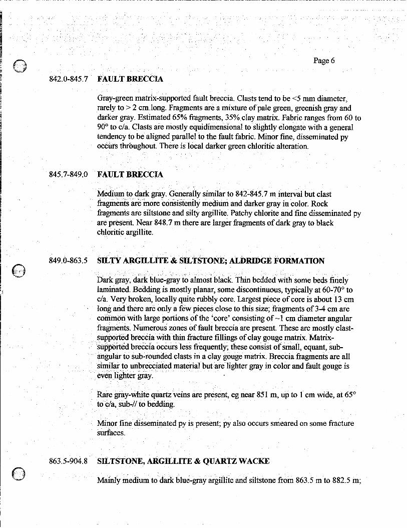
842.0-845.7 FAULT BRECCIA
Gray-green matrix-supported fault breccia. Clasts tend to be ~5 mm diameter, rarely to > 2 cm-long. Fragments are a mixture of pale green, greenish gray and darker gray. Estimated 65% fragments, 35% clay matrix. Fabric ranges from 60 90’ to c/a. Clasts are mostly equidimensional to slightly elongate with a general tendency to be aligned parallel to the fault fabric. Minor fine, disseminated py occurs throughout. There is local darker green chloritic alteration.
845.7-849.0 FAULT BRECCIA
Medium to dark gray. Generally similar to 842-845.7 m interval but clast fragments are more consistently medium and darker gray in color. Rock fragments are siltstone and silty argillite. Patchy chlorite and fine disseminated py are present. Near 848.7 m there are larger fragments of dark gray to black chloritic argillite.
to
849.0-863.5 SILTY AR@LLlTE & SILTSTONE; ALDRIDGE FORMATION
Dark gray, dark blue-gray to almost black. Thin bedded with some beds finely laminated. Bedding is mostly planar, some discontinuous, typically at 60-70’ to c/a. Very broken, locally quite rubbly core. Largest piece of core is about 13 cm
- long and there are only a few pieces close to this size; fragments of 3-4 cm are common with large portions of the ‘core’ consisting of -1 cm diameter angular fragments. Numerous zones of fault breccia are present. These are mostly clast- supported breccia with thin fracture fillings of clay gouge matrix. Matrix- supported breccia occurs less frequently; these consist of small, equant, sub- angular to sub-rounded clasts in a clay gouge matrix. Breccia fragments are all similar to unbrecciated material but are lighter gray in color and fault gouge is even lighter gray. D
Rare gray-white quartz veins are present, eg near 85 1 m, up to 1 cm wide, at 65” to c/a, sub-// to bedding.
Minor fine disseminated py is present; py also occurs smeared on some fracture surfaces.
863.5-904.8 SILTSTONE, ARGILLJTE & QUARTZ WACKE
Mainly medium to dark blue-gray argillite and siltstone from 863.5 m to 882.5 m;

904.8-932.0
Page 7
mainly lighter gray and pale blue-gray to gray-green quartz wacke below. Siltstone and argillite are thin bedded and laminated, quartz wackes are at least medium and thin bedded (may be thick bedded; core is much too broken to tell).
Extensively brecciated with alternating sections of fault breccia or gouge and broken wallrock. Longest piece of core is about 12 cm. Most of the core is very rubbly, consisting of angular fragments of siltstone, argillite and quartz wacke or fault bredcia and fault gouge. Fault breccia is commonly matrix supported, with clay gouge matrix; some clast-supported breccia also present. Below 887.7 m core is even more rubbly; lithology is more siliceous and more pale brown-gray to pink-gray in color.
Chloritic alteration occurs in3 zones; at 868.7 m -20 cm of fault rubble is dark green, &lo&e altered, at 875 m -60 cm of core is a pale green color and 882.5 to 887.5 is also greenish and chloritic.
At 904.5 m shearing in one piece of core 6 cm long is at 5-10” to c/a, within a more intensely rubbly zone from 899 - 906.5 m.
SILTSTONE & QUARTZ WACKE
Pale greenish gray to light and medium gray colored, somewhat mottled. Core is quite broken, fairly rubbly with only small pieces of core preserved, but significantly more siliceous than previous interval. Fault breccia and fault gouge are also present. Very little bedding is evident; quartz wacke beds are medium or thick bedded; some thin beds are present, at 75-80” to c/a.
Above 911.8 in, minor quartz is present, as widespread, almost rare, fault fabric - parallel bands and lenses oriented -75-80” to c/a.
9 Il. 8-9 13 m is mostly quartz vein rubble consisting of angular fragments of light gray to blue-gray, relatively massive quartz with rare very fine-grained disseminated pyrite.
Most of the fault ‘shearing’ or ‘breccia’ zones are oriented at higher angles to c/a, -7O-80”, although there are scattered fractures to 15 or 30” to c/a.
Very minor fine disseminated py is present, in both sedimentary rock fragments and in fault breccia and gouge; est. <l/4%.
There is local more pale colored alteration, possibly sericitic.

At 932 m
932-934.5
934.5-935.7
935.7-937.3
Page 8
Narrow zones of gabbro pebbles occur where reaming of the hole was necessary during tripping of rods. Eg. gabbro pebbles are present at 916923.3, and 928.5 m. At 916 m when rods were tripped, reaming started at 8 16 m; -70 cm of muddy fault gouge was collected’and cored Corn fault gouge zone(s) squeezing into hole.
Four attempts made at cementing the bottom of the hole after a 1 week break from drilling. These were generally apparently unsuccessful.
.
15 cm of cave: rounded to sub-angular fragments of mainly gabbro with a few vein quartz fragments. Then about 70 cm of brownish silty, unconsolidated material with very small rock fragments, apparently cave (not a remnant of the cementing process as it is non-calcareous).
Below cave, - 50-60 cm of recovered chloritic, quartz vein material with S-7% disseminated fine-grained euhedral py - probably fault veining.
Rubbly fault breccia. Small quartzitic and silty fragments with sheared chloritic, siliceous and micaceous material, locally strongly calcareous. Shear fabric is -50” to c/a
SILTSTONE, QUARTZ WACKE
937.3-956.0
Medium - dark gray fragments of siltstone, quartz wacke and quartzite. Appears silicified, compatible with Middle Aldridge Formation.
F’ELSIC DIKE
Mostly a dull, gray-green fine grained rock, strongly chloritic altered, apparently feldspar-rich. Very broken up with very poor core recovery. Fine grained pyrite is very common in many of the rock fragments. Individual rock fragments display a variety of textures. Some fragments display a homogeneous, massive tine-grained texture, many others have a porphyritic texture with altered, commonly rounded, pale green feldspar phenocrysts. Sections of this core consist of rounded to sub- angular ‘pebbles’ up to 4 cm across. Most of these fragments are similar to the dike description given above; a few others are darker green and more intensely chloritic altered. These darker fragments typically carry more abundant pyrite.
Narrow bands (up to 12 cm in core, probably longer in the hole) of fault breccia occur throughout this dike interval; gray clay gouge with small fragments of the pale gray-green felsic dike rock and scattered grains of pyrite. Near the bottom, fine-grained biotite is present.

956.0-959.0
959.0-962.0
962.0-998.0
998.0-1010
Page 9
SILTSTONE, minor QUARTZ WACKE
3 m of hole represented by -25 cm of rock fragments. Predominantly pale gray- green. Some is thin bedded with bedding at 70-75” to c/a. Appears bleached, may be sericitically altered. Weakly to fairly strongly chloritic with dissem py common.
.
VEIN QUARTZ
3 m of hole represented by -10-15 cm of vein quartz. Quartz is milky white, quite massive with a band of chloritic, micaceous material developed sub-parallel to c/a. Two small irregular patches of tine-grained PbS noted.
SILTSTONE AND QUARTZ WACKY, minor ARGILLITE
Very poor core recovery in parts of this interval; no recovery from 980 to 983. Recovered material shows a range of lithologies, mainly gray-brown quartz wackes and dark blue-gray to (altered?) pale gray-green siltstone. Locally there is dark blue-gray argillite. Much of the interval is thin bedded; a few fragments are finely laminated, and the ‘better recovered’ quartz wackes are medium thick. Bedding is at -80” to c/a.
Zones of fault breccia and fault gouge are present, with minor local vein quartz.
Chloritic alteration occurs throughout and varies in intensity. A brownish gray alteration occurs locally, in bedding-parallel bands typically 2-3 cm wide. Some bands are softer and may be sericite altered, elsewhere the bands are hard and are probably albite altered.
Minor pyrite is common through most of the interval. Locally py occurs with chlorite as metamorphic grain aggregates with a central cluster of pyrite rimmed by dark green chlorite. Locally these occur in irregular narrow bedding-// zones. Fine-grained pyriteis also dissem through some sections of the interval, including the quartz wackes. Pyrite is also smeared along fractures with chlorite.
CALCAREOUS SlLTSTONEI
Light to medium brownish gray and pinkish gray. Thin bedded and laminated to more massive. Core is rubbly, broken, with very poor recovery. Many of the fragments are fine-grained, quite massive, with hairline fractures healed by

1010-1118
1118-1129.5
large fragments of coarse crystalline calcite are present, in rubbly core. 110 l- 1102 m is a section of better recovered fault breccia and gouge, consisting of sheared and shattered wailrock with very minor clay matrix. This fabric ranges from 70 to 30” to c/a but is most prominently at -45O to c/a.
Pyrite is fairly common throughout, averaging 2’ to 4%. It occurs most commonly in a fine-grained manner as thin wavy, irregular veins which range from bedding- ‘parallel to 50 or 6o’O.to c/a, sub-parallel to shearing or fracturing. Py also occurs as small irregular fine-grained clots, usually parallel to bedding, and is present in some bands as medium or coarse-grained disseminations. Fine pyrite is also disseminated within the argillite / siltstone.
ARGILLITE & SILTSTONE FAULTBRECCIA
Dark blue-gray to black argillite and siltstone. Better core recovery, est. 50-70%. Fault breccia is mostly clast-supported; a tectonic breccia with narrow zones of clay gouge. Fabric is more variable than has been typical higher in the hole, ranging from 80” to 0” to c/a with 30” to 60” to c/a most common.
chlorite and associated pyrite.
Page 10 ,
Largest piece of core is 12 cm, with a few 5-6 cm pieces. Minor fault breccia is present, as generally small pieces.
ARGILLITE, SILTY ARGILLITE, minor SILTSTONE
Dark blue-gray to black. Narrow sections are more medium gray in the upper part of the interval. Finely laminated to thin bedded, possibly some medium beds. Bedding tends to be at 60-80” to c/a with only local variation. Many of the small fragments are massive in character with no obvious bedding character. Pyrite is common and is usually associated with some chlorite.
Much of the core is very rubbly with generally very poor recovery. Some of the longer pieces recovered are of fault gouge or breccia. Evidently the argillite is so intensely fractured that it breaks up as the drill bit penetrates it. The fault zones which are typically of a crushed argillite clay matrix are better recovered because they remain more intact as the drill penetrates them.
Fault breccia and gouge zones have a lighter gray clay matrix or a sheared argillite matrix. Fault fabric tends to be at 65-70” to c/a but locally can be at 15- 20” to c/a. Thin calcite veins are present in some fault zones. Some of these form a denser lensey anastomosing network in short sections of core. At 1082 m a few

Page 11
Quartz and quartz carbonate veining is scattered through the fault breccia, up to -3 cm wide but most commonly lensey and <5 mm wide. Py and chlorite can be present with quartz-carbonate veins. A few sections of fault breccia are chloritic.
Pyrite is quite common, dissem and in small,patches. At 1128 m an irregular, wavy quartz-chlorite vein at 20 to 40° to c/a (-3 cm wide) carries abundant py; as irregular veinlets, almost a ‘matrix’ through the vein, and as a thin vein along much of the contact. One small patch of PbS and ZnS occurs in this QV.
A few thin beds are recognizable, at -70” to c/a.
1129.5-1222.3 ARGLLLITE dz SILTY ARGILLITE
Dark blue-gray to black argillite and silty argillite. Generally very poor core recovery with mostly small fragments of core <2 cm diam, rarely >3 cm diam. Some thin bedded character evident, with bedding at -75” to c/a. At 1197 m bedding is at 45” to c/a; at 1201 at 60”. Narrow bands of fault bx (usually these pieces are -5 cm across) are scattered through the interval. Pyrite is common with numerous thin bands both bedding-parallel and cross-cutting. Near 1202.3 m some of the pyrite ‘veins’ are actually narrow bands of an anastomosing network of very thin pyrite veinlets as a matrix to argillite.
In better core, brecciation is locally evident. Breccia is mainly CM-supported with some fragments bedded at 10” to c/a; evidently rotated by disruption.
Irregular, lensey quartz-carbonate veins are present, ranging from -bedding- parallel at 75-80’ to c/a to -15” to c/a.
There are scattered, apparently narrow sections of chloritic alteration.
a
1222.3-1242.6 BRECCIATED ARGILLITE
Core recovery is considerably better here and general character of the rock is more evident.
Dark blue-gray to black argillite with very minor silty argillite. Commonly finely laminated with bedding at 60-70” to c/a
The interval is a poorly healed breccia; core appears competent but commonly breaks apart when picked up. The breccia has a very irregular texture, suggesting complex tectonic movement. There is a strong general fabric at 30 to 60’ to c/a;

Page 12
healed fractures commonly intersect. Narrow sections are pale greenish and chloritic altered.
Patchy silicification occurs throughout, ranging from distinct (but wavy and irregular or re-brecciated) quartz veins to a more pervasive brownish to greenish silicification. Quartz veins get up to 12 cm wide but are commonly ~1 to 2 cm wide.
Pyrite is common but very irregularly distributed, est 2-4%, usually as thin, wavy and irregular veins, parallel to fracturing / shearing at 30-60” to c/a and also N and sub-// to bedding. Py is also dissem in silicified zones, both in quartz-rich areas and in more weakly silicified argillite. Py is both fine and coarse grained. At 1241.5 m dissem PbS is mixed with dissem py in a vague narrow ‘band’ at -90” to c/a.
1242.6-1244.6 SILTSTONE & QUARTZITE
Light to medium gray-green, appears mainly thin bedded but quite brecciated. Bedding at 60-75” to c/a. Texture is somewhat mottled with brownish patches and scattered cross-cutting thin QV. Weakly to moderately chloritic altered. Minor py is present, dissem in siltstone and with QV. Minor epidote occurs with QV at 1243.1 m.
1244.2-1331.5 ARGILLITE, minor SILTSTONE & QUARTZITE
Dark gray to black, finely laminated. Bedding at 65-75” to c/a. Much of the core has a‘healed breccia texture. There are scattered narrow sections of lighter gray- green, typically somewhat chlorite-altered siltstone and quart&e. These bands are ~15 cm thick and are typically only l-4 cm wide. The siltstonequartzite bands commonly displ~~y a healed brdccia texture, occasionally with angular fragments of black laminated argillite and bedding-parallel lenses of fine to medium grained pyrite.
The core is generally quite rubbly with poor recovery. Largest piece is -15 cm long; much of the core is angular rubble ~1 cm across. Py is common, est. 2-4%, occurring as bedding-parallel laminations, as cross-cutting irregular veins and as dissem medium to coarse grained patches. Minor Cpy occurs with py locally.

Page 13
1331.5-1397.2 SILTSTONE & QUARTZRE
Light to medium gray-green and pale yellow-green with medium to darker gray- brown sections, locally dark gray-brown to almost black. Variably chloritic altered and somewhat mottled in texture with variable color. Medium and thin bedded with a few thick beds. Some medium and thick beds are internally laminated. Bedding at -65” to c/a. Texture is largely a healed breccia and bedding is not obvious throughout the interval.
Healed breccia is clast-supported, mostly of only minor movement; beds are offset along healed fractures a few nnn. There are a few healed fractures (eg at 25-30° to c/a) where distinctly different beds are juxtaposed; movement is probably 10’s of ems or more. Veins of fine-grained medium gray silica with chlorite and fine dissem pyrite are common. A few thin lensey QV are present as breccia matrix. Healed fractures do not have any obvious preferred orientation; they are mostly from 30 to 70” to c/a but range from 0 to 90”.
Minor pyrite (est l-2%) is scattered throughout, commonly dissem in siltstone and quartz&e. Small lenses of py tend to follow bedding and breccia fabric and are locally associated with patches of epidote that are developed along lithologic contacts in more obvious breccia zones. Coarse dissem py occurs locally with more intense, dark green chlorite.
Dark reddish hematite-stained fractures are present near 1349.5 m.
Numerous narrow zones of core are very rubbly but generally there is much better recovery here with sections of ‘intact’ core (fractured but no core loss) up to 1.5 m long.
1397.2-1407.3 ARGILLITE D
Dark blue-gray to black. Thin bedded and laminated; bedding at -65” to c/a. Some fracture surfaces are graphitic. Pyrite is common (est 24%) in irregular bands ‘parailei to and’cross&&ing bedding. Py also occurs with thin lensey to irregular QV which also parallel and crosscut bedding. Py is also locally dissem in argillite. At 1406.5 m small blebs of Cpy and PbS are common in one 3-10 mm wide fractured, bedding-parallel QV.
Most of the core is quite rubbly with some core loss.

Page 14
1407.3-1440.6 SILTSTONE, SILTY QUARTZITE & ARGILLITE
Interval of varicolored, mixed lithologies. Bands of gray-green and gray siltstone and silty quartz&e are interbedded with black argillite. Est 60% siltstone and quartzite, 40% argillite
Siltstone and silty quartzite are medium and thick bedded, argillite is laminated and thin bedded. Bedding is at -65” to c/a. Silty quartzite typically consists of medium grains of light gray quartz isolated in a greenish much finer grained and softer silty matrix. Some of the thicker silty quartzite beds are internally laminated. Silty quartzite beds range in thickness from 10 cm to 1.7 m.
Considerable healed brecciation is evident, with chloritic fractures at 5-60” to c/a; most intense fracturng is at 35-55” to c/a.
Black argillite zones are commonly fractured with thin quartz &/or pyrite veins. A few thin, irregular beds or laminae of light gray chert are present within argillite.
Minor pyrite is common throughout, dissem in quartzite and argillite, as cross- cutting veins and more rarely as bedding-parallel and sub-parallel bands of concentrated coarse-grained dissem py with dark green chlorite.
A few 3 cm wide QV cut core at -25” to c/a in the lower part of the interval.
1440.6-1448.4 FAULTZONE; ARGILLITE & SILTY QUARTZITE
Lithologies are sin&r to previous interval with est 70% dark gray to black argillite and 30% light gray to pale green silty quartzite. Moderately to strongly foliated throughoug at 35 to 45” to c/a, Narrow clay gouge ‘mud’ zones are present. A few thin lensey veinlets of quartz occur locally. Very minor dissem py is scattered through the interval.
1448.4-1472-O ~UARTZl’lk, minor ARGILLITE
Zones of up to 1.5 m thick massive ‘healed breccia texture’ light gray to pale or medium gray-green quartzite interbedded with a mixture of thinner quartzite beds and thin beds and laminations of medium to dark gray phyllitic argillite. Argillite zones are quite strongly fractured, parallel and sub-// to bedding, producing very thin lenses of rock. Bedding at 50-75’ to c/a., disrupted by small-scale healed tectonic fracturing sub-parallel to c/a (ie -vertical) with mm scale displacement.

Page 15
More massive quartz&es are mottled with angular fragments apparent, as though brecciated and cemented. Some argillite bands are micaceous with a schistose texture.
No pyrite noted; it is either absent or very rare
Sections of core, both quartz&es and argillites, are quite broken and rubbly.
1472.0-1491.5 QUARTZITE, very minor ARGILLbE
Very light gray to pale gray-green. Texture is typically quite massive and mottled with no obvious bedding. Healed breccia texture. Near 1480 m is a 50 cm band of tectonically fractured medium gray-green argillite. Fracturing is at 60° to c/a. Micaceous, clay-altered argillite is bedded at -65” to c/a.
1491.5-1492.8 FAULT ZONE
Zone of unconsolidated mixture of clay gouge and micaceous material with small rock fragments, generally ~1 cm across, typically of gray-green argillite. No fabric evident. No sulfides noted.
1492.8-1495.4 QUARTZTTE
Pale gray-green, mottled .texture, quite -massive, locally ‘bedded’ (probably cross- bedding or internal laminations of thick beds), locally sheared at 30” to c/a in narrow’ argilh~~eous zones. Core is quite fracture& broken.
1495/l-149718 GABRRQ, minor QUARTZITE
1495.4-1496.3 and 1497-1497.8 is gabbro, dark green, fine grained with thin irregular quartz-cah&e veins and very minor fine dissem pyrite,. Upper and lower Cantacts of the interval are at 45-55” to c/a, probably bedding-sub-parallel although there is no evident bedding in the adjacent or included quartzite. Internal contacts (with included quart&e) are in broken core. Gabbro is locally fractured at 45” to c/a_ Internal quart&e is pale gray-green, massive with mottled texture, similar to overlying interval.

Page 16
1497.8-1529.6 QUARTZITE minor SfLTSTONE
Light gray-green, mottled, massive. Mainly fine-grained, locally medium to coarse-grained. This interval is of more massive, dense quartzite than previous intervals. Locally bedded at 40-50” to c/a @ossibly internal laminations or cross- bedding). Core is quite broken, evidently still tectonically Gactured. Narrow bands of siltstone are medium gray colored.
1529.6 m End of Hole
Five dip tests were taken in the hole:
Depth Uncorrected Dip
615m 704 m 888 m 1115m 1480 m
-78” -82O -86O -80”