Embed Size (px)
Citation preview
Patchiness in Satellite Derived Sea Surface Temperature
Karl-Heinz S z e k i e I d a and Amnon P t a s h e k
UDC 551.465.62; Indian Ocean
Summary
Patchiness, indicated by ship measurements from the International Indian Ocean Expedition, was checked against the most advanced sea surface temperature program based on satellite observations. The statistical analysis of structures observed with sea surface temperature measurements showed that they are highly correlated with the time span of observations; i. e., structures or patches in the temperature field can be artificially created by the "age" of temperature observations. Simulated multi-ship observations, based on satellite temperature measurements over a time frame of several weeks, show patches that were created by the time span during which the measurements were taken.
Patchiness in aus Satellitenbildern gewonnenen Oberfl~ichentemperaturen (Zu- sammenfassung)
Patchiness, nachgewiesen durch die Schiffsmessungen der Internationalen Expedi- tion in den Indischen Ozean, wurde mit Ergebnissen yon neuesten Oberfl~ichentempera- turmessungen durch Satelliten verglichen.
Die statistische Analyse der Strukturen, die mit Hilfe von Oberfl~ichentemperatur- messungen ermittelt wurden, zeigt, dab die Messungen in hohem Mage mit der Zeitspanne der Beobachtungen korrelieren, d. h., Strukturen oder Patches im Tempera- turfeld k6nnen dutch das ,,Alter" der Beobachtungen ktinstlich erzeugt werden.
Simulierte Beobachtungen vieler Schiffe, basierend auf Temperaturmessungen dutch Satelliten fiber einen Zeitraum von mehreren Wochen, zeigen Flecken, die durch den Zeitraum, in dem die Beobachtungen stattfanden, hervorgerufen wurden.
1 Introduction
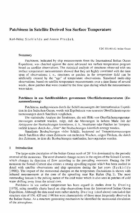
The large-scale circulation of the Indian Ocean north of 20 ~ S is dominated by the periodic reversal of the monsoons. The most dramatic change occurs in the region of the Somali Current, which changes its direction of flow according to the prevailing monsoon. During the SW monsoon the Somali Current also creates a strong upwelling regime which has been studied in detail with satellite observations and ship operations during the last years (S z e k i e ld a [1988]). The impact of the monsoonal changes on the temperature fluctuations is shown with infrared measurements at the core of the upwelling near Ras Hafun (Fig. 1). The most outstanding feature is the pulsing nature of the cold water which is also seen in patches of cold water drifting away from the actual core.
Patchiness in sea surface temperature has been argued in studies done by D u e i n g [1970], using monthly charts based on ship observations from the International Indian Ocean Expedition. Although the data used were rather sketchy, D u e i n g (cited above) concluded that structure size of 156, 420 and 1190 km were characteristic of those most frequently observed in the Indian Ocean. As a structure-generating mechanism he identified the monsoonal circulation of the atmosphere.
78 Dt. hydrogr. Z. 44, 1991/92. H. 2. S z e k i e l d a et al., Patchiness
30 oc
28
26
24
22
20
Fig. 1
/ \
7./,..v,,/"j \ /
._./",/\ / �9 I,.,,~
\ V
I I I I I J i i I I I
F IM A M J j A S 0 N D
Temperature fluctuations in 1988 for the upwelling regime of the Somali Current at Ras Hafun, 10 ~ N, 52 ~ E.
An attempt to work with satellite derived thermal IR data from the early Nimbus satellites and to verify the patchiness failed, due to the fact that technology for large-scale measuring of SST was not as developed during the early 70's. However, the existence of global coverage of measurements with a high accuracy allows us to look into structure size with a quasi-synoptic acquisition for data for large areas.
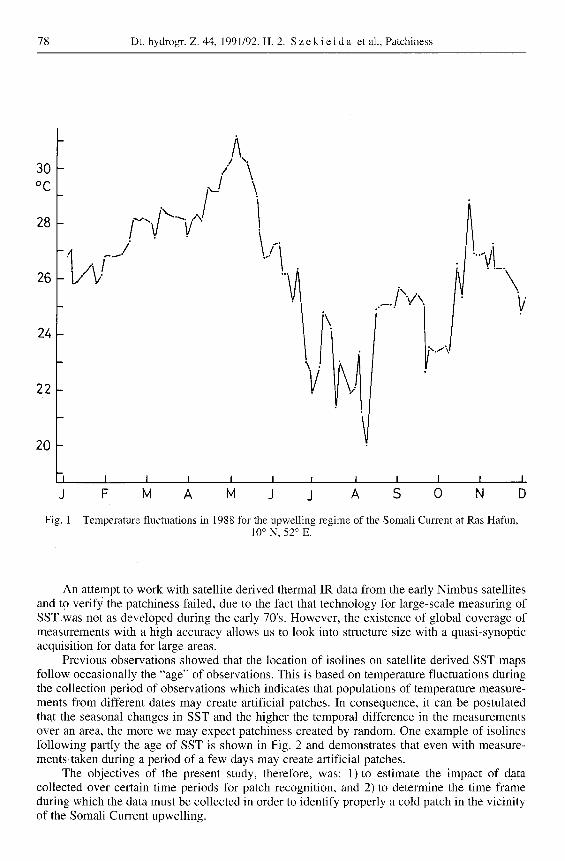
Previous observations showed that the location of isolines on satellite derived SST maps follow occasionally the "age" of observations. This is based on temperature fluctuations during the collection period of observations which indicates that populations of temperature measure- ments from different dates may create artificial patches. In consequence, it can be postulated that the seasonal changes in SST and the higher the temporal difference in the measurements over an area, the more we may expect patchiness created by random. One example of isolines following partly the age of SST is shown in Fig. 2 and demonstrates that even with measure- ments,taken during a period of a few days may create artificial patches.
The objectives of the present study, therefore, was: 1)to estimate the impact of data collected over certain time periods for patch recognition, and 2) to determine the time frame during which the data must be collected in order to identify properly a cold patch in the vicinity of the Somali Current upwelling.
Z
~b
r~
o ~ 1 - * * t ~ * * . § _ . §
* * § §
~ - § § § §
§ +m
t- . . . . . : : : : + . + * + *
+.it §
o * * * ~ w,* t ~
. . . . . , . . + * + * + .
o , . . . . . . .
+ * +,~ § +m
~o§ § * * §
I
I
I §
§ §
+~, §
§ §
§ §
§
+ o
§
§
§
§
§
§
§
I ;
§
* a
-2
t*
§ §
§ + *
+ . + .b
+~r §
§
,~ mm +m §
§ §
. . . . . * ~ ~ § § ~ § + * § . . . . . . ~
. , * * * * * * , . + *
§ ,~ § + ~ §
~ ~ ~
t * T* t * T* T* t * t * t " t * t * t * t ~ ~ ~
,,.~ ,~& 2,~
.at § § ON § +
~ W t
§ .... : "
§ § §
N
§ g.
t * t * t * t , ~
r . ~ ,
. - ~
~ ~ ~o~ ~ = &. "~ =
~ ~ .o .> ,~ ~ E ~ ~ ~ ~ ~ . o . ~ o ~ " ~
o ~ ~ : 2 ~. ~ ,~ E ~ ~
80 Dt. hydrogr. Z. 44, 1991/92. H. 2. S z e k i e l d a et al., Patchiness
, C
29.
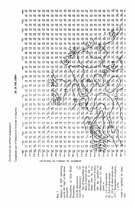
Fig. 3 Observed temperature patch in the Indian Ocean in September 1988 with MCSST from NOAA data.
A: one degree-spacing B: two degree-spacing C: three degree-spacing D: four degree-spacing
Dt. hydrogr. Z. 44, 1991/92. H. 2. S z e k i e I d a e t al., Patchiness 81
2 Identification of a real patch
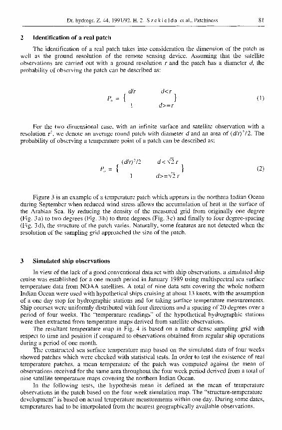
The identification of a real patch takes into consideration the dimension of the patch as well as the ground resolution of the remote sensing device. Assuming that the satellite observations are carried out with a ground resolution r and the patch has a diameter d, the probability of observing the patch can be described as:
d/r d< r
1 d>=r
For the two dimensional case, with an infinite surface and satellite observation with a resolution r 2, we denote an average round patch with diameter d and an area of (d/r)2/2. The probability of observing a temperature point of a patch can be described as:
(d/r)2~2 d< ~2 r
Po = { } (2) 1 d>=~2r
Figure 3 is an example of a temperature patch which appears in the northern Indian Ocean during September when reduced wind stress allows the accumulation of heat at the surface of the Arabian Sea. By reducing the density of the measured grid from originally one degree (Fig. 3 a) to two degrees (Fig. 3 b) to three degrees (Fig. 3 c) and finally to four degree-spacing (Fig. 3 d), the structure of the patch varies. Naturally, some features are not detected when the resolution of the sampling grid approached the size of the patch.
3 Simulated ship observations
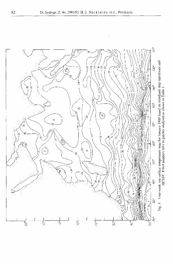
In view of the lack of a good conventional data set with ship observations, a simulated ship cruise was established for a one month period in January 1989 using mnltispectral sea surface temperature data from NOAA satellites. A total of nine data sets covering the whole nothern Indian Ocean were used with hypothetical ships cruising at about 13 knots, with the assumption of a one day stop for hydrographic stations and for taking surface temperature measurements. Ship courses were uniformly distributed with four directions and a spacing of 20 degrees over a period of four weeks. The "temperature readings" of the hypothetical hydrographic stations were then extracted from temperature maps derived from satellite observations.
The resultant temperature map in Fig. 4 is based on a rather dense sampling grid with respect to time and position if compared to observations obtained from regular ship operations during a period of one month.
The constructed sea surface temperature map based on the simulated data of four weeks showed patches which were checked with statistical tests. In order to test the existence of real temperature patches, a mean temperature of the patch was computed against the mean of observations received for the same area throughout the four week period derived from a total of nine satellite temperature maps covering the northern Indian Ocean.
In the following tests, the hypothesis mean is defined as the mean of temperature observations in the patch based on the four week simulation map. The "structure-temperature- development" is based on actual temperature measurements within one day. During some dates, temperatures had to be interpolated from the nearest geographically available observations.
82 Dt. hydrogt. Z. 44, 1991/92. H. 2. S z e k i e l d a et al., Patchiness
% I I I
% % % % c~ w) t~- tr~
=
~D
�9
e>
~ZO
~=~
O o
c,z
8 ~
b ~ 8 o o
�9
&

Dt. hydrogr. Z. 44, 1991/92. H. 2. S z e k i e 1 d a e t al., Patchiness 83
The me thod for tes t ing a small sample is g iven by:
y - / 2 z - (3)
o-/~
According to the central l imit theorem, z processes approximate ly a normal dis tr ibut ion in repeated sampl ing when n is large. In another form, the test statistics can be writ ten as:
t - (4) s / ~
In this form, t is more var iable than z and its variabil i ty decreases as n increases. The sample variance is wri t ten as:
i =
0 o 2 - - i = I __ i = I n ( 5 )
n - 1 n - 1
where the divisor of the sum of squares of deviat ions, (n - 1), that occurs in equat ion for S 2, is called the n u m b e r of degrees of f reedom associated with S 2.
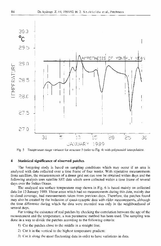
The conducted tests on ten patches shown in Fig. 4 are summar ized in Table 1. All patches indicated the re ject ion of the hypothes is mean. The s ignif icance increased with a larger sample size and showed evident ly that the month ly averaged data f rom the s imulated ship course created the patches in the month ly sea surface temperature map. As can be seen in Fig. 5 f rom the month ly temperature range distr ibution and the interpolat ion curve be tween the midpoints of the range, the hypothes is mean is out of the range center. This, in connect ion with the t test, concludes that the patches are artificial and were created by the t ime interval during which the measurement s were simulated.
T a b l e 1 T-test on sea sur face t e m p e r a t u r e p a t c h e s as s h o w n in Fig. 4.
1 2 3 4 5 6 7 8 9 l0
Null Hypothesis Ho:/2 =/xo
Sample mean
Sample variance S 2
Standard deviation S
Sample size n
Test statistic t
Degrees of freedom d. o. f.
Critical t value for 5 % level of significance
Lowest significance c~ level to reject Ho %
272 254
265 248
54 33
7.4 5.8
8 8
-2 .7 -2 .9
7 7
1.9 1.9
1.7 1.3
291 284 291 292 302 248 219 246 273
283 281 285 286 291 252 206 237 269
60 17 31 59 57 72 101 139 41
7.7 4.1 5.6 7.7 7.5 8.5 10.0 11.8 6.4
8 27 31 38 4 9 9 9 26
--2.7 -3 .8 -6 .0 - 5 . 0 -2 .6 1.5 4.0 -2 .3 -3 .2
7 26 30 37 3 8 8 8 25
1.9 1.7 1.7 1.7 2.4 1.9 1.9 1.9 1.7
1.7 0.1 0.1 0.1 4.3 8.6 3.2 2.5 0.1
LS G!
b--
Cs LS [3_
LS b -
39,0
~ C
s
=' 9, @ L . _
~YP~I~ISISR H~NI(HLY '~I,
1
U_O,~
o, U
87,5
/ , U
ir
84 Dt. hydrogr. Z. 44, 1991/92. H. 2. S z e k i e 1 d a et al., Patchiness
~N
Fig. 5
I ~ I r I I p
31 5_ 10 1 ._J = S 0 2_ 5 .3 O
J AI,,IU A R'u 1989 Temperatme range variance for structure 5 (refer to Fig. 4) with polynomial inteq)olation.
4 Statistical significance of observed patches
The foregoing study is based on sampling conditions which may occur if an area is analyzed with data collected over a time frame of four weeks. With repetative measurements from satellites, the measurements of a dense grid net can now be obtained within days and the following analysis uses satellite SST data which were collected within a time frame of several days over the Indian Ocean.
The analyzed sea surface temperature map shown in Fig. 6 is based mainly on collected data for 13 January 1989. Those areas which had no measurements during this date, mainly due to cloud coverage, had measurements taken from previous days. Therefore, the patches found may also be created by the inclusion of quasi-synoptic data with older measurements, although the time difference during which the data were recorded was only in the neighbourhood of several days.
For testing the existence of real patches by checking the correlation between the age of the measurement and the temperature, a non-parametric method has been used. The sampling was done in a way to divide the patches according to the following criteria:
1) Cut the patches close to the middle in a straight line;
2) Cut it in the vertical to the highest temperature gradient;
3) Cut it along the most fluctuating data in order to have variations in data.

Dt. hydrogr. Z. 44, 1991/92. H. 2. S z e k i e l d a et al., Patchiness 85
%
r I
�9 �9 :i !
o
o
o
" o
o
==
�9
e '~
do
86 Dt. hydrogr. Z. 44, 1991/92. H. 2. S z e k i e ld a et al., Patchiness
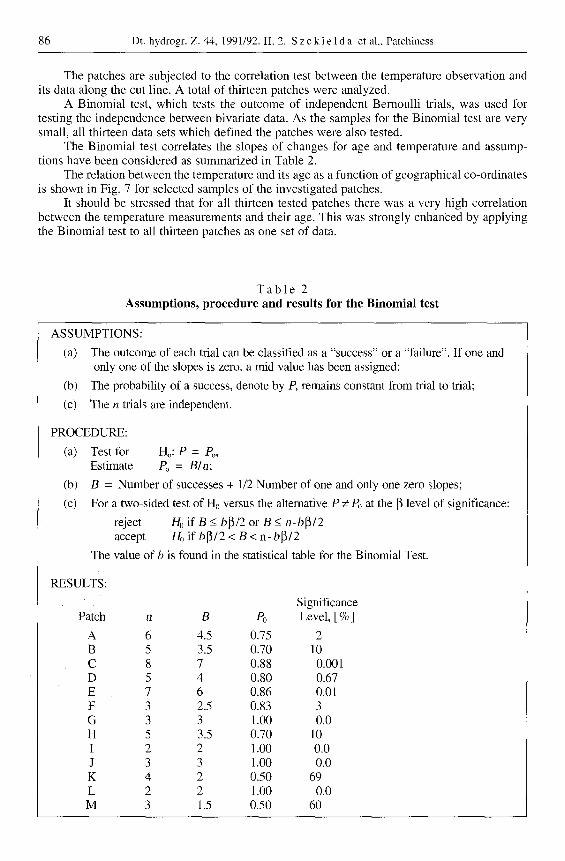
The patches are subjected to the correlation test between the temperature observation and its data along the cut line. A total of thirteen patches were analyzed.
A Binomial test, which tests the outcome of independent Bernoulli trials, was used for testing the independence between bivariate data. As the samples for the Binomial test are very small, all thirteen data sets which defined the patches were also tested.
The Binomial test correlates the slopes of changes for age and temperature and assump- tions have been considered as summarized in Table 2.
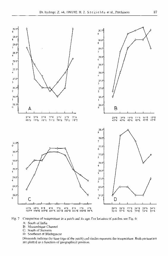
The relation between the temperature and its age as a function of geographical co-ordinates is shown in Fig. 7 for selected samples of the investigated patches.
It should be stressed that for all thirteen tested patches there was a very high correlation between the temperature measurements and their age. This was strongly enhanced by applying the Binomial test to all thirteen patches as one set of data.
T a b l e 2 Assumptions, procedure and results for the Binomial test
ASSUMPTIONS:
(a) The outcome of each trial can be classified as a "success" or a "failure". If one and only one of the slopes is zero, a mid value has been assigned;
(b) The probability of a success, denote by P, remains constant from trial to trial;
(c) The n trials are independent.
PROCEDURE:
(a) Test for Ho: P = Po, Estimate Po = B/n;
(b) B = Number of successes + 1/2 Number of one and only one zero slopes;
(c) For a two-sided test of H0 versus the alternative P r P0 at the 13 level of significance:
reject Ho if B <_ b~/2 or B < n-b~ /2 accept H0 if b~/2 < B < n- b~/2
The value of b is found in the statistical table for the Binomial Test.
RESULTS:
Significance Patch n B P0 Level, [ % ]
A 6 4.5 0.75 2 B 5 3.5 0.70 l0 C 8 7 0.88 0.001 D 5 4 0.80 0.67 E 7 6 0.86 0.01 F 3 2.5 0.83 3 G 3 3 1.00 0.0 H 5 3.5 0.70 10 I 2 2 1.00 0.0 J 3 3 1.00 0.0 K 4 2 0.50 69 L 2 2 1.00 0.0 M 3 1.5 0.50 60
30.0' 9
29.5' 8
29.0 '
7
28.5 ' 6
28 ,0 '
5
27.5 ~
4
27.0 ~
3
26.5 '
2
26 .0 ' 1
25.5 ~ 0
31.0 ' 0
30.5 c
1
30.0 ~ 2
29.5 ~ 3
29.0 ~
4
28.5 ~
5
28 .0 c
6
Ed k,
I I I I I I I
2ON 2 ~ 2ON 2ON 2ON 2 ~ 2 ~
8 0 ~ 7 9 ~ 7 8 ~ 7 7 ~ 7 6 ~ 7 5 ~ 7 4 ~
Y
30.5 ~
9
30.0 ~ 8
29.5 ~
7
29.0 ' 6
28.5 ' 5
28.0 ' 4
27.Y 3
27.0'
2
26.5' 1
26.0' 0 B
I I I I I I
2 0 ~ 1 9 ~ 1 8 ~ 1 7 ~ 16~ 1 5 ~ 4 2 ~ 4 2 ~ 4 2 ~ 4 2 ~ 4 2 ~ 4 2 ~
Fig. 7
[3 I I I I I I
2 9 ~ 2 8 ~ 2 7 ~ 2 6 ~ 2 5 ~ 2 4 ~ 5 8 ~ 5 7 ~ 5 6 ~ 5 5 ~ 5 4 ~ 5 3 ~
28.5' 8
28.0 '
7
27.5 ' 6
27.0 ~ 5
26.5 ' 4
26.0 c 3
25.5 c
2
25.0 r
1
24 .5 '
C 0 I I I I I I I I I
l l ~ 10~ 9 ~ 8 o s 7 ~ 6 ~ 5 ~ 4 ~ 3 ~ 1 0 7 ~ 1 0 6 ~ 1 0 5 ~ 1 0 4 ~ 1 0 3 ~ 1 0 2 ~ 1 0 1 ~ 1 0 0 ~ 9 9 ~
Dt. hydrogr. Z. 44, 1991/92. H. 2. S z e k i e l d a et al., Patchiness 87
Comparison of temperature in a patch and its age. For location of patches see Fig. 6: A: South of India B: Mozambique Channel C: South of Sumatra D: Southeast of Madagascar
Diamonds indicate the time (age of the patch) and circles represent the temperature. Both parameters are plotted as a function of geographical position.
88 Dt. hydr0gr. Z. 44, 1991/92. H. 2. S z e k i e l d a et al., Patchiness
o
�9
c~
~D
o
t~ �9 ~v
Dt. hydrogr. Z. 44, 1991/92. H. 2. S z e k i e 1 d a et al., Patchiness 89
5 Conclus ions
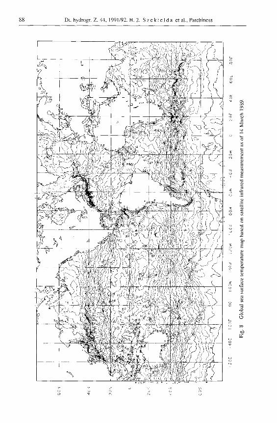
This study has revealed that averaged data which have been collected over a four week period, may create artificial structures in the distribution of sea surface temperature. This indicates that data used from ship sampling may show similar features or even a larger departure from the real picture. The analysis of a quasi-synoptic SST coverage showed that even with data which have been collected within a few days show patterns which are related to the age of the collected data. From those observations, it can be concluded that in the open ocean the SST shows less discrete distribution patterns than indicated by temperature maps from multi temporal composites, and we can assume that meandering of SST-isolines and temporal fluctuations of sea surface temperature contribute to the artificial patchiness detected in the measurements. Thus, the discrete patches discernable in satellite SST, even if taken within short intervals, have to be interpreted with caution for the open ocean. An example on how such artificial structures may look like for the mid and low latitudes is given in Fig. 8 for all oceans. In order to properly assess the validity of such patches, one has to consider therefore, the "age" of the temperature measurements. Ideally, the temperature maps should be based on one day measurements, However , taking into account the cloud statistics, a global temperature map of the oceans derived from infrared measurements still has to be constructed from multi-day-observations until, for instance, microwave SST's become operational. For an ongoing study on patches connected with the upwell ing in the Somali Current, it was concluded that only one day measurements can be used for properly identifying an existing patch.
A c k n o w l e d g e m e n t
Satellite derived SST data have been supplied by N O A A - N E S D I S for which we would like to express our gratitude. Comments from N O A A personnel on the manuscript have also been incorporated in the finalized version. We take this opportunity to thank them through this publication.
References
B e y e r , W. H., 1971: Basic statistical tables. The Chemical Rubber Co., Cleveland, Ohio. 310 pp.
D u e i n g , W., 1970: The monsoon regime of the currents in the Indian Ocean. Honolulu: East- West Center Press, 68 pp.
H o l l a n d e r , M. andD. A. W o l f e , 1973: Non- parametric statistical methods. New York: John Wiley and Sons, 503 pp.
M c C l a i n , E. P., W. G. P i c h e l , and C. C. W a l t o n , 1985: Comparative performance of AVHRR-based multichannel sea surface tem- perature. J. Geophys. Res. 90, II, 587-II, 601.
M e n d e n h a l l , W., 1983: Introduction to proba- bility and statistics. Boston: P. W. S. Publishers, 646 pp.
z e k i e 1 d a, K.-H., 1983: Satellite investigations on the fluctuations of the subtropical and Antarc- tic Convergence Zone, Dt. hydrogr. Z. 36, 25-43.
z e k i e 1 d a, K.-H., 1988: Investigations with sat- ellites on eutrophication of coastal regions. Part VII: Response of the Somali upwelling onto mon- soonal changes, 1-33. In: Transport of carbon and minerals in major world rivers. SCOPE/ UNEP Sonderbd. 65 pp.
Eingegangen am 3. Januar 1990
Angenommen am 5. Februar 1992
Anschriften der Verfasser: Dr. Karl-Heinz Szekielda
United Nations, Room DC-I-724, New York, N. Y. 10017, U S A
Amnon Ptashek
City University of New York