Embed Size (px)
Citation preview

Pastoralists and GIS:
Predictive Modeling and CampsiteLocation in Beidha, Southern Jordan

Outline
• Predictive Modeling: Why?
• Why Beidha?
• Modeling Parameters: What works, WhatDoesn't.
• The Model.
• The Next Steps for Predictive Modeling.
• Beidha Revisited (Site FormationProcesses).
• Conclusions
Predictive Modeling and NearEastern Nomadic Pastoralism
• Goats and sheep were fully domesticated by9000 kya. Nomadic pastoralism was therefore amajor social and economic strategy by at leastthe PPN whose participants were dynamicallyinvolved with their more settled neighbors.
• Why then do we know so little about theseancient pastoralists?
• Due to the nature of pastoralism, campsites aregenerally temporary and ephemeral. Therefore,the survey strategies employed to find morepermanent agricultural sites are not effective.
• Survey methodologies utilized in the research ofhunter-gatherer site are more useful, but eventhese do not take the interdependence ofpastoralists and their herd animals in to account

Predictive Modeling and NearEastern Nomadic Pastoralism
• Predictive models have been used successfulyin other types of archaeology for severaldecades, but have never been employed in thearchaeology of nomadic pastoralists.
• Modern GIS combines advanced terrrainsimulation and robust geo-statistical abilities withhigh powered computing to provide a platformfor types of predictive modeling heretoforethought functionally impossible.
• Multivariate analysis of ecological, cultural, andgeographic variables of nomadic campsitelocation can be cross-tabulated with knowncampsites to create a unique model.

• These models can be tuned both in geographicand cultural scope, and provide multiple types ofinformation useful to archaeologists.
• Not only can they tell us where sites are located,they can tell us exactly why these types of siteare located where they are.
Predictive Modeling and NearEastern Nomadic Pastoralism
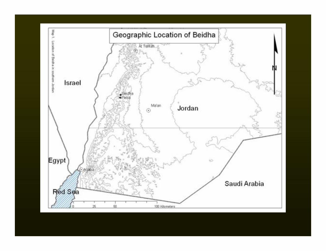

Pastoralism in Beidha
• Why Beidha?

Pastoralism in Beidha
• Why Beidha?• Surveyed specifically for recent pastoral
campsites in 1982 by Banning and Köhler-Rollefson and again in 1989-1993 by Simms andRussell, and other travel 19th and early 20th
century travellers visited the are and wrote aboutthe pastoralists they encountered.
• Extensive ethnological and ethnoarchaeologicaldata for the modern Bedouin of the region.
• Small in total area, but comprised of diverseecological and geographic zones.
• Presents a “living laboratory” that has beenstudied ethnoarchaeologically for over twodecades.

LowlandAlluvial Zones
UplandForested
Wadis


Modeling Parameters
• What seems useful?• The fallacy of water and pasture…
• Purely ecological factors?
• Purely cultural factors?
• The right mix.
• Trial and error is the only way.
• What I used for the Beidha Model:• Distance to Wadi bottoms as a proxy for water.
• Distance to ridge tops as a proxy for pasture and seasonality.
• Slope as a measure of water avoidance and ease of camping.
• Aspect as measure of wind and sun avoidance/seeking.
• Parameters tested and not used.• Substrate type; Distance to shadows (Summer and Winter); Viewshed area and
direction; Distance to the roads; Distance to the various geobotanical zones.

Summer Areas Winter AreasAll Predicted Areas

The Future of Predictive Modeling
• More sophisticated environmental models.• Larger scale, more realistic digital elevation models.
• More accurate environmental simulation using remotely sensed data and irradiationsimulation.

Intensity of Solar Radiation Overall Ground Reflectance

The Future of Predictive Modeling
• More sophisticated environmental models.• Larger scale, more realistic digital elevation models.
• More accurate environmental simulation using remotely sensed dataand irradiation simulation.
• More appropriate model building tools.• Dempster Schafer Theory and Plugin for GRASS GIS
• Paleoenvironmental reconstruction.• The Mediterranean Landscape Dynamics project at ASU.
• Paleoclimatic data and reconstruction.
• Geomorphic landscape reconstruction and erosion/deposition modeling.

USPED-basedlandscape
evolution inGRASS GIS
(6 timesteps,landcover, rainfall,and soil type held
constant)

Beidha Revisited
• In 2004 I was able to briefly revisit Beidha with Dr.Banning, and we reconnoitred some of the sites herecorded in 1982.
• Simms and Russell investigated the effects of 1, 2,and 4 years worth of site formation at some of theirethnoarchaeologically recorded campsites.
• Because the sites were recorded in depth morethan 20 years ago, the Banning and Köhler-Rollefson sites are prime candidates for siteformation studies.
• In combination with the short term effects of siteformation garnered from the Simms and Russellstudy, reanalysis of the Banning and Köhler-Rollefson sites would provide ancillary informationon the long term effects of site formation.

Site formation processesaffecting the preservationof compacted goat-dungfloors at two sites.

Eroding Hearth
Rock Ring
Surface Scatter

Conclusions
• Predictive modeling is a tool that can and should beused to address the challenges presented toarchaeologists interested in nomadic peoples.
• Caveat emptor however: You only get what you putinto the model.
• Therefore, complex multivariate models of sitelocation built from archaeolgical, ethno-archaeologal, and ecological data and applied torobust terrain and environmental models should bepursued above other types of modeling.
• These models not only aid in site location, but alsogive us the means to test why sites are where theyare, and can open up new avenues of research.

Conclusions
• Most importantly, however, it should bestated that predictive models are only thefirst step.
• In order to bring the archaeology of NearEastern nomadic pastoralists to the samelevel as their agriculturalist neighbours, wemust pursue other important researchtopics, such as site formation studies.
• Hopefully, the model presented hererepresents a good first step, and will helpbring the archaolgy of nomadicpastoralists into the 21st century.

The End!
For More Information:
[email protected]://www.public.asu.edu/~iullah
Land-Use and Landscape Socioecology in the Mediterranean Basin: ANatural Laboratory for the Study of the Long-Term Interaction of Human andNatural Systemshttp:medland.asu.eduNSF Award #0410269
References:
Banning, E. B., and I. Köhler-Rollefson. 1986. Ethnoarchaeological survey in the Beda area, southernJordan. Zeitschrift des Deutschen Palastina-Vereins 102:152-170.—. 1992. "Ethnographic lessons for the pastoral past: camp locations and material remains near Beidha,southern Jordan," in Pastoralism in the Levant: Archaeological Materials in Anthropological Perspectives,vol. 10, Monographs in World Archaeology, pp. 181-205. Madison: Prehistory Press.
Simms, S. R., and K. W. Russell. 1996. Ethnoarchaeology of the Bedul Bedouin of Petra, Jordan:Implications for the Food producing Transition, Site Structure, and pastoralist Archaeology. Utah StateUniversity, Manuscript.