Embed Size (px)
Citation preview

PASTORALISM AND LAND TENURE TRANSFORMATION: POLICY
IMPLICATIONS AND LIVELIHOODS ADAPTATIONS IN
BOTSWANA
LENYELETSE VINCENT BASUPI
SUBMITTED IN ACCORDANCE WITH THE REQUIREMENTS FOR THE DEGREE OF DOCTOR OF PHILOSOPHY
THE UNIVERSITY OF LEEDS
SCHOOL OF EARTH AND ENVIRONMENT
JUNE, 2018

- ii -
The candidate confirms that the work submitted is his own, except where work
which has formed part of jointly-authored publications has been included. The
contribution of the candidate and the other authors to this work has been
explicitly indicated below. The candidate confirms that appropriate credit has
been given within the thesis where reference has been made to the work of
others.
This copy has been supplied on the understanding that it is copyright material
and that no quotation from the thesis may be published without proper
acknowledgement.
© 2018 The University of Leeds and Lenyeletse Vincent Basupi
The right of Lenyeletse Vincent Basupi to be identified as Author of this work has
been asserted by him in accordance with Copyright Designs and Patents Acts of
1988.
- iii -
Thesis Supervisors
Dr Claire H Quinn
Associate Professor: Natural Resources Management; Deputy Director of
Research (Excellence) – School of Earth and Environment - University of Leeds.
Professor Andy J Dougill
Dean of Faculty of Environment & Professor of Environmental Sustainability -
University of Leeds.
Academic papers
Published
1. Basupi LV; Quinn CH; Dougill AJ (2017) Historical perspectives on
pastoralism and land tenure transformation in Ngamiland, Botswana:
What are the policy and institutional lessons?, Pastoralism, 7, Doi:
10.1186/s13570-017-0093-1 (CHAPTER 2).
2. Basupi LV; Quinn CH; Dougill AJ (2017) Using participatory mapping and
a participatory geographic information system in pastoral land use
investigation: Impacts of rangeland policy in Botswana, Land Use Policy,
64, pp.363-373. Doi: 10.1016/j.landusepol.2017.03.007
(CHAPTER 3).
3. Basupi LV; Quinn CH; Dougill AJ (2017) Pastoralism and Land Tenure
Transformation in Sub-Saharan Africa: Conflicting Policies and Priorities
in Ngamiland, Botswana, Land, 6, . Doi: 10.3390/land6040089
(CHAPTER 1 AND 6).
Revised and resubmitted
4. Basupi et al. (Revised) Adaptation strategies to environmental and
policy change in semi-arid pastoral landscapes: evidence from Ngamiland,
Botswana, Journal of Arid Environments (CHAPTER 4).

- iv -
Under Review
5. Basupi et al. (Under Review) Institutional Challenges in Pastoral
Landscape Management: Towards Sustainable Land Management in
Ngamiland, Botswana, Land Degradation and Development
(CHAPTER 5).
Candidate Contribution
The candidate designed the research that led to the published journal articles or
articles under review, including the methodologies, fieldwork and data analyses,
and led the writing of the articles, with co-authors (supervisors) providing
supervisory work, editorial input around the structure and writing style.
Rationale for thesis by alternative format
I wrote the thesis as a series of publications (Journal articles). The publication
process allowed other specialists’ outside my supervision team to review and
critique my work, thus providing helpful feedbacks throughout the process. I
found the process of developing a journal article and responding to reviewers
and editors to have instilled a high level of discipline in my research process and
written style.

- v -
Acknowledgements
First of all I give all praises to the almighty God for providing me with the strength
and blessing to complete this thesis.
I take this opportunity to sincerely acknowledge my sponsors: The Botswana
International University of Science and Technology (BUIST) and the Botswana
Government – Department of Tertiary Education Financing for providing all the funds
for my tuition fees and living expenses in the UK, including covering my fieldwork
expenses. The fieldwork for this thesis also benefited immensely from the University
of Leeds Sustainable Agriculture Bursary Fund, which enabled me to successfully host
workshops in Ngamiland for which I am grateful.
Special appreciation goes to my supervisory team: Prof Andy Dougill and Dr Claire
Quinn, for their supervision and constant support. Their hard work, commitment and
constructive comments and suggestions throughout the thesis contributed
immensely to the success of this thesis for which I am indebted.
My profound gratitude also goes to the following Botswana government ministries
and departments; Department of Meteorological Services, Ministry of Agriculture,
Ministry of Environment Wildlife and Tourism, Department of Environmental Affairs
and Tawana Land Board for providing some of the information required for this
study. I warmly thank the University of Botswana Okavango Research Institute (ORI)
for providing access to their GIS lab as when needed throughout the fieldwork.
I expand my thanks to communal area pastoralists/agro-pastoralists, the chiefs,
extension officers, members of different village level committees: Farmers
committees, Farmers associations and Village Development Committees in the study
villages: Toteng, Sehithwa, Bothatogo, Bodibeng, Kareng, Makakung and Semboyo
for participating in this study with interest and enthusiasm.
My family: my fiancée (Ms Onkemetse Tabulawa), my mother, my brother and
sisters, have given me their unequivocal support throughout as always for which my
expression of thanks likewise does not suffice.

- vi -
I am indebted to my friend Tebogo Maphondo, for his help in recruitment of research
assistants, arranging fieldwork transport and fieldwork accommodation logistics. I
am thankful that in the midst of all his activities, he was always there for me during
the times of need. I am grateful to the support offered by Mr Ramugaupi Gaborekwe
(Office of the District Commissioner Maun), particularly his help in arranging
stakeholder workshops and availing some documents needed for this thesis.
Lastly but not least, I am indebted to my research fieldwork assistants team; Mr
Godfrey Tamuthiba, Mr Tebogo Maphondo and Ms Tebogo Malumbila, for providing
a stimulating and fun filled environment for a fieldwork and learning.
At the end I would once more want to thank all those people who made this thesis
possible and an unforgettable experience for me including those that I might not
have mentioned here. However, I take the entire responsibility for any errors or
inadequacies that might remain in this work.

- vii -
ABSTRACT
In dryland Africa, access to land and water resources are central to pastoral livelihood
activities and sustainability. Policy intervention in these regions represents the
outcome of concerted post-independence processes in which countries have
committed to land tenure transformation as a policy objective. This was meant to
create private, liberal property rights to replace communal customary tenure
systems which were considered to be a constraint to development. Despite these
efforts, decades of research indicate that countries are struggling to meet
environmental sustainability objectives. In Ngamiland District of Botswana,
communal pastoral herders find themselves in a situation where they are now
surrounded by privatised ranches, veterinary fences and wildlife conservation areas.
Their resilience to environmental-related threats such as drought and livestock
diseases have been significantly weakened. Using iterative participatory research
methods, this thesis examined the social and spatial impacts of rangeland
subdivisions and privatisation policies in Ngamiland District to inform sustainable
pastoralism and sustainable land management (SLM) policies in sub-Saharan Africa
and pastoral drylands. Results point to continued landscape fragmentations, land use
conflicts and increase in outbreaks of livestock diseases that have resulted in
pastoralists’ marginalisation and vulnerability. Fragmented institutional and policy
frameworks, weak governance structures and a lack of political will to build capacity
at the local level limit pastoralists’ adaptations and SLM adoption. Protecting
pastoral land rights and livelihoods requires establishing negotiated and flexible
tenure frameworks that strengthen pastoralists’ participation in decision-making
arenas. The integration of local spatial knowledge and integrative geospatial
approaches can be used to foster better articulation and understanding of
pastoralists’ tenures for a supportive decision-making system for SLM. As the ability
to adapt has positive attributes for livelihood sustainability and resilience, there is a
need for practical initiatives that improve pastoralists’ adaptive capacity including
access to land and markets. This thesis support and expand on the African Union
Policy Framework for Pastoralism of 2010, that call for the involvement of pastoral

- viii -
communities and their local level institutions in policy making and implementation
for greater SLM goals.
Table of Contents
Acknowledgements ...................................................................................... v
ABSTRACT .................................................................................................. vii
List of Tables ............................................................................................. xiii
List of Figures ............................................................................................ xiv
Acronyms and abbreviations ..................................................................... xv
Definition of key terms ............................................................................. xvi
CHAPTER 1: ............................................................................................................. 1
General Introduction and Rationale .............................................................. 1
1.1. INTRODUCTION .................................................................................... 1
1.2. OVERVIEW OF PASTORALISM AND LAND TENURE DISCOURSE IN SUB-SAHARAN AFRICA ......................................................................... 1
1.2.1. Land tenure, Property Rights and Common Pool Resources ...................................................................................... 3
1.2.1.1. Theoretical debates on Land Tenure, Property Rights and Common Pool Resources .................................................. 5
1.2.2. Privatisation of common pastures in sub-Saharan Africa ....... 15
1.3. BOTSWANA: PASTORALISM, COMMON POOL RESOURCES AND POLICY CONTEXT ............................................................................... 18
1.3.1. Democratic decentralisation of CPRs management ................ 19
1.3.2. The Tribal Grazing Land Policy ............................................. 21
1.3.3. National Policy on Agricultural Development ........................ 23
1.4. MOTIVATION AND JUSTIFICATION FOR THE STUDY ......................... 23
1.5. RESEARCH AIM AND OBJECTIVES ...................................................... 26
1.6. RESEARCH DESIGN AND METHODOLOGICAL CONSIDERATIONS ...... 28
1.6.1. Positionality ......................................................................... 30
1.7. DESCRIPTION OF THE STUDY AREA ................................................... 32
1.7.1. Location and Physiography................................................... 32
1.7.2. Climate ................................................................................ 34
1.7.3. Vegetation characteristics .................................................... 36
1.7.4. The people ........................................................................... 37
1.7.5. Land use and Land use planning ........................................... 38

- ix -
1.8. STRUCTURE OF THE THESIS AND SIGNIFICANCE ............................... 40
1.8.1. Significance and contribution to knowledge ........................... 42
1.9. REFERENCES ....................................................................................... 44
CHAPTER 2: .......................................................................................................... 55
Historical Perspectives on Pastoralism and Land Tenure Transformation in Ngamiland, Botswana: What are the Policy and Institutional Lessons? ........................................................ 55
ABSTRACT ................................................................................................... 56
2.1. INTRODUCTION................................................................................... 57
2.2. MATERIALS AND METHODS ................................................................ 59
2.2.1. Study area ............................................................................ 59
2.2.2. Oral histories ........................................................................ 61
2.2.3. Focus group discussions and Expert Interviews ..................... 62
2.2.4. Data Analysis ........................................................................ 63
2.3. RESULTS .............................................................................................. 64
2.3.1. HISTORICAL LAND USE PRACTICES ...................................... 66
2.3.1.1. Ethnic pastoral groups .................................................. 66
2.3.1.2. Ovambanderu/Ovaherero settlements patterns ............. 67
2.3.1.3. Traditional pastoral management practices and strategic mobility .................................................................. 68
2.3.1.4. 1920s – 1960s – The Tsetse fly Epidemic and eradication campaign ............................................................ 71
2.3.2. DROUGHT AND LAND TENURE TRANSFORMATION .............. 72
2.3.2.1. 1960s – 1980s Severe drought cycles ............................ 72
2.3.3. THE ERA OF LIVESTOCK DISEASE OUTBREAKS ..................... 74
2.3.3.1. 1995: The CBPP Epidemic ............................................. 74
2.3.3.2. 2007: Habu FMD outbreak ............................................ 75
2.3.3.3. 2012: The ranches protection buffer fence ..................... 75
2.3.3.4. 2014: Kareng FMD outbreak ......................................... 76
2.3.4. PERSPECTIVES ON CURRENT LAND USE ............................... 77
2.3.4.1. Rangeland access and control ........................................ 77
2.3.4.2. Wildlife conservation vs traditional livelihoods ............. 79
2.3.4.3. Increased vulnerability and poverty due to loss of resource access ..................................................................... 80
2.4. DISCUSSION ......................................................................................... 82
2.4.1. Flexible mobility and land tenure transformation .................. 82

- x -
2.4.2. Policy and institutional lessons ............................................. 83
2.5. CONCLUSION ....................................................................................... 84
2.6. ACKNOWLEDGEMENTS ...................................................................... 86
2.7. REFERENCES ....................................................................................... 86
CHAPTER 3: .......................................................................................................... 91
Using Participatory Mapping and a Participatory Geographic Information System in Pastoral Land Use Investigation: Impacts of Rangeland Policy in Botswana ....................................... 91
ABSTRACT .................................................................................................. 92
3.1. INTRODUCTION .................................................................................. 93
3.2. MATERIALS AND METHODS ............................................................... 97
3.2.1. Study area ............................................................................ 97
3.2.2. Focus group discussions ....................................................... 99
3.2.3. Participatory Mapping and PGIS ......................................... 100
3.2.4. Data analysis ...................................................................... 103
3.3. RESULTS ........................................................................................... 104
3.3.1. Grazing zones before land use and tenure transformation ... 104
3.3.2. Spatial comparisons and the impacts of grazing policies ...... 108
3.3.3. Access to water resources .................................................. 112
3.3.4. Current land use ................................................................. 113
3.4. DISCUSSION ...................................................................................... 116
3.4.1. Local spatial knowledge, rangeland privatisation and spatial mobility .......................................................................... 116
3.4.2. Participatory mapping, PGIS and government planning ....... 117
3.5. CONCLUSIONS ................................................................................... 119
3.6. ACKNOWLEDGEMENTS .................................................................... 120
3.7. REFERENCES ..................................................................................... 120
CHAPTER 4: ........................................................................................................ 126
Adaptation Strategies to Environmental and Policy Change in Semi-arid Pastoral Landscapes: Evidence from Ngamiland, Botswana ................................................................................................... 126
ABSTRACT ................................................................................................ 127
4.1. INTRODUCTION ................................................................................ 127
4.1.1. Conceptualising coping and adaptation strategies ............... 131
4.2. MATERIALS AND METHODS ............................................................. 133
4.2.1. Study area .......................................................................... 133

- xi -
4.2.2. Research methodology ........................................................ 136
4.2.3. Data processing and analysis ............................................... 138
4.3. RESULTS ............................................................................................ 138
4.3.1. Constraints to pastoral livelihoods in Ngamiland pastoral landscapes .................................................................................. 138
4.3.1.1. Livestock diseases and market access .......................... 139
4.3.1.2. Resource scarcity and limited access to rangelands...... 140
4.3.1.3. Elephant raids ............................................................ 141
4.3.1.4. Drought and associated constraints ............................. 141
4.3.2. Pastoral communities’ response to constraints .................... 142
4.3.2.1. Coping Strategies ........................................................ 142
4.3.2.2. Adaptation and livelihood diversification strategies ..... 144
4.3.3. Processes that constrain or enable pastoralists’ adaptive capacity ...................................................................................... 148
4.4. DISCUSSION ....................................................................................... 151
4.5. CONCLUSION ..................................................................................... 154
4.6. ACKNOWLEDGEMENTS ..................................................................... 156
4.7. REFERENCES ..................................................................................... 157
CHAPTER 5: ....................................................................................................... 162
Institutional Challenges in Pastoral Landscape Management: Towards Sustainable Land Management in Ngamiland, Botswana .................................................................................................. 162
ABSTRACT ................................................................................................. 163
5.1. INTRODUCTION................................................................................. 163
5.1.1. Scaling-up SLM in pastoral areas through multi-sectorial collaboration and co-management ............................................... 165
5.2. MATERIALS AND METHODS .............................................................. 168
5.2.1. Study Area .......................................................................... 168
5.2.2. Conceptual framework ........................................................ 169
5.2.3. District Stakeholder workshop & Expert Interviews ............. 170
5.2.4. Policy content analysis ........................................................ 171
5.2.5. Institutional capacity assessment ........................................ 172
5.3. RESULTS ............................................................................................ 174
5.3.1. Policies and legislative frameworks ..................................... 174
5.3.2. Policy processes .................................................................. 174
5.3.3. Policy discourse .......................................................... 176

- xii -
5.3.4. Institutional capacity assessment; actors in rangeland resource management ........................................ 180
5.3.5. Tawana Land Board ................................................... 182
5.3.6. District Land Use Planning Unit .................................. 183
5.3.7. Village level institutions – The Kgotla ......................... 184
5.4. DISCUSSION: TORWARDS SLM ......................................................... 185
5.4.1. Policy discourse ................................................................. 185
5.4.2. Communication gaps and fragmented institutional coordination .............................................................................. 185
5.5. CONCLUSION ..................................................................................... 189
5.6. ACKNOWLEDGEMENTS .................................................................... 190
5.7. REFERENCES ..................................................................................... 190
CHAPTER 6: ........................................................................................................ 195
Discussion and Conclusions ......................................................................... 195
6.1. INTRODUCTION ................................................................................ 195
6.2. REFLECTIONS AND SUMMARY OF MAIN FINDINGS.......................... 195
6.3. LINKAGES BETWEEN THE CHAPTERS .............................................. 202
6.4. CROSS-CUTTING THEMES ................................................................. 205
6.4.1. Landscape fragmentation (reduced livestock mobility ......... 205
6.4.2. Unanticipated consequences of grazing policies .................. 207
6.4.3. Disempowerment of traditional institutions. ....................... 208
6.4.4. Pastoralists response to institutional change around pasture CPRs .............................................................................. 209
6.5. INSTITUTIONAL AND POLICY IMPLICATIONS.................................. 211
6.6. FURTHER AREAS OF RESEARCH ....................................................... 215
6.7. CONCLUDING REMARKS ................................................................... 217
6.8. REFERENCES ..................................................................................... 218
Appendix ............................................................................................................ 224
Appendix A: Ethical Approval ............................................................. 224
Appendix B: Research Permit.............................................................. 226
Appendix C: Interview guide (in Setswana language)........................... 228

- xiii -
List of Tables
CHAPTER 2
Table 2.1: Human and livestock numbers in the study villages ................................ 60
Table 2.2: Results of oral histories and focus groups ............................................... 65
Table 2.3: Factors that influenced pastoralists temporary migrations before the land tenure transformation ....................................................................... 70
CHAPTER 3
Table 3.1: A GIS estimate of communal grazing areas before the land privatisation policies (Km2) ............................................................................ 111
Table 3.2: Pressures and associated impacts due to fences and growth in livestock numbers in communal areas .......................................................... 115
CHAPTER 4
Table 4.1: Demographics of interview participants, Population of study villages and livestock numbers per village ..................................................... 137
Table 4.2: Entries (counts) identifying livelihood constraints in the six study villages ............................................................................................................ 139
Table 4.3: Coping strategies mentioned per village ............................................... 143
Table 4.4: Adaptation and livelihood diversification strategies mentioned per village ............................................................................................................. 145
Table 4.5: Comparison of adaptation strategies between villages, complied from FGDs and key informant interviews ..................................................... .150
CHAPTER 5
Table 5.1: Criteria for determining policy stance towards SLM ............................. 172
Table 5.2: Summary of issues from stakeholder workshop .................................... 174
Table 5.3: Analysis of policies and legal instruments ............................................. 178

- xiv -
List of Figures
CHAPTER 1
Figure 1.1: Methodological Framework.................................................................... 29
Figure 1.2: Land use zones in Ngamiland, Location of the study sites/villages ........ 33
Figure 1.3: Temperature and rainfall variations in the study area ........................... 35
Figure 1.4: Rainfall spatial distribution (1970 – 2017) .............................................. 36
Figure 1.5: Dry season wildlife and livestock biomass in Ngamiland . ..................... 40
Figure 1.6: framework for reading the result chapters/papers and the thesis. ....... 41
CHAPTER 2
Figure 2.1: Ngamiland study area…………………………………………..……………………61
Figure 2.2: A sketch map (digitised), drawn by pastoralists during a focus group discussion at Toteng. ............................................................................. 71
CHAPTER 3
Figure 3.1: Ngamiland study area, its land uses and study sites .............................. 98
Figure 3.2: Land cover base map ............................................................................ 103
Figure 3.3: Combined respondents' participatory map .......................................... 108
Figure 3.4: Spatial configuration after the transformation .................................... 109
Figure 3.5: Cattle numbers, 2000 - 2014 ................................................................ 110
Figure 3.6: Land use pressure areas ....................................................................... 114
CHAPTER 4
Figure 4.1: Schematic of constraints and coping/adaptation strategies in pastoral socio-ecological systems.................................................................. 133
Figure 4.2: Location of the study sites and adjacent land use zones; privatised communal lands (ranches) and conservation areas. ..................................... 135
Figure 4.3: Adaptive capacity nexus in Ngamiland pastoral areas. ........................ 148
CHAPTER 5
Figure 5.1: Effective institutional and policy support for scaling-up SLM in pastoral
landscapes………………………………………………………………………………………………………….160
Figure 5.2: Ngamiland District Land Use Zones Data source: Department of Lands, Ministry of Agriculture. ...................................................................... 169
Figure 5.3: Conceptual framework for analysing policy arrangements and connections. ................................................................................................... 170
Figure 5.4: Structures in management of pastoral landscapes and communication linkages. ............................................................................... 182
Figure 5.5: Multi-level institutional collaboration in resource governance. .......... 187

- xv -
Acronyms and abbreviations
BMC - Botswana Meat Commission
CBPP - Contagious Bovine Pleuropneumonia
CHAs - Controlled Hunting Areas
CKGR - Central Kalahari Game Reserve
CSO - Central Statistics Office
DEA - Department of Environmental Affairs
DVS - Department of Veterinary Services
DWNP - Department of Wildlife and National Parks
EIA - Environmental Impact Assessment
FMD - Foot and Mouth Disease
GIS - Geographic Information Systems
GPS - Global Positioning System
MOA - Ministry of Agriculture
NPAD - National Policy on Agricultural Development
ODMP - Okavango Delta Management Plan
ODRS - Okavango Delta Ramsar Site
PRA - Participatory Rural Appraisal
PGIS - Participatory Geographic Information System
RAD - Remote Area Dweller
RADP - Remote Area Development Programme
SLM - Sustainable Land Management
SSA - sub-Saharan Africa
SLOCA - Services to Livestock Owners in Communal areas
TGLP - Tribal Grazing Land Policy
UNESCO - United Nations Educational, Scientific and Cultural Organisation

- xvi -
Definition of key terms
ADAPTIVE CAPACITY: The ability of a pastoral socio-ecological system to adjust to
constraints or potential damages by taking advantage of available opportunities to
self-organise and implement new strategies that can help manage the consequences
of constraints and reduce livelihood vulnerability.
ADAPTIVE MANAGEMENT: An integral method of resource and ecosystem
management that acknowledges that environmental conditions are always changing,
requiring societies to respond by adjusting and evolving through feedback learning
(Berkes et al., 2000).
CO-MANAGEMENT: A situation in which two or more social actors negotiate, define
and guarantee amongst themselves a fair sharing of the management functions,
entitlements and responsibilities for a given territory and natural resources
contained therein (Borrini-Feyerabend et al., 2007)
COMMUNAL LAND: Land shared by multiple users for grazing and for gathering
veldt products (fuel, building poles, medicinal plants, etc.) and managed through
customary laws (Chauveau, 2007).
LAND DEGRADATION: A human – induced phenomenon that decreases the capacity
of the land system and threatens the long term biological and/or economic resilience
and adaptive capacity of the ecosystem (UNEP, 1997).
LAND SUBDIVISIONS: In this thesis, the term shall mean, the division of communal
land into pieces for the purpose of commercial ranches, veterinary fences, wildlife
management areas and human settlements.
LAND TENURE : The system of rights and institutions that govern access to and the
use of land (Simbizi et al., 2014).

- xvii -
PARTICIPATORY GIS: A spatial tool which is used to combine both official expert and
local stakeholders’ spatial knowledge into a mapping process for the exploration of
issues (Wang et al., 2008).
PASTORALISM: In this thesis, where the term ‘pastoralism’ is used, it should be
understood to mean ‘the pastoral way of living’ that includes livestock rearing,
especially where livestock constitute an important part of the pastoral livelihood
identity.
PRIVATISATION: A process that involves the transfer of ownership of public
properties such as state land or communal land to private individuals. Where the
term is used in this thesis, it should be understood to include all measures and
policies aimed at commercialization of the rangelands by privatizing land for private
use by individuals or syndicates.
PROPERTY RIGHTS: Variety of rights which include the right to access natural
resources, management and exclusion. Research in the area of property rights seeks
to understand how allocations of property rights influence the efficiency and
sustainability of natural resources (Ostrom, 1990).
VULNERABILITY: Lack of resilience by pastoral communities to the occurrences of
uncertain events; droughts, livestock diseases, exclusion from markets including
resource scarcity in the form of marginalised access or rangeland degradation (Rass,
2006).


- 1 -
CHAPTER 1:
General Introduction and Rationale
1.1. INTRODUCTION
This chapter provides the background on pastoralism and land tenure discourse in
sub-Saharan Africa (SSA) and sets the scene for studying pastoralists’ issues in
Ngamiland District, Botswana. The motivation and rationale for the study is
discussed. The aim and specific objectives are highlighted. A brief introduction to the
research design and data collection methods is provided. The study area is described
in detail and choice justified with further information about the study area also
provided in each results chapter. This chapter therefore aims to outline the academic
and policy position of this study, the subject matter and the research methods. The
chapter concludes by presenting the thesis structure, significance and a framework
for reading the result chapters and the thesis as a whole.
1.2. OVERVIEW OF PASTORALISM AND LAND TENURE
DISCOURSE IN SUB-SAHARAN AFRICA
In drylands, access to grazing and water resources are central to rural pastoral
livelihoods activities. Pastoralism is based on a resource use system that is highly
dynamic and uncertain (Catley et al., 2013). For rural community dwellers, communal
lands and their resources are the mainstay of most economic activities and rural
livelihoods; including arable farming, hunting and the day to day gathering of natural
resources such as veld products (e.g. Bennett and Barrett, 2007, Chanda et al., 2003).
Pastoral communities typically hold their land under customary tenure, based on

- 2 -
customary laws. Customary laws includes a body of extremely diverse rules and
regulations (usually unwritten) founding their legitimacy in ‘tradition’ (Chauveau,
2007). This management regime is critical because it creates shared communal rights
of access, providing an ideal framework for communities to exploit scarce resources
across various agro- ecological conditions, which in turn reduces the level of
vulnerability (Agrawal, 2001). However, concerns over the demise of traditional
pastoral resource use systems due to rangeland and water resource degradation,
impacts of climate change, impacts of land tenure policies, and expansion in
commercial agricultural activities and conservation areas continue to occupy the
central agenda in pastoralism literature (e.g. Lesorogol, 2008, Lebert and Rohde,
2007, Thornton et al., 2009). Many pastoral communities are faced with shifts in land
tenure as their communal rights are considered by development practitioners as a
constraint that hinders development and that needs to be modernised (Elhadary,
2010). Moreover, climate change, population growth and land use policies that focus
on sedentarisation of pastoral communities continue to cause accelerated pressure
on natural resources leading to rangeland resource degradation, wildlife declines and
pastoralist vulnerability (Western et al., 2009, Meadows and Hoffman, 2003).
As drylands are characterised by low and spatio-temporally variable precipitation
(Kaptue et al., 2015), sustainable land and livestock management in these
environments is dependent on adaptive mobility and pastoralist flexibility to make
use of highly variable rangeland resources (Turner, 2011). Historically pastoralists
have been able to follow rainfall or specific pasture resources through space and time
in order to meet the needs of their animals and prevent rangeland degradation
caused by the concentration of animals in smaller territories (Oba, 2013, Adriansen
and Nielsen, 2002). It is this flexibility that provides a measure of security in times of
drought or other ecological disasters by creating reciprocal expectations of resource
sharing between groups (Stringer et al., 2017, Reynolds et al., 2007).

- 3 -
1.2.1. Land tenure, Property Rights and Common Pool
Resources
In SSA, access to land is widely considered a precondition for access to other
livelihood opportunities (Ellis, 2000, Toulmin, 2009). Land tenure is the institutional
arrangements that define the rules of how rights to land are distributed/allocated,
how the land is used and who can use the land; for how long and under what
conditions (Clover and Eriksen, 2009). Property rights are important institutional
arrangements for access to land and other natural resources. The term property
implies a system of relations between resource users which involves rights, duties,
privileges and power, among others (Payne, 2004). Property rights define uses, which
can be viewed through a bundle of characteristics: exclusivity, inheritability,
transferability and rights enforcement mechanisms (Feder and Feeny, 1991). Rights
to land may also have a temporal dimension, such as in pastoral regions. There are
four main categories of rights concerned with land and other natural resources: open
access, common property rights, private property rights, and state property rights
(Vatn, 2015). In open access, rights are left unassigned and access to resources is
characterised by a lack of exclusivity, which means anyone can access the land and
use the resource (Feder and Feeny, 1991). An absence of property rights means
resources can be subject to overexploitation and degradation. Under common
property, exclusive rights are assigned to a group of individuals who determine who
can access the resource and under what conditions. Groups of individuals (e.g.
members of a community) who collectively use the resource determine the rules
under customary management institutions. These rules include: (1) defining who the
members of the common are, and (2) defining their rights to use the resource, what
benefits streams can be utilised and by which members (Vatn, 2015). In state
property, management of the land and its resources are assigned to the public sector.
While the resource is in principle owned by all persons having state membership,
state-authorised representatives or a public department make decisions concerning

- 4 -
resource use. In private property, an individual is assigned all or certain rights and
obligations regarding the use of the land.
Providing security of tenure is often seen as a precondition for better natural
resource management and sustainable rural livelihoods (Clover and Eriksen, 2009).
Because land rights comprises a full set of use and transfer rights, vested in
communities, groups, individuals or households, secure tenure implies being able to
enforce those rights against claims of others (Mutangadura, 2007). Land rights
addresses the ownership of land which provides security against threat of expulsion
or exclusion (Clover and Eriksen, 2009). Rural communities generally need both
secure individual rights to farm plots and secure collective rights to the common pool
resources upon which they depend collectively for livestock grazing, veld products
harvesting and fishing, among others.
Common Pool Resources (CPRs) are goods that are either natural or manmade, large
enough that exclusion from the resource system is costly, but where consumption of
the resource unit is subject to competition and rivalry (Araral, 2014). Communal
pastures are described as CPRs. CPRs can be defined based on two attributes: the
difficulties of excluding individuals from benefiting from a good, pertaining to
provision problems, and the subtractability of the benefits consumed by one
individual from those available to others, pertaining to appropriation problems
(Ostrom, 1990). Excludability and competition are two features that distinguish CPR
from private property. These two characteristics make CPRs susceptible to
overharvesting and destruction hence the ‘tragedy of the commons’. CPR are not
always open access as customary institutions act to dictate rules of access and use of
the resource, though they are always characterised by rivalry (Quinn et al., 2007,
Vatn, 2015). In SSA, CPRs are important since the majority of the rural population rely
on them to provide at least part of their livelihood (Moritz et al., 2013). Decisions
made through common property regimes (institutions) can lead to collective action
for the management of CPR and therefore allow communities to spread risk created

- 5 -
by ecological uncertainty because CPRs can cover a larger area allowing a group of
users to access resources across a landscape as they become available over time.
1.2.1.1. Theoretical debates on Land Tenure, Property
Rights and Common Pool Resources
1.2.1.1.1. The tragedy of the commons
Hardin’s metaphorical theory ‘The tragedy of the commons’ has been used to
symbolise the degradation of the environment to be expected whenever many
individuals use a scarce CPR (Ostrom, 1990). The theory pictures an open pasture,
with pasture resources open to all, hence ‘the commons’. Each herder receives large
benefits from selling his or her own animals while facing small costs of overgrazing.
When the number of animals exceeds the carrying capacity of the pasture, each
herder is still motivated to add more animals since the herder receives all of the
proceeds from the sale of animals and the cost of overgrazing is shared equally
among herders in the form of reduced pasture or rangeland degradation (Hardin,
1968). Once the rangeland has reached its carrying capacity, every animal added
degrades the commons, leading to ‘the tragedy’. Hardin presumed that resource
users were trapped in a commons dilemma where they are unable to create solutions
which safeguard the sustainability of the commons (Hardin, 1968). He claimed that
only state-established institutional arrangements and a property rights system could
sustain CPR over the long run (Dietz et al., 2003).
In SSA Africa, pastoralism has often been described as unproductive and directly
responsible for land degradation, since it is carried out in rangelands open to all or
common lands where access is rarely restricted (Dregne, 2002, Oba, 2013). Stocking
rates were assumed to exceed the ecological carrying capacity of the land, making

- 6 -
production unsustainable, off-take per animal sub – optimal and rangeland
degradation unavoidable. Indigenous land tenure practices were blamed for
discouraging private incentives to manage pasture CPR and encouraging higher
stocking rates; livestock farmers overexploit an area and move on (Rohde et al.,
2006). This view portrays pastoralism as a destructive and maladaptive system, which
needs to be changed before ‘the tragedy’ strikes. Enclosure and individualization of
the commons was the logical policy prescription that emerged from this analysis,
since only private individuals or the state are seen by governments as capable of
managing resources sustainably where the incentives to do so under communal
system is weak or absent (Rohde et al., 2006, Peters, 1994).
Hardin (1968)’s thesis had a large impact on understanding and shaping scientific
research concerned with famine and environmental degradation in arid lands (e.g.
Nori et al., 2008, Adams et al., 2003) Critiques of Hardin’s tragedy thesis however,
point to his oversimplification of CPR use which inherently missed many aspects of
CPR management institutions. The simple model of a group of herders seeking to
maximise private benefit from a common pasture unless constrained by state
established rules is compelling but quite divergent from on-the-ground realities
(Tuner, 2011). Many societies, including pastoral herders, have for many years
developed self-governing institutions which are successful against threats of
resource degradation and climatic variability
1.2.1.1.2. The Economic/market theory of property rights
In sub–Saharan Africa (SSA), competition over land has intensified over the last few
decades due to urbanisation, agricultural intensification, conservation initiatives and
privatisation of communal lands through rangeland policies that have sought to
create private, liberal property rights to replace communal customary systems
(Kisamba-Mugerwa et al., 2006). It has been argued that communal land tenure

- 7 -
arrangements, whereby pastoralists have unregulated access to communal lands,
were responsible for land degradation and desertification due to overstocking and
poor livestock management practices (Magole, 2009). The market-oriented theory of
land tenure and property rights (Simbizi et al., 2014), was at the forefront of
communal lands privatisation schemes in SSA since the 1970s (Deininger, 2003).
Proponents of the theory argued that indigenous customary tenure encourages land
degradation and limits entry into the market economy, hence better farmers have
difficulties gaining access to productive land (Sjaastad and Cousins, 2009). The land
was seen to be embedded in local backward social systems (Dorner, 1972). It was
further argued that the success of economic policy will depend on the state’s
commitment to free markets, the privatisation of state-owned enterprises and
communal land resources, and legal security of property rights (Simbizi et al., 2014).
The two opposing views in this debate are focussed on either supporting tenure
reform through the registration of land to individuals and the state, or strengthening
customary tenure. The proponents of tenure reform have received support since
Hardin’s argument that communal tenure arrangements fail to regulate irrational
behaviour, leading to overexploitation of communal resources (Hardin, 1968).
Hardin’s thesis also provided the rationale for World Bank programs calling for
privatisation of communal grazing lands so as to commercialise the livestock sector
in developing countries (Fratkin, 1997). De Soto’s support has been particularly
singled out, with his theoretical argument stating that the conditions and terms of
negotiation under which land is held under customary tenure only encourage low
rates of productivity-enhancing investments (De Soto, 2000). De Soto refers to land
held under customary tenure as ‘dead capital’ because it cannot be used as collateral
in a formal banking system.

- 8 -
1.2.1.1.3. The legal based School
The legal system is at the core of this school of thought arguing that the basis of land
tenure security is in legal statutory systems that protect someone’s rights to the land.
This school of thought places emphasis on formalisation of tenure and security of
property rights for personal welfare and economic development through
enforcement of one’s rights or interest in land (Simbizi et al., 2014). The security of
property rights is an outcome of policy choices and institutions that define and
enforce property rights by applying the law fairly to all and ensuring that government
does not engage in coercion and expropriation of common property resources
(Levine, 2005). Besides formal legal based systems, this school of thought recognises
that land tenure and property rights are also shaped by moral and ethical norms
governing human interaction.
1.2.1.1.4. The adaptation paradigm oriented school of
thought
However, both these views have been widely contested as not representing
customary land rights and management systems that were in place for African rural
communities (e.g. Cousins and Scoones, 2010, Leach et al., 1999). The adaptation
paradigm school of land and property rights (Simbizi et al., 2014) emerged in the
1990s as a reaction to the popular views held by the economic/market oriented
school of thought. Proponents of this theory argue against communal land
privatisation, emphasising the adaptive nature of customary tenure systems within
the context of unpredictable ecological conditions in African dryland systems. It is
further argued that communal tenure systems often provide safety nets for
marginalised groups such as women and the youth by providing low cost access to
land (German et al., 2013). Farmers have long term and secure usufruct rights, and

- 9 -
in many places communal tenures are evolving to accommodate new technologies
at a cost lower than state run land titling and registration systems (ILRI, 1995).
Ostrom (1990), and others have argued against solutions that are imposed on users
by external authorities, arguing that traditional group property regimes are able to
self-organise, that local users are capable of designing and changing their own rules,
implementing the agreed upon rules and most importantly can draw on inherited
skills to learn strong locally crafted rules as well as evolved norms of behaviour
(Ostrom, 1999, Ostrom, 1990), especially reciprocity (Bendor, 1987). Ostrom further
argues that undermining local resource users through privatisation or rangeland
enclosure schemes increases the vulnerability of resources to degradation and
increases the vulnerability of their users (Ostrom, 1990).
1.2.1.1.5. The Ostrom school of thought
Issues concerning the management of the CPRs, including common pastures, have
been rigorously debated since Hardin’s ‘Tragedy of the commons’. Some scholars
have advocated for a ‘market solution’ as discussed above (e.g. De Soto, 2000).
Whilst others have advocated for a state solution (Wade, 1987). Those advocating
for a state solution argue that external coercion is required because CPR users, in the
absence of external influence, overexploit resources giving priority to individual
interest over common interest (Sarker and Itoh, 2001).
Ostrom’s work, ‘Governing the commons’ (Ostrom, 1990) strongly advocates for
institutional solutions (i.e. self-governance) as the best alternative in the
management of CPRs. She argues that neither state nor market solutions as proposed
are consistently successful in facilitating individuals to sustain long-term productivity
of CPRs. She further argues that communities have relied on locally crafted
institutions resembling neither the state nor market to govern CPRs with some
degree of success over long periods of time (Forsyth and Johnson, 2014). Using a

- 10 -
number of empirical case studies of CPRs, Ostrom establishes that self-governance
of CPRs is possible under customary property institutions that users of the commons
design and implement themselves (Ostrom, 1990). Institutions are defined as shared
decisions and behavioural practices that control rational but self-centred actions of
individuals (Ostrom et al., 2002). Ostrom argues that Hardin’s alternatives of
ecological collapse, state-led solutions, or privatisation could be replaced by a more
inclusive and flexible locally crafted institutions for the management of CPRs
(Ostrom, 1990). Individuals are more likely to conserve the commons when they have
reliable information about costs and benefits of resource decisions, including an
opportunity to decide the rules of the game (Dietz et al., 2003).
Ostrom identified her design principles as being most directly about long-term
institutional sustainability (Agrawal, 2014). The design principles are enabling
conditions that should be present in order for successful CPR management regimes
to occur (Quinn et al., 2007, Sarker and Itoh, 2001). These principles provide a
theoretical framing for analysing resource management institutions.
Design principle 1: Clearly defined boundaries
Knowing the physical and ecological properties of resources is of critical importance
in the management of CPRs. Ostrom argues that individuals, including households,
who have access rights to a common resource must be clearly defined, as should be
the physical boundaries of the CPR itself. Without clearly defined boundaries, users
face the risk that the benefits of a CPR will also be enjoyed by outsiders, including
those that did not invest in the management of the CPR, resulting in overexploitation
and resource degradation (Ostrom, 1990). However, in SSA pasture CPR, climate
variability and ecological factors such as drought means that resource availability
varies both spatial and temporally (Quinn et al., 2007). This means that an extensive
area of exploitation is needed to ensure pastoralists survival and also avoid rangeland

- 11 -
degradation. Rangeland carrying capacity is likely to increase if pastoralists have
access over a large area following fluid boundaries (Vetter, 2005).
Design principle 2: Congruence between appropriation and provision rules
and local conditions
This design principle attempts to address the aspect of sustainable use of CPR
resources (Quinn et al., 2007). The management of CPRs usually encounters two
broad types of problems; appropriation and provision problems. Appropriation
problems are time independent and result from the allocation arrangement of a
limited resource (Ostrom, 1990). Provision problems are time dependent and result
from the allocation arrangement of responsibilities for building, repairing, or
maintaining resource systems, as well as the appropriators’ well-being (Ostrom,
1990). Ecological factors may prevent effective management institutions and this
principle attempts to link the local social structures that make management of CPR
possible with the ecological system (Vatn, 2015). In a study of Tanzanian CPR
regimes, Quinn et al (2007), found a strong adherence to this rule in CPR regimes
such as forest management regimes. However, adherence to the principle was found
to be weak among the pasture CPR regimes.
Design principle 3: Collective – choice arrangements
This design principle maintains that individuals who use the CPR and are affected by
the operational rules will create rules best suited to their local conditions and context
(Ostrom, 1990). The strength of CPR regimes is determined by strong adherence to
these rules. In sub-Saharan Africa, most pre-colonial CPR management was based on
customary institutions with most of the executive powers vested on traditional
leaders such as the chiefs (Peters, 1994). After independence, there was a lot of
restructuring of CPR management. In South Africa, recent legislation placed
considerable powers in the hands of the traditional chiefs (Wisborg and Rhode,

- 12 -
2005), while countries such as Lesotho and Botswana preferred democratically
elected members from resource users or appointed local land management bodies
(Peters, 1994).
Design principle 4: Monitoring
This design principle demonstrates that communities can self-organise to limit and
monitor extraction of commonly held resources by establishment of clear rules and
boundaries (Dietz et al., 2003). The continuous auditing of CPR conditions and
behaviour of appropriators is the responsibility CPR institutions. Monitoring serves
to ensure that users adhere to the operational rules so as to safeguard the resource
from overexploitation and degradation (Ostrom, 1990). Based on this principle,
community based conservation works since the early 1990s have focused on
developing rules by local communities, creating governance structures and
establishing resource boundaries for management of the commons (Ribot et al.,
2010, Vatn, 2015).
Design principle 5: Graduated sanctions
This design principle maintains that where there is a robust institution for the
management of CPRs, monitoring and sanctioning of abusers is taken not by external
authorities but by participants/users of the CPR themselves. Violators are assessed
based on the severity of their infractions and modest sanctions are imposed on first
offenders (Dietz et al., 2003). The severity of sanctions will increase for repeat
violators (Ostrom, 1990). CPR management regimes rely on informal strategies for
achieving compliance and commitment to the rules. From a range management
perspective, this principle addresses management factors affecting the magnitude of
grazing pressures at range sites: the spatiotemporal distribution of livestock
population and the overall size of the livestock population across the grazing
common (Turner, 2011).

- 13 -
Design principle 6: Conflict resolution mechanisms
Differences in power and values of individuals make conflicts inherent in the
management of CPRs (Dietz et al., 2003). This principle maintains that users of
resources have rapid access to low cost local arenas to solve conflicts among and
between themselves compared to external induced mechanisms (Ostrom, 1990).
Delegating authority to a third party does not always solve conflicts satisfactorily.
Design principle 7: Minimum recognition to organise
This principle maintains that CPR users have the right to devise their own
management institutions. Resource users devise their own rules and associated
arrangements without the involvement of government officials (Ostrom, 1990). In
SSA, though the traditional leadership was more responsible for CPR management,
informal institutions for the management of CPR exist in the form of social networks
of alliances and lobbying groups. Rules set by external authorities do not always
work.
Design principle 8: Nested enterprises
The nested enterprise design principle describes institutional arrangements that
must be available to ensure effective management of CPRs (Ostrom, 1990).
Institutional arrangements must be complex and nested in many layers of
collaborative management that ensures monitoring, enforcement of rules and
conflict resolution (Dietz et al., 2003). Imposed strategies for management of CPR
such as centralised command and control or markets solutions do no always work
and can lead to catastrophic failures such as massive environmental degradation and
poverty (Dietz et al, 2003).

- 14 -
Ostrom’s work has been criticised for a lack of attention to the state and its role in
structuring contemporary resource governance (Agrawal, 2014). Many of the design
principles also overlook the complexities inherent in communities and the variability
of the natural environment (Quinn et al., 2007). The design principles have also been
found to be only specific to a certain type of CPR (e.g. Quinn et al, 2007). In SSA, the
conclusion is that indigenous management regimes have been weakened in terms of
their adherence to the structure as outlined in Ostrom’s 8 design principles (Wily,
2011). In many cases, post-colonial governments claimed overall control and
legislated on property rules which ignored customary management institutions,
often undermining and thus weakening existing forms of authority over land (Lund
and Boone, 2013). Communal land tenure transformation means that boundaries,
protection of access rights, conflict resolution and the general protection of CPRs has
been significantly affected, mostly in a negative way (Magole et al., 2010). Customary
management institutions have been replaced by sectorial based institutions and
fragmented systems characterised by conflicting power relations, making it difficult
for local communities to negotiate their stake in the management of CPRs (Büscher,
2010). CPR management is now mostly in the hands of respective government
departments, whose resource management agencies operate in various degrees
through command and control instruments with minimal cooperation with local
communities, and/or traditional decision making authorities (Benjamin, 2008).
However, Ostrom’s work provides a more positive and focused framework for
research and development on CPRs than previous discussions based on the Tragedy
of the Commons thesis. Her argument that individuals who are well informed and
with minimum rights of autonomy and monitoring could undertake collective action
to protect communal resources without causing unnecessary degradation, or
requiring state or private intervention, has contributed significantly to the CPR
discourse and is critical to the conceptualisation of the common property struggles
that subsequently present themselves in this thesis.

- 15 -
1.2.2. Privatisation of common pastures in sub-Saharan Africa
In SSA, land use policies have often ignored the multi-purpose goals of traditional
group property regimes as practiced in communal lands and emphasised rangeland
enclosure, privatisation of communal grazing lands and commercialisation of the
livestock sector, leading to weakening and marginalisation of traditional land and
pastoral management regimes (Oba, 2013, Rohde et al., 2006). Mobility and
flexibility have diminished as land ownership has become more rigid and fixed, with
different land uses separated by fences and other administrative barriers (Letai and
Lind, 2013). In Kenya’s Maasailand for example, researchers describe the impact of
government enclosure policy in which rangeland development schemes have not
only privatised the best land but have also led to overgrazing, violent conflicts and
increased wealth inequalities (Galaty, 1992, Lesorogol, 2008).
Inspired by the tragedy of the commons and market liberalisation theory, since the
1960s many SSA countries have been revisiting their customary tenure arrangements
in pastoralists’ areas, reforming institutions for the administration of land rights and
finding ways of liberalising tenure arrangements by embarking on individualisation,
rangeland enclosures, commercialisation and privatisation of communal lands
(Adams, 2013, Mwangi, 2009). While the views expressed by neo-liberal scholars that
privatisation is essential in stimulating economic growth, in sub-Saharan pastoralists
economies, this was not found to be the case because pastoralism and the nature of
dryland environments (Vetter, 2005) and cultural institutions (Berry, 2002, Ostrom,
2015) required that communities manage resources flexibly and jointly over
relatively large tracts of land (Fernandez-Gimenez and Febre, 2006).
The literature highlights land tenure security and land expropriation as key problems
in pastoral land development (e.g. Fernandez-Gimenez, 2002, Lane, 2014). Expansion
of competing land-uses, land tenure transformation, individualisation and enclosures
have reduced the net availability of rangeland resources, often with significant

- 16 -
consequences for pastoral livelihoods and the environment. For example, in Kenya,
the group ranch concept is now said to be in its fourth decade, but there is general
consensus among scholars and researchers, including policymakers, that the policy
has failed to meet its objective (of commercializing production, improving pastoral
wellbeing, improving environmental management) and has also jeopardised the
socio-economic welfare of the Maasai community (e.g. Letai and Lind, 2013, Mwangi
and Dohrn, 2008, Mwangi, 2007b).
In Ethiopia, the practice of reserving some pastures for drought was widely practiced
by Borana, Guji and Gabra Oromo communities long before the arrival of
externally/donor funded land tenure and pastoral development projects (Tache,
2013). Tache argues that these reserved areas were not fenced, but word of mouth
was enough to restrict access. Over the years pastoralists in Ethiopian drylands have
experienced a major shrinkage in available dry season grazing, a reduction in
communally managed grazing reserves and a growing individualisation of land use
rights through privatisation. Similarly, in Sudan, the process of land resource
individualisation has severely fragmented the Central Sudan rangelands as land is
expropriated for large-scale commercial farming and wildlife conservation (Babiker,
2013).
In summary, the issues emanating from the literature show that in SSA, land tenure
transformation policies have been based on western, classical rangeland ecological
models (Klintenberg and Verlinden, 2008, Rohde et al., 2006), economic theories
(Simbizi et al., 2014), rangeland degradation narratives and tragedy of the commons
theory (Rohde et al., 2006, Hardin, 1968), rather than the socio-ecological realities of
dryland rangeland dynamics. Often economic development objectives have been
prioritised over environmental concerns or pastoralists wellbeing. Consequently,
traditional grazing territories have been shrinking while pastoralists dependent on
rangeland resources and ecosystem services have been displaced and exposed to
incremental risks; poverty, livestock diseases and a breakdown of social networks
and safety nets as well as a decline in rangeland productivity. This compression has

- 17 -
suppressed the flexibility and spatial extent necessary for pastoralism in these
dryland environments.
Implementing property rights that are equitable and that enhance the sustainability
of both pastoral livelihoods and resources has remained a challenge for public policy
in SSA drylands (Mwangi, 2009). The performance of land tenure transformation
policies has had mixed results and issues of impacts and implementation of such
policies for sustainability remains debated in the research literature. Proponents of
communal land privatisation do not indicate how the various attributes of communal
resources involved will be measured; how impacts associated with such processes
will be mitigated, who will pay for the costs of excluding communal pastoralists from
access, how conflicts over rights of access will be adjudicated, or how the residual
interests of the different stakeholders in the resource will be organized (Ostrom,
1990). In SSA, only a small minority of pastoral elites have been able to take
advantage of government incentives that have facilitated private commercial
ranching (Galaty, 2013, Magole, 2009, Sjaastad and Cousins, 2009). As such, the
failure of rangeland privatization programs is almost universal (German et al., 2013,
Mwangi, 2007a, Homewood, 2004). Low levels of economic development and
deficiencies in markets also makes it almost impossible to achieve environmental
sustainability objectives (Thomas, 2008). Further evidence from the literature
suggests that the perceived benefits of tenure transformation have acted as a
justification for the concentration of land in the hands of a few, especially political
connected individuals, exacerbating insecurity of land tenure for the rural poor
(Boone, 2014). The overall policymaking processes in these regions remain weak and
insufficient as deficiencies in the data and governments priorities often lead to poor
performance of different land tenure transformation policies.
The relevance of the ranching system in rangeland resource management and its
principal assumptions have been hotly debated in the pastoralism literature (e.g.
Rohde et al., 2006, Dougill et al., 1999, Ellis and Swift, 1988). However, studies have
tended to focus more on environmental and economic consequences of land tenure

- 18 -
transformation. Few studies have had local spatial knowledge and historical
perspectives as their point of departure. Less is understood about the interlinkages
between multiple historical factors and evolution of issues in shaping pastoralists’
landscapes and land use patterns. Such lack of empirical analyses on the historical
evolution of issues for communal rangeland areas affects the sustainability of current
rangeland policies (Fernandez-Gimenez, 2006) ) and is central to the need for this
study.
1.3. BOTSWANA: PASTORALISM, COMMON POOL RESOURCES
AND POLICY CONTEXT
Botswana is a semi-arid country whose population depends largely on livestock
production. Botswana’s rural people are mostly village dwellers and their pastoral
activities assume the form of transhumance under a three-tier settlement system,
whereby rural village dwellers commute between villages, land areas and temporary
encampments, known as cattle posts, where livestock are kept (DoL, 2009). Due to
unpredictable climatic conditions, production for livelihoods can be maintained by
moving to exploit resources as they become available. Traditionally, communal
rangelands have been managed by traditional institutions based on customary rights
to resources which allowed for inter-territorial grazing between unfixed tribal
boundaries so that animals can access forage and water even in times of stress, such
as drought years (Makepe, 2006). Change in environmental conditions has always
influenced pastoral livelihoods in Botswana (Chanda et al., 2003). However,
unfavourable ecological conditions and pastoralist vulnerability have increased since
the 1980s due to increased fragmentation of landscapes as a result of new rangeland
policies (Abson et al., 2012, Magole, 2009).

- 19 -
1.3.1. Democratic decentralisation of CPRs management
Decentralisation involves a number of related policy reforms, in which central
government agencies transfer rights and responsibilities of the management of CPRs
to more localised institutions (Agrawal and Gupta, 2005). Where community
members are elected into these management institutions and given meaningful
discretional powers, such reforms are referred to as democratic decentralisation, as
they are assumed to represent the entire community (Ribot et al., 2010). Efforts to
promote popular participation in the management of CPRs such as communal lands,
shared water resources or forests are gaining increasing prominence. Development
agencies and researchers around the world are promoting greater local participation
in decision making so as to improve local communities’ development and efficient
management of CPRs (Ribot, 2003). Recently, Community Based Natural Resource
Management (CNRM) organisations have gained prominence as decentralised CPR
institutions for the efficient management of natural resources in rural sub-Saharan
Africa (Cassidy, 2001, Blaikie, 2006). However, a review of CBNRM shows a number
of studies documenting positive benefits for the management of wildlife resources,
but evidence for positive benefits for other CPRs such as pasture land are more
limited (Barcus, 2018, Ichinkhorloo and Yeh, 2016, Blaikie, 2006). Emerging from this
documentation is the argument that CBNRM (its production, representation in policy
documents, and implementation) is not made nor delivered for the development of
the community but rather primarily concerned with a conservation agenda (Twyman,
2017, Arntzen et al., 2003). Therefore, the agenda and the rules of the game are not
set by local people, but by funders and central governments (Blaikie, 2006).
In Botswana, prior to independence in 1966, rights in tribal land including common
pastures were vested in the Chiefs who had both the right and the obligation to
allocate land to their tribesmen (Peters, 1994). People were able to graze their stock
on the commons, but land overseers appointed by the Chiefs played a role in
managing the grazing commons, in consultation with land users. Before the advent

- 20 -
of borehole technology (in the 1930s) grazing range was confined to those areas with
seasonal surface water, or where the water table was high and wells could be dug
(Perkins, 1996). Improvements in deep borehole technology with motorised pumps
to tap into groundwater sources in the 1950s enabled livestock farmers to expand
into the sandveld.
The first post – independence land reform instrument in Botswana was the Tribal
Land Act of 1968. From the Tribal Land Act, new institutions were put in place to
implement the post-independence approach to land, property rights and
governance. The Act made provision for the creation of Land Boards to take control
of communal land duties from Chiefs and all traditional leaders (Mulale et al., 2014,
Magole, 2009). The Land Boards were established in 1970 and given responsibilities
for land – use zoning, planning and allocation including change of use (RoB, 1968).
The Tribal Land Act did not change customary law, what it changed was who was
responsible for administering it. It took that power away from the Chiefs and gave it
to the Land Boards, which were decentralised. Members of the Land Boards were
appointed by the Minister of Lands on the recommendation of the District
Commissioner (RoB, 1968). The Chief was a member, but this was most often done
to minimise the Chief’s opposition to having the land allocation function taken away
from them. Initially, each Land Board had two District Councillors as members to
make sure that there was democratic accountability. Landholders granted lands
under customary law were issued with leases or customary certificates by the Land
Board (DoL, 2009). Those issued with leases had exclusive individual rights to their
holding with respect to residential, cultivation and ranches.
However, as time went by, the government felt the need to professionalise the
management of the Land Boards in line with modern management practices. Steps
were taken by the State to remove the Chiefs and District Councillor representatives
from the Land Boards altogether. This was followed by a period where Land Board
members were elected at District level under the supervision of the District
Commissioner. This was replaced by the current system where people apply to sit on

- 21 -
the Land Board and are appointed to the positions of Land Board member by the
Minister of Lands.
However there are strong counter arguments which question the success of
Botswana’s land governance decentralisation process, particularly in relation to the
Land Boards. Some studies argue that the establishment of Land Boards has enabled
local elites to centralise decisions about land to the benefits of a few individuals
(Peters, 1994). Others argue that the Land Boards have actually replaced an already
highly decentralised system characterised by locally negotiated rights and claims to
land and other CPRs (Perkins, 1996, Magole, 2009). While CBNRM programmes in
Botswana have been ongoing for almost two decades, studies show that CBNRM
largely involves wildlife-based tourism, and has very little to do with management of
common pastures (Mbaiwa, 2015).
1.3.2. The Tribal Grazing Land Policy
Botswana registered its concern for rangeland degradation and what was termed
‘unsustainable livestock keeping’ in 1975 through the Tribal Grazing Land Policy
(TGLP) (RoB, 1975). The “Tragedy of the Commons” (Hardin, 1968) theory had been
widely used to blame communal grazing for land degradation (Magole, 2009). TGLP
had three objectives: (1) to stop overgrazing and degradation of the range, (2) to
promote greater equality and incomes in the rural areas and (3) to allow growth and
commercialisation of the livestock industry on a sustainable basis (RoB, 1975).
Through this policy, the government hypothesised that economic progress could only
be accelerated by encouraging private land ownership and that pressure in
communal lands would be alleviated through demarcation of ranches. Large herds
owners would then be allowed to transfer their cattle to these ranches, thus leaving
the communal lands for communal subsistence pastoralists (White, 1993). According
to the White Paper on the TGLP and feasibility reports by the Ministry of Agriculture,

- 22 -
development had to start with granting exclusive rights and fencing of specific areas.
Land Boards and Land Use Officers in the Ministry of Agriculture were given the
responsibility of surveying the Tribal areas of Botswana (making up 71% of the total
area of the country at that time). These were to be zoned into three categories: (1)
commercial areas where exclusive rights would be granted to individuals and groups
with a minimal rental payment, (2) Communal areas, where the land tenure system
would remain the same but stock limitations would be imposed and (3) reserved
areas which would not be allocated to anyone but rather set aside for the future,
thus ensuring ‘safeguards for the future generation and poor members of the
population’ (APRU, 1976).
The planning stage of TGLP focussed on economic gains and administrative initiatives
(Childers, 1981). In spite of complaints from local people at the consultation stage
(i.e. before implementation) of the uncertainty of potential benefits (White, 1993),
the policy was implemented without mapping to provide the necessary spatial
baseline information on how much land would be available for the policy’s different
objectives. In addition, there was no plan to monitor the progress of activities in the
different zones stated above. Lack of spatial information and a good monitoring plan
made implementation in its original form difficult to evaluate. Bennett et al (2013),
argue that successful legitimisation of SSA land tenure reforms will depend on clear
descriptions of pastoral systems and environments, including the spatial dimensions,
being understood and available to decision makers at both local and national level.
Yet, many tenure transformation policies in SSA lacked an understanding of this
critical component. The integration of pastoralists’ spatial knowledge, spatial
comparisons and/or participatory mapping approaches and geospatial technologies
(such as GIS) to analyse pastoral management systems is lacking. Studies have
emphasised the need to generate such spatial landscape knowledge regarding
pastoralists’ tenures and land use in order to develop the capacity of local
communities and to help governments develop appropriate policies, reconcile
pastoral tenure conflicts and manage resources in dryland areas (e.g. Turner et al.,

- 23 -
2014, Bennett et al., 2013, Lengoiboni et al., 2010). This spatial component is also
central to the need for this study
1.3.3. National Policy on Agricultural Development
In spite of difficulties in implementation of the TGLP (Tsimako, 1991), Botswana
continued with communal land privatisation in the subsequent National Policy on
Agricultural Development (NPAD) issued in 1991 (RoB, 1991). NPAD included a wide
range of objectives for the development of the agricultural sector in Botswana. As
regards to fencing and privatisation of communal lands, NPAD emphasised that TGLP
would be intensified and expanded into all communal areas. Under NPAD, the
ranches would not have a fixed size as originally stated in the first stage of TGLP (8
km x 8 km). The size of the ranch would depend on the number of cattle the applicant
for a ranch owned and the availability of land and its carrying capacity. Most
importantly individuals could apply to fence areas within the vicinity or around
boreholes, regardless of their location in communal areas (RoB, 1991). This policy
implied a major land tenure transformation since the zones that were originally
identified as communal lands in the earlier TGLP zoning process would gradually be
privatised (RoB, 1991).
1.4. MOTIVATION AND JUSTIFICATION FOR THE STUDY
In drylands, although livelihoods options are affected by multiple factors such as
climate conditions, insecure land tenure and limited access to land have the most
profound effects on smallholder livelihoods in SSA (Peters, 2009). Loss of access to
land and water resources have dramatically increased in recent years due to poor
land use planning, privatisation policies, including a lack of recognition of land and

- 24 -
resource ownership rights of pastoralists in communal areas (Derman et al., 2007,
Reid et al., 2004). The literature presents a striking situation in which private land
rights have been unduly treated as superior to customary land rights so that land
reform policies in SSA have sought to modernise customary rights and pastoralism
(Chimhowu and Woodhouse, 2006, Rohde et al., 2006). This has in turn resulted in
increased landscape fragmentations and pastoralist vulnerability (Hobbs et al., 2008,
Galvin et al., 2008).
Meanwhile, many African countries support for communal land privatisation was
accompanied by expansion of conservation areas and fences for diseases control
purposes (McGahey, 2011, Galvin et al., 2008). The coexistence of different forms of
tenure suggest the need to develop appropriate policies and analytical frameworks
focusing on the relationship between land tenure, pastoralists’ wellbeing and
sustainable land management (SLM). The empirical evidence on the failure of
rangeland policies in relation to pastoralism, poverty reduction and land tenure
security is clear in Africa. Although research has focused on developing
methodologies and strategies for poverty reduction (e.g. Krantz, 2001, Fraser, 2005)
combating land degradation (e.g. Stringer and Reed, 2007, Dregne, 2002), and
ameliorating the impacts of climate change (e.g. Gillson et al., 2013, Belay et al.,
2017, Di Falco and Veronesi, 2018), most of these studies pay only a scant attention
to the role of critical historical perspectives, local spatial knowledge and pastoralist
adaptation strategies to policy change, particularly their small scale variations in
shaping and informing SLM strategies in Africa’s drylands.
Current communal lands across SSA are becoming increasingly fragmented and are
under increased pressure from encroaching land uses, increases in livestock numbers
and expansion in human population. This increases rural communities’ vulnerability,
with significant consequences for pastoral livelihoods. In Botswana these issues have
so far only been considered in terms of how they impact on pastoral livelihoods (e.g.
Rohde et al 2006). Research has yet to consider how pastoralists respond to these

- 25 -
constraints. Therefore, pastoralists’ micro level adaptations to both environmental
and policy change in these marginal environments remain poorly understood.
The study was carried out in Ngamiland District, North-western Botswana. The focus
of the study was on communal grazing lands adjacent to the south of the Okavango
Delta (a Ramsar and UNESCO world heritage inscribed site) including areas around
Lake Ngami. In communal areas south of Lake Ngami, blocks of commercial ranches
were demarcated and allocated under both TGLP and NPAD policies (Magole, 2009).
Wildlife Management Areas (WMAs) emerged in the 1980s as a result of a national
land zoning exercise following the introduction of the TGLP (DoL, 2009). In
Ngamiland, pastoral herders find themselves in a situation where they are squeezed
from all sides from privatized ranches, protection/buffer zones, veterinary fences
and wildlife conservation areas (see Figure 1.2). In Ngamiland, veterinary disease
control fences have formed an integral part of the land use system and have led to
increasingly fragmented parcels of land. Such zoning methods of disease control aim
to prevent and contain disease outbreaks (McGahey, 2011). These fences have since
resulted in several kilometres of fences that aim to separate livestock from wildlife
(particularly buffalo which are known carriers of FMD). These changes are likely to
increase pastoralists’ vulnerability and their adaptation mechanisms remains
unknown.
While efforts have been made to address unsustainable practices, reduce rangeland
degradation and improve rural livelihoods in drylands (e.g. Stringer et al., 2017,
Mulale et al., 2014, Reynolds et al., 2007), the implementation of rangeland
management strategies remains a challenge. Botswana’s policy approach to
management of land and water resources, as with other SSA countries, is through a
range actors with a multiplicity of policies, regulations, and legislative instruments
(Mulale et al., 2014). To date, studies of institutional frameworks and the capacities
of actors to implement strategies that are geared towards the sustainable use of
rangelands in drylands are limited.

- 26 -
This thesis is envisaged to contribute to the debate on land tenure and privatisation
of communal grazing lands. It offers some useful robust empirical evidence from an
area that has been less investigated. It is on this basis that it is hoped that the results
will influence and/or shape policy directions towards pastoral communities
adaptations and SLM in SSA and pastoral drylands more generally.
1.5. RESEARCH AIM AND OBJECTIVES
The overall research aim of this study is to examine the spatial impact of subdivisions,
fragmentation and privatisation of communal grazing lands on pastoral livelihoods,
traditional grazing and water resource access and pastoral management regimes in
Ngamiland, South of the Okavango Delta. The thesis addresses four objectives which
have been used to develop four papers each with its own specific aim and research
questions or sub-objectives, as below.
1. Critical historical perspectives:
Objective: To provide a synthesis of historical perspectives on pastoral land use and
tenure transformations in Ngamiland, south of the Okavango Delta, Botswana.
Sub-objectives: (1) Identify historical occurrences that influenced pastoralists land
use patterns and determine their impact on the current form of land use;
(2) Explore pastoral communities’ perspectives on current land use and rangeland
access;
(3) Explore the relevance of historical perspectives to lessons regarding policy
processes, institutions and strategies for SLM in pastoral landscapes.

- 27 -
2. Resources access and spatial Impacts:
Objective: To explore local spatial knowledge through participatory mapping and PGIS
to understand and analyse pastoralists’ grazing spaces and patterns of spatial mobility
prior to the 1975 rangeland policy and after policy intervention in Ngamiland,
Botswana.
Sub-objectives: (1) Investigate the spatial extent of communal grazing, past patterns
of transhumance, and regulatory mechanisms for accessing grazing lands from before
land tenure transformation to the current situation in Ngamiland District, Botswana;
and
(2) Determine current land use patterns and the spatial impacts of rangeland policies
on access to grazing and water resources based on respondents’ spatial knowledge.
3. Pastoralists adaptations to environmental and policy change:
Objective: To investigate the ways in which pastoral communities cope and
adapt to constraints due to environmental and policy changes in Ngamiland,
Botswana.
Research Questions:
1. What processes constrain pastoral livelihoods in Ngamiland pastoral
landscapes?
2. How do pastoral communities cope and adapt to constraints due to
environmental and policy changes in Ngamiland pastoral landscapes?
3. What processes constrain or enable pastoralists’ adaptive capacity in
Ngamiland?
4. Institutional frameworks and/or policy appraisal:

- 28 -
Objective: To analyse current policy, institutional and governance challenges in
relation to SLM and access to rangeland resources in Ngamiland pastoral landscapes.
Sub-objectives: (1) identify policies and legislative frameworks that have a direct or
indirect impact on communal grazing lands and assess their stance on issues of SLM;
(2) Assess the district institutional frameworks and their implications for SLM in
Ngamiland pastoral landscapes and
(3) Determine how current arrangements for managing pastoral landscapes can be
integrated into a more effective and accountable framework for SLM adoption in
drylands.
1.6. RESEARCH DESIGN AND METHODOLOGICAL
CONSIDERATIONS
This section outlines the overarching research design, research strategy and broad
methodological approaches, including the two main phases of fieldwork and
methods used. Using inspiration from participatory research methods, the
methodological framework illustrated in Figure 1.1 was designed with a pragmatist’s
lens to facilitate an iterative mixed methods approach. Pragmatism as a research
philosophy suggests the use of mixed methods and emphasises on choosing
explanations and methods that best produce desired outcomes (Morgan, 2014).
Pragmatists argue that the research problem, questions and/or objectives are the
most important and individual researchers have freedom of choice regarding the
methods, techniques and procedures of research that best meet their need and
purpose (Pansiri, 2005). It is against this background that the study adopts an
iterative participatory mixed methods approach to address the study objectives. This
includes; Oral histories, Participatory Mapping, Participatory GIS, Key Informant
Interviews, GPS based transect walks, Focus Group Discussions, Stakeholder
workshops, Policy Content Analysis and some Qualitative Semi-structured

- 29 -
Interviews. These methods were chosen based on their practical applications and the
specific details of individual methods are provided in each of the results-based
chapters (due to their stand-alone journal article basis).
Any research method has its inherent limitations and the choice of that method alone
limits conclusions that can be drawn (Scandura and Williams, 2000). Therefore,
obtaining evidence through methodological triangulation (combining different
methods to measure the same phenomena) helped to achieve greater validity (Leech
and Onwuegbuzie, 2007). The mixed method approach was tailored to allow the
issue of impacts of rangeland policies to remain at the centre of the analysis, while
thoroughly exploring issues of pastoralists’ adaptations and other local level issues
of rangeland resource access, property rights and policy stances for SLM. The
integration of the qualitative methods, spatial analysis methods with policy content
analysis (Figure 1.1) enabled the research process to focus on providing robust
empirical evidence and a grounded analysis of the pastoral landscape.
Figure 1.1: Methodological Framework.

- 30 -
The fieldwork was carried out in two separate phases. The first phase of fieldwork
(April 2015 – August 2015) focused on analysis of the problem; historical and socio-
political forces governing patterns of pastoral land use and tenures, resources access
and impacts of rangeland enclosures. The second phase (April 2016 – September
2016) focused on exploring issues of adaptation and policy analysis for sustainable
pastoral and land management. The fieldwork supported the interweaving use of a
range of methods which helped in understanding the causal connections between
policy, societies, institutions, environmental and social impacts.
1.6.1. Positionality
Positionality describes the practice of a researcher delineating his or her own position
in relation to the research, with the implication that this position may influence
aspects of the study such as the level of trust with participants, data collected and
the ways in which it is interpreted (Merriam et al., 2001, Bourke, 2014). This research
focused on pastoralism, land tenure and shifts in property rights and institutions
including implications for policy and livelihood adaptation. As such the research
included discussions with local people and with state policy makers and other non-
governmental organisations. The local communities of Ovambaderu and Ovaherero
value cattle, and issues related to land and cattle always generates interest, meaning
I did not have any access problems.
I am a Motswana and prior to studying for this PhD, I worked for the government of
Botswana in the Ministry of Lands and Housing, Department of Lands, as well as the
Department of Town and Regional Planning. My experience working on issues of land
and land use planning ultimately led to my interest in conducting this research in
Ngamiland. Being a former government employee meant I had to mediate my
positionality such that I achieved a shared space of engagement that was not

- 31 -
influenced by my previous roles. Throughout the research, I introduced myself as a
research student from the University of Leeds, UK but also as a former government
employee in order to be transparent. This kind of positionality was important for the
respondents to separate myself and the research team from government officials.
Conscious of my difference and the local dynamic inherent in the area; power
hierarchies, the culture, beliefs and values, I made considerable effort to blend in as
much as I could. I believe that who I am and the way I interacted and associated with
local people helped in forming relationships of trust that are important and desirable
in any fieldwork. The main research approaches; focus group discussions,
participatory mapping, in-depth interviews and participant field observations were
meant to diminish the distance between the researcher and the participants thus
creating an anti-authoritative researcher-researched relationship. However, that did
not mean that I became a complete insider, or that my relationship with the people
was fully on an equal basis. Being from a different part of the country and of different
ethnic background meant I could not communicate in the local dialect (Otjiherero)
which obviously identified me as an outsider. Fortunately, Setswana is a national
language which means all the locals were conversant in Setswana and the entire field
work was conducted in Setswana.
Participants in stakeholder workshops were qualified professionals with expert
knowledge within the research area. In this case I held a privileged position in terms
of being a former government employee so that we shared some body of knowledge
by virtue of having a similar background. This in itself created some level of trust. In
this case, I knew who to contact; that is knowledgeable people in the field and most
were willing to participate.
In line with ethical best practice, respondents were constantly assured that their
involvement in the study was voluntary and that their identities would be kept
anonymous throughout the research. At the end, local communities, the chiefs and
some members of village level committees, participated in this research with interest
and enthusiasm.

- 32 -
Ethical approval was granted by the University of Leeds Ethics Review Committee
(Reference number Area 14-091). The research was conducted with the permission
of The Ministry of Environment, Wildlife and Tourism in Botswana (Now Ministry of
Environment, Natural Resources Conservation and Tourism) (Government research
permit number EWT 8/36/4 XXX (73)).
1.7. DESCRIPTION OF THE STUDY AREA
1.7.1. Location and Physiography
Field data collection was conducted within the semi-arid area of Ngamiland South of
the Okavango Delta, around Lake Ngami and areas south of the Setata veterinary
cordon fence (Figure 1.2). The study villages included Semboyo and Makakung to the
northern part; Kareng to the south – western part of the Okavango Delta; Bothatogo
and Bodibeng on the southern shore of lake Ngami; Sehithwa on the northern shore
of Lake Ngami and Toteng to the south east at the confluence of Nhabe and Kunyere
which are the main channels feeding into the lake from the Okavango Delta (Figure
1.2). The criteria for selecting these sites were based on the highest concentration of
livestock numbers and distance from privatised ranches and veterinary fences so as
to make it more relevant to the phenomenon being studied and enable a spatial
comparison. The delta is fed with water through the Okavango River that rises in the
Angolan highlands, flowing through Namibia before entering Botswana (DoL, 2009).
Water from the Okavango River feeds the Selinda, Nhokwa, Boro, Thaoge, Khwai,
Gomoti and Santatadibe distributaries. Flow over the delta extends over a great area
feeding into Thamalakane, the Nhabe and Boteti rivers. The Nhabe and Kunyere
discharge into the Lake Ngami (Water Surveys, 2003). The hydrological system has a
significant influence on livestock grazing particularly around Lake Ngami.

- 33 -
Ngamiland is generally flat with gently undulating plateau surface averaging about
1000m above sea level. Together with the delta, parts of the Kalahari basin found in
the district form the dominating feature of the land surface. The parts of the Kalahari
Basin that lie within the district, dip to the south, with the lowest parts being in the
Mababe depression, Lake Ngami and the Makgadikgadi depression (DEA, 2008).
Within Ngamiland District, there are some isolated hills of the Ghanzi ridges sticking
up through the vast sands. These include the Tsodilo hills, Aha hills, Gcwihaba hills
and Kgwebe hills in the area known as Hainaveld where most of the TGLP ranches
are found. The connectivity between the two systems (the delta and the sandveld) is
critical for pastoralists survival.
Figure 1.2: Land use zones in Ngamiland, Location of the study sites/villages.

- 34 -
1.7.2. Climate
The climate is sub-tropical (semi-arid), with distinct hot, wet summers, and cold dry
winters. Most of the rains in Ngamiland fall between the months of November and
March, with peaks recorded in January. The average annual rainfall recorded in
Ngamiland District averages between 350 – 550 mm in the South and up to 650 mm
in the north (Figure 1.3 and Figure 1.4) (DMS, 2013). Rainfall tends to be erratic and
localised falling in spells of 2 -4 days (DMS, 2013). The temperature is characterised
by large diurnal variations, with winter temperatures varying widely from as high as
26°C to as low as 7°C in July. During summer months temperatures equally vary, from
a maximum of about 35°C to a minimum of about 18°C (Figure 1.3). Maximum
temperatures hovering around 40°C in the summer have been recorded in the district
especially in Maun (DMS, 2017). The sunshine duration is between 8 – 10 hours a day
during the summer months, and 5 – 8 hours a day during the winter months (DMS,
2013). Drought is endemic due to the interior’s peripheral and topographically
isolated location in respect to the region’s northern and eastern moisture bearing air
masses (Bhalotra, 1987).

- 35 -
Figure 1.3: Temperature and rainfall variations in Ngami, Sehithwa village weather
station, Data source: (DMS, 2017).

- 36 -
Figure 1.3: Rainfall spatial distribution in Ngamiland, Botswana (1970 – 2017) Data
source: (DMS, 2017).
1.7.3. Vegetation characteristics
The study area is dominated by open low shrubs and tree savannas. In spite of the
different parent material (sandveld, alluvium (along the rivers) and limited hardveld),
the vegetation of the region has developed in a rather uniform way according to
associations on massive fossil valleys and sand dunes (Burgess, 2004, BRIMP, 2002).
Associated grass species include Anthephora pubescens, Aristicla meridionalis,
Eragrostis spp, and Stipagrostis uniplumis (BRIMP, 2002). Lake Ngami depends on
flood water from the Okavango delta. The lake shore and the lake bed (in dry years)

- 37 -
consist of a forbland of Sesbania sp., and Asclepias fruticosa. The forbland merges
into a zone of shrub and tree savanna on the flats, belonging to the Terminalia
sericea, Lonchocarpus nelsii / Acacia erioloba association (DoL, 2009). Grass species
include Aristida congesta, Cenchrus ciliaris, Cynodon dactylon, and Panicum repens
(DoL, 2009, BRIMP, 2002). Colophospermum mopane is also found in the region and
enters the region just North of Lake Ngami and runs around the Okavango Delta to
the North in the direction of the village Nokaneng. From Nokaneng to Shakawe,
Colophospermum mopane only occurs in a 5 – 15 km wide zone along the Okavango
Delta and the Panhandle (DoL, 2009). Grass species such as Anthephora pubescens,
Stipagrostis uniplumis Cynodon dactylon, Panicum repens are reported to be very
good for grazing animals and as such the area around Lake Ngami attracts lots of
grazing ruminants.
1.7.4. The people
Ngamiland District ranks as Botswana’s most ethnically diverse district. Cultural and
ethnic diversity is evident in the numerous languages spoken in the District. The
following people are often cited as the natives of Ngamiland: San groups (Basarwa),
BaYeyi, Bambukushu, Ovaherero and Ovambaderu, Batawana, Bakgalagadi and
Basubiya (DEA, 2008). Diversity is also evident not only in the languages spoken but
also in the various socio–cultural and economic activities associated with each group.
The BaYeyi and Bambukushu are particularly known for their fishing skills and have
intended to inhabit areas around the Okavango Delta. For their part, Ovaherero and
Ovambanderu are renowned pastoral farmers who rarely engage in arable
agriculture (Tlou, 1985). This was confirmed during the field work as focus groups
and elders reported that the Ovambaderu and Ovaherero are still largely pastoralists
practicing minimal arable agriculture with crops limited to sweet reeds, melons,
pumpkins and/or maize in small scale flood recession gardens known as Molapo

- 38 -
farming. Traditional Batawana are known to engage in both pastoral and arable
farming. The San communities are generally known for their hunting and gathering
skills and rarely engage in arable or pastoralism activities (Tlou, 1985). According to
the 2011 population census, the study villages had a total of about 6249 inhabitants
(Central Statistics Office, 2012) with the dominant ethnic groups being the
pastoralists; Ovambaderu and Ovaherero.
1.7.5. Land use and Land use planning
Ngamiland district covers an important ecological system characterised by both
drylands and water bodies, abundant wildlife and interesting traditional cultures. In
1997, the government of Botswana ratified the Ramsar Convention on Wetlands of
International Importance and listed the Okavango Delta System as a Wetland of
International Importance as per Article 2 of the convention. The Convention on
Wetlands, is an intergovernmental treaty which provides the framework for national
action and international cooperation for the conservation and wise use of wetlands
and their resources (Matthews, 1993). In 2006, a boundary was drawn around the
delta, resulting in what came to be known as the Okavango Delta Ramsar Site (ODRS)
(Figure 1.5) (DEA, 2008). This boundary incorporated all the focus villages in this
study. It is interesting to note that the inland delta wetland system is in what is
otherwise a semi-arid region. With an average annual rainfall of 350 mm, the focus
area falls into the semi-arid or dryland transition zone. It is this uniqueness, combined
with annual variations in inflow and changing seasons, which has led to the delta’s
rich diversity in flora and fauna (DEA, 2008).
Article 3 of the Ramsar Convention reiterates the need for conservation and wise use
of the Delta’s resources (Matthews, 1993). It was on the basis of this that the
Okavango Delta Management Plan (ODMP) was drawn up as an integrated overall

- 39 -
plan for the sustainable utilisation, conservation and management of the ODRS (DEA,
2008). As such, land in the district is broadly zoned into distinct uses consisting of
communal areas, National Parks, Game Reserves, Conservation areas (operated as
tourism concession areas), Leasehold farms and Wetlands. Within the broader land
use zones listed above, there are further subdivisions as the communal areas include
pastoral, arable and human settlements. Pastoral land use is further divided into
cattle posts and village grazing areas (DTRP, 2003). In WMAs, the primary economic
activity is natural resource use (both consumptive and non-consumptive) (DEA,
2008). The district is further divided into Controlled Hunting Areas (CHAs) for multiple
uses such as photographic safaris, commercial safaris, and community-based
resource management (DoL, 2009). Ngamiland has 52 CHAs, with each area zoned
for land use according to the ecological and social characteristics of the environment.
Twenty eight of these CHAs are classified as Wildlife Management Areas (WMAs)
where the principal land use is wildlife conservation and management and most are
operated as tourism concessions (DEA, 2008). While much research has been done
and continues to be done on the core of the Okavango Delta, especially the wetland
part, very little work has been done on the drier sandveld areas of the delta system
where livestock is the principal livelihood activity.
Ngamiland rangelands contain both wildlife and livestock. Connectivity between the
Okavango Delta system and the Kalahari sandveld is critical to the maintenance of key
wildlife populations and ecosystem resilience. It is also a key component of land use
planning for both the livestock and wildlife sectors (DoL, 2009). The ever increasing
number of elephants in the district has been described as a threat to the biodiversity
and livelihoods sustenance (Salerno et al., 2018). However, some studies have argued
that by debarking and pushing over trees, elephants open up woodland for grass
invasion, subsequently attracting a variety of grazing animals (Marchant, 2010). With
a population of more than 130,000 elephants (Department of Wildlife and National
Parks, 2013), Botswana has one of the highest elephant populations in Africa. More
than 70% of this population is found outside of protected areas (DEA, 2008), bringing

- 40 -
elephants into contact with local residents and fuelling conflict over water, arable
lands, fodder and space (DeMotts and Hoon, 2012). Agricultural land use activities
continue to be plagued by the increasing elephant population.
Figure 1.4: Dry season wildlife and livestock biomass in Ngamiland (analysed based on wildlife aerial survey counts by the Department of Wildlife and National Parks - 2013)—livestock distribution pattern shows a high density in communal areas especially around water resources such as Lake Ngami. The map of shows Okavango Delta Ramsar Site Boundary which incorporates all the study sites/villages selected for this study.
1.8. STRUCTURE OF THE THESIS AND SIGNIFICANCE

- 41 -
This thesis consists of this introductory chapter, four result chapters are organised as
individual papers, and a discussion and conclusion chapter (Figure 1.6). The research
was structured into four phases: Situational analysis (chapter 1), Problem analysis
(chapter 2 and 3), Interventions (chapter 4 and 5) and a Discussions and concluding
phase (chapter 6) (Figure 1.6). In addressing the research objectives through a
participatory mixed qualitative and spatial methods, this thesis presents a range of
theoretical and practical arguments and propositions which combine to provide the
novelty the research seeks to make. The study portrays pastoralists’ tenure issues to
be embedded in a continuum of historical, spatially-determined factors that can be
understood through local knowledge and genuine participatory decision making.
Figure 1.6 illustrates the structure of this thesis.
Figure 1.5: framework for reading the result chapters/papers and the thesis.

- 42 -
1.8.1. Significance and contribution to knowledge
CHAPTER 2: Historical perspectives on pastoralism and land tenure transformation
in Ngamiland, Botswana: What are the policy and institutional lessons? This
chapter demonstrates the importance of critical historical and socio-cultural contexts
in land and environmental decision making. The analytical point of departure for this
chapter is the local communities’ ‘construction of reality’. The analysis draws upon
oral testimonies to investigate the implications of structural land use changes, tenure
transformation and rangeland enclosure within the pastoral socio-ecological system.
Current pressing pastoralism, land use and tenure issues are examined and analysed
within the context of past experiences. The discussion from the analysis then draws
out potential lessons of importance for rangeland policy processes. The chapter
argues that historical perspectives and oral histories should be included in research
and policy processes so as to understand dynamics of pastoralism, challenges
brought about by policies and implications for sustainability. A neglect of pastoralists’
experiences results in strategies that fail to address the root cause of the problem.
On the basis of empirical understanding of the impact of land tenure transformation
from pastoralists’ experiences, the chapter sets analytical entry points for
exploration in the subsequent chapters.
CHAPTER 3: Using Participatory Mapping and a Participatory Geographic
Information System in pastoral land use investigation: Impacts of rangeland policy
in Botswana. The empirical basis of this chapter is a case study of incremental effects
of increased landscape fragmentation and subdivisions on pastoralism and landscape
management. The chapter has a dual contribution; first it demonstrates the
methodological potential of using participatory mapping and PGIS in exploring
traditional pastoralists’ information systems and local spatial knowledge in drylands.
Second, and based on the previous chapter, this chapter analyses and discuss the
spatial impacts of tenure transformation on traditional grazing patterns and livestock
spatial mobility. Key themes emerging from this chapter are landscape

- 43 -
heterogeneity, spatial dynamism, dependency on indigenous spatial knowledge
systems, high dependency on climate related variables and the interplay between
pastoralists’ interests and larger national economic and conservation goals
expressed through land use planning and tenure transformation policies. While some
of these characteristics are understood and discussed throughout the literature what
is lacking is the use of technical spatial tools to operationalise them. As a result, the
spatial relationship between local communities and the natural environment in
which they make their living is often poorly understood in rangeland policies. The
chapter concludes that the integration of local spatial knowledge can be used to
foster better articulation and understanding of pastoralists’ tenures.
CHAPTER 4: Adaptation strategies to environmental and policy change in semi-arid
pastoral landscapes: evidence from Ngamiland, North-western Botswana. The
adaptation discourse has influenced the way in which this chapter was
conceptualised. As a departure from the common focus in the literature on
adaptation to climate change, the chapter puts the spotlight on both the
environment and socio-political factors constraining the livelihoods of pastoral
communities and how these communities have responded through short term
(coping) and long term (adaptation) strategies. The adaptation strategies of resource
users are concerned with the decision making and management aimed at remedying
livelihood constraints. Based on in-depth qualitative analysis of individual
households in 6 pastoral communities, the chapter shows how a combination of
strategies are chosen to cope with or adapt to current challenges and conditions.
Moreover, the chapter discusses the small scale variations in adaptation strategies
between the study villages based on their locations and/or proximity to water
resources and infrastructure provisions.
CHAPTER 5: Institutional Challenges in Pastoral Landscape Management: Towards
Sustainable Land Management in Ngamiland, Botswana. Tenure regimes and
institutions that accommodate sustainability are critical for a pastoral way of life. In
order to enhance resilience of pastoral social ecological systems policies and

- 44 -
management strategies must move towards tackling institutional challenges in
support of more SLM practices. This chapter analyses policy, institutional and
governance challenges in relation to SLM in Ngamiland pastoral landscapes.
Currently, there is limited understanding of how governance structures and
pastoralists interact and how policies and legal instruments affect the processes,
measures, and conditions for facilitating SLM in pastoral landscapes. The analysis of
the empirical data in this chapter identifies a lack of integrated planning,
coordination, and cooperation between the many actors with responsibilities for the
management of the same rangeland, and a fragmented policy framework which
hampers prospects for SLM in drylands. The chapter concludes by setting out SLM
pathways for delivery of cohesive SLM solutions in pastoral landscapes
CHAPTER 6: Discussion and conclusions: This chapter follows up on the issues raised
in the introduction and the results chapters. As the chapters can be read
independently, the chapter discusses issues that cut across the topics dealt with in
each of the chapters and concludes by outlining the policy implications of the study.
1.9. REFERENCES
ABSON, D. J., DOUGILL, A. J. & STRINGER, L. C. 2012. Using Principal Component Analysis for information-rich socio-ecological vulnerability mapping in Southern Africa. Applied Geography, 35, 515-524
ADAMS, M. 2013. Reforming communal rangeland policy in southern Africa: challenges, dilemmas and opportunities. African Journal of Range & Forage Science, 30, 91-97.
ADAMS, W. M., BROCKINGTON, D., DYSON, J. & VIRA, B. 2003. Managing tragedies: understanding conflict over common pool resources. Science, 302, 1915-1916.
ADRIANSEN, H. K. & NIELSEN, T. T. 2002. Going where the grass is greener: On the study of pastoral mobility in Ferlo, Senegal. Human Ecology, 30.
AGRAWAL, A. 2001. Common property institutions and sustainable governance of resources. World Development, 29, 1649-1672.

- 45 -
AGRAWAL, A. 2014. Studying the commons, governing common-pool resource outcomes: Some concluding thoughts. Environmental Science & Policy, 36, 86-91
AGRAWAL, A. & GUPTA, K. 2005. Decentralization and participation: the governance of common pool resources in Nepal’s Terai. World development, 33, 1101-1114
AMANOR, K. S. & MOYO, S. 2013. Land and sustainable development in Africa, Zed Books Ltd.
APRU 1976. An Integrated Programme of Beef Cattle and Range Research in Botswana: 1970 – 1976. Animal Production Research Unit (APRU), Ministry of Agriculture, Gaborone.
ARARAL, E. 2014. Ostrom, Hardin and the commons: A critical appreciation and a revisionist view. Environmental Science & Policy, 36, 11-23
ARNTZEN, J. W., MOLOKOMME, D., TERRY, E., MOLEELE, N., TSHOSA, O. & MAZAMBANI, D. 2003. Main findings of the review the community-based natural resource management projects in Botswana. CBNRM Support Programme Paper, IUCN/SNV and CAR
BABIKER, M. 2013. MOBILE PASTORALISM AND LAND GRABBING IN SUDAN Pastoralism and Development in Africa: Dynamic Change at the Margins, 177-185.
BARCUS, H. R. 2018. Contested Space, Contested Livelihoods: A Review of Mongolia's Pastureland Management and Land‐Tenure Reform. Geographical Review, 108, 138-157.
BELAY, A., RECHA, J. W., WOLDEAMANUEL, T. & MORTON, J. F. 2017. Smallholder farmers’ adaptation to climate change and determinants of their adaptation decisions in the Central Rift Valley of Ethiopia. Agriculture & Food Security, 6, 24.
BENDOR, J. 1987. In good times and bad - reciprocity in an uncertain world. American Journal of Political Science, 31, 531-558.
BENJAMIN, C. E. 2008. Legal pluralism and decentralization: Natural resource management in Mali. World Development, 36, 2255-2276
BENJAMINSEN, T. A. & SJAASTAD, E. 2008. Where to draw the line: Mapping of land rights in a South African commons. Political Geography, 27, 263-279.
BENNETT, J. & BARRETT, H. 2007. Rangeland as a Common Property Resource: Contrasting Insights from Communal Areas of Central Eastern Cape Province, South Africa. Human Ecology, 35, 97-112.
BENNETT, R., ZEVENBERGEN, J. & LENGOIBONI, M. 2013. The pastoralist's parcel: towards better land tenure recognition and climate change response in

- 46 -
Kenya's dry lands. FIG Working Week 2013, Environment for Sustainability, Abuja, Nigeria.
BERKES, F., COLDING, J. & FOLKE, C. 2000. Rediscovery of traditional ecological knowledge as adaptive management. Ecological applications, 10, 1251-1262.
BERRY, S. 2002. Debating the land question in Africa. Comparative Studies in Society and History, 44, 638-668.
BHALOTRA, Y. P. R. 1987. Climate of Botswana – Part II: Elements of Climate. Department of Meteorological Services, Ministry of Works and Communications, Botswana.
BLAIKIE, P. 2006. Is small really beautiful? Community-based natural resource management in Malawi and Botswana. World development, 34, 1942-1957.
BOONE, C. 2014. Property and political order in Africa: Land rights and the structure of politics, Cambridge University Press.
BORRINI-FEYERABEND, G., FARVAR, M. T., NGUINGUIRI, J. C. & NDANGANG, V. A. 2007. Co-management of natural resources: Organising, negotiating and learning-by-doing, GTZ and IUCN, Kasparek Verlag, Heidelberg (Germany).
BRIMP 2002. The Biomass Map of Botswana: Growing Season 2000/2001. Botswana Range Inventory and Monitoring Project (BRIMP), Ministry of Agriculture, Gaborone.
BURGESS, J. 2004. Country Pasture/Forage Resource Profile. Ministry of Agriculture, Gaborone.
BÜSCHER, B. 2010. Anti‐politics as political strategy: Neoliberalism and transfrontier conservation in southern Africa. Development and change, 41, 29-51.
CATLEY, A., LIND, J. & SCOONES, I. 2013. Development at the margins: Pastoralism in the Horn of Africa. In: CATLEY, A., LIND, J. & SCOONES, I. (eds.) Pastoralism and development: Dynamic change at the margins. London: Routledge and Earthscan.
CHANDA, R., TOTOLO, O., MOLEELE, N., SETSHOGO, M. & MOSWEU, S. 2003. Prospects for subsistence livelihood and environmental sustainability along the Kalahari Transect: The case of Matsheng in Botswana's Kalahari rangelands. Journal of Arid Environments, 54, 425-445.
CHAUVEAU, J.-P. 2007. Changes in customary land tenure systems in Africa, Iied.
CASSIDY, L. 2001. Improving Women's participation in CBNRM in Botswana, IUCN Botswana.
CHILDERS, G. W. 1981. Western Ngwaketse Remote Area Dwellers: A Land Use and Development Plan for Remote Area Settlements in Southern District. Government Printer, Gaborone, Botswana.

- 47 -
CHIMHOWU, A. & WOODHOUSE, P. 2006. Customary vs private property rights? Dynamics and trajectories of vernacular land markets in Sub‐Saharan Africa. Journal of Agrarian Change, 6, 346-371.
CLOVER, J. & ERIKSEN, S. 2009. The effects of land tenure change on sustainability: human security and environmental change in southern African savannas. Environmental Science & Policy, 12, 53-70.
COUSINS, B. & SCOONES, I. 2010. Contested paradigms of 'viability' in redistributive land reform: perspectives from southern Africa. Journal of Peasant Studies, 37, 31-66.
DE SOTO, H. 2000. The Mystery of Capital: Why Capitalism Triumphs in the West and Fails Everwhere Else. Buntum Press, London.
DEA 2006. Botswana National Action Programme to Combat Desertification. Department of Environmental Affairs , Gaborone.
DEA 2008. OKAVANGO DELTA MANAGEMENT PLAN Department of Environmental Affairs , Gaborone, Botswana Notes and Records.
DEININGER, K. W. 2003. Land policies for growth and poverty reduction, World Bank Publications.
DEMOTTS, R. & HOON, P. 2012. Whose Elephants? Conserving, Compensating, and Competing in Northern Botswana. Society & Natural Resources, 25, 837-851.
DERMAN, B., ODGAARD, R. & SJAASTAD, E. 2007. Conflicts over land & water in Africa.
DI FALCO, S. & VERONESI, M. 2018. Managing environmental risk in presence of climate change: the role of adaptation in the Nile Basin of Ethiopia. Climate Smart Agriculture. Springer.
DIETZ, T., OSTROM, E. & STERN, P. C. 2003. The struggle to govern the commons. science, 302, 1907-1912.
DMS 2013. Ngamiland Rainfall Statistics. Department of Meteorological Services, Ministry of Environment Wildlife and Tourism, Gaborone, Botswana.
DMS 2017. Weather and Climate Digest. Department of Meteorological Services, Ministry of Environment, Natural Resources Conservation and Tourism, Gaborone, Botswana.
DOL 2009. Department of Lands (DoL). Ngamiland Integrated Land Use Plan, Final Report, . Ministry of Lands and Housing, Botswana.
DORNER, P. 1972. Land Reform and Economic Development, Middlesex, England: Penguin Books.
DREGNE, H. E. 2002. Land degradation in the drylands. Arid land research and management, 16, 99-132.

- 48 -
DTRP 2003. Ngamiland District Settlement Strategy. Department of Town and Regional Planning (DTRP), Gaborone, Botswana.
ELHADARY, Y. A. E. 2010. Challenges facing land tenure system in relation to pastoral livelihood security in Gedarif State, Eastern Sudan. Journal of Geography and Regional Planning, 3, 208-218.
ELLIS, F. 2000. The determinants of rural livelihood diversification in developing countries. Journal of Agricultural Economics, 51, 289-302.
FEDER, G. & FEENY, D. 1991. Land tenure and property rights : theory and implications for development policy. The World Bank economic review, 5, 135-153.
FERNANDEZ-GIMENEZ, M. E. 2002. Spatial and Social Boundaries and the Paradox of Pastoral Land Tenure: A Case Study from Postsocialist Mongolia. Human Ecology, 30.
FERNANDEZ-GIMENEZ, M. E. & FEBRE, S. 2006. Mobility in pastoral systems: Dynamic flux or downward trend? International Journal of Sustainable Development & World Ecology, 13.
FORSYTH, T. & JOHNSON, C. 2014. Elinor Ostrom's Legacy: Governing the Commons and the Rational Choice Controversy. Development and Change, 45, 1093-1110.
FRASER, A. 2005. Poverty reduction strategy papers: Now who calls the shots? Review of African Political Economy, 32, 317-340.
FRATKIN, E. 1997. Pastoralism: Governance and Development Issues. Annual Review of Anthropology, 26, 235-261.
GALATY, J. G. 1992. " The land is yours": social and economic factors in the privatization, sub-division and sale of Maasai ranches. Nomadic peoples, 26-40.
GALATY, J. G. 2013. Land grabbing in the Eastern African rangelands. In: Catley, A., Lind., J., and Scoones, I. (Eds). Pastoralism and Development in Africa: Dynamic Change at the Margins, Pathways to sustainability, Routlege, 143 - 153.
GALVIN, K. A., REID, R. S., BEHNKE, R. & HOBBS, N. T. 2008. Fragmentation in semi-arid and arid landscapes. Consequences for Human and Natural Systems. Dordrecht, The Neth.: Springer.
GERMAN, L., SCHONEVELD, G. & MWANGI, E. 2013. Contemporary Processes of Large-Scale Land Acquisition in Sub-Saharan Africa: Legal Deficiency or Elite Capture of the Rule of Law? World Development, 48, 1-18.

- 49 -
GILLSON, L., DAWSON, T. P., JACK, S. & MCGEOCH, M. A. 2013. Accommodating climate change contingencies in conservation strategy. Trends in Ecology & Evolution, 28, 135-142.
HAMANDAWANA, H. & CHANDA, R. 2010. Natural and human dimensions of environmental change in the proximal reaches of Botswana's Okavango Delta. Geographical Journal, 176, 58-76.
HARDIN, G. 1968. The tragedy of the commons. Science, 162, 1243 - 8.
HOBBS, N. T., GALVIN, K. A., STOKES, C. J., LACKETT, J. M., ASH, A. J., BOONE, R. B., REID, R. S. & THORNTON, P. K. 2008. Fragmentation of rangelands: Implications for humans, animals, and landscapes. Global Environmental Change-Human and Policy Dimensions, 18, 776-785.
HOMEWOOD, K. M. 2004. Policy, environment and development in African rangelands. Environmental Science & Policy, 7, 125-143.
ICHINKHORLOO, B. & YEH, E. T. 2016. Ephemeral ‘communities’: spatiality and politics in rangeland interventions in Mongolia. The Journal of Peasant Studies, 43, 1010-1034.
ILRI 1995. (International Livestock Research Institute). 1995. Livestock Policy Analysis. ILRI Training Manual 2. ILRI, Nairobi, Kenya, 264.
KAPTUE, A. T., HANAN, N. P., PRIHODKO, L. & RAMIREZ, J. A. 2015. Spatial and temporal characteristics of rainfall in Africa: Summary statistics for temporal downscaling. Water Resources Research, 51, 2668-2679.
KISAMBA-MUGERWA, W., PENDER, J. & KATO, E. Impacts of individualization of land tenure on livestock and rangeland management in Southwestern Uganda. 11th Biennial Conference of the International Association for the Study of Common Property, IFPR Institute, Editor, 2006.
KLINTENBERG, P. & VERLINDEN, A. 2008. Water points and their influence on grazing resources in central northern Namibia. Land Degradation & Development, 19, 1-20.
KRANTZ, L. 2001. The sustainable livelihood approach to poverty reduction. SIDA. Division for Policy and Socio-Economic Analysis.
LANE, C. 2014. Custodians of the Commons: Pastoral Land Tenure in Africa, Routledge.
LEACH, M., MEARNS, R. & SCOONES, I. 1999. Environmental Entitlements: Dynamics and Institutions in Community-Based Natural Resource Management. World Development, 27, 225-247.
LEBERT, T. & ROHDE, R. 2007. Land reform and the new elite: Exclusion of the poor from communal land in Namaqualand, South Africa. Journal of Arid Environments, 70, 818-833.

- 50 -
LEECH, N. L. & ONWUEGBUZIE, A. J. 2007. An array of qualitative data analysis tools: A call for data analysis triangulation. School psychology quarterly, 22, 557.
LESOROGOL, C. K. 2008. Land privatization and pastoralist well-being in Kenya. Development and Change, 39, 309-331.
LETAI, J. & LIND, J. 2013. SQUEEZED FROM ALL SIDES Changing resource tenure and pastoralist innovation on the Laikipia Plateau, Kenya. Pastoralism and Development in Africa: Dynamic Change at the Margins, 164-176.
LEVINE, R. 2005. Law, endowments and property rights. Journal of Economic Perspectives, 19, 61-88.
LUND, C. & BOONE, C. 2013. Introduction: land politics in Africa–constituting authority over territory, property and persons. Africa, 83, 1-13.
MAGOLE, L. 2009. The 'shrinking commons' in the Lake Ngami grasslands, Botswana: the impact of national rangeland policy. Development Southern Africa, 26, 611-626.
MAGOLE, L., TURNER, S. & BÜSCHER, B. 2010. Towards an effective commons governance system in Southern Africa? International Journal of the Commons, 4, 602 - 620.
MAKEPE, P. M. 2006. The Evolution of Institutions and Rules Governing Communal Grazing Lands in Botswana. Eastern Africa Social Science Research Review, 22, 39-61.
MARCHANT, R. 2010. Understanding complexity in savannas: climate, biodiversity and people. Current Opinion in Environmental Sustainability, 2, 101-108.
MATTHEWS, G. V. T. The Ramsar Convention on Wetlands: its history and development. 1993. Ramsar Convention Bureau Gland.
MBAIWA, J. E. 2015. Community-based natural resource management in Botswana. Institutional arrangements for conservation, development and tourism in Eastern and Southern Africa. Springer.
MCGAHEY, D. 2011. Livestock mobility and animal health policy in southern Africa: the impact of veterinary cordon fences on pastoralists. Pastoralism, 1, 1-29.
MEADOWS, M. E. & HOFFMAN, T. M. 2003. Land degradation and climate change in South Africa. Geographical Journal, 169, 168-177.
MORGAN, D. L. 2014. Pragmatism as a Paradigm for Social Research. Qualitative Inquiry, 20, 1045-1053.
MORITZ, M., SCHOLTE, P., HAMILTON, I. M. & KARI, S. 2013. Open access, open systems: pastoral management of common-pool resources in the Chad Basin. Human Ecology, 41, 351-365.
MOTSUMI, S., MAGOLE, L. & KGATHI, D. 2012. Indigenous knowledge and land use policy: Implications for livelihoods of flood recession farming communities in

- 51 -
the Okavango Delta, Botswana. Physics and Chemistry of the Earth, 50-52, 185-195.
MULALE, K., CHANDA, R., PERKINS, J. S., MAGOLE, L., SEBEGO, R. J., ATLHOPHENG, J. R., MPHINYANE, W. & REED, M. S. 2014. Formal institutions and their role in promoting sustainable land management in Boteti, Botswana. Land Degradation & Development, 25, 80-91.
MUTANGADURA, G. The incidence of land tenure insecurity in Southern Africa: Policy implications for sustainable development. Natural Resources Forum, 2007. Wiley Online Library, 176-187.
MWANGI, E. 2007a. The puzzle of group ranch subdivision in Kenya's Maasailand. Development and Change, 38, 889-910.
MWANGI, E. 2007b. Subdividing the commons: Distributional conflict in the transition from collective to individual property rights in Kenya's Maasailand. World Development, 35, 815-834.
MWANGI, E. 2009. Property rights and governance of Africa's rangelands: A policy overview. Natural Resources Forum, 33, 160-170.
MWANGI, E. & DOHRN, S. 2008. Securing access to drylands resources for multiple users in Africa: A review of recent research. Land Use Policy, 25, 240-248.
NORI, M., TAYLOR, M. & SENSI, A. 2008. Browsing on fences: pastoral land rights, livelihoods and adaptation to climate change, IIED.
OBA, G. 2013. The sustainability of pastoral production in Africa. In: Catley, A., Lind., J., and Scoones, I. (Eds). Pastoralism and Development in Africa: Dynamic Change at the Margins, Pathways to sustainability, Routlege, 29-36.
OSTROM, E. 1990. Governing the commons: the evolution of Institutions for Collective Action. Cambridge University Press, New York.
OSTROM, E. 1999. Coping with tragedies of the commons. Annual Review of Political Science, 2, 493-535.
OSTROM, E. 2015. Governing the commons, Cambridge university press.
OSTROM, E. E., DIETZ, T. E., DOLŠAK, N. E., STERN, P. C., STONICH, S. E. & WEBER, E. U. 2002. The drama of the commons, National Academy Press.
PANSIRI, J. 2005. Pragmatism: A methodological approach to researching strategic alliances in tourism. Tourism and Hospitality Planning & Development, 2, 191-206.
PAYNE, G. 2004. Land tenure and property rights: an introduction. Habitat International, 28, 167-179.
PERKINS, J. S. 1996. Botswana: Fencing out the equity issue. Cattleposts and cattle ranching in the Kalahari Desert. Journal of Arid Environments, 33, 503-517.

- 52 -
PETERS, P. E. 1994. Dividing the commons: politics, policy, and culture in Botswana, Charlottesville, University Press of Virginia.
PETERS, P. E. 2009. Challenges in Land Tenure and Land Reform in Africa: Anthropological Contributions. World Development, 37, 1317-1325.
QUINN, C. H., HUBY, M., KIWASILA, H. & LOVETT, J. C. 2007. Design principles and common pool resource management: An institutional approach to evaluating community management in semi-arid Tanzania. Journal of environmental management, 84, 100-113.
REID, R. S., THORNTON, P. K. & KRUSKA, R. L. 2004. Loss and fragmentation of habitat for pastoral people and wildlife in east Africa: concepts and issues. African Journal of Range & Forage Science, 21, 171-181.
REYNOLDS, J. F., SMITH, D. M. S., LAMBIN, E. F., TURNER, B., MORTIMORE, M., BATTERBURY, S. P., DOWNING, T. E., DOWLATABADI, H., FERNÁNDEZ, R. J. & HERRICK, J. E. 2007. Global desertification: building a science for dryland development. science, 316, 847-851.
RIBOT, J. C. 2003. Democratic decentralisation of natural resources: institutional choice and discretionary power transfers in Sub‐Saharan Africa. Public administration and development, 23, 53-65.
RIBOT, J. C., LUND, J. F. & TREUE, T. 2010. Democratic decentralization in sub-Saharan Africa: its contribution to forest management, livelihoods, and enfranchisement. Environmental Conservation, 37, 35-44.
ROB 1968. Republic of Botswana, Tribal Land Act, Chapter 32:02. Government Printer, Gaborone.
ROB 1975. Republic of Botswana, National Policy on Tribal Grazing Land: Government Paper No. 2 of 1975. Government Printers, Gaborone, Botswana.
ROB 1991. Republic of Botswana, National Policy on Agricultural Development (NPAD). Government Printers, Gaborone, Botswana.
ROHDE, R. F., MOLEELE, N. M., MPHALE, M., ALLSOPP, N., CHANDA, R., HOFFMAN, M. T., MAGOLE, L. & YOUNG, E. 2006. Dynamics of grazing policy and practice: environmental and social impacts in three communal areas of southern Africa. Environmental Science & Policy, 9, 302-316.
SALERNO, J., CASSIDY, L., DRAKE, M. & HARTTER, J. 2018. Living in an Elephant Landscape. American Scientist, 106, 34-41.
SARKER, A. & ITOH, T. 2001. Design principles in long-enduring institutions of Japanese irrigation common-pool resources. Agricultural Water Management, 48, 89-102.

- 53 -
SCANDURA, T. A. & WILLIAMS, E. A. 2000. Research Methodology in Management: Current Practices, Trends, and Implications for Future Research. The Academy of Management Journal, 43, 1248-1264.
SCOONES, I. & GRAHAM, O. 1994. New directions for pastoral development in Africa. Development in Practice, 4, 188-198.
SIMBIZI, M. C. D., BENNETT, R. M. & ZEVENBERGEN, J. 2014. Land tenure security: Revisiting and refining the concept for Sub-Saharan Africa's rural poor. Land Use Policy, 36, 231-238.
SJAASTAD, E. & COUSINS, B. 2009. Formalisation of land rights in the South: An overview. Land Use Policy, 26, 1-9.
STRINGER, L. C. & REED, M. S. 2007. Land degradation assessment in southern Africa: integrating local and scientific knowledge bases. Land Degradation & Development, 18, 99-116.
STRINGER, L. C., REED, M. S., FLESKENS, L., THOMAS, R. J., LE, Q. B. & LALA-PRITCHARD, T. 2017. A New Dryland Development Paradigm Grounded in Empirical Analysis of Dryland Systems Science. Land Degradation & Development, 28, 1952-1961.
TACHE, B. 2013. Rangeland enclosures in Southern Oromia, Ethiopia: an innovative response or the erosion of common property resources? In: Catley, A., Lind., J., and Scoones, I. (Eds). Pastoralism and Development in Africa: Dynamic Change at the Margins, Pathways to sustainability, Routlege, 37 - 46.
THOMAS, D. S. G., SPORTON, D. & PERKINS, J. 2000. The environmental impact of livestock ranches in the Kalahari, Botswana: natural resource use, ecological change and human response in a dynamic dryland system. Land Degradation & Development, 11, 327-341.
THOMAS, R. J. 2008. Opportunities to reduce the vulnerability of dryland farmers in Central and West Asia and North Africa to climate change. Agriculture, Ecosystems & Environment, 126, 36-45.
THORNTON, P. K., VAN DE STEEG, J., NOTENBAERT, A. & HERRERO, M. 2009. The impacts of climate change on livestock and livestock systems in developing countries: A review of what we know and what we need to know. Agricultural Systems, 101, 113-127.
TLOU, T. 1985. A history of Ngamiland: the formation of an African State, Gaborone, Botswana, Macmillan Publishers.
TOULMIN, C. 2009. Securing land and property rights in sub-Saharan Africa: The role of local institutions. Land Use Policy, 26, 10-19.
TSIMAKO, B. 1991. The Tribal Grazing Land Policy (TGLP) ranches: performance to date. Ministry of Agriculture, Gaborone.

- 54 -
TURNER, M. D. 2011. The New Pastoral Development Paradigm: Engaging the Realities of Property Institutions and Livestock Mobility in Dryland Africa. Society & Natural Resources, 24, 469-484.
TWYMAN, C. 2017. Community‐Based Natural Resource Management. The International Encyclopedia of Geography.
UNEP 1997. (United Nations Environment Programme). In World Atlas of Desertification (2nd edn). Middleton N, Thomas DSG (eds). Edward Arnold: London.
VATN, A. 2015. Environmental governance: institutions, policies and actions, Edward Elgar Publishing, Cheltenham, UK.
VETTER, S. 2005. Rangelands at equilibrium and non-equilibrium: Recent developments in the debate. Journal of Arid Environments, 62.
WADE, R. 1987. THE MANAGEMENT OF COMMON PROPERTY RESOURCES: Finding a Cooperative Solution. The World Bank Research Observer, 2, 219-234.
WANG, X., YU, Z., CINDERBY, S. & FORRESTER, J. 2008. Enhancing participation: experiences of participatory geographic information systems in Shanxi province, China. Applied Geography, 28, 96-109.
WESTERN, D., GROOM, R. & WORDEN, J. 2009. The impact of subdivision and sedentarization of pastoral lands on wildlife in an African savanna ecosystem. Biological Conservation, 142, 2538-2546.
WHITE, R. 1993. Livestock development and pastoral production on communal rangeland in Botswana. The Botswana Society, Gaborone.
WILY, L. A. 2011. ‘The Law is to Blame’: The Vulnerable Status of Common Property Rights in Sub-Saharan Africa. Development and Change, 42, 733-757.
WISBORG, P. & ROHDE, R. 2005. Contested land tenure reform in South Africa: experiences from Namaqualand. Development Southern Africa, 22, 409-428.
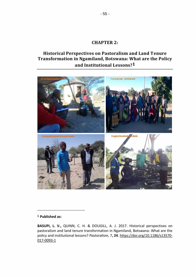
- 55 -
CHAPTER 2:
Historical Perspectives on Pastoralism and Land Tenure Transformation in Ngamiland, Botswana: What are the Policy
and Institutional Lessons?1
1 Published as:
BASUPI, L. V., QUINN, C. H. & DOUGILL, A. J. 2017. Historical perspectives on pastoralism and land tenure transformation in Ngamiland, Botswana: What are the policy and institutional lessons? Pastoralism, 7, 24. https://doi.org/10.1186/s13570-017-0093-1

- 56 -
ABSTRACT
Pastoral societies in dryland Africa continue to face changes to their pastoral systems.
These systems are influenced by a range of historical factors but little use is made of
this information to design policies that suit pastoralists’ landscapes. This article
provides a synthesis of historical perspectives on pastoral land use and tenure
transformations in Ngamiland, south of the Okavango Delta, Botswana. Little
documentation of herders’ historical perspectives exists and less is known about how
past experiences can be applied to sustainable pastoralism policies. In this article,
current land use pressing issues are examined and analysed within the context of
past experiences. We use a series of oral histories with key informants, focus group
discussions, expert interviews and rangelands field observations. Ngamiland
historical perspectives depict a pastoral landscape that has been shaped by a variety
of factors; livestock diseases, Human-wildlife-conflicts, droughts, land tenure
transformations associated with rangeland policies and the pastoral identity of the
Ovaherero/Ovambanderu ethnic groups. Pastoralists have followed unique
trajectories, specific to their rangeland conditions and socio-cultural context.
Resilience to climate shocks and diseases has been weakened by inequitable patterns
of control over rangeland resources. We recommend institutional diversity such that
from experiences of the past, lessons can be drawn of the sort of processes and
institutions required for pastoralism policies including targeted pastoralists’
adaptations. Using pastoralists to provide information, especially in the area of
indigenous knowledge, strategies can be developed to link conservation of wildlife
and rangelands with pastoral production by developing ecologically-sensitive low-
volume tourism that pastoral communities can tap to diversify their livelihoods.
Keywords: Environmental histories, Livestock mobility, Institutions, Rangeland
policy, Vulnerability, Okavango Delta

- 57 -
2.1. INTRODUCTION
Policy debates on pastoralism have given increasing attention to issues of communal
area development and management (Rohde et al., 2006, Behnke, 1987). Many
policies have been attempted in African countries to increase livestock production in
communal areas while at the same time maintaining the forage quality of the range
(Mwangi, 2009, Rass, 2006, Fratkin, 1997). In this effort, traditional pastoralism has
been commonly viewed as unproductive and directly responsible for rangeland
degradation (Oba, 2013).
Pastoral societies and their use of rangelands have been shaped by a range of
historical factors, but little use is made of this information to make policies that suit
pastoralists’ landscapes and local knowledge bases (Fernandez-Gimenez, 2006).
Research on pastoralism has given increasing recognition and support to traditional
pastoralism, livestock spatial mobility (Kitchell et al., 2014, Scoones, 1995) and to
rights of pastoral people to control and manage their grazing territories (Adriansen
and Nielsen, 2002, Swift, 1991). It is argued that flexible livestock mobility reduces
pastoralists’ vulnerability to climate change and the likelihood of livestock-induced
rangeland degradation (Brottem et al., 2014). However, in most SSA countries such
recognition has not yet translated into the protection and maintenance of traditional
pastoralism of flexible mobility-based systems (Basupi et al., 2017, Kitchell et al.,
2014).
The history of land tenure transformation in Africa shows a prevailing trend whereby
the erosion of collectively – held communal grazing lands and natural resources
under customary tenure is being hastened by policies that support privatisation of
formally communal grazing lands (Rohde et al., 2006). Intensified means of livestock
production through privatisation are often incompatible with a mobility strategy,
especially when privatised land tenures prompt pasture fragmentation and
underpins ecosystem service diversity losses. The livelihood prospects of pastoralists
remaining in communal grazing areas is hence potentially challenged by higher

- 58 -
vulnerability to livestock diseases incidences, climate variability and land
degradation. Livestock mobility in resource-scarce environments is critical for
reducing the concentration of livestock in smaller territories thus contributing to
Sustainable Land Management (SLM) (Moritz et al., 2013). Many governments, still
face the challenge of developing the right institutional frameworks and strategies
that address pastoral development while ensuring SLM (Notenbaert et al., 2012).
Historical perspectives can help increase our understanding of pastoral areas, thus
providing a reference point for assessing current pressing issues (Swetnam et al.,
1999).
Botswana represents a case study country that has focused agricultural development
policy on communal land privatisation (Rohde et al., 2006, White, 1992) and fencing
linked to animal health policies (McGahey, 2011). The ranching system was formally
introduced in 1975 through the Tribal Grazing Land Policy (TGLP) as an option to
promote the conservation and sustainability of dryland ecosystems (Magole, 2009,
RoB, 1975). It was argued under TGLP that land could be used to greater advantage,
if farmers had an incentive to gain control over grazing areas, exclude others by
fencing their land and be able to obtain direct benefits through investments and
production of quality beef. TGLP targeted land that was believed to be unused. This
was later extended by the National Policy on Agricultural Development (NPAD) of
1991 through intensification and expansion of TGLP objectives into all communal
areas. Through NPAD, ranches would not be limited to certain ‘unused’ areas,
instead, demarcation of ranches would depend on the number of cattle, the
availability of land and its carrying capacity, and individuals could apply to fence areas
within the vicinity of their boreholes (RoB, 1991). The relevance of the ranching
system in rangeland resource management and its principal assumptions has been
hotly debated in the pastoralism literature (Rohde et al., 2006, Dougill et al., 1999,
Ellis and Swift, 1988). What is limited in the academic debate is a detailed
understanding of the historical evolution of pastoral landscapes and land use
patterns, and how historical perspectives are embedded within the policy processes.

- 59 -
Less is understood about the interlinkages between multiple historical factors and
evolution of issues in shaping pastoralists’ landscapes and land use patterns. Such
lack of empirical analyses on the historical evolution of issues for communal
rangeland areas affects the sustainability of current rangeland policies. To
understand current pastoral land use patterns and policies, a historical perspective
is useful since it can help uncover the evolution of social and environmental
challenges in rangelands (Fernandez-Gimenez, 2006). Our findings rest on enhancing
understanding of pastoral social-ecological system from a historical analysis point of
view so as to inform policy strategies to improve pastoral livelihoods and manage
pastoral landscapes.
The paper aims to provide a synthesis of historical perspectives on pastoral land use
and tenure transformations in Ngamiland, south of the Okavango Delta, Botswana.
The study’s objectives are to; (1) identify historical occurrences that influenced
pastoralists land use patterns and determine their impact on the current form of land
use; (2) explore pastoral communities’ perspectives on current land use and
rangeland access; (3) explore the relevance of historical perspectives to lessons
regarding policy processes, institutions and strategies for SLM in pastoral landscapes.
2.2. MATERIALS AND METHODS
2.2.1. Study area
Ngamiland District is situated in north-western Botswana (Figure 2.1). It is home to
one of the world’s largest inland deltas; the Okavango. Land is broadly zoned into
different uses: communal areas, National Parks, Game Reserves, ranches, wetlands,
controlled hunting areas and wildlife conservation areas (operated as tourism
concessions) (DoL, 2009). Flow over the delta extends over a great area feeding into
the Thamalakane, Kunyere, Nhabe and Boteti rivers. The hydrological system of the
district has a significant influence on livestock grazing, particularly around Lake

- 60 -
Ngami. The climate is sub-tropical (semi-arid), with distinct hot, wet summers, and
cold dry winters. The study area is dominated by open low shrubs and tree savannas.
Livestock rearing is concentrated along the permanent open water sources at the
fringes of the Okavango Delta and around Lake Ngami.
A mixed- method approach; oral histories, focus group discussions and expert
Interviews was used in seven study villages; Sehithwa, Toteng, Bodibeng, Bothatogo,
Kareng, Semboyo and Makakung (Figure 2.1). The villages were selected on the basis
that the majority of residents practice agro-pastoralism and rely heavily on livestock,
particularly cattle, as the largest investment in agricultural assets and livelihoods.
Table 2.1 shows human and livestock numbers in the study villages.
Table 2.1: Human and livestock numbers in the study villages
Village Human
population
Cattle
population
Goats
population
Sheep
population
Donkeys and
Horses
Sehithwa 2748 16635 1712 471 953
Toteng 909 24828 3743 1015 1444
Bodibeng/Bothatogo 1333 26842 4070 1313 1816
Kareng 1259 37722 4760 707 1850
Semboyo/Makakung 691 19986 3484 632 1299
Total 6249 126013 17769 4138 7362
Data Source: Central Statistics Office, 2011 Department of Veterinary Services, 2016

- 61 -
Figure 2.1: Ngamiland study area Source: Authors Data sources: Tawana Land Board, Ministry of Agriculture
2.2.2. Oral histories
An enquiry into the pastoral history of the area was conducted through oral histories
to collect information from a wide range of people with experience of pastoral
systems, especially around issues of land tenure transformation and historical
occurrences that influenced pastoral land use patterns. Through historical accounts,
we reconstruct how pastoralism, land use and tenure has changed over time as well
as establishing past land management practices and historical timelines of major
events influencing land use. The selection of participants was based on purposive
sampling based on their extensive knowledge and experience. In order to find

- 62 -
participants, we established rapport with members of the pastoral community
through visits and interactions. We visited cattle posts and examined watering
points. We also helped some pastoralists in transporting fodder to calves and
participated in Foot and Mouth Disease (FMD) (Aphthae epizooticae) vaccinations.
Through such visits, we gained insights about the pastoral systems and explained our
research to potential respondents. Potential respondents were identified and
appointments for detailed in-depth interviews made. We also visited and held talks
with members of farmers’ committees and farmers’ associations who suggested
further potential respondents. Most informants were older men and women, mostly
of the Ovambanderu and Ovaherero tribes who were young during the 1940s – 1960s
and had witnessed most of the transformations in communal land in Ngamiland since
the era of the Tsetse fly epidemic (1960s). Some of the histories narrated were
passed down through generations. A total of 26 informants were sampled from
across the study villages.
2.2.3. Focus group discussions and Expert Interviews
In order to gain insights into the current land use issues, nine focus group discussions
(8-14 participants per focus group) were held as follows; Semboyo (n = 9 attendees),
Makakung (n = 12), Bothatogo (n = 10), Bodibeng (n = 8), Toteng (n = 9), Sehithwa (n
= 8), Kareng (n = 6). Data from focus groups was used to corroborate information
from professional informants and Oral Histories. Focus groups targeted different
stakeholders and groups in the community, especially pastoralists with experience in
communal areas, members of the communal farmers’ associations and farmers
committees. One of the focus groups targeted only women (n = 14 participants; agro-
pastoralists, members of farmers committees drawn from across the lake villages;
Sehithwa, Bodibeng, Toteng, and Bothatogo) in order to incorporate divergent views
and also to avoid a situation whereby influential male members of a group dictate

- 63 -
the discussions. Another focus group targeted young farmers (n = 14 young
participants who are engaged in pastoral farming and those that were active in
community projects, drawn from across the study villages). This was meant to solicit
views and perceptions of youth groups concerning issues of pastoral land use and
rangeland access. Interviews were also held with government officials in the Ministry
of Agriculture, Department of Veterinary Services (n = 4); Tawana Land Board,
Division of Land Use (n = 2); District Land Use Planning Unit (n = 2); Department of
Environmental affairs (n = 2), National Development Bank (NDB) (n = 1), Department
of Wildlife and National Parks (n = 4) and Department of Forestry and Range
Resources (n = 2). The purpose of these interviews was to get an in-depth
understanding of pastoralists’ issues, perspectives on current land use, pastoralism
and policy issues from professional experts.
2.2.4. Data Analysis
Oral history data were analysed based on the Miller–Rosser et al. (2009) analysis
approach. This involved: (i) Testimonies’ of each respondent were transcribed using
Microsoft Word and interpreted to derive meaning from each historic account using
a coding framework (Table 2); (ii) searching for commonalities: extrapolation of
common themes from each narrative, each individual testimony was cross-validated
and inconsistencies identified; (iii) writing the narrative, the interpretation of all
participants testimonies was constructed into one story per theme emanating from
the discussion (Miller - Rosser et al., 2009). Historical literature was used to validate
and contextualize participants’ accounts. Findings from oral histories were directly
compared to historical literature at University of Botswana library - Botswana
Collection and Botswana National Archives. The following were used; History of
Ngamiland (Tlou, 1985), Herero/Mbanderu history (Gewald, 2002, Almagor, 1980)

- 64 -
and History of the Basarwa (Dziewiecka, 2008). Relevant quotations were used to
explain and clarify data (Patton, 1990)).
Other qualitative data from focus groups were transcribed and analysed using
content analysis to identify the main themes or issues emerging from the discussions
(Adam et al., 2015). The development of themes involving the orderly and continuous
search for patterns was used to produce full descriptions that shed light on the issues
under investigation (Gale et al., 2013).
2.3. RESULTS
This section presents the study’s results based on the objectives. First, we give an
account of major historical occurrences affecting pastoralism and pastoral land use
patterns in Ngamiland since the 1920s through to the present. Secondly, drawing
from data gathered from focus group and expert interviews, we discuss local
pastoralists’ perspectives on current land use and how rangeland privatisation has
affected pastoral land use and land tenure. Finally, the study offers insights on how
historical perspectives can be used to inform policy on sustainable pastoralism. Table
2.2 is a summary of results of oral histories and focus group discussions and the four
global themes have been used to organise the findings section.
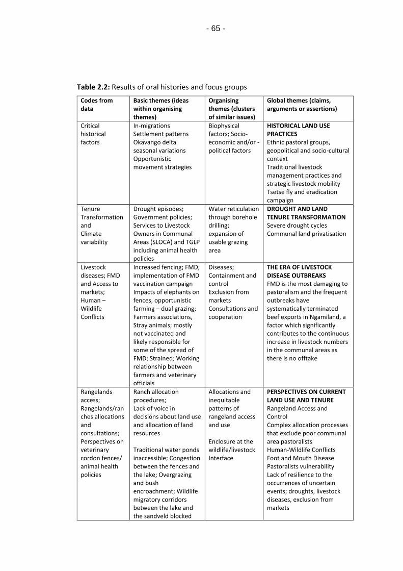
- 65 -
Table 2.2: Results of oral histories and focus groups
Codes from data
Basic themes (ideas within organising themes)
Organising themes (clusters of similar issues)
Global themes (claims, arguments or assertions)
Critical historical factors
In-migrations Settlement patterns Okavango delta seasonal variations Opportunistic movement strategies
Biophysical factors; Socio-economic and/or -political factors
HISTORICAL LAND USE PRACTICES Ethnic pastoral groups, geopolitical and socio-cultural context Traditional livestock management practices and strategic livestock mobility Tsetse fly and eradication campaign
Tenure Transformation and Climate variability
Drought episodes; Government policies; Services to Livestock Owners in Communal Areas (SLOCA) and TGLP including animal health policies
Water reticulation through borehole drilling; expansion of usable grazing area
DROUGHT AND LAND TENURE TRANSFORMATION Severe drought cycles Communal land privatisation
Livestock diseases; FMD and Access to markets; Human – Wildlife Conflicts
Increased fencing; FMD, implementation of FMD vaccination campaign Impacts of elephants on fences, opportunistic farming – dual grazing; Farmers associations, Stray animals; mostly not vaccinated and likely responsible for some of the spread of FMD; Strained; Working relationship between farmers and veterinary officials
Diseases; Containment and control Exclusion from markets Consultations and cooperation
THE ERA OF LIVESTOCK DISEASE OUTBREAKS FMD is the most damaging to pastoralism and the frequent outbreaks have systematically terminated beef exports in Ngamiland, a factor which significantly contributes to the continuous increase in livestock numbers in the communal areas as there is no offtake
Rangelands access; Rangelands/ranches allocations and consultations; Perspectives on veterinary cordon fences/ animal health policies
Ranch allocation procedures; Lack of voice in decisions about land use and allocation of land resources Traditional water ponds inaccessible; Congestion between the fences and the lake; Overgrazing and bush encroachment; Wildlife migratory corridors between the lake and the sandveld blocked
Allocations and inequitable patterns of rangeland access and use Enclosure at the wildlife/livestock Interface
PERSPECTIVES ON CURRENT LAND USE AND TENURE Rangeland Access and Control Complex allocation processes that exclude poor communal area pastoralists Human-Wildlife Conflicts Foot and Mouth Disease Pastoralists vulnerability Lack of resilience to the occurrences of uncertain events; droughts, livestock diseases, exclusion from markets

- 66 -
2.3.1. HISTORICAL LAND USE PRACTICES
2.3.1.1. Ethnic pastoral groups
In Ngamiland South of the Okavango Delta, the Ovaherero and Ovambanderu ethnic
groups, are the dominant community. Pastoralism is their main livelihood activity and
their transhumant system has developed under variable geopolitical, social and
climatic conditions (Tlou, 1985). Oral histories detail that Ovaherero and
Ovambanderu pastoral communities in Ngamiland have their origin in Namibia.
Historically, people who speak dialects of the Bantu language Otjiherero belong to
the three broad divisions within the Otjiherero – speaking society in Namibia; the
Ovaherero, the Ovambanderu, and the Ovahimba. These people share a number of
cultural elements that relate to social organisation, preferred economy,
epistemology, and spatio–political organisation. The Ovambanderu and Ovaherero
speak the same language, both live a pastoral way of life and practice the same
pattern of land and livestock management (Almagor, 1980). In spite of these
similarities, they have maintained two separate identities, divided by an ethnic
boundary. Many of these people fled to Ngamiland during the German – Herero
colonial war of 1904 – 1914 (Tlou, 1985). During that period, Kgosi Sekgoma
Letsholathebe (Kgosi translates as Chief or King in Setswana) ruled the Tawana
Kingdom in Ngamiland (Gewald, 2002, Tlou, 1985). In order to establish a strong base
for the Tawana Kingdom, Sekgoma allowed the Ovambanderu and Ovaherero groups
to become full members of the Tawana Kingdom yet retain their own identity;
speaking their own language and continuing their pastoral way of life (Tlou, 1985).
Through the practice of mafisa2, and through the royal cattle loans provided by Kgosi
2 Mafisa is a traditional practice which is similar across most Tswana tribes, entitling the loan of cattle to a borrower, who in exchange for herding is entitled to the

- 67 -
Sekgoma, the Otjiherero refugees were able to re-establish themselves as wealthy
cattle owners within a generation (Gewald, 2002).
2.3.1.2. Ovambanderu/Ovaherero settlements patterns
Oral history testimonies of pastoralists interviewed in Sehithwa, Bothatogo,
Bodibeng and Toteng suggest that Ovambanderu pastoralists have been expanding
their territories around Lake Ngami, especially along the western margin of the Delta,
since the early 1930s. The number of settlements in the dry Kalahari Sandveld
remained low until the 1950/60s outbreak of the tsetse fly epidemic after which
settlements in the sandveld increased. Most cited stock losses due to diseases
alongside the Okavango swamps as reasons for moving inland.
Information gathered from key informants and focus groups suggest that the area
stretching from the southern and eastern shores of Lake Ngami to Kuke cordon fence
(Figure 2.1) was a Basarwa3 territory. The settlements around the Khwebe hills were
a well-known area for the Basarwa, who had relatives in the adjacent, Central
Kalahari Game Reserve (CKGR). The inhabitants of the Khwebe hills, otherwise known
as the Kwe people (Kwe meaning place of people), were nomadic hunter-gatherers
(Dziewiecka, 2008). Ngamiland was seen as being rich in grasslands, woods and
water, especially during the wet season, and Okavango floods attracted a lot of game
milk, to use the cattle as draft power, as well as keeping some of the offspring of the herded cattle (Parsons, 1974).
3 Basarwa, also known as the San people or Bushmen, are indigenous former nomadic people occupying the Kalahari Desert and adjacent areas in Botswana. Basarwa are known to live in some of the most inhospitable terrains surviving by hunting wild game, gathering roots, tubers and wild fruits. Today the land that Basarwa used to hunt on is increasingly being taken up for grazing, commercial ranching, game reserves and national parks. They predominate among the Remote Area Dweller (RAD) groups.

- 68 -
making it a favourable place for the Kwe, ‘…the Kwe were generally carefree people…,
they knew the land…faced with the worst drought in the 1960s, we moved further
south until we reached the Khwebe hills (Figure 2.1), we found the Kwe, …they showed
us spring water in the hill…the land was good, some of our animals survived the harsh
drought…’ (Oral histories data, 82-year-Old Ovambanderu pastoralist, Bodibeng,
2015). Respondents reported that, following the arrival of the Ovambanderu
pastoralists, the Kwe’s mobility started to decrease and temporary encampments
were gradually replaced with semi–permanent settlements on cattle posts. Some
were employed by the encroaching Ovambanderu pastoralists and were paid a calf
or two a year for their service, enabling them to accrue some cattle of their own. The
area of Khwebe hills was demarcated as ranches under the TGLP and is now
inaccessible by the Basarwa of Kwe or Ovambanderu pastoralists. The remnants of
the Kwe people can now be found in Somelo, a Remote Area Dweller (RAD)4
settlement 70 kilometres south-east of Maun.
2.3.1.3. Traditional pastoral management practices and
strategic mobility
Oral history narratives suggest that before the land tenure transformation,
Ovaherero and Ovambanderu of Lake Ngami viewed their grazing landscapes as an
interconnected ecological zone, divided into neighbouring localities and grazing
4 Remote Area Dweller (RAD) settlements are settlements established under the government of Botswana's Remote Area Development Programme (RADP). The programme targets socially and economically marginalised populations living outside main villages. People living in RAD settlements are out of reach in terms of distance from generally available services such as education, health and have no real access to land or adequate water rights. They are normally assisted with food, clothing, children’s transportation to school and some income generating activities to address rural poverty.

- 69 -
grounds for different seasons. Herding practices involved following seasonal
transhumant patterns between areas around the delta in the dry season and
sandveld grasslands in the wet season. It was important that grazing areas had
sufficient resting time from the previous grazing cycle. The grazing system was
enforced by the chief (Traditional leader or ‘Omuhona’). Clans controlled different
grazing areas and cattle posts (‘ofarama’ or ‘kombanda’) areas established around
large pans (‘macha’ or ‘ovikango’). If pastoralists did not follow the grazing patterns,
fines were imposed by the chief and a council of elders in the clan known as land
overseers. These transhumant pastoralists adopted an approach involving controlled
but flexible movements away from the delta to the sandveld grasslands during the
wet seasons, including reciprocal access agreements with neighbouring clans in order
to respond to environmental variability. Table 2.3 summarises factors that influenced
the Ovambanderu/Ovaherero temporary migrations, while Figure 2.2 shows
pastoralists' conceptualisation of settlements around Lake Ngami and their adjacent
rainy season pastures before fences and land sub-divisions. The pans were normally
associated with the rainy season because of the water that is collected. Once the
rainy season started, small groups from individual compounds left their settlements
and moved away from the lake in search of better pastures. They spent the entire
rainy season within a single pasture area, around a specific pan, returning only when
water sources had dried up. Each settlement had their own pans which they
controlled and regulated through reciprocal access agreements and social relations.

- 70 -
Table 2.3: Factors that influenced pastoralists temporary migrations before the land tenure transformation (Focus group discussions data, 2015)
Factor influencing
strategic mobility
Justification
Fluctuations in forage
and water availability
Take advantage of resources found in different places in different
seasons such as water in the sandveld pans and surrounding grasslands
Allow grass to recover around Lake Ngami and Okavango riparian
woodlands which were typically dry season grazing areas
The number of livestock
herds owned
In order to take advantage of a diversity of ecosystems those with
larger herds utilized herd splitting and grouping as a strategy to cope
with drought or climatic variations; lactating, pregnant cows and calves
were kept separate and closer to settlements, the males and non-
producing females could travel long distances without water and were
kept at distant encampments moving from one pan/ovikango to
another in search of better grazing and water
The seasonality of the
natural regimes; rainfall,
Okavango delta seasonal
flooding
Reduce the probability of crop damage and resultant fines because
floodplains were used by agro-pastoralists for flood recession
agriculture known as ‘Molapo’ farming or ‘Ondondu’ farming (Molapo
means river in Setswana and Ondondu means river in Otjiherero).
Avoid the moist conditions of the delta which is often a breeding
ground for insects and disease outbreaks. Such movement strategies
were used to combat the spread of FMD or the Nagana disease
associated with the tsetse fly.
During rainy season buffaloes move from the core of the delta to the
peripheral areas of the delta hence increasing the possibility of mixing
with cattle. By moving away to the sand veld such mixing was avoided
hence pastoralists argue that outbreaks of FMD were low and
manageable
Skill level of the herder
and labour availability
Knowledge of the herder was paramount in exploiting the different
characteristics of the range, determining niche specialization of herds
and herd splitting for herds’ survival during prolonged dry season and
drought periods.

- 71 -
Figure 2.2: A sketch map (digitised), drawn by pastoralists during a focus group discussion at Toteng.
The sketch map depicts pastoralists' conceptualisation of settlements around Lake Ngami and their adjacent rainy season pastures before fences and land sub-divisions.
2.3.1.4. 1920s – 1960s – The Tsetse fly Epidemic and
eradication campaign
Respondents reported that from the mid-1920s – late 1960s, they were confronted
with frequent outbreaks of sleeping sickness and nagana disease caused by the tsetse
fly. The Tsetse epidemic played a critical role in settlements and migration patterns
of different ethnic groups around the Okavango Delta. To flee the ravages of the
tsetse fly, people moved out into the sandveld with their livestock. Riverine lifestyles

- 72 -
were disrupted and new settlements emerged. According to local informants in
Sehithwa and Toteng, neither the colonial government nor the Tawana authorities
were able to handle the problem. The only alternative for pastoralists was to move
to unaffected areas in the sandveld. It was only in the mid-1960s under Sir Seretse
Khama (Botswana’s first president from 1966 – 1980) that the tsetse was effectively
controlled. According to Tlou (1985), the tsetse fly had the most devastating effects
on the spatial distribution of the Ngamiland population because unlike mosquito-
borne malaria, the tsetse fly-borne diseases, sleeping sickness (trypanosomiasis) and
nagana, afflicted both humans and cattle alike. Settlements such as Semboyo and
Makakung emerged during this period as the Ovaherero migrated further into the
sandveld.
2.3.2. DROUGHT AND LAND TENURE TRANSFORMATION
2.3.2.1. 1960s – 1980s Severe drought cycles
This period was characterised by recurrent droughts owing to successive seasons of
poor rainfall. Respondents reported that the impact of the 1965/66 drought was so
significant that by the middle of the drought period grazing fodder was almost non–
existent and many cattle died. Weaker and severely emaciated cows were kept near
homesteads and fed on branch leaves pruned from trees around the Okavango Delta.
Some calves were slaughtered so as to reduce stress on their mothers. There was a
massive movement of animals to areas with water, ‘…every drought in Ngamiland
brought other pastoralists from different parts of the district to Lake Ngami, which
even up to now has the highest concentration of cattle in Ngamiland’ (Oral histories
data, 69-year-old Mbanderu pastoralist, Sehithwa, 2015). However, respondents
reported that little water collected in the pans (macha) and lagoons dried up. Some
pastoralists moved as far as the Khwebe hills in the current Hainaveld ranches area.
It was also during this period (1975) that the government introduced the TGLP to

- 73 -
curb the problems of overgrazing that were reported to be commonplace in the
communal grazing lands, particularly in the eastern hardveld of Botswana. So, this
marked the start of an era of tenure transformations.
Another severe drought hit the country in 1982. Participants in both focus groups
and oral histories recalled that in the midst of this drought, the government
introduced the programme: Services to Livestock Owners in Communal Areas
(SLOCA); a grant scheme designed to help small-scale pastoralists in the communal
areas with water reticulation through borehole drilling and construction of drift
fences. Some pastoralists were able to drill boreholes through this scheme and as a
result, new lands in the dry Kalahari sandveld were opened up for grazing. However,
some Ovambanderu and Ovaherero pastoralists reported that they were reluctant to
invest in borehole drilling because they still had hopes of going back to Namibia;
‘…some pastoralists thought then, it will be futile to do so, drilling a borehole is
expensive and again you cannot carry a borehole to Namibia’ (Oral histories data, 74-
year-old Ovaherero pastoralist, Semboyo, 2015). Many Tswana-speaking tribes
invested in boreholes leaving those reliant on the water from Lake Ngami, majority
Ovambanderu/Ovaherero pastoralists. During the interviews, most Tswana-
speaking tribes referred to the Lake as ‘lecha la ma Mbanderu’ (Meaning Lake of the
Ovambanderu). Some boreholes were drilled by the government for communal use.
Pastoralists also reported that they were provided with free diesel and engine
maintenance parts. The development of water resources signified the expansion of
usable grazing area in Ngamiland as pastoralists stretched further into the sandveld.
However, most of the SLOCA boreholes are now reported to be dysfunctional, as
pastoralists reported that ‘…they were expensive to maintain and most of the water
was saline…’ (Oral histories data, 59-year-old member of the Kareng farmers’
committee, Kareng, 2015). The period also coincided with the construction of the
southern buffalo fence (Figure 2.1) a veterinary cordon fence designed to separate
cattle from buffaloes for the purpose of controlling the transmission of FMD, so
access to the Okavango swamp grazing areas was lost at this time.

- 74 -
2.3.3. THE ERA OF LIVESTOCK DISEASE OUTBREAKS
2.3.3.1. 1995: The CBPP Epidemic
In February 1995, an outbreak of Contagious Bovine Pleuropneumonia (CBPP) known
as cattle lung disease occurred in western Ngamiland, with first cases reported along
the Xaudum valley (Figure 2.1). Respondents reported that this period was the most
disturbing period of their lives as pastoralists; ‘…many families were impoverished
and had to rely on government temporary relief programmes...’ (Oral history data,
69-year old Mbanderu pastoralists, Sehithwa, 2015). CBPP is an acute or chronic
disease of cattle and water buffaloes. According to officials at Department of
Veterinary Services (DVS), during the early stages, the disease was confined to the
western part of the district. Despite control measures, the disease spread rapidly to
the east, prompting the government to resort to total eradication by clearing the
entire district of cattle. In total, 320,000 cattle were killed of which 114,000 cattle
were eradicated from ranches and 206,000 were eradicated from communal lands
(DVS, 2000). According to respondents, the CBPP caused enormous disruption to the
spatial configuration of the pastoral landscape. Following the outbreak, more
veterinary fences were introduced. Three major fences were constructed as
emergency control measures in 1995 to contain the spread of CBPP; Samochima (Red
line fence), Ikoga (Yellow line fence) and Setata (Green line fence) (Raborokgwe,
1997) (Figure 2.1). Pastoralists in the villages of Semboyo and Makakung indicated
that the Setata fence changed their land use patterns completely. Livestock
movements were curtailed and grazing lands bisected, with some water resources
becoming inaccessible. Restocking started in 1997 and by the end of the year, about
70,000 cattle had been reintroduced (DVS, 2000). The period also coincided with the
implementation of the NPAD fencing component.
Following the declaration of the country as CBPP free, conservation groups, notably
the Kalahari Conservation Society (KCS) and local communal pastoralists convinced
the government to demolish the Setata fence. While conservation groups cited

- 75 -
environmental concerns, such as blockage of ungulate migratory routes, pastoralists
argued that they had been separated from their critical grazing land and water
resources. As a result, the Setata fence was decommissioned while the remaining
two, Samochima and Ikoga fences, were declared permanent and incorporated into
the Department of Veterinary Service (DVS) Master Plan.
2.3.3.2. 2007: Habu FMD outbreak
In April 2007, an outbreak of FMD was reported at Habu along the Okavango Delta
southern buffalo fence. Pastoralists reported that government responded to the
outbreak by reconstructing the Setata Fence. Cattle in the entire district could not be
slaughtered at the Botswana Meat Commission (BMC) abattoirs, which respondents
indicated, resulted in serious financial constraints as they couldn’t pay school fees or
have enough to eat. In the process, cattle numbers continued to accumulate in the
district. The government set up a relief fund under the National Development Bank
(NDB). In this fund, cattle were used as sureties for loans. A farmer could register up
to 30 cattle with the Bank at BWP 1,500 per animal on the basis that pastoralists
would repay the loans once they started selling to the BMC abattoir. During
interviews, some pastoralists claimed that they were being driven into poverty and
did not have the means to repay the loans. An interview with NDB staff in Maun
revealed that 721 pastoralists used the fund before it was stopped but so far only 55
had managed to clear their loans. ‘…we are owed around BWP 103 million ($10.3
million) by Ngamiland pastoralists, there is no market due to the recurrent FMD in
the area…’ (Expert Interview data NDB officer in Maun, 2015).
2.3.3.3. 2012: The ranches protection buffer fence

- 76 -
The ranches protection buffer fence (Figure 2.1) was constructed in 2012 as an
emergency measure to prevent FMD from spreading into commercial ranches and
Ghanzi district. However, communal pastoralists argued that they never agreed to
the creation of the fence on the grounds that it exclusively protects ranchers while
cutting communal pastoralists off from their traditional grazing land and water
resources. Pastoralists argued that the money used to construct the fence could have
been used to maintain the southern buffalo fence which would have solved the
problem for all pastoralists. Pastoralists reported that lots of cattle from the
communal areas die because they become stranded along the fence while seeking to
access traditionally good grazing on the ranches side5. Interviews with government
officials revealed that the fence was not preceded by any impact assessment or
feasibility study since it was assumed that it would follow the ranches boundary.
2.3.3.4. 2014: Kareng FMD outbreak
In April 2014, an outbreak of FMD occurred in Kareng communal lands, an area that
has been free from the disease for a long time. It is rare to experience an FMD disease
outbreak in the sandveld. According to a veterinary officer, the 2014 outbreak
started in Tubu, an area within the swamp, ‘…that cattle crush and the surrounding
cattle posts were surrounded with water following the floods and were
inaccessible…so they missed the routine vaccination…’ (Expert Interview data,
Veterinary officer, Maun, 2015). However, pastoralists blamed the outbreak on
elephants which destroy veterinary fences allowing cattle to cross to the buffalo area
or vice versa. Following the outbreak, the Department of Veterinary Services
5 Most ranches are unfenced, before the ranches protection buffer fence was constructed, cattle could roam freely and thus utilised numerous pans for grazing and watering on the ranches’ side.

- 77 -
imposed stringent livestock movement protocols on herders. Livestock herding was
not allowed except with a permit from the veterinary extension officer, even within
the same vaccination area. Pastoralists reported that this resulted in an increase in
stray animals, poor herding practices and increased livestock predation as they were
not able to conduct routine herding and night kraaling of their animals.
2.3.4. PERSPECTIVES ON CURRENT LAND USE
2.3.4.1. Rangeland access and control
Respondents reported that they objected to the enclosure by TGLP ranches, mainly
on the grounds of reduced resource access and restricted mobility. They feared that
changes in the structure of the landscape would jeopardise their way of life as a self-
sufficient pastoral community. Some informants still recall that they were told during
the consultations, a period which they referred to as ‘during Seretse Khama’, that the
ranches would not affect any communal area pastoralists as they would be
demarcated in unused land close to the CKGR. However, many respondents argued
during focus groups that the land referred to as unused was never there, that in
actual fact these were rangelands that were important to pastoralists for managing
periods of excessive drought and disease outbreaks near the delta system and some
portions were occupied by the Basarwa communities. Respondents reported that
over the years ranches have been pushing closer, and have encroached further onto
communal grazing lands, especially during the implementation of the NPAD ranches;
‘…the pastoral character of our community has long been lost, so are the ethnic
boundaries which distinguished us from the other tribes…’ (Interview data, 68-year-
old Ovambanderu pastoralist, Bothatogo, 2015). Respondents argued that they
wanted to preserve their pastoral identity, maintain the traditional arrangement in
which they had regulated access to grazing resources by pastoral communities and
also maintain their territorial integrity.

- 78 -
During focus groups, respondents were critical about government consultation
processes, especially the NPAD ranches allocation process. Many argued that the
ranches, which were allocated around cattle posts, did not consider many poor
pastoralists who did not have boreholes but depended on the communal areas and
the numerous sandveld natural water pans for survival. As respondents stressed;
‘…government officials came to the Kgotla (traditional gathering place) and told the
community that those with boreholes will be allocated ranches, the community
agreed because they didn’t know what that meant…some people had just borehole
points and those were treated as boreholes and were allocated ranches…’ (Focus
group discussion data, Toteng, 2015)
A few respondents reported that they tried applying for ranches, but the allocation
process and requirements were beyond their comprehension so the majority of
those ranches were given to outsiders or those with financial resources; ‘…also,
business proposals and management plans are demanded from us, overriding the
practical experience we have as pastoralists …’ (Focus group discussion data, Toteng,
2015), ‘I tried to apply for an NPAD ranch and I think my ranch management plan was
comprehensive enough…but still, the land board turned down my application...’
(Youth focus group discussion data, Sehithwa, 2015).
The allocation process for the ranches is a complex process for communal area
pastoralists, especially those without boreholes. First, the Land Board requires an
applicant to show proof of financial resources in excess of BWP250 000 (US$25 000)
to develop the ranch if allocated (TLB, 2015). ‘The applicant is also expected to
demonstrate through a business or ranch management plan a thorough knowledge
of the ranching management processes; paddocking, rotational grazing, fire
management, water development and disease management …’ (Expert Interview
data, Maun, 2015). Such requirements exclude poor communal area farmers from
competing with those with financial resources. Moreover, most of the business plans
and management plans submitted for ranch applications are prepared by consultants
(Ntingana, 2007). This means that the understanding of the commercial ranch

- 79 -
management strategies demonstrated in the management plan is a theoretical
understanding by the consultant and not the applicant. The majority of the
communal area pastoralists do not have financial resources to hire a consultant to
write management plans for them. The allocation system is such that it gives those
who previously had only de facto rights to grazing around their boreholes exclusive
rights to previously communal grazing lands (RoB, 1991). The large costs of drilling
and equipping a borehole ensures that owning a borehole remains a privilege of the
wealthier.
2.3.4.2. Wildlife conservation vs traditional livelihoods
One of the pertinent issues in the area is human-wildlife conflict, especially with
elephants, which respondents argued is the major contributing factor to the rampant
FMD. Most of the respondents complained about the ever-increasing elephant and
buffalo populations; ‘It is not fair that as Ngamiland farmers we continue being
impoverished by these increasing buffalo and elephant population…if the government
cannot help us, they should allow these animals to move to other parts of the
country…’ (Focus group discussion data, a member of Ngamiland Integrated Farmers’
Association, Sehithwa, 2015). Buffaloes are considered to be the carrier of FMD.
Elephants’ extend their range into cattle post areas and arable lands, damaging
livestock water resources and veterinary fences that separate cattle from buffaloes.
Respondents appeared to be critical about the way government departments are
handling the FMD epidemic. The Department of Wildlife and National Parks is
criticised for failing to control the movement of elephants which continue to destroy
veterinary cordon fences on a daily basis; ‘…the attitude of authorities when dealing
with the control and containment of FMD is worrisome…there is no maintenance of
the buffalo fence. We have long called for the electrification of that fence but up to
now nothing is happening…’ (Focus group discussion data, a member of the farmer's

- 80 -
committee, Kareng, 2015). Government officials acknowledged that efforts to
mitigate the conflict at the interface between elephants and shrinking rangelands
have met with limited success. However, others still blamed pastoralists for their
reluctance to help the government to contain the problem; ‘….frequent damage of
the buffalo fence by elephants presents our greatest challenge in confronting the
FMD scourge. We continue trying…but at the same time ask for maximum
cooperation from pastoralists…others are reluctant, we urge them to do their part by
stopping their cattle from moving closer to the buffalo fence …’ (Interview data,
Veterinary officer, Maun, 2015).
2.3.4.3. Increased vulnerability and poverty due to loss of
resource access
Vulnerability denotes pastoralists’ lack of resilience to the occurrences of uncertain
events; droughts, livestock diseases, exclusion from markets, resource scarcity in the
form of marginalised access or rangeland degradation (Rass, 2006). Historical
narratives suggest that people living on the fringes of the Okavango Delta have
experienced difficulties over a long period of time. Risks range from diminishing
communal grazing lands, drought, livestock diseases, predation, conflicting land uses,
floods and destruction of crops by animals. The FMD epidemic and the enclosure of
the formerly wet season grazing pastures and water resources continues to
undermine the livelihood of the Ovambanderu and Ovaherero, with communities
reporting that many impoverished young men and women are being forced into
seeking employment in town or the government labour intensive public works
(Ipelegeng) programme; ‘…We now depend on government hand-outs for survival
because the land is not enough for sustainable pastoral farming and there are no
markets for livestock products…’ (Focus group discussion data, Toteng, 2015).

- 81 -
Some respondents reported that they used to diversify their income sources by
working off–farm, selling fuelwood, logs, thatching grass and wild berries. This is no
longer the case as all these are now enclosed by the ranches protection buffer fence;
‘I used to cut logs, droppers, thatching grass and gather wild berries in there and sell,
now my business has collapsed because all these resources are now on private
land…we can’t even go near that fence because we are afraid of the soldiers...’ (Oral
histories data, 68-year-old pastoralist, Bothatogo, 2015).
The persistently high stocking pressures in communal areas especially around Lake
Ngami are driven not only by large numbers of animals, but also by the effects of a
shrinking land base. As pressure on land increases, the pastoralists’ mode of
subsistence is left in a situation of worsening vulnerability. Discussions in focus
groups and subsequent expert interviews both stressed that the effect of overgrazing
between the ranches protection fence and Lake Ngami has significantly reduced both
the grass cover density and biodiversity of the area. Bare soils and a significant
presence of invasive species such as of Acacia mellifera were observed and some
areas were choked with bushes. Congestion in communal areas has also made it
difficult to control the spread of FMD.
Expert interviews and focus groups revealed that the exclusion from livestock
markets has resulted in part-time and town dwelling livestock owners. This has
resulted in neglected livestock near major settlements, roads, rivers and the Lake,
including lots of stray animals. Some respondents argue that this is also a major
contributing factor in the spread of livestock diseases since these stray animals are
never vaccinated. Citing the destruction of their cattle–led lifestyle, and land use
policies which pastoralists argued favours mainly two types of land use (wildlife and
commercial ranching), some Ovaherero pastoralists expressed their desire to
abandon Ngamiland and repatriate to their native Namibia; ‘….I haven’t been able to
sell since 2007, the land has seriously diminished since the erection of that fence (the
ranches protection buffer fence)…BMC buys only from the ranches, we poor
- 82 -
pastoralists are in the dark. I think it’s meaningful to go back to Namibia…’ (Oral
histories data, 65-year-old Ovaherero pastoralist, Makakung, 2015).
2.4. DISCUSSION
2.4.1. Flexible mobility and land tenure transformation
Understanding how pastoral landscapes have changed over time in response to a
range of influences is essential for planning and policy development and can promote
a clearer understanding of likely future changes in pastoral landscapes (Cousins et
al., 2007). Adaptation and response strategies must be grounded in pastoralists
historical experience and knowledge (Ericksen et al., 2013). Pastoralists have a deep
knowledge and understanding of their environment and have developed grazing
practices and adaptation strategies which are consistent with their environment and
socio-cultural context (Basupi et al., 2017). Ngami pastoralists, have customarily used
risk-spreading tactics over the years that include strategic movement of livestock
away from disease prone environs such as the Okavango Delta Swamps, and to access
pasture resources and water in sandveld pans after rains including herds splitting to
take advantage of the varied and uncertain environmental conditions.
Dryland pastoralists rely on the demonstrated coping strategy of mobility in order to
respond to environmental variability and occurrence of uncertain events such as
droughts (Fernandez-Gimenez and Le Febre, 2006, Ellis, 1995). Mobility allows
strategic access to scarce and scattered rangelands resources; water and pasture
(Vetter, 2005, Kaye-Zwiebel and King, 2014). In Ngamiland, the de facto privatisation
of communal rangelands did not take into consideration this effective strategy of
extracting value out of these marginal lands. Botswana’s rangelands policy was
developed because of the perceived overstocking, degradation and the negative
stigma associated with opportunistic pastoralism especially in the eastern hardveld

- 83 -
communal rangelands (Rohde et al., 2006, White, 1992). The severe droughts in the
1960s/80s seems to have strengthened the communal rangeland crisis narrative
resulting in the conclusion by government that rangelands are in crises and in need
of an intervention. This gave impetus to rangeland enclosure and privatisation
through TGLP. The process of rangeland tenure transformation is changing the
patterns of resource tenure and access, reinforcing the dominant patterns of winners
and losers in the communal areas (Tache, 2013, Cullies and Watson, 2005). The use
of boreholes as a mechanism in ranch allocation effectively meant that grazing land
is allocated de facto to an elite of cattle owners who have acquired exclusive use of
the land by making the necessary investment in borehole drilling and water
reticulation (Perkins, 1996, White, 1992). In Ngamiland, resource-poor pastoralists
who could not afford to invest in borehole drilling subsequently lost the opportunity
to capture private land. The ensuing scenario is one in which pastoralists are
squeezed between fences (Basupi et al., 2017), their resilience to climatic shocks and
diseases have been significantly weakened, and problems of congestion and land use
conflicts could lead to the very problems of rangeland degradation that these policies
and strategies had purported to prevent.
2.4.2. Policy and institutional lessons
Historical perspectives recounted by local pastoralists provide important insights into
key events and changes in an area. In Ngamiland livestock disease outbreak emerges
as a key theme. FMD outbreaks have occurred with increasing frequency in recent
years. Livestock owners appear to be less observant of animal health issues than
was previously the case. A strategy which emphasises getting the general conditions
right for livestock owners to make the necessary commitment and investment in the
fight against the disease, in a manner suitable to the local condition and context is
suggested. In Ngamiland, pastoralists’ seasonal movements served as a means of

- 84 -
controlling grazing lands, preventing out of season grazing, managing livestock
diseases and human-wildlife conflicts. Although the allocation of rangeland resources
existed especially between villages and clans around important historical natural
water pans, customary enforcement of movement patterns by village chiefs were an
effective means of managing rangelands and livestock and also provided pastoralists
with secure access rights to key grazing resources, especially in periods of scarcity
such as during dry or drought periods. These traditional livestock management
institutions have been significantly altered by rangelands transformations. The
centralisation of land resources management has meant that a complex network of
sectoral institutions is used to manage communal lands, excluding the pastoralists
and their leaders thus rendering them losers in the process (Cullies and Watson,
2005, Peters, 1994). Pastoralists’ resilience to climate shocks and uncertainties has
been weakened as a result. The new pastoral environment means that pastoralists’
vulnerability is increasing even to slight variations and intensity of rainfall (Letai and
Lind, 2013). Technocratic approaches to policy making neglects local communities
experiences in formulating rangeland policies (Rennie, 1998) resulting in strategies
that fails to address the root cause of the problem.
2.5. CONCLUSION
This study proposes a strong consideration of historical perspectives in informing
policy debates on sustainable pastoralism. Understanding the management of
rangelands through pastoralism has substantial policy relevance and can help
structure possible entry points for sustainable land management initiatives. Findings
show that in Ngamiland pastoral social-ecological systems, the trajectories of change
can be outlined within four themes: Ovambanderu/Ovaherero historical land use
practices, disease outbreaks, climate variability and land tenure transformation
facilitated through expansion in borehole technology and rangeland policies. The
effect of communal land tenure transformation on SLM and pastoralists adaptive

- 85 -
capacity requires understanding complex social-ecological systems and developing
more appropriate and locally relevant strategies. From experiences of the past,
lessons can be drawn of the sort of practices, processes and institutions required for
pastoralism policies and/or planned pastoralists’ adaptations. In Ngamiland,
historical narratives suggest a high level of human-wildlife conflict that even a double
fence will do little to stop. Pastoralists’ attitudes towards wildlife are negative as they
feel that wild animals are responsible for their distresses such as livestock diseases.
Working with pastoralists could act to protect their lifestyles as pastoralists while
ensuring wildlife conservation. There is need for institutional diversity in order to
maintain any part of the systems. Using pastoralists to provide services, particularly
in the area of indigenous knowledge, interlocking strategies can be developed to link
conservation of wildlife and rangelands with pastoral production by developing
ecologically-sensitive low-volume tourism that pastoral communities can tap to
diversify their livelihoods. For example, community managed game farming around
the periphery of the Delta along the southern Buffalo fence would form a protective
buffer against FMD while generating income opportunities for pastoral communities.
Throughout the study villages, the relationship between pastoralists and government
officials when it comes to either containment of FMD, elephants – related conflicts
or control and access to rangeland resources came close to institutionalised mistrust.
Dealing with a complex social ecological system requires that government do more
than pay lip-service to the concept of consultation and participation. While
governments have access to information on climate or disease, pastoralists can
provide a compact account of local conditions based on years of practical experience
thus enabling a more appropriate and locally relevant policy environment. In this
process, historical perspectives can form a point of reference by which institutions
perceive issues, assess scientific findings and justify decisions. In Botswana, relatively
little effort has been made to integrate historical perspectives into land use planning.
Past attempts to support pastoral development have failed to successfully balance
the needs of critical ecological pastoral areas through appropriate policy and

- 86 -
technical approaches. Progress from here will depends not so much on the
pastoralists, but on the willingness of government agencies responsible for policy to
talk to people through genuine participation.
2.6. ACKNOWLEDGEMENTS
This research fieldwork was supported by funding from the Government of
Botswana, the Botswana International University of Science and Technology and the
University of Leeds Sustainable Agriculture Fund Bursary. Funds for publication of
this paper was provided by the Centre for Climate Change Economics and Policy,
University of Leeds. The study was carried out under the Government of Botswana
research permit number EWT 8/36/4 XXX (73). We thank the Ngamiland pastoral
communities for sharing their opinions and for their active participation in the
research. Many thanks to the anonymous reviewers for their insightful comments
and suggestions. Thanks to Dr. Susannah Sallu for the insightful feedback on earlier
draft of this manuscript.
2.7. REFERENCES
ADAM, Y. O., PRETZSCH, J. & DARR, D. 2015. Land use conflicts in central Sudan: Perception and local coping mechanisms. Land Use Policy, 42, 1-6.
ADRIANSEN, H. K. & NIELSEN, T. T. 2002. Going where the grass is greener: On the study of pastoral mobility in Ferlo, Senegal. Human Ecology, 30, 215-226.
ALMAGOR, U. 1980. Pastoral Identity and Reluctance to Change: the Mbanderu of Ngamiland. Journal of African Law, 24, 35-61.
BASUPI, L. V., QUINN, C. H. & DOUGILL, A. J. 2017. Using participatory mapping and a participatory geographic information system in pastoral land use investigation: Impacts of rangeland policy in Botswana. Land Use Policy, 64, 363-373.

- 87 -
BEHNKE, R. H. 1987. CATTLE ACCUMULATION AND THE COMMERCIALIZATION OF THE TRADITIONAL LIVESTOCK INDUSTRY IN BOTSWANA. Agricultural Systems, 24, 1-29.
BROTTEM, L., TURNER, M. D., BUTT, B. & SINGH, A. 2014. Biophysical Variability and Pastoral Rights to Resources: West African Transhumance Revisited. Human Ecology, 42, 351-365.
COUSINS, B., HOFFMAN, M. T., ALLSOPP, N. & ROHDE, R. F. 2007. A synthesis of sociological and biological perspectives on sustainable land use in Namaqualand. Journal of Arid Environments, 70, 834-846.
CULLIES, A. & WATSON, T. 2005. Winners and Losers: Privatising the commons in Botswana. Willprint, Colchester.
DOL 2009. Department of Lands (DoL). Ngamiland Integrated Land Use Plan, Final Report, . Ministry of Lands and Housing, Botswana.
DOUGILL, A. J., THOMAS, D. S. G. & HEATHWAITE, A. L. 1999. Environmental change in the Kalahari: Integrated land degradation studies for nonequilibrium dryland environments. Annals of the Association of American Geographers, 89, 420-442.
DVS 2000. Livestock Report: CBPP, destocking and restocking. Department of Veterinary Services, Maun, Botswana.
DZIEWIECKA, M. 2008. Place of People: The Khwebe Hills in the History of Ngamiland. Botswana Notes and Records, 40, 11 - 20.
ELLIS, J. E. 1995. Climate variability and complex system dynamics: implications for pastoral development. In: Scoones, I. (ed.), Living with Uncertainty: New directions in pastoral development in Africa, Intermediate Technology Publications, Exeter, 37 - 46.
ELLIS, J. E. & SWIFT, D. M. 1988. Stability of African pastoral ecosystems: Alternate paradigms and implications for development. Journal of Range Management, 41.
ERICKSEN, P., LEEUW, J. D., THORNTON, P., SAID, M., HERRERO, M. & NOTENBAERT, A. 2013. Climate Change in sub-Saharan Africa: What consequences for pastoralism. In Catley, A., Lind., J., and Scoones, I. (Eds). Pastoralism and Development in Africa: Dynamic Change at the Margins, Pathways to sustainability, Routlege,, 71-81.
FERNANDEZ-GIMENEZ, M. E. 2006. Land Use and Land Tenure in Mongolia: A Brief History and Current Issues. USDA Forest Service Proceedings, RMRS-P-39, 30-36.
FERNANDEZ-GIMENEZ, M. E. & LE FEBRE, S. 2006. Mobility in pastoral systems: Dynamic flux or downward trend? International Journal of Sustainable Development & World Ecology, 13, 341-362.

- 88 -
FRATKIN, E. 1997. Pastoralism: Governance and Development Issues. Annual Review of Anthropology, 26, 235-261.
GALE, N. K., HEATH, G., CAMERON, E., RASHID, S. & REDWOOD, S. 2013. Using the framework method for the analysis of qualitative data in multi-disciplinary health research. BMC Medical Research Methodology, 13, 117-117.
GEWALD, J. 2002. 'I was afraid of Samuel, therefore i came to Sekgoma': Herero refugees and patronage politics in Ngamiland, Bechuanaland protectorate, 1890 - 1994. Journal of African History, 43, 211 - 234.
KAYE-ZWIEBEL, E. & KING, E. 2014. Kenyan pastoralist societies in transition: varying perceptions of the value of ecosystem services. Ecology and Society, 19.
KITCHELL, E., TURNER, M. D. & MCPEAK, J. G. 2014. Mapping of pastoral corridors: practices and politics in eastern Senegal. Pastoralism, 4, 1-14.
LETAI, J. & LIND, J. 2013. SQUEEZED FROM ALL SIDES Changing resource tenure and pastoralist innovation on the Laikipia Plateau, Kenya. Pastoralism and Development in Africa: Dynamic Change at the Margins, 164-176.
MAGOLE, L. 2009. The 'shrinking commons' in the Lake Ngami grasslands, Botswana: the impact of national rangeland policy. Development Southern Africa, 26, 611-626.
MCGAHEY, D. 2011. Livestock mobility and animal health policy in southern Africa: the impact of veterinary cordon fences on pastoralists. Pastoralism, 1, 1-29.
MILLER - ROSSER, K., CHAPMAN, Y. & FRANCIS, K. 2009. Analysing oral history: A new approach when linking method to methodology. International Journal of Nursing, 15, 475 - 480.
MORITZ, M., LARISA CATHERINE, B., DRENT, A., KARI, S., MOUHAMAN, A. & SCHOLTE, P. 2013. Rangeland governance in an open system: Protecting transhumance corridors in the Far North Province of Cameroon. Pastoralism, 3, 1-10.
MWANGI, E. 2009. Property rights and governance of Africa's rangelands: A policy overview. Natural Resources Forum, 33, 160-170.
NOTENBAERT, A., DAVIES, J., DE LEEUW, J., SAID, M., HERRERO, M., MANZANO, P., WAITHAKA, M., ABOUD, A. & OMONDI, S. 2012. Policies in support of pastoralism and biodiversity in the heterogeneous drylands of East Africa. Pastoralism, 2, 1-17.
NTINGANA, T. 2007. Consultant fault? Boreholes and the fencing policy in Ngamiland: A discussion paper. Sustainable Land Management Workshop. Tawana Land Board, Maun. Botswana.
OBA, G. 2013. The sustainability of pastoral production in Africa. In: Catley, A., Lind., J., and Scoones, I. (Eds). Pastoralism and Development in Africa: Dynamic Change at the Margins, Pathways to sustainability, Routlege, 29-36.

- 89 -
PATTON, M. Q. 1990. Qualitative Evaluation and Research Methods., Sage Publications, Inc, Newbury.
PERKINS, J. S. 1996. Botswana: Fencing out the equity issue. Cattleposts and cattle ranching in the Kalahari Desert. Journal of Arid Environments, 33, 503-517.
PETERS, P. E. 1994. Dividing the commons: politics, policy, and culture in Botswana, Charlottesville, University Press of Virginia.
RABOROKGWE, M. V. 1997. Cordon Fences and wildlife issues. In: Proceedsings of a National Confrence on conservation and management of wildlife in Botswana: Strategies for the twenty first century, 13th - 17th October 1997, 114 - 120.
RASS, N. 2006. Policies and strategies to address the vulnerabilty of pastoralits in sub-Saharan Africa. FAO Pro-poor Livestock Policy Initiative, Working paper No 37.
RENNIE, R. 1998. History and Policy - making. The social science sphere, Blackwell Publishers, Oxford, UK, ISSJ 156.
ROB 1975. Republic of Botswana, National Policy on Tribal Grazing Land: Government Paper No. 2 of 1975. Government Printers, Gaborone, Botswana.
ROB 1991. Republic of Botswana, National Policy on Agricultural Development (NPAD). Government Printers, Gaborone, Botswana.
ROHDE, R. F., MOLEELE, N. M., MPHALE, M., ALLSOPP, N., CHANDA, R., HOFFMAN, M. T., MAGOLE, L. & YOUNG, E. 2006. Dynamics of grazing policy and practice: environmental and social impacts in three communal areas of southern Africa. Environmental Science & Policy, 9, 302-316.
SCOONES, I. 1995. Living with uncertainty. New directions in pastoral development in Africa, London, Intermediate Technology Publications Ltd.
SWETNAM, T. W., ALLEN, C. D. & BETANCOURT, J. L. 1999. Applied historical ecology: Using the past to manage for the future. Ecological Applications, 9, 1189-1206.
SWIFT, J. 1991. LOCAL CUSTOMARY INSTITUTIONS AS THE BASIS FOR NATURAL-RESOURCE MANAGEMENT AMONG BORAN PASTORALISTS IN NORTHERN KENYA. Ids Bulletin-Institute of Development Studies, 22, 34-37.
TACHE, B. 2013. Rangeland enclosures in Southern Oromia, Ethiopia: an innovative response or the erosion of common property resources? In: Catley, A., Lind., J., and Scoones, I. (Eds). Pastoralism and Development in Africa: Dynamic Change at the Margins, Pathways to sustainability, Routlege, 37 - 46.
TLB 2015. Tawana Land Board, Allocation guidelines for ranches and other commercial plots. Maun, Botswana.
TLOU, T. 1985. A history of Ngamiland: the formation of an African State, Gaborone, Botswana, Macmillan Publishers.

- 90 -
VETTER, S. 2005. Rangelands at equilibrium and non-equilibrium: recent developments in the debate. Journal of Arid Environments, 62, 321-341.
WHITE, R. 1992. Livestock Development and Pastoral Production on Communal Rangeland in Botswana: Case study for Workshop: New directions in African Range Management Policy, Matopos, Bulawayo, Zimbabwe, London, UK, Commonwealth Secretariat.

- 91 -
CHAPTER 3:
Using Participatory Mapping and a Participatory Geographic Information System in Pastoral Land Use Investigation:
Impacts of Rangeland Policy in Botswana6
6 Published as:
Basupi LV; Quinn CH; Dougill AJ. 2017. Using Participatory Mapping and a Participatory Geographic Information System in Pastoral Land Use Investigation: Impacts of Rangeland Policy in Botswana, Land Use Policy, 64, pp.363-373. doi: 10.1016/j.landusepol.2017.03.007

- 92 -
ABSTRACT
Since the 1980s, the spatial extent of communal grazing lands in Botswana has been
diminishing due to rangeland privatisation and fencing associated with animal health
policies. Spatial comparisons of pastoral land use transformations are particularly
important where accessibility to grazing and water resources remains at the core of
sustainable pastoralism policies. Achieving success in pastoral development research
requires a sound understanding of traditional pastoralists’ information systems,
including the nature of local spatial knowledge. This study explores local spatial
knowledge through participatory mapping and a Participatory Geographic
Information System to understand and analyse pastoralists’ grazing patterns, spatial
mobility and the impacts of subdivisions and privatisation policies in Botswana’s
Ngamiland rangelands. The study uses focus group discussions, historical analysis
through key informant interviews, and participatory mapping exercises along with
community guided transect walks. The resulting maps provide insights into the
traditional tenure patterns of land use and the impacts of rangeland policy on
traditional livestock spatial mobility and access to grazing lands. Privatisation and
rangeland enclosures have resulted in the restricted movement of livestock and
overstocking of floodplains and riparian rangelands, with some natural water pans
becoming inaccessible to local communities. We conclude that the integration of
local spatial knowledge can be used to foster better articulation and understanding
of pastoralists’ tenures, which are often lacking in communal land administration
systems. Such integrated analysis can contribute to sustainable pastoral land
management policy toolkits in semi-arid rangeland environments and enable better
land tenure and management decision making for sustainable land management.
Keywords: Communal grazing lands; Pastoralism; Local spatial knowledge;
Privatisation; Sustainable Land Management; Okavango Delta
- 93 -
3.1. INTRODUCTION
Policies and regulations that govern communal grazing lands have important
implications for pastoral livelihoods and traditional pastoralism characterised by
flexible herd mobility (Benjaminsen et al., 2009, Rohde et al., 2006, Chanda et al.,
2003). In sub–Saharan Africa, the consequences are particularly significant (Galaty,
2013, Tache, 2013, Mwangi, 2007, Peters, 1994) as many countries have undergone
rapid tenure transformations (Toulmin, 2009). The need to establish private and
secure property rights, avert land degradation, and to modernise and commercialise
agricultural production has been used to justify numerous land privatisation
programmes undertaken through bilateral and multilateral aid agencies (Peters,
2009). The form and content of these rangeland management policies is a result of
the modernisation process based on a model of development established in
developed countries (Rohde et al., 2006). Enclosure and privatisation of the
commons, including a shift from traditional institutions of land management to
modern ones, was the policy recommendation to emerge from this modernisation
process (Rohde et al., 2006). Pastoralism became a major target of the modernisation
model and its subsequent policies (Cleaver and Donovan, 1996).
Pastoralism in arid or semi-arid lands is characterised by substantial spatial
heterogeneity in land use, resource access, management regimes and the ways in
which pastoralists respond to environmental constraints (Tsegaye et al., 2013).
Pastoral land tenure needs secure land use rights that accommodate flexibility in
resource access (Fernandez-Gimenez, 2002). The rationale for traditional pastoralism
of herd mobility and flexibility has been reinforced by the recognition that drylands
systems are non-equilibrial in nature and that resource sustainability is largely a
function of spatial and temporal variability in rainfall and/or fire regimes (Dougill et
al., 2016, Kakinuma et al., 2014, Dougill et al., 1999). The survival of herds depends
on the pastoralists’ ability to respond to variability or uncertainty and hence move to
better areas with available fodder (Vetter, 2005). Therefore, extensive spatial scales

- 94 -
of exploitation become a prerequisite for a successful pastoral production system
(Moritz et al., 2013, Notenbaert et al., 2012). For example, in Kenya the need for
more spatially extensive rangelands has led some Maasai pastoralists to recombine
some private parcels of land to improve mobility strategies (Coleman and Mwangi,
2015).
Pastoral societies are also characterised by a high dependency on local knowledge
(Adriansen and Nielsen, 2002). The spatial knowledge systems held by herders help
them determine what the temporal and spatial distribution of resources might be in
any given year and are central to sustainable pastoral herd mobility (Oba, 2013).
However, changes in statutory land tenure systems through privatisation have
interrupted pastoralists’ capacity to utilise customary land rights, including
traditional mobility strategies, to cope with eventualities such as drought and disease
incidences (Kaye-Zwiebel and King, 2014, Lengoiboni et al., 2010). Most rangeland
privatisation policies have not yet yielded the intended benefits (Homewood, 2004).
Where land degradation existed it has not been halted (Dougill et al., 2016) and
traditional livestock management institutions have been disoriented, undermining
traditional livelihoods and rangeland management systems (Peters, 1994).
In Botswana, the policy arrangement that has most significantly impacted communal
rangelands is the TGLP of 1975 (Magole, 2009, White, 1992, Childers, 1981a). TGLP
allowed for the fencing of communal grazing lands for commercial ranches (Adams,
2013). Claims related to the overstocking and degradation of communal grazing
lands, including the tragedy of the commons theory (Hardin, 1968), were used to
structure and justify policy objectives (Rohde et al., 2006, Cullies and Watson, 2005).
The assumption was that the effect of unregulated communal grazing coupled with
perceived increases in livestock numbers was responsible for rangeland degradation
and that the consequences would become severe (RoB, 1975). Livestock needed to
be regulated based on ecological carrying capacity, and the only way this was to be
achieved was through privatisation since it was assumed that communal land tenure
arrangements fail to regulate pastoralists’ access to resources (APRU, 1976, RoB,

- 95 -
1975). TGLP assumed that there was ample unoccupied land available for
privatisation (RoB, 1975). However, implementation was far more difficult than
anticipated (Peters, 1994). Many parts of the country that had been assumed to be
unoccupied contained substantial numbers of people, some of whom were not cattle
herders, such as hunter gatherers (Childers, 1981a). Despite these shortcomings,
TGLP implementation continued and by 2009 a total of 342 ranches, each measuring
approximately 6400 hectares, had been allocated (Mathuba, 2009). The TGLP
objectives were expanded and continued by the National Policy on Agricultural
Development (NPAD) (RoB, 1991). NPAD targeted the land around communal grazing
areas or cattle posts7 owned by individuals or syndicates (Cullies and Watson, 2005).
An additional 552 ranches, each measuring approximately 3600 hectares, were
demarcated and allocated under NPAD by 2009 (Mathuba, 2009).
Local communities do not have much say in the ranch allocation process, as it is
controlled by the Land Boards and Ministry of Agriculture (Adams, 2013). The
allocation process gives those who previously had only de facto rights to grazing
around their boreholes exclusive rights to previously communal grazing lands (RoB,
1991). The large costs of drilling and equipping a borehole ensures that owning a
borehole remains a privilege of the wealthy, hence most beneficiaries belong to the
wealthier echelons of society (Magole, 2009, Perkins, 1996). In a few instances, some
poor pastoralists were incorporated into syndicate ranches and granted water and
pastures as hirers who paid fees (Peters, 1994). Today, communal pastoralists find
themselves surrounded by private ranches and disease control fences which bisect
rangelands and separate communal pastoralists from critical grazing resources.
7 Cattle post is a traditional Tswana livestock management system that involves routine herding confined to kraaling of animals around a water point at dusk and their subsequent release in the morning (Perkins, 1996).

- 96 -
To date, few studies have proposed integration of pastoralists’ spatial knowledge,
spatial comparisons and/or participatory mapping approaches and a Participatory
Geographic Information System (PGIS) to analyse pastoral management systems and
the impacts of such transformations as described above. Studies have emphasised
the overarching need to generate spatial landscape knowledge regarding
pastoralists’ tenures and land use in order to develop the capacity of local
communities to help governments to reconcile pastoral tenure conflicts and manage
resources in dryland areas (Turner et al., 2014, Bennett et al., 2013, Lengoiboni et al.,
2010). This study draws on participatory research methods and geospatial
technology to explore local spatial knowledge to understand traditional pastoralists’
spatial mobility and the impacts of subdivisions and privatisation policies in
Botswana’s Ngamiland district. Local spatial knowledge is the unique knowledge held
by local communities, acquired through practical experience and developed around
specific geographic areas (McCall and Dunn, 2012). This study provides important
spatial information based on local pastoralists’ knowledge that could potentially be
used to inform planning. This approach emphasises the involvement of local
communities in producing distinctive spatial knowledge of their communities (Smith
et al., 2012, Dunn, 2007).
The aim of this study is to explore local spatial knowledge through participatory
mapping to understand and analyse pastoralists’ grazing spaces and patterns of
spatial mobility prior to the 1975 rangeland policy and after policy intervention. The
study objectives are to (1) investigate the spatial extent of communal grazing, past
patterns of transhumance, and regulatory mechanisms for accessing grazing lands
from before land tenure transformation to the current situation in Ngamiland
District, Botswana; and (2) determine current land use patterns and the spatial
impacts of rangeland policies on access to grazing and water resources based on
respondents’ spatial knowledge.

- 97 -
3.2. MATERIALS AND METHODS
Participatory research methods were used to collect primary data in seven study
villages between April and August 2015. Study sites were selected based on proximity
to ranches and/or veterinary cordon fences to determine the impact along a
gradient. The sites were categorised as follows depending on their locations:
Toteng/Sehithwa/Bodibeng Bothatogo (located adjacent to the ranches and Lake
Ngami: Lake villages), Kareng, located 42 km southwest of Lake Ngami, and
Semboyo/Makakung, located 34 km northwest of Lake Ngami and adjacent to the
Setata veterinary fence (Setata villages) (see Figure 3.1).
3.2.1. Study area
The study area is located on the southern fringe of the Okavango Delta (Figure 3.1).
Ngamiland was chosen because the number of ranches (approximately 200)
demarcated in the district (both through TGLP and NPAD) makes it relevant to the
problem being investigated. In addition, the Okavango Delta and the surrounding
rangelands are host to a large diversity of natural resources, including wildlife,
diverse vegetation and water resources. Land fragmentation due to veterinary
cordon fences and protection areas to separate wildlife and livestock is prominent.
Wildlife management areas (WMAs) were established based on TGLP’s
recommendation in the early 1980s (DoL, 2009). The District is further divided into
Controlled Hunting Areas (CHAs) for utilisation under the Community-Based Natural
Resource Management (CBNRM) programme. Veterinary fences have been created
across the district to separate livestock from wild animals, particularly buffaloes
which are known carriers of Foot and Mouth Disease (FMD) (DoL, 2009). Field data
collection was conducted around Lake Ngami and villages south of the Setata
veterinary cordon fence, where the primary livelihood activity is subsistence
pastoralism. The following ethnic groups inhabit the study area: San groups

- 98 -
(Basarwa), BaYeyi, Ovaherero, Ovambanderu, Batawana and Bakgalagadi. However,
the dominant ethnic groups are the Ovambanderu and Ovaherero (DoL, 2009). The
Ovaherero and Ovambanderu are pastoralists who rarely engage in arable
agriculture (Tlou, 1985). The climate is semi-arid with distinct hot, wet summers, and
cold dry winters. Average annual rainfall ranges between 450 and 550 mm (DMS,
2013). The distribution of rainfall over space and time is highly variable and is the
determining factor in grazing distribution (DoL, 2009). Selection and use of natural
resources as well as disease pandemics (both human and livestock) have influenced
settlements and migration patterns (including configuration of kinship networks) of
different ethnic groups around the Okavango Delta (Mbaiwa et al., 2008).
Settlements have been largely confined to the margins of the permanent swamps.
The sandveld area where the privatised ranches have been demarcated, known as
Hainaveld, is located to the south of Lake Ngami.
Figure 3.1: Ngamiland study area, its land uses and study sites Source: Authors

- 99 -
3.2.2. Focus group discussions
A total of nine focus group discussions were conducted. One focus group was held in
each study village (n = 7), with between 8 and 14 participants in each meeting. These
discussions targeted stakeholders and groups in the community, particularly
pastoralists with experience in communal areas and members of the farmers’
committees8. Two additional focus groups targeted only women (a mix of female
agro-pastoralists selected from the lake villages, 14 participants) and youth groups
(youths engaged in pastoral farming and those that were active in community
projects, selected across the study villages, 14 participants) to incorporate divergent
views. This approach also helped avoid situations in which influential male members
of a group dictate the mapping and discussion process. Farmers’ committees, village
leadership and village development committees were used to solicit names of
participants for focus groups.
Discussions were structured around a set of questions on traditional mechanisms
controlling access to communal lands, institutional forces governing patterns of
spatial mobility, major changes in land tenure and pastoral land use arrangements
since the introduction of fences in the early 1980s, problems experienced in the
communal areas and perspectives on current land tenure and land use. From this,
volunteers were identified who guided the transect walks and provided invaluable
knowledge about the names of places and landscape features. A total of 7 transect
walks were carried out and the number of volunteers were as follows: Semboyo (n =
4), Makakung (n = 6), Bodibeng (n = 2), Bothatogo (n = 6) Toteng (n = 3), Sehithwa (n
8 Farmers committees are community-level lobbying structures representing arable farmers and pastoralists or agro-pastoralists. They argue for the safeguards of pastoralists’ land rights and access to water resources and markets. They are also responsible for farmer/pastoralist education and are community liaisons with government departments (DOL, 2009).

- 100 -
= 4), Kareng (n = 4). All discussions were conducted in the Setswana language and
tape-recorded.
3.2.3. Participatory Mapping and PGIS
Using a cognitive mapping process (Chan et al., 2014), we utilised sketch maps drawn
by respondents during the focus groups to determine grazing areas and the spatial
extent and patterns of seasonal livestock mobility before and after fences.
Participatory mapping can form an important aspect of generating local spatial
knowledge (Chapin et al., 2005, Neitschman, 1995), since it allows resource users to
convey not only positions of activities but also background details concerning the
locations and drivers of land use activities (Levine and Feinholz, 2015). The process
involves using maps as tools to acquire indigenous knowledge and portraying this in
a spatial way using GIS (Dunn, 2007, Talen, 2000). Pastoralists’ maps can be
incorporated into the government cadastral classification to improve awareness of
pastoralists’ customary tenures, thus protecting indigenous grazing land patterns
and transhumance corridors.
Participants were provided with two printed land cover base maps (Figure 3.2) at a
spatial scale of 1:250,000. These maps were produced using data obtained from
Botswana’s Department of Surveys and Mapping in the form of processed Landsat 8
imagery data for 2013 (dry season; June and August) and 2014 (wet season;
December and February). The classification was achieved using ArcGIS ‘cluster
unsupervised classification’ tool, in which pixels are grouped using reflectance
properties. Accuracy was improved by combining summer and winter data rather
than performing single data analyses. The map recorded the following land cover
categories: savanna woodland, open low shrubland, swamp vegetation (aquatic
herbaceous), natural bare ground or degraded land, natural waterbodies such as
pans or ponds, hills and rivers. To validate the land cover map, ground truthing was
carried out during two weeks of extensive field surveys in June 2016 (dry season).

- 101 -
The field surveys covered most of the accessible areas and landmark features such
as natural water bodies or pans, rivers, hills, plains and gravel roads used by pastoral
communities in the study area. A Global Positioning System (GPS) was used to record
all the coordinates of the features visited. Local volunteers assisted in the naming of
landscape features; rivers, roads, pans and plains. The aim was to produce a base
map to aid the participatory mapping process.
District land use data was obtained from various government departments including
the Department of Lands, Ministry of Agriculture, Department of Tourism and
Tawana Land Board. Each department had a map to show its areas of interest and
operation. For example, the Tawana Land Board’s map showed general land uses
while the Ministry of Agriculture had a more detailed map of agricultural land uses.
The land cover map was geo-referenced and then overlaid with land use data. This
was done to allow land use features such as roads, settlements and boreholes to
appear on the land cover map, so that participants could identify and sketch their
grazing spaces around these features. The principal land features on the map that
respondents could identify were the Okavango delta, swamp areas, hills, Lake Ngami,
roads, rivers, pans, pastoralists’ settlements and fences. Borehole data obtained
from the Tawana Land Board was also used to help focus group participants identify
specific grazing lands and cattle posts. Borehole numbers were shown on the map
and attribute data about the boreholes, such as names of owners, were printed on a
separate page.
Mapping sessions were conducted with each focus group. At the beginning,
participants were asked to identify their settlements and prominent landscape
features and to locate their grazing areas or cattle posts. Second, participants were
asked to delineate their historical pasture boundaries before the current fences,
identifying them according to seasons. This was done on the land cover map
provided. Based on their practical knowledge, participants were then asked to
describe areas identified as grazing areas in terms of resources and access
mechanisms. On a separate land cover map showing the fences and ranches,

- 102 -
participants were asked to identify and sketch their contemporary grazing spaces,
including the general patterns of livestock movement among all pastoralists in the
area (wet season/dry season alternation). The placement of a boundary or migratory
movement patterns was achieved through consensus among group members. To
validate features on participatory maps with features on the ground, community
guided GPS transect walks were conducted with volunteers from each mapping
group.
Results from the focus group discussions and participatory maps were checked for
consistency through a series of key informant interviews as well as visits to cattle
posts and conflict-prone zones. The selection of key informants was based on
purposive/judgemental sampling (Tongco, 2007). Members of farmers’ committees,
village development committees and pastoralists in cattle posts were consulted to
provide an initial list of potential respondents. Subsequent informants were
identified using a snowballing technique (Speelman et al., 2014, Denzin and Lincoln,
2000). Participants were asked if they knew of others who met the selection criteria
and could potentially participate in the interviews. A total of 26 informants were
interviewed across the study area.

- 103 -
Figure 3.2: Land cover base map
Source: Authors Data Source: Landsat 8 satellite imagery, Department of Surveys and Mapping, Tawana Land Board
3.2.4. Data analysis
Maps made by local respondents were scanned and converted to digital versions
using ArcGIS software. To align the coordinates, locations and other topographic
features, participatory sketch maps were geo-referenced using the base maps and
district land use maps. These were then digitised into layers of digital polylines or
polygons delineating the full extent of boundaries identified by participants, or
participants’ impressions of livestock movement patterns before and after the
barrier fences. Maps from different villages were overlaid to produce a consolidated

- 104 -
map. The aim of the mapping exercise was to provide a landscape-scale picture of
the pastoral production system in terms of time and space based on the herders’
spatial knowledge. These were then visualised in ArcGIS as PGIS maps. Land use
pressure zones were identified using proximity and geographic distribution analysis
through spatial statistics, using mean centre and standard distance tools in ArcGIS
(Scott and Janikas, 2010). First, we identified the mean centre (the centre of
concentration) for the land use features (cattle posts and arable lands or gardens).
Standard Distance was then used to measure the degree to which these features are
concentrated or dispersed around the mean centre, giving a spatial representation
of the concentration of land use pressures.
Qualitative data from focus group discussions and key informant interviews were
transcribed and analysed using content analysis in order to identify the main themes
or issues emerging from the discussions. The content analysis involved the following
steps: (i) identifying major themes emanating from the discussions (ii) assigning
codes to major themes (iii) classifying responses under the identified themes (iv)
writing the research narratives and discussions (Adam et al., 2015).
3.3. RESULTS
This section presents the results of the study based on the study objectives. It
examines traditional pastoral systems and grazing zones before land tenure
transformations, and makes spatial comparisons of past and present pastoral land
use. From this information, the spatial impacts of land transformations were
analysed.
3.3.1. Grazing zones before land use and tenure transformation

- 105 -
Information gathered through focus groups and in-depth interviews reveals that
before the rangeland policy interventions, pastoralists’ movements were prescribed
and regulated through traditional institutional arrangements. Traditional village
chiefs determined rules of access including regulating seasonal livestock movements.
Places that contained dry season grazing resources and seasonal water sources were
considered critical to the pastoral production system. Clans or kin networks
controlled different pans and wells at their cattle posts and the surrounding
rangelands. Each of these rangelands were delineated based on physiographic
features and were defined genealogically.
Before the current land tenure and land use transformations, respondents identified
three distinct grazing zones in the extensive indigenous grazing lands (Figure 3.3)
according to characteristics of grazing resources, indigenous management systems
and seasonal livestock movement patterns. These zones are consistent with the
indigenous management system of rotating livestock between key permanent water
sources and remote grazing lands in the sand veld areas (Magole, 2009). The
identified grazing zones are as follows: (1) Village grazing areas which formed a radius
of approximately 15 – 20 km around the main settlements. These grazing lands were
reserved for milk cows, smaller calves and some small livestock. The village grazing
areas were the most important communal grazing land for families with small herds
of cattle. They derived from these areas not only grazing but also veld products,
thatching grass, firewood and water for their livestock. (2) Dry season grazing areas,
which include plains around perennial water sources, swamps, lagoons, lakes and
river areas. Before the introduction of fencing and rangeland enclosures, the Lake
Ngami flood plains and surrounding riverine vegetation served as dry season grazing
reserves. According to information gathered from key informants and focus group
discussions, each herder was expected by the village chief and/or community to take
his/her livestock out of these areas immediately after the first rains when water had
collected in the sand veld pans. (3) Wet season grazing areas. Central to these
rangelands were the traditional natural water ponds and pans spreading along vast

- 106 -
sands of the dune system in the sand veld areas. These water sources are surrounded
by wet season grazing areas.
During focus groups, respondents around Lake Ngami reported that immediately
after the first rains, herds moved slowly away from Lake Ngami and surrounding
riverine rangelands back to the south (wet season grazing areas). The first rains fall
in September/October and livestock must move to the south to take advantage of
renewed pastures and water in the sand veld pans. The move was an attempt to
make optimal use of the rain and lessen pressure on deteriorated dry season
pastures. Based on the composition and size of herds and available fodder,
pastoralists pressed on towards the Khwebe hills in the current commercial ranch
areas. Those with the largest herds made the longest moves while those with fewer
cattle moved a shorter distance. In good years, the return was delayed until late
winter (around July or August) because the wells and pans retained water for a longer
time. In drought years, such as the 1965/1966 and 1982 droughts periods, this return
would commence immediately after arable farmers had harvested (around
April/May). Once back in the dry season grazing areas, the grazing pressure around
settlements and water resources increased significantly, so the incentive to delay the
return was a positive one. The movement was also vital for small-scale arable farmers
who utilised the rivers and floodplains for flood recession arable farming. These fields
were not fenced and hence the problem of cattle raiding crops was avoided. Once
the harvest was complete and harvests collected, some weaker stock such as
lactating cows and calves were returned to feed on crop residues. Pasturing on
agricultural fields or village grazing areas was quite brief, lasting for a month.
Livestock had to move with the beginning of winter.
Opportunistic movements in response to the highly spatially and temporally variable
occurrence of green grass in response to rainfall and fire events were critical. Riverine
and floodplain pastures were strictly conserved for use during the dry season or
periods of drought. Moreover, risks imposed by environmental conditions such as
livestock disease, livestock predation and sometimes flooding of the Okavango delta

- 107 -
demanded flexibility in pastoralists’ decision-making. Permanent grazing in
floodplains exposes livestock to parasites such as liver fluke and roundworms, which
develop rapidly under moist conditions. Because of this risk, grazing on Okavango
Delta system swamps and floodplains was limited to the dry seasons when water
levels had subsided. Flexible spatial mobility ensured that pastoralists were able to
mitigate risks and avert disasters. Respondents assert that when land was available
before the privatisation policies, they engaged in an adaptive system of livestock
herding and management which involved guiding and controlling livestock
movement with techniques including herd splitting, in which livestock are divided
into separate herds depending on their age, sex or type for increased niche
specialisation. ‘…herd splitting resulted in improved livestock watering practices and
in the distribution of grazing pressure as each animal was taken to the pasture land
which best suits its characteristics…’ (Interview data, pastoralist, Kareng, 2015).

- 108 -
Figure 3.3: Combined respondents' participatory map
Showing grazing zones and historical migration patterns before major policy interventions.
3.3.2. Spatial comparisons and the impacts of grazing policies
Spatial comparisons of the current situation show that the functional distinction
between village grazing areas, dry season grazing areas, and wet season grazing areas
have been eroded by rangeland policy interventions. Figure 3.4 shows the spatial
configuration of land use and the land available for communal grazing after land
tenure transformation. Herds are confined around settlements, with the areas
between the ranches and veterinary fences serving as all-season grazing areas.
Commercial ranches have replaced wet season grazing areas to the south of Lake

- 109 -
Ngami. To the north, these rangelands have been bisected by veterinary fences. This
has significantly reduced the area available for communal pastoralism.
Figure 3.4: Spatial configuration after the transformation
Showing all-season grazing areas after the land tenure transformation.
The significant reduction in the amount of communal grazing lands available was not
accompanied by a reduction in cattle numbers as purported by TGLP. Under TGLP, it
was assumed that large scale cattle owners would transfer their herds to ranches and
leave the communal grazing land to the poor subsistence pastoralists (RoB, 1975).
Respondents argued that cattle numbers continued to increase and are currently
very high. Opportunistic ranchers with access to privatised land continue to keep
large numbers of cattle in communal areas. This allows them access to communal

- 110 -
grazing lands and Lake Ngami, and to sell when opportunities for markets arise on
either side of the buffer fence. Some ranchers interviewed during focus groups and
key informant interviews agreed that they have cattle posts in communal lands. The
persistent outbreak of FMD has systematically terminated beef exports in
Ngamiland, a factor which also significantly contributes to the continuous increase in
livestock numbers in the communal areas as there is no offtake. The livestock trend
statistics from the Department of Veterinary Services depicted in Figure 3.5 indicate
a continuing increase in cattle numbers in the communal areas. The increase has
possible consequences such as overgrazing and degradation of communal lands as
mobility is constrained.
Figure 3.5: Cattle numbers, 2000 - 2014
Data source: Department of Veterinary Services (DVS)
Respondents argued that current rangelands are congested and heavily over-utilised
and that conflicts are prominent. Table 3.1 provides a GIS-estimated measure of the
areas used by pastoralists before land privatisation and subdivision. The current
grazing area between the fences (Figure 3.4) measures 7, 371 km2 of all-season
12
22
16
13
10
69
14
49
90
16
64
79
24
68
18
24
78
19
25
42
67
20
32
69
17
24
4
24
14
3
20
13
7
29
85
2
41
56
9
38
19
0
38
99
4
32
55
0
0
50000
100000
150000
200000
250000
300000
2000 2002 2004 2006 2008 2010 2012 2014
Cat
tle
nu
mb
ers
PERIODS - YEARS
Trends in cattle numbers south of the Setata fence, Ngamiland
Communal lands commercial ranches

- 111 -
grazing areas shared by all villages in the study area, compared to 22,380 km2 of wet,
dry and drought season grazing before the fences. Approximately 65% of communal
lands have been lost to privatisation and subdivisions since 1975. This scenario
underscores the impacts of rangelands policies on livestock spatial mobility,
traditional grazing patterns and access to rangeland resources.
Table 3.1: A GIS estimate of communal grazing areas before the land privatisation policies (Km2)
Study villages
Grazing zones
Village
grazing areas
Dry season
grazing areas
Wet season
grazing areas
Total
Semboyo/Makakung
(Setata)
705 2,009 2,598 5,312
Kareng (Western Sandveld) 695 850 4,586 6,133
Bothatogo/Bodibeng/Tote
ng/Sehithwa (lake villages)
1,863 2,942 6,131 10,935
Total 3,263 5,801 13,315 22,380
Interviews with key informants focusing on their spatial knowledge revealed that
after the introduction of fences and ranches, spatial mobility declined significantly
and year-round use of formerly dry season riverine riparian pastures and village
grazing areas increased. This has prompted uncontrolled livestock movements,
livestock crop damage, stray livestock and increased human-wildlife conflicts,
especially with elephants, as fences have bisected migratory corridors. ‘…the
construction of fences did not give due consideration to animal migratory corridors,
fences have diverted animals from their traditional migratory corridors, especially
elephants into our cattle posts and arable gardens...’ (Interview data, 63-year-old
male pastoralist, Bothatogo, 2015).

- 112 -
Respondents also assert that control of livestock diseases is difficult because of
congestion in communal areas. Livestock movement patterns tend to be chaotic and
severely limited. Pastoralists follow individualistic strategies to access grazing and
water resources with little regard for the old traditions of consensus. Most reported
that it is no longer possible to migrate away from Lake Ngami or the surrounding
riverine vegetation during the wet season because there is nowhere to which they
can migrate.
3.3.3. Access to water resources
Competition for water is a major source of land and natural resource use pressure
among pastoralists in the study area. Water rights are crucial to the sustainable
management of land. Respondents argued that the government’s decision to allow
enclosure of natural water pans by private ranches had weakened local rangeland
management systems, deprived pastoralists of valuable assets and fostered conflict
over the remaining water sources, and contributed to land degradation caused by
livestock congestion around Lake Ngami. Competition over access to water between
and within land use systems, especially between livestock and wildlife, was also
reported to be widespread as most of the natural ponds are now enclosed by private
ranches. Only 30% of the 26 respondents interviewed during key informant
interviews indicated that they own livestock boreholes of their own. The rest depend
on natural water sources or pay a fee to those with boreholes. Respondents argued
that the creation of private water points in communal areas was used as a strategy
by elites to gain access to privatised communal lands, as the NPAD policy later gave
preference to those with water points when allocating ranches. Moreover,
respondents argued that most of the underground water is saline and some borehole
owners, including ranchers, continue to use natural water sources, ponds, lagoons,
rivers and the lake to water their livestock.

- 113 -
3.3.4. Current land use
An assessment of land use categories within the remaining area (Figure 3.4) shows a
spatial configuration of cattle posts concentrated around permanent water sources,
especially around Lake Ngami, settlements, and arable fields. The effects of
privatisation and subdivision are reflected mostly in the changing patterns of pastoral
land use, including the year-round use of critical grazing reserves that were
previously used only for one season each year. Livestock is concentrated near major
settlements, roads, rivers and the lake (Figure 3.6). Pastoralists are now confined to
smaller areas with limited access to the broader range of ecological zones that were
traditionally used for managing environmental variability.
Herding practices such as the niche specialisation of herds were dismantled as
flexible movements were curtailed. ‘…Hainaveld formed our grazing reserves and wet
seasons retreat…these ranches and fences have displaced us from our traditional
grazing land and significantly destructed our pastoral management system…the
remaining piece of land is congested and overgrazed…’, (Focus group discussion data,
Sehithwa, 2015). The distinction between land use systems, cattle posts, arable lands
and settlements is unclear. The area between the lake and the ranches was described
by respondents as a zone of competition and stocking pressure due to the ever
increasing number of cattle in the area. Pastoralists displaced by the ranches have
been encroaching on this zone, pushing the communal pastoralists further towards
the villages.
Using land use concentrations and ArcGIS proximity and geographic distribution
analysis, we utilised land use data (cattle posts and arable lands) obtained from
Landsat 8 imagery and GPS-based transect walks to estimate land use pressure zones
in the study area. The standard distance, 25,182.25 m from the centre of
concentration (Lake Ngami), represents the highest degree of compactness of land
use (severe pressure zone). Beyond this distance, the dispersion increases, and
therefore land use pressure decreases (moderate pressure zone). Respondents

- 114 -
identified the types of land use pressures and their associated impacts (Table 3.2)
during focus group discussions. Figure 3.6 identifies land use pressure zones. Land
use activities are concentrated around Lake Ngami and the ranches; hence, these
areas suffer the greatest land use and grazing pressure.
Figure 3.6: Land use pressure areas
Cattle posts concentrations and other land uses; ranches, arable fields superimposed to identify areas of competing land use using spatial statistics (mean centre and standard distance)

- 115 -
Table 3.2: Pressures and associated impacts due to fences and growth in livestock numbers in communal areas
Land use pressure Associated Impacts
Fences and expansion of ranches
– restricted access
Loss of grazing and water resources, blockage of livestock and
wildlife migratory corridors, curtailment of seasonal migrations.
Concentration of cattle closer to
permanent water sources, e.g.,
Lake Ngami
Overstocking of floodplains and riparian rangelands, piosphere-
based rangeland degradation, destruction of ecosystems,
difficulty controlling disease incidences, e.g., FMD
Land use overlaps; arable land,
cattle posts and wildlife
Land use competition and conflicts; destruction of crops by
livestock and wildlife, predation, human-elephant conflicts
Dual grazing – opportunistic
stocking strategies
Resource use conflicts, overstocking in communal areas,
land use conflicts and strained local social relations between
ranchers and communal area pastoralists
Borehole-based livestock
expansion in an area with poor
groundwater
Borehole drilling along dry river valleys where shallow ground
water exists, rapid development of sacrifice and bush
encroachment zones
The research area contains four land use systems. Drawing a transect from the south
to the north, land use categories and management regimes range from commercial
farming on privately owned ranches (both livestock and game), to subsistence agro-
pastoralists squeezed in the area between the fences where land use and grazing
pressures are intense (settlements, arable and cattle posts) especially around Lake
Ngami. To the southwest is the contested wildlife management area known as NG5.
A network of veterinary fences is followed by a purely commercial wildlife
management area and tourism facilities to the northeast, where pastoralist
production systems are restricted.

- 116 -
3.4. DISCUSSION
3.4.1. Local spatial knowledge, rangeland privatisation and
spatial mobility
To cope with environmental variability, pastoralists have developed knowledge and
skills (Solomon et al., 2007), including comprehensive systems of seasonal migration
and livestock mobility under controlled grazing patterns (Fernandez-Gimenez and Le
Febre, 2006). The most pertinent challenge faced by pastoralists today is access to
sufficient pasture resources and portable water to sustain their livestock through
both good and drought years. Respondents in this study were particularly wary of
problems associated with livestock spatial mobility. As elsewhere in sub–Saharan
Africa, pastoralists continue to suffer extreme marginalisation due to reduced access
to pastureland (Lesorogol, 2008, Bogale and Korf, 2007). Researchers have shown
how policy interventions in rangelands have ignored traditional pastoral systems,
leading to a widespread loss of rangeland productivity and an increase in pastoral
poverty (Taylor, 2012, Bassett, 2009, Rohde et al., 2006). In Ngamiland, as common
pastures and ephemeral water sources are enclosed for private use and trekking
routes are blocked, communal pastoralists bear the effects of ecosystem
deterioration.
The findings of this study show that pastoralists in the area used to follow a
traditional transhumance pattern of pastoralism with seasonal movement to and
from Lake Ngami and surrounding Okavango delta floodplains. Our findings suggest
that the loss of critical wet season grazing reserves was due to a failure to recognise
the spatial heterogeneity of the Ngamiland pastoral landscape, including diversity
within traditional pastoralists’ management strategies. This is compounded by the
dual grazing rights problem, in which ranchers continue to use loopholes in policies
to graze their livestock in the communal areas (Mulale et al., 2014, Magole, 2009,
White, 1992). This was reported to be widespread in Ngamiland. Respondents
blamed government policy interventions for the loss of traditional grazing territories,

- 117 -
erosion of traditional management institutions, and overall rangeland degradation in
the communal areas especially around Lake Ngami.
3.4.2. Participatory mapping, PGIS and government planning
The study set out to investigate pastoral land use and livestock spatial mobility within
the context of pastoralists’ spatial knowledge using participatory mapping and PGIS.
This process generated unique spatial knowledge representing traditional grazing
systems, pasture boundaries and the impacts of rangeland policies on livestock
spatial mobility. It also facilitated a spatially explicit discussion (Talen, 2000), which
enabled participants to articulate their viewpoints in a spatially explicit manner. In
addition to spatial data, participatory mapping processes provide non-spatial
information such as histories, social relations and patterns (Levine and Feinholz,
2015). By collecting evidence from the field through participatory mapping and GPS-
based transect walks, overlapping claims to pasture boundaries can be identified and
mapped as spatial units. For example, conflict-prone areas or land use pressure zones
can be identified. Such information can inform planning and/or strategies for
resolving land use conflicts in communal areas.
Conventional land administration systems, which focus mostly on fixed tenure
systems, are often not equipped to capture the dynamism inherent in traditional
pastoralists’ tenures (Bennett et al., 2013, Smith, 2003), particularly in sub–Saharan
African rangelands. Indigenous pastoral lands have mostly been presented as empty
spaces (Smith et al., 2012) by some rangeland policies. For example, Botswana's TGLP
assumed that there was an abundance of empty lands which could be turned into
ranches or even reserved for future use (Magole, 2009, Childers, 1981a). However,
many such ‘unused’ lands were actually rangelands that were critically important to
pastoralists for managing routine dry spells or drought cycles, as demonstrated in
this paper, or used by nomadic hunter-gatherers. Smith (2003) notes that when
mapmaking is done only by government officials or bureaucratic elites, they

- 118 -
inherently neglect features of the landscape that are important and the most
relevant to local communities. We agree, and argue by extension that analysing
pastoral land use using local pastoralists’ spatial knowledge allows resource users to
depict not only their grazing space but also the relationship between resource
temporal arrangements and their spatial functionality.
Respondents reported that it was the first time they had been involved in a project
in which they drew their own maps and delineated boundaries. Pasture boundaries,
alienation of productive grazing lands and encroachment by ranches remain sources
of disputes between pastoralists, government officials and ranchers. Respondents
felt strongly that the maps produced will help them present their case to the relevant
authorities or make their case for land heard. Though the study did not aim at
resolving pastoralists’ issues and problems, nor advocate for the dismantling of
existing private rights, it did offer an alternative way of studying pastoralists’ issues
through participatory mapping and PGIS, and produce useful cartographic
information and empirical evidence regarding problems associated with privatisation
and subdivision of communal grazing lands.
The empirical evidence and experience drawn from this research shows that local
pastoralists can work with researchers to transform their cognitive spatial knowledge
into forms that can inform policy. The basic spatial relationship between local
communities and the natural environment in which they make their living is often
poorly understood by government planners and/or policy makers (Herlihy, 2003).
However, instead of playing an active role in research agendas, pastoralists are often
the subject of research (Vetter, 2005). Their needs, priorities, and environmental and
spatial knowledge are often omitted from policies that directly affect them.
Participatory mapping and PGIS becomes an alternative way of producing
environmental and spatial knowledge by decentralising the process (Herlihy and
Knapp, 2003) and putting it in the hands of indigenous resource users. This research
has documented the spatial extent of livestock mobility and traditional grazing
reserve zones, and provided a measure of traditional pastoral land use patterns

- 119 -
before and after rangeland policies. By creating indigenous spatial maps of
pastoralism and making spatial comparisons of the impacts of rangeland policies over
time, the study reveals, in a novel way, the spatial impacts of the contested land
transformations that have taken place in Ngamiland since 1975.
3.5. CONCLUSIONS
This study demonstrates how participatory mapping and GIS can be used to foster
better articulation and understanding of pastoralists’ tenures and grazing patterns.
Respondents from all focus groups lamented diminishing communal grazing lands
and constriction of livestock spatial mobility as ranches have taken large tracts of
land out of communal ownership. Respondents argued that animal health and
rangeland policies do not recognise their traditional resource rights, grazing
territories and management systems. Efforts to negotiate with authorities have been
difficult mainly due to a lack of documented spatial information for their grazing
territories. The local authorities observed the value of participatory mapping as a way
of producing empirical evidence and detailed information that they can use to
engage relevant government entities, defend their grazing space against
expropriation by state or opportunistic elites, and help them manage their resources
in a sustainable manner. This study reveals that local pastoralists are endowed with
a wealth of spatial knowledge about their grazing territories. This knowledge is rarely
documented or incorporated into conventional government planning processes. The
PGIS approach produces valuable pastoral land use and spatial information vital to
the sustainable management of land in dryland environments, where mobility and
resource access remain at the core of pastoral sustainability. As communal lands
continue to shrink and prospects for sustainable pastoralism become more
uncertain, future research will need to focus on pastoralists’ adaptations within this
constrained environment and how pastoralist production systems can be made
resilient in the face of continued environmental and policy changes.

- 120 -
3.6. ACKNOWLEDGEMENTS
The research was carried out under research permit number EWT 8/36/4 XXX (73) of
the Government of Botswana. We are thankful for the research funding provided by
the Botswana International University of Science and Technology (BIUST),
Government of Botswana and University of Leeds Sustainable Agriculture Bursaries.
Many thanks to the anonymous reviewers for their insightful comments and
suggestions. Thanks to Professor Lindsay Stringer for feedback on earlier draft of this
manuscript.
3.7. REFERENCES
ADAM, Y. O., PRETZSCH, J. & DARR, D. 2015. Land use conflicts in central Sudan: Perception and local coping mechanisms. Land Use Policy, 42, 1-6.
ADAMS, M. 2013. Reforming communal rangeland policy in southern Africa: challenges, dilemmas and opportunities. African Journal of Range & Forage Science, 30, 91-97.
ADRIANSEN, H. K. & NIELSEN, T. T. 2002. Going where the grass is greener: On the study of pastoral mobility in Ferlo, Senegal. Human Ecology, 30, 215-226.
APRU 1976. An Integrated Programme of Beef Cattle and Range Research in Botswana: 1970 – 1976. Animal Production Research Unit (APRU), Ministry of Agriculture, Gaborone.
BASSETT, T. J. 2009. Mobile pastoralism on the brink of land privatization in Northern Cote d'Ivoire. Geoforum, 40, 756-766.
BENJAMINSEN, T. A., HOLDEN, S., LUND, C. & SJAASTAD, E. 2009. Formalisation of land rights: Some empirical evidence from Mali, Niger and South Africa. Land Use Policy, 26, 28-35.
BENNETT, R., ZEVENBERGEN, J. & LENGOIBONI, M. 2013. The pastoralist's parcel: towards better land tenure recognition and climate change response in Kenya's dry lands. FIG Working Week 2013, Environment for Sustainability, Abuja, Nigeria.
BOGALE, A. & KORF, B. 2007. To share or not to share? (Non-)violence, scarcity and resource access in Somali Region, Ethiopia. Journal of Development Studies, 43, 743-765.

- 121 -
CHAN, D. V., HELFRICH, C. A., HURSH, N. C., ROGERS, E. S. & GOPAL, S. 2014. Measuring community integration using Geographic Information Systems (GIS) and participatory mapping for people who were once homeless. Health & Place, 27, 92-101.
CHANDA, R., TOTOLO, O., MOLEELE, N., SETSHOGO, M. & MOSWEU, S. 2003. Prospects for subsistence livelihood and environmental sustainability along the Kalahari Transect: The case of Matsheng in Botswana's Kalahari rangelands. Journal of Arid Environments, 54, 425-445.
CHAPIN, M., LAMB, Z. & THRELKELD, B. 2005. Mapping Indigenous Lands. The Annual Review of Anthropology, 34, 619 - 638.
CHILDERS, G. W. 1981. Western Ngwaketse Remote Area Dwellers: A Land Use and Development Plan for Remote Area Settlements in Southern Botswana. Government Printers, Botswana.
COLEMAN, E. A. & MWANGI, E. 2015. Conflict, Cooperation, and Institutional Change on the Commons. American Journal of Political Science, 59, 855-865.
CULLIES, A. & WATSON, T. 2005. Winners and Losers: Privatising the commons in Botswana. Willprint, Colchester.
DENZIN, N. & LINCOLN, Y. 2000. Handbook of Quantitative Research, London, Sage Publications.
DMS 2013. Ngamiland Rainfall Statistics. Department of Meteorological Services, Ministry of Environment Wildlife and Tourism, Gaborone, Botswana.
DOL 2009. Department of Lands (DoL). Ngamiland Integrated Land Use Plan, Final Report, . Ministry of Lands and Housing, Botswana.
DOUGILL, A. J., AKANYANG, L., PERKINS, J. S., ECKARDT, F. D., STRINGER, L. C., FAVRETTO, N., ATLHOPHENG, J. & MULALE, K. 2016. Land use, rangeland degradation and ecological changes in the southern Kalahari, Botswana. African Journal of Ecology, 54, 59-67.
DOUGILL, A. J., THOMAS, D. S. G. & HEATHWAITE, A. L. 1999. Environmental change in the Kalahari: Integrated land degradation studies for nonequilibrium dryland environments. Annals of the Association of American Geographers, 89, 420-442.
DUNN, C. E. 2007. Participatory GIS - a people's GIS? Progress in Human Geography, 31, 616 - 637.
FERNANDEZ-GIMENEZ, M. E. 2002. Spatial and Social Boundaries and the Paradox of Pastoral Land Tenure: A Case Study from Postsocialist Mongolia. Human Ecology, 30.

- 122 -
FERNANDEZ-GIMENEZ, M. E. & LE FEBRE, S. 2006. Mobility in pastoral systems: Dynamic flux or downward trend? International Journal of Sustainable Development & World Ecology, 13, 341-362.
GALATY, J. G. 2013. Land grabbing in the Eastern African rangelands. In: Catley, A., Lind., J., and Scoones, I. (Eds). Pastoralism and Development in Africa: Dynamic Change at the Margins, Pathways to sustainability, Routlege, 143 - 153.
HARDIN, G. 1968. The tragedy of the commons. Science, 162, 1243 - 8.
HERLIHY, P. H. 2003. Participatory research mapping of indigenous lands in Darien, Panama. Human Organization, 62, 315-331.
HERLIHY, P. H. & KNAPP, G. 2003. Maps of, by, and for the peoples of Latin America. Human Organization, 62, 303-314.
KAKINUMA, K., OKAYASU, T., JAMSRAN, U., OKURO, T. & TAKEUCHI, K. 2014. Herding strategies during a drought vary at multiple scales in Mongolian rangeland. Journal of Arid Environments, 109, 88-91.
KAYE-ZWIEBEL, E. & KING, E. 2014. Kenyan pastoralist societies in transition: varying perceptions of the value of ecosystem services. Ecology and Society, 19.
LENGOIBONI, M., BREGT, A. K. & VAN DER MOLEN, P. 2010. Pastoralism within land administration in Kenya-The missing link. Land Use Policy, 27, 579-588.
LESOROGOL, C. K. 2008. Land privatization and pastoralist well-being in Kenya. Development and Change, 39, 309-331.
LEVINE, A. S. & FEINHOLZ, C. L. 2015. Participatory GIS to inform coral reef ecosystem management: Mapping human coastal and ocean uses in Hawaii. Applied Geography, 59, 60-69.
MAGOLE, L. 2009. The 'shrinking commons' in the Lake Ngami grasslands, Botswana: the impact of national rangeland policy. Development Southern Africa, 26, 611-626.
MATHUBA, B. 2009. Botswana Land Policy: Paper presented at an international workshop on Land Policies in Southern Africa. Berlin, German.
MBAIWA, J. E., NGWENYA, B. N. & SETHORA, M. 2008. Ethnicity and Utilization of Natural Resources in the Okavango Delta, Botswana: A Historical Perspective of Conflict and Collaboration. In: AHMED, A. (ed.) Managing Science and Technology for a Sustainable Future: Wasd 2008 Conference Proceedings. Brighton: World Assoc Sustainable Development-Wasd, Spru-Science & Technol Policy Res.
MCCALL, M. K. & DUNN, C. E. 2012. Geo-information tools for participatory spatial planning: Fulfilling the criteria for 'good' governance? Geoforum, 43, 81-94.

- 123 -
MORITZ, M., LARISA CATHERINE, B., DRENT, A., KARI, S., MOUHAMAN, A. & SCHOLTE, P. 2013. Rangeland governance in an open system: Protecting transhumance corridors in the Far North Province of Cameroon. Pastoralism, 3, 1-10.
MULALE, K., CHANDA, R., PERKINS, J. S., MAGOLE, L., SEBEGO, R. J., ATLHOPHENG, J. R., MPHINYANE, W. & REED, M. S. 2014. Formal institutions and their role in promoting sustainable land management in Boteti, Botswana. Land Degradation & Development, 25, 80-91.
MWANGI, E. 2007. Subdividing the commons: Distributional conflict in the transition from collective to individual property rights in Kenya's Maasailand. World Development, 35, 815-834.
NEITSCHMAN, B. 1995. Defending the Miskito Reefs with maps and GPS. Cultural Survival Quarterly, 18, 34 - 83.
NOTENBAERT, A., DAVIES, J., DE LEEUW, J., SAID, M., HERRERO, M., MANZANO, P., WAITHAKA, M., ABOUD, A. & OMONDI, S. 2012. Policies in support of pastoralism and biodiversity in the heterogeneous drylands of East Africa. Pastoralism, 2, 1-17.
OBA, G. 2013. The sustainability of pastoral production in Africa. In: Catley, A., Lind., J., and Scoones, I. (Eds). Pastoralism and Development in Africa: Dynamic Change at the Margins, Pathways to sustainability, Routlege, 29-36.
PERKINS, J. S. 1996. Botswana: Fencing out the equity issue. Cattleposts and cattle ranching in the Kalahari Desert. Journal of Arid Environments, 33, 503-517.
PETERS, P. E. 1994. Dividing the commons: politics, policy, and culture in Botswana, Charlottesville, University Press of Virginia.
PETERS, P. E. 2009. Challenges in Land Tenure and Land Reform in Africa: Anthropological Contributions. World Development, 37, 1317-1325.
ROB 1975. Republic of Botswana, National Policy on Tribal Grazing Land: Government Paper No. 2 of 1975. Government Printers, Gaborone, Botswana.
ROB 1991. Republic of Botswana, National Policy on Agricultural Development (NPAD). Government Printers, Gaborone, Botswana.
ROHDE, R. F., MOLEELE, N. M., MPHALE, M., ALLSOPP, N., CHANDA, R., HOFFMAN, M. T., MAGOLE, L. & YOUNG, E. 2006. Dynamics of grazing policy and practice: environmental and social impacts in three communal areas of southern Africa. Environmental Science & Policy, 9, 302-316.
SCOTT, L. M. & JANIKAS, M. V. 2010. Spatial Statiscs in ArcGIS. In Fischer, M. M and Getis, A (Eds), Handbook of Applied Spatial Analysis: Software Tools, Methods and Applications.
SMITH, D. A. 2003. Participatory mapping of community lands and hunting yields among the Bugle of western Panama. Human Organization, 62, 332-343.

- 124 -
SMITH, D. A., HERLIHY, P. H., VIERA, A. R., KELLY, J. H., HILBURN, A. M., ROBLEDO, M. A. & DOBSON, J. E. 2012. Using Participatory Research Mapping and GIS to Explore Local Geographic Knowledge of Indigenous Landscapes in Mexico. Focus on Geography, 55, 119-124.
SOLOMON, T. B., SNYMAN, H. A. & SMIT, G. N. 2007. Cattle-rangeland management practices and perceptions of pastoralists towards rangeland degradation in the Borana zone of southern Ethiopia. Journal of Environmental Management, 82, 481-494.
SPEELMAN, E. N., GROOT, J. C. J., GARCIA-BARRIOS, L. E., KOK, K., VAN KEULEN, H. & TITTONELL, P. 2014. From coping to adaptation to economic and institutional change - Trajectories of change in land-use management and social organization in a Biosphere Reserve community, Mexico. Land Use Policy, 41, 31-44.
TACHE, B. 2013. Rangeland enclosures in Southern Oromia, Ethiopia: an innovative response or the erosion of common property resources? In: Catley, A., Lind., J., and Scoones, I. (Eds). Pastoralism and Development in Africa: Dynamic Change at the Margins, Pathways to sustainability, Routlege, 37 - 46.
TALEN, E. 2000. Bottom-up GIS - A new tool for individual and group expression in participatory planning. Journal of the American Planning Association, 66, 279-294.
TAYLOR, J. 2012. Constraints of grassland science, pastoral management and policy in Northern China: Anthropological perspectives on degradational narratives. International Journal of Development Issues, 11, 208-226.
TLOU, T. 1985. A history of Ngamiland: the formation of an African State, Gaborone, Botswana, Macmillan Publishers.
TONGCO, M. D. C. 2007. Purposive Sampling as a tool for Informant Selection: Research Methods. Ethnobotany Research and Application: A journal of Plants, People and Applied Research., 5.
TOULMIN, C. 2009. Securing land and property rights in sub-Saharan Africa: The role of local institutions. Land Use Policy, 26, 10-19.
TSEGAYE, D., VEDELD, P. & MOE, S. R. 2013. Pastoralists and livelihoods: A case study from northern Afar, Ethiopia. Journal of Arid Environments, 91, 138-146.
TURNER, M. D., MCPEAK, J. & AYANTUNDE, A. A. 2014. The role of livestock mobility in the livelihood strategies of rural peoples in semi-arid West Africa. Human Ecology, 42.
VETTER, S. 2005. Rangelands at equilibrium and non-equilibrium: recent developments in the debate. Journal of Arid Environments, 62, 321-341.

- 125 -
WHITE, R. 1992. Livestock Development and Pastoral Production on Communal Rangeland in Botswana: Case study for Workshop: New directions in African Range Management Policy, Matopos, Bulawayo, Zimbabwe, London, UK, Commonwealth Secretariat.

- 126 -
CHAPTER 4:
Adaptation Strategies to Environmental and Policy Change in Semi-arid Pastoral Landscapes: Evidence from Ngamiland,
Botswana9
9 Revised AND Resubmitted
Journal of Arid Environments

- 127 -
ABSTRACT
Semi-arid rangeland pastoral areas have been affected by diverse pressures;
livestock diseases, human-wildlife conflicts, droughts and resource scarcity as a result
of fragmented landscapes that constrain pastoral livelihoods. In Botswana,
pastoralists’ adaptations remain insufficiently documented. Adaptation strategies
are responses to livelihood constraints and if mainstreamed into development
programmes can counter negative impacts arising from ecosystem deterioration.
Using iterative participatory rural appraisal methods, this study examines adaptation
strategies that pastoral societies in Ngamiland, Botswana have used to cope with
pressures in their pastoral socio-ecological system. Findings show a move towards
mixed and spatially varied livelihood strategies. Mixed agro-pastoral farming,
intensification of flood recession farming, fishing and a network of self-help groups
have developed over the last few decades of significant policy and environmental
change. Pastoralists have become more sedentary with increases in petty trade and
higher dependency on social welfare programmes. As the ability to adapt has positive
attributes for livelihood sustainability and resilience, there is a need for practical
initiatives that improve pastoralists’ adaptive capacity, such as reforming
pastoralists’ institutions and expanding infrastructural development in pastoral areas
so as to enable access to markets. These also include the need to share insights more
widely across the district, nationally and regionally.
Keywords: Socio-ecological system; Land fragmentations; Climate variability,
Vulnerability; Adaptive capacity; Coping strategies
4.1. INTRODUCTION
Dryland pastoral landscapes are characterised by unpredictable rainfall changes and
frequent ecological disasters such as droughts and livestock diseases (Ellis and Swift,

- 128 -
1988). The International Panel on Climate Change's Fifth Assessment Report predicts
that the impacts of climate change will lead to more droughts which could have a
negative effect for millions of people in the poorest parts of the world, especially
Africa (IPCC, 2014). Moreover, people living in dryland areas will continue to be
increasingly affected by the effects of climate change because of the marginal nature
of the resources to which they have access. Despite unpredictable environmental
conditions, dryland areas have for many years supported pastoral livelihoods that
employ strategic mobility to access water and quality grazing resources in these areas
of high rainfall variability (Schnegg and Bollig, 2016). For instance, pastoralists have
historically integrated their accumulated environmental knowledge of dryland
systems with traditional adaptation mechanisms, which has enabled them to sustain
livestock production and livelihoods even in difficult times (Niamir-Fuller, 1999,
Scoones, 1995). Using locally available resources, pastoralists have always had to act
to avoid the worst impacts of drought and other disasters such as livestock diseases
(Ifejika Speranza, 2010). However, most pastoral socio – ecological systems have
undergone dramatic changes due to landscape fragmentation, shifts in institutions
and the multifaceted role of markets (Goldman and Riosmena, 2013). Increasingly,
livestock mobility is dictated by rangeland policies and conservation objectives rather
than herder’s choice of grazing sites (Basupi et al., 2017a). This tends towards
reducing pastoral mobility so potentially increasing exposure to adverse impacts of
climate variability (Dougill et al., 2010).
The ability of pastoralist communities to cope with, and adapt to changes to their
environment and livelihoods has been given greater attention in environmental
research agendas (e.g. Agrawal, 2010, Paavola, 2008). However, this attention has
tended to focus on particular types of change, notably climate change. This bias is
reflected in National Adaptation Plans (NAPs) and National Adaptation Programmes
of Action (NAPAs). This is despite significant evidence suggesting that marginalised
pastoral communities are faced with a number of challenges including fragmented
landscapes and livestock diseases (AU, 2010). Since the 1970s countries in sub-

- 129 -
Saharan Africa have caused significant disruption to pastoral socio-ecological
systems through privatisation of communal grazing lands (Rohde et al., 2006),
wildlife reserves, mining operations and rapid economic adjustment (Neumann,
1995). This is in addition to exposure to extreme events such as droughts and disease
epidemics (Hitchcock, 2002). This situation makes pastoral adaptation necessary and
disaster risk management a primary need (Bollig, 2010). Studies of pastoralism in
drylands show that securing the mobility of herders and their access to relevant
natural resources (pasture and water) is a key strategy for adaptation to constraints
and risk management (Scoones, 1995). In pastoral areas, risk management includes
activities geared towards reducing livelihood vulnerability due to system
deterioration (Moritz et al., 2011). Restricting access to resources that are unevenly
distributed in space leads to increased vulnerability due to limitations imposed by
traditional coping and adaptation strategies.
Botswana’s poor tend to be more rural and has struggled with increasingly unreliable
rain-fed agriculture and significant environmental change affecting the resources
they depend upon. Key environmental problems in Botswana include land
degradation, water scarcity and biodiversity loss (DoL, 2009, DTRP, 2003). The main
factors contributing to land degradation are the growing human population with
increased livestock numbers kept on smaller areas of communal land. Some studies
emphasise that large tracts of the Kalahari sandveld are degraded, with indicators of
declining productivity such as soil erosion, loss of vegetation cover, and bush
encroachment evident in communal areas (Stringer and Reed, 2007). Major threats
to biodiversity include rangeland degradation, inappropriate harvesting methods,
habitat destruction, climate change, increased elephant population (especially in
northern areas) (DeMotts and Hoon, 2012), fuel wood collection and the impacts of
rangeland policies.
Botswana’s Tribal Grazing Lands Policy (TGLP) of 1975, was initiated to alleviate
grazing pressure on the eastern hardveld, mitigate the ‘Tragedy of the Commons’
(Hardin, 1968) and commercialise the livestock sector through the creation of a series

- 130 -
of cattle ranches in ‘unused’ sandveld areas (White, 1993). This was then rolled out
to other parts of the country; the largest TGLP block is in Ngamiland district (Basupi
et al., 2017b). It was believed that large herd owners would transfer their herds into
ranches and leave the dwindling communal grazing land to subsistence agro-
pastoralists (White, 1993). Studies have shown that the policy has failed to achieve
this and as a result has drastically changed animal husbandry practices and herder
livelihoods (Magole, 2009). The idea that there were ample unused land that could
be reserved for future use was misleading as most land was already occupied by
smallholder pastoralists (Basupi et al., 2017a). Moreover, those allocated ranches
continued to enjoy dual grazing rights by keeping their livestock in communal areas
and ranches (White, 1993). This led to environmental threats through concentration
of livestock in reduced areas.
The government of Botswana continued with the ranch model in the subsequent
National Policy on Agricultural Development (NPAD) issued in 1991; prompting fears
that the concentration of rural poor on the country’s remaining communal lands may
cause further social and environmental problems (Rohde et al., 2006, Peters, 1994).
Through NPAD, ranches were not limited to ‘unused’ areas, because demarcation of
ranches depended on the number of cattle, the availability of land and its carrying
capacity, and individuals could apply to fence areas within the vicinity of their
boreholes (Basupi et al., 2017b). Veterinary disease control fences have also been
constructed alongside TGLP/NPAD ranches resulting in severe landscape
fragmentation. In Ngamiland, the most recent and controversial veterinary cordon
fence is the ranches protection buffer fence constructed at the request of Ngamiland
ranchers in 2012 (Basupi et al., 2017a). Current communal land across the district is
becoming increasingly fragmented and is under increased pressure from shrinking
land area, increases in livestock numbers and competing land uses (Basupi et al.,
2017b). These issues have so far only been considered in terms of how they impact
on pastoral livelihoods (Rohde et al 2006). Research has yet to consider how

- 131 -
pastoralists respond to these constraints. Pastoralists’ coping and adaptations in
these marginal environments remain poorly understood.
Through a case study of pastoralist communities in Ngamiland, Botswana, we
illustrate how pastoralists are coping and adapting to multiple constraints in
fragmented landscapes. We study factors (termed constraints) affecting pastoralists
livelihoods in communal areas. Livelihood decisions or strategies to deal with these
constraints are identified as household coping or adaptation strategies. The aim of
this study is to investigate the ways in which pastoral communities cope and adapt
to constraints due to environmental and policy changes in Ngamiland, Botswana. The
study is driven by the following questions: 1. What processes constrain pastoral
livelihoods in Ngamiland pastoral landscapes? 2. How do communities respond and
adapt to environment and policy changes in Ngamiland pastoral landscapes? 3. What
processes constrain or enable pastoralists’ adaptive capacity in Ngamiland?
4.1.1. Conceptualising coping and adaptation strategies
In dryland pastoral areas, environments and livelihoods are intrinsically connected
(Herrero et al., 2009). Agro-pastoral communities depend on the services provided
by the socio-ecological system for their wealth and security. However, human
actions, policy impacts and environmental factors such as drought can render
ecosystems unable to provide environmental services, with consequences for
livelihoods (Folke et al., 2002). Robust socio-ecological systems are those that can
absorb shocks without changing in fundamental ways (Anderies et al., 2004).
However, when transformation is inevitable, a flexible system which can cope, adapt
or reorganise (Magnani et al., 2014) without sacrificing the livelihoods dependent
upon it is necessary. Such a system is said to be resilient. Resilience refers to the
capacity of a socio-ecological system to tolerate disturbance without shifting into a
different state (Abel et al., 2006). Management that causes continued ecosystem

- 132 -
fragmentation and excessive sub-division can erode resilience and reduce the
capacity of the system to self-organise (Abel et al., 2006). The system is hence in a
state of fragility (Figure 4.1) and livelihoods become threatened because of
ecosystem deterioration. This requires adaptive responses that increase the range of
pathways or alternative livelihoods so as to enable the system to cope and sustain
livelihoods (Folke, 2006).
Adaptation strategies represent pathways that individuals develop to reduce
vulnerability (Smit and Wandel, 2006). These strategies can be autonomous or
spontaneous or a result of directed intervention by a public agency (Forsyth and
Evans, 2013). For this study we adopt the definition provided by Smit and Wandel
(2006, pp 282), which defines adaptation in the context of human dimensions as a
‘‘process, action or outcome in a system (household, community…) in order for the
system to better cope with, manage or adjust to some changing condition, hazard,
risk or opportunity…”. Adaptive capacity is the central element in this adaptation
discourse (Engle, 2011, Adger and Vincent, 2005). Adaptive capacity enables a socio-
ecological system, including its components, to be robust to disturbance and be
capable of responding to change (Folke, 2006). In this study, we define adaptive
capacity as the ability of a pastoral socio-ecological system to adjust to constraints or
potential damages by taking advantage of available opportunities to self-organise
and implement new strategies that can help manage the consequences of constraints
and reduce livelihood vulnerability. The capacity of a household to respond to
constraints depends on the enabling environment of the community and whose
adaptive capacity is reflective of the available resources and institutional processes
therein (Smit and Wandel, 2006). In this study, we understand short-term and
temporary responses to shocks as coping strategies (Davies, 1993). While adaptation
strategies are perceived as longer term adjustment to livelihood activities which also
involve alternative livelihood activities and are backed by some institutional
processes. Development of strong social organisation and institutions are key to
improving adaptive capacity and can help transform coping responses into adaptive

- 133 -
strategies (Speelman et al., 2014). Figure 4.1 provides the framework used to
distinguish between coping and adaptation strategies and was used to structure the
results section (A = constraints to livelihoods, B = System behaviour in response to
constraints or deteriorating socio-ecological system and C = Pastoral communities’
response to constraints).
Figure 4.1: Schematic of constraints and coping/adaptation strategies in pastoral socio-ecological systems.
4.2. MATERIALS AND METHODS
4.2.1. Study area
The research area is located on the southern fringes of the Okavango Delta in
Ngamiland District, North-western Botswana (Figure 4.2). This region is characterised
by inherent climatic variability, particularly in rainfall, and exhibits low and highly

- 134 -
variable biomass productivity (DoL, 2009). The average annual rainfall is 350mm.
Unpredictable precipitation changes mean that droughts are endemic and the most
obvious characteristic of the local climate. Temperature is characterised by large
diurnal variations, with winter temperatures as high as 260C to as low as 70C. During
summer months, temperatures equally vary from a maximum of about 350C to a
minimum of about 180C (DMS, 2017). In recent years, maximum temperatures
around 400C have been recorded, especially in January. The vegetation is dominated
by open low shrubs and bush savanna. Associated herbaceous species include
Anthephora pubescens, Aristicla meridionalis, Eragrostis spp, and Stipagrostis
uniplumis (BRIMP, 2002).
A prominent feature in the region is Lake Ngami, which is a terminal portion of the
Okavango Delta distributaries (Nhabe and Kunyere Rivers). The delta is fed with
water through the Okavango River that rises in the Angolan highlands, flowing
through Namibia before entering Botswana. The lake flood regime has been
characterised by periodic fluctuations. Between 1989 and 2004 there was no water
inflow and the lake dried (DoL, 2009). However, exceptional flooding in the Okavango
Delta since 2008 has resulted in extensive surface water in the Kunyere, Nhabe and
Boteti rivers thus filling Lake Ngami to unprecedented levels. This has resulted in an
increase in livestock numbers in the region as watering has become possible on the
lake.
A mosaic of tenure arrangements and natural resource management regimes,
ranging across core protected areas, wildlife management areas, communal
subsistence agro-pastoralism and fenced commercial ranches have existed side by
side since the introduction of rangeland enclosures by the TGLP (Basupi et al., 2017b),
later extended by the ranches of the NPAD (RoB, 1991). Two-thirds of the district’s
land area is utilised for wildlife conservation and tourism (DoL, 2009). Land use types
are affected by environmental factors such as the distribution of surface water and
soil quality, regulating the spatial distribution of cattle, wildlife, and dryland and
floodplain cultivation. Within the study area the six study villages were: Semboyo and

- 135 -
Makakung 50 km north of Lake Ngami (sandveld villages) and villages’ adjacent Lake
Ngami: Bothatogo, Bodibeng, Sehithwa and Toteng (riparian villages) (Figure 4.2).
The sites were purposively selected based on an understanding that there are mainly
pastoral communities with high numbers of livestock (Table 4.1). The location factor
(sandveld vs riparian) and distance from the privatised ranches also influenced
selection of these sites. Pastoral and agro-pastoral communities in the area include
the Ovambanderu, Ovaherero and to a lesser extent the Bakgalagadi, Batawana and
BaYeyi ethnic groups (Tlou, 1985). The majority of residents follow an agro-pastoral
lifestyle keeping multispecies livestock. Livestock statistics indicate that the
communal areas south of the Setata veterinary cordon fence have the highest
concentration of livestock in Ngamiland (DVS, 2016).
Figure 4.2: Location of the study sites and adjacent land use zones; privatised communal lands (ranches) and conservation areas.

- 136 -
4.2.2. Research methodology
The study uses iterative participatory rural appraisal (PRA) methods. PRA approaches
seek to enable local people to share their knowledge of life and conditions
(Narayanasamy, 2009). Field data collection took place from April to September 2016
using a number of PRA tools; qualitative semi-structured interviews, Focus Group
Discussions (FGD), Key informant interviews and participant field observations. A
total of 112 households in the 6 study villages participated in semi-structured
interviews. Participants were selected from a cross-section of the pastoral
community and included both genders, different age groups and different tribal
groups in different localities (Table 4.1). In each study area, pastoral households were
randomly selected with the aid of extension officers from the ministry of agriculture
and field assistants recruited from the villages. In each household a head, or available
adult member, who was either a pastoralist or agro-pastoralist was interviewed. All
interviews were conducted face to face and tape recorded, with each lasting for
about 30 minutes. Table 4.1 shows the population in the study villages, ethnic groups
and numbers in semi-structured interviews. Further discussions were held with a
total of 26 people considered to be key informants; village elders, local chiefs,
chairperson of farmers associations, village extension officers and political leaders.
In addition, 6 focus group discussions were held (1 focus group per village, each with
10 – 14 participants). Purposive sampling and snowballing techniques (Tongco, 2007)
were used to identify key informants. Farmers’ committees, village leadership and
village development committees were used to solicit names of participants for key
informant interviews and focus groups. Participants were selected based on their
pastoral and local environmental knowledge. Respondents were asked to talk, in
open-ended terms, about constraints that they have to deal with as pastoralists.
Information about coping or adaptive strategies was collected by asking respondents
about how they responded to constraints. This also included both changing
pastoralist practices as well as livelihood diversification and other sources of income.

- 137 -
Respondents were further asked how long they had been using the identified
strategy and how significant it was to their livelihood.
Field observations and community guided walks were used to corroborate the
information from interviews and focus group discussions. Volunteers mostly
comprising of community elders guided the field observations. In each study village
the number of volunteers were as follows: Semboyo (n = 3), Makakung (n = 4),
Bodibeng (n = 2), Bothatogo (n = 4) Toteng (n = 3), Sehithwa (n = 2).
Table 4.1: Demographics of interview participants, Population of study villages and livestock numbers per village
Variables
Study areas (semi-structured interviews n=112)
Sehithwa (n =28) Toteng (n=20)
Bodibeng & Bothatogo (n=31)
Semboyo & Makakung n=33)
Gender
(i) Male 18 (64%) 12 (60%) 13 (42%) 15 (45%)
(ii) Female 10 (36%) 8 (40%) 18 (58%) 18 (55%)
Age group
(i) 20 to 40 years 11 (39%) 8 (40%) 11 (35%) 10 (30%)
(ii) 41 to 60 years 9 (32%) 9 (45%) 12 (39%) 12(36%)
(iii) 61 - 80 years 8 (29%) 3 (15%) 8 (26%) 11 (34%)
Ethnic groups
Ovambaderu 12 (43%) 8 (40%) 10 (32%) 9 (27%)
Ovaherero 7 (25%) 3 (15%) 5 (16%) 15(46%)
Batawana 3 (11%) 4 (20%) 3 (10%) 6 (18%)
BaKgalagadi 2 (7%) 2 (10%) 11 (35%) 2 (6%)
Others 4 (14%) 1 (5%) 2 (7%) 1 (3%)
Village population 2748 909 1333 691
Livestock numbers per village
(i) Cattle 19251 29319 39916 28030
(ii) Goats 1712 3743 4070 3484
(iii) Sheep 471 1015 1313 632
(iv) Donkeys/Horses 953 1444 1816 1299

- 138 -
Data source: Statistics Botswana, 2011; Department of Veterinary Services 2016;
Author’s Interview transcripts
4.2.3. Data processing and analysis
Our qualitative analysis procedure was done in accordance with principles of
qualitative content analysis: (i) identifying major themes emanating from the
discussions; (ii) assigning codes to major themes; (iii) classifying responses under the
identified themes; (iv) writing the research narratives and discussions. Each
testimony from semi-structured interview respondent was converted to text using
Microsoft word. The process involved close observation of data through repeated
careful listening. This was done simultaneously with the researcher’s reflective field
notes (memos). Transcribed interviews were imported into Nvivo 10 (QRS 2012) for
coding. Themes were organised into tables, arrived at by counting the number of
times (entries) each theme was mentioned. Further, data was rearranged by
categorising it into coping or adaptation strategies, allowing for cross checking
against the objectives so that only the most pertinent findings are included. This also
facilitated comparison between villages. Relevant quotes from focus groups and key
informant interviews were used to explain and clarify data (Patton, 1990).
4.3. RESULTS
4.3.1. Constraints to pastoral livelihoods in Ngamiland pastoral
landscapes
Table 4.2 gives a summary of thematic analysis of livelihood constraints across the
six study villages. Constraints related to environmental changes were cited as
livestock diseases, drought, wildlife issues and limited water availability. Livestock
diseases were closely linked to market constraints. Respondents across the study

- 139 -
villages frequently cited increased landscape fragmentation due to land privatisation
policies, dual grazing by ranchers’ and fencing related to animal health policies as
major contributors to the constraint of limited grazing lands and livestock congestion
in communal areas.
Table 4.2: Entries (counts) identifying livelihood constraints in the six study villages
Themes
Livelihood Constraints
Study villages (n = 112)
Bodibeng (n=16)
Makakung (n=16)
Semboyo (n=17)
Bothatogo (n=15)
Toteng (n=20)
Sehithwa (n=28)
Total
Livestock diseases 13 15 14 14 18 25 99
Limited markets 15 14 15 13 17 23 97
Limited grazing land 11 14 12 9 15 19 80
Human-wildlife -conflicts
10 9 9 11 13 16 68
Stray animals 6 8 12 9 10 8 53
Drought/declining rains
7 6 11 8 10 9 51
Dual grazing by ranchers
8 0 0 7 11 7 33
Access to water 2 7 5 1 6 11 32
Underground water salinity
4 6 6 0 2 5 23
Data from semi-structured interviews, generated though Nvivo 10 (QRS 2012)
4.3.1.1. Livestock diseases and market access
Livestock diseases are endemic to Ngamiland and have a significant effect on
livelihoods and herd management. For example in 1995, there was a severe outbreak
of a cattle lung disease (contagious bovine pleuro-pneumonia - CBPP) which resulted
in the culling of the entire district herd (DVS, 2000) leaving many households on the
brink of destitution and dependent on government social welfare programmes. In
the period from 2007 to 2017, the district experienced an outbreak of foot and

- 140 -
mouth disease (FMD) (Basupi et al., 2017a). Continuous outbreaks of livestock
diseases have meant a dramatic collapse of a major livelihood asset as the market
and value of cattle has dropped significantly and households continue to experience
a serious loss of income leading to instances of ‘destitute’ pastoralists. Market access
was not simply defined by the numbers of cows sold to Botswana’s meat abattoirs or
local butchers, but by a combination of other factors such as labour, time and
sustainability of livelihoods dependent upon livestock herding. Many pastoral
households reported that they had lost herding labour through reallocation to other
more productive pursuits. The remaining herders, mostly elderly men and women,
were often constrained as out-migration of young men and women led to higher
workloads, ‘….many young men and women are growing impatient about the lack of
sale and most have migrated to towns or are pursuing other means of livelihood…’
(FGD data, Sehithwa). Substantial variation in herder behaviour was observed
throughout the study area. Those with smaller herds were in a better position to
perform daily herding and sometimes night kraaling of cattle. Large herd owners
preferred to leave their cattle to roam around and only rounded them up for
vaccination or when performing management practices such as branding. Together
these factors contributed to the decline in the quality of herding, increasing
environmental stress and the spread of livestock diseases through livestock
congestion around water resources.
4.3.1.2. Resource scarcity and limited access to rangelands
The most persistently discussed aspect of resource scarcity in all study villages was a
shortage of grazing lands because of fragmented and disconnected landscapes that
restricted access to pasture and water resources. Limited grazing land placed
limitations on the ability of pastoralists to carry out livestock management practices
such as herding and kraaling of animals, controlled grazing, control of animal diseases
and increased the likelihood of livestock loss during drought years. Conflicts between
- 141 -
herders over the limited key pasture resources also remained an issue. Respondents
also referred to higher incidences of dual grazing by ranchers and stray animals,
blamed on absentee pastoralists who have migrated to towns. These animals were
considered problematic because they accumulate near major roads causing road
accidents especially at night, encroach on arable fields and make vaccination against
FMD difficult. Similarly, the Ministry of Agriculture’s Livestock Management and
Infrastructure Development Programme (LIMID) and the Ministry of Youth
Development are said to have been funding livestock projects despite disease
outbreaks and lack of markets. This has contributed to the increase in livestock
numbers, worsening the problem of intensive grazing in communal areas as there is
no offtake.
4.3.1.3. Elephant raids
In the study villages, especially around Lake Ngami, elephants were blamed for crop
damage, especially on flood recession arable fields, and ecosystem deterioration,
and considered a threat to human life. In the sandveld villages, the threat was
attributed mostly to the destruction of veterinary fences and water resources such
as boreholes, ‘…For us the cost of living alongside these animals is the hectares of
crops crushed, that borehole-pumping machinery routinely destroyed or the life of a
farmer that is constantly under threat…’ (FGD data, Bodibeng). Explanations given for
the increasing elephant threats were mainly related to land use changes as fencing
has significantly affected ecosystem integrity. Respondents argued that policies
favour wildlife compared to pastoralism. Notwithstanding these challenges, the
pastoral community is confronted with the reality of having to live with elephants.
4.3.1.4. Drought and associated constraints

- 142 -
Respondents mentioned recurrent drought and decreasing and more irregular
rainfall patterns as a primary risk factor. Like in many sub-Saharan African countries,
over-reliance on cattle makes rural communities more vulnerable to climate
variability, especially trends in low rainfall (Herrero et al., 2009). Respondents
reported that their vulnerability to climate-related environmental shocks was mainly
due to their inability to adapt to changes brought about by rangeland policies that
hamper livestock mobility and the capacity to access critical grazing and water
resources. Rainfall in Ngamiland, as in the rest of the country, is characterised by
large annual variability (Batisani and Yarnal, 2010). Some years are characterised by
significantly less than average rainfall (drought). This risk was defined by the impacts
on pasture regeneration, rainfed arable agriculture and the impact of societal
reliance on ecosystem services. Other constraints associated with low rainfall were
defined in terms of availability of potable water for livestock, with ephemeral water
sources said to be especially congested during dry years, while ground water sources
were said to be mostly saline and not suitable for livestock.
4.3.2. Pastoral communities’ response to constraints
4.3.2.1. Coping Strategies
A thematic analysis of coping strategies across the study villages is summarised in
Table 4.3. Coping strategies are more reactive and involve the short term and
temporary arrangement of livelihood activities in response to constraints faced. In all
the study villages, respondents emphasised the importance of government relief
programmes in providing temporary safety nets in the face of a lack of alternative
livelihoods and formal employment opportunities. Over-reliance on the
government’s Labour Intensive Public Works Program (LIPWP) and transfer
payments in the form of old age pensions was mentioned in all villages. The LIPWP is
a government strategy employed to address problems of rural income and poverty.
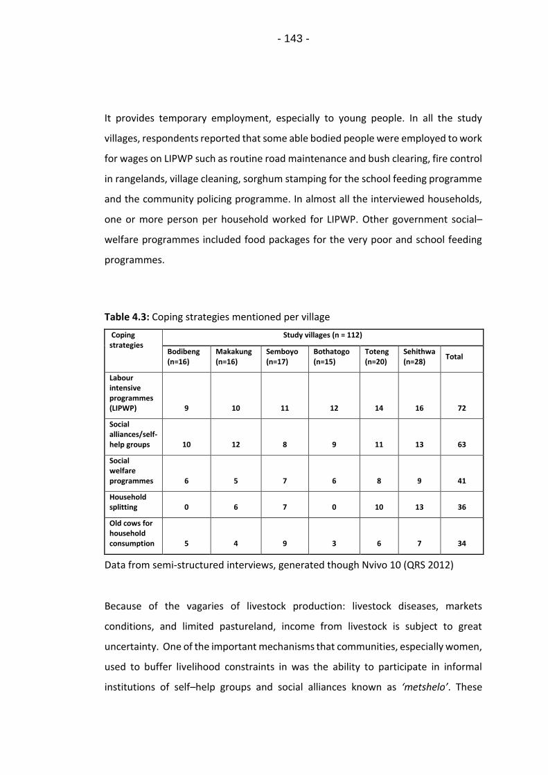
- 143 -
It provides temporary employment, especially to young people. In all the study
villages, respondents reported that some able bodied people were employed to work
for wages on LIPWP such as routine road maintenance and bush clearing, fire control
in rangelands, village cleaning, sorghum stamping for the school feeding programme
and the community policing programme. In almost all the interviewed households,
one or more person per household worked for LIPWP. Other government social–
welfare programmes included food packages for the very poor and school feeding
programmes.
Table 4.3: Coping strategies mentioned per village
Coping strategies
Study villages (n = 112)
Bodibeng (n=16)
Makakung (n=16)
Semboyo (n=17)
Bothatogo (n=15)
Toteng (n=20)
Sehithwa (n=28)
Total
Labour intensive programmes (LIPWP) 9 10 11 12 14 16 72
Social alliances/self-help groups 10 12 8 9 11 13 63
Social welfare programmes 6 5 7 6 8 9 41
Household splitting 0 6 7 0 10 13 36
Old cows for household consumption 5 4 9 3 6 7 34
Data from semi-structured interviews, generated though Nvivo 10 (QRS 2012)
Because of the vagaries of livestock production: livestock diseases, markets
conditions, and limited pastureland, income from livestock is subject to great
uncertainty. One of the important mechanisms that communities, especially women,
used to buffer livelihood constraints in was the ability to participate in informal
institutions of self–help groups and social alliances known as ‘metshelo’. These

- 144 -
networks are developed in a reciprocal and participatory manner and are defined by
kinship, friendship, or neighbourhood and some extend beyond village boundaries to
incorporate members from other villages. They pursue active give-and-take links
which include labour exchange (during ploughing season), the establishment of
saving schemes and a traditional non-cash gift system that includes food and
household utensil donations on a rotational basis among members. In the sandveld
village of Makakung, the village network went a step further to establish a traditional
choral group that was often engaged to perform in cultural events both locally and
in neighbouring Namibia. Proceeds from the choir went towards the saving scheme,
some of which linked into a burial society fund used to help members bury loved
ones by contributing food and money. Households that were able to invest resources
in such schemes were able to buffer shocks, such as enabling them to borrow money
to buy school uniforms.
Respondents also reported that they compensated for labour lost through
reallocation to other activities by relying on social networks or support from friends.
This included cooperation over herding related tasks and practices of labour sharing
such as watering of livestock on a rotational basis. Families with more labour
subdivided their household spatially (household splitting) such that they had a cattle
post on either side of the veterinary fences. Having two or more cattle posts
strategically located was considered advantageous because it allowed such a family
to sell when a market opportunity arose on either side of the fence.
4.3.2.2. Adaptation and livelihood diversification strategies
Livelihood diversification involves the creation of a portfolio of non-pastoral
livelihood activities. Table 4.4 gives a summary of thematic analysis of livelihood
adaptation strategies across the six study villages. Most households still keep a
significant number of diversified livestock; cattle, sheep, goats, donkeys and horses.
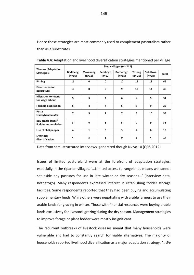
- 145 -
Hence these strategies are most commonly used to complement pastoralism rather
than as a substitutes.
Table 4.4: Adaptation and livelihood diversification strategies mentioned per village
Themes (Adaptation Strategies)
Study villages (n = 112)
Bodibeng (n=16)
Makakung (n=16)
Semboyo (n=17)
Bothatogo (n=15)
Toteng (n= 20)
Sehithwa (n=28)
Total
Fishing 11 0 0 10 12 13 46
Flood recession agriculture
10 0 0 9 13 14 46
Migration to towns for wage labour
5 9 8 6 4 5 37
Farmers association 5 4 4 5 9 9 36
Petty trade/handicrafts
7 3 1 7 7 10 35
Buy arable lands/ Fodder accumulation
3 6 5 5 7 9 35
Use of chili pepper 4 1 0 3 4 6 18
Livestock diversification
4 3 3 0 3 4 17
Data from semi-structured interviews, generated though Nvivo 10 (QRS 2012)
Issues of limited pastureland were at the forefront of adaptation strategies,
especially in the riparian villages. ‘…Limited access to rangelands means we cannot
set aside any pastures for use in late winter or dry seasons…’ (Interview data,
Bothatogo). Many respondents expressed interest in establishing fodder storage
facilities. Some respondents reported that they had been buying and accumulating
supplementary feeds. While others were negotiating with arable farmers to use their
arable lands for grazing in winter. Those with financial resources were buying arable
lands exclusively for livestock grazing during the dry season. Management strategies
to improve forage or plant fodder were mostly insignificant.
The recurrent outbreaks of livestock diseases meant that many households were
vulnerable and had to constantly search for viable alternatives. The majority of
households reported livelihood diversification as a major adaptation strategy, ‘…We

- 146 -
have to find alternative ways of putting food on the table. It is greedy to kill cows just
for meat, except of course on special occasions…’ (Key Informant Interview data,
Makakung). Livelihood diversification strategies included; fishing, migration to towns
by some members of the household in search of wage labour, petty trade, artisan
work such as basket weaving and leather tanning, and a shift to agro-pastoralism
especially the intensification of flood recession agriculture. The primary source of
petty commodity income was described in terms of the artisan production of crafts
as marketable commodities, table traders who sell produce in the market and some
illicit brews in homes.
The outbreaks of FMD since 2007 have resulted in an intensification of two livelihood
activities: fishing and flood recession cultivation. The riparian villages (Sehithwa,
Toteng, Bodibeng, and Bothatogo) all mentioned fishing as a livelihood diversification
strategy. Some young people have obtained loans from the Youth Development Fund
with the intention of investing in fishing activities. However, interviews with key
informants revealed that even though proceeds from fishing are attractive, fishing in
the area is not sustainable because of the nature of the lake’s flood regime. The high
number of people from across the district, and the country, flocking to the lake in
search of an alternative livelihood also make fishing a problematic activity. This has
prompted the Department of Wildlife and National Parks to frequently suspend
fishing in the lake citing hygiene issues and pollution problems, as well as conflicts
between fishers and other users; ‘…issues of squatters, poor sanitation, untidy
surroundings and criminal activities, including incidents of drowning were rife…the
decision to suspend fishing activities had to be taken…’ (Key informant interview,
Department Wildlife and National Parks, Fisheries Division, 2016).
Most of Ngamiland sandveld areas lack adequate rainfall for arable agriculture and
soils are generally poor. Discussants in both FGD and interviews reported that flood
recession agriculture, known locally as Molapo farming, is an important land use and
livelihood diversification activity for the rural poor living on the fringes of the
Okavango Delta. Molapo is a local term coined to refer to the seasonally flooded

- 147 -
plains (Motsumi et al., 2012). Villages along the rivers Kunyere, Nhabe and Lake
Ngami flood plains reported that they preferred Molapo farming over dryland
farming because soils are higher in fertility and tend to retain moisture for a long
time. Molapo cropping is less risky as the residual flood water in the soil acts as a
supply of moisture during seasons of low or poorly distributed rainfall. Respondents
reported that they also accessed government transfer payments to bolster dryland
rain-fed arable agriculture through the government’s Integrated Support Program for
Arable Agriculture Development (ISPAAD). Through ISPAAD, villagers received free
seeds, fertiliser and farming implements. Farmers who did not use the ISPAAD
tractors and ploughed using their own resources were given money equivalent to the
amount that the government would have spent to plough for them. However,
frustration towards elephants that destroy crops has caused many respondents to be
sceptical about arable farming, at least on a large scale. ‘…with ISPAAD you can have
some of your money back, but if you are lucky and the elephants avoid you, you can
have the money and the harvest’ (FGD data, Toteng).
Strategies to deal with human-elephant conflicts were limited. Traditional scare
tactics mentioned by respondents included making noise by beating drums, lighting
fires close to arable lands and keeping them burning overnight, or clearing vegetation
around the fields and boreholes so as to see elephants from a distance. ‘…these
tactics are not always effective as elephants quickly get used to them and with time
ignore them…’ (Key Informant Interview data, Toteng). Respondents expressed
frustration that elephants have become increasingly aggressive and less fearful of
humans. A few households reported that they had resorted to using chilli pepper as
a deterrent; a concept that was introduced to them by the Department of Wildlife
and National Parks. According to respondents, chilli is a natural irritant and its smell
causes intense but short-lived pain that drives elephants away. Chilli is dried, mixed
with cow dung and sun-dried into a brick, which is burnt by the edge of a field or
borehole at night. Others reported that they mix the chilli powder with used engine
oil or grease, which is then smeared on fences.

- 148 -
4.3.3. Processes that constrain or enable pastoralists’ adaptive
capacity
Understanding adaptation processes requires scrutiny of the combination of
conditions that affect the ability to adapt, and incentives or barriers that affect
adaptive capacity (Adger, 2006). In Ngamiland, focus group discussions perceived a
nexus of adaptation under three categories as detailed in Figure 4.3; Physical/Natural
environment, Economic resources and knowledge and Institutional structures. The
three can be considered pillars of adaptive capacity due to their influence on how
pastoral communities respond to constraints.
Figure 4.3: Adaptive capacity nexus in Ngamiland pastoral areas.
A clear disparity in adaptation strategies was noted between riparian villages
(because of their proximity to Lake Ngami or main road) and the sandveld villages
(Semboyo and Makakung) (as shown in Table 4.5). Villages closer to better roads

- 149 -
(riparian villages) had more frequent and direct contact with the market of Maun and
were able to produce more systematically for the market (Maun is the District’s
administrative centre, a primary tourism hub and the gateway to the Okavango
Delta). The majority of products produced by villagers, including artisan work such as
handicrafts are sold in Maun. Good road infrastructure was perceived to reduce the
cost of transport to markets as well as permitting entry into new and more profitable
pursuits. Similarly, the resources of Lake Ngami were described as a pull-factor
driving the transition to more intensive land-use around the lake and the few flood
plains. Limited infrastructural development in the sandveld villages was noted as a
key constraint to adaptation. Respondents in these villages discussed a lack of roads
or seasonally impassable and poorly maintained gravel roads, which made it difficult
to access critical resource areas. A marked distancing from government services was
noted in these villages with focus group discussions and key informant interviews
identifying a distinct lack of interest in providing assistance on the part of the
government or political leaders. Noteworthy is that despite a recognition of the
constraints related to pastoralism in these areas, inhabitants have not directly sought
to deviate from or abandon pastoralism, with all the group discussions and key
informant interviews pointing to a willingness to continue with pastoralism.
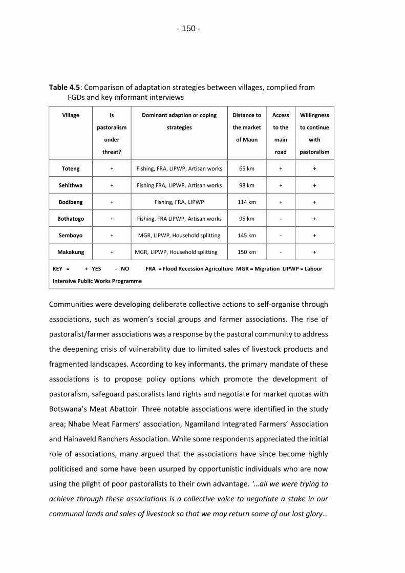
- 150 -
Table 4.5: Comparison of adaptation strategies between villages, complied from FGDs and key informant interviews
Village Is
pastoralism
under
threat?
Dominant adaption or coping
strategies
Distance to
the market
of Maun
Access
to the
main
road
Willingness
to continue
with
pastoralism
Toteng + Fishing, FRA, LIPWP, Artisan works 65 km + +
Sehithwa + Fishing FRA, LIPWP, Artisan works 98 km + +
Bodibeng + Fishing, FRA, LIPWP 114 km + +
Bothatogo + Fishing, FRA LIPWP, Artisan works 95 km - +
Semboyo + MGR, LIPWP, Household splitting 145 km - +
Makakung + MGR, LIPWP, Household splitting 150 km - +
KEY = + YES - NO FRA = Flood Recession Agriculture MGR = Migration LIPWP = Labour
Intensive Public Works Programme
Communities were developing deliberate collective actions to self-organise through
associations, such as women’s social groups and farmer associations. The rise of
pastoralist/farmer associations was a response by the pastoral community to address
the deepening crisis of vulnerability due to limited sales of livestock products and
fragmented landscapes. According to key informants, the primary mandate of these
associations is to propose policy options which promote the development of
pastoralism, safeguard pastoralists land rights and negotiate for market quotas with
Botswana’s Meat Abattoir. Three notable associations were identified in the study
area; Nhabe Meat Farmers’ association, Ngamiland Integrated Farmers’ Association
and Hainaveld Ranchers Association. While some respondents appreciated the initial
role of associations, many argued that the associations have since become highly
politicised and some have been usurped by opportunistic individuals who are now
using the plight of poor pastoralists to their own advantage. ‘…all we were trying to
achieve through these associations is a collective voice to negotiate a stake in our
communal lands and sales of livestock so that we may return some of our lost glory…

- 151 -
but, those with influence and money make decisions for their own benefits…’ (Key
informant interview data, Bodibeng). Respondents argued that some of these
associations have now limited themselves to issues of livestock sales and are charging
pastoralists large sums of money to transport their livestock to markets. They do not
address the broader patterns and nature of marginalisation. Such disjointed groups
are unlikely to mobilise the necessary resources critical for pastoralists’ adaptation
or bring pressure on policy making processes to address pastoralists’ needs.
4.4. DISCUSSION
This study investigated the ways in which pastoral communities respond to
constraints due to changes in the environment and in policy. Here, a history of
rangeland privatisation policies, animal health policies, and conservation policies
have had a strong influence on the way in which rangeland resources are now
accessed and managed by local pastoral communities (Basupi et al., 2017a). As
illustrated in the theoretical framework (Figure 4.1), in addition to fragmented and
disconnected landscapes, pastoralists must also contend with environmental
problems such as droughts, livestock diseases, human-wildlife conflicts and
rangeland degradation. While a combination of factors can be attributed to the
increase in livestock diseases, for example, climate change (Bett et al., 2017, Rojas-
Downing et al., 2017), increasing pastoralist vulnerability can also be attributed to
weakened coping mechanisms especially decreased mobility resulting from
rangeland enclosures and concentration of livestock on ever reducing communal
lands. Continuous contact and intermingling of herds at crowded water points and
stresses due to pasture shortages may account for higher prevalence of FMD in these
pastoral systems. The FMD crisis, its impact and management has taken on a new
urgency because it is now obviously driving people who have long been productive
into poverty (Basupi et al., 2017a).

- 152 -
Understanding changes in livelihoods is important in understanding rural
communities’ vulnerability and response to change, be that either policy or
environment driven (Twyman et al., 2004). In Ngamiland, pastoral communities
demonstrated a range of alternative livelihood activities, such as flood recession
agriculture, fishing, and petty trade. These are in turn bolstered by access to
government social welfare programmes; old age pensions, LIPWP, and destitute and
school feeding programmes. These coping and adaptation strategies are not without
challenges. Like in many other pastoral areas (Greiner and Mwaka, 2016, Rettberg,
2010), the ability to adapt is influenced by such factors as access to resources, access
to markets, the institutional environment within which adaptation occurs, political
influence, financial resources and kinship networks. Households with limited access
to resources and financial services were more vulnerable. Those with financial
resources were able to buy fodder or pay for private access to pasture in arable fields
and hence cope with the effects of constraints such as drought or limited grazing
lands. However, this option was only available to a limited number of households.
Similarly, remote villages in the sandveld had limited access to natural resources,
such as water and infrastructural services, compared to riparian villages, limiting
their diversification options. These examples illustrate how institutional and
landscape changes are leading to further uneven capacities within the pastoral
communities.
A key finding from this study is that landscape fragmentation and a lack of market
access threaten the sustainability of rangelands and challenge the practice of
pastoral mobility. While this might be fostering a rise in livelihood diversification
through non-pastoral activities, some of these strategies might actually undermine
the long-term sustainability of pastoralism and complicate responses to climate
change in the future. This has been found to be the case for many dryland pastoral
areas, such as in Kenya and Tanzania (Goldman and Riosmena, 2013, Galvin, 2009).
In the specific case of Ngamiland, flood recession agriculture and expansion of rain-
fed crop cultivation is based on the use of seasonally flooded plains and areas with

- 153 -
marginally higher productive potential, thus removing land from pastoralism that
would otherwise be highly productive and would have been traditionally used for dry
season grazing. Moreover, these strategies depend to a large extent on household
labour availability and ability of a household to direct their investment options to
strategies that add value to the household economy. Stiff competition for labour has
been noted as the demand for wage labour and migrations to towns’ increases, thus
posing a threat to traditional systems of labour sharing. Migration was more
pronounced in the sandveld villages where alternative livelihood options are limited.
Similarly, involvement in petty trade has removed an important source of labour
from the household and placed extra workload on the elderly. Most traders are
either absentee pastoralists or ex-pastoralists who have lost interest in livestock and
are now trying to make a living through informal income generating activities. This
has direct impact on livestock management and diseases control. As noted by Adger
and Vincent, 2005, adaptation may reduce risks over the short term yet cause an
increase in exposure to risk in the long term.
Similarly to other research in Botswana (Sallu et al., 2010), this study has found that
family involvement in social networks buffered the impacts of stress caused by
ecosystem deterioration and lack of alternatives. In most African communities,
informal associations are becoming increasingly important in shaping and mediating
local adaptation practices (Rodima-Taylor, 2012). For example, in the Tanzanian
Maasailand, pastoralists with access to the right social networks and sufficient labour
are more likely to have higher adaptive capacity compared to those who do not
(Goldman and Riosmena, 2013). However, despite the importance placed on these
associations, they face a number of challenges including a lack of entrepreneurial
skills, inadequate leadership skills, inadequate managerial ability, low levels of
production by member households and low purchasing power. In this study, pastoral
households struggled to balance between producing for their families and fulfilling
their obligations to these social networks. However, in-spite of the challenges, in
- 154 -
most study villages, social networks were said to perform better than externally
created initiatives.
Studies have shown how adaptive capacity is context specific, varies from community
to community and that it is not equally distributed (Engle, 2011, Smit and Wandel,
2006). In this research, the capacity of the riparian villages to undertake adaptations
was better than the more remote sandveld village communities who had limited
access to resources and infrastructural services. Understanding the different
adaptations that households implement and why provides some indication of
adaptive capacity, and so the adaptation space within which adaptation decisions are
likely to take place (Adger and Vincent, 2005, Twyman et al., 2004). It is important
that policy makers accommodate the necessary preconditions for pastoral
adaptation strategies in National Adaptation Programmes of Action (NAPAs).
Therefore the argument is to develop meaningful scenarios of adaptive capacity
rather than scenarios of adaptation per se. Often core causes of vulnerability such as
poor access to land, especially by the marginalised and vulnerable, and poor
infrastructural services need to be addressed first before impact-oriented adaptation
efforts can be effective. Once the conditions are favourable, communities are likely
to take the necessary steps to develop suitable adaptation strategies specific to their
socio-ecological systems. In Ngamiland, there is a need for practical initiatives that
improve pastoralists’ adaptive capacity at appropriate spatial and temporal scales.
This also includes the need for strengthening the knowledge base, improving data
gathering, surveillance/forecasting systems and sharing insights more widely across
the district and nationally.
4.5. CONCLUSION
Adaptation is a social process that requires attention to the structures that influence
vulnerability and adaptive capacity, including local level (on-the-ground) actions that
pastoralists conduct in order to address vulnerability. Understanding these

- 155 -
strategies, including their implications, through a participatory process could form
the basis of better formulated policy intervention or development projects in
pastoral areas. In Ngamiland, income from pastoralism is subject to great uncertainty
arising from livestock diseases, market conditions and limited access to productive
rangelands, and climate-related constraints such as droughts. Opportunities for wage
labour are limited, and the high dependency on the Botswana government’s labour
intensive public works program suggests a society in dire need of alternative sources
of income.
This study shows how social networks of self-help groups and farmers associations
are now an important aspect of the vulnerability context and pastoralists adaptive
capacity. Well managed networks provide solidarity within and across villages, and
thus help manage multiple constraints collectively. Supporting pastoralists’ adaptive
capacity in this context is not about targeting one particular strategy but empowering
local pastoral communities in acquiring flexibility and inclusiveness in their response
system. Assistance from practitioners is essential in empowering and assisting
pastoral communities to self-organise. The requirement on the part of practitioners
is to provide a platform for the formalisation of these groups and ensure that they
are backed by necessary legislative instruments and also supported to establish
simple constitutional documents, functional leadership, formal registration and
training. These groups, when functional, can then develop their own action plans that
allow each community to identify their own situation-specific entry points and level
of involvement in livestock and land management, including a long-term strategy for
engagement with the government.
The capacity and options of pastoralists to adjust their livelihood options are shaped
in turn by infrastructural development and institutional structures. Like in other
dryland areas, Ngamiland drylands are disadvantaged in the distribution of public
resources and provision of services. The availability of livelihood options that depend
more on infrastructural development like inter-village trade is hence hampered by
poor roads and other development policy biases against dryland areas. The dynamics

- 156 -
of household labour availability also comes into focus as pastoralists redirect their
household labour with negative impacts on herd management strategies. Livelihood
diversification is happening but some opportunities like fishing may not be feasible
over the longer term unless backed by a more sustainable fisheries sector (e.g.
improved fishing, processing and market access infrastructure) and an adequate
legislative framework aimed at developing the livelihoods of communities around
the lake and safe guarding the lake environs. As the ability to adapt has positive
attributes for livelihood sustainability and resilience, there is a need for practical
initiatives that improve pastoralists’ adaptive capacity, such as reforming
pastoralists’ institutions and expanding infrastructural development in pastoral areas
so as to enable access to markets. These also include the need to share insights more
widely across the district, nationally and regionally.
4.6. ACKNOWLEDGEMENTS
This research was supported by funding from the Botswana International University
of Science and Technology (BIUST), Government of Botswana and the University of
Leeds Sustainable Agriculture Fund Bursary. The research was conducted with the
permission of The Ministry of Environment, Wildlife and Tourism in Botswana (Now
Ministry of Environment, Natural Resources Conservation and Tourism)
(Government research permit number EWT 8/36/4 XXX (73)). This research would
not have been possible without the active participation, support and cooperation of
Ngamiland pastoral communities in the villages of Toteng, Bothatogo, Bodibeng,
Sehithwa, Makakung and Semboyo. Many thanks to the anonymous reviewers for
their insightful comments and suggestions. Thanks to Ms. Onkemetse Thelma
Tabulawa for feedback on an earlier draft of this manuscript.

- 157 -
4.7. REFERENCES
ABEL, N., CUMMING, D. H. & ANDERIES, J. 2006. Collapse and reorganization in social-ecological systems: questions, some ideas, and policy implications. Ecology and Society, 11.
ADGER, W. N. 2006. Vulnerability. Global Environmental Change, 16, 268-281.
ADGER, W. N. & VINCENT, K. 2005. Uncertainty in adaptive capacity. Comptes Rendus Geoscience, 337, 399-410.
AGRAWAL, A. 2010. Local institutions and adaptation to climate change. Social dimensions of climate change: Equity and vulnerability in a warming world, 2, 173-178.
ANDERIES, J. M., JANSSEN, M. A. & OSTROM, E. 2004. A framework to analyze the robustness of social-ecological systems from an institutional perspective. Ecology and Society, 9.
AU 2010. Policy Framework for Pastoralism in Africa: Securing, Protecting and Improving the Lives, Livelihoods and Rights of Pastoralist Communities. African Union, Department of Rural Economy and Agriculture, Addis Ababa, Ethiopia.
BASUPI, L. V., QUINN, C. H. & DOUGILL, A. J. 2017a. Historical perspectives on pastoralism and land tenure transformation in Ngamiland, Botswana: What are the policy and institutional lessons? Pastoralism, 7, 24.
BASUPI, L. V., QUINN, C. H. & DOUGILL, A. J. 2017b. Using participatory mapping and a participatory geographic information system in pastoral land use investigation: Impacts of rangeland policy in Botswana. Land Use Policy, 64, 363-373.
BATISANI, N. & YARNAL, B. 2010. Rainfall variability and trends in semi-arid Botswana: Implications for climate change adaptation policy. Applied Geography, 30, 483-489.
BETT, B., KIUNGA, P., GACHOHI, J., SINDATO, C., MBOTHA, D., ROBINSON, T., LINDAHL, J. & GRACE, D. 2017. Effects of climate change on the occurrence and distribution of livestock diseases. Preventive Veterinary Medicine, 137, 119-129.
BOLLIG, M. 2010. Risk management in a hazardous environment: A comparative study of two pastoral societies, Springer Science & Business Media.
BRIMP 2002. The Biomass Map of Botswana: Growing Season 2000/2001. Botswana Range Inventory and Monitoring Project (BRIMP), Ministry of Agriculture, Gaborone.
DAVIES, S. 1993. Are Coping Strategies a Cop Out? IDS Bulletin, 24, 60-72.

- 158 -
DEMOTTS, R. & HOON, P. 2012. Whose Elephants? Conserving, Compensating, and Competing in Northern Botswana. Society & Natural Resources, 25, 837-851.
DMS 2017. Weather and Climate Digest. Department of Meteorological Services, Ministry of Environment, Natural Resources Conservation and Tourism, Gaborone, Botswana.
DOL 2009. Department of Lands (DoL). Ngamiland Integrated Land Use Plan, Final Report, . Ministry of Lands and Housing, Botswana.
DOUGILL, A. J., FRASER, E. D. G. & REED, M. S. 2010. Anticipating Vulnerability to Climate Change in Dryland Pastoral Systems: Using Dynamic Systems Models for the Kalahari. Ecology and Society, 15.
DTRP 2003. Ngamiland District Settlement Strategy. Department of Town and Regional Planning (DTRP), Gaborone, Botswana.
DVS 2000. Livestock Report: CBPP, destocking and restocking. Department of Veterinary Services, Maun, Botswana.
DVS 2016. Department of Veterinary Services. Livestock Census Report - Ngamiland District. Ministry of Agriculture, Gaborone, Botswana.
ELLIS, J. E. & SWIFT, D. M. 1988. Stability of African pastoral ecosystems: alternate paradigms and implications for development. Rangeland Ecology & Management/Journal of Range Management Archives, 41, 450-459.
ENGLE, N. L. 2011. Adaptive capacity and its assessment. Global Environmental Change, 21, 647-656.
FOLKE, C. 2006. Resilience: The emergence of a perspective for social-ecological systems analyses. Global Environmental Change-Human and Policy Dimensions, 16, 253-267.
FOLKE, C., CARPENTER, S., ELMQVIST, T., GUNDERSON, L., HOLLING, C. S. & WALKER, B. 2002. Resilience and sustainable development: Building adaptive capacity in a world of transformations. Ambio, 31, 437-440.
FORSYTH, T. & EVANS, N. 2013. What is Autonomous Adaption? Resource Scarcity and Smallholder Agency in Thailand. World Development, 43, 56-66.
GALVIN, K. A. 2009. Transitions: Pastoralists living with change. Annual Review of Anthropology, 38.
GOLDMAN, M. J. & RIOSMENA, F. 2013. Adaptive capacity in Tanzanian Maasailand: Changing strategies to cope with drought in fragmented landscapes. Global Environmental Change, 23, 588-597.
GREINER, C. & MWAKA, I. 2016. Agricultural change at the margins: adaptation and intensification in a Kenyan dryland. Journal of Eastern African Studies, 10, 130-149.
HARDIN, G. 1968. The tragedy of the commons. Science, 162, 1243 - 8.

- 159 -
HERRERO, M., THORNTON, P. K., GERBER, P. & REID, R. S. 2009. Livestock, livelihoods and the environment: understanding the trade-offs. Current Opinion in Environmental Sustainability, 1, 111-120.
HITCHCOCK, R. K. 2002. Coping with uncertainty: adaptive responses to drought and livestock disease in the Northern Kalahari. Sustainable Livelihoods in Kalahari Environments: Contributions to Global Debates, 161-192.
IFEJIKA SPERANZA, C. 2010. Drought Coping and Adaptation Strategies: Understanding Adaptations to Climate Change in Agro-pastoral Livestock Production in Makueni District, Kenya. The European Journal of Development Research, 22, 623-642.
IPCC 2014. Climate Change 2014: Synthesis Report. Contribution of Working Groups I, II and III to the Fifth Assessment Report of the Intergovernmental Panel on Climate Change [Core Writing Team, R.K. Pachauri and L.A. Meyer (eds.)]. IPCC, Geneva, Switzerland, 151.
MAGNANI, S. D., ANCEY, V. & HUBERT, B. Resilience, social-ecological system and pastoral mobility: the risk of simplification. Resilience Alliance 2014, 2014-05-04 / 2014-05-08 2014 Montpellier, France. restricted: Centre pour la Communication Scientifique Directe, 746-746.
MAGOLE, L. 2009. The 'shrinking commons' in the Lake Ngami grasslands, Botswana: the impact of national rangeland policy. Development Southern Africa, 26, 611-626.
MORITZ, M., GIBLIN, J., CICCONE, M., DAVIS, A., FUHRMAN, J., KIMIAIE, M., MADZSAR, S., OLSON, K. & SENN, M. 2011. Social Risk-Management Strategies in Pastoral Systems: A Qualitative Comparative Analysis. Cross-Cultural Research, 45, 286-317.
MOTSUMI, S., MAGOLE, L. & KGATHI, D. 2012. Indigenous knowledge and land use policy: Implications for livelihoods of flood recession farming communities in the Okavango Delta, Botswana. Physics and Chemistry of the Earth, 50-52, 185-195.
NARAYANASAMY, N. 2009. Participatory rural appraisal: Principles, methods and application, SAGE Publications India.
NEUMANN, R. P. 1995. LOCAL CHALLENGES TO GLOBAL AGENDAS: CONSERVATION, ECONOMIC LIBERALIZATION AND THE PASTORALISTS' RIGHTS MOVEMENT IN TANZANIA. Antipode, 27, 363-382.
NIAMIR-FULLER, M. 1999. Managing mobility in African rangelands. Property rights, risk and livestock development in Africa, 102-31.
PAAVOLA, J. 2008. Livelihoods, vulnerability and adaptation to climate change in Morogoro, Tanzania. Environmental Science & Policy, 11, 642-654.

- 160 -
PATTON, M. Q. 1990. Qualitative Evaluation and Research Methods., Sage Publications, Inc, Newbury.
PETERS, P. E. 1994. Dividing the commons: politics, policy, and culture in Botswana, Charlottesville, University Press of Virginia.
RETTBERG, S. 2010. Contested narratives of pastoral vulnerability and risk in Ethiopia’s Afar region. Pastoralism, 1, 248-273.
ROB 1991. Republic of Botswana, National Policy on Agricultural Development (NPAD). Government Printers, Gaborone, Botswana.
RODIMA-TAYLOR, D. 2012. Social innovation and climate adaptation: Local collective action in diversifying Tanzania. Applied Geography, 33, 128-134.
ROHDE, R. F., MOLEELE, N. M., MPHALE, M., ALLSOPP, N., CHANDA, R., HOFFMAN, M. T., MAGOLE, L. & YOUNG, E. 2006. Dynamics of grazing policy and practice: environmental and social impacts in three communal areas of southern Africa. Environmental Science & Policy, 9, 302-316.
ROJAS-DOWNING, M. M., NEJADHASHEMI, A. P., HARRIGAN, T. & WOZNICKI, S. A. 2017. Climate change and livestock: Impacts, adaptation, and mitigation. Climate Risk Management, 16, 145-163.
SALLU, S. M., TWYMAN, C. & STRINGER, L. C. 2010. Resilient or Vulnerable Livelihoods? Assessing Livelihood Dynamics and Trajectories in Rural Botswana. Ecology and Society, 15.
SCHNEGG, M. & BOLLIG, M. 2016. Institutions put to the test: Community-based water management in Namibia during a drought. Journal of Arid Environments, 124, 62-71.
SCOONES, I. 1995. Living with uncertainty. New directions in pastoral development in Africa, London, Intermediate Technology Publications Ltd.
SMIT, B. & WANDEL, J. 2006. Adaptation, adaptive capacity and vulnerability. Global Environmental Change, 16, 282-292.
SPEELMAN, E. N., GROOT, J. C. J., GARCIA-BARRIOS, L. E., KOK, K., VAN KEULEN, H. & TITTONELL, P. 2014. From coping to adaptation to economic and institutional change - Trajectories of change in land-use management and social organization in a Biosphere Reserve community, Mexico. Land Use Policy, 41, 31-44.
STRINGER, L. C. & REED, M. S. 2007. Land degradation assessment in southern Africa: integrating local and scientific knowledge bases. Land Degradation & Development, 18, 99-116.
TLOU, T. 1985. A history of Ngamiland: the formation of an African State, Gaborone, Botswana, Macmillan Publishers.

- 161 -
TONGCO, M. D. C. 2007. Purposive Sampling as a tool for Informant Selection: Research Methods. Ethnobotany Research and Application: A journal of Plants, People and Applied Research., 5.
TWYMAN, C., SPORTON, D. & THOMAS, D. S. G. 2004. ‘Where is the life in farming?’: The viability of smallholder farming on the margins of the Kalahari, Southern Africa. Geoforum, 35, 69-85.
WHITE, R. 1993. Livestock development and pastoral production on communal rangeland in Botswana. The Botswana Society, Gaborone.

- 162 -
CHAPTER 5:
Institutional Challenges in Pastoral Landscape Management: Towards Sustainable Land Management in Ngamiland,
Botswana10
10 In Review
Journal: Land Degradation and Development

- 163 -
ABSTRACT
Policies, institutions and governance structures have implications for the sustainable
use of land resources. In dryland Africa, pastoral landscapes are faced with challenges
of land degradation, livestock diseases, droughts and land use conflicts. In order to
enhance resilience and integrity of pastoral societies and landscapes, Sustainable
Land Management (SLM) requires that policies and institutions create an enabling
environment that encourages sustainable use. This study analyses current policy,
institutional and governance challenges in relation to SLM in Ngamiland, Botswana.
We use a series of expert interviews, local stakeholder workshops, document and
policy content analysis to analyse policy and institutional challenges. Key policy and
institutional threats and thus challenges for SLM include: fragmented institutional
and policy frameworks, conflicting policies and priorities, weak governance
structures, lack of integrated planning and coordination between sectors, gaps in
communication, knowledge gaps and fragmented pastoralists lobbying institutions.
Harmonisation of sectoral policies requires institutional and policy design to consider
institutional co-ordination and enhanced learning on other actors’ perspectives and
constraints. Findings in Ngamiland show that integrative geospatial approaches can
play a role in facilitating inter-sectoral data sharing to enable successful development
of pastoral landscapes and a supportive decision-making system for SLM.
Keywords: Rangelands; Pastoralism; Policy Analysis; Institutions; Co-management.
5.1. INTRODUCTION
In sub-Saharan Africa, pastoralism is the dominant livelihood activity for the majority
of the rural populace (Catley et al., 2013). Pastoralists modes of production have
been consistently portrayed as unproductive, responsible for land degradation and

- 164 -
threatening the survival of the system they depend on (Sinclair and Fryxell, 1985).
Communal land tenure practices have been blamed for discouraging private
investments and encouraging higher stocking rates (Rohde et al., 2006). As the
evidence pointing to the limitation of this thinking has accumulated, discussions have
moved from a narrow land tenure focus to a wider interdisciplinary discourse (Oba,
2013). A growing body of opinion now considers pastoralism as a viable form of land-
use in drylands (Davies, 2008). This necessitates the need for policies and
management strategies to move towards tackling institutional challenges in support
of more SLM practices. SLM is concerned with the management of land and water
resources in a manner that is capable of delivering solutions which integrate
environmental, economic and social objectives without damaging ecological
processes (UNEP, 2016). To realise SLM for rangelands requires an ability to
overcome policy and institutional fragmentation and develop locally-appropriate,
flexible and tailored solutions (Cowie et al., 2011). However, many governments,
especially in sub-Saharan Africa, still face the challenge of properly assessing policy
outcomes, and developing the right mix of policies and institutional frameworks that
address and accelerate pastoral development while protecting biodiversity in
rangelands (Notenbaert et al., 2012). The consequences of inadequate land
management frameworks can be seen in unnecessary rangeland resource
degradation, land use conflicts, and decisions that favour short-term, piecemeal
responses (UNCCD, 2013).
Botswana’s semi-arid rangelands make a significant contribution to the livelihoods
and wellbeing of its rural communities, many of whom depend on cattle (SB, 2013).
The country’s national development plans from independence in 1966 to the
present, indicate substantial government expenditure in agricultural production and
wildlife conservation programmes (ROB, 2009). Significant expenditure has been
invested in veterinary services and cordon fences, water-point policies, rangeland
privatisation policies and the provision of livestock subsidies. Like many other sub-
Saharan African countries, Botswana faces the significant challenges of land

- 165 -
degradation (DEA, 2006), land use conflicts, livestock diseases and drought (DoL,
2009). In parts of the country rangeland degradation has led to extensive bush
encroachment, bare soils and a decline in the cover density of perennial and
palatable grass species (Moleele et al., 2002). The persistence of dual grazing rights
for those who have been allocated ranches promotes overgrazing on communal
lands and livestock encroachment into wildlife management areas, impacting
negatively on wildlife habitats (Rohde et al., 2006). Efforts have been made to
address unsustainable practices, reduce rangeland degradation and improve rural
livelihoods in communal areas (e.g. Favretto et al., 2016, Reed et al., 2015). However,
the implementation of rangeland management strategies remains a challenge and
this has prompted some studies to question the efficiency of the current institutional
arrangements and legislative frameworks (Mulale et al., 2014, DEA, 2008).
Botswana’s policy approach to management of land and water resources, as with
other sub-Saharan African countries, is through a range actors with a multiplicity of
policies, regulations, and legislative instruments (Mulale et al., 2014). To date,
studies of Botswana’s institutional frameworks and the capacities of actors to
implement strategies that are geared towards the sustainable use of rangelands are
limited. This study draws on a series of expert interviews, a local stakeholder
workshop and content analysis of policy documents to analyse and assess the land
management policies and institutional frameworks for SLM practices in Ngamiland
district, Botswana.
5.1.1. Scaling-up SLM in pastoral areas through multi-sectorial
collaboration and co-management
Scaling up SLM in pastoral landscapes focuses on adapting successful policies and
programs that can reach greater number of pastoralists and communities.
Institutional and policy changes are required to create an enabling environment to

- 166 -
promote adoption of SLM. Figure 5.1 illustrates how SLM in pastoral landscapes can
be scaled up through effective institutional and policy support. Identifying the
barriers (constraints in pastoral areas) from an array of contributing factors is a key
first step. The second step involves identifying institutional, policy and stakeholders
at nested spatial scales (Basurto, 2013, Osei-Tutu et al., 2015). By identifying
stakeholders at nested spatial scales, it is possible to identify trade-offs arising from
the adoption of certain strategies, for example, impacts of a fence on access to key
resource areas for a certain pastoral community or on wildlife movement. Once such
trade-offs have been identified, it is possible to facilitate a cost-benefit analysis and
dialogue between affected stakeholders so as to manage conflict and mitigate the
worst negative effects. The third step involves fostering institutional and multi-
sectorial collaboration through collaborative co-management and capacity building
at the local scale (Leys and Vanclay, 2011). Management of communal resources such
as grazing lands, forests and wildlife are always too complex to be managed by a
single agency (Berkes, 2009). This requires a strategy that engages key stakeholders;
pastoralists, famers, NGOs, research teams and state-planners, through a continuous
learning process. Such a strategy should include working were necessary with high
level intermediaries to build momentum for policy change (Pahl-Wostl, 2009).
The concept of co-management realises that in order to deal with the shortcomings
of a single agency and top down management, management activities must be
collaborative in practice (Berkes, 2009). Co-management involves the sharing of
responsibilities between government and resource users (Carlsson and Berkes,
2005). The concept works best when combined with learning based approaches such
as adaptive management. Adaptive co-management emphasises innovative
strategies that explicitly foster collaboration between stakeholders and learning,
which contribute to trust building and the formation of social networks of all
stakeholders; researchers, communities, NGOs and policy makers (Armitage et al.,
2009). Such collaborative institutional frameworks are critical to the needs of this
study.

- 167 -
Figure 5.1: Effective institutional and policy support for scaling-up SLM in pastoral landscapes
The aim of the paper is to analyse current policy, institutional and governance
challenges in relation to SLM and access to rangeland resources in Ngamiland
pastoral landscapes. The objectives are to: (1) identify policies and legislative
frameworks that have a direct or indirect impact on communal grazing lands and
assess their stance on issues of SLM; (2) assess the district institutional frameworks
and their implications for SLM in Ngamiland pastoral landscapes; and (3) determine
how current arrangements for managing pastoral landscapes can be integrated into
a more effective and accountable framework for SLM adoption in drylands.

- 168 -
5.2. MATERIALS AND METHODS
5.2.1. Study Area
Ngamiland district presents an interesting case to analyse policies and institutions
due to its multifunctional landscapes. The focus area is populated by pastoralists; the
Ovambanderu and Ovaherero ethnic groups who practice extensive livestock
keeping across communally managed rangelands (Tlou, 1985). Due to the Okavango
delta system, these rangelands are also home to a diversity of plants and animal
species, including migratory wildebeests and elephants (DEA, 2008). Supported by a
number of national agricultural policies notably the Tribal Grazing Land Policy of 1975
(TGLP), National Policy on Agricultural Development of 1991 (NPAD) and
international trade agreements for access to international beef markets (Stevens and
Kennan, 2005), former communal rangelands south of the delta are being privatized
and fenced to create incentives for SLM. This has restricted resource access by local
pastoral communities (Basupi et al., 2017). Pastoralism has been subject to frequent
outbreaks of livestock diseases, notably Foot and Mouth Disease (FMD). Veterinary
fences have been created to separate livestock from wild animals, especially
buffaloes as carriers of the FMD virus. The district land use plans and other natural
resource management strategies (DoL, 2009, DEA, 2008) recognise that competing
land uses, land use conflicts and environmental degradation cannot be resolved by
continuously extending the boundaries of one land use at the expense of the other.
This calls for a clear strategy to ensure close integration of land management efforts
and mechanisms to manage the pastoral landscape sustainably (DEA, 2008). Figure
5.1 shows the current land use zones in Ngamiland.

- 169 -
Figure 5.2: Ngamiland District Land Use Zones Data source: Department of Lands, Ministry of Agriculture.
5.2.2. Conceptual framework
The political modernisation and policy arrangements framework (Arts et al., 2006)
helps explain the structure of environmental policy arrangements in terms of policy
content and organisation. We adopted this framework and modified it for
Botswana’s environmental policy context (Figure 5.2). The emphasis of the
framework is on policy actors, policy discourses and policy processes. Policy actors
are the authorities, their powers, influence, and coalitions in the policy domain
(Rogge and Reichardt, 2016). The notion of discourse refers to actual policy content
and how the views of actors are embedded within policy (Arts et al., 2006) and
considers the comprehensiveness of policy elements (Rogge and Reichardt, 2016).

- 170 -
Policy processes are concerned with policy making and implementation processes,
which contribute directly or indirectly to the achievement of objectives (Rogge and
Reichardt, 2016). Resources such as money, information or support are required for
a successful implementation process (Runhaar et al., 2006). As such, coherent policy
processes should include a clear implementation strategy outlining funding of
activities within it.
Figure 5.3: Conceptual framework for analysing policy arrangements and connections (adapted from Arts et al., 2006).
5.2.3. District Stakeholder workshop & Expert Interviews
A local level stakeholder workshop was held with 13 government officials from the
Ngamiland District Land Use Planning Unit (DLUPU). DLUPU is an integrated
committee comprising government departments; Land Board official, Senior Lands
Officer (Tawana Land Board), Council Physical Planner, Scientific officer (Animal
Production), Council Planning officer (Economic), District Officer (Development),

- 171 -
Land Use Officer (Crops), Wildlife Biologists, Scientific Officer (Veterinary Services),
Secretary to the District Conservation Committee, Range Ecologist, District Tourism
Officer, District Environmental Coordinator. We divided the workshop into two
sessions. The first discussion focused on exploring issues and challenges experienced
in communal grazing areas, compiling a list of policies, legislative frameworks, and
institutions that directly or indirectly influence land management and pastoralism in
Ngamiland communal areas and identifying policy and institutional challenges. The
second part of the discussion explored solutions and measures that could address
the identified issues and challenges. Each discussion lasted for approximately 90
minutes. In addition, expert interviews were held with professionals from
government offices both before and after the stakeholder workshop. These
interviews enabled assessment of the relationship between the district land
management institutional framework and the organizational structures.
Respondents were as follows; Department of Environmental Affairs (n = 2), Tawana
Land Board (n = 4), Department of Wildlife and National Parks (n = 4), Department
of Veterinary Services (n = 4), Department of Forestry and Range Resources (n = 2),
District Administration (n = 2) and Tribal Administration (‘Dikgosi’ or Village Chiefs
and chairpersons of Farmers’ Committees (n = 11)). The data from stakeholder
workshop discussions and expert interviews were analysed using qualitative content
analysis (Flick, 2015)
5.2.4. Policy content analysis
The stakeholder workshop identified policies that have a significant impact on
pastoralists’ issues and communal areas in the district. Copies of relevant policies and
management plans were obtained from district offices and the Government
publishing agency. The documents were analysed using iterative content analysis,
examining narratives in relation to SLM within each policy document (Forbes, 2000).
The policy evaluation and appraisal criteria in Table 5.1 were identified based on

- 172 -
decision support needed for upscaling SLM best practices in pastoral landscapes
(Liniger et al., 2011); addressing the root cause of land use conflicts and land
degradation; multi-stakeholder involvement and multi-sectorial approaches. We
examined policy stances that provide for cross-sectoral and collaborative
management of communal lands.
Table 5.1: Criteria for determining policy stance towards SLM
No support for SLM (-) No co-management, top-down imposition, no
reference or inference to SLM
Weak support for SLM (+) Single sector focus, no references to other sectors,
no clear implementation strategy
Medium support for SLM
(++)
Has potential for co-management hence SLM,
however, activities towards SLM and
implementation strategies are not explicit
Strong support for SLM
(+++)
Strong on co-management, equitable access,
participation, extensive decision-making, clear
implementation strategy
5.2.5. Institutional capacity assessment
Barley and Tolbert (1997: 6), define institutions as ‘shared rules and typifications that
identify categories of social actors and their appropriate activities or relationships’.
Understanding the nature of resource institutions helps explore links between
various institutional arrangements involved in natural resource management.
Organisations are structures made up of individual actors some with conflicting
objectives (Hodgson, 2006). Hence institutions are socially constructed templates for
actions, produced and maintained through ongoing interactions and collaborations
between organisations (Barley and Tolbert, 1997). Ostrom (1990) proposed a set of
conditions (Ostrom’s eight design principles) that could influence the likelihood that

- 173 -
self-governing institutional arrangements will be long-lasting and improve
management of Common Pool Resources (CPRs). Design principle 8 states that
appropriation, provision, monitoring, enforcement of rules, conflict resolution and
governance activities must be organised in multiple layers of nested enterprises in
order to achieve sustainable management of CPRs. Understanding the relationship
between multi-level institutional linkages and conditions influencing the likelihood
of successful co-management has practical relevance to SLM upscaling and local
resource governance (Basurto, 2013). Since it is argued that SLM must be
mainstreamed into broader sectorial institutional frameworks (WOCAT, 2009), we
assessed organisational structures and institutional frameworks based on their
capacities and efficiency in supporting SLM through collaboration between actors
involved in implementing land use policies and resources management plans, i.e. co-
management. Efficiency was determined by clear institutional arrangements, clear
cross-sector collaboration or communication linkages, traceable budgets towards
SLM activities, technologies in place to upscale SLM best practices (Liniger et al.,
2011) and evidence for engagement and involvement of pastoralists communities in
the planning of activities. At the local level, linkages are between local level
institutions and district actors through direct involvement in decision making and
developing co-management arrangements to increase political support for
local/village level livestock management institutions (Armitage et al., 2008). Linkages
at the national level are between district actors, local level structures and the central
government through active participation in national-level policymaking on SLM and
pastoralism issues. These linkages are thought to create interdependencies by which
local level institutions can shape their bargaining power with the central government
on a variety of issues including autonomy in resource management (Armitage et al.,
2009). Autonomy in this case means local institutions are able to exercise self-
governance over decision making and implementation without being constantly
overruled by the central government (Bodin and Crona, 2009)

- 174 -
5.3. RESULTS
5.3.1. Policies and legislative frameworks
During the stakeholder workshop, a number of policy-related factors were identified
as critical (Table 5.2).
Table 5.2: Summary of issues from stakeholder workshop
Issue Area of concern
Livestock
and Land
management
Uncontrolled expansion in livestock numbers.
Difficulties within the livestock marketing system.
Outbreak of livestock diseases.
Shrinking communal grazing lands
Lack of alternative investments opportunities and
adaptive capacities.
Presence of invasive species observed around villages and
Lake Ngami.
Issues related to the position, operation, maintenance,
effectiveness and impact of the veterinary fences.
Policies and
Institutions Legal pluralism - traditional management institutions
operate alongside modern legislative frameworks.
Lack of integrated planning, coordination, and cooperation
between the many actors with responsibilities for
rangeland management.
Lack of enforcement of existing land use policies.
Knowledge and technological gaps.
Consultation
and
participation
Pastoralists’ opinions are not taken into consideration in
policy making.
Information not communicated in a way that is practical
for local communities to apply.
No motivational incentives for improved livestock and
land management.
5.3.2. Policy processes

- 175 -
Key stakeholders, including chiefs and members of the Farmers’ Committees, had
only a vague impression of policies, some of which have important impacts on
communal grazing lands and pastoralism. For instance, village level representatives
from Village Development Committees (VDC) did not know of the existence of any
Integrated Land Use Plan for the district. They argued that policy making processes
remain top-down and communities tend to be aware of only basic services or
information which are acquired through one-of village-level Kgotla consultation
meetings or via state radio. Communities are consulted after the policy process and
agenda has been discussed and agreed at central government level by elites who
often do not understand the policy implications. ‘The issue is we as the people only
get to talk about the policy in terms of how it can work best for us, the other aspects
like whether the policy is necessary, why and what kind of policy, are reserved for the
government and the political elites…’ (Interview data, Member of the Farmers’
Committee, Toteng, 2016).
Participants stressed the implementation challenges brought about by centralized
policy making processes which do not take into consideration the spatial
heterogeneity of different pastoral landscapes. Policy makers tend to treat the
country as a homogenous landscape such that the same policy instrument can be
applied throughout the country ‘…we need to say at the policy level: this is how we
can use opportunities available in the district to help pastoral communities, but we
can’t because the policy making process is centralised….’ (Expert interview data, DVS,
Maun, 2016). Some extension officers felt that they are given policies and
programmes to implement without being asked whether they will work. One
example given was wildlife compensation within the Wildlife Conservation Policy of
1990, where the compensation for wildlife damage to livestock or crops is
significantly lower than the value of the lost crop, animal or property. Officers argued
that the issue negatively affects the attitude of communities towards wildlife as
people feel the government cares more for wildlife than people or livestock.

- 176 -
5.3.3. Policy discourse
The policies and statutes analysed (Table 5.3) relate to management of communal
areas and have implications for SLM and pastoralism. Using the criteria in Table 5.1,
the instruments were assessed to identify their support for SLM. Botswana’s long-
term vision for management of environmental resources, ‘a fully integrated
approach towards conservation and development of resources…including equitable
distribution of these resource between its people’ (RoB, 1990) is consistent with the
principles of co-management. It is evident from Table 5.3 that the intentions of policy
or legislative instruments as far as management of communal resources is concerned
are based on key sustainable development principles; equity and fairness in
allocation of land resources (RoB, 1968), sustainable use of natural resources through
a coordinated policy approach (RoB, 1990) or effective Livestock disease control
(RoB, 1977) among others.
The first legislative instrument which considered management of communal areas
was the Tribal Land Act of 1968, which replaced customary institutions for land
management. The change in land management institutions with the transfer of
responsibility for land allocation from Chiefs to Land Boards has affected the land use
system. Though the Act advocates equity and fairness, land management decisions
and powers of control lie solely with select Board Members who are answerable to
the ‘Minister of Lands’ (RoB, 1968). ‘In most cases, Land Board Members do not have
expertise in the field of land use, they are therefore not well equipped to guide the
implementation of programmes that promote SLM’ (Expert Interview, TLB, 2016).
The TGLP (1975) was introduced with the intention of reducing rangeland
degradation by demarcation and allocation of ranches to individual farmers. TGLP
objectives were expanded by the National Policy on Agricultural Development
(NPAD) of 1991 (RoB, 1991). While TGLP targeted what was deemed ‘unoccupied
land’, NPAD targeted the land around communal grazing areas or cattle posts owned
by individuals or syndicates (RoB, 1991). The policy restated the TGLP assertion that

- 177 -
growth in livestock numbers had caused significant overgrazing and degradation and
recommended fencing of a significant amount of the communal areas as commercial
leasehold ranches (RoB, 1991). The policy does not provide any technical guidelines
or protocols on how to create and allocate these ranches without negatively
impacting on issues of sustainability and equity in pastoral areas. Instead, the policy
loosely recommends an Inter-Ministerial Technical committee to oversee the
preparation of feasibility studies and implementation, despite existing land use
planning structures such as DLUPU.
Numerous land and natural resource management policies and legislation exist
(Table 5.3). The Okavango Delta Management Plan (ODMP) through its components
addresses the conflicts between pastoralism and wildlife conservation by recognizing
the role of pastoralism in conserving biodiversity and sustainable livelihoods. The
plan identifies issues in the livestock sector and proposes measures or relevant
departments that can develop programmes to tackle these issues. The National
Conservation Strategy provides for a national conservation strategy advisory body
with broad membership across all structures, a coordinating unit and environmental
liaison officers in other Ministries (Table 5.3).

- 178 -
Table 5.3: Analysis of policies and legal instruments
Instrument Objective/policy problem definition
Policy stance on SLM and rangeland access
Support for SLM
Comments on policy effects / implementation
Tribal Land Act, 1968, amended 1993
Provides for the establishment of tribal Land Boards to manage all communal lands.
Equity and fairness in allocation of land resources and access to communal land.
++ Collapse of customary or village level management institutions. Management duties taken from the chiefs and village level institutions.
Disease of Animal Act, 1971
Prevention and control of diseases.
Food security through appropriate prevention and control of livestock diseases.
+ Emphasis on decisions taken by political administrative elites e.g. ‘the minister may at any time cause fences to be erected on any land’.
Agricultural Resources Conservation Act, 1974
Conservation and wise use of agricultural and rangeland resources.
Establishment of district level conservation committees under the ministry of agriculture.
+ The selection of Board Members solely by the Minister of agriculture means that the Act provides weak support for SLM.
Tribal Grazing Land Policy, 1975
Fenced rangelands - grant exclusive rights to groups and individuals.
Reduce rangeland degradation by decongesting the communal areas, give farmers incentives to manage their land.
+ Deficiencies in the data or information on which planning and management decisions were based led to poor performance.
Wildlife Conservation Policy, 1990
Wildlife co-management through CBNRM and private concessions, Wildlife Management Areas (WMAs)
Establishment of community wildlife utilisation through WMAs and private concessions. Local advisory committees.
++ Potential for SLM due to its emphasis on co-management for wildlife through CBNRM. Emphasis on a single sector; wildlife. Pastoralists’ issues, especially those utilising WMAs, are not fully integrated.

- 179 -
National Conservation Strategy, 1990
Policy coordination, Coordinate Environmental Impact Assessments and Strategic Environmental Assessments, Improved livestock management Restoration of degraded lands.
Integrated environmental management through the formulation of a National conservation strategy advisory body with a multiplicity of stakeholders.
+++ Emphasis on co-management with representation across stakeholders. Special attention is given to local structures and other interest groups. Implementation remains weak.
National Policy on Agricultural Development, 1991
Fencing of grazing lands. Improved management is considered impossible under the communal management system.
Proposes detailed mapping of grazing areas.
+ Land is allocated de facto to an elite of cattle owners with boreholes, at the expense of poor communal area pastoralists.
Community-Based Natural Resource Management (CBNRM) Policy, 2007
Community involvement in the management of natural resources to diversify the rural economy away from livestock.
Communities receive user or proprietary rights over resources, incentives for local communities to manage wildlife resources and alleviate poverty.
++ A single sector focus; wildlife, means it may not support strategies for SLM in communal lands.
Okavango Delta Management Plan, 2008
Protection, sustainable use and integrated management of natural resources on the Delta and its fringes.
Government departments have activities in the plan which they are to budget for. Continuous dialogues in the form of workshops
++ Supports institutional collaboration. Coordination between sectors is a challenge, most departments still do not have a budget for their components in the plan.
Ngamiland Integrated Land Use Plan, 2009
Sustainable use of land, equitable distribution, harmonizing land allocation with ecosystems, guiding the Land Board.
Proposes communal area-specific management plans. Proposes yearly workshops and evaluation seminars. Sectors to budget for their specific plan mandates.
++ No clear implementation strategy that can guide actors to implement their components. Activities within the plan are not budgeted for.
(-) No support for SLM (+) Weak support for SLM (++) Medium support for SLM (+++) Strong support for SLM

- 180 -
5.3.4. Institutional capacity assessment; actors in rangeland
resource management
Group discussions and subsequent interviews all stressed the lack of involvement at
the local level by the Tawana Land board (TLB) despite various development planning
and land management structures. These include local authorities and their
operational sub-committees such as District Council Planning Committee (DCPC),
Tribal Administration – the Kgotla, VDC and District Land Use Planning Unit (DLUPU).
Working parallel to these local authorities are government departments such as the
Department of Environmental Affairs (DEA), Department of Veterinary services
(DVS), Department of Animal Production (DAP), Department of Crop Production
(DCP), Department of Forestry and Range Resources (DFRRS), Department of Wildlife
and National Parks (DWNP) and Department of Tourism (DOT), which could provide
technical support and advice to the Land Board.
One of the strategic objectives of the National Conservation Strategy is to harmonise
natural resource management policies and legislation to facilitate implementation,
with DEA as the coordinating agency. The general view from interviews and
workshop is that DEA is under-resourced in terms of staff and resources to
successfully carry out this mandate.
A multiplicity of government departments have responsibilities for implementation
of various land management programmes, policies and legislation. While this has its
advantages, participants’ argued that the arrangement limits integration of SLM
efforts and fosters an issues-driven approach to implementation on a department by
department basis whereby departments are not accountable to each other. For
example, officials from the Ministry of Agriculture reported that the Ministry is totally
against conversion of cattle ranches to other uses such as game farms or tourism
related activities because this defeats the purpose of TGLP and NPAD of reducing
pressure in the communal areas and commercialising the livestock sector.
Conversely, the Tawana Land Board has no objection to individuals transferring their

- 181 -
ranches or introducing wildlife on their ranches and changing use as long as it is done
in accordance with the Department of National Parks (DWNP) requirements.
Group discussions and interviews all stressed that problems experienced in the
communal areas, such as livestock congestion and human-wildlife conflicts, are
exacerbated by a lack of coordination and conflicting priorities by authorities. For
example, the Ministry of Agriculture’s Livestock Management and Infrastructure
Development Programme (LIMID) and the Ministry of Youth Development Fund
continue to fund livestock projects despite disease outbreaks. This is worsening the
problem of intensive grazing leading to degradation, in the form of bush
encroachment or reduced fodder availability.
Figure 5.3 identifies the actors in communal land management and their
communication linkages. A strong vertical line of accountability is noted between
district departments and their ministries at the national level but district
departments are only loosely connected and do not often collaborate on issues that
affect pastoral areas. There is also a weak communication linkage between these
actors and village level structures which are supposed to spearhead SLM efforts.
Respondents highlighted limited consultation, delays and lack of feedback on issues
of concern to pastoral communities as major communication issues in pastoral areas.
Little information is shared among these various actors resulting in uncoordinated
planning. ‘To a certain extent as departments, we fail local communities in terms of
addressing their concerns/issues adequately and within a reasonable timeframe. The
unavailability of information to communities makes them hostile to interventions that
would have otherwise sailed smoothly to aid SLM...’ (Expert interview, DEA, 2016).

- 182 -
Figure 5.4: Structures in management of pastoral landscapes and communication linkages.
5.3.5. Tawana Land Board
The Tawana Land Board is the authority responsible for the overall management of
all communal/tribal land in the district, in trust for the community. The Board falls
under the Ministry of Lands, Water and Sanitation Services and under the provisions
of the Tribal Land Act of 1968 (amended 1993). It is mandated to deal with issues
regarding the allocation of tribal land for residential purposes, grazing of livestock,
ploughing purposes, commercial and industrial uses and zoning of wildlife
management areas in conjunction with Department of Wildlife and National Parks.

- 183 -
The Land Boards are required under section 17 of the Tribal Land Act to determine
and define land use zoning within tribal land which once approved and codified by
the Minister, then prohibits any granting of land that is contrary to the land use
zoning plan. It is provided under the same section that the Boards may determine
management plans and their revision for purposes of assisting or providing guidance
on the use and designation of land use zones. Boards make strategic decisions while
the Secretariat makes administrative decisions. While the Board may seek advice
from institutions such as DLUPU, such advice is not binding and the Board may
disregard them if they so wish. Stakeholder workshop participants were of the view
that members of the Board are mostly unqualified and do not have capacity to deal
with complex issues, hence mismanagement of the communal lands and land use
conflicts are on the rise.
5.3.6. District Land Use Planning Unit
The central mandate of DLUPU is to play a coordinating role for management of land
and other natural resources at the district level. Further, DLUPU is charged with the
responsibility of advising Land Boards regarding land allocations and management,
assisting in the resolution of land use conflicts and implementation of government
policies, advising community-based organisations including Farmers’ Committees
and drafting agricultural land use and zoning plans. Theoretically, DLUPU works to
align and synergise sectorial policies and strategies of district level departments to
that of the National Land Policy, the Tribal Land Act and National Conservation
Strategy as well as ensuring effective communication with Village Extension Officers,
local communities, and pastoralists. Workshop participants argued that the
committee does not function in this manner and continues to decline in value due to
poor attendance. It is not backed by any statutory provision or powers which it can
use to compel members to attend meetings or carry out projects regularly. The fact
that the committee is not capable of operating like a viable institution means that it

- 184 -
cannot effectively deal with issues of SLM. The committee does not have a budget
but relies on resources from the secretariat whose office has other core mandates.
The absence of a viable institution has created an implementation gap for policies
and strategies which require integrated efforts. This was particularly felt during the
implementation of NPAD’s fencing component when an ad–hoc Inter-Ministerial
Technical committee had to be formed to deal with policy implementation.
5.3.7. Village level institutions – The Kgotla
In Botswana community level structures exist, notably the tribal chiefs and council of
elders who make up Village Courts, the Kgotla. The Kgotla is an institutionalised
traditional system of governance headed by the Village Chief. It serves as a forum for
community consultations, village level development planning and as a social platform
for interaction and learning. It is also a place where political and economic decisions
are made (Moumakwa, 2010). The Kgotla and its associated institutions such as the
VDCs and Farmers’ Committees offer potential for community mobilisation and
involvement in SLM activities. The policy and government institutional framework for
management of communal lands has yet to take full advantage of these traditional
institutions. Workshop participants argued that the power of these structures has
declined and they are now used for one-off consultation by authorities. The issue of
legal pluralism occurs mainly because traditional pastoral institutions are not
thoroughly integrated into policy. Where they are mentioned, such as in the District
Integrated Land Use Plan (DILUP) and ODMP, an overall framework on how to
effectively integrate traditional institutions, pastoralist rights; and their knowledge
of the environment, is absent.

- 185 -
5.4. DISCUSSION: TORWARDS SLM
5.4.1. Policy discourse
Findings from the workshop and policy content analysis reveal that privatisation of
communal lands is still viewed as a superior solution to the rangeland management
problems in communal areas. Several studies point out that TGLP was implemented
based on questionable epistemological grounds, and has yielded little evidence that
it has achieved its intended SLM objectives (Basupi et al., 2017, Makepe, 2006,
Perkins, 1996, White, 1993). Political ‘lock-in’ to a policy of land privatisation limits
efforts to empower local communities to manage communal rangelands. As noted in
Table 5.3, most policy support for SLM is weak, except for the National Conservation
Strategy which provides for a coordinated multi-sectorial approach. Provision for
SLM in key policy instruments such as the DILUP is also weak. SLM requires multi-
sectoral institutions that are carefully coordinated (UNCCD, 2008). All experts
interviewed agreed that their operations require such a body, however such a body
does not exist. Findings from this study add insights to the thesis advanced by Mulale
et al (2014: 88), that land degradation may be partly promoted by ‘…failure to exploit
the synergy between mutually reinforcing legislative and policy instruments to
promote SLM and more sustainable livelihoods…’ We have expanded this by
assessing the various actors in the management of pastoral landscapes and their
communication linkages.
5.4.2. Communication gaps and fragmented institutional
coordination
Findings from this study show that policy processes remain predominantly top-down
such that pastoral communities perceive local governance structures as inefficient
and unable to meet their needs. The reluctance of district departments to work with

- 186 -
DLUPU, and also to view DLUPU as part of their mandates, is a compelling
manifestation of a sectorial and fragmented institutional framework. Where land
management responsibilities involve multiple stakeholders, each accountable to a
different government department, it is difficult to secure accountability. Analysis of
local level institutions shows that they are not empowered to participate in SLM
activities. Like in other sub-Saharan Africa communal areas (e.g. Bennett et al., 2013),
there is very limited institutional interactions between village level structures and
government departments. There is currently no strong operational mechanism at the
district or national level that links relevant actors and provides oversight for ensuring
SLM across scales. Institutional and legislative frameworks do not assign local level
institutions with any role or financially resources to participate in land management
activities. Integrated management systems such as SLM call for consultation,
involvement, participation and a level platform for negotiation by all actors in land
management especially at grass-roots level (UNEP, 2016).
Timely availability of information is important for decision-making processes in SLM
(Hurni, 2000). The communication gap between actors reflects constraints in the
capacity of sectors to successfully implement SLM initiatives and disseminate
information to pastoralists. The challenges discussed throughout this paper will
constrain prospects and opportunities for SLM in Ngamiland unless they are
recognised and addressed through a more holistic institutional and policy
framework. Most CPRs are contested by multiple stakeholders and management
structures are often internally divided. The concept of CBNRM currently has a strong
wildlife focus, which means it may not support strategies for SLM in pastoral
landscapes. New institutional reforms and rearrangement of existing structures are
needed to bring in platforms for negotiations and greater collaborative co-
management. The priority should be to fix the uncoordinated institutional
operational situation of the many actors as demonstrated in this study. Lack of cross-
sectorial coordination is having a negative impact on service delivery at the local level
which in turn affects implementation of SLM programmes and strategies in

- 187 -
communal areas. The recommendation is to strengthen the existing integrated
institution (i.e. DLUPU), which operates at the district level. What is important and
practical is to ensure that there exist a platform for stakeholders to create a shared
vision and assign each other roles that improve the ability of others to carry out their
core-mandates. Empowering a collaborative structure such as DLUPU will help build
trust and capacity for local institutional stakeholders, allowing for social learning to
take place at all scales. Through this arrangement, we hope for a self-organising
process of adaptive co-management which is facilitated by a legislative framework
and incentives of higher levels .
Figure 5.5: Proposed multi-level institutional arrangements for collaboration in resource governance

- 188 -
Figure 5.5 illustrates a potential multi-level institutional structure for collaboration in
which different networks of actors are connected in a process of social learning and
collaborative resource governance with local institutions collaborating directly with
DLUPU. In this institutional arrangement, local level actors should have an
increasingly central role in CPR management decisions, with high level organisations
providing an enabling environment under which this can prevail. Currently, priorities
regarding local land resource managements are set at the national level
(Departmental headquarters). As such, resources and operational tools necessary for
SLM such as communication strategies and staff are concentrated at headquarters
for most government departments. Local level institutions are rarely involved in
planning and design of these strategies. This may be resolved by a strong integrated
planning structure at the district level which draws the attention of headquarters to
local issues. DLUPU should be empowered through legislative frameworks to become
an environmental governance institutions that can develop explicit strategies for
collaborative processes, multi-stakeholder engagement, public participation,
produce annual activity plans including funds for a yearly budget. Moreover, DLUPU
should be provided with a full time secretariat, dedicated and qualified staff that is
expanded to include primary and secondary stakeholders as appropriate so that it
produces desired outcomes in terms of materials and institutional culture.
Land use intensification and restrictions on livestock mobility mean that conflicts
over rangelands are getting more severe and complex. Sustainable solutions to these
complexities will require management institutions that account for differences in
bargaining power among stakeholders and user groups (Bennett et al., 2013, Adger
et al., 2003). Moreover, this reality requires strategies that are in harmony with the
local context, hence the need to collect and model both local and aggregated
information about CPR condition and to use that information to design policies at the
appropriate scale (Dietz et al., 2003) through DLUPU.
Reinforcement of local level structures and indigenous management institutions is
required to achieve sustainable land use and resource management planning that

- 189 -
accounts for the changed conditions (Homann et al., 2008). Effective spatial planning
and regulation of chaotic or opportunistic land use activities is crucial. A district multi-
stakeholder workshop suggested that future research should focus on exploring
various means under which DLUPU can become a robust integrated and collaborative
environmental governance structure that incorporates indigenous environmental
governance systems and enables environmental information systems.
5.5. CONCLUSION
This paper set out to examine current policy, institutional and governance challenges
that constrain SLM uptake in Ngamiland pastoral landscapes. Of significant
importance is the communication gap and lack of inter-sectoral cooperation and
coordination between the many actors involved in pastoral landscape management.
There exists a multiplicity of sectorial policies with their own resource management
objectives, loosely or poorly connected with other sectorial policies and crafted along
sectorial lines. Most policies are not area specific and do not adequately address
pastoralists’ issues in different heterogeneous environments. Drawing on our
findings, we set out a potential multi-level institutional collaborative structure to
facilitate a process of adaptive co-management in Ngamiland pastoral areas. This will
involve aligning sectorial policies around delivery of cohesive SLM solutions and
building consensus at the local level under the auspices of DLUPU. With appropriate
capacity building (education and training), village level institutions can play an active
role in common resource governance (e.g. early warning systems for predicting
drought, rangeland conditions and community mobilisation for SLM upscaling).
Strong policy and institutional support is required to ensure uptake and effective
dissemination mechanisms that support inter-sectorial data sharing and
collaborative management efforts.

- 190 -
5.6. ACKNOWLEDGEMENTS
The research was carried out under research permit number EWT 8/36/4 XXX (73) of
the Government of Botswana. We are thankful for funding provided by the Botswana
International University of Science and Technology (BIUST), Government of
Botswana and University of Leeds Sustainable Agriculture Bursary.
5.7. REFERENCES
ADGER, W. N., BROWN, K., FAIRBRASS, J., JORDAN, A., PAAVOLA, J., ROSENDO, S. & SEYFANG, G. 2003. Governance for sustainability: towards a ‘thick’analysis of environmental decisionmaking. Environment and planning A, 35, 1095-1110.
ARMITAGE, D., MARSCHKE, M. & PLUMMER, R. 2008. Adaptive co-management and the paradox of learning. Global environmental change, 18, 86-98.
ARMITAGE, D. R., PLUMMER, R., BERKES, F., ARTHUR, R. I., CHARLES, A. T., DAVIDSON-HUNT, I. J., DIDUCK, A. P., DOUBLEDAY, N. C., JOHNSON, D. S. & MARSCHKE, M. 2009. Adaptive co‐management for social–ecological complexity. Frontiers in Ecology and the Environment, 7, 95-102.
ARTS, B., LEROY, P. & VAN TATENHOVE, J. 2006. Political Modernisation and Policy Arrangements: A Framework for Understanding Environmental Policy Change. Public Organization Review, 6, 93-106. DOI: 10.1007/s11115-006-0001-4
BARLEY, S. R. & TOLBERT, P. S. 1997. Institutionalization and structuration: Studying the links between action and institution. Organization Studies, 18, 93-117. DOI: 10.1177/017084069701800106
BASUPI, L. V., QUINN, C. H. & DOUGILL, A. J. 2017. Using participatory mapping and a participatory geographic information system in pastoral land use investigation: Impacts of rangeland policy in Botswana. Land Use Policy, 64, 363-373. DOI: http://dx.doi.org/10.1016/j.landusepol.2017.03.007.
BASURTO, X. 2013. Linking multi-level governance to local common-pool resource theory using fuzzy-set qualitative comparative analysis: insights from twenty years of biodiversity conservation in Costa Rica. Global Environmental Change, 23, 573-587.

- 191 -
BENNETT, J., AINSLIE, A. & DAVIS, J. 2013. Contested institutions? Traditional leaders and land access and control in communal areas of Eastern Cape Province, South Africa. Land Use Policy, 32, 27-38.
BERKES, F. 2009. Evolution of co-management: role of knowledge generation, bridging organizations and social learning. Journal of environmental management, 90, 1692-1702.
BODIN, Ö. & CRONA, B. I. 2009. The role of social networks in natural resource governance: What relational patterns make a difference? Global environmental change, 19, 366-374.
CARLSSON, L. & BERKES, F. 2005. Co-management: concepts and methodological implications. Journal of environmental management, 75, 65-76.
CATLEY, A., LIND, J. & SCOONES, I. 2013. Development at the margins: Pastoralism in the Horn of Africa. In: Catley, A., Lind., J., and Scoones, I. (Eds). Pastoralism and Development in Africa: Dynamic Change at the Margins, Pathways to sustainability, Routlege., 1-26.
COWIE, A. L., PENMAN, T. D., GORISSEN, L., WINSLOW, M. D., LEHMANN, J., TYRRELL, T. D., TWOMLOW, S., WILKES, A., LAL, R., JONES, J. W., PAULSCH, A., KELLNER, K. & AKHTAR-SCHUSTER, M. 2011. Towards sustainable land management in the drylands: scientific connections in monitoring and assessing dryland degradation, climate change and biodiversity. Land Degradation & Development, 22, 248-260. DOI: 10.1002/ldr.1086
DAVIES, J. 2008. Turning the tide: Enabling sustainable development for Africa's mobile pastoralists. Natural Resources Forum, 32, 175-184. DOI: 10.1111/j.1477-8947.2008.00190.x
DEA 2006. Botswana National Action Programme to Combat Desertification. Department of Environmental Affairs , Gaborone.
DEA 2008. OKAVANGO DELTA MANAGEMENT PLAN Department of Environmental Affairs , Gaborone, Botswana Notes and Records.
DIETZ, T., OSTROM, E. & STERN, P. C. 2003. The struggle to govern the commons. science, 302, 1907-1912.
DOL 2009. Department of Lands (DoL). Ngamiland Integrated Land Use Plan, Final Report, . Ministry of Lands and Housing, Botswana.
FAVRETTO, N., STRINGER, L. C., DOUGILL, A. J., DALLIMER, M., PERKINS, J. S., REED, M. S., ATLHOPHENG, J. R. & MULALE, K. 2016. Multi-Criteria Decision Analysis to identify dryland ecosystem service trade-offs under different rangeland land uses. Ecosystem Services, 17, 142-151.
FLICK, U. 2015. Qualitative Inquiry2.0 at 20? Developments, Trends, and Challenges for the Politics of Research. Qualitative Inquiry, 21, 599-608. DOI: 10.1177/1077800415583296

- 192 -
FORBES, D. 2000. Reading texts and writting geography. In I. Hay (Ed), Qualitative research methods in human geography. Oxford: Oxford University Press.
HODGSON, G. M. 2006. What Are Institutions? JOURNAL OF ECONOMIC ISSUES, XL, 1-25.
HOMANN, S., RISCHKOWSKY, B. & STEINBACH, J. 2008. The effect of development interventions on the use of indigenous range management strategies in the Borana Lowlands in Ethiopia. Land degradation & development, 19, 368-387.
HURNI, H. 2000. Assessing sustainable land management (SLM). Agriculture Ecosystems & Environment, 81, 83-92. DOI: http://dx.doi.org/10.1016/S0167-8809(00)00182-1.
LEYS, A. J. & VANCLAY, J. K. 2011. Social learning: A knowledge and capacity building approach for adaptive co-management of contested landscapes. Land use policy, 28, 574-584.
LINIGER, H. P., MEKDASCHI, S., HAUERT, C. & GURTNER, M. 2011. Sustainable Land Management in Practice – Guidelines and Best Practices for Sub-Saharan Africa. . TerrAfrica, World Overview of Conservation Approaches and Technologies (WOCAT) and Food and Agriculture Organization of the United Nations (FAO).
MAKEPE, P. M. 2006. The Evolution of Institutions and Rules Governing Communal Grazing Lands in Botswana. Eastern Africa Social Science Research Review, 22, 39-61. DOI: https://doi.org/10.1353/eas.2006.0005
MOLEELE, N. M., RINGROSE, S., MATHESON, W. & VANDERPOST, C. 2002. More woody plants? The status of bush encroachment in Botswana's grazing areas. Journal of Environmental Management, 64, 3–11. DOI:10.1006/jema.2001.0486
MOUMAKWA, P. C. 2010. The Botswana Kgotla System: A mechanism for Traditional Conflict Resolution in modern Botswana. Case study of the Kanye Kgotla. Master’s Thesis in Philosophy of Peace and Conflict Transformation Faculty of Humanities, Social Sciences and Education University of Tromsø.
MULALE, K., CHANDA, R., PERKINS, J. S., MAGOLE, L., SEBEGO, R. J., ATLHOPHENG, J. R., MPHINYANE, W. & REED, M. S. 2014. Formal institutions and their role in promoting sustainable land management in Boteti, Botswana. Land Degradation & Development, 25, 80-91. DOI: 10.1002/ldr.2274
NOTENBAERT, A., DAVIES, J., DE LEEUW, J., SAID, M., HERRERO, M., MANZANO, P., WAITHAKA, M., ABOUD, A. & OMONDI, S. 2012. Policies in support of pastoralism and biodiversity in the heterogeneous drylands of East Africa. Pastoralism, 2, 1-17. DOI: 10.1186/2041-7136-2-14
OBA, G. 2013. The sustainability of pastoral production in Africa. In: Catley, A., Lind., J., and Scoones, I. (Eds). Pastoralism and Development in Africa: Dynamic Change at the Margins, Pathways to sustainability, Routlege, 29-36.

- 193 -
OSEI-TUTU, P., PREGERNIG, M. & POKORNY, B. 2015. Interactions between formal and informal institutions in community, private and state forest contexts in Ghana. Forest Policy and Economics, 54, 26-35.
OSTROM, E. 1990. Governing the commons: the evolution of Institutions for Collective Action. Cambridge University Press, New York.
PAHL-WOSTL, C. 2009. A conceptual framework for analysing adaptive capacity and multi-level learning processes in resource governance regimes. Global Environmental Change, 19, 354-365.
PERKINS, J. S. 1996. Botswana: Fencing out the equity issue. Cattleposts and cattle ranching in the Kalahari Desert. Journal of Arid Environments, 33, 503-517. DOI: https://doi.org/10.1006/jare.1996.0086
REED, M. S., STRINGER, L. C., DOUGILL, A. J., PERKINS, J. S., ATLHOPHENG, J. R., MULALE, K. & FAVRETTO, N. 2015. Reorienting land degradation towards sustainable land management: Linking sustainable livelihoods with ecosystem services in rangeland systems. Journal of Environmental Management, 151, 472-485.
ROB 1968. Republic of Botswana, Tribal Land Act, Chapter 32:02. Government Printer, Gaborone.
ROB 1977. Republic of Botswana, Diseases of Animals. government Printer, Gaborone.
ROB 1990. Republic of Botswana, National Conservation Strategy. Government Printers, Gaborone, Botswana.
ROB 1991. Republic of Botswana, National Policy on Agricultural Development (NPAD). Government Printers, Gaborone, Botswana.
ROB 2009. National Development Plan 10 Republic of Botswana, Government Printing and Publishing Services, Gaborone.
ROGGE, K. S. & REICHARDT, K. 2016. Policy mixes for sustainability transitions: An extended concept and framework for analysis. Research Policy, 45, 132-147. DOI: http://dx.doi.org/10.1016/j.respol.2016.04.004
ROHDE, R. F., MOLEELE, N. M., MPHALE, M., ALLSOPP, N., CHANDA, R., HOFFMAN, M. T., MAGOLE, L. & YOUNG, E. 2006. Dynamics of grazing policy and practice: environmental and social impacts in three communal areas of southern Africa. Environmental Science & Policy, 9, 302-316 DOI: http://dx.doi.org/10.1016/j.envsci.2005.11.009.
RUNHAAR, H., DIEPERINK, C. & DRIESSEN, P. 2006. Policy analysis for sustainable development. International Journal of Sustainability in Higher Education, 7, 34-56.
SB 2013. Annual Agricultural Survey Report. Statistics Botswana, Gaborone. DOI

- 194 -
http://dx.doi.org/10.1108/14676370610639236
SINCLAIR, A. R. E. & FRYXELL, J. M. 1985. THE SAHEL OF AFRICA - ECOLOGY OF A DISASTER. Canadian Journal of Zoology-Revue Canadienne De Zoologie, 63, 987-994.
STEVENS, C. & KENNAN, J. 2005. Botswana Beef Exports and Trade Policy Institute of Development Studies, University of Sussex, Brighton, BN1 9RE, UK
TLOU, T. 1985. A history of Ngamiland: the formation of an African State, Gaborone, Botswana, Macmillan Publishers.
UNCCD 2008. HUMAN RIGHTS AND DESERTIFICATION: Exploring the Complementarity of International Human Rights Law and the United Nations Convention to Combat Desertification, Secretariat of the United Nations Convention to Combat Desertification in cooperation with the Swiss Agency for Development and Cooperation.
UNCCD 2013. The Economics of Desertification, Land Degradation and Drought: Methodologies and Analysis for Decision-Making. Background document. UNCCD 2nd Scientific Conference. .
UNEP 2016. Unlocking the Sustainable Potential of Land Resources: Evaluation Systems, Strategies and Tools. A Report of the Working Group on Land and Soils of the International Resource Panel., Job Number: DTI/2002/PA, ISBN: 978-92-807-3578-9.
WHITE, R. 1993. Livestock development and pastoral production on communal rangeland in Botswana. The Botswana Society, Gaborone
WOCAT 2009. Benefits of sustainable land management. World Overview of Conservation Approaches and Technologies, http://www.unccd.int/Lists/SiteDocumentLibrary/Publications/CSD_Benefits_of_Sustainable_Land_Management%20.pdf.

- 195 -
CHAPTER 6:
Discussion and Conclusions
6.1. INTRODUCTION
Through the four results chapters, the thesis aims to make a wide range of
contributions to current knowledge which can serve to enhance our understanding
of pastoral livelihoods and pastoral landscape management in Botswana and
drylands more generally. In this chapter, key findings and contributions to knowledge
are discussed, the linkages between the different objectives are highlighted and
explained in terms of their implications for policy. In the following section (6.2), the
chapter reflects on each of the objective to draw out the key findings and then
discusses the extent to which the objectives have advanced our understanding of
pastoralists’ tenures and linkages to the broader pastoralism issues. After having
reflected upon the findings of the four result chapters, section 6.3 return to the issues
raised in the literature (Chapter 1), and discusses linkages between the chapters and
lessons through the research process. These linkages and lessons are closely related
to both methodological aspects of studying pastoralists’ issues and empirical
evidences to inform policies in drylands more generally. Section 6.4 discusses in
detail the main cross-cutting themes arising from this research. This inform Section
6.5 which highlights the implications of the thesis findings for policy and future
research needs (6.6). The chapter concludes by summing-up in terms of key
messages from the thesis as a whole (6.7).
6.2. REFLECTIONS AND SUMMARY OF MAIN FINDINGS

- 196 -
Objective 1: Providing a synthesis of critical historical perspectives on pastoral
land use and tenure transformations in Ngamiland, south of the Okavango Delta,
Botswana
This objective was intended to fill the first gap in the literature (Chapter 1, section
1.2), concerning the use of historical perspectives as an important element in policy
design. Few studies have had the use of historical perspectives as their point of
departure in framing environmental problems in pastoral social – ecological system.
Findings revealed how a range of political, socio-economic and ecological (diseases
and droughts) changes have over the years dramatically shaped land use and
resource access in Ngamiland. Moreover, findings demonstrate how pastoral
communities were able to cope with constraints through temporary migrations and
flexible resource access. One of the striking findings was that despite increasingly
fragmented and fenced landscapes, the frequency and duration of livestock disease
outbreaks has increased significantly, especially FMD. This happening at a time when
communal management institutions and pastoral landscapes are least structured to
cope with such crises. This reality shows that existing disease control practices are
failing in the face of constrained livestock mobility, diminishing communal lands and
human-wildlife conflicts. As the area remained politically and economically
marginalised, livelihood vulnerability increased as market for livestock products is
severely restricted due to livestock diseases.
The objective’s major contribution was in exploring the possibilities for an alternative
framing of environmental realities and problems in a socio-ecological system using
historical narratives. Previously, the pastoralism discourse in drylands has portrayed
pastoral landscapes as marked by a state of ‘crises that can challenge and hinder
environmental sustainability at the local level (chapter 1, section 1.2). Existing
pastoral livelihoods have as a result been treated as a problem to overcome rather
than an asset on which to build (Oba, 2013). However, such limited narratives have
been critiqued and found to be insufficient in recognising and dealing with the
established nature of many environmental problems as experienced in pastoral areas

- 197 -
in a variety of locations and circumstances (Cousins and Scoones, 2010). As
demonstrated in this thesis, pastoral communities more often have very little
political space to challenge such narratives because the policy environment does not
provide such space (chapter 5). A more robust and better understanding of the land
degradation and tragedy of the commons narratives has led to a call for a more
balanced explanation of environmental problems by providing greater accountability
for how scientific conclusions, especially about problems in pastoral landscapes, have
evolved (e.g. Davies, 2008, Ellis and Swift, 1988). This thinking allows for more realist,
pragmatic and socially relevant methodologies and explanations that consider local
histories and ecological realities from the view point of both local communities
(people experiencing the problem), scientists, researchers and/or development
practitioners (Rennie, 1998, Ericksen et al., 2013).
Objective 2: Exploring local spatial knowledge through participatory mapping and
PGIS to understand and analyse pastoralists’ grazing spaces and patterns of
spatial mobility
The integration of pastoralists spatial knowledge in research agendas remains limited
(Chapter 1, section 1.3). A lack of spatial information on pastoralists’ events and
deficiencies in the data or information on which planning and management decisions
were based was mostly blamed for poor performance of most rangelands policies in
SSA (Chapter 1, 3 and 5). In order to fill this gap, this objective explored the
possibilities of using participatory mapping and PGIS to gather information on
pasture resource use and pastoralists events in drylands. These were employed to
study the spatial events of pastoralists before and after the fences; temporary
migrations, location and access to dry season and wet season grazing areas and land
use pressure zones. Spatial comparisons revealed two distinct land use patterns
(before and after the fences). Before the fences, pastoralists were involved in
seasonal movements between the riparian rangelands (dry season) and sandveld
rangelands (wet season). The PGIS exercise clearly revealed that after the fences,

- 198 -
land use overlaps became prominent resulting in pressures and conflicts in
communal areas especially around water resources. Since livestock mobility is the
principal means by which communities cope with risks and vulnerability within the
dryland pastoral landscapes (Nori et al., 2008), the findings underscores the impact
of rangeland enclosures on societal resilience to natural environmental variability
and risk factors such as livestock diseases. Human – wildlife conflicts have increased
as access to critical pasture and water resources is restricted.
Findings from this objective, suggest that local communities can work with
researchers or development practitioners to transform their spatial knowledge into
forms that can inform policy (chapter 3). Therefore, before developing policies that
support sustainable pastoralism and land management, development practitioners
must draw upon such evidence-based analysis to identify and separate different
pastoralists’ spatial events on the land, thereby developing targeted solutions.
Proponents of such an approach argue that it has the possibility of increasing the
visibility of the marginalised, breaking down entrenched planning structures (Bauer,
2009), thereby allowing community members to strengthen the legitimacy of their
customary claims to natural resources (McCall and Minang, 2005).
Objective 3: Investigating the ways in which pastoral communities cope and adapt
to constraints due to environmental and policy changes in Ngamiland, Botswana.
The proliferation of fenced enclosures around drylands is a widespread practice in
SSA (e.g. Bennett et al., 2010, Rohde et al., 2006). These trends affect responses to
temporal and spatial variability in pasture availability and disease outbreaks (Næss,
2013). In making decisions on whether to continue with livestock production amid
these uncertainties or to pursue alternative livelihood generating activities,
pastoralists are evaluating these multidimensional trade-offs and their choices
ultimately shape the landscape level trends affecting the viability of a pastoral
ecological system. However, as outlined in chapter 1 (section 1.4), besides adaptation

- 199 -
to climate variability and climate change, pastoralists adaptation to policy related
impacts in these marginal environments remain poorly understood. In order to focus
on these ideas of adaptive capacity and resilience, or the lack of it in pastoral socio-
ecological systems, this analyses focused on the small scale variations of pastoralists’
adaption and coping strategies in the different villages. In an attempt to mitigate
their increased vulnerability, some households have adapted by intensifying flood
recession agriculture, fishing, herd splitting and involvement in associations of self-
help groups. However, higher dependency on social welfare programmes including
the government’s Labour Intensive Public Works Programme was noted in all the
study villages. Moreover, pastoralists’ adaptive capacity is challenged by multiple
factors; infrastructural services, access to markets, insecure property rights and lack
of political will to address pastoralist problems in marginal areas.
These findings point to the complexity of adaptation processes in drylands, above all
to their small scale variations between villages and locations. Understanding such
variations is a key element in adaptation planning. In SSA there is little empirical
understanding of how these livelihood adaptation strategies unfold and operate at
the village or household level and how they impact directly on livelihoods and
pastoralism in general. As adaptation planning is expected to lower the cost of
environmental and policy related impacts (Woodruff and Stults, 2016), it follows that
planned adaptation should take into consideration the full range of existing
adaptation practices, the opportunities and barriers at all levels (McLeman et al.,
2011), including the resultant impacts associated with each strategy. Scoones (2009),
argue that in order to understand or solve these complex rural development
problems requires practitioners and researchers to look at the real world and try to
understand things from the local perspectives.
Objective 4: Analysing current policy, institutional and governance challenges in
relation to SLM and access to rangeland resources in Ngamiland pastoral
landscapes

- 200 -
In SSA, it has been argued that structural defects in how policies are formulated,
especially policies formulated through external influence with limited involvement of
local level structures fail to reflect the complexity and necessary flexibility of
customary tenure arrangements (e.g. Vedeld, 2014, Lengoiboni et al., 2010). This
complexity is exacerbated by poor implementation and institutional frameworks that
fail to balance and appreciate the need of critical pastoral areas (chapter 5). As
outlined in Chapter 1 (Section, 1.4), studies of institutional frameworks and the
capacity of actors to design and implement strategies that are geared towards the
sustainability of pastoral landscapes are limited. To address this gap, this analysis put
the spotlight on policy processes, policy content, institutions and collaborations
between organisational structures for SLM in pastoral landscapes. One of the most
important finding was that of a fragmented and disjointed institutional framework
(Chapter 5, section 5.3.4). A lack of appropriate land use planning and cross-sectoral
collaboration between actors and stakeholders further escalate problems of
rangeland resource mismanagement and conflicts especially where policies are
formulated and implemented along sectorial lines with little regard to other actors’
interests.
As noted in chapter 5 (section, 5.3.2), local communities were particularly wary of a
failure by decision makers to communicate with affected pastoral communities
before a major decision is taken. Land use conflicts including those between
traditional pastoral land rights, human-wildlife conflicts, livestock predation and crop
losses were attributed to conflicts in policies and priorities of actors. Demarcation of
ranches and the provision of veterinary cordon disease control fencing were said to
have exacerbated conflicts, particularly when the fence lines have bisected key
pastureland, wildlife habitats and movements, rather than strengthening existing
land uses (chapter 3, section 3.3.2). These conflicts manifest themselves in
encroachment of land uses such as settlements into arable land, arable into
communal grazing lands, commercial ranching into communal grazing lands and
grazing into wildlife areas (chapter 3, section 3.3.4). Land use competition is a

- 201 -
problem in that where market forces are left to prevail, essential land uses, perhaps
with lower economic rents, run the risk of being out-competed and relegated to less
suitable areas. Expansion of competing land-uses has reduced the net availability of
rangeland resources. Wildlife conflicts, especially elephants related conflicts, were
viewed as a permanent threat to pastoralism as they compete for available water
resources, and also destroy veterinary fences that separate livestock from wildlife.
As discussed in chapter 2 and 3 the blockage of wildlife migratory corridors by barrier
fences was blamed for elephant threats as fences were said to have bisected
traditional wildlife migratory corridors thus diverting elephants into communal areas.
Like in other pastoral areas (e.g. Okello, 2005) the concern for pastoralists was that
while wild animals are protected by national and international laws and enjoy long-
term security in wildlife management areas, game farms, national parks and game
reserves, pastoralists do not enjoy such security.
The new pastoral environment where complex sectorial based institutions are used
to manage livestock and land resources is such that pastoralists have relinquished
control of the management of communal areas. They do not regard themselves as
responsible, which in turn has created a liability gap in communal resource
management and fight against livestock diseases. Pastoralists blamed government
departments for problems in communal areas.
Policies and land management strategies are needed to tackle the interconnected
dryland challenges of land and water resource degradation, human wildlife conflicts,
biodiversity loss, climate change, population growth and local communities’
adaptations. The literature demonstrates that there are several strategies designed
to improve livelihoods and land management in drylands (e.g. Akhtar-Schuster et al.,
2017, Schwilch et al., 2012, Enfors and Gordon, 2008). However, these strategies are
not always successful due to numerous institutional and policy barriers preventing
their adoption at the local scale (Antwi-Agyei et al., 2015, Akhtar‐Schuster et al.,
2011). The analysis under this objective demonstrated how governance structures
and pastoralists interact and how policies and legal instruments affect the processes,

- 202 -
measures, and conditions for facilitating SLM in pastoral landscapes. Much less
research has explicitly considered these issues at both the national or local scales.
The chapter argued that, a lack of integrated planning, coordination, and cooperation
between the many actors with responsibilities for the management of the same
rangeland including fragmented policy framework hampers prospects for SLM in
semi-arid drylands such as Botswana. In order to realise benefits of SLM (increases in
primary productivity of rangelands), requires an ability to overcome policy and
institutional fragmentation and ability to develop locally-appropriate, flexible and
tailored solutions.
6.3. LINKAGES BETWEEN THE CHAPTERS
The expansion in privatised ranches and veterinary fences raises both socio-
economic and environmental concerns (chapter 2 and 3). This thesis employed a
multiplicity of methods to investigate both the spatial changes and socio-economic
challenges in parallel. It was hoped that such an approach would yield insights
additional to that which would have emerged from investigating these issues in
isolation. In seeking to understand the impact of privatisation and subdivisions of
communal lands on pastoralists wellbeing, the thesis developed a detailed
understanding of landscape and pastoral management changes (Chapter 2 and 3),
which then provided justification for investigating pastoralists adaptations and
institutional challenges in pastoral landscape management (Chapter 4 and 5). By
preceding the spatial impact assessment with a detailed account of local histories of
major landscape changes, this thesis benefited in several ways; the detailed historical
perspectives and local knowledge in relation to land use and livelihoods enabled a
more targeted spatial assessment, with participatory mapping exercises focused on
issues raised through historical perspectives. This methodological approach proved
that the enquiry can yield substantial insights into the policy impacts.

- 203 -
It is hoped that by exploring historical perspectives and local spatial knowledge, this
thesis gained a more socially-relevant interpretation of landscape changes and socio-
economic impacts than that which may have emerged if these issues were
investigated in isolation. It emerged from both objective 1 and 2 (chapter 2 and 3)
that in land use planning, a more accurate account of land use and environmental
dynamics could be gained by exploring local spatial knowledge and historical
perspectives as a starting point. Using modern scientific methods, researchers and
planners could then extend local observations to wider areas for SLM. The only
limitations observed was that the process of exploring and situating such local
environmental perspectives within different communities and comparing knowledge
can be time consuming. Despite this challenge, this knowledge proved essential in
complementing, supporting and even enhancing scientific understanding emerging
from the field data and the literature more generally.
Beyond the direct benefits related to the methodological approach, the study
revealed several interesting additional empirical insights into the pastoralism, land
tenure and policy discourse. This research has demonstrated the importance of
rangeland enclosures as a mechanism, structuring and determining patterns of
resources access and influencing the intensification of land use in Botswana’s
communal lands. Further analysis of land use in communal areas revealed that land
use pressures and conflicts have begun to intensify in communal areas and between
the ranchers and pastoralists over the increasingly scarce resources. Such pressures
and conflicts are likely to increase if access to pasture and water remains restricted
and if the FMD epidemic is not effectively controlled.
It emerged from this study that, both TGLP and NPAD represent policies whose poor
results could be attributed to structural defects that characterised their formulation
and implementation. After more than three decades the TGLP has not yet realised its
objectives especially of reducing pressure on communal grazing land or promoting
equality and incomes in the rural areas (e.g. Magole, 2009, White, 1993, Tsimako,
1991). Some studies have argued that the policy has reduced both environmental

- 204 -
and societal resilience to environmental variability (e.g. Thomas et al., 2000). The
idea that they were ample empty land that could be reserved for future use was
misleading (chapter 2 and 3). During the planning phase of TGLP, potential conflicts
in accessibility to grazing resources between ranch owners and communal land
dwellers were identified and a regulation was imposed to protect villages with a 20-
km buffer zone within which no ranch would be allocated. This was done to prevent
the ranches from encroaching into the village grazing areas so as to reduce land use
pressure and conflicts areas around villages by allowing some space for village
grazing, settlements expansion and arable farming (RoB, 1975). This was further
reiterated by the NPAD and subsequent feasibility studies which stated that in order
to safeguard the interest of the poor households, the village grazing area should
cover a radius of 20 km (RoB, 1991). However, with an emphasis on rangeland
enclosures and commercialisation and without the use of a proper spatial technique
to monitor the expansion of the demarcation of ranches the buffer zone was difficult
to enforce as some ranches are now less than 10 km from the villages (chapter 3).
In view of the issues discussed in chapter 2 and 3, chapter 4 expand on these issues
by examining pastoralists’ adaptation processes. Further, the chapter reveals that in
light of the increased vulnerability, pastoralists have started forming lobbying
institutions. In order to support pastoralists in these initiatives, this thesis
recommend that both pastoral communities and stakeholders: development agents,
service providers and policy makers enter into a regularised process of negotiation
and learning that builds on local conditions, indigenous knowledge and pastoralists
organisational structures. Such an arrangement will help facilitate a continuous
learning process and implementation of new knowledge and initiatives. Involving
communities in such joint learning structures can enhance their adaptive capacity to
changing environmental and policy conditions (Thi Hong Phuong et al., 2017,
Armitage et al., 2008). Diversification of livelihoods activities is a typical adaptation
strategy described in many rural development research and studies (e.g. Berhanu et
al., 2007). For pastoral livelihoods, policies and strategies that are informed by

- 205 -
evidence about the ways in which socio-ecological systems respond and adjust to
change seems necessary. The challenge for development practitioners is to specify
clearly the goals of adaptation (adaptation for what purpose?) in order to move
policy away from generalisation and to focus on particular issues, locations,
communities and groups at risk. In doing so, understanding more clearly the values
that communities’ hold that are likely to be associated with decisions about
adaptation is necessary. Such a process can help identify possibilities of
maladaptation, and therefore highlights the consequences that may arise from
certain adaptation strategies. Programmes can therefore outline initiatives that are
aimed at enhancing strategies that positively impact on livelihoods and the ecological
systems.
Building on the findings from chapter 2 to chapter 4, chapter 5 provided an
illustrative scenario of pastoral and natural resource management institutional and
organisational structures in the district. A stakeholder feedback workshop was held
in Maun, Botswana on the 29th of November 2017. One of the important
recommendation from this workshop was the need for collaborative approaches that
underscores the importance of district coordinated and multi-scale approach in
addressing pastoralists’ issues and SLM upscaling. While such a structure existed in
the form of DLUPU (chapter 5), participants were of the view that the committee is
not backed by any legislative instruments and does not involve village level
structures, hence it fails to provide an effective oversight of complex planning and
pastoralism issues in the district. Workshop participants further emphasised the
importance of evidence based research to help support and convince policy makers
to invest and re-direct policy towards sustainable pastoralism and land management
options in drylands.
6.4. CROSS-CUTTING THEMES
6.4.1. Landscape fragmentation (reduced livestock mobility)

- 206 -
Rangelands in sub-Saharan Africa are held as common pastures and managed
through common property regimes (Bollig and Lesorogol, 2016, Wairore et al., 2015).
It is against this background that much of sub-Saharan African common pastures
have served as a prominent basis for the studies and arguments of the ‘The tragedy
of the commons’. This thesis has demonstrated that the erosion of pastoral
livelihoods as a result of privatisation of common pastures, conservation policies,
massive landscape fragmentation and the constriction in livestock mobility has
continued to accelerate with significant social and ecological implications. Firstly, the
confusion surrounding pastoralism, customary management regimes and the
ecological dynamic of rangelands led to poor policies with poor understanding of
pastoral herd management strategies. A number of interrelated trends have been
observed that have implications for both grazing management and livelihoods;
livestock diseases, land use pressures and conflicts, human-wildlife conflicts, uneven
distribution of livestock leading to greater year round presence of livestock around
water resources and village grazing areas, overgrazing and land degradation.
Since the 1990s, a new pastoral development paradigm of non-equilibrium dynamics
has emerged based on the appreciation of livestock mobility, opportunistic stocking
strategies and the abilities of pastoral communities to self-organise to manage
common pastures in drylands through common property regimes (Turner et al.,
2014, Turner, 2011). From this, researchers and scholars have encouraged
recognition of pastoralism as a sustainable livelihood strategy and the creation of
community based land management in drylands (Reed et al., 2007, Reynolds et al.,
2007). However, despite this appreciation and emphasis on livestock mobility, many
SSA pastoral systems continue to be fragmented. In other areas, pastoral lands have
been alienated to become state property from which pastoralists are excluded.
Others have been converted to open access situations whereby access and use is
unregulated resulting in negative ecological and social consequences..

- 207 -
6.4.2. Unanticipated consequences of grazing policies
In SSA, many land reform policies failed to achieve expected outcomes; increases in
agricultural investment, poverty reduction, combating land degradation, among
others (Manji, 2001, Peters, 2009). Assumptions about land availability led to loss of
drought grazing, relocation of people, pervasive competition and conflicts over land,
exclusion of the poor and deepening social divisions and class formation (Peters,
2004). These policies ignored overlapping and multiple rights and uses of land and in
the process reinforced patterns of unequal and privileged access to land (German et
al., 2013). Many of the challenges arose from practical issues concerning the
execution and effective implementation of policies (Rohde et al., 2006). In Botswana,
the implementation of both TGLP and NPAD was characterised by a number of
problems. Some of these problems had been predicted by local communities and
some researchers during the consultation campaign (Childers, 1981). The TGLP
zoning process revealed that many parts of the country that had been assumed to be
unutilised actually contained a substantial number of people. Many such ‘unused’
lands were actually rangelands that were critically important to pastoralists for
managing routine drought cycles. When zoning was done, it was felt in most districts
that there was too little land available to permit reserved areas to be set aside, so the
reserved category as described in chapter 1, section was dropped. The establishment
of commercial ranches became the major focus of attention in spite of the TGLP
White Paper’s (RoB, 1975) emphasis on ensuring ‘safeguards for the future
generation and poor members of the population’. A problem arose when it was found
that many of the people residing in areas considered potential commercial zones
were non stock holders, some of whom were mobile hunter gatherers (the Basarwa)
(chapter 2). No provision had been made in the TGLP for people who lacked livestock
and water rights. It was found during the course of the drylands surveys that the
consultation campaign did not reach these people who were most likely to be
affected (Childers, 1981); a case in particular here is the Basarwa community around

- 208 -
the Kgwebe hills in Ngamiland Hainaveld who were later relocated to Somelo (a
Remote Area Dwellers’ settlement) because they had been enclosed by TGLP ranches
(Chapter 2). The problem of implementation of policies spill over into the problem of
extension work at district and village level such that extension workers struggle to
implement policies that were designed without grassroots involvement.
Elsewhere in SSA, the group ranch subdivisions in Kenya is said to have benefited
elites and outside investors, undermining the traditional livelihoods of poor Maasai
pastoralists who were left landless and impoverished (Galaty, 2013). While the
formalisation and privatisation of the commonage under the Transformation of
Certain Rural Areas Act of 1998 (TRANCRAA) in South Africa’s rural Namaqualand has
increased tenure security for individual plot holders, in respect to de Soto’s
hypothesised benefits of formalisation and privatisation, tenure security for users of
the commons, especially pastoralists, has decreased (Wisborg and Rohde, 2005).
Formalisation has led to privatisation, increased fencing, reduced communal
rangelands and closed corridors so undermining local grazing patterns (Benjaminsen
and Sjaastad, 2008).
6.4.3. Disempowerment of traditional institutions.
Following years of land tenure transformation in SSA, decentralisation of land
management decisions and the emergence of new institutions and actors, the ability
of rural communities to manage commonly held resources such as common pastures
or shared water resources have significantly declined. While decentralisation was
often described as of utmost importance in the management of CPR, in SSA
decentralisation has created various new institutions in the field of CPR management
which have effectively led to the demise of customary management regimes through
alienation of land to private and state sectors (Alden Wily, 2012). This in turn has

- 209 -
undermined the management of the commons. In Botswana, the disempowerment
of chiefs and indigenous institutions left a power vacuum in the management of
common pastures. Despite being community leaders, traditional management
institutions are not adequately included in CPR management except for in CBNRM
programmes. This has led to the collapse of customary institutions; common pasture
resources have been opened up to overexploitation as they have become open
access. Resources boundaries have been dismantled. Today pressure on natural
resources have increased significantly. Rules and regulations can no longer be
enforced due the absence of clear boundaries and weak customary institutions.
Institutions are shaped by power relations and politics (Adger et al., 2005). These
relations and power dynamics determine how resource related benefits and
responsibilities are shared (Raik et al., 2008). Changing institutional arrangements in
pastoral areas means norms, values, power and power relations are reshuffled
(Jandreau and Berkes, 2016, Coleman and Mwangi, 2015). Where issues of poverty
reduction and equity are of primary concern, the question of whose views are
articulated in an institutional regimes is crucial (Ojha et al., 2016, Cullen et al., 2014).
In SSA, current formal institutional arrangements are designed in a top down manner
and do not account for social structures, heterogeneity in pastoral landscapes and
diversity of traditional institutions in the management of CPRs (Mulale et al., 2014).
Less powerful stakeholders are often marginalised leading to their vulnerability.
6.4.4. Pastoralists response to institutional change around
pasture CPRs
In Ngamiland study area, the majority of the households were pastoralists and their
livelihood was highly dependent on livestock production. This has begun to shift
gradually as agro-pastoralism has expanded. This research has shown that land
shortages, climate change and fluctuations in resource availability has increasingly

- 210 -
resulted in substantial intra-village livestock movement and the adoption of risk
minimizing strategies such as the intensification of flood recession agriculture and
grazing in arable lands. Current challenges in the area can therefore be described in
terms of land scarcity, the loss of key grazing resources, the need to seek for
alternative sources of food, increased resource competition and pressure of
cultivation around seasonal flooded areas. The expansion and intensification of land
use means watercourses and lakes will continue to suffer altered flows and elevated
load of sediments and other pollutants detrimental to the freshwater ecosystem.
While diversification is often promoted as a strategy for mitigating risks to
livelihoods, and as a way of adapting to changes such as climate change, there may
be consequences for doing so, such as reducing water availability, pollution and over
exploitation of other resources (e.g. in fisheries).
Similar to Ngamiland, the majority of Tanzanian pastoralists in communities around
water bodies are also involved in some form of fisheries (Kihila, 2017). Whether such
strategies are sustainable depend to a large extent on whether the strategy can
improve the capacities of the communities in terms of livelihoods sustenance and
environmental sustainability (Valdivia and Barbieri, 2014). These invariably depend
on the availability of effective administrative tools within a community (Scoones,
2009). In Ngamiland, there was no evidence to the effect that fishing in Lake Ngami
can provide such capacities because of the land use conflicts and other
environmental related concerns around the lake (chapter 4, section 4.3.2.2). Though
fishing has the potential to improve the socio-economic capacities of the
communities around the lake, effective administrative tools were lacking. Thus policy
frameworks with clear direction for action towards building adaptive capacity and
socio-ecological sustainability are required. Strategies can improve livelihoods or the
landscape provided the underlying barriers to adaptations are overcome (Kihila,
2017). Availability of infrastructure for example, especially access to water sources,
accessible road networks, pasture land and access to markets could enhance

- 211 -
livestock productivity and transform pastoralists livelihoods by creating different
economic opportunities (Ambelu et al., 2017).
Across SSA, research has shown that pastoralists’ livelihood diversification is coupled
to fragmentation of rangelands as arable agriculture, veterinary fences and wildlife
conservation areas expands into grazing lands and multiple actors compete for land
(Goldman and Riosmena, 2013, Hobbs et al., 2008). These changes reflect
transformations occurring across pastoral rangelands, and pose the broader
challenge of reconciling pastoralism adaptations with conservation and sustainable
development objectives (Goldman and Riosmena, 2013). In realisation that their
control over grazing lands and pastoral livelihoods have been lost, pastoral
communities have started forming associations (Kamara et al., 2004). The main
objectives being to regain control over grazing lands, negotiate conflicting claims
with the formal administration and sales of livestock products. In Ethiopia, Borana
pastoralists have developed adaptive management strategies to the new
environmental and economic situations by integrating foreign concepts of crop
cultivation and exclusive grazing rights into indigenous systems of control (Homann
et al., 2008). This efforts indicate the potential of pastoralists local strategies and
institutions to self-organise.
6.5. INSTITUTIONAL AND POLICY IMPLICATIONS
Effective common pasture and livestock management requires coordinated effort
that pays particular attention to the roles of village level institutions and the
processes of collaborative co-management. Elected members of farmers’
associations and farmers committees need substantial decision making power over
livestock and land management supported by both government officials and external
actors. In Botswana, this can be realised if the Tribal land Act and the relevant
legislative frameworks are amended to show the specific roles of these associations,

- 212 -
traditional village institutions and the role of DLUPU as a collaborative environmental
governance organisation.
By devolving decision making to the most appropriate levels and scale through an
integrated structure such as DLUPU, which is closer to the ground, rules can be
applied in an adaptive way such that resource users and authorities can obtain rapid
feedback on their strategies and policies and adapt them accordingly. Such an
approach will require that the process of policy making is decentralised so that
DLUPU is given more power to design and implement policies. As management of
CPRs is characterised by challenges, institutional regimes that are tailored specifically
to the local context are more likely to succeed (Agrawal, 2014, Araral, 2014). Such
institutional arrangements can better tackle problems of overgrazing and rangeland
degradation, livestock diseases and containment, they can foresee and prevent land
use conflicts. The role and recognition of indigenous knowledge and traditional
pastoral management regimes have received much attention in the literature (e.g.
Tamou et al., 2018), as such, frameworks for strengthening the inclusion of
pastoralists indigenous knowledge in policy are gaining widespread attention (e.g.
Bonfoh et al., 2016). This thesis strongly advocates for institutional arrangements
that strive for full stakeholder awareness and inclusion in decision making. Such
institutions can contribute meaningfully to credible accepted rules that identify and
assign responsibilities appropriately (Renn and Schweizer, 2009). The process of
adaptive co-management understands that predicting the outcomes of institutional
change is not always possible (Vatn, 2015), hence management interventions are
always to some degree experimental as demonstrated under section 6.4.2 whereby
policies are characterised by many unintended consequences. By acknowledging this
reality stakeholders can learn how to improve and adapt the design of institutions to
the specific local context. Continuous assessment of the current situation,
monitoring and dialogue between DLUPU and stakeholders should bring together
scientific information and indigenous knowledge to allow for a comprehensive
understanding of the pastoral landscape.

- 213 -
This thesis has demonstrated that there is little evidence of effective mechanisms to
guide the integration of indigenous knowledge, local land use practices and customs
into policy. Chapter 3 demonstrates that not only were local knowledge and practices
absent from tenure transformation policies, but the policy guidelines were often
misleading as they did not reflect the actual reality of land users. Both the
misunderstanding of customary land rights and pastoralists land use patterns,
including the absence of clear rights over grazing, has worsened land degradation in
the context of widespread privatisation of rangelands in SSA (Bedunah and Angerer,
2012, Reenberg, 2012). This thesis argues for policies that integrate local spatial
knowledge (clear understanding of spatial patterns of traditional land tenure types
that underpin land use activities under customary property regimes) in policy to
better articulate and understand pastoral land-use. Participatory mapping and
geographic information systems (GIS) can be used as part of integrated assessments
to develop sustainable pastoral land management policy toolkits and to inform land
tenure and management decision making for sustainable land management.
The challenge facing Botswana’s rangeland policy and other SSA countries is to
provide an empirically sound basis for formulating policies and strategies that
ensures sustainable pastoral livelihoods while balancing the needs of other critical
land uses. One of the challenges identified in chapter 3 was that of dual grazing rights.
Effective range management strategies will have to be put in place to discourage this
practice. Efforts therefore need to be directed at putting in place programmes to
identify and define dual grazing rights, where it exist and why, and appropriate
institutions to manage such problems. Similarly, as recommended in chapter 2,
considerations should be given to establishing community managed game farming
around the periphery of the Delta along the southern Buffalo fence. This would form
a protective buffer against FMD while generating income opportunities for pastoral
communities. Pilot studies may be needed to assess how policies and legislative
instruments’ can include this provision as well as being flexible enough to allow for
improvement or adjustment when needed.

- 214 -
As discussed in chapter 4, implementing pro-pastoralism policies may require the
provision of infrastructure to support pastoralist’s adaptations and fight against
livestock diseases. These include road networks, facilities for communication
between the relevant stakeholders and accessible veterinary services. Moreover,
policies for rangeland enclosures need to consider both wildlife migratory and
livestock corridors. As discussed in chapter 5, a multi-scale mapping of rangelands,
wildlife habitats and pastoralists grazing patterns is necessary before erecting any
fence on the communal land.
Policymakers and government land managers need to reorient their relationship with
pastoralists so as to overcome anti-pastoral prejudice. There is a need to focus on
SLM goals (providing environmental, economic, and social opportunities, while
maintaining and enhancing the quality of the land) in communal areas by establishing
participatory negotiating and flexible frameworks that strengthen local communities’
participation in decision-making arenas. This entails working with pastoral
communities on the basis of understanding their livelihood system. There is also a
need for an appropriate communication programme in pastoral areas where key
stakeholders including those that represent pastoralists will share information about
pastoral system functionality including mutual understanding of strategic choices for
conservation and sustainable use.
Despite the participatory planning rhetoric, chapter 5 demonstrated that land use
planning and policy making is still being carried out in a top-down, technocratic and
one-size-fits all manner. Likewise facts that may influence the success and
implementation of a policy, such as local environmental dynamics, dynamics of local
users, their perceptions, trust, and access to information, interests and priorities are
rarely taken into consideration. This therefore means that policies fail to differentiate
and integrate variations in socio-economic and ecological conditions among different
dryland pastoral landscapes. This study therefore emphasises local negotiated
policies and programmes that deal directly with and appreciate heterogeneity in

- 215 -
pastoral landscapes, social and cultural conditions so as to develop policies that are
tailored to the needs of a particular pastoral system.
6.6. FURTHER AREAS OF RESEARCH
This thesis has provided evidence for and a discussion of the impacts of structural
land use changes and rangeland enclosures on a pastoral socio-ecological system. It
is clear that policy provisions need to be made for pastoralists to be granted their
communal access rights to pasture and water resources (chapter 1, 2, 3, 4 and 5).
Their grazing space and rights need to be incorporated into land use plans and
protected from expropriation through statutory systems (chapter 3). Moreover local
communities’ adaptive capacities need to be strengthened on all fronts (chapter 4).
To do this, a number of questions need to be investigated in future research:
How can problems caused by neglect of pastoralists grazing patterns during
the land tenure transformation processes be corrected? Land reform debates
remain pivotal in SSA (e.g. Moyo, 2011, Cousins, 2013). While there is
increased acknowledgments of the importance of customary and communal
land rights in the literature (e.g.Simbizi et al., 2014), there is also an increasing
failure by most governments to comprehensively pursue land reform
measures that ensures and maintains pastoralists access to land (chapter 1, 2
and 3). Against this background, pastoralism research should focus on
strategies that are needed for pastoralists to be granted their access to
seasonal grazing areas or legal provisions that need to be in place to guard
against further expropriation of the remaining communal lands.
What criteria must be met in development strategies to link conservation of
wildlife and rangelands at the local scale in a way that will reduce human
wildlife conflicts? Rangelands are currently undergoing irreversible changes
caused by policies. Throughout the research, respondents blamed human
wildlife conflicts and increased landscape fragmentations on increased

- 216 -
incidences of livestock diseases. More research is needed on ways of
achieving effective integration of wildlife and livestock management so that
the cost of competition, predation and diseases can be offset.
What policy frameworks are required to help build resilience among pastoral
communities faced with recurrent hazards like livestock diseases? Livestock
disease were a major theme throughout this thesis. More research is needed
to explore how policies and development strategies can help pastoral
societies become more resilient and robust to growing uncertainties’ as a
result of livestock diseases.
Specifically focusing on Ngamiland study area, the following issues need to be
investigated in future research:
The extent and magnitude of land degradation between the lake and the
ranches protection buffer fence. This is particularly important given land use
pressures and the concentration of livestock activities around Lake Ngami as
discussed in chapter 3.
In Ngamiland pastoral areas, both short term coping strategies and longer
term adaptation strategies were critical. What remains unclear is how current
institutional frameworks can be transformed to help influence the
transformation of some coping strategies to longer term adaptation
strategies.
In chapter 4, one of the main findings was that informal associations of social
network groups are increasingly becoming important in shaping and
mediating local coping and adaptation practices. Further studies are needed
to examine the organisational features of these groups and their multi-scale
connections with a view of enhancing their innovation, patterns of
communication and sustainability.
One of the livelihood diversification strategies mentioned by riparian villages
was fishing in Lake Ngami. In order to help better inform development and
conservation planning process, they is need for a detailed study on fishing in

- 217 -
the lake; on how important it is for livelihoods and resilience, and how
sustainable it is. This also includes the need to develop a more robust fisheries
programme, targeting the poor and marginalised.
6.7. CONCLUDING REMARKS
Protecting pastoral land rights and pastoral transhumance corridors requires
deliberate policy interventions that recognise pastoralism as a productive and
efficient use of resources. Land use planning should therefore support and provide
for economic mobility of pastoralists. This thesis provided critical lessons on
pastoralism issues in SSA drylands:
1. The need for adopting genuine participatory techniques for studying
pastoralists’ livelihoods and issues in drylands.
2. The interplay between pastoralists’ interests, communal land management
and larger national economic and conservation goals.
3. The importance of local context, local spatial knowledge, socio-cultural and
environmental dynamics of rangelands in research, policy and land use
planning.
4. That the loss of critical common property management regimes has impacted
on pastoralists adaptations and coping mechanisms
5. That actors’ priorities, conflicting interests and inadequate resources to
support implementation of policies hampers prospects for SLM, and
6. The importance of local level structures and multi-sectorial collaboration in
policy design and land use planning.
Moreover, this study contributes to the land tenure discourse by providing robust
empirical evidence to deepen our understanding of the challenges of land tenure
transformation on pastoralism in SSA. In SSA, the ongoing tenure transformation
coupled with the impacts of changing climate means that many pastoral livelihoods
are uncertain. While pastoral households are adopting some mixed strategies:

- 218 -
keeping one foot in pastoralism while exploiting other avenues of livelihoods, there
are many constraints affecting pastoralists’ adaptations in pastoral areas. These
include remoteness, continuous livestock disease outbreaks, land use conflicts,
tenure insecurity, poor infrastructural services and policies/institutional frameworks
that undermine or even fail to understand innovative pastoral responses to change.
The challenge for governments and development agencies is to develop and
implement policies that protect pastoralists’ access to key water and grazing
resources and support pastoralists adaptations, even while investing in other
activities like conservation and arable agriculture. This thesis support and expand on
the African Union Policy Framework for Pastoralism (AU, 2010), that call for the
involvement of pastoral communities and their local level institutions in policy
making and implementation for greater SLM goals.
6.8. REFERENCES
ADGER, W. N., BROWN, K. & TOMPKINS, E. L. 2005. The political economy of cross-scale networks in resource co-management. Ecology and society, 10.
AGRAWAL, A. 2014. Studying the commons, governing common-pool resource outcomes: Some concluding thoughts. Environmental Science & Policy, 36, 86-91.
AKHTAR-SCHUSTER, M., STRINGER, L. C., ERLEWEIN, A., METTERNICHT, G., MINELLI, S., SAFRIEL, U. & SOMMER, S. 2017. Unpacking the concept of land degradation neutrality and addressing its operation through the Rio Conventions. Journal of environmental management, 195, 4-15.
AKHTAR‐SCHUSTER, M., THOMAS, R. J., STRINGER, L. C., CHASEK, P. & SEELY, M. 2011. Improving the enabling environment to combat land degradation: Institutional, financial, legal and science‐policy challenges and solutions. Land Degradation & Development, 22, 299-312.
ALDEN WILY, L. 2012. Looking back to see forward: the legal niceties of land theft in land rushes. The Journal of Peasant Studies, 39, 751-775.
AMBELU, A., BIRHANU, Z., TESFAYE, A., BERHANU, N., MUHUMUZA, C., KASSAHUN, W., DABA, T. & WOLDEMICHAEL, K. 2017. Intervention pathways towards improving the resilience of pastoralists: A study from Borana communities, southern Ethiopia. Weather and Climate Extremes, 17, 7-16.

- 219 -
ANTWI-AGYEI, P., DOUGILL, A. J. & STRINGER, L. C. 2015. Barriers to climate change adaptation: evidence from northeast Ghana in the context of a systematic literature review. Climate and Development, 7, 297-309.
ARARAL, E. 2014. Ostrom, Hardin and the commons: A critical appreciation and a revisionist view. Environmental Science & Policy, 36, 11-23.
ARMITAGE, D., MARSCHKE, M. & PLUMMER, R. 2008. Adaptive co-management and the paradox of learning. Global environmental change, 18, 86-98.
AU 2010. Policy Framework for Pastoralism in Africa: Securing, Protecting and Improving the Lives, Livelihoods and Rights of Pastoralist Communities. African Union, Department of Rural Economy and Agriculture, Addis Ababa, Ethiopia.
BAUER, K. 2009. On the politics and the possibilities of participatory mapping and GIS: using spatial technologies to study common property and land use change among pastoralists in Central Tibet. Cultural Geographies, 16, 229-252.
BEDUNAH, D. J. & ANGERER, J. P. 2012. Rangeland degradation, poverty, and conflict: how can rangeland scientists contribute to effective responses and solutions? Rangeland Ecology & Management, 65, 606-612.
BENJAMINSEN, T. A. & SJAASTAD, E. 2008. Where to draw the line: Mapping of land rights in a South African commons. Political Geography, 27, 263-279.
BENNETT, J., AINSLIE, A. & DAVIS, J. 2010. Fenced in: Common property struggles in the management of communal rangelands in central Eastern Cape Province, South Africa. Land Use Policy, 27, 340-350.
BERHANU, W., COLMAN, D. & FAYISSA, B. 2007. Diversification and livelihood sustainability in a semi-arid environment: A case study from southern Ethiopia. The Journal of Development Studies, 43, 871-889.
BOLLIG, M. & LESOROGOL, C. 2016. The “new pastoral commons” of Eastern and Southern Africa. International Journal of the Commons, 10.
BONFOH, B., FOKOU, G., CRUMP, L., ZINSSTAG, J. & SCHELLING, E. 2016. Institutional development and policy frameworks for pastoralism: from local to regional perspectives. The future of pastoralism (J. Zinsstag, E. Schelling & B. Bonfoh, eds). Rev. Sci. Tech. Off. Int. Epiz, 35, 499-509.
CHILDERS, G. W. 1981. Western Ngwaketse Remote Area Dwellers: A Land Use and Development Plan for Remote Area Settlements in Southern Botswana. Government Printers, Botswana.
COLEMAN, E. A. & MWANGI, E. 2015. Conflict, Cooperation, and Institutional Change on the Commons. American Journal of Political Science, 59, 855-865.

- 220 -
COUSINS, B. 2013. Smallholder irrigation schemes, agrarian reform and ‘accumulation from above and from below’in South Africa. Journal of Agrarian Change, 13, 116-139.
COUSINS, B. & SCOONES, I. 2010. Contested paradigms of 'viability' in redistributive land reform: perspectives from southern Africa. Journal of Peasant Studies, 37, 31-66.
CULLEN, B., TUCKER, J., SNYDER, K., LEMA, Z. & DUNCAN, A. 2014. An analysis of power dynamics within innovation platforms for natural resource management. Innovation and Development, 4, 259-275.
DAVIES, J. 2008. Turning the tide: Enabling sustainable development for Africa's mobile pastoralists. Natural Resources Forum, 32, 175-184.
ELLIS, J. E. & SWIFT, D. M. 1988. Stability of African pastoral ecosystems: Alternate paradigms and implications for development. Journal of Range Management, 41.
ENFORS, E. I. & GORDON, L. J. 2008. Dealing with drought: The challenge of using water system technologies to break dryland poverty traps. Global Environmental Change, 18, 607-616.
ERICKSEN, P., DE LEEUW, J., THORNTON, P., SAID, M., HERRERO, M. & NOTENBAERT, A. 2013. Climate change in sub-Saharan Africa. Pastoralism and development in Africa: Dynamic change at the margins, 71.
GALATY, J. G. 2013. Land grabbing in the Eastern African rangelands. In: Catley, A., Lind., J., and Scoones, I. (Eds). Pastoralism and Development in Africa: Dynamic Change at the Margins, Pathways to sustainability, Routlege, 143 - 153.
GERMAN, L., SCHONEVELD, G. & MWANGI, E. 2013. Contemporary processes of large-scale land acquisition in Sub-Saharan Africa: legal deficiency or elite capture of the rule of law? World Development, 48, 1-18.
GOLDMAN, M. J. & RIOSMENA, F. 2013. Adaptive capacity in Tanzanian Maasailand: Changing strategies to cope with drought in fragmented landscapes. Global Environmental Change, 23, 588-597.
HOBBS, N. T., GALVIN, K. A., STOKES, C. J., LACKETT, J. M., ASH, A. J., BOONE, R. B., REID, R. S. & THORNTON, P. K. 2008. Fragmentation of rangelands: Implications for humans, animals, and landscapes. Global Environmental Change-Human and Policy Dimensions, 18, 776-785.
HOMANN, S., RISCHKOWSKY, B., STEINBACH, J., KIRK, M. & MATHIAS, E. 2008. Towards endogenous livestock development: Borana pastoralists’ responses to environmental and institutional changes. Human Ecology, 36, 503
JANDREAU, C. & BERKES, F. 2016. Continuity and change within the social-ecological and political landscape of the Maasai Mara, Kenya. Pastoralism, 6, 1.

- 221 -
KAMARA, A. B., SWALLOW, B. & KIRK, M. 2004. Policies, interventions and institutional change in pastoral resource management in Borana, Southern Ethiopia. Development Policy Review, 22, 381-403.
KIHILA, J. M. 2017. Indigenous coping and adaptation strategies to climate change of local communities in Tanzania: a review. Climate and Development, 1-11.
LAURANCE, W. F., SAYER, J. & CASSMAN, K. G. 2014. Agricultural expansion and its impacts on tropical nature. Trends in ecology & evolution, 29, 107-116.
LENGOIBONI, M., BREGT, A. K. & VAN DER MOLEN, P. 2010. Pastoralism within land administration in Kenya-The missing link. Land Use Policy, 27, 579-588.
MANJI, A. 2001. Land reform in the shadow of the state: the implementation of new land laws in Sub-Saharan Africa. Third World Quarterly, 22, 327-342.
MAGOLE, L. 2009. The 'shrinking commons' in the Lake Ngami grasslands, Botswana: the impact of national rangeland policy. Development Southern Africa, 26, 611-626.
MCCALL, M. K. & MINANG, P. A. 2005. Assessing participatory GIS for community‐based natural resource management: claiming community forests in Cameroon. The Geographical Journal, 171, 340-356.
MCLEMAN, R. A., BRKLACICH, M., WOODROW, M., VODDEN, K., GALLAUGHER, P. & SANDER-REGIER, R. 2011. Opportunities and Barriers for Adaptation and Local Adaptation Planning in Canadian Rural and Resource-Based Communities. In: FORD, J. D. & BERRANG-FORD, L. (eds.) Climate Change Adaptation in Developed Nations: From Theory to Practice. Dordrecht: Springer Netherlands.
MOYO, S. 2011. Three decades of agrarian reform in Zimbabwe. Journal of Peasant Studies, 38, 493-531.
MULALE, K., CHANDA, R., PERKINS, J. S., MAGOLE, L., SEBEGO, R. J., ATLHOPHENG, J. R., MPHINYANE, W. & REED, M. S. 2014. Formal institutions and their role in promoting sustainable land management in Boteti, Botswana. Land Degradation & Development, 25, 80-91.
NÆSS, M. W. 2013. Climate change, risk management and the end of Nomadic pastoralism. International Journal of Sustainable Development & World Ecology, 20, 123-133.
OBA, G. 2013. The sustainability of pastoral production in Africa. In: Catley, A., Lind., J., and Scoones, I. (Eds). Pastoralism and Development in Africa: Dynamic Change at the Margins, Pathways to sustainability, Routlege, 29-36.
OKELLO, M. M. 2005. Land use changes and human–wildlife conflicts in the Amboseli Area, Kenya. Human Dimensions of Wildlife, 10, 19-28.

- 222 -
OJHA, H. R., FORD, R., KEENAN, R. J., RACE, D., VEGA, D. C., BARAL, H. & SAPKOTA, P. 2016. Delocalizing communities: changing forms of community engagement in natural resources governance. World Development, 87, 274-290.
OSTROM, E. 1990. Governing the commons: the evolution of Institutions for Collective Action. Cambridge University Press, New York.
PETERS, P. E. 2004. Inequality and social conflict over land in Africa. Journal of agrarian change, 4, 269-314.
PETERS, P. E. 2009. Challenges in Land Tenure and Land Reform in Africa: Anthropological Contributions. World Development, 37, 1317-1325.
RAIK, D. B., WILSON, A. L. & DECKER, D. J. 2008. Power in natural resources management: an application of theory. Society and natural resources, 21, 729-739.
REED, M. S., DOUGILL, A. J. & TAYLOR, M. 2007. Integrating local and scientific knowledge for adaptation to land degradation: Kalahari rangeland management options. Land Degradation & Development, 18, 249-268.
RENN, O. & SCHWEIZER, P. J. 2009. Inclusive risk governance: concepts and application to environmental policy making. Environmental Policy and Governance, 19, 174-185.
REENBERG, A. 2012. Insistent dryland narratives: portraits of knowledge about human-environmental interactions in Sahelian environment policy documents. West African Journal of Applied Ecology, 20, 97-111.
RENNIE, R. 1998. History and policy-making. The social science sphere, Oxford, Blackwell Publishers.
REYNOLDS, J. F., SMITH, D. M. S., LAMBIN, E. F., TURNER, B., MORTIMORE, M., BATTERBURY, S. P., DOWNING, T. E., DOWLATABADI, H., FERNÁNDEZ, R. J. & HERRICK, J. E. 2007. Global desertification: building a science for dryland development. science, 316, 847-851.
ROB 1975. Republic of Botswana, National Policy on Tribal Grazing Land: Government Paper No. 2 of 1975. Government Printers, Gaborone, Botswana.
ROHDE, R. F., MOLEELE, N. M., MPHALE, M., ALLSOPP, N., CHANDA, R., HOFFMAN, M. T., MAGOLE, L. & YOUNG, E. 2006. Dynamics of grazing policy and practice: environmental and social impacts in three communal areas of southern Africa. Environmental Science & Policy, 9, 302-316.
SCHWILCH, G., HESSEL, R. & VERZANDVOORT, S. 2012. Desire for greener land. Options for sustainable land management in drylands. Centre for Development and Environment, University of Bern (CDE): Bern, Switzerland.
SCOONES, I. 2009. Livelihoods perspectives and rural development. The Journal of Peasant Studies, 36, 171-196.

- 223 -
SIMBIZI, M. C. D., BENNETT, R. M. & ZEVENBERGEN, J. 2014. Land tenure security: Revisiting and refining the concept for Sub-Saharan Africa's rural poor. Land Use Policy, 36, 231-238.
TAMOU, C., DE BOER, I., RIPOLL-BOSCH, R. & OOSTING, S. 2018. Traditional ecological knowledge underlying herding decisions of pastoralists. animal, 12, 831-843.
THI HONG PHUONG, L., BIESBROEK, G. R. & WALS, A. E. J. 2017. The interplay between social learning and adaptive capacity in climate change adaptation: A systematic review. NJAS - Wageningen Journal of Life Sciences, 82, 1-9.
THOMAS, D. S. G., SPORTON, D. & PERKINS, J. 2000. The environmental impact of livestock ranches in the Kalahari, Botswana: natural resource use, ecological change and human response in a dynamic dryland system. Land Degradation & Development, 11, 327-341.
TSIMAKO, B. 1991. The Tribal Grazing Land Policy (TGLP) ranches: performance to date. Ministry of Agriculture, Gaborone.
TURNER, M. D. 2011. The New Pastoral Development Paradigm: Engaging the Realities of Property Institutions and Livestock Mobility in Dryland Africa. Society & Natural Resources, 24, 469-484.
TURNER, M. D., MCPEAK, J. & AYANTUNDE, A. A. 2014. The role of livestock mobility in the livelihood strategies of rural peoples in semi-arid West Africa. Human Ecology, 42.
VALDIVIA, C. & BARBIERI, C. 2014. Agritourism as a sustainable adaptation strategy to climate change in the Andean Altiplano. Tourism Management Perspectives, 11, 18-25.
ATN, A. 2015. Environmental governance: institutions, policies and actions, Edward Elgar Publishing, Cheltenham, UK.
VEDELD, T. 2014. Enabling Local Institution Building: Reinventing or Enclosing the Commons of the Sahel? Occasional Paper, 135-189.
WAIRORE, J. N., MUREITHI, S. M., WASONGA, O. V. & NYBERG, G. 2015. Enclosing the commons: reasons for the adoption and adaptation of enclosures in the arid and semi-arid rangelands of Chepareria, Kenya. SpringerPlus, 4, 595.
WHITE, R. 1993. Livestock development and pastoral production on communal rangeland in Botswana. The Botswana Society, Gaborone.
WISBORG, P. & ROHDE, R. 2005. Contested land tenure reform in South Africa: experiences from Namaqualand. Development Southern Africa, 22, 409-428.
WOODRUFF, S. C. & STULTS, M. 2016. Numerous strategies but limited implementation guidance in US local adaptation plans. Nature Climate Change, 6, 796.

- 224 -
Appendix
Appendix A: Ethical Approval
Performance, Governance and Operations Research & Innovation Service Charles Thackrah Building 101 Clarendon Road Leeds LS2 9LJ Tel: 0113 343 4873 Email: [email protected]
Lenyeletse Vincent Basupi School of Earth and Environment Sustainability Research Institute University of Leeds Leeds, LS2 9JT
ESSL, Environment and LUBS (AREA) Faculty Research Ethics Committee University of Leeds
22 April 2015 Dear Lenyeletse Vincent Basupi
Title of study:
Spatial Impacts of Subdivisions and Privatisation of Communal Grazing Lands in Ngamiland South of the Okavango delta, Botswana.
Ethics reference: AREA 14-091
I am pleased to inform you that the above research application has been reviewed by the ESSL, Environment and LUBS (AREA) Faculty Research Ethics Committee and following receipt of your response to the Committee’s initial comments, I can confirm a favourable ethical opinion as of the date of this letter. The following documentation was considered:
Document Version Date
AREA 14-091 Committee Provisional.doc (researcher’s response) 2 09/03/15
AREA 14-091 ETHICS_APPLICATION_VINCENT_signed.docx 3 10/03/15
AREA 14-091 Fieldwork RA form -Vincent_May_data_collection.doc 1 13/02/15
AREA 14-091 Semi - Structured Interview guide.docx 1 13/02/15
AREA 14-091 PROJECT BRIEF FOR PROFESSIONAL PARTICIPATS.docx 1 13/02/15
AREA 14-091 Informed Consent Form for Professional Participants.docx 1 13/02/15
AREA 14-091 INFORMED_CONSENT_VERBAL.docx 1 13/02/15

- 225 -
Committee members made the following comments about your application:
In Section A10, confidentiality is mentioned, when based on my understanding of the terms, only anonymity can truly be provided: further information on the difference between the two terms is available at http://ris.leeds.ac.uk/ConfidentialityAnonymisation.
Please notify the committee if you intend to make any amendments to the original research as submitted at date of this approval, including changes to recruitment methodology. All changes must receive ethical approval prior to implementation. The amendment form is available at http://ris.leeds.ac.uk/EthicsAmendment. Please note: You are expected to keep a record of all your approved documentation, as well as documents such as sample consent forms, and other documents relating to the study. This should be kept in your study file, which should be readily available for audit purposes. You will be given a two week notice period if your project is to be audited. There is a checklist listing examples of documents to be kept which is available at http://ris.leeds.ac.uk/EthicsAudits. We welcome feedback on your experience of the ethical review process and suggestions for improvement. Please email any comments to [email protected]. Yours sincerely Jennifer Blaikie Senior Research Ethics Administrator, Research & Innovation Service On behalf of Dr Andrew Evans, Chair, AREA Faculty Research Ethics Committee CC: Student’s supervisor(s)

- 226 -
Appendix B: Research Permit

- 227 -
- 228 -
Appendix C: Interview guide (in Setswana language)
TSHEKATSHEKO YA TIRISO YA LEFATSHE, MAFUDISO LE DITSATHOLEGO
(PASTORALISM AND LAND TENURE TRANSFORMATION: POLICY
IMPLICATIONS AND LIVELIHOODS ADAPTATIONS IN BOTSWANA)
RESEARCH PERMIT NUMBER: EWT 8/36/4 XXX (73)
OBJECTIVE NUMBER 3: Investigating the ways in which pastoral communities cope and adapt to constraints due to environmental and policy changes in Ngamiland, Botswana.
Village_______________________ Respondent
Number_____________________
INTERVIEWER IDENTIFICATION NUMBER: ____________________________
Respondent Household information
Gender Male Female
Age of the interviewee
Household size Adult men Adult women Children
Ethnicity/Morafe Herero / Mbanderu/Kgalagadi /Hambukusho/Tawana/ WaYeyi
Other,specify_____________________
Education levels/
number of years spent
in school
None Primary Secondary Tertiary
Numbers and types of
livestock owned
Cattle Goats Sheep Donkey Horses
DITSELANA TSA ITSHETSO
1. Wena le ba lelwapa la gago le dira eng go itshetsa(livelihood activities or sources of
income for the household)? (NB : interviewer - List livelihood activities according
to order of importance)

- 229 -
2. Mo dingwageng tse di fetileng, a wena kana mongwe mo lelwapeng o kile a dira
kgwebo ya itshetso mme e se ya temo thuo? (NB: interviewer- If the answer is yes,
ask the respondent to elaborate)
3. A go na le mongwe mo lelwapeng la gago yo o dirisang ditsa tlholego go
itshetsa?(NB: interviewer- If the answer is yes OR no, ask the respondent to explain
why)
4. Fa o akanya ka ga gago le ba lelwapa la gago, tiriso ya ditsa tlholego e fetogile jang
mo dingwageng tse di fetileng?
5. A gona le ditsatlholego tse o neng o didirisa bogologolo tse o sa kgoneng go di drisa
gompieno?
6. Ke eng o sa kgone go dirisa ditsatholego tseo?
7. Ka kakaretso o ka re botshelo jwa gago bo fetogile jang mo dingwageng tse di
fetileng
MAIKUTLO A BARUI KA SELEKANYO SA PHULO LE METSI A A NOSANG LERUO
8. A o na le moraka?
9. Ke diphetogo dife tse di nnileng mo merakeng mo dingwageng tse di fetileng?
10. A phulo e lekane leruo mo kgaolong ya lona? Tlhalosa ka botlalo. 11. A o na le sediba (Livestock borehole)? (Interviwer…..if the answer is no, ask the
respondent to state where he/she waters his/her livestock).
12. A metsi aa nosang leruo a lekane mo kgaolong ya lona? Tlhalosa ka botlalo.
13. Fa re tshwantshanya gompieno le dingwaga tse di fetileng, o ka re seemo se a
tokafala kana se golela pele?
14. A wena kana mongwe mo lelwapa la gago o kile a abelwa polase?
15. Maikutlo a gago ke eng mabapi le dipolase gotlhe le diterata tsa mathoko a leruo
(veterinary cordon fences/ protection zone?
5.DITSELANA TSA GO ITEPATEPANYA LE SEEMO KANA DIKGWETLHO TSE DI LENG TENG
MO MAFUDISONG
16. Ke maano afe a le a dirisang go itepatepanya le seemo sa tlhaelo ya mafudiso fa se
le teng?
17. Ke eng o dirisa maano ao?
18. A o kile wa tlamega go fudusetsa leruo la gago ko go ba masika kana ditsala go go
thusa mo leruong la gago ka dinako tse di rileng?
19. Fa o arabile mo potsong ee fa godimo o re ee, o dira jalo ga kae, gape kwa o
fudusetsang leruo la gago teng go bokgakala bo kae?
20. A batho ba ba go thusang o ba leboga ka sengwe?
21. Go ya ka wena go ka dirwa eng go tokafatsa seemo sa mafudiso a morafe?
22. A o kile wa tsenelela mekgatlho mengwe e e itebagantseng le ts temo thuo? Sekai:
farmers’ association; Ngamiland intergrated association, Nhabe farmers’
association, hainaveld farmers’ association ?

- 230 -
23. Mekgatlho e, e le thusa jang le le balemi barui?
24. Ko bokhutong, le kare tirisanyo ya lona le le balemi barui le maphata a ga
goromente ke e e ntseng jang, re lebile thata mo go tsa therisanyo?