Embed Size (px)
Citation preview
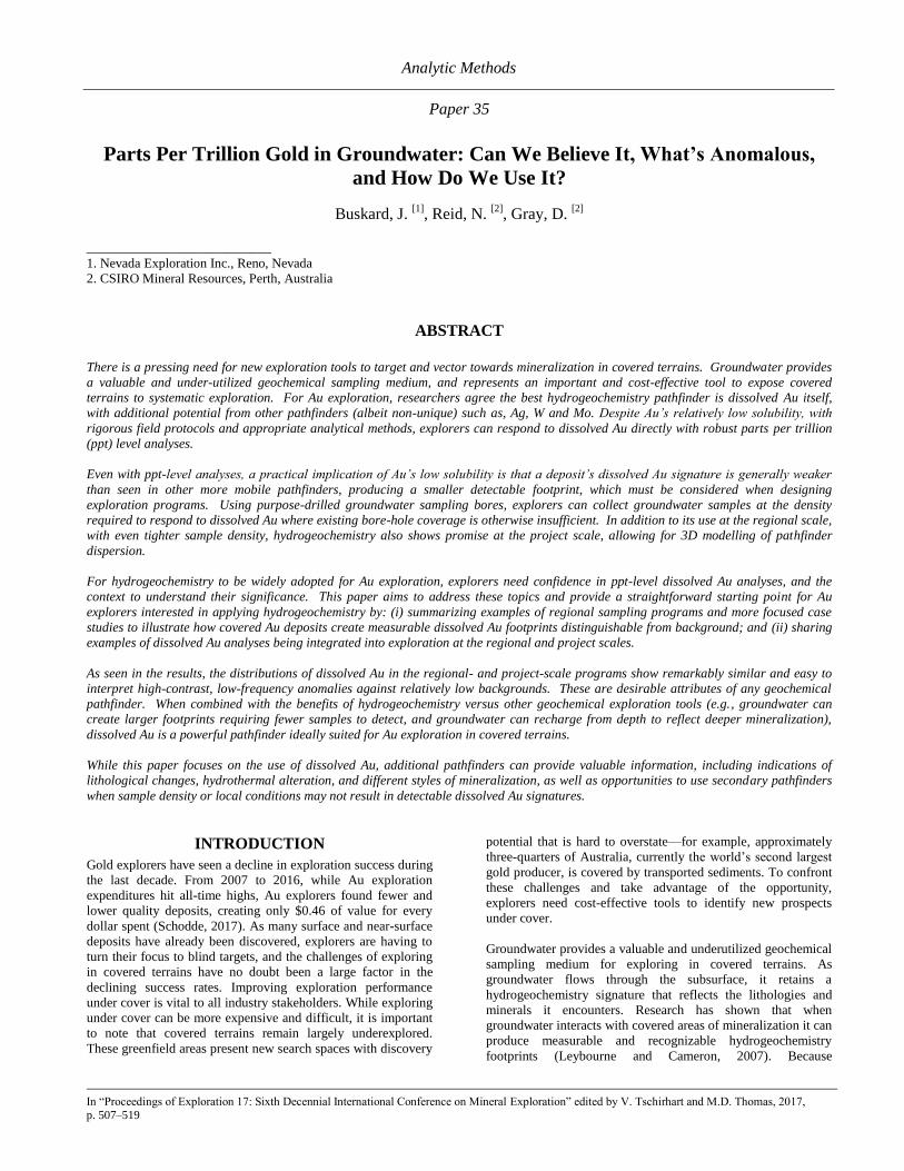
Analytic Methods
Paper 35
In “Proceedings of Exploration 17: Sixth Decennial International Conference on Mineral Exploration” edited by V. Tschirhart and M.D. Thomas, 2017, p. 507–519
Parts Per Trillion Gold in Groundwater: Can We Believe It, What’s Anomalous,
and How Do We Use It?
Buskard, J. [1]
, Reid, N. [2]
, Gray, D. [2]
_________________________ 1. Nevada Exploration Inc., Reno, Nevada
2. CSIRO Mineral Resources, Perth, Australia
ABSTRACT
There is a pressing need for new exploration tools to target and vector towards mineralization in covered terrains. Groundwater provides
a valuable and under-utilized geochemical sampling medium, and represents an important and cost-effective tool to expose covered
terrains to systematic exploration. For Au exploration, researchers agree the best hydrogeochemistry pathfinder is dissolved Au itself,
with additional potential from other pathfinders (albeit non-unique) such as, Ag, W and Mo. Despite Au’s relatively low solubility, with
rigorous field protocols and appropriate analytical methods, explorers can respond to dissolved Au directly with robust parts per trillion
(ppt) level analyses.
Even with ppt-level analyses, a practical implication of Au’s low solubility is that a deposit’s dissolved Au signature is generally weaker
than seen in other more mobile pathfinders, producing a smaller detectable footprint, which must be considered when designing
exploration programs. Using purpose-drilled groundwater sampling bores, explorers can collect groundwater samples at the density
required to respond to dissolved Au where existing bore-hole coverage is otherwise insufficient. In addition to its use at the regional scale,
with even tighter sample density, hydrogeochemistry also shows promise at the project scale, allowing for 3D modelling of pathfinder
dispersion.
For hydrogeochemistry to be widely adopted for Au exploration, explorers need confidence in ppt-level dissolved Au analyses, and the
context to understand their significance. This paper aims to address these topics and provide a straightforward starting point for Au
explorers interested in applying hydrogeochemistry by: (i) summarizing examples of regional sampling programs and more focused case
studies to illustrate how covered Au deposits create measurable dissolved Au footprints distinguishable from background; and (ii) sharing
examples of dissolved Au analyses being integrated into exploration at the regional and project scales.
As seen in the results, the distributions of dissolved Au in the regional- and project-scale programs show remarkably similar and easy to
interpret high-contrast, low-frequency anomalies against relatively low backgrounds. These are desirable attributes of any geochemical
pathfinder. When combined with the benefits of hydrogeochemistry versus other geochemical exploration tools (e.g., groundwater can
create larger footprints requiring fewer samples to detect, and groundwater can recharge from depth to reflect deeper mineralization),
dissolved Au is a powerful pathfinder ideally suited for Au exploration in covered terrains.
While this paper focuses on the use of dissolved Au, additional pathfinders can provide valuable information, including indications of
lithological changes, hydrothermal alteration, and different styles of mineralization, as well as opportunities to use secondary pathfinders
when sample density or local conditions may not result in detectable dissolved Au signatures.
INTRODUCTION
Gold explorers have seen a decline in exploration success during
the last decade. From 2007 to 2016, while Au exploration
expenditures hit all-time highs, Au explorers found fewer and
lower quality deposits, creating only $0.46 of value for every
dollar spent (Schodde, 2017). As many surface and near-surface
deposits have already been discovered, explorers are having to
turn their focus to blind targets, and the challenges of exploring
in covered terrains have no doubt been a large factor in the
declining success rates. Improving exploration performance
under cover is vital to all industry stakeholders. While exploring
under cover can be more expensive and difficult, it is important
to note that covered terrains remain largely underexplored.
These greenfield areas present new search spaces with discovery
potential that is hard to overstate—for example, approximately
three-quarters of Australia, currently the world’s second largest
gold producer, is covered by transported sediments. To confront
these challenges and take advantage of the opportunity,
explorers need cost-effective tools to identify new prospects
under cover.
Groundwater provides a valuable and underutilized geochemical
sampling medium for exploring in covered terrains. As
groundwater flows through the subsurface, it retains a
hydrogeochemistry signature that reflects the lithologies and
minerals it encounters. Research has shown that when
groundwater interacts with covered areas of mineralization it can
produce measurable and recognizable hydrogeochemistry
footprints (Leybourne and Cameron, 2007). Because

508 Analytic Methods
groundwater mixes and flows, deposits can create larger
hydrogeochemistry footprints than seen in other sampling
media, which can reduce the required sample density to explore
a region, providing evidence of nearby mineralization in
otherwise barren drill-holes. Additionally, where groundwater
recharges from depth it can provide opportunities to detect
mineralization beneath thicker cover. Beyond increasing the
size and improving the detection of a deposit’s geochemical
footprint, groundwater movement can also define a gradient or
vector pointing back to its source. With these characteristics,
hydrogeochemistry allows explorers to evaluate covered terrains
faster and cheaper than relying on traditional techniques alone,
opening up covered terrains to systematic exploration.
As explorers become more familiar with hydrogeochemistry, its
use is increasing around the world, most notably in Australia,
led by the Commonwealth Scientific and Industrial Research
Organisation (CSIRO), with considerable collaborative support
from academic, government, and industry sponsors. In the
review of the use of hydrogeochemistry for Exploration ‘07,
Leybourne and Cameron (2007) summarized the primary
hydrogeochemical pathfinders and key related publications for
several deposit types, including: porphyry copper, volcanogenic
massive sulfide (VMS), uranium, and gold. The most significant
change in the application of hydrogeochemistry for exploration
since Exploration ’07 has been the continued widespread
availability and lower cost of analytical methods with lower
detection limits, such as High Resolution Inductively Coupled
Plasma Mass Spectrometry (HR-ICP-MS), and the ability to
review datasets from large sampling programs that have used
these lower detection limit methods.
A recent example of how lower detection limits have increased
the utility of hydrogeochemistry for exploration is the surface-
water sampling program at the largely covered Pebble porphyry
Cu-Au-Mo deposit in Alaska. Because the program relied on
analyses of surface water samples, the researchers were faced
with the need to measure low absolute concentrations of
pathfinder elements. Using HR-ICP-MS, Kelley et al. (2010)
and Eppinger et al. (2010) demonstrated good quality control
down to low parts-per-trillion (ng/l, ppt) levels, and successfully
defined hydrogeochemical signatures associated with the
covered mineralization not previously detected using less
sensitive analytical methods, which most notably included a 10
km2 dissolved Ag halo centered on the deposit.
In terms of its application for Au exploration, Leybourne and
Cameron (2007) and others (e.g., Gray et al., 2014) have
concluded that the best hydrogeochemistry pathfinder for Au
mineralization is dissolved Au itself (though this can be
relatively enhanced with other pathfinders). As a consequence
of Au’s low solubility, explorers are obvious benefactors of the
increased availability of analytical methods with lower detection
limits. With these improved tools, the functional detection limit
for directly measuring dissolved Au is down to concentrations of
2 ppt (Noble et al., 2011), and perhaps lower. As will be shown
in the examples below, at these low ppt levels dissolved Au has
become an important pathfinder for Au exploration.
A practical implication of Au’s low solubility is that a deposit’s
dissolved Au signature is generally defined by lower
concentrations relative to other more mobile pathfinders, such as
Sb and Ag. Through physical and chemical groundwater
processes such as mixing and adsorption, these weaker dissolved
Au concentrations often return to below-detectable levels over a
shorter distance than other pathfinders, creating smaller
dissolved Au footprints. The size of a deposit’s measurable
dissolved Au footprint needs to be considered when designing a
hydrogeochemistry exploration program, though because most
programs rely on collecting samples from existing bore-holes,
samplers often have little control over sample location or
density. To mitigate the limitations inherent in relying on
existing bore-holes, considerable research has focused on
developing multi-parameter indices that include additional more
mobile pathfinders (e.g., Gray et al., 2014) to define targets
where sampling density may be too wide to rely on encountering
measurable dissolved Au alone.
The team of Nevada Exploration Inc. (“Nevada Exploration”),
has been advancing the use of hydrogeochemistry for Au
exploration in Nevada since the early 2000s. Like Australia,
Nevada is a mature mining jurisdiction, characterized by well-
explored exposed regions and underexplored covered areas, with
more than half of the state covered by post-mineralization basin
fill. Based on the results of its efforts, Nevada Exploration
places significant value on the use of hydrogeochemistry for
early-stage Au exploration, and has acquired and developed
boring equipment to collect groundwater samples without being
limited by the distribution of existing bore-holes. With this
equipment, Nevada Exploration is using hydrogeochemistry as a
basin-scale generative exploration tool to identify new prospects
in Nevada’s covered basins. Additionally, by increasing
sampling density, through reducing bore-hole spacing and taking
multiple down-hole samples, Nevada Exploration has begun to
incorporate the use of hydrogeochemistry to guide exploration at
the project scale, which represents a new scale of application
than has otherwise been presented in the literature.
Whereas CSIRO, Nevada Exploration, and others are using
hydrogeochemistry to explore in covered terrains around the
world, many explorers have not yet become familiar with its
application. For hydrogeochemistry to be widely adopted for
Au exploration, explorers need confidence in field and
laboratory methods to assign weight to ppt-level dissolved Au
analyses, and the context to understand their significance. This
paper aims to address these topics and provide a straightforward
starting point for gold explorers interested in integrating
hydrogeochemistry into their exploration workflow, with two
objectives:
(1) Building comfort around the use of ppt-level dissolved Au
as a pathfinder by providing examples of how covered Au
deposits create measurable dissolved Au footprints
distinguishable from background.
(2) Demonstrating the utility of integrating
hydrogeochemistry into an exploration workflow,
emphasizing the value of “drilling for water”, by sharing
examples of how Nevada Exploration is applying
hydrogeochemistry at the basin scale to identify new
prospects, and at the project scale to focus follow-up
exploration efforts.
Buskard, J., et al. Parts Per Trillion Gold in Groundwater 509
MEASURING PPT-LEVEL DISSOLVED AU
Whereas anomalous concentrations of Au in most other
geochemical sampling media are regularly measured in parts-
per-billion (ug/l), dissolved Au in waters is generally measured
in ppt (ng/L). Outside of hydrogeochemistry, ppt is not a
frequently used unit of measure for most explorers, and for most
other geochemical sampling media, ppt-level concentrations
would fall well below the detection limits of the most commonly
used analytical methods.
There are two strategies to achieve ppt-level detection of
dissolved Au in groundwaters: 1) use lower-detection-limit
analytical methods; or 2) pre-concentrate samples and apply
conventional analytical methods. As will be shown in the
examples below, explorers are using both strategies to achieve
meaningful and repeatable dissolved Au analyses at the single-
digit ppt level (e.g., Grimes et al., 1995; Noble and Gray, 2010).
In groundwaters with low salinity (<1,000 ppm Total Dissolved
Solids, TDS), samples can be analysed for dissolved Au directly
with HR-ICP-MS or low-detection-limit ICP-MS with relative
simplicity and accuracy. Other methods, such as atomic
absorption spectroscopy (AAS), can also potentially be used for
direct Au analysis; however, because explorers need multi-
element chemistry to use hydrogeochemistry effectively, ICP-
MS methods offer an advantage in providing suitable analyses
for ~60 elements with a single method.
In groundwaters with higher salinities (>1,000 ppm TDS),
samples must be diluted first to be safely run through an ICP-
MS system, which increases the detection limits. In these
settings, a pre-concentration step is required to achieve accurate
ppt-level dissolved Au analysis. As described in Gray et al.
(2014), the most widely used pre-concentration method is to
collect a 1 L sample of groundwater and add 1 g of activated
carbon enclosed in a nylon mesh along with 10 g of NaCl for
ionic balance. To ensure maximum uptake of Au, Ag, Pt and Pd
onto the carbon sachet the sample needs to be agitated for a
minimum of 4 days. The sachets are then removed from the
sample, rinsed in deionised water, and air dried for 2 days.
Once concentrated, the samples are prepared by ashing the
sachets, followed by aqua-regia digestion, and analyzed by ICP-
MS. Instrumental neutron activation analysis (INAA) of the
sachets can also provide robust dissolved Au analyses repeatedly
to 2 ng total Au, which equates to 2 ppt in the original solution,
though ICP-MS remains the preferred method, because it
provides lower detection limits for other important pathfinders:
Ag, Pt and Pd.
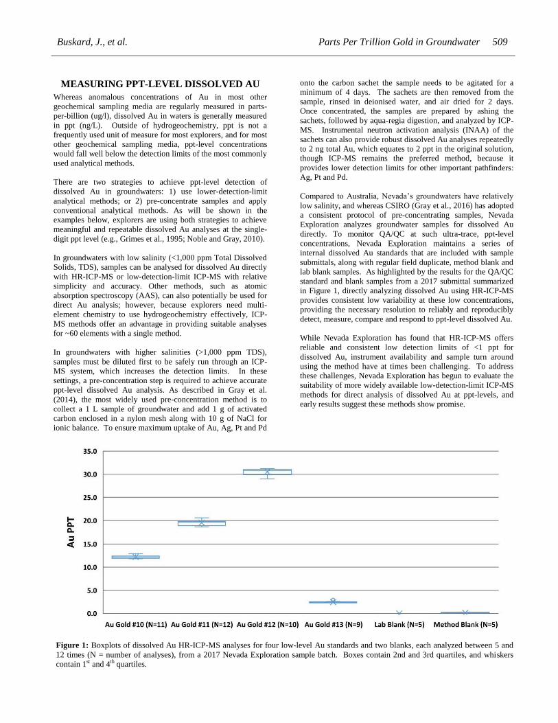
Compared to Australia, Nevada’s groundwaters have relatively
low salinity, and whereas CSIRO (Gray et al., 2016) has adopted
a consistent protocol of pre-concentrating samples, Nevada
Exploration analyzes groundwater samples for dissolved Au
directly. To monitor QA/QC at such ultra-trace, ppt-level
concentrations, Nevada Exploration maintains a series of
internal dissolved Au standards that are included with sample
submittals, along with regular field duplicate, method blank and
lab blank samples. As highlighted by the results for the QA/QC
standard and blank samples from a 2017 submittal summarized
in Figure 1, directly analyzing dissolved Au using HR-ICP-MS
provides consistent low variability at these low concentrations,
providing the necessary resolution to reliably and reproducibly
detect, measure, compare and respond to ppt-level dissolved Au.
While Nevada Exploration has found that HR-ICP-MS offers
reliable and consistent low detection limits of <1 ppt for
dissolved Au, instrument availability and sample turn around
using the method have at times been challenging. To address
these challenges, Nevada Exploration has begun to evaluate the
suitability of more widely available low-detection-limit ICP-MS
methods for direct analysis of dissolved Au at ppt-levels, and
early results suggest these methods show promise.
Figure 1: Boxplots of dissolved Au HR-ICP-MS analyses for four low-level Au standards and two blanks, each analyzed between 5 and
12 times (N = number of analyses), from a 2017 Nevada Exploration sample batch. Boxes contain 2nd and 3rd quartiles, and whiskers
contain 1st and 4th quartiles.
510 Analytic Methods
ESTABLISHING REGIONAL CONTEXT FOR
DISSOLVED AU
As with any geochemical pathfinder, the use of dissolved Au for
exploration requires a regionally-specific understanding of
background concentrations, concentrations surrounding known
gold deposits and appropriate sampling density. To examine the
importance of regional-scale hydrogeochemistry programs for
establishing and characterizing these benchmarks, as well as to
provide the context for reviewing the case studies that follow,
this section summarizes the results of two large groundwater
sampling programs, both from Australia, that have generated
two of the largest published datasets reporting analyses for
dissolved Au.
Central Victoria Dataset (CSIRO)
Over a 20-year period, CSIRO collected 1,133 groundwater
samples from existing bore-holes in southeastern Australia,
primarily focused on central Victoria. The resulting dataset,
presented as an appendix to Arne and Giblin (2009), includes
921 dissolved Au analyses. The statistical distribution of
dissolved Au (Figure 2) across the entire study area shows that
the majority of values cluster near and below the median of 2.2
ppt (73% < 2x median), followed by multiple-order-of-
magnitude increases at the upper percentiles. In bore-holes near
known Au deposits within the Victorian study area, Arne and
Giblin (2009) found dissolved Au showed good correlation with
mineralization, including examples in the vicinity of the
Stallwall, Ararat, Bendigo, and Tandarra deposits, with enriched
dissolved Au in bore-holes near several of the deposits
exceeding 50 ppt. Compared to the regional distribution, the
dissolved Au near the known areas of mineralization represent
clear anomalies (50ppt > 97th percentile and 20x median).
Based on the results of the Victorian sampling program, Arne
and Giblin (2009) offered the following conclusions: (a)
hydrogeochemistry provides a suitable reconnaissance tool for
Au mineralization in covered terrains; (b) in this study area
dissolved Au and As provided the most reliable indicators of
bedrock Au mineralization; and (c) the exploration thresholds
for dissolved Au in the subregions within the study area range
from 5 to 50 ppt. This orientation data provides practical and
valuable context to evaluate future sampling in the region.
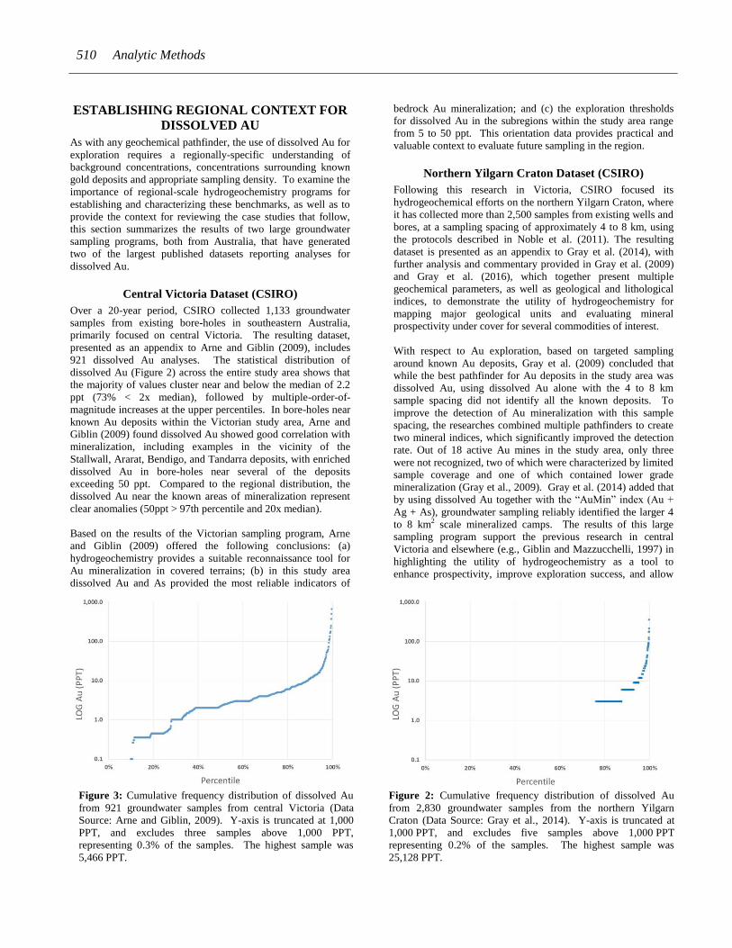
Northern Yilgarn Craton Dataset (CSIRO)
Following this research in Victoria, CSIRO focused its
hydrogeochemical efforts on the northern Yilgarn Craton, where
it has collected more than 2,500 samples from existing wells and
bores, at a sampling spacing of approximately 4 to 8 km, using
the protocols described in Noble et al. (2011). The resulting
dataset is presented as an appendix to Gray et al. (2014), with
further analysis and commentary provided in Gray et al. (2009)
and Gray et al. (2016), which together present multiple
geochemical parameters, as well as geological and lithological
indices, to demonstrate the utility of hydrogeochemistry for
mapping major geological units and evaluating mineral
prospectivity under cover for several commodities of interest.
With respect to Au exploration, based on targeted sampling
around known Au deposits, Gray et al. (2009) concluded that
while the best pathfinder for Au deposits in the study area was
dissolved Au, using dissolved Au alone with the 4 to 8 km
sample spacing did not identify all the known deposits. To
improve the detection of Au mineralization with this sample
spacing, the researches combined multiple pathfinders to create
two mineral indices, which significantly improved the detection
rate. Out of 18 active Au mines in the study area, only three
were not recognized, two of which were characterized by limited
sample coverage and one of which contained lower grade
mineralization (Gray et al., 2009). Gray et al. (2014) added that
by using dissolved Au together with the “AuMin” index (Au +
Ag + As), groundwater sampling reliably identified the larger 4
to 8 km2 scale mineralized camps. The results of this large
sampling program support the previous research in central
Victoria and elsewhere (e.g., Giblin and Mazzucchelli, 1997) in
highlighting the utility of hydrogeochemistry as a tool to
enhance prospectivity, improve exploration success, and allow
Figure 3: Cumulative frequency distribution of dissolved Au
from 921 groundwater samples from central Victoria (Data
Source: Arne and Giblin, 2009). Y-axis is truncated at 1,000
PPT, and excludes three samples above 1,000 PPT,
representing 0.3% of the samples. The highest sample was
5,466 PPT.
Figure 2: Cumulative frequency distribution of dissolved Au
from 2,830 groundwater samples from the northern Yilgarn
Craton (Data Source: Gray et al., 2014). Y-axis is truncated at
1,000 PPT, and excludes five samples above 1,000 PPT
representing 0.2% of the samples. The highest sample was
25,128 PPT.

Buskard, J., et al. Parts Per Trillion Gold in Groundwater 511
explorers to move into covered terrains to search for
economically viable targets (Gray et al., 2009, Gray et al., 2014,
and Gray et al., 2016).
The CSIRO northern Yilgarn Craton dataset provides valuable
information about the distribution of dissolved Au and other
pathfinders for continued exploration in the region. As shown in
Figure 3, most of the dissolved Au samples show low to no
detectable Au (87.5% showed <= 3 ppt), followed by multiple-
order-of-magnitude increases in the upper percentiles. The
distribution of dissolved Au in the northern Yilgarn Craton
closely matches that in central Victoria (Figure 2), characterized
by similar orders of magnitude at the major percentile breaks
(Table 1). With low background concentrations and high
contrast between background and anomalous values, both
datasets provide clear information to orient future
hydrogeochemistry sampling efforts in each region.
ORIENTATION CASE STUDIES
Building from the context provided by the two regional-scale
programs above, this section summarizes a selection of project-
scale hydrogeochemical orientation studies. These studies
provide examples of the size of the measurable dissolved Au
footprints surrounding known areas of mineralization, and
importantly, the variability in the absolute dissolved Au values
that define these footprints.
Case Study 1: St. Ives Area, Western Australia
Source: Carey et al. (2003)
One of the most thorough hydrogeochemistry orientation
programs for Au exploration was completed in a study area
referred to as St. Ives that includes the Junction (2.3 Moz. Au)
and Argo/Apollo (0.8 Moz. Au) Au deposits, located in the
Eastern Goldfields of the Yilgarn Craton. Whereas the rest of
the case studies mentioned below, as well as elsewhere in the
literature, have relied predominantly on collecting groundwater
samples from existing bore-holes, the St. Ives study is unique
and significant in that it collected groundwater samples from 80
purpose-drilled bore-holes on a regularized 1 km by 1 km grid.
At the same time as collecting groundwater samples, the
researchers also collected water level measurements at each
bore-hole to establish the regional gradient and direction of
groundwater flow, which they determined to be east to west.
Based on the dense and regularized sample distribution, the
results of the St. Ives study clearly defined the size and shape of
the dissolved Au footprint associated with the Junction deposit
(Figure 4). Using a 10 ppt contour, which is now known to be a
regionally-significant threshold based on the more recent 2,830-
sample CSIRO northern Yilgarn Craton dataset (10 ppt > 95th
percentile – see Table 1), the data define a horseshoe-shaped
dissolved Au footprint extending up to 5 km west (downstream)
of the Junction deposit. Dissolved Au increases closer to the
deposit, reaching a maximum of 52 ppt in the sample bore
immediately downstream of the deposit. At 52 ppt, the
dissolved Au in this bore-hole is not only locally significant, but
also regionally-significant based on the CSIRO northern Yilgarn
Craton dataset, falling within the 99th percentile of all samples
collected in the region. In this case, from an exploration
perspective, it is reasonable to expect that a hydrogeochemistry
sampling program with a similar sampling density would have
identified the dissolved Au footprint downstream of the Junction
deposit as a significant anomaly to investigate further.
Other than coincident with and downstream of the St. Ives Mill
and tailings dam complex, the relatively deep (generally >40 m)
groundwater samples from the 1 km x 1 km sampling near the
Argo/Apollo deposit did not identify enriched concentrations of
dissolved Au or other pathfinders. Carey et al. (2003) attributed
the lack of elevated dissolved Au in these samples to the local
influence of groundwater recharge from the nearby Lake Lefroy,
speculating that the groundwater in the horizons sampled had
not been sourced from the areas of mineralization.
Nevertheless, Carey et al. (2003) also noted that earlier,
shallower (<15 m) groundwater sampling across the
Argo/Apollo area had, defined a 4 km x 2 km, 10 ppt, dissolved
Au footprint above and downstream of the mineralization,
including several samples exceeding 40 ppt with a high value of
2,560 ppt. These findings certainly constitute a regionally-
significant anomaly associated with the deposit, though because
Carey et al. (2003) did not believe that these shallow
groundwaters had directly encountered the Argo/Apollo
mineralization, they were left to speculate as to the mechanism
of transport.
Overall, the results of the St. Ives program provide a
comprehensive example of the value of hydrogeochemistry for
Au exploration in covered terrains. In summary, the program
concluded: (i) that where groundwater had interacted with
mineralized zones, the resulting dissolved Au footprints were
larger than seen in the regolith cover; (ii) that the 1 km x 1 km
sample spacing was sufficient to detect these dissolved Au
footprints; and (iii) that coarser sampling would likely still have
been effective. These are significant observations because
drilling holes for hydrogeochemical sampling allows for a much
broader drill pattern than required for conventional regolith and
bedrock sampling, thus providing a considerably less expensive
sampling tool for evaluating covered areas. The results also
highlight the important fact that for groundwater to be an
effective sampling medium, the water needs to have an
opportunity to interact with mineralization.
Table 1: Major percentile breaks for dissolved Au for the
CSIRO central Victoria and northern Yilgarn Craton datasets.

512 Analytic Methods
In addition to providing insight into appropriate sample spacing,
Carey et al. (2003) also identified anomalous dissolved Au
upstream from the Junction deposit, along the southeastern
portion of the study area, following the Boulder–Lefroy Fault,
an important structural control for Au mineralization in the
region. With both anomalous dissolved Au and a favourable
geological setting, this area presents a compelling target for
follow-up investigation, and also highlights how
hydrogeochemistry can be integrated into a generative
exploration program.
Case Study 2: Carosue Dam, Western Australia
Source: Gray et al. (2007)
The Carosue Dam Au deposit (0.5 Moz.) is also located in the
Eastern Goldfields of the Yilgarn Craton, and is covered by
more than 80 m of regolith, including up to 20 m of transported
material. As part of a study to characterize the Au dispersion
halo in the regolith at Carosue Dam, Gray et al. (2007) analyzed
dissolved Au in samples collected from several drill-holes near
the deposit. The samples were spaced irregularly in a small
study area measuring approximately 1,000 m long by 600 m
wide. Out of 21 samples collected, 18 were deemed
uncontaminated and suitable for analysis.
With the presence of both acidic and oxidising conditions in the
groundwater at Carosue Dam, Gray et al. (2007) expected
relatively higher dissolved Au than at other Yilgarn sites, such
as St. Ives, and this was certainly the case. Eight samples
contained dissolved Au greater than or equal to 640 ppt,
including two samples greater than 2,000 ppt. At this local <1
km2 scale, Gray et al. (2007) concluded that dissolved Au
provided the best correlation with the mineralization. This
correlation was variable though, likely due to the small area of
investigation with a lack of background samples further from the
deposit. At the regional scale, however, based on the
distribution seen in the more recent CSIRO northern Yilgarn
Craton dataset, the dissolved Au concentrations proximal to the
mineralization correspond with some of the highest
Figure 4: Dissolved Au distribution of the St. Ives study area based on IDW of Carey et al. (2003) sampling program.
Buskard, J., et al. Parts Per Trillion Gold in Groundwater 513
concentrations anywhere in the region (640 ppt > 99.7th
percentile). From the standpoint of conducting regional-scale
exploration to identify geochemical footprints associated with
covered deposits, the dissolved Au surrounding the Carosue
Dam deposit defines a clear anomaly and an obvious target for
follow-up exploration.
In addition to demonstrating the utility of dissolved Au as a
pathfinder for regional exploration, the results from the Carosue
Dam also point to the influence that local conditions can have on
a deposit’s hydrogeochemistry footprint. In this case, acidic and
oxidizing groundwater conditions likely contributed to dissolved
Au enrichment measurable on the order of 1,000s of ppt.
Case Study 3: Harmony Gold Deposit, Western
Australia
Source: Noble et al. (2010)
Noble et al. (2010) presented several hydrogeochemistry case
studies for mineral exploration in Western Australia, including
an Au-related study from the covered Harmony deposit (250
Koz. Au; Robertson and Gray, 2003). The Harmony study was
based on groundwater samples collected from approximately 40
drill-holes covering 6 km2.
The results at Harmony defined a hydrogeochemical footprint
characterized by enriched dissolved Au, as well as Mo, W and
Rb (Noble et al., 2010). Compared to local background
concentrations of 2–3 ppt, the deposit’s hydrogeochemical
footprint included 10 samples with dissolved Au greater than or
equal to 5 ppt, with 3 samples greater than or equal to 7 ppt
clustered close to the deposit.
While the absolute dissolved Au concentrations near the
Harmony deposit are considerably lower than those seen in other
case studies, such as the Carosue Dam, it is important to
recognize that these concentrations are still regionally
significant based on the CSIRO northern Yilgarn Craton
dataset—5 and 7 ppt correspond to approximately the 88th and
93rd percentiles, respectively. Locally, dissolved Au quickly
returned to lower concentrations away from the mineralization
marking the deposit as a hydrogeochemical anomaly. With this
regional context and local contrast, it is reasonable to expect that
a hydrogeochemical exploration program would have identified
the covered Harmony deposit as a target for follow-up
exploration. Noble et al. (2010) concluded the same, and that
dissolved Au is a good pathfinder for Au mineralization in the
region. Based on further review of the results, Noble et al.
(2011) later added that dissolved As in the study area closely
correlated with areas of major hydrothermal alteration. This
correlation points to the complementary utility of other
pathfinder elements in regional Au exploration.
Getchell District, Nevada
Source: Grimes et al. (1995)
The significant and ongoing government-led support for
hydrogeochemical exploration in Australia is unique, and
accordingly most recent case studies and published regional-
scale sampling programs are Australian; though in the mid-
1990s, the U.S. Geological Survey conducted several important
groundwater sampling programs surrounding known Au
deposits in Nevada. As part of these efforts, Grimes et al.
(1995) completed a hydrogeochemical study along the Getchell
district in the Kelly Creek Basin to determine if
hydrogeochemistry could reveal the presence of otherwise
concealed Au deposits. The researchers collected between 2–5
down-hole samples from active and recent drill-holes near what
is now known as the Twin Creeks mine (Chimney Creek +
Rabbit Creek), the Summer Camp deposit, and an unnamed low-
grade deposit 1.5 km northwest of the Preble mine. The samples
were analyzed for major pathfinders, including dissolved Au,
which was analyzed by graphite-furnace atomic-absorption
spectrometry after pre-concentration using anion-exchange
resins.
At Twin Creeks, the dataset included 14 groundwater samples
collected from 4 drill-holes, 3 of which were located close to the
mine, and 1 of which was located 800 m downstream from the
mine. Of the 3 drill-holes closest to the mineralization, the
dissolved Au values ranged from 1–23 ppt, with each drill-hole
having at least one sample greater than 10 ppt, together defining
a measurable dissolved Au footprint at Twin Creeks. The 2
samples from the fourth drill-hole, located 800 m downstream
from the mineralization contained dissolved Au values of 11 ppt
and 26 ppt, confirming that this enriched Au footprint extended
beyond the limits of the mineralization.
At Summer Camp, the dataset included 9 groundwater samples
collected from 2 drill-holes, 1 located on top of the deposit,
penetrating the mineralized bedrock, and 1 located 380 m
downstream from the deposit. Dissolved Au in the samples
collected from the drill-hole penetrating mineralization ranged
widely, from 370–4,700 ppt—the highest concentration came
from a sample collected from an upper, oxidized bedrock unit,
and the lower concentrations came from the samples collected
from a deeper, unoxidized bedrock unit, which demonstrates
how local conditions influence the enrichment of dissolved Au.
As seen at Twin Creeks, the down-gradient samples at Summer
Camp also contained higher dissolved Au levels, ranging from
10 - 140 ppt, confirming the size of the measurable dissolved Au
footprint was larger than the deposit. These downstream samples
also provide an indication of the rate of dispersion for dissolved
Au at this site, with concentrations falling more than an order of
magnitude over 380 metres.
At the unnamed deposit near Preble, the dataset included 7
groundwater samples collected from 2 drill-holes, 1 located 450
m upstream from the deposit, and 1 penetrating the low-grade,
unoxidized deposit. The groundwater samples collected from the
upstream drill-hole showed low to no detectable dissolved Au
(≤1 ppt), as well as relatively low concentrations of other
regionally-important pathfinders: As, Sb and W. These samples
likely provide an approximation of the local background. In
comparison, the samples collected from the drill-hole that
penetrated the mineralized bedrock showed 10–50x enrichment
of As, Sb and W, although no significant dissolved Au (Max = 1
ppt). Grimes et al. (1995) speculated that the low dissolved Au
levels were likely due to the reducing groundwater conditions
surrounding the unoxidized, low-grade mineralization, which
514 Analytic Methods
provides another example of how site-specific variables can
influence a deposit’s hydrogeochemical signature.
Based on results of the Getchell sampling program, Grimes et al.
(1995) summarized: (i) that the background dissolved Au
concentration in the study area was likely less than 1 ppt; (ii)
that the dissolved Au near the deposits ranged from 1–140 ppt;
and (iii) that the dissolved Au in the drill-holes that penetrated
mineralized bedrock reached as high as 4,700 ppt. Grimes et al.
(1995) suggested that the results indicate measurable dissolved
Au is being mobilized from concealed Au deposits and actively
dispersed into the surrounding groundwater, and concluded that
hydrogeochemistry can provide valuable information to explore
for covered Au deposits in Nevada and elsewhere.
While the sample coverage is too focused to be considered
representative of the larger region, these findings are significant
for Nevada’s Au explorers. It is interesting and useful to note
that the dissolved Au found upstream of, downstream of, and in
contact with the known mineralization in the Getchell study
closely match the distributions seen in the regional datasets
(Table 1) and case studies from Australia, with high contrast
anomalies, defined by similar orders of magnitude, against
similarly low background values.
Because the Getchell dataset only includes samples from 2–4
drill-holes at each deposit, it does not provide much information
to characterize the spatial extent of their measurable dissolved
Au footprints. As a complement to Grimes et al. (1995), for
some regionally-specific insight into the lateral extent of
hydrogeochemical footprints surrounding covered Au deposits
in Nevada, readers are encouraged to review Muntean and
Taufen (2011), which included hydrogeochemistry as part of a
series of orientation surveys over covered Au deposits in the
Cortez area to evaluate their utility. While the published data
did not include analysis for dissolved Au, based on samples
from monitoring wells surrounding the Pipeline deposit,
Muntean and Taufen (2011) defined an approximately 5 km2
hydrogeochemical footprint associated with the deposit
characterized by enriched secondary pathfinders: As, Tl, K and
F. The spatial extent of the Pipeline footprint provides some
indication of appropriate sample spacing for groundwater
sampling in this part of Nevada. In terms of evaluating its
suitability for Au exploration in Nevada, Muntean and Taufen
(2011) echoed Grimes et al. (1995) in concluding that
hydrogeochemistry is an effective and underutilized sampling
medium for reconnaissance-scale exploration.
CONCLUSIONS FROM REGIONAL AND
PROJECT-SCALE PROGRAMS
The sampling programs summarized above illustrate that in
many settings dissolved Au deposit footprints are measurable,
recognizable, readily distinguishable from background and
larger than the deposits themselves. The resulting datasets
provide useful examples of the distributions of dissolved Au at
regional and project scales, the variability in both the enrichment
and extent of dissolved Au footprints, and ultimately, the
significance and utility of ppt-level analysis for Au exploration.
Even with ppt-level detection limits, one of the biggest
challenges in using hydrogeochemistry for Au exploration
remains the relatively low solubility of Au. As seen in the
deposit case studies, the enrichment and dispersion of Au is
influenced by many site-specific factors, such as the degree and
nature of groundwater interaction with mineralization and the
presence of oxidizing or reducing conditions, all of which
together determine the detectable extent of a deposit’s dissolved
Au footprint, and accordingly, the appropriate sample spacing
for exploration. Gray et al. (2009) found that analyzing
dissolved Au at the 4 to 8 km scale did not identify all deposits
in the northern Yilgarn study area, whereas Carey et al. (2003)
concluded that spacing coarser than the 1 km x 1 km sample grid
used in the St. Ives study area would likely have still been
effective, which together provide two important points for this
discussion. In practice, however, sample spacing is often limited
by the distribution of existing bore-holes, and given the lower
solubility of Au compared to other target commodities, the lack
of available sampling bores presents a considerable challenge.
On the whole, despite significant differences in geological
settings, hydrogeological conditions, sampling protocols, and
analytical methods, that the dissolved Au results of the studies
above are so remarkably similar in terms of their: (a) relatively
low background concentrations, (b) high-contrast anomalies, and
(c) major percentile breaks, speaks to the robustness of the
dissolved Au method, and define it as a reliable pathfinder for
gold exploration around the world.
With so many site-specific and sampling-related sources of
variability, it is important to note that the objective of using
dissolved Au as a pathfinder for regional-scale exploration is not
to compare or rank exploration targets based on absolute
dissolved Au concentrations. Rather, the objective of using
dissolved Au at this scale is to provide a cost-effective tool to
evaluate large areas and identify discrete exploration targets.
The results from the programs above illustrate that the entire
range of dissolved Au associated with the known areas of Au
mineralization, whether 7 ppt or 700 ppt, represent at least
multiple-times, and in most cases orders-of-magnitude,
enrichment relative to the local background concentrations, as
well as corresponding to the upper few percentiles of the
regional distributions. With such high-contrast and low-
frequency anomalies, dissolved Au represents a model
geochemical pathfinder to reduce large covered areas and focus
exploration efforts on targets defined by significantly enriched
Au.
While the focus of this paper is on the practical application of
dissolved Au as a primary pathfinder for Au exploration,
Leybourne and Cameron (2007) and others have highlighted the
additional value of other hydrogeochemical pathfinders in the
search for Au. In addition to Noble et al. (2011), who identified
a relationship between As and areas of major hydrothermal
alteration, Giblin and Mazzucchelli (1997) observed that
enriched As helped distinguish between bedrock-hosted Au
deposits versus palaeochannel deposits. As noted above, Gray
et al. (2009) used a multi-element index based on Au, Ag and As
to improve the detection of Au mineralization where sample
spacing was too coarse to rely on dissolved Au alone. Using the
same dataset, with implications beyond just Au exploration,
Buskard, J., et al. Parts Per Trillion Gold in Groundwater 515
Gray et al. (2014, 2016) demonstrated the broader value of
multi-parameter hydrogeochemistry in defining lithological
changes, hydrothermal alteration and other types of
mineralization. These studies illustrate that the value of
hydrogeochemistry for Au exploration is enhanced with the
support of additional pathfinders.
INCORPORATING DISSOLVED AU INTO AN
EXPLORATION WORKFLOW
Faced with the now familiar challenges of exploring in a mature
district, where over half of the bedrock is hidden by post-
mineralization cover, Nevada Exploration is integrating
hydrogeochemistry into its exploration workflow to explore for
covered Au deposits in Nevada. The foundation of Nevada
Exploration’s hydrogeochemical efforts is a groundwater
sampling program centred on north-central Nevada, primarily
within the basins near the Battle Mountain-Eureka and Carlin
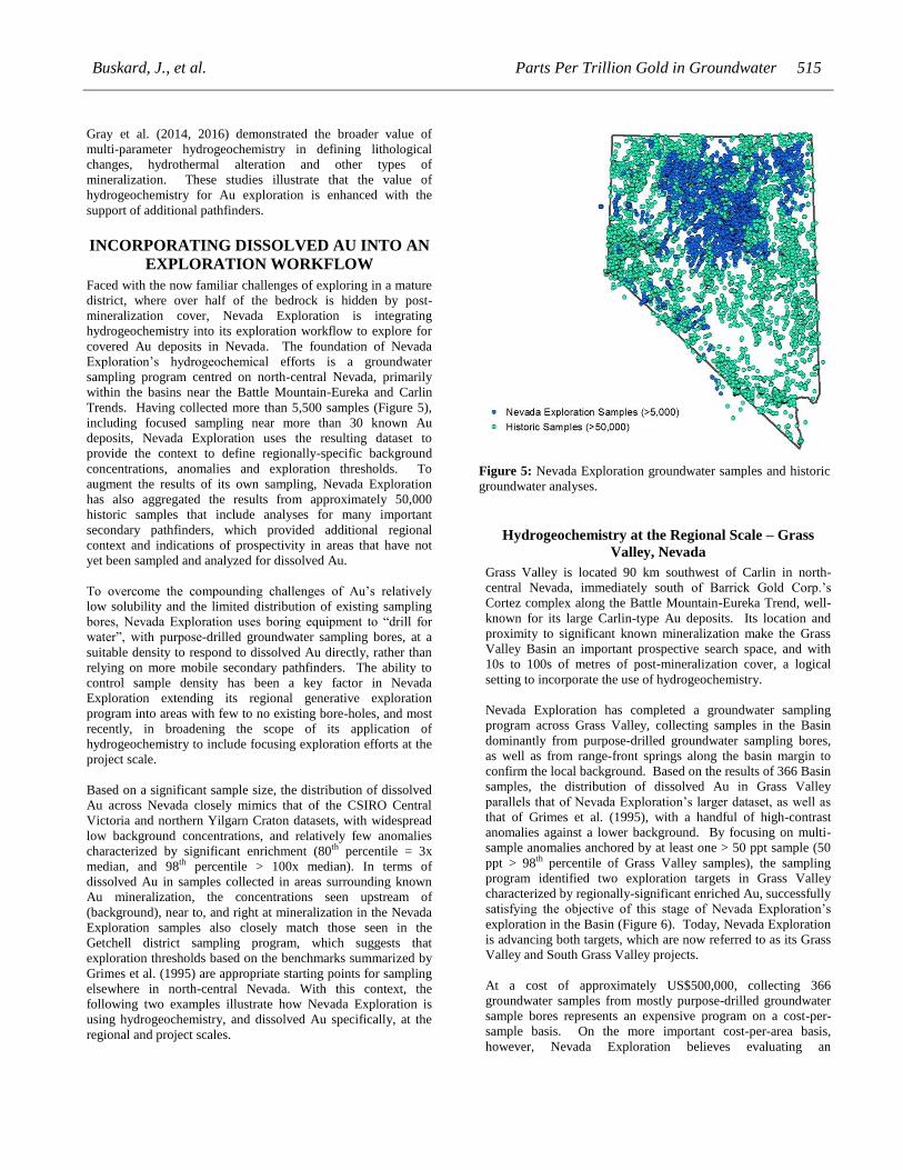
Trends. Having collected more than 5,500 samples (Figure 5),
including focused sampling near more than 30 known Au
deposits, Nevada Exploration uses the resulting dataset to
provide the context to define regionally-specific background
concentrations, anomalies and exploration thresholds. To
augment the results of its own sampling, Nevada Exploration
has also aggregated the results from approximately 50,000
historic samples that include analyses for many important
secondary pathfinders, which provided additional regional
context and indications of prospectivity in areas that have not
yet been sampled and analyzed for dissolved Au.
To overcome the compounding challenges of Au’s relatively
low solubility and the limited distribution of existing sampling
bores, Nevada Exploration uses boring equipment to “drill for
water”, with purpose-drilled groundwater sampling bores, at a
suitable density to respond to dissolved Au directly, rather than
relying on more mobile secondary pathfinders. The ability to
control sample density has been a key factor in Nevada
Exploration extending its regional generative exploration
program into areas with few to no existing bore-holes, and most
recently, in broadening the scope of its application of
hydrogeochemistry to include focusing exploration efforts at the
project scale.
Based on a significant sample size, the distribution of dissolved
Au across Nevada closely mimics that of the CSIRO Central
Victoria and northern Yilgarn Craton datasets, with widespread
low background concentrations, and relatively few anomalies
characterized by significant enrichment (80th percentile = 3x
median, and 98th percentile > 100x median). In terms of
dissolved Au in samples collected in areas surrounding known
Au mineralization, the concentrations seen upstream of
(background), near to, and right at mineralization in the Nevada
Exploration samples also closely match those seen in the
Getchell district sampling program, which suggests that
exploration thresholds based on the benchmarks summarized by
Grimes et al. (1995) are appropriate starting points for sampling
elsewhere in north-central Nevada. With this context, the
following two examples illustrate how Nevada Exploration is
using hydrogeochemistry, and dissolved Au specifically, at the
regional and project scales.
Hydrogeochemistry at the Regional Scale – Grass
Valley, Nevada
Grass Valley is located 90 km southwest of Carlin in north-
central Nevada, immediately south of Barrick Gold Corp.’s
Cortez complex along the Battle Mountain-Eureka Trend, well-
known for its large Carlin-type Au deposits. Its location and
proximity to significant known mineralization make the Grass
Valley Basin an important prospective search space, and with
10s to 100s of metres of post-mineralization cover, a logical
setting to incorporate the use of hydrogeochemistry.
Nevada Exploration has completed a groundwater sampling
program across Grass Valley, collecting samples in the Basin
dominantly from purpose-drilled groundwater sampling bores,
as well as from range-front springs along the basin margin to
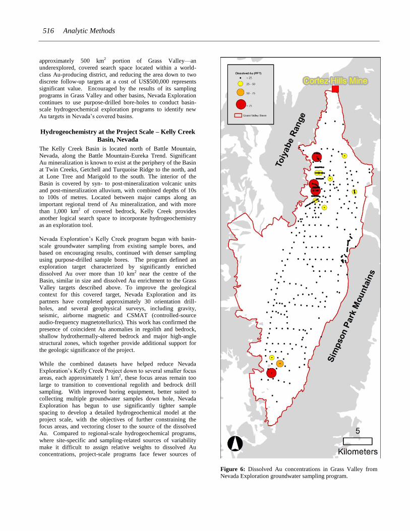
confirm the local background. Based on the results of 366 Basin
samples, the distribution of dissolved Au in Grass Valley
parallels that of Nevada Exploration’s larger dataset, as well as
that of Grimes et al. (1995), with a handful of high-contrast
anomalies against a lower background. By focusing on multi-
sample anomalies anchored by at least one > 50 ppt sample (50
ppt > 98th percentile of Grass Valley samples), the sampling
program identified two exploration targets in Grass Valley
characterized by regionally-significant enriched Au, successfully
satisfying the objective of this stage of Nevada Exploration’s
exploration in the Basin (Figure 6). Today, Nevada Exploration
is advancing both targets, which are now referred to as its Grass
Valley and South Grass Valley projects.
At a cost of approximately US$500,000, collecting 366
groundwater samples from mostly purpose-drilled groundwater
sample bores represents an expensive program on a cost-per-
sample basis. On the more important cost-per-area basis,
however, Nevada Exploration believes evaluating an
Figure 5: Nevada Exploration groundwater samples and historic
groundwater analyses.
516 Analytic Methods
approximately 500 km2 portion of Grass Valley—an
underexplored, covered search space located within a world-
class Au-producing district, and reducing the area down to two
discrete follow-up targets at a cost of US$500,000 represents
significant value. Encouraged by the results of its sampling
programs in Grass Valley and other basins, Nevada Exploration
continues to use purpose-drilled bore-holes to conduct basin-
scale hydrogeochemical exploration programs to identify new
Au targets in Nevada’s covered basins.
Hydrogeochemistry at the Project Scale – Kelly Creek
Basin, Nevada
The Kelly Creek Basin is located north of Battle Mountain,
Nevada, along the Battle Mountain-Eureka Trend. Significant
Au mineralization is known to exist at the periphery of the Basin
at Twin Creeks, Getchell and Turquoise Ridge to the north, and
at Lone Tree and Marigold to the south. The interior of the
Basin is covered by syn- to post-mineralization volcanic units
and post-mineralization alluvium, with combined depths of 10s
to 100s of metres. Located between major camps along an
important regional trend of Au mineralization, and with more
than 1,000 km2 of covered bedrock, Kelly Creek provides
another logical search space to incorporate hydrogeochemistry
as an exploration tool.
Nevada Exploration’s Kelly Creek program began with basin-
scale groundwater sampling from existing sample bores, and
based on encouraging results, continued with denser sampling
using purpose-drilled sample bores. The program defined an
exploration target characterized by significantly enriched
dissolved Au over more than 10 km2 near the centre of the
Basin, similar in size and dissolved Au enrichment to the Grass
Valley targets described above. To improve the geological
context for this covered target, Nevada Exploration and its
partners have completed approximately 30 orientation drill-
holes, and several geophysical surveys, including gravity,
seismic, airborne magnetic and CSMAT (controlled-source
audio-frequency magnetotellurics). This work has confirmed the
presence of coincident Au anomalies in regolith and bedrock,
shallow hydrothermally-altered bedrock and major high-angle
structural zones, which together provide additional support for
the geologic significance of the project.
While the combined datasets have helped reduce Nevada
Exploration’s Kelly Creek Project down to several smaller focus
areas, each approximately 1 km2, these focus areas remain too
large to transition to conventional regolith and bedrock drill
sampling. With improved boring equipment, better suited to
collecting multiple groundwater samples down hole, Nevada
Exploration has begun to use significantly tighter sample
spacing to develop a detailed hydrogeochemical model at the
project scale, with the objectives of further constraining the
focus areas, and vectoring closer to the source of the dissolved
Au. Compared to regional-scale hydrogeochemical programs,
where site-specific and sampling-related sources of variability
make it difficult to assign relative weights to dissolved Au
concentrations, project-scale programs face fewer sources of
Figure 6: Dissolved Au concentrations in Grass Valley from
Nevada Exploration groundwater sampling program.

Buskard, J., et al. Parts Per Trillion Gold in Groundwater 517
variability. With control over sample density, project-scale
hydrogeochemistry allows for meaningful interpretation of
relative changes in dissolved Au to significantly reduce search
spaces.
Nevada Exploration’s current detailed hydrogeochemistry
program at Kelly Creek consists of sampling from purpose-
drilled bore-holes, spaced generally from 200–400 m apart, at
approximately 10 m down-hole intervals, to depths of up to 140
m. Nevada Exploration has now completed more than 50 multi-
sample bore-holes, collecting approximately 490 groundwater
samples over 7 km2.
The most important additional information provided by the
increased sampling density is the vertical dimension needed to
characterize the hydrogeochemistry between sampling horizons.
At the bore-hole scale, the results illustrate significant down-
hole variability in pathfinder concentrations, likely reflecting
relative differences in hydraulic conductivity between different
strata in the alluvium, typical of hydrologic environments (i.e.,
clay vs. sand). At the project scale, however, the variability
resolves into constrained targets, considerably smaller than
identified by the shallower sampling.
Compared to programs where a single sample is collected from
each bore-hole, effectively producing a two-dimensional dataset
(e.g., the St. Ives study), collecting multiple down-hole samples
allows for modelling the dispersion of dissolved Au and other
pathfinders in three dimensions. Figure 7 shows an example of
the distribution of dissolved Au from a cluster of four bore-holes
designed to follow up on a target characterized by >50 ppt
dissolved Au identified by earlier, wider-spaced, basin-scale, 2D
sampling (one sample per bore-hole). In this cluster, the
detailed 3D hydrogeochemistry defined an upper zone of
dissolved Au enrichment across all four holes (130–168 ppt),
perched above a more focused zone of dissolved Au enrichment
(410–482 ppt) intersected by one of the bore-holes (KCBS046)
located at the bedrock contact. Coincident with this focused
zone of enriched dissolved Au, the geochemistry samples
(alluvium and bedrock) collected from the same bore-hole
included an 11 m interval that spanned the bedrock contact
averaging 0.095 ppm Au, which included two 3 m intervals
averaging 0.149 ppm Au and 0.120 ppm Au, respectively.
These Au concentrations at the bedrock-alluvium contact
represent the most consistent volume of mineralized material
seen at the project to date, and present a compelling target now
suitable for the focused application of conventional regolith and
bedrock drilling.
Nevada Exploration’s Kelly Creek exploration program is
ongoing, though the results to date already emphasize the
suitability of different scales of hydrogeochemistry sampling at
different stages of exploration. While the first stage of wide-
spaced, regional-scale, 2D groundwater sampling at Kelly Creek
provided a suitable scale of information to reduce the search
space from 100s of km2 to a handful of small focus areas, these
areas were still too large to transition to conventional drilling.
By increasing the sample density to provide the resolution to use
hydrogeochemistry in 3D at the project scale, Nevada
Exploration has significantly constrained the targets at Kelly
Creek and identified new, previously undiscovered mineralized
targets of a size now suitable to transition to conventional
regolith and bedrock drilling. By providing this otherwise
missing scale of information to direct the application of
conventional drilling tools in large, otherwise blind search
spaces, Nevada Exploration considers the Kelly Creek program
a success, and expects to utilize this proven workflow in similar
programs at its other projects in Grass Valley and elsewhere.
CONCLUSIONS
There is a pressing need for innovative exploration tools to
target and vector towards mineralization in covered terrains. As
summarized by Leybourne and Cameron (2007), and highlighted
in the presented case studies, covered deposits create distinct
hydrogeochemical footprints providing an important and under-
utilized exploration sampling medium. Researchers agree the
best hydrogeochemical pathfinder for Au mineralization is
dissolved Au, and despite its relatively low solubility, with
appropriate field protocols and analytical methods, explorers can
Figure 7: Dissolved Au concentrations in sampling bore-holes at the Kelly Creek project. Bore-hole spacing is 200 metres.

518 Analytic Methods
achieve the ppt-level analysis required to detect and respond to
dissolved Au anomalies directly.
The dissolved Au distributions from large sampling programs in
Australia and Nevada show remarkably similar and easy to
interpret high-contrast, low-frequency anomalies against
relatively low background values. These are desirable attributes
of any geochemical pathfinder, and when combined with the
benefits of hydrogeochemistry versus other geochemical
exploration tools (e.g., produces larger footprints requiring
fewer samples to detect, and groundwater can recharge from
depth to reflect deeper mineralization) make dissolved Au a
powerful pathfinder ideally suited for Au exploration in covered
terrains.
In terms of its application, to effectively incorporate dissolved
Au analyses into an exploration workflow, explorers need large
orientation datasets to establish meaningful regionally-specific
background values and exploration threshold—good examples
of which are the 2,803-sample CSIRO Northern Yilgarn and
>5,500-sample Nevada Exploration datasets. Even with
comprehensive regional context, it is important, however, not to
place undue weight on absolute dissolved Au concentrations to
compare or rank targets, because dissolved Au is influenced by
many local and sampling-related sources of variability (such as
pH and salinity). Rather, the significance of dissolved Au as a
pathfinder is that it allows for relatively wide sample spacing,
compared to other geochemical sample media, with a high
degree of selectivity, to provide a cost-effective tool to evaluate
large covered areas.
One of the biggest challenges in conducting groundwater
sampling programs is the availability of sampling bore-holes.
Using purpose-drilled groundwater sampling bores, explorers
can complete sampling programs at the density required to
respond directly to dissolved Au where existing bore-hole
coverage is otherwise insufficient. While the cost-per-sample
from purpose-drilled bores is high, the value of the information
on a cost-per-area basis offers the potential to open up new
covered search spaces for exploration.
To date, the adoption of hydrogeochemistry for exploration has
been focused on regional-scale exploration. With increased
sample density allowing for 3D modelling of the dispersion of
dissolved Au and other pathfinders, project-scale
hydrogeochemistry offers an important new scale of information
to constrain targets and direct more focused application of high-
cost conventional regolith and bedrock drilling.
Lastly, while this paper focuses on the use of dissolved Au, it is
important to note that other pathfinders can provide valuable and
complementary information for gold explorers, including
indications of lithological changes, hydrothermal alteration and
different styles of mineralization, as well as the opportunity to
use more mobile secondary pathfinders when the sample spacing
or local conditions may not result in detectable dissolved Au
signatures.
ACKNOWLEDGEMENTS
Nevada Exploration Inc. and its stakeholders are thanked for
sharing data and insights for this paper. It is especially
important to recognize the dedicated focus and hard work of
Wade Hodges and Ken Tullar in advancing the company’s
hydrogeochemistry program, as well as the contributions of the
late Paul Taufen in the program’s important early stages.
Thanks to the Geological Surveys of Victoria and Western
Australia for supporting hydrogeochemical research. Also
thanks to Vaclav Metelka for reviewing this manuscript.
REFERENCES
Arne, D.C. and A.M. Giblin, A.M., 2009, Hydrogeochemistry of
groundwaters associated with orogenic gold deposits in central
Victoria: Geoscience Victoria Gold Undercover Report 14,
Department of Primary Industries, Victoria, Australia, 20 p.
Carey, M.L., D.C. McPhail, P.M. Taufen, 2003, Groundwater
flow in playa lake environments: impact on gold and pathfinder
element distributions in groundwaters surrounding mesothermal
gold deposits, St. Ives area, Eastern Goldfields, Western
Australia: Geochemistry: Exploration, Environment, Analysis,
3, 57-71.
Eppinger, R.G., K.D. Kelley, D.L. Fey, S.A. Giles, B.J. Minsley,
and S.M. Smith, 2010, USGS exploration geochemistry studies
at the Pebble porphyry Cu-Au-Mo deposit: U.S. Geological
Survey, Open-File Report 2010–1225, 64 p.
Giblin, A. and R. Mazzucchelli, 1997, Groundwater
geochemistry in exploration: An investigation in the Black Flag
district, Western Australia: Australian Journal of Earth Sciences,
44, 433-443.
Gray, D.J., N.B. Sergeev, and C.G. Porto, 2007,
Characterisation of gold distribution and hydrogeochemistry at
the Carosue Dam gold prospect, Western Australia: CRC LEME
Open File Report 217, Western Australia, Australia, 45 p.
Gray, D.J., R.R.P. Noble, and N. Reid, 2009, Hydrogeochemical
mapping of the northeast Yilgarn Craton: CSIRO Exploration
and Mining, Report P2009/1612, Minerals and Energy Research
Institute of Western Australia, Report No. 280, 73 p.
Gray, D.J., N. Reid, and R.R.P Noble, 2014, Improved
hydrogeochemical exploration in the northwest Yilgarn – adding
value to underexplored areas: EP143875 CSIRO, Western
Australia, Australia, 86 p.
Gray, D.J., R.R.P. Noble, N. Reid, G.J. Sutton, and M.C. Pirlo,
2016, Regional scale hydrogeochemical mapping of the northern
Yilgarn Craton, Western Australia: a new technology for
exploration in arid Australia: Geochemistry: Exploration,
Environment, Analysis, 16, 100–115.
Grimes, D.J., W.H. Ficklin, A.L. Meier, and J.B. McHugh,
1995, Anomalous gold, antimony, arsenic, and tungsten in
ground water and alluvium around disseminated gold deposits
along the Getchell Trend, Humboldt County, Nevada: Journal of
Geochemical Exploration, 52, 351–371.

Buskard, J., et al. Parts Per Trillion Gold in Groundwater 519
Kelley, K.D., J. Lang, and R.G. Eppinger, 2010, Exploration
geochemistry at the giant Pebble porphyry Cu-Au-Mo deposit,
Alaska: Society of Economic Geologists Newsletter, 80, 18-23.
Leybourne, M.I. and Cameron, E.M., 2007, Groundwaters in
geochemical exploration: methods, applications, and future
directions, in B. Milkereit, ed., Proceedings of Exploration 07,
201–221.
Muntean, J. and P. Taufen, 2011, Geochemical exploration for
gold through transported alluvial cover in Nevada: examples
from the Cortez Mine: Economic Geology, 106, 809–833.
Noble R.R.P., and D.J. Gray, 2010, Hydrogeochemistry for
mineral exploration in Western Australia (I): Methods and
equipment: Explore, 146, 2–11
Noble, R.R.P., D.J. Gray, I.D.M. Robertson, and N. Reid, 2010,
Hydrogeochemistry for mineral exploration in Western Australia
II: case studies: Explore, a newsletter of The Association of
Applied Geochemists, Newsletter No. 146, 12–17.
Noble, R.R.P., D.J. Gray, and A.J. Gill, 2011, Field guide for
mineral exploration using hydrogeochemical analysis: CSIRO
Earth Science and Resource Engineering, Western Australia,
Australia, 46 p.
Robertson, I.D.M. and D.J. Gray, 2003, Harmony gold deposit,
Baxter mining district, Western Australia, in C.R.M. Butt,
I.D.M. Robertson, K.M. Scott, and M. Cornelius, eds., Regolith
Expressions of Australian Ore Systems, CRC LEME, Perth.
259-261.
Schodde, R.C., 2017, Recent trends and outlook for global
exploration: Presented at PDAC,
http://www.minexconsulting.com/publications/Exploration%20
Trends%20and%20Outlook%20-20PDAC%20Presentation.pdf.