Embed Size (px)
Citation preview

Part II. Assessment


Part II Contents
PART
II. STATEWIDE FOREST RESOURCE ASSESSMENT
A. Working Forestlands & Conversion
CONDITIONS & TRENDS A1 Land Ownership Patterns A2 Timber Harvest A7 Forest Products Manufacturing Industry A9 Forest Practices Program A11 Population & Demographics A16 THREATS & OPPORTUNITIES A16 Forestland Conversion A16 Loss of Economic Viability A17 Climate Change A19 RELEVANT NATIONAL THEMES & STRATEGIC OBJECTIVES A21 EXISTING STRATEGIES A21 State Trust Lands Working Forest Landscapes A21 Forest Practices Program A22 Working Forestlands Data & Research A24 U.S. Forest Service State & Private Forestry Programs A26 Partners in Protecting Forest Landscapes A27 Land-Use Planning A29 Forest Biomass Markets A30 Ecosystem Services Markets A30 Carbon Sequestration Markets A31 Climate Change Strategies A31 DATA & PROGRAM GAPS A32 Drivers for Conversion Decisions A32 Economic Viability A32 Climate Change A32 PRIORITY LANDSCAPES: All-lands opportunities A34
B. Biodiversity & Habitat Conservation INTRODUCTION B1 CONDITIONS & TRENDS B1 Ecosystems & Ecosystem Processes B1 At-Risk Species B6 THREATS & OPPORTUNITIES B11 Habitat Fragmentation & Loss of Legacy Features B11 Altered Fire & Disturbance Regimes B12 Invasive Non-Native Species B12 Climate Change B13 RELEVANT NATIONAL THEMES & STRATEGIC OBJECTIVES B13 EXISTING STRATEGIES B14 Washington Biodiversity Conservation Strategy B14 The State of Washington Natural Heritage Plan B14

Comprehensive Wildlife Conservation Strategy B15 Wildlife Habitat Connectivity Working Group B15 Washington Wildlife & Recreation Program B16 Habitat Conservation Plans in Washington State B16 Forest Certification B17 Other Public-Private Partnerships B17 DATA & PROGRAM GAPS B17 Rare Species Surveys B17 Vegetation & Forest Structure B17 Climate Change B17 PRIORITY LANDSCAPES: All-lands opportunities B18
C. Upland Water Quality, Quantity & Puget Sound Restoration INTRODUCTION C1 CONDITIONS & TRENDS C2 Land Cover & Impervious Surfaces C2 Freshwater & Marine Aquatic Lands C3 Freshwater Riparian Conditions & Surface Water
Quality in Forested Watersheds C4
Surface Water Quantity in Forested Watersheds C9 THREATS & OPPORTUNITIES C12 Loss of Surface Water Quality C12 Improper Design, Construction & Maintenance of Forest
Roads C14
Climate Change C14 RELEVANT NATIONAL THEMES & STRATEGIC OBJECTIVES C15 EXISTING STRATEGIES C15 Forest Practices Rules & Forest Practices Program C15 Puget Sound Partnership C20 DNR Aquatic Habitat Conservation Plan C22 U.S. Forest Service Aquatic Restoration Strategy and
Legacy Roads & Trails Program C22
U.S. Forest Service State & Private Forestry Programs C23 DATA & PROGRAM GAPS C23 Impervious Surfaces C23 Groundwater C23 Surface Water Quantity C23 Forest Roads on Family Forests C24 Stream Barrier Inventory C24 Marine Riparian Vegetation C24 Surface Water Mapping C24 PRIORITY LANDSCAPES: All-lands opportunities C26
D. Wildfire Hazard Reduction INTRODUCTION D1 History of Wildfire Protection in Washington D1 Wildfire Protection Responsibilities D2 CONDITIONS & TRENDS D4 Identified Wildfire Risk Areas D4 Wildfire Starts & Acres Burned D6 Wildfire Causes D8

Property Damage D8 Population Growth D9 Forest Health D10 THREATS & OPPORTUNITIES D11 Human Safety & Property Loss D11 Increased Development in the Wildland-Urban Interface D11 Deteriorating Forest Health D11 Climate Change D12 Loss of Forest Markets D13 RELEVANT NATIONAL THEMES & STRATEGIC OBJECTIVES D13 EXISTING STRATEGIES D13 2020 Strategic Plan for Wildland Fire Protection D13 U.S. Forest Service State & Private Forestry Programs D15 Restoring Fire-Adapted Lands across Ownerships D18 DATA & PROGRAM GAPS D19 WUI and Population Growth D19 Quantifying Avoided Costs D19 Fire Suppression Cost Analysis D20 Treatment Optimization D20 Completed Treatment Data D20 PRIORITY LANDSCAPES: All-lands opportunities D22
E. Forest Health Restoration CONDITIONS & TRENDS E1 Tree Mortality & Defoliation E1 Treatment E11 Landowner Response E12 THREATS & OPPORTUNITIES E13 Invasive Non-Native Forest Insects & Diseases E13 Overcrowded Eastern Washington Forests E13 High Fuel Loads in Eastern Washington Forests E14 Loss of Productivity & Function in Western Washington
Forests E16
Climate Change E16 Loss of Forest Markets E16 RELEVANT NATIONAL THEMES & STRATEGIC OBJECTIVES E17 EXISTING STRATEGIES E17 Washington Forest Health Strategic Plan E17 2020 Strategic Plan for Wildland Fire Protection E18 Washington Forest Health Law E19 Washington Invasive Species Plan E20 U.S. Forest Service State & Private Forestry Programs E20 Federal Land Management E21 Cross-Ownership Efforts E22 DATA & PROGRAM GAPS E22 Fine-Scale Forest Condition Data E22 Cross-Ownership Data E22 Invasive Species Gap Analysis E22 Communications Methods and Messages E22 PRIORITY LANDSCAPES: All-lands opportunities E24

F. Urban & Community Forests INTRODUCTION F1 CONDITIONS & TRENDS F1 Population Growth F1 Forest Fragmentation & Canopy Loss F2 Ecosystem Services from Trees & Forests in Urban
Areas F3
Human Health & Well-Being Benefits F5 Urban Forest Planning & Management F6 THREATS & OPPORTUNITIES F7 Loss of Urban Trees & Forests to Development F7 Loss of Ecosystem Services of Urban Trees F7 Loss of Social & Economic Benefits of Urban Trees F8 Inadequate Urban Forest Planning & Management F8 Invasive Non-Native Species F8 RELEVANT NATIONAL THEMES & STRATEGIC OBJECTIVES F10 EXISTING STRATEGIES F10 Washington Urban & Community Forestry Program F10 Washington Growth Management Act F14 Urban Forestry Partnerships F15 DATA & PROGRAM GAPS F15 Forest Canopy Assessment F15 Ground-Level Threat Inventory F16 Urban Growth Areas F16 Ecosystem Services F16 Keeping Assessments Current F16 Urban Forestry Professional Services F16 PRIORITY LANDSCAPES: Connectivity opportunities F17

1 of 36 Washington State Department of Natural Resources ▪ Statewide Assessment & Strategy ▪ Working Forests Section A
Working Forestlands & Conversion Washington is appropriately known as the “Evergreen State” for its conifer-dominated landscape extending from the Pacific Coast rain forest to the dry regions east of the crest of the Cascade Mountains. These vast and productive forestlands supply economic and ecological benefits that are important to Washington State, the nation and the world. “Working forests” could be defined as “sustainably managed for commodity products as well as ecological and social values” and requiring a “permanent and un-fragmented land base” (NW Environmental Forum, 2008). In 2006, Washington’s forest sector provided 45,000 jobs, generated $16 billion in gross business revenue, and paid out $2 billion in wages and $100 million in tax receipts. The forest products industry is a significant economic driver for communities in all regions of the state and plays a particularly important role in rural, timber-dependent communities. However, an increasing set of challenges confront private and public forestland managers. Washington is experiencing loss of private working forestlands at an unprecedented rate. Changing land-use patterns and the current economics of forestry are driving conversion of forestlands to non-forestry land uses. This is resulting in loss of current and future commodity production, ecosystem services (clean air, clean water, carbon sequestration, etc), and other public benefits.
CONDITIONS & TRENDS Of Washington’s 43 million acres in land area, 22 million are considered forested (DNR 2007). Of that number, roughly 16 million acres are considered “unreserved timberlands” by virtue of their high soil productivity and availability for harvest.
Figure A1. Major ownership categories of total
Washington forestland (DNR 2007)
section A

2 of 36 Washington State Department of Natural Resources ▪ Statewide Assessment & Strategy ▪ Working Forests Section A
Land Ownership Patterns
Roughly 57 percent of the total forestland is in State or Federal Government ownership, and 43 percent is in private ownership (Figure A1). The private forestland subset is comprised of 31 percent industrial and 69 percent non-industrial landowners. However, land ownership patterns differ among eastern and western Washington. Western Washington unreserved timberlands, as displayed in Figure A2, are nearly 40 percent held by industrial private landowners, compared to 14 percent in Eastern Washington. Federal lands comprise a much larger proportion in Eastern Washington as compared to Western Washington. Native American tribes also manage a significant amount of the Eastern Washington forest landscape.
Figure A2. Unreserved timberland ownership in western and eastern Washington (DNR 2007) Private Ownership Overview
In Washington, the 43 percent of the forest landscape in private ownership amounts to 9.4 million acres of forestland (Figure A1). Of those privately-owned lands, 3.2 million acres are in small ownerships, leaving 6.2 million acres in large ownerships. Although traditionally the majority of this large private acreage was owned by industrial companies, those companies now own about 2.9 million acres. The other 3.3 million acres are owned by Timber Investment Management Organizations, Real Estate Investment Trusts, and other non-industrial owners including corporations, private

3 of 36 Washington State Department of Natural Resources ▪ Statewide Assessment & Strategy ▪ Working Forests Section A
individuals or families, Indian tribes, and conservation groups. Given ongoing transactions, these numbers should be expected to continually change to some degree. Using data from two U.S. Forest Service Forest Inventory and Analysis (FIA) reports, Washington’s Public and Private Forests (Bolsinger 1997) and Timber Resource Statistics for Non-national Forest Land in Western Washington (Gray et al. 2005), it is possible to estimate the changing ownership patterns and loss of timberland acres. According to these two reports, timberland (excluding national forest land) in western Washington declined at an average rate of 0.37 percent per year from 1978 to 2001 (from 7.7 million acres to 7 million acres). A minimal amount of this land was moved out of the Forest Inventory and Analysis dataset and reclassified into national forest land, while the remaining loss was to either urban, right-of-ways, or agricultural land uses. Land use change from forested to non-forested uses are highly regional, with changes in the Puget Sound ecoregion (encompassing the Puget Sound lowlands) amounting to loss of about 0.45 percent a year between 1989 and 2000 (Gray 2009). During that same period, forestland in greater western Washington declined at a lesser rate of 0.11 percent a year. Estimates of more recent land use change show annual forestland loss in the Puget Sound ecoregion exceeding 0.5 percent by the mid 2000s. Further studies suggest that a substantial portion of land use change (0.18 percent for 1992-2006) on non-federal ownership in western Washington is happening in “wildland forest” areas, or those with very low densities of dwellings and roads (Gray 2010).
Figure A3. Timberland ownership and change in ownerships (new flow) on non-National
Forest lands in Eastern (left) and Western (right) Washington (DNR 2007)
T R E N D 1 T O T R A C K
Change in private
forestland ownership
and patterns (industrial and non-industrial)
over time

4 of 36 Washington State Department of Natural Resources ▪ Statewide Assessment & Strategy ▪ Working Forests Section A
One relatively dominant pattern reflected in this data is the transfer of ownership from forest industry companies to other private owners, followed by the subsequent conversion to non-timberland by the other private owners (Figure A3). Data from the Forest Inventory and Analysis Timber Resource Statistics for Forest Land in Eastern Washington publication (Gray et al. 2006) shows timberland declining at an average rate of 0.35 percent per year from 1980 to 2002 (from 4.3 million acres to 3.8 million acres), with a higher rate between 1970 to 1980 than 1980 to 2002.
Figure A4. Forestland ownership in Washington State
Focus: Small Forest Landowners
Approximately 3.2 million acres of private land in Washington State are considered small forestland parcels, defined generally as less than 5,000 acres in size (DNR 2009b). These parcels are held by an estimated 215,000 individual small forest landowners (Table A1).
T R E N D 2 T O T R A C K
Rate of loss of timberland
in Eastern and Western
Washington

5 of 36 Washington State Department of Natural Resources ▪ Statewide Assessment & Strategy ▪ Working Forests Section A
Table A1. Number of small forest landowners in Washington State by size of ownership
Landholding Size Class (Ac.)
Western Washington (# Landowners)
Eastern Washington (# Landowners)
Statewide (# Landowners)
<20 133,008 26,578 159,586 20-100 21,462 20,470 41,932 100-1000 5,423 6,998 12,421 1000-5000 75 983 1,058 5000+ 98 98
Total* 159,956 55,096 215,052 *A single owner may be represented in more than one size class, so the numbers in “Total” will be less than the sum of the individual classes. Nearly 75 percent of forestland owners in Washington own in holdings less than 20 acres. This pattern is noticeably less dominant in eastern Washington, where there are significantly fewer owners in the under-20-acre category, and significantly more owners with 100 acres and greater. The pattern of these ownerships across the state tends to be concentrated in the lowland forested areas, often along major rivers and streams (Figure A4). Small forest landowners also tend to be situated as the first band of forestland that borders urban growth areas and thus are subjected to significant conversion pressure. Small forest landowners feel a close tie to their land and see the implications of the conversion of surrounding forestland as a threat to their quality of life. However, the continued trend of breaking large parcels into smaller ones, and consequent increases in the number of small-parcel landowners further reduces the cohesiveness of these landowners. This means that no single set of assumptions about economic or social motivations can be easily applied. One broadly applicable set of statistics is that the average age of ‘small forest landowners’ is between 57 and 67 years old, and nearly half of the land is held by individuals who are 65 or older (DNR 2007). This means intergenerational transfer is likely to become an issue in much the same way it has for family farms and ranches. When family forest owners pass their land onto their heirs, high property value can force a decision to subdivide or convert to other non-forest uses in order to cover estate tax expenses incurred by the forest owners’ heirs.
Focus: Industrial Private Landowners
In western Washington, nearly 40 percent of the unreserved timberlands are managed by private industry (Figure A1). Forestland ownership trends have changed significantly in recent years as self-sufficient vertically-integrated forest products companies divested themselves of large portions of their land holdings. Few companies now hold forested

6 of 36 Washington State Department of Natural Resources ▪ Statewide Assessment & Strategy ▪ Working Forests Section A
properties solely to supply raw materials to their own manufacturing facilities. Many of these large industrial-forestland holdings have been transferred to firms managing financial investment for institutional investors. These firms are known as Timber Investment Management Organizations (TIMOs).Timberlands became an attractive investment because these properties continued to appreciate as the forests mature and there is a tendency for forestlands to deliver financial returns that are counter-cyclical to the stock market. Many formerly integrated forest products companies have chosen to restructure by separating ownership of their mills and timberland holdings, rather than selling their timberland outright. Income derived from forestlands of a vertically-integrated company are taxed at the federal corporate income rate while those timberlands held for investment pay a dividend that is taxed at the much lower federal capital gains rate. These corporate structures are known as Real Estate Investment Trusts (REITs) and their shares are traded publicly. The laws governing REITs require that 90 percent of all revenue generated must be distributed to the shareholders annually and thus, can present a different set of management objectives than those within which TIMOs operate. Industrial landowners, although their corporate structures are changing, continue to hold land in generally large and contiguous blocks (Figure A4). These blocks tend to be positioned as a second concentric ring of forestland outward from developing areas, with small forestland owners the first ring. The fate of industrial and small forest landowners are linked in this way, because conversion to non-forest uses by one category of owners will affect the viability of neighboring land.
Focus: Forested State Trust Lands
The state Department of Natural Resources manages 2.2 million acres of forested state trust lands, representing about 12 percent of all forestlands in the State. These working forests are held in trust, and revenues generated from timber management and leasing activities are used to provide funding to build the state’s public schools and universities, correctional institutions, State Capitol buildings in Olympia, to provide funding for county services in which those particular trust lands are located, and contribute to the general fund, earmarked for education. The department must manage trust lands in a manner that will preserve the health and productivity of the trust lands in perpetuity, while providing the greatest return to the beneficiaries, and offering other benefits such as access for recreation, where appropriate. State trust lands are managed under the Policy for Sustainable Forests (Policy), the 1997 trust lands Habitat Conservation Plan (Trust Lands HCP), and the Forest Practices Habitat Conservation Plan (Forest Practices HCP) to meet obligations for certain federally listed

7 of 36 Washington State Department of Natural Resources ▪ Statewide Assessment & Strategy ▪ Working Forests Section A
wildlife species. The Policy, finalized in 2006, integrates trust management objectives with the Department’s legal commitments under both HCPs. A sustainable timber harvest level for forested state trust lands is established at least once in 10 years, which sets the harvest on a sustainable, even-flow basis to assure a supply of trees in perpetuity. DNR also provides vast dispersed recreation trails, many recreation sites, and public access opportunities that are an important component of the quality of life in Washington State. DNR has made a significant investment to consolidate and optimize the state trusts’ forestlands. The “checkerboard” ownership pattern of statehood land grants has been blocked into numerous large ‘state forests’, although many dispersed and isolated parcels remain. The position of trust lands is variable within the landscape (Figure A4). In some cases, forested state trust lands are sandwiched between industrial forests and US Forest Service lands at higher elevations. In others, DNR-managed forests are next to population centers. While forested state trust lands are not under pressure to convert to non-forest uses in the same way as private lands, forest management can become prohibitively complicated and expensive when surrounding lands are developed.
Focus: Federal Lands
Federal agencies manage 9.5 million acres of forestland in Washington State. The U.S. Forest Service manages 8.2 million acres in six National Forest System units — the Colville, Gifford Pinchot, Mount Baker-Snoqualmie, Okanogan Wenatchee, Olympic, and Umatilla National Forests. Another 1.1 million acres are managed by the National Park Service in three major units — the Olympic, Mount Rainier, and North Cascades National Parks. The Bureau of Land Management, U.S. Fish & Wildlife Service, and Department of Defense each manage another 60,000 forested acres. Federal land tends to occupy the highest elevation forests in the Olympic, Cascade and Rocky Mountain Ranges of Washington (Figure A4). Nearly the entire crest of the Cascade Mountains is managed by the U.S. Forest Service and National Park Service. There is no appreciable development pressure on federal lands as is the case with private forestland and federal land is looked upon as a stable component of the landscape. However, in many cases, federal land is adjacent to areas of population growth and development, and experiences heavy public use pressures. The changing patterns in neighboring land use cause complications for federal managers.
Timber Harvest
Of the 16 million acres of Washington forestlands available for timber harvest, 9.5 million acres are west of the Cascade Crest, and 6.5 million acres are located in Eastern Washington. The coastal region is predominately Sitka Spruce and western hemlock forest, while interior Western Washington and the foothills of the Cascades are

8 of 36 Washington State Department of Natural Resources ▪ Statewide Assessment & Strategy ▪ Working Forests Section A
dominated by Douglas-fir and western hemlock. Red Alder is also an important commercial species unique to Pacific coastal regions and usually found along streams, riparian areas such as floodplains, and recently cleared lands. Eastern Washington forests contain primarily true firs, Douglas-fir, lodgepole pine, ponderosa pine and western larch, often in mixed stands. Additionally, western red cedar can be found in commercially significant forest stands statewide. Annual precipitation in Western Washington can exceed 200 inches per year in some locations on the Olympic peninsula while rainfall can be as little as 7 inches per year east of the Cascades. Much of the Puget Trough has precipitation between 35 and 60 inches of rain a year. This mild temperate climate and deep soils make Western Washington one of the best locations in the US for forest growth. Commercial forests in Washington are managed for the harvest of timber primarily for a North American market, with smaller but important international markets as well. A variety of non-timber co-products and services also are produced from these lands, including clean and abundant water, fish and wildlife habitat, a wide range of public recreational activities, floral greens, and biomass for energy.
Figure A5. Timber harvest categorized by type of landowner (1990-2002) (DNR 2007)

9 of 36 Washington State Department of Natural Resources ▪ Statewide Assessment & Strategy ▪ Working Forests Section A
The volume of timber harvested from Washington’s forests has declined dramatically in the past two decades (Figure A5). For Western Washington’s timberlands, total timber harvest volumes declined from 4.65 billion board feet in 1990 to 2.67 billion board feet in 2002, a 43 percent decline. This change was most pronounced on national forests, where harvest volumes as a percentage of total state harvest, dropped from 11 percent to 1 percent during this 12-year period. The share of total state harvest from industry lands increased from 62 percent to 73 percent, even though the industry level of harvest fell from 2.97 to 1.94 billion board feet, a 35 percent decline, during this same period. The shares of total harvest from non-industrial private lands, state trust lands, and tribal lands remained fairly stable, although actual volumes dropped for all. Changes in the degree and extent of management activities on private lands — as well as increases in state regulatory requirements to protect threatened salmon species — may explain much of the decline for private lands. Traditionally, U.S. Forest Service-managed land has made a significant contribution to working forest landscapes in Washington. However, timber harvest from federal lands has been reduced by nearly 80 percent since the early 1990s. In the Northwest Forest Plan, The First Ten Years (Rapp 2008), it is reported that only 54 percent of the allowed timber harvest on Federal land has taken place. The role of the National Forest System in a working landscape has in many respects shifted from commodity production to supplying habitat for species listed under the federal Endangered Species Act.
Forest Products Manufacturing Industry
Washington State’s timber supply is primarily consumed by domestic sawmills producing lumber and other building products. In 2002, sawmills consumed about 61 percent of Washington’s timber harvest from combined ownerships. Veneer and plywood mills consumed another 11 percent. Poles and pilings, shake and shingle mills, and chipping mills producing chips for pulp mills consume another 6 percent. Pulp and paper mills also consume wood residues from sawmills as well as recycled paper. The remaining 22 percent of the timber supply is exported as logs. These forest industry sectors compete to supply a domestic and global demand for forest products, mainly lumber and newsprint. Log exports have significantly declined as a percentage of Washington timber production since the 1990s, as a consequence of federal and state policy decisions, restructuring in the Japanese markets, global market competition and global financial changes. Meanwhile, the volume of timber going to sawmills has declined only slightly and has increased as a percentage of the declining overall timber supply. In general, as supply has decreased from Washington State timberlands, it has increased from the Southeast and from Canada.
T R E N D 3 T O T R A C K
Annual statewide timber
harvest among landowner categories over time

10 of 36 Washington State Department of Natural Resources ▪ Statewide Assessment & Strategy ▪ Working Forests Section A
Figure A6. Forest products manufacturing facilities in Washington State (DNR 2007)
The ability to profitably sell sawlogs and other forest products to wood manufacturing industries is critical to sustaining forest ownership in Washington State. Figure A6 displays the distribution and types of forest products manufacturing facilities as of 2007. The absence of a diversified and competitive industrial infrastructure to process sawlogs, small-diameter timber and thinnings would undermine the value of Washington forests, and constrain landowners’ ability and options for managing for ecological and economic health. Mirroring the decline in timber harvest in Washington State in the past 15 years, the number of sawmill, veneer and plywood, and pulp and paper mills also has declined. Between 1987 and 1993, numerous sawmills closed, and softwood lumber production decreased by 23.5 percent. From 1994 to present, the net number of sawmills has continued to decline. Much of the early part of this decline can be attributed to the closure of older, small sawmills that relied on large, old-growth logs coming from the federal forests. The net effect—for the sawmill sector only—from 1987 to 2002, was a loss of about 1,600 jobs. These job losses were disproportionately felt in rural areas.

11 of 36 Washington State Department of Natural Resources ▪ Statewide Assessment & Strategy ▪ Working Forests Section A
Across the forest industry during this period, decreases in timber harvest also reduced logging, trucking, and related employment by an estimated 10,000 jobs. The trend in mill closures continues. Since the data for Figure A6 were collected, one sawmill in central Yakima County has closed and the Colville Confederated Tribes’ mill in central Okanogan County is indefinitely curtailed. Job losses in the sawmill sector continue as a result of a complex set of factors including timber harvest declines; closure of older, small sawmills; opening of larger modern mills; and increased productivity of those mills. However, while older mills were closing and job losses occurred, more productive modern mills were being built closer to major transportation corridors. Since 1991, softwood lumber production in Washington has increased by almost 60 percent. The plywood industry in Washington, previously the largest in the United States, has been in decline since 1962 with a reduction from 35 mills to eight. The pulp and paper sector also has declined. From 1988 to 2003, the number of Washington pulp and paper mills declined from 26 to 15, accompanied by a 45 percent reduction in domestic production and a 75 percent reduction in exports. Because the state sawmill industry relies upon the sale of processing residuals to pulp and paper mills, the decline in this industry sector could have broad implications. Pulp and paper mills are also the largest non-hydroelectric contributor to renewable energy in Washington. Forest biomass energy is an emerging forest products industry sector that is hoped will help the existing industry diversify, and rebuild infrastructure where it has been lost. In 2008, DNR undertook an agency initiative to partner with private industry and help jump-start this emerging sector, including the selection of four biomass pilot projects. DNR selected diverse scales for projects, as well as diverse technologies and geographic locations in order to test multiple sets of business model and forest management results. In 2010, DNR sought and received authority from the state legislature to update its contracting statutes in order to conduct biomass supply agreements on forested state trust lands.
Forest Practices Program
Forest practices on the 11 million acres of State and private working lands in Washington are regulated by the state’s Forest Practices Act [chapter 76.09 Revised Code of Washington (RCW)], Forest Practices Rules [Title 222 Washington Administrative Code (WAC)], and the Forest Practices Habitat Conservation Plan. These protections are in place to safeguard “public resources” such as water, soil and wildlife during the course of forestry operations, and represent one of the most comprehensive and protective systems in the United States.
T R E N D 4 T O T R A C K
Washington state wood processing
facilities over time

12 of 36 Washington State Department of Natural Resources ▪ Statewide Assessment & Strategy ▪ Working Forests Section A
In 2006, Washington State completed the Forest Practices Habitat Conservation Plan (Forest Practices HCP) that helps landowners protect aquatic and riparian-dependent species on more than 9 million acres of state and private forestlands. The Forest Practices HCP is the culmination of a multi-stakeholder effort in response to the status of certain fish species that have been federally listed as threatened or endangered. This effort produced the “Forests and Fish Report” and the State Salmon Recovery Act (sometimes called the Forests & Fish Law) in 1999. The stakeholder group was comprised of five caucuses including: environmental, Tribes, forest landowners, federal government and state government. The Forest Practices HCP was submitted to the United States Fish and Wildlife Service (USFWS) and National Marine Fisheries Service (NOAA Fisheries) (collectively referred to as “the Services”). The Services accepted the Forest Practices HCP and formalized documentation of this 50-year agreement. Under the authority of the Endangered Species Act (ESA), in June 2006, the Services issued Incidental Take Permits to Washington State. The Incidental Take Permits provide assurances for forest landowners that if they conduct their forest practices in compliance with Forest Practice Rules, they cannot be prosecuted if they inadvertently “take” a member of a species covered by the ESA. The implementation of the Forest Practices HCP is a partnership between the Services and Washington State, and has the important effect of creating a stable regulatory environment that provides working forestland owners with certainty about their future. Three state agencies, the Washington State Department of Natural Resources (DNR), the Washington Department of Fish and Wildlife (WDFW) and the Washington Department of Ecology (Ecology) work together to implement the Forest Practices HCP. DNR provides the majority of staff positions that help make sure that landowners fulfill their obligations, due to the authority given the department in the Forest Practices Act and Rules. Because maintaining water quality and quantity in forests has been acknowledged as essential to recovering the Puget Sound ecosystem, a newly-formed state agency, the Puget Sound Partnership, has identified implementing the Forest Practices HCP an essential element of the state’s Action Agenda for restoring the health of the Puget Sound.
The major components of the Forest Practices program include:
The Cooperative Monitoring Evaluation and Research Committee (CMER), The Forests and Fish Policy Working Group, The Adaptive Management program, The Compliance Monitoring program, Small Forest Landowner Office, The Family Forest Fish Passage Program (FFFPP), Forest Stewardship Program, Forestry Riparian Easement Program,

13 of 36 Washington State Department of Natural Resources ▪ Statewide Assessment & Strategy ▪ Working Forests Section A
The review of Road Maintenance and Abandonment Plans (RMAPs), The development of Forest Practices Board rules and board manuals, The maintenance of a complete and accurate hydrographic data layer, The review of forest practices applications, and Interdisciplinary teams.
Small Forest Landowner Office
Within DNR, the Small Forest Landowner Office serves as a resource and focal point for small forest landowner concerns and policies. The office has a mission to promote the economic and ecological viability of small forest landowners. The office was established in 1999 when the Forest Practices Rules were passed specifying increased sizes of riparian buffers, and created further measures to protect water quality and restore habitats that help salmon during different parts of their lifecycle. The Washington Legislature recognized that the Forest Practices Rules would have a disproportionate burden on small, family-owned forests. The Legislature wanted to help landowners of small forests to retain their forestland and not convert the land to another land use. The Legislature authorized a Small Forest Landowner Office to be established to assist small forest landowners and begin assessing ways in which policies could be crafted to support them. In addition to its many other functions, the Small Forest landowner Office administers two key state-funded incentive programs designed to help small forest landowners remain viable: The Forestry Riparian Easement Program and the Family Forest Fish Passage Program. Forestry Riparian Easement Program compensates eligible small forest landowners in exchange for a 50-year easement on those lands with “qualifying timber.” These include lands required to be left unharvested adjacent to streams, wetlands, unstable slopes, and other sensitive features on their land associated with requirements to protect aquatic resources under Forest Practices Rules. Landowners cannot cut or remove any qualifying timber during the life of the easement period. The landowner still owns the property and retains full access, but has “leased” the trees and their associated riparian function to the state. DNR does not evaluate the merits of Forestry Riparian Easement Program applications. The applications are processed and purchased in the order received, commensurate with available funding. As of June 30, 2009, the state had purchased 278 Forestry Riparian Easement Program conservation easements on more than 5,300 acres of forest land that is adjacent to over 150 miles of streams. Because eliminating fish passage barriers can be costly, especially for the family forest landowner, the 2003 Washington Legislature established the Family Forest Fish Passage Program (RCW 76.13.150). The program offers technical assistance and creates a cost-

14 of 36 Washington State Department of Natural Resources ▪ Statewide Assessment & Strategy ▪ Working Forests Section A
share mechanism provides 75-to-100 percent of the cost of correcting small forest landowners’ fish barriers. A fish passage barrier is a human-made structure, often associated with a road crossing, the removal of which can help restore access to miles of vital habitat for salmon and trout populations in decline. Small forest landowners enrolling in the program are required to fix their barriers only if financial assistance is available from the state. Barriers are prioritized, funded and repaired on a “worst-first” basis in order to provide the greatest benefit to salmon and other identified public resources. Lower priority projects remain in the program to be funded once they become higher priority and money is available. By signing up for the program, a landowner is relieved of any forest practices obligation to fix a fish passage barrier until the state determines the barrier is a high priority. The Family Forest Fish Passage Program has removed 180 fish passage barriers, opening up over 400 miles of stream habitat previously inaccessible to fish (DNR 2009a). Despite these accomplishments, the program currently has more than 400 qualified repair projects proposed by landowners (plus a growing backlog) that are not yet funded. Road Maintenance & Abandonment Plans
Forest Practices Rules include road maintenance and abandonment provisions to prevent sediment and hydrology-related impacts to public resources such as fish and fish habitat. The rules require large forest landowners to develop and implement a Road Maintenance and Abandonment Plan (RMAP) for roads within their ownership. Large forest landowners were required by July 1, 2006, to have all roads within their ownership covered under a DNR-approved RMAP (WAC 222-24-051) and to bring all roads into compliance with forest practices standards by July 1, 2016. This includes all roads that were constructed or used for forest practices after 1974. An inventory and assessment of orphaned roads (i.e., forest roads and railroad grades not used for forest practices since 1974) also must be included in the RMAP. In an effort to minimize the economic hardship on small forest landowners, the 2003 Washington Legislature passed a Road Maintenance and Abandonment Plan bill (HB1095) that modified the definition of “small forest landowner” and clarified how the road requirements applied to small forest landowners. Small forest landowners have the option to submit a “checklist” RMAP with each forest practices application or notification, rather than to provide a plan for their entire ownership.

15 of 36 Washington State Department of Natural Resources ▪ Statewide Assessment & Strategy ▪ Working Forests Section A
Table A2. Washington statewide cumulative RMAP implementation status
Year
Miles of road
improved
Miles of DNR-approved road abandonment
completed
Miles of orphaned
roads*
Miles of fish passage opened
Number of structures on
type "F" streams
removed or replaced for fish passage
Number of RMAP
checklist submitted by small forest landowner**
2002 645 502 52 46 2003 362 744 123 309 2004 580 698 472 862 2005 269 163 128 146 2006 212 206 207 456
2007*** 13,140 85 -20 239 429 8,121 2008 1,879 278 12 227 623 506 2009 1,176 189 -1 121 270 176
TOTAL 16,195 2,621 2,304 1,569 3,141 8,804 Note: Figures are all rounded to whole numbers and therefore may not add to column total due to rounding. * Orphaned roads miles are negative for some years due to changes in road status, ownership, etc. ** Small forest landowners may submit more than 1 checklist *** 2007 was the first year the number of submitted large landowner RMAPs and Small Landowner Checklist were documented separately.
Table A3. Washington statewide fish barriers identified and repaired on large land ownerships 2001-2009
DNR Region
Total repaired or replaced in calendar year
2009
Cumulative repairs from 2001-2009
Total # of fish passage barriers in
RMAPs*
Percent of total repaired as of
12/31/2009 Northeast 64 579 861 67% Northwest 15 209 610 34% Olympic 75 429 1,194 36% Pacific Cascade 69 1,324 1,666 79% South Puget sound 24 265 676 39% Southeast 21 335 573 58% State Wide totals 268 3,141 5,580 56%
*This number fluctuates as water types of streams with identified barriers are confirmed and/or modified.

16 of 36 Washington State Department of Natural Resources ▪ Statewide Assessment & Strategy ▪ Working Forests Section A
As Tables A2 and A3 demonstrate, state and private forest landowners have made a significant capital commitment to protecting public resources and listed species through the RMAP requirement. The relationship of RMAP and Forest Practices Program work to protecting riparian and aquatic habitats is discussed in greater detail in Section C, Upland Water Quality, Quantity & Puget Sound Restoration.
Population & Demographics
The primary factors driving forestland conversion in Washington stem from population growth, urbanization, and the economic pressures felt by private forest landowners. Washington’s population rose by 21 percent between 1990 and 2000 according to the State’s Office of Financial Management (OFM). Washington is the tenth-fastest growing state in the United States with a decadal growth rate much higher than the national average of 13.3 percent. This change made Washington the fifteenth most populated state in the nation and this growth is expected to continue to outpace that of the rest of the nation as a whole according to the U.S. Census Bureau. In 2000, the Census Bureau reported Washington’s population at 5.9 million, and it is expected to exceed 11 million by the year 2045 according to OFM predictions.
According to a study of private forestlands by the U.S. Forest Service Pacific Northwest Research Station (White and Mazza 2008), the total amount of forestland in Washington State declined by six percent — or 1.4 million acres — between the mid-1970s and 2008. Population growth has led to the increased need for housing which, in turn, has stimulated demand for buildable land. The availability of relatively affordable land outside cities has led new residents and developers to build in rural areas. The corresponding rise in property value has either motivated or forced small and industrial landowners alike to convert their lands to non-forest uses. A 2004 study assessed forestland values for 38 counties in western Oregon and Washington and found average land values to be $1,483 per acre in forest use and $165,947 per acre in urban use. The Natural Resource Conservation Service reports that, “Washington has the highest conversion rate of forest and agricultural lands in the Pacific Northwest region and that this rate exceeds that of the nation as a whole” (Natural Resources Conservation Service 2001). Since 1997, forestland conversion to either transportation and commercial or residential development has begun to outpace the conversion of agricultural land for those same uses (McClinton and Lassiter 2002).
THREATS & OPPORTUNITIES
Threat: Forestland Conversion
The loss of working forestlands is occurring at an alarming rate in Washington. A complex set of factors is driving this threat, including population growth, changes in landowner motivations, local and global economic factors, and the cost of environmental
T R E N D 5 T O T R A C K
Landowner investments in
RMAP implementation
T R E N D 6 T O T R A C K
Washington state population growth
over time

17 of 36 Washington State Department of Natural Resources ▪ Statewide Assessment & Strategy ▪ Working Forests Section A
regulations. With the increasing age of small private forestland owners and the need for industrial land owners to provide returns for shareholders, forestland conversion becomes a more viable option for both ownership categories. Fragmentation is an outcome of forest conversion that compromises resource operations, and biological and economic functionality of working lands. There is deceased availability of land to support the necessary business infrastructure — including the mills to process the lumber. Converted forestland no longer falls within the same set of regulations to protect public environmental resources with which working forestlands must comply. This can mean detrimental changes to riparian forests or their outright removal, and inadequately designed and maintained roads. Negative ecological consequences include increased amounts of hardened impervious surfaces, reducing the water storage and ground water capability of the land and increasing pollutants delivered into the state’s waterways. Habitat is further degraded by reducing important migration corridors and reducing the amount of wildlife habitat available regionally. Rates of forestland conversion are highest in Western Washington along the I-5 and I-90 transportation corridors. These forestlands are located near the major metropolitan and economic centers of the state where population growth is strongest. These same lands are highly suitable for forestry situated on gentle slopes with and abundant of rainfall and located on soils capable of producing 120 cubic feet of volume in tree growth per acre per year. Eastern Washington is also experiencing a loss of forestlands. Spokane County ranks as the eighth most densely populated county in the state and is ranked within the top ten counties for timberland loss.
Opportunities
Reduce the rate of forest conversion Assist forest landowners with meeting environmental protection
requirements Compensate forest landowners for ecosystem services Conserve riparian forest vegetation Identify and protect and/or restore critical landscape linkages for
species movement
Threat: Loss of Economic Viability
The erosion of a viable forest products industry diminishes landowners’ ability to retain their land in working status, and in turn, forestland conversion reduces the effective timber harvest volume available to maintain infrastructure. A recent University of Washington study (Bradley et al. 2009) predicts that if conversion trends continue in the south Puget Sound region, within 60 years zero timber will be harvested. Eight sawmills currently operate in this region and would be unable to source the material needed to

18 of 36 Washington State Department of Natural Resources ▪ Statewide Assessment & Strategy ▪ Working Forests Section A
stay in business. By 2080, total Western Washington sawlog harvest may be reduced by over 1 billion board-feet as a consequence of forestland conversion, a 43 percent decline. Aspects of this scenario already have begun to play out in Eastern Washington, and will worsen if current conversion trends prevail. Harvests from federal land have diminished 85 percent from 1989 levels. The effect of this reduction on industry infrastructure and working forests is amplified in comparison with Western Washington, by virtue of the larger proportion of federal forestland (40 percent compared with 24 percent). Small and industrial private forestland owners are relied upon heavily for supply, and substantial changes in the amount of working lands would quickly doom the remaining infrastructure. The costs of meeting environmental protection requirements are an additional aspect of economic viability. For this reason, DNR and the state legislature have dedicated significant resources to assisting forest landowners with compliance, completing RMAP work, and compensation for ecosystem services provided by riparian forests through conservation easements. As is outlined in the section C — Upland Water Quality, Quantity and Puget Sound Restoration — of this Assessment, other landowners and managers are making significant road- and riparian forest -related restoration investments. Coordination among these landowners and managers is necessary to achieve the desired improvements in watershed condition, but may also afford opportunities to reduce capital outlay and improve economic viability by avoiding counter-productive expenditures and sharing costs, where possible. Maintaining economic viability is also related to the continued biological productivity of forestlands. As is discussed in the Forest Health Restoration, section E of the Assessment, native insects, diseases and wildfires can incur the loss of stand productivity, if not the stand in its entirety. For many landowners, this represents a significant loss of revenue-generating capability that threatens their economic viability. Preventing, mitigating and responding to these events contribute to conserving the working forestland base.
Opportunities
Maintain and develop forest markets and infrastructure Maintain a dependable and non-declining flow of timber from unreserved timberlands
Restore and rebuild timber-dependent rural economies Assist forest landowners with meeting environmental protection
requirements Remove barriers to fish passage from forest roads and increase
aquatic habitat availability Compensate forest landowners for ecosystem services
Enhance coordination among forest landowners and managers toward integrated watershed restoration outcomes
Protect productivity and function from forest health threats

19 of 36 Washington State Department of Natural Resources ▪ Statewide Assessment & Strategy ▪ Working Forests Section A
Threat: Climate Change
Another form of “conversion” is predicted to affect Washington forestlands in the form of significant shifts in forest ecosystem types, productivity, and disturbance patterns caused by climate change. Emerging research predicts how forest ecosystems will change as a result of climate change. Rehfeldt et al. (2006) at the Rocky Mountain Research Station are modeling changes to the climate profiles of 25 biotic communities in the western United States. In scenarios modeled out in 30 year time periods until 2090, results show widespread disruption of forest ecosystems. While this study did not highlight changes state by state, overall changes in climate profiles for biotic community groups are illustrative. By 2100, it is projected that approximately 55 percent of the western landscape would exhibit climates that are incompatible with the vegetation occurring there today. Specifically, only 51 percent and 60 percent of montane and coastal conifer forests (respectively), which comprise the bulk of forested area in Washington, are expected to have the same climate profile throughout the century. This despite the overall area of these forests not changing substantially in the western United States. However, the overall change in area where individual biotic communities are found is only one way to characterize the effects of the climatic changes that forest ecosystems are projected to endure by Rehfeldt et al. Nearly one-half (47%) of the western landscape is projected to be governed by climate regimes that are “extramural” – i.e., the climate regime for that landscape in the future will be unlike any existing today, with at least one of the climate variables considered falling outside of the climate tolerance for that community. For montane and coastal conifer forests, 12 percent and 62 percent (respectively) of those landscapes are expected to be extramural, suggesting different outcomes for different forest communities. For communities that do persist within a given region over the next century, but may experience a different climate regime (one more suited to that same community elsewhere in its range), the ability of that community to persist given a genetic makeup specialized to a former climate is in question. Together, these predictions estimate that only 22 percent of the future landscape would have been free of disruption, and therefore expected to support the same vegetation as it does today. This graphically illustrates the fact that the forest ecosystems of the future may be facing substantially different climate profiles, resulting in unknown changes to ecological conditions for those communities. Updated modeling provided by Rehfeldt et al. (using the methodology detailed in their 2006 study) demonstrate predicted changes for Washington forest ecosystems over the next century (Figure A7).

20 of 36 Washington State Department of Natural Resources ▪ Statewide Assessment & Strategy ▪ Working Forests Section A
Figure A7. Projected change in forested ecosystems as a result of climate change in Washington over the next century. Notes: Unpublished research from Rehfeldt et al., based on methodology published in Rehfeldt et al. 2006; Projections use GFDL GCM A2 scenario.
Another study projects the area of severely water-limited forests to increase 32 percent in the 2020s (Climate Impacts Group 2009). Douglas-fir productivity could potentially increase in wetter parts of the state during the near-term but decrease in the driest parts of its range. An initial statewide productivity increase may occur due to warmer temperatures, but will then decrease with time as drought stress increases. Changes in tree species mortality rates, new response dynamics between insects and pathogens and their host trees, or seedling regeneration failures may occur before, during or after water limitations manifest themselves. The area burned by wildfires within the interior Columbia River basin in the United States is predicted to double within 10 years, from an average 425,000 acres annually to 800,000 acres. Larger increases are projected for the ensuing decades. This pattern can be anticipated to release more carbon and other pollutants into the atmosphere, as well as reduce the carbon stored in above-ground forest biomass.
Opportunities
Restore and maintain forest productivity and carbon sequestration value of forests for climate change mitigation
Assist forest ecosystems with adapting to a changed climate

21 of 36 Washington State Department of Natural Resources ▪ Statewide Assessment & Strategy ▪ Working Forests Section A
RELEVANT NATIONAL THEMES & STRATEGIC OBJECTIVES
The Working Forestlands & Conversion issue area falls into the National Themes “Conserve working forest lands” and “Enhance public benefits from trees and forests” from the State and Private Forestry Redesign structure. It will be addressed through three Strategic Objectives — “Identify and conserve high priority forest ecosystems and landscapes,” “Actively and sustainably manage forests,” and “Maintain and enhance the economic benefits and values of trees and forests.”
EXISTING STRATEGIES
The following describes the programs, strategies, and efforts that are underway to conserve working forestlands by addressing the multitude of forces that threaten their persistence. State Trust Lands Working Forest Landscapes
In 1998, the Board of Natural Resources adopted for state trust lands an Asset Stewardship Plan, which provided a summary of DNR’s process for land asset planning, and a recommended strategy for assuring the future value of these assets. This overall approach is reflected in DNR’s Asset Allocation Strategy for Washington’s Upland Trust Lands (2003) that, among other things, guides the acquisition and disposal of forested state trust lands. Recent updates to the strategy evaluated region-by-region forestland conversion pressures and the ability to continue effectively generating trust land revenue. A set of asset designations was developed that included long-term forests, interim “hold and manage” forests, and conservation areas. From these, long-term “working forest landscape” boundaries were developed around blocks of forested state trust land, displayed in Figure A8. Since population growth pressures are unlikely to abate, strategies for maintaining stability in the forest land base can provide a practical buffer against the risk of conversion. Forestry and environmental leaders in Washington have discussed the concept of how the core of a stable working landscape could form an “anchor” around which efforts to protect lands at risk of conversion may be successfully focused. DNR-managed state trust lands represent a fixture of stable land ownership, and owing to their sustainable harvest mandate, can be counted upon to continue supplying wood products that support manufacturing infrastructure.

22 of 36 Washington State Department of Natural Resources ▪ Statewide Assessment & Strategy ▪ Working Forests Section A
Forest Practices Program The Forest Practices Program and HCP provide a framework of environmental and economic sustainability for working forestlands in Washington State. The Forest Practices HCP provides certainty in the regulatory environment and allows forest landowners to plan their business operations. An important element of the original 1974 Forest Practices Act that endured through the Forests and Fish discussions and the Forest Practices HCP is to require a balance between protecting public resources and the continued economic viability of forestry in Washington. The Program and Forest Practices HCP recognize the need to continually improve the performance of the Forest Practices Rules based on a collaborative adaptive management process. The Adaptive Management Program (AMP) provides science-based recommendations and technical information to assist the Forest Practices Board in determining if and when it is necessary or advisable to adjust rules and guidance for aquatic resources to achieve the resource goals and objectives of the Forests and Fish
Figure A8. Long-term working forest landscapes identified in proximity to DNR forested state trust lands
23 of 36 Washington State Department of Natural Resources ▪ Statewide Assessment & Strategy ▪ Working Forests Section A
Report and Law. The Forest Practices Board also may use this program to adjust other rules and guidance. The Adaptive Management Program has three desired outcomes: Certainty of change as needed to protect targeted public resources, such as
water, unstable slopes, and salmon; Predictability and stability of the process of change so that landowners,
regulators and interested members of the public can anticipate and prepare for change; and
Application of quality controls to study design and execution and to the interpreted results.
This process includes the Cooperative Monitoring, Evaluation and Research program (CMER), which is composed of scientific representatives of ‘Timber, Fish, and Wildlife’ participating caucuses. An additional measure of flexibility in the Forest Practices Rules has existed since the 1980s, but was expanded and modernized with the Forests and Fish update to the rules. A mechanism called “alternate plans” provides landowners with a means to develop site-specific management plans for all timber activities regulated under state Forest Practices Rules. An alternate plan may alter the prescriptions outlined in the Rules as long as the plan provides protection to public resources at least equal in overall effectiveness to the protections offered by the Forest Practices Act and the Forest Practices Rules. Finally, in addition to incentive programs like Family Forest Fish Passage, and Forest Riparian Easements, that help ease the costs and regulatory burden on small forest landowners, provisions also were developed in the Rules to allow long-term forest practices applications. Normally, approved applications are valid for two years and the application process can be complex and time consuming, particularly for small landowners that do not have dedicated forestry staff. As an incentive to keep their land in forestry use (especially for small forest landowners), the Forest Practices Board authorized a long-term application that is valid for up to 15 years. These can reduce the amount of paperwork over the long term, allow more flexibility to react quickly to changing markets and unforeseen forest health problems or natural disasters, and encourages long-term planning.

24 of 36 Washington State Department of Natural Resources ▪ Statewide Assessment & Strategy ▪ Working Forests Section A
Working Forestlands Data & Research
Washington State agencies, research institutions, and landowners have invested heavily in understanding the challenges and prospective strategies to preserve the working forestland base. In 2005, the Washington State Legislature expressed its ongoing interest in the economic and environmental health and contribution of the state’s forestlands and forest industry, as well as protecting working forest lands. Funding was appropriated to DNR to contract with the University of Washington’s College of Forest Resources to complete a comprehensive report, the Future of Washington Forests. The legislative request grew out of the College’s first Northwest Environmental Forum session on working forests, held in November 2004. Completed in 2007, the study details Washington state’s forests and timber availability, conditions and management alternatives, the economic contributions made directly and indirectly by forestlands, the competitiveness of the industry in Washington, and land-use pressures that exist for these lands. The study also produced a lengthy set of policy recommendations on working forestland retention. The legislature and the federal government also have invested in developing an accurate understanding of land ownership patterns and areas of greatest conversion pressure. The University of Washington Rural Technology Initiative — working with small forest landowners and DNR, and using, in part, U.S. Forest Service funding — produced a 2007 Washington State Forestland Database (Rogers and Cooke 2010) and subsequent report on the Retention of High-Valued Forest Lands at Risk of Conversion to Non-Forest Uses in Washington State (Bradley et al. 2009). The Washington State Forestland Database maps quantify the location and features of forestlands at individual parcel levels as small as one acre. Data were assembled from County Assessor’s Offices, and included attributes in the state’s 39 counties, and then were normalized into a common statewide format. These parcels were then compared to satellite imagery to verify forest cover. Knowing the location and distribution of various landowner types enables better targeting of incentive program deployment, and better informs policy decisions designed to retain working forestlands. Tracking changes in land ownership patterns over time will provide an objective gauge of results and quantify the need to make adjustments as necessary.

25 of 36 Washington State Department of Natural Resources ▪ Statewide Assessment & Strategy ▪ Working Forests Section A
Using the forestland database, information about the risk of conversion was developed based on the discrepancy between forestland property values and developed property values (Bradley et al. 2009). The percentage of each watershed projected to convert from private forestland use by 2050 is displayed in Figure A9. The Bradley study describes that a successful state strategy to support the long-term future of working forests must include increasing working forest values by improving the product value of the timber resource and the value of non-timber resources. Further, it recommends decreasing non-forest land use values by compensating or incentivizing landowners for maintaining their intact lands, or by better means of containing urban sprawl. Based on Northwest Environmental Forum discussions, the report addresses the potential for “anchor forest” landscapes where forestry remains the dominant land use.
Figure A9. Projected percentage of watershed converted from private forest to non-forest uses by 2050 (from Bradley et al. 2009)

26 of 36 Washington State Department of Natural Resources ▪ Statewide Assessment & Strategy ▪ Working Forests Section A
U.S. Forest Service State & Private Forestry Programs
Forest Stewardship Program
The Forest Stewardship Program provides technical assistance to small forest landowners, primarily with the development and implementation of Forest Stewardship Plans. Stewardship Plans are a prerequisite for many sources of funding for forest management, improvement and conservation programs, and demonstrate a commitment to continued forest use by the landowner. Through the process of plan development and the assistance services provided by the program, landowners become more educated about forest ecosystems and their management, and are able to articulate a set of goals and objectives for their land. Assistance provided by Forest Stewardship Program staff integrates information from several disciplines and programs. For example, the Forest Stewardship Program is the primary source of delivery of forest health and wildfire hazard reduction information and assistance to small forest landowners. In addition to their technical assistance function, Forest Stewardship Program staff routinely support Washington State University Extension education programs for small forest landowners across the state. Forest Legacy Program
Since 1993, Washington State has participated in the federal Forest Legacy Program as a means to protect environmentally important forestland from conversion to other uses. The program is administered by the U.S. Forest Service, and the state’s participation in the program is managed by DNR. Each participating state is required to prepare an Assessment of Need, which DNR most recently updated and the U.S. Forest Service approved, in 2004 (DNR 2004). For the purposes of this assessment and strategy, the 2004 Washington Assessment of Need is incorporated without modification and remains as the basic guidance under which Forest Legacy operates. The Assessment of Need details Washington’s need for inclusion in the Forest Legacy Program and defines how the program will be applied in the state. The updated assessment revised the eligibility criteria used to identify important forested areas to be included as a Forest Legacy Area (the area in which the legacy program is to be applied); proposed boundaries for the Forest Legacy Area; specific goals and objectives to be accomplished by the program in Washington State; and the process that DNR will use to evaluate and prioritize projects to be considered for inclusion in the Forest Legacy Program. The Assessment of Need expresses the following overall program goals:
1. Provide present and future timber management opportunities;
2. Protect water quality;
3. Provide habitat for native fish, wildlife or plants;
4. Protect existing landscapes to discourage further fragmentation;
5. Incorporate federal program goals when evaluating proposals to ensure Washington’s projects meet the intent of the authorizing legislation.

27 of 36 Washington State Department of Natural Resources ▪ Statewide Assessment & Strategy ▪ Working Forests Section A
The Assessment of Need also designated a new “Forest Legacy Area” of eligible and prioritized lands, as displayed in Figure A10. The Forest Legacy Area included all forestlands lying outside designated urban growth areas, but within watersheds containing lands with at least one household unit per 40 acres (with some adjustments for low-risk landscapes). Drawing on all lands within those identified watersheds, Priority A lands were mapped as those with less than one household per 40 acres; Priority B lands contained more than one per 40 acres.
Figure A10. 2004 Washington State Department of Natural Resources (DNR) Forest Legacy
Program Assessment of Need “Forest Legacy Area”
Since 1995, the Forest Legacy Program has permanently protected nearly 30,000 acres of working forestland in Washington State, primarily through the acquisition of conservation easements.
Partners in Protecting Forest Landscapes
Land trusts, private interests, and government recognize the critical role that working forest landscapes play, especially near population centers where threat of forest

28 of 36 Washington State Department of Natural Resources ▪ Statewide Assessment & Strategy ▪ Working Forests Section A
conversion is greatest. The state implements the Forest Legacy Program, in cooperation with interest groups and local government, to provide opportunities for conservation of connective forest landscapes (DNR 2004). Land trusts and local governments have contributed millions of dollars toward conservation efforts that directly complement and leverage Forest Legacy Program transactions. Combining other programs, strategies, and funding with Forest Legacy Program projects provides unparalleled focused conservation benefits. When positioned strategically, lands acquired and managed through these programs can complement the goals and objectives of the other. For example, efforts such as the Mountains to Sound Greenway and the Cascade Foothills Initiative provide a common goal and a means to connect and coordinate various landowners and programs in order to focus their multiple efforts for on-the-ground effectiveness. Washington State is carefully assessing how conservation and preservation land acquisitions complement management of working forest landscapes, and how they contribute to sustaining of biodiversity, good water quality, local communities, recreation, and other values. Washington State intends to use available resource data and other sources to evaluate how Forest Legacy project proposals support land acquisition goals, objectives and criteria, and to prioritize potential land transactions for inclusion in the Forest Legacy Program. The contribution of the individual parcel in the larger conservation landscape is of critical importance; evaluation resources could include: Ecoregional Assessments, DNR region assessments, Geographic Information System (GIS) products, the NatureServe program, local habitat conservation plans, Forest Practices and other regulatory requirements, pertinent land management plans, Growth Management Plans, and more. DNR, in addition to managing the state Forest Legacy Program, also manages other land acquisition and conservation programs that in conjunction with the Forest Legacy Program, complement each other to provide excellent landscape benefits. Washington Natural Heritage Program maintains a database on rare species and
native ecosystems, and recommends lands for acquisition to protect them.
Natural Areas Program acquires lands for preservation of ecological values and protection of native ecosystems and habitat for endangered, threatened, and sensitive plants and animals.
Riparian Open Space Program provides funding to private landowners for acquisition lands in Channel Migration Zones to protect riparian function.
State Trust Land Management Program manages about 2.1 million acres of forestland to generate revenue for state trust beneficiaries.
29 of 36 Washington State Department of Natural Resources ▪ Statewide Assessment & Strategy ▪ Working Forests Section A
Through DNR, the state also participates in other federal grant programs that, when used in combination with the Forest Legacy Program, can provide greater benefit and leverage important conservation transactions. Such programs include the Cooperative Endangered Species Conservation Fund and National Coastal Wetlands Conservation Program––both from the U.S. Department of the Interior.
Land Use Planning
Land use planning plays a central role in managing the human development on forest lands resulting primarily from population growth. This development drives land conversion and the subsequent loss of economic and ecosystem services provided by those forests. In response to Washington’s rapid growth, the Growth Management Act (Revised Code of Washington [RCW] 36.70A) was passed in 1990. It requires all cities and counties in the state to do some growth management planning. In the fastest growing areas, cities and counties are required to plan extensively to reduce sprawl and concentrate urban growth, while planning for open space and recreation, environmental protection, natural resource industries, and shoreline management. Even cities and counties with slower population growth are required to classify and designate resource lands (including forests), and critical areas (including wetlands and habitat conservation areas). The Growth Management Act is an important way for communities to designate areas where they would like to maintain forests and maintain forestry as a viable part of the natural resource economy. Designated lands carry zoning and taxing ramifications that may aid in maintaining the economic viability of working forests. Forest resource lands additionally provide crucial ecosystem services (including water quality and carbon sequestration) to those communities – services which are likely to become increasingly valuable in the context of emerging ecosystem services markets. The Washington Growth Management Act encourages the use of land use management tools to meet the stated goal of conserving productive forest and agricultural lands and discouraging incompatible uses (RCW 36.70A.020(8)). One such innovative tool, known as “transfer of development rights”, encourages the voluntary transfer of growth from places where a community would like to see less development (referred to as “sending areas”) to places where a community would like to see more development (referred to as “receiving areas”). The “Regional Transfer of Development Rights Program”, administered by the Washington Department of Commerce, is focused on development of a regional program for four quickly-growing central Puget Sound Counties (King, Kitsap, Pierce and Snohomish), and the 71 cities within their boundaries. It builds upon existing transfer of development rights programs, pilot projects, and private initiatives through the creation of a market-based regional program. The largest existing transfer of development rights program in the central Puget Sound region exists in King County, which has preserved over 92,000 acres of rural, agricultural and forest land since 1998 (Washington State Department of Community, Trade, and Economic Development 2008).

30 of 36 Washington State Department of Natural Resources ▪ Statewide Assessment & Strategy ▪ Working Forests Section A
Forest Biomass Markets
Washington’s forests have an abundant, renewable supply of woody biomass. Using some of this material for liquid transportation fuel, heating, and electrical power generation will play an important role in Washington’s emerging green economy and help to address climate change. Removing biomass from forests in ecologically sustainable ways can provide income for forest landowners while improving forest health, creating jobs in rural parts of the state, and reducing wildfire risk and greenhouse gas emissions. In 2009, the Washington State Legislature passed HB 2165, authorizing DNR to implement forest biomass-to-energy pilot projects. The goal of the biomass initiative is to fill a void in convening public-private partnerships among forest biomass suppliers, biomass purchasers, energy producers, communities and state agencies to utilize biomass materials for renewable energy generation. In 2010, DNR requested, and the legislature passed, a forest biomass supply agreement bill (2SHB 2481) that will allow the agency to enter into long-term biomass supply agreements with the emerging biomass energy economy. The ability to secure reliable and predictably priced biomass feedstock supply removes a major obstacle to maximizing the benefits of the emerging biomass energy economy. Ecosystem Services Markets
Forests in a range of conditions can provide ecological functions that serve society’s interests in many ways. These “ecosystem services” of forests include stabilization of water flows in watersheds, purification of air, provision of biodiversity and of habitat for valuable wildlife, and absorbing and storing carbon from the atmosphere (see below). Some of these services are necessary to provide basic protection of public resources such as water and air quality and threatened or endangered species. In Washington State these functions are protected through the regulatory authority of the state and federal government, for example through the State Forest Practices Act and Federal Endangered Species Act. Beyond these regulatory protections, society has an interest in restoring and perpetuating ecosystem functions in a way that benefits forest landowners. In some cases, this could entail the creation of market mechanisms that allow society or specific benefiting entities to pay landowners for securing those benefits. Such ecosystem service market payments, or similar payments originating in government incentive programs, could be an important way to retain forest lands in forest uses. Washington State has a history of working to develop ecosystem service markets, including passage of state legislation, non-profit initiatives, and university-based research. Specific regulatory-driven mechanisms have been developed in Washington, most notably for wetlands (per Chapter 173-700 of the Washington Administrative Code), where a network of mitigation banks has been established, predominantly in western Washington

31 of 36 Washington State Department of Natural Resources ▪ Statewide Assessment & Strategy ▪ Working Forests Section A
(Washington State Department of Ecology 2010). Pure market-based systems for selling and purchasing ecosystem functions or services in Washington like water quality, biodiversity and carbon have successfully emerged in several groundbreaking instances, but robust, mature markets will require more time to develop. For example, the U.S. Environmental Protection Agency has a policy that allows water quality trading to meet federal Clean Water Act requirements. It allows a source to meet its regulatory obligations by using pollutant reductions created by another source with lower pollution control costs. The policy allows trading partners to include both point and non-point sources. An effective program has yet to fully develop in Washington, with challenges that include the need for willing collaborators, and finding sources to trade within a watershed that demonstrate required improvements under the law. Because sources can only sell credits for measures beyond those required to meet water quality standards, forestland owners are generally unable to take advantage of water quality trading opportunities simply through compliance with the Washington Forest Practices Act. However, future opportunities may exist to maintain the cold clean water flowing from forest lands by promoting riparian buffers on downstream agricultural lands. Carbon Sequestration Markets
One forest ecosystem service currently of great relevance is the absorption of carbon dioxide from the atmosphere through tree respiration and growth, and the long-term storage of carbon in plant tissues, especially wood, which continues in long-lived wood products. This forest carbon “sequestration” plays a crucial role in mitigating the atmospheric build-up of carbon dioxide and other greenhouse gasses contributing to climate change. Washington State has been among the leaders in the nation in advancing discussions of market mechanisms for forest carbon sequestration. Significant initiatives include the 2007 State Climate Advisory Team, passage of E2SHB 2815 by the 2008 Washington Legislature, Washington State Leadership of the Western Climate Initiative, leadership in discussions leading to the Western Forestry Leadership Coalition’s 2009 adoption of its Position Statement, “A Framework for Forests and Climate Change,” and the 2008 consensus stakeholder recommendations to the legislature for forest carbon offsets and incentives. The State currently is re-engaging a broad-based stakeholder group to develop further recommendations, pursuant to a 2009 Governor’s Executive Order and 2010 legislation. Climate Change Strategies
Federal, state and local governments as well as non-governmental organizations and businesses each are wrestling with strategies to address climate change. The 2009 Washington State Legislature passed and the Governor signed E2SSB 5560, which included provisions for the formation of an “integrated climate change response strategy.” The
32 of 36 Washington State Department of Natural Resources ▪ Statewide Assessment & Strategy ▪ Working Forests Section A
Strategy would “better enable state and local agencies, public and private businesses, nongovernmental organizations, and individuals to prepare for, address, and adapt to the impacts of climate change.” The legislation directs the state Department of Ecology, in partnership with the state departments of Agriculture, Commerce, Fish and Wildlife, Natural Resources, and Transportation to develop an initial state strategy by December of 2011. This will build on the 2007 creation of general frameworks for climate change adaptation developed by stakeholder-scientist work groups, including a forestry workgroup. These six state agencies, along with other representatives from across state government, currently are developing an outline for the draft strategy, along with the details of a stakeholder process that will ensure that we take advantage of the existing expertise in the region. Local governments that will be faced with many of the front-line challenges in dealing with the negative effects of climate change, will be closely consulted in the development of the strategy. The strategy is being developed in concert with Topic Advisory groups, including a Natural Resources group and an Ecosystems, Species and Habitats group. The scientific input for this effort, and previous climate adaptation work has been largely provided by the University of Washington Climate Impacts Group, for example through The Washington Climate Change Impacts Assessment (Climate Impacts Group 2009). Both the U.S. Forest Service and the Department of Interior are working on climate change strategies that will guide adaptation paths for their land management responsibilities that guard against climate-related threats. Common threads among state and federal strategic efforts include a focus on maintaining forests’ carbon sequestration values, and assisting forest ecosystems with adapting to a changed climatic regime. The technical data and resources to develop specific adaptation strategies is largely still in development.
DATA & PROGRAM GAPS Drivers for Conversion Decisions: Quantitative economic and social considerations
that drive landowner conversion decisions among small forest landowners. Economic Viability: Quantitative data and indicators for threshold levels of
economic viability of small and large forest landowners. Qualitative information is available. However, there is a low level of decision certainty for specific strategies to maintain economic viability.
Climate Change: Landscape-scale projected changes in statewide forest vegetation types under varying future climate scenarios.

33 of 36 Washington State Department of Natural Resources ▪ Statewide Assessment & Strategy ▪ Working Forests Section A
See following pages for Priority landscapes for All-Lands Opportunities for Conserving Working Forestlands & Preventing Conversion

34 of 36 Washington State Department of Natural Resources ▪ Statewide Assessment & Strategy ▪ Working Forests Section A
P R I O R I T Y L A N D S C A P E S All-Lands Opportunities for Conserving Working Forestlands & Preventing Conversion The analysis helped identify landscape-level opportunities for shared work and investments in conservation of working forestlands in Washington State. Population growth pressure and biodiversity values were compared with opportunities for conserving private forestland, using large blocks of stable DNR-managed state trust lands as an anchor point. Identified are high quality landscapes within which to defend forests against conversion pressures (as opposed to identifying where conversion pressure is greatest).
Geospatial data from the Statewide Assessment and other sources were compiled to assign opportunity categories to each landscape. In choosing the scale of “landscape” at which to aggregate opportunities, large watersheds were selected as the appropriate scale — Watershed Resource Inventory Areas (WRIAs).
There are 62 WRIAs in Washington. The boundary of each includes a major river drainage about the size of a U.S. Geologic Survey Hydrologic Unit Code 8 (HUC-8) sub-basin watershed.
In this analysis DNR compared forestland data among the landscapes including Forest Legacy Program priorities, DNR-identified working forest landscapes surrounding trust lands, biodiversity conservation opportunities and future population growth projections. Specific documentation and maps of the spatial data subsets are displayed in Appendix A.

35 of 36 Washington State Department of Natural Resources ▪ Statewide Assessment & Strategy ▪ Working Forests Section A
Snohomish Landscape
Total Forestland in Landscape (acres) 800,797 Percent of Snohomish WRIA in Forestland 68.0% Forest landowners Acres Percent of
Forested landscape Small Private Owners 127,772 16.0% Industrial Private Owners 113,516 14.2% US Forest Service (non-Wilderness) 237,193 29.6% US Forest Service (Wilderness) 142,279 17.8% Tribal 13,685 1.7% State Trust Land (DNR) 96,311 12.0% DNR Natural Areas 32,549 4.1% State Parks 5,242 0.7%
Analysis Data
Forest Legacy Priority 416,848 52.1% DNR Working Forest Landscapes 253,988 33.9% High Biodiversity Conservation Opportunity 369,422 46.1%
Examples & Key Measures
HIGH-OPPORTUNITY LANDSCAPE
General characteristics Contains extensive amounts of forestland identified
as a priority in the Forest Legacy Program Assessment of Need, and
Contains extensive amounts of land that DNR has analyzed as long-term “Working Forest Landscapes” around state trust lands, and
Where working forestlands are providing high ecosystem services benefits for biodiversity conservation, and
Where population growth pressures are projected to cause increasing conversion risk.
MODERATE-OPPORTUNITY LANDSCAPE General characteristics May have fewer acres, or a lower percentage of the
overall forested landscape within the three data layers used to identify opportunities, or
May include forestlands with lower population growth risk, or
May be a significant priority for one or more criteria of high-opportunity landscapes, but lack priority in other criteria. In limited cases this may be due to a gap in biodiversity data coverage.
LOW-OPPORTUNITY LANDSCAPE General characteristics May contain only one characteristic of high-opportunity
landscapes, or May include forestlands with low population growth risk,
or May contain little forestland overall, or May have only small acreages, compared to other
landscapes, within the data used for the analysis. In limited cases, this may be due to a gap in biodiversity data coverage.
Klickitat Landscape
Total Forestland in Landscape (acres) 488,246 Percent of Klickitat WRIA in Forestland 53.5%
Forest landowners Acres Percent of Forested landscape
Small Private Owners 44,568 9.1% Industrial Private Owners 100,590 20.6% US Forest Service (non-Wilderness) 0 0.0% US Forest Service (Wilderness) 191,252 35.8% Yakima Tribe 295,742 60.6% State Trust Land (DNR) 38,696 7.9% Washington Department of Fish & Wildlife 4,262 0.9%
Analysis Data Forest Legacy Program Priority 178,324 36.5% DNR Working Forest Landscapes 48,140 9.8% High Biodiversity Conservation Opportunity 129,812 26.6%
Deschutes Landscape
Total Forestland in Landscape (acres) 75,989 Percent of Deschutes WRIA in Forestland 46.7% Forest Landowners Acres Percent of
Forested landscape Small Private Owners 30,872 40.6% Industrial Private Owners 36,167 47.6% US Forest Service (non-Wilderness) 0 0.0% US Army 3,853 5.1% State Trust Land (DNR) 3,040 4.0%
Analysis Data
Forest Legacy Program Priority 52,916 69.6% DNR Working Forest Landscapes 4,347 5.7% High Biodiversity Conservation Opportunity 34,144 44.9%

36 of 36 Washington State Department of Natural Resources ▪ Statewide Assessment & Strategy ▪ Working Forests Section A

1 of 20 Washington State Department of Natural Resources ▪ Statewide Assessment & Strategy ▪ Biodiversity Section B
Biodiversity & Habitat Conservation
INTRODUCTION Forested ecosystems in Washington are diverse, from the rainforests of the Olympic Peninsula to the dry ponderosa pine forests of eastern Washington. These forests support a significant portion of Washington’s biodiversity, including many species and ecosystems that are of conservation concern. The most obvious and significant threat to forested ecosystems and the species that they support is outright loss of forest through conversion to other land uses, including residential, commercial, industrial and agricultural. However, forests also are threatened by fragmentation and degradation. The human footprint (development, transportation corridors, timber harvest, etc.) has fragmented the landscape of remaining forests and altered ecosystem processes (such as the rate, frequency and severity of natural fire and disease), and wildlife movement. With increased ‘edges’ to forest habitats, and exposure to non-native species, remaining fragments are degraded. Retaining intact, forested ecosystems is critical to the long-term survival of their component species.
CONDITIONS & TRENDS The following discussion addresses three key components of biodiversity: ecosystems (i.e., assemblages of native species within specific physical environments), ecosystem processes, and species that depend upon the particular habitats within the ecosystem. Ecosystems & Ecosystem Processes
Many of Washington’s ecosystems have undergone significant declines in the last 100-to-150 years, including forested ecosystems. The declines have been primarily the result of direct loss due to conversion to other land uses; habitat fragmentation, which has influenced wildfire, wildlife movement across the landscape and other natural processes; and management practices, such as timber harvest and fire suppression. Natural processes, including disturbances, are critical for the maintenance of healthy, functioning ecosystems. These ecosystem processes help create the mosaic pattern of early, mid and late- successional stages of individual ecosystem types. As human activities have disrupted these processes, they have affected the current status and future trends of ecosystems and their component plant, fungal, fish and wildlife species. Harvest of old-growth forests, the practice of aggressive fire suppression, and the fragmentation of forests all have impacted these processes.
section B

2 of 20 Washington State Department of Natural Resources ▪ Statewide Assessment & Strategy ▪ Biodiversity Section B
Old-Growth & Forest Structure
It is estimated that between two-thirds and 87 percent of historical old growth in Washington has been harvested (Booth 1991; Washington State Office of Financial Management [OFM] 1999). Southwestern Washington and the Puget Sound lowlands (collectively, the Puget Trough) experienced the greatest losses of old growth forest because the trees were easy to access and predominantly on private land. Additionally, harvest of old growth continued on state and federal lands through the 1980s. Finally, more than one million acres of Washington’s forestlands, predominantly in the Puget lowlands, has been lost in the last two decades to development (OFM 1999). Modern forest management in the last decade has caused the naturally occurring forest stands with a mix of species to be replaced by single-species plantations. Intensive management also has resulted in a significant decrease in important habitat structures such as downed wood and standing snags necessary for wildlife habitat and ecosystem processes (Washington Biodiversity Council 2007a). The distribution of forest stands of different ages is one way to measure the diversity of forest conditions, habitats and structure on the landscape. In Western Washington, about 75 percent of forest lands are younger than 100-years old (Figure B1). About 45 percent are less than 40-years old, which is currently the optimal economic harvest age for intensively-managed commercial forests in which most tress are of the same age. The vast majority of stands more than 100-years in age are on federal forestland, with only 1 percent on non-federal lands. While some estimates of reference conditions have been made for the age distribution within forest stands in Eastern Washington (Agee 2003), estimates of historical Western Washington forests are not widely established. Prior to Euro-American settlement stand-replacing windstorms in coastal forests and historical fire regimes in drier forests (particularly in Eastern Washington) likely created a mosaic of forest stand ages and structures with a far greater proportion of older, late-successional forests than exist today.
Figure B1. Federal and non-Federal forest age in Western Washington, 1992 (DNR 2007)
3 of 20 Washington State Department of Natural Resources ▪ Statewide Assessment & Strategy ▪ Biodiversity Section B
The application of more modern forest management practices, particularly on state trust lands managed by DNR, has retained legacy tree components and snags that serve as important habitat and take a long time to develop. Commercial timber stands are grown beneath these legacy structures, creating a mixed-age stand. Diversity in the composition of tree species replanted after harvest is also gaining favor over single-species plantations. Finally, new forest practices rules were instituted in 2000 that require a more extensive system of riparian forest buffers along waters and wetlands to protect salmon and riparian-dependent species. Studies are underway by the Forest Practices Cooperative Monitoring Evaluation and Research Program to quantify the extent of added benefits for old-forest structure and non-aquatic-dependent biodiversity that are resulting from the Rules. Dry Forest Structure & Wildfire Disturbance Processes
The disruption of the natural fire regime has had an impact on forested ecosystems. Wildfires have been aggressively fought and suppressed in natural landscapes for many decades. This has shifted the composition of species in these areas away from those that are fire resistant and fire dependent. Forested ecosystems now have stands with more trees per acre, while the species composition of those stands gradually has shifted to include more fire-susceptible species. Dry forests in Eastern Washington are primarily comprised of ponderosa pine and mixed-conifer ecosystems of ponderosa pine, Douglas-fir, western larch, grand fir and Engelmann spruce. These systems have been significantly changed by timber harvest practices and fire suppression. On the lower elevations of the eastern flank of the Cascades, forests historically were characterized by open stands of large ponderosa pine trees, which are relatively resistant to fire. Douglas-fir, on the other hand, is more susceptible to fire. With diminished fire frequency, Douglas-fir is not eliminated from the stands. Because it is intermediately tolerant of shade, Douglas-fir can persist and grow in the forest understory. Over time, Douglas-fir gains ground, eventually overtopping ponderosa pine and out-competing shade-intolerant pine seedlings. In the last 100 years, overall stand density has increased 307 percent for Douglas-fir, 81 percent for ponderosa pine and 138 percent for Engelmann spruce. Western larch, an important species for its fire, insect, and disease resistance, decreased in density by 48 percent (Ohlson and Schellhaas, unpublished). Harvest of the large ponderosa pine trees exacerbated the effects of fire suppression by leaving most of the fire-susceptible trees in place. The end result is that these ecosystems today have a significantly different structure and different species composition. They contain different pathogens, insects, and wildlife than they did historically. One recent study demonstrated that in many regions of Eastern Washington, wildfire-related mortality among large-diameter forests now outpaces their removal through timber harvest (Healy et al. 2008).
T R E N D 7 T O T R A C K
Changes in and distribution of forest structure and stand age
over time

4 of 20 Washington State Department of Natural Resources ▪ Statewide Assessment & Strategy ▪ Biodiversity Section B
One way of measuring the interruption of fire as an ecosystem process is Fire Regime Condition Class (FRCC). FRCC measures the degree of “departure” (low, moderate or high) in present-day vegetation from historical reference conditions. Areas with an FRCC value of 1, or low departure, contain conditions that are historically appropriate and ecologically functional. Areas with an FRCC value of 3, or high departure, stand a significant risk of losing key ecosystem components from unnaturally severe wildfire. In Eastern Washington, 6.2 million acres of forestland are at either moderate or high FRCC departure. Urban Growth & Fragmentation
As urban centers expand, forested ecosystems will continue to be subject to residential and urban development. At greater distances from urban centers, forests will be fragmented by suburban, exurban, and rural development. The movement of more people to rural landscapes will add complexity to fire suppression issues, particularly in Eastern Washington where fire frequency, size and severity are typically greater than on the state’s Westside. Plant Communities of Conservation Concern
The number of plant community types that are of conservation concern is, in part, a reflection of these changes on the landscape. The 2009 State of Washington Natural Heritage Plan (DNR 2009c) identifies 319 plant community types in Washington as priorities for conservation, of which 176 (>50 percent) are forest types. Of the 176 forest types, 159 are associated with upland forests while 17 are associated with wetland forest. The complete list of plant community priorities maintained by the Washington Natural Heritage Program is available on the DNR website (DNR 2009a). Biodiversity Conservation Opportunity Framework
The Washington Biodiversity Council, a state-convened group of agency, local government, conservation and industry representatives, generated a framework to guide invest in conservation activities (Washington Biodiversity Council 2007b). Ecoregional assessments – completed as part of a multi-year collaboration between the Washington Department of Fish and Wildlife, Washington State Department of Natural Resources (DNR), The Nature Conservancy, and The Nature Conservancy of Canada – are the best and most recent statewide analysis of Washington’s biodiversity. (Ecoregional assessments have been completed for seven of the nine ecoregions in Washington, so Conservation Opportunity maps have not been completed for the Canadian Rockies or the Blue Mountains ecoregions, which stretch into the far southeast and northeast corners of the state.) Ecoregional assessments include state agency and conservation data on three commonly accepted measures of biodiversity significance: richness, rarity, and representation. Together these data were used to create a biodiversity significance score on a scale of 1 to 3. Using projections of future population growth and land use, a biodiversity “risk” score was also developed on the same scale. Together, these two measures provide a composite score that represents “conservation opportunity,” where areas with both high

5 of 20 Washington State Department of Natural Resources ▪ Statewide Assessment & Strategy ▪ Biodiversity Section B
significance and risk of changes in land use rate highest. Figure B2 displays the results of this analysis, referred to as the Conservation Opportunity Framework.
Figure B2. Assessment of areas with biodiversity conservation opportunity as assessed in the
Conservation Opportunity Framework (Washington Biodiversity Council 2007b) Note that the seven ecoregional assessments were conducted using different resolution data – for some assessments, a fine scale resolution of 1-2 square mile hexagons were used, while other assessments used watershed scale data. Consequently, when examining conservation opportunity data statewide as above, differences in the resolution of data suggest that some areas have a greater density of conservation opportunity, when it is simply an artifact of the underlying scale of the data.
In the forested environment, the Conservation Opportunity Framework identifies approximately 4.3 million acres of high biodiversity significance and 5.5 million acres of moderate significance. In looking at areas with the greatest conservation opportunity, the Conservation Opportunity Framework identifies 6.3 million acres in the forested environment for which either biodiversity significance or risk to biodiversity is rated as high (and the other measure as moderate) or where both measures are rated as high.
T R E N D 8 T O T R A C K
Conservation significance, risk and opportunity
in the forested environment
over time
6 of 20 Washington State Department of Natural Resources ▪ Statewide Assessment & Strategy ▪ Biodiversity Section B
For a measure of forestland converted over time, see the discussion on Land Ownership Patterns in Working Forestlands and Conversion, section A. See the Wildfire Hazard Reduction section D for a measure of Eastern Washington forest lands that exhibit departure from historical fire regimes and conditions using FRCC. At-Risk Species
The changes in Washington’s landscape over the last 100-150 years have resulted in significant declines for many of Washington’s native species, including plants and animals in forested environments. Various state and federal agencies and some conservation organizations maintain lists of species that are of conservation concern; all of these lists continue to grow as landscape changes outpace conservation efforts.
One measure of decline is the number of species listed as endangered or threatened under the federal Endangered Species Act (ESA). According to the U.S. Fish and Wildlife Service (USFWS) Endangered Species website (USFWS 2010), there are currently 34 animal species and 10 plant species listed under the federal Endangered Species Act that occur in Washington. The animal species include five mammals and two birds that rely on intact forested environments, as well as 16 fish whose habitats include rivers and streams that run through forested environments. The northern spotted owl (Strix occidentalis caurina), marbled murrelet (Brachyramphus marmoratus), and 10 evolutionary significant units of salmon (Oncorhynchus spp.), five steelhead, and two bull trout are among these federally-listed species. Of the federally listed plant species, three are within forested environments and are potentially affected by the overall health and condition of the forests (Howellia aquatilis, Sidalcea oregana var. calva, and Hackelia venusta). Lists of animals maintained by the Washington Department of Fish and Wildlife (WDFW) and of plants by the DNR Natural Heritage Program provide a more comprehensive view of the status of Washington’s species. The overall number and distribution of species of conservation concern is displayed in Table B1. These species face an uncertain future in Washington State unless they are given special management consideration. Complete lists of species considered of conservation concern by the Washington Natural Heritage Program and the WDFW are available on the respective agency websites. The list of Washington’s rare plant species with their respective ranks can be found on the DNR website (DNR 2009b). A list of animal species identified in the Comprehensive Wildlife Conservation Strategy can be found on the WDFW website (WDFW 2005).
T R E N D 9 T O T R A C K
Number of animal and plant
species of conservation
concern in Washington
occurring within the forested
environment

7 of 20 Washington State Department of Natural Resources ▪ Statewide Assessment & Strategy ▪ Biodiversity Section B
Table B1. Distribution of terrestrial species of conservation concern by ecoregion
Ecoregion Plant Species Animal Species Total Northwest Coast 69 84 153 Puget Trough 56 101 157 North Cascades 36 29 65 West Cascades 36 50 86 East Cascades 87 41 128 Okanogan 68 54 122 Canadian Rockies 38 31 69 Blue Mountains 28 43 71 Columbia Plateau 104 70 174 Note: There is considerable overlap between ecoregions of individual species. The total numbers reflected in this table includes 359 plant species and 179 animal species (not including salmonids). Source: Washington Biodiversity Council (2007a)
With regard to plant species that are of conservation concern, a significant subset occurs within forested environments (not necessarily within forest stands). They include nine state endangered (two of which are federally endangered and two are USFWS ‘species of concern’), thirty-two state threatened (of which one is ‘federally threatened’ and seven are USFWS ‘species of concern’), fifty-two state sensitive (of which six are USFWS ‘species of concern’), and nine species that are under review for potential addition to the listings. Animal species of conservation concern within the forested environment paint a similar picture. Forests provide habitat for ten state-endangered, five state-threatened, thirty-two state-candidate, three state-sensitive, and seventeen species that are under review for potential addition.
Salmonids
Fish are an important and focal natural resource with both biodiversity and economic significance in the State of Washington. In particular, Pacific salmon and trout, as well as other fish species, are indicators of a properly functioning aquatic ecosystem because they require cool, clean water, complex channel structures and substrates, and low levels of silt. Properly functioning riparian ecosystems, and the upland conditions that can affect them, are essential to healthy fish runs. In addition, Pacific salmon and trout support economically important commercial and sport fishing industries, as well as subsistence fishing by many Washington Indian Tribes. Because of their importance, and federal and state listing status, significant efforts and investments have been devoted to conserving Pacific salmon and trout and the contributions they make to maintaining overall biodiversity. Table B2 displays the listed species and their distribution in Washington State, and Table B3 displays the 1992 and 2002 status of salmonid stocks by region.
T R E N D 10 T O T R A C K
Population status of salmon,
steelhead and bull trout stocks

8 of 20 Washington State Department of Natural Resources ▪ Statewide Assessment & Strategy ▪ Biodiversity Section B
Table B2. Federal- and state-listed Pacific salmon, steelhead and trout species in Washington
Species Population1 Federal Status State Status Distribution2
Chum Salmon Oncorhynchus keta
Hood Canal Summer Run Threatened Candidate 5 Columbia River Threatened Candidate 3
Coho Salmon O. kisutch
Puget Sound-Strait of Georgia Species of Concern None 1, 4-7 Lower Columbia River Candidate None 3 Southwest Washington Species of Concern None 2
Sockeye Salmon O. nerka
Snake River Endangered Candidate 12 Ozette Lake Threatened Candidate 1
Chinook Salmon O. tshawytscha
Snake River – Fall run Threatened Candidate 12 Snake River – Spring/Summer run Threatened Candidate 12 Puget Sound Threatened Candidate 4, 5, 7 Lower Columbia River Threatened Candidate 3, 9 Upper Willamette River Threatened Candidate 9 Upper Columbia River – Spring run Endangered Candidate 8
Steelhead Trout O. mykiss
Upper Columbia River Endangered Candidate 8 Snake River Threatened Candidate 12 Lower Columbia River Threatened Candidate 3, 9 Upper Willamette Threatened Candidate 9 Middle Columbia River Threatened Candidate 9
Bull Trout Salvelinus confluentus
Columbia River Threatened Candidate 3, 8-10, 12 Coastal – Puget Sound Threatened Candidate 1, 2, 4, 5, 7
Notes: 1. Populations of Pacific salmon are designated as Evolutionarily Significant Units (ESU) by the National Marine Fisheries Service. The US
Fish and Wildlife Service designates threatened and endangered population segments as Distinct Population Segments (DPS). 2. Numbers indicate EIS Regions where species occurs. Region: 1=Olympic Coast; 2= Southwest; 3=Lower Columbia; 4=South Puget Sound;
5=West Puget Sound; 6=Islands; 7=North Puget Sound; 8= Upper Columbia (downstream Grand Coulee); 9=Mid-Columbia; 10=Upper Columbia (upstream Grand Coulee); 11=Columbia Basin; 12=Snake River.

9 of 20 Washington State Department of Natural Resources ▪ Statewide Assessment & Strategy ▪ Biodiversity Section B
Table B3. Status of salmonid stocks in Puget Sound, Pacific Coast and Columbia River in Washington (WDFW Salmonid Stock Inventory, 2002)
Puget Sound
North Sound 1992 2002
# Stocks % Stocks # Stocks % Stocks Healthy Stocks 27 38% 25 38% Depressed Stocks 12 17% 15 23% Critical Stocks 4 6% 2 2% Extinct Stocks 0 0% 0 0% Unknown Stocks 28 39% 24 36% Total 71 66
South Sound 1992 2002
# Stocks % Stocks # Stocks % Stocks Healthy Stocks 40 65% 20 47% Depressed Stocks 7 11% 14 23% Critical Stocks 1 2% 3 5% Extinct Stocks 1 2% 1 2% Not Rated Stocks NA 2 3% Unknown Stocks 13 21% 12 20% Total 62 60
Hood Canal 1992 2002
# Stocks % Stocks # Stocks % Stocks Healthy Stocks 17 47% 17 36% Depressed Stocks 11 31% 14 30% Critical Stocks 1 3% 2 4% Extinct Stocks 0 0% 6 13% Unknown Stocks 7 20% 8 17% Total 36 47
Strait of Juan de Fuca 1992 2002
# Stocks % Stocks # Stocks % Stocks Healthy Stocks 9 23% 11 26% Depressed Stocks 14 35% 9 21% Critical Stocks 5 13% 5 12% Extinct Stocks 0 0% 1 2% Unknown Stocks 12 30% 16 38% Total 40 42
Puget Sound Total 1992 2002
# Stocks % Stocks # Stocks % Stocks Healthy Stocks 93 45% 81 38% Depressed Stocks 44 21% 52 24% Critical Stocks 11 5% 12 6% Extinct Stocks 1 <1% 8 4% Not Rated Stocks NA 2 <1% Unknown Stocks 60 29% 60 28% Total 208 215

10 of 20 Washington State Department of Natural Resources ▪ Statewide Assessment & Strategy ▪ Biodiversity Section B
Coast
North Coast 1992 2002
# Stocks % Stocks # Stocks % Stocks Healthy Stocks 35 49% 31 45% Depressed Stocks 4 6% 3 4% Critical Stocks 0 0% 1 2% Extinct Stocks 0 0% 0 0% Unknown Stocks 33 46% 34 49% Total 72 69
South Coast 1992 2002
# Stocks % Stocks # Stocks % Stocks Healthy Stocks 30 70% 32 65% Depressed Stocks 4 9% 10 20% Critical Stocks 0 0% 0 0% Extinct Stocks 0 0% 0 0% Unknown Stocks 9 21% 7 14% Total 43 49
Coast Total 1992 2002
# Stocks % Stocks # Stocks % Stocks Healthy Stocks 65 57% 63 53% Depressed Stocks 8 7% 13 11% Critical Stocks 0 0% 1 <1% Extinct Stocks 0 0% 0 0% Unknown Stocks 42 37% 41 35% Total 115 118
Columbia River
Lower Columbia 1992 2002
# Stocks % Stocks # Stocks % Stocks Healthy Stocks 19 29% 10 15% Depressed Stocks 40 61% 29 43% Critical Stocks 0 0% 1 2% Extinct Stocks 0 0% 0 0% Not Rated Stocks 1 2% 0 0% Unknown Stocks 6 9% 25 38% Total 66 65
Mid Columbia 1992 2002
# Stocks % Stocks # Stocks % Stocks Healthy Stocks 5 33% 5 28% Depressed Stocks 7 47% 6 33% Critical Stocks 0 0% 0 0% Extinct Stocks 0 0% 0 0% Unknown Stocks 3 20% 7 39% Total 15 18

11 of 20 Washington State Department of Natural Resources ▪ Statewide Assessment & Strategy ▪ Biodiversity Section B
Snake River 1992 2002
# Stocks % Stocks # Stocks % Stocks Healthy Stocks 0 0% 0 0% Depressed Stocks 5 83% 4 67% Critical Stocks 1 17% 0 0% Extinct Stocks 0 0% 1 17% Unknown Stocks 0 0% 1 17% Total 6 6
Upper Columbia 1992 2002
# Stocks % Stocks # Stocks % Stocks Healthy Stocks 6 33% 3 17% Depressed Stocks 12 67% 6 33% Critical Stocks 0 0% 7 39% Extinct Stocks 0 0% 0 0% Unknown Stocks 0 0% 2 11% Total 18 18
Columbia River Total 1992 2002
# Stocks % Stocks # Stocks % Stocks Healthy Stocks 29 26% 18 17% Depressed Stocks 70 63% 45 42% Critical Stocks 1 <1% 8 7% Extinct Stocks 0 0% 1 1% Unknown Stocks 11 10% 35 33% Total 111 107
THREATS & OPPORTUNITIES As noted above, the primary threats to Washington’s forested ecosystems, and the biodiversity supported by those ecosystems, are associated with habitat conversion, fragmentation, and degradation. Threat: Habitat Fragmentation & Loss of Legacy
Features
A significant portion of the state’s original forested environment has been converted since statehood in 1889. Much of what remains occurs as isolated fragments within a mosaic of a variety of land uses. The fragmentation interrupts natural ecosystem processes, such as fire, disease and predation, to varying degrees. Wildlife movement patterns and migration routes may be blocked or altered, resulting in isolation from other breeding populations. According to the Washington Department of Fish and Wildlife, 30,000 to 80,000 acres of functional habitat for wildlife are lost or altered every year (WDFW 2005). These impacts are felt most severely in lowland western Washington, where the footprint of the human population continues to expand. However, forests within daily commuting distance of all of the state’s larger towns and cities are experiencing conversion to housing development and other land uses.

12 of 20 Washington State Department of Natural Resources ▪ Statewide Assessment & Strategy ▪ Biodiversity Section B
Opportunities
Identify and protect priority species and ecosystems Reduce the rate of forest conversion Identify and protect and/or restore critical landscape linkages
for species movement Conserve Western Washington legacy features
Threat: Altered Fire & Disturbance Regimes
Fire suppression is one key factor contributing to changing conditions within forested ecosystems, particularly east of the Cascade crest. The challenge is, in part, how to maintain the full range of seral conditions distributed across the landscape in such a way that the full complement of species and ecosystems can be sustained. Many plant species evolved in the presence of fire and require periodic burning (e.g., for seed germination or for maintaining appropriate sunlight conditions for growth and development). In the absence of fire, these species have declined and the species that replaced them are less well-adapted to the environment. Shifts in species composition and increasing forest density are contributing to more frequent severe fire events than are historically expected as well as heightened levels of tree mortality from insects and diseases. In turn, these events are causing the loss of important biodiversity features, such as large fire-resistant trees and snags.
Opportunities
Restore ecological integrity, appropriate density, structure and species composition to overstocked Eastern Washington forests
Partner with multiple landowners and managers to achieve landscape-scale forest restoration objectives
Reduce fuel loads in Eastern Washington forests Use prescribed fire to restore and maintain fire-resistant stand
conditions and fire-dependent species Maintain stocks of genetically appropriate tree species
Threat: Invasive Non-native Species
Invasive, non-native plants and animals are of increasing concern in Washington. They outcompete and displace our native species, profoundly changing natural ecosystems. They evolved in other parts of the world but arrived in Washington without the natural predators or diseases that controlled their growth in their native environments. This is not only a problem for native plants and animals, but for Washington’s agricultural industries as well. Many state and federal agencies have a shared responsibility for invasive non-native species detection and eradication. This should include a recognition that urban forests, owing to the state’s many shipping port cities, as well as tree nurseries can serve as a vector for introduction.

13 of 20 Washington State Department of Natural Resources ▪ Statewide Assessment & Strategy ▪ Biodiversity Section B
Opportunities
Early detection and eradication of invasive non-native species
Threat: Climate Change
Climate change is expected to have significant impacts on ecological processes and species’ distribution patterns. An overview of the issues and some of the potential impacts of climate change are provided in a report prepared by Lawler and Mathias (2007) for the Washington Biodiversity Council. With regard to forested ecosystems, they anticipate the greatest changes occurring at current forest boundaries, where seedling establishment is limited by cold temperatures (upper elevations) or dry conditions (lower elevations on the east slope of the Cascades). Forests may expand or contract based on regional or local changes in temperature and moisture availability. Lawler and Mathias also anticipate that increasing temperatures will lead to drier fuels which, in turn, will lead to more frequent, intense and, possibly, larger wildfires. A number of efforts are underway to better understand the potential impacts of climate change and to identify strategies to both adapt to and mitigate for climate change. The Washington Department of Fish and Wildlife is currently engaged in a process of adapting the state wildlife action plan to take climate change into account.
Opportunities
Restore and maintain forest productivity and carbon sequestration value of forests for climate change mitigation
Assist forest ecosystems with adapting to a changed climate Identify, protect and/or restore landscape linkages for species’
movement Maintain stocks of genetically appropriate tree species
RELEVANT NATIONAL THEMES AND STRATEGIC OBJECTIVES Issues concerning Biodiversity and Habitat Conservation can be addressed by the National Theme “Enhance public benefits from trees and forests” from the State and Private Forestry Redesign structure. Specific to these issues are two Strategic Objectives – “Protect, conserve and enhance wildlife and fish habitat” and “Manage and restore trees and forests to mitigate and adapt to global climate change.” There are many linkages between these issues and the other national themes and strategic objectives identified in the State and Private Forestry Redesign.

14 of 20 Washington State Department of Natural Resources ▪ Statewide Assessment & Strategy ▪ Biodiversity Section B
CURRENT STRATEGIES A number of different conservation ‘strategies’ have been implemented in Washington. These strategies include setting statewide priorities for important species, ecosystems, and locations where conservation actions are needed. Many of these strategies, assessments and plans can and will make a direct contribution to the National Themes and their associated management objectives. Some of the higher profile efforts are described below and their contributions to the national themes and associated strategies are identified. Washington Biodiversity Conservation Strategy
The Washington Biodiversity Council was established by executive order of the Governor in 2004. The Council was charged with developing a biodiversity conservation strategy for the state with a 30-year time frame (Washington Biodiversity Council 2007b). The strategy identifies six action recommendations:
1. Guide investments on the ground, using the ‘conservation opportunity framework, which provides a statewide map of conservation values and future risks (as indicated by projected human population growth).
2. Make use of, and expand the availability of, incentive programs and conservation markets to encourage investment in high priority landscapes.
3. Incorporate biodiversity conservation priorities into land use planning processes. 4. Establish a comprehensive scientific understanding of Washington’s biodiversity
and effective conservation practices and make available information readily accessible and useful for land managers and decision makers.
5. Inform, educate, and engage Washingtonians to create an understanding of biodiversity’s importance to our quality of life and to build capacity to take action to conserve, care for, and restore ecosystems.
6. Provide leadership, accountability, and funding to ensure successful implementation of the Biodiversity Conservation Strategy.
The State of Washington Natural Heritage Plan
The Natural Heritage Plan (DNR 2009c) is updated each biennium. It establishes priorities for species and ecosystems to be targeted for inclusion within the statewide system of natural areas, which includes areas in federal, state and private ownership. The conservation priorities established in the Natural Heritage Plan are also widely used outside of the context of natural areas. Conservation organizations, county planning departments and others recognize the Plan’s priorities and incorporate them into land-use planning and decision-making. Priorities for species are based on rarity, threats and species’ vulnerability. Priorities for ecosystems are based on rarity, size, ecological condition, and landscape context.

15 of 20 Washington State Department of Natural Resources ▪ Statewide Assessment & Strategy ▪ Biodiversity Section B
Comprehensive Wildlife Conservation Strategy
Washington’s Comprehensive Wildlife Conservation Strategy (WDFW 2005) was developed by the Washington Department of Fish and Wildlife and approved by the U.S. Fish and Wildlife Service in 2005. It qualifies Washington for an important federal funding source – the State Wildlife Grants program. The strategy identifies six categories of effective conservation action:
1. Identify scientific information for local governments and planners. 2. Enhance and conserve habitat on public, private, and tribal lands and
waterways. 3. Implement species conservation strategies and coordinated salmon recovery. 4. Expand wildlife information and conservation education programs. 5. Conduct biological assessments, research, monitoring and surveys of fish,
wildlife and habitat. 6. Ensure implementation of local, state, and federal laws to protect fish, wildlife
and habitat. The strategy also identifies three actions to take to implement action plans for each of Washington’s nine ecoregions:
1. Determine which species, habitats and landscapes represent the greatest conservation opportunities for each ecoregion.
2. Identify specific actions needed to realize ecoregional conservation opportunities. 3. Activate partnerships; identify conservation roles.
Wildlife Habitat Connectivity Working Group
Habitat connectivity is necessary to meet the needs of wildlife for their daily, seasonal, and dispersal movements. In Washington State a group of state and federal agencies, non-governmental organizations and universities, have joined together to form the Wildlife Habitat Connectivity Working Group to address wildlife connectivity needs; a statewide analysis is the initial task of this organization. The primary product of the statewide analysis will be maps that represent a depiction of landscape features that contribute to unimpeded movements of wildlife throughout Washington and adjacent areas of Idaho, Oregon and British Columbia. Protecting and restoring landscape features that allow animals to move is essential to ensure the long-term viability of many Pacific Northwest wildlife populations. In Washington State, at least 34 vertebrate Species of Greatest Conservation Need (WDFW 2005), and 22 additional vertebrate species are considered highly vulnerable to loss of habitat connectivity. Of these species, approximately one-third are associated with forested environments. The connectivity plan is being accomplished with support from the Washington Biodiversity Council, and Washington State Governor’s Office, and will have many uses,

16 of 20 Washington State Department of Natural Resources ▪ Statewide Assessment & Strategy ▪ Biodiversity Section B
including use by the Washington State Department of Transportation for safe wildlife passage implementation, by local governments in their comprehensive plans, and by conservation organizations involved in protecting wildlife habitat. The statewide analysis will fulfill a part of Washington State’s contribution to the Western Governors’ Association Wildlife Corridors and Crucial Habitat Initiative, and is a component of Washington Department of Fish and Wildlife’s Wildlife Action Plan. The Western Governors’ Association Wildlife Corridors Initiative Report (Western Governors’ Association 2008) established a Wildlife Council in June 2008 to coordinate and oversee implementation of the recommendations made in the report. The Council’s goal and primary tasks are to “identify key wildlife corridors and crucial wildlife habitats in the West, and conserve these lands—and the vast wildlife species that depend upon them—for future generations.” The report called for states to map and assess wildlife habitat connectivity, work to which the Wildlife Habitat Connectivity Working Group is contributing for Washington. Washington Wildlife & Recreation Program
The Washington Wildlife and Recreation Program has provided funding for improvement, restoration, and acquisition of 350,000 acres of land since its inception in 1989. In all, $620 million in state funds and $444 million in matching local and federal funds have been leveraged to complete over 1,000 projects over the last 20 years. Many of these projects have been for critical habitats, natural areas, parks, riparian protection and recreation in forested environments. In order to be eligible for acquisition in the Habitat Conservation category, sites must contain species or ecosystems that have been identified as priorities for conservation by either DNR’s Natural Heritage Program or the Washington Department of Fish and Wildlife. Habitat Conservation Plans in Washington State
Habitat Conservation Plans (HCPs) are agreements between a landowner and the U.S. Fish and Wildlife Service in which the landowner agrees to meet specified conservation measures for a federally listed species (or multiple listed species). An HCP gives a landowner a level of certainty regarding which land management activities will be appropriate within the habitat of a listed species. They also put in place terms and conditions for ‘incidental taking’ of a listed species. Twelve forest-related HCPs are in place in Washington, covering more than 11 million acres. The Forest Practices HCP is the largest at 9.1 million acres, and covers aquatic species (for more information on the Forest Practices HCP, see Existing Strategies in the section C on Upland Water Quality, Quantity and Puget Sound Restoration). Additionally, 1.8 million acres of DNR-managed forest lands are covered by an HCP. A number of private companies have also entered into HCPs.

17 of 20 Washington State Department of Natural Resources ▪ Statewide Assessment & Strategy ▪ Biodiversity Section B
Forest Certification
Two certification programs have been available in Washington: Sustainable Forestry Initiative (SFI) and Forest Stewardship Council (FSC). Both include standards for biodiversity conservation. DNR has achieved SFI certification for all forested trust lands in the state and FSC certification for forested trust lands within the department’s South Puget Planning Unit. In total, this amounts to more than 2 million acres of certified DNR-managed land. In Washington State, there are currently 4.2 million acres of SFI-certified forest land, and 267,000 acres of FSC-certified forest land. Other Public-Private Partnerships
Private conservation organizations and public agencies have collaborated on various conservation projects in Washington. Two examples are the Mountains to Sound Greenway and the Tapash Sustainable Forest Collaborative. The Greenway seeks to conserve and enhance the landscape along the 100-mile stretch from Seattle across the Cascade Mountains to Central Washington and ensuring a long-term balance between people and nature. The organization achieves that goal by promoting land acquisition for wildlife habitat and working forests, recreational access, restoration, trail planning, building and maintenance, advocacy, outreach and education. The Tapash Sustainable Forest Collaborative is a formal partnership of the USDA Forest Service, Washington Department of Fish and Wildlife, DNR, The Nature Conservancy, and Yakama Nation Indian Tribe. Other state and federal agencies, conservation groups and entities are also active participants. Formalized in May 2006, the Collaborative’s aim is to use a collaborative, cross-ownership approach to restore forest health and protect the forested ecosystems of the eastern Cascades – specifically, thousands of acres in Tieton Canyon — from imminent conversion. For more information on the Tapash Collaborative, see the Existing Strategies in section D of this report on Wildfire Hazard Reduction. DATA & PROGRAM GAPS Rare Species Surveys: Survey and inventory work for rare species is ongoing, but
has yet to be completed on much of Washington’s forested lands, particularly those that are private, tribal, and state owned.
Vegetation and Forest Structure: Production of a wall-to-wall statewide vegetation map, including changes to forest structure over time.
Climate Change: Information about the impacts of climate change and how species will respond to that change.

18 of 20 Washington State Department of Natural Resources ▪ Statewide Assessment & Strategy ▪ Biodiversity Section B
P R I O R I T Y L A N D S C A P E S All-Lands Opportunities for Forest Biodiversity & Habitat Conservation Analysis helped identify landscape-level opportunities for shared work and investments in forest biodiversity and habitat conservation in Washington State. An “All Lands” approach to forest management is a policy goal articulated by federal and state government leaders, and enjoys broad support from many other governmental and non-governmental partners. Therefore, the opportunities to work across ownership boundaries — with continuity of purpose and shared objectives —were what defined “priority landscapes” for this assessment.
Geospatial data from the Statewide Assessment and other sources were compiled to assign opportunity categories to each landscape. In choosing the scale of “landscape” at which to aggregate opportunities, large watersheds were selected as the appropriate scale — Watershed Resource Inventory Areas (WRIAs).
There are 62 WRIAs in Washington. The boundary of each includes a major river drainage about the size of a U.S. Geologic Survey Hydrologic Unit Code 8 (HUC-8) sub-basin watershed.
In this analysis DNR compared forestland data among the landscapes including biodiversity significance, status of salmonid stock and distribution of bull trout, and priority habitat data for state- and federally-listed terrestrial species. Specific documentation and maps of the spatial data subsets are displayed in Appendix A.

19 of 20 Washington State Department of Natural Resources ▪ Statewide Assessment & Strategy ▪ Biodiversity Section B
Willapa Landscape
Total Forestland in Landscape (acres) 433,151 Percent of Willapa WRIA in Forestland 69.1% Forest landowners Acres Percent of
Forested landscape Small Private Owners 34,538 8.0% Industrial Private Owners 321,812 74.3% US Forest Service (non-Wilderness) 0 0.0% US Fish & Wildlife Service 7,066 1.6% State Trust Land (DNR) 57,493 13.3% DNR Natural Areas 5,905 1.4% State Parks 3,197 0.7%
Analysis Data High Biodiversity Significance 149,245 34.5% Moderate Biodiversity Significance 213,625 49.3% Priority Habitat for Candidate and Listed Terrestrial Species
326,729 75.4%
Unhealthy Salmonid Stocks for Candidate and Listed Runs (miles)*
1,028 69.1%
*Mileage summed where multiple listed or candidate runs are present.
Examples & Key Measures HIGH-OPPORTUNITY LANDSCAPE General characteristics Contains extensive amounts of forestland identified as having
high and moderate biodiversity significance, and Contains extensive amounts of land within the Priority
Habitats & Species data set for state and federal candidate, threatened, or endangered species, and
Contains river systems with extensive mileage of candidate, threatened or endangered salmon and steelhead stocks that are not in a healthy status.
MODERATE-OPPORTUNITY LANDSCAPE General characteristics May have fewer acres, or a lower percentage of the overall
forested landscape within the three forestland data layers used to identify opportunities, or
May contain river systems with extensive mileage of salmon and steelhead stocks that are not listed, or are otherwise healthy, or
May be a significant priority for one or more criteria of high-opportunity landscapes, but lack priority in other criteria. In limited cases this may be due to a gap in biodiversity data coverage.
LOW-OPPORTUNITY LANDSCAPE General characteristics May contain only one characteristic of high-opportunity
landscapes, or May include forestlands with low biodiversity significance, or May contain river systems with salmon and steelhead stocks
that are not listed, are otherwise healthy, or contain little habitat overall, or
May contain little forestland overall, or May be a priority for one or more criteria of high-opportunity
landscapes, and lack priority in other criteria. In limited cases this may be due to a gap in biodiversity data coverage.
Alkali-Squilchuck Landscape
Total Forestland in Landscape (acres) 41,837 Percent of Alkali-Squilchuck WRIA in Forestland 7.7% Forest Landowners Acres Percent of
Forested landscape Small Private Owners 7,514 18.0% Industrial Private Owners 4,082 9.8% US Forest Service (non-Wilderness) 1,915 4.6% Washington Department of Fish & Wildlife 11,139 26.6% State Trust Land (DNR) 15,474 37.0%
Analysis Data High Biodiversity Significance 12,222 29.2% Moderate Biodiversity Significance 6,024 14.4% Priority Habitat for Candidate and Listed Terrestrial Species
25,271 60.4%
Unhealthy Salmonid Stocks for Candidate and Listed Runs (miles)*
0 --
*Mileage summed where multiple listed or candidate runs are present.
Pend Oreille Landscape
Total Forestland in Landscape (acres) 632,218 Percent of Pend Oreille WRIA in Forestland 85.7%
Forest landowners Acres Percent of Forested landscape
Small Private Owners 50,697 8.0% Industrial Private Owners 62,885 9.9% US Forest Service (non-Wilderness) 451,007 71.3% US Forest Service (Wilderness) 39,356 6.2% Kalispel Tribe 3,031 0.5% State Trust Land (DNR) 23,131 7.9% Analysis Data High Biodiversity Significance Gap -- Moderate Biodiversity Significance Gap -- Priority Habitat for Candidate and Listed Terrestrial Species
454,014 71.8%
Distribution of Listed Bull Trout (miles)* 153 -- *Bull trout distribution was used as a surrogate to fill gaps in salmonid stock data.

20 of 20 Washington State Department of Natural Resources ▪ Statewide Assessment & Strategy ▪ Biodiversity Section B

1 of 28 Washington State Department of Natural Resources ▪ Statewide Assessment & Strategy ▪ Water & Puget Sound Section C
Upland Water Quality, Quantity, & Puget Sound Restoration
INTRODUCTION From mountain glaciers to the Pacific Ocean, water from forested streams, wetlands, rivers, lakes, and sounds is the flowing force that connects terrestrial and aquatic ecosystems in Washington. Washingtonians depend on the forests’ streams and groundwater to provide clean, cold and abundant water, fish and wildlife habitat, municipal watersheds and sources of domestic water supply along with boundless scenic beauty and recreational opportunities. These waters carry sediments and nutrients to the sea. When they mix with the marine water in coastal or inland estuaries, they feed the Pacific nearshore ecosystem, and they contribute to one of the most fertile fjords in the world, the Salish Sea. Washington’s water resources come from both surface water and groundwater. Washington streams are home to many species of amphibians and fish, and are essential to the area’s wildlife, some of which are at risk of extinction. Groundwater plays a critical role in maintaining the health of riparian and wetland ecosystems, sustaining stream and river base flows and stabilizing the temperatures of surface waters. Based on DNR statewide mapping, Washington State has about 265,000 miles of streams. About 47 percent of the stream miles are in western Washington and 53 percent are in eastern Washington. Some 169,000 miles (or 64 percent) of the total stream miles are on forestlands; not surprisingly, about 84 percent of the western Washington streams are on forestland compared to about 46 percent of the eastern Washington streams (USFWS and NMFS 2005). Groundwater supplies more than one-quarter of the State’s water demand and is estimated to provide at least 65 percent of the drinking water for the State’s residents (Washington Department of Ecology 2002). In large areas east of the Cascade Range, 80-to-100 percent of available drinking water is obtained from groundwater resources. Of the total number of public water supply systems in Washington, over 95 percent use groundwater as their primary water source (U.S. Environmental Protection Agency 1999). Groundwater often is connected directly or indirectly to rivers, streams, lakes, and other surface water bodies, with exchange and mixing occurring between the sources. Contaminants entering groundwater therefore can affect surface waters (and vice versa) and associated aquatic organisms (USFWS and NMFS 2005). As indicated above, most of the rivers and streams that flow into Puget Sound have their origin in forested lands. Freshwater, estuary, nearshore, marine, and upland habitats are critical in supporting the health of fish, wildlife and humans. The clean, cool tributaries
section C

2 of 28 Washington State Department of Natural Resources ▪ Statewide Assessment & Strategy ▪ Water & Puget Sound Section C
flowing into Puget Sound provide critical habitat for many important freshwater and marine species. Healthy water systems depend on forests to provide shade, to keep the water cool, filter rain runoff, and provide nutrients and food sources for salmon and other aquatic species. The waterways and riparian forests are migration corridors for fish and wildlife species important to the health of the food web of Puget Sound and the entire watershed. CONDITIONS & TRENDS Land Cover & Impervious Surfaces
Land cover is a key indicator of ecosystem health because of its importance for birds and animals, retention of water runoff, and the function of large trees in forming habitat along the rivers. Loss of forest habitat and forested corridors can dramatically affect river and stream systems and the species that depend on them. When rain falls on a mature forest in the Pacific Northwest, more than 99 percent of the water either evaporates, soaks into the ground, or is taken up by vegetation. Less than 1 percent becomes surface water runoff. When forests are replaced with roads, roofs, and pavement — collectively referred to as “impervious surfaces” — the amount of surface runoff skyrockets to 30 percent or more (Puget Sound Action Team 2004). The result is a dramatic change in flow patterns in the downstream channel, with the largest flood peaks doubled or more and the frequency of storm discharges increased by as much as ten-fold (Booth and Hartley 2002). Too much water undercuts stream channels, delivers excessive amounts of sediment to streams and ultimately to estuaries, and scours stream habitat—such as salmon spawning beds, called redds. The conversion of forestlands also eliminates the role of forests in storing water and slowly releasing it during the dry summer months (Batker undated). Low summer flows and loss of trees that shade the waters can lead to water temperatures too high for salmon, or to stream flows that are inadequate for fish migration from marine waters to the freshwater streams where they spawn. As forestland is lost at an alarming rate due to land use conversion, impervious surfaces increase, and stormwater runoff increases. Permanent forest clearing for agriculture or real estate development is reducing total forest area on private lands in western Washington by about one percent per year. Estimates of the loss of forest cover in the Puget Sound basin are similar to those of greater Western Washington. In areas below 1,000 feet elevation, forest cover was lost at almost 0.4 percent between 1991 and 2001, with some watersheds like the Nisqually losing as much as 1 percent of its forest area a year during this same time period. Impervious surfaces in the Puget Sound lowlands increased by 10.4 percent between 1991 and 2001 (Puget Sound Action Team 2007). In what were formerly forestlands, stormwaters cascade across impervious surfaces, picking up oil, grease, metals, chemicals, sediment, bacteria, nutrients, pathogens and other pollutants and carry them untreated into rivers and on to the marine waters.

3 of 28 Washington State Department of Natural Resources ▪ Statewide Assessment & Strategy ▪ Water & Puget Sound Section C
In Puget Sound, these excessive nutrients and pollutants cause the closure of shellfish beds, harm eelgrass meadows and other nearshore habitat that salmon and other fish and wildlife depend on, and create toxic sediment cleanup sites. In their decision to list several salmon species as at risk of extinction under the Endangered Species Act, federal agencies identified habitat loss in Puget Sound nearshore environment caused by stormwater runoff as one of the primary obstacles to salmon recovery. For more about the loss of timberland in Eastern and Western Washington, see the discussion in the Land Ownership Patterns portion of Working Forestlands and Conversion, section A. Freshwater & Marine Aquatic Lands
DNR is steward of 2.6 million acres of state-owned aquatic lands. ‘Aquatic lands’ sounds like a contradiction, but mostly consists of the submerged lands in the state, such as the 2.2 million acres of the marine beds of Puget Sound, Straits, and Pacific Coast, and more than 320,000 acres under freshwater navigable lakes and rivers. State-owned aquatic lands also include about 35 percent of the tidelands (88,500 acres or about 1,000 miles of the 3,026 miles of marine shorelines). Of the freshwaters, DNR manages about 70 percent of the shorelands (33,000 acres) along lakes and rivers. Of the 4,174 lakes and ponds in the state, the beds of about 145 are state-owned. The beds and shores of most of the major rivers are also state-owned. It is these rivers that receive the collective water and sediments and associated pollutants from small streams that flow into them.
The delivery of sediment to river deltas and nearshore beaches in Puget Sound and coastal estuaries contributes sediments and nutrients critical to their maintenance and proper functioning. The amount, timing, and grain size of sediment in river systems is controlled by erosion and the hydrology (water flow) of the system, often dominated by effects during peak flows (Finlayson 2006, Collins and Sheikh 2005). Soil erosion, streambed structure, dams, channelization, and large woody debris all affect sediment delivery. Deltas are formed and maintained by a careful balance of inputs and erosion into deeper marine waters. The ability of deltas to form marshes — and hence critical transition and feeding habitats for salmonids —depends on maintaining this balance. Small creeks also deliver sediments into the beach system and these sediments are then carried along the shore, providing erosion control, and proper substrate for forage fish spawning. The formation of spits and lagoon features also is critical in juvenile salmon rearing and feeding. Changes in Puget Sound deltas and the nearshore have been quantified by the Puget Sound Nearshore Ecosystem Restoration Project (PSNERP) (U.S. Army Corps of Engineers 2010) and DNR (Collins and Sheikh 2005). The draft PSNERP Problem Statement (PSNERP unpublished) states:
T R E N D 11 T O T R A C K
Area of impervious
surface over time.

4 of 28 Washington State Department of Natural Resources ▪ Statewide Assessment & Strategy ▪ Water & Puget Sound Section C
“The 16 largest deltas of Puget Sound have all been extensively modified. Combining all 16 deltas, the length of their shoreline has declined ~ 176 km, a decline of 25 percent from historical conditions. The two primary anthropogenic stressors in large deltas are tidal barriers, which account for 320 km of the current delta shoreline and armoring, which accounts for 174 km of the current delta shoreline. Because many tidal barriers are also armored, there is considerable overlap between these two stressors in deltas. A total of 63 percent of the area of the large deltas is classified as developed land (residential, commercial or industrial uses). Changes to the wetlands of the large deltas have been especially dramatic. For the 16 deltas combined, 45 percent of their wetlands (188 km2) have been eliminated. There has been a dramatic loss of small embayments in Puget Sound. Historically, embayments represented 23 percent of the shoreline of Puget Sound while currently they account for 15 percent of the shoreline.”
To use Puget Sound as the example, the marine riparian zones are forested areas along the marine shoreline at the top of the nearshore. The nearshore “extends from the top of shoreline bluffs to the depth offshore where light penetrating the Sound’s waters falls below a level supporting plant growth, and includes estuaries to the head of tidal influence. It includes bluffs, beaches, mudflats, kelp and eelgrass beds, salt marches, gravel spits, and estuaries.” (PSNERP 2010) The riparian zones adjacent to marine waters contain a variety of forest types (Brennan 2007) and provide many ecological functions similar to those in stream and river systems. These include soil and slope stability, sediment control, wildlife habitat, microclimate, water quality, nutrient input, fish prey production, habitat structure (e.g., large woody debris), and shade (Brennan and Culverwell 2004, Washington Sea Grant Program 2005). The link of these functions to the health of forage fish and salmonids production is strong. The degree to which these forests — and hence these functions — have been modified is un-quantified but significant. Freshwater Riparian Conditions & Surface Water Quality in Forested Watersheds
Management decisions about forestlands have direct consequences regarding surface water quality. Forest activities carried out near streams or other waterbodies have the greatest potential effect on water temperature, and sediment-related water quality parameters such as turbidity, dissolved oxygen, pesticides and herbicides, and nutrients. Forest landowners and managers monitor and evaluate water quality using these parameters that include physical properties and chemical constituents. The temperature of stream water is regulated by heat exchange between the stream water and the aerial conditions, such as shade or lack of shade, and subsurface conditions, such as the temperature of groundwater seeping into the streambed. In
T R E N D 12 T O T R A C K
Change in length of tidal barriers
and armoring affecting delta
shorelines of Puget Sound

5 of 28 Washington State Department of Natural Resources ▪ Statewide Assessment & Strategy ▪ Water & Puget Sound Section C
small- to intermediate-size streams of forested regions, incoming solar radiation represents the dominant form of energy input to streams during the summer, with convection, conduction, evaporation, and advection playing relatively minor roles (Brown 1980; Beschta et al. 1987; Sullivan et al. 1990). Water with high temperatures can contribute to low dissolved oxygen because warm water cannot hold as much oxygen in solution as cold water can. Salmon (at all life stages) and other aquatic life need sufficient levels of dissolved oxygen to survive. Also, as temperature increases, salmon metabolism increases and the demand for oxygen also increases. For this reason, to shade and help control the stream temperature, maintenance of riparian vegetation in working forestlands is essential. Although some sediments are needed downstream to feed the tideland beaches and estuaries, too much sediment in streams can be problematic. Sediments can smother salmon spawning gravel, or the eggs of salmon after they are laid, as well as harm other aquatic-dependent species. Clean Water Act Listings
Section 303(d) of the federal Clean Water Act requires Washington State to periodically prepare a list of all surface waters in the state for which beneficial uses —such as for drinking water, aquatic habitat, recreation, and industrial use — are impaired by pollutants. These estuaries, lakes, and streams fall short of state surface water-quality standards, and are not expected to improve within the next two years. The Washington State Department of Ecology (Ecology) has the responsibility for listing the impaired surface waters, classified as Category 5 (previously collectively referred to as the 303(d) list). Once a segment is listed, Ecology prepares a Total Maximum Daily Load plan that can direct the remediation of water-quality problems, which puts them into Category 4A. The 2008 Category 5 list shows 3,246 freshwater segments statewide that have been identified as impaired out of 11,394 segments analyzed in 2008. The total length of listed stream segments that intersect forestland—with and without an approved plan —and that have concerns with sediment, temperature, dissolved oxygen, and turbidity is 877 miles (query of 2008 Washington State Water Quality Assessment, Ecology 2010a). Road Maintenance & Abandonment Planning
Two of the most commonly measured and monitored water quality parameters are suspended sediment and turbidity. Both are related to sediment delivery and transport in hydrologic systems. If improperly constructed or unmaintained, forest roads can contribute unwanted sediment to these waterways. Washington’s Forest Practices rules include a Road Maintenance and Abandonment Plan (RMAP) program to prevent sediment and hydrology-related impacts to public resources such as fish, and water quality and quantity. The rules regarding road maintenance and abandonment plans are different for large landowners and small landowners. They
T R E N D 13 T O T R A C K
Total number of forested
streams classified as
impaired under the
Clean Water Act

6 of 28 Washington State Department of Natural Resources ▪ Statewide Assessment & Strategy ▪ Water & Puget Sound Section C
require large forest landowners (as defined in Washington Administrative Code 222-16-010) to develop and implement an RMAP for roads within their entire ownership. Large landowners are required to bring all roads into compliance with forest practices standards by July 1, 2016. This includes all roads that were constructed or used for forest practices after 1974 (Washington DNR 2009). Statewide, large landowners have developed RMAPs for 57,442 miles of forest roads, with approximately 22,900 miles of forest road identified as needing improvement to meet forest practices standards. As of the end of 2009, approximately 16,195 miles of road, or 71 percent of those identified, have been improved. Of the 5,580 identified fish passage barriers within completed RMAPs, 3,141 or 56 percent were repaired by the end of 2009. This has opened 1,569 miles of stream to fish passage. (See Tables A2 and A3 in section A, Working Forestlands & Conversion, for more detailed statewide data on progress in completing RMAP requirements.) In an effort to accomplish the necessary stream protection but minimize the economic hardship of road maintenance and abandonment planning on small forest landowners, the 2003 Washington Legislature passed an RMAP bill (HB1095) that modified the definition of small forest landowner and clarified how requirements applied to small forest landowners. Small forest landowners have the option to submit an RMAP “checklist” with each forest practices application or notification, rather than provide a plan for their entire ownership. The RMAP checklist is a brief assessment of certain road characteristics and is limited to the area described in the forest practices application. This approach does not provide an inventory method for determining the extent and condition of small forest landowner roads or their impact on water quality; and funding is needed to do a sample survey to determine the condition of these roads, and supplement the Forest Practices RMAP checklist strategy, if needed. The 2003 Legislature also established the Family Forest Fish Passage Program (Revised Code of Washington 76.13.150). The program offers technical assistance and creates a cost-share mechanism provides 75 to 100 percent of the cost of correcting small forest landowners’ fish barriers. Through this program, small forest landowners have removed 180 fish passage barriers, opening up over 400 miles of stream habitat previously inaccessible to fish (DNR 2009).
Federal Land Management
Federal agencies manage 43 percent of Washington State’s forestland. By acreage, the U.S. Forest Service (8.2 million) and National Park Service (1.1 million) are the largest among these agencies. Most often, these are the highest-elevation forestlands in the state and therefore occupy the headwater regions of most watersheds. As the missions, land use plans, and management objectives of the agencies differ, so too does their approach to watershed protection.
T R E N D 14 T O T R A C K
Miles of road improvement completed by
large forest landowners
with approved RMAPs
T R E N D 15 T O T R A C K
Number of fish passage
barriers repaired by forest
landowners

7 of 28 Washington State Department of Natural Resources ▪ Statewide Assessment & Strategy ▪ Water & Puget Sound Section C
During the 1960s and 70s, an extensive network of road infrastructure was constructed on National Forest land to support intensive timber management. Subsequently reduced timber harvest emphasis has antiquated a significant amount of the roads system. At the same time, maintenance funding lagged, and without harvest activity and revenue to support roads upkeep a significant amount of this system has fallen into disrepair.
In response to these and other restoration needs, the U.S. Forest Service began implementing an Aquatic Restoration Strategy in 2003. Major acceleration of road system restoration began in Fiscal Year 2008, when Congress authorized the Legacy Roads and Trails program and allocated the Forest Service $40 million to begin implementation. Funds are specifically intended to reduce risks and impacts to watershed health and aquatic ecosystems by removing fish passage barriers, decommissioning unneeded roads and addressing critical repair and deferred maintenance needs. Strong support for this effort was provided by the Washington Watershed Restoration Initiative, a coalition of State agencies and local organizations. Since its initial funding in 2008, the Legacy Roads and Trails program has received $180 million in annual appropriations, and investments under the American Recovery and Reinvestment Act of 2009. In Washington State this has enabled the following accomplishments in Fiscal Years 2008 and 2009: Restored or enhanced 63 miles of fish habitat; Improved or maintained 733 miles of roads; Removed 160 miles of unneeded roads; and Improved or repaired 102 miles of trails.
National Park Service land managers have road management and development concerns of their own that are legacies of past decisions. One high-profile example is the removal of two dams along the Elwha River in Olympic National Park. Before construction of the dams, 10 native anadromous fish runs used the Elwha River and its diverse habitats for spawning – including Chinook, Coho, Chum, Sockeye, and Pink salmon, native char (bull trout and dolly varden), steelhead, and sea-run cutthroat trout. The inaccessibility to the upper river created by the dams has seriously diminished fish populations. Dams have also blocked the downstream movement of needed gravel and woody debris from entering the lower 5 miles of the river, and rendering the available reaches practically unsuitable for fish spawning. The dams are scheduled for removal beginning in 2011, followed by flood prevention, water treatment, re-vegetation and other restorative actions (Olympic National Park 2010).
Federal land managers are investing significantly in watershed restoration, although using different strategies and tactics depending on agency missions. Tracking the type, location and size of federal investments in watershed restoration is important to achieving integrated water quality protection outcomes. In many watersheds, not only is
T R E N D 16 T O T R A C K
Location and magnitude of federal land
managers’ investments in
watershed restoration

8 of 28 Washington State Department of Natural Resources ▪ Statewide Assessment & Strategy ▪ Water & Puget Sound Section C
there a broad diversity of landowners with different objectives and financial means, but in many cases these entities are separately responsible for managing different segments of a shared roads system. Informed, and where possible, coordinated decision-making and investments in watershed restoration is necessary.
Invasive Non-Native Species
Water quality in the forested environment can also be significantly influenced by invasive non-native species. These may either directly affect aquatic habitat by influencing stream channel morphology and function, or affect surrounding riparian forest conditions. In addition, eradication efforts subsequent to invasive species’ establishment that must, for instance, employ the use of additional herbicides and pesticides may, in turn, increase the concentration of these substances in forested rivers and streams, detrimentally affecting water quality. Other control mechanisms may have adverse consequences of their own. Three specific examples are knotweeds (Fallapia spp.), Asian and European Gypsy moth, and the organism that causes “Sudden Oak Death” syndrome, Phytopthora ramorum. Stream channels, stream riparian areas and adjacent wetlands in western Washington managed forests are threatened by a number of invasive non-native plant species that include reed canarygrass (Phalaris arundinacea), Himalayan blackberry (Rubus armeniacus), and knotweeds. Invasive knotweeds, including the Japanese and Bohemian knotweeds, are perennials that establish in riparian areas, and along stream banks that colonize through rhizomes (roots) that can spread up to 60 feet from a plant and to a depth of 10 feet (Invasive Plant Council of British Columbia 2008). Root and stem fragments as small as a half inch can form new plant colonies. The plant is dispersed primarily from rhizome and stem fragments that are dispersed by human activities or by water to downstream areas. Knotweeds are of particular concern in areas prone to seasonal high water or flooding. Plants emerge in early spring and produce large leaves that can shade out other plant species, and dominate stream banks. They threaten biodiversity by outcompeting native plants and increase soil erosion potential with roots that do not hold soil well. Because of its ease of dispersal, mechanical removal is problematic, and some use of physical barriers (geotextile fabric) has been implemented with high cost and limited effectiveness (Bigley 2010). Chemical control methods are available, but are publically controversial. The Gypsy moth is an invasive non-native insect whose larval (caterpillar) stage eats the leaves from susceptible tree species. Gypsy moth has become well-established throughout the United States and is the most damaging forest insect pest ever introduced into North America. In Washington, however, monitoring and eradication programs have succeeded in preventing populations from becoming permanently established. If populations were allowed to become established and grow, this insect is capable of eating the leaves from tens of thousands of acres in a single year, and many

9 of 28 Washington State Department of Natural Resources ▪ Statewide Assessment & Strategy ▪ Water & Puget Sound Section C
susceptible broad-leaved tree species are critical in providing shade to riparian areas. While concerted eradication projects by state agencies like DNR and the Washington State Department of Agriculture are carefully designed, sometimes landowners in an outbreak area can haphazardly apply over-the-counter pesticides that are later washed into our rivers and streams. Sudden Oak Death is a serious plant disease of red oaks that is widespread in northern California and is of concern world-wide. The pathogen which causes Sudden Oak Death also causes leaf and shoot diseases that potentially may affect many types of plants and trees common to Pacific Northwest wildlands and gardens, including azalea, bigleaf maple, huckleberry, camellia, honeysuckle, Pacific madrone, Douglas-fir, rhododendron and viburnum. The disease was discovered in nursery stock plants in Washington State in 2003 and a rigorous monitoring and eradication program has been ongoing since that time. In nature, the pathogen is spread through the movement of water in the form of rain, mist, dew, runoff and waterways such as streams and rivers. Humans spread the pathogen through the movement of infected nursery stock and possibly with firewood and soil adhering to shoes, boots, vehicles and tires. Water movement as a vector of spread makes the diseases’ effects on riparian vegetation a significant concern, as well as the potential effects of efforts to control the disease once detected in riparian areas. There is no pesticide registered by the U.S. Environmental Protection Agency that will eradicate the organism that causes Sudden Oak Death. Current efforts to stop the disease include soil removal or fumigation and removal (plus burning or deep burial) of infected plants and trees followed by herbicide treatments to prevent regrowth of potential hosts. Stream shading could be substantially reduced by the removal or death of riparian trees and plants See also the discussion of Invasive Non-Native Species in the section E, Forest Health Restoration. Water quality in urban areas is heavily influenced by the presence of urban trees and forests. For a detailed discussion of urban water quality, see section F on Urban and Community Forests.
Surface Water Quantity in Forested Watersheds
Three primary factors affect surface water quantity in forested watersheds (USFWS and NMFS 2005):
Climate: Precipitation amount and form (snow or rain) determine the rates of delivery of water to a watershed. These processes are largely controlled by climate.
Vegetation: Interception as precipitation falls, condensation, evapotranspiration, and canopy snowmelt influence delivery of water to the forest floor. These processes are controlled mainly by foliage.

10 of 28 Washington State Department of Natural Resources ▪ Statewide Assessment & Strategy ▪ Water & Puget Sound Section C
Transport Pathways: Surface and subsurface pathways transport water from the forest floor to the streams. These pathways are controlled by the interaction of condensation, precipitation, evapotranspiration, interception, snowmelt, and other physical and biological factors. The hydrologic functions of a watershed are dependent upon these processes. When these processes are individually or cumulatively altered by road construction, harvesting, or other forest practices, the hydrologic continuity of the watershed is altered (Montgomery 1994; Rashin et al. 1999; U.S. Forest Service 2001).
There are three major areas of hydrologic concern—annual water yields, low flows, and peak flows. Water yield is the amount of water that is transported from a watershed. In general, forests act to lower average stream flows, forests also may reduce peak flows and increase flows during dry seasons. This is because forested lands tend to have better infiltration capacity and a higher capacity to retain water than non-forested lands (Jones and Grant 1996; Intergovernmental Panel on Climate Change 2003). Low flows often are referred to as base flows, dry-weather flows, and groundwater flows. Low flows are the flows provided by groundwater to the streams during the lowest precipitation months of the year in the summer. Though no studies are known in Washington, in western Oregon, increases in low flow are generally short-term (5 years) following clearcut timber harvest (Rothacher 1970). Small volumetric increases may provide improved habitat conditions (lower stream temperature, increased in-stream wetted area and volume) and survivability of aquatic species. Peak flow is the maximum instantaneous (point-in-time) discharge measured in stream channels during high flow periods. Management activities can affect peak flows based upon their site-specific effect, elevation location within a watershed, and proportion of basin forest that has been altered by timber-related activities, such as roads and timber harvest (Bauer and Mastin 1997). Western Washington (and much of Eastern Washington) receives moderate to high precipitation and is influenced by rain-on-snow events—that is, when rainfall melts snow to add water volume into streams. A significant amount of water can be delivered to the stream system during these events, compared to rainfall alone. The direct effects of peak flows from these events include stream channel alteration, bank erosion, redistribution of sediment and large organic debris, and flooding. In addition, rain-on-snow events also generate large inputs of water to the soils that can generate unstable conditions on hillslopes by increasing the pore-water pressure, which decreases the strength of the soil (Sidle et al. 1985); a reduction in soil strength increases the potential for slope failure.

11 of 28 Washington State Department of Natural Resources ▪ Statewide Assessment & Strategy ▪ Water & Puget Sound Section C
The most comprehensive available information to date on water quantity trends in Western Washington has been compiled by the Puget Sound Partnership (PSP 2009c), using an analytical approach developed by the University of Washington’s Climate Impacts Group (Mote et al. 2005). They focus on the magnitude and timing of stream flows as a way of characterizing the hydrologic regime in the major, unregulated rivers (i.e., those unobstructed by dams) of the Puget Sound region. For example, river flows for 1984 to 2008 show a shift to higher and earlier fall flows and summer flows that peak earlier compared to flows from 1939 to 1967 (Figure C1.). Data show changes in flow patterns for this 70-year period in midpoint date of annual flows, summer fraction of annual flows, and numbers of high and low flows per year. These changes in patterns of flow are hypothesized to largely be the result of a regional effect of global climate change (PSP 2009c).
Figure C1. Seasonal pattern of flows in Puget Sound’s major rivers has shifted
from those observed in mid‐20th century (taken from PSP 2009c) The frequency and duration of high and low flows in rivers are perhaps the water quantity trends most relevant to changes in land use, particularly from forestlands in Western Washington.
The conversion of forested and other predominantly undeveloped land to urban and suburban land covers in the Puget Lowland has increased winter peak flows and decreased winter base flows as infiltration of rainfall is reduced and runoff from compacted soils and impervious cover is more quickly routed to receiving streams via engineered conveyance systems. Although the historical flow regime was not without its inter and intra-annual disturbances, forest clearing and urbanization in the Puget Lowlands over the last 150 years have dramatically altered the historical flow regime, exacerbating disturbances during winter high flows and introducing disturbances during late summer when none typically occurred in the past. (PSP 2009c)
The Puget Sound Partnership hopes to focus future reports on indicators that could better characterize relevant hydrologic changes. These include comparing results across watersheds, focusing on volume and duration of winter high and summer low flows
T R E N D 17 T O T R A C K
Timing and duration
of low summer flows

12 of 28 Washington State Department of Natural Resources ▪ Statewide Assessment & Strategy ▪ Water & Puget Sound Section C
(rather than simply extreme flow days), and utilizing approaches such as Degree of Hydrologic Alteration to capture the effect of changes resulting from land cover change (PSP 2009c). In Eastern Washington, the buildup of snowpack over winter contributes to large amounts of spring runoff. Rain-on-snow events are less common. In forested areas east of the Cascades, snowmelt is the dominant mechanism for producing peak flows, most commonly in February to July depending upon location and elevation. Snowpack depths often are greater in forest openings in Eastern Washington forests, as conducted in similar studies (Kattlemann et al. 1983; Troendle 1983). Peak flows are generated predominantly by snowmelt and may account for most of the 2- to 10-year peak flows. The timing of snowmelt runoff is important for many Eastern Washington watersheds because this runoff is vital for fish habitat and to supply irrigation during the dry months through summer and into the fall.
THREATS & OPPORTUNITIES Threat: Loss of Surface Water Quality
Ecology’s Pre-2008 assessments of marine water and freshwater quality indicate that the primary water quality problems in Washington State were due to temperature and fecal coliform bacteria (303-d list, Washington State Department of Ecology 2010b). Analysis of physical stream conditions (USFWS and NMFS 2005) indicates that common pollutants and impairments include temperature, turbidity, and dissolved oxygen, as well as physical impairments to in-stream flow and fish habitat, to varying degrees, throughout the state. One factor for impairments is that past timber harvest practices generally resulted in too little riparian vegetation being retained along streams (Kuttel 2001, 2002; Correa 2002), thereby reducing down woody debris recruitment at least in the near-term, as well as shade, which can affect water temperature and fish habitat. Another factor attributable to historic Western Washington timber harvest is that many riparian buffers have regenerated as hardwood-dominated stands (i.e., greater than 70 percent hardwoods) (Marshall and Assoc. 2000), with most of this being red alder. Because red alder has a short life span (80 years), limited height (50 to 90 feet depending on soil and climate) and size potential, and lacks the foliage density of conifers, it is less effective in providing large woody debris or shading to wider channels. Also, red alder generally has less longevity as in-stream wood than coniferous species (Marshall and Assoc. 2000). Wetlands are areas that are saturated by surface or groundwater often enough and long enough to support vegetation typically adapted for life in saturated soil conditions. Wetlands, like surface waters, provide important habitat and are a critical component in maintaining watershed function and meeting water quality standards by providing water storage and filtration. A 1989 report completed by the U.S. Fish and Wildlife Service conservatively estimated that activities such as draining and filling wetlands have
T R E N D 18 T O T R A C K
Timing and magnitude
of peak spring snowmelt
runoff

13 of 28 Washington State Department of Natural Resources ▪ Statewide Assessment & Strategy ▪ Water & Puget Sound Section C
reduced Washington wetland areas by 33 percent since statehood in 1889 (Canning and Stevens 1990, as cited in Changing Our Water Ways, DNR 2000). Washington’s Forest Practices Rules provide protection measures that include a wetland ‘typing’ or categorizing system, that requires a wetland management zone adjacent to typed wetlands, and the use of low-impact harvest systems in forested wetlands (DNR 2005). Converting forestland to other uses such as homes or other development — or even agriculture to a lesser degree — results in additional impervious surfaces that reduce water storage and infiltration, threatening surface water quality. In addition, forest fragmentation resulting from conversion also affects habitat by reducing important migration corridors between protected areas. Mitigating conversion risk for small forest landowners is especially important because they tend to be located in lowland areas in close proximity to streams that run into Puget Sound. Protecting and expanding urban forest tree canopies, and increasing urban green space can reduce stormwater runoff to partially counteract increased impervious surfaces in developed areas. Known invasive non-native species such as knotweed, Gypsy moth, Sudden Oak Death, as well as the introduction of new species, can have a significant detrimental effect on water quality. In addition to direct effects, eradication efforts and control mechanisms implemented to control invasive species after establishment may have adverse consequences of their own. Wildfires also have an impact on water quality. Approximately 2 million acres of Eastern Washington forests are plagued with an alarming increase in severe insect infestations, resulting in many dead and dying trees, which can lead in turn to an increase in the severity of forest fires. High summer temperatures and decreased moisture, both of which have exceeded their 100-year historic range since 2000, contribute to record levels of infestation by the mountain pine beetle (DNR 2007). This declining forest health situation poses a significant threat to forest habitats, and in turn, to water quality. Burned-over forest slopes and disturbed soils expose streams to increased sediment delivery as a result of an accelerated risk of surface run-off.
Opportunities
Conserve riparian forest vegetation and reestablish appropriate species composition
Conserve forested wetlands Conserve, restore and expand the urban tree canopy Reduce the rate of forest conversion Improve connectivity of ecosystem services between the
developed and forested upland environment Early detection and eradication of invasive non-native species Reduce the risk and hazard of large, severe wildfires

14 of 28 Washington State Department of Natural Resources ▪ Statewide Assessment & Strategy ▪ Water & Puget Sound Section C
Threat: Improper Design, Construction & Maintenance of Forest Roads
The design, construction, and maintenance of forest roads interacts with watershed characteristics—soil, topography, and geology—and natural disturbances such as large storms to determine the effects of the roads on the hydrology of a particular watershed. The interception of surface runoff during storms and interception of shallow groundwater flow by a road prism can affect the routing of surface water, and extend the channel network (Wemple et al. 1996). It also can increase the potential for higher peak flows, and increase the potential for mass wasting (Montgomery 1994). Additionally, the process of road building can cause sedimentation of streams. However, one recent study of the Deschutes River watershed in Western Washington suggests that higher standards of road building, increased attention to reducing sediment production from roads, and minimizing the amount of road runoff reaching stream channels have been the primary causes of the declining turbidity levels observed in the watershed (Reiter et al. 2009). Because of the inherent connectivity of hydrologic systems it is essential for road and stream crossing work to be coordinated among landowners and managers within a given watershed. The work of downstream land managers can be rendered moot by a failure to achieve restoration objectives upstream, and vice-versa.
Opportunities
Reduce negative effects on the hydrology of watersheds from forest roads
Remove barriers to fish passage and increase aquatic habitat availability
Enhance coordination among forest landowners and managers toward integrated watershed restoration outcomes
Threat: Climate Change
Small changes in temperature can strongly affect the balance of precipitation falling as rain or snow, depending on a watershed’s location, elevation, and aspect. Washington, and the Pacific Northwest as a whole, often is characterized as having three runoff regimes: snow-melt dominant, rain dominant and transient — where rain-on-snow events are particularly common during winter (Hamlet and Lettenmaier 2007). In future climate scenarios, the water content of Washington’s spring snowpack is projected to decrease by an average of about 27-to-29 percent across the state by the 2020s, 37-to-44 percent by the 2040s, and 53-to-65 percent by the 2080s (Elsner et al. 2009). Seasonal stream-flow timing is projected to shift significantly in watersheds that are both dominated by snowmelt and rain-snow mixed precipitation regimes. Annual runoff across the state is projected to increase by 0-to-2 percent by the 2020s, 2-to-3 percent by the 2040s, and 4-to-6 percent by the 2080s, mainly driven by projected increases in winter precipitation (Elsner et al. 2009).

15 of 28 Washington State Department of Natural Resources ▪ Statewide Assessment & Strategy ▪ Water & Puget Sound Section C
Opportunities
Restore and maintain forest productivity and carbon sequestration value of forests for climate change mitigation
Assist forest ecosystems with adapting to a changed climate
RELEVANT NATIONAL THEMES & STRATEGIC OBJECTIVES The Upland Water Quality, Quantity, and Puget Sound Restoration issue falls into the National Theme “Enhance public benefits from trees and forests” from the State and Private Forestry Redesign structure. It will be addressed through two Strategic Objectives — “Protect and enhance water quality and quantity,” and “Manage and restore trees and forests to mitigate and adapt to global climate change.” EXISTING STRATEGIES The following describes the current strategies that protect the water quality and water quantity of streams, rivers, and the embayments into which they drain, such as Puget Sound. Areas also are identified in which funding or additional funding would allow the state to take full advantage of strategies currently in place. Forest Practices Rules & Forest Practices Program
In Washington State, forest practices are regulated through the Department of Natural Resources Forest Practices Program by means of the Forest Practices Act, originally established by the legislature in 1974. The state Forest Practices Board (Board) is charged with creating rules to implement the Forest Practices Act and protect the state’s public resources (including water, fish, and wildlife) while maintaining a viable timber industry. The Forest Practices Act and Forest Practices Rules apply to non-Federal and non-tribal forestlands, which contain fish and wildlife habitat, including for species that have been listed as at risk under the federal Endangered Species Act. Among others, activities covered by the forest practices rules include road and skid trail construction, forest road maintenance and abandonment, final and intermediate harvesting, pre-commercial thinning, reforestation, salvage of trees and brush control. The Act and Rules were designed and adopted, in part, to meet the requirements of the federal Clean Water Act, and the state water quality standards. In October 2009, Ecology “conditionally” extended Clean Water Act assurances for the state’s forest practices program. The conditional extension allows DNR to continue its regulatory program and is based on meeting a set of milestones for program improvements and research development. A number of these milestones are related to water-quality-focused

16 of 28 Washington State Department of Natural Resources ▪ Statewide Assessment & Strategy ▪ Water & Puget Sound Section C
research projects within the Forest Practices Adaptive Management Program, explained in greater detail below. With the goal to protect healthy forests and clean streams, components of the Forest Practices Program has developed tools, discussed below, that include the Forest Practices Habitat Conservation Plan, Road Maintenance and Abandonment Plans, the Water Typing System, the Adaptive Management Program, the Forestry Riparian Easement Program, the Family Forest Fish Passage Program, the Riparian Open Space Program, and the Landslide Hazard Zonation Project. Forest Practices Habitat Conservation Plan
The Forest Practices Habitat Conservation Plan (HCP) covers nearly 9.3 million acres of state and privately owned forestlands, and thousands of forest landowners across the state. In addition to generally protecting public resources such as water, fish and wildlife and soils, it addresses the protection of water-dependent species that have been listed as threatened and endangered. It asserts that the Forest Practices Rules and Program are a way to meet the requirements of the Endangered Species Act (ESA) as well as those of the Federal Clean Water Act. Its protection measures include two separate but interrelated conservation strategies. The Riparian Conservation Strategy measures protect surface waters and wetlands, including wetland and water typing systems, channel migration zones, and wetland and riparian management zones. The Upland Conservation Strategy measures protect the habitat of listed species, and are related to unstable slopes, road construction, maintenance, and abandonment and rain-on-snow. Road Maintenance & Abandonment Plans
The 1999 Salmon Recovery Act required all forest roads on state and private lands to be brought up to new forest roads standards by 2016, as outlined in state Forest Practices Rules. The mechanism established to ensure road standards are met is the RMAP process. A landowner’s Road Maintenance and Abandonment Plan (RMAP) contains ownership maps and a schedule for completing necessary road work by 2016. To date, state and large private landowners have brought approximately 71 percent of forest road miles identified for improvements into compliance (DNR 2009). In 2003, it became clear that the RMAP requirement could cause an unintended disproportionate financial hardship on small forest landowners. As a result, a law established an abbreviated RMAP process (a RMAP checklist) for small forest landowners. The RMAP checklist is a brief assessment of certain characteristics on roads currently being used for forest practice activities only, and does not provide a complete inventory of the landowner’s roads. Information is lacking from ‘Family Forest’ landowners that have not filed an RMAP or Forest Practice Application after 2003. This information is needed to fully understand the status of small forest landowner roads on a statewide basis. Currently, there is no funding available to conduct this survey.

17 of 28 Washington State Department of Natural Resources ▪ Statewide Assessment & Strategy ▪ Water & Puget Sound Section C
Water Typing System
The Washington Forest Practices Act directs DNR, in cooperation with other state agencies and affected tribes, to classify streams, lakes and ponds using the water typing system. Water types generally are based on three criteria: (1) if a stream or waterbody is designated as ‘a significant water’, (2) the likelihood that it is potentially used by fish, and/or (3) whether or not a stream flows year-round. This designation determines the amount and pattern of riparian buffer protection required during forest practice activities. DNR maintains a hydrography geographic information system (GIS) data layer that describes the location and character of the surface waters of the state, and is used to evaluate individual forest practice applications. This database is the best currently available, but contains inaccuracies that include missing, incorrectly located, and incorrectly typed surface waters. These inaccuracies affect DNR’s ability to be effective in permitting, compliance, and monitoring. Maintaining an accurate and updated hydrography database is integral to successful implementation of riparian conservation measures contained in the Forest Practices Rules, and is a crucial strategy for protecting water quality and quantity in the forested environment. DNR’s Hydrography GIS data layer currently is updated incrementally on a site-by-site basis, typically addressing one or two streams at a time based on field observation. To systematically address inaccuracies in the hydrography data on a watershed or landscape level, corrections to the data based on high resolution topography are needed. High-resolution topography data, produced with Light Detection and Ranging (LiDAR) technology, now is available and provides a means to generate a more accurate depiction of the number and location of stream channels. Funding to support efforts to produce a complete LiDAR coverage for Washington and correct the hydrography database currently is unavailable. Adaptive Management Program
The Adaptive Management Program was created to provide science-based recommendations and technical information to assist the Forest Practices Board in determining when it is necessary or advisable to adjust rules and guidance for practices that affect aquatic-dependent species and their habitat. Since Forest Practices rules are complex, and to account for improvements in scientific knowledge, there was a need to provide a framework to:
“. . . make adjustments as quickly as possible to forest practices that are not achieving the resource objectives . . . (and)…incorporate the best available science and information, include protocols and standards, regular monitoring, a scientific and peer review process, and provide recommendations to the board on proposed
18 of 28 Washington State Department of Natural Resources ▪ Statewide Assessment & Strategy ▪ Water & Puget Sound Section C
changes to forest practices rules to meet timber industry viability and salmon recovery” (RCW 76.09.370(7)).
There are three desired outcomes of the Adaptive Management Program: 1. Certainty of change as needed to protect targeted resources; 2. Predictability and stability of the process of change so that landowners,
regulators and interested members of the public can anticipate and prepare for change; and
3. Application of quality controls to study design and execution and to the interpreted results.
The program has conducted a rigorous effort of Cooperative Monitoring, Evaluation and Research to improve the scientific underpinnings of the rules. DNR has not as yet secured adequate long-term funding for the Adaptive Management Program that will sustain the state’s Forest Practices Habitat Conservation Plan and Clean Water Act assurances. Forestry Riparian Easement Program for Small Forest Landowners
State legislation passed in 1999 created the Forestry Riparian Easement Program (FREP), managed by the Small Forest Landowner Office within the Forest Practices Program. The riparian easement program acknowledges the importance of small forest landowners and the contributions they make to protect wildlife habitat and water quality. The program also recognizes the disproportionate impact that the forest practices riparian harvest rules have on small forest landowners. In exchange for a 50-year easement on a landowner’s riparian forestland, FREP compensates the eligible small forest landowner for those streamside forests that the landowner is required to leave unharvested as a result of forest practices rules. Landowners cannot cut or remove the trees during the life of the easement period. The landowner still owns the property and retains full access, but has leased the trees and their associated riparian function to the state. The applications are processed and purchased commensurate with available funding. There were 278 FREP easements purchased with more than $24 million in state-appropriated funds between January 2001 and June 2009. The program has protected 4,303 acres of streamside forest. These riparian acres include channel migration zones and wetlands. As of the date of this report, there are 81 verified applications waiting for FREP funding. Family Forest Fish Passage Program
Family forest landowners own about a third of the private forestland in the state, with many miles of fish-bearing streams. A key to restoring fish populations is removing barriers to fish passage along those streams. A single artificial barrier on a stream can keep fish from reaching many miles of habitat upstream. Washington State’s Family Forest Fish Passage Program (FFFPP) was created in 2003 to assist owners of small forest land parcels in correcting fish passage barriers on their land. FFFPP is a cost-share

19 of 28 Washington State Department of Natural Resources ▪ Statewide Assessment & Strategy ▪ Water & Puget Sound Section C
program that provides 75-to-100 percent of the cost of correcting fish barriers. The program is managed by three Washington State Agencies (Department of Natural Resources, Department of Fish and Wildlife, and Recreation and Conservation Office). The program has surpassed expectations by completing nearly 200 projects and opening up 441 miles of stream habitat previously inaccessible to fish. The state of Washington has invested more than $17 million in the program. Despite these accomplishments, the program has 428 qualified landowner-proposed repair projects that are not funded. Several hundred more barriers are known to exist on these smaller forest ownerships, in addition to those already waiting for funding. Every year 50-to-100 new landowners enroll in the program. The major factor limiting progress is funding. More than 30 local community conservation organizations around the state provide project oversight and accountability, and work with the small forestland owners to insure projects are installed according to plan. Minimal state agencies staff provide the program structure, accounting, coordination and consistency. In terms of stream habitat opened up per dollar spent, FFFPP has proven to be one of the soundest investments in salmon recovery being made in Washington State. In order to continue to improve the “worst first” prioritization strategy and accelerate implementation beyond the current pace, a portion of new funds will be dedicated to seeking out the best projects in high priority watersheds. An important step is to walk small sub-watersheds to contact streamside landowners and identify barriers to accelerate the pace of implementation by focusing on priority barriers and willing forest landowners. Riparian Open Space Program
The Riparian Open Space Program was created as part of the Forests and Fish law signed in 1999. The program compensates private landowners for lost timber value caused by required harvest restrictions in the forest practices rules. In return, the state acquires a permanent conservation easement on that land which provides for ecological protection and fisheries enhancement.
Starting in 1999, the Riparian Open Space Program purchased easements on forestlands within unconfined avulsing channel migration zones (CMZ). These areas typically have very high ecological value by offering full riparian function and by providing future spawning and rearing habitat for salmon and other fish species. Under the forest practices rules, no timber harvesting or road construction may occur within CMZs due to their ecological importance. Willing landowners can apply to donate or sell a permanent conservation easement covering the trees, or land and trees, to the state, represented by DNR. In 2009, the legislature funded the program for $500,000 and expanded the eligibility to include all forestlands containing channel migration zones and the habitats

20 of 28 Washington State Department of Natural Resources ▪ Statewide Assessment & Strategy ▪ Water & Puget Sound Section C
of threatened or endangered species requiring protection under the forest practices rules. There have been 12 conservation easements purchased on CMZ land so far in this program. Landslide Hazard Zonation Project
Landslides are a major source of sediment that affects water quality and fish and wildlife habitats. Landslides also can threaten public safety. This Landslide Hazard Zonation (LHZ) Project provides standardized methods for conducting landslide inventories and produces unstable slope hazard maps. These maps are used as a screening tool to assess the potential for delivery of sediment or debris into a public resource or threaten public safety. Four watershed analysis units have been completed, and four watershed analysis units are in various stages of completion. There are still 37 priority watersheds that have not been inventoried using the LHZ protocols. Funding was cut for the LHZ project in 2009; therefore the remaining 37 watersheds cannot be assessed until funding is obtained. Puget Sound Partnership
In 2007, the Washington Legislature created a new state agency called the Puget Sound Partnership, which has a full time agency staff, but also includes the involvement of state agency leaders, scientists, and citizens with an interest in the health of Puget Sound. The Puget Sound Action Agenda (Puget Sound Partnership 2009b), developed by the Partnership in 2008, is a strategy to clean up and recover Puget Sound by 2020. The Agenda was adopted and endorsed by the U.S. Environmental Protection Agency in May 2009 as the National Estuary Program Comprehensive Conservation and Management Plan for Puget Sound. EPA’s adoption allows federal Clean Water Act funds to support implementation of the Action Agenda. The Agenda notes that,
“Habitat alteration consists of activities such as clearing forest, armoring shorelines, diking and draining saltmarshes and freshwater wetlands, dredging, filling, and paving the land. Habitat alteration occurs in Puget Sound marine waters and on the sea floor, along the shoreline, throughout river systems, and in the upland forests, meadows, prairies, and brush. In the nearshore, docks and bulkheads cover beaches that produce the plant life, insects, forage fish, and shellfish that provide food for fish, shorebirds, and marine mammals.”
The Puget Sound Action Agenda identifies two areas as the highest priorities to sustain a healthy Puget Sound into the future: Alteration and loss of habitat, and the ongoing input of pollutants. In uplands, these priorities are tied heavily to forest management practices. Alteration and loss of habitat can occur with timber harvest, riparian management, and forestland conversion trends. Management of forests adjacent to streams influences water quality and the input of pollutants through sediment delivery, aerial or ground application of pesticides, and nutrient loading (low dissolved oxygen

21 of 28 Washington State Department of Natural Resources ▪ Statewide Assessment & Strategy ▪ Water & Puget Sound Section C
conditions resulting from delivery of excess nutrients). There is an inextricable link between the management of upland forests and the health of the Puget Sound; this link is recognized in the Puget Sound Action Agenda. The following are “near-term actions” (NTAs) identified in the Action Agenda (Puget Sound Partnership 2009b) that pertain specifically to forest environment and linkages to Puget Sound restoration priorities (with NTA reference numbers in parentheses) : Protect high-value habitat and land at immediate risk of conversion as identified
through existing processes such as the salmon recovery plans and others (A.2.1) Purchase or transfer development rights or use conservation easements for
working lands at immediate risk of conversion (A.4.1) Support small forest landowners through non-regulatory and technical assistance
programs (A.4.3.2) Continue to implement existing forest practice plans and regulations consistent
with the Action Agenda, including the state trust lands HCP [habitat conservation plan], state forest practices rules, and road maintenance and abandonment plans as informed by the Forest and Fish Plan, and others (A.4.4)
Develop a Puget Sound baseline and database of invasive species to guide control efforts (A.5.3)
Enhance and target existing capacity to rapidly respond to immediate invasive species risks (A.5.4)
Remove significant blockages of ecosystem processes and provide access to habitat (B.1.4)
Implement coordinated incentive and technical assistance programs for private landowners through the Conservation Commission, Conservation Districts, Department of Natural Resources, other state agencies, Washington State University Extension, local governments, non-governmental organizations, and others as appropriate (B.3.1)
Assist cities and counties in incorporating LID [low impact development] requirements for development and redevelopment into all stormwater codes (C.2.3)
Develop and implement LID incentives. Work with regional experts to develop and implement incentives and remove barriers to the use of low impact stormwater management techniques on development projects (C.2.4)
Implement road maintenance and abandonment programs for state and private timberlands (C.2.7)
For the 2009-2011 Biennium, about $400 million in state funds and $132 million in federal and local government funds have been appropriated toward Puget Sound protection and restoration programs, activities, land acquisition, and capital projects. When the Puget Sound Action Agenda was adopted in December 2008, estimated costs to implement the plan for state agencies was $602 million for the 2009-2011 Biennium, leaving a gap of about $200 million in state funding. The Puget Sound Partnership notes

22 of 28 Washington State Department of Natural Resources ▪ Statewide Assessment & Strategy ▪ Water & Puget Sound Section C
in its 2009 State of the Sound report that “To achieve recovery by the 2020 deadline, additional resources will need to be found to close this gap.” This is especially the case in the area of protecting forest lands, where funds needed to implement water quality research and compliance strategies fall far short of full funding. DNR Aquatic Habitat Conservation Plan
As steward of 2.6 million acres of state-owned aquatic lands, many of which serve as habitat for salmon and other at-risk species, DNR is developing a Habitat Conservation Plan for the state-owned aquatic lands in its care. This science-based plan will help DNR protect species that have been listed as at risk of extinction under the ESA, and help protect Puget Sound, Washington’s river systems and all other state-owned aquatic lands by guiding management activities that:
Avoid or minimize adverse impacts to species that are protected under the ESA Provide habitat mitigation (compensation) for unavoidable impacts Preserve the navigation, economic and recreation benefits derived from the use
of state-owned aquatic lands The research that DNR has undertaken in developing this Habitat Conservation Plan has shown that specific habitat protection measures need to be incorporated into the leases and other use agreements that DNR issues to those seeking to use state-owned aquatic lands. Achieving the conservation goals will rely in part on reducing pollution and habitat loss in upland areas of the Puget Sound Basin. U.S. Forest Service Aquatic Restoration Strategy and Legacy Roads & Trails Program
National forests play a critical role in the long-term maintenance and restoration of watersheds and aquatic ecosystems. In most cases, national forests are positioned as the highest-elevation forestlands in the watersheds of Washington State, and are therefore responsible for delivering cool, clean water to downstream habitats, landowners and users. The U.S. Forest Service Pacific Northwest Region has developed and is implementing an Aquatic Restoration Strategy (US Forest Service 2007), which strategically guides implementation of its watershed and aquatic resource programs and allocation of associated resources. The Aquatic Restoration Strategy has been fully integrated into the Region’s business plans and budget allocation process. It complements and guides near-term execution of the individual forest plan strategies for aquatic resources through a more specifically-focused Aquatic and Riparian Conservation Strategy. Through the Aquatic Restoration Strategy the Forest Service has designated the Upper Columbia, Lower Columbia, Washington Coastal and Puget Sound as priority river basins. Individual national forests, using the Aquatic and Riparian Conservation Strategy, have designated focus watersheds at the sub-basin scale according to aquatic resource condition, watershed sensitivity, and management intensity. Focus watersheds represent

23 of 28 Washington State Department of Natural Resources ▪ Statewide Assessment & Strategy ▪ Water & Puget Sound Section C
areas of concentrated investment for restoration actions on national forest land in Washington State. Active and passive restoration, community and government partnerships, and education and outreach activities the primary approaches employed to attain the strategies’ long-term goal of accelerating watershed improvement.
U.S. Forest Service State & Private Forestry Programs
U.S. Forest Service funding from the Forest Stewardship, Forest Health, and National Fire Plan programs is being used to provide technical, educational, and financial assistance for project activities to family forest owners to protect and improve water quality. The Forest Stewardship program provides assistance for landowners to develop and implement multi-resource Forest Stewardship Plans, which include a description and assessment of soil and water resources and specific practices to protect and enhance these resources. Stewardship foresters also perform a key delivery mechanism for project implementation funds under National Fire Plan fuels reduction and Forest Health programs. Fuels reduction actions occur in the wildland-urban interface and are designed to moderate the severity of fire behavior, which can help avoid harmful erosion from severe fires that may damage water quality. Forest health actions help insure that undesired tree mortality is avoided, maintaining forest cover and preventing the accumulation of heavy fuel loading that can result from severe tree mortality and, in turn, produce increased fire severity.
DATA & PROGRAM GAPS Impervious surface: Although area of impervious surface is recognized to be a
major factor influencing water quality, quantity and the health of Puget Sound, there is not a standard method for measuring or reporting on this trend. The authors hope for a standard for measuring this trend emerges so that changes in impervious surface in watersheds can be monitored.
Groundwater: Groundwater is often connected directly or indirectly to rivers, streams, lakes, and other surface water bodies, with exchange and mixing occurring between the sources. Contaminants entering groundwater therefore can affect surface waters (and vice versa) and associated aquatic organism. There is currently little data for the status of groundwater in Washington.
Surface water quantity: The frequency and duration of high and low flows are perhaps the water quantity trend most relevant to changes in land use, particularly from forestlands in Western Washington. Analyses to better characterize relevant hydrologic changes are not currently available. These include comparing results across watersheds, focusing on volume and duration of winter high and summer low flows (rather than simply extreme flow days), and utilizing approaches such as Degree of Hydrologic Alteration to capture the effect of changes resulting from land cover change.

24 of 28 Washington State Department of Natural Resources ▪ Statewide Assessment & Strategy ▪ Water & Puget Sound Section C
Forest roads on family forests: Information on location and coverage of forest roads on lands managed by family forest landowners statewide is lacking. As a result it is difficult to determine what the impact of family forest landowner’s roads is on water quality and whether they are on track to meet current forest practices standards by 2016.
Stream barrier inventory: The size of the total workload for Family Forest Fish Passage Program is not known because inventories of barriers have not been completed for most watersheds. Without a complete barrier inventory it is impossible to identify small forest landowners who have barriers on their properties but have not yet applied for cost-share funding.
Marine riparian vegetation: The amount of marine riparian vegetation has not been mapped in Washington, nor has any historical or change analysis been done. Hence the change in the ecological functions provided cannot be assessed or the effectiveness of protection provided by Forest Practices or the Shoreline Management Act.
Surface water mapping: The DNR Hydrography GIS Data Layer, which serves as the framework for the water-typing system, is missing many streams in the forest environment, and depicts many others in the wrong location. Where high resolution topography data from LiDAR exists, it could be used to improve the water typing system. Much of the Puget Sound Basin has been mapped with LiDAR, but this high resolution data is lacking for most other areas of the state.

25 of 28 Washington State Department of Natural Resources ▪ Statewide Assessment & Strategy ▪ Water & Puget Sound Section C
See following pages for Priority landscapes for All-Lands Opportunities for Forest Water Quality, Quantity & Puget Sound Restoration

26 of 28 Washington State Department of Natural Resources ▪ Statewide Assessment & Strategy ▪ Water & Puget Sound Section C
P R I O R I T Y L A N D S C A P E S
All-Lands Opportunities for Forest Water Quality, Quantity & Puget Sound Restoration This analysis helped identify landscape-level opportunities for shared work and investments in water quality and quantity in forests, and Puget Sound restoration in Washington State. An “All Lands” approach to forest management is a policy goal articulated by federal and state government leaders, and enjoys broad support from many other governmental and non-governmental partners. Therefore, opportunities to work across ownership boundaries — with continuity of purpose and shared objectives — were what defined “priority landscapes” for this assessment.
Geospatial data from the Statewide Assessment and other sources were compiled to assign opportunity categories to each landscape. In choosing the scale of “landscape” at which to aggregate opportunities, large watersheds were selected as the appropriate scale — Watershed Resource Inventory Areas (WRIAs).
There are 62 WRIAs in Washington. The boundary of each includes a major river drainage about the size of a U.S. Geologic Survey Hydrologic Unit Code 8 (HUC-8) sub-basin watershed.
To assess these opportunities, DNR compared forestland data among the landscapes including the status of salmonid stock and distribution of bull trout, impaired water quality designations, and U.S. Forest Service focal watersheds for aquatic habitat restoration. Specific documentation and maps of the spatial data subsets are displayed in Appendix A.

27 of 28 Washington State Department of Natural Resources ▪ Statewide Assessment & Strategy ▪ Water & Puget Sound Section C
Snohomish Landscape
Total Forestland in Landscape (acres) 800,797 Percent of Snohomish WRIA in Forestland 68.0% Forest landowners Acres Percent of
Forested landscape Small Private Owners 127,772 16.0% Industrial Private Owners 113,516 14.2% US Forest Service (non-Wilderness) 237,193 29.6% US Forest Service (Wilderness) 142,279 17.8% Tribal 13,685 1.7% State Trust Land (DNR) 96,311 12.0% DNR Natural Areas 32,549 4.1% State Parks 5,242 0.7% Analysis Data
Listed Impaired Forest-Adjacent Streams (miles)
17 --
Unhealthy Salmonid Stocks for Candidate and Listed Runs (miles)*
326 --
U.S. Forest Service Focal Watersheds 79,614 9.9% *Mileage summed where multiple listed or candidate runs are present.
Examples & Key Measures
HIGH-OPPORTUNITY LANDSCAPE
General characteristics Contains significant lengths of state-listed impaired
water segments that are directly adjacent to forestlands, and/or
Contains river systems with extensive mileage of candidate, threatened or endangered salmon and steelhead stocks that are not in a healthy status, and/or
Contains significant acreage of focal aquatic restoration watersheds designated by the U.S. Forest Service, and/or
Received additional emphasis by virtue of draining Puget Sound.
MODERATE-OPPORTUNITY LANDSCAPE
General characteristics May have fewer overall miles or acres within the data
layers used to identify high-opportunity landscapes, or May contain river systems with extensive mileage of
salmon and steelhead stocks that are not listed, or are otherwise healthy, or
May be a significant priority for one or more criteria of high-opportunity landscapes, but lack priority in other criteria, or
Received additional emphasis by virtue of draining Puget Sound.
LOW-OPPORTUNITY LANDSCAPE General characteristics May contain only one characteristic of high-opportunity
landscapes, or May not include forestlands within a U.S. Forest
Service focal watershed, or May contain river systems with salmon and steelhead
stocks that are not listed, are otherwise healthy, or contain little habitat overall, or
May not contain river systems with listed bull trout populations, or contain little habitat overall, or
May contain little forestland overall.
Middle Lake Roosevelt Landscape
Total Forestland in Landscape (acres) 549,697 Percent of Middle Lake Roosevelt WRIA in Forestland 69.1% Forest Landowners Acres Percent of
Forested landscape Small Private Owners 79,313 14.4% Industrial Private Owners 69,074 12.6% US Forest Service (non-Wilderness) 91,403 16.6% Tribal 280,928 51.1% State Trust Land (DNR) 15,160 2.8% Analysis Data
Listed Impaired Forest-Adjacent Streams (miles)
9 --
Distribution of Listed Bull Trout (miles)* 69 -- U.S. Forest Service Focal Watersheds 61 0.0% *Bull trout distribution was used as a surrogate to fill gaps in salmonid stock data.
Upper Chehalis Landscape
Total Forestland in Landscape (acres) 496,809 Percent of Upper Chehalis WRIA in Forestland 63.3%
Forest landowners Acres Percent of Forested landscape
Small Private Owners 105,856 21.3% Industrial Private Owners 253,940 51.1% US Forest Service (non-Wilderness) 0 0.0% Tribal 2,156 0.4% State Trust Land (DNR) 131,985 26.6% DNR Natural Areas 511 0.1% Analysis Data Listed Impaired Forest-Adjacent Streams (miles)
25 --
Unhealthy Salmonid Stocks for Candidate and Listed Runs (miles)*
814 --
U.S. Forest Service Focal Watersheds 0 0.0% *Mileage summed where multiple listed or candidate runs are present.

28 of 28 Washington State Department of Natural Resources ▪ Statewide Assessment & Strategy ▪ Water & Puget Sound Section C

1 of 24 Washington State Department of Natural Resources ▪ Statewide Assessment & Strategy ▪ Wildfire Section D
Wildfire Hazard Reduction INTRODUCTION Wildfire poses a tremendous threat to the people and resources of Washington State. On average, $28 million is spent each year suppressing wildfires on state and private forestland in Washington (Cline 2010). At stake are millions of acres of productive forestland, and human safety and property. History of Wildfire Protection in Washington
Forest fires are an integral part of Washington’s landscapes. Fires, small and large, have shaped the state’s forest for millennia. Dendro-chronologists and other researchers have documented high carbon values indicating many forest fires long before Euro-American settlement. The log of Captain Robert Gray documented vast burns and active fires that obscured the coast from the sea. East of the Cascade Crest, fire occurrences are more common and more obvious. The fire re-occurrence cycles — the average number of years between fires in the absence of human mechanical intervention (Hann et al. 2008) — generally are shorter than those in Western Washington (Figure D1).
Figure D1. Historical fire regimes in Washington State
section D

2 of 24 Washington State Department of Natural Resources ▪ Statewide Assessment & Strategy ▪ Wildfire Section D
By the mid-1800s and the early 1900s, settlers had begun extensive land clearing and timber harvesting. The results were fairly predictable. Enormous and uncontrolled wildfires swept the state. Names like the ‘Yacolt burn’, the ‘Forks fire’ and the ‘Entiat fire’ are familiar to historians. These three fires burned well over a million acres and billions of board feet of timber and caused substantial loss of life and property. Prompted by large fires in Washington and elsewhere, the Legislature acted at the beginning of the 20th century in an attempt at organized forest fire protection. The Legislature first appropriated funding for fire detection and control on state and public land in 1905. The Washington Forest Protection Association was formed in 1908 by private forest landowners to pool resources and equipment for private forestland protection. In 1911, the Legislature created county fire wardens and a state board of forest commissioners. A compulsory state fire control law was enacted in 1917. The law required each forest landowner to provide acceptable fire control and prevention for their forestland, or pay an “in lieu” annual per-acre fee for the state to provide this service. Forest landowners also were required to abate slash hazard conditions or be charged for abatement costs. This compulsory fire control law created the first voluntary forest patrol assessment option for private forest landowners (DNR 2006).
Wildfire Protection Responsibilities
The Washington State Department of Natural Resources (DNR) is the state’s fire department for fires on private and state-owned forestlands (DNR 2006). DNR is responsible for protecting 12.7 million acres of the roughly 22 million forested acres in the state. Of the forestlands DNR protects from fire, 10 million acres are privately owned; just more than 2 million acres are state-owned forests, and the remainder a portion of tribal lands. The federal government is responsible for protecting roughly the same amount, 12 million acres (both forested and non-forested federal lands). The Washington State Legislature has provided direction for DNR’s role in fire protection. Specifically, in law, DNR’s primary wildfire protection mission is protecting forest resources and suppressing forest fires, second only to saving lives. In addition, it defines the primary mission of rural fire districts and municipal fire departments as protecting and suppressing structural fires (DNR 2006). Within their jurisdiction, local fire districts are responsible for suppressing all fires. There are many instances in which both DNR and fire districts protect the same acre. In these areas, landowners pay both the fire district levy and the state’s forest fire protection assessment. Typically, fire districts do not pay DNR for its assistance; however, under some circumstances DNR may pay fire districts for their assistance. The relationships are
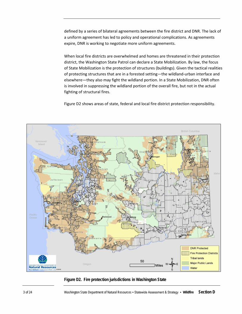
3 of 24 Washington State Department of Natural Resources ▪ Statewide Assessment & Strategy ▪ Wildfire Section D
defined by a series of bilateral agreements between the fire district and DNR. The lack of a uniform agreement has led to policy and operational complications. As agreements expire, DNR is working to negotiate more uniform agreements. When local fire districts are overwhelmed and homes are threatened in their protection district, the Washington State Patrol can declare a State Mobilization. By law, the focus of State Mobilization is the protection of structures (buildings). Given the tactical realities of protecting structures that are in a forested setting—the wildland-urban interface and elsewhere—they also may fight the wildland portion. In a State Mobilization, DNR often is involved in suppressing the wildland portion of the overall fire, but not in the actual fighting of structural fires. Figure D2 shows areas of state, federal and local fire district protection responsibility.
Figure D2. Fire protection jurisdictions in Washington State

4 of 24 Washington State Department of Natural Resources ▪ Statewide Assessment & Strategy ▪ Wildfire Section D
CONDITIONS & TRENDS Identified Wildfire Risk Areas
Three main categories of forests in Washington are identified as having a high risk of wildfire. Those are the Eastern Washington dry forests, mountain gap wind zones, and the San Juan Islands in the Puget Sound. Eastern Washington Dry Forests
The majority of fire starts and acres burned occur in the dry forests of Eastern Washington. Fifty four percent of fire starts and ninety six percent of wildfire acres burned on DNR protected lands occurred in Eastern Washington (DNR 2006). In addition, 1.1 million acres of forest land protected by DNR in Eastern Washington is classified as fire regime I or II (Eisfeldt 2010). These areas historically experienced wildland fires every thirty years, or less. Due to forest growth, past forest management practices, and the reduced role of natural fire, a significant part of the Eastern Washington forest landscape is at elevated risk of large, severe wildfires. One method of quantifying increased risk is Fire Regime Condition Class, which combines fire regime data with a metric for present-day conditions in terms of their degree of departure from historical reference conditions — i.e., how prone to wildfire forestlands are as a result of changes to the natural forest landscape. As shown in Figure D3, much of the overall Eastern Washington landscape is categorized as a moderate or high degree of departure from historical conditions. From among the nearly 9 million acres of forested land in Eastern Washington, 6.2 million are at moderate or high departure Fire Regime Condition Class. When these areas experience wildfire in the future, fires have a greater potential to be large and severe. Applying prescribed fire or other fuel reduction treatments can restore forest stand conditions to a state of greater resiliency against severe wildfires and moderate wildfire behavior. This is the area of focus for most community wildfire planning efforts and fuel reduction projects. Mountain Gap Wind Zones
The Cascade Mountain range creates an effective barrier to wind flow across the state. This results in wind funneling through gaps in the mountains at low points. Key areas of concern include the Columbia Gorge, Stampede Gap, Kittitas Valley, the north and south sides of the Olympic Mountains, among other areas. Sustained winds in these areas regularly exceed thirty miles per hour. The Enumclaw area in the western Cascade foothills experiences and average of five episodes of 50- to 80-mile per hour winds each year (Mass 2008). These winds can sustain wind-driven fires during any season of the year. Community wildfire planning and fuel reduction efforts in Western Washington focus on these areas.
T R E N D 19 T O T R A C K
Acres of forestland in
Condition Class 2 and 3 in
Eastern Washington

5 of 24 Washington State Department of Natural Resources ▪ Statewide Assessment & Strategy ▪ Wildfire Section D
Figure D3. Fire Regime Condition Class — departure from historic fire patterns —
in Eastern Washington State

6 of 24 Washington State Department of Natural Resources ▪ Statewide Assessment & Strategy ▪ Wildfire Section D
San Juan Islands While fire occurrence is low in Washington’s San Juan Islands, these areas present significant wildfire risks. The islands lie in the rain shadow of the Olympic Mountain Range. Some of the islands are exposed to gap winds flowing through the Strait of Juan de Fuca, similar to winds in the Cascade Mountains. Finally, the need to travel by boat delays wildfire response when outside resources are needed. Understandably, residents of the islands are very concerned with wildfire and are strong proponents of fire prevention. Many of the recognized ‘Firewise Communities’ in the state are on the San Juan Islands.
Wildfire Starts and Acres Burned
Table D1 shows the number of fires and acres for calendar years 2004 through 2009 (DNR 2010a). The 2009 fire season was characterized by above average numbers of fires (15 percent above average) and significantly below average acres burned (45 percent below average). This was the smallest area burned on DNR-protected lands in five years. Table D1. Total annual number of fires and acres burned in Washington State, 2004-2009
(DNR 2010a)
Calendar year DNR Protected Lands All Lands
# Wildfires Acres Burned # Wildfires Acres Burned 2004 863 6,975 1,694 89,301
2005 645 30,962 972 28,698
2006 1021 48,802 1,634 303,289
2007 981 23,535 1,571 182,192
2008 830 32,680 1,426 78,373
2009 1044 17,203 1,976 77,250
6 yr Average 897 26,693 1,546 126,517 Since the late 1980s, the number of wildfire starts has been trending downward while the number of acres burned has trended upward, as shown in Figure D4. This mirrors a national trend wherein large, complex and severe fires have become more common.
T R E N D 20 T O T R A C K
Annual acres burned
by wildfires on all ownerships

7 of 24 Washington State Department of Natural Resources ▪ Statewide Assessment & Strategy ▪ Wildfire Section D
Figure D4. Trend in wildfire starts and acres burned in Washington State on all lands since 1989 (Includes federal, state, local public, tribal and private lands)
Patterns of change in the overall length of the wildfire season – and the period of time within each season when fire danger is extreme—are other factors potentially affecting the trend in large, severe events. In future assessments, one metric that could be used to track these patterns of change is Energy Release Component (ERC). ERC measures the contribution that all live and dead forest fuels can make to potential fire intensity based on their moisture content and local weather conditions. ERC above a certain threshold level indicates that fire behavior will be extreme. Aggregating data over several fire seasons can depict the length of time ERC ratings were sustained above those thresholds to begin informing a trend in large fire potential.
DNR’s fire suppression performance goal is to contain 93 percent of wildfires on DNR-protected forestland at or below 10 acres in size. For the 2009 fire season, DNR exceeded this goal by keeping 96.4 percent of fires below 10 acres (Table D2).
0
500
1,000
1,500
2,000
2,500
0
100,000
200,000
300,000
400,000
500,000
600,000
1989
1990
1991
1992
1993
1994
1995
1996
1997
1998
1999
2000
2001
2002
2003
2004
2005
2006
2007
2008
2009
Num
ber o
f Fir
e St
arts
Acr
es B
urne
d
Acres Burned Number of Fire Starts

8 of 24 Washington State Department of Natural Resources ▪ Statewide Assessment & Strategy ▪ Wildfire Section D
Table D2. Percentage of fires on DNR- protected forestlands contained at or below 10 acres in size
Year Percent of fires contained
at or below 10 acres 2005 95.7% 2006 97.6% 2007 96.2% 2008 94.4% 2009 96.4%
Wildfire Causes
Most wildfires in Washington are caused by people. Between 2004 and 2008, 81 percent of fires were human-caused, and 19 percent were started by lightning. Lightning-caused fires tend to be larger in size on average, accounting for 43 percent of acres burned during the period (Table D3). Table D3. Number of fire starts in Washington State, by general cause, 2004-2008
General Cause
2008 2007 2006 2005 2004 5 Year Average
Lightning 219 126 160 62 268 167 Incendiary 38 46 32 25 44 37 Recreation 80 161 159 129 110 128 Smokers 19 15 19 3 12 14 Debris burns 152 211 218 146 166 179 Logging 5 10 19 12 11 11 Children 32 46 73 28 33 42 Railroad 5 15 14 13 11 12 Miscellaneous 280 351 327 227 208 279 Totals 830 981 1021 645 863 868
Property Damage
Although DNR does not have jurisdictional responsibility to protect developed property from wildfire, DNR firefighters take action to keep forest fires from reaching homes and other improvements. The presence of homes and other improvements within and adjacent to forests protected by DNR strongly influences incident management strategy
T R E N D 21 T O T R A C K
Percentage of annual fire starts
caused by humans
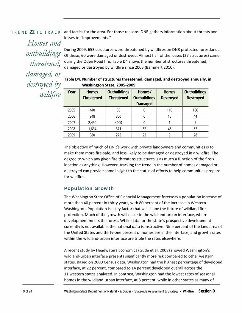
9 of 24 Washington State Department of Natural Resources ▪ Statewide Assessment & Strategy ▪ Wildfire Section D
and tactics for the area. For those reasons, DNR gathers information about threats and losses to “improvements.” During 2009, 653 structures were threatened by wildfires on DNR protected forestlands. Of these, 60 were damaged or destroyed. Almost half of the losses (27 structures) came during the Oden Road fire. Table D4 shows the number of structures threatened, damaged or destroyed by wildfire since 2005 (Bammert 2010). Table D4. Number of structures threatened, damaged, and destroyed annually, in
Washington State, 2005-2009
Year Homes Threatened
Outbuildings Threatened
Homes/ Outbuildings
Damaged
Homes Destroyed
Outbuildings Destroyed
2005 440 86 0 110 106 2006 948 350 0 15 44 2007 2,490 4000 0 1 5 2008 1,634 371 32 48 52 2009 380 273 23 9 28
The objective of much of DNR’s work with private landowners and communities is to make them more fire-safe, and less likely to be damaged or destroyed in a wildfire. The degree to which any given fire threatens structures is as much a function of the fire’s location as anything. However, tracking the trend in the number of homes damaged or destroyed can provide some insight to the status of efforts to help communities prepare for wildfire. Population Growth
The Washington State Office of Financial Management forecasts a population increase of more than 40 percent in thirty years, with 80 percent of the increase in Western Washington. Population is a key factor that will shape the future of wildland fire protection. Much of the growth will occur in the wildland-urban interface, where development meets the forest. While data for the state’s prospective development currently is not available, the national data is instructive. Nine percent of the land area of the United States and thirty-one percent of homes are in the interface, and growth rates within the wildland-urban interface are triple the rates elsewhere. A recent study by Headwaters Economics (Gude et al. 2008) showed Washington’s wildland-urban interface presents significantly more risk compared to other western states. Based on 2000 Census data, Washington had the highest percentage of developed interface, at 22 percent, compared to 14 percent developed overall across the 11 western states analyzed. In contrast, Washington had the lowest rates of seasonal homes in the wildland-urban interface, at 8 percent, while in other states as many of
T R E N D 22 T O T R A C K
Homes and outbuildings threatened,
damaged, or destroyed by
wildfire

10 of 24 Washington State Department of Natural Resources ▪ Statewide Assessment & Strategy ▪ Wildfire Section D
44 percent of homes in the interface were seasonal. Washington’s wildland-urban interface is highly developed, with the vast majority as primary residences. The largest areas of forested wildland-urban interface are concentrated in counties with the major population centers in Western Washington. Increasing urbanization of already-developed interface areas is an accelerating trend. However, Eastern Washington has counties with some of the largest areas of undeveloped forests. When coupled with high rates of population growth and frequent return interval fire regimes, Eastern Washington represents the highest future risk to human safety and property loss in the wildland-urban interface. Forecasts for Washington show the population increasing by almost 2.4 million between 2006 and 2020. This means that there will be some 600,000 new dwelling units, many of which will be single-family homes located in the wildland-urban interface. Substantially increased fire protection capabilities are necessary to adequately protect life, developed property and forest resources. Not only is the population growing, more people also are acquiring second homes. As more homes are built in the wildlands, the land becomes less “wild” but still exposed to substantial wildfire risk. The risks often are compounded by the interaction of forest health issues and affects of climate change. For more information about population growth over time, see the discussion in the Population / Demographic portion of Working Forestlands & Conversion, section A. Forest Health
Trends in forest health, particularly in Eastern Washington forests, and their role in exacerbating wildfire risk is well documented. For more on the relationship between forest health and wildfire, see section E on Forest Health Restoration.

11 of 24 Washington State Department of Natural Resources ▪ Statewide Assessment & Strategy ▪ Wildfire Section D
THREATS & OPPORTUNITIES Threat: Human Safety & Property Loss
Wildfires present a clear and present danger to human safety and can result in catastrophic loss of property. Declining forest health, a changing climate, and increasing populations in the wildland-urban interface are putting human populations in closer proximity with an ever increasing risk of wildfire. As the state and federal government and local fire districts work diligently to quickly contain what likely are to be more frequent wildfire starts, human safety and property will continue to be put at risk. In addition, vast tracts of forestlands that provide valuable resources for the timber industry may be lost to wildfire.
Opportunities Improve fire prevention and suppression Protect, assist and educate populations in the wildland-urban
interface Reduce fuel loads in Eastern Washington forests
Threat: Increased Development in the Wildland-Urban Interface
Substantial projected growth in the state of Washington means increased development in the wildland-urban interface will continue, and likely at increased rates. Wildfire in the wildland-urban interface threatens human safety, property, and loss of forest resources crucial to local, regional and state economies. Dense, unhealthy forests in these areas carry dangerously high fuel loads that, if not treated, make them highly susceptible to wildfire.
Opportunities Protect, assist and educate populations in the wildland-urban
interface Reduce fuel loads in Eastern Washington forests Reduce the rate of forest conversion
Threat: Deteriorating Forest Health
Eastern Washington faces serious forest health problems where forests are overcrowded or trees lack sufficient resilience to insects, diseases, and fire. Contributions to these problematic conditions include fire suppression, past timber harvesting and silvicultural practices — stand structure and planting stands with species that do not mimic native stand compositions — and the amplified risks that occur when the urban interface penetrates forestland.

12 of 24 Washington State Department of Natural Resources ▪ Statewide Assessment & Strategy ▪ Wildfire Section D
Heavy accumulations of live and dead trees have increased the wildfire fuel loads and potential fire behavior in many parts of Eastern Washington. Major wildfires in recent years have been associated with insect and disease activity. Unless actively managed, or burned (either controlled or by wildfire), many Eastern Washington forests remain at high risk of serious additional disturbance from pests and wildfire. Some structural elements of forests and habitats such as soil quality, forest composition and productivity, require a long time to grow or accumulate. In locations where fires burn at high intensity, these basic elements of biodiversity and productivity may be diminished for centuries. Furthermore, the loss of vegetation can cause short-term and long-term damaging stream temperature and sedimentation that represent harmful effects to water quality.
Opportunities Reduce fuel loads in Eastern Washington forests Restore ecological integrity, appropriate density, structure and
species composition to overstocked Eastern Washington forests Integrate fuel reduction activities with forest health
improvement actions Partner with multiple landowners and managers to achieve
landscape-scale forest health restoration objectives Use prescribed fire to restore & maintain fire-resistant stand
conditions
Threat: Climate Change
The impacts of climate change are anticipated to have a significant impact on fire occurrence and severity wildfires in Washington. The Washington Climate Change Impacts Assessment (Climate Impacts Group 2009) reported that:
Due to increased summer temperature and decreased summer precipitation, the area burned by fire regionally is projected to double by the 2040s and triple by the 2080s (relative to 1916-2006). The probability that more than two million acres will burn in a given year is projected to increase from 5 percent (observed) to 33 percent by the 2080s. Primarily east of the Cascades, mountain pine beetles will likely reach higher elevations and pine trees will likely be more vulnerable to attack by beetles.
Projected changes in climate and therefore precipitation and temperature patterns will likely put trees under greater moisture stress and therefore declines in forest health. For more on climate change impacts to forest health, please see section E.
Opportunities Restore and maintain forest productivity and carbon
sequestration value of forests for climate change mitigation Assist forest ecosystems with adapting to a changed climate

13 of 24 Washington State Department of Natural Resources ▪ Statewide Assessment & Strategy ▪ Wildfire Section D
Threat: Loss of Forest Markets
At the same time wildfire hazard and forest health conditions have been worsening in Eastern Washington, landowners’ and managers’ ability to address the problem has also diminished. Forest manufacturing infrastructure that once could pay for the removal of trees from thinning, harvest and restoration actions has been reduced. Without markets for forest materials, large-scale improvements in forest health and fuels conditions are rendered infinitely more difficult. Additionally, many fuels reduction and forest health treatments result in the removal of biomass materials that are not yet widely utilized for commercial purposes, and therefore present a significant challenge in their disposal.
Opportunities Maintain and develop forest markets and infrastructure
RELEVANT NATIONAL THEMES & STRATEGIC OBJECTIVES The Wildfire Hazard Reduction issue area is reflected in two National Themes “Protect Forests from Harm” and “Enhance Public Benefits from Trees and Forests” from the State and Private Forestry Redesign structure. Wildfire risks will be addressed through two Strategic Objectives — “Restore fire-adapted lands and reduce risk of wildfire impacts” and “Assist communities in planning for and reducing wildfire risks.”
EXISTING STRATEGIES
2020 Strategic Plan for Wildland Fire Protection
In 2006, DNR completed its first comprehensive review of the agency’s Wildfire Protection Program since 1986. Within those two decades, much had changed on the 12.7 million acres of forests protected by DNR. An additional 1.6 million people, a 40 percent increase in population, has resulted in more homes in the woods that often don’t have any fire protection. Climate change and other factors substantially have reduced the health of our forests. The results are increased risks to public safety and firefighter safety, compounded by the increased costs of fire suppression and accelerated losses of productive soils, important habitats, as well as landowner timber values. The DNR worked collaboratively with an external advisory committee to develop the 2020 Strategic Plan for Wildland Fire Protection in 2006. The 2007 Legislature directed DNR to create a broad-based, multi-stakeholder group to review previous studies of DNR Fire Programs (including the Strategic Plan); examine the current funding mechanisms of fire programs for appropriateness and adequacy; and look at future challenges and

14 of 24 Washington State Department of Natural Resources ▪ Statewide Assessment & Strategy ▪ Wildfire Section D
opportunities. This group was called the Forest Fire Prevention & Protection Work Group (Workgroup). The 2006 Strategic Plan and 2008 Forest Fire Prevention & Protection Work Group Recommendations (DNR 2008) include the following elements:
Focus on forest health: Forest health and wildfire are closely connected. Based on the ecology of Washington’s forests, our understanding of the role that fire plays in healthy forests is increasing. A forest’s ability to withstand stresses such as drought, fire, insects and diseases is directly affected by complex interactions of many biotic (or living) and abiotic (non-living) factors. Forest health issues cross ownership boundaries, and efforts must be made to address how landscape level forest health improvement efforts can reduce public costs and protect resources.
Focus on evaluating near-term investments against long-term savings: Methods must be used to comprehensively evaluate ‘up-front’ investments in fire prevention within the scope of long-term costs and savings associated with fire suppression – known as “net cost” accounting. There are substantial savings to taxpayers and the public when wildfire fuels reduction projects are completed. Substantial costs can be avoided when both market and non-market values are part of wildland fire protection decisions. A “net cost” framework provides a method to evaluate solutions that recognize the various types of risk and the net effect of resources, while acknowledging the different parties at risk.
Focus on personal and institutional responsibilities: Landowners, communities, governmental entities and the public each have different responsibilities for wildfire protection. Decisions by individual property owners and land-use or other regulatory authorities can reduce or increase costs and risks to private property and the public. There is a strategic priority for assisting entities with understanding and fulfilling their respective roles, so that each may be working toward an effective and comprehensive system of wildfire protection.
Development of a Model Wildfire Protection Ordinance: With more than 600,000 new homes to be built in Washington by 2020, actions taken today can reduce future costs and risks to public safety. Many of these homes will be in the wildland urban interface, in which wildfire protection has become increasingly complex and costly. The strategic plan calls for working with the various interests to collaboratively develop the elements of a model wildfire protection ordinance that can be used throughout the state.
Create Universal Fire Protection: Current state law does not require universal fire protection, creating tension for both property owners and those who provide fire protection services. Organized and funded fire protection should be required for all land in Washington.

15 of 24 Washington State Department of Natural Resources ▪ Statewide Assessment & Strategy ▪ Wildfire Section D
U.S. Forest Service State & Private Forestry Programs
Community Wildfire Protection Plans
Washington has 43 Community Wildfire Protection Plans (CWPP) in 21 counties that are either developed or in progress (Figure D5, DNR 2010c). These plans define actions to be taken by communities and landowners, as well as recommendations for state and federal land managers. At a minimum, Community Wildfire Protection Plans must:
be collaboratively developed by local and state government representatives, in consultation with federal agencies and other interested parties,
identify and prioritize areas for hazardous fuel reduction, and
recommend measures that homeowners and communities can take to reduce the ignitability of structures throughout the area addressed by the plan.
Copies of all completed plans are available at the DNR website.
Figure D5. Areas covered by Community Wildfire Protection Plans (CWPPs) in Washington

16 of 24 Washington State Department of Natural Resources ▪ Statewide Assessment & Strategy ▪ Wildfire Section D
Wildland-Urban Interface Wildfire Fuel Reduction Projects
DNR collaborates with other state and local partners to administer funding received through the Western State Fire Managers’ wildland-urban interface grant program and the Community Assistance Grant Program under the Pacific Northwest National Fire Plan. These programs help private forest landowners accomplish hazardous fuel reduction projects identified as priorities in community wildfire protection plans. Since 2001, 727 projects have been completed, and an additional 226 projects are planned and funded (Figure D6). In addition, many more landowners apply for assistance each year for projects identified in Community Wildfire Protection Plans than can be funded (Harris 2010).
Figure D6. Planned, completed Eastside hazardous wildfire fuel reduction projects

17 of 24 Washington State Department of Natural Resources ▪ Statewide Assessment & Strategy ▪ Wildfire Section D
Firewise Communities/USA
The Firewise Communities/USA program (National Fire Protection Association 2010) encourages and acknowledges actions by communities that minimize home loss to wildfire. The program adapts especially well to small communities, developments and residential associations. Firewise Communities/USA is a simple, ‘three-legged’ template that is easily tailored to different locales. It works in the following way:
DNR staff or other wildfire specialists provide a community with information about living with the threat of wildfire, including specific ways to mitigate wildfire risks for that particular community.
The community assesses its own wildfire risk and creates a community network of cooperating homeowners, agencies and organizations.
The community identifies and implements local solutions. Washington currently has 62 certified Firewise communities, more than any other western state. In Washington, the locations of recognized Firewise Communities are shown in Figure D7. The complete list of communities is available on the internet (National Fire Protection Association 2010).
Figure D7. Firewise Communities in Washington State, 2010

18 of 24 Washington State Department of Natural Resources ▪ Statewide Assessment & Strategy ▪ Wildfire Section D
Fire District Assistance
In areas served by fire protection districts, volunteer firefighters frequently are the first responders to wildfires within their boundaries. DNR supports fire districts with this responsibility through administration of the Volunteer Fire Assistance and Federal Personal Property Programs. These U.S. Forest Service-funded programs provide fire districts with training, equipment and vehicles needed to suppress fires while they are still small, saving natural resources, money and property. Through these programs, DNR has provided more than 500 firefighting vehicles to fire districts. These programs provide crucial assistance, as 80 percent of replaced vehicles are more than 20 years old and are reaching the end of their useful lives for fighting wildfires (DNR 2010b).
Restoring Fire-Adapted Lands across Ownerships
Several collaborative efforts are underway in Washington to restore the health of the fire-adapted lands generally east of the Cascade Range to reduce the risk of uncharacteristic —and catastrophic—wildfire across these landscapes. Tapash Sustainable Forest Collaborative
This coalition of public, non-profit and tribal land managers is working cooperatively to overcome land management constraints presented by the checkerboard ownership pattern characteristic of eastern Washington (U.S. Fire Learning Network 2008). The Tapash Collaborative is focused on restoring fire-adapted ecosystems to a core area within the Wenatchee National Forest by exploring new implementation tools and opportunities including stewardship contracting, ecosystem services markets, cellulosic ethanol production from forest biomass and National Fire Plan funding. Using a process developed by The Nature Conservancy called “Conservation Action Planning,” the collaborative partners structured the scope, overall project vision and desired ecological outcomes. They then created clear strategies to accomplish the shared vision. The Tapash Collaborative has built a protocol for applying fuels treatment projects across federal and state ownership. Northeast Washington Forestry Coalition
The Northeast Washington Forestry Coalition (Coalition) was formed in 2002 to demonstrate the full potential of forestry to enhance forest health, public safety, and community economic vitality. The Coalition is a local, citizen-led cooperative effort to bring together mill workers, conservationists, business owners, recreationists, loggers, foresters, ranchers, Tribes and elected officials. Together they are working with the Colville National Forest and other land management agencies to find solutions to forest health, economic, and other land management challenges in northeast Washington. Originally formed to identify common ground between timber and conservation interests, the Coalition has worked together on over twenty forestry projects to reduce

19 of 24 Washington State Department of Natural Resources ▪ Statewide Assessment & Strategy ▪ Wildfire Section D
fire risk, improve forest health, and enhance wildlife habitat on the Colville National Forest (Northeast Washington Forestry Coalition 2010).
The Coalition’s objectives are:
to design and implement forest restoration and fuels reduction projects that demonstrate innovative approaches to forestry,
to demonstrate how a diverse coalition of stakeholders can work together to successfully promote restoration forestry and community protection from wildfire,
to use the projects to educate the public about the ecological and socio-economic benefits of restoration forestry and fuels reduction strategies, and
to develop model forest restoration and fuels reduction projects that can be emulated in other regions of the country.
Methow Forest Owners’ Cooperative
The Methow Forest Owners’ Cooperative was awarded funding through the National Fire Plan to develop the “Methow Valley Cost Share Incentive Program” (CSIP). The incentives program, administered by Methow Forest Owner’s Cooperative, provides cost-sharing to assist eligible property owners with needed fuels reduction and forest health improvements (Methow Forest Owners’ Cooperative 2010). This program is intended to reduce the risk of wildfire damage to homes and resources on public and private lands, and has been developed in cooperation with the Methow Community Fire Plan Coordinating Group to focus on areas identified as high priority — those most at risk for catastrophic wildfire. Cost-share funds may be used for such activities as thinning, pruning, piling slash, and chipping. Eligible landowners who have signed a CSIP Work Plan have the option of completing the work themselves — at agreed-upon landowner reimbursement rates, working with a contractor from the co-op’s roster, or hiring their own contractor. National Fire Plan funding was awarded in 2007, 2008 and 2009.
DATA & PROGRAM GAPS WUI and Population Growth: Projections of population growth (homes to be
built) in Washington state in the wildland-urban interface. National data exists, but state data is unavailable. Projections that reflect differences in population growth and development rates (by county, for instance) would help with planning for wildland firefighting and prevention planning.
Quantifying Avoided Costs: Development of a methodology to evaluate and estimate the costs and savings that could result from more effective fire
20 of 24 Washington State Department of Natural Resources ▪ Statewide Assessment & Strategy ▪ Wildfire Section D
prevention activities, including forest management, specifically as they relate to forest health issues.
Fire Suppression Cost Analysis: Development of a methodology to estimate costs incurred for fire suppression to protect human built structures in the increasingly developed wildland-urban interface of Washington State.
Treatment Optimization: Development of an optimization model for fire prevention and mitigation activities in the wildland-urban interface.
Completed Treatment Data: Centralized spatial data for completed fuels reduction and forest health restoration projects. Portions of these data exist for public agencies and government-funded actions on private land, but a clearinghouse of information to be shared among land and fire managers is not yet available.

21 of 24 Washington State Department of Natural Resources ▪ Statewide Assessment & Strategy ▪ Wildfire Section D
See following pages for Priority landscapes for All-Lands Opportunities Forest Wildfire Hazard Reduction

22 of 24 Washington State Department of Natural Resources ▪ Statewide Assessment & Strategy ▪ Wildfire Section D
P R I O R I T Y L A N D S C A P E S
All-Lands Opportunities for Forest Wildfire Hazard Reduction Analysis helped identify landscape-level opportunities for shared work and investments in wildfire hazard reduction on forestlands across Washington State. An “All Lands” approach to forest management is a policy goal articulated by federal and state government leaders, and enjoys broad support from many other governmental and non-governmental partners. Therefore, the opportunities to work across ownership boundaries — with continuity of purpose and shared objectives — were what defined “priority landscapes” for this assessment.
Geospatial data from the Statewide Assessment and other sources were compiled to assign opportunity categories to each landscape. In choosing the scale of “landscape” at which to aggregate opportunities, large watersheds— Watershed Resource Inventory Areas (WRIAs) —were selected as the appropriate scale.
There are 62 WRIAs in Washington. The boundary of each includes a major river drainage about the size of a U.S. Geologic Survey Hydrologic Unit Code 8 (HUC-8) sub-basin watershed.
To assess “All Lands” opportunities for wildfire hazard reduction, DNR compared forestland data among the landscapes for Fire Regime Condition Class 2 and 3 (moderate and high, respectively), fuels treatments carried out on private land, Community Wildfire Protection Plan priority forest treatments, and areas planned for future U.S. Forest Service projects. Specific documentation and maps of the spatial data subsets are displayed in Appendix A.

23 of 24 Washington State Department of Natural Resources ▪ Statewide Assessment & Strategy ▪ Wildfire Section D
Okanogan Landscape
Total Forestland in Landscape (acres) 468,426 Percent of Okanogan WRIA in Forestland 35.0% Forest landowners Acres Percent of
Forested landscape Small Private Owners 80,881 17.3% Industrial Private Owners 7,853 1.7% US Forest Service (non-Wilderness) 124,094 26.5% Bureau of Land Management 12,782 2.7% US Fish & Wildlife Service 1,597 0.3% Colville Tribe 76,497 16.3% State Trust Land (DNR) 123,209 26.3% Washington Department of Fish & Wildlife 4,513 1.0% Analysis Data
Forested Condition in Class 2&3 396,689 84.4% Forested CWPP-Identified Priority Treatments
52,308 11.1%
Completed Private Land Fuels Treatments 1,754 0.4% US Forest Service Project Planning Areas 20,097 4.2%
Examples & Key Measures HIGH-OPPORTUNITY LANDSCAPE
General characteristics Contains extensive amount of forest with conditions
that are at elevated risk of severe wildfires, and Community Wildfire Protection Plans have identified
locations with a significant amount of treatment required, and
Previous hazard reduction treatments have been conducted, and future adjacent treatments could achieve a more complete result across a broader landscape, and
Federal land managers are planning hazard reduction treatments.
MODERATE-OPPORTUNITY LANDSCAPE
General characteristics May have fewer acres with the four criteria of high-
opportunity landscapes, or May be a significant priority for one or more criteria of
high-opportunity landscapes, but lack priority in other criteria, or
May be designated to address landscapes in which wildfires are not as frequent, but can be extremely severe and threaten lives and resource values when they do occur (e.g., Westside mountain gap wind zones).
LOW-OPPORTUNITY LANDSCAPE General characteristics May contain only one of the characteristics of high-
opportunity landscapes, or May have only small acreages, relative to other
landscapes, of the metrics used in the analysis, or May contain little forestland overall, or May lack significant wildfire hazards.
Little Spokane Landscape
Total Forestland in Landscape (acres) 188,512 Percent of Little Spokane WRIA in Forestland 55.9%
Forest landowners Acres Percent of Forested landscape
Small Private Owners 144,751 76.8% Industrial Private Owners 25,380 13.5% US Forest Service (non-Wilderness) 273 0.1% Bureau of Land Management 0 0.0% US Fish & Wildlife Service 0 0.0% Tribal 0 0.0% State Trust Land (DNR) 9,844 5.2% Washington State Parks 6,642 3.5% Analysis Data Forested Condition Class 2&3 153,134 63.2% Forested CWPP-Identified Priority Treatments
18,796 7.8%
Completed Private Land Fuels Treatments 3,395 1.8% US Forest Service Project Planning Areas 0 0.0%
Palouse Landscape
Total Forestland in Landscape (acres) 55,448 Percent of Palouse WRIA in Forestland 3.2% Forest Landowners Acres Percent of
Forested landscape Small Private Owners 44,132 79.6% Industrial Private Owners 107 0.2% US Forest Service (non-Wilderness) 0 0.0% Bureau of Land Management 442 0.8% US Fish & Wildlife Service 7,553 13.6% State Trust Land (DNR) 2,090 3.8%
Analysis Data Forested Condition Class 2&3 45,661 79.2% Forested CWPP-Identified Priority Treatments
8,079 14.0%
Completed Private Land Fuels Treatments 86 0.2% US Forest Service Project Planning Areas 0 0.0%

24 of 24 Washington State Department of Natural Resources ▪ Statewide Assessment & Strategy ▪ Wildfire Section D

1 of 26 Washington State Department of Natural Resources ▪ Statewide Assessment & Strategy ▪ Forest Health Section E
Forest Health Restoration Insects and disease, the absence of natural fire, and climate change threaten forest health, particularly in Eastern Washington. Reduced productivity and catastrophic mortality in forests and ecosystems reduce their ability to provide wildlife habitat, forest products, and other public benefits on which people depend, such as air quality and carbon sequestration. Investments and effort should be made to effectively address threats to forest health. CONDITIONS & TRENDS Washington’s forests always have been affected by insects, pathogens, wildfire and extremes in weather. In recent decades, some of these disturbances seem to have become more widespread, more intense and of longer duration than occurred previously. Such changes in the forests, particularly in Eastern Washington, are associated with a high density of trees and changes in species composition, stand structure and connectivity. These changes create tree stress and allow disturbance agents to spread easily (Hessburg et al. 1999). Weather and climate changes predicted for future decades are likely to make many of these problems worse. Tree Mortality & Defoliation
In 2009, more than 1.73 million acres of Washington’s forest land contained elevated levels of new tree mortality, current tree defoliation or foliage diseases (DNR 2010). This is an increase from the 1.36 million acres reported in 2008 (Table E1). The primary causes of this mortality and defoliation in recent years have been bear damage or root disease, pine bark beetles, western spruce budworm and fir engraver beetle infestations (Table E1, DNR 2010). Not every tree on affected acres is damaged. Some important damage agents such as dwarf mistletoe are not included in this survey. The location and additional information about causal agents is depicted in Figure E1: Forest Disturbance Activity in Western Washington, and Figure E2: Forest Disturbance Activity in Eastern Washington.
T R E N D 23 T O T R A C K
Total annual area of
forest land containing new tree mortality,
current tree defoliation or foliar diseases
section E

2 of 26 Washington State Department of Natural Resources ▪ Statewide Assessment & Strategy ▪ Forest Health Section E
Figure E1. Forest Disturbance Activity in Western Washington (based on 2009 aerial survey data)
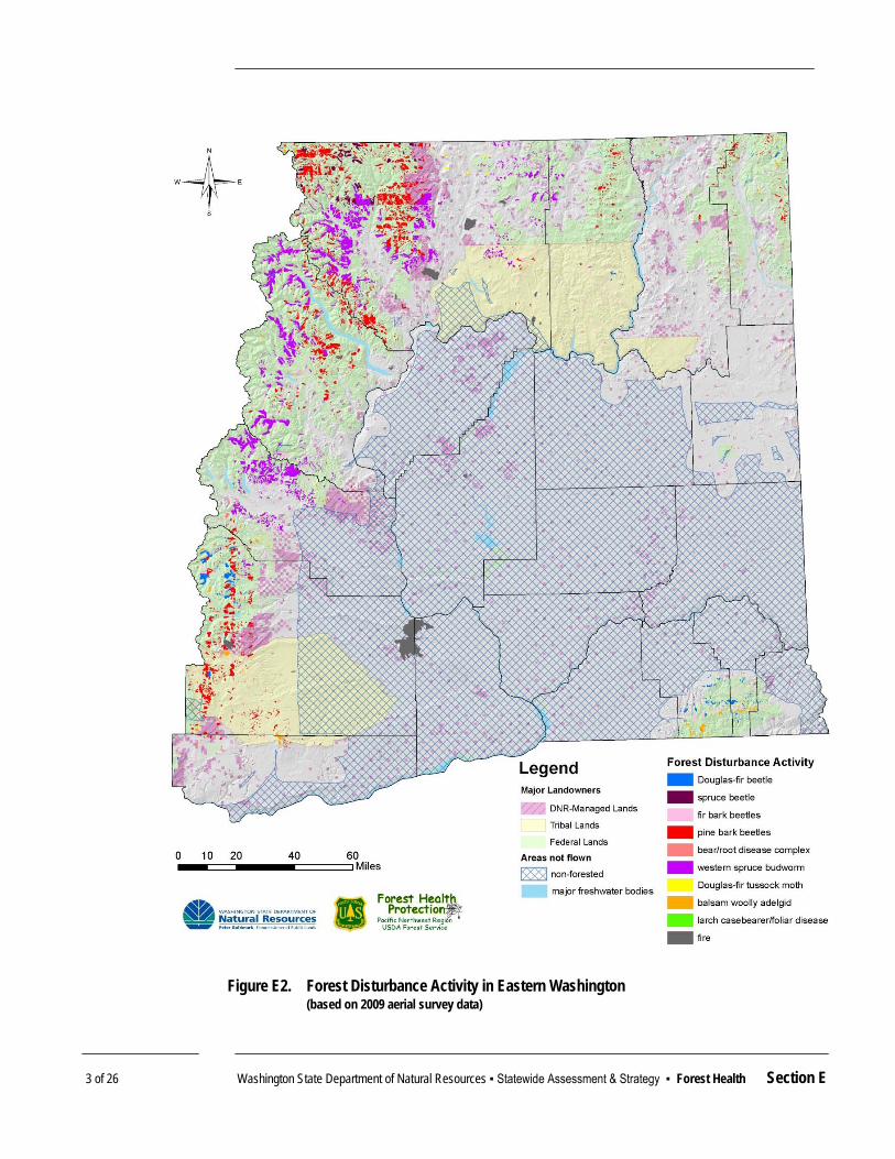
3 of 26 Washington State Department of Natural Resources ▪ Statewide Assessment & Strategy ▪ Forest Health Section E
Figure E2. Forest Disturbance Activity in Eastern Washington (based on 2009 aerial survey data)
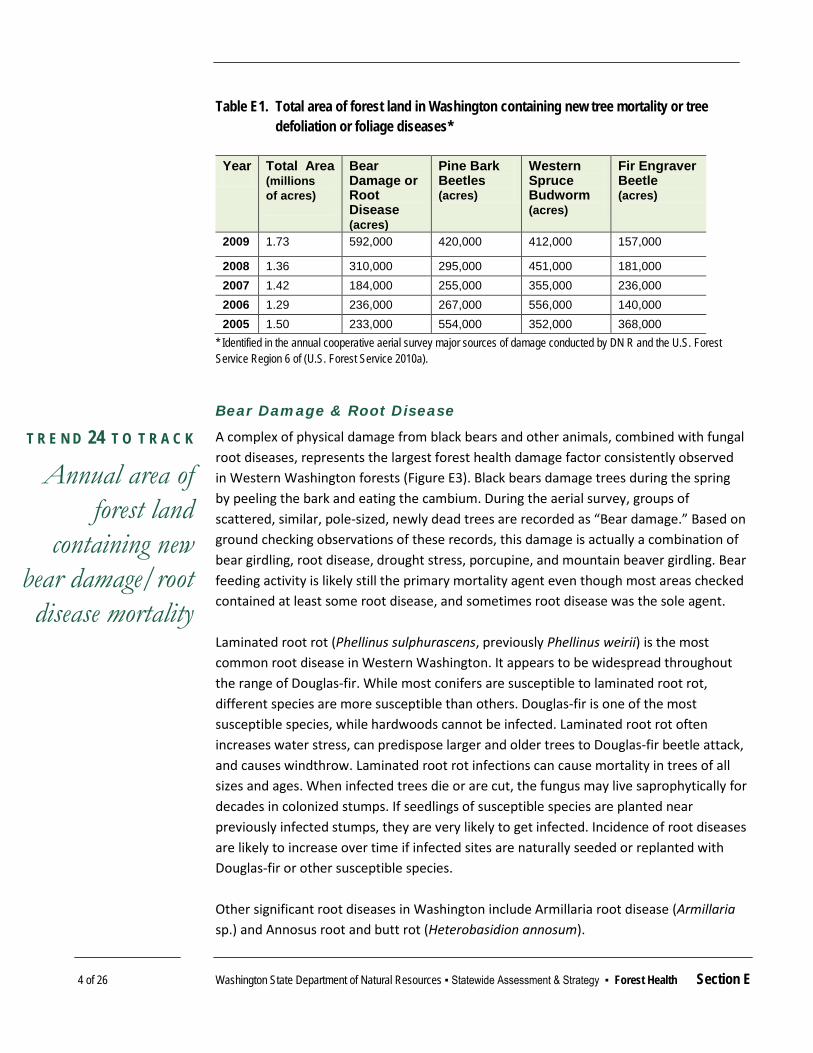
4 of 26 Washington State Department of Natural Resources ▪ Statewide Assessment & Strategy ▪ Forest Health Section E
Table E1. Total area of forest land in Washington containing new tree mortality or tree defoliation or foliage diseases*
Year Total Area
(millions of acres)
Bear Damage or Root Disease (acres)
Pine Bark Beetles (acres)
Western Spruce Budworm (acres)
Fir Engraver Beetle (acres)
2009 1.73 592,000 420,000 412,000 157,000
2008 1.36 310,000 295,000 451,000 181,000 2007 1.42 184,000 255,000 355,000 236,000 2006 1.29 236,000 267,000 556,000 140,000 2005 1.50 233,000 554,000 352,000 368,000
* Identified in the annual cooperative aerial survey major sources of damage conducted by DN R and the U.S. Forest Service Region 6 of (U.S. Forest Service 2010a).
Bear Damage & Root Disease
A complex of physical damage from black bears and other animals, combined with fungal root diseases, represents the largest forest health damage factor consistently observed in Western Washington forests (Figure E3). Black bears damage trees during the spring by peeling the bark and eating the cambium. During the aerial survey, groups of scattered, similar, pole-sized, newly dead trees are recorded as “Bear damage.” Based on ground checking observations of these records, this damage is actually a combination of bear girdling, root disease, drought stress, porcupine, and mountain beaver girdling. Bear feeding activity is likely still the primary mortality agent even though most areas checked contained at least some root disease, and sometimes root disease was the sole agent. Laminated root rot (Phellinus sulphurascens, previously Phellinus weirii) is the most common root disease in Western Washington. It appears to be widespread throughout the range of Douglas-fir. While most conifers are susceptible to laminated root rot, different species are more susceptible than others. Douglas-fir is one of the most susceptible species, while hardwoods cannot be infected. Laminated root rot often increases water stress, can predispose larger and older trees to Douglas-fir beetle attack, and causes windthrow. Laminated root rot infections can cause mortality in trees of all sizes and ages. When infected trees die or are cut, the fungus may live saprophytically for decades in colonized stumps. If seedlings of susceptible species are planted near previously infected stumps, they are very likely to get infected. Incidence of root diseases are likely to increase over time if infected sites are naturally seeded or replanted with Douglas-fir or other susceptible species. Other significant root diseases in Washington include Armillaria root disease (Armillaria sp.) and Annosus root and butt rot (Heterobasidion annosum).
T R E N D 24 T O T R A C K
Annual area of forest land
containing new bear damage/root disease mortality

5 of 26 Washington State Department of Natural Resources ▪ Statewide Assessment & Strategy ▪ Forest Health Section E
Pine Bark Beetles
Three major species of bark beetles affect pine host trees in Washington State. Mountain pine beetles (Dendroctonus ponderosae Hopkins), Western pine beetles (Dendroctonus brevicomis LeConte) and engraver beetles (Ips spp.) are the primary agents of mortality for ponderosa and lodgepole pine in Eastern Washington. Pine bark beetles infest only green, living trees, or damaged or fallen trees that are still green. Beetles tunnel beneath the bark, laying eggs along what is called a “gallery.” Within a few weeks the eggs hatch and the larvae feed on the nutritious tissue just beneath the bark. Once beetles find a suitable host tree, they release aggregating pheromones to attract other beetles enabling a “mass attack” that can overwhelm even a healthy tree’s defenses. If enough beetles are attracted to a tree, the feeding of the larvae outward from the gallery can girdle the tree. Along with releasing pheromones, the attacking beetles introduce a staining fungus that further weakens the tree by disrupting the trunk’s ability to transfer water. Bark beetle populations fluctuate year-to-year depending on the prevalence of stress-causing conditions in the forest. During “normal” years, beetle populations tend to decline because reasonably healthy trees are better able to resist beetle attacks. During drought years, beetle populations tend to increase. Competition between trees that are too closely crowded together has the effect of inducing stress on otherwise healthy trees as they compete with one another for the resources needed to grow.
Figure E3. Trend in bear damage/root disease in Washington State (2000-2009) (based on aerial survey data)
T R E N D 25 T O T R A C K
Annual area of forest land
containing new pine bark beetle-caused mortality

6 of 26 Washington State Department of Natural Resources ▪ Statewide Assessment & Strategy ▪ Forest Health Section E
Pine bark beetles consistently cause one of the highest amounts of damage among any other agent in Washington’s forests. Consistently upward-trending amounts of mortality in recent years (Figure E4) are considered to be a product of prolonged drought stress, climate change, natural fire exclusion, and over-crowded forest conditions. Where historically, beetle outbreaks were relatively short in duration and limited in size, we are now experiencing more widespread and severe levels of mortality.
Western Spruce Budworm
Western spruce budworm (Choristoneura occidentalis Freeman) is a widespread, native defoliating insect in western conifer forests. The insect is a small, mottled rusty-brown moth whose larvae (caterpillars) will eat the needles of almost all western conifers. Douglas-fir and grand fir tend to be the most suitable hosts. Other somewhat suitable hosts include Engelmann spruce, western larch, and subalpine fir. Trees infested by defoliators suffer reduced growth, topkill, and sometimes death. The amount of sustained damage depends on the initial health and vigor of the tree, and on the intensity and duration of attack. Severely defoliated trees often die, but topkill is usually more common than mortality. Trees weakened by defoliators become vulnerable to subsequent attack by bark beetles. Douglas-fir beetles (Dendroctonus pseudotsugae Hopkins) and fir engraver (Scolytus ventralis Le-Conte) beetles may kill more timber than the defoliator. Smaller trees tend to suffer more from the effects of defoliation, and larger trees tend to suffer more mortality from subsequent bark beetle attack.
Figure E4. Trend in pine bark beetle activity in Washington State (2000-2009) (based on aerial survey data)
T R E N D 26 T O T R A C K
Annual area of forest land
containing new Western spruce
budworm defoliation

7 of 26 Washington State Department of Natural Resources ▪ Statewide Assessment & Strategy ▪ Forest Health Section E
Forests most susceptible to attack and vulnerable to damage by spruce budworm contain more than 50 percent of their tree composition in susceptible species, have uneven or layered tree canopies with large host trees in the overstory, and contain trees that are crowded too closely together. Unfortunately, a lack of natural fire or mechanical thinning, and historical forest management practices that reduced the diversity of tree species have contributed to making susceptible forest conditions more and more common throughout Eastern Washington. Over time, as unsusceptible species like ponderosa pine were harvested and only the susceptible species like Douglas-fir were left, stands that once contained a mixture of tree species have shifted in composition. Additionally, periodic fires historically killed susceptible species like grand fir, preventing these trees from growing beneath the canopy of larger and less susceptible trees. When natural fire became less frequent due to fire suppression, these species continued growing. Forest density increased and a multi-layered canopy developed, which allows defoliators to thrive. Widespread susceptible conditions have resulted in consistently high levels of budworm damage in recent years (Figure E5).
Figure E5. Trend in Western spruce budworm defoliation in Washington State (2000-2009) (based on aerial survey data)

8 of 26 Washington State Department of Natural Resources ▪ Statewide Assessment & Strategy ▪ Forest Health Section E
Fir Engraver Beetle
Fir engraver beetles attack primarily grand fir and white fir host trees. Fir engravers burrow beneath the bark on the tree trunk, and create damage similar to that of pine bark beetles. Engraver beetle damage can cause individual branches and tree tops to die, or may kill the entire tree. Breeding also occurs in fresh logging slash larger than 4 inches across and recently blown-down trees, allowing populations to build enough that otherwise healthy adjacent trees are attacked.
Fir engraver populations are an important indicator (Figure E6) because beetles often select hosts that are damaged by other agents or are under severe moisture stress. Western spruce budworm defoliation can weaken trees enough to make them susceptible to subsequent mortality by fir engravers. Attacks are also commonly associated with root disease.
Vigorous firs may exude enough pitch to drown the beetles or cause them to abandon attack. Prolonged and severe drought conditions can lead to outbreaks over larger areas where trees have insufficient moisture to produce enough pitch.
Predictions of Future Mortality
Predicting future disturbances and tree mortality provides useful information to prioritize attention and preventive treatments. Over time, maintaining forests in a healthy condition achieves better outcomes than responding to outbreaks on an emergency basis. Once an outbreak has begun important forest management objectives
Figure E6. Trend in fir engraver damage in Washington State (2000-2009) (based on aerial survey data)
T R E N D 27 T O T R A C K
Annual area of forest land
containing new fir engraver
mortality

9 of 26 Washington State Department of Natural Resources ▪ Statewide Assessment & Strategy ▪ Forest Health Section E
like protecting large trees, maintaining the diversity of forest structure, or managing the accumulation of forest fuels may already have been compromised before responsive actions can be initiated. Predictive tools enable forest managers to identify high-risk areas before actual mortality takes place. Direct insect population monitoring and weather pattern forecasts are two important predictive tools. Data from direct trapping to estimate insect populations in 2009 indicate that the ongoing western spruce budworm outbreak is likely to expand in 2010. Much of Eastern Washington continues to be “abnormally dry,” with north central Washington experiencing “Moderate” drought conditions (National Drought Mitigation Center 2010). Drought conditions cause tree stress, and stressed trees generally are more vulnerable to increased insect and disease activity and impacts. Some forest conditions such as tree uniformity, age, tree density, and crown layering (tree branches overlapping or in close proximity) increase the likelihood that trees will be damaged by forest insects and diseases. A 2007 Risk Assessment—adapted specifically for Washington State by the U.S. Forest Service Forest Health Monitoring Program—identified areas where, based on forest structure and condition derived from 1999 and 2000 Forest Inventory and Analysis (FIA) surveys, trees were likely to die within 15 years (Figure E7, see also U.S. Forest Service 2010b). Areas of high risk were common, with most scattered across eastern Washington. Some of the largest areas of concern are in Stevens County (likely mortality in Douglas-fir from many agents) and Yakima County (likely mortality in pines from pine beetles). Another iteration of the National Insect and Disease Risk Map is in progress and will be available in 2011 or 2012. Among other improvements, it will make use of more current forest inventory information and data will be analyzed at a finer scale than occurred in the 2007 effort. Finer-scale improvements are needed because the 2007 risk assessment informs only a coarse-scale prioritization of treatment actions that could prevent or diminish significant insect and disease losses. For most forest landowners and managers, maintaining healthy conditions is far more preferable and practical than responding to outbreaks after they have begun and tree mortality has occurred. Especially for large landowners, perpetually chasing outbreaks can grow to be an impossible task, and fails to address the underlying forest conditions contributing to insect and disease susceptibility. A weakness of the current assessment is that once an at-risk landscape has been identified the data are not refined enough to identify specific areas in need of treatment.

10 of 26 Washington State Department of Natural Resources ▪ Statewide Assessment & Strategy ▪ Forest Health Section E
Invasive Non-Native Pests & Diseases
The most important invasive non-native forest pests that have become established in Washington are the larch casebearer, balsam woolly adelgid, and white pine blister rust. Although successful introduction of predators has reduced the impact of larch casebearer (with only 216 acres of damage recorded in 2009), balsam woolly adelgid and blister rust have spread throughout the range of their hosts and continue to cause serious impacts. Balsam woolly adelgid (69,000 acres of activity recorded in 2009) results in heavy pesticide use in the Christmas tree industry, has altered the presence of Pacific silver fir in mixed forests, and likely will alter the distribution of subalpine fir. Blister rust has reduced the range of western white pine to about 5 percent of its former extent and is contributing to severe new mortality in whitebark pine (a critical component of alpine forests).
Figure E7. Insect and Disease Risk and Mortality Predictions for trees in Washington State in the next 15 years (based on 2007 U.S. Forest Service Washington-specific update to the National Insect & Disease Risk Map)
11 of 26 Washington State Department of Natural Resources ▪ Statewide Assessment & Strategy ▪ Forest Health Section E
Washington participates in efforts to identify cultural practices and develop genetically blister rust resistant “F3” western white pine. Impact evaluations and seed collections of whitebark pine have been initiated by the U.S. Forest Service to conserve this species. Treatment
Strategies to reduce damage —and the risk of damage—from specific forest insects and diseases need to be customized to target a specific pest or forest condition. Usually, this increases the vigor of individual trees and encourages stand and forest structures that reduce the pests’ survival or dispersal success. For example, some forests are overcrowded with ingrowth of Douglas-fir and grand fir and now are being damaged by the western spruce budworm. These stands may be managed to:
Increase non-host tree species such as pine and larch on the site;
Thin a stand to expand the distances between trees so each remaining tree has more growing space;
Reduce canopy layering (tree crown overlapping), so caterpillars spreading between trees will be less likely to encounter a host tree and be more likely to fall to the forest floor and get eaten by predators (Shaw et al. 2009).
Although management tools such as spraying pesticides over wide areas to kill caterpillars are still available, strategies based on shifting ecological balance away from the pests and toward vigorous trees are more durable and less likely to have adverse effects on non-target insects, wildlife and public resources. In the more limited cases when pesticides are used in forestry, they generally are highly selective and timed to target one pest or location. For example, the pesticide B.t.k. kills only the larvae of moths and butterflies that eat it, in contrast to broad-spectrum pesticides used in the past that killed many types of insects that came in contact with them. Pheromone-baited insect traps also can provide monitoring to identify exactly where certain insect populations are changing in order to target effective treatments. As forests have become more accessible to people, social awareness of forest health conditions has increased. At the same time, special wildlife habitats have become more critical, wildfire fighting has become more expensive, and forest products have become more valuable. The result is that forest health issues have become even more important. While some forest users object to and are alarmed by large areas of tree damage or mortality, other users perceive insect and disease activity as a natural part of forest ecosystems that is a less significant risk to their values than human intervention. Moderate proponents of forest health stewardship recognize that many forest conditions have been affected by past management practices and forest fire suppression. They seek integrated solutions that actively manage forests to mitigate risk of serious forest health disturbances while not seriously affecting other valuable forest benefits.

12 of 26 Washington State Department of Natural Resources ▪ Statewide Assessment & Strategy ▪ Forest Health Section E
Landowner Response
A landowner’s response to forest health threats depends on their management objectives, the nature of the specific threat, and the likelihood of successfully reducing that threat. Financial motivation, legal constraints and risk aversion also contribute to response. In general, public forestland owners (state and federal) have larger ownerships that mostly are at higher elevations and less accessible than privately owned forests. While public forest managers may be able to muster management activities that affect large areas, they may also be more constrained by multiple use policies and fiscal obligations. Forested state trust lands managed by the Department of Natural Resources generally are more accessible than the federal forests and are managed with financial obligations to the public schools and other trust beneficiaries, which include commitments to productive healthy and sustainable growth of forests for high quality timber and habitat — as well as public access. Private landowners that have more access to their forests may be able to respond quickly to changing forest conditions or disturbances, and also may have a high financial motivation to maintain rapid tree growth and high timber quality. However, private owners have widely varying knowledge about how to recognize forest threats or devise management strategies, and generally cannot assert control over large areas. The ecological approach to correcting vulnerable conditions by leaving the healthiest trees often demands that landowners remove the smallest, damaged or least commercially valuable trees. This has changed the business of forest management, particularly in Eastern Washington, where high volumes of low value trees may be available for harvest but are uneconomical to move large distances for processing. In order to more effectively address forest health issues, efforts are needed that support a well dispersed wood product manufacturing infrastructure, increase the value and range of products that can be made from small trees, and enhance economies of scale. Private, state and federal land managers each have varying priorities, awareness and abilities to respond to existing and emerging forest health threats. One objective of the DNR’s Forest Health Program is to raise awareness and action among all landowners, with a particular focus on small private forestlands (see Existing Strategies section for more details). However, tracking the rate at which private landowners are responding to forest health issues is difficult. Management of forested state trust lands considers forest health in each proposed timber sale and forest improvement project, but the ability to successfully implement treatments is constrained by market difficulties throughout Eastern Washington. This limits the amount of treatment that is feasible. In the face of competing priorities, the U.S. Forest Service has not been able to carry out extensive treatment, despite consistently experiencing one of the highest rates of insect and disease damage among any Eastern Washington landowner.
T R E N D 28 T O T R A C K
Annual rate of harvest and treatment to
address forest health among all lands in Eastern
Washington

13 of 26 Washington State Department of Natural Resources ▪ Statewide Assessment & Strategy ▪ Forest Health Section E
THREATS & OPPORTUNITIES Threat: Invasive Non-Native Forest Insects & Diseases
Invasive non-native forest insects or diseases, even in small numbers, can constitute serious threats to native forests because natural immunity and natural control agents —such as predators or climate barriers — are absent for native tree species. Mild climate, rising human populations, active international trade and ports, and development of rural lands add up to create a high threat of new invasive non-native pests being introduced and established in Washington (Washington Invasive Species Council 2008). The Citrus Longhorn beetle (a relative of Asian Longhorn beetle) was successfully detected and eradicated in 2001-06 near Seattle. Since 2001, Phytophthora ramorum, the organism that causes several diseases such as Sudden Oak Death, has been detected and controlled inside dozens of Washington nurseries. However, it currently is being eradicated outside one nursery, and is being sought and evaluated in several major waterways in 2010. Gypsy moth easily could become established in Washington, so it is monitored annually with an extensive network of detection traps. Invasive non-native bark beetles have been surveyed by the Washington State Department of Agriculture in high priority areas, as resources have been made available through federal funding sources.
Opportunities
Early detection and eradication of invasive non-native species
Threat: Overcrowded Eastern Washington Forests
Washington faces serious forest health problems, primarily in Eastern Washington, where forests are overcrowded or trees lack sufficient resilience to insects, diseases, wind, ice storms, and fire. The causes of and contributions to these conditions include fire exclusion, past timber harvesting and silvicultural practices, such as altered forest stand species composition and structure, and the amplified risks that occur when residential development and the urban interface penetrate forest land. For example, in many mixed conifer forests, trees either have been planted too close together, or have become more crowded, and forests are dominated by fir rather than pine and larch—species historically more present and tolerant of drier Eastern Washington conditions. These conditions allow aggressive insects and pathogens to spread relatively easily between weakened trees.
Opportunities
Restore ecological integrity, appropriate density, structure and species composition to overstocked Eastern Washington forests
Partner with multiple landowners and managers to achieve integrated landscape-scale fuels and forest health restoration objectives
Maintain adequate stocks of genetically appropriate tree species

14 of 26 Washington State Department of Natural Resources ▪ Statewide Assessment & Strategy ▪ Forest Health Section E
Threat: High Fuel Loads in Eastern Washington Forests
Heavy accumulations of live and dead trees have increased the fuel loads and potential wildfire behavior in many parts of Eastern Washington. Major wildfires in recent years have been associated with insect and disease activity (Figure E8). Unless actively managed, or burned, many Eastern Washington forests remain at high risk of
Figure E8. Major wildfires following insect activity in central Okanogan County

15 of 26 Washington State Department of Natural Resources ▪ Statewide Assessment & Strategy ▪ Forest Health Section E
serious additional disturbance from pests and wildfire (Figure E9). Where fires burn at high intensity, the soil may be severely scorched and eroded, compromising soil quality—and forest productivity. The structural elements of forests and habitats that require a long time to grow may be diminished for centuries.
Opportunities
Reduce fuel loads in Eastern Washington forests
Integrate fuel load reduction activities with forest health improvement actions
Partner with multiple landowners and managers to achieve landscape-scale forest health restoration objectives
Use prescribed fire to restore and maintain fire-resistant stand conditions and fire-dependent species
Figure E9. Fifteen years of cumulative mortality in Washington by Watershed Resource Inventory Area (WRIA) (recorded by aerial survey).

16 of 26 Washington State Department of Natural Resources ▪ Statewide Assessment & Strategy ▪ Forest Health Section E
Threat: Loss of Productivity and Function in Western Washington Forests
In Western Washington, stand replacing disturbances such as catastrophic wildfire are less common, but physical conditions of tree crowding, annual summer drought, and nutrient deficiencies can reduce productivity and increase susceptibility to forest insects and diseases. Although, generally, shifting from older forests to younger forests increases tree vigor and reduces the impact of slow-accumulating damage from rots and decays, some pests (such as bears) are more abundant in relatively young forests. In some areas with high levels of on-the-ground activity, the impact of unrecognized root diseases may be increased by repeated activities that decrease tree species diversity, wound trees or increase rotting stumps and roots in the soil.
Opportunities
Protect productivity and function in Western Washington forests Reduce root disease impacts
Threat: Climate Change
Most forests of the Pacific Northwest are characterized by an annual summer drought that limits tree growth, productivity, and resistance to various threats. Moreover, environmental moisture and temperature conditions regulate forest insect and pathogens’ life cycles and determine time periods when hosts are most vulnerable to invasion. Current climate change models indicate significantly increased variability in annual temperature and precipitation levels, and increasing average temperatures in the near future. Without compensatory increases in growing season precipitation, there is high likelihood that trees will face intense, prolonged periods of moisture stress and wildfire danger (Climate Impacts Group 2009). The responses to the stresses that occur at the same time in the insects and pathogen lifecycles are unknown (some fungal spores may not spread as well if springs are drier; some insects may emerge in warmer springs before new leaves are available). However, insects and pathogens tend to be equally or more variable and mobile than their tree hosts, and likely will be able to rapidly locate and take advantage of trees stressed by adverse weather or climate.
Opportunities
Restore and maintain forest productivity and carbon sequestration value of forests for climate change mitigation
Assist forest ecosystems with adapting to a changed climate
Threat: Loss of Forest Markets
At the same time wildfire hazard and forest health conditions have been worsening in Eastern Washington, landowners’ and managers’ ability to address the problem has also diminished. Forest manufacturing infrastructure that once could pay for the removal of

17 of 26 Washington State Department of Natural Resources ▪ Statewide Assessment & Strategy ▪ Forest Health Section E
trees from thinning, harvest and restoration actions has been reduced. Without markets for forest materials, large-scale improvements in forest health and fuels conditions are rendered infinitely more difficult. Additionally, many fuels reduction and forest health treatments result in the removal of biomass materials that are not yet widely utilized for commercial purposes, and therefore present a significant challenge in their disposal.
Opportunities
Maintain and develop forest markets and infrastructure
RELEVANT NATIONAL THEMES & STRATEGIC OBJECTIVES Healthy forests have sound ecological function; are sustainable, resilient, and resistant to insects, diseases, fire and other disturbance; and have the capacity to meet landowner objectives. Effective strategies to increase forest health are reflected in the National Themes, “Protect Forests from Harm” and “Enhance Public Benefits from Trees and Forests.” This is accomplished through the National Strategic Objectives: Identify, manage and reduce threats to forest and ecosystem health, and manage and restore trees and forests to mitigate and adapt to global climate change.
EXISTING STRATEGIES Washington State has excellent strategic infrastructure in place to conduct such actions and meet its forest health challenges. Washington Forest Health Strategic Plan
In 2004, with the assistance of a diverse stakeholder group called the Forest Health Strategy Work Group, the DNR adopted a Strategic Plan for Healthy Forests (DNR 2004). Key principles of this plan include: Achieving healthy forests is a shared responsibility between the public and
landowners. Maintaining landowner options and flexibility is essential. Emphasizing prevention of insect and disease outbreaks, stressing that
maintaining forest growth that is in balance with available water resources and climatic conditions is an important forest health strategy across Washington.
Managing forests in natural resource and developed landscapes to lower fire risk, maintain an acceptable risk of catastrophic fire, and protect public resources — i.e., in (multiple use) National Forests, forested state trust lands, private industrial forest lands, family forest land, and forested lands in and around residential and commercial development.

18 of 26 Washington State Department of Natural Resources ▪ Statewide Assessment & Strategy ▪ Forest Health Section E
Success requires the ability to provide landowners and policy makers with timely and accurate assessments of forest health conditions, and requires systems in place to prevent, suppress, or control undesirable insect or disease outbreaks or infestations when necessary. Data and information, an effective legal construct, operational programs and preparation, landowner assistance, public acceptance, a collaborative atmosphere, economics and markets, and special capacity to identify and respond to invasive non-native pests all contribute to an effective program and results. Forest health in Eastern Washington was recognized as one of four key focus areas of The Future of Washington Forests (DNR 2007), a comprehensive report requested by the Legislature in 2005. This report and continued stakeholder discussions and advocacy have heightened awareness of forest health conditions and issues, and aligned forest health proponents. This may achieve improved legislative and industrial collaboration to sustain markets and infrastructure, including increasing innovative utilization options for forest biomass. 2020 Strategic Plan for Wildland Fire Protection
Forest health also is recognized in the state Department of Natural Resources’ 2020 Strategic Plan for Wildland Fire Protection (DNR 2006) as a critical element in the future ability to manage wildfire in Washington. The Plan sets out a forest health goal to, “Create landowner capability and public desire to improve or maintain forest health,” recognizing the strong connection between forest health conditions and wildfire risks. As with the 2004 Strategic Plan for Healthy Forests, building social recognition and acceptance to establish shared responsibilities between public and private landowners is a central objective. Other objectives include:
Increasing public understanding that forests change over time and are influenced by human action and inaction.
Integrating forest health principles with wildfire protection.
Developing opportunities and incentives to move toward appropriate tree spacing and fuel accumulation levels.
Taking strategically placed actions that address forest health and extreme fire behavior intersections.
Examining financial, regulatory and policy challenges that could be better aligned toward increasing the survivability of forest landscapes from fire, insects and disease.
The overall Wildland Fire Protection goal of the Plan also incorporates key forest health considerations, such as maintaining economic, ecological and social values such as viable forest industries, watersheds, community stability, wildlife habitat and a sense of place. Implementing the forest health strategy is anticipated to reduce the number and severity of wildfires and is cited as a key fire protection objective.

19 of 26 Washington State Department of Natural Resources ▪ Statewide Assessment & Strategy ▪ Forest Health Section E
Washington Forest Health Law
Washington’s Forest Health Law (RCW 76.06) was updated by the 2007 Legislature to ensure that authorities exist to implement an effective statewide forest health program. The specific new authorities were an outgrowth of the Forest Health Strategy Work Group and the 2004 Strategic Plan for Healthy Forests. Emergency authorities were improved to allow rapid response if a new invasive non-native pest is detected and there is high likelihood of successful eradication. Broader forest health program authority improvements were attained by establishing a structure and process for implementing a tiered system of actions. In the first tier, existing monitoring and technical assistance activities to all landowners were expanded. Following the legislation’s passage, DNR selected a pilot project area of Stevens County in northeast Washington to test economically effective methods for increased voluntary forest health improvement actions. Expanded Tier 1 actions also included a heightened effort from DNR to engage with and coordinate management actions on federal land. The law’s second tier of authority provides for circumstances in which voluntary efforts have failed to prevent an outbreak from increasing in size where it has the potential to affect many landowners. A broad technical advisory panel convened to recommend types and locations of actions, and a forest health hazard warning may be issued by the Commissioner of Public Lands. The third tier carries the potential to assign landowners liability for future wildfire suppression costs in areas where treatments are not conducted or are not effective and significant amounts of dead trees accumulate. Implementation of the tiered program has been initiated by using available state and federal funding to strengthen current insect and disease monitoring and technical assistance capacity to seven personnel. This has increased capacity to interact on forest health policy and issues with the U.S. Forest Service and pilot enhanced effort in Stevens County. Although not fully funded, to date the Stevens County efforts include providing:
On-the-ground technical assistance to state and private forest landowners from Landowner Assistance foresters, a university extension specialist, and a forest health specialist.
Cost share grants that prevent bark beetle damage and reduce wildfire risk;
Testing LiDAR remote sensing technology to generate forest inventory information that can be analyzed for insect, disease or wildfire risk;
Communication with important forest stakeholders.

20 of 26 Washington State Department of Natural Resources ▪ Statewide Assessment & Strategy ▪ Forest Health Section E
Pending 2009 American Recovery and Reinvestment Act (ARRA) grants will prioritize landowner grants for forest health improvement treatments in Stevens County, based on results of the LiDAR effort and on synergizing the effects of Community Wildfire Protection Plan prioritized fuels management projects. This project will test three methods of encouraging voluntary landowner actions: a prioritized general sign-up, and geographically-focused landowner actions based on preventive risk identification using LiDAR, and wildfire risk reduction priorities. Washington Invasive Species Plan
The Washington Invasive Species Council has developed an Invasive Species Plan (Washington Invasive Species Council 2008) that recognizes the importance of effective prevention, detection, management plans and actions that help reduce the current and future impacts of invasive species. The council supports, coordinates and implements new and existing strategies for addressing invasive species across the state. Existing programs include the state pest and noxious weed programs, both administered through the Washington State Department of Agriculture. For example, the agency conducts ongoing surveillance efforts on high-priority pest species such as the gypsy moth, and has a program with staff and resources to respond quickly when a new infestation is found. Additionally, the Invasive Species Council implements a strong education and outreach emphasis in its strategic plan to better address forest pests. It has developed a tri-state (Washington, Oregon, and Idaho) public education campaign aimed at reducing risks associated with firewood as a vector for spreading forest pest infestations. The “Don’t move firewood” campaign is designed to educate the public to buy local and burn local. Parks at risk of infestation — those most often visited by people coming from highly infested states or areas — have been targeted for surveys and a pilot program to offer visitors free firewood. U.S. Forest Service State & Private Forestry Programs
A number of state and federal program assistance options are available for small forest landowners that wish to take action to improve forest health conditions on their land. Traditionally, they have included State & Private Forestry and National Fire Plan funding in the Forest Health and Forest Stewardship Programs. Washington’s forest health monitoring and improvement efforts receive major technical and financial support from Forest Health Protection (FHP), and the U.S. Forest Service state and private forestry offices. FHP is DNR’s most important partner. The Program enables excellent entomology and pathology technical assistance, high quality insect and pathogen monitoring, and cost share grants for tree thinning and other treatments to be delivered to landowners and managers. The 2008 federal Farm Bill also enhanced the eligibility and focus of certain conservation programs administered by the USDA Natural Resources Conservation Service to be

21 of 26 Washington State Department of Natural Resources ▪ Statewide Assessment & Strategy ▪ Forest Health Section E
applied for by nonindustrial private forestland owners according to program and local priorities. For instance, Environmental Quality Incentives Program (EQIP) funding has been used to conduct thinning to improve forest stand conditions. In addition to EQIP, improved forest health outcomes could be leveraged by combining State & Private Forestry program projects with the Healthy Forests Reserve Program, Conservation Stewardship Program, Cooperative Conservation Partnership Initiative, and Conservation Innovation Grants. Federal Land Management
Federal land management strategies in Eastern Washington are guided by federal statute, local land management plans, and annually appropriated resources. Much of the U.S. Forest Service land on the east slope of the Cascade Mountains is managed under the direction of the Northwest Forest Plan, which zones management emphases among fixed areas for northern spotted owl habitat (Late Successional Reserves) and areas more oriented toward active management (Matrix, Managed Late Successional Areas). There is increasing scientific recognition that new owl-recovery strategies are needed that include active forest management and restoration to assure that important habitat structures, such as large trees, are not lost to uncharacteristically severe disturbances. Outside the range of the spotted owl, U.S. Forest Service lands are managed under early-1990s-vintage forest plans that were later modified by supplemental direction to the Northwest Forest Plan, called the “Eastside Screens.” In each case, local forest plans are undergoing a regularly scheduled revision, and these are expected to respond to changed forest conditions and risks, such as forest health. Forest plans provide the long-term strategic direction for the location and design of individual management projects. In some cases, individual national forests have undertaken supplemental strategic analyses that guide the location and type of projects. One example is the Okanogan Wenatchee National Forest’s Forest Restoration Strategy, currently under development. The strategy will provide a methodology for analyzing forest conditions within a given landscape to suggest the location and type of restoration most needed for forest health, wildfire, habitat and other important factors. Recent federal legislation — including the Healthy Forests Restoration Act of 2003 (P.L. 108-148) and the Forest Landscape Restoration Act of 2009 (P.L. 111-11) — have established a heightened national priority for forest health on federal lands. The Forest Landscape Restoration Act created a specific federal policy emphasis on coordinated restoration strategies across land ownership boundaries. In all cases, individual national forests produce a five-year action plan for project decisions, and these represent the best short-term estimation of where action is intended to take place.

22 of 26 Washington State Department of Natural Resources ▪ Statewide Assessment & Strategy ▪ Forest Health Section E
Cross Ownership Efforts
Washington’s Forest Health law recognizes that forest health problems may exist on forest land regardless of ownership, and furthermore, that outbreaks originating as a result of unhealthy conditions on one ownership can and frequently do spread to others. The state is encouraged to collaborate with the federal government to address common forest health deficiencies. Similar collaboration among regional landowners and stakeholders must occur in order to agree on land management objectives, devise superior action plans, and generate a supportive environment to implement such actions. In addition to the collaborative framework supported by community wildfire protection planning efforts, cross landowner efforts such as the Tapash Collaborative, Northeast Washington Forestry Coalition, and Methow Valley Forest Owners have the potential to stimulate and support significant forest health improvements across wide areas. For more information on these efforts, see the discussion in section D, Wildfire Hazard Reduction, on Restoring Fire Adapted Lands Across Ownerships.
DATA & PROGRAM GAPS Elements of the DNR’s Forest Health strategy and activities that still have vulnerable gaps include:
Fine-Scale Forest Condition Data: Lack of ability to acquire accurate spatially explicit forest inventory data, and apply risk and hazard models to enable pragmatic, timely prioritization, prescription development, and change measurement. Coarse-scale data are abundant, but lack the detail to inform localized actions.
Cross-Ownership Data: Lack of cross-ownership data on forest health improvement efforts that would help strategically coordinate efforts and expenditures;
Invasive Species Gap Analysis: Data evaluating of the effectiveness/a gap analysis of current invasive species prevention, detection and management actions; and
Communication Methods and Messages: Data on effective methods to influence and develop an economic or moral climate among diverse landowners that would facilitate rapid implementation of forest health improvement treatments.

23 of 26 Washington State Department of Natural Resources ▪ Statewide Assessment & Strategy ▪ Forest Health Section E
See following pages for Priority landscapes for All-Lands Opportunities for Forest Health Restoration

24 of 26 Washington State Department of Natural Resources ▪ Statewide Assessment & Strategy ▪ Forest Health Section E
P R I O R I T Y L A N D S C A P E S
All-Lands Opportunities for Forest Health Restoration Analysis helped identify landscape-level opportunities for shared work and investments in restoration of forest health on forestlands in eastern Washington. An “All Lands” approach to forest management is a policy goal articulated by federal and state government leaders, and enjoys broad support from many other governmental and non-governmental partners. Therefore, the opportunities to work across ownership boundaries — with continuity of purpose and shared objectives —were what defined “priority landscapes” for this assessment.
Geospatial data from the Statewide Assessment and other sources were compiled to assign opportunity categories to each landscape. In choosing the scale of “landscape” at which to aggregate opportunities, large watersheds were selected as the appropriate scale — Watershed Resource Inventory Areas (WRIAs).
There are 62 WRIAs in Washington. The boundary of each includes a major river drainage about the size of a U.S. Geologic Survey Hydrologic Unit Code 8 (HUC-8) sub-basin watershed.
To assess opportunities to restore forest health in eastern Washington, DNR compared forestland data among the landscapes including cumulative tree mortality from 1989-2008, predicted future mortality from 2007-2022, and areas planned for future projects on U.S. Forest Service land. Specific documentation and maps of the spatial data subsets are displayed in Appendix A.

25 of 26 Washington State Department of Natural Resources ▪ Statewide Assessment & Strategy ▪ Forest Health Section E
Middle Lake Roosevelt Landscape
Total Forestland in Landscape (acres) 549,697 Percent of Middle Lake Roosevelt WRIA in Forestland 69.0% Forest landowners Acres Percent of
Forested landscape Small Private Owners 79,313 14.4% Industrial Private Owners 69,074 12.6% US Forest Service (non-Wilderness) 91,403 16.6% Bureau of Land Management 3,900 0.7% Tribal 280,928 51.1% State Trust Land (DNR) 15,160 2.8% Washington Department of Fish & Wildlife 4,305 0.8% Analysis Data
Cumulative Mortality 1989-2008 25,997 4.7% Predicted Elevated Mortality 2007-2022 186,242 33.9% US Forest Service Project Planning Areas 75,819 14.0%
Examples & Key Measures
HIGH-OPPORTUNITY LANDSCAPE
General characteristics Contains extensive amount of forestland with conditions
that have experienced significant tree mortality, and Contains extensive amount of forestland that is
predicted to experience significant future mortality, and Where Federal land managers are planning hazard
reduction treatments that can be leveraged toward broader-scale restoration objectives, and
Where a diversity of forestland owners and managers are present, have shared risks, and shared objectives for mitigating them.
MODERATE-OPPORTUNITY LANDSCAPE
General characteristics May have fewer acres within the criteria of high-
opportunity landscapes, or May be a significant priority for one or more criteria of
high-opportunity landscapes, but lack priority in other criteria, or
May have had a score deduction due to limited “All Lands” opportunities by virtue of low small forest landowner acreage.
LOW-OPPORTUNITY LANDSCAPE General characteristics May contain only one of the characteristics of high-
opportunity landscapes, or May have only small acreages, relative to other
landscapes, of the metrics used in the analysis, or May contain little forestland overall, or May have limited “All Lands” opportunities, or May be a western Washington landscape, which were
not prioritized in the analysis.
Wenatchee Landscape
Total Forestland in Landscape (acres) 533,961 Percent of Wenatchee WRIA in Forestland 61.4%
Forest landowners Acres Percent of Forested landscape
Small Private Owners 30,037 5.6% Industrial Private Owners 26,614 5.0% US Forest Service (non-Wilderness) 278,409 52.1% US Forest Service (Wilderness) 191,252 35.8% Tribal 0 0.0% State Trust Land (DNR) 4,378 0.8% Washington Department of Fish & Wildlife 721 0.1% Analysis Data
Cumulative Mortality 1989-2008 9,969 1.9% Predicted Elevated Mortality 2007-2022 188,618 35.3% US Forest Service Project Planning Areas 68,917 12.9%
Hangman Landscape
Total Forestland in Landscape (acres) 50,593 Percent of Palouse WRIA in Forestland 18.6% Forest Landowners Acres Percent of
Forested landscape Small Private Owners 45,204 89.3% Industrial Private Owners 2,079 4.1% US Forest Service (non-Wilderness) 0 0.0% US Fish & Wildlife Service 945 1.9% State Trust Land (DNR) 1,753 3.5% Analysis Data
Cumulative Mortality 1989-2008 162 0.3% Predicted Elevated Mortality 2007-2022 1,392 2.8% US Forest Service Project Planning Areas 0 0.0%

26 of 26 Washington State Department of Natural Resources ▪ Statewide Assessment & Strategy ▪ Forest Health Section E

1 of 18 Washington State Department of Natural Resources ▪ Statewide Assessment & Strategy ▪ Urban Forestry Section F
Urban & Community Forests INTRODUCTION In Washington, the “Evergreen State,” trees are the signature natural resource. The color and textures of trees, sturdy trees for climbing, the sound of rustling leaves — all contribute to the a beautiful, rich quality of the life in our communities. Trees provide shade, and when strategically located can cool buildings and other hardened surfaces, saving energy. Trees along the streams in the urban environment help absorb and filter water that runs off pavement, and offer habitat corridors and temperature protection to encourage healthy conditions for salmon. The presence of trees in neighborhoods and yards boosts property values, increases worker productivity, and promotes healing. As development makes smaller spaces for tree planting, and hardened surfaces take over our communities, not having trees results in reduced air quality, reduced capacity to sequester carbon, and increased stormwater runoff and soil erosion. Taken together, this threatens the essential character of the State, and the health and well being of all who live here. To stop tree canopy loss and the associated environmental degradation, communities need to implement comprehensive community forestry programs. Street and park trees were once the focus of urban forestry programs in cities and towns, generally as a component of community beautification. Communities now have become interested in achieving sustainability and realize that the use of trees in urban settings —where people live, work, play, and learn — are a major component of sustainability. Scientific studies have helped us to understand that trees provide many benefits, in many ways. Results from studies done by university and government scientific researchers confirm many environmental, economic and social benefits.
CONDITIONS & TRENDS
Population Growth
The State of Washington’s population has doubled in the past 50 years. If projections hold true, Washington State will be home to more than 11 million people by the year 2050; the equivalent population of 29 cities the size of Tacoma or Spokane (approximately 200,000). Increasingly, Washington residents live in urban areas. According to 2000 U.S. Census data, 82 percent of the population now lives in urban areas, an increase from 76 percent in 1990 and 73 percent in 1980. Much of the projected population growth is likely to occur within established cities. These cities will therefore face increased urban densities and sprawling growth that will pressure urban growth boundaries (Washington Office of Financial Management 2009).
section F

2 of 18 Washington State Department of Natural Resources ▪ Statewide Assessment & Strategy ▪ Urban Forestry Section F
Considering the exponential nature of projected growth, the need for green spaces and type of the environmental services that urban forests provide will also increase. The population will need and demand urban areas with fresh air, clean water and places of respite and beauty as well as places to live, work, and play. At the same time, increasing pressure is likely to be put on urban forests due to development under growth management requirements designed to focus growth in urban centers. If tree resources are to remain viable enough to provide environmental, economic, and social services outlined above, it will be essential to plan for the maintenance of urban trees and forests. For a discussion of projected population growth for Washington, see the Population/ Demographics portion of Working Forestlands & Conversion, section A. Forest Fragmentation & Canopy Loss
Broadly speaking, urban areas face declining forest health, with losses in natural areas and biodiversity, and problems associated with invasive non-native species, tree species diversity, tree age diversity, and poor soils management, to name a few. One of the symptoms of declining forest health is a marked loss of urban forest canopy. Forest canopy loss is a common result of urbanization. While many cities and counties have ordinances to help curb tree removal due to development, canopy assessments comparing satellite data between 1974 and 1996 show dramatic reductions in tree canopy in the Puget Sound Metropolitan Area (Figure F1). Key findings show that areas of high vegetation and tree canopy declined by 37 percent over that time period. One result of that canopy loss was a 35 percent increase in stormwater runoff. The cost of replacing the equivalent lost tree canopy with pipes and ponds and other engineered systems to manage stormwater (between 1974 and 1996) would be more than $2.4 billion. It is further estimated that the lost tree canopy would have removed about 35 million pounds of pollutants from the air (American Forests 1998). Further study of a smaller urban growth area in Bellevue, Washington showed dramatic change over that same time period, with a loss of more than 50 percent of areas with high levels of tree cover (Table F1). Table F1. Vegetation change between 1972 and 1996 in urban growth area of Bellevue,
Washington (American Forests 1998) Year Area with low tree cover
(20% or less) (acres)
Area with high level tree cover (20-50%)
(acres)
Area with high tree cover (50% or more)
(acres) 1972 85,123 129,157 208,166 1996 229,878 91,402 101,166

3 of 18 Washington State Department of Natural Resources ▪ Statewide Assessment & Strategy ▪ Urban Forestry Section F
Figure F1. Change in tree canopy (in green) between 1972 and 1996 in the Puget Sound
Metropolitan Area using satellite imagery (American Forests 1998) A 2008 American Forests follow-up study using high quality Landsat satellite imagery showed that Bellevue lost 20 percent of its tree canopy between 1986 and 2006 (American Forests 2008). Increasing population and expanding urban growth boundaries continue to directly affect canopy cover in developing communities. Management and retention of existing canopy coupled with the identification and planting of potential tree sites, will help to mitigate loss and may even result in maintenance of tree canopy over time. In order for programs to achieve “sustainability,”— or no net loss of tree canopy — it is imperative to develop long-range urban forestry resource management plans. Ecosystem Services from Trees & Forests in Urban Areas
“Ecosystem services” is a concept that includes the full range of services and functions that nature provides for people, including environmental, social, and economic benefits. Trees contribute environmental functions in built places. Trees capture both suspended particulates and gases in the air, and reduce air temperature, which can reduce smog levels (McPherson et al. 2002). Tree covered paved projects are replaced less frequently, particularly in warmer climates, providing public costs savings. Because the tree canopy intercepts rain, it reduces the amount of storm water falling on pavement. The absorption of precipitation by the trees, and into the ground around the trees, interrupt the runoff and help reduce its volume. In turn, this may require smaller
T R E N D 29 T O T R A C K
Historical and predicted
change in urban tree canopy
over time
1972 1986 1996

4 of 18 Washington State Department of Natural Resources ▪ Statewide Assessment & Strategy ▪ Urban Forestry Section F
stormwater treatment facilities and result in significant cost savings. With loss of tree canopy, stormwater interception diminishes. This stormwater is directed into streams and rivers, and eventually into the Puget Sound, carrying pollutants from urban areas into one of the most imperiled water bodies in the nation (see section C on Upland Water Quantity, Quality and the Puget Sound Restoration for a more detailed discussion of impacts to the Puget Sound). Tree canopy is important for salmon habitat, as large trees block direct sunlight over stream corridors, helping to maintain water temperature and providing cover for fish. Canopy loss directly reduces shade, increasing stream temperatures and degrading water bodies. Riparian canopies also supply insects and other food that fall into the stream, and their loss can in turn starve aquatic invertebrates, fish and other wildlife that depend on those food sources. These conditions, when combined with siltation from runoff and other impacts from urban development, may also inhibit salmon passage at various stages of their lives. In the previously mentioned study of tree canopy loss in the city of Bellevue, Washington (American Forests 2008), researchers quantified the loss of environmental functions associated with the 20 percent loss of canopy, which included loss of stormwater value that would have percolated back into the watershed and ecosystem, air pollution removal, and carbon sequestered. The loss of stormwater value alone was estimated to be valued at over $7 million (Table F2). Table F2. Forest change in ecosystem services in Bellevue, Washington as measured with
Landsat data (American Forests 2008)
1985-1996 1996-2006 Tree Canopy
Initial Year Tree Canopy (acres) 4,108 3,609 Ending Tree Canopy (acres) 3,609 3,271 Tree Canopy Change (acres) -499 -338 Tree Canopy Change percentage -12% -9% Stormwater retention
Loss in Stormwater Value (cu. ft.) -2,807,081 -754,825 Loss in Stormwater Value @ $2/ cu. ft. ($) -$5,614,162 -$1,509,650 Air Pollution
Loss of Air Pollution Removal (lbs./yr) -44,548 -30,093 Loss of Air Pollution Removal Value ($) -$100,176 -$67,669 Carbon Sequestration
Loss of Carbon Stored (tons) -21,505 -14,527 Loss of Carbon Sequestered (tons/yr) -167 -113

5 of 18 Washington State Department of Natural Resources ▪ Statewide Assessment & Strategy ▪ Urban Forestry Section F
Human Health & Well Being Benefits
Trees also contribute to human health and well being by way of social benefits and functions. Ecosystem services also include the intangible things that make life better. Nearly forty years of research reveals how urban greening improves quality of life and productivity for urban residents (Wolf 2008).
Healing and Wellness: Hospital patients who have a view of nature recover faster from surgery and require less medication for pain. Views of nature reduce physiological stress response, including driving and commuting stress. Trees and landscapes contribute to more ‘walkable’ cities and increase recreational benefits. More active lifestyles combat obesity, improve cardiovascular health, increase longevity, and enhance physical and psychological development of children. City trees may help reduce escalating personal and public spending for health services. Individual Mental Functioning: Nearby nature provides restorative experiences that aids in overcoming the mental fatigue associated with urban lifestyles. Desk workers who have a view of nature report greater job productivity and satisfaction. Children diagnosed with Attention Deficit Hyperactivity Disorder (ADHD) show reduced symptoms after spending time in outdoor green spaces. The latest research suggests that students show better academic performance on green campuses. Community Wellness: Well-managed urban forests can strengthen communities by empowering citizens, improving social ties, and revitalizing neighborhoods. Urban neighborhoods having trees and landscape experience lower crime rates. The urban forest contributes to a sense of place that people value, even cherish. Community Economics: Trees contribute to the local economy in a variety of ways. Research has shown that residential property values are enhanced up to 20 percent by the presence of trees; rental rates are up to 7 percent higher for commercial office properties having a quality landscape; consumers report being willing to spend up to 12 percent more in central business districts having large trees; desk workers with a view of nature report less illness and greater job satisfaction; and talented workers and firms are drawn to places that have high levels of amenities and environmental quality (Wolf 2006).

6 of 18 Washington State Department of Natural Resources ▪ Statewide Assessment & Strategy ▪ Urban Forestry Section F
Urban Forest Planning & Management
To realize the ecosystem services provided by trees, resource management is essential. Research by the Center for Urban Forest Research (McPherson et al. 2002) showed that for every dollar spent on forest maintenance and management, nearly two dollars in environmental services and increased property values are returned. In order for cities to manage urban forests with the goal of increasing or maintaining canopy cover, accountability and oversight of trees in a wide variety of circumstances and situations are essential. James Clark and colleagues (1997) proposed a widely used model for evaluating and planning for urban forest sustainability. This model established three necessary components:
Vegetation: The composition, extent, distribution, and health of an urban forest. Sustainable forests have a mix of species, size, and ages.
Resource Management: The policies enacted by a city to protect urban forests, and the staff who provide maintenance. Elements of resource management for sustainable urban forests include management plans, appropriate funding, dedicated, trained staff, tree care standards, and tree protection ordinances.
Community Framework: A shared vision of a sustainable urban forest based in neighborhoods, public spaces, and private lands. The support and cooperation of private landowners is key to maintaining a sustainable urban forest.
Cities with recognized programs address all three sustainable urban forest components. Washington communities have increased their urban forest planning and management efforts with the support of the Washington Urban and Community Forestry Program. The program measures its efforts by tracking key elements of sustainable local programs as defined in the Community Accomplishment Reporting System (CARS). As of 2009, 44 percent of Washington residents live in communities that have all the elements of a sustainable urban forestry program, while 48 percent live in communities still developing the necessary elements of a sustainable program. Another measure of the emergence of urban forestry efforts in Washington is the increase in participation of communities in the Tree City USA Program. In order to qualify, a community must apply and meet minimum requirements of a viable tree management program and plan. Enrollment in this program has increased tenfold in the last two decades (from 7 communities in 1991 to 77 communities in 2009) with assistance from Washington’s Urban and Community Forestry Program and promotion of Arbor Day Foundation’s Tree City USA Program (Figure F2).
T R E N D 31 T O T R A C K
The number of Washington communities
recognized by the Tree City USA
program
T R E N D 30 T O T R A C K
Status of Washington
community forestry programs in the
CARS reporting system

7 of 18 Washington State Department of Natural Resources ▪ Statewide Assessment & Strategy ▪ Urban Forestry Section F
THREATS & OPPORTUNITIES Threat: Loss of Urban Trees & Forests to Development
Projections of increased development and population signify a threat to continued canopy retention and mitigation. Increased densities within urban boundaries places pressure to replace remaining open spaces —and their tree canopies and permeable soils—with buildings and hardened surfaces. These areas at risk of development potentially could instead support existing urban trees and forest or even new areas with additional tree canopy. It is imperative to have thoughtful and well-conceived long range plans, because as limited space becomes more valuable, land-use decisions may favor development of the built environment, instead of providing adequate space for urban trees and forests.
Opportunities
Conserve, restore and expand the urban tree canopy Identify and protect and/or restore critical landscape linkages
for species movement Improve connectivity of ecosystem services between the
developed and forested upland environments Threat: Loss of Ecosystem Services of Urban Trees
Trees provide essential environmental services in urban areas that maintain key functions and benefits important to urban populations. Trees help maintain water quality
0
10
20
30
40
50
60
70
80
90
1983 1988 1993 1998 2003 2008No.
of T
ree
City
USA
Com
mun
ities
Year
Figure F2. Growth of participating Washington communities in Tree City USA Program

8 of 18 Washington State Department of Natural Resources ▪ Statewide Assessment & Strategy ▪ Urban Forestry Section F
and improved stormwater management. They also shade and cool paved surfaces, thereby reducing urban heat island effects. They offer energy savings through shade in summer and buffering from wind and other weather in winter. Improved air quality is another benefit due to reduced atmospheric carbon dioxide through carbon sequestration and the capture of suspended particulates. Trees are essential to protect both large and small streams that flow through Washington’s urban areas, and offer increased wildlife habitat and healthier salmon streams. Loss of urban tree canopy will reduce or eliminate these ecosystem services.
Opportunities
Conserve, restore and expand the urban tree canopy Improve connectivity of ecosystem services, especially water
quality, between the developed and forested upland environments
Maintain and improve air quality and energy conservation Maintain the carbon sequestration value of forests for climate
change mitigation
Threat: Loss of Social and Economic Benefits of Urban
Trees
Research shows the clear benefit of trees in our urban centers. Many citizens readily think about the effects of trees on air, water, and habitat. In addition, trees provide the amenities that make cities more livable, and enhance quality of life. As mentioned earlier, human health and well being benefits are extensive and well-documented, but may not be as widely recognized as environmental services. Nonetheless, as population grows and more people settle in cities trees and forests are needed within the places where people live, work, play, and learn. Loss of urban tree canopy will reduce or eliminate the social and economic benefits they provide to local communities.
Opportunities
Conserve, restore and expand the urban tree canopy Improve public awareness of the benefits of urban forests Reconnect urban people, especially youths, with the forested
outdoors environment Improve connectivity of ecosystem services between the
developed and forested upland environments Threat: Inadequate Urban Forest Planning &
Management
A survey of communities for management plans and practices was done by the University of Washington, including tree inventories (Corletta 2001), management plans (Studer 2003), and tree codes and ordinances (Dugan 2004). The presence of these elements,

9 of 18 Washington State Department of Natural Resources ▪ Statewide Assessment & Strategy ▪ Urban Forestry Section F
combined with Arbor Day celebrations, are good ways to evaluate the sustainability of a community’s urban forest (Wolf 2006). There were examples of high quality planning and management efforts across the state. Yet, the studies revealed some concerns, pointing to the need for consistent practices across all communities in the state. Just 10 percent of communities had up-to-date tree inventories, and 12 percent of communities had management plans. Few cities had clear goals and objectives for tree care that are shared by local government agencies and the public. Reported challenges to tree care were poor pruning practices, hazard trees, pests and disease, and lack of replacement of removed trees. More communities (47 percent) had laws and code to guide tree care and protection, though enforcement was a concern. Finally, 61 percent of communities celebrate Arbor Day, indicating strong citizen and volunteer commitment to trees. While there may be recent improvements in these findings, widespread adoption and use of best practices for urban forestry is still a concern.
Opportunities
Assist communities with developing and implementing urban forest conservation programs
Threat: Invasive Non-Native Species
Invasive non-native species are a threat to forests, both within and outside urban areas. Direct and disastrous invasive species effects on urban forests have emerged from the introduction of Dutch elm disease, Gypsy moth, emerald ash borer, Asian long-horned beetle, and others. In the broader forested environment, invasive plants, pests, and diseases can threaten water quality by damaging riparian forests. They also disrupt hydrologic processes that supply clean cool water critical for healthy salmon and human populations (see discussion in section C, Upland Water Quality, Quantity, and Puget Sound Restoration). Additionally, they threaten forest health on large landscape scales, damaging productive timberland and habitat, and potentially removing susceptible tree species or groups of species from the ecosystem entirely (see discussion in section E on Forest Health Restoration). Invasive non-native species have a unique relationship with urban forests. Urban areas are directly impacted by threats to urban trees, but can also serve as a vector for introduction of new invasive non-native species into both urban and wildland forests. Ports and plant nurseries bring agricultural and arboricultural products from other regions of the country, and from other parts of the world. The products themselves, the vehicles used to transport them, or even the packing materials used to ship them can all contain and spread invasive species. Introduced insects and diseases, even in small numbers, can constitute a serious threat to native forests within and outside urban areas. For this reason, early detection and eradication efforts in urban areas is critical.
Opportunities
Early detection and eradication of invasive non-native species

10 of 18 Washington State Department of Natural Resources ▪ Statewide Assessment & Strategy ▪ Urban Forestry Section F
RELEVANT NATIONAL THEMES & STRATEGIC OBJECTIVES The Urban and Community Forests issue area falls into the National Theme “Enhance public benefits from trees and forests” from the State and Private Forestry Redesign structure. It will be addressed through two Strategic Objectives – “Improve air quality and conserve energy” and “Connect people to trees and forests, and engage them in environmental stewardship activities.”
EXISTING STRATEGIES Strategies that currently are in place support and promote Urban and Community Forestry and the benefits it provides. Washington Urban & Community Forestry Program
Since the establishment of Urban and Community Forestry Program, following the Cooperative Forestry Assistance Act (1978) and major federal funding provided by subsequent Farm Bills (beginning in 1990), Washington has actively sought to establish and grow community forestry programs at the local level with the help of U.S. Forest Service State & Private Forestry. The Program educates citizens and decision-makers about the economic, environmental, psychological and aesthetic benefits of trees and assists local governments, citizen groups and volunteers in planting and sustaining healthy trees and vegetation wherever people live and work in Washington State. Washington’s staff of two certified arborists has been providing technical, financial, and educational urban forestry assistance since 1991. This assistance focuses on achieving the mission of the Urban and Community Forestry program and the Washington Community Forestry Council: To provide leadership to create self-sustaining urban and community forestry programs that preserve, plant and manage forests and trees for public benefits and quality of life. Currently the U.S. Forest Service, through administration of the national Urban and Community Forestry program, requires all states to measure program efforts and results with the Community Accomplishment Reporting System (or ‘CARS’). The system defines local program sustainability in terms of four key elements: Professional staff, a management plan based on a resource assessment, local policy or ordinance, and having a local tree-advocacy group.

11 of 18 Washington State Department of Natural Resources ▪ Statewide Assessment & Strategy ▪ Urban Forestry Section F
Figure F3. Washington communities with urban and community forestry programs designated as "managing" and "developing" according to the CARS reporting system
Monitoring of Washington communities using CARS shows that local programs currently include the four key elements of sustainability in the following numbers: 114 communities with professional staff 54 communities with a management plan based on a resource assessment 157 communities with a local policy or ordinance 109 communities having a local tree advocacy group
Communities having between one and three of these key measures are considered as developing; when a community achieves all four of these key measures it are considered to be actively managing its urban forest resources. For federal fiscal year 2009, 44 percent of Washington residents live in communities that are managing, while 48 percent live in communities that are developing.

12 of 18 Washington State Department of Natural Resources ▪ Statewide Assessment & Strategy ▪ Urban Forestry Section F
Evergreen Communities Act
The Evergreen Communities Act (Act) of 2008 is designed to provide assistance to cities, towns, counties and tribes throughout Washington that wish to improve or enhance their urban and community forests in order to reap the many social, ecological, and economic benefits provided by urban trees, including an economically viable, vital and healthy community. The Evergreen Communities Act (ESSHB 2844) recognizes the many contributions of the state’s urban and community forests, stating that the “preservation and enhancement of city trees and urban and community forests is one of the most cost-effective ways to protect and improve water quality, air quality, human well-being, and our quality of life.” The Act provided funding and authority for the Urban & Community Forestry Program in the state Department of Natural Resources and the Department of Commerce (Commerce, formerly the Department of Community, Trade and Economic Development) to convene panels of experts to assist in the implementation of the Act. Urban & Community Forestry was tasked to develop criteria and an implementation plan for a statewide urban forestry inventory and assessment, while Commerce was given the responsibility for model tree ordinances, management plans and an Evergreen Communities recognition program to distinguish communities that achieve basic standards for healthy, functional community forests. The interlocking tools developed through the Evergreen Communities Act are intended to support its directive to help communities establish quality urban forestry programming that provides maximum benefits and ecological services from the urban forestry resource. A key focus of the Act is to assist communities to develop the solid baseline documentation necessary to position themselves for participation in potential future carbon markets. Programs based on recommendations developed through the Evergreen Communities Act present unique opportunities for communities to achieve goals and objectives associated with climate change and sustainability initiatives in local governments (DNR 2010). Urban & Community Forestry Strategic Plan
In 2009, the Washington Community Forestry Council and DNR’s Urban & Community Forestry staff worked together to revise and update the strategic plan, Forever Green: Urban and Community Forestry in Washington State. This strategic plan sets a course of action for the Washington Urban & Community Forestry Program. It also serves as a tool to communicate that course of action to the program’s various stakeholders around the state, the region and the country. In addition to its communication function, this plan will be used as a progress assessment tool for the program itself.

13 of 18 Washington State Department of Natural Resources ▪ Statewide Assessment & Strategy ▪ Urban Forestry Section F
The ‘Strategic Action Plan’ is the technical action-oriented portion of the strategic plan. It enumerates the activities that ultimately will lead to the attainment of the five major goals.
Goal One: Provide Leadership. Provide leadership to decision makers and agencies on the development and implementation of urban and community related activities.
Goal Two: Promote Education and Outreach. Increase the level of understanding, protection and management of Washington's community trees and native vegetation while increasing the number of people involved in urban and community forestry activities.
Goal Three: Provide Financial and Technical Assistance. Secure sustainable funding sources to provide high quality public service from the Urban & Community Forestry program staff and the best information to our clients.
Goal Four: Build Urban and Community Forestry Program Capacity. Develop additional monetary support for the Urban & Community Forestry program and the people it serves.
Goal Five: Plant Trees. Encourage the planting of more trees and appropriate follow-up management. The ability to achieve this goal is a natural outcome of success in the first four goals.
Arbor Day Celebrations
Arbor Day has been celebrated in Washington since 1917 when Governor Ernest Lister conducted the first official observance recognizing that trees have “gladden hearts and promote the well being of present and future generations” (from the 2002 proclamation by then Washington State Governor Gary Locke). Washington’s Arbor Day was designated by the 1957 Washington State Legislature as the second Wednesday in April. Each year communities, non-profit organizations, schools, civic groups, agencies and others plant trees in recognition. Washington’s Tree City USA communities, Tree Line USA utilities, and Tree Campus USA schools must proclaim and celebrate Arbor Day each year to retain their certification. Tree City USA Program
The Tree City USA program is sponsored by the Arbor Day Foundation in cooperation with the U.S. Forest Service and the National Association of State Foresters. The program provides direction, technical assistance, public attention, and national recognition for urban and community forestry programs in thousands of towns and cities that more than 135 million Americans call home. The first Tree City USA in Washington was Ellensburg, in central-eastern Washington, enrolling in 1983. Today, Washington has 77 recognized Tree City USA communities (or27 percent of Washington’s 281 cities and towns). These Tree City USA communities range in size from under 300 residents to more than half a million. The program has

14 of 18 Washington State Department of Natural Resources ▪ Statewide Assessment & Strategy ▪ Urban Forestry Section F
Figure F4. Tree City/USA Program participating communities in Washington
experienced steady growth; the technical assistance provided by the Urban & Community Forestry program and grant funding have resulted in consistent annual increases in communities participating. In 2009, for each federal dollar invested in urban forestry, Washington’s Tree City USA communities invested nearly $70 of state and local funds. This represents $8.87 spent for each resident of a Tree City USA. In total, Washington’s Tree City USA communities invested more than $25 million at the local level in their urban forestry programs (based on 2009 reporting data). Without the technical assistance and other support that Urban & Community Forestry funding provides, this investment would decline.
Washington Growth Management Act
In the late 1980s, studies in Washington State found that “uncoordinated and unplanned growth, together with a lack of common goals… pose a threat to the environment, sustainable economic development, and the health, safety, and high quality of life enjoyed by residents of this state.” The study further states, “It is in the public interest

15 of 18 Washington State Department of Natural Resources ▪ Statewide Assessment & Strategy ▪ Urban Forestry Section F
that citizens, communities, local governments, and the private sector cooperate and coordinate with one another in comprehensive land use planning” (from the preamble to the Growth Management Act, 1990). To address this issue, the Washington State legislature passed the Growth Management Act (RCW 36.70A) in 1990 in an effort to reduce urban sprawl and protect valuable natural resources. The parameters placed on growth by the Growth Management Act have led to increased density of available housing within cities and urban communities, creating additional challenges for trees planted or retained forests in urban settings. While the state — through the Department of Commerce — provides a broad range of technical expertise for communities preparing Comprehensive Plans to guide growth and development, urban forestry has not traditionally been identified as supporting the desired outcomes of growth management planning. The variety of services provided by urban forests is not widely recognized, nor incorporated into urban planning in a coordinated, sustainable fashion. The Evergreen Communities Act, signed in 2008, was designed to provide this link between urban forestry and urban planning, through the partnership of the existing DNR Urban and Community Forestry Program along with a newly created Urban Forestry Planning Specialist in the Growth Management Unit in the Department of Commerce — with additional stormwater expertise from the Department of Ecology.
Urban Forestry Partnerships
Partnering with other organizations, agencies, universities and non-governmental organizations is an effective way to deliver urban and community forestry messages and assistance. The Urban and Community Forestry program has been very effective in developing these important partnerships. The program works on a regular basis with a spectrum of organizations in Washington, including The Cascade Land Conservancy and their “Green Cities” program, Washington State University Extension, the University of Washington, the Pacific Northwest Chapter of the International Society of Arboriculture, Plant Amnesty in Seattle, the Association of Washington Cities, the Washington Association of Counties, state agencies, individual municipalities, conservation districts, and public utilities. The program continues to develop partnerships as opportunities arise and new organizations form.
DATA & PROGRAM GAPS Urban forestry research is relatively new and ongoing. In order to better manage this public resource, more data is needed. Forest Canopy Assessment: A statewide assessment of urban forest canopy was
initiated by the US Forest Service in 2009. The data is based on 60-meter resolution satellite imagery taken in 2000, which provides a rough estimate of state-wide forest canopy coverage a decade ago. This project is not yet completed.

16 of 18 Washington State Department of Natural Resources ▪ Statewide Assessment & Strategy ▪ Urban Forestry Section F
In order to assess canopy change over time and quantify existing canopy, this canopy analysis should be repeated, with higher resolution imagery. Ground data should be collected and paired with the spatial analysis in order to assess the structure, condition and function of the state-wide urban and community forest.
Ground-Level Threat Inventory: Ground data is of particular importance as a planning strategy to prevent or curb the spread of introduced insects, plants and diseases, similar to the Emerald Ash Borer in the mid-west. It is equally important to monitor research on management of outbreaks threatening urban forests on a national level, since the majority of urban trees are native to other areas of the country. In Washington State, efforts to monitor and respond to the spread of invasive species are underway by the Washington Invasive Species Council and Washington Department of Agriculture. A complete inventory of these threats does not currently exist, though an assessment of invasive species information and programs was identified as a near-term priority in the 2008 Invasive Species Council Strategic Plan (Washington Invasive Species Council 2008).
Urban Growth Areas: In order to develop management strategies that support sustainable urban and community forestry programs and prepare for naturally occurring events (such as weather events and insect and disease outbreaks), spatial and ground data on urban forests should be collected within urban growth management area boundaries.
Ecosystem Services: Social science research on trees and their role in human health, particularly in obesity prevention and mitigation, could have direct positive impact to urban forestry, and should be monitored, along with continued economic and environmental research. Collaboration with universities and colleges across the state is important to achieve this research.
Keeping Assessments Current: The community assessments done in the early 2000s could be repeated every few years to better understand the trends and needs in urban forest planning and management across the state. While many communities reported existing policies and practices that were less than recommended for sustainable urban forestry, others were conducting programs of high quality. Identifying those cities that are developing and using best practices could be the source of innovations and ideas that are best suited to the needs and conditions of Washington State.
Urban Forestry Professional Services: A periodic survey of the industries that support urban forestry, including the nursery industry and arboriculture consultants, would help determine if there are enough professionals, and people with adequate qualifications to plan, manage and steward urban trees across the state. This analysis could serve to assess services availability and training needs.

17 of 18 Washington State Department of Natural Resources ▪ Statewide Assessment & Strategy ▪ Urban Forestry Section F
P R I O R I T Y L A N D S C A P E S
Connectivity Opportunities for Urban Forests & Forest Uplands Analysis helped identify intersections between potential urban and community forest conservation projects and landscapes with high priority forested ecosystems, expanding the connectivity of functions in the watershed. For example, urban forestry projects that restore riparian areas improve access for salmonids moving upstream into upland forests.
Geospatial data from the Statewide Assessment and other sources were compiled to assign opportunity categories to each landscape, based on working forestlands, biodiversity, water, forest health and wildfire hazard issues. In choosing the scale of “landscape” at which to aggregate opportunities, large watersheds — Watershed Resource Inventory Areas (WRIAs) —were selected as the appropriate scale. There are 62 WRIAs in Washington. The boundary of each includes a major river drainage about the size of a U.S. Geologic Survey Hydrologic Unit Code 8 (HUC-8) sub-basin watershed.
To assess opportunities to improve urban and upland forest connectivity, DNR selected communities in the ‘managing’ and ‘developing’ stages of the Community Accomplishment Reporting System that are located within priority landscapes — as identified for the biodiversity and water quality issues in the State Assessment. Landscapes with actively managing communities or developing Tree City U.S.A. communities, and significant uplands issue priorities were categorized as high opportunities. Landscapes with communities in the developing stages and significant uplands issue priorities were categorized as moderate opportunities. The process for indentifying opportunities is further discussed in Appendix A.

18 of 18 Washington State Department of Natural Resources ▪ Statewide Assessment & Strategy ▪ Urban Forestry Section F