Embed Size (px)
Citation preview


Part-G: Environmental Study
G-i
Part-G: ENVIRONMENTAL STUDY
Table of Contents Page
G1 General ............................................................................................................... G-1
G2 Philippine Environmental Legal Framework Relevant to the Project ........ G-3G2.1 Regulatory Framework for Environmental Impact Assessment (EIA) ... G-3 G2.2 Regulatory Standards and Criteria Applicable to the Proposed Development ........................................................................... G-4 D2.3 Other Laws Related to the Proposed Development................................ G-6
G3 Site Reconnaissance, Data Collection and Initial Environmental Examination (IEE) Study.................................................................................. G-9
G3.1 Results of the Reconnaissance Surveys .................................................. G-9 G3.2 Data Collection and Meetings with Various Government Agencies and Communities Involved ..................................................................... G-21 G3.3 The Initial Environmental Examination Study........................................ G-27 G3.4 Outline of the Environment Affected by the Proposed Development .... G-30 G3.5 Significant Environmental Issues Identified............................................ G-30
G4 Analysis of Alternative Development Plans .................................................... G-33G4.1 Assessment Criteria................................................................................. G-33 G4.2 Evaluation of Alternatives ...................................................................... G-33 G4.3 Tentative Combination Options for the Water Resources Development G-34
G5 Specification for Environmental Impact Assessment (EIA) Survey to be Carried Out in the Feasibility Study...................................................... G-35
G5.1 The EIA Requirements............................................................................ G-35 G5.2 Surveys, Sampling and Analysis.............................................................. G-35 G5.3 Community Participation ........................................................................ G-35 G5.4 Project Monitoring .................................................................................. G-38 G5.5 Environmental Management Plan........................................................... G-38

Part-G: Environmental Study
G-ii
List of Tables
PageTable G3.1 Environmental Conditions of the Study Area, Agos River Basin ......... GT-1 Table G4.1 Predicted Impacts of Water Development Schemes on Natural and Social Environment............................................................................... GT-5 Table G4.2 Predicted Impacts of Water Conveyance Schemes on Natural and Social Environment...............................................................................GT-17 Table G4.3 Predicted Impacts of Proposed Options on Natural and Social Environment of Water Development Schemes and Water Conveyance Scheme and Its Mitigation/Enhancement Measures........GT-21
List of Figures
PageFigure G1.1 Potential Damsites and Water Conveyance Routes and Land Status/Regulatory of the Study Area ........................................... GF-1 Figure G1.2 Site Reconnaissance Survey Points and Impact Areas ...........................GF-2 Figure G2.1 EIA Framework Plan ..............................................................................GF-3
List of Plates
PagePlates 1 and 2 Station 1-Confluence of Kaliwa and Sapang Bukas rivers............... GP-1 Plates 3 and 4 Station 2-Upstream of Kaliwa River and/or Station 1...................... GP-1 Plates 5 and 6 Station 3-Downstream of Kaliwa River and/or Station 1................. GP-1 Plates 7 and 8 Station 4-Downstream of Kaliwa River and/or Station 3................. GP-2 Plates 9 to 12 Station 5-Downstream of Kaliwa River and/or Station 4................. GP-2 Plates 13 and 14 Station 5-Downstream of Kaliwa River and/or Station 4................. GP-3
List of Appendices
PageAppendix G-1 Scope of the EIS System.......................................................................GA-1
Appendix G-2 Revised Water Usage and Classification Water Quality Criteria
Amending Section Nos.68 and 69, Chapter III of the 1978 NPCC
Rules and Regulations...........................................................................GA-3
Appendix G-3 Philippine National Standards for Drinking Water 1993 under the
Provision of Chapter II, Section 9 of PD 856, otherwise known as
The Code on Sanitation of the Philippines..........................................GA-10
Appendix G-4 List of Rare and Endangered Species of Wildlife ...............................GA-13
Part-G: Environmental Study
G-1
Part-G: ENVIRONMENTAL STUDY
G1 General
Environmental aspects were considered in this Master Plan Study that supports animmediate and long term water supply development project to create improvementsin public health and quality of life of the people in Metro Manila and itssurrounding cities and towns. With this concern, an affordable solution to theproblems of water supply brought about by increased demands arising from thegrowth in population can be catered for without harming the environment orimposing unsustainable financial burdens on the facility users. For this MasterPlan, a preliminary environmental evaluation is undertaken to lessen, to the greatestextent possible, further environmental degradation and likewise promoteenvironmental enhancement of the study area.
The Master Plan entails the study of five (5) potential water resources developmentsites and seven (7) schemes of water conveyance routes as reflected in Figure G1.1.The identified water resources development sites are:
Kaliwa River Kanan River Agos River1. Laiban Dam 3. Kanan Dam (either Kanan No.1 or Kanan No.2
mutually exclusive of each other)5. Agos Dam
2. Kaliwa Low Dam 2 4. Kanan B1
The water conveyance schemes are:Conveyance Waterways Interbasin Tunnels
1. Laiban Intake-Pantay-Taytay (WCS-1)2. Kaliwa Intake-Tanay-Laguna Lake (WCS-2)3. Kaliwa Intake-Tanay-Angono(WCS-3)4. Kaliwa-Abuyod-Angono (WCS-4) 1/5. Laiban-Tanay-Angono (WCS-5)
6. Kanan-Kaliwa Interbasin Tunnel(WCT-1)
7. Kanan-Laiban Interbasin Tunnel(WCT-2)
Notes: Conveyance waterway represents the section from intake to main service reservoir. From thelatter, water is further conveyed to Metro Manila for distribution.1/ The proposed facilities have been realigned and referred to as Kaliwa-Taytay Waterwayin the F/S.
The environmental assessment began with a review of existing conditions of thestudy area covering the sub-basins of Kaliwa and Kanan rivers and the Agos Rivermainstream including the estuary as reflected in Figure G1.2. This reviewentailed evaluation of previous and existing studies and reports includingenvironmental criteria and standards, as well as laws, rules and regulations relevantto the proposed development. On-site inspection was conducted to assessprevailing conditions in the study area. Initial discussions with officers and staffsof institutions involved in environmental protection and conservation as well assome officials of concerned local government units and members of the communitywhere the different schemes are to be located were undertaken for collection ofadditional information. An environmental evaluation followed for the different

Part-G: Environmental Study
G-2
water resources development and water conveyance schemes. Mitigatingmeasures were provided for identified negative effects/impacts to the environment.Based on the evaluation, a proposed combination option was assessed from anenvironmental viewpoint.
As part of the environmental survey in the Master Plan Study, an InitialEnvironmental Examination (IEE) for the Agos River Basin was carried out byMADECOR Environmental Management Systems, Inc. (MEMSI) for the mainpurpose of identifying the natural and social environmental problems and issues oneach of the schemes and recommending corresponding mitigation measures. Theresult forms part of the basis of the evaluation of alternatives.

Part-G: Environmental Study
G-3
G2 Philippine Environmental Legal Framework Relevant to the Project
A strong environmental legal and regulatory framework and the establishment ofstandards and criteria are necessary so as to achieve the desired outcomes to effectenvironmental protection.
The following summarize the specific legal framework of these Acts/Regulations,which has impact on the proposed water supply development and the receivingenvironment.
G2.1 Regulatory Framework for Environmental Impact Assessment (EIA)
(1) Philippine Environmental Policy of 1977 (Presidential Decree No. 1151)
PD 1151, otherwise known as the “Philippine Environmental Policy” is the firstpolicy issuance on Environmental Impact Statement (EIS) in June 6, 1977. Itrequires that “all agencies and instrumentalities of the national government,including government-owned and controlled corporations, as well as privatecorporations, firms and entities to prepare and file an Environmental ImpactStatement (EIS) in every action, project or undertaking which significantly affectsthe quality of the environment".
(2) Philippine Environmental Impact Statement (EIS) System of 1978(Presidential Decree No. 1586)
By virtue of PD No. 1586, the Philippine Environmental Impact Statement (EIS)System was formally established in June 11, 1978. Reiterating the policystatement under PD 1151, it categorized environmentally critical projects (ECPs)and projects within environmentally critical areas (ECAs) as projects which requirethe submission of an EIS.
(3) Proclamation of Certain Areas and Types of Projects as EnvironmentallyCritical and Within the Scope of the Environmental Statement System of1981 (Proclamation No. 2146)
The major categories of ECPs and ECAs were identified through PresidentialProclamation No. 2146 series of 1981. ECPs category has high potential fornegative environmental impacts. These include heavy industries, resourceextractive industries and infrastructure projects. Major dams are classified asinfrastructure projects under the ECPs.
ECAs category covers projects located in areas that are considered ecologicallysensitive and other areas declared by the President as environmentally critical.Appendix G-1 provides the list of ECPs and ECAs covered by the Philippine EISSystem.
(4) Revising DENR AO No. 21, series of 1992, to Further Strengthen theImplementation of the Environmental Impact Statement System (DENRAdministrative Order No. 37, series of 1996)
The EIS system has undergone several refinements to make it a more effectiveplanning, management, and regulatory tool in addressing environmental problems.

Part-G: Environmental Study
G-4
The latest of this effort is the Department of Environment and Natural Resources(DENR) Administrative Order (DAO) No. 37, series of 1996, which attempt tofurther streamline the EIS system and strengthen the processes for itsimplementation. In consonance with the basic policy, DAO 37 seeks to addressthe following objectives:
• Ensure that environmental considerations are incorporated at the earliestpossible stage of project development;
• Further streamline the current procedures in the conduct of theEnvironmental Impact Assessment (EIA) in order to improve itseffectiveness as a planning, regulatory and management tool;
• Enhance maximum public participation in the EIA process to validate thesocial acceptability of the project or undertaking so as to ensure the fullestconsideration of the environmental impact of such project or undertaking.
Figure G2.1 shows the proposed EIA process flow diagram.
G2.2 Regulatory Standards and Criteria Applicable to the Proposed Development
(1) Philippine Environment Code of 1988 (Presidential Decree No. 1152)
PD No. 1152, otherwise known as the Philippine Environment Code, was approvedon June 6, 1988. It prescribes management guidelines aimed to protect andimprove the quality of Philippine water resources through classification ofPhilippine waters, establishment of water quality standards, protection andimprovement of the quality of Philippine water resources and responsibilities forsurveillance and mitigation of pollution incidents.
(2) Revised Water Usage and Classification/Water Quality Criteria AmendingSection Nos. 68 and 69, Chapter III of the 1978 NPCC Rules andRegulations (DENR Administrative Order No. 34, series 1990)
It is within the framework of PD 1152 that the DENR DAO 34 was strictlyenforced. DAO 34, series of 1990 embodies the water beneficial usage andclassification. Classification refers to current best beneficial use that is expectedto last, at least, for the next 10 to 20 years. The following provides the waterusage and classification for fresh surface and coastal/marine waters relevant to theproposed development:

Part-G: Environmental Study
G-5
Classification of Water and Beneficial Use
Fresh Surface Waters(Rivers, lakes, reservoirs, etc.)
Coastal and Marine Waters
Classification
Beneficial Use Classification Beneficial Use
Class AA
Class A
Public Water Supply Class I.This class is intended primarilyfor waters having watershedswhich are uninhabited andotherwise protected and whichrequire only approveddisinfection in water to meetthe Philippine NationalStandards for Drinking Water(PNSDW)
Public Water Supply Class II.For sources of water supply thatwill require complete treatment(coagulation, sedimentation,filtration and disinfection) inorder to meet the PNSDW.
Class SB
Class SC
• Recreational Water Class I(Areas regularly used by thepublic for bathing, swimming,skin-diving, etc.)
• Fishery Water Class I(Spawning areas for Chanos -chanos (Bangus) and similarspecies
• Recreational Water Class II(e.g., boating, etc.)
• Fishery Water Class II(Commercial and sustenancefishing)
• Marshy and/or mangrove areasdeclared as fish and wildlifesanctuaries
DAO 34 further provides minimum water quality criteria for both surface andcoastal waters. This includes standards for raw water used for drinking, standardsfor protection of aquatic ecosystem both coastal/marine waters and freshwater,standards for recreation, aesthetic values, navigation, etc. This regulatoryinstrument is essential in maintaining water quality of waterbodies and in pollutioncontrol and is used to evaluate if a certain waterbody has already exceeded itsacceptable limits for its intended use. Appendix G-2 shows a copy of DAO-34detailing the water usage and classification as well as the water quality criteria foreach of the classification.
(3) Philippine National Standards for Drinking Water 1993 (DOHAdministrative Order No. 26-A, series of 1994)
This PNSDW 1993 revises and updates the 1978 National Standards for DrinkingWater to guide the waterworks officials, developers and operators of water supplysystems, health and sanitation authorities and the general public.
The Standards cover requirements for the acceptable values of the determined waterquality parameters: microbiological, physical, chemical and radiologicalcompositions of the water. Also, the Standards define values established inconforming to the medical and health implication of the parameters as opposed tovalues established to meet aesthetic requirements. Appendix G-3 provides thestandard parameters and values for drinking-water quality.

Part-G: Environmental Study
G-6
G2.3 Other Laws Related to the Proposed Development
(1) Declaration of National Park, Wildlife Sanctuary and Game Preserve a CertainParcel of the Land of the Public Domain Embraced and Situated in the Provinces ofBulacan, Rizal, Laguna and Quezon, Island of Luzon (Proclamation No. 1636)
This Proclamation withdraws from sale, settlement, exploration or exploitation andset aside and declare as National Park, Wildlife Sanctuary and Game Reserve,subject to private rights, if any, a certain parcel of land of the public domain inBulacan, Rizal, Laguna and Quezon. It should be noted that portions of the studyarea are covered by this Proclamation (refer to Figure G1.1).
The following are among the prohibited acts within the protected area: i) thehunting, wounding, taking or killing of wild animals or birds and/or the destructionof any vegetation or any act causing disturbances to the habitat of the wildlifeprotected; ii) mutilating, defacing or destroying objects of natural beauty, or objectsof interest to cultural communities (of scenic value); damaging and leaving roadsand trails in a damaged condition; and iii) construction or maintaining any kind ofstructure, fence or enclosures, conducting any business enterprise without a permit.
Appendix G-4 presents the Proclamation No. 1636 delineating the area of thereservation.
(2) National Integrated Protected Areas Act (Republic Act No. 7586 of 1992)
The Act provides for the establishment and management of national integratedprotected areas system to ensure the protection, sustainable development, andrehabilitation of protected areas for the conservation of biological diversity andenjoyment. The protected areas cover proclaimed national parks, game refuge,bird and wildlife sanctuaries, wilderness areas, strict nature reserves, watersheds,mangrove reserves, fish sanctuaries, natural and historical landmarks, protected andmanaged landscapes and seascapes as well as identified virgin forests.
For each of the protected areas, a site specific management plan shall be formulatedto address the following: i) promoting the adoption and implementation ofinnovative management techniques, such as management zones, buffer zones formultiple use and protection, habitat conservation and rehabilitation, biodiversitymanagement, community organizing, socio-economic and scientific researches,site-specific policy development, pest management and fire control; ii) providingfor the protection of indigenous cultural community domains and interests and forthe rights of tenured migrants; and iii) creating closer coordination between andamong the DENR, local government, the private sector, and the general public.
(3) Republic Act No. 2152
An act which provides priority of preference when the waters of any source ofsupply are not sufficient for the service of all those desiring the use of the same,and when priority of appropriation can not be established the order of preferenceshall be as follows:

Part-G: Environmental Study
G-7
• Domestic purposes,• Agricultural purposes or power development for agricultural purposes,• Industrial purposes,• Ponds for fisheries, and• Mining purposes or milling connected with mining purposes
(4) Republic Act No. 2056
An act to prohibit, remove and/or demolish the construction of dams, dikes or anyworks in public navigable waters or waterways and in communal fishing grounds,to regulate works in such waters or waterways and in communal fishing grounds,and to provide penalties for it violation and for other purposes.
(5) Act Amending Section 90 of Commonwealth Act No. 141-Public Land Act(Republic Act No. 1273)
Section 1 of RA No.1273 otherwise known as an Act to amend Section 90 ofCommonwealth Act No. 141 (Public Land Act) mandates that a strip of 40 meterswide starting from the bank on each side of any river or stream that may be foundon the land applied for shall be demarcated and preserved as permanent timberlandto be planted exclusively to trees of known economic value. Further, the applicantshall not make any clearing thereon or utilize the same for ordinary farmingpurposes even after patent shall have been issued to him or a contract lease shallhave been executed in his favor.
(6) Forestry Code (Presidential Decree No. 705)
Section 16 (Paragraph 7 and 8) of PD No. 705, otherwise known as “ForestryCode”, provides:
• 20 meter strips of land along the edge of the normal high waterline of riversand streams with channels of at least five meters wide;
• Strips of mangrove or swamplands at least 20 meters wide, along shorelinesfacing oceans, lakes and other bodies of water and strips of land at least 20meters facing lakes.
(7) Water Code of the Philippines (Presidential Decree No. 1067)
PD No. 1067, otherwise known as “Water Code of the Philippines”, revised andconsolidated the laws governing the ownership, appropriation, utilization,exploitation, development, conservation and protection of water resources.
Article 51 of this Decree states that the banks or rivers and streams and the shoresof seas and lakes throughout their entire length and within a zone of three meters inurban areas, 20 meters in agricultural areas and 40 meters in forest areas, alongtheir margins, are subject to the easement of public use in the interest of recreation,navigation, flotage, fishing and salvage. No person shall be allowed to stay in thiszone longer than what is necessary for recreation, navigation, floatage, fishing orsalvage or to build structures of any kind.

Part-G: Environmental Study
G-8
(8) Procedures in the Retention of Areas within Certain Distances along theBanks of Rivers, Streams, and Shore of Seas, Lakes and Oceans forEnvironmental Protection (DENR AO No. 05, series of 1997)
It has been observed that in the processing and subsequent approval of isolated andcadastral survey and patents, the provisions of Republic Act (RA) 1273, PD 705and PD 1067 have not been followed. These areas are crucial to ensureenvironmental protection, hence, DENR DAO No. 05, series of 1997 waspromulgated. DAO 05 embodies the procedures in the retention of areas withincertain distances along the banks of rivers, streams, and shore of seas, lakes andoceans in order to promote ecological balance and protection of the environment.
(9) Indigenous Peoples Right Act of 1997 (Republic Act No. 8371)
The Act recognizes the importance and rights of indigenous cultural communities/indigenous peoples (ICCs/IPs) to preserve their culture. It emphasizes theindigenous concept of ownership that "sustains the view that ancestral domains andall resources found therein shall serve as material basis of their cultural integrity."The rights of ownership and possessions of ICCs/IPs to their ancestral domainsshall include lands, bodies of water traditionally and actually occupied by ICCs/IPs,sacred places, traditional hunting and fishing grounds, and all improvements madeby them at any time within the domains.
The Act further provides conditions when relocation of IPs is considered necessary.Said relocation should take place only with the free and prior consent of theconcerned IPs with the following conditions:
• Relocation to a site, which shall, in all possible cases, be of equal qualityand legal status as what previously occupied, and which shall be suitable toprovide for their present needs and future development;
• Security of tenure over lands to which they will be resettled or relocated;and
• Compensation for loss, injury or damage as a consequence of suchrelocation or replacement.

Part-G: Environmental Study
G-9
G3 Site Reconnaissance, Data Collection and Initial Environmental Examination(IEE) Study
G3.1 Results of the Reconnaissance Surveys
(1) General
Five (5) observation points were established in the potential impact area of theKaliwa Low Dam. These are at the following:
• confluence of Kaliwa and Sapang Bukas rivers (Sta. 1)• upstream of Kaliwa River and/or Sta. 1 (Sta. 2)• downstream of Kaliwa River and/or Sta.1 (Sta. 3)• downstream of Kaliwa River and/or Sta. 3 (Sta. 4)• downstream of Kaliwa River and/or Sta. 4 (Sta. 5)
Another two (2) observation points in the potential impact area of the Agos Damwere establihed:
• confluence of Kaliwa, Kanan and Agos rivers (Sta. 6)• Kaliwa River upstream of the confluence (Sta. 7)
At the lower Agos River mainstream, one (1) station was established at the on-going bridge construction (Station 8). The estuary (sand dunes) and mangroveareas of Infanta were also covered.
Sites for possible access road to the proposed Kaliwa Low Dam No.2 site were alsoinspected:
• intersection of Marcos Highway and Sitio Silangan, BarangaySantiago/Saksak, Santa Maria, Laguna (Sta. 9)
• intersection of Marcos Highway and Sitio Cueba, BarangaySantiago/Saksak, Santa Maria, Laguna (Sta. 10)
• intersection of Marcos Highway and Sitio Kamagong/Little Baguio,Barangay Magsaysay, Infanta, Quezon (Sta. 11)
Refer to Figure G1.2 for the site survey points.
For water conveyance, the portions of the routes of the following schemes weretraversed:
• Scheme No. 1 Laiban Intake-Pantay-Taytay-Metro Manila (WCS-1)• Scheme No. 2 Kaliwa Intake-Tanay-Laguna Lake-Metro Manila
(WCS-2)• Scheme No. 3 Kaliwa Intake-Tanay-Northern Coast of Laguna Lake-
Metro Manila (WCS-3)• Scheme No. 4 Kaliwa Intake-Abuyod-Angono-Metro Manila
(WCS-4)1
1 Referred to as the Kaliwa-Taytay Waterway in the Feasibility Study (2002).

Part-G: Environmental Study
G-10
(2) Reconnaissance Survey of the Kaliwa Low Dam/Agos Reservoir Area
Barangay Daraitan is one of the communities that will mostly be affected by thedevelopment of the Kaliwa Low Dam and the Agos Dam.2 The Barangay is partof the Kaliwa Watershed that was classified as a forest reserve under ProclamationNo. 573 in 26 June 1969 and also within the declared National Park and WildlifeSanctuary under Proclamation No. 1636 of 18 April 1977. Under the law, theDENR-Provincial Environment and Natural Resource Office (PENRO) of Rizalrepresented by the Community Environment and Natural Resources Office(CENRO) of Antipolo City has the jurisdiction, both administration andmanagement, of the area but with close coordination with the local government unit(LGU) of Tanay. Based on the municipal plan, the designated dominant land usesof Brgy. Daraitan are: forest protection/development, agriculture and humansettlement. A small portion of the Barangay, Sitio Tinipak, is planned for eco-tourism development. Tinipak is about an hour walk through a footpath on the leftside bank of Kaliwa River (facing downstream). Its major attractions are largelimestone outcrops, pristine water and cool, invigorating climate.
There is also a plan to put up a "hanging" bridge over Daraitan River becauseduring the months of September and October, flooding usually occurs and thisisolates the Barangay. At present, the LGU of Tanay is actively promoting Brgy.Daraitan as one of the major tourist spots in Tanay. The area has a very highpotential for tourism development as an outdoor recreation and ecologicaldestination project. Furthermore, Daraitan River was adjudged as the "cleanestriver" of the province in 2000.3
The Municipality of General Nakar in Quezon Province has a pending boundarydispute with Tanay, Rizal and the area being disputed is Barangay Daraitan. Atpresent, Tanay assumes political and administrative jurisdiction over the Barangay.
Diarrhea, intestinal parasitism and skin diseases are among the notifiable water-related diseases in Tanay.4 Lately, blood test positive for malaria is found. Amidwife is assigned to the Barangay to cater to the health services needs of thepopulation but her schedule is irregular. Water vector diseases associated withdam construction are malaria, filariasis, and dengue or H-fever. The control andprevention of these diseases and the prevention of an introduced water-baseddiseases, e.g., schistosomiasis should be taken into account including the provisionof sanitary latrines and promotion of proper hygiene practices.
Indigenous peoples (IPs) in Brgy. Daraitan are the Dumagats and Remontados.The latter are half-breds as a result of intermarriage between a Dumagat and alowlander. Sitio Magata has the highest percentage of IPs with 90% of itspopulation belonging to this group. During the feasibility study stage, a census ofthe indigenous peoples (IPs) who would be affected by the proposed development
2 The EIA Study carried out in the F/S stage indicated that the residential area of Brgy. Daraitan would not besubmerged.3 Pers. communication, Engr. A. Sunga-Municipal Planning and Devt. Coordinator of Tanay, Rizal.4 Pers. communication, Ms. N. Galeno-Nurse, Rural Health Unit of Tanay, Rizal.

Part-G: Environmental Study
G-11
shall be conducted in line with the Indigenous Peoples Right Act of 1997 (R.A. No.8371- Part II, Section 4 of the Implementing Rules and Regulations).
NGOs present in Brgy. Daraitan that are involved in environmental activities are:
• Sierra Madre Multi-purpose Cooperative, accredited to participate in theDENR Community Based Forestry Management Program involving 200hectares. Contract period is 25 years.
• Sultan Kudarat Farmers Cooperative, plans to involve in 150ha forestdevelopment activities. Its application is still being process.
(a) Station 1-Confluence of Kaliwa and Sapang Bukas rivers (Plates 1 and 2)This Station is located at coordinates 14o 35' 46.8" latitude and 121o 25'39.5" longitude.
Riverine EcosystemAt this junction, the economic importance of Kaliwa River is primarily forsustenance fishing of families and used as a transport mode. Major speciescaught are: tilapia (Tilapia sp.), carp (Cyprinus sp.), catfish (Clarias) andmudfish (Ophiocephalus). However, there are times when catch wouldyield about 20kg and this would be sold to the neighborhood. Fishingactivities are usually done during dry season when there is absence of strongcurrents. From an interview with a fisherman, it was reported that migratoryspecies of fish such as eel (Anguilla sp.) and mullet (Mugli sp.) reached thisarea.The river manifested a proliferation of filamentous blue-green algaeindicative of high organic loading in the water column. It was found outthat this phenomenon only occurs during the months of May and June whenwater level is low and flow is sluggish. These algal blooms are usuallyflushed out at the onset of the rainy season when there is high waterdischarge. According to the residents, the river water becomes clear againof these nuisance organisms.Sapang Bukas (a tributary of Kaliwa River) is sometimes called SapangAlas-Asin by the residents of Brgy. Daraitan. (referred to as SabalanasasinRiver in the NAMRIA map). One of the rivers that fed Sapang BukasRiver is Sampaloc River. This river traverses the populated area ofBarangay Sampaloc and the military camp of Camp Capinpin. These areasare possible sources of organic pollution. In the over-all developmentstrategy of the Municipality of Tanay, Brgy. Sampaloc has been designatedas the next major urban center and an agro-forestry processing center.With its role, additional pollution load to its ecosystem is expected.
Terrestrial EcosystemPatches of upland agricultural areas planted to corn (Zea mais) in steep/hillyareas were observed. This agricultural practice often results to soil erosionand the eventual siltation of the river.Natural vegetation can still be found in the hills consisting mostly of

Part-G: Environmental Study
G-12
shrubs/brushes and secondary growth forest. Cogon grasses (Imperata sp.)have supplanted natural vegetation where shifting cultivation or remnants ofoverlogged areas have previously existed.An eagle (Pithecophaga jeferryie), a bird of prey, was seen flying, anindication of a balance ecosystem. The Philippine eagle is listed as rareand endangered specie by the PAWB/DENR and the International Union forthe Conservation of Nature and Natural Resources. A complete list of rareand endangered species of wildlife is shown in Appendix G-5.
(b) Station 2-Upstream of Kaliwa River and/or Station 1 (Plates 3 and 4)This Station is located at coordinates latitude 14o 36' 34.6" North andlongitude 121o 25' 26.1" East.
Riverine EcosystemObserved river uses in this portion are for washing of clothes, bathing andnavigation of illegally cut logs or aptly termed "small-scale communitylogging" being practiced by the residents for lack of alternative livelihood.Log ponds for storing these logs prior to transport by land can also beobserved. Since the major activity in this section of the river is riverinetransport of logs, fishing activity is minimal.Dense mats of filamentous blue-green algae are also observed in this area.Agricultural inputs, e.g., fertilizers to ricelands upstream of Kaliwa Riverand domestic wastewater from settlements (about 7 Barangays) can bemajor sources of organic pollution load of the river.
Terrestrial EcosystemGrasses (parang type) are the land dominant vegetation within the vicinityof the area. Soil erosion is observed in rolling and hilly areas wherepopulation pressure for housing is being experienced. Application ofappropriate control measures, e.g., vegetatively or mechanically, canminimize further soil losses and reduce siltation of waterways.With the volume of cut logs being transported daily in the river,uncontrolled illegal logging in Kaliwa watershed led to forest denudation.It was reported that the old growth forest (primary growth of dipterocarptrees) has been depleted to a mere 9% of the watershed's original forestcover within 20 years time (27,600ha. in 1979 to only 2,479ha. in 1999).5Destruction of forest cover results to wildlife habitat loss, and consequentlydiminishing biodiversity and wildlife. The DENR-Forest ManagementBureau (FMB) through its Water Resources DevelopmentProject/Watershed Management Improvement Component has drawn out awatershed development and management plan for the Kaliwa catchmentbasin. One of the Plan's objectives is "to formulate strategies torehabilitate, manage and restore the productive and protective functions ofthe Kaliwa Watershed".
5 1979 data from Synergistics Consultants, Inc. and 1999 data from REECS.

Part-G: Environmental Study
G-13
(c) Station 3-Downstream of Kaliwa River and/or Station 1 (Plates 5 and 6)This Station is located at coordinates latitude 14o 36' 1" North and longitude121o 25' 58.5" East.
Riverine EcosystemThe blue green algae still pre-dominates the river water and in areas wherethere are no algae, the water is clear. Bathing and washing of clothes ofresidents living nearby are observed. The vegetation on both sides of thebanks serves as filter to eroded soils.The amount of suspended solids or sediment loads entering the river mustbe controlled. The possible sources of siltation are from the surface run-offs of the developed land (housing and farms) and the upper slopes of thehills/mountains.
Terrestrial EcosystemFruit tree farms for citrus production and mixed orchard land dominate theland use of the flat and gently rolling areas. At the hillside, grazing and"kaingin" (slash and burn farming) making in the reproduction brush andgrassland areas can be observed. Some of the species found are anabiong(Trema orientalis), tibig (Ficus nota), and takip-asin (Macaranga tanarius).The importance of these species is mostly for ecological diversity.Bamboo plants (Bambusa sp.) along the river bend are present and controlthe erosion of the banks. Thick secondary forest is observed at the ridgesof the hills/mountains. The source of income of some families in this areais gathering of rattan poles, a forest product from the Kanan watershed.
(d) Station 4-Downstream of Kaliwa River and/or Station 3 (Plates 7 and 8)This Station is located at coordinates latitude 14o 36' 17.3" North andlongitude 121o 26' 30.8" East.
Riverine EcosystemWater striders (Gerridae) can be seen at the water surface. Dense mats offilamentous blue-green algae are still observed in this section of the river.No economic activity was observed in this part of the river.Limestone outcrops in the riverbed have been quarried/mined using powerdrills as manifested in the drilled blocks left behind. Mining has alreadybeen stopped due to the issuance of the DENR-DAO No. 34, series of 1993,nullifying the Authority to receive application and issue mining/quarryingpermits covering the areas embraced by Proclamation Nos. 1636 and 1637without clearance from the Parks and Wildlife Bureau and the HousingLand Use Regulatory Board. Small-scale mining/quarrying forlandscaping of gardens has also been practiced. In the past, in spite ofbeing located within a Protected Area, there has been indiscriminatelimestone mining/quarrying.

Part-G: Environmental Study
G-14
Terrestrial EcosystemThe ridge and mid-level of the mountains are covered by residual forestcomposed of dipterocarps, non-dipterocarps, and lesser known species.This vegetation cover is still home to some migratory and permanentendangered faunal species: Philippine eagle (Pithecophaga jeferryii)6, deer(Cervus marianus), wild pig (Sus philippinensis), monitor lizard (Varanussalvator) and kalaw (Buceros hydrocorax).7 These species are importantcomponents in the stability and productivity of the ecosystem.
(e) Station 5-Downstream of Kaliwa River and/or Station 4 (Plates 9 and 14)This Station is located at coordinates latitude 14o 36' 11.3" North andlongitude 121o 26' 39.7" East.
Riverine EcosystemLocation of Tinipak Spring along the riverbank. The spring is the sourceof drinking water for the residents of Daraitan during watershortage/drought. It has an estimated catchment area of 42 sqm. Anotherunnamed spring is also located in the vicinity. The site of the proposedeco-tourism development of the LGU is upstream of this spring.The dried-up portion (occurs during summer only) of the riverbed iscovered by weeds: cogon (Imperata cylindrica) and talahib (Saccharumspontaneum). The economic importance of these species is for roofthatches and for pasture grass.Seven fishermen were observed spear fishing. Caught species were carp(Cyprinus), tilapia (Tilapia) and mudfish (Ophicephalus).
Terrestrial EcosystemVegetation type in the steep slopes of the mountains is of residual forest,composed mostly of dipterocarps such as white lauan (Shorea contorta),tanguile (Shorea polysperma), bagtikan (Parashorea malaanonan), andguijo (Shorea guiso). These species are used for timber.Patches of introduced species such as ipil-ipil (Leucaena leucocephala),mahogany (Swietenia macrophylla) and yemane (Gmelina arboea) arefound in the banks. About a kilometer from this spring is a commercialfruit tree farm planted to mangoes (Mangifera indica).
(3) Reconnaissance Survey of the Agos River Confluence(a) Station 6- Confluence Point of Kaliwa, Kanan and Agos Rivers (Plates 15
and 16)This Station is located at coordinates latitude 14o 41' 22.3" North andlongitude 121o 31' 43.4" East.
6 No sighting was observed during the conduct of the EIA Study.7 MEMSI IEE Report, 2001.

Part-G: Environmental Study
G-15
Riverine EcosystemAgos River functions as navigational route, fishery ground and sources ofdomestic water (bathing, washing and livestock raising) and agriculturalwater. Fishes caught are ayungin (Hypothalmicthys), banaks (Elops sp.),gurami (Trichogaster sp), tilapia (Tilapia), goby (Gobiidae), hito (Clariassp.), eel (Anguilla sp) and other economically important species. Prawns(Macrobrachium) and freshwater shrimps (Palaemon) are also caught inmarketable quantities.Prawns (local name: ulang) and eel (local name: palos) are considered ascatandromous species, i.e., adults migrating to river mouths to mate and laytheir eggs and the young migrating upstream to grow.The presence of benthos from the two orders of insect larvae (Trichopteraand Ephemeroptera) is an indicator of a well-aerated water and amanifestation of good water quality.8 Filamentous blue-green algae arealso found at the edge of the river where flow is sluggish. The quantity issmaller compared to the upstream portion of Kaliwa River.
Terrestrial EcosystemExtensive logging at the Kanan River watershed as indicated in the amountof logs being transported at the confluence posed a serious threat to theprimary (old growth) forest. Although the existing natural vegetation isenduring pressure from the unabated logging operation, the watershed stillharbors high species diversity. Nine (9) floral immediately threatened orvulnerable species were listed.9 These include: trees of premium timber,almaciga (Agathis philippinenses) and bago (Gnetum gnemon), rattan(Calamus sp.); and rare species, Dorystephania luzoniensis (an orchid) andPodochilus intricatus. Likewise, a number of faunal rare and endangeredspecies were observed: horned forest frog (Platymantis cornutus),Philippine bullfrog (Rana magna), Philippine bent-toed gecko(Crytodactylus philippinicus), Philippine trogon (Harpactes ardens), rufoushornbill (Buceros hydrocorax), tarictic hornbill (Penelopides panini), white-winged flying fox (Ptenochirus jagori) and Philippine deer (Cervusmarianus).10
At the confluence itself, hardwood forest still remains along the steep slopes,while along the riverbanks of both Kanan and Agos rivers, cash crops suchas coconuts (Cocus nucifera), bananas and other fruit trees were commonlyobserved.
(b) Station 7- Kaliwa River Upstream of the Confluence (Plates 17 and 18)This Station is located at coordinate latitude 14o 41' 17.1" North andlongitude 121o 31' 33.6" East.
8 ibid9 Ibid.10 NPC Report

Part-G: Environmental Study
G-16
Riverine EcosystemFilamentous blue green algae can be observed along the riverbank wherethe flow of water is sluggish. At the central portion where the current isstrong, "bakyo", a goby can be caught in marketable quantity. This fishspecie stays on fast current and feeds on algae thriving on rocks.11
Terrestrial EcosystemThe main settlement of Barangay Pagsangahan, Gen. Nakar, Quezon issituated on the upper portion of the bank of Kaliwa River (west side facingdownstream). It lies on a gently sloping area cultivated to coconuts andfruit trees. In areas where steep slopes exist, old growth forestpredominates. As part of the Kanan watershed, the same biologicaldiversity subsists in the area, although to a lesser extent, due to diminishingforest cover.Barangay Pagsangahan has a total of 571 households based on its 2001census. The Barangay has 5 big upland Sitios. Only the Barangay proper(main settlement) with around 60 houses is located near the bank of KaliwaRiver. At the Barangay proper, there is a primary school, a Barangayhealth station and a church. All these structures are made of concretematerials with GI roofings.
(4) Reconnaissance Survey of the Lower Agos River, Estuary and theMangrove Area in the Northern Part of Lamon Bay
(a) Station 8-Lower Agos River Mainstream (Plates 19 and 20)This Station is located at coordinates latitude 14o45'5.4" North andlongitude 121o37'9.6" East and the site of an on-going bridge construction.
Riverine EcosytemFrom the confluence, the Agos River is primarily used for navigation andirrigation. Other than the gravel road (passable only during summer) thatruns parallel with the river in Barangay Magsaysay, Infanta, the transport ofgoods and farm products to and from the upland communities/settlements,including forest products is being done in Agos River. Also, the AgosRiver Irrigation System of NIA supplies irrigation water to 1,280 ha offarmlands with a flow requirement of 2.4 m3/sec. or about 3% of theaverage flow of the river.Other beneficial water uses of Agos River are for fisheries and domesticuses such as bathing, washing and livestock raising. Sand quarrying isalso practiced.
Terrestrial EcosystemAlong the bank are built-up areas of the riverine Barangays of Infanta,namely; Magsaysay, Banugao, Catambungan, Ilog, Pilaway, and
11 Pers. communication, a fisherman from the lower reaches of Kaliwa River.

Part-G: Environmental Study
G-17
Pinaglapatan and of Gen. Nakar; Mahabang Lalim, Batangan, Maigang,Minahan Sur, and Anoling. Portions of some of these Barangays arecovered by Proclamation No. 1636. Because these areas have alreadybeen settled and/or farmed, an application to DENR for micro-zonation wassubmitted to determine which portion of the protected area should bepreserved for their environmental values.The current land uses of these Barangays include riceland, orchards andsettlements.
(b) Coastal Areas of InfantaThe coastal zone of Infanta comprises of three distinct ecosystems: i) thesand dunes at the estuary, ii) the coastal mangrove area, and iii) the areanear coastal waters which is usually inundated one or more times in anygiven year.
Estuarine EcosystemA notable sub-system within the shoreland is the sand dune system at theAgos River mouth that provides special habitats for crustaceans andshellfish as well as support for the shoreline. The formation of such sanddunes is a result of continuous deposition of sand from the Agos Riverdirectly affecting Brgy. Pinaglapatan and other nearby Barangays in theInfanta plain. The river carries an appreciable volume of sand and soil.Data from the Banugao Gauging Station in the Agos River estimated anaverage yield of sediment load of 557 m3/km2/year (estimate in 1981 JICAstudy). As a result, sand and gravel quarrying are regular economicactivities in the area.The beach type grass predominates the vegetation in these dry sandybeaches. A few stumps of mangrove trees are observed indicative that thearea has been heavily logged-over.
Coastal Mangrove EcosystemThe municipality of Infanta has a large tidal flat covering the coastalBarangays of the northern part of Lamon Bay, namely: Silangan, Tudturan,Maypulot, Antikin, Cawayanin, Balobo, Langgas, Alitas, Anibong,Binonoan, Amolongin, Pulo and Bacong. Barangay Silangan has a largetract of riceland on its western side, while its eastern side has a thickvegetation of mangrove forest. The rest of the Barangays basicallyexhibits a swampland ecosystem with thick nipa palm (Nypas fruticans) andmangrove cover as one approach seaward. Small streams and creeks thattraverse these Barangays drain into Lamon Bay.Agos River does not drain directly into this swampland/mangrove area.However, during Agos River overflow, floodwaters reach this area.Sediments carried by the floodwater provide additional nutrients in the area,which adds to the productivity of the ecosystem.Swamplands/mangrove ecosystem provides shellfish, crustaceans breedingand nursery ground as well as food source for fish and other marine

Part-G: Environmental Study
G-18
organisms. This ecosystem also acts as a buffer to wave action regardingin-coming waves, the mangrove fringe acts as a sediment trap that slowsout-flowing waters, thereby allowing sediments to settle out.The most part of the mangrove forest nearest the land area seems to beaffected by population pressure. Rapid encroachment/conversion of thesemangrove areas was considered severe as observed (base reference:NAMRIA map and interviews). Development includes conversion toriceland, cocoland, fishpond and housing. Conversion of mangroves intofishpond should be controlled partly because the preservation of mangrovesas spawning ground for many fish species determine to a great extent theviability of municipal and near-shore fisheries. The other reason is theexistence of nipa palm-based livelihood activities. These include small-scaledistilleries producing nipa liquor ("lambanog"), vinegar and palm juicetappers. Nipa shingles are also produced by some families and areadditional sources of income.
Nearshore Coastal EcosystemThe nearshore coastal Barangays facing Polilio Strait are: Boboin, Libjo,Bantilan, Abiawin, Binolasan and Dinahican. These areas are usuallyinundated when there is high tide water level coupled with heavy rains andstrong winds. The shoreline is characterized by sandy beaches and inbetween residential and resort developments are patches of beach-typegrasses and coconut plantations. At the right side of the national roadfacing seaward, the low-lying areas are planted to rice and interspersed withnipa palms. At Brgy. Dinahican, the Philippine Fisheries DevelopmentAuthority (PFDA) has recently completed the municipal fishing port. ThePFDA has programmed the construction in Infanta because the fishingground in the area is one of the very few fishing grounds in the Philippinesconsidered as unexploited. The fishing area consists of Polilio Strait,Lamon Bay and its offshore waters, the Philippine Sea/Pacific Ocean.Infanta also supports extensive brackishwater fisheries.
(5) Reconnaissance Survey of the Possible Access Road to Kaliwa Low DamNO.2 Area
(a) Station 9-Intersection of Marcos Highway and Sitio Silangan, BarangaySantiago/Saksak, Santa Maria, Laguna - Alternative 1The verified location is at coordinates latitude 14o 33' 48.4" North andlongitude 121o 27' 40" East.This unused logging road is presently the access to reach the SitioQueborosa, Brgy. Magsaysay, Infanta, Quezon, about 2.5 to 4 hrs walk fromSitio Silangan or through horseback riding. Road length is about 8 km.The terrain is rugged with a "parang" type of vegetation.
(b) Station 10-Intersection of Marcos Highway and Sitio Cueba, BarangaySantiago, Santa Maria, Laguna - Alternative 2The verified location is at coordinates latitude 14o 32' 20.5" North and

Part-G: Environmental Study
G-19
longitude 121o 28' 49.6" East.This is also an old logging road already supplanted by tall grasses(Saccharum). The unused road is about 11.5 km from the intersection ofMarcos Highway and the footpath going to Sitio Cueba. This road needsscraping in areas that are eroded and is more appropriate to rehabilitatecompared to the other two (2) options.
(c) Station 11-Intersection of Marcos Highway and Sitio Kamagong/New LittleBaguio, Barangay Magsaysay, Infanta, Quezon - Alternative 3The verified location is at coordinates latitude 140o 33' 28.7" North andlongitude 121o 28' 59.9" East.This alternative is about 8 km from the Marcos Highway to Sitio Queborosa.Only 2 km is developed which was formerly used as quarry road and withthe remaining 6 km still undeveloped with stiff slope. Shrubs and bushescover the undeveloped portion.
(5) Reconnaissance Survey of the Proposed Routes of the Water Conveyance
The descriptions presented herein for the proposed water conveyance routes aregeneral in nature since no detail plans have yet been drawn (to be prepared duringfeasibility study). Descriptions are just indicative of the environmental setting asthe bases are plans drawn only on a map of 1:50,000 scale and aerial photos. Onlyaccessible areas were traversed and evaluated.
(a) Laiban Intake-Pantay-Taytay (WCS-1)The tunnel route would pass from the Laiban Intake across Mt. Kamunay, apart of the Marikina watershed and then through Mount Balidbiran and Mt.Tanauan. Water is treated at the Pantay Water Treatment Plant and fromPantay, the pipeline passes through grassland/ shrubs and agricultural lands.The tunnel then crosses the southern part of Antipolo City and traversesmiddle class subdivisions until it reaches the boundary of Taytay where thetreated storage reservoir is proposed to be located. After which, theconveyance passes through the densely populated area of Taytay runningparallel to the roadways. The waterway route corresponds to theAlternative Plan A studied in Part E of this Volume.
(b) Kaliwa Intake-Tanay-Laguna Lake (WCS-2)The north-easternmost segment of the proposed tunnel (from the intakestructure) is located in Brgy. Magsaysay, Infanta, Quezon until it reaches theboundary of Tanay, Rizal. It passes through the Marcos Highway-DaraitanJunction to the lowlands of Tanay. The tunnel route passes throughforested areas grown with dipterocarps and fruit trees and through grasslandand open spaces. This route also runs through Sitio Agoho, Brgy.Sampaloc, Tanay.From Tanay, a submarine pipeline is installed that will pass through Lagunade Bay. The lake is classified as Class C waters suitable for fishery andaquaculture development. At present, however, the lake is a multi-use

Part-G: Environmental Study
G-20
resource; it functions as source of raw domestic water supply, transport andnavigational route, recreational ground, source of industrial and agriculturalwaters, hydropower and as a receiving environment for domestic andindustrial waste water. As a receptor of high pollution load, deepsediments that have accumulated characterize the lake substrate. Thepipeline passes through these areas and also through numerous fishpens andfishcages.This waterway route was conceived during the Inception Report preparationand has now been dropped in the present study.
(c) Kaliwa Intake-Tanay-Angono (WCS-3)The same configuration exists as WCS-2 except that the transmissionpipeline route passes through the northern coast of Laguna Lake then MetroManila. From the Kaliwa Intake in Brgy. Magsaysay, Infanta, Quezon, thewaterway traverses through Tanay, Rizal (Marcos Highway DaraitanJunction, Sitio Agoho, Sampaloc), Bry. San Lorenzo, Pililia, Barangays.San Guillermo and Prinza in Morong, Rizal.The pipeline runs parallel to the existing national highway in Tanay andupon reaching Morong, it traverses Brgys. San Guillermo and Prinza. Thevicinity land uses of these areas are ricefields and residential uses. InMorong, conversion from agricultural to residential use was observed by thepresence of emerging subdivisions along the highway.This waterway route corresponds to the alternate waterway Plan B1-astudied in Part E. This plan was also finally abandoned from further study.
(d) Kaliwa-Abuyod-Angono or Kaliwa-Taytay Waterway (WCS-4)12From the proposed Kaliwa Low Dam, the tunnel passes through shrubs/grasslands and agricultural land with an undulating and sloping terrain. Itcuts across several creeks before finally traversing the Maharlika (Marcos)Highway upon reaching the northern portion of Barangay Cuyambay. Thetunnel traverses further through grassland/agricultural area within theundulating hills and mountains. Upon reaching Lagundi (Morong) wherethe proposed water treatment plant is located, treated water is conveyed tothe service reservoirs of Taytay and Antipolo and then distributed to MetroManila and Antipolo.The route corresponds to alternative Plan B1-c, which is envisaged underseveral Development Scenarios examined in Part E.
(e) Laiban-Tanay-Angono (WCS-5)From the proposed Laiban Low Dam, the tunnel will pass through relativelythin ridges of forest/shrub land and agricultural land with an undulating andsloping terrain. The tunnel will cut across upper reach of Tanay riverbefore reaching a powerhouse located on the right bank of the Tanay river.Water is then conveyed through pipelines and a tunnel to a water treatment
12 Refer to Footnote 1.

Part-G: Environmental Study
G-21
plant located north of Karan Batu. Present land use of the water treatmentplant site is plantation of fruits, coffee and other agricultural crops. Then,water is further conveyed to a service reservoir at Angono by pipeline andtunnel.This waterway is proposed for Alternative Development Scenario H. Theroute after the water treatment plant corresponds to alternative Plan B1-cexamined in Part E.
G3.2 Data Collection and Meetings with Various Government Agencies andCommunities Involved
(1) Review of Existing Environmental Studies
A review of the various project reports and documents prepared by MWSS, DENR,JICA, NPC and other agencies related to the proposed development was undertaken.The following provides brief assessment of each document.
(a) Manila Water Supply III Project (Appendix E, Environmental Studies),Presidential Inter-Agency Committee for the Re-Study of the MarikinaRiver Project, Electrowatt Engineering Services, Ltd., et al, December 1979This study was conducted to assess qualitatively the existing environmentalconditions of the Kaliwa and Marikina River Watersheds and determinepossible environmental impacts of constructing dams across Marikina andKaliwa Rivers. The study mainly dealt with collation and analysis ofprimary data on socio-economics, vegetation, land use, wildlife andpedology and secondary data on geology, hydrology, meteorology and waterquality.Various impacts of the proposed dam construction were presented using thesuggested format by the then National Environmental Protection Council(NEPC) of the Ministry of Human Settlements for the preparation of InitialEnvironmental Examination (IEE) report.The IEE provides discussions on the identified environmental impacts andthe corresponding mitigating measures. Based on the results of analysis,the proposed action would result to impacts ranging from low negative tohigh positive environmental impacts on the physical and biological systems.However, high negative cultural impacts are predicted to occur, particularlyon the life styles and population density.The proposed action is expected to involve extensive physical development,thus natural conditions of the sites will be disturbed. Change in land usefeatures such as the inundation of the reservoir area is likewise expected.Impoundment will also affect the water quality especially in view ofexistence of a number of agro-industrial farms in the watershed. However,it was noted that there are no unfavorable effect foreseen on the present fishpopulation. Also, the vegetation types to be affected are those of poorerecological quality and the displaced fauna will be able to re-establishthemselves in the immediate surroundings of the project site

Part-G: Environmental Study
G-22
On the socio-cultural aspect, the proposed action was predicted to causeinvoluntary changes in the present lifestyle of the people residing in the area.Their living conditions, beliefs, norms, standards will greatly change inaccordance with their new environment. Eventually, an accompanyingdecrease in population density was expected to take place as a consequenceof relocation of human settlements in the project site. However, the studydid not mention any relocation plan for the affected residents especiallythose occupying the reservoir areas.
(b) Laiban Dam Project, MWSS, 1986The MWSS undertook an environmental impact assessment of the proposedManila Water Supply Project III in 1986. The Environmental ImpactStatement (EIS) Report conformed to the requirements of the NEPC inapplying for the Environmental Compliance Certificate (ECC). Generally,the EIS structure also complied with the World Bank and AsianDevelopment Bank guidelines but identification and assessment ofenvironmental impacts were not treated in sufficient details to satisfy thestandards of the banks.The 1986 EIS identified environmental impacts of all components of theproposed development, including the dam, reservoir, pipelines, tunnels,hydroelectric plant, water treatment plant, water storage basins and pumpstations. Impacts predicted ranged from low negative to high positiveenvironmental impacts. Similar to the IEE conducted in 1979, theproposed project was predicted to have high positive impacts on mineralresources, soils and occurrence of erosion.NEPC issued an ECC to Metropolitan Waterworks and Sewerage System(MWSS) for the Manila Water Supply Project III in August 1986. TheECC specified nine conditions that include biological controls for malariaand other insect-related diseases, epidemiological monitoring, seismicmonitoring, livelihood assistance for displaced minorities, resettlementmanagement, implementation of specified sludge disposal methods,submission of contingency plans, application of soil erosion controls andadoption of air, water and noise impact mitigation measures during theconstruction phase.
(c) Kaliwa Watershed Rehabilitation and Management Plan, Province of Rizaland Quezon, Forest Management Bureau and Resources, Environment andEconomic Center for Studies, Inc. (REECS), December 1999A Plan/Study to develop and manage the Kaliwa Watershed was prepared in1999, in recognition of the paramount importance to mitigate the adverseimpacts of the water crisis in the country. Its primary objective was toorganize, mobilize and capacitate the watershed stakeholders to becomeactive partners of the FMB in implementing re-vegetation and sustainablemanagement strategies transforming the watershed as a productive area.Part of the Plan/Study is the presentation of the present socio-institutional,
Part-G: Environmental Study
G-23
economic, biophysical and environmental characteristics of the watershedarea.The Study identified the following existing problems in the Kaliwawatershed: illegal timber poaching, continuous grazing, illegal gathering offuelwood, kaingin making and forest fires.
(d) Laiban Dam Project, Final Report on Environmental Appraisal of Project,GHD, Ltd. et al, July 2000This environmental appraisal in July 2000 was conducted to re-examine thepotential environmental impacts of the proposed water supply project. Theappraisal presented the scope of EIS and findings as well as the conditionsof ECC issued in 1986 for the project. Due to the lapse in time andmodifications to the project, the ECC is considered to be no longer valid.A new ECC should therefore be obtained and the existing EIS need to beupdated. During this stage, the DENR required preparation of a new EISto allow proper assessment of the environmental impact of the proposeddevelopment.The appraisal also provides the identification and assessment ofenvironmental issues. Recommended actions followed every status ofexisting physical, biological and human environment presented in the 1986EIS. Current geological study, description of topography, mineralresources, current analyses of water samples, more detailed study on thespecies of fish, terrestrial vertebrate, description of the location of the mainpopulation centers, extent of land ownership and presence of indigenouscultural communities or indigenous people within the watershed are amongthe recommended actions enumerated in this Appraisal.The appraisal further recommended action to update the anticipatedenvironmental impacts and mitigation measures listed in the 1986 EIS.Among which include the provision for active protection of the watershedfrom illegal activities which may degrade the quality of water in thereservoir, implementation of surface water protection strategies duringconstruction and operation of the dam and other project components such asprotection of surface waterways from sediments in runoff water, inclusionof Barangays. Pintung Bocawe and Daraitan in the relocation census, asresidents of these Barangays may need to be relocated, archaelogicalartifacts survey in the affected areas and identification of requirements ofgrave sites in areas to be flooded or disturbed regarding relocation of thegraves.
(e) EIS for Kanan B1 Hydroelectric Power Project, National PowerCorporation, MEMSI, October 1994The EIS of the proposed Kanan B1 Hydroelectric Power Project wasundertaken to establish potential significant impacts that may result fromthe proposed action and feasible alternatives and recommends

Part-G: Environmental Study
G-24
environmental protection measures and propose management plans tomitigate significant adverse impacts.Results of the study revealed that there were five critical environmentalissues: construction hazards, resistance to the project, fear of dam failure,loss of income from illegal logging and inundation of settlements and foodsource areas of 25 Dumagats.Construction hazards may be due to blasting and hauling of spoils that couldaffect the health and safety of workers and nearby residents. The Studyrecommended environmental protection measures that include the use ofproper blasting techniques, containment of spoils and the construction ofcheck dams and silt control devices.During the “Awareness and Perception on the Project” survey conducted forthe Study, a substantial proportion of residents of the affected Barangays didnot favor the project. Major reasons for the resistance to the projectinclude fear of dam failure, prohibition of access to forest products, whichare their main source of livelihood and alleged insincerity of governmentagency in compensating the affected community for losses due toconstruction of project facilities. To address such issue, the Studyrecommended a concrete demonstration of intent to honor commitmentsregarding compensation for losses due to project and the immediate andextensive implementation of communication strategy.The Study also revealed that 90 percent of the total income derived fromforest-based income was from illegal logging. Once operational, the damwill present a physical barrier thus logging will be significantly affected andriver navigation of the logged timber will be impaired. The catchment areaupstream of the dam will be protected from logging. The Studyrecommended development of livelihood programs in order to mitigate oroffset such impact. The program will include training component that willprepare the affected community in alternative livelihood schemes and willprovide seed money to start micro enterprises.The economic losses to the 25 Dumagats families living or cultivating in thepotential dam area include those arising from the inundation of theirmakeshift houses and crops and improvements. A resettlement plan andpayment packages were proposed to mitigate and offset this impact.On the other hand, the Study presented the predicted economic and socialbenefits of the Kanan B1 Project. These benefits include watershedprotection, mandatory payments and benefits, improvement of agriculturalproduction and other positive externalities on local economy andenvironment.The Study concluded that there were no significant hazards that mayendanger the environment provided that the proposed environmentalprotection measures will be effectively implemented during the differentphases of the project. Benefits of the project will be more than enough to

Part-G: Environmental Study
G-25
offset the economic and social costs to the affected people and theenvironment.
(f) Pre-Feasibility Study for the Agos River Multi-Purpose Development(Preliminary Environmental Examination, Draft Report), MWSS-EDCOP,May 2001This preliminary environmental investigation/study presents the generalenvironmental conditions of the project area, impact prediction andevaluation and proposed mitigation and enhancement measures. Majorityof baseline data presented in this Study, e.g., physical and biologicalenvironments, were taken from secondary data, specifically from theKaliwa Watershed Management Programme Report of the FMB/REECSand Reconnaissance Survey Report of Kanan Watershed of the DENRRegion IV-A.Based on the preliminary investigation/study, implementation of theproposed project would result to significant negative environmental impactssuch as loss of agricultural and forest lands/deforestation, disruption ofbiological productivity and diversity in the area, alteration of hydrology andlimnology of the river system and possible inundation of Barangay Daraitan.Potential positive impacts were also presented in the Study, which includethe hydropower generation, more reliable and higher quality of water supply,reduced burden on forestlands and employment generations.Likewise, preliminary investigation/study presented proposals in mitigatingthe significant impacts of the proposed development. Environmental andsocial management measures include the establishment of compensatoryparks or reserved areas that will make up for the loss of wild lands andwildlife habitat, protection of remaining agricultural and/or forestlands,maintenance of minimum flow for fisheries and provision of fish laddersand other means of passage, protection of spawning grounds, anddevelopment and implementation of a resettlement plan to relocate theaffected people to a suitable area.The preliminary investigation/study further recommended the establishmentof environmental and socio-economic units on the project site to collaboratewith counterpart units within the river basin authority or similar agency sothat specific river basin-wide environmental management initiatives can bedrawn up and implemented for the long term management of environmentalimpacts.
(2) Baseline Data Collection
Data collection, both secondary and primary, was undertaken parallel to interviewswith key informants. Baseline secondary information on the physical, biologicaland socio-economic characteristics of the study area was gathered from the variousstudies and reports generated since 1979 including the most recent study, the InitialEnvironmental Examination, conducted by MEMSI last July 2001 for this

Part-G: Environmental Study
G-26
particular Master Plan. The information was used, along with the primary data, inthe situational analysis and impact identification.
These existing secondary data were supplemented by actual field investigations(refer to G2.1 above). The investigations added information for an assessment ofimpacts to the physical, biological and socio-economic environment arising fromthe proposed development. Among the investigations conducted for such purposeinclude the following: i) ground trothing, ii) field consultations, and iii) expertopinions.
Reports obtained during the course of this investigation and used in thepreparation of this preliminary environmental report are listed in the References.
(3) Interviews with Key Informants and Meetings with Various GovernmentAgencies and Stakeholders
Prior to impact identification, interviews with key informants were conducted toobtain opinions and concerns regarding the proposed development.
(a) Meeting with Tanay LGU OfficialsThe Municipal Mayor of Tanay expressed concern of the proposed LaibanDam Project that will eventually inundate seven of the 18 Barangays ofTanay. With the master plan study, he is optimistic that other options willbe studied and considered in the development of water supply for MetroManila. Another concern that he brought up was the proposed relocationsite for the affected families of the Laiban project which, he said, is outsidehis administrative and political jurisdiction. The proposed site is withinthe jurisdiction of Antipolo City. He recommended that the study wouldconsider a site within Tanay because this is what his constituents wanted.Another meeting was held with the Municipal Planning and DevelopmentCoordinator. His main concern was the eventual inundation of an eco-tourism site as well as a "spiritual" place for the Dumagats if thedownstream portion of Kaliwa River and Agos River will be tapped aswater source. He further stated that Brgy. is part of the National Park andWildlife Sanctuary under Proclamation 1636 and therefore any developmentintervention in the area would need an approval/endorsement from theProtected Area Management Board (PAMB).
(b) Attendance to Barangay Magsaysay Council Meeting, Infanta, QuezonThe Barangay council meeting is held once in every two months andattended by the Barangay Captain and the Barangay Kagawads orCouncilmen representing the different Sitios. The Team briefly presentedthe objectives of the master plan study and informed the body that publicconsultations will be conducted with regards to the proposed development ifits Barangay will be affected.As a support activity to watershed rehabilitation, the Barangay is currentlyimplementing the Community Based Forestry Management Program of theDENR participated in by a people's organization (PO), the "Kaisahan ng

Part-G: Environmental Study
G-27
Mga Gawain Nakaugat sa Gawain Nag-uugnay". At the moment, theorganization is applying to the DENR for the allocation/ reclassification of aportion of the designated forest reserve to multiple-use/buffer since Brgy.Magsaysay is covered under Proc. 1636 that declares the area as a NationalPark or a watershed reserve. Another NGO, the "Infanta IntegratedCommunity Development Assistance (IICDA)", is also accredited toparticipate in the program covering Infanta-Real-Gen. Nakar area.
(c) Meeting with Infanta LGU OfficialsThe meeting with the Municipal Mayor of Infanta included the BarangayCaptain of Binolosan. The problem presented was the "illegal" conversionof the mangrove area into fishponds in Brgy. Binolosan, one of the coastalBarangays of Infanta and has a total area of approximately 400 ha. Abouttwo thirds (265 ha) of this area is tidal flats characterized by the presence ofmangrove and nipa (palm) vegetation. A total of 15 ha have already beenconverted into fishponds without the necessary permits. The Barangay hasfiled a complaint to CENRO-Infanta and CENRO has already issued aCease and Desist Order (CDO) to the effect. Still, continued developmentis taking place up to this time, hence the meeting with the Mayor. Theagreed course of action was to bring the case to the DENR Secretary.
G3.3 The Initial Environmental Examination Study
In May 2001, the JICA Study Team contracted out MEMSI to undertake an InitialEnvironmental Survey. The main objective of the Survey is to prepare the InitialEnvironmental Examination (IEE) for each of the candidate schemes for waterresources development in the Agos River basin and water conveyance for MetroManila. The IEE is aimed to identify the natural and social environmentalproblems and issues on each of the candidate schemes. The scope of work entailsthe following:
• collection of baseline data;
• field investigation including the conduct of "hearing" survey in the threeconcerned municipalities of Tanay (Rizal), Infanta and Gen. Nakar(Quezon), and also in Barangay Daraitan (Tanay);
• identification of natural and social environmental problems and issues;
• screening and scoping of environmental items for each of the schemes; and
• preparation of the IEE Report.
The IEE also provided recommendations to mitigate negative impacts andenvironmental protection measures.
The following provides a description of the Agos River basin, the study area for thewater resources development.
The basin is fed by two major watersheds: the Kanan and Kaliwa. The Kananwatershed has a mountainous terrain with elevations ranging from 100 to 200

Part-G: Environmental Study
G-28
meters above sea level (masl) in the river valley and up to approximately 1000 maslat the ridges’ summits. The slopes are predominantly covered by primary forestand few "kaingin" farms (slash and burn farming) are found along the river. Thethick forested area is still a habitat of rare and endangered species such as the birdsof prey (Pithecophaga jeferryie), the Philippine deer, and other species. Itsdrainage area is approximately 393 km2 with the river valley generally steepwinding with several rapids throughout its length.
The topography of Kaliwa Watershed is generally rolling with slopes varying from8% to 50%. Two sub-watersheds feed the Kaliwa River: Limutan in QuezonProvince and Lenatin in Rizal Province. Limutan is mainly characterized by thickvegetation, while cultivated areas and tracks of grassland predominate thevegetation cover of Lanatin.
The study area for water resources development schemes covers 17 rural Barangaysin the municipalities of Tanay (Rizal), and Infanta and Gen. Nakar (Quezon). Forwater conveyance schemes, the study area covers the municipalities of Infanta andGen. Nakar (Quezon), Tanay, Baras, Morong, Binangonan, Angono, and Pililla(Rizal), and the cities of Antipolo and Metro Manila.13
Varying degrees of physical, biological and socio-economic impacts are expected tooccur as a result of the different development schemes. Major issues identifiedwith water resource development schemes were downstream flow reduction/changein flow regime, impact on precious and indigenous species, resettlement of theaffected residents and impact on indigenous people. The downstream flowreduction/change in flow regime is considered as trade-off of the project; allocatingthe water resource particularly for domestic supply for the “public good”, out-weighs the negative impact on resource use. It was recommended that appropriatecompensation, e.g. in the form of royalty, must be provided to the affected sector ofsociety.
Resettlement issues include the number of households to be affected and theselection of resettlement site. In terms of impact magnitude, Laiban Dam is themost serious, followed by Agos Dam, Kanan B1 Dam, Kaliwa Low Dam andKanan No.1 and No.2 Dams. Likewise, the indigenous peoples, particularly theDumagats will be affected by any of the five schemes. It was recommended thatspecific program must be formulated to lessen the cultural impact of the project tothis particular group (refer to Part H of this Volume for the detailed discussion onthe resettlement issues).
Moderate impacts identified were:
• modification of aquatic ecosystem through: temporary increase in turbidityand nutrient loading in the aquatic ecosystems; migratory pattern ofcatandromous species such as the Anguilla and Macrobrachium would beseverely affected; attraction of species that are normally hosts of water-
13 The waterway facilities are to be located in the municipalities of Tanay (Tunnel #1), Morong, Teresa,Taytay and the city of Antipolo, all in the province of Rizal as per F/S .

Part-G: Environmental Study
G-29
borne diseases. Negative impact of fish migration would be mitigated withprovision of fish stairs and ladders on the design of the dams.
• improvement of land transportation: improve the flow of traffic and deliveryof basic goods and services; also perceived to worsen illegal loggingactivities in the area. Mitigating measure is the formulation of a watershedmanagement plan that can provide alternative livelihood activities such asagro-forestry.
• increased waste/discharges production during project construction: wastegenerated by construction workers, if not properly disposed, can result tohealth and sanitation problems. Measure to mitigate the problem is byproper coordination with the contractors and the workers to ensure properwaste disposal.
• air pollution; exhaust fumes and odors: earthwork during projectconstruction will increase dust particle levels in the air coupled with theoperation of construction machinery that will also increase carbonmonoxide levels. Mitigation measure identified is by maintaining moistenvironment in work sites to minimize suspension of dust particles.
• noise pollution: increased noise levels in the area due to operation ofconstruction machineries and vehicles. Earplugs should be provided inorder to minimize the sound levels impacting on the workers’ ears.
The IEE study indicated that the Kanan No.1 and 2, as well as Kanan B1 wouldhave relatively high social acceptability compared to the other two schemesconsidering all the above identified issues. However, the LGU of Gen. Nakar hasplans to utilize Kanan river as source for hydroelectric power generation. As such,an agreement between MWSS and the LGU will have to be worked out.
For water conveyance schemes, the major environmental issue identified is thedisturbance of wildlife due to blasting and quarrying. Vibrations on the groundwill also affect ground-dwelling wildlife species, although temporary. The highlymobile wildlife can move to other undisturbed areas.
From the IEE, the significant social issues for the water conveyance schemes areacquisition of right-of-way (ROW) and disruption of community services andfacilities along congested route during construction. Acquisition of ROW isidentified as the most serious in WCS-1 and WCS-3, involving middle-classsubdivisions in Morong, Teresa, Antipolo City and Taytay. It was recommendedthat for these two schemes, if relocation is involved, resettlement plans andprovision of adequate financial compensation packages and support mechanismsmust be addressed. WCS-4 was predicted to have the least social andenvironmental effects. For WCS-2, the lake ecology has to be studied in detail todetermine the effects of partly dredging the lake bed for pipe laying to theecosystem, particularly the benthos organisms and the fishery industry.
Over-all, the IEE concluded that the Kaliwa Low Dam, the Kanan B1 and theKanan No.1 and 2 are predicted to have lesser environmental impacts compared

Part-G: Environmental Study
G-30
with the Agos and the Laiban dam for the water resources development schemes.WCS-4 is the preferred option for water conveyance route having the leastenvironmental and social costs.
An Environmental Management Plan (EMP) was formulated as part of the IEE toensure that environmental mitigation and enhancement measures are properlyimplemented.
G3.4 Outline of the Environment Affected by the Proposed Development
The existing environmental conditions vary widely for each of the sub-watersheds:the Kaliwa watershed, the Kanan watershed, and the watershed of the Agos rivermainstream. This conspicuously varies with the biological, social and economicfeatures of the area. In general, Kaliwa watershed is experiencing great pressureon its natural vegetation. Settlements and farmlands have replaced its forest areas.High level of water pollution is imminent if uncontrolled development is pursued.On the other hand, Kanan watershed is still covered with thick primary growthforest. Because of its rugged terrain, human intrusion is quite difficult. However,to protect this important habitat of endangered species of wildlife, illegal loggingneeds to be controlled. The watershed of the Agos river mainstream is alsoexperiencing the same problems as that of the two watersheds: encroachment ofhuman activities to its forested area, and illegal logging.
Table G3.1 outlines the environmental conditions of the study area.
G3.5 Significant Environmental Issues Identified
The significant environmental issues and concerns identified during this evaluationare categorized into project phases, e.g., project siting, design, construction andmaintenance phases. After which, some of these issues/concerns are translatedinto specific impacts of the candidate schemes to each of the environmentalaspects.
(1) Issues Relating to Project Siting
• Impounding of surface water conflicting with other beneficial uses;influence on the lowermost water use due to reduction of river flow;
• Encroachment into precious ecology zones. Influence on valuable, rareand endangered wildlife. Any development in a designated Protected Areamust first secure a permit/approval from the PAMB. Being located withina national park, activities/projects shall not be allowed without theEnvironmental Compliance Certificate (ECC);
• Influence on sand dunes at the river mouth due to reduction of sedimentsupply from the upstream;
• Influence on the swampy area at the estuary including flooding;
• Impairment of cultural areas/monuments and ancestral domains of theIndigenous Peoples (IPs);

Part-G: Environmental Study
G-31
• Irreversible loss of agricultural resources and scenic spots in BarangayDaraitan, Tanay;
• Possible pollution of water supply source from Kaliwa River: Tanay isenvisioned as an agro-industrial center in the Metro Manila-Rizal-Laguna-Quezon (MARILAQUE) Growth Area Framework. Also, from the 1999Comprehensive Development Plan of Tanay, the municipality is the site of a315 ha Rizal Industrial Estate that will position light to medium industries;and
• Resettlement of families residing in the reservoir area.
(2) Issues Relating to Design
• Inadequate protection of water source (reservoirs) from surface runoffpollution;
• Excessive growth of algae in reservoirs;
• Unsatisfactory raw water quality due to excessive turbidity and otherconstituents present at concentrations above acceptable limits;
• Inadequate buffer zone around pumping and treatment plants as needed foralleviating noise and other possible nuisances to neighboring properties andfor protecting these facilities from damage by outsiders;
• Impairments commonly associated with transmission lines and access roads;and
• Continuing soil erosion from exposed areas not resurfaced or revegetated.
(3) Issues During Construction Stage
• Damage to waterbodies due to erosion and silt runoff during construction:The project construction plan should include provision to limit damage towaterbodies and control silt runoff during the construction stage that couldadversely affect the beneficial uses or property values;
• In particular, it should be noted that reduction of sand and soil deposition tothe sand dunes/bars ecosystem might result to erosion of coastal shorelandof Infanta and Gen. Nakar;
• Resurfacing of exposed areas: The construction plan should includeprovision for resurfacing/replanting of exposed areas that will otherwiseresult in continuing excessive erosion and silt runoff and in continuingdepreciation of environmental aesthetics;
• Monitoring: The construction plan should include provision for monitoringduring the construction period to ensure contractor’s compliance withspecified constraints; and
• Quarry areas and borrow pits should be identified on the basis of leastenvironmental sensitivity.
Part-G: Environmental Study
G-32
(4) Issues Resulting from O&M Inadequacies
• Delivery of water which is unsafe due to poor O&M of treatment processes(especially mud accumulations in filters) and inadequate chlorination;
• Lack of adequate monitoring of chlorine residuals as a check on safety ofwater; and
• Disposal of wastewater from treatment plant including sludge disposalmanagement.

Part-G: Environmental Study
G-33
G4 Analysis of Alternative Development Plans
The main options that need to be considered are for water resources developmentschemes and for water conveyance schemes.
G4.1 Assessment Criteria
The approach used to assess the significance of the potential impacts is to apply"significance ratings" to each impact using objective criteria, such as magnitude,extent and duration of that impact to yield a final evaluation of the significance ofimpacts. The impacts were classified into: A - serious (major), B - to some extent(moderate), C - unknown, and D - none.14 The use of significance ratings reducesthe number of variables that must be considered by the decision-makers, whileproviding pertinent information about the implications of the various schemes.Corresponding numerical value was assigned to each category (4 - A, 3 - B, 2 - Cand 1 - D) in order to come up with numerical rating for the evaluation of thealternatives.
G4.2 Evaluation of Alternatives
(1) Evaluation of Environmental Impacts on the Alternatives Considered for theWater Resources Development
The environmental impacts, either positive or negative, arising from the five watersource development schemes are described in a tabular form. Some of theenvironmental impacts identified are indicative in nature due to lack of adequatedata and details yet available at this stage, e.g., extent of areas to be flooded,inventory of biological resources, etc. A more detailed evaluation of positive andnegative environmental and socio-economic impacts, which might be expected,will be provided during the Feasibility Study.
Table G4.1 presents the potential impacts conceivable at this study stage for each ofthe water resources development schemes.
(2) Evaluation of Environmental Impacts on the Alternatives Considered for theWater Conveyance Routes
The same process used for the evaluation of water resources development wasapplied to the evaluation of water conveyance routes. Again, the evaluation is justindicative, since the present plans are drawn only on a small-scale map of 1:50,000with little information as to the exact location of the routes.
The potential positive and negative environmental impacts (physical, biological andsocio-economic) arising as a result of the various options for water conveyanceroutes is presented in Table G4.2.
14 JICA IEE Checklist.

Part-G: Environmental Study
G-34
G4.3 Tentative Combination Options for the Water Resources Development
(1) Combination Options for the Water Resources Development
The least environmentally and socially sensitive option for water resourcesdevelopment is the Kaliwa Low Dam No.2 scheme. The Kaliwa Low Dam No.2scheme, due to its nature of run-of river scheme, posses significant advantagescompared to the other reservoir options, notably the magnitude of the structure thatwill entail a lesser area to be inundated and therefore to some extent, lesser impacton the encroachment of productive ecological systems.
Among the reservoir schemes, Kanan No.1 and Kanan No.2 schemes will have alesser extent of socio-environmental impacts in view particularly smaller relocationrequirement. Common to both the Kanan No.1 and No.2 Dams, the reservoir willinundate a settlement area located in upper part of watershed (appearing on1:50,000 map). Although the number of relocation of households is not known, it isconservatively estimated to be around 100. This is less than the relocationrequirement in Laiban Dam (3,000 families) and Agos Dam (300-700 familiesvarying by FSL proposed).
On one hand, an overall comparison of alternative development scenarios hasrevealed that Scenario B consisting of the Kaliwa Low Dam and Agos Dam wouldbe most favorably evaluated in term of unit water cost.
The analysis of alternative water conveyance routes provides that the land-basedoptions (WCS-4, WCS-1 and WCS-3) are seen to have the least environmental costcompared to the lake-based option (WCS-2). WCS-4 is the preferred optionhaving the least environmental and social costs. The displacement of families as aresult of acquisition of ROW seems to be least in the case of WCS-4.
(2) Impact Mitigation Measures
The main purpose of the mitigation plan for this Study phase is to provide astrategy for environmental protection whereby all negative activities are identifiedand rectified to prevent damage to the environment. This mitigation planaddresses specific negative impacts and corresponding mitigation/enhancementmeasures and does not yet identify the person/institution responsible and timing forthe effective implementation of the Plan. If some issues have been overlooked,the mitigation plan should be updated during the feasibility study.
Table G4.3 provides the specific impacts and the corresponding mitigatory actions,where the proposed schemes are assumed to be Kaliwa Low Dam, Agos Dam andWCS-4.

Part-G: Environmental Study
G-35
G5 Specification for Environmental Impact Assessment (EIA) Survey to beCarried Out in the Feasibility Study
G5.1 The EIA Requirements
The EIA is a multi-disciplinary activity requiring specialists on terrestrial ecology,aquatic/coastal ecology, water quality, air/noise, geology, social, etc. Thesespecialists shall be collectively known as the Project EIA Team. These peopleshall be involved in the conduct of EIA for the project until such time that theEnvironmental Compliance Certificate (ECC) is issued.
G5.2 Surveys, Sampling and Analysis
In the preparation of an EIA, field surveys and detailed site assessments arerequired. These surveys will serve as primary baseline data in evaluating theimpacts of the proposed project. Detailed site assessments shall cover biophysicalaspects of the existing environment where the project would be located. Thefollowing are the important surveys, sampling and analysis:
• Terrestrial survey;• Aquatic/Coastal ecology survey;• Sedimentation study (to be inputted by the Engineering group);• Geotechnical investigation including Topographic survey (to be inputted by
the Engineering group);• Water quality sampling and analysis;• Air quality sampling and analysis/Noise measurements; and• Environmental health impact assessment
G5.3 Community Participation
Apart from the above requirements, one of the critical aspects in the EIA process issocial acceptability. The environment involves not only the biophysical aspectsbut also the socio-economic dimension of a proposed development. People arepart of the environment and are often the subject of or directly affected by projectsor undertakings.
Community participation is the most effective process to determine socialacceptability of the project, which is a decision criterion in the issuance of ECC.It is important that involvement of key stakeholders such as the local residents,LGUs, non-government organizations (NGOs) and community leaders be identifiedas soon as it is practically possible and the process and the decisions be transparent.The project proponent, the Metropolitan Waterworks and Sewerage System(MWSS) shall be the main driver in the community participation process withpractical advice and insight from the EIA Team.

Part-G: Environmental Study
G-36
(1) Social Preparation
Social preparation is a process of informing and generating awareness andunderstanding of the concerned public about the project in a manner that willenable them to effectively participate and make informed and guided decisions.An information drive is an effective tool for social preparation.
(a) Information CampaignA framework plan for the Information, Education and Communication(IEC) of the Project shall be developed by the EIA Team in coordinationwith the MWSS. The MWSS in coordination with the EIA Team shallimmediately initiate efforts to gradually inform the general public about theadvantages and usefulness of the project including its benefits to humanhealth and measures to mitigate disruption of the affected ecosystems.One approach is to develop simplified yet “catchy” IEC resource materials,e. g., primer, flyers, billboards, etc., for information of the general public.Information materials shall be used to introduce the proposed project to thestakeholders and to gain support for the Project.
(b) Socio-economic/Perception SurveyThe objective of the perception survey is to determine the level ofknowledge of the people, especially those that will be directly affected bythe Project. One aspect of the perception survey is the view on resettlementissues. This is important in evaluating the viability of the proposedproject.The survey is also expected to establish the basis for identifying potentialsocial impacts of project activities and on finding socially acceptable andeconomically rewarding mitigating and enhancement measures.
(c) Workshops/OrientationAnother way of conducting social preparation is through the conduct ofworkshops and orientation where the participants will come from theaffected areas, for them to be informed, set directions, level-off plans andget involve in activity planning including formulation of necessary supportprograms. To realize this, the MWSS with the technical assistance fromthe EIA Team shall work together towards the awareness process of theaffected communities.
(2) Conduct of Scoping
Under the revised DENR DAO 96-37, a formal scoping is required to commonlyagree on the priority issues and concerns that should be addressed by the EIA.The agreed upon scope shall be recorded and approved by DENR and shall serve asthe basis for the EIA and the consequent review of the EIS Report.
A series of scoping sessions is to be conducted to capture all the issues andconcerns of the project stakeholders. In this case, involvement of a qualifiedCommunity Organizer is necessary. Conduct of scoping for the proposed project

Part-G: Environmental Study
G-37
should be led by the MWSS, being the project proponent, with the assistance fromthe EIA Team.
(a) Public ConsultationPublic consultation is a form or stage of public participation that involvesinformation dissemination and gathering of public opinion. It is a form ofparticipation where citizens can directly be involved in planning ordecision-making. It aims to produce the widest and most diversifiedpublic debate possible involving people directly affected by the project.The NWRB shall initiate the conduct of public consultation to ensure thatthe concerns of the public are fully integrated into the EIA process.
(b) Pre-scoping/Leveling-off with the LGU Key Officials and ConcernedGovernment OfficialsThe first scoping session shall involve the concerned local governmentofficials. The session would involve consultative orientation and leveling-off. The said activity shall be initiated by the MWSS with participationfrom officials of concerned LGUs (provincial, municipal and Barangaylevels), PAMB, various CENRO/PENRO and EMB-Region IV.
(c) 1st Level Scoping Session with the DENR-EMBPrior to the formal scoping sessions, the MWSS (Project Proponent), theEIA Team, DENR-EMB and members of the EIA Review Committee(EIARC) shall meet and agree on the technical and substantive scope ofEIA study for the Project. Aside from the brief project information, theMWSS/EIA Team shall present to DENR-EMB and the EIARC theactivities being undertaken for the project, e.g., social preparation,feasibility study, etc., and the proposed activities, e.g., formal scopingsessions, engineering surveys and other works related to the completion ofthe EIA study.
(d) Formal Scoping Sessions with the Project StakeholdersThe formal scoping session shall be conducted in accordance with therecommendation of the MWSS/EIA Team as affirmed by the DENR-EMB/EIARC during the 1st level scoping. The meeting shall be heldpreferably at the project site.Issues and concerns of the project stakeholders such as the affectedcommunity including its leaders, non-government organizations, people’sorganization, etc. shall be gathered during the formal scoping sessions.These issues and concerns shall be properly addressed by the MWSS andthe EIA Team during the EIA process and documented in the EIS Report.After completion of the scoping sessions, a Scoping Report shall beprepared and signed by representatives of the MWSS, EIA Team, EIARCand stakeholders. The Scoping Report, which contains the technical andsubstantive scope agreed during the 1st level scoping and issues and

Part-G: Environmental Study
G-38
concerns raised during the formal scoping, will serve as basis for the reviewof the EIS Report.
G5.4 Project Monitoring
The momentum gained with community participation in the scoping and conduct ofEIA should be sustained until the monitoring phase. The vigilance of stakeholdersin the construction and operational phases is much more important in monitoringcompliance of the project with the conditions of the ECC and commitments madein the EIS Report.
A multi-partite environmental monitoring team (MEMT) shall be created toregularly monitor compliance of the project with the government laws, policies andstandards. MEMT shall be organized for the purpose of encouraging publicparticipation, greater stakeholders’ vigilance and provide appropriate check andbalance mechanisms in the monitoring of project implementation. However, theestablishment of the MEMT does not preclude the DENR from conducting its ownmonitoring or inspection of the project, as deemed necessary.
G5.5 Environmental Management Plan
The Environmental Management Plan (EMP) for the project is an integral part ofthe EIS Report. The EMP presents detailed plan of the proponent to mitigate orenhance potential impacts of the proposed project including the proposedimplementation schedule, manner of implementation, responsible party, etc. It isactually a commitment of the Project Proponent that such EMP would be properlyimplemented during the construction and operational phases of the Project.


Table G3.1 Environmental Conditions of the Study Area, Agos River Basin (1/4)
Laiban Dam Kaliwa Low Dam 2 Kanan 1/Kanan 2 Kanan B1 Agos Dam Resource Environment Kaliwa Watershed Kanan Watershed Agos (Mainstream) Watershed
Land Area covered by the watershed, to which Kaliwa River locates, is 27,608 ha. and is part of the Sierra Madre Mountain Range. The river system of Kaliwa River watershed traverses Barangays Sta. Ines, Cayabu, Mamuyao, Sto. Niño, Tinukan, San Andres, Laiban and Daraitan in Tanay, Rizal and Barangay Limutan in General Nakar, Quezon. The different geologic units found in Kaliwa Watershed consist of alluvium in the downstream areas, pyroclastic, volcanic, clastic-volcanic rocks and limestones in the upland. High rate of sedimentation due to deforestation.
Area covered by the watershed, to which Kanan River locates, is about 38,500 ha. Portion of the area is categorized as National Park or watershed reserve. Kanan River traverses Barangay Pagsangahan, General Nakar, Quezon. Major geologic units in the Kanan watershed belong to Tignoan and Kanan Formations. Active sedimentation occurs along parts of the Kanan River. Erosion is mainly from run-off during rainfall.
Agos River traverses Barangays Mahabang Lalim, Batangan, Maigang, Minahan Sur and Anoling in General Nakar and Barangays Magsaysay, Banugao, Catambungan, Ilog, Pilaway, Pinaglapatan and Boboin in Infanta. Tignoan Formation underlies Agos River. Alluvial deposits also fill the floodplains of the river. Sedimentation is most active on the coastal part of the Agos River.
P H
YS
ICA
L
Water Mean monthly discharge is 23.4 m3/sec for the Laiban Dam and 27.9 m3/sec for Kaliwa Low Dam 2. Some parts of Kaliwa River are used for navigational purposes. Households used the river for fishery. It is also used for bathing, washing and livestock raising. Water quality analysis undertaken in May 1994 revealed that the following parameters exceeded DENR criteria for Class A waters: - Phosphate (0.28 mg/l); - Turbidity (25 NTU)
Mean monthly discharge is 55.0 m3/sec for Kanan No.2 site. The whole stretch of Kanan River is commonly used for navigation. Households used the river for fishery. It is also used for bathing, washing and livestock raising. Water quality analysis undertaken in May 1994 revealed that the following parameters exceeded DENR criteria for Class A waters: - Nitrate (1.06 mg/l)
Mean monthly dischange is 113.6 m3/sec at Agos Dam site. Agos River is mainly used for irrigation. It supplies irrigation requirement of 23 barangays in General Nakar and Infanta. It is also used for navigation, bathing, washing, livestock raising, fishery, and quarrying. Water quality analysis undertaken in May 1994 revealed that the following parameters exceeded DENR criteria for Class A waters: - Phosphate (0.2 mg/l); - Turbidity (43 NTU)
GT
-1

Table G3.1 Environmental Conditions of the Study Area, Agos River Basin (2/4)
Laiban Dam Kaliwa Low Dam 2 Kanan 1/Kanan 2 Kanan B1 Agos Dam Resource Environment Kaliwa Watershed Kanan Watershed Agos (Mainstream) Watershed
Climate Falls under Type II Climate characterized by no distinct dry season and pronounced rainy period. - Experienced relatively higher
temperature than the Kanan River due to poor vegetation cover.
- Relative humidity is 83%; - Moderate and uniform rainfall.
Monthly rainfall ranges from 170 to 200mm;
- Winds come predominantly from the north
Falls under Type IV Climate characterized by evenly distributed rainfall throughout the year. - Annual mean temperatures reach 27OC;- Relative humidity is 83%; - Moderate and uniform rainfall. Average
monthly rainfall ranges from a low 160mm (June) to 1,000mm (November);
- Winds come predominantly from the north;
Expected temperatures may be 3OChigher or lower than Kanan River due to difference in elevation; Other climate parameters may be similar to that of Kanan River/Watershed.
P H
YS
ICA
L
Air Quality/ Noise
Main sources of air pollution/ emissions are fires from “kaingin” patches and domestic sources, e.g., cooking by the use of firewood. Natural and minor sources of noise are river rapids, domestic animals and wild fauna. Other noise sources include public vehicles, chain saws, etc.
Main sources of air pollution/emissions are fires from “kaingin” patches and domestic sources, e.g., cooking by the use of firewood Natural and minor sources of noise are river rapids, domestic animals and wild fauna. Other noise sources include public vehicles, chain saws, etc.
Main sources of air pollution/emissions are fires from “kaingin” patches and domestic sources, e.g., cooking by the use of firewood Natural and minor sources of noise are river rapids, domestic animals and wild fauna. Other noise sources include public vehicles, chain saws, etc.
B I
O L
O G
I C
A L
Terrestrial Flora and Fauna
Vegetation cover in the area consists of old growth, residual and mossy forest, bare or rocky, reproduction bush and agricultural area. The western portion of the watershed is considered deforested while eastern portion is covered with residual and old growth forest. Common vegetation found near the riverbanks includes species tolerant of swampy areas such as “lumanay” and bamboo trees. Endangered fauna species are observed within the Kaliwa watershed area.
Vegetation cover in the watershed consists of old growth and second growth forest, reproduction brush and cultivated areas. Endangered flora and fauna species are observed.
Portions of the riverbanks are planted to agricultural crops, mainly corn. Tree ferns are observed at higher elevations. Endangered flora and fauna species are observed.
GT
-2

Table G3.1 Environmental Conditions of the Study Area, Agos River Basin (3/4)
Laiban Dam Kaliwa Low Dam 2 Kanan 1/Kanan 2 Kanan B1 Agos Dam Resource Environment Kaliwa Watershed Kanan Watershed Agos (Mainstream) Watershed
B I
O L
O G
I C
A L
Aquatic Flora and Fauna
At least six economically important species are found in Kaliwa River which include eel (Anguilla), tilapia (Tilapia), catfish (Clarias), goby (Glossogobius), ulang (Macrobrachium) and slipper snails (Vivipara).
At lease 15 economically important species are found in Kanan River, among which include lulong (Elops), goramy (Trichogaster), ayungin (Hypothalmicthys), snakehead (Ophiocephalus), etc.
Major fish caught in Agos River includes tilapia (Tilapia), carp (Carpa), Mullet (Mugle), shrimp (Palaemon), etc.
L A
N D
U
S E
Land Use/Zoning
Most common land uses of Kaliwa watershed are grassland, grazing and upland agriculture. Planted crops include cassava, sweet potato, bananas and vegetables. Kaliwa Watershed was classified as a forest reserve under Proclamation No. 573. Portion of the watershed was declared as National Park (Proclamation No. 1636); Stock farm with an area of 3,131 ha was proclaimed under Proclamation No. 982 for the use of the Bureau of Animal Industry for its animal research. However, it has not been used for its purpose.
Some 12,935 hectares or 33.6% of the Kanan watershed area are categorized as National Park (Proclamation No. 1636) or watershed reserve. Remaining area is mostly forest land.
Built up areas along the riverbanks. Portions of the barangays are covered by Proclamation No. 1636 or watershed reserve. Other uses include riceland and orchards.
S O
C I
O –
E C
O N
O
M Y
Population, Household Size and Density
The municipality of Tanay has a total population of 78,096 (NSO, 2000); Average population increase of Tanay is 3.44%; Total number of households is 15,709; Average household size is 4.97.
The municipality of General Nakar has a total population of 23,678 (NSO, 2000); Population steadily increased with an average of 3.85% substantial annual growth rate; Total number of households is 4,568; Average household size is 5.18; Population density of the municipality is 18 persons/km2
The municipality of Infanta has a total population of 50,992 (NSO, 2000); Annual population growth rate of Infanta was 2.49%; Total number of household is 10,220; Average household size is 4.99; Population density of the municipality is 197 persons/km2
GT
-3

Table G3.1 Environmental Conditions of the Study Area, Agos River Basin (4/4)
Laiban Dam Kaliwa Low Dam 2 Kanan 1/Kanan 2 Kanan B1 Agos Dam Resource Environment Kaliwa Watershed Kanan Watershed Agos (Mainstream) Watershed
Sources of Income
Major sources of income in Tanay include fishing (63.45%), forestry (32.35%) and agriculture/farming (4.2%).
Major sources of income in General Nakar include agriculture/farming (70.9%), forestry (21.27%) and fishing (7.9%).
Major sources of income in Infanta include agriculture/farming (42%), forestry (26.7%) and fishing (5.3%).
Infrastructure and Public Utilities
Almost half of the households in Tanay are served by the Tanay Water District. Tanay has a total of 185km road network. National and provincial roads are made of either concrete or gravel while most municipal roads are of concrete. MERALCO provides 24 hours of electricity to the households of Tanay
General Nakar is served by the Infanta-General Nakar Water District; General Nakar has a total road network of 63km; Only 5% of the roads are concrete paved. Only 9 of the 19 barangays in General Nakar are provided with electricity by the QUEZELCO.
Infanta is served by the Infanta-General Nakar Water District; Infanta has more than 80km of road network; All national and provincial roads are made of gravel. Most of municipal roads are made of concrete while barangay roads are of gravel and earthfill; Electricity in Infanta is also provided by QUEZELCO. All 36 barangays of the municipality are now served by the power supply cooperative.
S O
C I
O –
E C
O N
O M
Y
Health & Education
Leading causes of morbidity in Tanay include acute respiratory infection, diarrhea, parasitism, vitamin deficiency and influenza; Leading causes of mortality include Pneumonia, disease of the heart, PTB, cancer and accidents/wounds. Tanay has one physician, one dentist, two nurses, 11 midwives and one sanitary inspectors. Tanay has 22 elementary, five secondary and three tertiary schools.
Leading causes of morbidity in General Nakar include upper respitatory infection, skin problems, pneumonia, wounds and gastroenteritis; Leading causes of mortality include PTB, CVA, senility, pneumonia and cancer. General Nakar has one physician, three nurses, 17 midwives, one dentist and one sanitary inspector. General Nakar has 27 primary, five secondary and two pre-schools;
Leading causes of morbidity in Infanta include acute respiratory infection, vitamin deficiency, parasitism, skin diseases and musculo-skeletal disease; Leading causes of mortality include CVA, degenerative disease, pneumonia, PTB and cancer; A rural health unit in Infanta is manned by one doctor, one nurse, one medical technologist, nine midwives, one nursing aide and one sanitary inspector. Infanta has six pre-schools and five high schools.
GT
-4

Table G4.1 Predicted Impacts of Water Development Schemes on Natural and Social Environment (1/12)
Kaliwa River Kanan River Agos River Resource
Environment Likely Impacts Laiban Dam Kaliwa Low
Dam 2 Kanan-1/ Kanan -2
Kanan B1 Dam Agos Dam
Pre-construction/ Construction Phase Modification of land forms Permanent
disappearance of natural landscapes within the dam reservoir and disappearance of natural waterscapes due to inundation.
Modification of terrain due to borrow pits and quarry site that will have to be excavated.
Volume of soil that will be cut/displaced due to the construction of structure will be dumped to the adjacent areas which may cause runoffs during rainy seasons
Permanent disappearance of natural landscapes within the dam reservoir and disappearance of natural waterscapes due to inundation
Minimal modification of terrain due to borrow pits and quarry site that will have to be excavated.
Minimal volume of soil that will be cut/displaced due to the construction of structure will be dumped to the adjacent areas which may cause runoffs during rainy seasons
Permanent disappearance of natural landscapes within the dam reservoir and disappearance of natural waterscapes due to inundation
Modification of terrain due to borrow pits and quarry site that will have to be excavated.
Volume of soil that will be cut/displaced due to the construction of structure will be dumped to the adjacent areas which may cause runoffs during rainy seasons
Permanent disappearance of natural landscapes within the dam reservoir and disappearance of natural waterscapes due to inundation
Modification of terrain due to borrow pits and quarry site that will have to be excavated.
Volume of soil that will be cut/displaced due to the construction of structure will be dumped to the adjacent areas which may cause runoffs during rainy seasons
Permanent disappearance of natural landscapes within the dam reservoir and disappearance of natural waterscapes due to inundation.
Modification of terrain due to borrow pits and quarry site that will have to be excavated.
Volume of soil that will be cut/displaced due to the construction of structure will be dumped to the adjacent areas which may cause runoffs during rainy seasons
P
H
Y
S
I
C
A
L
Land
Soil erosion/sedimentation Soil and sediment wash into waterways causing turbidity and potential blockages of water flow due to earth moving, land clearing, road construction and excavation during construction
Soil and sediment wash into waterways causing turbidity and potential blockages of water flow due to earth moving, land clearing, road construction and excavation during construction
Soil and sediment wash into waterways causing turbidity and potential blockages of water flow due to earth moving, land clearing, road construction and excavation during construction
Soil and sediment wash into waterways causing turbidity and potential blockages of water flow due to earth moving, land clearing, road construction and excavation during construction
Soil and sediment wash into waterways causing turbidity and potential blockages of water flow due to earth moving, land clearing, road construction and excavation during construction
GT
-5

Table G4.1 Predicted Impacts of Water Development Schemes on Natural and Social Environment (2/12)
Kaliwa River Kanan River Agos River Resource
Environment Likely Impacts Laiban Dam Kaliwa Low
Dam 2 Kanan-1/ Kanan -2
Kanan B1 Dam Agos Dam
Change in physical and chemical properties of soil
Potential contamination of soil due to fuel and oil spills during construction
Potential contamination of soil due to fuel and oil spills during construction
Potential contamination of soil due to fuel and oil spills during construction
Potential contamination of soil due to fuel and oil spills during construction
Potential contamination of soil due to fuel and oil spills during construction
Siting of structures in hazard prone areas particularly earthquake
Presence of assumed active faults
Presence of assumed active faults but less hazardous because of dam height .
Presence of assumed active faults
Presence of assumed active faults
Presence of assumed active faults. High risk due to Highly populated downstream
Operational/ Maintenance Phase
Land
Introduction of geologic hazards that maybe caused by the project
High risk area due to presence of dam within the vicinity of an assumed active fault.
Moderate risk area due to presence of dam within the vicinity of an assumed active fault.
High risk area due to presence of dam within the vicinity of an assumed active fault.
High risk area due to presence of dam within the vicinity of an assumed active fault.
High risk area due to presence of dam within the vicinity of an assumed active fault.
Pre-construction/ Construction Phase
P
H
Y
S
I
C
A
L
Water Change in hydrologic pattern Reduced downstream flow
Temporary water diversion would impact adjacent vegetation.
Increase turbulance at the downstream tailrace
Moderating effects on flood levels
Reduced downstream flow
Temporary water diversion would impact adjacent vegetation.
Increase turbulance at the downstream tailrace
Moderating effects on flood levels
Reduced downstream flow
Temporary water diversion would impact adjacent vegetation.
Increase turbulance at the downstream tailrace
Moderating effects on flood levels
Reduced downstream flow
Temporary water diversion would impact adjacent vegetation.
Increase turbulance at the downstream tailrace
Moderating effects on flood levels
Reduced downstream flow
Temporary water diversion would impact adjacent vegetation.
Increase turbulance at the downstream tailrace
Moderating effects on flood levels
GT
-6

Table G4.1 Predicted Impacts of Water Development Schemes on Natural and Social Environment (3/12)
Kaliwa River Kanan River Agos River Resource
Environment Likely Impacts Laiban Dam Kaliwa Low
Dam 2 Kanan-1/ Kanan -2
Kanan B1 Dam Agos Dam
Change in quality of surface water Sediments settling out from turbid water or deposited directly can affect organisms living on the bottom that may result to disappearance of habitat
Accidental or unforseen releases of domestic waste will affect the water quality..
Decrease of nutrient input from the river's sediment load
Sedimentation upstream of dam
Sediments settling out from turbid water or deposited directly can affect organisms living on the bottom that may result to disappearance of habitat
Accidental or unforseen releases of domestic waste will affect the water quality..
Decrease of nutrient input from the river's sediment load
Sedimentation upstream of dam
Operational/ Maintenance Phase Increase in surface runoff Increase in the river
discharge and depth during releases
No increase in river discharge due to nun-of-river scheme
Increase in the river discharge and depth during releases
Increase in the river discharge and depth during releases
Increase in the river discharge and depth during releases
P
H
Y
S
I
C
A
L
Water
Decrease in flooding and the serviceability of the watershed and rivers
Downstream flood flow reduction
Reduction of nutrient loading deposited in rivers, estuaries and mangrove areas
No significant effect to downstream flood flow reduction
Reduction of nutrient loading deposited in rivers, estuaries and mangrove areas.
Downstream flood flow reduction
Reduction of nutrient loading deposited in rivers, estuaries and mangrove areas.
Downstream flood flow reduction
Reduction of nutrient loading deposited in rivers, estuaries and mangrove areas.
Downstream flood flow reduction
Reduction of nutrient loading deposited in rivers, estuaries and mangrove areas.
GT
-7

Table G4.1 Predicted Impacts of Water Development Schemes on Natural and Social Environment (4/12)
Kaliwa River Kanan River Agos River Resource
Environment Likely Impacts Laiban Dam Kaliwa Low
Dam 2 Kanan-1/ Kanan -2
Kanan B1 Dam Agos Dam
Euthrophication of reservoir water
Change in water temperature
Increase decomposition of organic matter from cut vegetation may result in higher DO, BOD and nutrients.
Low water temperature in deeper part of reservoir
Increase decomposition of organic matter from cut vegetation may result in higher DO, BOD and nutrients.
Minimal due to continuous recharge and release of water
Increase decomposition of organic matter from cut vegetation may result in higher DO, BOD and nutrients.
Low water temperature in deeper part of reservoir
Increase decomposition of organic matter from cut vegetation may result in higher DO, BOD and nutrients.
Low water temperature in deeper part of reservoir
Increase decomposition of organic matter from cut vegetation may result in higher DO, BOD and nutrients.
Low water temperature in deeper part of reservoir
Siltation and sedimentation of reservoir
Accumulation of silt and sediments resulting to decreased efficiency of the dam
Accumulation of silt and sediments resulting to decrease efficiency of the dam
Accumulation of silt and sediments resulting to decrease efficiency of the dam
Accumulation of silt and sediments resulting to decrease efficiency of the dam
Accumulation of silt and sediments resulting to decrease efficiency of the dam
Contamination and depletion of surface water
Accidental or improper releases of domestic and agricultural/ industrial waste will affect the water quality
Accidental or improper releases of domestic and agricultural/ industrial waste will affect the water quality
Accidental or improper releases of domestic and agricultural/ industrial waste will affect the water quality
Accidental or improper releases of domestic and agricultural/ industrial waste will affect the water quality
Accidental or improper releases of domestic and agricultural/ industrial waste will affect the water quality
Water
Possible decrease in coastal water productivity
Decrease of nutrient input from the river's sediment load
No particular impact due to run-of-river scheme
Decrease of nutrient input from the river's sediment load
Decrease of nutrient input from the river's sediment load
Decrease of nutrient input from the river's sediment load
Pre-construction/ Construction Phase
P
H
Y
S
I
C
A
L
Climate and Air Quality
Air pollution generation Dust generation resulting from earthworks, and other construction related activities
Increase traffic along the access road delivering construction materials on site.
Dust generation resulting from earthworks, and other construction related activities
Increase traffic along the access road delivering construction materials on site.
Dust generation resulting from earthworks, and other construction related activities
Increase traffic along the access road delivering construction materials on site.
Dust generation resulting from earthworks, and other construction related activities
Increase traffic along the access road delivering construction materials on site.
Dust generation resulting from earthworks, and other construction related activities
Increase traffic along the access road delivering construction materials on site.
GT
-8

Table G4.1 Predicted Impacts of Water Development Schemes on Natural and Social Environment (5/12)
Kaliwa River Kanan River Agos River Resource
Environment Likely Impacts Laiban Dam Kaliwa Low
Dam 2 Kanan-1/ Kanan -2
Kanan B1 Dam Agos Dam
Increase concentration of gas pollutants
Gas (SO2, NOx)emissions and increase concentration of CO resulting from the heavy equipment used in the construction site.
Increase incidence of respiratory related and skin diseases
Gas (SO2, NOx)emissions and increase concentration of CO resulting from the heavy equipment used in the construction site.
Increase incidence of respiratory related and skin diseases
Gas (SO2, NOx)emissions and increase concentration of CO resulting from the heavy equipment used in the construction site.
Increase incidence of respiratory related and skin diseases
Gas (SO2, NOx)emissions and increase concentration of CO resulting from the heavy equipment used in the construction site.
Increase incidence of respiratory related and skin diseases
Gas (SO2, NOx)emissions and increase concentration of CO resulting from the heavy equipment used in the construction site.
Increase incidence of respiratory related and skin diseases
Operational/ Maintenance Phase Dust generation due increase in traffic volume
Increase incidence of respiratory related diseases among nearby communities.
Increase incidence of respiratory related diseases among nearby communities.
Increase incidence of respiratory related diseases among nearby communities.
Increase incidence of respiratory related diseases among nearby communities.
Increase incidence of respiratory related diseases among nearby communities.
Climate and Air Quality
Change in air quality due to operation of power generators
Generation of exhaust/fumes leading to increase incidence of respiratory related diseases
Generation of exhaust/fumes leading to increase incidence of respiratory related diseases
Generation of exhaust/fumes leading to increase incidence of respiratory related diseases
Generation of exhaust/fumes leading to increase incidence of respiratory related diseases
Generation of exhaust/fumes leading to increase incidence of respiratory related diseases
Pre-construction/ Construction Phase
P
H
Y
S
I
C
A
L
Noise/Vibration Increase of noise level due to vehicles
and noise/vibration producing equipment
Noise generation is expected in any construction activity causing nuisance and disturbance to human as well as wildlife. Excessive vibrations maybe experienced as a result of the use of heavy equipment such as compactor, etc.
Noise generation is expected in any construction activity causing nuisance and disturbance to human as well as wildlife. Excessive vibrations maybe experienced as a result of the use of heavy equipment such as compactor, etc.
Noise generation is expected in any construction activity causing nuisance and disturbance to human as well as wildlife. Excessive vibrations maybe experienced as a result of the use of heavy equipment such as compactor
Noise generation is expected in any construction activity causing nuisance and disturbance to human as well as wildlife. Excessive vibrations maybe experienced as a result of the use of heavy equipment such as compactor
Noise generation is expected in any construction activity causing nuisance and disturbance to human as well as wildlife. Excessive vibrations maybe experienced as a result of the use of heavy equipment such as compactor
GT
-9

Table G4.1 Predicted Impacts of Water Development Schemes on Natural and Social Environment (6/12)
Kaliwa River Kanan River Agos River Resource
Environment Likely Impacts Laiban Dam Kaliwa Low
Dam 2 Kanan-1/ Kanan -2
Kanan B1 Dam Agos Dam
Operational/ Maintenance Phase PHYSICAL
Noise/ Vibration
Increase in noise level Potential nuisance and disturbance to human as well as wildlife during the operation of power and water treatment plants
Potential nuisance and disturbance to human as well as wildlife during the operation of power and water treatment plants
Potential nuisance and disturbance to human as well as wildlife during the operation of power and water treatment plants
Potential nuisance and disturbance to human as well as wildlife during the operation of power and water treatment plants
Potential nuisance and disturbance to human as well as wildlife during the operation of power and water treatment plants
Pre-construction/ Construction Phase Disturbance/Destruction of wildlife Disturbance/Destructio
n of rare and endangered species such as birds of prey and Philippine deer
Disturbance/Destruction of rare and endangered species such as birds of prey and Philippine deer
Disturbance/Destruction of rare and endangered species such as birds of prey and Philippine deer
Disturbance/Destruction of rare and endangered species such as birds of prey and Philippine deer
Disturbance/Destruction of rare and endangered species such as birds of prey and Philippine deer
Encroachment on precious ecosystems
Moderate destruction/removal/ submergence of natural vegetation
Moderate destruction/removal/ submergence of natural vegetation
Highly significant destruction/removal/ submergence of natural vegetation
Highly significant destruction/removal/ submergence of natural vegetation
Moderate destruction/removal/ submergence of natural vegetation
Disturbance and loss of habitat Inundation of second growth forest, agricultural and fresh water ecosystem.
Inundation of second growth forest, agricultural and fresh water ecosystem.
Inundation of primary and secondary forest and fresh water ecosystem
Inundation of primary and secondary forest and fresh water ecosystem
Inundation of secondary growth, agricultural and fresh water ecosystem.
Operational/ Maintenance Phase
B
I
O
L
O
G
I
C
A
L
Terrestrial Flora and Fauna
Impacts of the project operation on the biology, reproduction and feeding habits of wildlife
Disappearance of important habitat such as forest land, agricultural land and fresh water ecosystem
Intensification of agro-forestry practices in the watershed
Disappearance of important habitat such as forest land, agricultural land and fresh water ecosystem
Intensification of agro-forestry practices in the watershed
Disappearance of important habitat such as primary forest and fresh water ecosystem
Intensification of agro-forestry practices in the watershed
Disappearance of important habitat such as primary forest and fresh water ecosystem.
Intensification of agro-forestry practices in the watershed
Disappearance of important habitat such as secondary growth, agricultural and fresh water ecosystem
Intensification of agro-forestry practices in the watershed
GT
-10
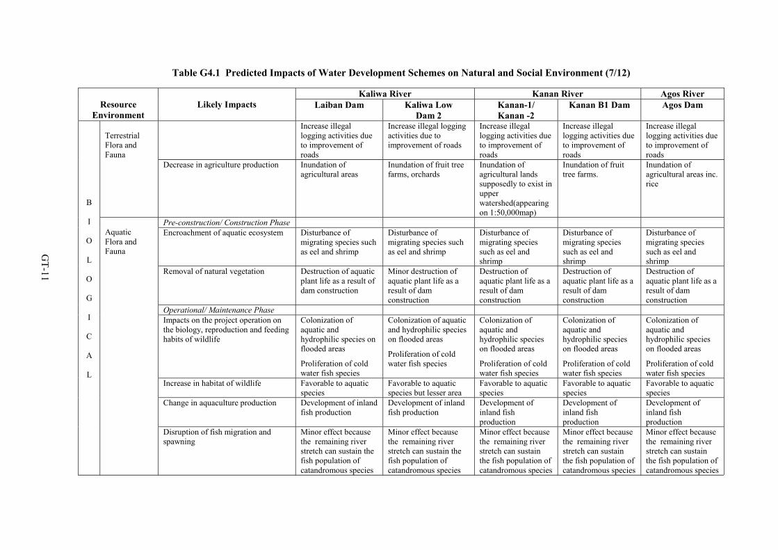
Table G4.1 Predicted Impacts of Water Development Schemes on Natural and Social Environment (7/12)
Kaliwa River Kanan River Agos River Resource
Environment Likely Impacts Laiban Dam Kaliwa Low
Dam 2 Kanan-1/ Kanan -2
Kanan B1 Dam Agos Dam
Increase illegal logging activities due to improvement of roads
Increase illegal logging activities due to improvement of roads
Increase illegal logging activities due to improvement of roads
Increase illegal logging activities due to improvement of roads
Increase illegal logging activities due to improvement of roads
Terrestrial Flora and Fauna
Decrease in agriculture production Inundation of agricultural areas
Inundation of fruit tree farms, orchards
Inundation of agricultural lands supposedly to exist in upper watershed(appearing on 1:50,000map)
Inundation of fruit tree farms.
Inundation of agricultural areas inc. rice
Pre-construction/ Construction Phase Encroachment of aquatic ecosystem Disturbance of
migrating species such as eel and shrimp
Disturbance of migrating species such as eel and shrimp
Disturbance of migrating species such as eel and shrimp
Disturbance of migrating species such as eel and shrimp
Disturbance of migrating species such as eel and shrimp
Removal of natural vegetation Destruction of aquatic plant life as a result of dam construction
Minor destruction of aquatic plant life as a result of dam construction
Destruction of aquatic plant life as a result of dam construction
Destruction of aquatic plant life as a result of dam construction
Destruction of aquatic plant life as a result of dam construction
Operational/ Maintenance Phase Impacts on the project operation on the biology, reproduction and feeding habits of wildlife
Colonization of aquatic and hydrophilic species on flooded areas
Proliferation of cold water fish species
Colonization of aquatic and hydrophilic species on flooded areas
Proliferation of cold water fish species
Colonization of aquatic and hydrophilic species on flooded areas
Proliferation of cold water fish species
Colonization of aquatic and hydrophilic species on flooded areas
Proliferation of cold water fish species
Colonization of aquatic and hydrophilic species on flooded areas
Proliferation of cold water fish species
Increase in habitat of wildlife Favorable to aquatic species
Favorable to aquatic species but lesser area
Favorable to aquatic species
Favorable to aquatic species
Favorable to aquatic species
Change in aquaculture production Development of inland fish production
Development of inland fish production
Development of inland fish production
Development of inland fish production
Development of inland fish production
B
I
O
L
O
G
I
C
A
L
Aquatic Flora and Fauna
Disruption of fish migration and spawning
Minor effect because the remaining river stretch can sustain the fish population of catandromous species
Minor effect because the remaining river stretch can sustain the fish population of catandromous species
Minor effect because the remaining river stretch can sustain the fish population of catandromous species
Minor effect because the remaining river stretch can sustain the fish population of catandromous species
Minor effect because the remaining river stretch can sustain the fish population of catandromous species
GT
-11

Table G4.1 Predicted Impacts of Water Development Schemes on Natural and Social Environment (8/12)
Kaliwa River Kanan River Agos River Resource
Environment Likely Impacts Laiban Dam Kaliwa Low
Dam 2 Kanan-1/ Kanan -2
Kanan B1 Dam Agos Dam
Creation of habitat for disease vectors Potential occurrence of water-related diseases such as malaria, schistosomiasis
Potential occurrence of water-related diseases such as malaria, schistosomiasis
Potential occurrence of water-related diseases such as malaria, schistosomiasis
Potential occurrence of water-related diseases such as malaria, schistosomiasis
Potential occurrence of water-related diseases such as malaria, schistosomiasis
BIOLOGICAL
Aquatic Flora and Fauna
Generation of aquatic plants Proliferation of algal blooms if high level of nutrient is introduced
Proliferation of algal blooms if high level of nutrient is introduced
Proliferation of algal blooms if high level of nutrient is introduced
Proliferation of algal blooms if high level of nutrient is introduced
Proliferation of algal blooms if high level of nutrient is introduced
Pre-construction/ Construction Phase Change in land use Change in land use
from a forest, agricultural and river to a infrastructure-related use
Change in land use from a forest, agricultural and river to a infrastructure-related use
Change in land use from a forest, agricultural and river to a infrastructure-related use
Change in land use from a forest, agricultural and river to a infrastructure-related use
Change in land use from a forest, agricultural and river to a infrastructure-related use
Land Use/ Zoning
Change of the aesthetic character of the area
Construction of structure will render an unaesthetic impact due to damaged areas and excavated materials dumped in the vicinity.
Inundation of caves along Limutan River.
Construction of structure will render an unaesthetic impact due to damaged areas and excavated materials dumped in the vicinity.
Inundation of "tinipak" and caves along Kaliwa River
Construction of structure will render an unaesthetic impact due to damaged areas and excavated materials dumped in the vicinity.
Inundation of old growth forest.
Construction of structure will render an unaesthetic impact due to damaged areas and excavated materials dumped in the vicinity.
Inundation of old growth forest
Construction of structure will render an unaesthetic impact due to damaged areas and excavated materials dumped in the vicinity.
Inundation of "tinipak" and caves along Kaliwa River
Pre-construction/ Construction Phase
LAND
USE
&
IMPORTANT
SITES
Archaeolo-gical/ Historical Sites
Destruction of important and cultural sites
Not known Loss of worship place for Dumagats
Not known Inundation of a pre-World war II foundation of early house, Dumagat burial sites, historical site located at Tigbak
Loss of worship place for Dumagats
GT
-12

Table G4.1 Predicted Impacts of Water Development Schemes on Natural and Social Environment (9/12)
Kaliwa River Kanan River Agos River Resource
Environment Likely Impacts Laiban Dam Kaliwa Low
Dam 2 Kanan-1/ Kanan -2
Kanan B1 Dam Agos Dam
Pre-construction/ Construction Phase Displacement of household Displacement of
households in Brgy. Cayabu, Mamuyao, Sto. Nino, Tinukan, San Andres, Sta. Inez, Laiban (see details in Supporting Report H)
No displacement will occur.
No displacement will occur.
Settlement is located upstream of the watershed. No. of displacemend is nit known, but conservatively assumed to be some 100. They are presumably Dumagat.
Displacement of 25 Dumagats
Displacement of households in Brgys. Magsaysay (Infanta) Pagsangahan and Mahabang Lalim (Gen. Nakar). (see details in Part H)
Increase in population due to migration of people could trigger social conflicts between residents and construction worker
Competition of migrants and locals for the employment opportunities
Rapid increase of migrants, e.g., construction workers and families, will result to greater demand for basic services, which may bring concern to local communities.
Competition of migrants and locals for the employment opportunities
Rapid increase of migrants, e.g., construction workers and families, will result to greater demand for basic services, which may bring concern to local communities.
No major impact will likely occur
Competition of migrants and locals for the employment opportunities
Rapid increase of migrants, e.g., construction workers and families, will result to greater demand for basic services, which may bring concern to local communities.
Competition of migrants and locals for the employment opportunities
Rapid increase of migrants, e.g., construction workers and families, will result to greater demand for basic services, which may bring concern to local communities.
Operational/ Maintenance Phase
S
O
C
I
O
-
E
C
O
N
O
M
Y
Population
Increase in the population of the area due to migration of workers
Increase of population due to improved access, which may cause some conflicts with local people.
No noteworthy impact in view of isolated small facilities
Increase of population due to improved access, which may cause some conflicts with local people.
Increase of population due to improved access, which may cause some conflicts with local people.
Increase of population due to improved access, which may cause some conflicts with local people.
GT
-13

Table G4.1 Predicted Impacts of Water Development Schemes on Natural and Social Environment (10/12)
Kaliwa River Kanan River Agos River Resource
Environment Likely Impacts Laiban Dam Kaliwa Low
Dam 2 Kanan-1/ Kanan -2
Kanan B1 Dam Agos Dam
Pre-construction/ Construction Phase Generation of employment and other economic activities
Increase income and improve standards of living
Increase income and improve standards of living
Increase income and improve standards of living
Increase income and improve standards of living
Increase income and improve standards of living
Change in the economic activities during construction
Change from agriculture/forestry based economic activities to construction services
Change from agriculture/forestry based economic activities to construction services
Change from agriculture/forestry based economic activities to construction services
Change from agriculture/forestry based economic activities to construction services
Change from agriculture/forestry based economic activities to construction services
Operational/ Maintenance Phase Generation of employment and other economic services
Increase income and improve standards of living
Increase income and improve standards of living
Increase income and improve standards of living
Increase income and improve standards of living
Increase income and improve standards of living
Labor and Employment
Change in revenue generation of the community
Expected increase in employment opportunities will result to increase in revenue of the community
Expected increase in employment opportunities will result to increase in revenue of the community
Expected increase in employment opportunities will result to increase in revenue of the community
Expected increase in employment opportunities will result to increase in revenue of the community
Expected increase in employment opportunities will result to increase in revenue of the community
Pre-construction/ Construction Phase
S
O
C
I
O
-
E
C
O
N
O
M
Y
Housing and Social Services
Change in house facilities and change in usage of public utilities due to relocation
Relocation of households in Brgy. Cayabu, Mamuyao, Sto. Nino, Tinukan, San Andres, Sta. Inez, Laiban (see details in Supporting Report H)
No relocation Settlement is located upstream of the watershed, which will he submerged by the reservior. Relocation of households is conservatively estimeated to be around 100.
Relocation of 25 Dumagats
Relocation of households in Brgys. Magsaysay (Infanta) Pagsangahan and Mahabang Lalim (Gen. Nakar).
GT
-14
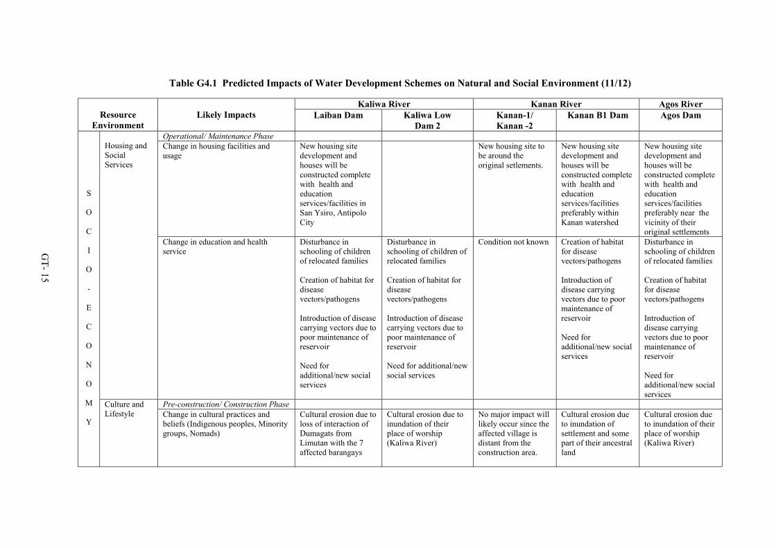
Table G4.1 Predicted Impacts of Water Development Schemes on Natural and Social Environment (11/12)
Kaliwa River Kanan River Agos River Resource
Environment Likely Impacts Laiban Dam Kaliwa Low
Dam 2 Kanan-1/ Kanan -2
Kanan B1 Dam Agos Dam
Operational/ Maintenance Phase Change in housing facilities and usage
New housing site development and houses will be constructed complete with health and education services/facilities in San Ysiro, Antipolo City
New housing site to be around the original setlements.
New housing site development and houses will be constructed complete with health and education services/facilities preferably within Kanan watershed
New housing site development and houses will be constructed complete with health and education services/facilities preferably near the vicinity of their original settlements
Housing and Social Services
Change in education and health service
Disturbance in schooling of children of relocated families
Creation of habitat for disease vectors/pathogens
Introduction of disease carrying vectors due to poor maintenance of reservoir
Need for additional/new social services
Disturbance in schooling of children of relocated families
Creation of habitat for disease vectors/pathogens
Introduction of disease carrying vectors due to poor maintenance of reservoir
Need for additional/new social services
Condition not known Creation of habitat for disease vectors/pathogens
Introduction of disease carrying vectors due to poor maintenance of reservoir
Need for additional/new social services
Disturbance in schooling of children of relocated families
Creation of habitat for disease vectors/pathogens
Introduction of disease carrying vectors due to poor maintenance of reservoir
Need for additional/new social services
Pre-construction/ Construction Phase
S
O
C
I
O
-
E
C
O
N
O
M
Y
Culture and Lifestyle Change in cultural practices and
beliefs (Indigenous peoples, Minority groups, Nomads)
Cultural erosion due to loss of interaction of Dumagats from Limutan with the 7 affected barangays
Cultural erosion due to inundation of their place of worship (Kaliwa River)
No major impact will likely occur since the affected village is distant from the construction area.
Cultural erosion due to inundation of settlement and some part of their ancestral land
Cultural erosion due to inundation of their place of worship (Kaliwa River)
GT
- 15

Table G4.1 Predicted Impacts of Water Development Schemes on Natural and Social Environment (12/12)
Kaliwa River Kanan River Agos River Resource
Environment Likely Impacts Laiban Dam Kaliwa Low
Dam 2 Kanan-1/ Kanan -2
Kanan B1 Dam Agos Dam
Operational/ Maintenance Phase Change in cultural aspects of people in the affected communities due to relocation and loss of source of livelihood
Living conditions in the resettlement site is different from the existing lifestyle of the communities
Living conditions in the resettlement site is different from the existing lifestyle of the communities
No significant impact in view of relocation to nearby area.
Living conditions in the resettlement site is different from the existing lifestyle of the communities
Living conditions in the resettlement site is different from the existing lifestyle of the communities
Pre-construction/ Construction Phase Solid waste generation and problems of storage/ disposal
Generation of soil spoils from excavated areas
Generation of soil spoils from excavated areas
Generation of soil spoils from excavated areas
Generation of soil spoils from excavated areas
Generation of soil spoils from excavated areas
Wastewater generation Increased waste generation by workers and construction equipment during construction including oil and gasoline spills
Increased waste generation by workers and construction equipment during construction including oil and gasoline spills
Increased waste generation by workers and construction equipment during construction including oil and gasoline spills
Increased waste generation by workers and construction equipment during construction including oil and gasoline spills
Increased waste generation by workers and construction equipment during construction including oil and gasoline spills
Operational/ Maintenance Phase Solid waste generation and problems of disposal
Generation of soil spoils from excavated areas
Generation of soil spoils from excavated areas
Generation of soil spoils from excavated areas
Generation of soil spoils from excavated areas
Generation of soil spoils from excavated areas
W
A
S
T
E
M
N
G
T. Wastewater generation and disposal Waste generation by
wastewater treatment plant with high TDS and silt content
Waste generation by wastewater treatment plant with high TDS and silt content
Waste generation by wastewater treatment plant with high TDS and silt content
Waste generation by wastewater treatment plant with high TDS and silt content
Waste generation by wastewater treatment plant with high TDS and s16ilt content
GT
-16

Table G4.2 Predicted Impacts of Water Conveyance Schemes on Natural and Social Environment (1/4)
Resource Environment Likely Impacts WCS-1 WCS-2 WCS-3 WCS-4 WCT-1 WCT-2
Modification of land forms
Disturbance of landscape at the tunnel entrance
Disturbance of landscape at the tunnel entrance
Disturbance of landscape at the tunnel entrance
Disturbance of landscape at the tunnel entrance
Disturbance of landscape at the tunnel entrance
Disturbance of landscape at the tunnel entrance
Soil erosion and sedimentation
Waste soil and sediment washed into waterways and storm drains with potential for causing blockages of existing infrastructure
Waste soil and sediment washed into waterways and storm drains with potential for causing blockages of existing infrastructure
Waste soil and sediment washed into waterways and storm drains with potential for causing blockages of existing infrastructure
Waste soil and sediment washed into waterways and storm drains with potential for causing blockages of existing infrastructure
Waste soil and sediment washed into waterways and storm drains with potential for causing blockages of existing infrastructure
Waste soil and sediment washed into waterways and storm drains with potential for causing blockages of existing infrastructure
Siting of tunnels in hazard prone areas particularly earthquake
Presence of assumed active faults
Presence of assumed active faults
Crossing fan assumed active fault
Presence of assumed active faults
Presence of assumed active faults
Presence of assumed active faults
Land
Change in physical and chemical properties of soil
Potential contamination of soil due to fuel and oil spills during construction
Potential contamination of soil due to fuel and oil spills during construction
Potential contamination of soil due to fuel and oil spills during construction
Potential contamination of soil due to fuel and oil spills during construction
Potential contamination of soil due to fuel and oil spills during construction
Potential contamination of soil due to fuel and oil spills during construction
P
H
Y
S
I
C
A
L
Water Change in quality of surface water
Sediments settling out from turbid water or deposited directly can affect benthic organisms that may result to habitat disappearance
Accidental or unforeseen releases of domestic waste from construction sites will led to pollution
Disruption of Laguna bottom sediments in lake and increase in particulate matter suspension
Accidental or unforeseen releases of domestic waste from construction sites will led to pollution
Sediments settling out from turbid water or deposited directly can affect benthic organisms that may result to habitat disappearance
Accidental or unforeseen releases of domestic waste from construction sites will led to pollution
Sediments settling out from turbid water or deposited directly can affect benthic organisms that may result to habitat disappearance
Accidental or unforeseen releases of domestic waste from construction sites will led to pollution
Sediments settling out from turbid water or deposited directly can affect benthic organisms that may result to habitat disappearance
Accidental or unforeseen releases of domestic waste from construction sites will led to pollution
Sediments settling out from turbid water or deposited directly can affect benthic organisms that may result to habitat disappearance
Accidental or unforeseen releases of domestic waste from construction sites will led to pollution
GT
- 17

Table G4.2 Predicted Impacts of Water Conveyance Schemes on Natural and Social Environment (2/4)
Resource Environment Likely Impacts WCS-1 WCS-2 WCS-3 WCS-4 WCT-1 WCT-2
Water transfer Reduction of river water flow due to Laiban intake
Reduction of river water flow due to Kaliwa intake
Reduction of river water flow due to Kaliwa intake
Reduction of river water flow due to Kaliwa intake
Decreased quantity of Kanan River due to water transfer to Kaliwa River
Decreased quantity of Kanan River due to water transfer to Laiban Dam
Climate and Air Quality
Air pollution generation
Dust generation resulting from earthworks and other construction related activities
Gas (SO2), NO2)emissions and increased concentration of CO resulting from operation of heavy equipment during construction
Dust generation resulting from earthworks and other construction related activities
Gas (SO2), NO2)emissions and increased concentration of CO resulting from operation of heavy equipment during construction
Dust generation resulting from earthworks and other construction related activities
Gas (SO2), NO2)emissions and increased concentration of CO resulting from operation of heavy equipment during construction
Dust generation resulting from earthworks and other construction related activities
Gas (SO2), NO2)emissions and increased concentration of CO resulting from operation of heavy equipment during construction
Dust generation resulting from earthworks and other construction related activities
Gas (SO2), NO2)emissions and increased concentration of CO resulting from operation of heavy equipment during construction
Dust generation resulting from earthworks and other construction related activities
Gas (SO2), NO2)emissions and increased concentration of CO resulting from operation of heavy equipment during construction
P
H
Y
S
I
C
A
L Noise/ Vibration
Increased noise level due to vehicles and to noise/vibration producing equipment
Noise generation is expected in any construction activity causing nuisance and disturbance to human and wildlife
Excessive vibrations may be experienced as a result of the use of heavy equipment
Noise generation is expected in any construction activity causing nuisance and disturbance to human and wildlife
Excessive vibrations may be experienced as a result of the use of heavy equipment
Noise generation is expected in any construction activity causing nuisance and disturbance to human and wildlife
Excessive vibrations may be experienced as a result of the use of heavy equipment
Noise generation is expected in any construction activity causing nuisance and disturbance to human and wildlife
Excessive vibrations may be experienced as a result of the use of heavy equipment
Noise generation is expected in any construction activity causing nuisance and disturbance to human and wildlife
Excessive vibrations may be experienced as a result of tunneling
Noise generation is expected in any construction activity causing nuisance and disturbance to human and wildlife
Excessive vibrations may be experienced as a result of tunneling
GT
-18

Table G4.2 Predicted Impacts of Water Conveyance Schemes on Natural and Social Environment (3/4)
Resource Environment Likely Impacts WCS-1 WCS-2 WCS-3 WCS-4 WCT-1 WCT-2
Disturbance and loss of habitat
Minimal disruption of habitat of wildlife as result of digging trench to lay pipelines
Disruption of habitat of wildlife as a result of tunneling and digging trench to lay pipelines
Disruption of habitat of wildlife as a result of tunneling and digging trench to lay pipelines
Disruption of habitat of wildlife as a result of tunneling and digging trench to lay pipelines
Disturbance of habitat of endangered wildlife as a result of tunneling
Disturbance of habitat of endangered wildlife as a result of tunneling
Terrestrial Flora and Fauna
Encroachment on precious ecosystem
Minimal removal of natural vegetation
Clearing of natural vegetation at the tunnel entrance and access road
Clearing of natural vegetation at the tunnel entrance and access road
Clearing of natural vegetation at the tunnel entrance and access road
Clearing of natural vegetation at the tunnel entrance and access road
Clearing of natural vegetation at the tunnel entrance and access road
BIOLOGICAL
Aquatic Flora and Fauna
Disturbance of and loss of habitat
Disruption of benthic infaunal communities due to sediments generated by earth works
Disruption of benthic infaunal communities in Laguna lake bed
Disruption of benthic infaunal communities due to sediments generated by earth works
Disruption of benthic infaunal communities due to sediments generated by earth works
No potential impact identified
No potential impact identified
Displacement of household
Displacement of some 300 household in pipelines and at water treatment plant site(approx.estimate)
Displacement of some 300 household in pipelines and at water treatment plant site(approx. estimate)
Displacement of some 300 household in pipelines and at water treatment plant site(approx. estimate)
Displacement of some 222 households in pipelines and water treatment plant site.
No foreseen displacement in as much as tunneling is at a depth of 200m.
No foreseen displacement in as much as tunneling is at a depth of 200m. S
OCIO-ECONOMY
Population
Increase in population due to migration of workers
Competition of migrants and locals for employment opportunities
Increase of migrants will result to greater demand for basic services, which may bring concern to local communities
Competition of migrants and locals for employment opportunities
Increase of migrants will result to greater demand for basic services, which may bring concern to local communities
Competition of migrants and locals for employment opportunities
Increase of migrants will result to greater demand for basic services, which may bring concern to local communities
Competition of migrants and locals for employment opportunities
Increase of migrants will result to greater demand for basic services, which may bring concern to local communities
Competition of migrants and locals for employment opportunities
Increase of migrants will result to greater demand for basic services, which may bring concern to local communities
Competition of migrants and locals for employment opportunities
Increase of migrants will result to greater demand for basic services, which may bring concern to local communities
GT
- 19

Table G4.2 Predicted Impacts of Water Conveyance Schemes on Natural and Social Environment (4/4)
Resource Environment Likely Impacts WCS-1 WCS-2 WCS-3 WCS-4 WCT-1 WCT-2
Labor and Employment
Generation of employment and other economic activities
Increased income and improved standards of living
Increased income and improved standards of living
Increased income and improved standards of living
Increased income and improved standards of living
Increased income and improved standards of living
Increased income and improved standards of living
SOCIO-ECONOMY
Infrastructure Disruption of community services and facilities
Disruption of traffic, pedestrians, etc., along congested route
Damage to road, pavements, irrigation channels as a result of digging a trench for pipeline
Potential damage to other key infrastructural lines, e.g., telephone, water supply
Disruption of traffic, pedestrians, etc., along congested route
Damage to road, pavements, irrigation channels as a result of digging a trench for pipeline
Potential damage to other key infrastructural lines, e.g., telephone, water supply
Disruption of traffic, pedestrians, etc., along congested route
Damage to road, pavements, irrigation channels as a result of digging a trench for pipeline
Potential damage to other key infrastructural lines, e.g., telephone, water supply
Disruption of traffic, pedestrians, etc., along congested route
Damage to road, pavements, irrigation channels as a result of digging a trench for pipeline
Potential damage to other key infrastructural lines, e.g., telephone, water supply
No impact likely to occur since it is an undeveloped land
No impact likely to occur since it is an undeveloped land
Notes: WCS-1: Laiban Intake-Pantay-Taytay WCS-2: Kaliwa Intake-Tanay-Laguna Lake WCS-3: Kaliwa Intake-Tanay-Angono WCS-4 Kaliwa Intake-Abyodo-Angono/Kaliwa Intake-Taytay Waterway WCT-1 Kanan-Kaliwa Interbasin Tunnel WCT-2 Kanan Intake-Laiban Interbasin Tunnel
GT
-20
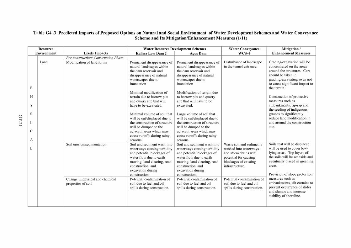
Table G4 .3 Predicted Impacts of Proposed Options on Natural and Social Environment of Water Development Schemes and Water Conveyance Scheme and Its Mitigation/Enhancement Measures (1/11)
Water Resource Development Schemes Water Conveyance Resource Environment Likely Impacts Kaliwa Low Dam 2 Agos Dam WCS-4
Mitigation / Enhancement Measures
Pre-construction/ Construction Phase Modification of land forms Permanent disappearance of
natural landscapes within the dam reservoir and disappearance of natural waterscapes due to inundation.
Minimal modification of terrain due to borrow pits and quarry site that will have to be excavated.
Minimal volume of soil that will be cut/displaced due to the construction of structure will be dumped to the adjacent areas which may cause runoffs during rainy seasons.
Permanent disappearance of natural landscapes within the dam reservoir and disappearance of natural waterscapes due to inundation
Modification of terrain due to borrow pits and quarry site that will have to be excavated.
Large volume of soil that will be cut/displaced due to the construction of structure will be dumped to the adjacent areas which may cause runoffs during rainy seasons.
Disturbance of landscape in the tunnel entrance.
Soil erosion/sedimentation Soil and sediment wash into waterways causing turbidity and potential blockages of water flow due to earth moving, land clearing, road construction and excavation during construction.
Soil and sediment wash into waterways causing turbidity and potential blockages of water flow due to earth moving, land clearing, road construction and excavation during construction..
Waste soil and sediments washed into waterways and storm drains with potential for causing blockages of existing infrastructure.
P
H
Y
S
I
C
A
L
Land
Change in physical and chemical properties of soil
Potential contamination of soil due to fuel and oil spills during construction.
Potential contamination of soil due to fuel and oil spills during construction.
Potential contamination of soil due to fuel and oil spills during construction.
Grading/excavation will be concentrated on the areas around the structures. Care should be taken in grading/excavating so as not to cause significant impact to the terrain.
Construction of protective measures such as embankments, rip-rap and the seeding of indigenous grasses to significantly reduce land modification in and around the construction site.
Soils that will be displaced will be used to cover low-lying areas. Top layers of the soils will be set aside and eventually placed in greening areas.
Provision of slope protection measures such as embankments, silt curtains to prevent occurrence of slides and slumps and increase stability of shoreline.
GT
-21
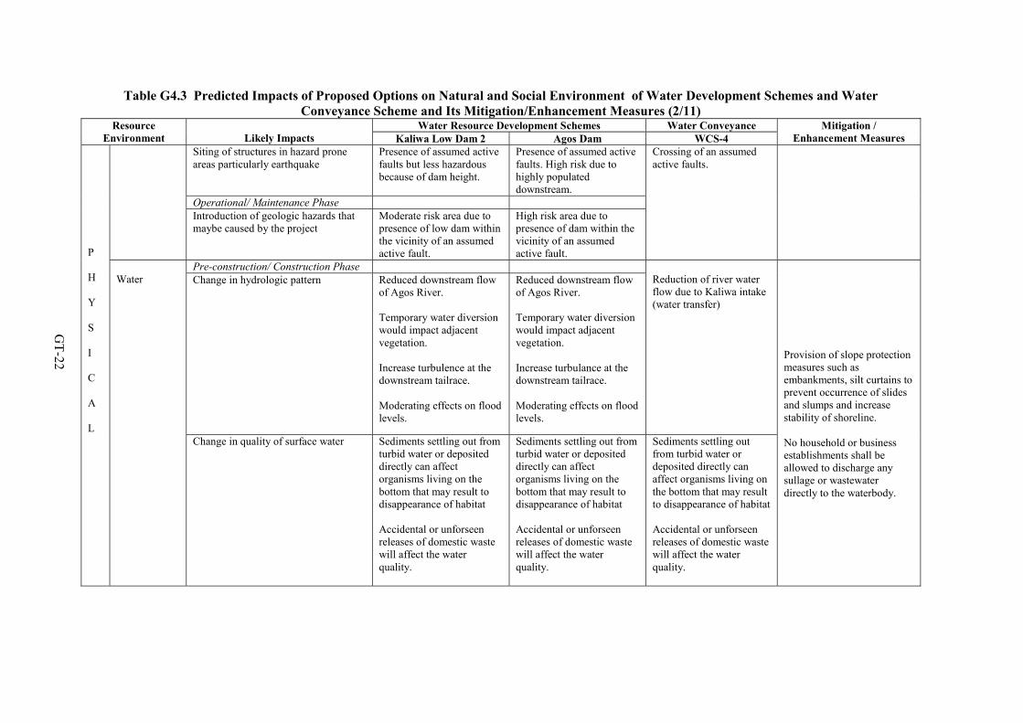
Table G4.3 Predicted Impacts of Proposed Options on Natural and Social Environment of Water Development Schemes and Water Conveyance Scheme and Its Mitigation/Enhancement Measures (2/11)
Water Resource Development Schemes Water Conveyance Resource Environment Likely Impacts Kaliwa Low Dam 2 Agos Dam WCS-4
Mitigation / Enhancement Measures
Siting of structures in hazard prone areas particularly earthquake
Presence of assumed active faults but less hazardous because of dam height.
Presence of assumed active faults. High risk due to highly populated downstream.
Operational/ Maintenance Phase Introduction of geologic hazards that maybe caused by the project
Moderate risk area due to presence of low dam within the vicinity of an assumed active fault.
High risk area due to presence of dam within the vicinity of an assumed active fault.
Crossing of an assumed active faults.
Pre-construction/ Construction Phase Change in hydrologic pattern Reduced downstream flow
of Agos River.
Temporary water diversion would impact adjacent vegetation.
Increase turbulence at the downstream tailrace.
Moderating effects on flood levels.
Reduced downstream flow of Agos River.
Temporary water diversion would impact adjacent vegetation.
Increase turbulance at the downstream tailrace.
Moderating effects on flood levels.
Reduction of river water flow due to Kaliwa intake (water transfer)
P
H
Y
S
I
C
A
L
Water
Change in quality of surface water Sediments settling out from turbid water or deposited directly can affect organisms living on the bottom that may result to disappearance of habitat
Accidental or unforseen releases of domestic waste will affect the water quality.
Sediments settling out from turbid water or deposited directly can affect organisms living on the bottom that may result to disappearance of habitat
Accidental or unforseen releases of domestic waste will affect the water quality.
Sediments settling out from turbid water or deposited directly can affect organisms living on the bottom that may result to disappearance of habitat
Accidental or unforseen releases of domestic waste will affect the water quality.
Provision of slope protection measures such as embankments, silt curtains to prevent occurrence of slides and slumps and increase stability of shoreline.
No household or business establishments shall be allowed to discharge any sullage or wastewater directly to the waterbody.
GT
-22

Table G4.3 Predicted Impacts of Proposed Options on Natural and Social Environment of Water Development Schemes and Water Conveyance Scheme and Its Mitigation/Enhancement Measures (3/11)
Water Resource Development Schemes Water Conveyance Resource Environment Likely Impacts Kaliwa Low Dam 2 Agos Dam WCS-4
Mitigation / Enhancement Measures
Decrease of nutrient input from the river's sediment load. Sedimentation upstream of dam.
Decrease of nutrient input from the river's sediment load. Sedimentation upstream of dam.
Operational/ Maintenance Phase Increase in surface run-off No increase in river
discharge due to run-of-river scheme
Increase in the river discharge and depth during releases.
Decrease in flooding tand he serviceability of the watershed and rivers
No significant effect to downstream flow reduction
Reduction of nutrient loading deposited in rivers, estuaries and mangrove areas.
Downstream flood flow reduction at Agos River
Reduction of nutrient loading deposited in rivers, estuaries and mangrove areas.
Euthrophication of reservoir water Increase decomposition of organic matter from cut vegetation may result in higher DO, BOD and nutrient levels.
Increase decomposition of organic matter from cut vegetation may result in higher DO, BOD and nutrient levels.
Change in water temperature Minimal due to continuous recharge and release of water.
Low water temperature in deeper part of reservoir
Siltation and sedimentation of reservoir
Accumulation of silt and sediments resulting to decrease efficiency of the dam.
Accumulation of silt and sediments resulting to decrease efficiency of the dam.
P
H
Y
S
I
C
A
L
Water
Contamination and depletion of surface water
Accidental or improper releases of domestic and agricultural/ industrial wastes will affect the water quality.
Accidental or improper releases of domestic and agricultural/ industrial wastes will affect the water quality.
Regular monitoring of water quality shall be undertaken.
GT
-23
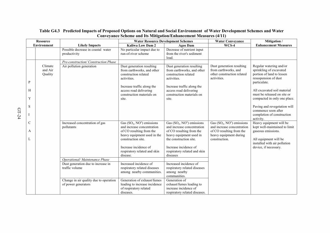
Table G4.3 Predicted Impacts of Proposed Options on Natural and Social Environment of Water Development Schemes and Water Conveyance Scheme and Its Mitigation/Enhancement Measures (4/11)
Water Resource Development Schemes Water Conveyance Resource Environment Likely Impacts Kaliwa Low Dam 2 Agos Dam WCS-4
Mitigation / Enhancement Measures
Possible decrease in coastal water productivity
No particular impact due to run-of-river scheme
Decrease of nutrient input from the river's sediment load.
Pre-construction/ Construction Phase Air pollution generation Dust generation resulting
from earthworks, and other construction related activities.
Increase traffic along the access road delivering construction materials on site.
Dust generation resulting from earthworks, and other construction related activities.
Increase traffic along the access road delivering construction materials on site.
Dust generation resulting from earthworks, and other construction related activities.
Regular watering and/or sprinkling of excavated portion of land to lessen resuspension of dust particulate.
All excavated soil material must be released on site or compacted in only one place.
Paving and revegetation will commence soon after completion of construction activity.
Increased concentration of gas pollutants
Gas (SO2, NOx) emissions and increase concentration of CO resulting from the heavy equipment used in the construction site.
Increase incidence of respiratory related and skin disease.
Gas (SO2, NOx) emissions and increase concentration of CO resulting from the heavy equipment used in the construction site.
Increase incidence of respiratory related and skin diseases
Operational/ Maintenance Phase Dust generation due to increase in traffic volume
Increased incidence of respiratory related diseases among nearby communities.
Increased incidence of respiratory related diseases among nearby communities.
P
H
Y
S
I
C
A
L
Climate and Air Quality
Change in air quality due to operation of power generators
Generation of exhaust/fumes leading to increase incidence of respiratory related diseases.
Generation of exhaust/fumes leading to increase incidence of respiratory related diseases.
Gas (SO2, NOx) emissions and increase concentration of CO resulting from the heavy equipment during construction.
Heavy equipment will be kept well-maintained to limit gaseous emissions.
All equipment will be installed with air pollution device, if necessary.
GT
-24

Table G4.3 Predicted Impacts of Proposed Options on Natural and Social Environment of Water Development Schemes and Water Conveyance Scheme and Its Mitigation/Enhancement Measures (5/11)
Water Resource Development Schemes Water Conveyance Resource Environment Likely Impacts Kaliwa Low Dam 2 Agos Dam WCS-4
Mitigation / Enhancement Measures
Pre-construction/ Construction Phase Increase of noise level due to vehicles and noise/vibration producing equipment
Noise generation is expected in any construction activity causing nuisance and disturbance to human as well as wildlife
Excessive vibrations maybe experienced as a result of the use of heavy equipment such as compactor, etc.
Noise generation is expected in any construction activity causing nuisance and disturbance to human as well as wildlife
Excessive vibrations maybe experienced as a result of the use of heavy equipment such as compactor
Operational/ Maintenance Phase
P
H
Y
S
I
C
A
L
Noise/ Vibration
Increase in noise level Potential nuisance and disturbance to human as well as wildlife during the operation of power and water treatment plants.
Potential nuisance and disturbance to human as well as wildlife during the operation of power and water treatment plants.
Noise generation is expected in any construction activity causing nuisance and disturbance to human as well as wildlife
Excessive vibrations maybe experienced as a result of the use of heavy equipment.
All equipment should conform to the noise limitation standards of the Government.
Use of properly maintained motor engine and other mechanically moving parts of heavy equipment.
Provisions of enclosures/ baffles at the construction sites.
Construction activities will take place during normal working hours especially at sites near housing areas.
Equipment should be mounted on shock absorbing mountings such as cork set on reinforced concrete foundation set on piles. Buffer zone planted to trees and shrubs shall be adequately provided to lessen noise.
GT
-25

Table G4.3 Predicted Impacts of Proposed Options on Natural and Social Environment of Water Development Schemes and Water Conveyance Scheme and Its Mitigation/Enhancement Measures (6/11)
Water Resource Development Schemes Water Conveyance Resource Environment Likely Impacts Kaliwa Low Dam 2 Agos Dam WCS-4
Mitigation / Enhancement Measures
Pre-construction/ Construction Phase Disturbance/Destruction of wildlife Disturbance/destruction of
rare and endangered species such as birds of prey and Philippine deer.
Disturbance/destruction of rare and endangered species such as birds of prey and Philippine deer.
Encroachment on precious ecosystems Moderate destruction/removal/submergence of natural vegetation.
Moderate destruction/removal/submergence of natural vegetation.
Disturbance and loss of habitat Inundation of second growth forest, agricultural and fresh water ecosystem.
Inundation of primary and secondary forest and fresh water ecosystem.
Operational/ Maintenance Phase Disappearance of important habitat such as forest land, agricultural land and fresh water ecosystem.
Intensification of agro-forestry practices in the watershed.
Disappearance of important habitat such as primary forest and fresh water ecosystem.
Intensification of agro-forestry practices in the watershed.
Impacts of the project operation on the biology, reproduction and feeding habits of wildlife
Increased illegal logging activities due to improvement of roads
Increased illegal logging activities due to improvement of roads
Terrestrial Flora and Fauna
Decrease in agricultural production Inundation of fruit tree farms, orchards
Inundation of agricultural area incl. rice field
Disruption of habitat of wildlife as a result of tunneling and digging trench to lay pipelines.
Clearing of natural vegetation at the tunnel entrance and access road.
Removal of forest and/or vegetation cover shall be kept to a minimum.
Regulatory procedures for cutting of trees shall be strictly followed.
Pre-construction/ Construction Phase Encroachment of aquatic ecosystem Disturbance of migrating
species such as eel and shrimp
Disturbance of migrating species such as eel and shrimp
B
I
O
L
O
G
I
C
A
L
Aquatic Flora and Fauna
Removal of natural vegetation Minor destruction of aquatic plant life as a result of dam construction
Destruction of aquatic plant life as a result of dam construction.
Disruption of benthic infaunal communities in streams due to sediments generated frpm earth works.
GT
-26

Table G4.3 Predicted Impacts of Proposed Options on Natural and Social Environment of Water Development Schemes and Water Conveyance Scheme and Its Mitigation/Enhancement Measures (7/11)
Water Resource Development Schemes Water Conveyance Resource Environment Likely Impacts Kaliwa Low Dam 2 Agos Dam WCS-4
Mitigation / Enhancement Measures
Operational/ Maintenance Phase Impacts on the project operation on the biology, reproduction and feeding habits of wildlife
Colonization of aquatic and hydrophilic species on flooded areas.
Proliferation of cold water fish species.
Colonization of aquatic and hydrophilic species on flooded areas.
Proliferation of cold water fish species.
Increase in habitat of wildlife Favorable to aquatic species but lesser area.
Favorable to aquatic species.
Change in aquaculture production Development of inland fish production.
Development of inland fish production.
Disruption of fish migration and spawning
Minor effect because the remaining river stretch can sustain the fish population of catandromous species.
Minor effect because the remaining river stretch can sustain the fish population of catandromous species.
Creation of habitat for disease vectors Potential occurrence of water-related diseases such as malaria, schistosomiasis.
Potential occurrence of water-related diseases such as malaria, schistosomiasis.
BIOLOGICAL
Aquatic Flora and Fauna
Generation of aquatic plants Proliferation of algal blooms if high level of nutrient is introduced.
Proliferation of algal blooms if high level of nutrient is introduced.
Pre-construction/ Construction Phase LAND
USE
Land Use/ Zoning
Change in land use Change in land use from a forest, agricultural and river to a infrastructure-related use
Change in land use from a forest, agricultural and river to a infrastructure-related use.
Modification on the present land use are predicted to be positive.
Access road will pave the way to furthet encroachment of people in search of possible livelihood and other economic activities.
GT
-27
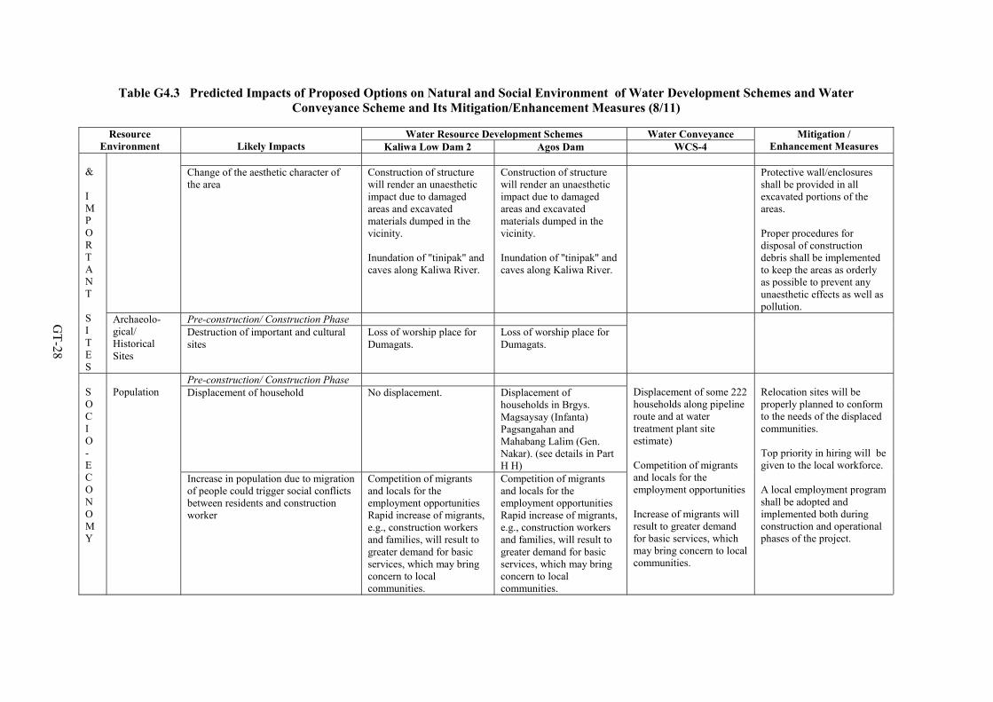
Table G4.3 Predicted Impacts of Proposed Options on Natural and Social Environment of Water Development Schemes and Water Conveyance Scheme and Its Mitigation/Enhancement Measures (8/11)
Water Resource Development Schemes Water Conveyance Resource Environment Likely Impacts Kaliwa Low Dam 2 Agos Dam WCS-4
Mitigation / Enhancement Measures
Change of the aesthetic character of the area
Construction of structure will render an unaesthetic impact due to damaged areas and excavated materials dumped in the vicinity.
Inundation of "tinipak" and caves along Kaliwa River.
Construction of structure will render an unaesthetic impact due to damaged areas and excavated materials dumped in the vicinity.
Inundation of "tinipak" and caves along Kaliwa River.
Protective wall/enclosures shall be provided in all excavated portions of the areas.
Proper procedures for disposal of construction debris shall be implemented to keep the areas as orderly as possible to prevent any unaesthetic effects as well as pollution.
Pre-construction/ Construction Phase
&
IMPORTANT
SITES
Archaeolo-gical/ Historical Sites
Destruction of important and cultural sites
Loss of worship place for Dumagats.
Loss of worship place for Dumagats.
Pre-construction/ Construction Phase Displacement of household No displacement. Displacement of
households in Brgys. Magsaysay (Infanta) Pagsangahan and Mahabang Lalim (Gen. Nakar). (see details in Part H H)
SOCIO-ECONOMY
Population
Increase in population due to migration of people could trigger social conflicts between residents and construction worker
Competition of migrants and locals for the employment opportunities Rapid increase of migrants, e.g., construction workers and families, will result to greater demand for basic services, which may bring concern to local communities.
Competition of migrants and locals for the employment opportunities Rapid increase of migrants, e.g., construction workers and families, will result to greater demand for basic services, which may bring concern to local communities.
Displacement of some 222 households along pipeline route and at water treatment plant site estimate)
Competition of migrants and locals for the employment opportunities
Increase of migrants will result to greater demand for basic services, which may bring concern to local communities.
Relocation sites will be properly planned to conform to the needs of the displaced communities.
Top priority in hiring will be given to the local workforce.
A local employment program shall be adopted and implemented both during construction and operational phases of the project.
GT
-28

Table G4.3 Predicted Impacts of Proposed Options on Natural and Social Environment of Water Development Schemes and Water Conveyance Scheme and Its Mitigation/Enhancement Measures (9/11)
Water Resource Development Schemes Water Conveyance Resource Environment Likely Impacts Kaliwa Low Dam 2 Agos Dam WCS-4
Mitigation / Enhancement Measures
Operational/ Maintenance Phase Population Increase in the population of the area No noteworthy impact in
view of isolated small facilities
Increase of population due to improved access, which may cause some conflicts with local people
Pre-construction/ Construction Phase Generation of employment and other economic activities
Increase income and improve standards of living.
Increase income and improve standards of living.
Change in the economic activities during construction
Change from agriculture/forestry based economic activities to construction services.
Change from agriculture/forestry based economic activities to construction services.
Operational/ Maintenance Phase Generation of employment and other economic services
Increase income and improve standards of living
Increase income and improve standards of living
S
O
C
I
O-E
C
O
N
O
M
Y
Labor and Employment
Change in revenue generation of the community
Expected increase in employment opportunities will result to increase in revenue of the community
Expected increase in employment opportunities will result to increase in revenue of the community
Increase income and improve standards of living.
Capability building program shall be formulated to ensure local residents will be given ample opportunities for employment placement.
GT
-29

Table G4.3 Predicted Impacts of Proposed Options on Natural and Social Environment of Water Development Schemes and Water Conveyance Scheme and Its Mitigation/Enhancement Measures (10/11)
Water Resource Development Schemes Water Conveyance Resource Environment Likely Impacts Kaliwa Low Dam 2 Agos Dam WCS-4
Mitigation / Enhancement Measures
Pre-construction/ Construction Phase Change in house facilities and change in usage of public utilities due to relocation
No relocation of households.
Relocation of households in Brgys. Magsaysay (Infanta) Pagsangahan and Mahabang Lalim (Gen. Nakar).
Operational/ Maintenance Phase Change in housing facilities and usage New housing site
development and houses will be constructed complete with health and education services/facilities preferably near the within the vicinity of their original settlements
Housing and Social Services
Change in education and health service/ Infrastructure
Disturbance in schooling of children of relocated families
Creation of habitat for disease vectors/pathogens
Introduction of disease carrying vectors due to poor maintenance of reservoir
Need for additional/new social services
Disturbance in schooling of children of relocated families
Creation of habitat for disease vectors/pathogens
Introduction of disease carrying vectors due to poor maintenance of reservoir
Need for additional/new social services
Disruption of traffic, pedestrians, etc., along congested route.
Damage to road, pavements, irrigation channels as a result of digging a trench for pipeline.
Potential damage to other key infrastructural lines, e.g., telephone, water supply.
Relocation sites will be properly planned to conform to the needs of the displaced communities.
Enclosures/walls around the excavated portion of the road shall be provided.
Signs, warning devices and other protective means shall be placed in conspicuous places within the working area.
Pre-construction/ Construction Phase Change in cultural practices and beliefs (Indigenous peoples, Minority groups, Nomads)
Cultural erosion due to inundation of their place of worship (Kaliwa River).
Cultural erosion due to inundation of their place of worship (Kaliwa River).
S
O
C
I
O-E
C
O
N
O
M
Y
Culture and Lifestyle
GT
-

Table G4.3 Predicted Impacts of Proposed Options on Natural and Social Environment of Water Development Schemes and Water Conveyance Scheme and Its Mitigation/Enhancement Measures (11/11)
Water Resource Development Schemes Water Conveyance Resource Environment Likely Impacts Kaliwa Low Dam 2 Agos Dam WCS-4
Mitigation / Enhancement Measures
Operational/ Maintenance Phase Change in cultural aspects of people in the affected communities due to relocation and loss of source of livelihood
Living conditions in the resettlement site is different from the existing lifestyle of the communities.
No impact will likely occur since there are no affected communities.
Pre-construction/ Construction Phase Solid waste generation and problems of storage/ disposal
Generation of soil spoils from excavated areas.
Generation of soil spoils from excavated areas.
Wastewater generation Increased waste generation by workers and construction equipment during construction including oil and gasoline spills.
Increased waste generation by workers and construction equipment during construction including oil and gasoline spills.
Operational/ Maintenance Phase Solid waste generation and problems of disposal
Generation of soil spoils from excavated areas.
Generation of soil spoils from excavated areas.
WASTE
MNGT.
Waste Management
Wastewater generation and disposal Waste generation by wastewater treatment plant with high TDS and silt contents.
Waste generation by wastewater treatment plant with high TDS and silt contents.
Identification of low-lying areas to serve as dump site for soil spoils.
Provision of temporary sanitation facilities for the construction workers such as portalets, bathing area, etc. G
T-31