Embed Size (px)
Citation preview

Part D:
Controls Applying to Specific Land Uses/Activities
Camden Council
Development Control Plan 2011
Part D - Controls Applying to Specific Land Uses/Activities Page Dii
Part D: Controls Applying to Specific Land Uses/Activities D1 RURAL LAND USES .......................................................................................................................... 8
D1.1 Rural Accommodations, Dwellings and Outbuildings ......................................................... 9 D1.2 Farm Buildings................................................................................................................... 10 D1.3 Agricultural Development ................................................................................................. 11
D1.3.1 Intensive Plant Agriculture ........................................................................................................... 11 D1.4 Non-Agricultural Development ......................................................................................... 13
D1.4.1 Rural Industry ............................................................................................................................... 13 D1.4.2 Keeping of Trucks ..................................................................................................................... 14
D1.5 Support Infrastructure ....................................................................................................... 15 D1.5.1 Earth Dams ............................................................................................................................... 15 D1.5.2 Rural Fences ................................................................................................................................ 19
D2 RESIDENTIAL DEVELOPMENT ........................................................................................................... 20 D2.1 Primary Residential Controls ............................................................................................. 20
D2.1.1 Setbacks ...................................................................................................................................... 20 D2.1.2 Zero Lot Line development.......................................................................................................... 23 D2.1.3 Height, Massing and Siting .......................................................................................................... 25 D2.1.4 Visual and Acoustic Privacy .......................................................................................................... 25 D2.1.5 Private Open Space, Site Cover and Landscaped Area ................................................................. 26 D2.1.6 Garages, Site Access and Parking ................................................................................................. 28 D2.1.7 Streetscape and Architectural Design .......................................................................................... 29 D2.1.8 Unsewered Sites ........................................................................................................................... 31 D2.1.9 Fencing in R5 zones ...................................................................................................................... 31 D2.1.10 Dwellings in R5 Zones ............................................................................................................... 32 D2.1.11 Outbuildings ............................................................................................................................. 33 D2.1.12 Summary of Primary Controls for Residential Development ................................................... 35
D2.2 Controls for Specific Forms of Residential Accommodation .............................................. 37 D2.2.1 Secondary Dwellings .................................................................................................................... 37 D2.2.2 Dual Occupancies and Semi-detached Dwellings ......................................................................... 38 D2.2.3 Multi Dwelling Housing and Attached Dwellings ......................................................................... 40 D2.2.4 Residential Flat Buildings.............................................................................................................. 45 D2.2.5 Shop Top Housing......................................................................................................................... 49
D2.3 Site Specific Controls for Residential Accommodation ...................................................... 52 D2.3.1 Elderslie Release Area .................................................................................................................. 53 D2.3.2 Spring Farm Release Area............................................................................................................. 55 D2.3.3 Manooka Valley ............................................................................................................................ 57 D2.3.4 Harrington Grove ......................................................................................................................... 59 A - Harrington Grove General Residential Building Controls Applying to all Precincts ................................ 59 B - Specific building controls and plans for Harrington Grove Precincts ...................................................... 75 D2.3.5 Mater Dei ................................................................................................................................... 109 D2.3.6 Camden Lakeside ....................................................................................................................... 111 D2.3.7 Yamba ........................................................................................................................................ 113 D2.3.8 Former Bus Depot Site (Ironbark Avenue, Camden South) ........................................................ 115 D2.3.9 ECB/Gledswood Controls ................................................................................................................ 123 D2.3.10 Emerald Hills ................................................................................................................................. 126 D2.3.11 Crase Place, Grasmere .................................................................................................................. 127 D2.3.12 121 Raby Road, Leppington .......................................................................................................... 128
D3 COMMERCIAL AND RETAIL DEVELOPMENT ....................................................................................... 129 D3.1 Business Zone and Retail Hierarchy ................................................................................ 129 D3.2 General Controls Applying to all Business Zone Areas .................................................... 130
D3.2.1 Function and Uses ...................................................................................................................... 130 D3.2.2 Layout/Design ............................................................................................................................ 130 D3.2.3 Built Form and Appearance ........................................................................................................ 130 D3.2.4 Pedestrian Amenity .................................................................................................................... 131 D3.2.5 Public Domain ............................................................................................................................ 131 D3.2.6 Parking and Access ..................................................................................................................... 132
D3.3 Spring Farm – B1 Neighbourhood Centre........................................................................ 133 D3.3.1 Maximum Floor Area .................................................................................................................. 133

Camden Council
Development Control Plan 2011
Part D - Controls Applying to Specific Land Uses/Activities Page Diii
D3.3.2 Layout/Design ............................................................................................................................ 133 D3.3.3 Built Form and Appearance ........................................................................................................ 134
D3.4 Elderslie – B1 Neighbourhood Centre .............................................................................. 136 D3.4.1 Maximum Floor Area .................................................................................................................. 136 D3.4.2 Layout/Design ............................................................................................................................ 136 D3.4.3 Built Form and Appearance ........................................................................................................ 136
D3.5 Camden – B2 Local Centre............................................................................................... 138 D3.5.1 Layout/Design ............................................................................................................................ 139 D3.5.2 Heritage and Character .............................................................................................................. 139
D3.6 Narellan – B2 Local Centre .............................................................................................. 140 Background ................................................................................................................................................ 140 D3.6.1 Desired future character for Narellan Town Centre .................................................................. 141 D3.6.2 Town Centre Structure ............................................................................................................... 142 D3.6.3 Access and Movement .................................................................................................................... 146 D.3.6.4 Public Domain ................................................................................................................................ 149 D3.6.5 Land Use and Built Form ................................................................................................................. 150 D.3.6.6 Site Access, Parking and Loading ................................................................................................... 157 D3.6.7 Signage and Graphics ...................................................................................................................... 158 D3.6.8 Somerset Avenue, Narellan ............................................................................................................ 158
D3.7 Camden – B4 Mixed Use ................................................................................................. 161 D3.7.1 Layout/Design ............................................................................................................................ 162 D3.7.2 Built Form and Appearance ........................................................................................................ 162 D3.7.3 Light Industrial Development ..................................................................................................... 162 D3.7.4 Heritage and Character .............................................................................................................. 162
D3.8 Narellan Business Park – B5 Business Development ....................................................... 163 D3.8.1 Function and Uses ...................................................................................................................... 164 D3.8.2 Layout/Design ............................................................................................................................ 164 D3.8.3 Built Form and Appearance ........................................................................................................ 164
D3.9 Emerald Hills – B2 Local Centre ............................................................................................. 165 D3.9.1 Maximum Floor Area ...................................................................................................................... 165 D3.9.2 Layout and Design .......................................................................................................................... 165 D3.9.3 Built Form and Appearance ............................................................................................................ 166
D4 INDUSTRIAL ................................................................................................................................ 167 D4.1 General Industrial Controls ............................................................................................. 168 D4.2 Built Form and Design ..................................................................................................... 169
D4.2.1 Lot Sizes & Proportions .............................................................................................................. 169 D4.2.2 Building Materials & Appearance ............................................................................................... 169 D4.2.3 Multi-Unit Industrial Developments ........................................................................................... 169 D4.2.4 External Storage ......................................................................................................................... 170 D4.2.5 Fencing ....................................................................................................................................... 170 D4.2.6 Environmental Management Plans ............................................................................................ 171 D4.2.7 Stormwater ................................................................................................................................ 171 D4.2.8 Liquid & Solid Waste .................................................................................................................. 171 D4.2.9 Recycling and Waste Management ............................................................................................ 171 D4.2.10 Noise and Vibration .................................................................................................................... 172 D4.2.11 Air Quality ................................................................................................................................... 172 D4.2.12 Hazardous Goods and Materials ................................................................................................. 172
D4.3 Landscaping and Public Domain ..................................................................................... 173 D4.3.1 Landscaping ................................................................................................................................ 173 D4.3.2 Lighting ....................................................................................................................................... 174
D4.4 Parking and Access .......................................................................................................... 175 D4.5 Site Specific Industrial Controls ....................................................................................... 177
D4.5.1 Narellan IN2 Land ....................................................................................................................... 177 D4.5.2 Smeaton Grange ......................................................................................................................... 179 D4.5.3 Ironbark Avenue, Camden South ............................................................................................... 184
D5 OTHER LAND USES ...................................................................................................................... 188 D5.1 Child Care Centres ........................................................................................................... 188 D5.2 Footpath Cafés ................................................................................................................ 196 D5.3 Restricted Premises ......................................................................................................... 201
Camden Council
Development Control Plan 2011
Part D - Controls Applying to Specific Land Uses/Activities Page Div
D5.4 Sex Service Premises ........................................................................................................ 202 D5.5 Exhibition Homes and Villages ........................................................................................ 203 D5.6 Home Business& Home Industry ..................................................................................... 204 D5.7 Domestic Solid Fuel Burning Appliances (Wood Fired Heaters) ...................................... 206

Camden Council
Development Control Plan 2011
Part D - Controls Applying to Specific Land Uses/Activities Page Dv
Part D – Figures
Figure D1 Zero Lot Line Development ............................................................................................... 24 Figure D2 Zero Lot Line Development .................................................................................................... 25 Figures D3 and D4 Good streetscape design principles ...................................................................... 30 Figure D5 Dwelling addressing both frontages ................................................................................... 60 Figure D6 Street Facades .................................................................................................................. 61 Figure D7 Facades which are/are not permitted ................................................................................ 62 Figure D8 Side Boundary Setback ..................................................................................................... 64 Figure D9 Corner Lot Setbacks .......................................................................................................... 65 Figure D10 Roof Articulation ............................................................................................................. 67 Figure D11 Carparking Clearance from Fixed Structures ................................................................. 68 Figure D12 Carparking Clearance from Fixed Structures ................................................................. 68 Figure D13 Examples of Allowable Fences ...................................................................................... 70 Figure D14 Common Boundary Fencing .......................................................................................... 71 Figure D15 Lot Fencing on Corner Lots............................................................................................ 72 Figure D16 Lot Fencing Abutting a Road Reserve on a Retaining Wall ........................................... 72 Figure D17 Pre-painted Sheet Steel Fencing on Common Lot Boundaries ...................................... 73 Figure D18 Return Fencing .............................................................................................................. 74 Precinct A................................................................................................................................................ 75 Figure D19 Single Storey Lots in Precinct A ..................................................................................... 75 Figure D20 Conceptual Layout of Local Community and Recreation Centre Site ............................ 76 Figure D21 Location of Local Community and Recreation Centre .................................................... 77 Salinity and Aggressivity ......................................................................................................................... 78 Figure D22 Salinity Risk Areas in Precinct A .................................................................................... 78 Figure D23 Aggressivity to Concrete and Steel in Precinct A ........................................................... 79 Bushfire Management ............................................................................................................................. 79 Figure D24 Asset Protection Zones in Precinct A ............................................................................. 80 Precinct B................................................................................................................................................ 81 Figure D25 Salinity Risk Areas in Precinct B .................................................................................... 81 ................................................................................................................................................................ 81 Figure D26 Aggresivity to Concrete and Steel in Precinct B ............................................................. 82 Figure D27 Asset Protection Zones and Bushfire Attack Levels in Precinct B .................................. 83 Precinct C ............................................................................................................................................... 84 Figure D28 Zero Lot Lines in Elevation............................................................................................. 84 Figure D29 Zero Lot Lines in Plan View ........................................................................................... 85 Figure D30 Lots subject to special design requirements .................................................................. 87 Figure D31 Lot Boundary Fencing .................................................................................................... 88 Figure D32 Salinity Risk Areas in Precinct C .................................................................................... 90 Figure D33 Aggressivity to Concrete and Steel in Precinct C ........................................................... 91 Figure D35 Aggresivity to Concrete and Steel in Precinct D ............................................................. 93 Bushfire Management ............................................................................................................................. 93 Figure D36 Asset Protection Zones and Bushfire Attack Levels in Precinct D ................................. 94 Figure D37 Zero Lot Lines in Elevation............................................................................................. 95 Figure D38 Zero Lot Lines in Plan View ........................................................................................... 96 Figure D39 Lot Boundary Fencing .................................................................................................... 97 Precinct H ............................................................................................................................................... 98 Note: Side and rear fencing is to be constructed of Colorbond pre-painted sheet steel in the colour of Riversand® or a similar product and colour. ........................................................................................... 98 Figure D40 Salinity Risk Areas in Precinct H .................................................................................... 99 Figure D41 Aggressivity to Concrete and Steel in Precinct H ......................................................... 100
Camden Council
Development Control Plan 2011
Part D - Controls Applying to Specific Land Uses/Activities Page Dvi
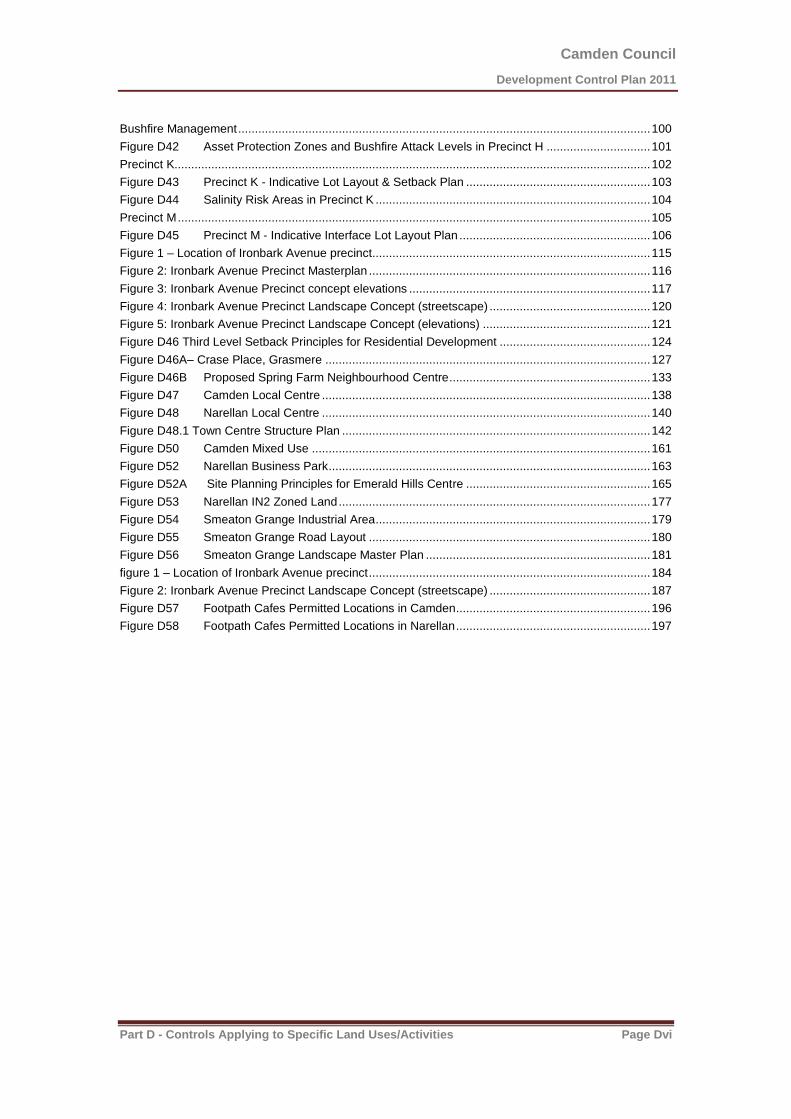
Bushfire Management ........................................................................................................................... 100 Figure D42 Asset Protection Zones and Bushfire Attack Levels in Precinct H ............................... 101 Precinct K.............................................................................................................................................. 102 Figure D43 Precinct K - Indicative Lot Layout & Setback Plan ....................................................... 103 Figure D44 Salinity Risk Areas in Precinct K .................................................................................. 104 Precinct M ............................................................................................................................................. 105 Figure D45 Precinct M - Indicative Interface Lot Layout Plan ......................................................... 106 Figure 1 – Location of Ironbark Avenue precinct................................................................................... 115 Figure 2: Ironbark Avenue Precinct Masterplan .................................................................................... 116 Figure 3: Ironbark Avenue Precinct concept elevations ........................................................................ 117 Figure 4: Ironbark Avenue Precinct Landscape Concept (streetscape) ................................................ 120 Figure 5: Ironbark Avenue Precinct Landscape Concept (elevations) .................................................. 121 Figure D46 Third Level Setback Principles for Residential Development ............................................. 124 Figure D46A– Crase Place, Grasmere ................................................................................................. 127 Figure D46B Proposed Spring Farm Neighbourhood Centre ............................................................ 133 Figure D47 Camden Local Centre .................................................................................................. 138 Figure D48 Narellan Local Centre .................................................................................................. 140 Figure D48.1 Town Centre Structure Plan ............................................................................................ 142 Figure D50 Camden Mixed Use ..................................................................................................... 161 Figure D52 Narellan Business Park ................................................................................................ 163 Figure D52A Site Planning Principles for Emerald Hills Centre ....................................................... 165 Figure D53 Narellan IN2 Zoned Land ............................................................................................. 177 Figure D54 Smeaton Grange Industrial Area .................................................................................. 179 Figure D55 Smeaton Grange Road Layout .................................................................................... 180 Figure D56 Smeaton Grange Landscape Master Plan ................................................................... 181 figure 1 – Location of Ironbark Avenue precinct .................................................................................... 184 Figure 2: Ironbark Avenue Precinct Landscape Concept (streetscape) ................................................ 187 Figure D57 Footpath Cafes Permitted Locations in Camden .......................................................... 196 Figure D58 Footpath Cafes Permitted Locations in Narellan .......................................................... 197
Camden Council
Development Control Plan 2011
Part D - Controls Applying to Specific Land Uses/Activities Page Dvii
Part D- Tables
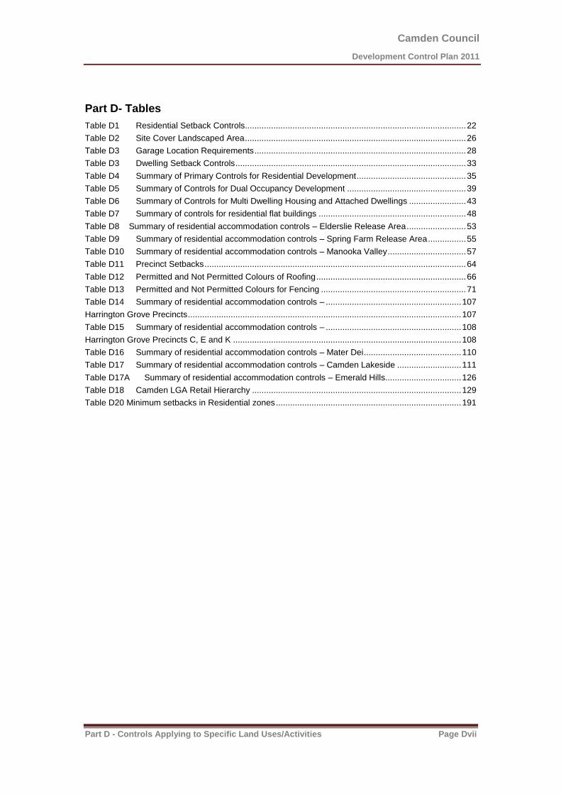
Table D1 Residential Setback Controls............................................................................................. 22 Table D2 Site Cover Landscaped Area ............................................................................................. 26 Table D3 Garage Location Requirements ......................................................................................... 28 Table D3 Dwelling Setback Controls ................................................................................................. 33 Table D4 Summary of Primary Controls for Residential Development .............................................. 35 Table D5 Summary of Controls for Dual Occupancy Development .................................................. 39 Table D6 Summary of Controls for Multi Dwelling Housing and Attached Dwellings ........................ 43 Table D7 Summary of controls for residential flat buildings .............................................................. 48 Table D8 Summary of residential accommodation controls – Elderslie Release Area ......................... 53 Table D9 Summary of residential accommodation controls – Spring Farm Release Area ................ 55 Table D10 Summary of residential accommodation controls – Manooka Valley ................................. 57 Table D11 Precinct Setbacks .............................................................................................................. 64 Table D12 Permitted and Not Permitted Colours of Roofing ............................................................... 66 Table D13 Permitted and Not Permitted Colours for Fencing ............................................................. 71 Table D14 Summary of residential accommodation controls – ......................................................... 107 Harrington Grove Precincts ................................................................................................................... 107 Table D15 Summary of residential accommodation controls – ......................................................... 108 Harrington Grove Precincts C, E and K ................................................................................................ 108 Table D16 Summary of residential accommodation controls – Mater Dei ......................................... 110 Table D17 Summary of residential accommodation controls – Camden Lakeside ........................... 111 Table D17A Summary of residential accommodation controls – Emerald Hills................................ 126 Table D18 Camden LGA Retail Hierarchy ........................................................................................ 129 Table D20 Minimum setbacks in Residential zones .............................................................................. 191
Camden Council
Development Control Plan 2011
Part D - Controls Applying to Specific Land Uses/Activities Page D8
Part D: Controls Applying to Specific Land Uses / Activities
D1 Rural Land Uses
Background
Camden’s rural areas play an important role – not only from an agricultural production perspective, but also through the provision of diverse rural landscapes. Increasing urbanisation has placed added pressure on the rural lands. Accordingly Council seeks to ensure that development undertaken in the rural areas maintains the production potential of agriculture, conserves the scenic and cultural landscapes, and protects and enhances the natural environment.
What are the Rural Land Areas?
The rural land areas that are covered by this section of the DCP include the RU1 (Primary Production), RU2 (Rural Landscape), RU4 (Rural Small Holdings) and other zones where rural land uses may occur including the E2 (Environmental Management) and E4 (Environmental Living) Zones.
Objectives
1. Provide controls for rural dwellings, outbuildings and farm buildings which ensure the buildings are appropriately sited, designed and constructed in the rural context of the site.
2. Ensure that the use of rural land for primary production purposes occurs in an orderly manner, minimising impacts upon the natural environment and surrounding land uses.
3. Provide controls for non-agricultural developments in rural zones to ensure they are compatible with the use of the surrounding land for primary production and rural living.
4. Ensure that support infrastructure in rural zones are appropriately sited and constructed.
5. Maintain the scenic rural landscapes which characterise the rural zoned land in the Camden LGA.
Other Relevant Documents
Camden Rural Land Study, 2000, Camden Council.
Camden Scenic and Cultural Landscapes Study, February 1998, Lambcon Associates.

Camden Council
Development Control Plan 2011
Part D - Controls Applying to Specific Land Uses/Activities Page D9
D1.1 Rural Accommodations, Dwellings and Outbuildings
Background
Rural Dwellings - Residential development in rural zones takes many forms, including dwellings which
complement the use of the land for primary production purposes, and rural-residential living on smaller rural lots. Residential development has the potential to create conflict with other land uses in rural zones if buildings are inappropriately sited and designed. All development should take into account the inherent rural character of a locality and be responsive to that character and the local landscape qualities.
Outbuildings - Outbuildings are associated with rural dwellings and area an integral part of rural life and
activities. Outbuildings should be designed and sited to complement rural character. Inappropriate uses and activities are not permitted.
Objectives
1. Ensure that development does not detract from the rural landscape, scenic quality, heritage value, nature conservation significance or agricultural productivity of rural areas.
2. Provide separation between residential uses and noise generating sources.
3. Provide buffers between residential buildings and land uses to minimise the potential for land use conflict and additional pressure on agriculture or other rural activities.
4. Ensure that external finishes used have minimal detrimental impact on the visual amenity of an area.
5. Encourage consideration of all the rural components of development such as fencing, outbuildings, driveways and landscaping in the design of the proposed development.
Controls
1. Buildings in all rural zones shall provide a minimum front setback of 20 metres.
2. Buildings in all rural zones shall provide a minimum side and rear setback of 5 metres.
3. Dwellings must be located to minimise the removal of existing vegetation.
4. Buildings should be visually unobtrusive in the overall landscape.
5. Buildings should complement the characteristics of the landform. Cut and fill shall be kept to a minimum.
6. The roofline of buildings should reflect the land profile within the vicinity of the development.
7. All outbuildings must be ancillary to an approved use on the land on which it is situated.
8. External wall cladding to outbuildings shall be of masonry, colorbond sheet metal or other approved material compatible with authorised existing development on the site and the character of the immediate environment.
9. Roof cladding to outbuildings shall be of tiles, colorbond sheet metal or other approved material compatible with authorised existing development on the site and the character of the immediate environment.
10. The colours of roof and wall cladding shall be generally low reflective neutral/earth tones, compatible with authorised existing development on the site and environmentally sensitive, so as to minimise any possible adverse impact on the amenity of the area.
11. All outbuildings shall be provided with appropriate complementary landscaping to minimise the environmental impact on adjoining premises and the area generally.

Camden Council
Development Control Plan 2011
Part D - Controls Applying to Specific Land Uses/Activities Page D10
12. The maximum floor area for rural outbuildings not used for the purposes of agriculture is 100m2.
13. On unsewered sites, effluent and household waste water is to be disposed in accordance with Council’s Sewage Management Strategy.
14. Access driveways are to be of trafficable width to allow for passing vehicles, manoeuvring and turning space, and bush fire access including emergency and service vehicles.
15. Attached Dual Occupancy development, where permitted by an Environmental Planning Instrument, the dwellings shall be physically attached under the same roofline and have the general appearance of a dwelling-house when viewed from the primary street frontage. Structures such as carports with skillion roofs, pergolas, covered awnings and the like are not acceptable as a mode of attachment.
16. Detached Dual Occupancy and Secondary Dwelling development, where permitted by an Environmental Planning Instrument, the architectural treatment and building materials of both dwellings in the development shall be compatible. Mirror reversed or replica dwelling design is not acceptable form of development.
D1.2 Farm Buildings
Background
As the nature of agricultural activities changes there has been an increase in the number and size of farm buildings and a corresponding increase in their impacts on the surrounding area. For this reason, it is necessary to provide controls for all developments involving farm buildings.
Unless specifically stated, controls for farm buildings apply to all buildings associated with any permissible use of rural land, whether or not that use is considered an agricultural use. In some cases there are additional controls for particular buildings, such as greenhouses and poultry farms. These controls are included in the relevant land use sections, and should be applied instead of the controls for farm buildings.
Objectives
1. Protect the scenic, historic and cultural value of the Camden LGA’s natural and built environment.
2. Maintain the existing streetscape and rural aesthetic of the area.
Controls
Note: Farm buildings may be exempt development subject to requirements listed in Subdivision 16 Farm buildings and structures in State Environmental Planning Policy (Exempt and Complying Development Codes) 2008
1. All farm buildings must be ancillary to an existing agricultural use being undertaken on the land on which it is situated.
2. Farm buildings should be constructed using materials, colours and finishes that complement the principal dwelling, including low reflective, neutral/earth tones which blend in with the natural landscape.
3. Farm buildings should be sited so as not to be visually prominent when viewed from the road.
4. Farm buildings should be constructed in a cluster to minimise the amount of land occupied by development.
5. The minimum setback from any road is 20 metres.
6. The minimum side and rear boundary setback is 5 metres.

Camden Council
Development Control Plan 2011
Part D - Controls Applying to Specific Land Uses/Activities Page D11
7. Cut and fill shall be kept to a minimum and slope should not exceed 15%.
8. Farm buildings should feature pitched roofs.
9. Farm buildings must be designed and located to comply with Council’s Flood Risk Management Policy.
D1.3 Agricultural Development
D1.3.1 Intensive Plant Agriculture
Note: The definition of intensive plant agriculture can be found in the Dictionary section of LEP 2010.
Objectives
1. Ensure that intensive plant agriculture is compatible with the rural environment.
2. Minimise any adverse impact of intensive plant agriculture on surrounding properties.
3. Minimise the environmental impact of intensive plant agriculture on surrounding areas and the creek system.
Controls
1. The minimum lot size required to undertake intensive plant agriculture is 2 hectares.
2. The following setbacks apply to all buildings and structures associated with intensive plant agriculture:
Front boundary 20m
Side and rear boundary 5m
Watercourses 40m

Camden Council
Development Control Plan 2011
Part D - Controls Applying to Specific Land Uses/Activities Page D12
3. Only new and durable materials shall be used in the construction of greenhouses/igloos/market gardens. These structures shall be maintained in a sound and tidy condition, free from defective or damaged material including plastic/fabric covering, at all times.
4. A suitable landscape screening or buffer shall be established between any boundary and greenhouses/igloos/market gardens to effectively mitigate the visual impact of the development.
5. The landscape screening or buffers shall be established through planting trees or shrubs (minimum 1.5m in height). This should occur when any structures are erected and shall be adequately maintained at all times to enhance its growth. Landscaped and grassed areas should be maintained in a neat manner.
6. On unsewered sites, effluent and household waste water is to be disposed in accordance with Council’s Sewage Management Strategy.
7. A Water Cycle Management Plan (WCMP) detailing how water will be sourced, stored, used, treated and recycled for the agricultural operation must be provided with any development application. The WCMP must demonstrate that the operation will not significantly impact on the total water cycle beyond the boundaries of the site.
8. Buffer distances from any septic wastewater disposal areas must comply with the requirements of Council’s Sewage Management Strategy.
9. Any odour generated from the use of the site must be contained within the boundaries of the site and not be offensive to surrounding properties.

Camden Council
Development Control Plan 2011
Part D - Controls Applying to Specific Land Uses/Activities Page D13
D1.4 Non-Agricultural Development
D1.4.1 Rural Industry
Objectives
1. Ensure that rural industries are compatible with the rural environment.
2. Minimise any adverse impact of rural industries on surrounding lands.
Controls
1. The minimum lot size required for rural industries is 10 hectares.
2. Buildings and outside storage areas are to be sited at least 20m from a public street and from any boundary where there is a dwelling on an adjoining property. These setbacks may need to be increased in order to address potential environmental or amenity impacts of the proposed development.
3. Rural industries should maintain the rural streetscape. Designs should complement the surrounding buildings in relation to materials used, colours and building form. Building colours should be low reflective, neutral/earth tones.
4. Outdoor storage yards are to be screened from roadways and neighbouring dwellings.
5. Chained wire fences are to be screened by landscaping.
6. Council may limit the hours of operation of a rural industry where there is a likelihood of adverse impact on the amenity of the surrounding area.
7. No hazardous materials shall be stored below 1% AEP flood level plus 600mm freeboard.
8. Where an industry has the potential to generate offensive odour beyond the boundaries of the site, an odour assessment must be undertaken in accordance with DECCW’s “Technical framework: Assessment and Management of Odour from Stationary Sources in NSW” and be submitted with the application.
9. On unsewered sites, effluent and household waste water is to be disposed in accordance with Council’s Sewage Management Strategy.
Note: The definition of Rural Industries can be found in the Dictionary section of LEP 2010.
Camden Council
Development Control Plan 2011
Part D - Controls Applying to Specific Land Uses/Activities Page D14
D1.4.2 Keeping of Trucks
Objectives
1. Allow the storage of trucks, plant or similar vehicles owned and operated by the occupier of a property.
2. Limit the interference of vehicle movements on the amenity of the neighbourhood.
3. Minimise visual impact of garaging and servicing equipment.
Controls
1. The maximum number of trucks, plant or similar equipment to be stored on a property (not associated with an authorised use occurring on that property), within a rural zone is two.
Note: If more than two vehicles are intended to be stored on the site, the use of the site may be defined as a “Truck Depot” under the Dictionary section of LEP 2010, which will require the lodgement of a development application to seek consent for the use of the land for this purpose. Given the potential impacts on adjoining property owners, consideration should be given to locating truck depots on land within an industrial zone.
2. Loading Bays or parking for trucks are to be located in an area that is not visible from the street.
3. An Acoustic Report undertaken by a suitable acoustic consultant in accordance with the Roads and Maritime Services and Office of Environment & Heritage measurement methodology may be required to accompany the development application.
4. The vehicles should be stored where they are not visible from any public place. In this regard, screening of the truck and plant parking area may be required.
5. Goods, freight and the like are not to be stored on site.
Camden Council
Development Control Plan 2011
Part D - Controls Applying to Specific Land Uses/Activities Page D15
D1.5 Support Infrastructure
D1.5.1 Earth Dams
Note: Dams are defined as Waterbody (artificial) in the Dictionary section of LEP 2010 and require development consent. Council will not accept the construction of prescribed Earth Dams on land either owned or to be owned by Council.
Definitions
For the purposes of this subsection the following definitions apply:
Batter means the slope of the dam wall, the excavated or constructed face of a dam wall, embankment or cutting, produced as a result of earthmoving operations involving cutting and filling.
Bywash means a depressed area adjacent to the dam wall used for the dispersion of overflow water away
from or around the embankment.
Crest means the top of the dam wall.
Cut-off trench means a trench dug below ground level of the dam wall, parallel to the crest, to prevent seepage or movement of water under or past the structure. Pervious material is removed and replaced with clay.
Earth dam means a barrier, embankment or excavated earth structure generally built in or near a drainage line which has the primary purpose for impounding water for storage. These dams are usually used for water conservation on properties with an agricultural use and are used for such purposes as stock watering, domestic supply, irrigation and fire fighting.
Freeboard means the height from the top water level to the crest.
Maximum harvestable right dam capacity (MHRDC) means the total dam capacity allowed under the harvestable rights for your property, based on 10% of the average regional rainfall runoff and takes into account local evaporation rates and rainfall periods.
Spillway means pipes, bywashes or other devices used to divert excess water from a dam. In most cases this includes an excavated level channel extending from the end of the embankment to a level outlet, i.e., bywash.
Top water level means the height of the water level of the dam determined at its maximum capacity at
spillway level.
Objectives
1. Ensure dams are stable, have minimal environmental impact and do not adversely affect surrounding properties, either by ponding water back onto upstream properties or by concentrating the flow of water to any downstream properties.
2. Ensure riparian right of the water users are not affected by the construction of a dam.

Camden Council
Development Control Plan 2011
Part D - Controls Applying to Specific Land Uses/Activities Page D16
Controls
Note: Building and maintenance of dams may be subject to licence from the NSW Office of Water. However there are three categories of dams, listed below, which do not require licence for building and maintenance from the Department;
1. Farm dams up to one megalitre on properties which were subdivided prior to 1 January 1999.
2. Harvestable right dams (see definition above)
3. Farm dams built before 1999 used for stock and domestic purposes.
The location of a dam, size and licence requirement can be obtained from the NSW Office of Water. Large dams (more than 0.5ha surface area) located in or within 40m of a natural water body, wetland or an environmental sensitive area, or in a high waterable or acid sulphate, sodic or saline soils will be considered as Designated Development and need additional considerations.
Earth dams that are or will be classified as ‘prescribed dams’ in accordance with the NSW Dams Safety Committee’s requirements, should only be constructed subject to obtaining development consent from Council.
Camden Council
Development Control Plan 2011
Part D - Controls Applying to Specific Land Uses/Activities Page D17
1. Dams should not be sited near roads, utility installations or neighbouring dwellings due to potential adverse affect of seepage and bywash/spillway overflow and potential breaks of the embankment.
2. If a dam is to be built near a boundary, any water which bypasses the dam or spillage discharges should flow from the property in the same place it did before the dam was built.
3. Dam spillways must be designed to handle storm flows and freeboard sufficient to prevent overtopping in a 1:100 year storm when a by-wash is provided.
4. No dams shall be constructed within 15 metres (to top water level) of a public road. The toe of the embankment batter or top water level shall not be closer than 3 metres of a private property.
5. The width of the dam crest shall be a minimum of 3 metres for dams having up to a 3 metre high dam wall. Crests should increase in width 0.5 metres for every metre above a 3 metre high dam.
6. A minimum 1 metre freeboard is required over the top water level. This should increase by 10% for every metre over a 3 metre high wall.
7. The height of the outlet in relation to the dam governs the top water level if pipes are excluded. The outlet must be level and at least six (6) metres wide. The width of the outlet should not be less than the inlet width.
8. Natural vegetation below the spillway outlet and on the inflow areas must not be disturbed by machinery, vehicles or livestock.
9. The spillway size shall be as follows:
Catchment Area (ha) Outlet length(m) Channel Width(m)
less than 20 7 3
20-40 12 6
greater than 40 Subject to detailed design
10. An earth bywash is required on all dams in order to pass surplus run-off around the dam which would otherwise pass over the embankment. The bywash should be generally 6 metres in width.
11. The width of the outlet from the bywash is not to be less than the inlet width. The bywash shall not direct flows onto the downstream batter toe. The bywash cut batter is not to exceed a maximum steepness of 1.5:1.
12. If the bywash is required to be vegetated then the bywash is to be excavated 75mm below the top water level and backfilled with compacted topsoil and planted with a suitable holding grass such as kikuyu or couch. No trees and shrubs are to be planted in the bywash area.
Camden Council
Development Control Plan 2011
Part D - Controls Applying to Specific Land Uses/Activities Page D18
Note: In some instances Council may require a pipe spillway through the embankment to act as an outlet. This is especially applicable where spring flows or small flows of long duration are known to occur. Rock baskets and geotextile fabric may be required to prevent erosion where velocities are high.
13. The pipe spillway invert is to be at least 100mm below the level of the bywash.
14. The bywash or spillway water from a dam should not have an adverse affect on neighbouring properties. Dams are to be sited so that excess water is contained on the property on which they are located before meeting with a natural watercourse downstream.
15. Three metres should be considered the minimum depth of a dam, as evaporation in many areas will lower water level by approximately 1.5 metres during dry periods. Batter slopes should be retained at 1:3, therefore the depth will be dependent upon surface area measurements in small dams.
16. The material used to construct an embankment should the sufficiently impervious to keep seepage low and to be stable. A soil with 25% clay content is ideal to form an impervious barrier.
17. The following soil types should not be used for dam construction or batters:
(a) sand
(b) gravels
(c) organic soils
(d) peat
18. The slope of upstream embankment batters should conform with the ratio of 3(horizontal):1(vertical) and downstream embankment batters no steeper than 2.5(horizontal):1(vertical).
19. All dams shall have a cut-off trench to be constructed along the entire embankment length a minimum depth of 300mm. Impervious material from the excavation must be placed into the trench and compacted forming a watertight harrier preventing seepage past the structure.
Backfilling of Earth Dams
20. A dam fill plan shall be prepared by a suitably qualified person and should indicate the extent of filling, original and final contours, and depth of filling in maximum 0.5m increments. The dam fill plan shall accompany a report prepared by a suitably qualified engineer, detailing the type of fill material used, the compaction levels achieved, and classification in accordance with the provisions of AS2870 Residential Slabs and Footings.
Note: Continuous trickle flows kill vegetation, keeps the soil wet and encourages spillway erosion. A small diameter sewer class pipe or stronger (usually 150mm. but varied according to flow rate) can be built into the wall during construction to accommodate trickle flows. The pipe is normally installed with a fall in gradient between its inlet and outlet, with the outlet 300mm, below the flood spillway.
The trickle pipe is to be extended beyond the toe of the batter of the embankment in order to prevent any potential instability problem to the embankment.

Camden Council
Development Control Plan 2011
Part D - Controls Applying to Specific Land Uses/Activities Page D19
D1.5.2 Rural Fences
Objectives
1. Preserve and enhance the rural qualities and the overall amenity of rural areas whilst recognising the desires, needs and rights of residents to have private open space area.
2. Balance the need to preserve and enhance the rural qualities and the overall amenity of rural areas and safety to the public by achieving acceptable standards of fence construction.
Controls
Note: Rural fencing may be Exempt development subject to requirements listed Subdivision 19 Fences (rural) State Environmental Planning Policy (Exempt and Complying Development Codes).
1. Council will consider a development application for rural fencing which exceeds the development standards specified in the SEPP based on the merits of the application.
2. Where screening of a building or item is needed, a solid fence may be provided behind intensive landscaping.
Camden Council
Development Control Plan 2011
Part D - Controls Applying to Specific Land Uses/Activities Page D20
D2 Residential Development
Background
The Camden LGA features a range of residential zones which permit a variety of residential accommodation types and densities within existing urban areas and future release areas. This chapter establishes the objectives, principles and controls which will guide the design of residential development in the Camden LGA.
D2.1 Primary Residential Controls
D2.1.1 Setbacks
Objectives
1. Provide a variety of attractive and cohesive streetscapes that reflect the character of both established and emerging residential neighbourhoods, the diversity of edge treatments, house types and road hierarchies.
2. Reduce the dominance of garages on the streetscape.
3. Allow the use of eaves, verandahs, balconies and feature elements which may encroach upon the required setbacks, but provide variation and modulation in the front facades of dwellings.
4. Minimise the impacts of development on neighbouring properties with regard to view, privacy and overshadowing.
5. Ensure buildings are sited to make efficient use of the land and provide ‘breathing space’ between buildings.
6. Ensure buildings on corner sites provide an appropriate secondary street setback and maintain sight lines for the safety of pedestrians and vehicles.
Controls
Note: the ‘Building façade line’ is the predominant front building line of a dwelling at ground level as demonstrated in the figure below.

Camden Council
Development Control Plan 2011
Part D - Controls Applying to Specific Land Uses/Activities Page D21
Camden Council
Development Control Plan 2011
Part D - Controls Applying to Specific Land Uses/Activities Page D22
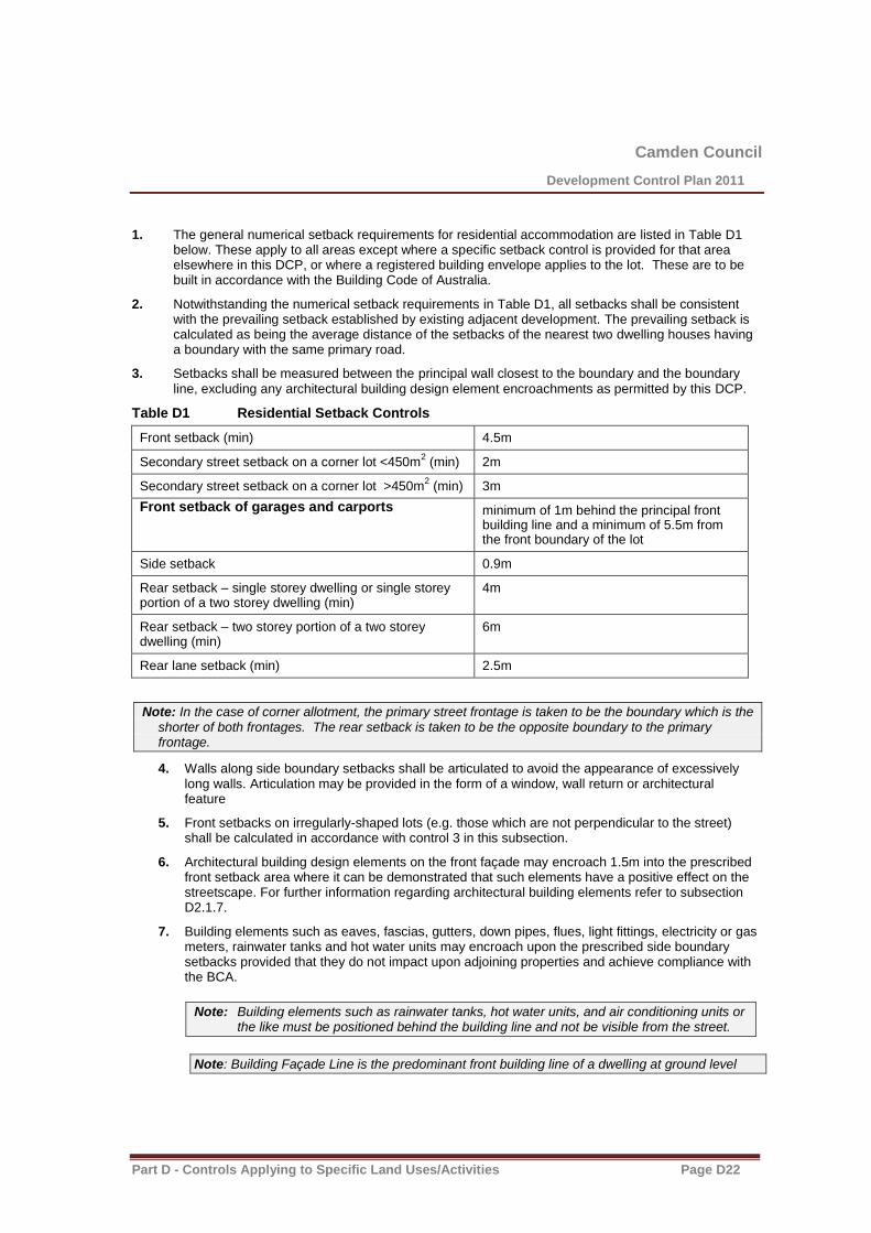
1. The general numerical setback requirements for residential accommodation are listed in Table D1 below. These apply to all areas except where a specific setback control is provided for that area elsewhere in this DCP, or where a registered building envelope applies to the lot. These are to be built in accordance with the Building Code of Australia.
2. Notwithstanding the numerical setback requirements in Table D1, all setbacks shall be consistent with the prevailing setback established by existing adjacent development. The prevailing setback is calculated as being the average distance of the setbacks of the nearest two dwelling houses having a boundary with the same primary road.
3. Setbacks shall be measured between the principal wall closest to the boundary and the boundary line, excluding any architectural building design element encroachments as permitted by this DCP.
Table D1 Residential Setback Controls
Front setback (min) 4.5m
Secondary street setback on a corner lot <450m2 (min) 2m
Secondary street setback on a corner lot >450m2 (min) 3m
Front setback of garages and carports
minimum of 1m behind the principal front building line and a minimum of 5.5m from the front boundary of the lot
Side setback 0.9m
Rear setback – single storey dwelling or single storey portion of a two storey dwelling (min)
4m
Rear setback – two storey portion of a two storey dwelling (min)
6m
Rear lane setback (min) 2.5m
Note: In the case of corner allotment, the primary street frontage is taken to be the boundary which is the shorter of both frontages. The rear setback is taken to be the opposite boundary to the primary frontage.
4. Walls along side boundary setbacks shall be articulated to avoid the appearance of excessively long walls. Articulation may be provided in the form of a window, wall return or architectural feature
5. Front setbacks on irregularly-shaped lots (e.g. those which are not perpendicular to the street) shall be calculated in accordance with control 3 in this subsection.
6. Architectural building design elements on the front façade may encroach 1.5m into the prescribed front setback area where it can be demonstrated that such elements have a positive effect on the streetscape. For further information regarding architectural building elements refer to subsection D2.1.7.
7. Building elements such as eaves, fascias, gutters, down pipes, flues, light fittings, electricity or gas meters, rainwater tanks and hot water units may encroach upon the prescribed side boundary setbacks provided that they do not impact upon adjoining properties and achieve compliance with the BCA.
Note: Building elements such as rainwater tanks, hot water units, and air conditioning units or the like must be positioned behind the building line and not be visible from the street.
Note: Building Façade Line is the predominant front building line of a dwelling at ground level
Camden Council
Development Control Plan 2011
Part D - Controls Applying to Specific Land Uses/Activities Page D23
8. Where there is a large or potentially large tree in the road reserve or public open space adjacent to the site, a setback will be required sufficient to avoid damage to the tree or future problems with the development.
9. For steeply sloping sites the front setbacks specified in this clause may be inappropriate and may need to be varied. The siting of buildings on such sites must take into consideration the grade of the resultant access driveway and allow for the need to provide batters and/or retaining walls for any areas of cut and filling. Generally front boundary setbacks need to be increased for steeply sloping sites.
10. The setbacks may vary if the property is within an Asset Protection Zone.
Note: In exceptional circumstances, Council may consider a reduced rear setback on corner allotments where it can be demonstrated that there is no adverse impact on the adjacent properties, streetscape in general and lot coverage. The following factors will be taken into consideration, but are not limited to:
- Bulk, mass and scale of the structure;
- Privacy impact;
- Overshadowing;
- Streetscape and architectural treatment; and
- Provision of Private Open Space and landscaping requirements.
D2.1.2 Zero Lot Line development
To facilitate the most efficient use of land on smaller lots, a dwelling may be designed so that a side wall of the dwelling is built on or close to the side boundary. This is referred to as ‘zero lot line’ development.
Note: Zero lot line development has a zero lot line on one side boundary only. This is distinct to semi-detached dwellings (subsection D2.2.2) which may be attached to other dwellings.
Objectives
1. Maximise the efficient use of small allotments where no adverse impact is created for adjoining properties
Controls
1. Zero lot lines may be provided where it can be demonstrated that there is no unreasonable adverse impact on the privacy, amenity or solar access of adjoining properties.
2. An easement for ‘support and maintenance’ of the zero lot line wall (and any services along the side of the dwelling) is to be provided on the adjoining property, except where a 400mm side boundary setback is provided. No overhanging eaves or services will be permitted within the easement, however roof gutters may project into the easement. No excavation is permitted within an easement for ‘support and maintenance’. All filling adjacent to an easement for ‘support and maintenance’ shall be contained within the building footprint i.e. drop edge beams. Refer to Figures D1 and D2.
3. The S88B instrument relating to the support and maintenance easement is to be worded so that Council is removed from any dispute resolution process.
4. Zero lot line development must comply with the relevant provisions of the BCA.

Camden Council
Development Control Plan 2011
Part D - Controls Applying to Specific Land Uses/Activities Page D24
5. No section of a wall built on a side boundary should be longer than 10 metres (ie an internal courtyard or light well will be required to achieve this standard). For single storey development, such walls should not exceed 50% of the length of the corresponding boundary. Two storey walls should not exceed 30% of the length of the corresponding boundary.
6. The location of zero lot line development shall have regard to dwelling design, allotment orientation, adjoining dwellings, landscape features, topography and proposed and existing infrastructure.
7. Access to the rear yard of zero lot line development must be provided via a larger side setback on the opposite side of the dwelling, or via a rear garage door provided as a ‘drive through garage’.
Figure D1 Zero Lot Line Development
Camden Council
Development Control Plan 2011
Part D - Controls Applying to Specific Land Uses/Activities Page D25
Figure D2 Zero Lot Line Development
D2.1.3 Height, Massing and Siting
Objectives
1. Ensure building heights achieve high quality built form and urban design outcomes.
2. Protect and enhance residential amenity.
3. Ensure outbuildings are designed to have an appropriate height.
Controls
1. The highest point of a building containing residential accommodation shall not exceed the height specified on the Height of Buildings Map in LEP 2010. In those areas which have a maximum height of 9.5m under LEP 2010, the height of a dwelling house shall not exceed two storeys above natural ground level.
2. Attic rooms may be provided in the roof void where the roof pitch does not exceed 45 degrees and where dormer windows are provided. Such rooms are not considered to be a storey.
3. The ground floor level shall be no more than 1m above natural ground level.
Note: In exceptional circumstances, Council may consider a finished ground floor level greater than 1m from natural ground where the applicant can demonstrate that there is no adverse impact on the adjacent properties and streetscape in general. The following are factors that will be taken into consideration, but not limited to:
a. Bulk, mass and scale of the structure b. Privacy impact; c. Overshadowing; and d. Streetscape and architectural treatment
D2.1.4 Visual and Acoustic Privacy
Objectives
1. Locate and design dwellings in order to meet requirements for visual and acoustic privacy, whilst minimising visual and acoustic impacts of development on adjoining properties.
Controls
1. Reference should be made to section B1.16 of this DCP for further information regarding acoustic amenity.
2. The design of dwellings must minimise the opportunity for sound transmission through the building structure, with particular attention given to protecting bedrooms and living areas.
3. The internal layout of residential buildings, window openings, the location of outdoor living areas (i.e. courtyards and balconies) and building plant should be designed to minimise noise impact and transmission.

Camden Council
Development Control Plan 2011
Part D - Controls Applying to Specific Land Uses/Activities Page D26
4. Direct overlooking of the main living areas and private open spaces of adjacent dwellings should be minimised through building layout, window and balcony location and design, and the use of screening devices, including landscaping. For example, the use of louvers or strategically-placed high parapet walls may facilitate the retention of distant views whilst screening short, downward views.
5. Active recreation facilities (e.g. swimming pools) should be located away from the bedroom areas of adjoining dwellings.
6. Balconies or decks are not permitted at the side or rear of the top floor of a two storey dwelling unless it can be demonstrated that no adverse privacy impacts occur.
D2.1.5 Private Open Space, Site Cover and Landscaped Area
Objectives
1. Provide a high level of residential amenity with opportunities for outdoor recreation and relaxation within the property.
2. Facilitate solar access to the living areas and private open spaces of the dwelling.
3. Ensure that dwellings are designed to minimise overshadowing of adjacent properties and to protect minimum standards sunlight access to private outdoor living space of adjacent dwellings.
4. Ensure that each site has sufficient area for landscaping, including deep soil planting areas for larger trees, to facilitate the establishment of attractive and functional open space areas.
Controls
1. Dwellings are to comply with the maximum site cover and minimum landscaped area requirements (as percentage of the allotment area) shown in table D2. The landscaped area means any part of a site, at ground level, that is permeable and consists of soft landscaping, turf or planted areas and the like. Site cover means all buildings and structures that cover the land.
Table D2 Site Cover Landscaped Area
Lot size Site Cover (max) Landscaped Area (min)
<450m2 Single storey development - 60% 30%
Two storey development – 50% ground floor, 30% upper floor 30%
>450m2 Single storey development - 50% 30%
Two storey development – 50% ground floor, 30% upper floor 30%

Camden Council
Development Control Plan 2011
Part D - Controls Applying to Specific Land Uses/Activities Page D27
2. Each dwelling shall be provided with quality, useable private open space (POS) behind the building line. The total area of POS for each dwelling is to be a minimum 20% of the site area.
Note: In calculating the POS, areas with a measurement in any direction of less than 2.5m are to be excluded.
3. The POS area of each dwelling is to have a principal private open space (PPOS) in at least one courtyard directly connected to a living zone of the dwelling with a minimum area of 24m
2, including
a minimum length of 4m and being not steeper than 1:10 gradient. On steeper sites open space is to be terraced to provide useable space or a timber deck with the minimum dimensions of 4 metres by 2.5 metres, constructed adjacent and accessible to a living zone of the dwelling to minimise any site disturbance.
4. Sunlight must reach at least 50% of the PPOS of both the subject dwelling and of any adjoining dwelling, for not less than 3 hours between 9.00am and 3.00pm on 21 June. POS that has a southerly orientation (shaded by the dwelling and/or adjacent dwelling) may require an increase in its area to compensate for the shaded POS.
5. North facing windows of living areas shall receive at least 3 hours solar access between 9am and 3pm on June 21
st over a portion of their surface.
6. North facing windows to living areas of neighbouring properties shall not have sunlight reduced to less than 3 hours between 9 and 3pm on June 21
st.
7. At least one principal living area of a dwelling must face predominantly north.
8. The PPOS shall be adequately screened for privacy from adjacent dwellings and passers-by.
9. At least 65% of the POS area shall be soft landscaping.

Camden Council
Development Control Plan 2011
Part D - Controls Applying to Specific Land Uses/Activities Page D28
10. Any dwellings which cannot be provided with private open space at ground level (i.e. residential flat buildings, shop top housing) shall instead be provided with a balcony with a minimum size of 10m
2
and a minimum dimension of 2.5m.
11. An area for external clothes drying with good solar access shall be provided within the POS area.
12. Landscaping is to be provided in order to enhance the natural features of the site and adjoining areas. Existing landscape elements such as rock formations, or water courses are to be preserved where possible.
D2.1.6 Garages, Site Access and Parking
Objectives
1. Provide safe and secure onsite parking for residents and visitors.
2. Reduce the visual impact of garages, carports and parking areas on the streetscape and improve dwelling presentation.
3. Ensure the design of garages do not dominate the frontage of the house.
4. Encourage the use of studios over garages to provide surveillance, work from home or residential accommodation opportunities.
Controls
Note: Section B5 of this DCP sets out the general car parking requirements and the number of spaces required for specific development types.
1. The design of the garage and its door/s is to be integrated with the house facade so that it does not dominate the dwelling or the streetscape.
2. The garage location requirements are set out in table D3 below. Where a carport or garage entry forms part of the front façade of a dwelling, the carport or garage is to be set back a minimum of 5.5m from the front boundary to enable a car to be parked in the driveway. A carport or garage is to be setback at least 1m behind the front building façade. Where a three car garage is proposed, the third garage is to be setback at least 1m from the front garage line.
Table D3 Garage Location Requirements
Lot Width* 5m to10m >10m to15m >15m
Garages Lots 5m to 7m:
Single rear loaded
garage only (rear loaded tandem garages permitted)
No frontloaded garages are permitted
Lots>7m to 10m:
Double rear loaded garages permitted or
Frontloaded tandem garages permitted.
Lots>10m to 12.5m:
Single frontloaded
garages only (tandem garages permitted)
Or
Rear loaded double and tandem garages permitted
Lots >12.5m to 15m:
Front loaded double and
tandem garages permitted
Front loaded double and tandem garages
permitted
Or
Rear loaded double and
tandem garages permitted.
Lots >20m:
Front loaded triple garages are permitted.
Camden Council
Development Control Plan 2011
Part D - Controls Applying to Specific Land Uses/Activities Page D29
Or
Rear loaded double and tandem garages
permitted
* Measured at the building line
3. The width of garage doors must not be greater than:
(a) 60% of the dwelling’s front elevation width on lots between 7-15m wide.
(b) 50% of the dwelling’s front elevation width on lots greater than 15m wide.
4. Carports and garages are to be treated as an important element of the dwelling facade and interface with the public domain. They are to be integrated with and complementary, in terms of design and material, to the dwelling design. Garage doors are to be visually recessed through use of materials, colours, and overhangs.
5. The garage door width, garage setback and lane width shall be designed in accordance with AS2890. The maximum width of a driveway at the property boundary is to be 5.5m. On narrow roads, a wider driveway width may be required in order to comply with AS 2890.
6. Driveway paved areas must be kept to a minimum and long straight driveways must be avoided. Trees and shrubs can soften and screen driveways, but care must be taken not to obscure the visibility of cars entering or leaving and driveway.
7. If the carport/garage is freestanding and not located under the main roof of the dwelling, it must match or complement the dwelling with regards to materials, pitch of roof, design, colour and external appearance.
Note: Details of the design and finish of garage door(s) must be shown on the building plan submitted for development approval.
D2.1.7 Streetscape and Architectural Design
Objectives
1. Ensure that buildings are designed to enhance the existing and future desired built form and character of the neighbourhood by encouraging innovative and quality designs that fit harmoniously with their surroundings.
2. Complement the visual character of the street and neighbourhood through appropriate building scale, form, detail and finish.
3. Reinforce existing streetscape features such as building setbacks, alignments, heights and fence design.
4. Provide a clear distinction between private and public space and encourage casual surveillance of the street.
Controls
1. The form, scale and siting of buildings, the materials and colours shall be appropriate to the character of the area.
2. Each street façade of a dwelling, whether addressing the primary frontage, must incorporate at least two of the following design features:
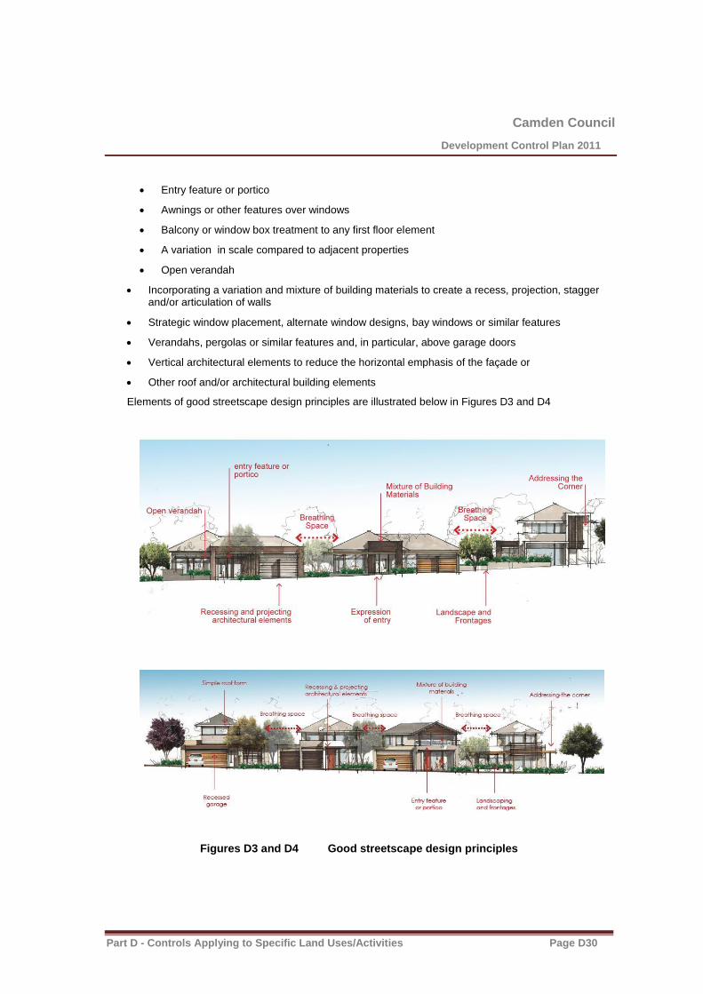
Camden Council
Development Control Plan 2011
Part D - Controls Applying to Specific Land Uses/Activities Page D30
Entry feature or portico
Awnings or other features over windows
Balcony or window box treatment to any first floor element
A variation in scale compared to adjacent properties
Open verandah
Incorporating a variation and mixture of building materials to create a recess, projection, stagger and/or articulation of walls
Strategic window placement, alternate window designs, bay windows or similar features
Verandahs, pergolas or similar features and, in particular, above garage doors
Vertical architectural elements to reduce the horizontal emphasis of the façade or
Other roof and/or architectural building elements
Elements of good streetscape design principles are illustrated below in Figures D3 and D4
Figures D3 and D4 Good streetscape design principles

Camden Council
Development Control Plan 2011
Part D - Controls Applying to Specific Land Uses/Activities Page D31
3. Eaves are to provide sun shading and protect windows and doors and provide aesthetic interest. Except for walls built to the boundary, eaves should have a minimum of 450mm overhang (measured to the facia board) and be provided to a minimum of 70% of the dwelling. Council will consider alternative solutions to eaves so long as they provide appropriate sun shading to windows and display a high level of architectural merit.
4. Proposed dwelling colours, materials and finishes are to be from a predominantly neutral palette of colours. Bright and highly reflective colours are to be avoided, except for architectural features. Multi-coloured roof tiles are not permitted.
D2.1.8 Unsewered Sites
Objective
1. To ensure that unsewered sites are provided with appropriate effluent management.
Control
1. On unsewered sites, effluent and household waste water is to be disposed in accordance with Council’s Sewage Management Strategy.
D2.1.9 Fencing in R5 zones
Objectives
1. Ensure boundary fencing is of a high quality and constructed using materials and finishes which are consistent with the character of the locality and do not detract from the streetscape.
2. Permit appropriate fencing for the screening of courtyards and private open space areas.
Controls
Front fences and dividing fences
1. Front fences shall be a maximum of 1.5m in height and be of traditional picket, open post and wire, post and rail, or masonry utilising only brick or stone construction.
2. Dividing fences and returns to dividing fences shall be a maximum of 1.5m in height and be open post and wire or post and rail in construction.
3. Front fences and dividing fences shall be erected on the alignment of the common boundary of the land.
4. Front fences on corner lots shall be designed to maintain adequate sight line distances for motorists.
5. Special feature entrances and special feature front fencing which does not comply with the above may be considered on a case-by-case basis and will be assessed on merit.
6. Continuous front and dividing fencing of masonry, paling, painted or unpainted or colorbond sheet metal, fibrous cement or the like in either part or full shall not be used in the construction of a front fence or dividing fence.

Camden Council
Development Control Plan 2011
Part D - Controls Applying to Specific Land Uses/Activities Page D32
7. Fences constructed over or adjacent to easements must include appropriate means of access (eg. gates) to enable the servicing of the easements.
8. Fences constructed on land affected by drainage easements, watercourses or drainage waterways shall be designed and constructed so as not to obstruct the free flow of stormwater.
Courtyard and screen fences
1. Courtyard and screen fences shall not be erected forward of the front building line.
2. On lots 4000m2 or greater, courtyard and screen fences shall not be erected within 3m of any side
or rear boundary.
3. Courtyard and screen fences shall be a maximum of 2m in height.
4. Where courtyard and screen fences are constructed using painted, unpainted or colorbond sheet metal, the materials used must be a recognised fencing-grade product with a profile, design and colour which integrates with the surrounding development.
5. Courtyard fences which enclose a part or portion of the allotment of land shall have a maximum
internal area of 50m2.
6. The maximum length of any side of a court yard fence or screen fence shall be 40 metres.
7. The exterior of all courtyard fences and screen fences shall be provided with appropriate landscaping to minimise the impact on the adjoining premises and the area generally.
Feature entrances and special feature front fencing
1. Feature entrances and feature front fences are to be constructed of materials, and be a size, style and design to complement and be consistent with, the existing development on the site, are to impact minimally on the area generally.
2. Continuous brickwork incorporated in feature front fencing shall be a maximum of 500mm above the natural ground surface beneath the fence.
3. Posts and/or columns incorporated in feature front fences shall be maximum of 1.5 metres in height.
4. Fencing panels between the posts or columns in feature front fencing shall be of the open, decorative type with the structure of the panel covering a maximum of 30% of the area of the panel.
D2.1.10 Dwellings in R5 Zones
Background
The Camden LGA features an R5 Large Lot Development residential zone which permits a specific type and density within the area. This chapter establishes the objectives, principles and controls which will guide the design of residential development in the Camden LGA.
Objectives
1. To provide controls for dwellings in R5 zones to ensure that it achieves a high standard of urban design and that it is compatible with the amenity and character of the R5 zone.
2. To provide a variety of attractive and cohesive streetscapes within the R5 zone. 3. Additional objectives are listed in the detailed controls of the various land uses.

Camden Council
Development Control Plan 2011
Part D - Controls Applying to Specific Land Uses/Activities Page D33
Setbacks
Controls
1. The general numerical setback requirements for dwellings in R5 development are listed in Table D3 below. These apply to all areas except where a specific setback control is provided for that area elsewhere in this DCP, or where a registered building envelope applies to the lot.
2. Notwithstanding the numerical setback requirements in Table D3, all setbacks shall be consistent with the prevailing setback established by existing adjacent development. The prevailing setback is calculated as being the average distance of the setbacks of the nearest two dwelling houses having a boundary with the same primary road.
3. Setbacks shall be measured between the principal wall closest to the boundary and the boundary line, excluding any architectural building design element encroachments as permitted by this DCP.
Table D3 Dwelling Setback Controls
Front setback (min) 20m
Secondary street setback on a corner lot <4000m2 5m
Side setback 5m
Rear setback 5m
Primary setback - (min) lots 2000m2 10m
Secondary setback – (min) lots 2000m2 3m
Primary setback – lots <2000m2 7.5m
D2.1.11 Outbuildings
Objectives
1. Ensure outbuildings in the Residential zones are appropriately sited and designed to minimise impacts on adjoining properties, the streetscape and the character of the locality.
2. Ensure the visual impact of the outbuilding is minimized and integrated into the existing surrounding environment.
3. Preserve the existing natural vegetation on site.
Controls
The following controls apply to outbuildings in the R1, R2, R3, R4 and R5 zones.
General
1. Outbuildings should be sited to retain existing vegetation on site and in a location where the future growth of vegetation can be retained and protected.
2. Unless otherwise approved by Council, the use of the outbuilding must be of domestic storage and hobby use only, which is ancillary to the use of the dwelling onsite.
3. Outbuildings should be sited so as they are not to encroach or impact on any existing service

Camden Council
Development Control Plan 2011
Part D - Controls Applying to Specific Land Uses/Activities Page D34
infrastructure, onsite sewerage management systems and associated effluent areas.
Site Requirements
4. The floor area of an outbuilding on a lot must not be more than the following:
a. 36m², if the lot has an area of less than 300m²
b. 45m², if the lot has an area of at least 300m² but less than 600m²
c. 60m², if the lot has an area of at least 600m² but less than 900m²
d. 100m², if the lot has an area of at least 900m².
5. The Maximum height of an outbuilding or alterations and additions to an existing outbuilding must not be more than 4.8m above ground level (existing)
6. Despite sub clause (5) above, a one storey structure with an attic above is permissible provided the height does not exceed 5.4m and amenity to adjacent sites is maintained and the roof pitch, of the building, must not exceed 45 degrees.
6A. Despite sub-clauses 5 and 6 the maximum height of an outbuilding or alterations and additions to an existing outbuilding must not be more than 4.5m above ground level (existing) for 121 Raby Road, Leppington.
7. Stormwater discharge must be disposed of solely within the property boundary without causing any nuisance to the adjacent properties.
8. For outbuildings greater than 20m2 in floor area, stormwater must be collected and discharged to:
a. Existing onsite stormwater lines; or
b. To a collection tank with an overflow connected to the existing onsite stormwater lines.
c. Absorption trenches or existing watercourse as deemed suitable by Council.
9. Notwithstanding the general controls for cut and fill requirements within this DCP, there must be a balance of cut and fill on site. Any fill must be contained wholly within the property boundary without causing any nuisance to the adjacent site.
Setbacks
10. All outbuildings must be planned and organized in a group and must be located behind the building line so it is predominantly hidden from view from the public domain.
11. All outbuildings must comply with the setback provisions in Clause 3.16 of State Environmental Planning Policy (Exempt and Complying Development Codes) 2008.
12. Greater setbacks may be required in order to minimize any adverse impacts on the amenity of adjoining residents due to the proposed use of the outbuilding.
Building Design and Style
13. The roof pitch for any outbuilding must not exceed 36 degrees.
14. The external wall cladding of outbuildings should be of masonry, colorbond sheet metal or other approved material which is compatible with the surrounding development in terms of profile, colour and finish.
15. The roof cladding of outbuildings should be of tiles, colorbond sheet metal or other approved material which is compatible with the surrounding development in terms of profile, color and finish.
16. The colours of roof and wall cladding should generally be of low reflective natural earth and
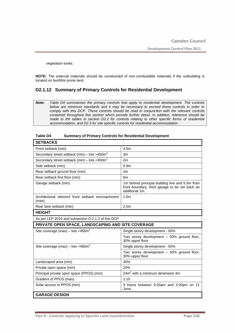
Camden Council
Development Control Plan 2011
Part D - Controls Applying to Specific Land Uses/Activities Page D35
vegetation tones.
NOTE: The external materials should be constructed of non-combustible materials if the outbuilding is
located on bushfire prone land.
D2.1.12 Summary of Primary Controls for Residential Development
Note: Table D4 summarises the primary controls that apply to residential development. The controls below are minimum standards and it may be necessary to exceed these controls in order to comply with this DCP. These controls should be read in conjunction with the relevant controls contained throughout this section which provide further detail. In addition, reference should be made to the tables in section D2.2 for controls relating to other specific forms of residential accommodation, and D2.3 for site specific controls for residential accommodation.
Table D4 Summary of Primary Controls for Residential Development
SETBACKS
Front setback (min) 4.5m
Secondary street setback (min) – lots >450m2 3m
Secondary street setback (min) – lots <450m2 2m
Side setback (min) 0.9m
Rear setback ground floor (min) 4m
Rear setback first floor (min) 6m
Garage setback (min) 1m behind principal building line and 5.5m from front boundary; third garage to be set back an additional 1m.
Architectural element front setback encroachment (max)
1.5m
Rear lane setback (min) 2.5m
HEIGHT
As per LEP 2010 and subsection D.2.1.3 of this DCP
PRIVATE OPEN SPACE, LANDSCAPING AND SITE COVERAGE
Site coverage (max) – lots <450m2
Single storey development - 60%
Two storey development – 50% ground floor, 30% upper floor
Site coverage (max) – lots >450m2 Single storey development - 50%
Two storey development – 50% ground floor, 30% upper floor
Landscaped area (min) 30%
Private open space (min) 20%
Principal private open space (PPOS) (min) 24m2 with a minimum dimension 4m
Gradient of PPOS (max) 1:10
Solar access to PPOS (min) 3 hours between 9.00am and 3.00pm on 21 June.
GARAGE DESIGN

Camden Council
Development Control Plan 2011
Part D - Controls Applying to Specific Land Uses/Activities Page D36
Garage door width (max) – lots 7 to15m wide 60% of front elevation width
Garage door width (max) – lots greater than 15m wide
50% of front elevation width

Camden Council
Development Control Plan 2011
Part D - Controls Applying to Specific Land Uses/Activities Page D37
D2.2 Controls for Specific Forms of Residential Accommodation
Background
This section provides additional detailed controls that apply to specific forms of residential accommodation including:
secondary dwellings
dual occupancies and semi-detached dwellings
multi dwelling housing and attached dwellings
residential flat buildings
shop top housing
This section must be read in conjunction with the controls and provisions contained in Section D2.1 and all other relevant chapters of the DCP. If there is no specific control listed in the subsections below, the general residential controls contained in Section D2.1 will apply. In the event of any inconsistencies, the provisions of section D2.2 will prevail.
Each form of residential accommodation includes a table which summarises the principal controls applying to that development type (except where otherwise noted).
D2.2.1 Secondary Dwellings
Note: Secondary dwellings are a type of residential development commonly referred to as ‘granny flats’ or ‘fonzie flats’.
Objectives
1. Provide unique dwelling types that satisfy a social need.
2. Contribute to the availability of affordable housing.
3. Promote innovative housing solutions that are compatible with the surrounding residential environment.
Controls
1. The maximum floor area requirement for secondary dwellings is established by Clause 5.4(9) of Camden LEP 2010. Secondary dwellings must not exceed 60m
2 in size, or 25% of the total floor
area of the principal dwelling, whichever is the greater (excluding any area used for parking).
2. Secondary dwellings shall be designed to complement the design of the principal dwelling and be subservient to the principal dwelling in terms of visual bulk and scale.
3. No additional car parking or private open space area is required for secondary dwellings, however provisions must be made for clothes drying facilities in a location with adequate solar access.
4. Strata or Torrens title subdivision of secondary dwellings is not permitted.
Note: There is no table summary of controls provided for secondary dwellings

Camden Council
Development Control Plan 2011
Part D - Controls Applying to Specific Land Uses/Activities Page D38
D2.2.2 Dual Occupancies and Semi-detached Dwellings
Note: Dual occupancies and semi-detached dwellings are types of residential accommodation that are very similar in terms of built form (both consist of two dwellings). The distinction between the two is that dual occupancies are located on one lot of land and may only be strata subdivided, whereas semi-detached dwellings are located on their own lot of land (Torrens title). Accordingly, semi-detached dwellings are generally suitable for locations which have a smaller minimum lot size, and development consent must be sought for both semi-detached dwellings and Torrens title subdivision concurrently when lodging a development application in order to satisfy the LEP definition.
Objectives
1. Ensure dual occupancies and semi-detached dwellings are compatible with existing housing and do not adversely affect the local environment or the amenity of adjacent residents.
2. Provide housing choice for the residents of the Camden LGA.
Controls
1. Sites for dual occupancy development should have a minimum principal street frontage of 22m, a minimum area of 600m
2 for standard sites, and a minimum area of 800m
2 for corner sites.
2. The maximum site coverage for a dual occupancy development is 60%.
3. Dual occupancy development on corner lots must provide a setback to the secondary street of at least 4.5m (ie. the general front setback control for residential development will apply to both the primary and secondary street frontages on a dual occupancy development on a corner lot).
4. Dual occupancy development on corner lots must be designed to address both street frontages. Each dwelling should have a separate driveway.
5. Dual Occupancy development is not permitted on battleaxe lots.
6. Dwellings shall be compatible in siting, bulk, scale, size, height and appearance to adjoining and adjacent houses.
7. The architectural treatment and building materials of both dwellings should be compatible.
8. Mirror-reversed or replica dual occupancy developments are not permitted. Forms of differentiation and interest are encouraged in all dwellings.
9. Applicants should avoid repeating designs used in other developments, particularly those located in close proximity to the proposal. It is, however, recognised that there may be instances in a planned development where repetition of a design element is used to create a theme development. These proposals will be considered on the merit of the design. Forms of differentiation and interest are encouraged in all dwellings.
10. Car parking shall be provided in accordance with Chapter B5 of this DCP.

Camden Council
Development Control Plan 2011
Part D - Controls Applying to Specific Land Uses/Activities Page D39
Summary of controls for dual occupancy development
Note: Table D5 summarises the primary controls that apply to dual occupancy development. The controls below are minimum standards and it may be necessary to exceed these controls in order to comply with this DCP. These controls should be read in conjunction with the relevant controls contained throughout this section which provide further detail.
Table D5 Summary of Controls for Dual Occupancy Development
SITE REQUIREMENTS
Lot size (min) 600m2
Lot size corner lot (min) 800m2
Lot width primary frontage (min) 22m
SETBACKS
Front setback (min) 4.5m
Secondary street setback (min) 4.5m
Side setback (min) 0.9m
Rear setback ground floor (min) 4m
Rear setback first floor (min) 6m
Garage setback (min) 1m behind principal building line and 5.5m from front boundary
Architectural element front setback encroachment (max)
1.5m
Rear lane setback (min) 2.5m
HEIGHT
As per LEP 2010 and subsection D.2.1.3 of this DCP
PRIVATE OPEN SPACE, LANDSCAPING AND SITE COVERAGE
Site coverage (max)
Single storey development - 60%
Two storey development – 60% ground floor, 30% upper floor
Landscaped area (min) 30%
Private open space (min) 20%
Principal private open space (PPOS) (min) 24m2 with a minimum dimension 4m
Gradient of PPOS (max) 1:10
Solar access to PPOS (min) 3 hours between 9.00am and 3.00pm on 21 June.
GARAGE DESIGN
Garage door width (max) 50% of front elevation width

Camden Council
Development Control Plan 2011
Part D - Controls Applying to Specific Land Uses/Activities Page D40
D2.2.3 Multi Dwelling Housing and Attached Dwellings
Note: Multi dwelling housing and attached dwellings are forms of residential accommodation that are very similar in terms of built form. Multi dwelling housing is three or more dwellings (whether attached or detached) on one lot of land, whereas attached dwellings are a building containing three or more dwellings which are attached via common walls and are each on their own lot of land. Accordingly, attached dwellings are generally suitable for locations which have a smaller minimum lot size, and development consent will be sought for attached dwellings and Torrens title subdivision concurrently when lodging a development application in order to satisfy the LEP definition.
Objectives
1. Encourage high quality residential developments which feature a high standard of urban design and provide a high level of amenity for residents.
2. Ensure that development sites have sufficient site area to accommodate appropriate setbacks and open space areas, including areas for deep soil planting and natural site drainage.
Controls
Site requirements
Sites for multi unit housing or attached dwellings should have the following attributes:
1. smaller developments which consist of one row of dwellings parallel to the street with direct vehicular access for each dwelling should have a minimum frontage of 25m.
2. smaller developments which consist of one row of dwellings perpendicular to the street with communal vehicular access to the street via a common driveway should have a minimum frontage of 25m.
3. larger developments which propose direct public road frontage for some of the dwellings and internal vehicular access to service the remainder of the development, should have minimum road frontage of 70m and a minimum depth of 80m.
Site coverage
4. The maximum site coverage for multi dwelling housing and attached dwellings is 50%.
Image and legibility
The proposed development should:
5. blend in with its surroundings and/or be in keeping with the character of the area.
6. be designed to be compatible with the streetscape and be attractive when viewed within the site.
7. ensure that all units are designed to face and address both external public roads and internal private access roads/driveways.
8. create an appearance of a single or grouped dwellings that are separated by gardens and ancillary structures, with facades designed to incorporate a variety of materials and shading structures.
9. avoid repeating designs used in other developments, particularly those located in close proximity to the proposal. It is, however, recognised that there may be instances in a planned development where repetition of a design element is used to create a theme development. These proposals will be considered on the merit of the design. Forms of differentiation and interest are encouraged in all dwellings.

Camden Council
Development Control Plan 2011
Part D - Controls Applying to Specific Land Uses/Activities Page D41
10. provide a clear differentiation between private areas (open space, private front and side yard areas, private car parking spaces) and communal open space and car parking.
11. provide a minimum of 12m between front facades within the development so that the layout does not create gun-barrel vistas.
12. clearly identify each unit, its entrance, visitor carparking to enable a visitor to easily understand the development’s layout.
Camden Council
Development Control Plan 2011
Part D - Controls Applying to Specific Land Uses/Activities Page D42
Access and entries
13. The proposed development should:
(a) minimise vehicular and pedestrian entry and exit points to the site.
(b) provide a defined and well-lit pedestrian ‘safe route’ which can be clearly viewed by residents for passive surveillance.
(c) consider site accessibility to people in wheelchairs and with lesser mobility.
Car parking
14. Car parking shall be provided in accordance with Chapter B5 of this DCP.
15. Communal visitor and/or resident’s parking areas should be located within view of residents to facilitate passive surveillance of these areas.
16. Traffic calming measures should be provided to ensure a safer vehicle and pedestrian environment.
17. Driveways, manoeuvring areas, parking areas and garages are to be located away from bedrooms.
Storage
18. Each dwelling shall be provided with a separate secure storage space of 8m3. This space is to be
provided exclusively for storage purposes and must be provided in addition to any garage space.
Private open space
19. Private open space is to be provided in accordance with subsection D2.1.5 of this DCP.
Communal open space and landscaping
20. Each development shall incorporate landscaping in accordance with subsection D2.1.5 of this DCP, along with an area of dedicated communal open space.
21. Landscaping shall take into account probable day and night use by residents, seating, shade and allows surveillance by residents ie the plants are either high (canopy trees) or low (ground covers).
22. If the area is fenced, the fence shall be dark in colour and permeable to maximise passive surveillance of the area.
23. Communal open space landscaping shall be designed to minimise water usage and maintenance requirements.
24. Communal open space should be provided in locations which help to retain existing trees wherever possible.
Security
25. The proposed development should be designed to comply with Council’s ‘Safer By Design’ Guidelines.
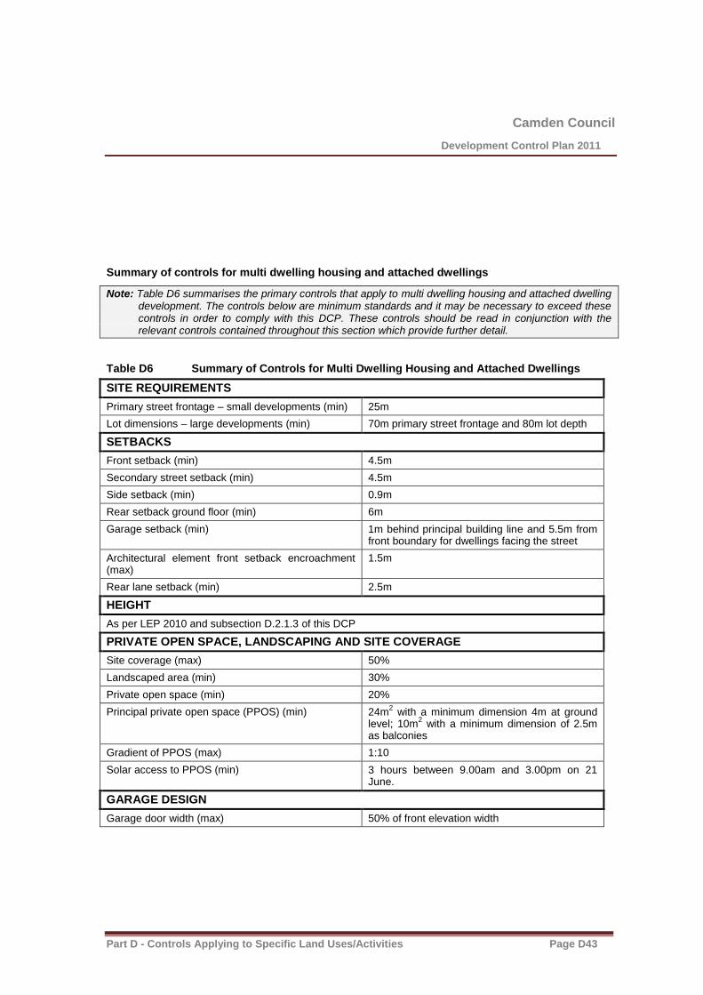
Camden Council
Development Control Plan 2011
Part D - Controls Applying to Specific Land Uses/Activities Page D43
Summary of controls for multi dwelling housing and attached dwellings
Note: Table D6 summarises the primary controls that apply to multi dwelling housing and attached dwelling development. The controls below are minimum standards and it may be necessary to exceed these controls in order to comply with this DCP. These controls should be read in conjunction with the relevant controls contained throughout this section which provide further detail.
Table D6 Summary of Controls for Multi Dwelling Housing and Attached Dwellings
SITE REQUIREMENTS
Primary street frontage – small developments (min) 25m
Lot dimensions – large developments (min) 70m primary street frontage and 80m lot depth
SETBACKS
Front setback (min) 4.5m
Secondary street setback (min) 4.5m
Side setback (min) 0.9m
Rear setback ground floor (min) 6m
Garage setback (min) 1m behind principal building line and 5.5m from front boundary for dwellings facing the street
Architectural element front setback encroachment (max)
1.5m
Rear lane setback (min) 2.5m
HEIGHT
As per LEP 2010 and subsection D.2.1.3 of this DCP
PRIVATE OPEN SPACE, LANDSCAPING AND SITE COVERAGE
Site coverage (max)
50%
Landscaped area (min) 30%
Private open space (min) 20%
Principal private open space (PPOS) (min) 24m2 with a minimum dimension 4m at ground
level; 10m2 with a minimum dimension of 2.5m
as balconies
Gradient of PPOS (max) 1:10
Solar access to PPOS (min) 3 hours between 9.00am and 3.00pm on 21 June.
GARAGE DESIGN
Garage door width (max) 50% of front elevation width

Camden Council
Development Control Plan 2011
Part D - Controls Applying to Specific Land Uses/Activities Page D44

Camden Council
Development Control Plan 2011
Part D - Controls Applying to Specific Land Uses/Activities Page D45
D2.2.4 Residential Flat Buildings
Objectives
1. Encourage high quality medium density residential development where the occupants of all dwellings have a high level of amenity, and the amenity of adjoining dwellings is not substantially affected.
2. Require a high standard of architecture and design so that residential flat buildings are appropriately integrated with the surrounding development in terms of character, height, bulk and scale.
Controls
Residential Flat Design Code
1. All residential flat buildings and shop top housing developments, regardless of the number of storeys, are to be consistent with the principles and guidelines outlined in SEPP 65 Residential Flat Development.
Site requirements and density
2. Residential flat buildings are to:
(a) be located on sites with a minimum site area of 1000m2 and a street frontage of 30m.
(b) have a dwelling density not exceeding 1 unit per 200m2 of site area.
(c) have direct frontage to an area of the public domain (including streets and public parks).
(d) not adversely impact upon the existing or future amenity of any adjoining land upon which residential development is permitted with respect to overshadowing impact, privacy impact or visual impact.
Site coverage
3. The maximum site coverage for residential flat buildings is 50%.
Setbacks
4. The minimum front and secondary street setback is 6m
5. The minimum side boundary setback is 3m
6. The minimum rear boundary setback is 6m
Building height, bulk and scale
7. The maximum height of buildings is established by Clauses 4.3A, 4.3B and 4.3C of Camden LEP 2010 and the associated Height of Buildings Map.
8. Residential flat buildings may be designed with flat roof forms in order to maximise the number of storeys within a building. However, such buildings must feature a high level of architectural design and incorporate appropriate treatments to minimise the visual bulk and scale of the building.
9. For residential flat buildings, basement car parks that do not exceed more than 1m above natural ground level are not considered to be a storey.
Image and legibility
10. The proposed development shall:
(a) blend in with its surroundings and/or be in keeping with the character of the area.
Camden Council
Development Control Plan 2011
Part D - Controls Applying to Specific Land Uses/Activities Page D46
(b) create visual interest internally and with its relationship within the streetscape via building design, materials and colour scheme.
(c) provide a clear differentiation between private areas (open space, private front and side yard areas, private car parking spaces) and communal open space and car parking.

Camden Council
Development Control Plan 2011
Part D - Controls Applying to Specific Land Uses/Activities Page D47
Access and entries
11. The proposed development should:
(a) minimise vehicular and pedestrian entry and exit points to the site.
(b) provide a defined and well-lit pedestrian ‘safe route’ which can be clearly viewed by residents for passive surveillance.
(c) consider site accessibility to people in wheelchairs and with lesser mobility.
Car parking
12. Car parking shall be provided in accordance with Chapter B5 of this DCP.
13. Basement car parking areas shall include adequate lighting, ventilation and access control/security. To enhance the effectiveness of the lighting system, it is recommended that the walls and ceiling of basement car parking areas should be painted white.
14. Traffic calming measures should be provided to ensure a safer vehicle and pedestrian environment.
15. Driveways, manoeuvring areas, parking areas and garages are to be located away from bedrooms.
Storage
16. Each dwelling shall be provided with a separate secure storage space of 8m3. This space is to be
provided exclusively for storage purposes and must be provided in addition to any garage space.
Private open space
17. Private open space is to be provided in accordance with subsection D2.1.5 of this DCP.
Communal open space and landscaping
18. Each development shall incorporate landscaping in accordance with Section D2.1.5 of this DCP, along with an area of dedicated communal open space.
19. Landscaping shall take into account probable day and night use by residents, seating, shade and allow surveillance by residents ie the plants are either high (canopy trees) or low (ground covers).
20. If the area is fenced, the fence shall be dark in colour and permeable to maximise surveillance of the area.
21. Communal open space landscaping shall be designed to minimise water usage and maintenance requirements.
22. Communal open space should be provided in locations which help to retain existing trees wherever possible.
Security
23. The proposed development should be designed to comply with Council’s ‘Safer By Design’ Guidelines.

Camden Council
Development Control Plan 2011
Part D - Controls Applying to Specific Land Uses/Activities Page D48
Summary of controls for residential flat buildings
Note: Table D7 summarises the primary controls that apply to residential flat building development. The controls below are minimum standards and it may be necessary to exceed these controls in order to comply with this DCP. These controls should be read in conjunction with the relevant controls contained throughout this section which provide further detail.
Table D7 Summary of controls for residential flat buildings
SITE REQUIREMENTS
Lot size (min) 1000m2
Primary street frontage (min) 30m
Dwelling density (max) 1 per 200m2 of site area
SETBACKS
Front setback (min) 6m
Secondary street setback (min) 6m
Side setback (min) 3m
Rear setback (min) 6m
Architectural element front setback encroachment (max)
1.5m
Rear lane setback (min) 2.5m
HEIGHT
As per LEP 2010 and subsection D.2.1.3 of this DCP
PRIVATE OPEN SPACE, LANDSCAPING AND SITE COVERAGE
Site coverage (max)
50%
Landscaped area (min) 30%
Private open space (min) 20%
Principal private open space (PPOS) (min) 24m2 with a minimum dimension 4m at ground
level; 10m2 with a minimum dimension of 2.5m
as balconies
Gradient of PPOS (max) 1:10
Solar access to PPOS (min) 3 hours between 9.00am and 3.00pm on 21 June.
GARAGE DESIGN
Garage door width (max) 50% of front elevation width
Camden Council
Development Control Plan 2011
Part D - Controls Applying to Specific Land Uses/Activities Page D49
D2.2.5 Shop Top Housing
Objectives
1. Encourage shop top housing which provides the occupants with a high level of amenity whilst addressing issues associated with the interface between residential and business/commercial land uses.
Controls
Access and entries
The proposed development should:
1. minimise vehicular and pedestrian entry and exit points to the site;
2. provide a defined and well-lit pedestrian ‘safe route’
3. provide a separate and well-defined entry point(s) to the shop top housing dwellings from the primary street frontage.
Building height, bulk and scale
4. The maximum height of buildings is established by Clauses 4.3A, 4.3B and 4.3C of Camden LEP 2010 and the associated Height of Buildings Map.
5. Shop top housing may be designed with flat roof forms in order to maximise the number of storeys within a building. However, such buildings must be feature a high level of architectural design and incorporate appropriate treatments to minimise the visual bulk and scale of the building.
6. For shop top housing, basement car parks that do not exceed more than 1m above natural ground level are not considered to be a storey.
Image and legibility
7. The proposed development should:
(a) blend in with its surroundings and/or be in context with the area.
(b) minimise intrusion on adjacent land uses eg noise, overshadowing, carparking overflow, vehicles reversing onto public roads.
(c) create visual interest internally and with its relationship within the streetscape via building design, materials and colour scheme.
Car parking
8. Car parking shall be provided in accordance with Chapter B5 of this DCP.
9. Basement car parking areas shall include adequate lighting, ventilation and access control/security. To enhance the effectiveness of the lighting system, the walls and ceiling of basement car parking areas shall be painted white.
10. The basement car parking area in a mixed use development which includes shop top housing must provide a separate car parking area for the residents and visitors to the shop top housing. The resident and visitor car parking area must have controlled access via electronic and mechanical means to eliminate parking conflict between residents/visitors and the employees and customers of the business/commercial component of the development.
11. Traffic calming measures should be provided to ensure a safer vehicle and pedestrian environment where required.
12. Driveways, manoeuvring areas, parking areas and garages are to be located away from bedrooms.

Camden Council
Development Control Plan 2011
Part D - Controls Applying to Specific Land Uses/Activities Page D50
Servicing
13. Each dwelling shall be provided with a separate secure storage space of 8m3. This space is to be
provided exclusively for storage purposes and must be provided in addition to any garage space.

Camden Council
Development Control Plan 2011
Part D - Controls Applying to Specific Land Uses/Activities Page D51
Private open space
14. Private open space is to be provided in accordance with Section D2.1.5 of this DCP.
Security
15. The proposed development should be designed to comply with Council’s ‘Safer By Design’ Guidelines.
Note: There is no table summary of controls provided for shop top housing

Camden Council
Development Control Plan 2011
Part D - Controls Applying to Specific Land Uses/Activities Page D52
D2.3 Site Specific Controls for Residential Accommodation
Background
This section provides additional site-specific controls that apply to residential accommodation in the following areas (shown in Figure C2) or other specific locations:
Elderslie Release Area
Spring Farm Release Area
Manooka Valley
Harrington Grove
Mater Dei
Camden Lakeside
Yamba
121 Raby Road, Leppington
This section must be read in conjunction with the general controls and provisions contained in Sections D2.1 , D2.2 and the rest of the DCP. In the event of any inconsistencies, the provisions of section D2.3 will prevail.
A summary of the controls that apply to each of the above areas is provided in table format in each subsection below. These controls are taken from Sections D2.1, D2.2 and this section.
Note: Part C Residential Subdivision contains the controls relating to the subdivision of the abovementioned areas.

Camden Council
Development Control Plan 2011
Part D - Controls Applying to Specific Land Uses/Activities Page D53
D2.3.1 Elderslie Release Area
Note: The controls listed below (table D8) are specific to the Elderslie Release Area . They must be read in conjunction with the controls in section D2.1 and D2.2 of this DCP. In the event of any inconsistency, the controls included in this subsection will take precedence.
Front setback
The minimum front setback of a residential building fronting Liz Kernohan Drive is 6m.
Secondary street setback
The minimum secondary street setback of a residential building fronting Liz Kernohan Drive is 3m.
Table D8 Summary of residential accommodation controls – Elderslie Release Area
SETBACKS
Front setback (min) 4.5m
Front setback - Liz Kerhohan Drive 6m
Secondary street setback (min) – lots >450m2 3m
Secondary street setback (min) – lots <450m2 2m
Secondary street boundary setback on a corner lot - Liz Kerhohan Drive
3m
Side setback (min) 0.9m
Rear setback ground floor (min) 4m
Rear setback first floor (min) 6m
Garage setback (min) 1m behind principal building line and 5.5m from front boundary; third garage to be set back an additional 1m.
Architectural element front setback encroachment (max)
1.5m
Rear lane setback (min) 2.5m
Public reserve setback (min) 3m
HEIGHT
As per LEP 2010 and subsection D.2.1.3 of this DCP
PRIVATE OPEN SPACE, LANDSCAPING AND SITE COVERAGE
Site coverage (max) – lots <450m2
Single storey development - 60%
Two storey development – 50% ground floor, 30% upper floor
Site coverage (max) – lots >450m2 Single storey development - 50%
Two storey development – 50% ground floor, 30% upper floor
Landscaped area (min) 30%
Private open space (min) 20%
Principal private open space (PPOS) (min) 24m2 with a minimum dimension 4m
Gradient of PPOS (max) 1:10
Solar access to PPOS (min) 2 hours between 9.00am and 3.00pm on 21

Camden Council
Development Control Plan 2011
Part D - Controls Applying to Specific Land Uses/Activities Page D54
June.
GARAGE DESIGN
Garage door width (max) – lots 7-15m wide 60% of front elevation width
Garage door width (max) – lots greater than 15m wide
50% of front elevation width

Camden Council
Development Control Plan 2011
Part D - Controls Applying to Specific Land Uses/Activities Page D55
D2.3.2 Spring Farm Release Area
Note: The controls listed below (Table D9) are specific to the Spring Farm Release Area. They must be read in conjunction with the controls in section D2.1 and D2.2 of this DCP. In the event of any inconsistency, the controls included in this subsection will take precedence.
Front setback
The minimum front setback of a residential building is 4m.
The minimum front setback of a residential building fronting collector roads (including Liz Kernohan Drive) is 4.5m.
Secondary street setback
The minimum secondary street setback of a residential building is 1m.
The minimum secondary street setback of a residential building fronting Liz Kernohan Drive is 2m.
Table D9 Summary of residential accommodation controls – Spring Farm Release Area
SETBACKS
Front setback (min) 4m
Front setback – collector road (incl. Liz Kerhohan Drive) (min)
4.5m
Secondary street setback (min) 1m
Secondary street setback - collector road (incl. Liz Kernohan Drive) (min)
2m
Side setback (min) 0.9m
Rear setback ground floor (min) 4m
Rear setback first floor (min) 6m
Garage setback (min) 1m behind principal building line and 5.5m from front boundary; third garage to be set back an additional 1m.
Architectural element front setback encroachment (max)
1.5m
Rear lane setback (min) 2.5m
Public reserve setback (min) 3m
HEIGHT
As per LEP 2010 and subsection D.2.1.3 of this DCP
PRIVATE OPEN SPACE, LANDSCAPING AND SITE COVERAGE
Site coverage (max) – lots <450m2
Single storey development - 60%
Two storey development – 50% ground floor, 30% upper floor
Site coverage (max) – lots >450m2 Single storey development - 50%
Two storey development – 50% ground floor, 30% upper floor
Landscaped area (min) 30%
Camden Council
Development Control Plan 2011
Part D - Controls Applying to Specific Land Uses/Activities Page D56
Private open space (min) 20%
Principal private open space (PPOS) (min) 24m2 with a minimum dimension 4m
Gradient of PPOS (max) 1:10
Solar access to PPOS (min) 2 hours between 9.00am and 3.00pm on 21 June.
GARAGE DESIGN
Garage door width (max) – lots 7-15m wide 60% of front elevation width
Garage door width (max) – lots greater than 15m wide
50% of front elevation width

Camden Council
Development Control Plan 2011
Part D - Controls Applying to Specific Land Uses/Activities Page D57
D2.3.3 Manooka Valley
Note: The controls listed below (Table D10) are specific to Manooka Valley. They must be read in conjunction with the controls in section D2.1 and D2.2 of this DCP. In the event of any inconsistency, the controls included in this subsection will take precedence.
Front setbacks
The minimum front setback of a residential building on north-facing lots fronting ‘Main Street’ is 6m.
The minimum front setback of a residential building on land zoned E4 Environmental Living is 5.5m.
Secondary street setback
The minimum secondary street setback of a residential building on land zoned E4 Environmental Living is 4.5m.
Side setback
The minimum side setback of a residential building on land zoned E4 Environmental Living is 1.5m.
Table D10 Summary of residential accommodation controls – Manooka Valley
SETBACKS
Front setback (min) 4.5m
Front setback – north-facing lots fronting ‘Main Street’
6m
Front setback - Land zoned E4 5.5m
Secondary street setback (min) – lots >450m2 3m
Secondary street setback (min) – lots <450m2 2m
Secondary street boundary setback on a corner lot - Land zoned E4
4.5m
Side setback (min) 0.9m
Side setback - Land zoned E4 1.5m
Rear setback ground floor (min) 4m
Rear setback first floor (min) 6m
Garage setback (min) 1m behind principal building line and 5.5m from front boundary; third garage to be set back an additional 1m.
Architectural element front setback encroachment (max)
1.5m
Rear lane setback (min) 2.5m
Public reserve setback (min) 3m
HEIGHT
As per LEP 2010 and subsection D.2.1.3 of this DCP
PRIVATE OPEN SPACE, LANDSCAPING AND SITE COVERAGE
Site coverage (max) – lots <450m2
Single storey development - 60%
Two storey development – 50% ground floor, 30% upper floor
Site coverage (max) – lots >450m2 Single storey development - 50%

Camden Council
Development Control Plan 2011
Part D - Controls Applying to Specific Land Uses/Activities Page D58
Two storey development – 50% ground floor, 30% upper floor
Landscaped area (min) 30%
Private open space (min) 20%
Principal private open space (PPOS) (min) 24m2 with a minimum dimension 4m
Gradient of PPOS (max) 1:10
Solar access to PPOS (min) 3 hours between 9.00am and 3.00pm on 21 June.
GARAGE DESIGN
Garage door width (max) – lots 7-15m wide 60% of front elevation width
Garage door width (max) – lots greater than 15m wide
50% of front elevation width

Camden Council
Development Control Plan 2011
Part D - Controls Applying to Specific Land Uses/Activities Page D59
D2.3.4 Harrington Grove
Note: The controls listed below are specific to Harrington Grove. They must be read in conjunction with the controls in section D2.1 and D2.2 of this DCP. In the event of any inconsistency, the controls included in this subsection will take precedence.
A - Harrington Grove General Residential Building Controls Applying to all Precincts
Housing
Design Objectives
1. Development is to enhance the existing or planned town/suburban character and streetscape.
2. The form, scale and siting of buildings, and the materials and colours are to be appropriate to the character of the area.
3. Garages are to be recessed from the front facade so as not to dominate the house and the streetscape.
4. Building heights are to maintain the single and double storey residential character of the Camden LGA and to minimise the impact on existing residential development.
5. Setbacks are to enhance or create landscape features, and maintain visual and acoustic privacy.
Building and Site Design
Form and Character
Residential development within Harrington Grove comprises a variety of styles, densities and form, which creates neighbourhood villages of a high standard.
1. Whilst encouraging variety in housing design these Building Controls promote characteristics of good design such as:
(a) facades that are attractive and provide interest.
(b) facades that are “welcoming” and do not dominate the streetscape.
(c) rooflines that are aesthetically pleasing and incorporate adequate eaves.
(d) reduced visual impact from garage doors.
(e) make best use of the site area and orientation of the lot.
(f) energy consumption reductions in housing through passive solar design.
(g) good landscape design to maximise energy efficiency of dwellings.
(h) high levels of amenity (daylight, outlook, privacy) from within the house and the private open space.
(i) safe neighbourhoods through informal surveillance of the street.
Siting of Dwellings
2. The orientation, siting and layout of dwellings is to take into account the following:

Camden Council
Development Control Plan 2011
Part D - Controls Applying to Specific Land Uses/Activities Page D60
(a) location and design of houses are to relate to the site topography.
(b) houses to be orientated to the front street.
(c) visual and acoustic privacy is to be maintained between the dwellings and adjacent residential properties.
(d) the benefits of passive solar design and natural ventilation.
(e) effective landscaping and careful site design is to assist in acoustic and visual privacy and enhance shaded areas.
(f) minimise the effects of overshadowing, and visual and acoustic intrusion.
(g) the provision of sunlight in living spaces within buildings and in open spaces around buildings to improve energy efficiency.
Corner Lots
3. Dwellings on corner lots are to consider the following:
(a) Dwellings on corner lots are to address both street frontages (figure D5).
(b) Dwellings on corner lots may encroach closer to the road reserve to frame the corner and improve the visual quality of the streetscape.
Figure D5 Dwelling addressing both frontages
Street Facades
Garages are not to protrude in front of houses and/or dominate the streetscape. The front of the house is to have an attractive facade that displays sufficient articulation (figure D7). To achieve this, the following provisions apply. 4. Triple garages are to have at least one garage set back a minimum distance of 900mm behind the
other garages.
5. Part of the front facade (excluding the garage) must be set back a minimum of 900mm from the rest of the facade (excluding the garage) (figure D6). This results in a staggered or articulated facade. Recessed or protruding entry alcoves, central to the front building facade and containing the front door, do not, alone, satisfy this requirement.
6. On corner homesites, no straight section of the side wall facing a street is to be longer than 9m or shorter than 2.5m. Walls longer than 9m are to have a ‘step’ of at least 900mm between the sections.

Camden Council
Development Control Plan 2011
Part D - Controls Applying to Specific Land Uses/Activities Page D61
Figure D6 Street Facades
7. Garages are permitted forward of the front building facade providing (figure D7):
(a) garage doors do not front the street,
(b) the facade of the garage fronting the street resembles a dwelling facade which includes windows and similar architectural elements, and
(c) the garage is integrated with the dwelling.

Camden Council
Development Control Plan 2011
Part D - Controls Applying to Specific Land Uses/Activities Page D62
Facades – Acceptable Facades – Not Acceptable
Figure D7 Facades which are/are not permitted

Camden Council
Development Control Plan 2011
Part D - Controls Applying to Specific Land Uses/Activities Page D63
Setbacks
Setbacks for Dwellings and Structures (General)
1. Setbacks within these precincts are to be in accordance with Table

Camden Council
Development Control Plan 2011
Part D - Controls Applying to Specific Land Uses/Activities Page D64
Table D11 Precinct Setbacks
2. Eaves, facias, downpipes, chimneys and gutters can encroach into the side setbacks provided there is a minimum separation distance of 450mm from the boundary, as shown on figure D8.
Figure D8 Side Boundary Setback
3. All outbuildings greater than 10m2 in area are to comply with the standard setback provisions above.
Corner Lots
4. Corner lots may have a reduced front setback to the neighbouring allotments primary front setback. (i.e. where an abutting lot has a primary street setback of 6 metres, the corner lot shall have a setback to that road of 4 metres)(Refer Figure D9).
5. No side wall is to be longer than 9m or shorter than 2.5m in length and is to contain a minimum 900mm step in the facade.

Camden Council
Development Control Plan 2011
Part D - Controls Applying to Specific Land Uses/Activities Page D65
Figure D9 Corner Lot Setbacks
Garages
6. Garages are to be setback a minimum of 5.5m from any street frontage.
7. Garages are to be setback a minimum of 1.1m from any other boundary.
8. Garages are to be setback by a minimum of 900mm from the primary building facade closest to the road.
9. Triple garages are to have at least one garage setback a minimum distance of 900mm behind the other garages.
Site Coverage and Floor Area
10. The area of the dwelling (including ancillary buildings) is to occupy no more than 50% of the lot area (excluding access legs of battle-axe allotments).
11. Dwellings are to have a minimum floor area not less than 300m2. This includes attached garage
areas but does not include verandahs or patios.
Materials
Colour
1. A colour schedule containing samples of external colours is to be provided to Camden Council when applying for development consent.
Note: Open verandahs and covered outdoor entertaining areas with perimeter walling no higher than 1m are excluded, as are garden sheds that comply with the SEPP (Exempt and Complying Development) 2009. Awnings must be no closer than 900mm to the boundary.
Note: Different minimum floor areas exist for Precincts A, C, E and K which are detailed in the Precinct specific building controls.

Camden Council
Development Control Plan 2011
Part D - Controls Applying to Specific Land Uses/Activities Page D66
2. Bolder, brighter, deeper shades of colour on feature areas of the building is encouraged provided they are in keeping with the overall colour scheme of the dwelling and do not detract from the streetscape.
Walls
3. External walls of all dwellings are to be constructed of;
(a) face or rendered brickwork,
(b) stone,
(c) rendered concrete blocks,
(d) glass, or
(e) lightweight materials such as fibre cement or seamless, textured and coated materials.
4. The use of lightweight materials is only permitted on upper-storey walls, and is to be constructed of fibre cement or other seamless, textured, coated materials.
5. Dwellings are to be finished in earthy colours that blend with the natural surrounds. Bold contrasting colours are to be avoided, so as to not detract from the natural setting of the development.
Roofs
6. Roofs are to be constructed of pre-painted steel sheet, tiles or slate.
7. Roofs are to consist of a single colour and material.
8. Highly reflective roofing materials (such as uncoated zincalume) are not permitted as the reflective qualities can impact upon neighbouring allotments and the surrounding area.
9. A colour schedule containing samples of roof colours is to accompany the Development Application for building.
10. The colour of roofing, whether tiles or pre-painted sheet steel, is to be generally consistent with the natural surrounds and comprise of colours similar to those specified in the table below from the Colorbond® range (refer table D12).
Table D12 Permitted and Not Permitted Colours of Roofing
Permitted Not Permitted
Jasper® Headland®
Dune® Manor Red®
Windspray® Sandbank®
Woodland Grey® Classic Cream™
Bushland® Surfmist®
Pale Eucalypt® Paperbark®
Wilderness® Shale Grey™
Cottage Green®
Plantation®
Blue Ridge®

Camden Council
Development Control Plan 2011
Part D - Controls Applying to Specific Land Uses/Activities Page D67
Deep Ocean®
Ironstone®
Night Sky®
Note: Colour quality may change when printing and names are subject to changeHedge®
Roof Form
Roof Pitch and Line
1. The roof pitch is to be a minimum of 22.50 and a maximum of 45
0.
2. Skillion roofs are permitted with a minimum slope of 22.50.
3. The roof line is to be articulated to follow the modulation of the dwelling facade where the step within the facade exceeds 2.5m in length and fronts a road or public reserve (i.e. corner lot and street front) (Refer figure D10).
4. Eaves no smaller than 450mm are to be incorporated into the building design and are required on all front and side facades of dwellings.
Note: Variations to the minimum roof pitch requirement can be considered where architectural merit and
innovation in the building design is demonstrated.
Figure D10 Roof Articulation
Lofts
5. Lofts are intended to provide flexibility in the design and location of floor space within a dwelling, but are not intended to be an additional storey.
6. Lofts are to be contained entirely within the roof pitch.
7. Lofts will not be counted as a storey.
8. Lofts may be used as habitable areas, but are not included in floorspace calculations.
9. Dormer windows and tilt up windows that are flush with the roof are permitted.
Garages and Driveways
Garage Design
1. Garages are to have a minimum internal dimension of 3m wide x 5.5m length for a single garage or 5.5m width x 5.5m length for a double garage. All dimensions are to be clear of any fixed internal structures, such as staircases (Figure D11).
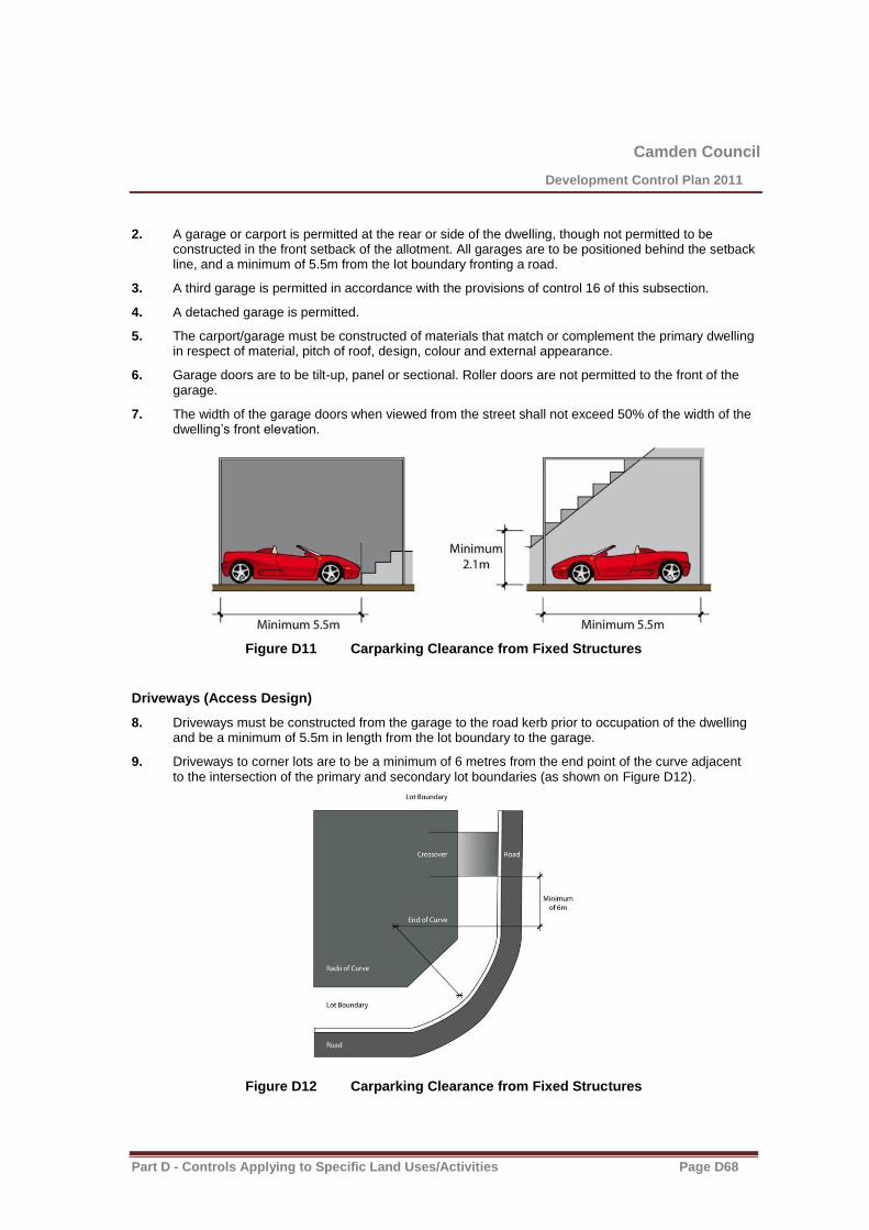
Camden Council
Development Control Plan 2011
Part D - Controls Applying to Specific Land Uses/Activities Page D68
2. A garage or carport is permitted at the rear or side of the dwelling, though not permitted to be constructed in the front setback of the allotment. All garages are to be positioned behind the setback line, and a minimum of 5.5m from the lot boundary fronting a road.
3. A third garage is permitted in accordance with the provisions of control 16 of this subsection.
4. A detached garage is permitted.
5. The carport/garage must be constructed of materials that match or complement the primary dwelling in respect of material, pitch of roof, design, colour and external appearance.
6. Garage doors are to be tilt-up, panel or sectional. Roller doors are not permitted to the front of the garage.
7. The width of the garage doors when viewed from the street shall not exceed 50% of the width of the dwelling’s front elevation.
Figure D11 Carparking Clearance from Fixed Structures
Driveways (Access Design)
8. Driveways must be constructed from the garage to the road kerb prior to occupation of the dwelling and be a minimum of 5.5m in length from the lot boundary to the garage.
9. Driveways to corner lots are to be a minimum of 6 metres from the end point of the curve adjacent to the intersection of the primary and secondary lot boundaries (as shown on Figure D12).
Figure D12 Carparking Clearance from Fixed Structures

Camden Council
Development Control Plan 2011
Part D - Controls Applying to Specific Land Uses/Activities Page D69
10. The footpath cross-over needs to be constructed from the kerb to the boundary.
11. The driveway must not be less than 3m and no greater than 5.5m in width from the kerbside to the boundary of the lot and a consistent width for its length between the kerb and the lot boundary.
12. The driveway must be constructed to its full width using either a stencilled or stamped concrete, clay pavers or exposed aggregate. No portion of the driveway is to be uncoloured concrete.
13. Driveways are to be sufficiently setback from side boundaries to allow effective screen planting along the boundary, provided vehicular and pedestrian safety is maintained.
14. Driveways are to have an average overall grade of 1:6 (refer to Council’s detailed requirements for grades and vertical curves) and be a minimum of 500mm clear of all drainage structures on the kerb and gutter and side fencing. They are not to interfere with the existing public utility infrastructure, unless prior approval is obtained from the relevant authority.
Landscaping and Private Open Space
Landscaping
1. All parts of the lot not built upon or paved are to be landscaped with turf, groundcover, shrubs and/or trees.
2. No more than 40% of the front yard is to be hard paved surfaces.
3. Impervious areas are to be limited to a maximum of 65% of the lot area.
4. All gardens visible from roads or parks must be fully landscaped within three months of the house being occupied.
Private Open Space
5. Each dwelling is to have quality, useable private open space, behind the primary building line to allow outdoor recreational and clothes drying areas.
6. The total area of private open space is to be a minimum area of 80m2 (dwellings with 3 or less
bedrooms) and 100m2 (dwellings with 4 or more bedrooms).
7. Each dwelling is to have a principal private open space in at least one courtyard directly connected to a living zone, with the minimum dimensions of 5m wide x 5m deep and being not steeper than 1:15 gradient. On steeper sites open space is to be terraced to provide useable space or a timber deck with the minimum dimensions of 4m x 2.5m constructed adjacent and accessible to a living zone to minimise any site disturbance.
8. Sunlight must reach at least 50% of the principal private open space and of any adjoining dwelling for not less than 3 hours between 9:00am and 3:00pm on 21st June.
Lot Fencing
Front Fencing
1. Fencing along the front boundary is limited to a maximum height of 1m from finished ground level. Notwithstanding piers with a maximum dimension of 500mm x 500mm are permitted to a maximum height of 1200mm.
Note: Any area to be included in the above calculation is to have a minimum dimension of 2.5m. Any area in front of the front building alignment is not to be considered in the above calculation.

Camden Council
Development Control Plan 2011
Part D - Controls Applying to Specific Land Uses/Activities Page D70
2. Fencing is to be constructed of face brick, rendered brick or rendered blockwork piers with visually permeable infill panels of landscaping, decorative steel, wrought iron or timber pickets (Figure D13). Panels are to be at least 70% visually permeable.
3. Where front fencing is located on top of a retaining wall, the total height of the front fence and retaining wall (measured from finished ground level on the verge side) is not to exceed 1m in height.
4. Fences constructed entirely of timber pickets, palings or materials of similar appearance are not permitted.
5. Bold contrasting primary coloured fencing is to be avoided so as to not detract from the natural setting of the development.
Front fencing with infill panels
Face brick piers with pickets Rendered brick with decorative Steel
Figure D13 Examples of Allowable Fences
Fencing Along Common Lot Boundaries
6. Fencing on side boundaries is limited to:
(a) 1m in height from the front boundary to 1m behind the front building facade closest to the side boundary, and
(b) 1.8m in height from 1m behind the front building facade closest to the side boundary to the rear boundary (Refer Figure D14).
Note: The side fence erected with dwelling constructed first takes precedence or otherwise by agreement between both affected landowners where these arrangements are impracticable
(c) Fencing on rear boundaries is limited to 1.8m in height.

Camden Council
Development Control Plan 2011
Part D - Controls Applying to Specific Land Uses/Activities Page D71
Figure D14 Common Boundary Fencing
7. Fencing along the side and rear common lot boundaries is to be constructed:
(a) of pre-painted sheet steel fencing or masonry materials where a fence height limit of 1.8m is permitted, and
(b) in accordance with the front fencing requirements where a fence height limit of 1m is permitted (refer to control 1 in this subsection).
8. For side and rear fencing along common lot boundaries on corner lots refer to subclause 41 in this subsection.
9. The colour of common lot boundary fencing is to be generally consistent with the natural surrounds. Masonry fencing is to be in context with the dwelling and pre-painted sheet steel fencing is to be similar to those specified in the table D13 below from the Colorbond® range.
Table D13 Permitted and Not Permitted Colours for Fencing
Permitted Not Permitted
Riversand® Harvest®
Grey Ridge® Terrace®
Teatree® Domain®
Meadow® Summershade®
Willow® Red Oak®
Evergreen® Bluestone®
Hedge©
Estate®
Note: Colour quality may change when printing and names are subject to change®

Camden Council
Development Control Plan 2011
Part D - Controls Applying to Specific Land Uses/Activities Page D72
Corner Lot Fencing
10. Fencing over 1m in height along the lot boundary abutting a road reserve (permitted up to 1.8m) is:
(a) not to exceed more than 50% of the length of the dwelling fronting that road boundary (measured in accordance with figure D15), and
(b) is only permitted on one street frontage per corner lot.
Figure D15 Lot Fencing on Corner Lots
11. Fencing abutting a road reserve is to be constructed of:
(a) face brick, rendered brick or rendered blockwork, or
(b) face brick, rendered brick or rendered blockwork piers with infill panels of landscaping, decorative steel, wrought iron, decorative timber or brushwood, or
(c) brushwood.
12. Where 1.8m corner lot fencing abutting a road reserve is constructed on top of a retaining wall, the total height of the front fence and retaining wall (measured from ground level on the verge side) is not to exceed 1.8m in height. Notwithstanding fencing is permitted to a height of 1.8m above a retaining wall provided the fence is setback a minimum of 500mm from the facia of the retaining wall (Refer Figure D16).
Figure D16 Lot Fencing Abutting a Road Reserve on a Retaining Wall

Camden Council
Development Control Plan 2011
Part D - Controls Applying to Specific Land Uses/Activities Page D73
13. Fencing on common lot boundaries for corner lots is limited to a height of 1.8m.
14. Pre-painted sheet steel fencing along side and rear common lot boundaries on corner lots is not to extend past a point measured to be 2.9m behind the minimum building setback for the corner lot (Refer to Figure D17 and Table D11 for setback requirements for corner lots). Fencing forward of this point is to be constructed of face brick, rendered brick or rendered blockwork with or without visually permeable infill panels of landscaping, decorative steel, wrought iron, brushwood, or decorative timber.
Figure D17 Pre-painted Sheet Steel Fencing on Common Lot Boundaries
Return Fencing to the Dwelling
15. Return fencing to the dwelling is:
(a) limited to a maximum height of 1.8m, and
(b) is to be setback a minimum of 1m behind the building facade fronting the street and closest to the lot boundary.
16. Fencing between the dwelling and the side boundary is to be constructed from the same or similar materials as the dwelling.
17. Gates located between the dwelling and the side boundary are to be constructed of decorative steel, wrought iron, brushwood or decorative timber.
18. Gates painted with bold primary colours are not permitted.
19. Fencing between the dwelling and side boundary may be constructed from pre-painted sheet steel where the distance is less than 3m to the boundary, and a minimum of 10m behind the building line. (Maximum height of 1.8m). (Refer figure D18).
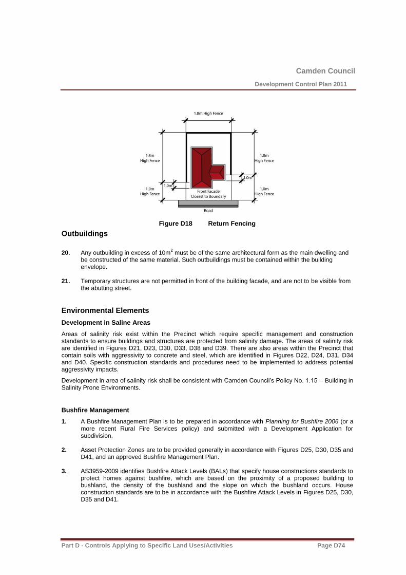
Camden Council
Development Control Plan 2011
Part D - Controls Applying to Specific Land Uses/Activities Page D74
Figure D18 Return Fencing
Outbuildings
20. Any outbuilding in excess of 10m
2 must be of the same architectural form as the main dwelling and
be constructed of the same material. Such outbuildings must be contained within the building envelope.
21. Temporary structures are not permitted in front of the building facade, and are not to be visible from
the abutting street.
Environmental Elements
Development in Saline Areas
Areas of salinity risk exist within the Precinct which require specific management and construction standards to ensure buildings and structures are protected from salinity damage. The areas of salinity risk are identified in Figures D21, D23, D30, D33, D38 and D39. There are also areas within the Precinct that contain soils with aggressivity to concrete and steel, which are identified in Figures D22, D24, D31, D34 and D40. Specific construction standards and procedures need to be implemented to address potential aggressivity impacts.
Development in area of salinity risk shall be consistent with Camden Council’s Policy No. 1.15 – Building in Salinity Prone Environments.
Bushfire Management
1. A Bushfire Management Plan is to be prepared in accordance with Planning for Bushfire 2006 (or a more recent Rural Fire Services policy) and submitted with a Development Application for subdivision.
2. Asset Protection Zones are to be provided generally in accordance with Figures D25, D30, D35 and
D41, and an approved Bushfire Management Plan. 3. AS3959-2009 identifies Bushfire Attack Levels (BALs) that specify house constructions standards to
protect homes against bushfire, which are based on the proximity of a proposed building to bushland, the density of the bushland and the slope on which the bushland occurs. House construction standards are to be in accordance with the Bushfire Attack Levels in Figures D25, D30, D35 and D41.

Camden Council
Development Control Plan 2011
Part D - Controls Applying to Specific Land Uses/Activities Page D75
B - Specific building controls and plans for Harrington Grove Precincts
Note: The controls listed below are specific to Precincts within Harrington Grove. They must be read in conjunction with the generic controls in section D2.3.4 of this DCP. In the event of any inconsistency, the Precinct specific controls included in this subsection will take precedence.
Precinct A
Dwelling Sizes
1. Dwellings are to have a minimum floor area of 350m2.
Lots with Single Storey Limitations
2. Certain development sites may potentially impact on the visual linkages from the Harrington Park Homestead to across the ridgeline (Refer Figure D19). These sites must ensure dwellings are limited to single storey.
Figure D19 Single Storey Lots in Precinct A
Dual Frontage Residential Lots Fronting Harrington Parkway
3. Dwellings that front both Harrington Parkway and an opposing street (front and rear) are to address both frontages.
4. No direct vehicular access to Harrington Parkway is permitted.
5. Garages are to be setback a minimum of 20 metres from the lot boundary fronting Harrington Parkway.
6. Boundary fencing along the street frontage where vehicular access is permitted is limited to a maximum height of 1.8 metres. A minimum length of 10 metres of this fencing is to be 70% permeable.
Local Community and Recreation Centre
The Local Community and Recreation Centre will provide a central focus for local residents to meet and interact outside their homes. It will include indoor and outdoor facilities which are located within a selected site that is bound by existing native vegetation to provide a scenic backdrop.
7. A Local Community and Recreation Centre is to be developed on the site identified Figure D20 and D21. The site is located abutting the Community Woodland and will provide a central focal point for Precinct A and the wider estate.
8. The Local Community and Recreation Centre is located on gently sloping ground overlooking the adjoining riparian corridor.

Camden Council
Development Control Plan 2011
Part D - Controls Applying to Specific Land Uses/Activities Page D76
9. The Local Community and Recreation Centre may contain facilities such as a community centre, function rooms, restaurant/café/bar, gymnasium, indoor recreation activities, child care centre, offices and sales office & display suite. Outdoor facilities may also be provided and include but not be limited to a swimming pool(s), tennis court(s), picnic areas, bowling/bocce greens, playgrounds and an amphitheatre/entertainment facility.
Figure D20 Conceptual Layout of Local Community and Recreation Centre Site
Note: Layout of Local Community and Recreation Centre is conceptual only and subject to design development.

Camden Council
Development Control Plan 2011
Part D - Controls Applying to Specific Land Uses/Activities Page D77
Figure D21 Location of Local Community and Recreation Centre
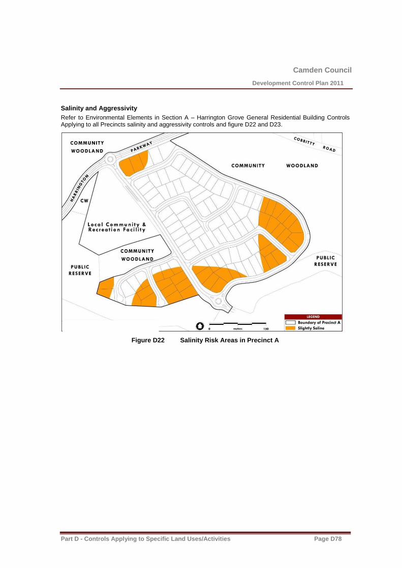
Camden Council
Development Control Plan 2011
Part D - Controls Applying to Specific Land Uses/Activities Page D78
Salinity and Aggressivity
Refer to Environmental Elements in Section A – Harrington Grove General Residential Building Controls Applying to all Precincts salinity and aggressivity controls and figure D22 and D23.
Figure D22 Salinity Risk Areas in Precinct A
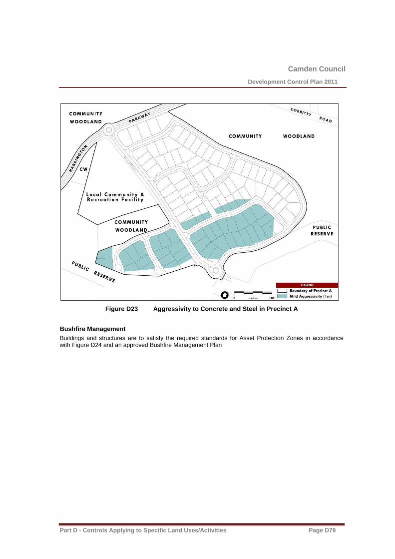
Camden Council
Development Control Plan 2011
Part D - Controls Applying to Specific Land Uses/Activities Page D79
Figure D23 Aggressivity to Concrete and Steel in Precinct A
Bushfire Management
Buildings and structures are to satisfy the required standards for Asset Protection Zones in accordance with Figure D24 and an approved Bushfire Management Plan
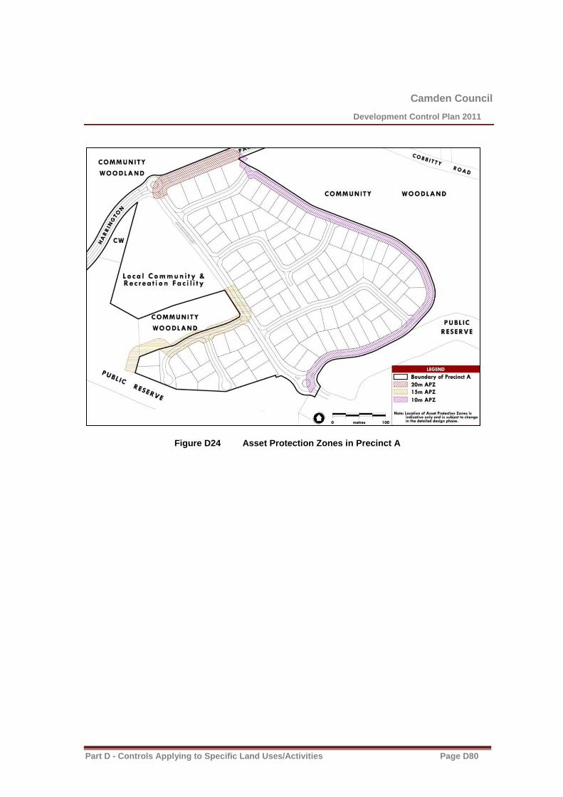
Camden Council
Development Control Plan 2011
Part D - Controls Applying to Specific Land Uses/Activities Page D80
Figure D24 Asset Protection Zones in Precinct A

Camden Council
Development Control Plan 2011
Part D - Controls Applying to Specific Land Uses/Activities Page D81
Precinct B
Dual Frontage Residential Lots Fronting Harrington Parkway
1. Dwellings that front both Harrington Parkway and an opposing street (front and rear) are to address both frontages.
2. No direct vehicular access to Harrington Parkway is permitted.
3. Garages are to be setback a minimum of 20 metres from the lot boundary fronting Harrington Parkway.
4. Boundary fencing along the street frontage where vehicular access is permitted is limited to a maximum height of 1.8 metres. A minimum length of 10 metres of this fencing is to be 70% permeable.
Salinity and Aggressivity
Refer to Environmental Elements in Section A – Harrington Grove General Residential Building Controls Applying to all Precincts salinity and aggressivity controls and figure D25 and D26.
Figure D25 Salinity Risk Areas in Precinct B

Camden Council
Development Control Plan 2011
Part D - Controls Applying to Specific Land Uses/Activities Page D82
Figure D26 Aggresivity to Concrete and Steel in Precinct B
Bushfire Management
Buildings and structures are to satisfy the required standards for Asset Protection Zones and Bushfire Attack Levels in accordance with Figure D27 and an approved Bushfire Management Plan.

Camden Council
Development Control Plan 2011
Part D - Controls Applying to Specific Land Uses/Activities Page D83
Figure D27 Asset Protection Zones and Bushfire Attack Levels in Precinct B
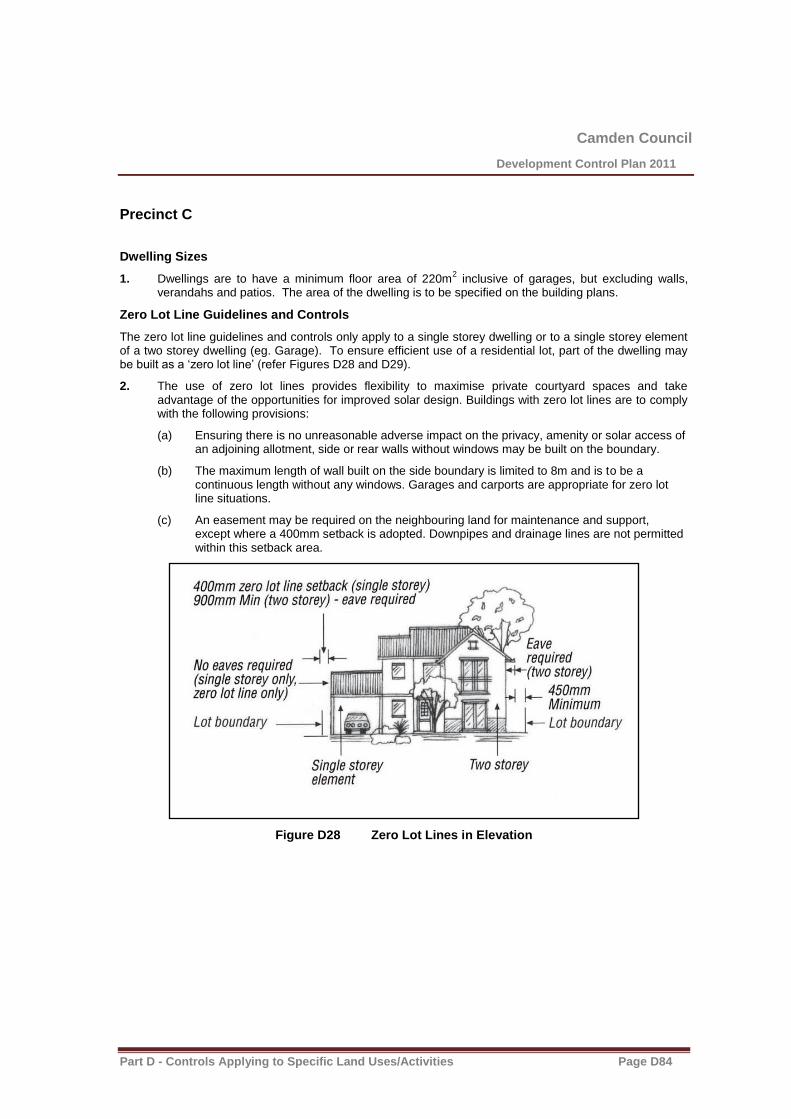
Camden Council
Development Control Plan 2011
Part D - Controls Applying to Specific Land Uses/Activities Page D84
Precinct C
Dwelling Sizes
1. Dwellings are to have a minimum floor area of 220m2 inclusive of garages, but excluding walls,
verandahs and patios. The area of the dwelling is to be specified on the building plans.
Zero Lot Line Guidelines and Controls
The zero lot line guidelines and controls only apply to a single storey dwelling or to a single storey element of a two storey dwelling (eg. Garage). To ensure efficient use of a residential lot, part of the dwelling may be built as a ‘zero lot line’ (refer Figures D28 and D29).
2. The use of zero lot lines provides flexibility to maximise private courtyard spaces and take advantage of the opportunities for improved solar design. Buildings with zero lot lines are to comply with the following provisions:
(a) Ensuring there is no unreasonable adverse impact on the privacy, amenity or solar access of an adjoining allotment, side or rear walls without windows may be built on the boundary.
(b) The maximum length of wall built on the side boundary is limited to 8m and is to be a continuous length without any windows. Garages and carports are appropriate for zero lot line situations.
(c) An easement may be required on the neighbouring land for maintenance and support, except where a 400mm setback is adopted. Downpipes and drainage lines are not permitted within this setback area.
Figure D28 Zero Lot Lines in Elevation
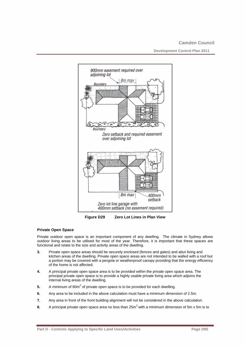
Camden Council
Development Control Plan 2011
Part D - Controls Applying to Specific Land Uses/Activities Page D85
Figure D29 Zero Lot Lines in Plan View
Private Open Space
Private outdoor open space is an important component of any dwelling. The climate in Sydney allows outdoor living areas to be utilised for most of the year. Therefore, it is important that these spaces are functional and relate to the size and activity areas of the dwelling.
3. Private open space areas should be securely enclosed (fences and gates) and abut living and kitchen areas of the dwelling. Private open space areas are not intended to be walled with a roof but a portion may be covered with a pergola or weatherproof canopy providing that the energy efficiency of the home is not affected.
4. A principal private open space area is to be provided within the private open space area. The principal private open space is to provide a highly usable private living area which adjoins the internal living areas of the dwelling.
5. A minimum of 80m2 of private open space is to be provided for each dwelling.
6. Any area to be included in the above calculation must have a minimum dimension of 2.5m.
7. Any area in front of the front building alignment will not be considered in the above calculation.
8. A principal private open space area no less than 25m2
with a minimum dimension of 5m x 5m is to
Camden Council
Development Control Plan 2011
Part D - Controls Applying to Specific Land Uses/Activities Page D86
be provided.
9. The principal private open space area is to be directly accessible from internal living area.

Camden Council
Development Control Plan 2011
Part D - Controls Applying to Specific Land Uses/Activities Page D87
Lots adjacent to the Harrington Park Homestead Heritage Curtilage
There are four lots near the boundary of the Harrington Park Homestead heritage curtilage which have specific design requirements for dwellings. These lots area identified in figure D30 below.
Figure D30 Lots subject to special design requirements
10. The following design and construction requirements apply to these lots:
(a) Materials used for external surfaces are to comply with the following:
(i) roofs are to use concrete tiles or non-reflective metal sheeting, in either case being of a uniform dark colour (such as black, dark grey or olive),
(ii) external walls of a building are to be finished in:
unpainted brickwork comprising brown or brownish red bricks, or
brickwork or masonry that is bagged or rendered in a soft muted colour (such as grey, grey-green, blue-grey, brown, salmon or fawn).
(iii) the front fencing on the site is of a post and rail or post and wire construction,
(b) The building has a verandah that has a minimum depth of 2 metres and that extends across at least 50% of the front of the building (excluding any garage),and
(c) Any trees planted in the front yard of the site are of a species approved by the Council.
Front Fencing Abutting a Road
11. The height of front fencing is limited to a maximum of 900mm and is to be at least 70% visually permeable.
12. Front fencing is to be constructed of rendered brick or blockwork columns with visually permeable infill panels of landscaping, decorative steel, wrought iron or timber pickets.
13. Front fencing is to be consistent in colour with the dwelling and neighbouring houses and fences.

Camden Council
Development Control Plan 2011
Part D - Controls Applying to Specific Land Uses/Activities Page D88
Figure D31 Lot Boundary Fencing
Side Fencing Abutting a Reserve or Park
14. The height of side fencing is limited to a maximum 1.8m.
15. Side boundary fencing abutting a park or reserve can be constructed the entire length from the rear boundary to the front lot boundary line.
16. Fencing on side boundaries facing a reserve or park is to be constructed of:
(a) faced/rendered brick or rendered blockwork columns with infill panels of landscaping (hedges), decorative steel, wrought iron, timber pickets, rendered/faced brickwork or rendered blockwork, or
(b) dressed timber.
Side and Rear Fencing Between House Lots
17. The height of side and rear fencing is limited to a maximum of:
(a) 900mm where the fence is in front of the front facade of the home, or
(b) 1800mm where the fence is 900mm behind the front facade of the house.
Note: Side and rear fencing is to be constructed of Colorbond pre-painted sheet steel in the colour of Riversand® or a similar product and colour.

Camden Council
Development Control Plan 2011
Part D - Controls Applying to Specific Land Uses/Activities Page D89

Camden Council
Development Control Plan 2011
Part D - Controls Applying to Specific Land Uses/Activities Page D90
Salinity and Aggressivity
Refer to Environmental Elements in Section A – Harrington Grove General Residential Building Controls Applying to all Precincts salinity and aggressivity controls and figure D32 and D33.
Figure D32 Salinity Risk Areas in Precinct C
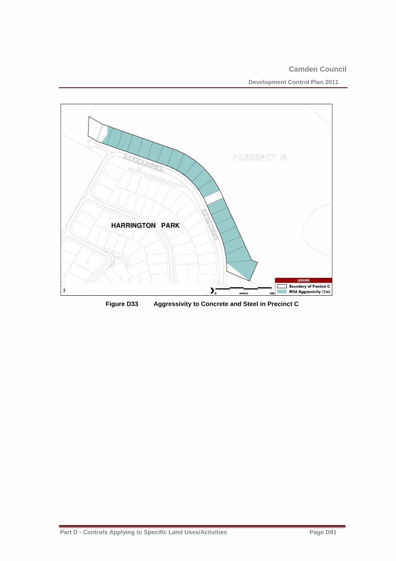
Camden Council
Development Control Plan 2011
Part D - Controls Applying to Specific Land Uses/Activities Page D91
Figure D33 Aggressivity to Concrete and Steel in Precinct C

Camden Council
Development Control Plan 2011
Part D - Controls Applying to Specific Land Uses/Activities Page D92
Precinct D
Salinity and Aggressivity
Refer to Environmental Elements in Section A – Harrington Grove General Residential Building Controls Applying to all Precincts salinity and aggressivity controls and figure D34 and D35.
Figure D34 Salinity Risk Areas in Precinct D
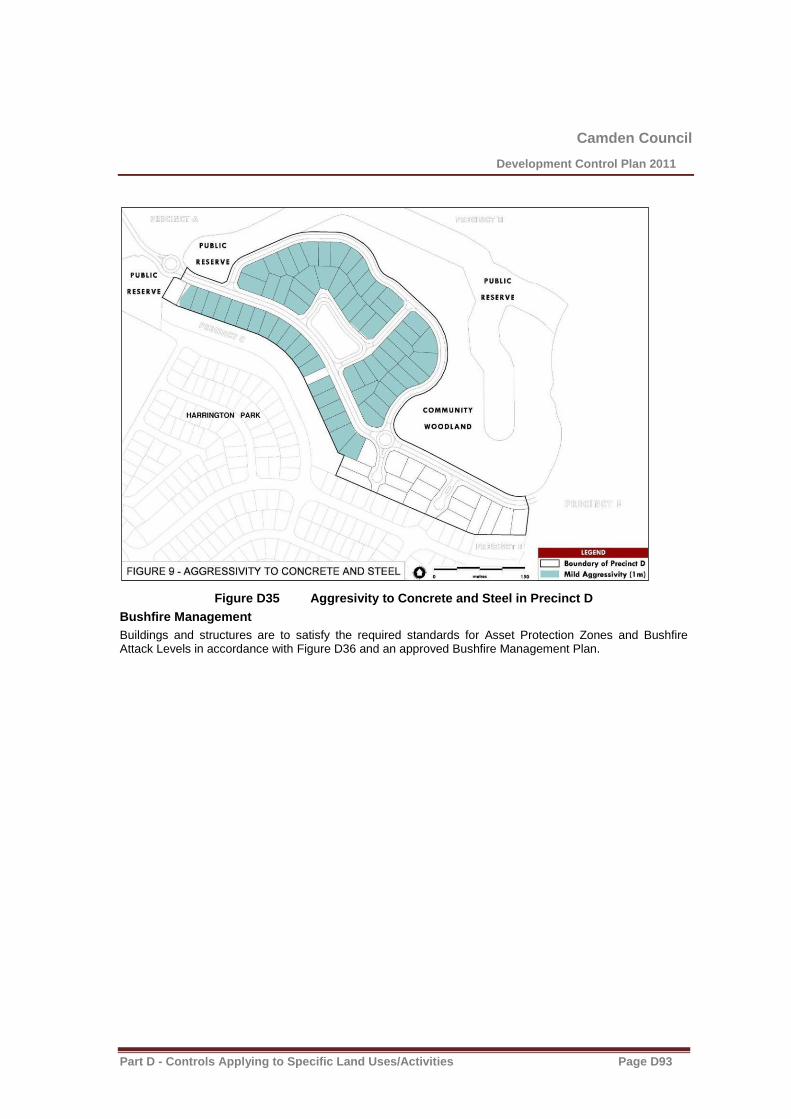
Camden Council
Development Control Plan 2011
Part D - Controls Applying to Specific Land Uses/Activities Page D93
Figure D35 Aggresivity to Concrete and Steel in Precinct D
Bushfire Management
Buildings and structures are to satisfy the required standards for Asset Protection Zones and Bushfire Attack Levels in accordance with Figure D36 and an approved Bushfire Management Plan.
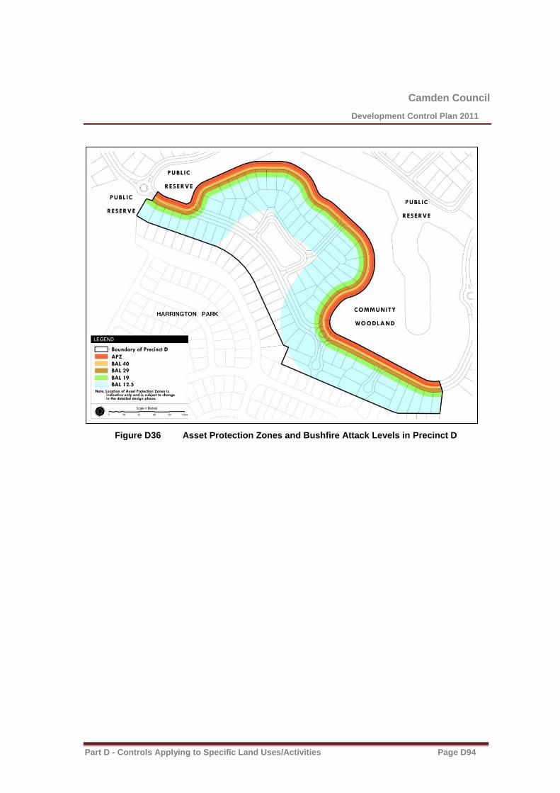
Camden Council
Development Control Plan 2011
Part D - Controls Applying to Specific Land Uses/Activities Page D94
Figure D36 Asset Protection Zones and Bushfire Attack Levels in Precinct D

Camden Council
Development Control Plan 2011
Part D - Controls Applying to Specific Land Uses/Activities Page D95
Precinct E Dwelling Sizes
1. Dwellings are to have a minimum floor area of 220m2 inclusive of garages, but excluding walls,
verandahs and patios. The area of the dwelling is to be specified on the building plans.
Setbacks to Open Space Areas
2. Setbacks to lot boundaries abutting open space are to be a minimum of 4.5m.
3. Verandahs and balconies can extend into the setback to open space by up to 1m provided these areas are not enclosed (excluding handrails and balustrades).
4. Eaves overhangs can extend into the setback to open space up to 1m.
Zero Lot Line Guidelines and Controls
The zero lot line guidelines and controls only apply to a single storey dwelling or to a single storey element of a two storey dwelling (eg. Garage). To ensure efficient use of a residential lot, part of the dwelling may be built as a ‘zero lot line’ (Refer Figures D37 and D38).
5. The use of zero lot lines provides flexibility to maximise private courtyard spaces and take advantage of the opportunities for improved solar design. Buildings with zero lot lines are to comply with the following provisions:
(a) Ensuring there is no unreasonable adverse impact on the privacy, amenity or solar access of an adjoining allotment, side or rear walls without windows may be built on the boundary.
(b) The maximum length of wall built on the side boundary is limited to 8m and is to be a continuous length without any windows. Garages and carports are appropriate for zero lot line situations.
(c) An easement may be required on the neighbouring land for maintenance and support, except where a 400mm setback is adopted. Downpipes and drainage lines are not permitted within this setback area.
Figure D37 Zero Lot Lines in Elevation
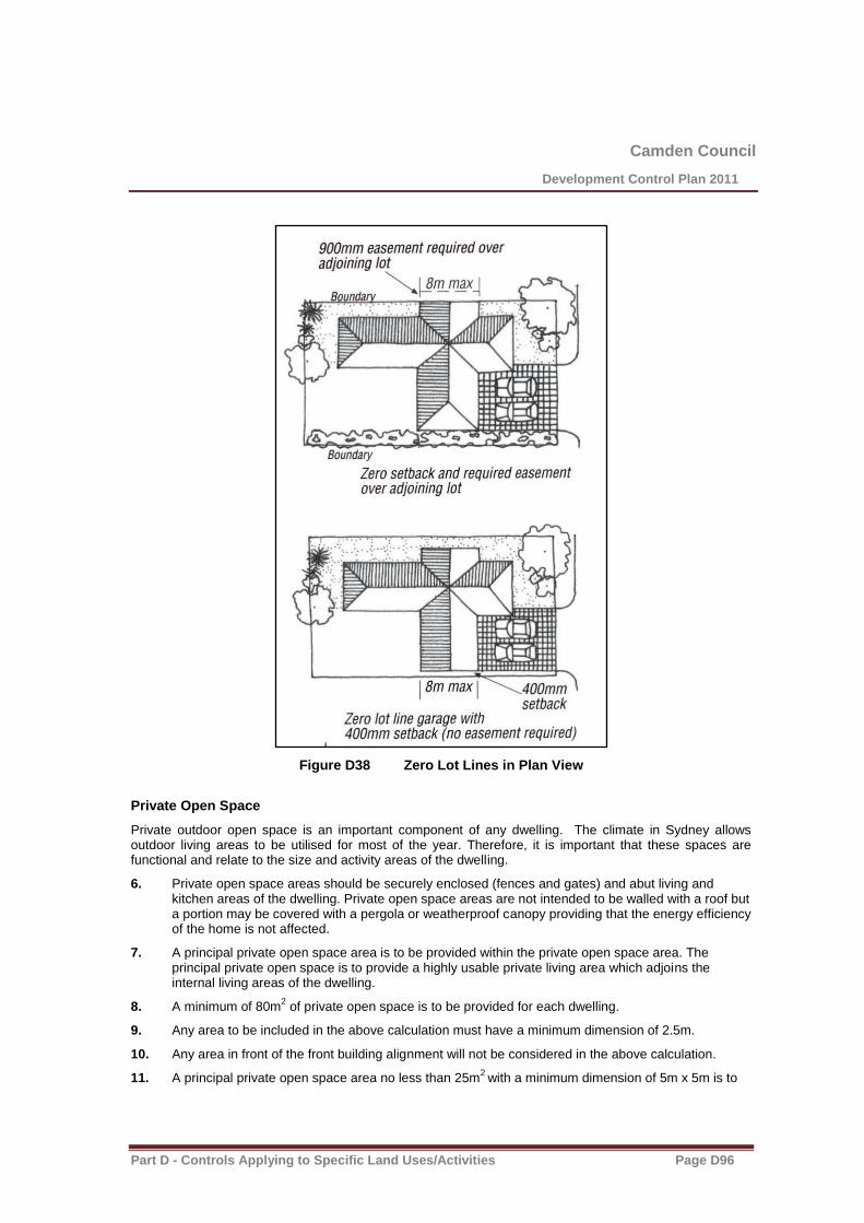
Camden Council
Development Control Plan 2011
Part D - Controls Applying to Specific Land Uses/Activities Page D96
Figure D38 Zero Lot Lines in Plan View
Private Open Space
Private outdoor open space is an important component of any dwelling. The climate in Sydney allows outdoor living areas to be utilised for most of the year. Therefore, it is important that these spaces are functional and relate to the size and activity areas of the dwelling.
6. Private open space areas should be securely enclosed (fences and gates) and abut living and kitchen areas of the dwelling. Private open space areas are not intended to be walled with a roof but a portion may be covered with a pergola or weatherproof canopy providing that the energy efficiency of the home is not affected.
7. A principal private open space area is to be provided within the private open space area. The principal private open space is to provide a highly usable private living area which adjoins the internal living areas of the dwelling.
8. A minimum of 80m2 of private open space is to be provided for each dwelling.
9. Any area to be included in the above calculation must have a minimum dimension of 2.5m.
10. Any area in front of the front building alignment will not be considered in the above calculation.
11. A principal private open space area no less than 25m2
with a minimum dimension of 5m x 5m is to

Camden Council
Development Control Plan 2011
Part D - Controls Applying to Specific Land Uses/Activities Page D97
be provided.
12. The principal private open space area is to be directly accessible from internal living area.
Front Fencing Abutting a Road
13. The height of front fencing is limited to a maximum of 900mm and is to be at least 70% visually permeable.
14. Front fencing is to be constructed of rendered brick or blockwork columns with visually permeable infill panels of landscaping, decorative steel, wrought iron or timber pickets.
15. Front fencing is to be consistent in colour with the dwelling and neighbouring houses and fences.
Figure D39 Lot Boundary Fencing
Side Fencing Abutting a Reserve or Park
16. The height of side fencing is limited to a maximum 1.8m.
17. Side boundary fencing abutting a park or reserve can be constructed the entire length from the rear boundary to the front lot boundary line.
18. Fencing on side boundaries facing a reserve or park is to be constructed of:
Camden Council
Development Control Plan 2011
Part D - Controls Applying to Specific Land Uses/Activities Page D98
(a) faced/rendered brick or rendered blockwork columns with infill panels of landscaping (hedges), decorative steel, wrought iron, timber pickets, rendered/faced brickwork or rendered blockwork, or
(b) dressed timber.
Side and Rear Fencing Between House Lots
19. The height of side and rear fencing is limited to a maximum of:
(a) 900mm where the fence is in front of the front facade of the home, or
(b) 1800mm where the fence is 900mm behind the front facade of the house.
Note: Side and rear fencing is to be constructed of Colorbond pre-painted sheet steel in the colour of Riversand® or a similar product and colour.

Camden Council
Development Control Plan 2011
Part D - Controls Applying to Specific Land Uses/Activities Page D99
Precinct H
Salinity and Aggressivity
Refer to Environmental Elements in Section A – Harrington Grove General Residential Building Controls Applying to all Precincts salinity and aggressivity controls and figure D40 and D41.
Figure D40 Salinity Risk Areas in Precinct H
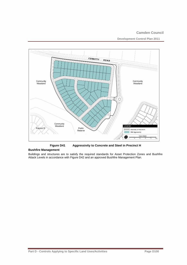
Camden Council
Development Control Plan 2011
Part D - Controls Applying to Specific Land Uses/Activities Page D100
Figure D41 Aggressivity to Concrete and Steel in Precinct H
Bushfire Management
Buildings and structures are to satisfy the required standards for Asset Protection Zones and Bushfire Attack Levels in accordance with Figure D42 and an approved Bushfire Management Plan.

Camden Council
Development Control Plan 2011
Part D - Controls Applying to Specific Land Uses/Activities Page D101
Figure D42 Asset Protection Zones and Bushfire Attack Levels in Precinct H

Camden Council
Development Control Plan 2011
Part D - Controls Applying to Specific Land Uses/Activities Page D102
Precinct K
Dwelling Sizes
1. Dwellings are to have a minimum floor area of 220m2 inclusive of garages, but excluding walls,
verandahs and patios. The area of the dwelling is to be specified on the building plans.
Private Open Space
Private outdoor open space is an important component of any dwelling. The climate in Sydney allows outdoor living areas to be utilised for most of the year. Therefore, it is important that these spaces are functional and relate to the size and activity areas of the dwelling.
2. Private open space areas should be securely enclosed (fences and gates) and abut living and kitchen areas of the dwelling. Private open space areas are not intended to be walled with a roof but a portion may be covered with a pergola or weatherproof canopy providing that the energy efficiency of the home is not affected.
3. A principal private open space area is to be provided within the private open space area. The principal private open space is to provide a highly usable private living area which adjoins the internal living areas of the dwelling.
4. A minimum of 80m2 of private open space is to be provided for each dwelling.
5. Any area to be included in the above calculation must have a minimum dimension of 2.5m.
6. Any area in front of the front building alignment will not be considered in the above calculation.
7. A principal private open space area no less than 25m2
with a minimum dimension of 5m x 5m is to be provided.
8. The principal private open space area is to be directly accessible from internal living area.
Lot Specific Setbacks
Refer to figure D43 below.
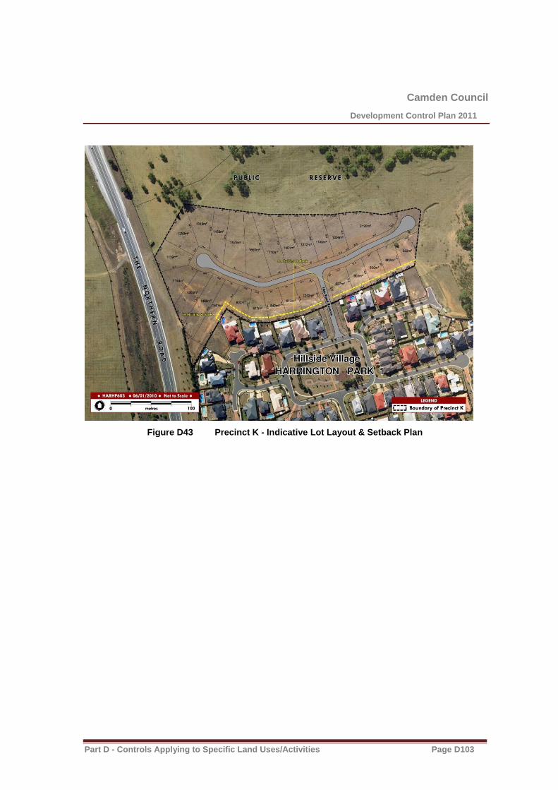
Camden Council
Development Control Plan 2011
Part D - Controls Applying to Specific Land Uses/Activities Page D103
Figure D43 Precinct K - Indicative Lot Layout & Setback Plan
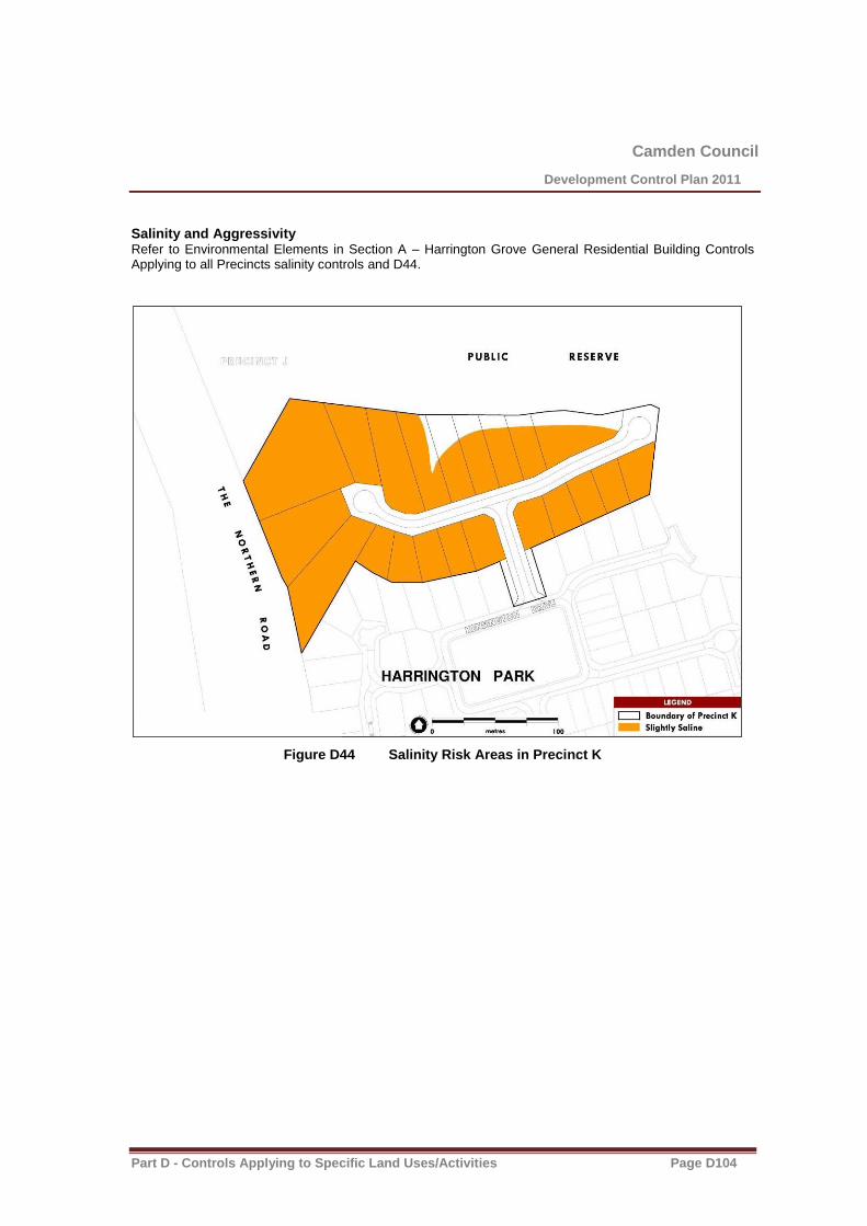
Camden Council
Development Control Plan 2011
Part D - Controls Applying to Specific Land Uses/Activities Page D104
Salinity and Aggressivity Refer to Environmental Elements in Section A – Harrington Grove General Residential Building Controls Applying to all Precincts salinity controls and D44.
Figure D44 Salinity Risk Areas in Precinct K
Camden Council
Development Control Plan 2011
Part D - Controls Applying to Specific Land Uses/Activities Page D105
Precinct M
The rear setback to “The Lanes” residential area is 10m as outlined in Figure D45.
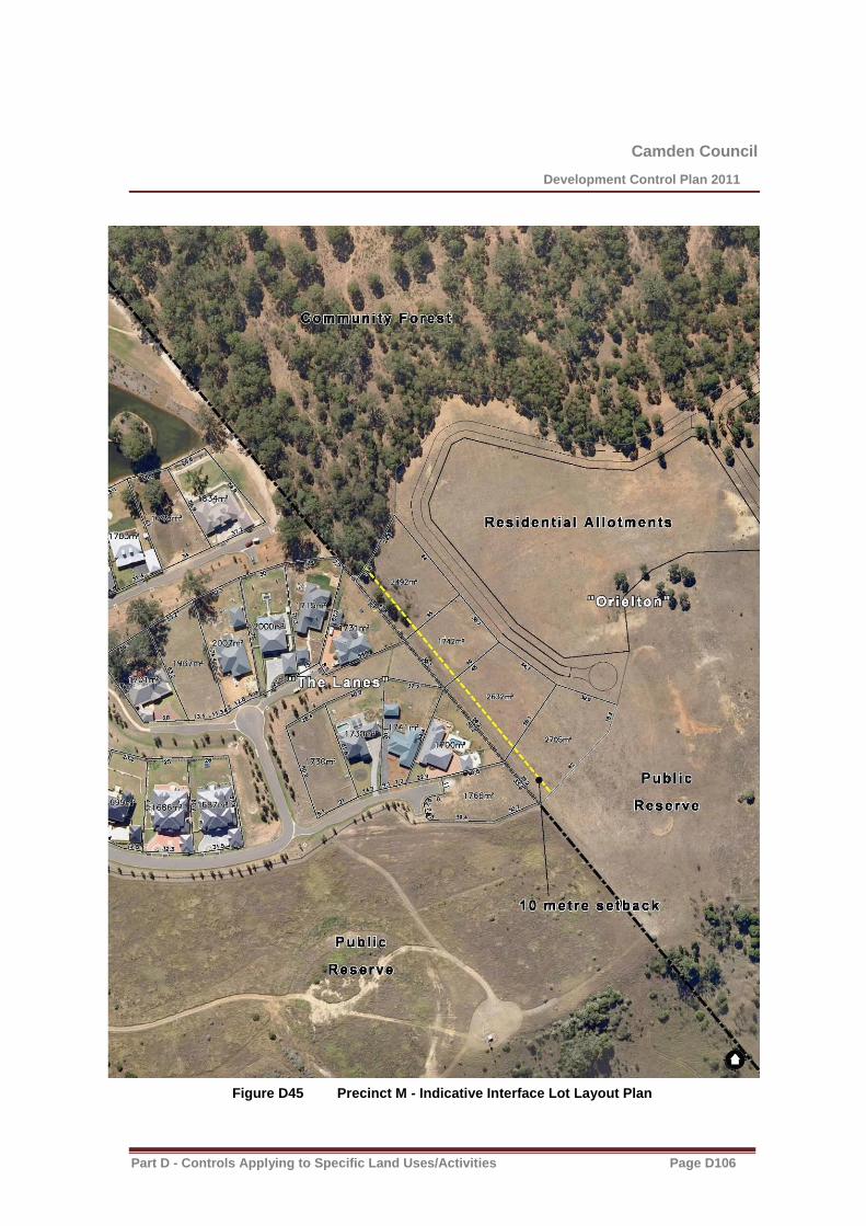
Camden Council
Development Control Plan 2011
Part D - Controls Applying to Specific Land Uses/Activities Page D106
Figure D45 Precinct M - Indicative Interface Lot Layout Plan
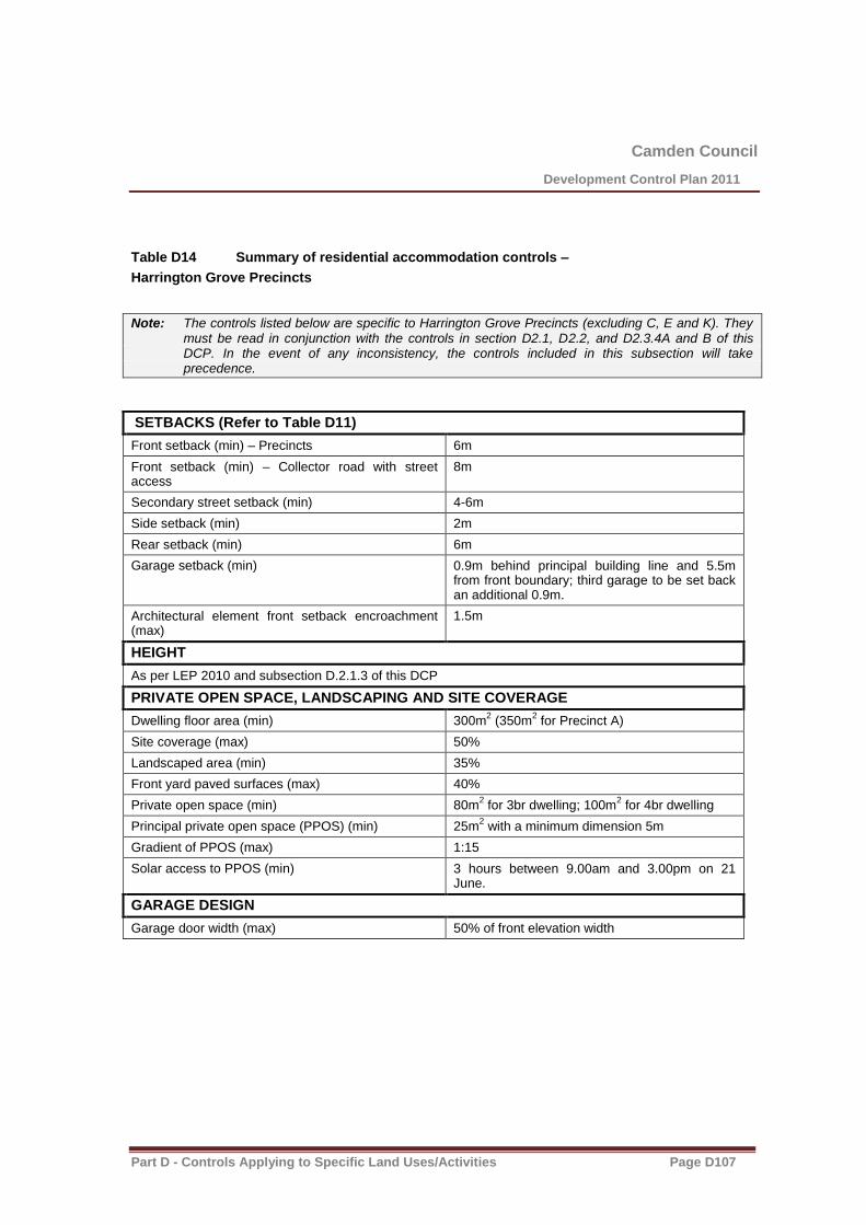
Camden Council
Development Control Plan 2011
Part D - Controls Applying to Specific Land Uses/Activities Page D107
Table D14 Summary of residential accommodation controls –
Harrington Grove Precincts
Note: The controls listed below are specific to Harrington Grove Precincts (excluding C, E and K). They must be read in conjunction with the controls in section D2.1, D2.2, and D2.3.4A and B of this DCP. In the event of any inconsistency, the controls included in this subsection will take precedence.
SETBACKS (Refer to Table D11)
Front setback (min) – Precincts 6m
Front setback (min) – Collector road with street access
8m
Secondary street setback (min) 4-6m
Side setback (min) 2m
Rear setback (min) 6m
Garage setback (min) 0.9m behind principal building line and 5.5m from front boundary; third garage to be set back an additional 0.9m.
Architectural element front setback encroachment (max)
1.5m
HEIGHT
As per LEP 2010 and subsection D.2.1.3 of this DCP
PRIVATE OPEN SPACE, LANDSCAPING AND SITE COVERAGE
Dwelling floor area (min)
300m2 (350m
2 for Precinct A)
Site coverage (max) 50%
Landscaped area (min) 35%
Front yard paved surfaces (max) 40%
Private open space (min) 80m2 for 3br dwelling; 100m
2 for 4br dwelling
Principal private open space (PPOS) (min) 25m2 with a minimum dimension 5m
Gradient of PPOS (max) 1:15
Solar access to PPOS (min) 3 hours between 9.00am and 3.00pm on 21 June.
GARAGE DESIGN
Garage door width (max) 50% of front elevation width
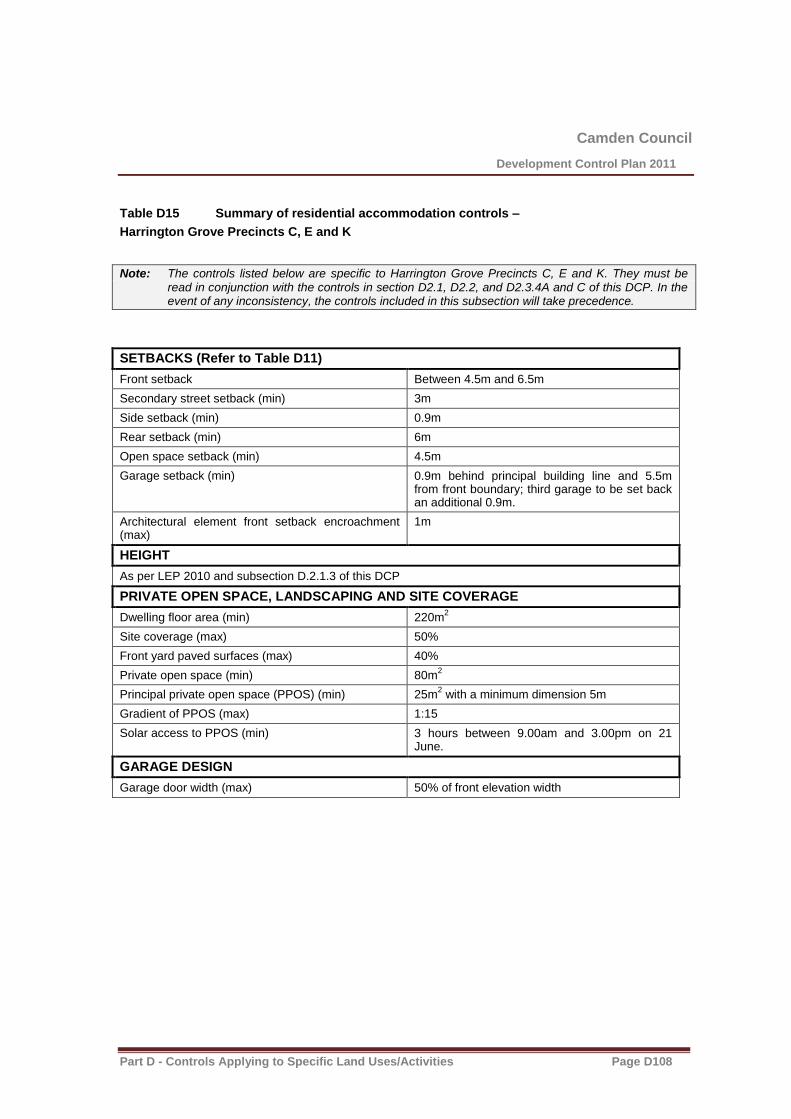
Camden Council
Development Control Plan 2011
Part D - Controls Applying to Specific Land Uses/Activities Page D108
Table D15 Summary of residential accommodation controls –
Harrington Grove Precincts C, E and K
Note: The controls listed below are specific to Harrington Grove Precincts C, E and K. They must be read in conjunction with the controls in section D2.1, D2.2, and D2.3.4A and C of this DCP. In the event of any inconsistency, the controls included in this subsection will take precedence.
SETBACKS (Refer to Table D11)
Front setback Between 4.5m and 6.5m
Secondary street setback (min) 3m
Side setback (min) 0.9m
Rear setback (min) 6m
Open space setback (min) 4.5m
Garage setback (min) 0.9m behind principal building line and 5.5m from front boundary; third garage to be set back an additional 0.9m.
Architectural element front setback encroachment (max)
1m
HEIGHT
As per LEP 2010 and subsection D.2.1.3 of this DCP
PRIVATE OPEN SPACE, LANDSCAPING AND SITE COVERAGE
Dwelling floor area (min)
220m2
Site coverage (max) 50%
Front yard paved surfaces (max) 40%
Private open space (min) 80m2
Principal private open space (PPOS) (min) 25m2 with a minimum dimension 5m
Gradient of PPOS (max) 1:15
Solar access to PPOS (min) 3 hours between 9.00am and 3.00pm on 21 June.
GARAGE DESIGN
Garage door width (max) 50% of front elevation width

Camden Council
Development Control Plan 2011
Part D - Controls Applying to Specific Land Uses/Activities Page D109
D2.3.5 Mater Dei
Note: The controls listed below are specific to Mater Dei (table D16). They must be read in conjunction with the controls in section D2.1 and D2.2 of this DCP. In the event of any inconsistency, the controls included in this subsection will take precedence.
Appearance
Homes should be designed to be of ‘contemporary, eco character’.
Use of architectural features such as awnings, porticos and verandah’s are required to ensure street presentation of the homes is in keeping with the vision for Mater Dei.
Roof Eves
600mm at a minimum on eastern and western facades.
Corner Lots
Should be designed to present to both street frontage and public areas.
Front facade feature should continue around to 40% of the secondary frontage.
Parkland Lots
Should be designed to appropriately address the parkland area.
Architectural features are to be replicated to secondary frontages with front a parkland.
Blank walls to the parkland are not permitted.
Roofing
Roof designs must be a minimum pitch of 200
Skillion roofs can have a minimum pitch of 50
Highly reflective roofing material are not permitted.
Colours and Materials
Colours should be low in contrast and sympathetic to the natural environment. Rendered masonry, stone, timber, steel and painted/rendered brickwork should be the predominant external materials.
Fencing
Open fencing is preferred wherever possible.
Front fencing is not allowed.
Brush mat fencing is prohibited.
Rear and side boundary fences once behind the building line can be a maximum height of 1.8m but on bush front lots must return with open post and rail or post and wire for the rear 6m of the lot.
Maximum Driveway Width
4.0m wide at the property verge but can be splayed within the property boundary to allow for adequate vehicle manoeuvrability.
Rainwater Tanks
Each dwelling must have a tank of at least 5,000ltr.
If the home contains a swimming pool, the water tank must be connected to the pool to assist in topping up

Camden Council
Development Control Plan 2011
Part D - Controls Applying to Specific Land Uses/Activities Page D110
the pool.
Water tanks in the APZ cannot be constructed of plastic
Kirkham Rise Guidelines
Kirkham Rise Design Guidelines volume 1, November 2010 and as amended, should be referenced for further detailed design requirements
Table D16 Summary of residential accommodation controls – Mater Dei
SETBACKS
Front setback (min) 4.5m; average of 5.5m
Secondary street setback (min) 4.5m
Side setback ground floor (min) 1.5m
Side setback second floor (min) 4.5m
Rear setback ground floor (min) 6m
Rear setback second floor (min) 10m
Garage setback (min) 1m behind principal building line and 5.5m from front boundary; third garage to be set back an additional 1m.
Architectural element front setback encroachment (max)
1m
Rear lane setback (min) 2.5m
Public reserve setback (min) 3m
HEIGHT
As per LEP 2010 and subsection D.2.1.3 of this DCP
PRIVATE OPEN SPACE, LANDSCAPING AND SITE COVERAGE
Site coverage (max) – lots >450m2 Single storey development - 50%
Double storey development – as per LEP 2010 and subsection D.2.1.5 of this DCP.
Front yard paved surfaces (max) 40%
Landscaped area (min) 40%
Principal private open space (PPOS) (min) 24m2 with a minimum dimension 4m
Gradient of PPOS (max) 1:10
Solar access to PPOS (min) 3 hours between 9.00am and 3.00pm on 21 June.
GARAGE DESIGN
Garage door width (max) – lots 7-15m wide 60% of front elevation width
Garage door width (max) – lots greater than 15m wide
50% of front elevation width

Camden Council
Development Control Plan 2011
Part D - Controls Applying to Specific Land Uses/Activities Page D111
D2.3.6 Camden Lakeside
Note: The controls listed below are specific to Camden Lakeside (table D17). They must be read in conjunction with the controls in section D2.1 and D2.2 of this DCP. In the event of any inconsistency, the controls included in this subsection will take precedence.
Table D17 Summary of residential accommodation controls – Camden Lakeside
SETBACKS
Front setback (min) 4.5m
Secondary street setback (min) – lots >450m2 3m
Secondary street setback (min) – lots <450m2 2m
Side setback (min) 0.9m
Rear setback (min) 6m, with 50% of the building width permitted to extend to within 3m of the rear boundary
Rear setback - (where land abuts Sydney Water Upper Canal)
6m with 10m being preferable
Garage setback (min) 1m behind principal building line and 5.5m from front boundary; third garage to be set back an additional 1m
Architectural element front setback encroachment (max)
1.5m
Rear lane setback (min) 2.5m
Public reserve setback (min) 3m
HEIGHT
As per LEP 2010 and subsection D.2.1.3 of this DCP
PRIVATE OPEN SPACE, LANDSCAPING AND SITE COVERAGE
Site coverage (max) – lots <450m2
Single storey development - 60%
Two storey development – 50% ground floor, 30% upper floor
Site coverage (max) – lots >450m2 Single storey development - 50%
Two storey development – 50% ground floor, 30% upper floor
Landscaped area (min) 30%
Private open space (min) 20%
Principal private open space (PPOS) (min) 24m2 with a minimum dimension 4m
Gradient of PPOS (max) 1:10
Solar access to PPOS (min) 2 hours between 9.00am and 3.00pm on 21 June.
GARAGE DESIGN
Garage door width (max) – lots 7-15m wide 60% of front elevation width
Garage door width (max) – lots greater than 15m 50% of front elevation width

Camden Council
Development Control Plan 2011
Part D - Controls Applying to Specific Land Uses/Activities Page D112
wide

Camden Council
Development Control Plan 2011
Part D - Controls Applying to Specific Land Uses/Activities Page D113
D2.3.7 Yamba
Note: The controls listed below are specific to Yamba. They must be read in conjunction with the controls in section D2.1 and D2.2 of this DCP. In the event of any inconsistency, the controls included in this subsection will take precedence.
Background
This subsection provides detailed site-specific controls for residential development at Yamba. The development must occur in accordance with the following controls and documents:
(a) Yamba Voluntary Planning Agreement
(b) Yamba Cottage Conservation Management Plan
(c) controls for the subdivision of the Yamba site contained in section C2.3 of this DCP
(d) heritage controls contained in chapter B3 of this DCP
Controls
New detached dwelling houses to the rear of Yamba cottage
1. New stand-alone dwellings shall have a footprint not exceeding 150m2 excluding garages.
2. Each dwelling shall have a maximum width of 15m and a minimum of 20-25m separation shall be provided between each new dwelling in accordance with the development concept plan shown at Figure C6.
3. The maximum height of new dwellings is 1 storey with attic rooms permissible where the pitch of the roof does not exceed 35 degrees.
4. Dwellings and additions shall be constructed using appropriate materials to achieve a light-weight appearance which are complementary to Yamba cottage. Such materials may include timber or cladding for external walls, corrugated metal roofing and guttering in non-reflective colours, and minimal use of masonry and brickwork (eg. foundation plinths only).
5. New dwellings shall address the internal access road, with private open space being provided behind the dwelling on the lower slopes.
6. Preference shall be given to locating car parking underneath the dwellings wherever the fall of the land permits this, with vehicular access achieved via a driveway beside each dwelling.
7. If the car parking cannot be located underneath the dwelling, car parking may be provided at-grade in the form of one enclosed garage not exceeding 20m
2 and a single carport attached to the garage.
At-grade car parking shall be designed so that it is not visually dominant when viewed from the front of the dwelling. Preference shall be given to locating at-grade car parking behind the rearmost point of the dwelling rather than integrating the garaging with the front façade of the dwelling.
8. Post and rail / post and wire fencing shall be used to delineate the side and rear boundary lines between allotments, with screening vegetation used to enhance privacy where necessary. Fences forward of the building line are not permitted in any form. Solid non-transparent boundary fencing is not permitted.
Additions to Yamba cottage and workers cottage
9. Additions to the rear of Yamba cottage shall not exceed 100m2 inclusive of any at-grade enclosed
car parking areas.

Camden Council
Development Control Plan 2011
Part D - Controls Applying to Specific Land Uses/Activities Page D114
10. Additions to the rear of Yamba cottage shall not exceed the width of the core of Yamba cottage (that is, excluding the width of the verandah structure).
11. Additions to the rear of the worker’s cottage shall not exceed 100m2.
12. It is preferred that car-parking be incorporated underneath the additions at the rear of the workers cottage given the fall of the land adjacent to the cottage.
13. The additions shall feature materials and finishes that are complementary to the existing built form of the cottages. A suitably qualified heritage consultant should assist in the formulation of a schedule of materials, finishes and colours for the additions to the cottages, and the schedule must be consistent with the recommendations of the Yamba CMP.
Multi dwelling housing at Yamba
14. Development fronting Camden Valley Way shall be limited to single storey with attic rooms permitted within the roof void provided that the roof pitch does not exceed 40 degrees.
15. The outdoor private open space areas of new dwellings shall achieve an acceptable level of amenity in compliance with the Department of Environment and Climate Change’s Environmental Criteria for Road Traffic Noise and Council’s Environmental Noise Policy.
16. The use of solid boundary fencing fronting Camden Valley Way shall be minimised and avoided wherever possible.
17. Where the location of private open space areas necessitates the use of solid boundary fencing to provide acceptable amenity to these areas, the fencing shall incorporate design measures such as modulation and articulation of the wall façade, landscaping screening and features, and variation in building materials, colours and finishes in order to achieve an acceptable urban design outcome. Landscaping may be incorporated by measures including, but no limited to, alcoves in an articulated wall façade or a uniform setback at the front of the wall.
18. Where boundary fencing does not provide adequate noise attenuation, appropriate and attractive acoustic treatments shall be incorporated into the design of the dwellings.
19. Development should utilise neutral/earthen tones and non-reflective finishes. The use of light or bright colours or reflective materials may result in an adverse impact upon distant views from Studley Park House which is an item of heritage significance located nearby.
20. A buffer of at least 5m shall be provided between the sewage pumping station and habitable buildings on the site to provide visual and acoustic separation between the pumping station and future dwellings. Preference should be given to siting non-habitable buildings or other land uses adjacent to the sewage pumping station wherever possible.
21. Sydney Water must be consulted early in the design stage to ascertain the exact location of existing and proposed easements at the north-eastern corner of the site to ensure that no construction is proposed in or over these easements.

Camden Council
Development Control Plan 2011
Part D - Controls Applying to Specific Land Uses/Activities Page D115
D2.3.8 Former Bus Depot Site (Ironbark Avenue, Camden South)
Background
The former bus depot site is located on land bounded by Pindarri Avenue, Belar Road, Dobroyd Avenue
and Ironbark Avenue, as shown with a red line in Figure 1 below.
Figure 1 – Location of Ironbark Avenue precinct
A concept masterplan has been prepared for the former bus depot site and was driven by the need to
provide details of the general built form that should be achieved on this site in Ironbark Avenue. It is
indicative only, and may be subject to change, provided the objectives and controls are met. The concept
masterplan for the site is presented in Figure 2; whilst concept elevations are provided in Figure 3.

Camden Council
Development Control Plan 2011
Part D - Controls Applying to Specific Land Uses/Activities Page D116
Figure 2: Ironbark Avenue Precinct Masterplan
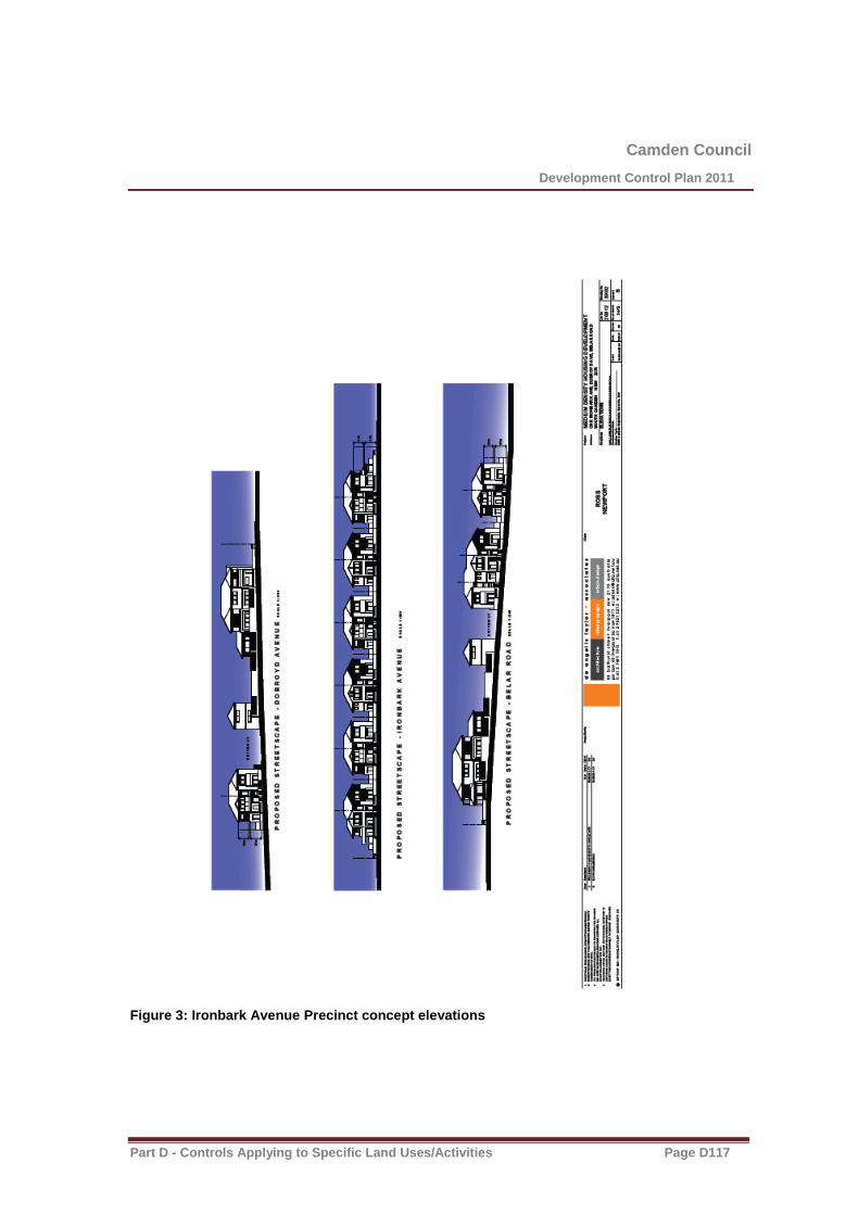
Camden Council
Development Control Plan 2011
Part D - Controls Applying to Specific Land Uses/Activities Page D117
Figure 3: Ironbark Avenue Precinct concept elevations

Camden Council
Development Control Plan 2011
Part D - Controls Applying to Specific Land Uses/Activities Page D118
Salinity
Controls:
1. Reference is to be made to requirements for salinity addressed in Section B1.3 of this DCP.
2. The Salinity Management Plan shall be submitted with the Development Application and is to be
in accordance with the Salinity Management Plan for 11 Ironbark Avenue’ prepared by
Environmental Earth Sciences NSW September 2010.
Tree Planting
Objectives:
1. To create a soft, informal separation and ascetically pleasing green interface between the
residential and light industrial areas.
2. To provide a higher level of public amenity by creating a safe, functional and professionally
landscaped road verge open space area.
Controls:
1. Any Landscape Plan prepared for the site is to be generally in accordance with the concept
landscape plan shown in Figure 4.
Contamination
Background
A Stage 1 Environmental Site Assessment of the former bus depot site was undertaken at the rezoning
stage to identify the potential for contamination as a result of past landuses. The Assessment identified
areas that are potentially contaminated. None of the identified constraints were considered to present a
high risk to preclude the rezoning.
Phase 2 investigations were undertaken in respect of the Areas of Environmental Concern (AECs) and
recommended that a Remediation Action Plan shall be prepared and implemented as part of the
development application process for development of the former bus depot site for residential purposes. A
precautionary approach is adopted considering the development involves contaminated or potentially
contaminated land. Such reports are available from Council Administration Offices.
A Remediation Action Plan (RAP) was prepared by Environmental Earth Sciences, dated November 2010
(version 3), to confirm that identified contamination is capable of being remediated to make the site suitable
for its intended (residential) use.
Camden Council
Development Control Plan 2011
Part D - Controls Applying to Specific Land Uses/Activities Page D119
Objectives
(a) To minimise the risks to human health and the environment from the development of potentially
contaminated land; and
(b) To ensure that potential site contamination issues are addressed at the development stage.
Controls
1. The Remediation Action Plan (RAP), as endorsed by an EPA accredited site auditor, provides an
acceptable strategy to address the remediation of identified contaminants at the site. Compliance
with the RAP will be required where future residential development is proposed.
2. Compliance with Camden Council’s ‘Management of Contaminated Lands Policy’ will be required
for any development proposal.
Public Domain
Background
The proposed redevelopment of the former bus depot site has incorporated a streetscape that has open
parkland like atmosphere to enrich the local area. The landscape retains existing large significant Iron Bark
trees, which are cultural significant to the name Ironbark Avenue. Increased public amenity has been
provided with additional planting of evergreen and deciduous street trees and low maintenance ground
cover grasses. The deciduous trees provide seasonality and fit in with the landscape style of Camden.
The proposed development has been designed to be sympathetic in its integration with the existing
residences and the proposed streetscape to be continued in the surrounding area, including the opposite
side of the street (refer to Figures 4 & 5).
Objectives
1. To provide a safe, clear and quality accessibility network .
2. To provide a pleasant, informal and green interface between the residential and light industrial
sections.
3. To retain and enhance the existing significant landscape elements and trees with additional
plantings to provide an improved landscape amenity for the community..
Controls
1. No vehicle access onto Ironbark Avenue .
2. Any Landscape Plan prepared for the site is to be generally in accordance with the concept
landscape plan shown in Figure 4
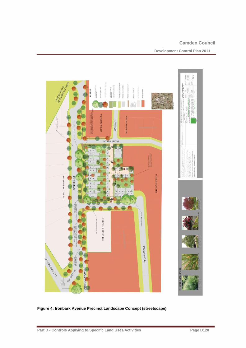
Camden Council
Development Control Plan 2011
Part D - Controls Applying to Specific Land Uses/Activities Page D120
Figure 4: Ironbark Avenue Precinct Landscape Concept (streetscape)
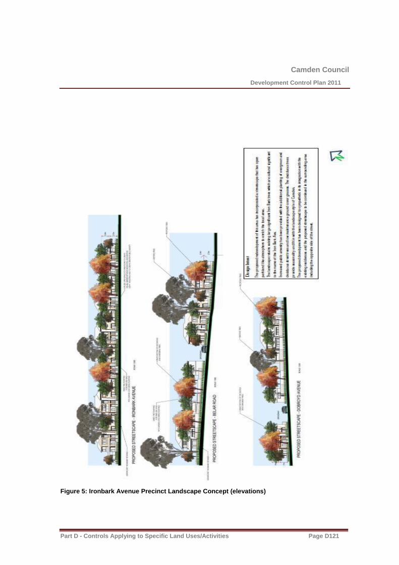
Camden Council
Development Control Plan 2011
Part D - Controls Applying to Specific Land Uses/Activities Page D121
Figure 5: Ironbark Avenue Precinct Landscape Concept (elevations)

Camden Council
Development Control Plan 2011
Part D - Controls Applying to Specific Land Uses/Activities Page D122
Landscaping
Controls
1. Any residential redevelopment for the former bus depot site is to include the adjacent road
verge/nature strip open space areas and those road verge/nature open area are to be landscaped
in accordance with the concept landscape plan shown in Figure 4.
2. Any proposed landscaping, for all sites, is to be designed to enhance and be sympathetic to all
existing significant trees and landscaping elements and to include the concepts detailed in the
Landscape Plan shown in Figure 4.

Camden Council
Development Control Plan 2011
Part D - Controls Applying to Specific Land Uses/Activities Page D123
D2.3.9 ECB/Gledswood Controls
Residential Controls
These controls supplement the controls in chapter C 12 El Caballo Blanco and Gledswood and only address matters that are not specifically dealt with in existing controls in this DCP.
Matters such as car parking (other than for secondary dwellings), cut and fill, road geometry and construction, services, stormwater management, crime prevention through environmental design, noise
attenuation and waste collection are all addressed within Parts D and E of the DCP.
Housing Types – Minimum Lot Sizes and Widths
Attached Dwellings
Attached dwellings will form groups of dwellings that front or are opposite either golf course lands, RE2 zoned lands, riparian corridor lands or public open space areas to create “mews housing”. All attached housing must have a rear lane or rear second street access. Attached dwellings are permitted within
Precincts 1, 2, 3 and 4 and are able to be subdivided into Torrens title lots.
Controls
1. Minimum Lot size: 250m2
2. Minimum Lot width: 7.5m (measured at the building line)
Front Setbacks – 3rd
Level
Objectives
1. To provide a variety of streetscapes that reflect the character of different precincts, the diversity of edge conditions, house types and road hierarchies.
2. To create an attractive and cohesive streetscape.
3. To encourage the use of simple and articulated building forms.
Controls
Attached Dwellings
1. 7.5m for any third level from the front street boundary as illustrated in Figure D46.

Camden Council
Development Control Plan 2011
Part D - Controls Applying to Specific Land Uses/Activities Page D124
Figure D46 Third Level Setback Principles for Residential Development
Golf Course Setbacks – Residential Development
Objectives
1. Specific setback requirements are necessary for the development of any lot that shares a boundary with lands used for golf course purposes. This is necessary to ensure that suitable landscape integration occurs between golf course and residential development.
Controls
1. Any lot that shares any boundary with the golf course must provide a setback, to any building, of 5.0m from that shared boundary.
2. Ancillary recreation facilities such as decks can be provided within the required setback so long as the finished height is no greater than 500mm above ground level (finished).
Dwelling Height, Massing and Siting
Objectives
1. To ensure development is appropriately scaled to suit the dwelling’s context and its scale.
2. To ensure building heights achieve built form outcomes that reinforce quality urban and building design.
3. To protect residential amenity.
Camden Council
Development Control Plan 2011
Part D - Controls Applying to Specific Land Uses/Activities Page D125
Controls
1. All housing forms will be generally 1 and 2 storeys in height.
2. Third storeys are permitted where the third level is setback 7.5m from a street boundary and occupies an area no greater than 40% of the area of the ground floor footprint. The design must also demonstrate that the required levels of solar access are maintained to the subject and adjoining dwellings. Any balconies at the third level must be recessed to avoid impacts upon privacy and
overlooking to adjoining properties.
Fences
Objectives
1. To ensure boundary fencing and walls are of a high quality and do not detract from the streetscape or golf course.
2. To provide privacy and security for the development.
3. To define boundaries between public and private areas.
Controls
1. No fencing shall be provided to any street frontages, forward of the applicable building setbacks.
2. Side and rear fencing is to be a maximum of 1.8m high and is not to project beyond the applicable building line.
3. Side fencing may be timber lap and cap fencing or masonry walls. Metal fencing is discouraged.
4. On corner lots the preferred outcome is for the dwelling to front both street frontages providing a better overall streetscape presentation. Where fencing to the secondary frontage is proposed it must comply with the secondary street setback requirements, and not exceed 1.8m in height.
5. Fencing to golf course lands is to be a maximum height of 1.2m and be of open style.
6. Side fencing on lots fronting golf course land is to terminate 3m from the golf course boundary. The remaining 3m is to be fencing to a maximum height of 1.2m to match the fencing to the golf course.
7. Fencing that adjoins mews or rear accessways is to be open style fencing that permits casual surveillance. Metal or timber paling or lapped/capped fencing can only be used internally between dwelling lots.
Where cut is proposed on the boundary of a lot, retaining walls are to be constructed with side fence posts integrated with its construction (relevant construction details are required with retaining wall approval). Otherwise retaining walls must be located a minimum of 450mm from the side or rear boundary of the lot containing the cut.

Camden Council
Development Control Plan 2011
Part D - Controls Applying to Specific Land Uses/Activities Page D126
D2.3.10 Emerald Hills
Note: The controls listed below (table D17A) are specific to the Emerald Hills area. They must be read in conjunction with the controls in section D2.1 and D2.2 of this DCP. In the event of any inconsistency, the controls included in this subsection will take precedence.
Table D17A Summary of residential accommodation controls – Emerald Hills
SETBACKS
Front setback (min) 4.5m
Secondary street setback (min) 1m
Side setback (min) 0.9m or 0m where nominated zero lot line on lot development plan
Rear setback ground floor (min) 4m
Rear setback first floor (min) 6m
Garage setback (min) 1m behind principal building line and 5.5m from front boundary; third garage to be set back an additional 1m.
Architectural element front setback encroachment (max)
1.5m
Rear lane setback (min) 2.5m
Public reserve setback (min) 3m
Ridgeline reserve setback for large lots (min) 10m
HEIGHT
As per LEP 2010 and subsection D.2.1.3 of this DCP
PRIVATE OPEN SPACE, LANDSCAPING AND SITE COVERAGE
Site coverage (max) – lots <450m2
Single storey development - 60%
Two storey development – 50% ground floor, 30% upper floor
Site coverage (max) – lots >450m2 Single storey development - 50%
Two storey development – 50% ground floor, 30% upper floor
Landscaped area (min) 30%
Private open space (min) 20%
Principal private open space (PPOS) (min) 24m2 with a minimum dimension 4m
Gradient of PPOS (max) 1:10
Solar access to PPOS (min) 3 hours between 9.00am and 3.00pm on 21 June.
GARAGE DESIGN
Garage door width (max) – lots 7-15m wide 60% of front elevation width
Garage door width (max) – lots greater than 15m wide
50% of front elevation width

Camden Council
Development Control Plan 2011
Part D - Controls Applying to Specific Land Uses/Activities Page D127
D2.3.11 Crase Place, Grasmere
Objective
1) To ensure residential and associated development is designed and located to blend in with the rural residential backdrop, when viewed from the important view corridors including the vehicle entrance to Carrington hospital on the corner of Werombi and Smalls Road.
2) Maintain consistency with existing adjoining development.
Controls
1) Native screen landscaping, incorporating trees and shrubs, must be planted along the area marked green in Figure D46A to screen development.
2) Building materials and colours (of dwellings, outbuildings and hard landscaping) are to be restricted to recessive, mid-dark earth tones to blend in with the rural setting. White, cream, red, terracotta, or contrasting and reflective colours are not acceptable. Uncoloured or light concrete driveways are not acceptable.
All structures shall have a front boundary setback of 12m
Figure D46A– Crase Place, Grasmere
Note: The controls listed below are specific to Crase Place, Grasmere. They must be read in conjunction with the controls in section C3.2.1, D2.1 and D2.2 of this DCP. In the event of any inconsistency, the controls included in this subsection will take precedence.

Camden Council
Development Control Plan 2011
Part D - Controls Applying to Specific Land Uses/Activities Page D128
D2.3.12 121 Raby Road, Leppington
Objectives
1. To protect the landscape and visual character of the Scenic Hills.
2. To ensure new buildings, utility and ancillary structures do not pose an adverse impact on sensitive landscape areas such as the Scenic Hills, the settings of heritage items or heritage conservation areas or other places of heritage significance.
Controls
1. Materials and colours for buildings, utility and ancillary structures must adopt darker, recessive toned colours such as browns, dark greens, dark greys and charcoal. Both wall and roof cladding must be constructed of non-reflective materials.
Further information
Betteridge Consulting Pty Ltd, t / a MUSEcape , November 2015, 121 Raby Road, Leppington Visual Impact Assessment Peer Review (of Distinctive Living Design Landscape and Visual Analysis);
Betteridge Consulting Pty Ltd, t / a MUSEcape , July 2015, Leppington Visual Impact Assessment Peer Review (of James Mather Delaney Design Landscape and Visual Analysis);
JMD Design, February 2013, Landscape and Visual Analysis, 121 Raby Road Leppington;
Distinctive Living Design, October 2015, Landscape and Visual Analysis, 121 Raby Road Leppington;
PKA Acoustic Consulting, January 2016, Planning Proposal Acoustic Assessment, 121 Raby Road Leppington;
Dominic Steele Consulting Archaeology, September 2015, Aboriginal Archaeological & Cultural Heritage Assessment, 121 Raby Road, Leppington;
Douglas Partners, October 2015, Salinity Investigation and Management Plan, Land Capability Assessment, Lot 121 Raby Road Leppington;
Lesryk Environmental Consultants, May 2014, Flora and Fauna Assessment;
Douglas Partners, July 2014, Preliminary Site Investigation;
Stefani Group, May 2015, Stormwater Management and Flood Assessment Report, 121 Raby Road Leppington;
Australian Bushfire Protection Planners Pty Ltd, September 2015, Bushfire Constraints Assessment, 121 Raby Road Leppington;
Traffix Traffic & Transport Partners, January 2016, 121 Raby Road Leppington;
GLN Planning, May 2015, Open Space and Community Facilities Assessment, 121 Raby Road Leppington.

Camden Council
Development Control Plan 2011
Part D - Controls Applying to Specific Land Uses/Activities Page D129
D3 Commercial and Retail Development
D3.1 Business Zone and Retail Hierarchy
Business Zone Hierarchy
Camden LEP 2010 contains four business zones. These are described below:
Zone B1 Neighbourhood Centre
This zone generally covers small neighbourhood centres including small scale convenience retail premises, business premises or community uses that serve the needs of the surrounding area.
Centres zoned B1 in the Camden LGA are: Bringelly; Catherine Field; Cobbitty; Currans Hill; Harrington Park; Leppington; Mount Annan South; Narellan Vale; South Camden (Flinders Avenue). In addition there are proposed neighbourhood centres in the new urban release areas of Elderslie and Spring Farm.
Zone B2 Local Centre
This zone generally covers centres that provide a range of retail, business, entertainment and community functions that typically service a wider catchment than a neighbourhood centre.
Centres zoned B2 in the Camden LGA are: Camden; Narellan and Mount Annan.
Zone B4 Mixed Use
This zone generally covers land where a wide range of land uses are encouraged, including retail, employment, residential, community and other uses.
Centres zoned B4 in the Camden LGA is that area surrounding the central core of the town of Camden.
Zone B5 Business Development
This zone is generally intended for land where employment generating uses such as offices, warehouses and bulky goods are to be encouraged.
Centres zoned B5 in the Camden LGA are: The Narellan Business Park; land bounded by Narellan Road, The Northern Road and Camden Valley Way; and a portion of land at the rear of Elyard Street Narellan.
Note: The South West Growth Centre has identified a major centre at Leppington and a town centre is currently being developed at Oran Park. These centres will be incorporated into this DCP at a future date.
Retail Hierarchy
The Retail Hierarchy within the Camden LGA is as follows (table D18):
Table D18 Camden LGA Retail Hierarchy
Major Centre Leppington
Town Centres Camden, Narellan, Oran Park
Villages Mount Annan

Camden Council
Development Control Plan 2011
Part D - Controls Applying to Specific Land Uses/Activities Page D130
Small Villages Harrington Park, Spring Farm, Gregory Hills
Neighbourhood Centres Bringelly; Catherine Field; Cobbitty; Currans Hill; Elderslie; Mount Annan
South; Narellan Vale; South Camden (Flinders Avenue).
D3.2 General Controls Applying to all Business Zone Areas
Objectives
1. Ensure an appropriate supply, distribution, and mix of retail, commercial and employment floor space
across the Camden LGA.
2. Ensure that the retail floor space within the Camden LGA does not undermine the potential of
existing and proposed centres within the region.
3. Encourage the early investment and delivery of employment generating development and retail uses
to serve the population.
4. Achieve high quality urban design outcomes which deliver economic, social and environmental
benefits to existing and new residents.
5. Promote business development which is designed to facilitate an active public domain.
6. Ensure business zones in the Camden LGA is supported by adequate and appropriate public
infrastructure and amenities.
Controls
D3.2.1 Function and Uses
1. Development within business zones shall incorporate a range of local retail, commercial, entertainment, childcare, residential and community uses to serve the needs of the local community.
D3.2.2 Layout/Design
1. The layout and location of business zone uses must consider potential future noise and amenity conflicts for both the subject development and adjoining/nearby development.
2. Where development fronts the street or any other public place (including car parking areas and pedestrian thoroughfares) the development must be designed so that it addresses the street or public place.
3. New development must not detract from significant existing views and vistas.
D3.2.3 Built Form and Appearance
1. Buildings should have a similar mass and scale to create a sense of consistency. Within business zones, generally there will be gradation of massing from a dense inner core to a less dense outer edge to provide an appropriate interface with land uses in the adjoining zones and symmetry to the building.
2. Business development must feature high quality architectural design and a built form that promotes a ‘sense of place’ and contemporary character for all business zones
3. Development in business zones must be compatible with surrounding business development in terms of appearance, type, bulk and scale, design and character.
Camden Council
Development Control Plan 2011
Part D - Controls Applying to Specific Land Uses/Activities Page D131
4. Building wall planes must contain variations and architectural design features in their front facades in order to provide visual interest.
5. Where multiple tenancies are located within the one building, each tenancy must be defined by appropriate architectural design features (eg. the integration of vertical elements into the façade).
6. Consideration is to be given to the interface where the building and awning abuts an adjoining development to ensure compatibility.
7. Roof forms should be appropriately designed to respond to the built form of other nearby business development. The design of roofs may adopt traditional forms found in the immediate locality, or alternatively they may adopt a more contemporary appearance to a juxtaposition to traditional roof forms. However, it must be clearly demonstrated that the proposed roof form relates appropriately to the existing adjoining development.
8. New development must not cause significant overshadowing or overlooking of public places, relative to the patterns of usage of those places.
9. Where a building addresses a corner:
(a) the entrance should be on or near the corner ;
(b) the building should have positive frontage to both streets (i.e. windows and doors that overlook the streets and provide passive surveillance); and
(c) the corner should be emphasised through a built form element such as a landmark feature.
10. Buildings on corner lots may have feature elements that exceed the building height limit prescribed in LEP 2010 subject to compliance with Clause 5.6 of the LEP.
11. Where a building addresses a public space, buildings must always address and embellish that public space. Public spaces may include a street, any form of urban open space (e.g. courtyard, plaza, etc), or any form of landscaped open space. This must also help contribute towards place-making.
12. Service infrastructure such as air conditioning and other plant must be screened from public view and must be incorporated into the design of the building.
13. Site facilities such as loading, waste storage, servicing and other infrastructure shall be designed to minimise the visual impact on the public domain and impacts on neighbours.
14. Security devices shall be integrated with the design of the building and shall enable design features to be interpreted outside centre trading hours.
D3.2.4 Pedestrian Amenity
1. Business development must be designed to facilitate high levels of pedestrian amenity and permeability, including access and facilities for cyclists.
2. Development is to incorporate appropriate measures for convenient, weather sheltered access for pedestrians, including access to other land.
3. Buildings should be designed to minimise overshadowing of pedestrian thoroughfares and footpaths wherever possible.
D3.2.5 Public Domain
1. Development must include a high quality landscape design including a co-ordinated package of street furniture and lighting that enhances the character of the business zone. The design of landscaping and the public domain must be generally in accordance with Council’s Landscape and Streetscape Elements Manual and chapter B2 of this DCP where applicable.
2. The building and landscape design is to be complementary to ensure legible, safe, comfortable and easy access for pedestrian from the street frontages, within the business zone and to adjoining land, where appropriate.
3. Street tree and open space plantings are to provide generous shade for pedestrians.
4. All signage and advertising is to be designed in a coordinated manner.

Camden Council
Development Control Plan 2011
Part D - Controls Applying to Specific Land Uses/Activities Page D132
D3.2.6 Parking and Access
1. The visibility of parking areas at street frontages shall be minimised through parking layout and design, building location and design and landscaping treatments. Bitumen and cars are not to be the dominant features of the landscape.
2. Parking areas shall be designed to enable legible, safe, comfortable and easy access for pedestrians from the street frontages, within the centre and to adjoining land, where appropriate
3. Car parking shall be provided in accordance with Chapter B5 of this DCP.

Camden Council
Development Control Plan 2011
Part D - Controls Applying to Specific Land Uses/Activities Page D133
D3.3 Spring Farm – B1 Neighbourhood Centre
Background
The Spring Farm B1 Neighbourhood Centre will form part of the Spring Farm Urban Release Area. It is located as shown in Figure D46B below. The Spring Farm Neighbourhood Centre is to allow for a mix of retail, commercial, residential, community and recreational facilities and civic uses. It is intended to located shopping and entertainment/recreation facilities, a childcare centre, preschool, multi-function hall, sports centre/youth centre, village green, residential uses (including opportunities for flexi-units) and off-street parking areas.
Figure D46B Proposed Spring Farm Neighbourhood Centre Controls
D3.3.1 Maximum Floor Area
1. The neighbourhood centre will have a combined gross floor area of up to 7,000m2 for a retail
neighbourhood centre and 1,000m2 for commercial uses.
D3.3.2 Layout/Design
1. Layout and design of development in the Spring Farm Neighbourhood Centre shall have regard to Figure D46B and the Spring Farm Town Centre Guiding Principles which are provided below.
2. The layout and design must support the vitality of the neighbourhood centre and permit a level of activity to be maintained over long periods to create a vibrant atmosphere. It should also be recognised that there needs to be a balance between urban design principles, such as street activation, and design considerations important to the long term economic sustainability of retail and commercial services in the centre.
3. The village green shall have good solar access and be suitably landscaped to enable a range of public and communal activities. Elements such as formal gardens, recreational facilities, sculptures or memorials may be provided.
4. The development shall be designed to provide good exposure to surrounding streets and the village green.
5. The neighbourhood centre shall be provided with on-street parking for convenience and to contribute to the street life and surveillance.
Camden Council
Development Control Plan 2011
Part D - Controls Applying to Specific Land Uses/Activities Page D134
6. The neighbourhood centre shall also be provided with properly screened off-street parking. Landscaping should be provided to reduce the visual impact of large expanses of parking areas.
7. All parking configurations shall be in accordance with the relevant Australian Standards. Disabled bays are encouraged to be close to main entrances and clearly marked. Reference should be made to Council’s car parking requirements and retail industry standard of 5 car spaces per 100sqm of gross lettable floor area.
8. Potential noise and amenity conflicts from the Nepean/Camden zone substation must be taken into consideration when designing the development.
9. Where possible, travel distances for pedestrians and cyclists should be minimised to and within the neighbourhood centre. Consideration should be given to accessibility for pedestrian and cyclists connectivity in surrounding residential areas to the neighbourhood centre.
10. In addition to any relevant controls for the neighbourhood centre, residential buildings within the residential precinct of the neighbourhood centre are subject to the controls contained in Chapter D2 of this DCP. An exception to those controls is that the minimum front setback is 3m.
D3.3.3 Built Form and Appearance
1. Subject to compliance with the building height limits contained in LEP 2010, development within the neighbourhood centre should have a range of building heights up to a maximum of 3 storeys.
Note: clause 4.3B of Camden LEP 2010 contains specific provisions for building height at specific sites in Spring Farm
2. All development in the neighbourhood centre should respect the human scale and limit the visual impact of building height and mass so as to create a sense of visual comfort to the public.
3. Buildings are to be visible from and address the street frontages. Where buildings are not proposed to be built to the street frontage, setbacks are to be minimised. Buildings are also to be designed and located to take advantage of proximity to open space areas, including riparian corridors.
4. Blank walls visible from principal streets and the public domain are to be limited. Large format retail premises are to be sleeved, where appropriate, with active uses. In other circumstances, careful building design and landscaping shall be used to minimise the extent and visibility of blank walls.
5. Dedicated service access to loading facilities for retail and commercial buildings shall be provided via back or side lanes that are screened from view on the main street. The potential for service traffic to conflict with other vehicle movements is to be minimised.
6. Development within the Retail/Commercial precincts shall be built to the street alignment.
7. Important public buildings may be designed as landmark buildings which exhibit high quality design, are preferably two storeys in height, and sited at visually prominent locations such as corners and entries.
8. Street trees providing shelter from both sun and rain are important to encourage pedestrian use of the neighbourhood centre.
9. Development shall use design solutions to reduce opportunities for crime and reduce the perception of crime within the community. Housing designs shall provide casual surveillance over adjacent streets and public spaces. Public spaces shall also have good linkages i.e. the village green with the adjoining retail/commercial/community precincts to reinforce the concept of safety and accessibility.
10. The neighbourhood centre shall be provided with on-street parking that is conveniently located, attractive and open for surveillance.
11. Development located on the edges of the neighbourhood centre must consider the surrounding environment in order to address the potential for land use conflict and to ensure that the neighbourhood centre relates sympathetically to the surrounding development, providing for an appropriate visual transition between areas.
12. An allocation of 6,200sqm of land shall be provided for the combined area of the Village Green, Multi-Purpose Community Facility and Youth Recreation Facility. Should the Youth Recreation Facility not be required at Spring Farm the surplus land allocation shall be incorporated into the Village Green.

Camden Council
Development Control Plan 2011
Part D - Controls Applying to Specific Land Uses/Activities Page D135
Camden Council
Development Control Plan 2011
Part D - Controls Applying to Specific Land Uses/Activities Page D136
Spring Farm Neighbourhood Centre Village Green Concept Plan
D3.4 Elderslie – B1 Neighbourhood Centre
Background
The Elderslie B1 Neighbourhood Centre will form part of the Elderslie Urban Release Area.
Controls
D3.4.1 Maximum Floor Area
1. The neighbourhood centre will have a combined gross floor area of up to 2,500m2 for business
premises and retail premises.
D3.4.2 Layout/Design
1. A separate masterplan for the Neighbourhood Centre shall be submitted to Council for approval before development applications can be considered, other than development applications for the purposes of remediation, environmental landscape works and other minor works that, in the opinion of Council, do not predetermine an outcome on the land covered by the B1 Neighbourhood Centre zone boundaries in LEP 2010.
2. The development shall be designed to maximise exposure to Lodges Road and Liz Kernohan Drive (Spring Farm Link Road) whilst incorporating a vibrant and active focal point in the form of a civic square, plaza or main street.
3. In addition to any relevant controls for the neighbourhood centre, residential buildings within the neighbourhood centre residential precinct are subject to the controls contained in Chapter D2 of this DCP. An exception to those controls is the front setback which will be assessed on merit.
D3.4.3 Built Form and Appearance
1. Subject to compliance with the building height limits contained in Camden LEP 2010, development within the neighbourhood centre should have a range of building heights up to a maximum of three storeys.
2. Important public buildings may be designed as landmark buildings which exhibit high quality design, are preferably two storeys in height, and sited at visually prominent locations such as corners and entries.
3. Buildings are to be visible from and have a presence to street frontages. Where buildings are not proposed to be built to the street frontage, setbacks are to be minimised. Buildings are also to be designed and located to take advantage of proximity to open space areas, including riparian corridors.
4. Blank walls visible from principal streets and the public domain are to be limited. Large format retail premises are to be sleeved, where appropriate, with active uses. In other circumstances, careful building design and landscaping shall be used to minimise the extent and visibility of blank walls.
5. The neighbourhood centre should exhibit a character which is in keeping with nearby local heritage items. Significant heritage items and significant landscape elements should be promoted as urban design features.
6. Retail/commercial/residential buildings built to street alignment may have a posted awning/verandah over the footpath. This verandah may be two storeys in height and accessible for use as open space/balcony from the upper residential level.

Camden Council
Development Control Plan 2011
Part D - Controls Applying to Specific Land Uses/Activities Page D137
7. All buildings should be able to function as residential or as a mix of retail, business of home office at ground level and with an ancillary or separate residential unit upstairs. The design of buildings should provide flexibility to enable the use of various parts of the building to change over time as necessitated by demand.
8. A multi-purpose community centre of approximately 800m2 floor space is to be provided within
either the Elderslie or Spring Farm release area.
9. The neighbourhood centre shall be provided with on-street parking for convenience and to contribute to the street life and surveillance.
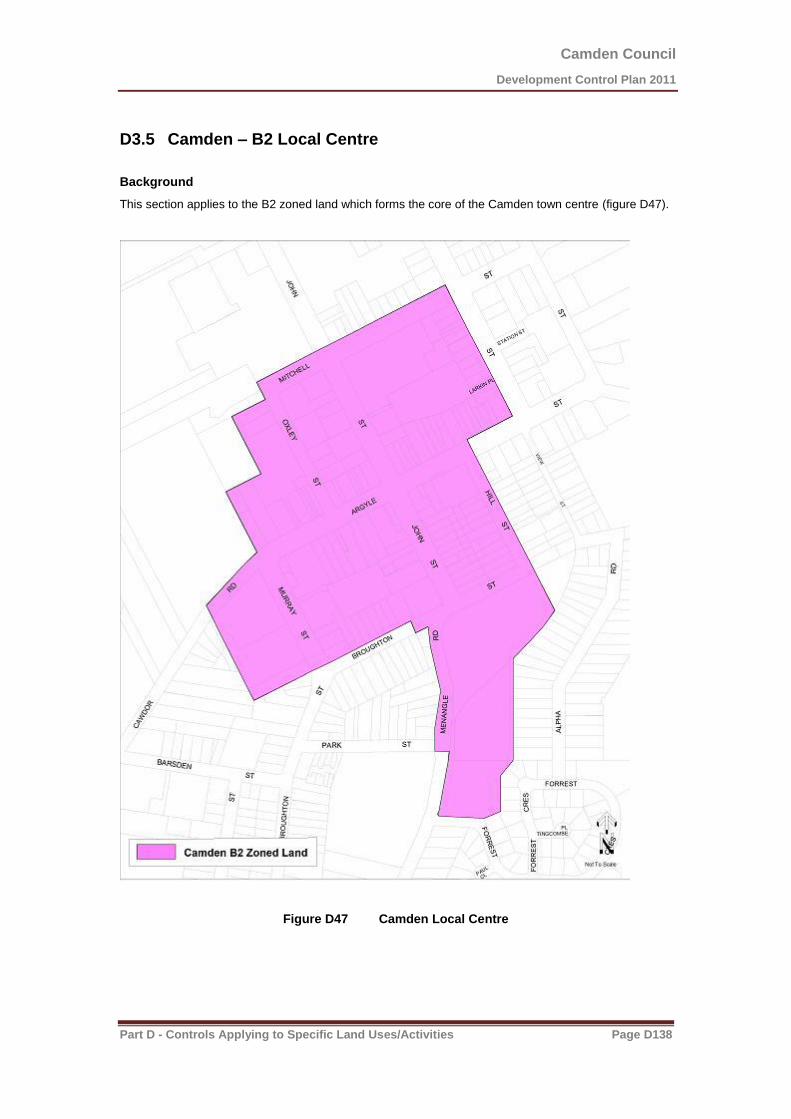
Camden Council
Development Control Plan 2011
Part D - Controls Applying to Specific Land Uses/Activities Page D138
D3.5 Camden – B2 Local Centre
Background
This section applies to the B2 zoned land which forms the core of the Camden town centre (figure D47).
Figure D47 Camden Local Centre
Camden Council
Development Control Plan 2011
Part D - Controls Applying to Specific Land Uses/Activities Page D139
Controls
D3.5.1 Layout/Design
1. New development should complement or reinforce the retail functions of the centre, particularly along Argyle Street frontages and associated pedestrian accessways.
2. Buildings should maintain and enhance the historic character of Argyle, Hill and John Streets in the town centre.
3. Buildings fronting Argyle Street should incorporate awning structures into their front facades in a manner consistent with the prevailing character of existing buildings. These awnings will convenient and sheltered access for pedestrians at the frontage of the premises.
D3.5.2 Heritage and Character
1. The Camden township is located within the Camden Heritage Conservation Area. Reference must be made to chapter B3 of this plan, with specific regard to subsection B3.1.2.
2. Development within the B2 Local Centre zone at Camden must be consistent with the Camden Town Centre Strategy dated 2008 prepared by Camden Council.

Camden Council
Development Control Plan 2011
Part D - Controls Applying to Specific Land Uses/Activities Page D140
D3.6 Narellan – B2 Local Centre
Background
The purpose of this part is to outline the vision for, and facilitate development of the Narellan Town Centre.
This section applies to land known as the Narellan Town Centre and surrounding land within the B2 -
Local Centre zone (Figure D48).
Figure D48 Narellan Local Centre

Camden Council
Development Control Plan 2011
Part D - Controls Applying to Specific Land Uses/Activities Page D141
Controls
D3.6.1 Desired future character for Narellan Town Centre
1. Narellan is a town centre anchored by a large shopping centre and supported by a range of other uses.
2. There is opportunity to demonstrate leading edge urban design principles in an integrated way which balances the challenge of achieving a sense of place and attractive streetscape within the constraints imposed by a traffic dominated environment.
3. Build on the existing character and history of Narellan in a contemporary manner.
4. Camden Valley Way to become a community heart with strong emphasis on integrated design
and linkages at multiple levels.
5. A variety of uses brings the community together in a central destination.
6. Highly accessible place for all modes of transport.
7. A place of high amenity and quality - a genuine Town Centre.
8. A successful commercial hub that encourages ongoing growth.
9. A place that reflects the history and promotes heritage items as an asset of Narellan while charting a new course to meet the aspirations of the growing community.
10. The vision for Narellan Town Centre is to create a people orientated and pedestrian friendly environment, where the built form has a human scale at street level, with cultural and civic expression.
11. Narellan Town Centre forms the heart of the existing region and community. Providing
employment opportunities in a range of industries and professions is a critical element to ensure success of the Town Centre.
12. Narellan Town Centre is prosperous and vibrant during the day and at night and all people feel
safe and comfortable moving through the Narellan Town Centre at any time.
13. Narellan Town Centre is not only a shopping centre; it is a true community hub providing all of the services and facilities that a community needs.
14. The design of the public and private realms is integrated to provide a sense of openness and
space.
15. Narellan Town Centre is designed to be used during a twenty-four hour cycle. A variety of spaces are located and designed for community interaction in large and small groups. Places are provided for recreation and entertainment, including community activities and cultural events

Camden Council
Development Control Plan 2011
Part D - Controls Applying to Specific Land Uses/Activities Page D142
D3.6.2 Town Centre Structure
D.3.6.2.1 Town Centre Structure Plan Layout
1. The Narellan Town Centre Structure Plan (refer to Figure D48.1 Town Centre Structure Plan) has been prepared to guide the future development of Narellan Town Centre. The Structure Plan describes the layout and land uses proposed for Narellan Town Centre.
2. The Structure Plan demonstrates an integration of land uses, with active street frontages to promote a vibrant Town Centre, maximise employment generation, promote economic development together with social and cultural interaction and provide a wide range of public and private services.
3. The Narellan Town Centre Structure Plan promotes a pedestrian friendly environment with integration of surrounding buildings at street level via two public plazas addressing Camden Valley Way and elevated walkway over Camden Valley Way. The structure plan incorporates an integrated pedestrian, cycle and public transport network, with linkages to the broader network.
Figure D48.1 Town Centre Structure Plan
Camden Council
Development Control Plan 2011
Part D - Controls Applying to Specific Land Uses/Activities Page D143
Objectives The Narellan Town Centre layout is to be consistent with the following principles: 1. Incorporate a pedestrian focused central heart consisting of two large public open spaces
located on Camden Valley Way that act as the focal point for the retail precinct.
2. Establish a clearly defined Town Centre core and frame differentiated through varying uses and intensity of development.
3. Consider potential future noise and amenity conflicts in the layout and location of Town
Centre uses.
4. Provide legibility by emphasising sight lines to gateways, places of key cultural significance, civic buildings and public open space.
5. Locate bus stops within easy walking distance of the central heart of Narellan Town
Centre.
Controls
1. Development should be generally in accordance with the principles set out in Figure D48.1
- Town Centre Structure Plan
D3.6.2.2 Land Uses
Objectives
1. Narellan Town Centre is to incorporate a variety of integrated land uses to meet the needs
of the existing region future residents. 2. Two large Urban Squares are proposed as the heart of the future Narellan Town Centre,
providing a key focal point for surrounding land uses and future visitors to the Town Centre.
3. Land uses within Narellan Town Centre will incorporate a range of retail, civic, community,
recreational, commercial, residential and mixed-use types.
(a) Retail Precinct
Objectives 1. The Retail Precinct constitutes modern centre-based retailing. The Retail Precinct seeks to
create a vibrant entry to Narellan Town Centre, which maximises employment generation and economic prosperity.
Controls Narellan Town Centre is to be consistent with the following controls as demonstrated in Figure D48.1 Town Centre Structure Plan, although it is acknowledged that land uses within Narellan Town Centre will change over time. Figure D48.1 illustrates land uses which demonstrate consistency with the following controls:
1. Achieve a large scale focus of retail premises within the B2 Local Centre Zone, limited by
a maximum floor space ratio (FSR) of 1:1. Additional retail premise floor space and uses are also acceptable, as appropriate, within the ‘Mixed Use Area’ identified on the Structure Plan.
2. Incorporate a variety of retail, commercial, entertainment, recreation, accommodation, and community uses to serve the needs of the wider community and promote an active and vibrant town centre.
3. Maximise employment opportunities within Narellan Town Centre.

Camden Council
Development Control Plan 2011
Part D - Controls Applying to Specific Land Uses/Activities Page D144
4. Focus a mix of active retail, restaurants, commercial and banking uses at ground level
along, and fronting the town squares/plaza, Camden Valley Way, Somerset Avenue, Queen and Elyard Street, with large-scale retail developments located within the retail precinct.
5. Co-locate uses and facilities where possible to maximise the efficient use of space.
6. Incorporate the needs of health and aged care providers, facilities for young people, civic
and emergency services within the Town Centre.
D3.6.2.3 The Town Squares
Objectives 1. The Town Squares should be located at the centre of Camden Valley Way, at the heart of
the Narellan Town Centre.
2. The Town Square should be provided as early as possible in the delivery of the Town Centre development to provide a place for people to meet, recreate and dine.
3. The Town Squares should function as a traditional ‘European’ style town square or
’Piazza‘, with coffee shops, restaurants and shop fronts spilling onto the plaza areas, with no clear delineation of public and private property boundaries.
4. The town square will incorporate appropriate levels of retail, commercial development and
landscaping elements, enhancing the feeling of enclosure intimacy, activity and sense of place.
5. The Squares should have places for people to sit and could include kiosk outlets and/or
shade elements.
6. The town Square should be designed to incorporate water elements that contribute to the activation of the town square and modify the microclimate.
7. Public art in the public domain should be provided to create a unique sense of place.
Public art elements should reflect the history of Narellan.
Controls 1. Development must include the provision of two Town Squares generally in accordance
with the principles for Special Places – Town Squares.
2. The two Town Squares should not be over scaled but should have a minimum useable area in the order of 2,000sqm (Northern Square) and 1,000sqm (Southern Square) clear of covered circulation areas or colonnades.
3. The Town Squares must contain appropriate public art elements.

Camden Council
Development Control Plan 2011
Part D - Controls Applying to Specific Land Uses/Activities Page D145
D3.6.2.4 Views, Vistas and Gateways
Objectives
1. The Narellan Town Centre Structure Plan has been designed to emphasise sight lines and define key gateways with key built form articulation.
Controls 1. Development should protect key sight lines. Refer to Figure D48.2 Views
Figure D48.2 Views

Camden Council
Development Control Plan 2011
Part D - Controls Applying to Specific Land Uses/Activities Page D146
D3.6.2.5 Interaction with Surrounding Land Uses
Objectives
1. The Narellan Town Centre Structure plan has been designed to respond to existing key land uses including residential, educational, open space and commercial development
outcomes.
Controls Detailed design of Narellan Town Centre should take into consideration proposed adjoining land uses and ensure provision for a high level of pedestrian connectivity between Narellan Town Centre and the surrounding development with particular reference to the Elyard Street proposed residential / commercial future developments and the existing civic uses including the Urban Forest Park, The Library and Council annex
D3.6.3 Access and Movement
D3.6.3.1 Vehicle Movement Network
Objectives
1. To provide an integrated hierarchy of roads, cycle ways and pedestrian pathways that provides safe, convenient and legible access within and around Narellan Town Centre.
2. To ensure that the hierarchy of the streets is clearly discernible through variations in carriageway, pavement surfaces, on-street parking and street tree planting.
3. To ensure a high quality, functional, safe, legible and visually attractive public domain.
4. To allow ease of vehicular access to Narellan Town Centre.
Controls
1. Traffic management measures are to be utilised within and surrounding Narellan Town Centre to produce a low speed pedestrian friendly traffic environment particularly on Somerset Avenue, Queen and Elyard Street. Such traffic management devices are to be identified at the time of lodgement of any Development Application directly affecting the local road network.
2. Principles of CPTED (Crime Prevention through Environmental Design) to be incorporated in the design of the access and movement system.

Camden Council
Development Control Plan 2011
Part D - Controls Applying to Specific Land Uses/Activities Page D147
D.3.6.3.2 Pedestrian and Cycle Movement
Objectives 1. To ensure that Narellan Town Centre is designed to promote high levels of accessibility for
pedestrian and cyclists.
2. To encourage pedestrian and cycle movements as a means of accessing services and facilities within and surrounding Narellan Town Centre.
Controls 1. Narellan Town Centre is to be designed to provide clear and legible pedestrian and cycle
connections as identified in Figure D48.3 Transport & Access.
2. Streets and pathway networks should be designed to ensure that walking and cycling within Narellan Town Centre takes priority over traffic circulation.
3. Continuous weather protection for pedestrians is to be provided in key locations by
colonnades or awnings.
4. Bike parking facilities should be provided at key locations on streets within Narellan Town Centre and within the two public plaza areas located on Camden Valley Way. Refer to Figure D48.3 Transport and Access.
D3.6.3.3 Public Transport
Objectives 1. To encourage the provision and use of public transport as a preferred method of access to
and from Narellan Town Centre.
2. To provide a high level of access to public transport services within and surrounding Narellan Town Centre.
3. To ensure that the Town Centre layout responds to the provision of a future public transport interchange to the Camden, Campbelltown and the future Leppington Regional Centre.
4. Bus stops to be located on both sides of Camden Valley Way and will be subject to
detailed design.
Controls 1. The location of bus stops to Camden, Campbelltown and Leppington Centre is to achieve
a high level of access to key places of interest such as residential and commercial development.
2. Bus stops are to be located to allow for integration of local and regional transport services. 3. Bus stops are to be located in areas of high pedestrian, active commercial / café’s and
vehicle activity and designed to ensure a high level of passive surveillance. Bus stops are to be provided generally in accordance with Figure D48.3 Transport and Access

Camden Council
Development Control Plan 2011
Part D - Controls Applying to Specific Land Uses/Activities Page D148
Figure D48.3 Transport and Access

Camden Council
Development Control Plan 2011
Part D - Controls Applying to Specific Land Uses/Activities Page D149
D.3.6.4 Public Domain
D.3.6.4.1 Public Domain
Objectives
1. To provide a variety of high quality public domain areas which cater for a wide range of activities.
2. To ensure that public domain areas are designed in a manner which recognise Narellan Town
Centre location and allow for a seamless transition between public and private spaces. 3. The public realm shall be unambiguously public in its design and detailing. 4. To ensure that the Town Squares respond to the character statements outlined under Clause
D.3.6.1.
Controls
1. Town Square areas are to be designed by a Registered Landscape Architect and located generally in accordance with Figure D48. Town Centre Structure Plan.
2. Two main Public Town Squares are to be designed to provide an urbanised, vibrant, interactive
public space, which incorporates outdoor seating areas associated with retail tenancies, which will open onto the Town Squares and opportunities for informal seating and gathering places.
3. External lighting is to be provided within the Town Square and must provide ample lighting for
night use throughout the year. Lighting is to be provided in accordance with Australian Standards AS 4282 - Control of the Obtrusive Effects of Outdoor Lighting and AS 1158 - Lighting for Roads and Public Spaces.
4. Any Development Application, which seeks approval for the design of a Town Square must
include a statement outlining how the design addresses the objectives outlined under Clause D3.6.2.3.
5. The Southern Square should include a means of vertical connection to achieve a seamless
pedestrian link between the retail podium level and ground level on Camden Valley Way. 6. All paving materials must conform to relevant standards for durability, non-slip textures,
strength and surface treatment to withstand use by light automobiles, service vehicles, pedestrians and bicycles.
7. Public art elements that reflect the history of Narellan are to be incorporated into the design of
public spaces.
D3.6.4.2 Street Trees
Objectives
1. To create a landscaped urban environment which helps to provide shade, comfort and amenity, particularly for pedestrians and provide distinctive streetscapes through the use of differentiated tree types / species.
2. To create a strong visual order for the streetscape.
3. To use appropriately scaled species, which can grow within the constraints, imposed by an urban environment.
4. To create a landscaped environment which responds to Environmentally Sensitive Design principles and can be reasonably maintained.
Camden Council
Development Control Plan 2011
Part D - Controls Applying to Specific Land Uses/Activities Page D150
Controls
1. Each Development Application must include a landscaping plan that demonstrates how they address Crime Prevention through Environmental Design (CPTED) principles.
2. Plant and Tree selection must take into account the following:
Species that complement remnant native vegetation.
Level of on-going maintenance.
Potential impacts on road and footpath pavements.
Focus on hardy, drought tolerant, easily maintained species.
Scale in relation to the function of the area.
Contribution to the character of the Town Centre.
3. Street trees and open space planting is to provide generous shade for pedestrians in summer and allow for sunlight penetration to street level in winter.
4. The town square must incorporate a sufficient density of trees, incorporating placement of medium to large deciduous trees, in order to provide seasonal amenity for pedestrians in the public domain places. All landscaping throughout the town square must not obstruct the
heritage significance of heritage items and view lines.
D3.6.5 Land Use and Built Form
D.3.6.5.1 Built Form Articulation
Objectives
1. To promote articulated building forms, which contribute to creating an interesting streetscape character.
2. To promote architectural articulation of building mass which responds to key design elements
of the Narellan Town Centre buildings.
Controls
1. Articulation zones should be provided to complement the building mass and emphasise key design elements such as vehicular and pedestrian entrance points and respond to environmental conditions including solar access, noise, privacy and views. (Refer to Diagram D48.4 Built Form)

Camden Council
Development Control Plan 2011
Part D - Controls Applying to Specific Land Uses/Activities Page D151
Figure D48.4 Built Form
D.3.6.5.2 Architectural Character Objectives
Objectives
1. Architectural expression should be diverse across building groups/blocks and facades should be articulated to create visual interest and reflect the buildings adjacent uses and context.
2. Recognise Camden Valley Way and associated key corners as the main focus for articulated
elements, visual indicators and ‘main street’ facade elements.
Camden Council
Development Control Plan 2011
Part D - Controls Applying to Specific Land Uses/Activities Page D152
3. There should be consideration of a contemporary architectural style based on simple primary
building forms and a fine-grained assemblage of elements (which may incorporate the diversity of character of streetscapes in historic towns such as Camden) where appropriate.
4. Architectural design should be sympathetic to the heritage context of the Burton Arms building
and other heritage items in the vicinity and respect the building’s curtilage.
5. Façade design should create a series of vertical elements along a building length reflecting a traditional main street façade where appropriate.
6. Sleeve buildings or appropriate screening is to be provided to minimise the visual impact of
large boxes, service areas and to define streets where viable and effective. Lifestyle environmental graphics alone are not considered as appropriate architectural screening and such graphics should be included in an integrated solution that offers a mix of techniques to improve visual presentation. Screening elements must be integrated within the Narellan Town Centre architectural character and language.
7. Roof forms and structures such as clock towers/spires are encouraged for key sites, corners
and roofs should be designed to break up the overall mass of a roof on a large building. Roof elements should be used to screen mechanical plant.
Controls
1. Articulation and Corners: Buildings within Narellan Town Centre are to generally align with street edges, be articulated in their façade treatments and express corners in design. (Refer Figure D48.4 Built Form).
2. Corners are to be visually prominent and may be reinforced by one and two story verandahs / balconies which turn the corner in a contemporary manner.
3. Building Interface: The interface between the building and the public domain is to be designed to create active safer streets, to encourage flexibility in design for changing uses at ground level and provide weather protection for pedestrian amenity.
4. Building facades are to be designed to accentuate key architectural features and clearly delineate points of interest such as building entries, vertical and horizontal elements.
5. Building facades are to incorporate a variety of finishes and materials which provide visual relief to the built form and be of a robust construction to withstand constant use and interface with the public.
6. A diverse palette of durable and cost efficient external materials exploring a contemporary urban character is to be used. A range of materials is to introduce a fine grain façade treatment along street edges.
Camden Council
Development Control Plan 2011
Part D - Controls Applying to Specific Land Uses/Activities Page D153
D3.6.5.3 Safety and Surveillance
Objectives
1. To ensure that the siting and design of buildings and spaces, through casual surveillance, decreases the opportunity for crime.
2. To ensure that development encourages people to use streets, parks and other public places
without fear of personal risk.
Controls
1. Buildings should be designed to overlook streets, lanes and other public or communal areas to provide casual surveillance. In the case of corner lots tenancies windows are also to be oriented to overlook the side street.
2. The design of all development, in particular, the public domain and community facilities is to enhance public surveillance of public streets and open space.
3. Appropriate design of publicly accessible areas (eg footpaths, etc) encourages a sense of community ownership of open and public spaces.
4. Developments are to avoid creating areas for concealment and blank walls facing the street.
5. Pedestrian and communal areas are to have lighting (to Australian Standards) to ensure a high
level of safety. These areas must be designed to minimise opportunities for concealment.
6. All development should aim to provide casual surveillance of the street as a means of passive security. This should be achieved by maximising outlooks and views, but minimising the overlooking of neighbouring properties.
7. All developments are to incorporate the principles of Crime Prevention Through Environmental
Design (CPTED). Development Applications for subdivision, public open space and community facilities may require a formal crime risk (CPTED) assessment as part of the Environmental Planning and Assessment Act 1979, development assessment and Camden Council’s Designing Safer Communities – Safer by Design Guidelines (October 2002).
D.3.6.5.4 Pedestrian Retail Bridge Articulation
Objectives
1. The detailed design of the pedestrian retail bridge must acknowledge its importance as a primary gateway / threshold into Narellan Town Centre as it will be highly visible to all modes of transport passing through the area.
2. The primary purpose of the pedestrian retail bridge is to ensure a successful commercial operation for the Shopping Centre, achieves a connected, vibrant link between the retail precincts on either side of Camden Valley Way.
3. The pedestrian retail bridge must reflect the architectural character of both buildings either side of Camden Valley Way and form an integrated composition of architectural form, elements and materials.
Controls
1. The pedestrian retail bridge should be single level only and may incorporate retail uses to activate the pedestrian connection across Camden Valley Way and achieve a connected, vibrant link between the retail precincts on either side of Camden Valley Way.

Camden Council
Development Control Plan 2011
Part D - Controls Applying to Specific Land Uses/Activities Page D154
2. The façade design of the pedestrian retail bridge must have a high level of architectural finishes and be consistent to the main building façade treatments along the Camden Valley Way frontages.
3. The eastern façade of the pedestrian retail bridge must be fully integrated with the two vertical circulation (escalators) elements that link street level to the retail podium level in terms of material resolution and ease of pedestrian use.
4. Both facades of the pedestrian retail bridge need to be treated in a similar manner in terms of materials and proportions selected.
5. Equal consideration of materials and façade treatment need to be shown to the underside of the pedestrian retail bridge including the night time experience for pedestrians and vehicles.
6. The vertical pedestrian circulation entries are to be provided at an appropriate scale to maximise the open air transparency of the pedestrian retail bridge abutments and encourage visible connectivity between plazas and retail levels.
7. The pedestrian retail bridge is comprised of the span and abutments to differentiate it from the remainder of the built form. Detailed consideration must be given to material selection of the pedestrian retail bridge with materials to reflect a lightweight feel to the pedestrian retail bridge structure. Solid, non transparent or reflective materials are to be minimised and transparent/translucent glazing panels with detailed fenestration should be encouraged.
8. No advertising on the pedestrian retail bridge will be permitted.
D.3.6.5.5 Building Envelopes / Bulk & Scale
Objectives
1. To ensure that the bulk and scale of future development responds to the desired vision, scale and character of Narellan Town Centre and existing surrounding development.
2. To encourage a variety of building heights within Narellan Town Centre, which respond to the site-specific, design considerations.
3. To encourage buildings with flexibility in their use over time.
4. Encourage redevelopment of neighboring sites over time.
5. Hierarchy of height acknowledges the status of the centre.
6. Heights to acknowledge the heritage buildings (in particular ‘Burton Arms’ and ‘Ben Linden’) and should respect and respond to them with appropriate transitions.
7. Building heights will transition to surrounding residential uses and school site.
Controls
1. Prominent street corners should be reinforced in a visual context through concentrating building height and built form.
2. Buildings are to be designed to ensure a human scale is maintained at street level.
3. Minimum floor to finished ceiling heights are as follows: a. 3.6m for the ground floor of all buildings (applies only to commercial and retail uses) b. 3.3m for the first floor for retail and/or commercial uses. c. 3.3m for all other retail and/or commercial floors.
d. 2.7m for all other residential floors.

Camden Council
Development Control Plan 2011
Part D - Controls Applying to Specific Land Uses/Activities Page D155
D.3.6.5.6 Weather Protection
Objectives
1. Pedestrians should be provided with amenity and comfort throughout the public realm, and the commercial and retailer occupants provided with a commercially viable and sustainable environment. (Refer Figure D48.4 Built Form)
2. The public realm should offer a diversity of experience, including providing a choice of
exposure to environmental conditions.
3. A variety of types, materials and methods for weather protection shall be adopted to promote a diverse experience across Narellan Town Centre.
Controls
1. Weather protection must maintain a feeling of openness and enhance both the public function of the specific space and /or street. (Refer Figure D48.4 Built Form).
2. Weather protection devices must take into account wind, sun, rain, night / day, seasons and
shadowing effects of other built components.
3. Weather protection devices must consider the scale of adjacent buildings and the width of the street / public space in order to ensure appropriate proportions and “feel”.
4. Weather protection solutions should be predominantly naturally ventilated.
5. Weather protection should be included as part of the design of the architecture / built form or landscape design.
6. Pedestrian rights of way, squares and other public spaces should typically have a variety of weather protection devices, where provided, ranging from minimal protection, fixed or temporary devices (including an array of devices such as awnings, canopies, “floating” roofs or be incorporated into the architecture of the building), and landscaped solutions, thus providing a variety of experiences and conditions.
7. Except where a colonnade is provided, active retail, restaurants, commercial, community and banking uses fronting the street or town square at ground level must provide weather protection along the majority of the façade, especially those areas facing north and west. This protection should typically take the form of a variety of awning types.
8. Awnings increase the usability and amenity of public footpaths by protecting pedestrians from sun and rain. Awnings encourage pedestrian activity along streets and, in conjunction with active edges such as retail frontages, support and enhance the vitality of the Town Centre. Awnings can be used in conjunction with colonnades. There are to be no wing walls so colonnades are continuous and unimpeded.
9. In particular, continuous awnings and colonnades are required to be provided along the ground floor street frontage on active street frontages in accordance with Figure D48.4 Built
Form.
10. The front fascia of the awning is to be set back a minimum of 500mm from the kerb of the street carriageway, including at street corners.
D.3.6.5.7 Setbacks
Objectives
1. To ensure that building setbacks reflect the desired future character of Narellan Town Centre and significance of heritage items in the vicinity.
2. To establish the desired vertical and horizontal spatial proportions of the streetscape.

Camden Council
Development Control Plan 2011
Part D - Controls Applying to Specific Land Uses/Activities Page D156
3. To provide a defined street edge within a Town Centre context.
4. To encourage passive surveillance of streetscape areas.
Controls
1. The urban character is achieved by adopting zero setback conditions to create street walls and introduce different types of streets. The main building facades are to be built to the block edge with allowances for insets and projections and to create stronger corner edges.
D.3.6.5.8 Streetscape Activation
Objectives
1. To encourage active streets throughout Narellan Town Centre.
2. To promote safety and security within Narellan Town Centre by maximising activation of street frontages where appropriate.
3. To ensure outlook to and surveillance of the street.
4. To acknowledge Camden Valley Way, Somerset Avenue, Queen and Elyard St as the key areas of importance in terms of street activation.
Controls
1. Active frontage uses are defined as one of a combination of the following at street level: a. Entrance to retail premises. b. Shop fronts. c. Glazed entries to commercial lobbies occupying less than 50% of the street frontage,
to a maximum of 12m frontage. d. Cafés or restaurants if accompanied by an entry from the street. e. Active office uses, such as reception areas, if visible from the street. f. Public buildings if accompanied by an entry.
2. Buildings are to maximise areas of street activation through a mixture of ground floor
retail/commercial suites.
3. As far as practical, retail and commercial development is to be built to the street alignment to achieve active street frontages.
4. Large format retail such as supermarkets and parking areas are to be sleeved or hidden by retail, commercial uses and detailed architectural features where appropriate.
5. Restaurants, cafes and the like are to consider providing openable shop fronts.
6. No external security shutters to be permitted.
7. On corner sites, shop fronts are to wrap around the corner.
D.3.6.5.9 Solar Access
Objectives
1. To maintain appropriate levels of solar access to public and private spaces within Narellan Town Centre.
2. To ensure that building mass does not impede solar access to public and private spaces within Narellan Town Centre and adjacent land uses without prior solar analysis.

Camden Council
Development Control Plan 2011
Part D - Controls Applying to Specific Land Uses/Activities Page D157
Controls (1) Any Development Application is required to submit detailed solar access diagrams for
between 9am and 3pm mid-winter to demonstrate sufficient solar access is maintained to public and private spaces and streets.
(2) The Town Squares are to receive sunlight on a minimum of 50% of the combined site
area between 11am and 2pm on June 21. (3) Building envelopes are to allow for north-south streets to receive 2 hours of sunlight
between 9am-3pm on 21 June on a minimum of 50% of the eastern or western footpaths.
(4) Building envelopes are to allow for east-west streets to receive 1 hour of sunlight
between 9am-3pm on 21June on a minimum of 50% of the southern footpaths.
D.3.6.6 Site Access, Parking and Loading
D.3.6.6.1 Vehicle Parking and Storage
Objectives
1. To ensure an appropriate number of parking spaces are provided within Narellan Town Centre to service the needs of both residents and visitors.
2. To encourage an appropriate mix of on and off-street parking options within Narellan Town Centre.
3. To provide integrated vehicle, bicycle and service access points without compromising the
streetscape character or pedestrian amenity.
Controls
1. Access, parking and loading areas must be provided in accordance with the requirements of Chapter B5.
2. Car parking dimensions are to be provided in accordance with relevant Australian Standards.
3. On street parking is encouraged and is to be provided as far as practical throughout Narellan Town Centre to contribute to street life and surveillance.
4. Above ground parking must incorporate appropriate design measures to mitigate adverse visual impact.
5. Below ground car parking is encouraged for mixed-use blocks as well as Town Centre retail blocks.
6. Where below ground parking is along a street edge and cross ventilation is desirable, any exposed section of car park wall is to be appropriately modeled and scaled.
7. The majority of car parking is to be provided under the Narellan Town Centre buildings and on street level to limit visual impact and maintain pedestrian amenity.
8. Natural ventilation of basement and sub-basement parking areas is encouraged to be provided wherever possible.
9. Service vehicle access points should be consolidated where possible to limit the potential for conflict points.

Camden Council
Development Control Plan 2011
Part D - Controls Applying to Specific Land Uses/Activities Page D158
Bicycle racks/storage areas are to be provided in accordance with Section B5 of Camden DCP 2011
D3.6.6.2 Loading Docks
Controls
1. Loading docks are to be developed in accordance with Section B5 of Camden DCP 2011.
D3.6.7 Signage and Graphics
Objectives
1. Environment graphics associated with the building and façade treatments are to be clearly distinguished from advertising and should take the form of abstracted architectural elements rather than “lifestyle“ advertising images.
Controls
1. All signage (advertising, business identification, environmental graphics and the like) must be provided in accordance with Chapter B4 'Advertising and Signage' except where otherwise stated by the following controls of this section.
2. All signage must be integrated into the architectural form and building elements.
3. Signage and environmental graphics should not adversely detract from significant views or vistas to and from heritage items.
4. Signage is permitted for the purpose of business identification for any retail, restaurant,
commercial or banking use that has an active street or town square frontage. The provision of signage for each tenancy must comply with the following: a) Where a unit or tenancy is visible from a public place, not more than one business
identification sign per unit or tenancy is permitted; b) Signage must only identify the business name and unit number, and any associated logos
or graphics; c) Signs must not exceed 20% of the visible wall area of the primary elevation of the unit or
tenancy; d) All signage visible from a public place must be of a complimentary size, shape and style
throughout the development; and e) Signage must be provided in accordance with Figure B10.
5. Signage must be scaled appropriately in proportion to the building mass.
D3.6.8 Somerset Avenue, Narellan
The following controls apply to land fronting Somerset Avenue, Narellan known as Part Lots 32 and 34, and Lots 37 to 45 inclusive DP 25582 shown on Figure D54.
Urban Design
1. Any building to be constructed adjoining a pedestrian walkway i.e. at Nos. 3 & 5 and 11 & 13 are to provide an active edge to the walkway in the form of windows and entrances.
2. The rear wall of any development is to be constructed to accommodate a future decked parking structure.
Note: Additional foundations may be required to accommodate future excavation works associated with any deck-structured car park.
Camden Council
Development Control Plan 2011
Part D - Controls Applying to Specific Land Uses/Activities Page D159
Building Footprint
3. A 2 metre strip of land fronting Somerset Avenue, as shown on figure D54, shall be restricted from development, but shall be available for external activities associated with businesses within the premises.
4. This area may be used for some external activities associated with a shop front, subject to Council approval.
5. Building setback from the rear boundary is to be 19 metres, comprising a 17.5 metre car park area and 1.5 metre wide footpath at the rear of the building.
Awnings Treatment
6. Awnings are to extend 3.6 metres from the building alignment within Somerset Avenue.
Storm Water Quantity Management
7. A strategy for managing storm water quantity shall be prepared in a manner consistent with the Somerset Avenue Augmentation Design Plan prepared by Council. (Ref No 2001-045)
8. Temporary on-site detention may be required as an interim measure in realising the overall Augmentation Design Plan.
9. Any drainage strategy incorporating car park detention shall have regard to any catchment influences.
Note: Drainage design should be developed in consideration of the overall car park levels, which are available from Council.
Accessibility - Vehicles:
10. Access to the car parking area is to be via access driveways at Slade Street and north of No 1 Somerset Ave as indicated in figure D54.
11. Short-term vehicle access may be achieved from Somerset Avenue, between Nos. 3 & 5, 11 & 13, where a 6 metre wide access is to be provided. Such access is to accommodate two-way vehicle movement and dedicated pedestrian access. Upon vehicle access becoming available from either Slade Street or North of No 1 Somerset Avenue then the temporary access is to revert to pedestrian access only. As an alternative should Nos. 3 & 5 or 11& 13 develop jointly then Council would accept an arcade style development, subject to the rear car park having access to Slade Street or north of No 1 Somerset Avenue.
12. Council will require a right of way over the above-mentioned land to the rear car park for both vehicles and pedestrians until such time as the car park is linked to the adjoining car park and has access to either Slade Street or north of No 1 Somerset Avenue. Following the linking of the car park to adjoining car parks a pedestrian only right-of -way will be required.
Accessibility - Car Parking:
13. All car parking areas and associated footpaths are to be dedicated to Council as part of the development process. These areas are shown shaded grey on figure D54.
14. Car parking is to be configured as shown on figure D54.
15. Car parks are to be constructed in accordance with specifications available from Council’s Works and Services Division.
16. Part Lots 35 & 36 DP25582 – Rear land to be dedicated to be dedicated to Council for car park when development occurs.
Note: A public “at grade” car park is to be provided at the rear of the properties facing Somerset and Doncaster Avenues, with attractive pedestrian walkways linking the car park to Somerset Avenue. Vehicular access to this car park will be gained from Slade Street, Somerset Avenue and Doncaster Avenue. At some time in the future and subject to demonstrated demand the car par will be redeveloped to a “decked” structure, which is to incorporate a commercial building fronting Doncaster Avenue.

Camden Council
Development Control Plan 2011
Part D - Controls Applying to Specific Land Uses/Activities Page D160
Accessibility - Pedestrian:
17. Access to the rear car parking area is to be via pedestrian walkways as indicated figure D54. These walkways may function as alternative vehicle access points until access is made available elsewhere.
18. The walkways are to be constructed without a defined level change; vehicle and pedestrian travel areas are to be identified within the paver/asphalt design.
Figure D54 Somerset Avenue Narellan

Camden Council
Development Control Plan 2011
Part D - Controls Applying to Specific Land Uses/Activities Page D161
D3.7 Camden – B4 Mixed Use
Background
This section applies to the B4 zoned land which fringes the B2 zoned land at Camden (figure D50).
Figure D50 Camden Mixed Use

Camden Council
Development Control Plan 2011
Part D - Controls Applying to Specific Land Uses/Activities Page D162
Controls
D3.7.1 Layout/Design
Development in the B4 Mixed Use zone should be complementary to the existing land uses in the B2 Local Centre zone which forms the core business and retail precinct of the Camden township.
D3.7.2 Built Form and Appearance
1. Buildings shall contribute to the local distinctiveness of the Camden township by using a varied palette of colours, materials and finishes.
2. Buildings in full corporate colours will not be permitted. Corporate colours can, however, be sensitively integrated as part of an overall design and signage strategy.
D3.7.3 Light Industrial Development
3. Light industrial development shall be consistent with the objectives and controls contained in section D4 of this DCP.
D3.7.4 Heritage and Character
4. The Camden township is located within the Camden Heritage Conservation Area. Reference must be made to chapter B3 of this plan, with specific regard to subsection B3.1.
5. Development within the B4 Mixed Use zone at Camden must be consistent with the Camden Town Centre Strategy dated 2008 prepared by Camden Council.

Camden Council
Development Control Plan 2011
Part D - Controls Applying to Specific Land Uses/Activities Page D163
D3.8 Narellan Business Park – B5 Business Development
Background
The Narellan Business Park area is located in the vicinity of Camden Valley Way and Narellan Road, Narellan, and is bisected by the Camden Bypass. The location of the land is shown in Figure D52.
Figure D52 Narellan Business Park

Camden Council
Development Control Plan 2011
Part D - Controls Applying to Specific Land Uses/Activities Page D164
Controls
D3.8.1 Function and Uses
1. Development within the Narellan Business Park must be complementary to the function of the Narellan township as a local centre.
D3.8.2 Layout/Design
1. Given the high visibility of the Narellan Business Park, storage areas will be located within the building.
2. A consistently high standard of landscaping shall unify development within the area, particularly along major roads. All front setback areas shall be landscaped to soften the visual impact of development.
3. A 3m landscaped area is to be provided along all road frontages
4. The following setbacks apply to all development within the Narellan Business Park:
(a) front setback to Narellan Road, Camden By-Pass or Camden Valley Way – 10m
(b) front setback to all other road frontages – 7.5m
(c) side setback to secondary road frontages on corner lots – 3m
(d) side and rear boundary setbacks – in accordance with the Building Code of Australia.
D3.8.3 Built Form and Appearance
1. The area must have a low scale built form, softened by landscaping to the main roads.
2. Landmark features including signature buildings shall be used in the gateway or highly visible locations where development adjoins the Camden Bypass, Narellan Road and Camden Valley Way and other highly visible areas. Such development will be constructed from high quality materials and designed to incorporate articulated roof and wall forms, ornamentation and prominent feature entrances. This may include glazed facades and recessed colonnades.
3. In order to avoid the proliferation of signage in the Narellan Business Park, signage will be integrated in a consistent theme as part of a building elevation, whether on a single occupancy building or multi unit development. Limited opportunities exist for individual free-standing signs and signage visible from arterial roads. No signage is to be directed towards the Camden By-Pass.
4. The maximum height of fencing shall be not more 2.1 metres.
5. The location of the front fencing will be dependent upon the type of fencing.
6. Decorative metal or a combination of decorative metal and masonry fences may be erected not less than 1 metre from the property boundary to allow a landscaped area to be provided in front.
7. A combination decorative metal and masonry fence must comply with the following:
(a) The ratio of the masonry component to decorative metal component must fall within the range of between 1 part masonry to 6.5 – 7 parts metal panels.
(b) The metal panels must not exceed 3 metres in length nor be less than 1.8 metres in length.
(c) Any masonry plinth established along the bottom of the fence must be not more than 600 mm high.
(d) Green or black plastic coated chain wire fencing may be erected behind the designated landscape area.
(e) Galvanised chain wire, untreated metal, colourbond and wooden fencing will not be permitted in front of the building line.
(f) All gates within the area covered by this DCP must be located behind the designated landscape area and must not swing towards the roadway.
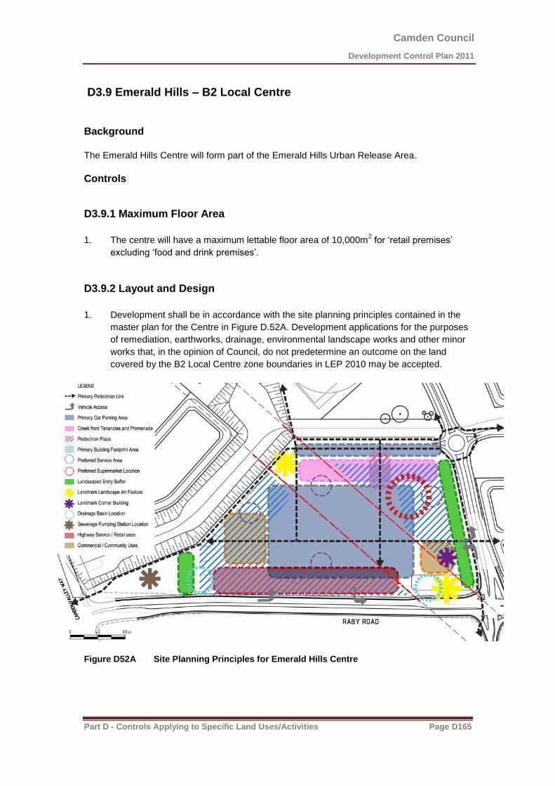
Camden Council
Development Control Plan 2011
Part D - Controls Applying to Specific Land Uses/Activities Page D165
D3.9 Emerald Hills – B2 Local Centre
Background The Emerald Hills Centre will form part of the Emerald Hills Urban Release Area. Controls
D3.9.1 Maximum Floor Area
1. The centre will have a maximum lettable floor area of 10,000m
2 for ‘retail premises’
excluding ‘food and drink premises’.
D3.9.2 Layout and Design
1. Development shall be in accordance with the site planning principles contained in the
master plan for the Centre in Figure D.52A. Development applications for the purposes
of remediation, earthworks, drainage, environmental landscape works and other minor
works that, in the opinion of Council, do not predetermine an outcome on the land
covered by the B2 Local Centre zone boundaries in LEP 2010 may be accepted.
Figure D52A Site Planning Principles for Emerald Hills Centre
Camden Council
Development Control Plan 2011
Part D - Controls Applying to Specific Land Uses/Activities Page D166
2. The development shall be designed to provide access and exposure to Raby Road and
Riley’s Creek adjoining the centre site whilst incorporating a vibrant and active focal
point in the form of a civic square, plaza or main street.
3. In addition to any relevant controls for the centre, residential buildings within the centre
are subject to the controls contained in Chapter D2 of this DCP as relevant.
4. Vehicle access and/or car parking facilities will not be approved if within 30 metres of a
Transmission Line structure without adequate precautions provided to protect the
structure from any accidental damage.
D3.9.3 Built Form and Appearance
1. Subject to compliance with the building height limits contained in Camden LEP 2010,
development within the centre should have a range of building heights up to a
maximum of three storeys.
2. Important buildings may be designed as landmark buildings which exhibit high quality
design, and should be sited at visually prominent locations such as corners and entries.
3. Buildings are to be visible from and have a presence to street frontages. Where
buildings are not proposed to be built to the street frontage, setbacks are to be
minimised. Buildings are also to be designed and located to take advantage of
proximity to open space areas, including the adjoining riparian corridor.
4. Blank walls visible from principal streets and the public domain are to be minimised.
5. The centre should exhibit a character which is in keeping with nearby significant
landscape elements, the presence of which should be promoted as urban design
features.
6. Building location form, land uses and activities and landscaping should be designed
and sited to minimise the visual impact of the power lines that traverse the centre site.
7. Retail/commercial/residential buildings built to the alignment of internal streets and
pedestrian areas shall incorporate awnings/verandahs over the footpath areas,
irrespective of whether building walls contain windows, doors or other openings.
8. Any building two storeys in height or greater shall include a verandah or balcony
terrace at level 1 above ground level to any internal street or pedestrian area. They
shall be accessible for use as open space/balcony from the upper level.
9. All mixed use buildings should be able to function as part residential use with potential
for a mix of retail, business, or residential at first level directly accessible and visible
from the ground level.
10. The design of buildings should provide flexibility to enable the use of various parts of
the building to change over time as necessitated by demand.
11. The centre shall be provided with parking that provides convenient access, but that is
located in a manner that does not dominate adjoining public domain areas, riparian
corridors and streetscapes.
12. Building walls, windows, entries, car parks, loading areas and service docks shall be
designed to enable maximum casual surveillance to be achieved to promote safety and
security in the public domain.

Camden Council
Development Control Plan 2011
Part D - Controls Applying to Specific Land Uses/Activities Page D167
D4 Industrial
Background
Camden LEP 2010 contains two industrial zones - IN1 General Industrial and IN2 Light Industrial.
The IN1 General Industrial zone is designed to accommodate traditional and modern forms of industrial development, including manufacturing and warehousing.
The IN2 Light Industrial zone is principally intended for light industry.
This chapter applies to the following industrial lands:
Smeaton Grange – Zoned part IN1 General Industrial and part IN2 Light Industrial.
Narellan industrial Area – Zoned part IN1 General Industrial and part IN2 Light Industrial.
Little Street, Camden – Zoned IN2 Light Industrial.
Ironbark Avenue, South Camden – Zoned IN2 Light Industrial.
The zones permit a wide range of industrial, warehouse, employment and related land uses, along with ancillary uses that serve the day to day needs of workers in surrounding development.
The objectives and controls contained in this section also apply to light industrial development in the B4 Mixed Use zone surrounding the Camden town centre in subsection D3.7 of this DCP.
Objectives
1. Facilitate the economic and orderly development of industrial areas for a wide range of uses including industrial, recreational and community uses, and limited business and retail uses that serve the day-to-day needs of those working in the immediate locality.
2. Create high-quality industrial areas which embrace innovative and imaginative building design that is both functional and aesthetically pleasing, along with appropriate landscaping and open space areas within each site.
3. Ensure that ecological sustainable development principles are integrated into all industrial developments.
4. Provide an effective traffic network within industrial areas and facilitate appropriate connections to the arterial road system.
5. Minimise the visual and environmental impact of development on the adjoining residential, rural residential and other sensitive land uses.
6. Ensure adequate facilities are provided within an industrial development for loading and unloading of goods, collecting garbage and trade waste and for the off-street parking of vehicles associated with that development.
7. Encourage innovation in grouping, configuration, screening or separation of parking areas.
Camden Council
Development Control Plan 2011
Part D - Controls Applying to Specific Land Uses/Activities Page D168
D4.1 General Industrial Controls
D4.1.1 Retailing in Industrial Areas
Permissibility
1. Retailing is not permissible except as outlined below. Showrooms may be permitted where they are ancillary to the principal use of the site, and are used only for the display of goods manufactured, produced or stored on-site.
Neighbourhood Shops
2. Neighbourhood Shops are permitted in Industrial Zones. Council must be satisfied that the neighbourhood shop will meet the day to day needs of people who live or work in the local area. The maximum gross floor area of a neighbourhood shop is 100m² (Clause 5.4 Camden LEP 2010).
Industrial Retail Outlets
3. Industrial Retail Outlets are permissible in all Industrial zones within the Camden LGA. The maximum gross floor area of an industrial retail outlet is 40% of the combined floor area of the industrial retail outlet and the building or place where the relevant industry is carried out, or 400m
2, whichever is the lesser (Clause 5.4 Camden LEP 2010).
D4.1.2 Showrooms in Industrial Areas
1. In considering applications for ancillary showrooms on industrial premises, Council shall take into account:
(a) the proportion of the total floor space devoted to the showroom activity;
(b) the nature of the goods to be displayed;
(c) the traffic generating potential of the proposed ancillary showroom; and
(d) the possible need for increased on-site car parking.
Note: Retailing from a showroom that is ancillary to the principal use of a premises is not permissible.
Camden Council
Development Control Plan 2011
Part D - Controls Applying to Specific Land Uses/Activities Page D169
D4.2 Built Form and Design
D4.2.1 Lot Sizes & Proportions
In new industrial areas, Council accepts that subdivision will result in the creation of allotments of varying sizes and dimensions to satisfy differing development requirements.
1. Industrial development shall generally not be carried out on any allotment of industrially- zoned land having an area of less than 2000m². The minimum width of such allotments, at the building line shall be 32m.
2. A front building line setback of 7.5m shall be provided.
3. Side and rear setbacks will be assessed on the merits of the application and subject to the requirements of the Building Code of Australia.
D4.2.2 Building Materials & Appearance
1. All elevations and roof surfaces are to be constructed predominantly in masonry, textured pre-cast concrete panels or colorbond metal cladding. Non-reflective roof surfaces are mandatory. Reflective materials such as mirror glass, colorbond white or off-white metal colours will not be permitted. The reflectivity index for glass used externally in the construction of a building (as a curtain wall or the like) shall not exceed 20%.
2. Development, which is free standing or abutting adjoining buildings, must avoid large, blank wall surfaces when viewed from a public place or a residential area. Substantial elevations must be articulated by either structural variation and/or a blend of external finishes and colours and decorative elements.
3. Colonnades, verandahs and awnings shall be provided along pedestrian areas, particularly for buildings that will experience high volumes of pedestrian movement.
4. While a variety of building designs and materials is encouraged, some continuity of style should be maintained.
5. Proposed buildings on site adjoining land zoned for open space and/or riparian areas shall have regard to the visual and functional opportunities of the location.
6. All roof mounted plant/equipment shall be designed and screened in a manner that complements the parent buildings.
D4.2.3 Multi-Unit Industrial Developments
The following requirements apply to multi-unit industrial developments
Numbering of the Units
1. Each unit in the development is to be numerically identified in the development application.
Amenities
2. Each unit is to have its own amenities. The premises are to be connected to the sewer.
Industrial Activity
3. All activities are to be carried out within the building and no activities shall occur externally to the building. Arrangements for the external storage of new and waste materials require the consent of the Council.
Consent for the Use of Individual Units
4. As well as obtaining development consent for the erection of the industrial building, the consent of Council is required for the specific use of each individual unit before the unit can be occupied. Consent may be sought as a combined development application along with the industrial building, or sought via a separate application.
Floor Area
5. The minimum floor area of each industrial unit shall be 140m2 inclusive of employee toilet
accommodation and amenities.

Camden Council
Development Control Plan 2011
Part D - Controls Applying to Specific Land Uses/Activities Page D170
Trade Waste storage unit
6. Trade wastes must be stored inside each unit, or in an approved communally managed storage area located so as not to interfere with parking or maneuvering of vehicles. The area to be set aside for this purpose is to be indicated on the development application plans and must be screened from public view.
Strata Subdivision
7. All landscaping, access areas and car parking spaces shall be included in any Strata Plan of subdivision as common property.
8. The subdivision certificate will not be issued until an Occupation Certificate has been issued for the development.
D4.2.4 External Storage
1. Council does not encourage external storage. Where such storage is proposed, Council requires applicants to have regard to the following provisions:
(a) Where any materials or products are to be stored outside buildings, detail must be provided with the development application.
(b) External storage areas are to be effectively screened and must not be visible from any public areas.
(c) In the case of development applications which do not include buildings, screen walls and/ or landscaping or other approved screen devices are to be erected in order to effectively prevent the use of the land being viewed from a public road, nearby public reserve, or dwelling.
(d) Screening devices are to be designed to harmonise with any existing or proposed landscaping. Landscaping should be used to break up large expanses of screen walls.
(e) In the case of development applications for the repair and/or wrecking of motor vehicles, the operation of junk yards, or recycling of metal and other waste materials, Council may impose special conditions on outdoor storage. In such cases, early consultation with Council (before the development application is lodged) is advisable.
(f) Screen walls are to incorporate finishes which match or are compatible with external finishes of the industrial building elsewhere on site.
(g) Any materials to be stored that can impact water quality must be covered or runoff water must be treated.
D4.2.5 Fencing
1. Front fencing shall be designed to complement the development and form an important security role taking into account safer by design principles.
2. The maximum height of fencing is 2.1 metres.
3. The location of the front fencing will be dependent upon the type of fencing.
4. Decorative metal or a combination of decorative metal and masonry shall be setback a minimum of 1 metre from the property boundary.
5. A combination decorative metal and masonry fence with a landscape screening buffer planted in front must comply with the following;
(a) the ratio of the masonry component to decorative metal component must fall within the range of between 1 part masonry to 6.5 – 7 parts metal panels.
(b) the metal panels must not exceed 3 metres in length nor be less than 1.8 metres in length.
(c) any masonry plinth established along the bottom of the fence must be not more than 600 mm high.
(d) green or black plastic coated chain wire fencing may be erected behind the designated landscape area.

Camden Council
Development Control Plan 2011
Part D - Controls Applying to Specific Land Uses/Activities Page D171
(e) galvanised chain wire, untreated metal, colourbond, wooden or barbed wire fencing will not be permitted as fencing in front of the building line or where visible from a public place.
6. All fencing proposed shall not restrict the function of existing and proposed overland flow paths.
7. All gates within the area covered by this DCP must be located behind the designated landscape area and must not swing towards the roadway.
D4.2.6 Environmental Management Plans
1. For an existing use, a development application for the use of premises will require the preparation of environmental management plans to accompany the development application which details the environmental impact of the use and the method to control and mitigate those impacts. Such plans will need to detail the use, storage and disposal of materials, liquids and chemicals on the site.
2. For the construction of a new building, a geotechnical report shall also be prepared for the land so as to determine potential constraints in terms of land stability, soil types, slopes and existing ground water levels.
D4.2.7 Stormwater
1. Industrial development in all areas except Smeaton Grange requires the use of on-site detention systems.
2. Water quality strategies must be incorporated to manage water generated from the site.
3. Council encourages the collection of roof stormwater into tanks which would serve as a detention and retention system.
4. The water in the retention system would be available for use for non-potable uses such as the watering of landscaped areas and use in toilet.
D4.2.8 Liquid & Solid Waste
The following controls apply to the discharge and disposal of all waste types for industrial developments:
1. No liquids (including water) discharged from the site shall contain pollutants above acceptable levels. Acceptable levels for given parameters for individual proposals will be determined at the time of development assessment, in conjunction with the Department of Environment, Climate Change and Water (DECCW).
2. A license to discharge may be required from the DECCW. It is the applicant’s responsibility to liaise with the DECCW to determine whether this is required and to provide Council with a copy of:
(a) correspondence received from the DECCW; and if required,
(b) a copy of any license issued by the DECCW.
3. Certain liquids (in addition to sewerage) may be discharged into the sewer provided a Trade Waste agreement is entered into with Sydney Water. Applicants shall consult with Sydney Water regarding the need for a trade waste discharger’s license, and a copy of any such license shall be provided to Council.
4. Developments associated with the repair, servicing or maintenance of motor vehicles shall provide a separate vehicular wash down bays. Details of such bays shall be provided with the development application and shall be subject to Sydney Water requirements.
5. Waste storage facilities must be properly sited and constructed to avoid negative impacts to the soil and water resources in the area.
6. Incinerators are not permitted for waste disposal. Liquid waste storage shall be covered and appropriately bunded.
D4.2.9 Recycling and Waste Management
1. All industrial developments shall consider adopting more environmentally friendly processes into their daily operations such as the recycling of waste and or products produced on site.

Camden Council
Development Control Plan 2011
Part D - Controls Applying to Specific Land Uses/Activities Page D172
2. Developments, which consume high volumes of water in their operation, shall incorporate recycling initiatives in the operation of the plant to reduce the demand on water. Council may be able to assist with water saving measures.
3. All Industrial development shall comply with Council’s Waste Management Policy and the provisions of chapter B1.9 of this DCP.
D4.2.10 Noise and Vibration
1. Development shall comply with the acoustic criteria contained within Camden Council’s Environmental Noise Policy.
2. Any noise generated shall not be offensive in accordance with the provisions of the Protection of the Environment Operations Act 1997.
3. Where it is considered that a development may have an adverse noise impact on nearby residential areas or adjoining properties, an acoustic assessment undertaken by a qualified acoustic consultant shall be submitted to Council with the development application. The assessment must be in accordance with Council’s Environmental Noise Policy.
4. Where it is considered that a development may have an adverse vibration impact on nearby residential areas or adjoining properties, an assessment of vibration by a qualified consultant shall be undertaken and submitted to Council with the development application. The assessment must be in accordance with DECCW’s Assessing Vibration: A Technical Guideline.
5. The industry shall operate in a manner to avoid unreasonable noise and interference to adjoining industrial occupations. Special precautions must also be taken to avoid nuisance to neighbouring residential areas and other sensitive land uses, particularly from warning sirens, public address systems, heavy duty compressors and the like.
D4.2.11 Air Quality
1. The emission of air impurities is to be strictly controlled in accordance with the Clean Air (Plant & Equipment) Regulation and must not exceed the prescribed standard concentration and emission rates.
2. Where there are no standards prescribed by the Regulation, any activity, or the operation of any plant, must be carried out by such means necessary to prevent or minimise air pollution.
3. Applications for new development must include full plans and specifications of any required air pollution control equipment. The application must demonstrate that the development meets the requirements of the Regulations or other relevant standards. Council may also require monitoring of an activity to verify that the emission of air impurities complies with the relevant requirements.
4. In accordance with the Protection of the Environment Operations Act and Regulations, some developments may require a license with respect to air emissions from the DECCW.
D4.2.12 Hazardous Goods and Materials
1. Where a development involves the storage and/or use of dangerous goods, full details of the quantities and types of goods and chemicals are to be submitted with the development application, together with the storage locations, mediums and the use intended for the goods and chemicals.
Note: The requirements of SEPP No. 33 must be complied with. Based on the types and quantities of hazardous goods and of materials used/stored in a development, Council may require an assessment in accordance with SEPP No.33.

Camden Council
Development Control Plan 2011
Part D - Controls Applying to Specific Land Uses/Activities Page D173
D4.3 Landscaping and Public Domain
D4.3.1 Landscaping
Appropriate and sufficient landscaping is essential for all Industrial/commercial developments, as it provides shade and amenity, as well as having many other environmental, financial and social benefits.
Detailed Landscaping Plans
1. Areas for landscaping are to be clearly identified on development application plans. As a condition of development consent, applicants will be required to submit detailed plans of the proposed landscaping. The detailed landscaping plans are to be prepared by a qualified landscape architect, or a suitably qualified landscape designer for approval prior to the issue of the Construction Certificate.
2. The detailed landscaping plans must include (but not limited to):
(a) The positioning and construction details of hard surfaced access paths and concrete pads for maintenance vehicles, where there is any proposed or existing permanent open water bodies, rain gardens and/or detention basins.
(b) The detailed landscaping plans must be consistent with and comply with any development consent, vegetation management plan, master plan or landscape concept plan applicable to this site.
(c) All universal access details for any open space areas and public facilities.
(d) Any landscape amenity elements such as boardwalks, lookouts, seating, playgrounds, picnic facilities, bubblers, signage, shade structures, paths, cycle ways, dog and litterbins and furniture elements.
(e) Details of any fencing, bollarding or other means of unauthorised entry control.
(f) Clearly detail how access to any open space areas for maintenance and emergency vehicles will be achieved.
(g) Detailed planting schedule, which includes positioning, species listed by botanical and common names, quantities, planting sizes and the estimated size of the plant at maturity.
(h) That the proposed landscaping is consistent with and complies with any cultural, ecological, environmental, heritage and existing amenity considerations applicable to the area.
(i) The type and installation details of the tree guard and root are to be provided for all street trees.
(j) That any relevant, existing, created or significant view lines are clearly shown on the detailed landscaping plans.
(k) That any existing trees and/or other landscape features on site as well as the effect that the development would have on the existing trees and/or other landscape features, is clearly shown on the landscaping plans.
Nature Strip/Road Verge and Street Tree Landscaping
3. Prior to the issue of the Occupation/Subdivision Certificate, the road verge/nature strip area adjoining the development site must be left weed and rubbish free, leveled, turfed and planted with appropriate upper canopy street trees at the rate of approximately 1 tree per 15 meters, main stem to main stem distance apart. The street trees are to be protected by the installation of durable and aesthetically appropriate tree guards with an approved root guard installed in the ground.
4. The selection and placement of upper canopy street trees should have regard to the following criteria:
(a) Power/Gas/Water/Sewer/Cable Services and Easements.
(b) Not planted within 3m of a Sydney Water access shaft.
Camden Council
Development Control Plan 2011
Part D - Controls Applying to Specific Land Uses/Activities Page D174
(c) Positioning of street lights.
(d) Pruning and shaping adaptability of selected trees.
(e) Infrastructure placement & easements.
(f) Driveways & bus stop placements.
(g) Frontages/setbacks.
(h) Lateral spread of branches.
(i) Road verge widths.
(j) Waste services collections.
(k) Pedestrian & vehicle vision.
(l) Existing amenity.
(m) Above ground services and easements.
(n) Footpaths and cycleways – (street trees must no be planted less than 1 metre away from a concrete footpath/cycleway unless Tripstop (or equivalent) has been installed to protect it from the roots.
Landscaping Elements
5. Landscaping can incorporate hard and soft elements and be used to:
(a) Enhance the appearance of the development.
(b) Provide a human scale and recreation facilities for staff.
(c) Define, soften and enhance the area, building, building entries and car parking areas.
(d) Make a statement for the character and community spirit of the site occupant and the Industrial/Commercial area as an entity.
Riparian/Waterfront Areas
6. Any land designated as Riparian/Waterfront shall be sufficiently rehabilitated prior to any handover considerations by Council for maintenance responsibilities.
7. A Construction Certificate will not be issued over any part of the site or Subdivision that requires a controlled activity approval (CAA) issued by NSW Office of Water, until a copy of the CAA has been provided to the Consent Authority (i.e., Camden Council).
D4.3.2 Lighting
1. The design of outdoor lighting poles and fixtures must be such as to minimise visual impact during daylight.
2. Bollard lights and wall mounted lights may be used at entrances to buildings and in setbacks along street frontages.
3. Choice of material for poles should be related to other building materials, and may include cell cured pine, pre-cast concrete or hollow aluminum.
4. The design of internal lighting and spotlighting is to be such as will ensure no adverse impact on approaching vehicles in terms of glare, blinding effects or driver confusion.
5. All lighting must comply with AS 1158 - Lighting for Roads and Public Spaces and AS 4282 - Control of the obtrusive effects of outdoor lighting. Lighting in public space must have timer switches installed for managing time of operation and power consumption.

Camden Council
Development Control Plan 2011
Part D - Controls Applying to Specific Land Uses/Activities Page D175
D4.4 Parking and Access
1. The car parking requirements are to comply with the controls as set out in Chapter B5 of the DCP. The requirement for compliance with Council’s Engineering Specification and Australian Standards is not required in this section. The references are already provided in the revised Chapter B5.
2. All parking shall be provided off-street and shall be appropriately line marked. A sign indicating customer parking shall be displayed at the entrance to the development. The number of parking spaces shall be in accordance with the car parking requirements referred to in Chapter B5 of this DCP.
Note: Designated car parking areas are not to be used for storing vehicles under repair, or for any other storage function
3. A maximum of one access driveway is permitted per lot frontage where the frontage is less than 60m.
4. Multiple access driveways servicing a single lot are limited to a maximum of two (2) driveways per lot frontage which must have a minimum separation distance of 30m, measured from the inside edge of each driveway crossover.
Figure D58 Driveways in Industrial Developments
5. All loading and unloading shall take place within the loading docks for each building. Where practical, loading facilities or vehicular entries to buildings shall not be provided on any street elevation. Where such facilities can only be provided to street frontages, they shall be screened by suitable landscaping.
6. Car parking on individual sites shall be located to integrate with proposed landscaping.
7. Access driveways shall be constructed as a kerb return not as a splay and shall otherwise be designed generally in accordance with Australian Standard 2890.2.

Camden Council
Development Control Plan 2011
Part D - Controls Applying to Specific Land Uses/Activities Page D176
8. The following table D19 gives Council’s requirements for the minimum size of service vehicle that must be provided for industrial/warehousing developments.
Table D19 Minimum Size of Service Vehicle
Development GFA Minimum Service Vehicle Size
< 300m² Medium Rigid Vehicle
> 300m² Large Rigid Vehicle
9. Consideration should also be given to providing parking, access and manoeuvring for B-double size service vehicles. Council encourages provision for these types of service vehicles, particularly on larger development sites.

Camden Council
Development Control Plan 2011
Part D - Controls Applying to Specific Land Uses/Activities Page D177
D4.5 Site Specific Industrial Controls
D4.5.1 Narellan IN2 Land
Background
The Narellan IN2 land is located to the north-west of the established Narellan industrial precinct and is known as often referred to as the Narellan Industrial Extension. The land is shown in Figure D53.
Figure D53 Narellan IN2 Zoned Land

Camden Council
Development Control Plan 2011
Part D - Controls Applying to Specific Land Uses/Activities Page D178
Landscaping
1. A minimum 3 metre wide landscape buffer shall be provided along all boundaries of the site that have an interface with any road or street and the proposed pedestrian/bike path.
Built Form and Appearance
2. Regardless of the approved traffic servicing arrangements, a 10 metre landscape buffer is to be provided along the Northern Road between the Eastern boundary (Pioneer Homes) and the Western boundary (Bunnings Hardware Store) which denies access to vehicles and pedestrians, other that if provided at the nominated entry and exit locations.
3. Individual advertising signs for each tenancy/land use within an industrial unit complex will not be permitted on the Northern Road frontage of any lots. All advertising must be located on or behind the approved building line within this precinct except where an integrated advertising structure has been approved as part of the original development application for the complex.
4. All service vehicles will be required to access the sites from the estates internal roads, i.e. Campbell Street extension.
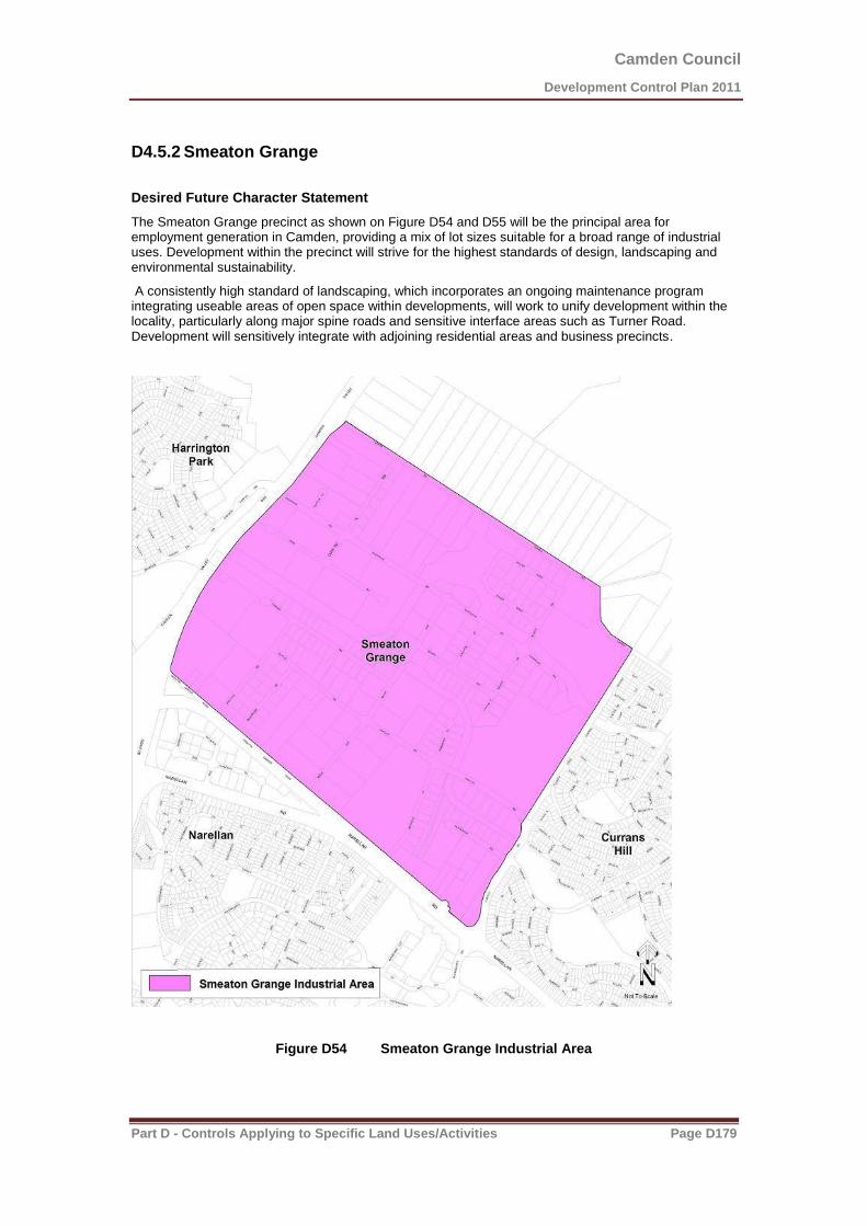
Camden Council
Development Control Plan 2011
Part D - Controls Applying to Specific Land Uses/Activities Page D179
D4.5.2 Smeaton Grange
Desired Future Character Statement
The Smeaton Grange precinct as shown on Figure D54 and D55 will be the principal area for employment generation in Camden, providing a mix of lot sizes suitable for a broad range of industrial uses. Development within the precinct will strive for the highest standards of design, landscaping and environmental sustainability.
A consistently high standard of landscaping, which incorporates an ongoing maintenance program integrating useable areas of open space within developments, will work to unify development within the locality, particularly along major spine roads and sensitive interface areas such as Turner Road. Development will sensitively integrate with adjoining residential areas and business precincts.
Figure D54 Smeaton Grange Industrial Area
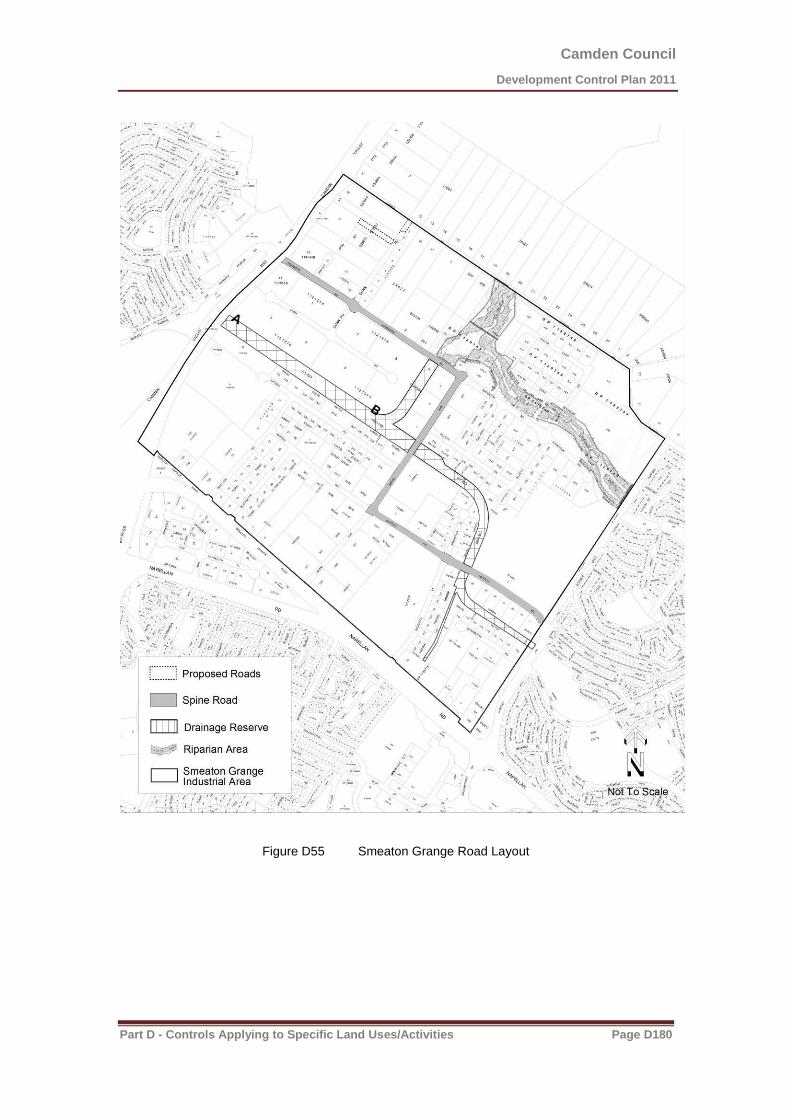
Camden Council
Development Control Plan 2011
Part D - Controls Applying to Specific Land Uses/Activities Page D180
Figure D55 Smeaton Grange Road Layout
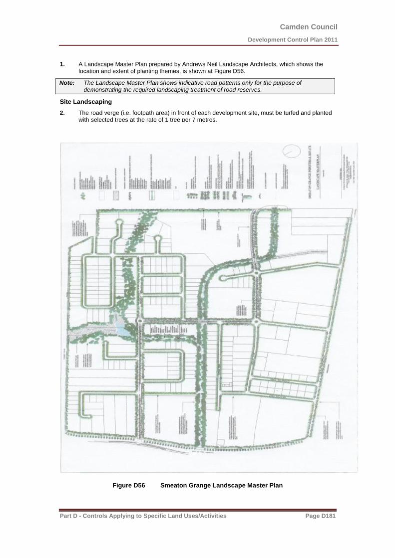
Camden Council
Development Control Plan 2011
Part D - Controls Applying to Specific Land Uses/Activities Page D181
1. A Landscape Master Plan prepared by Andrews Neil Landscape Architects, which shows the location and extent of planting themes, is shown at Figure D56.
Note: The Landscape Master Plan shows indicative road patterns only for the purpose of demonstrating the required landscaping treatment of road reserves.
Site Landscaping
2. The road verge (i.e. footpath area) in front of each development site, must be turfed and planted with selected trees at the rate of 1 tree per 7 metres.
Figure D56 Smeaton Grange Landscape Master Plan

Camden Council
Development Control Plan 2011
Part D - Controls Applying to Specific Land Uses/Activities Page D182
Riparian Areas
3. The land designated riparian areas within this chapter shall be rehabilitated and landscaped in accordance with the Landscape Master Plan shown at Figure D56 as a requirement of the subdivision of land and to the requirements and specifications of the conditions of a controlled activity approval. The extent of the riparian area shall be determined in consultation with Council and the Department of Environment, Climate Change and Water prior to the subdivision of land. The maintenance period for work within the riparian area shall be two years or other such time as specified by the Department of Environment and Conservation.
4. Where possible the riparian area should front the public road system. Special consideration to be given to the design of stormwater system discharging to the riparian area to provide for appropriate water quality and quantity controls.
Visual Impact
5. As a condition of development approval, Council will require the planting of a landscaped visual barrier screen in accordance with the Landscape Master Plan adjacent the road reserves of Camden Valley Way and Turner Road.
Individual site development
6. Development must provide minimum setbacks to buildings as outlined below:
(a) 15 metre setback from any spine road of which 10 metres must be utilised for landscaping;
(b) 10 metre setback from any minor road of which 5 metres must be utilised for landscaping;
(c) 30 mete setback from Camden Valley Way of which 15 metres must be utilised for landscaping;
(d) 10 metres to existing alignment of Turner Road of which 10 metres must be utilised for landscaping;
(e) 10 metres to the eastern boundary of the Industrial Area of which 10 metres must be utilised for landscaping;
(f) For corner lots the setback to the road which is not the primary frontage shall be:-
(g) 10 metres to a spine road;
(h) 5 metres to any other road, other than Camden Valley Way or Turner Road;
(i) 10 metres to main drainage channel marked (A)-(B) on Map No. 2 of which 5 metres must be utilised for landscaping.
(j) For the main drainage channel other than (A)-(B) the building setback is to be 5 metres of which 3 metres must be utilised for landscaping.
(k) 10 metres to Smeaton Grange Road between Narellan Road and Anzac Avenue of which 7.5 metres must be utilised for landscaping.
7. In assessing any application, Council will consider the visual impact of the height, bulk and scale of a proposed building to ensure that a high quality appearance is achieved, particularly as viewed from Turner Road, Camden Valley Way and Smeaton Grange Road. In this regard, buildings should not dominate the skyline and should include roof lines and facades which provide visual interest and an appropriate sense of scale. Roof mounted equipment such as air conditioning units, stacks, distilling towers, silos, communication towers and the like which protrude above the general roof line of the building shall not be permitted except where they are appropriately integrated with the design of the building.
Location of Certain Developments
8. Industries whose principal function is the storage and/or processing of goods and materials not enclosed within a building, shall not be located on land which fronts a spine road or land adjoining Camden Valley Way, Turner Road or Smeaton Grange Road.

Camden Council
Development Control Plan 2011
Part D - Controls Applying to Specific Land Uses/Activities Page D183
Proposed Road off Dunn Road
9. Council will require the construction of a road delineated as ‘Proposed Future Road’ off Dunn
Road shown on figure D54 to an industrial standard as part of any development consent issued
on Lot 77 DP 805851 (552 Camden Valley Way).
Upgrade of Turner Road
10. Any redevelopment of properties that have frontage to southern side of Turner Road, being:
o Lot 6 DP 657664 (556 Camden Valley Way)
o Lot 40 DP 28024 (36 Turner Road)
o 41 DP 28024 (42 Turner Road)
o Lot 1 DP 603134 (52 Turner Road)
o Lot 200 DP 746842 (62 Turner Road)
o Lot 202 DP 746842 (66 Turner Road)
o Lot 435 DP 1129749 (67 Anderson Road),
will be required, to upgrade the full width road reserve to an industrial standard extending from and
including the Dunn Road intersection to the western boundary of the subject site. This is to be
undertaken at either subdivision or building stage, whichever occurs first.
Stormwater Drainage (Properties fronting Turner Road)
11. Any redevelopment of properties that have frontage to southern side of Turner Road, being:
o Lot 40 DP 28024 (36 Turner Road)
o 41 DP 28024 (42 Turner Road)
o Lot 1 DP 603134 (52 Turner Road)
o Lot 200 DP 746842 (62 Turner Road)
o Lot 202 DP 746842 (66 Turner Road)
o Lot 435 DP 1129749 (67 Anderson Road),
will acquire an easement to convey stormwater drainage from that property through the adjoining
properties fronting Anderson Road to the south in the event that drainage is required, Documentary
evidence of the acquisition of this easement must be submitted with any Development Application for
further development of these properties fronting Turner Road.
Extension of Dunn Road to Turner Road
12. A Development Application for the extension of Dunn Road to Turner Road is to include studies to determine what steps, if any, can be taken to mitigate the impact of such road extension on the operation of the poultry operation in Dunn Road.

Camden Council
Development Control Plan 2011
Part D - Controls Applying to Specific Land Uses/Activities Page D184
D4.5.3 Ironbark Avenue, Camden South
Background
The Ironbark Avenue Precinct comprises land zoned IN2 Light Industrial, as shown with a red line in
Figure 1 below.
figure 1 – Location of Ironbark Avenue precinct
Camden Council
Development Control Plan 2011
Part D - Controls Applying to Specific Land Uses/Activities Page D185
Tree Planting
Background
The Ironbark Avenue Precinct contains scattered native vegetation. Opportunities do, however, exist to
create an attractive streetscape for the precinct as depicted in Figure 2 below.
Objectives
1. To promote the landscape treatment of the Precinct by providing opportunities to increase
landscaping within and external to sites.
2. To create a soft, informal separation and ascetically pleasing green interface between the
residential and light industrial areas.
3. To provide a higher level of public amenity by creating a safe, functional and professionally
landscaped road verge open space area.
Controls
1. A Landscape Plan prepared for any development site within the Ironbark Avenue IN2 zone is to
compliment and to be generally in accordance with the concept landscape plan shown in
Figure 2.
Acoustic Amenity
Background
Noise is a characteristic of the operation of certain industrial landuses and the accessing of such areas
by industrial traffic. It must be managed so as to achieve established environmental objectives. It should
be noted, however, that precise management measures for road related noise in particular will be
dependent upon the type of industrial landuse.
In deriving acoustic strategies it will be important to avoid compromising proposed and existing industrial
landuses and not unduly compromising the lifestyle of existing and future residential development.
Objectives
1. To establish design criteria for noise emissions from industrial or other employment-generating
development within the Ironbark Avenue Precinct;
2. To establish acoustic environmental goals for existing and future developments adjacent to
residential areas;
3. To minimise the adverse impact of noise emissions on surrounding residential enjoyment;
4. To ensure visual impacts are minimised in the development and implementation of acoustic
strategies;
5. To ensure that development does not cause adverse environmental impacts from noise and
vibration; and
6. To discourage the use of local streets by heavy vehicles.

Camden Council
Development Control Plan 2011
Part D - Controls Applying to Specific Land Uses/Activities Page D186
Controls/Requirements
1. Where it is considered likely that a development may cause an adverse impact on nearby
residential areas, noise impact must be assessed in accordance with Council’s Environmental
Noise Policy to determine if any acoustic assessment is required. Any required acoustic
assessment must be submitted with the development application.
Site Development and Urban Design
Public Domain
Background
The proposed redevelopment of this area has incorporated a streetscape that has open parkland like
atmosphere to enrich the local area. The landscape retains existing large significant Iron Bark trees,
which are culturally significant to the name Ironbark Avenue. Increased public amenity has been
provided with additional planting of evergreen and deciduous street trees and low maintenance ground
cover grasses. The deciduous trees provide seasonality and fit in with the landscape style of Camden.
Objectives
1. To provide a clear, functional and safe accessibility network.
2. To provide an enhance amenity for the general community. By retaining significant existing
landscaping elements and trees and planting new trees and other landscaping within the open
space areas.
3. To provide a pleasant, informal and green interface between the residential and light industrial
sections.
Controls
1. Any Landscape Plan prepared for the site is to be generally in accordance with the
concept landscape plan shown in Figure 2.
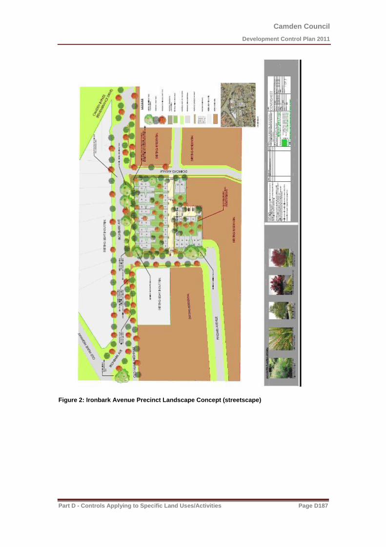
Camden Council
Development Control Plan 2011
Part D - Controls Applying to Specific Land Uses/Activities Page D187
Figure 2: Ironbark Avenue Precinct Landscape Concept (streetscape)

Camden Council
Development Control Plan 2011
Part D - Controls Applying to Specific Land Uses/Activities Page D188
D5 Other Land Uses
D5.1 Child Care Centres
Note The definition of a ‘child care centre’ is stated in the Dictionary section of Camden LEP 2010.
It is strongly recommended that applicants arrange a pre-DA meeting with Council prior to submitting a child care centre development application to ensure that all of the prerequisite documentation has been prepared.
Applicants should consult with the NSW Department of Education and Communities to determine licensing requirements prior to lodgement of a DA with Council. Further information is available at www.dec.nsw.gov.au
Introduction
This section is designed to deliver certainty to applicants, operators and the local community about planning requirements for child care centres.
The objectives and controls within section D5.1 aim to ensure that child care centres respond positively to their context and setting and minimise adverse environmental impacts. In addition, the controls aim to facilitate the establishment of high quality child care centres that are located and designed to achieve high levels of safety, security, environmental health and amenity for users.

Camden Council
Development Control Plan 2011
Part D - Controls Applying to Specific Land Uses/Activities Page D189
Planning and Design Criteria
Site Selection
Background
Careful consideration must be given in selecting a suitable location for a child care centre as not all sites are appropriate for this form of development.
Site selection criteria must take into account the needs of centre users in terms of safety, security and environmental health. Where located in residential zones, consideration must also be given to ensuring that the commercial nature of child care centres does not unreasonably detract from residential character and amenity.
Objectives
For residential areas, to ensure sites are sufficient in area and dimensions to accommodate
building, outdoor play area and car parking needs of child care centres without detracting from
the character or amenity of surrounding residential land.
To ensure that child care centres are appropriately located and sited having regard to the
environmental attributes of the locality and the health and well being of centre users.
Controls
1. Child care centres located within residential zoned land must be located
(a) on sites with a minimum site area of at least 1,200m2; and
(b) on sites with a minimum frontage of 20m, measured at the building line.
2. Child care centres must not be located on land:
(a) with direct access from an existing or proposed classified road;
(b) where access to the site is via a road with a carriageway width of less than 7.4m at any one point*;
(c) having a frontage to a cul-de-sac or no through road;
(d) where additional vehicle movement generated by the centre may cause traffic conflict or have an adverse impact on the amenity of any land in the neighbourhood;
(e) likely to be adversely affected by noise pollution or contamination unless these impacts can be satisfactorily mitigated;
(f) which is affected by a 1% Annual Exceedance Probability flood level;
(g) within 100m measured in a straight line from any part of the site to high voltage transmission lines, mobile phone towers or radio telecommunication facilities, unless the application is accompanied by a report demonstrating that the Electro Magnetic Radiation (EMR) affecting the site is within acceptable limits;
(h) within 100m measured in a straight line from any part of the site to approved restricted premises or sex services premises;
(i) within 55m measured in a straight line from any part of the site boundary to an above
ground liquid petroleum gas tank that has a capacity of 8 kilolitres or less; or
(j) which is not connected to a reticulated sewer of Sydney Water unless satisfactory on-site sewage management can be provided.
Camden Council
Development Control Plan 2011
Part D - Controls Applying to Specific Land Uses/Activities Page D190
3. Development applications for child care centres must be accompanied by a Phase 1
contamination investigation undertaken in accordance with Council’s Management of
Contaminated Lands policy.
Notes
1) In existing suburbs with limited roads that meet this requirement, consideration will be
given to Child Care Centres on roads with a carriageway of less then 7.4m where it can be
demonstrated that there is not an unacceptable adverse impact on traffic movement or
access.
2) Sites in unsewered areas will require larger sites to address effluent disposal areas and
their associated buffers.
3) Sites in bushfire prone areas will require a Bushfire Safety Authority from the NSW Rural
Fire Service, as per s100B of the Rural Fires Act 1997.
4) The proximity of child care centres to poultry farms or other existing odour generating
land uses will be considered and an assessment may be requested to be undertaken in
accordance with relevant odour assessment requirements.
5) An air quality report may be required for sites located in the vicinity of a major road or
industry.
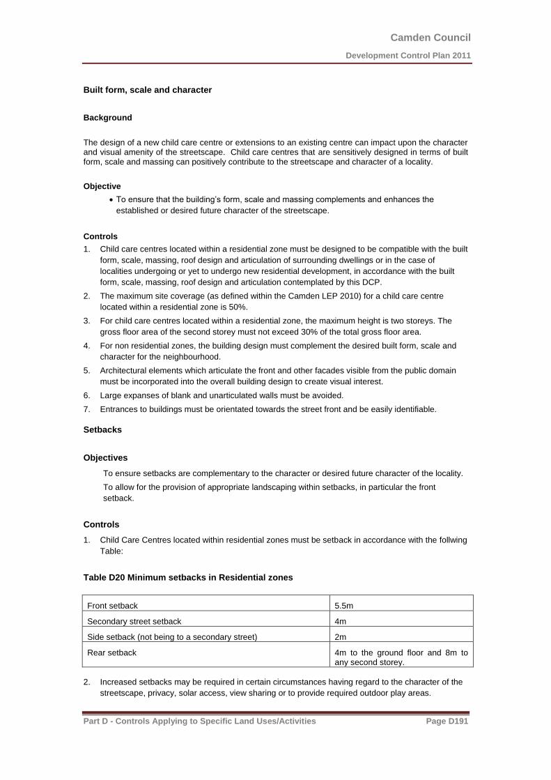
Camden Council
Development Control Plan 2011
Part D - Controls Applying to Specific Land Uses/Activities Page D191
Built form, scale and character
Background
The design of a new child care centre or extensions to an existing centre can impact upon the character and visual amenity of the streetscape. Child care centres that are sensitively designed in terms of built form, scale and massing can positively contribute to the streetscape and character of a locality.
Objective
To ensure that the building’s form, scale and massing complements and enhances the
established or desired future character of the streetscape.
Controls
1. Child care centres located within a residential zone must be designed to be compatible with the built
form, scale, massing, roof design and articulation of surrounding dwellings or in the case of
localities undergoing or yet to undergo new residential development, in accordance with the built
form, scale, massing, roof design and articulation contemplated by this DCP.
2. The maximum site coverage (as defined within the Camden LEP 2010) for a child care centre
located within a residential zone is 50%.
3. For child care centres located within a residential zone, the maximum height is two storeys. The
gross floor area of the second storey must not exceed 30% of the total gross floor area.
4. For non residential zones, the building design must complement the desired built form, scale and
character for the neighbourhood.
5. Architectural elements which articulate the front and other facades visible from the public domain
must be incorporated into the overall building design to create visual interest.
6. Large expanses of blank and unarticulated walls must be avoided.
7. Entrances to buildings must be orientated towards the street front and be easily identifiable.
Setbacks
Objectives
To ensure setbacks are complementary to the character or desired future character of the locality.
To allow for the provision of appropriate landscaping within setbacks, in particular the front
setback.
Controls
1. Child Care Centres located within residential zones must be setback in accordance with the follwing
Table:
Table D20 Minimum setbacks in Residential zones
Front setback 5.5m
Secondary street setback 4m
Side setback (not being to a secondary street) 2m
Rear setback 4m to the ground floor and 8m to any second storey.
2. Increased setbacks may be required in certain circumstances having regard to the character of the
streetscape, privacy, solar access, view sharing or to provide required outdoor play areas.

Camden Council
Development Control Plan 2011
Part D - Controls Applying to Specific Land Uses/Activities Page D192
3. The front setback area may only be used for access, car parking and landscaping purposes and not
for outdoor play areas and the like, unless it can be demonstrated that doing so is acceptable
having regard to:
(a) site characteristics (e.g. configuration, solar access, relationships to neighbouring properties),
and
(b) separate pedestrian access can be provided to the main entry to the building, and
(c) the incorporation of appropriate fencing or screening measures which are compatible with the
streetscape.
Dual Use of the Centre
Objective
To ensure reasonable amenity for the occupants of a dwelling where sited on a property containing a
child care centre.
Controls
1. Any dwelling must have separate and distinct access. Access to the dwelling through any part of
the child care centre including outdoor play areas is not permitted.
2. Separate toilet, laundry and kitchen facilities must be provided for each of the dwelling and the child
care centre.
3. Children attending the child care centre must not be able to access any part of the dwelling and its
private open space area.
4. A separate outdoor private open space area must be provided for the dwelling in accordance with
section D1.2.5 of this DCP.
5. Parking spaces for the residents must be provided in addition to the parking requirements of the
child care centre.
Acoustic amenity
Objective
To ensure satisfactory acoustic amenity for neighbouring properties
Controls
1. An Acoustic Assessment Report prepared in accordance with Council's Environmental Noise
Policy by a consultant qualified in acoustics which details compliance with acoustic criteria of that
Policy and this section of the DCP must be submitted with the development application.
2. Where acoustic fencing is required to ensure acceptable acoustic impacts it must be of solid
continuous construction and have a maximum height of 2.1m.
3. Outdoor play areas must be located to minimise noise for adjoining neighbouring properties.
4. For larger centres, the number of children participating in outdoor activities and play time at any one
time must be controlled to ensure satisfactory acoustic impacts for neighbouring properties. The
acoustic report submitted with the application must outline any necessary restrictions on numbers to
ensure such satisfactory acoustic impacts.

Camden Council
Development Control Plan 2011
Part D - Controls Applying to Specific Land Uses/Activities Page D193
Landscaping
Background
Landscaping can assist in integrating child care centres within the streetscape and contributing to a pleasant environment.
Objectives
To ensure that landscaping is compatible with and contributes in a positive manner to the
character of the locality.
To encourage the provision of suitable forms of landscaping.
Controls
1. A landscape concept plan must be submitted with the development application that incorporates the
following:
(a) existing vegetation and other natural features must be conserved on site, wherever it is
possible and safe to do so.
(b) any proposed building structures must be setback at least 3m from the trunk of any tree to be
retained.
(c) plant species must be chosen for their suitability to the site, ease of maintenance, be
interesting to children and serve the purposes of providing:
i. shade without undue overshadowing of adjoining properties.
ii. reduction of reflection from bright surfaces.
iii. emphasising pedestrian and vehicular routes.
iv. interesting quiet play areas capable of supervision.
Note: Refer to ‘Kidsafe’ book on plants for play areas, published by Playground Advisory Unit for the Child Accident Prevention Foundation of Australia
2. Landscaping design must reflect the prevailing landscape character of the streetscape in terms of
scale and planting style.
3. In residential areas, a landscape buffer at least 2m wide must be provided between any street
frontage and the location of car parking spaces or drop off areas.
4. On corner sites, fences over 1.2m in height must be setback 1m from the property boundary on the
secondary setback to enable landscaping in front of the fence.
Fencing
Objectives
To ensure that fences forward of the building line are complementary to the streetscape in terms of
materials, colour, height and form.
To assist providing a delineation between public and private areas.
To provide child safe fencing in appropriate locations.

Camden Council
Development Control Plan 2011
Part D - Controls Applying to Specific Land Uses/Activities Page D194
To ensure suitable fencing which encourages privacy for adjoining properties and has a satisfactory
visual impact.
To ensure consideration is given to the siting of the fence, articulation and the provision of adjacent
landscaping to ensure a satisfactory visual outcome when viewed from adjoining properties or the
public domain.
Controls
1. Fences must be designed to maximise privacy to all adjoining properties.
2. Child proof fencing and self closing gates must be installed around outdoor play areas and at the
entrance to ensure the safety and security of children.
3. Fencing, particularly that provided in the front setback area of the site, must be of a type and colour
complementary to the streetscape and residential character.
Signage
Objective
To ensure any signage associated with the child care centre does not dominate the building or the
streetscape.
Control
1. Signage must comply with Part B4.9 of this DCP.
Traffic, Parking & Pedestrians
Objectives
To ensure a safe environment for pedestrians, particularly children, motorists and cyclists in and
around child care centres.
To minimise impacts in the locality in terms of traffic generation and demand for on street parking.
To minimise the visual impact of car parking areas and to ensure they do not unreasonably detract
from the streetscape character.
To provide sufficient and convenient parking for staff members, visitors and for the dropping off and
picking up of children.
Controls
1. Proposed car parking and access must comply with the controls set out in chapter B5 of this DCP.
2. A traffic study must be submitted with the development application. The study must be prepared
by a qualified traffic consultant and address the adequacy of the vehicular access i.e. ingress and
egress arrangements, drop off areas, car parking layout and the impact of the additional traffic to
be generated by the proposed centre on the local road system.
3. The number of children proposed to attend the child care centre must be detailed as part of the
application. This information is necessary in order to determine the required number of parking
spaces.
4. All required parking spaces must be fully contained within the site, and clearly shown on a plan.
5. A drop off area must be provided fully contained within the site, and clearly shown on a plan.

Camden Council
Development Control Plan 2011
Part D - Controls Applying to Specific Land Uses/Activities Page D195
6. The driveway and car parking layout must be designed to allow for the safe delivery and collection
of children and also for the safe movement and parking of staff, visitors and service vehicles.
7. The car park design must make provision for:
a. safe pedestrian access,
b. existing/proposed shared pathways
8. Vehicular access must be separated from pedestrian access i.e. separate pathways are to be
provided adjacent to the car park to allow pedestrian access to the centre’s entrance, both from the
car park and from the footpath forming part of any adjoining public road.
9. Pathways and pedestrian ramps must have gradients no greater than 1:14 with a non-slip surface.
10. Separate ingress and egress is required but if this is not possible a turning area is to be provided to
facilitate safe manoeuvring and to enable all vehicles to enter and leave the centre in a forward
direction.
11. In residential areas, all car parks must be ‘at grade’ (basement car parks are not permitted) and
constructed only with materials such as, neutral coloured concrete or pavers of a distinct and
different form to dedicated pedestrian paths.
12. Adequate areas for landscaping and planting must be provided to reduce the visual impact of the
car park in the streetscape, including an area at least 2m wide along all street frontages.
13. Child care centres must comply with the requirements of the Building Code of Australia, AS/NZ
2890 and Disability Discrimination Act with regards to disabled access and car parking.
Hours of Operation
Objective
To ensure that child care centres hours of operation are reasonable and have minimal impact on the
locality and the environment.
Controls
1. Within residential zoned land the standard hours of operation will be restricted to between 7am and
7pm, Monday to Friday (excluding public holidays).
2. Within residential zoned land Council may consider longer hours of operation and/or opening on
Saturday morning if it can be demonstrated that no unreasonable amenity impacts will arise for
neighbouring properties.
3. Where a site is located outside of a residential zone the proposed hours of operation must be
included in the application.
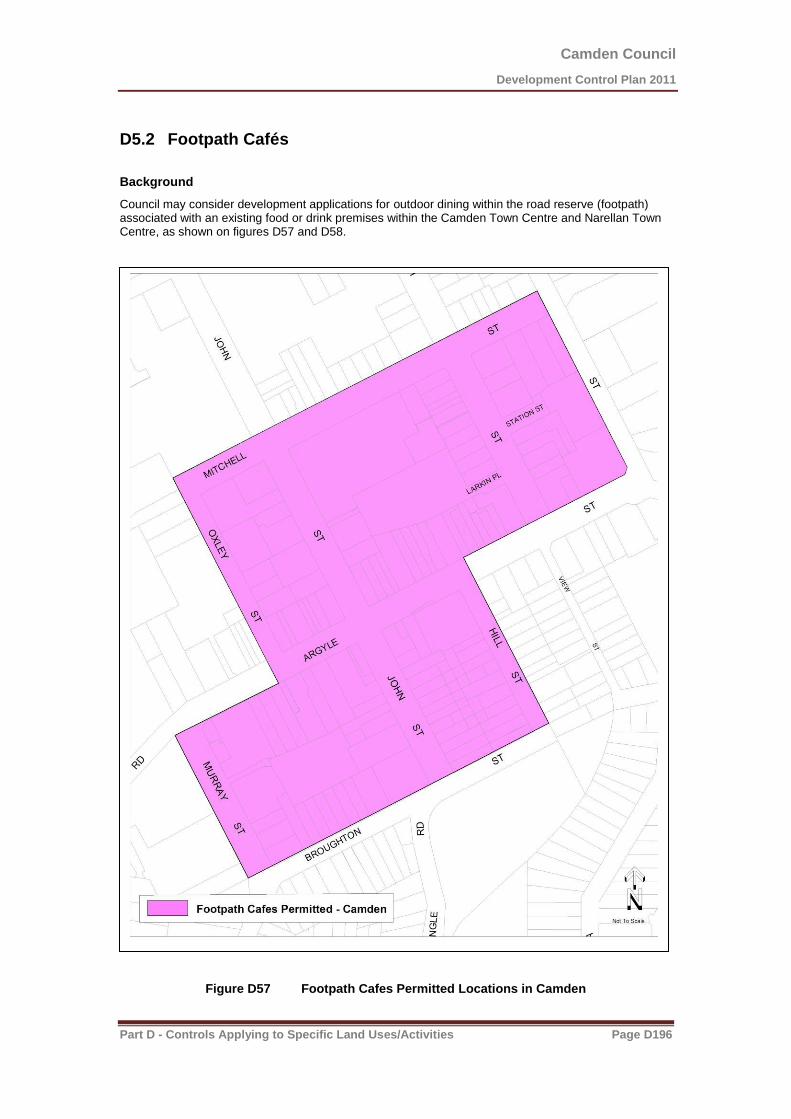
Camden Council
Development Control Plan 2011
Part D - Controls Applying to Specific Land Uses/Activities Page D196
D5.2 Footpath Cafés
Background
Council may consider development applications for outdoor dining within the road reserve (footpath) associated with an existing food or drink premises within the Camden Town Centre and Narellan Town Centre, as shown on figures D57 and D58.
Figure D57 Footpath Cafes Permitted Locations in Camden
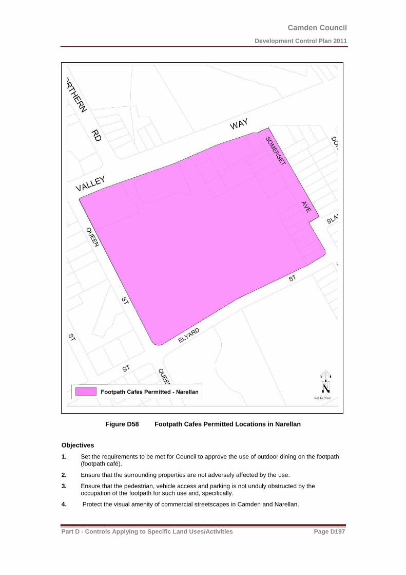
Camden Council
Development Control Plan 2011
Part D - Controls Applying to Specific Land Uses/Activities Page D197
Figure D58 Footpath Cafes Permitted Locations in Narellan
Objectives
1. Set the requirements to be met for Council to approve the use of outdoor dining on the footpath (footpath café).
2. Ensure that the surrounding properties are not adversely affected by the use.
3. Ensure that the pedestrian, vehicle access and parking is not unduly obstructed by the occupation of the footpath for such use and, specifically.
4. Protect the visual amenity of commercial streetscapes in Camden and Narellan.

Camden Council
Development Control Plan 2011
Part D - Controls Applying to Specific Land Uses/Activities Page D198
5. Ensure that food served in an outdoor environment is properly and safely delivered to the consumer, and that domestic pets are excluded from the dining area, as required by the NSW Food Authority and the provisions of the Food Act.
Controls
Footpath Requirement
1. The minimum width of a footpath for the purpose of operating a footpath café and pedestrian pathway shall be 3.6m.
A Footpath Cafe Layout
2. Generally the maximum width of the footpath café shall be 1.5 metres.
3. The footpath café shall be located adjacent to the associated shop front.
4. A distance of 2 metres for pedestrian passage must be maintained between outdoor seating and the kerb line.
5. Clear passage of access must be provided to the subject shop and to adjoining premises.
6. The locating of outdoor furniture must take into account all existing street furniture including service pits and allow for the manoeuvring around and use of these items.
7. The footpath café must be suitably enclosed by boundary furniture to confine and provide a safety barrier for the visual impaired.
8. Footpath café areas are to be identified by appropriate markings on the footpath approved by Council.
9. Where footpaths are substantially wider than 3.6m, areas other than adjacent to the shopfront may be considered. i.e. corners of Argyle and John Streets.
10. At no time shall the outdoor furniture be located outside of the approved and marked footpath café area.
11. The position of the footpath café must maintain direct pedestrian passage from the adjoining footpath.
12. There must be 0.5 metre setback from any adjoining premises door opening.
13. The footpath café should only accommodate a maximum of one table and three chairs for every 2 metres in length.
14. If a driveway adjoins the subject premises, an added setback of 1.0 metre shall be provided.
15. The footpath café should be arranged with due regard to its relationship to both the road and the indoor area of the premises. It should be visible from the indoor section of the premises, and it should be clear which establishment the footpath café is associated with. It should not obstruct access to the indoor areas, nor should it inhibit access for persons with a disability by blocking ramps or restricting the width of doorways.
16. Footpath cafés areas shall not encroach on the frontages of adjoining premises unless written consent is obtained. It must not interfere with the circulation of pedestrians around the frontage of adjoining premises. Council will not grant consent for an outdoor seating area if there is an expectation that its presence will interfere with the business of adjoining premises.
Conducting Business
17. Hours of operation for the footpath café shall be restricted to the approved hours of the associated restaurant/premises.
18. All outdoor furniture, including the boundary furniture, shall be removed from the footpath when the associated restaurant/premises is closed.
19. The use of the area shall not give rise to any nuisance to adjoining properties or an offensive noise as defined in the POEO Act. Amplified music is not allowed to be played within the footpath café.
20. No entertainment shall be permitted within the area of the footpath café without the consent of Camden Council.
21. The proprietor shall take all reasonable precautions to ensure the good conduct of employees and patrons of the footpath café.

Camden Council
Development Control Plan 2011
Part D - Controls Applying to Specific Land Uses/Activities Page D199
22. Tables, chairs, planters and other furniture must be kept clear of all required fire exits of the premise or of adjoining premises.
23. All outdoor furniture, facilities and the pavement shall be kept at all times clean and free from food scraps, cigarette butts, refuse and disfigurement etc.
24. No outdoor furniture other than that already approved by Council is permitted within the area of the footpath café. Any additional furniture and or awning blinds will require a further development application.
25. The outdoor furniture area shall not be used for purposes other than a footpath café.
26. Food must not be cooked or prepared in the outdoor footpath café.
27. Any rubbish which is collected from the land must be disposed of in accordance with Council directions and not to street bins.
28. The footpath cafe is required to be approved by Council every three years, in accordance with Section 125 of the Roads Act, the requirements of Section 68 of the Local Government Act.
29. The applicant is responsible for obtaining and maintaining for the approval period, a current public liability risk insurance policy for the sum of $10,000,000 which covers public liability from actions associated with footpath trading. The policy is to indemnify Council against any public liability action within areas between the front property boundary of the shop and the kerb line of the street for the full frontage of the shop premises.
Furniture
30. All furniture must be of sturdy construction and suitable for outdoor use.
31. All furniture must be of a high standard and aesthetic quality and must be kept clean and well maintained. Any damaged furniture shall be replaced straight away. Seats should be of metal frame construction or other suitable material. The furniture must not be of lightweight construction so as not to move in strong winds. Tables must be of a size no larger then 0.8 metres in width for a square table or 0.8 metre in diameter for a round table.
32. Umbrellas may be permitted, subject to merit. To minimise the risk to public safety, umbrellas and shall have a minimum height of 2.2 metres and must be anchored in an appropriate manner. The device used to anchor the umbrella should not present a trip hazard to patrons or pedestrians. Means of anchoring must be specified in the development application.
33. Applicants should select a single style and colour scheme for tables, chairs, umbrellas and edge furniture to provide consistency and identity. Details of furniture (including pictures) should be submitted with the development application.
34. The use of heaters is permitted when they have been approved as part of the furniture nominated in the development application. All heaters must be designed for outdoors use, freestanding and not require the use of additional electrical wiring over the footpath. They must be well maintained, stable and must be located at all times within the approved footpath café area.
Boundary Furniture
35. The boundary furniture shall be of sturdy construction, a minimum of 0.6 metres high and complementary in colour to the outdoor furniture and the surrounding area. (Note: The common type of boundary furniture is the metal frame with canvas centre.) The boundary furniture should have no sharp edges and any protruding feet must be contained wholly within the marked footpath café. All possible attempts should be made to reduce any probable hazards to pedestrians or patrons.
36. Planter boxes may be used as a substitute for metal frame boundary furniture, subject to compliance with the above controls.
Advertising
37. Advertising will be permitted on approved umbrellas and boundary furniture, but not on any other furniture, including tables, seating, or planter boxes.
38. No ‘A’ frames, sandwich boards or pedestal menu boards are permitted to be placed outside the premises or located within the footpath cafe.
39. Advertising on umbrellas must be restricted to two (2) logos or names on the entire surface.

Camden Council
Development Control Plan 2011
Part D - Controls Applying to Specific Land Uses/Activities Page D200
Further information:
NSW Food Authority and Food Act
Council’s Food Premises Code
Local Government Act
Roads Act
Protection of the Environment Operations Act
Liquor Act

Camden Council
Development Control Plan 2011
Part D - Controls Applying to Specific Land Uses/Activities Page D201
D5.3 Restricted Premises
Background
Note: LEP 2010 contains the definition of a restricted premises and clause 7.7 provides requirements regarding the location of restricted premises.
Objectives
1. Ensure that the amenity and safety of a particular area is not overly compromised by the implementation of a restricted premise.
Controls
1. Development for the purpose of restricted premises must be designed to minimise any impact on the surrounding area with regards to the appearance of the building or premises, the appearance and content of signage and advertising, and the location and intensity of external lighting.
2. Development applications seeking consent for restricted premises must include:
(a) A description of all materials, articles, compounds, preparations and the like to be offered for sale.
(b) The size, form or shape, illumination and position, colour and content of any proposed business identification sign, street number, advertisement or promotional device to be erected or displayed.
(c) Details of the existing and proposed external lighting.
(d) A specified operator, which must be named on the application.
3. All proposals must comply with section B1.8 of this DCP with regard with Trial Periods.
Further Information
Additional controls applying to restricted premises are located within the following legislation:
Pt 16 s 578(E)(2) of the Crimes Act.
Section 49, No.63 of the Classification (Publications, Films and Computer Games) Enforcement Act.
Camden Council
Development Control Plan 2011
Part D - Controls Applying to Specific Land Uses/Activities Page D202
D5.4 Sex Service Premises
Objectives
1. Provide appropriate planning controls relating to the use of a building or place as a sex service premise.
2. Ensure that sex service premises do not adversely affect the amenity of land used for educational, recreational, residential, service industrial, business, cultural or community purposes.
3. Ensure that sex service premises will not have adverse impacts on the community.
Controls
Note: The land use table and Clause 7.6 in LEP 2010 provides statutory land use controls for sex services premises in the Camden LGA.
1. Development for the purpose of a sex service premise must not be carried out if the building or place is adjacent to any property used or partly used for residential purposes.
2. Sex services premises must not be located near, or within view from a place of public worship, child care centre, hospital, community facility, school, public open space, residential development or any place regularly frequented by children for educational, recreational or cultural activities.
3. The operation of the sex service premise must not affect the amenity of the surrounding neighbourhood because of its size, operating hours, number of employees or clients.
4. The entrance to and exit from a sex service premise is not to be within view of any place regularly frequented by children.
5. A suitable waiting area is to be provided in the sex service premise so as to prevent clients loitering outside the building.
6. The operator of a sex service premise shall ensure proper conduct of patrons exiting the building.
7. Sex workers must not display themselves in windows or doorways of the sex service premise or outside such buildings.
8. The NSW Department of Health should be contacted in regard to relevant health standards for the operation of a sex service premise.
9. Advertising signs and structures are to be discreet and inoffensive. No signs may display words or images, which are in the opinion of the Council, sexually explicit, lewd or otherwise offensive.
10. Any sign should not exceed 0.3m x 0.6m in size (or other dimensions, but of equivalent surface area), and identifies only the name of the person who conducts the business or the registered name of the business.
11. All buildings used as a sex service premise must be fitted with the necessary services and facilities which are currently required for Class 5 buildings (an office building used for professional or commercial purposes) under the Building Code of Australia.
12. The development application must specify the name and residential address of the person responsible for operating the sex service premise. If development consent is granted, a condition of any consent will require written notification to Council of a change of name or address of the nominated operator.
13. All proposals must comply with section B1.8 of this DCP with regard with Trial Periods.
14. In determining a development application for sex services premises, Council consider:
(a) whether or not the operation of the sex service premise is likely to cause disturbance in thearea when taking into account other sex service premises operating in the area or other land uses within the area involving similar hours of operation;
(b) the design and external appearance of the building and any associated structure and their impact on the character of the surrounding built environment;
Camden Council
Development Control Plan 2011
Part D - Controls Applying to Specific Land Uses/Activities Page D203
(c) the content, illumination, size and shape or any advertisement and distinctive external lighting;
(d) the operation of the sex service premise is likely to cause a disturbance in the area because of its size, operating hours, number of employees or clients.
D5.5 Exhibition Homes and Villages
Background
Exhibition homes and exhibition villages are a way for homebuilders to display finished dwellings within a residential environment. During their use as exhibition homes & exhibition villages there is a potential for significant traffic generation, particularly on weekends. The exhibition homes can eventually be sold for use as dwellings and become part of the residential environment.
Objectives
1. Ensure that exhibition homes and exhibition villages operate with minimal impact on the surrounding residential area.
2. Ensure that exhibition homes and exhibition villages operate for a limited time after which they cease to operate.
3. Ensure that exhibition homes and exhibition villages revert to a conventional residential environment.
Controls
Subdivision, Frontage and Lot Sizes
1. Any subdivision of land shall be in accordance with the requirements for dwellings in LEP 2010.
2. Any proposed street with an exhibition village may be held as one lot within the development until the cessation of the operation of the exhibition village. Subdivision must be completed prior to use as a separate dwelling.
Site Location
3. Exhibition homes/ exhibition villages should be located:
(a) close to classified roads or sub classified roads.
(b) where vehicular access is from a collector street.
(c) on streets with widths that permit adequate safe manoeuvrability of vehicles and lines of sight for pedestrians, cyclists and vehicles.
(d) where traffic control devices do not impede vehicular access to and from the site.
4. Exhibition homes/ exhibition villages shall not be permitted:
(a) where access is from a street with a carriageway width of less than 6.5m.
(b) on streets which are cul-de-sacs.
Car Parking
5. Car parking for exhibition homes shall be provided off street. However, on-street car parking may be considered where there are no privately occupied dwellings opposite or adjoining the individual exhibition homes.
6. Internal streets may be closed out of hours of operation only where the streets are not yet dedicated as public roads.
Amenities and Environmental Impact
7. During the operation of an exhibition home/ exhibition village additional measures to maintain the privacy of adjoining residential development may be required.
8. The hours of operation shall be limited to 7am to 7pm each day.
Camden Council
Development Control Plan 2011
Part D - Controls Applying to Specific Land Uses/Activities Page D204
9. Buildings used for such uses as providing home finance, materials display or take-away food and the like shall cease to operate when the exhibition home/ exhibition village ceases.
10. Temporary buildings used for providing home finance, materials display or take-away food shall be removed and the site made good.
11. When the use of the dwelling ceases to be an exhibition home, any garage that has been used as a sales office is to be reinstated as a functioning garage with an appropriate garage door and associated driveway, prior to the occupation of the dwelling for residential purposes.
12. When the exhibition village/home ceases to operate, all signs and structures etc associated with the exhibition home/village shall be removed to ensure the site has a residential appearance.
13. Security lighting shall be provided in such a way to minimise any adverse impact on adjoining residential areas.
14. The operation of the exhibition village (including the use of designated off-street car parks) shall not cause offensive noise or affect the acoustic amenity of adjoining residents.
Waste Management
15. Waste disposal facilities shall be provided for development. These shall be located adjacent to the driveway entrance to the site.
16. Any structure involving waste disposal facilities shall be located as follows:
(a) setback one metre from the front boundary to the street.
(b) landscaped between the structure and the front boundary and adjoining areas to minimise the impact on the streetscape.
(c) not be located adjacent to an adjoining residential property.
Letterboxes and Numbering
17. Letterboxes shall be located along the front boundary and be clearly visible and accessible from the street.
18. The street number of a site must be visible from the street and made of a reflective material to allow visitors and emergency vehicles to easily identify the site.
Frontage Works and Damage to Council Assets
19. Where a footpath, road shoulder or new or enlarged access driveway is required to be provided this shall be provided at no cost to Council.
20. Council must be notified of any works that may threaten Council assets. Council must give approval for any works involving Council infrastructure.
21. Where there are no existing street trees in front of the site and contributions have not been collected for street tree planting, it may be a condition of consent that street trees be provided in the footpath area immediately in front of the site.
Acoustic Amenity
22. Dwellings located near future sources of noise are to incorporate appropriate noise attenuation measures when designed and constructed, to ensure that future residents are afforded an appropriate level of amenity.
Signage
23. Refer to section B4.8 in this DCP for signage controls for Exhibition Homes and Villages.
D5.6 Home Business& Home Industry
Background
Note: LEP 2010 contains the definition of home business and home industry and clause 5.4 provides requirements regarding these uses.

Camden Council
Development Control Plan 2011
Part D - Controls Applying to Specific Land Uses/Activities Page D205
Objectives
To allow for occupations or suitable low scale business activities to be conducted from houses or ancillary buildings in residential and rural areas, where the scale of the business does not interfere with the amenity of neighbouring properties.
Controls
1. Council shall not consent to an application for the purpose of a home business, unless it is demonstrated that the home business:
a) does not involve the employment of more than two persons other than those residents; b) does not take up floor space of more than 50m
2 in the dwelling or ancillary building. The use of
land (for storage purposes, etc.) external to a dwelling or an outbuilding for home business purposes will not be permitted;
c) does not interfere with the amenity of the locality because of the emission of noise, vibration, smell, fumes, smoke, vapour, steam, soot, ash, dust, waste, water, waste products, grit or oil or otherwise;
d) does not involve exposure to view from any adjacent premises or from any public space of any unsightly matter, goods or products;
e) does not give rise to traffic levels out of keeping with those of the surrounding locality; f) maintains existing parking spaces for residential use on site and business car parking be
provided off street in accordance with Table B8 of this DCP; g) has hours of operation should be restricted to the following , unless it can be demonstrated that
operation outside of these hours will not adversely affect the amenity of adjoining dwellings or the neighbourhood; i. 8.30am and 5.30pm, Monday to Friday; ii. 8.30pm to 12 noon Saturdays; iii. no work to be conducted on Sundays or public holidays, unless it can be demonstrated
that operation outside of these hours will not adversely affect the amenity of adjoining dwellings or the neighbourhood;
h) will not involve deliveries and loading/unloading activities outside of approved hours of operation;
i) All signage shall comply with Part B4 of the DCP. If signage is to be associated with the home business which will:
i. not exceed a maximum area of 0.72m2;
ii. be attached to the dwelling-house, letter box, front gate or the like; iii. only indicate the name and occupation of the resident; iv. not detract from the residential character of amenity of the area; and v. will only involve retailing of products which are ancillary to the home business and will not
adversely impact on the amenity of the locality in terms of traffic generation and pedestrian movement.
j) Development Applications for skin preparation, must comply with the Skin Penetration Guidelines (Public Health Regulations 2000) and Skin Penetration Code of Best Practice. Applications for the food manufacturing, must demonstrate compliance with the Food Act and Regulations incorporating the Food Standards Code and Camden Council’s Food Premises Code. Any application must submit plans and supporting documentation that demonstrate compliance with these polices.
k) a Statement of Environmental Effects must be submitted for all types of home business applications, they must outline the overall operation of the proposal.
l) but does not include bed and breakfast accommodation, home occupation (sex services) or sex services premises.
Trial Period
2 In the event that Council grants development consent for a home business, Council may include as
a condition of consent, a condition which limits the duration of the consent to a maximum 12 month period after which a further development application is required to continue the use beyond that date. Council, in determining any further application, will have regard to the operation of the use within the preceding 12 month period.

Camden Council
Development Control Plan 2011
Part D - Controls Applying to Specific Land Uses/Activities Page D206
D5.7 Domestic Solid Fuel Burning Appliances (Wood Fired Heaters)
Objectives
To allow for Domestic Solid Fuel Burning Appliances (Wood Fired Heaters) that are installed appropriately and will not have an adverse impact on air quality or the amenity of the surrounding residential neighbourhood.
Controls
Must be installed in accordance with the Building Code of Australia and the relevant Australian Standards (includes 4grams per kilogram of fuel burnt)
Note: Heaters with a 1gram per kilogram emissions rate or less and an efficiency rating of 65% or
greater are preferred as they have a lower impact on air quality