Embed Size (px)
Citation preview
348
50 CFR Ch. IV (10–1–13 Edition) § 403.08
(3) If within 90 days after notice is provided under paragraph (a)(2) of this section, the state has not taken such remedial measures as are necessary, in the judgment of the Service, to bring the state management program into compliance with the provision of the Act, this part and the state’s approved management program, the Service shall revoke the transfer of manage-ment authority by written notice to the state and publication in the FED-ERAL REGISTER.
(b) Voluntary return of management authority to the Service. (1) If a state de-sires to return management of a spe-cies of marine mammals to the Serv-ice, it shall provide the Service notice of intent to return management. The Service shall accept the return of man-agement, and such return shall become effective, upon publication of a notice in the FEDERAL REGISTER to this effect no sooner than 30 days (except in an emergency as determined by the Serv-ice) nor longer than 60 days after the state has provided notice of its intent to return management or unless other-wise agreed upon.
(2) If implementation of any aspect of the state management program is en-joined by court order, the state shall advise the Service of such injunction and its effect on the state management program. If the state determines that the effect of the injunction is to pre-clude effective conservation and man-agement of the species under the terms of the state management program, it shall so notify the Service and such no-tification shall be treated as a notice of intent to return management as pro-vided in paragraph (b)(1) of this sec-tion. If the state determines that the injunction does not preclude effective conservation and management of ma-rine mammals under the terms of the state management program, it shall so notify the Service together with the basis for the state’s determination and such notice shall be treated as a report submitted pursuant to the terms of § 403.06(c)(1) of this part. In either case, the state shall provide notice to the Service as soon as practicable but not more than 30 days after issuance of the injunction. Management authority re-turned to the Service pursuant to this paragraph may be re-transferred to the
state, notwithstanding the require-ments of § 403.03, when, in the judgment of the Service, the cause for return of management authority to the Service has been alleviated in such a way as to allow effective conservation and man-agement of the species consistent with the requirements of the Act and this part.
(c) When revocation of a manage-ment authority pursuant to paragraph (a) of this section becomes final, or when a state returns management pur-suant to paragraph (b) of this section, the Service shall resume such manage-ment authority and provide for the conservation of the species within the state in accordance with the provisions of the Act.
§ 403.08 List of States to which man-agement has been transferred.
The following states have received management authority pursuant to this part for the species listed and, where appropriate, cooperative alloca-tion agreements pursuant to § 403.05(c) are in force: [Reserved]
PART 404—NORTHWESTERN HA-WAIIAN ISLANDS MARINE NA-TIONAL MONUMENT
Sec. 404.1 Scope and purpose. 404.2 Boundary. 404.3 Definitions. 404.4 Access to the Monument. 404.5 Requirements for a vessel monitoring
system. 404.6 Prohibited activities. 404.7 Regulated activities. 404.8 Emergencies and law enforcement ac-
tivities. 404.9 Armed Forces actions. 404.10 Commercial fishing. 404.11 Permitting procedures and criteria. 404.12 International law.
APPENDIX A TO PART 404—MAP OF THE MONU-MENT OUTER BOUNDARY AND ECOLOGICAL RESERVES, SPECIAL PRESERVATION AREAS, AND MIDWAY ATOLL SPECIAL MANAGE-MENT AREA
APPENDIX B TO PART 404—APPROVED VESSEL MONITORING SYSTEMS
APPENDIX C TO PART 404—BOUNDARY COORDI-NATED FOR PAPAHANAUMOKUAKEA MARINE NATIONAL MONUMENT AREAS TO BE AVOIDED
APPENDIX D TO PART 404—BOUNDARY COORDI-NATES FOR PAPAHANAUMOKUAKEA MARINE
VerDate Mar<15>2010 15:29 Dec 13, 2013 Jkt 229237 PO 00000 Frm 00358 Fmt 8010 Sfmt 8010 Q:\50\50V11.TXT ofr150 PsN: PC150
349
FWS, DOI, and NOAA, Commerce § 404.3
NATIONAL MONUMENT SHIP REPORTING AREA
APPENDIX E TO PART 404—CONTENT AND SYN-TAX FOR PAPAHANAUMOKUAKEA SHIP RE-PORTING SYSTEM
AUTHORITY: 16 U.S.C. 431 et seq.; 16 U.S.C. 460k–3; 16 U.S.C. 1801 et seq.; 16 U.S.C. 742f, 16 U.S.C. 742l, and 16 U.S.C. 668dd–ee; 16 U.S.C. 1361 et seq.; 16 U.S.C. 1531 et seq., Pub. L. No. 106–513, § 6(g) (2000).
SOURCE: 71 FR 51135, Aug. 29, 2006, unless otherwise noted.
§ 404.1 Scope and purpose.
The regulations in this part codify the provisions of Presidential Procla-mation 8031, and govern the adminis-tration of the Northwestern Hawaiian Islands Marine National Monument. These regulations are jointly imple-mented by the Secretaries of the Inte-rior, through the U.S. Fish and Wildlife Service (USFWS), and Commerce, through the National Oceanic and At-mospheric Administration (NOAA). Nothing in these regulations shall be deemed to diminish or enlarge the ju-risdiction of the State of Hawaii.
§ 404.2 Boundary.
The Northwestern Hawaiian Islands Marine National Monument consists of all lands and interest in lands owned or controlled by the Government of the United States within the boundaries of the Monument, including emergent and submerged lands and waters of the Northwestern Hawaiian Islands. The map in Appendix A to this part 404 de-picts the outer boundary of the Monu-ment, which consists of the geodetic lines connecting the coordinates speci-fied in the Proclamation.
§ 404.3 Definitions.
The following definitions are applica-ble only to this Part.
Areas to be avoided means the four designated areas that should be avoid-ed by vessels that are conducting pas-sage through the Monument without interruption. Appendix C sets forth the coordinates of these areas.
Attract or Attracting means luring or attempting to lure a living resource by any means, except the mere presence of human beings (e.g., swimmers, divers, boaters).
Bottomfish Species means Bottomfish management unit species as defined at 50 CFR 665.12.
Categories of hazardous cargoes means goods classified in the International Maritime Dangerous Goods (IMDG) Code; substances classified in chapter 17 of the International Code for the Construction and Equipment of Ships Carrying Dangerous Chemicals in Bulk (IBC Code) and chapter 19 of the Inter-national Code for the Construction and Equipment of Ships Carrying Liquefied Gases in Bulk (IGC Code); oils as de-fined in MARPOL Annex I; noxious liq-uid substances as defined in MARPOL Annex II; harmful substances as de-fined in MARPOL Annex III; and radio-active materials specified in the Code for the Safe Carriage of the Irradiated Nuclear Fuel, Plutonium and High- Level Radioactive Wastes in Flasks on Board Ships (INF Code).
Commercial Bottomfishing means com-mercial fishing for bottomfish species.
Commercial passenger vessel means a vessel that carries individuals who have paid for such carriage.
Commercial pelagic trolling means commercial fishing for pelagic species.
Deserting a vessel means: (1) Leaving a vessel aground or
adrift: (i) Without notifying the Secretaries
of the vessel going aground or adrift within 12 hours of its discovery and de-veloping and presenting to the Secre-taries a preliminary salvage plan with-in 24 hours of such notification;
(ii) After expressing or manifesting intention to not undertake or to cease salvage efforts; or
(iii) When the Secretaries are unable, after reasonable efforts, to reach the owner/operator within 12 hours of the vessel’s condition being reported to au-thorities.
(2) Leaving a vessel at anchor when its condition creates potential for a grounding, discharge, or deposit and the owner/operator fails to secure the vessel in a timely manner.
Ecological Reserve means the areas of the Monument, identified in the Proc-lamation, consisting of contiguous, di-verse habitats that provide natural spawning, nursery, and permanent resi-dence areas for the replenishment and genetic protection of marine life, and
VerDate Mar<15>2010 15:29 Dec 13, 2013 Jkt 229237 PO 00000 Frm 00359 Fmt 8010 Sfmt 8010 Q:\50\50V11.TXT ofr150 PsN: PC150

350
50 CFR Ch. IV (10–1–13 Edition) § 404.3
also to protect and preserve natural as-semblages of habitats and species with-in areas representing a broad diversity of resources and habitats found within the Monument. Specific coordinates for Ecological Reserves within the Monu-ment are found in the Proclamation, and the Ecological Reserves consist of the areas within the geodetic lines con-necting these coordinates. The Ecologi-cal Reserves are depicted on the map in Appendix A to part 404.
Ecological integrity means a condition determined to be characteristic of an ecosystem that has the ability to maintain the function, structure, and abundance of natural biological com-munities, including rates of change in response to natural environmental var-iation.
Fishing year means the year begin-ning at 0001 local time on January 1 and ending at 2400 local time on De-cember 31.
IMO means the International Mari-time Organization.
Introduced Species means: (1) A species (including, but not lim-
ited to, any of its biological matter ca-pable of propagation) that is non-na-tive to the ecosystem(s) protected by the Monument; or
(2) Any organism into which genetic matter from another species has been transferred in order that the host orga-nism acquires the genetic traits of the transferred genes.
Landing means offloading fish from a fishing vessel or causing fish to be offloaded from a fishing vessel.
Midway Atoll Special Management Area means the area of the Monument sur-rounding Midway Atoll out to a dis-tance of 12 nautical miles, established for the enhanced management, protec-tion, and preservation of Monument wildlife and historical resources. The geographic coordinates of this area, which consists of the area within the geodetic lines connecting these coordi-nates, are found in the Proclamation. The Midway Atoll Special Management Area is depicted on the map in Appen-dix A to part 404.
Mobile transceiver unit means a vessel monitoring system or VMS device, as described in Appendix E to this Part, installed on board a vessel that is used for vessel monitoring and transmitting
the vessel’s position as required by this Part.
Monument means the Northwestern Hawaiian Islands Marine National Monument.
Native Hawaiian Practices means cul-tural activities conducted for the pur-poses of perpetuating traditional knowledge, caring for and protecting the environment and strengthening cultural and spiritual connections to the Northwestern Hawaiian Islands that have demonstrable benefits to the Native Hawaiian community. This may include, but is not limited to, the non- commercial use of Monument resources for direct personal consumption while in the Monument.
Ocean-based ecotourism means a class of fee-for-service activities that in-volves visiting the Monument for study, enjoyment, or volunteer assist-ance for purposes of conservation and management.
Office for Law Enforcement (OLE) re-fers to NOAA, National Marine Fish-eries Service, Office for Law Enforce-ment.
Pelagic Species means Pacific Pelagic Management Unit Species as defined at 50 CFR 665.12.
Pono means appropriate, correct, and deemed necessary by traditional stand-ards in the Hawaiian culture.
Proclamation means Presidential Proclamation 8031, dated June 15, 2006 (71 FR 36443).
Recreational activity means an activ-ity conducted for personal enjoyment that does not result in the extraction of Monument resources and that does not involve a fee-for-service trans-action. This includes, but is not lim-ited to, wildlife viewing, SCUBA div-ing, snorkeling, and boating.
Reporting area means the area within the coordinates set forth in Appendix D.
Secretaries means the Secretary of Commerce and the Secretary of the In-terior or their designees.
Special Preservation Area (SPA) means discrete, biologically important areas of the Monument, identified in the Proclamation, within which uses are subject to conditions, restrictions, and prohibitions, including but not limited to access restrictions. SPAs are used to avoid concentrations of uses that could
VerDate Mar<15>2010 15:29 Dec 13, 2013 Jkt 229237 PO 00000 Frm 00360 Fmt 8010 Sfmt 8010 Q:\50\50V11.TXT ofr150 PsN: PC150

351
FWS, DOI, and NOAA, Commerce § 404.4
result in declines in species popu-lations or habitat, to reduce conflicts between uses, to protect areas that are critical for sustaining important ma-rine species or habitats, or to provide opportunities for scientific research. Specific coordinates for Special Preser-vation Areas within the Monument are found in the Proclamation, and the Special Preservation Areas consist of the areas within the geodetic lines con-necting these coordinates. The Special Preservation Areas are depicted on the map in Appendix A to part 404.
Special ocean use means an activity or use of the Monument that is engaged in to generate revenue or profits for one or more of the persons associated with the activity or use, and does not de-stroy, cause the loss of, or injure Monument resources. This includes ocean-based ecotourism and other ac-tivities such as educational and re-search activities that are engaged in to generate revenue, but does not include commercial fishing for bottomfish or pelagic species conducted pursuant to a valid permit issued by NOAA.
Stowed and not available for immediate use means not readily accessible for immediate use, e.g., by being securely covered and lashed to a deck or bulk-head, tied down, unbaited, unloaded, or partially disassembled (such as spear shafts being kept separate from spear guns).
Sustenance fishing means fishing for bottomfish or pelagic species in which all catch is consumed within the Monu-ment, and that is incidental to an ac-tivity permitted under this part.
Vessel monitoring system or VMS means a vessel monitoring system or mobile transceiver unit as described in § 404.5 and approved by Office for Law Enforcement for use on vessels per-mitted to access the Monument, as re-quired by this Part.
[71 FR 51135, Aug. 29, 2006, as amended at 73 FR 73598, Dec. 3, 2008]
§ 404.4 Access to Monument.
(a) Entering the Monument is prohib-ited and thus unlawful except:
(1) As provided in §§ 404.8 and 404.9; (2) Pursuant to a permit issued under
§§ 404.10 or 404.11; or
(3) When conducting passage without interruption in accordance with para-graphs (b) through (f) of this section.
(b) Any person passing through the Monument without interruption is sub-ject to the prohibitions in §§ 404.5, 404.6, and 404.7.
(c) The following vessels, except ves-sels entitled to sovereign immunity under international law, passing through the Monument without inter-ruption must participate in the ship re-porting system as provided in para-graphs (d) and (e) of this section:
(1) Vessels of the United States, ex-cept as provided in paragraph (f) of this section;
(2) All other ships 300 gross tonnage or greater, entering or departing a United States port or place; and
(3) All other ships in the event of an emergency, entering or departing a United States port or place.
(d) Immediately upon entering the reporting area, the vessels described in paragraph (c) of this section must pro-vide the following information by e- mail sent to [email protected] in the IMO standard reporting format and data syntax shown in Appendix E:
(1) Vessel name, call sign or ship sta-tion identity, flag, and IMO identifica-tion number if applicable, and either Federal documentation or State reg-istration number if applicable.
(2) Date, time (UTC) and month of entry.
(3) Position. (4) True course. (5) Speed in knots and tenths. (6) Destination and estimated time of
arrival. (7) Intended route through the Monu-
ment and the reporting area. (8) Vessel draft (in meters). (9) Categories of hazardous cargoes
on board. (10) Any vessel defects or deficiencies
that restrict maneuverability or im-pair normal navigation.
(11) Any pollution incident or goods lost overboard within the Monument, the reporting area, or the U.S. EEZ.
(12) Contact information for the ves-sel’s agent or owner.
(13) Vessel size (length overall, gross tonnage) and type.
VerDate Mar<15>2010 15:29 Dec 13, 2013 Jkt 229237 PO 00000 Frm 00361 Fmt 8010 Sfmt 8010 Q:\50\50V11.TXT ofr150 PsN: PC150
352
50 CFR Ch. IV (10–1–13 Edition) § 404.5
(14) Total number of persons on board.
(e) Immediately upon leaving the re-porting area, the vessels described in paragraph (c) must provide the fol-lowing information by e-mail sent to [email protected] in the IMO standard reporting format and data syntax shown in Appendix E:
(1) Vessel name, call sign or ship sta-tion identity, flag, and IMO identifica-tion number if applicable, and either Federal documentation or State reg-istration number if applicable.
(2) Date, time (UTC) and month of exit.
(3) Position. (4) Any pollution incident or goods
lost overboard within the Monument, the reporting area, or the U.S. EEZ.
(f)(1) Vessels of the United States less than 300 gross tonnage that are not equipped with onboard e-mail capa-bility must provide notification of entry and the information described in paragraphs (d)(1), (2), (3) as applicable, (6), (7), (8), (9) as applicable, (10), (12), (13), and (14) of this section at least 72 hours, but no longer than 1 month, prior to the entry date. Notification of departure from the Monument and the information described in paragraph (e) of this section must be provided within 12 hours of leaving. Notification under this paragraph may be made by e-mail, telephone, or fax, by contacting: (i) E- mail: [email protected];
(ii) Telephone: 1–866–478–NWHI (6944); (iii) Fax: 1–808–397–2662. (2) The information must be provided
in the IMO standard reporting format and data syntax shown in Appendix E.
(g) All vessels passing through the Monument without interruption other than those described in paragraphs (c)(1) through (3) of this section should participate in the ship reporting sys-tem set forth in paragraphs (d) and (e) of this section.
[73 FR 73598, Dec. 3, 2008]
§ 404.5 Requirements for a vessel mon-itoring system.
(a) Requirement for use. Effective Au-gust 28, 2006, an owner or operator of a vessel that has been issued a permit for accessing the Monument must ensure that such vessel has an OLE-approved, operating VMS on board when
voyaging within the Monument. An op-erating VMS includes an operating mo-bile transmitting unit on the vessel and a functioning communication link between the unit and OLE as provided by an OLE-approved communication service provider. Appendix B to this part 404 provides information regarding OLE-approved transmitting units.
(b) Installing and activating the VMS. Only a VMS that has been approved by OLE may be used. When installing and activating the OLE-approved VMS, or when reinstalling and reactivating such VMS, the vessel owner or operator must:
(1) Follow procedures indicated on an installation and activation checklist, which is available from OLE; and
(2) Submit to OLE a statement certi-fying compliance with the checklist, as prescribed on the checklist.
(c) Interference with the VMS. No per-son may interfere with, tamper with, alter, damage, disable, or impede the operation of the VMS, or attempt any of the same.
(d) Interruption of operation of the VMS. When a vessel’s VMS is not oper-ating properly, the owner or operator must immediately contact OLE, and follow instructions from that office. If notified by OLE that a vessel’s VMS is not operating properly, the owner and operator must follow instructions from that office. In either event, such in-structions may include, but are not limited to, manually communicating to a location designated by OLE the vessel’s positions or returning to port until the VMS is operable.
(e) Access to position data. As a condi-tion of authorized access to the Monu-ment, a vessel owner or operator sub-ject to the requirements for a VMS in this section must allow OLE, the USCG, and their authorized officers and designees access to the vessel’s po-sition data obtained from the VMS. Consistent with other applicable laws, including the limitations on access to, and use of, VMS data collected under the Magnuson-Stevens Fishery Con-servation and Management Act, the Secretaries may have access to, and use of, collected data for scientific, sta-tistical, and management purposes.
VerDate Mar<15>2010 15:29 Dec 13, 2013 Jkt 229237 PO 00000 Frm 00362 Fmt 8010 Sfmt 8010 Q:\50\50V11.TXT ofr150 PsN: PC150

353
FWS, DOI, and NOAA, Commerce § 404.7
(f) Authority for installation and oper-ation. OLE has authority over the in-stallation and operation of the VMS unit. OLE may authorize the connec-tion or order the disconnection of addi-tional equipment, including a com-puter, to any VMS unit when deemed appropriate by OLE.
(g) Activities Regarding Vessel Moni-toring Systems. Effective August 28, 2006, the following activities regarding vessel monitoring systems are prohib-ited and thus unlawful for any person to conduct or cause to be conducted:
(1) Operating any vessel within the Monument without an OLE type-ap-proved mobile transceiver unit de-scribed in this section;
(2) Failing to install, activate, repair, or replace a mobile transceiver unit prior to leaving port;
(3) Failing to operate and maintain a mobile transceiver unit on board the vessel at all times as specified in this section;
(4) Tampering with, damaging, de-stroying, altering, or in any way dis-torting, rendering useless, inoperative, ineffective, or inaccurate the VMS, mobile transceiver unit, or VMS signal required to be installed on or trans-mitted by a vessel as specified in this section;
(5) Failing to contact OLE or follow OLE instructions when automatic posi-tion reporting has been interrupted as specified in this section;
(6) Registering a VMS or mobile transceiver unit to more than one ves-sel at the same time;
(7) Connecting or leaving connected additional equipment to a VMS unit or mobile transceiver unit without the prior approval of OLE; and
(8) Making a false statement, oral or written, to an authorized officer re-garding the installation, use, oper-ation, or maintenance of a VMS unit or mobile transceiver unit or communica-tion service provider.
§ 404.6 Prohibited activities.
The following activities are prohib-ited and thus unlawful for any person to conduct or cause to be conducted:
(a) Exploring for, developing, or pro-ducing oil, gas, or minerals within the Monument;
(b) Using or attempting to use poi-sons, electrical charges, or explosives in the collection or harvest of a Monu-ment resource;
(c) Introducing or otherwise releasing an introduced species from within or into the Monument; and
(d) Anchoring on or having a vessel anchored on any living or dead coral with an anchor, anchor chain, or an-chor rope.
§ 404.7 Regulated activities.
Except as provided in §§ 404.8, 404.9 and 404.10, the following activities are prohibited and thus unlawful for any person to conduct or cause to be con-ducted within the Monument without a valid permit as provided for in § 404.11:
(a) Removing, moving, taking, har-vesting, possessing, injuring, dis-turbing, or damaging; or attempting to remove, move, take, harvest, possess, injure, disturb, or damage any living or nonliving Monument resource;
(b) Drilling into, dredging, or other-wise altering the submerged lands other than by anchoring a vessel; or constructing, placing, or abandoning any structure, material, or other mat-ter on the submerged lands;
(c) Anchoring a vessel; (d) Deserting a vessel aground, at an-
chor, or adrift; (e) Discharging or depositing any ma-
terial or other matter into Special Preservation Areas or the Midway Atoll Special Management Area except vessel engine cooling water, weather deck runoff, and vessel engine exhaust;
(f) Discharging or depositing any ma-terial or other matter into the Monu-ment, or discharging or depositing any material or other matter outside the Monument that subsequently enters the Monument and injures any re-sources of the Monument, except fish parts (i.e., chumming material or bait) used in and during authorized fishing operations, or discharges incidental to vessel use such as deck wash, approved marine sanitation device effluent, cool-ing water, and engine exhaust;
(g) Touching coral, living or dead; (h) Possessing fishing gear except
when stowed and not available for im-mediate use during passage without interruption through the Monument;
VerDate Mar<15>2010 15:29 Dec 13, 2013 Jkt 229237 PO 00000 Frm 00363 Fmt 8010 Sfmt 8010 Q:\50\50V11.TXT ofr150 PsN: PC150
354
50 CFR Ch. IV (10–1–13 Edition) § 404.8
(i) Swimming, snorkeling, or closed or open circuit SCUBA diving within any Special Preservation Area or the Midway Atoll Special Management Area; and
(j) Attracting any living Monument resource.
§ 404.8 Emergencies and law enforce-ment activities.
The prohibitions in this part do not apply to activities necessary to re-spond to emergencies threatening life, property, or the environment, or to ac-tivities necessary for law enforcement purposes.
§ 404.9 Armed Forces actions. (a) The prohibitions in this part do
not apply to activities and exercises of the Armed Forces (including those car-ried out by the United States Coast Guard) that are consistent with appli-cable laws.
(b) These regulations shall not limit agency actions to respond to emer-gencies posing an unacceptable threat to human health or safety or to the marine environment and admitting of no other feasible solution.
(c) All activities and exercises of the Armed Forces shall be carried out in a manner that avoids, to the extent prac-ticable and consistent with operational requirements, adverse impacts on Monument resources and qualities.
(d) In the event of threatened or ac-tual destruction of, loss of, or injury to a Monument resource or quality result-ing from an incident, including but not limited to spills and groundings, caused by a component of the Depart-ment of Defense or the United States Coast Guard, the cognizant component shall promptly coordinate with the Secretaries for the purpose of taking appropriate actions to respond to and mitigate the harm and, if possible, re-store or replace the Monument re-source or quality.
§ 404.10 Commercial fishing. (a) Lobster fishing. Any commercial
lobster fishing permit is subject to a zero annual harvest limit condition.
(b) Fishing and bottomfish and pelagic species. (1) Notwithstanding the prohi-bitions in § 404.7(a) and (h), commercial fishing for bottomfish and associated
pelagic species may continue within the Monument subject to paragraph (c) of this section, until June 15, 2011, pro-vided that:
(i) The fishing is conducted in ac-cordance with a valid commercial bottomfish permit issued by NOAA; and
(ii) Such permit was in effect on June 15, 2006, and is subsequently renewed pursuant to NOAA regulations at 50 CFR part 665, subpart E as necessary.
(2) Total landings for each fishing year from fishing allowed under para-graph (b)(1) of this section may not ex-ceed the following amounts:
(i) 350,000 pounds for bottomfish spe-cies; and
(ii) 180,000 pounds for pelagic species. (3) Commercial fishing for bottomfish
and associated pelagic species is pro-hibited in the Monument after June 15, 2011.
(c) General requirements. Any commer-cial fishing within the Monument shall be conducted in accordance with the following restrictions and conditions:
(1) A valid permit or facsimile of a valid permit shall be on board the fish-ing vessel and available for inspection by an authorized officer;
(2) No attempt is made to falsify or fail to make, keep, maintain, or submit any logbook or logbook form or other required record or report.
(3) Only gear specifically authorized by the relevant permit issued under the Magnuson-Stevens Fishery Conserva-tion and Management Act is allowed to be in the possession of a person con-ducting commercial fishing under this section;
(4) Any person conducting commer-cial fishing notifies the Secretaries by telephone, facsimile, or electronic mail at least 72 hours before entering the Monument and within 12 hours after leaving the Monument in accordance with § 404.4(b) and (c);
(5) All fishing vessels must carry an activated and functioning VMS unit on board at all times whenever the vessel is in the Monument;
(6) All fishing vessels must carry an observer when requested to do so by the Secretaries;
(7) The activity does not take place within any Ecological Reserve, any
VerDate Mar<15>2010 15:29 Dec 13, 2013 Jkt 229237 PO 00000 Frm 00364 Fmt 8010 Sfmt 8010 Q:\50\50V11.TXT ofr150 PsN: PC150
355
FWS, DOI, and NOAA, Commerce § 404.11
Special Preservation Area, or the Mid-way Atoll Special Management Area.
§ 404.11 Permitting procedures and criteria.
(a) Issuance. Subject to such terms and conditions as the Secretaries deem appropriate, a person may conduct an activity prohibited by § 404.7 if such ac-tivity is specifically authorized by a permit issued under this section.
(b) Application requirements. Appli-cants for permits under this section shall submit applications to: North-western Hawaiian Islands Marine Na-tional Monument, 6600 Kalanianaole Highway, Suite 300, Honolulu, HI 96825.
(c) Permit Types. A permit under this subpart may be issued if the Secre-taries find that the activity:
(1) Is research designed to further un-derstanding of Monument resources and qualities;
(2) Will further the educational value of the Monument;
(3) Will assist in the conservation and management of the Monument;
(4) Will allow Native Hawaiian prac-tices subject to paragraph (e) of this section;
(5) Will allow a special ocean use sub-ject to paragraph (f) of this section; or
(6) Will allow recreational activities subject to paragraph (g) of this section.
(d) Findings. A permit may not be issued under this section unless the Secretaries find:
(1) The activity can be conducted with adequate safeguards for the re-sources and ecological integrity of the Monument;
(2) The activity will be conducted in a manner compatible with the purposes of the Proclamation, considering the extent to which the conduct of the ac-tivity may diminish or enhance Monu-ment resources, qualities, and ecologi-cal integrity, any indirect, secondary or cumulative effects of the activity, and the duration of such effects;
(3) There is no practicable alter-native to conducting the activity with-in the Monument;
(4) The end value of the activity out-weighs its adverse impacts on Monu-ment resources, qualities, and ecologi-cal integrity;
(5) The duration of the activity is no longer than necessary to achieve its stated purpose;
(6) The applicant is qualified to con-duct and complete the activity and mitigate any potential impacts result-ing from its conduct;
(7) The applicant has adequate finan-cial resources available to conduct and complete the activity and mitigate any potential impacts resulting from its conduct;
(8) The methods and procedures pro-posed by the applicant are appropriate to achieve the proposed activity’s goals in relation to their impacts to Monu-ment resources, qualities, and ecologi-cal integrity;
(9) The applicant’s vessel has been outfitted with a mobile transceiver unit approved by OLE and complies with the requirements of § 404.5; and
(10) There are no other factors that would make the issuance of a permit for the activity inappropriate.
(e) Additional findings for Native Ha-waiian practice permits. In addition to the findings listed in paragraph (d) of this section, a permit to allow Native Hawaiian practices under paragraph (c)(4) of this section, may not be issued unless:
(1) The activity is non-commercial and will not involve the sale of any or-ganism or material collected;
(2) The purpose and intent of the ac-tivity are appropriate and deemed nec-essary by traditional standards in the Native Hawaiian culture (pono), and demonstrate an understanding of, and background in, the traditional prac-tice, and its associated values and pro-tocols;
(3) The activity benefits the re-sources of the Northwestern Hawaiian Islands and the Native Hawaiian com-munity;
(4) The activity supports or advances the perpetuation of traditional knowl-edge and ancestral connections of Na-tive Hawaiians to the Northwestern Hawaiian Islands; and
(5) Any Monument resource har-vested from the Monument will be con-sumed in the Monument.
(f) Additional findings, criteria, and re-quirements for special ocean use permits. (1) In addition to the findings listed in
VerDate Mar<15>2010 15:29 Dec 13, 2013 Jkt 229237 PO 00000 Frm 00365 Fmt 8010 Sfmt 8010 Q:\50\50V11.TXT ofr150 PsN: PC150
356
50 CFR Ch. IV (10–1–13 Edition) § 404.11
paragraph (d) of this section, the fol-lowing requirements apply to the issuance of a permit for a special ocean use under paragraph (c)(5) of this sec-tion:
(i) Any permit for a special ocean use issued under this section:
(A) Shall authorize the conduct of an activity only if that activity is com-patible with the purposes for which the Monument is designated and with pro-tection of Monument resources;
(B) Shall not authorize the conduct of any activity for a period of more than 5 years unless renewed;
(C) Shall require that activities car-ried out under the permit be conducted in a manner that does not destroy, cause the loss of, or injure Monument resources; and
(D) Shall require the permittee to purchase and maintain comprehensive general liability insurance, or post an equivalent bond, against claims arising out of activities conducted under the permit and to agree to hold the United States harmless against such claims;
(ii) Each person issued a permit for a special ocean use under this section shall submit an annual report to the Secretaries not later than December 31 of each year which describes activities conducted under that permit and reve-nues derived from such activities dur-ing the year.
(2) In addition to the findings listed in paragraph (d) of this section, a per-mit may not be issued for a special ocean use unless the activity has been determined to be consistent with the findings made pursuant to paragraph (f) of this section.
(3) Categories of special ocean use being permitted for the first time under this section will be restricted in duration and permitted as a special ocean use pilot project. Subsequent permits for any category of special ocean use may only be issued if a spe-cial ocean use pilot project for that category meets the requirements of this section, and any terms and condi-tions placed on the permit for the pilot project.
(4) Public notice shall be provided prior to requiring a special ocean use permit for any category of activity not previously identified as a special ocean use.
(5) The following requirements apply to permits for a special ocean use for an activity within the Midway Atoll Special Management Area.
(i) A permit for a special ocean use for activities within the Midway Atoll Special Management Area may be issued provided:
(A) The activity furthers the con-servation and management of the Monument; and
(B) The Director of the United States Fish and Wildlife Service or his or her designee has determined that the activ-ity is compatible with the purposes for which the Midway Atoll National Wild-life Refuge was designated.
(ii) As part of a permit issued pursu-ant to this paragraph (f)(5), vessels may be allowed to transit the Monu-ment as necessary to enter the Midway Atoll Special Management Area.
(6) A permit for a special ocean use for activities outside the Midway Atoll Special Management Area may be issued provided:
(i) The activity will directly benefit the conservation and management of the Monument;
(ii) The purpose of the activity is for research or education related to the re-sources or qualities of the Monument;
(iii) Public notice of the application and an opportunity to provide com-ments is given at least 30 days prior to issuing the permit; and
(iv) The activity does not involve the use of a commercial passenger vessel.
(g) Additional findings for recreation permits. A permit for recreational ac-tivities under paragraph (c)(6) of this section may be issued for activities to be conducted within the Midway Atoll Special Management area if, in addi-tion to the findings listed in paragraph (d) of this section:
(1) The activity is for the purpose of recreation as defined in section 404.3;
(2) The activity is not associated with any for-hire operation; and
(3) The activity does not involve any extractive use.
(h) Sustenance fishing. Sustenance fishing, as defined in 404.3, may be al-lowed outside of any Special Preserva-tion Area as a term or condition of any
VerDate Mar<15>2010 15:29 Dec 13, 2013 Jkt 229237 PO 00000 Frm 00366 Fmt 8010 Sfmt 8010 Q:\50\50V11.TXT ofr150 PsN: PC150

357
FWS, DOI, and NOAA, Commerce Pt. 404, App. A
permit issued under this part. Suste-nance fishing in the Midway Atoll Spe-cial Management Area shall not be al-lowed unless the activity has been de-termined by the Director of the U.S. Fish and Wildlife Service or his or her designee to be compatible with the pur-poses for which the Midway Atoll Na-tional Wildlife Refuge was established. Sustenance fishing must be conducted in a manner compatible with the Proc-lamation and this part, including con-sidering the extent to which the con-duct of the activity may diminish Monument resources, qualities, and ec-ological integrity, as well as any indi-rect, secondary, or cumulative effects of the activity and the duration of such effects. Sustenance fishing is subject to
systematic reporting requirements when developed by the Secretaries.
[71 FR 51135, Aug. 29, 2006, as amended at 72 FR 5643, Feb. 7, 2007]
§ 404.12 International law. These regulations shall be applied in
accordance with international law. No restrictions shall apply to or be en-forced against a person who is not a citizen, national, or resident alien of the United States (including foreign flag vessels) unless in accordance with international law.
APPENDIX A TO PART 404—MAP OF THE MONUMENT OUTER BOUNDARY AND ECOLOGICAL RESERVES, SPECIAL PRESERVATION AREAS, AND MIDWAY ATOLL SPECIAL MANAGEMENT AREA
VerDate Mar<15>2010 15:29 Dec 13, 2013 Jkt 229237 PO 00000 Frm 00367 Fmt 8010 Sfmt 8002 Q:\50\50V11.TXT ofr150 PsN: PC150

358
50 CFR Ch. IV (10–1–13 Edition) Pt. 404, App. A
VerDate Mar<15>2010 15:29 Dec 13, 2013 Jkt 229237 PO 00000 Frm 00368 Fmt 8010 Sfmt 8006 Q:\50\50V11.TXT ofr150 PsN: PC150 ER
29A
U06
.000
</G
PH
>

359
FWS, DOI, and NOAA, Commerce Pt. 404, App. B
APPENDIX B TO PART 404—APPROVED VMS
I. VMS MOBILE TRANSCEIVER UNIT
Thrane & Thrane Sailor 3026D Gold VMS
The Thrane & Thrane Sailor 3026D Gold VMS (TT–3026D) has been found to meet the minimum technical requirements for vessels issued permits to operate in the North-western Hawaiian Islands Marine National Monument. The address for the Thrane & Thrane distributor contact is provided in this notice under the heading VMS Provider Address.
The TT–3026D Gold VMS features an inte-grated GPS/Inmarsat-C unit and a marine grade monitor with keyboard and integrated mouse. The unit is factory pre-configured for NMFS VMS operations (non-Global Mari-time Distress & Safety System (non- GMDSS)). Satellite commissioning services are provided by Thrane & Thrane personnel.
Automatic GPS position reporting starts after transceiver installation and power acti-vation onboard the vessel. The unit is an in-tegrated transceiver/antenna/GPS design using a floating 10 to 32 VDC power supply. The unit is configured for automatic reduced position transmissions when the vessel is stationary (i.e., in port). It allows for port stays without power drain or power shut down. The unit restarts normal position transmission automatically when the vessel goes to sea.
The TT–3026D provides operation down to ±15 degree angles. The unit has the capa-bility of two-way communications to send formatted forms and to receive e-mail and other messages. A configuration option is available to automatically send position re-ports to a private address, such as a fleet management company.
A vessel owner may purchase this system by contacting the entity identified in this notice under the heading ‘‘VMS Provider Ad-dress’’ The owner should identify himself or herself as a vessel owner issued a permit to operate in the Northwestern Hawaiian Is-lands Marine National Monument, so the transceiver set can be properly configured. To use the TT–3026D the vessel owner will need to establish an Inmarsat-C system use contract with an approved Inmarsat-C com-munications service provider. The owner will be required to complete the Inmarsat-C ‘‘Registration for Service Activation for Maritime Mobile Earth Station.’’ The owner should consult with Thrane & Thrane when completing this form.
Thrane & Thrane personnel will perform the following services before shipment: (1) Configure the transceiver according to OLE specifications for vessels issued permits to operate in the Northwestern Hawaiian Is-lands Marine National Monument; (2) download the predetermined NMFS position
reporting and broadcast command identifica-tion numbers into the unit; (3) test the unit to ensure operation when installation has been completed on the vessel; and (4) forward the Inmarsat service provider and the trans-ceiver identifying information to OLE.
II. INMARSAT-C COMMUNICATIONS PROVIDERS
It is recommended, for vendor warranty and customer service purposes, that the ves-sel owner keep for his or her records and that Telenor and Xantic have on record the following identifying information: (1) Signed and dated receipts and contracts; (2) trans-ceiver serial number; (3) Telenor or Xantic customer number, user name and password; (4) e-mail address of transceiver; (5) Inmarsat identification number; (6) owner name; (7) vessel name; (8) vessel documenta-tion or registration number; and (9) mobile earth station license (FCC license).
The OLE will provide an installation and activation checklist that the vessel owner must follow. The vessel owner must sign a statement on the checklist certifying com-pliance with the installation procedures and return the checklist to OLE. Installation can be performed by an experienced crew or by an electronics specialist, and the installa-tion cost is paid by the owner.
The owner may confirm the TT–3026D oper-ation and communications service to ensure that position reports are automatically sent to and received by OLE before leaving on a trip under VMS. The OLE does not regard the vessel as meeting requirements until po-sition reports are automatically received. For confirmation purposes, contact the NOAA Fisheries Office for Law Enforcement, 8484 Georgia Ave., Suite 415, Silver Spring, MD 20910, phone 888–219–9228, fax 301–427–0049.
Telenor Satellite Services
Inmarsat-C is a store-and-forward data messaging service. Inmarsat-C allows users to send and receive information virtually anywhere in the world, on land, at sea, and in the air. Inmarsat-C supports a wide vari-ety of applications including Internet, e- mail, position and weather reporting, a free daily news service, and remote equipment monitoring and control. Mariners can use Inmarsat-C free of charge to send critical safety at sea messages as part of the U.S. Coast Guard’s Automated Mutual-Assistance Vessel Rescue system and of the NOAA Ship-board Environmental Acquisition System programs. Telenor Vessel Monitoring Sys-tem Services is being sold through Thrane & Thrane, Inc. For the Thrane & Thrane and Telenor addresses, look inside this notice under the heading ‘‘VMS Provider Address’’
VerDate Mar<15>2010 15:29 Dec 13, 2013 Jkt 229237 PO 00000 Frm 00369 Fmt 8010 Sfmt 8002 Q:\50\50V11.TXT ofr150 PsN: PC150
360
50 CFR Ch. IV (10–1–13 Edition) Pt. 404, App. C
Xantic
Xantic is a provider of Vessel Monitoring Services to the maritime industry. By in-stalling an approved OLE Inmarsat-C trans-ceiver on the vessel, vessels can send and re-ceive e-mail, to and from land, while the transceiver automatically sends vessel posi-tion reports to OLE, and is fully compliant with the International Coast Guard Search and Rescue Centers. Xantic Vessel Moni-toring System Services are being sold through Thrane & Thrane, Inc. For the Thrane & Thrane and Xantic addresses, look in this notice under the heading ‘‘VMS Pro-vider Address’’
For Telenor and Xantic, Thrane & Thrane customer service supports the security and privacy of vessel accounts and messages with the following: (a) Password authentication for vessel owners or agents and for OLE to prevent unauthorized changes or inquiries; and (b) separation of private messages from OLE messages. (OLE requires VMS-related position reports, only.)
Billing is separated between accounts for the vessel owner and the OLE. VMS position reports and vessel-initiated messaging are paid for by the vessel owner. Messaging initi-ated from OLE operations center is paid for by NOAA.
Thrane & Thrane provides customer serv-ice for Telenor and Xantic users to support and establish two-way transmission of trans-ceiver unit configuration commands between the transceiver and land-based control cen-ters. This supports OLE’s message needs and, optionally, the crew’s private message needs.
The vessel owner can configure automatic position reports to be sent to a private ad-dress, such as to a fleet management com-pany.
Vessel owners wishing to use Telenor or Xantic services will need to purchase an Inmarsat-C transceiver approved for vessels issued permits to operate in the North-western Hawaiian Islands Marine National Monument. The owner will need to complete an Inmarsat-C system use contract with Telenor or Xantic, including a mobile earth station license (FCC requirement). The transceiver will need to be commissioned with Inmarsat according to Telenor or Xantic’s instructions. The owner should refer to and follow the configuration, instal-lation, and service activation procedures for the specific transceiver purchased.
III. VMS PROVIDER ADDRESS
For TT–3026D, Telenor, or Xantic informa-tion, contact Ronald Lockerby, Marine Prod-ucts, Thrane & Thrane, Inc., 509 Viking Drive, Suite K, L & M, Virginia Beach, VA 23452; voice: 757–463–9557; fax: 757–463–9581, e- mail: [email protected]; Web site: http:// www.landseasystems.com.
APPENDIX C TO PART 404—BOUNDARY COORDINATED FOR PAPAHANAUMOKUAKEA MARINE NA-TIONAL MONUMENT AREAS TO BE AVOIDED
APPENDIX C—GEOGRAPHICAL COORDINATES
Areas To Be Avoided
Papahanaumokuakea Marine National Monument
Reference chart: United States 540, 2008 edition; 19016, 2008 edition; 19019, 2008 edition; 19022, 2008 edition.
These charts are based on World Geodetic System 1984 Datum (WGS–84) and astronomic datum.
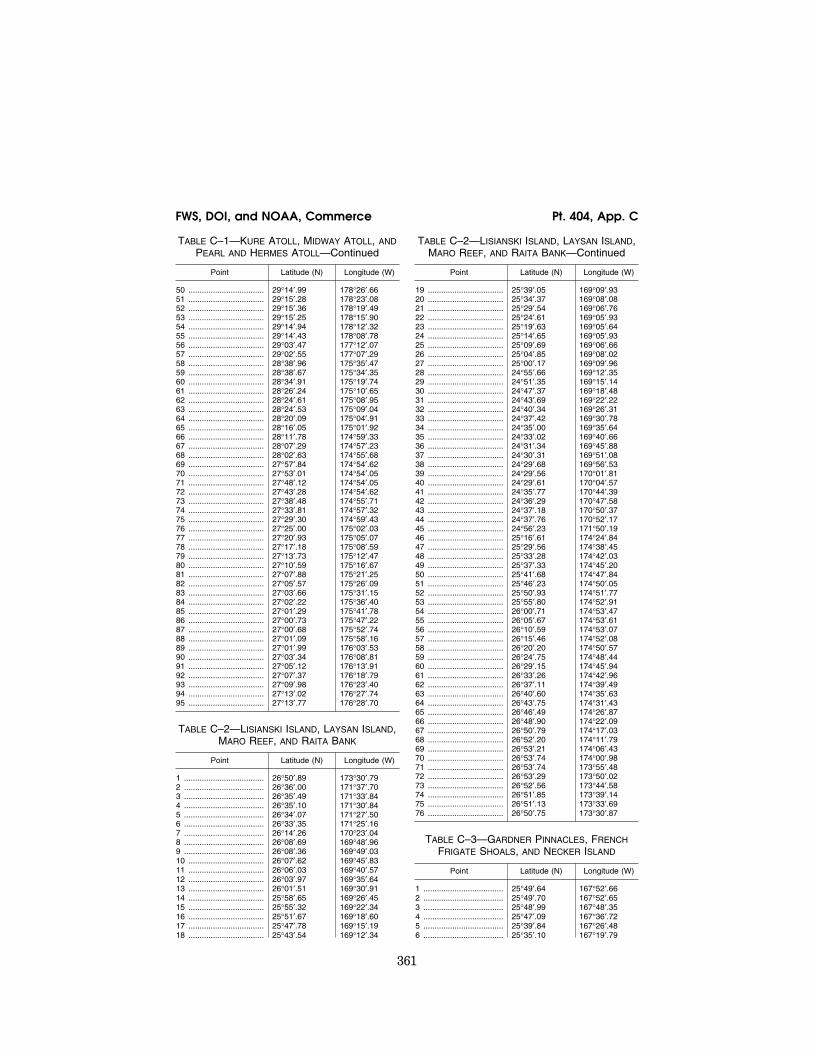
TABLE C–1—KURE ATOLL, MIDWAY ATOLL, AND PEARL AND HERMES ATOLL
Point Latitude (N) Longitude (W)
1 .................................... 27°14′.76 176°29′.87 2 .................................... 27°24′.95 177°33′.31 3 .................................... 27°35′.87 178°29′.90 4 .................................... 27°36′.64 178°33′.93 5 .................................... 27°37′.53 178°37′.32 6 .................................... 27°38′.60 178°40′.65 7 .................................... 27°39′.85 178°43′.90 8 .................................... 27°41′.28 178°47′.05 9 .................................... 27°42′.89 178°50′.10 10 .................................. 27°44′.66 178°53′.03 11 .................................. 27°46′.59 178°55′.83 12 .................................. 27°48′.67 178°58′.49 13 .................................. 27°50′.89 179°01′.00 14 .................................. 27°53′.22 179°03′.39 15 .................................. 27°55′.69 179°05′.61 16 .................................. 27°58′.29 179°07′.61 17 .................................. 28°01′.01 179°09′.47 18 .................................. 28°03′.81 179°11′.10 19 .................................. 28°06′.71 179°12′.53 20 .................................. 28°09′.67 179°13′.75 21 .................................. 28°12′.70 179°14′.75 22 .................................. 28°15′.78 179°15′.54 23 .................................. 28°18′.91 179°16′.11 24 .................................. 28°22′.04 179°16′.45 25 .................................. 28°24′.72 179°16′.56 26 .................................. 28°25′.20 179°16′.57 27 .................................. 28°25′.81 179°16′.56 28 .................................. 28°28′.35 179°16′.44 29 .................................. 28°31′.49 179°16′.10 30 .................................. 28°34′.61 179°15′.54 31 .................................. 28°37′.69 179°14′.75 32 .................................. 28°40′.71 179°13′.74 33 .................................. 28°43′.68 179°12′.54 34 .................................. 28°46′.58 179°11′.13 35 .................................. 28°49′.39 179°09′.52 36 .................................. 28°52′.11 179°07′.70 37 .................................. 28°54′.72 179°05′.70 38 .................................. 28°57′.21 179°03′.51 39 .................................. 28°59′.58 179°01′.15 40 .................................. 29°01′.81 178°58′.62 41 .................................. 29°03′.90 178°55′.93 42 .................................. 29°05′.83 178°53′.10 43 .................................. 29°07′.60 178°50′.13 44 .................................. 29°09′.21 178°47′.04 45 .................................. 29°10′.64 178°43′.84 46 .................................. 29°11′.89 178°40′.54 47 .................................. 29°12′.95 178°37′.16 48 .................................. 29°13′.82 178°33′.71 49 .................................. 29°14′.50 178°30′.21
VerDate Mar<15>2010 15:29 Dec 13, 2013 Jkt 229237 PO 00000 Frm 00370 Fmt 8010 Sfmt 8002 Q:\50\50V11.TXT ofr150 PsN: PC150
361
FWS, DOI, and NOAA, Commerce Pt. 404, App. C
TABLE C–1—KURE ATOLL, MIDWAY ATOLL, AND PEARL AND HERMES ATOLL—Continued
Point Latitude (N) Longitude (W)
50 .................................. 29°14′.99 178°26′.66 51 .................................. 29°15′.28 178°23′.08 52 .................................. 29°15′.36 178°19′.49 53 .................................. 29°15′.25 178°15′.90 54 .................................. 29°14′.94 178°12′.32 55 .................................. 29°14′.43 178°08′.78 56 .................................. 29°03′.47 177°12′.07 57 .................................. 29°02′.55 177°07′.29 58 .................................. 28°38′.96 175°35′.47 59 .................................. 28°38′.67 175°34′.35 60 .................................. 28°34′.91 175°19′.74 61 .................................. 28°26′.24 175°10′.65 62 .................................. 28°24′.61 175°08′.95 63 .................................. 28°24′.53 175°09′.04 64 .................................. 28°20′.09 175°04′.91 65 .................................. 28°16′.05 175°01′.92 66 .................................. 28°11′.78 174°59′.33 67 .................................. 28°07′.29 174°57′.23 68 .................................. 28°02′.63 174°55′.68 69 .................................. 27°57′.84 174°54′.62 70 .................................. 27°53′.01 174°54′.05 71 .................................. 27°48′.12 174°54′.05 72 .................................. 27°43′.28 174°54′.62 73 .................................. 27°38′.48 174°55′.71 74 .................................. 27°33′.81 174°57′.32 75 .................................. 27°29′.30 174°59′.43 76 .................................. 27°25′.00 175°02′.03 77 .................................. 27°20′.93 175°05′.07 78 .................................. 27°17′.18 175°08′.59 79 .................................. 27°13′.73 175°12′.47 80 .................................. 27°10′.59 175°16′.67 81 .................................. 27°07′.88 175°21′.25 82 .................................. 27°05′.57 175°26′.09 83 .................................. 27°03′.66 175°31′.15 84 .................................. 27°02′.22 175°36′.40 85 .................................. 27°01′.29 175°41′.78 86 .................................. 27°00′.73 175°47′.22 87 .................................. 27°00′.68 175°52′.74 88 .................................. 27°01′.09 175°58′.16 89 .................................. 27°01′.99 176°03′.53 90 .................................. 27°03′.34 176°08′.81 91 .................................. 27°05′.12 176°13′.91 92 .................................. 27°07′.37 176°18′.79 93 .................................. 27°09′.98 176°23′.40 94 .................................. 27°13′.02 176°27′.74 95 .................................. 27°13′.77 176°28′.70
TABLE C–2—LISIANSKI ISLAND, LAYSAN ISLAND, MARO REEF, AND RAITA BANK
Point Latitude (N) Longitude (W)
1 .................................... 26°50′.89 173°30′.79 2 .................................... 26°36′.00 171°37′.70 3 .................................... 26°35′.49 171°33′.84 4 .................................... 26°35′.10 171°30′.84 5 .................................... 26°34′.07 171°27′.50 6 .................................... 26°33′.35 171°25′.16 7 .................................... 26°14′.26 170°23′.04 8 .................................... 26°08′.69 169°48′.96 9 .................................... 26°08′.36 169°49′.03 10 .................................. 26°07′.62 169°45′.83 11 .................................. 26°06′.03 169°40′.57 12 .................................. 26°03′.97 169°35′.64 13 .................................. 26°01′.51 169°30′.91 14 .................................. 25°58′.65 169°26′.45 15 .................................. 25°55′.32 169°22′.34 16 .................................. 25°51′.67 169°18′.60 17 .................................. 25°47′.78 169°15′.19 18 .................................. 25°43′.54 169°12′.34
TABLE C–2—LISIANSKI ISLAND, LAYSAN ISLAND, MARO REEF, AND RAITA BANK—Continued
Point Latitude (N) Longitude (W)
19 .................................. 25°39′.05 169°09′.93 20 .................................. 25°34′.37 169°08′.08 21 .................................. 25°29′.54 169°06′.76 22 .................................. 25°24′.61 169°05′.93 23 .................................. 25°19′.63 169°05′.64 24 .................................. 25°14′.65 169°05′.93 25 .................................. 25°09′.69 169°06′.66 26 .................................. 25°04′.85 169°08′.02 27 .................................. 25°00′.17 169°09′.96 28 .................................. 24°55′.66 169°12′.35 29 .................................. 24°51′.35 169°15′.14 30 .................................. 24°47′.37 169°18′.48 31 .................................. 24°43′.69 169°22′.22 32 .................................. 24°40′.34 169°26′.31 33 .................................. 24°37′.42 169°30′.78 34 .................................. 24°35′.00 169°35′.64 35 .................................. 24°33′.02 169°40′.66 36 .................................. 24°31′.34 169°45′.88 37 .................................. 24°30′.31 169°51′.08 38 .................................. 24°29′.68 169°56′.53 39 .................................. 24°29′.56 170°01′.81 40 .................................. 24°29′.61 170°04′.57 41 .................................. 24°35′.77 170°44′.39 42 .................................. 24°36′.29 170°47′.58 43 .................................. 24°37′.18 170°50′.37 44 .................................. 24°37′.76 170°52′.17 45 .................................. 24°56′.23 171°50′.19 46 .................................. 25°16′.61 174°24′.84 47 .................................. 25°29′.56 174°38′.45 48 .................................. 25°33′.28 174°42′.03 49 .................................. 25°37′.33 174°45′.20 50 .................................. 25°41′.68 174°47′.84 51 .................................. 25°46′.23 174°50′.05 52 .................................. 25°50′.93 174°51′.77 53 .................................. 25°55′.80 174°52′.91 54 .................................. 26°00′.71 174°53′.47 55 .................................. 26°05′.67 174°53′.61 56 .................................. 26°10′.59 174°53′.07 57 .................................. 26°15′.46 174°52′.08 58 .................................. 26°20′.20 174°50′.57 59 .................................. 26°24′.75 174°48′.44 60 .................................. 26°29′.15 174°45′.94 61 .................................. 26°33′.26 174°42′.96 62 .................................. 26°37′.11 174°39′.49 63 .................................. 26°40′.60 174°35′.63 64 .................................. 26°43′.75 174°31′.43 65 .................................. 26°46′.49 174°26′.87 66 .................................. 26°48′.90 174°22′.09 67 .................................. 26°50′.79 174°17′.03 68 .................................. 26°52′.20 174°11′.79 69 .................................. 26°53′.21 174°06′.43 70 .................................. 26°53′.74 174°00′.98 71 .................................. 26°53′.74 173°55′.48 72 .................................. 26°53′.29 173°50′.02 73 .................................. 26°52′.56 173°44′.58 74 .................................. 26°51′.85 173°39′.14 75 .................................. 26°51′.13 173°33′.69 76 .................................. 26°50′.75 173°30′.87
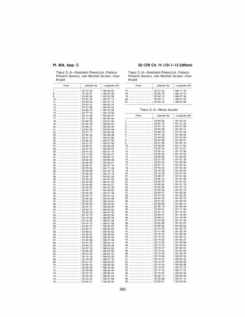
TABLE C–3—GARDNER PINNACLES, FRENCH FRIGATE SHOALS, AND NECKER ISLAND
Point Latitude (N) Longitude (W)
1 .................................... 25°49′.64 167°52′.66 2 .................................... 25°49′.70 167°52′.65 3 .................................... 25°48′.99 167°48′.35 4 .................................... 25°47′.09 167°36′.72 5 .................................... 25°39′.84 167°26′.48 6 .................................... 25°35′.10 167°19′.79
VerDate Mar<15>2010 15:29 Dec 13, 2013 Jkt 229237 PO 00000 Frm 00371 Fmt 8010 Sfmt 8002 Q:\50\50V11.TXT ofr150 PsN: PC150
362
50 CFR Ch. IV (10–1–13 Edition) Pt. 404, App. C
TABLE C–3—GARDNER PINNACLES, FRENCH FRIGATE SHOALS, AND NECKER ISLAND—Con-tinued
Point Latitude (N) Longitude (W)
7 .................................... 25°10′.43 166°45′.00 8 .................................... 24°40′.91 166°03′.36 9 .................................... 24°35′.64 165°34′.99 10 .................................. 24°23′.78 164°31′.12 11 .................................. 24°23′.59 164°31′.14 12 .................................. 24°23′.31 164°29′.74 13 .................................. 24°21′.85 164°24′.52 14 .................................. 24°20′.10 164°19′.39 15 .................................. 24°17′.75 164°14′.56 16 .................................. 24°14′.99 164°09′.97 17 .................................. 24°11′.86 164°05′.69 18 .................................. 24°08′.30 164°01′.80 19 .................................. 24°04′.48 163°58′.23 20 .................................. 24°00′.27 163°55′.22 21 .................................. 23°55′.85 163°52′.59 22 .................................. 23°51′.17 163°50′.56 23 .................................. 23°46′.33 163°48′.98 24 .................................. 23°41′.37 163°47′.99 25 .................................. 23°36′.34 163°47′.56 26 .................................. 23°31′.27 163°47′.60 27 .................................. 23°26′.27 163°48′.28 28 .................................. 23°21′.34 163°49′.50 29 .................................. 23°16′.53 163°51′.14 30 .................................. 23°11′.96 163°53′.47 31 .................................. 23°07′.54 163°56′.15 32 .................................. 23°03′.46 163°59′.38 33 .................................. 22°59′.65 164°03′.01 34 .................................. 22°56′.27 164°07′.10 35 .................................. 22°53′.22 164°11′.49 36 .................................. 22°50′.60 164°16′.18 37 .................................. 22°48′.48 164°21′.16 38 .................................. 22°46′.73 164°26′.28 39 .................................. 22°45′.49 164°31′.60 40 .................................. 22°44′.83 164°37′.03 41 .................................. 22°44′.65 164°42′.51 42 .................................. 22°44′.92 164°47′.99 43 .................................. 22°45′.11 164°49′.52 44 .................................. 22°45′.39 164°51′.48 45 .................................. 22°45′.17 164°51′.53 46 .................................. 22°50′.26 165°34′.99 47 .................................. 22°55′.50 166°19′.63 48 .................................. 22°55′.93 166°23′.32 49 .................................. 22°57′.41 166°36′.00 50 .................................. 23°03′.75 166°45′.00 51 .................................. 23°05′.48 166°47′.45 52 .................................. 24°12′.70 168°22′.86 53 .................................. 24°12′.88 168°22′.78 54 .................................. 24°16′.05 168°27′.28 55 .................................. 24°19′.15 168°31′.66 56 .................................. 24°22′.27 168°35′.95 57 .................................. 24°25′.71 168°39′.94 58 .................................. 24°29′.51 168°43′.55 59 .................................. 24°33′.67 168°46′.63 60 .................................. 24°38′.06 168°49′.29 61 .................................. 24°42′.68 168°51′.46 62 .................................. 24°47′.45 168°53′.12 63 .................................. 24°52′.34 168°54′.28 64 .................................. 24°57′.32 168°54′.82 65 .................................. 25°02′.32 168°54′.95 66 .................................. 25°07′.30 168°54′.43 67 .................................. 25°12′.19 168°53′.32 68 .................................. 25°16′.99 168°51′.76 69 .................................. 25°21′.57 168°49′.60 70 .................................. 25°25′.94 168°46′.93 71 .................................. 25°30′.09 168°43′.86 72 .................................. 25°33′.89 168°40′.42 73 .................................. 25°37′.37 168°36′.52 74 .................................. 25°40′.49 168°32′.24 75 .................................. 25°43′.24 168°27′.68 76 .................................. 25°45′.57 168°22′.82
TABLE C–3—GARDNER PINNACLES, FRENCH FRIGATE SHOALS, AND NECKER ISLAND—Con-tinued
Point Latitude (N) Longitude (W)
77 .................................. 25°47′.43 168°17′.76 78 .................................. 25°48′.79 168°12′.47 79 .................................. 25°49′.72 168°07′.09 80 .................................. 25°50′.11 168°01′.62 81 .................................. 25°50′.18 168°00′.09
TABLE C–4—NIHOA ISLAND
Point Latitude (N) Longitude (W)
1 .................................... 23°52′.82 161°44′.54 2 .................................... 23°52′.10 161°41′.20 3 .................................... 23°51′.18 161°37′.92 4 .................................... 23°50′.08 161°34′.71 5 .................................... 23°48′.79 161°31′.58 6 .................................... 23°47′.33 161°28′.55 7 .................................... 23°45′.69 161°25′.62 8 .................................... 23°43′.88 161°22′.81 9 .................................... 23°41′.92 161°20′.13 10 .................................. 23°39′.80 161°17′.60 11 .................................. 23°37′.54 161°15′.21 12 .................................. 23°35′.14 161°12′.99 13 .................................. 23°32′.62 161°10′.93 14 .................................. 23°29′.99 161°09′.05 15 .................................. 23°27′.25 161°07′.35 16 .................................. 23°24′.42 161°05′.85 17 .................................. 23°21′.51 161°04′.54 18 .................................. 23°18′.52 161°03′.43 19 .................................. 23°15′.48 161°02′.53 20 .................................. 23°12′.39 161°01′.84 21 .................................. 23°09′.27 161°01′.35 22 .................................. 23°06′.13 161°01′.09 23 .................................. 23°02′.97 161°01′.03 24 .................................. 22°59′.82 161°01′.19 25 .................................. 22°56′.69 161°01′.57 26 .................................. 22°53′.58 161°02′.15 27 .................................. 22°50′.51 161°02′.95 28 .................................. 22°47′.50 161°03′.95 29 .................................. 22°44′.55 161°05′.15 30 .................................. 22°41′.67 161°06′.54 31 .................................. 22°38′.88 161°08′.13 32 .................................. 22°36′.19 161°09′.90 33 .................................. 22°33′.61 161°11′.85 34 .................................. 22°31′.14 161°13′.97 35 .................................. 22°28′.81 161°16′.25 36 .................................. 22°26′.61 161°18′.69 37 .................................. 22°24′.56 161°21′.26 38 .................................. 22°22′.66 161°23′.97 39 .................................. 22°20′.92 161°26′.80 40 .................................. 22°19′.35 161°29′.74 41 .................................. 22°17′.95 161°32′.78 42 .................................. 22°16′.73 161°35′.90 43 .................................. 22°15′.70 161°39′.10 44 .................................. 22°14′.85 161°42′.37 45 .................................. 22°14′.20 161°45′.68 46 .................................. 22°13′.73 161°49′.03 47 .................................. 22°13′.47 161°52′.41 48 .................................. 22°13′.40 161°55′.80 49 .................................. 22°13′.53 161°59′.18 50 .................................. 22°13′.85 162°02′.55 51 .................................. 22°14′.31 162°05′.45 52 .................................. 22°14′.37 162°05′.89 53 .................................. 22°14′.59 162°06′.88 54 .................................. 22°15′.87 162°12′.18 55 .................................. 22°17′.70 162°17′.31 56 .................................. 22°19′.97 162°22′.20 57 .................................. 22°22′.73 162°26′.84 58 .................................. 22°25′.88 162°31′.15 59 .................................. 22°29′.41 162°35′.09
VerDate Mar<15>2010 15:29 Dec 13, 2013 Jkt 229237 PO 00000 Frm 00372 Fmt 8010 Sfmt 8002 Q:\50\50V11.TXT ofr150 PsN: PC150
363
FWS, DOI, and NOAA, Commerce Pt. 404, App. D
TABLE C–4—NIHOA ISLAND—Continued
Point Latitude (N) Longitude (W)
60 .................................. 22°33′.28 162°38′.61 61 .................................. 22°37′.47 162°41′.72 62 .................................. 22°41′.93 162°44′.34 63 .................................. 22°46′.63 162°46′.47 64 .................................. 22°51′.48 162°48′.05 65 .................................. 22°56′.46 162°49′.09 66 .................................. 23°01′.50 162°49′.58 67 .................................. 23°06′.58 162°49′.49 68 .................................. 23°11′.61 162°48′.89 69 .................................. 23°16′.57 162°47′.70 70 .................................. 23°21′.36 162°45′.98 71 .................................. 23°26′.02 162°43′.75 72 .................................. 23°30′.40 162°41′.01 73 .................................. 23°34′.51 162°37′.83 74 .................................. 23°38′.26 162°34′.18 75 .................................. 23°41′.69 162°30′.18 76 .................................. 23°44′.72 162°25′.79 77 .................................. 23°47′.36 162°21′.11 78 .................................. 23°49′.55 162°16′.16 79 .................................. 23°51′.24 162°10′.99 80 .................................. 23°52′.44 162°05′.63 81 .................................. 23°53′.14 162°00′.25 82 .................................. 23°53′.36 161°54′.75 83 .................................. 23°53′.09 161°49′.28 84 .................................. 23°52′.82 161°47′.09 85 .................................. 23°52′.39 161°44′.67
[73 FR 73599, Dec. 3, 2008]
APPENDIX D TO PART 404—BOUNDARY COORDINATES FOR PAPAHANAUMOKUAKEA MARINE NA-TIONAL MONUMENT SHIP REPORTING AREA
APPENDIX D—GEOGRAPHICAL COORDINATES
Ship Reporting Area
Papahanaumokuakea Marine National Monument
Reference chart: United States 540, 2008 edition; 19016, 2008 edition; 19019, 2008 edition; 19022, 2008 edition.
These charts are based on World Geodetic System 1984 Datum (WGS–84) and astronomic datum.
TABLE D–1—OUTER BOUNDARY
Point Latitude (N) Longitude (W)
1 .................................... 29°25′.47 178°16′.97 2 .................................... 28°43′.73 175°13′.84 3 .................................... 27°00′.77 173°25′.78 4 .................................... 26°44′.91 171°28′.07 5 .................................... 26°24′.23 170°20′.59 6 .................................... 25°56′.43 167°32′.10 7 .................................... 24°50′.20 165°58′.69 8 .................................... 24°05′.52 161°56′.86 9 .................................... 24°05′.29 161°56′.62 10 .................................. 24°04′.37 161°51′.53 11 .................................. 24°03′.44 161°46′.45 12 .................................. 24°02′.41 161°41′.39 13 .................................. 24°01′.31 161°36′.35 14 .................................. 23°59′.68 161°31′.55 15 .................................. 23°57′.85 161°26′.85 16 .................................. 23°55′.54 161°22′.31
TABLE D–1—OUTER BOUNDARY—Continued
Point Latitude (N) Longitude (W)
17 .................................. 23°52′.96 161°17′.92 18 .................................. 23°50′.12 161°13′.72 19 .................................. 23°46′.94 161°10′.08 20 .................................. 23°43′.49 161°06′.47 21 .................................. 23°39′.71 161°03′.09 22 .................................. 23°35′.72 161°00′.14 23 .................................. 23°31′.59 160°57′.46 24 .................................. 23°27′.32 160°55′.23 25 .................................. 23°22′.74 160°53′.71 26 .................................. 23°18′.29 160°52′.17 27 .................................. 23°13′.57 160°51′.04 28 .................................. 23°08′.68 160°50′.46 29 .................................. 23°03′.70 160°50′.17 30 .................................. 22°58′.67 160°50′.35 31 .................................. 22°53′.84 160°51′.04 32 .................................. 22°49′.11 160°52′.20 33 .................................. 22°44′.46 160°53′.56 34 .................................. 22°40′.03 160°55′.52 35 .................................. 22°35′.73 160°57′.68 36 .................................. 22°31′.54 161°00′.25 37 .................................. 22°27′.57 161°03′.23 38 .................................. 22°23′.76 161°06′.64 39 .................................. 22°20′.24 161°10′.23 40 .................................. 22°17′.02 161°14′.13 41 .................................. 22°14′.04 161°18′.34 42 .................................. 22°11′.35 161°22′.80 43 .................................. 22°09′.19 161°27′.45 44 .................................. 22°07′.29 161°32′.11 45 .................................. 22°05′.87 161°36′.94 46 .................................. 22°04′.62 161°41′.89 47 .................................. 22°03′.94 161°47′.09 48 .................................. 22°03′.41 161°52′.36 49 .................................. 22°03′.41 161°57′.51 50 .................................. 22°03′.82 162°02′.83 51 .................................. 22°04′.49 162°08′.04 52 .................................. 22°05′.43 162°13′.12 53 .................................. 22°05′.97 162°16′.41 54 .................................. 22°06′.29 162°16′.85 55 .................................. 22°34′.57 164°47′.27 56 .................................. 22°47′.60 166°38′.23 57 .................................. 24°03′.82 168°27′.91 58 .................................. 24°25′.76 170°45′.39 59 .................................. 24°46′.54 171°53′.03 60 .................................. 25°07′.60 174°28′.71 61 .................................. 27°05′.82 176°35′.51 62 .................................. 27°27′.32 178°38′.66 63 .................................. 27°28′.93 178°43′.56 64 .................................. 27°30′.64 178°48′.40 65 .................................. 27°32′.74 178°52′.96 66 .................................. 27°35′.06 178°57′.30 67 .................................. 27°37′.89 179°01′.49 68 .................................. 27°40′.90 179°05′.60 69 .................................. 27°44′.17 179°09′.41 70 .................................. 27°47′.74 179°12′.85 71 .................................. 27°51′.45 179°16′.00 72 .................................. 27°55′.32 179°18′.82 73 .................................. 27°59′.33 179°21′.13 74 .................................. 28°03′.49 179°23′.15 75 .................................. 28°07′.82 179°24′.76 76 .................................. 28°12′.31 179°26′.18 77 .................................. 28°16′.95 179°27′.05 78 .................................. 28°21′.61 179°27′.63 79 .................................. 28°26′.18 179°27′.77 80 .................................. 28°30′.87 179°27′.48 81 .................................. 28°35′.61 179°26′.95 82 .................................. 28°40′.09 179°25′.75 83 .................................. 28°44′.46 179°24′.31 84 .................................. 28°48′.70 179°22′.50 85 .................................. 28°52′.81 179°20′.43 86 .................................. 28°56′.71 179°17′.77 87 .................................. 29°00′.58 179°14′.92 88 .................................. 29°04′.18 179°11′.69
VerDate Mar<15>2010 15:29 Dec 13, 2013 Jkt 229237 PO 00000 Frm 00373 Fmt 8010 Sfmt 8002 Q:\50\50V11.TXT ofr150 PsN: PC150
364
50 CFR Ch. IV (10–1–13 Edition) Pt. 404, App. D
TABLE D–1—OUTER BOUNDARY—Continued
Point Latitude (N) Longitude (W)
89 .................................. 29°07′.62 179°08′.20 90 .................................. 29°10′.86 179°04′.37 91 .................................. 29°13′.76 179°00′.21 92 .................................. 29°16′.24 178°55′.78 93 .................................. 29°18′.51 178°51′.26 94 .................................. 29°20′.45 178°46′.50 95 .................................. 29°22′.26 178°41′.67 96 .................................. 29°23′.52 178°36′.64 97 .................................. 29°24′.53 178°31′.54 98 .................................. 29°25′.16 178°26′.31 99 .................................. 29°25′.42 178°20′.92 100 ................................ 29°25′.29 178°16′.70
TABLE D–2—INNER BOUNDARY AROUND KURE ATOLL, MIDWAY ATOLL, AND PEARL AND HER-MES ATOLL
Point Latitude (N) Longitude (W)
1 .................................... 27°14′.76 176°29′.87 2 .................................... 27°24′.95 177°33′.31 3 .................................... 27°35′.87 178°29′.90 4 .................................... 27°36′.64 178°33′.93 5 .................................... 27°37′.53 178°37′.32 6 .................................... 27°38′.60 178°40′.65 7 .................................... 27°39′.85 178°43′.90 8 .................................... 27°41′.28 178°47′.05 9 .................................... 27°42′.89 178°50′.10 10 .................................. 27°44′.66 178°53′.03 11 .................................. 27°46′.59 178°55′.83 12 .................................. 27°48′.67 178°58′.49 13 .................................. 27°50′.89 179°01′.00 14 .................................. 27°53′.22 179°03′.39 15 .................................. 27°55′.69 179°05′.61 16 .................................. 27°58′.29 179°07′.61 17 .................................. 28°01′.01 179°09′.47 18 .................................. 28°03′.81 179°11′.10 19 .................................. 28°06′.71 179°12′.53 20 .................................. 28°09′.67 179°13′.75 21 .................................. 28°12′.70 179°14′.75 22 .................................. 28°15′.78 179°15′.54 23 .................................. 28°18′.91 179°16′.11 24 .................................. 28°22′.04 179°16′.45 25 .................................. 28°24′.72 179°16′.56 26 .................................. 28°25′.20 179°16′.57 27 .................................. 28°25′.81 179°16′.56 28 .................................. 28°28′.35 179°16′.44 29 .................................. 28°31′.49 179°16′.10 30 .................................. 28°34′.61 179°15′.54 31 .................................. 28°37′.69 179°14′.75 32 .................................. 28°40′.71 179°13′.74 33 .................................. 28°43′.68 179°12′.54 34 .................................. 28°46′.58 179°11′.13 35 .................................. 28°49′.39 179°09′.52 36 .................................. 28°52′.11 179°07′.70 37 .................................. 28°54′.72 179°05′.70 38 .................................. 28°57′.21 179°03′.51 39 .................................. 28°59′.58 179°01′.15 40 .................................. 29°01′.81 178°58′.62 41 .................................. 29°03′.90 178°55′.93 42 .................................. 29°05′.83 178°53′.10 43 .................................. 29°07′.60 178°50′.13 44 .................................. 29°09′.21 178°47′.04 45 .................................. 29°10′.64 178°43′.84 46 .................................. 29°11′.89 178°40′.54 47 .................................. 29°12′.95 178°37′.16 48 .................................. 29°13′.82 178°33′.71 49 .................................. 29°14′.50 178°30′.21 50 .................................. 29°14′.99 178°26′.66 51 .................................. 29°15′.28 178°23′.08 52 .................................. 29°15′.36 178°19′.49
TABLE D–2—INNER BOUNDARY AROUND KURE ATOLL, MIDWAY ATOLL, AND PEARL AND HER-MES ATOLL—Continued
Point Latitude (N) Longitude (W)
53 .................................. 29°15′.25 178°15′.90 54 .................................. 29°14′.94 178°12′.32 55 .................................. 29°14′.43 178°08′.78 56 .................................. 29°03′.47 177°12′.07 57 .................................. 29°02′.55 177°07′.29 58 .................................. 28°38′.96 175°35′.47 59 .................................. 28°38′.67 175°34′.35 60 .................................. 28°34′.91 175°19′.74 61 .................................. 28°26′.24 175°10′.65 62 .................................. 28°24′.61 175°08′.95 63 .................................. 28°24′.53 175°09′.04 64 .................................. 28°20′.09 175°04′.91 65 .................................. 28°16′.05 175°01′.92 66 .................................. 28°11′.78 174°59′.33 67 .................................. 28°07′.29 174°57′.23 68 .................................. 28°02′.63 174°55′.68 69 .................................. 27°57′.84 174°54′.62 70 .................................. 27°53′.01 174°54′.05 71 .................................. 27°48′.12 174°54′.05 72 .................................. 27°43′.28 174°54′.62 73 .................................. 27°38′.48 174°55′.71 74 .................................. 27°33′.81 174°57′.32 75 .................................. 27°29′.30 174°59′.43 76 .................................. 27°25′.00 175°02′.03 77 .................................. 27°20′.93 175°05′.07 78 .................................. 27°17′.18 175°08′.59 79 .................................. 27°13′.73 175°12′.47 80 .................................. 27°10′.59 175°16′.67 81 .................................. 27°07′.88 175°21′.25 82 .................................. 27°05′.57 175°26′.09 83 .................................. 27°03′.66 175°31′.15 84 .................................. 27°02′.22 175°36′.40 85 .................................. 27°01′.29 175°41′.78 86 .................................. 27°00′.73 175°47′.22 87 .................................. 27°00′.68 175°52′.74 88 .................................. 27°01′.09 175°58′.16 89 .................................. 27°01′.99 176°03′.53 90 .................................. 27°03′.34 176°08′.81 91 .................................. 27°05′.12 176°13′.91 92 .................................. 27°07′.37 176°18′.79 93 .................................. 27°09′.98 176°23′.40 94 .................................. 27°13′.02 176°27′.74 95 .................................. 27°13′.77 176°28′.70
TABLE D–3—INNER BOUNDARY AROUND LISIANSKI ISLAND, LAYSAN ISLAND, MARO REEF, AND RAITA BANK
Point Latitude (N) Longitude (W)
1 .................................... 26°50′.89 173°30′.79 2 .................................... 26°36′.00 171°37′.70 3 .................................... 26°35′.49 171°33′.84 4 .................................... 26°35′.10 171°30′.84 5 .................................... 26°34′.07 171°27′.50 6 .................................... 26°33′.35 171°25′.16 7 .................................... 26°14′.26 170°23′.04 8 .................................... 26°08′.69 169°48′.96 9 .................................... 26°08′.36 169°49′.03 10 .................................. 26°07′.62 169°45′.83 11 .................................. 26°06′.03 169°40′.57 12 .................................. 26°03′.97 169°35′.64 13 .................................. 26°01′.51 169°30′.91 14 .................................. 25°58′.65 169°26′.45 15 .................................. 25°55′.32 169°22′.34 16 .................................. 25°51′.67 169°18′.60 17 .................................. 25°47′.78 169°15′.19 18 .................................. 25°43′.54 169°12′.34
VerDate Mar<15>2010 15:29 Dec 13, 2013 Jkt 229237 PO 00000 Frm 00374 Fmt 8010 Sfmt 8002 Q:\50\50V11.TXT ofr150 PsN: PC150

365
FWS, DOI, and NOAA, Commerce Pt. 404, App. D
TABLE D–3—INNER BOUNDARY AROUND LISIANSKI ISLAND, LAYSAN ISLAND, MARO REEF, AND RAITA BANK—Continued
Point Latitude (N) Longitude (W)
19 .................................. 25°39′.05 169°09′.93 20 .................................. 25°34′.37 169°08′.08 21 .................................. 25°29′.54 169°06′.76 22 .................................. 25°24′.61 169°05′.93 23 .................................. 25°19′.63 169°05′.64 24 .................................. 25°14′.65 169°05′.93 25 .................................. 25°09′.69 169°06′.66 26 .................................. 25°04′.85 169°08′.02 27 .................................. 25°00′.17 169°09′.96 28 .................................. 24°55′.66 169°12′.35 29 .................................. 24°51′.35 169°15′.14 30 .................................. 24°47′.37 169°18′.48 31 .................................. 24°43′.69 169°22′.22 32 .................................. 24°40′.34 169°26′.31 33 .................................. 24°37′.42 169°30′.78 34 .................................. 24°35′.00 169°35′.64 35 .................................. 24°33′.02 169°40′.66 36 .................................. 24°31′.34 169°45′.88 37 .................................. 24°30′.31 169°51′.08 38 .................................. 24°29′.68 169°56′.53 39 .................................. 24°29′.56 170°01′.81 40 .................................. 24°29′.61 170°04′.57 41 .................................. 24°35′.77 170°44′.39 42 .................................. 24°36′.29 170°47′.58 43 .................................. 24°37′.18 170°50′.37 44 .................................. 24°37′.76 170°52′.17 45 .................................. 24°56′.23 171°50′.19 46 .................................. 25°16′.61 174°24′.84 47 .................................. 25°29′.56 174°38′.45 48 .................................. 25°33′.28 174°42′.03 49 .................................. 25°37′.33 174°45′.20 50 .................................. 25°41′.68 174°47′.84 51 .................................. 25°46′.23 174°50′.05 52 .................................. 25°50′.93 174°51′.77 53 .................................. 25°55′.80 174°52′.91 54 .................................. 26°00′.71 174°53′.47 55 .................................. 26°05′.67 174°53′.61 56 .................................. 26°10′.59 174°53′.07 57 .................................. 26°15′.46 174°52′.08 58 .................................. 26°20′.20 174°50′.57 59 .................................. 26°24′.75 174°48′.44 60 .................................. 26°29′.15 174°45′.94 61 .................................. 26°33′.26 174°42′.96 62 .................................. 26°37′.11 174°39′.49 63 .................................. 26°40′.60 174°35′.63 64 .................................. 26°43′.75 174°31′.43 65 .................................. 26°46′.49 174°26′.87 66 .................................. 26°48′.90 174°22′.09 67 .................................. 26°50′.79 174°17′.03 68 .................................. 26°52′.20 174°11′.79 69 .................................. 26°53′.21 174°06′.43 70 .................................. 26°53′.74 174°00′.98 71 .................................. 26°53′.74 173°55′.48 72 .................................. 26°53′.29 173°50′.02 73 .................................. 26°52′.56 173°44′.58 74 .................................. 26°51′.85 173°39′.14 75 .................................. 26°51′.13 173°33′.69 76 .................................. 26°50′.75 173°30′.87
TABLE D–4—INNER BOUNDARY AROUND GARD-NER PINNACLES, FRENCH FRIGATE SHOALS, AND NECKER ISLAND
Point Latitude (N) Longitude (W)
1 .................................... 25°49′.64 167°52′.66 2 .................................... 25°49′.70 167°52′.65 3 .................................... 25°48′.99 167°48′.35
TABLE D–4—INNER BOUNDARY AROUND GARD-NER PINNACLES, FRENCH FRIGATE SHOALS, AND NECKER ISLAND—Continued
Point Latitude (N) Longitude (W)
4 .................................... 25°47′.09 167°36′.72 5 .................................... 25°39′.84 167°26′.48 6 .................................... 25°35′.10 167°19′.79 7 .................................... 25°10′.43 166°45′.00 8 .................................... 24°40′.91 166°03′.36 9 .................................... 24°35′.64 165°34′.99 10 .................................. 24°23′.78 164°31′.12 11 .................................. 24°23′.59 164°31′.14 12 .................................. 24°23′.31 164°29′.74 13 .................................. 24°21′.85 164°24′.52 14 .................................. 24°20′.10 164°19′.39 15 .................................. 24°17′.75 164°14′.56 16 .................................. 24°14′.99 164°09′.97 17 .................................. 24°11′.86 164°05′.69 18 .................................. 24°08′.30 164°01′.80 19 .................................. 24°04′.48 163°58′.23 20 .................................. 24°00′.27 163°55′.22 21 .................................. 23°55′.85 163°52′.59 22 .................................. 23°51′.17 163°50′.56 23 .................................. 23°46′.33 163°48′.98 24 .................................. 23°41′.37 163°47′.99 25 .................................. 23°36′.34 163°47′.56 26 .................................. 23°31′.27 163°47′.60 27 .................................. 23°26′.27 163°48′.28 28 .................................. 23°21′.34 163°49′.50 29 .................................. 23°16′.53 163°51′.14 30 .................................. 23°11′.96 163°53′.47 31 .................................. 23°07′.54 163°56′.15 32 .................................. 23°03′.46 163°59′.38 33 .................................. 22°59′.65 164°03′.01 34 .................................. 22°56′.27 164°07′.10 35 .................................. 22°53′.22 164°11′.49 36 .................................. 22°50′.60 164°16′.18 37 .................................. 22°48′.48 164°21′.16 38 .................................. 22°46′.73 164°26′.28 39 .................................. 22°45′.49 164°31′.60 40 .................................. 22°44′.83 164°37′.03 41 .................................. 22°44′.65 164°42′.51 42 .................................. 22°44′.92 164°47′.99 43 .................................. 22°45′.11 164°49′.52 44 .................................. 22°45′.39 164°51′.48 45 .................................. 22°45′.17 164°51′.53 46 .................................. 22°50′.26 165°34′.99 47 .................................. 22°55′.50 166°19′.63 48 .................................. 22°55′.93 166°23′.32 49 .................................. 22°57′.41 166°36′.00 50 .................................. 23°03′.75 166°45′.00 51 .................................. 23°05′.48 166°47′.45 52 .................................. 24°12′.70 168°22′.86 53 .................................. 24°12′.88 168°22′.78 54 .................................. 24°16′.05 168°27′.28 55 .................................. 24°19′.15 168°31′.66 56 .................................. 24°22′.27 168°35′.95 57 .................................. 24°25′.71 168°39′.94 58 .................................. 24°29′.51 168°43′.55 59 .................................. 24°33′.67 168°46′.63 60 .................................. 24°38′.06 168°49′.29 61 .................................. 24°42′.68 168°51′.46 62 .................................. 24°47′.45 168°53′.12 63 .................................. 24°52′.34 168°54′.28 64 .................................. 24°57′.32 168°54′.82 65 .................................. 25°02′.32 168°54′.95 66 .................................. 25°07′.30 168°54′.43 67 .................................. 25°12′.19 168°53′.32 68 .................................. 25°16′.99 168°51′.76 69 .................................. 25°21′.57 168°49′.60 70 .................................. 25°25′.94 168°46′.93 71 .................................. 25°30′.09 168°43′.86 72 .................................. 25°33′.89 168°40′.42 73 .................................. 25°37′.37 168°36′.52
VerDate Mar<15>2010 15:29 Dec 13, 2013 Jkt 229237 PO 00000 Frm 00375 Fmt 8010 Sfmt 8002 Q:\50\50V11.TXT ofr150 PsN: PC150
366
50 CFR Ch. IV (10–1–13 Edition) Pt. 404, App. E
TABLE D–4—INNER BOUNDARY AROUND GARD-NER PINNACLES, FRENCH FRIGATE SHOALS, AND NECKER ISLAND—Continued
Point Latitude (N) Longitude (W)
74 .................................. 25°40′.49 168°32′.24 75 .................................. 25°43′.24 168°27′.68 76 .................................. 25°45′.57 168°22′.82 77 .................................. 25°47′.43 168°17′.76 78 .................................. 25°48′.79 168°12′.47 79 .................................. 25°49′.72 168°07′.09 80 .................................. 25°50′.11 168°01′.62 81 .................................. 25°50′.18 168°00′.09
TABLE D–5—INNER BOUNDARY AROUND NIHOA ISLAND
Point Latitude (N) Longitude (W)
1 .................................... 23°52′.82 161°44′.54 2 .................................... 23°52′.10 161°41′.20 3 .................................... 23°51′.18 161°37′.92 4 .................................... 23°50′.08 161°34′.71 5 .................................... 23°48′.79 161°31′.58 6 .................................... 23°47′.33 161°28′.55 7 .................................... 23°45′.69 161°25′.62 8 .................................... 23°43′.88 161°22′.81 9 .................................... 23°41′.92 161°20′.13 10 .................................. 23°39′.80 161°17′.60 11 .................................. 23°37′.54 161°15′.21 12 .................................. 23°35′.14 161°12′.99 13 .................................. 23°32′.62 161°10′.93 14 .................................. 23°29′.99 161°09′.05 15 .................................. 23°27′.25 161°07′.35 16 .................................. 23°24′.42 161°05′.85 17 .................................. 23°21′.51 161°04′.54 18 .................................. 23°18′.52 161°03′.43 19 .................................. 23°15′.48 161°02′.53 20 .................................. 23°12′.39 161°01′.84 21 .................................. 23°09′.27 161°01′.35 22 .................................. 23°06′.13 161°01′.09 23 .................................. 23°02′.97 161°01′.03 24 .................................. 22°59′.82 161°01′.19 25 .................................. 22°56′.69 161°01′.57 26 .................................. 22°53′.58 161°02′.15 27 .................................. 22°50′.51 161°02′.95 28 .................................. 22°47′.50 161°03′.95 29 .................................. 22°44′.55 161°05′.15 30 .................................. 22°41′.67 161°06′.54 31 .................................. 22°38′.88 161°08′.13 32 .................................. 22°36′.19 161°09′.90 33 .................................. 22°33′.61 161°11′.85 34 .................................. 22°31′.14 161°13′.97 35 .................................. 22°28′.81 161°16′.25 36 .................................. 22°26′.61 161°18′.69 37 .................................. 22°24′.56 161°21′.26 38 .................................. 22°22′.66 161°23′.97 39 .................................. 22°20′.92 161°26′.80 40 .................................. 22°19′.35 161°29′.74 41 .................................. 22°17′.95 161°32′.78 42 .................................. 22°16′.73 161°35′.90 43 .................................. 22°15′.70 161°39′.10 44 .................................. 22°14′.85 161°42′.37 45 .................................. 22°14′.20 161°45′.68 46 .................................. 22°13′.73 161°49′.03 47 .................................. 22°13′.47 161°52′.41 48 .................................. 22°13′.40 161°55′.80 49 .................................. 22°13′.53 161°59′.18 50 .................................. 22°13′.85 162°02′.55
TABLE D–5—INNER BOUNDARY AROUND NIHOA ISLAND—Continued
Point Latitude (N) Longitude (W)
51 .................................. 22°14′.31 162°05′.45 52 .................................. 22°14′.37 162°05′.89 53 .................................. 22°14′.59 162°06′.88 54 .................................. 22°15′.87 162°12′.18 55 .................................. 22°17′.70 162°17′.31 56 .................................. 22°19′.97 162°22′.20 57 .................................. 22°22′.73 162°26′.84 58 .................................. 22°25′.88 162°31′.15 59 .................................. 22°29′.41 162°35′.09 60 .................................. 22°33′.28 162°38′.61 61 .................................. 22°37′.47 162°41′.72 62 .................................. 22°41′.93 162°44′.34 63 .................................. 22°46′.63 162°46′.47 64 .................................. 22°51′.48 162°48′.05 65 .................................. 22°56′.46 162°49′.09 66 .................................. 23°01′.50 162°49′.58 67 .................................. 23°06′.58 162°49′.49 68 .................................. 23°11′.61 162°48′.89 69 .................................. 23°16′.57 162°47′.70 70 .................................. 23°21′.36 162°45′.98 71 .................................. 23°26′.02 162°43′.75 72 .................................. 23°30′.40 162°41′.01 73 .................................. 23°34′.51 162°37′.83 74 .................................. 23°38′.26 162°34′.18 75 .................................. 23°41′.69 162°30′.18 76 .................................. 23°44′.72 162°25′.79 77 .................................. 23°47′.36 162°21′.11 78 .................................. 23°49′.55 162°16′.16 79 .................................. 23°51′.24 162°10′.99 80 .................................. 23°52′.44 162°05′.63 81 .................................. 23°53′.14 162°00′.25 82 .................................. 23°53′.36 161°54′.75 83 .................................. 23°53′.09 161°49′.28 84 .................................. 23°52′.82 161°47′.09 85 .................................. 23°52′.39 161°44′.67
[73 FR 73601, Dec. 3, 2008]
APPENDIX E TO PART 404—CONTENT AND SYNTAX FOR PAPAHANAUMOKUAKEA SHIP REPORTING SYSTEM
Immediately upon crossing the reporting area boundary, notification should be sent as a direct e-mail to [email protected] in the prescribed format and data syntax shown. Use of batch message routing services which may delay receipt of a report should not be used. Failure to follow the exact for-mat (e.g., extra information, extraneous characters, or double spacing) may cause the automated computer system to reject your report.
NOTE Report transmission costs via INMARSAT–C will be assumed by NOAA.
E.1 ENTRY NOTIFICATION FORMAT
Immediately upon entering the Reporting Area, vessels required to participate must provide the following information.
VerDate Mar<15>2010 15:29 Dec 13, 2013 Jkt 229237 PO 00000 Frm 00376 Fmt 8010 Sfmt 8002 Q:\50\50V11.TXT ofr150 PsN: PC150

367
FWS, DOI, and NOAA, Commerce Pt. 404, App. E
TABLE E.1—INFORMATION REQUIRED FOR ENTRY NOTIFICATION
Telegraphy
Function Information required Example field text
System identi-fier CORAL SHIPREP // CORAL SHIPREP //
A ................ Ship ................. Vessel name/call sign/flag/IMO number/Fed-eral documentation or State registration number if applicable //.
A/OCEAN VOYAGER/C5FU8/BAHAMAS/IMO 9359165//
B ................ Date, time (UTC), and month of entry.
A 6-digit group giving day of month (first two digits), hours and minutes (last four digits) in coordinated universal time, suffixed by the letter Z (indicating time in UTC), and three letters indicating month //.
B/271107Z DEC//
C ................ Position ........... A 4-digit group giving latitude in degrees and minutes, suffixed with the letter N (indicating north), followed by a single /, and a five-digit group giving longitude in degrees and min-utes, suffixed with the letter W (indicating west) // [Report in the World Geodetic Sys-tem 1984 Datum (WGS–84)].
C/2728N/17356W//
E ................ True course .... 3-digit number indicating true course // ............ E/180// F ................ Speed in knots
and tenths.3-digit group indicating knots decimal tenths // F/20.5//
I ................. Destination and estimated time of ar-rival.
Name of port city/country/estimated arrival date and time group expressed as in (B) //.
I/SEATTLE/USA/311230Z DEC//
L ................ Intended route through the reporting area.
Route information should be reported as a di-rect rhumbline (RL) course through the re-porting area and intended speed (expressed as in E and F) or a series of waypoints (WP). Each waypoint entry should be re-ported as latitude and longitude, expressed as in (C), and intended speed between waypoints (as in F) // (Note: As many ‘‘L’’ lines as needed may be used to describe the vessel’s intended route.).
L/RL/215/20.5// -OR-
L/WP/2734N/17352W/20.5// L/WP/2641N/17413W/20.5// L/WP/2605N/17530W/20.5//
O ............... Vessel draft in meters.
Maximum present static draft reported in me-ters decimal centimeters //.
O/11.50//
P ................ Categories of Hazardous Cargoes*.
Classification Code (e.g. IMDG, IBC, IGC, INF) / and all corresponding Categories of Hazardous Cargoes (delimited by commas) // Note: If necessary, use a separate ‘‘P’’ line for each type of Classification Code.
P/IMDG/1.4G,2.1,2.2,2.3,3,4.1,6.1,8,9//
Q ............... Defects or deficiencies**.
Brief details of defects, damage, deficiencies or limitations that restrict maneuverability or impair normal navigation // (If none, enter the number zero.).
Q/Include details as required//
R ................ Pollution inci-dent or goods lost overboard**.
Description of pollution incident or goods lost overboard within the Monument, the Report-ing Area, or the U.S. Exclusive Economic Zone//(If none, enter the number zero.).
R/0//
T ................ Contact infor-mation of ship’s agent or owner.
Name/address/and phone number of ship’s agent or owner //.
T/JOHN DOE/GENERIC SHIPPING COM-PANY INC, 6101 ACME ROAD, ROOM 123, CITY, STATE, COUNTRY 12345/123–123– 1234//
U ................ Ship size (length over-all and gross tonnage) and type.
Length overall reported in meters decimal cen-timeters/number of gross tons/type of ship (e.g. bulk carrier, chemical tanker, oil tanker, gas tanker, container, general cargo, fishing vessel, research, passenger, OBO, RORO) //.
U/294.14/54592/CONTAINER SHIP//
W ............... Persons ........... Total number of persons on board // ................ W/15//
TABLE E.1 NOTES *Categories of hazardous cargoes means goods classified in the International Maritime Dangerous Goods (IMDG) Code; sub-
stances classified in chapter 17 of the International Code for the Construction and Equipment of Ships Carrying Dangerous Chemicals in Bulk (IBC Code) and chapter 19 of the International Code for the Construction and Equipment of Ships Carrying Liquefied Gases in Bulk (IGC Code); oils as defined in MARPOL Annex I; noxious liquid substances as defined in MARPOL Annex II; harmful substances as defined in MARPOL Annex III; and radioactive materials specified in the Code for the Safe Car-riage of the Irradiated Nuclear Fuel, Plutonium and High-Level Radioactive Wastes in Flasks on Board Ships (INF Code).
**In accordance with the provisions of the MARPOL Convention, ships must report information relating to defects, damage, de-ficiencies or other limitations as well as, if necessary, information relating to pollution incidents or loss of cargo. Safety related re-ports must be provided to CORAL SHIPREP without delay should a ship suffer damage, failure or breakdown affecting the safety of the ship (Item Q), or if a ship makes a marked deviation from a route, course or speed previously advised (Item L). Pollution or cargo lost overboard must be reported without delay (Item R).
VerDate Mar<15>2010 15:29 Dec 13, 2013 Jkt 229237 PO 00000 Frm 00377 Fmt 8010 Sfmt 8002 Q:\50\50V11.TXT ofr150 PsN: PC150

368
50 CFR Ch. IV (10–1–13 Edition) Pt. 404, App. E
E.2 PRIOR NOTIFICATION OF ENTRY FORMAT
Vessels of the United States less than 300 gross tonnage that are not equipped with on-board e-mail capability must provide the fol-lowing notification of entry at least 72 hrs, but no longer than 1 month, prior to entry date, utilizing the data syntax described above. Notification may be made via the fol-lowing communication methods, listed in order of preference: E-mail [[email protected]]; fax [1–808–397– 2662]; telephone [1–866–478–NWHI (6944), 1–808– 395–NWHI (6944)].
TABLE E.2—INFORMATION REQUIRED FOR PRIOR NOTIFICATION
System identifier.
PRIOR NOTICE //.
Items ........ A, B, C (as applicable), I, L, O, P (as applicable), Q, T, U, W.
E.3 EXIT NOTIFICATION FORMAT
Immediately upon leaving the Reporting Area, vessels required to participate must provide the following information. Vessels of the United States less than 300 gross tonnage that are not equipped with onboard e-mail capability must provide the following Exit Notification information within 12 hrs of leaving the Reporting Area. Notification may be made via the following communica-tion methods, listed in order of preference: E-mail [[email protected]]; fax [1– 808–397–2662]; telephone [1–866–478–NWHI (6944), 1–808–395–NWHI (6944)].
TABLE E.3—INFORMATION REQUIRED FOR EXIT NOTIFICATION
Telegraphy
Function Information required Example field text
System identi-fier CORAL SHIPREP // CORAL SHIPREP//
A ...................... Ship ................ Vessel name / call sign / flag / IMO number / Federal documentation or State registra-tion number if applicable //.
A/OCEAN VOYAGER/C5FU8/BAHAMAS/ IMO9359165//
B ...................... Date, time (UTC), and month of exit.
A 6-digit group giving day of month (first two digits), hours and minutes (last four digits), suffixed by the letter Z indicating time in UTC, and three letters indicating month//.
B/271657Z DEC//
C ...................... Position .......... A 4-digit group giving latitude in degrees and minutes, suffixed with the letter N (indi-cating north), followed by a single //, and a five digit group giving longitude in degrees and minutes, suffixed with the letter W (in-dicating west) // [Report in the World Geo-detic System 1984 Datum (WGS–84)].
C/2605N/17530W//
R ...................... Pollution inci-dent or goods lost overboard.
Description of pollution incident or goods lost overboard within the Monument, the Re-porting Area, or the U.S. Exclusive Eco-nomic Zone // (If none, enter the number zero).
R/0//
E.4 EXAMPLE ENTRY REPORT
CORAL SHIPREP// A/SEA ROVER/WFSU/USA/IMO 8674208/DOC
602011// B/010915Z JUN// C/2636N/17600W// E/050// F/20.0// I/LOS ANGELES/USA/081215Z JUN// L/RL/050/20.0// O/10.90// P/IMDG/3,4.1,6.1,8,9// Q/0// R/0// T/JOHN DOE/CONTAINER SHIPPERS INC,
500 PORT ROAD, ROOM 123, LOS ANGE-LES, CA, USA 90050/213–123–1234//
U/199.90/27227/CONTAINER SHIP// W/15//
E.5 EXAMPLE EXIT REPORT
CORAL SHIPREP// A/SEA ROVER/WFSU/USA/IMO 8674208/DOC
602011// B/011515Z JUN// C/2747N/17416W// R/0//
[73 FR 73603, Dec. 3, 2008]
VerDate Mar<15>2010 15:29 Dec 13, 2013 Jkt 229237 PO 00000 Frm 00378 Fmt 8010 Sfmt 8002 Q:\50\50V11.TXT ofr150 PsN: PC150