Embed Size (px)
Citation preview

PART 2InFRASTRUCTURe
PLAn

Infrastructure PlanInfrastructure requirements to support the delivery of the Development Scheme for Grantham will be determined by Council as part of the staged detailed design of Council owned land and as part of the development assessment process for non-Council owned land.
Infrastructure will include:
• Roads
• Water
• Sewerage
• Stormwater management
• Parks
• Electricity supply
• Telecommunications
• Community facilities
Listed below is the infrastructure currently identified for the Grantham Reconstruction Area.
Local InfrastructureLocal infrastructure will include all internal works and external connections required to deliver the development including:
a. Roads (including internal local roads and external access roads required to service the new development)
b. Water Supply (including internal and external works to connect to existing infrastructure networks)
c. Sewerage (including works to proposed new sewerage treatment plant)
d. Stormwater Management (including works to connect the existing stormwater systems)
e. Parks (including the delivery of a recreational parkland to service the development)
Infrastructure description of works
Roads New internal roads to service the new residential area
New access road between Gatton -Helidon Road and the new residential area over the existing railway line
Water supply Water supply works for development that connects to existing networks
Sewerage Provision of package sewerage plant to service the new development
Stormwater Management New works linking with external stormwater management works
Parks Provision of new parkland
Electricity Supply Works as required by the relevant provider
Telecommunications Provision of telecommunications to the new residential area
Community facilities Facilities as agreed by the relevant provider
45

f. Electricity Supply (including internal and external works to connect to existing infrastructure networks )
g. Telecommunications (including internal and external works to connect to existing infrastructure networks)
h. Community facilities (including community facility sites).
Infrastructure RequirementsThe land owner will be required to deliver all local infrastructure required to service the new development.
The Department of Transport and Main Roads is constructing the new railway line crossing connecting Gatton -Helidon Road to the new residential area.
Road design should take into consideration emergency access.
A future electrical substation is likely to be required in the vicinity of the wastewater plant. Actual location and timing of this provision is to be determined by the provider.
The specific infrastructure requirements required for the proposed development will be subject to further detailed infrastructure investigations that will occur as the detailed design is completed and as the development continues. The infrastructure requirements and delivery responsibilities may be amended to reflect the outcomes of these investigations.
Indicative infrastructure plans for roads, water supply, sewerage and stormwater management are included for advisory purposes only.
The History of Infrastructure in Grantham
In 1866, the railway line was built through Sandy Creek (the original name for the siding at
Grantham). The first platform at Grantham was constructed in 1875. In 1914 the railway line
from Grantham to Helidon was duplicated and in 1936 electricity was installed at the railway
station.
In 1927, a loan was available for water supply for Grantham residents. Bores and windmills with
troughs were installed in Gatton, Helidon and Anzac Avenue, Grantham.
The first street lights were switched on in Grantham in August 1936.
In 1968, the Warrego Highway was rerouted through Grantham and in 1989 the $10 million
Gatton bypass commenced operation and traffic was diverted away from Grantham.
In 1979, the then Gatton Shire Council agreed to borrow $13,333 to construct the first public
toilets alongside the Warrego Highway at Grantham.
i
46

MAP A - ROADS
KEY
Colle
ctor
road
Sub-
col
lect
or ro
ad
Loca
l str
eet
KEY
Colle
ctor
road
Sub-
col
lect
or ro
ad
Loca
l str
eet
47
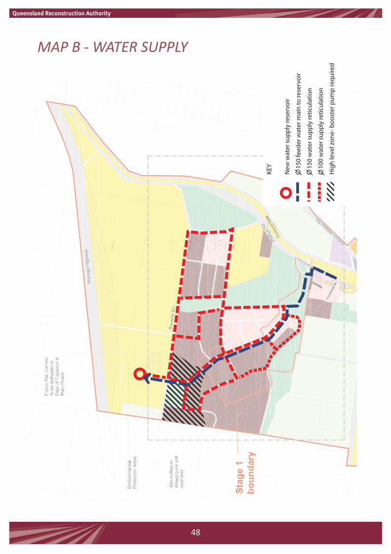
MAP B - WATER SUPPLY
to be updated
KEY
New
wat
er s
uppl
y re
serv
oir
1
50 fe
eder
wat
er m
ain
to re
serv
oir
1
50 w
ater
sup
ply
retic
ulat
ion
1
00 w
ater
sup
ply
retic
ulat
ion
Hig
h le
vel z
one-
boo
ster
pum
p re
quire
d
KEY
New
wat
er s
uppl
y re
serv
oir
1
50 fe
eder
wat
er m
ain
to re
serv
oir
1
50 w
ater
sup
ply
retic
ulat
ion
1
00 w
ater
sup
ply
retic
ulat
ion
Hig
h le
vel z
one-
boo
ster
pum
p re
quire
d
48

MAP C - SEWER
to be updated
KEY
New
sew
age
trea
tmen
t pla
nt
Low
pre
ssur
e se
wer
retic
ulat
ion
Clas
s ‘A’
effl
uent
dis
posa
l
- maj
ority
use
d in
sho
wgr
ound
s
KEY
New
sew
age
trea
tmen
t pla
nt
Low
pre
ssur
e se
wer
retic
ulat
ion
Clas
s ‘A’
effl
uent
dis
posa
l
- maj
ority
use
d in
sho
wgr
ound
s
49

MAP D - STORMWATER MANAGEMENT
KEY
Stor
mw
ater
ove
rland
flow
pat
hs
Stor
mw
ater
trea
tmen
t and
det
entio
n
Pipe
dra
inag
e
Swal
e dr
aina
ge
KEY
Stor
mw
ater
ove
rland
flow
pat
hs
Stor
mw
ater
trea
tmen
t and
det
entio
n
Pipe
dra
inag
e
Swal
e dr
aina
ge
50