Embed Size (px)
Citation preview
Port Macquarie-Hastings Development Control Plan 2013
v20190830 Preamble Chapter 1.1 - 1
PART 1 DCP OVERVIEW
Chapter 1.1 Preamble 1.1.1 Introduction
About this DCP Port Macquarie-Hastings Local Environmental Plan 2011 (LEP 2011) provides the statutory framework for land use management in the Port Macquarie-Hastings Local Government Area, subject to overriding planning controls in State Environmental Planning Policies and other State legislation. When assessing and determining development applications, the consent authority is required to take into consideration relevant matters under section 4.15 of the Environmental Planning and Assessment Act 1979. These matters include the provisions of any environmental planning instrument (i.e. the LEP and State Environmental Planning Policies), and the provisions of any Development Control Plan (DCP). This DCP supports the provisions of Port Macquarie-Hastings Local Environmental Plan 2011 by expanding upon the aims, objectives and other provisions of the Port Macquarie-Hastings Local Environmental Plan 2011.
Citation – Name of this Plan This Plan is called the Port Macquarie-Hastings Development Control Plan 2013. It has been prepared pursuant to the provisions of section 3.43 of the Environmental Planning and Assessment Act 1979 (the Act) and Clauses 16-24 of the Environmental Planning and Assessment Regulation 2000 (the Regulation).
The Consent Authority Broadly Port Macquarie-Hastings Council is the Consent Authority, except where the Regional Planning Panel (RPP) is given this role under the State Environmental Planning Policy (State and Regional Development) 2011.
1.1.2 Land and LEPs covered by this Plan The plan applies to all land in the Port Macquarie-Hastings Local Government Area. The Local Environmental Plan applying to the land is Port Macquarie-Hastings Local Environmental Plan 2011.
1.1.3 Purpose The principal purpose of the DCP is to provide guidance to persons carrying out development on the following matters: • giving effect to the aims of the Port Macquarie-Hastings Local Environmental Plan 2011, • facilitating development that is permissible under the Port Macquarie-Hastings Local Environmental Plan
2011, • achieving the objectives of land zones used in the Port Macquarie-Hastings Local Environmental Plan
2011. It will be used by Council and landowners as a guideline at the time of preparation and assessment of development applications.
1.1.4 Structure This plan currently contains four Parts, each containing Chapters: • Parts 1 to 2 apply to all development applications (subject to details of the application) • Part 3 applies to development based on the proposed land use activities.

Port Macquarie-Hastings Development Control Plan 2013
Chapter 1.1 - 2 Preamble v20190830
• Part 4 contains area-based provisions for parts of Port Macquarie, Thrumster, Fernbank Creek, and parts of Sancrox.
• Part 5 contains area-based provisions for the southern urban areas of Lake Cathie - Bonny Hills and the Camden Haven.
Figure 1.1-1 identifies land subject to area-based provisions, including (as described below) further area-based provisions adopted by reference.
Figure 1.1-1 Land subject to area-based provisions, including those adopted by reference
Port Macquarie-Hastings Development Control Plan 2013
v20190830 Preamble Chapter 1.1 - 3
Table of Contents Part / Chapter Title Applies to Part 1 DCP Overview 1.1 Preamble Relevant to all development applications - explains which
Chapters are relevant. 1.2 Planning Framework Provides context for DCP within NSW planning system. 1.3 Community Participation Outlines local public consultation requirements for
development applications. Part 2 General Provisions 2.1 Preamble Introduces Part 2 - applies to all development applications,
subject to relevance. 2.2 Advertising and Signage Provisions relevant to advertising structures and other signage
that requires development consent. 2.3 Environmental Management Environmental protection provisions. 2.4 Hazards Management Provisions relating to reduction of hazards to development. 2.5 Transport, Traffic Management,
Access and Car Parking Provisions relating to access, transport, roads and parking.
2.6 Tree Management Provisions relating to approvals for lopping, removal, etc of trees and other vegetation.
2.7 Social Impact Assessment and Crime Prevention
Provisions relating to consideration of social impacts and strategies to prevent crime.
Part 3 Development Specific Provisions
3.1 Preamble Introduces Part 3 - applies to development based on what it involves or the relevant land use zone.
3.2 Low Density Residential Development
Applies to: • dwellings (where not part of a high density residential,
commercial or industrial development), • dwelling houses, • exhibition homes, • exhibition villages, • semi-detached dwellings, • dual occupancies; • multi dwelling housing; • and ancillary development associated with these
developments. 3.3 Residential Flat Development,
Tourist and Visitor Accommodation, Mixed Use Development
Applies to: • Residential flat buildings, Hostels and Shop top housing, • Tourist and visitor accommodation (which encompasses
Backpackers’ accommodation, Bed and breakfast accommodation, Farm stay accommodation, Hotel or motel accommodation, and Serviced apartments), and
• Any residential component of a mixed use development including ‘shop top housing’.
3.4 Business and Commercial Development
Applies to development within the Business zones - B1, B2, B3, B4, B5 and B7
Port Macquarie-Hastings Development Control Plan 2013
Chapter 1.1 - 4 Preamble v20190830
Part / Chapter Title Applies to 3.5 Industrial Development Applies to:
• all development in land zoned IN1, IN2, IN3, IN4, and W3; and
• Industries, Heavy industrial storage establishments, Storage premises, Boat building and repair facilities, Vehicle body repair workshops and Vehicle repair stations in any zone.
3.6 Subdivision Applies to development applications to subdivide land. Part 4 Greater Port Macquarie Area-based Provisions 4.1 Preamble Introduces Part 4, and gives an overview of where area-based
provisions are in force within this DCP 4.2 Port Macquarie Greater Town
Centre Currently only contains provisions for the Westport Neighbourhood. Provisions for the Central Business District and Settlement City are currently adopted by reference from DCP 2011 Part 5.
4.3 Port Macquarie East Currently only contains provisions for the East Port Neighbourhood. Provisions for the Flynns Beach neighbourhood not covered by the above are currently adopted by reference from DCP 2011 Part 5.
4.4 Port Macquarie West Currently applies to 18 John Oxley Drive and other land in John Oxley Drive in the vicinity of Phillip Charley Drive. Some land along Hastings River Drive is also subject to provisions currently adopted by reference from DCP 2011 Part 5.
4.5 Thrumster Relates to the 2008 urban land release for Thrumster 4.6 Highway Employment Lands Currently only applies to land adjoining the Dennis Bridge, 4.7 Highways Gateway Sites Applies to Gateway Sites on the western side of the interchange
of the Pacific and Oxley Highways. Relates to Port Macquarie-Hastings Local Environmental Plan 2011 (Amendment No 53).
Part 5 Southern Coastal Towns - Area-based Provisions 5.1 Preamble Introduces Part 5, and gives an overview of where area-based
provisions are in force within this DCP 5.2 Lake Cathie - Bonny Hills Currently only provisions for Rainbow Beach Precincts A, B & C.
Relates to Port Macquarie-Hastings Local Environmental Plan 2011 (Amendment No 36).
5.3 Camden Haven West Currently only provisions for Homedale Road, Kew. Relates to Port Macquarie-Hastings Local Environmental Plan 2011 (Amendment No 45).
Adoption of other DCP provisions For the land so identified on Figure 1.1-1 this DCP adopts by reference the provisions of Part 5 of Port Macquarie-Hastings Development Control Plan 2011, containing Area-based provisions that supplement the provisions of this DCP. Notes Section 3.43 (3) of the Act enables a DCP to adopt by reference the provisions of another DCP.
Parts 1 to 3 of this DCP supersedes Parts 1 to 4 of DCP 2011. It is intended to progressively incorporate within additional Parts of this DCP the Area-based provisions in Part 5 of DCP 2011.
The provisions of Part 5 of DCP 2011 that are currently adopted by reference are:
Map Ref Name Starting Page 1 Port Macquarie Town Centre 5-3

Port Macquarie-Hastings Development Control Plan 2013
v20190830 Preamble Chapter 1.1 - 5
3 Flynns Beach Precinct (where not covered by Chapter 4.3.2) 5-53 5 King Creek 5-61 7 Hastings River Drive 5-65 8 Wauchope Town Centre 5-69 9 North Haven Shopping Precinct 5-71 11 Sancrox Employment Lands 5-75 12 Area 15 Camden Haven 5-97 13 West Haven 5-115 15 Settlement City Precinct 5-149 16 Fernbank Park Employment Lands 5-169 The Map Ref refers to the numbers on Figure 1.1-1.
1.1.5 How to use this DCP
When to use this plan This plan applies to all development that requires consent in the Port Macquarie–Hastings Local Government Area.
Relationship to other Council Policy Documents This Plan supports Port Macquarie-Hastings Local Environment Plan 2011.
Variations Council may consider varying the development provisions where it can be adequately demonstrated that the objective to which the provision relates can be wholly achieved by reasonable or innovative solutions and the proposal is consistent with all relevant LEP aims and Zone Objectives. A variation that is inconsistent with any LEP aim or a zone objective will not be supported.
1.1.6 Developer Contributions Development Contributions are levied as a means of funding local infrastructure and services that are required as a result of new development. The contributions are levied under the provisions of Development Contributions Plans prepared pursuant to the Environmental Planning and Assessment Act 1979 and under Development Servicing Plans prepared pursuant to the Water Management Act 2000. Council has adopted Development Contributions Plans for: • Road Works • Open Space • Community Cultural & Emergency Services • Parking and Traffic Facilities • Administrative Facilities • Section 94A Levy (Commercial and Industrial Development). Council has also adopted Development Servicing Plans for Water Supply and Sewerage Services. Contributions are determined in conjunction with a Development Application or Complying Development Application and are imposed by a condition of development consent in accordance with the development contributions plans in force at that time. Contribution rates are adjusted quarterly in line with the CPI. Generally development applications for subdivision, residential accommodation, rural dwellings and commercial or industrial development will be subject to development contributions. Contributions are normally satisfied by payment of monetary contributions. However, subject to Council approval, contributions can also be satisfied by dedication of land, and material public benefit (works in kind) or a combination of these.

Port Macquarie-Hastings Development Control Plan 2013
Chapter 1.1 - 6 Preamble v20190830
The EP&A Act also provides for negotiation of development contributions via Voluntary Planning Agreements between Council and a developer. Council has adopted a Planning Agreements Policy that establishes a framework for negotiation and public notification of planning agreements.
Relationship to Voluntary Planning Agreements The Consent Authority is required to take into consideration, where relevant, a planning agreement that has been entered into under section 7.4 of the Environmental Planning and Assessment Act 1979, or any draft planning agreement that a developer has offered to enter into under section 7.4, as provided in section 4.15 of that Act.
1.1.7 Dictionary Notes This plan adopts the terms and definitions of the Port Macquarie-Hastings Local Environment Plan 2011, State Environmental Planning Policy (Exempt and Complying Development Codes) 2008 and Environmental Planning and Assessment Act 1979. Additional terms used in this DCP are defined below. Where there is an inconsistency, the higher order instrument (Acts, then SEPP, then LEP) prevails. Active street frontage means where all premises on the ground floor of the building facing the street are used for the purposes of business premises or retail premises. Arborist means a person: (a) who holds the Australian Qualifications Framework Diploma in Horticulture (AQF5 Arboriculture) to the
satisfaction of Council or an international qualification considered equivalent by Council.; or (b) the Council. Aus-Spec means the Port Macquarie-Hastings Council version Design and Construction Specifications for infrastructure works. The Specifications are available on Council’s website. Brownfield development means development on a site that has previously been used for urban purposes. Crime Prevention Through Environmental Design (CPTED) means Section 5.1 of Council’s Crime Prevention Strategy, November 2010 – June 2015. Refer to Chapter 2.7 section 2.7.2.2 for further details. Dangerous tree means a tree that has lost stability or structural integrity to a point that it poses a threat to life that no remedial works can mitigate. Also refers to vegetation that interferes with the safe flight path of aircraft or sight lines for traffic. Destroy (a tree) includes killing, clearing, removing, cutting, burning, ring barking, knocking over, poisoning, lopping, topping or cutting of living branches of a tree, or root system, or damaging a trees root system by compaction, excavation or asphyxiation including unauthorised filling or stockpiling of materials. Dead (tree) means a tree where all process within all of the vascular tissue has ceased. Dying (tree) means a tree that has declined to a point that no remedial action will prevent death. Indigenous Street and Open Space Planting List means the list available from Council’s Tree Management Section. Infill development means development within an existing developed urban zone. Greenfield development means development on a site not previously used for an urban purpose. Tree worker means a tradesperson who holds the Australian Qualifications Framework 3 Horticulture (AQF3 Arboriculture) or an international qualification considered equivalent by Council.

Port Macquarie-Hastings Development Control Plan 2013
v20190830 Preamble Chapter 1.1 - 7
Unsuitable tree means a tree species that will have a negative impact on the surrounding native vegetation community as determined by Council Officers or has been planted in a location that the growth habit or mature size of a tree/s may be undesirable as determined by the Director Infrastructure Services
1.1.8 Reference to External Standards and Documents Throughout this document there are references to external documents and standards. These include, but are not limited to Australian and New Zealand Standards, AUSPEC specifications and standard drawings. In all circumstances, the reference is taken to mean the current version of that standard or specification.
1.1.9 Acknowledgements Council has used diagrams, figures and illustrations throughout this DCP that have been prepared on its behalf, as diagrams, figures and illustrations in superseded DCPs. Where available, Council has made reference to the author or the superseded DCP. Some sources are: • Anterra Design Pty Ltd, August 2007 - Sovereign Hills, Port Macquarie Proposed Indicative Street Profiles
1.1.10 Amendment history - Chapter 1.1 Preamble The Development Control Plan is a dynamic document. Please make sure you are using the most recent version for each Chapter. The version reference is printed in the footer of the document. The DCP page on Council’s website lists the current version reference for each Chapter. Each Chapter will end with a Table similar to below, listing the dates of adoption and commencement and subsequent amendments for that Chapter. Date adopted Date commenced Description Version
16/10/2013 08/11/2013 Port Macquarie-Hastings Development Control Plan 2013 v20131108
17/12/2014 02/04/2015 Port Macquarie-Hastings Development Control Plan 2013 (Amendment No 3) v20150402
15/04/2015 10/07/2015 Port Macquarie-Hastings Development Control Plan 2013 (Amendment No 2) v20150710
15/07/2015 24/07/2015 Port Macquarie-Hastings Development Control Plan 2013 (Amendment No 4) v20150724
16/12/2015 15/01/2016 Port Macquarie-Hastings Development Control Plan 2013 (Amendment No 6) v20160115
15/03/2017 12/04/2017 Port Macquarie-Hastings Development Control Plan 2013 (Amendment No 8) v20170412
21/02/2018 21/12/2018 Port Macquarie-Hastings Development Control Plan 2013 (Amendment No 9) v20181221
20/03/2019 31/05/2019 Port Macquarie-Hastings Development Control Plan 2013 (Amendment No 10) v20190531
19/06/2019 30/08/2019 Port Macquarie-Hastings Development Control Plan 2013 (Amendment No 11) v20190830
Port Macquarie-Hastings Development Control Plan 2013
Chapter 1.1 - 8 Preamble v20190830
This page is left intentionally blank
Port Macquarie-Hastings Development Control Plan 2013
v20131108 Planning Framework Chapter 1.2 - 1
Chapter 1.2 Planning Framework 1.2.1 Environmental Planning and Assessment Act 1979 The legislative framework for planning and development is primarily contained in the Environmental Planning and Assessment Act 1979, though sometimes other Acts may be applicable. Procedural requirements are contained in the Environmental Planning and Assessment Regulation 2000. Operational details can be contained in State Environmental Planning Policies, relating to: • minor development not requiring development consent (refer to Section 1.2.5 below), • identification of major development which is subject to special requirements, • provision of infrastructure under standard State-wide planning criteria, • provisions for particular types of development or for particular environmental areas.
1.2.2 Mid North Coast Regional Strategy The Mid North Coast Regional Strategy 2006 – 2031 was released by New South Wales Department of Planning in March 2009. The primary purpose of the regional strategy is to ensure that adequate land is available and appropriately located to accommodate projected housing and employment needs of the region’s population over the next 25 years. The regional strategy is intended to be the pre-eminent planning document for the Mid North Coast and will complement and inform other relevant State planning instruments, including future infrastructure investment priorities. In summary the aims of the strategy are to: • Protect high value environments and habitat corridors, cultural and Aboriginal heritage and scenic
landscapes. • Provide up to 58,400 new homes by 2031 to cater for a forecast population increase of 91,000. With
smaller households and an ageing population, a more suitable mix of housing will be encouraged, including more multi-unit style dwellings.
• Ensure an adequate supply of land is available to support economic growth and an additional 47,000 jobs.
• Encourage the growth and redevelopment of the Region’s four major regional centres (Grafton, Coffs Harbour, Port Macquarie and Taree) and six major towns (Maclean, Woolgoolga, Bellingen, Macksville, Kempsey and Forster–Tuncurry) through urban design and renewal strategies.
• Protect the coast by focusing new settlement in areas identified on local strategy maps. Development in places constrained by coastal processes, flooding, wetlands, important farmland and landscapes of high scenic and conservation value will be limited.
The strategy guides local planning in the eight local government areas of Clarence Valley, Coffs Harbour, Bellingen, Nambucca, Kempsey, Port Macquarie–Hastings, Greater Taree and Great Lakes, and will be reviewed every five years. Growth in the Port Macquarie-Hastings is to occur in a number of release areas, through infill development and urban consolidation of the existing urban footprint.
1.2.3 Urban Growth Management Strategy 2011-2031 The Mid North Coast Regional Strategy requires Council to prepare an urban growth management strategy which identifies growth areas and achieves regional outcomes and targets. Council’s Urban Growth Management Strategy 2011-2031 (UGMS) was adopted by Council in December 2010, and approved by the NSW Department of Planning in May 2011.
Port Macquarie-Hastings Development Control Plan 2013
Chapter 1.2 - 2 Planning Framework v20131108
In Council's corporate planning framework the urban growth management strategy is one of several strategic plans which sit under the overarching Community Strategic Plan. The UGMS consolidates and reviews the provisions of the previous growth strategies. The Vision and Objectives of UGMS state:
The vision for the Port Macquarie-Hastings is to achieve a “sustainable high quality of life for all”. In the context of this Strategy, this means that land use and population growth will be managed to maintain and enhance quality of life for all persons in the community in a balanced way for current and future generations. A “balanced way” means that social, economic and ecological objectives are balanced with each other. With this vision in mind, the following strategic objectives will guide the Urban Growth Management Strategy:
1. Provide an efficient settlement pattern that will maximise residents‟ access to services and facilities and reduce the cost of infrastructure to private, public and community sector providers.
2. Provide sufficient land to accommodate the kinds of households expected to be living in and visiting the area.
3. Allocate land for employment growth and protect economic resources in line with population growth and suited to changing business enterprise needs and opportunities.
4. Conserve the natural environment and provide opportunities to extend valuable biodiversity lands and protect threatened species.
5. Integrate the Urban Growth Management Strategy with other Council strategic plans and land use plans, including planned infrastructure and facilities.
1.2.4 Port Macquarie-Hastings Local Environmental Plan 2011 The Port Macquarie-Hastings Local Environmental Plan 2011 has been prepared for Port Macquarie-Hastings Local Government Area to conform with State Government requirements for all NSW Councils to prepare a consolidated LEP based on the Standard Instrument (Local Environmental Plans) Order 2006, known as the 'standard LEP template'.
The particular aims of this Plan are as follows: (a) to protect, conserve and sustainably manage the ecological biodiversity and natural environment of
the Port Macquarie-Hastings area, (b) to facilitate a strong and diverse local economy within the Port Macquarie-Hastings area, (c) to manage and coordinate the orderly, equitable and economic use and development of land within
the Port Macquarie-Hastings area, (d) to facilitate the provision and coordination of community services and facilities within the Port
Macquarie-Hastings area, (e) to facilitate adaptive planning for natural hazards and risks, including flooding, erosion, inundation,
land stability, bush fire risk and acid sulfate soils within the Port Macquarie-Hastings area, (f) to reinforce the role of the Port Macquarie-Hastings area’s settlement hierarchy, centred on Port
Macquarie and supported by its surrounding towns and villages, (g) to ensure the effective management of public assets within the Port Macquarie-Hastings area, (h) to provide a land use framework for development within the Port Macquarie-Hastings area that is
safe, inclusive and equitable, and caters for the housing, employment, entertainment, cultural, welfare and recreational needs of residents and visitors,
(i) to ensure that development does not conflict with the hierarchy of business and retail centres in the Port Macquarie-Hastings area and the role of the Greater Port Macquarie Central Business District as the focal point for subregional functions and service delivery,
(j) to identify and protect features of environmental, cultural or visual importance within the Port Macquarie-Hastings area.
Port Macquarie-Hastings Development Control Plan 2013
v20131108 Planning Framework Chapter 1.2 - 3
1.2.5 Exempt and Complying Development The Environmental Planning and Assessment Act 1979 provides that, as long as specified requirements are satisfied, certain development can be: a) exempt development, which can proceed without any approvals under the Act, and b) complying development, which can proceed with a streamlined approval process under the Act, known
as a Complying Development Certificate. Provisions relating to exempt and complying development are contained primarily in the SEPP (Exempt and Complying Development Codes) 2008 (the “Codes SEPP”), with some additional provisions in Schedules 2 and 3 of Port Macquarie-Hastings LEP 2011. Sections 4.1 and 4.2A of the EP&A Act and Division 2 of the Codes SEPP contain overriding qualifications for exempt and complying development and where it can be applied. Exempt development and complying development are still subject to any approvals or other requirements under other legislation such as the Local Government Act 1993, Roads Act 1993 and Water Management Act 2000. This includes approvals for driveways across nature strips, water and sewer connections and stormwater discharge.
1.2.6 Amendment history The Development Control Plan is a dynamic document. Please make sure you are using the most recent version for each Chapter. The version reference is printed in the footer of the document. The DCP page on Council’s website lists the current version reference for each Chapter. The Table below lists the dates of adoption and commencement and subsequent amendments for this Chapter.
Date adopted Date commenced Description Version
16/10/2013 08/11/2013 Port Macquarie-Hastings Development Control Plan 2013 v20131108

Port Macquarie-Hastings Development Control Plan 2013
Chapter 1.2 - 4 Planning Framework v20131108
This page is left intentionally blank

Port Macquarie-Hastings Development Control Plan 2013
v20131108 Community Participation Chapter 1.3 - 1
Chapter 1.3 Community Participation 1.3.1 Context
Land to which this Chapter applies This Chapter applies to all land within the Port Macquarie-Hastings Local Government Area.
Application This Chapter applies to applications for development listed within this Chapter as advertised development. This requires community participation as part of the application processing and assessment, whether by public exhibition or neighbour notifications. Notes The Act and Regulation specify that for certain types of development there is to be the opportunity for community participation: Designated development Identified by Schedule 3 of the Regulation or by an environmental planning instrument, such as: • SEPP No 14 - Coastal Wetlands • SEPP No 26 - Littoral Rainforests • SEPP No 33 - Hazardous and Offensive Development (the same advertising provisions apply for some
development, even though it may not be designated development) • SEPP No 62 - Sustainable Aquaculture This covers development with potential for significant impacts, and is subject to exhibition periods of at least 30 days. The public participation requirements are contained in Part 6 Division 5 of the Regulation (clauses 77 - 81). Not relevant to this DCP. State significant development Identified by a SEPP (refer to SEPP (State and Regional Development) 2011) or by the Minister in relation to specified development on specified land. Subject to exhibition periods of at least 30 days. The public participation requirements are contained in Part 6 Division 6 of the Regulation (clauses 82 - 85B). Not relevant to this DCP. Advertised development Means development, other than State significant development or designated development that is identified as advertised development by: • the Regulations (refer to cl 5). • an environmental planning instrument (e.g. SEPP No 55 - Remediation of Land) or a Development Control
Plan. • development for the purposes of a scheduled activity at any premises under the Protection of the
Environment Operations Act 1997 that is not State significant development or designated development (refer Section 4 Definitions in the Act).
Some public participation requirements are contained in Part 6 Division 7 (clauses 86 - 91) and clauses 117 - 119 and 252 of the Regulation. The exhibition period for advertised development is 14 days, or 30 days in the case of nominated integrated development (refer to clause 5 of the Regulation). A Development Control Plan can identify for public advertising or notification: • development applications (not already covered above), • requests for review of determinations of development applications (and applications for modifications)
where the review proposes amendments, and • applications for modifications of consent. [Act sec 74C (1)(b)-(c), 79A (2), 82A (4), 82C (5), 96, 96AA]
Port Macquarie-Hastings Development Control Plan 2013
Chapter 1.3 - 2 Community Participation v20131108
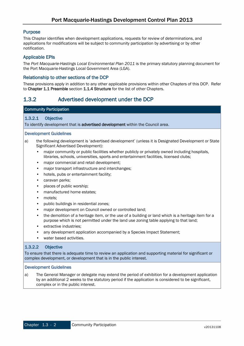
Purpose This Chapter identifies when development applications, requests for review of determinations, and applications for modifications will be subject to community participation by advertising or by other notification.
Applicable EPIs The Port Macquarie-Hastings Local Environmental Plan 2011 is the primary statutory planning document for the Port Macquarie-Hastings Local Government Area (LGA).
Relationship to other sections of the DCP These provisions apply in addition to any other applicable provisions within other Chapters of this DCP. Refer to Chapter 1.1 Preamble section 1.1.4 Structure for the list of other Chapters.
1.3.2 Advertised development under the DCP
Community Participation
1.3.2.1 Objective To identify development that is advertised development within the Council area.
Development Guidelines
a) the following development is ‘advertised development’ (unless it is Designated Development or State Significant Advertised Development): • major community or public facilities whether publicly or privately owned including hospitals,
libraries, schools, universities, sports and entertainment facilities, licensed clubs; • major commercial and retail development; • major transport infrastructure and interchanges; • hotels, pubs or entertainment facility; • caravan parks; • places of public worship; • manufactured home estates; • motels; • public buildings in residential zones; • major development on Council owned or controlled land; • the demolition of a heritage item, or the use of a building or land which is a heritage item for a
purpose which is not permitted under the land use zoning table applying to that land; • extractive industries; • any development application accompanied by a Species Impact Statement; • water based activities.
1.3.2.2 Objective To ensure that there is adequate time to review an application and supporting material for significant or complex development, or development that is in the public interest.
Development Guidelines
a) The General Manager or delegate may extend the period of exhibition for a development application by an additional 2 weeks to the statutory period if the application is considered to be significant, complex or in the public interest.

Port Macquarie-Hastings Development Control Plan 2013
v20131108 Community Participation Chapter 1.3 - 3
Community Participation
1.3.2.3 Objective To identify development that is notifiable local development.
Development Guidelines
a) Notifiable local development is all development other than: • advertised development • single storey dwellings and single storey additions that comply with setback provisions. • swimming pools. • sheds and outbuildings that comply with maximum floor area height and setback provisions. • fences and retaining walls • identified complying development; • rural dwellings and ancillary structures; • buildings ancillary to agriculture which are not complying development; • demolition of buildings; • industrial land uses within the IN1 zone, except where the site borders residentially zoned land; • minor development in commercial zones; • development which in the opinion of the General Manager or delegate does not require
notification.
1.3.2.4 Objective To describe the notification requirements for notifiable local development.
Development Guidelines
a) For Notifiable local development, a letter will be sent to potentially affected property owners by Council advising the nature of the development application and providing a period of 14 days in which to inspect the application and make written submission.
b) Where an adjoining or adjacent property is a strata title, then Council will notify the individual strata unit owners as well as the body corporate secretary.
1.3.3 Amendment history The Development Control Plan is a dynamic document. Please make sure you are using the most recent version for each Chapter. The version reference is printed in the footer of the document. The DCP page on Council’s website lists the current version reference for each Chapter. The Table below lists the dates of adoption and commencement and subsequent amendments for this Chapter.
Date adopted Date commenced Description Version
16/10/2013 08/11/2013 Port Macquarie-Hastings Development Control Plan 2013 v20131108

Port Macquarie-Hastings Development Control Plan 2013
Chapter 1.3 - 4 Community Participation v20131108
This page is left intentionally blank
Port Macquarie-Hastings Development Control Plan 2013
v20131108 Preamble Chapter 2.1 - 1
PART 2 GENERAL PROVISIONS
Chapter 2.1 Preamble 2.1.1 Context
Land and LEPs to which this Part applies This Part applies to all land in the Port Macquarie–Hastings Local Government Area. The Local Environmental Plans applying to the land are: • Port Macquarie-Hastings Council Local Environmental Plan 2011, and Port Macquarie-Hastings Council (Area 13 Thrumster) Local Environmental Plan 2008.
Application These provisions apply generally to advertising and signage that is not ‘Exempt development’, social impact assessment, transport, traffic management, access and car parking, hazard and environmental management and crime prevention.
Relationship to other sections of the DCP These provisions apply in addition to any other applicable provisions within other Chapters of this DCP. Refer to Chapter 1.1 Preamble section 1.1.4 Structure for the list of other Chapters.
Purpose This Chapter identifies general provisions which apply to all development applications on land within the local government area.
2.1.2 Content of Part 2 Part 2 contains the following Chapters:
Chapter 2.1 Preamble Chapter 2.2 Advertising and Signage Chapter 2.3 Environmental Management Chapter 2.4 Hazards Management Chapter 2.5 Transport, Traffic Management, Access and Car Parking Chapter 2.6 Tree Management Chapter 2.7 Social Impact Assessment and Crime prevention
2.1.3 Amendment history The Development Control Plan is a dynamic document. Please make sure you are using the most recent version for each Chapter. The version reference is printed in the footer of the document. The DCP page on Council’s website lists the current version reference for each Chapter. The Table below lists the dates of adoption and commencement and subsequent amendments for this Chapter.
Date adopted Date commenced Description Version
16/10/2013 08/11/2013 Port Macquarie-Hastings Development Control Plan 2013 v20131108

Port Macquarie-Hastings Development Control Plan 2013
Chapter 2.1 - 2 Preamble v20131108
This page is left intentionally blank
Port Macquarie-Hastings Development Control Plan 2013
v20131108 Advertising and Signage Chapter 2.2 - 1
Chapter 2.2 Advertising and Signage 2.2.1 Context
Land to which this Chapter applies This Chapter applies to all land within the Port Macquarie-Hastings Local Government Area.
Application This Chapter applies to development applications involving signage. Notes Refer to the Glossary for meanings. Under the LEP, the group term is signage, which encompasses: • advertising structures, • building identification signs, • business identification signs. Note: signage does not include a traffic sign or traffic control facilities. Generally the latter two types are exempt development, unless they don’t comply with the relevant requirements. Other types of signage can be exempt development, e.g. as listed in the Codes SEPP and in Schedule 2 of the LEP. State Environmental Planning Policy No 64 – Advertising and Signage applies to all signage that, under another environmental planning instrument that applies to the signage, can be displayed with or without development consent, and is visible from any public place or public reserve, other than signage that is exempt development. Where there is an inconsistency between the SEPP and this DCP, the provisions of the SEPP prevails. Clause 33 of the SEPP also lists as exempt development: • advertisements on transport corridor land, • electoral matter relating to Federal, State or local government elections. This Chapter applies only where the signage is subject to a requirement for development consent.
Applicable EPIs Some signage is exempt development – refer to SEPP No 64, SEPP (Exempt and Complying Development Codes) 2008 and Schedule 2 of LEP 2011 for details. For all other signage, consent cannot be granted unless it is consistent with the objectives of SEPP 64 and satisfies the assessment criteria specified in Schedule 1 of that SEPP. Where development consent is required for signage, the criteria in this Chapter will be considered.
Relationship to other sections of the DCP These provisions apply in addition to any other applicable provisions within other Chapters of this DCP. Refer to Chapter 1.1 Preamble section 1.1.4 Structure for the list of other Chapters.
Glossary Notes: Relevant definitions are:
advertisement means a sign, notice, device or representation in the nature of an advertisement visible from any public place or public reserve or from any navigable water. {Act]

Port Macquarie-Hastings Development Control Plan 2013
Chapter 2.2 - 2 Advertising and Signage v20131108
advertising structure means a structure used or to be used principally for the display of an advertisement. [Act]
building identification sign means a sign that identifies or names a building and that may include the name of a building, the street name and number of a building, and a logo or other symbol but does not include general advertising of products, goods or services. [LEP]
business identification sign means a sign: (a) that indicates: (i) the name of the person or business, and (ii) the nature of the business carried on by the person at the premises or place at which the sign
is displayed, and (b) that may include the address of the premises or place and a logo or other symbol that identifies the
business, but that does not contain any advertising relating to a person who does not carry on business at the
premises or place. [LEP]
signage means any sign, notice, device, representation or advertisement that advertises or promotes any goods, services or events and any structure or vessel that is principally designed for, or that is used for, the display of signage, and includes any of the following:
(a) an advertising structure, (b) a building identification sign, (c) a business identification sign, but does not include a traffic sign or traffic control facilities. [LEP]
Purpose The purpose of this Chapter is to specify development guidelines for signage requiring consent.
2.2.2 Objectives and Development Provisions
Advertising and Signage
2.2.2.1 Objective To ensure that signage:
• is compatible with the desired amenity and visual character of an area, and • is of high quality design and finish, and • does not dominate the streetscape, and • does not add to proliferation of signage, and • does not obscure or limit the view of motorists or pedestrians, and • does not reduce the safety of pedestrians, cyclists or vehicles using public roads or footpaths • does not include directions to traffic (such as turn left now or wrong way), and • does not imitate official regulatory signage or be capable of being confused with regulatory signage, • does not adversely affect the amenity of residential properties.
Development Guidelines
a) Signs primarily identifying products or services are not acceptable, even where relating to products or services available on that site.
b) Signage is not permitted outside property boundaries except where mounted upon buildings and clear of pedestrians and road traffic. No signage is permitted upon light or power poles or upon the nature strip (the area between the property boundary and constructed roadway). Limited directional signage and “A” frame signage may separately be approved by Council under the Roads Act 1993 or section 68 of the Local government Act 1993.

Port Macquarie-Hastings Development Control Plan 2013
v20131108 Advertising and Signage Chapter 2.2 - 3
Advertising and Signage
c) An on-building 'chalkboard' sign, for the purpose of describing services or goods for sale which vary on a regular basis generally should not be any larger than 1.5m2, and should contain a sign written heading indicating the premises to which it refers.
d) On-premise signs should not project above or to the side of building facades
2.2.2.2 Objective To provide for signage that effectively promotes the areas attractions, trade and services, whilst taking into consideration both the development on which it is displayed and the amenity and character of the surrounding area.
Development Guidelines
a) Where there is potential for light spill from signage in a non residential zone adjoining or adjacent to residential development, illuminated signage is to be fitted with a time switch to dim by 50% or turn off the light by 11pm each night, depending on the nature of the development.
2.2.3 Amendment history The Development Control Plan is a dynamic document. Please make sure you are using the most recent version for each Chapter. The version reference is printed in the footer of the document. The DCP page on Council’s website lists the current version reference for each Chapter. The Table below lists the dates of adoption and commencement and subsequent amendments for this Chapter. Date adopted Date commenced Description Version
16/10/2013 08/11/2013 Port Macquarie-Hastings Development Control Plan 2013 v20131108

Port Macquarie-Hastings Development Control Plan 2013
Chapter 2.2 - 4 Advertising and Signage v20131108
This page is left intentionally blank
Port Macquarie-Hastings Development Control Plan 2013
v20131108 Environmental Management Chapter 2.3 - 1
Chapter 2.3 Environmental Management 2.3.1 Context
Land to which this Chapter applies This Chapter applies to all land within the Port Macquarie-Hastings Local Government Area.
Application This Chapter applies to development applications generally.
Applicable EPIs Notes Other relevant controls are: • Environmental management provisions of the Environment Protection and Biodiversity Conservation
Act 1999, Threatened Species Conservation Act 1995 and the Fisheries Management Act 1994, and associated provisions of the Environmental Planning and Assessment Act 1979, Water Management Act 2000, Native Vegetation Act 2003.
• Clause 5.10 Heritage conservation and Schedule 5 of the LEP (relating to Aboriginal and European heritage and archaeology)
• National Parks and Wildlife Act 1974 (protection of the natural environment and Aboriginal cultural heritage)
• Heritage Act 1977 (relating to European heritage and archaeology).
Relationship to other sections of the DCP These provisions apply in addition to any other applicable provisions within other Chapters of this DCP. Refer to Chapter 1.1 Preamble section 1.1.4 Structure for the list of other Chapters.
Purpose The purpose of the environmental provisions set out in the DCP is to achieve a balance between assisting in appropriate development whilst conserving the most important biodiversity assets and maintaining the ecological processes that sustain them.
2.3.2 Strategic Context The PMH LGA contains outstanding areas of biodiversity and conservation importance due to its location within the confluence of tropical and temperate biogeographic regions. Coupled with relatively intact and healthy waterways, the area contains some of the highest valued biodiversity assets at regional and national scale. The natural environment is a key asset that makes the Port Macquarie-Hastings area a highly valued place to live and it is critical to local amenity. Effective management of environmental assets is one of the key components of achieving ecologically sustainable development and is therefore a fundamental philosophy required in developing land in the region. These DCP provisions are based on the best available science sourced from local to national peer-reviewed studies.
2.3.3 Objectives and Development Provisions
Cut and fill regrading
2.3.3.1 Objective To ensure that design of any building or structure integrates with the topography of the land to:
• Minimise the extent of site disturbance caused by excessive cut and fill to the site. • Ensure there is no damage or instability to adjoining properties caused by excavation or filling.

Port Macquarie-Hastings Development Control Plan 2013
Chapter 2.3 - 2 Environmental Management v20131108
Cut and fill regrading
• Ensure that there is no adverse alteration to the drainage of adjoining properties. • Ensure the privacy of adjoining dwellings and private open space are protected. • Ensure that adequate stormwater drainage is provided around the perimeter of buildings and that
overflow paths are provided.
Development Provisions
a) Development shall not exceed a maximum cut of 1.0m and fill of 1.0m measured vertically above the ground level (existing) at a distance of 1.0m outside the perimeter of the external walls of the building (This does not apply to buildings where such cut and fill is fully retained within or by the external walls of the building).
2.3.3.2 Objective To ensure retaining walls are functional, safe and positively contribute to the development and/or the streetscape.
Development Provisions
a) The maximum height of a retaining wall along all road frontages is 1.0m. b) Any retaining wall greater than 1.0m must be certified by a certified practising structural engineer. c) Where a combination of a fence and a wall is proposed to be greater than 1.2m high:
• be a maximum combined height of 1.8m above existing property boundary level; • be constructed up to the front boundary for a maximum length of 6.0m or 30% of the street
frontage, whichever is less; • the fence component have openings which make it not less than 25% transparent; and • provide a 3m x 3m splay for corner sites, and • provide a 900mm x 900mm splay for vehicle driveway entrances.
2.3.3.3 Objective To minimise the extent of landform change to render a site suitable for subdivision. To minimise adverse impact on other land, persons or public infrastructure from landform change. To preserve levels at site boundaries. To preserve significant natural watercourses, riparian vegetation, environmental and topographical features. To preserve the visual character of the landform as viewed from within and outside the land site. To preserve cross boundary drainage conditions. To ensure runoff from upstream or upslope land is not adversely impeded. To ensure there are no adverse geotechnical consequences to the site or to other land. To ensure there are no adverse consequences to public infrastructure.
Development Provisions a) Significant land reforming proposals where >10% gross site area or >1.0ha is to have surface levels
changed by more than 5m or where earthworks exceed an average of 10,000m3 per ha shall: • identify the impact of the proposed land reforming on the environment, landscape, visual
character and amenity, natural watercourses, riparian vegetation, topographical features of the environment and public infrastructure;
• demonstrate compliance with the provisions of Council’s Aus-Spec design specification; • assess the impacts and benefits of the proposal to all impacted persons and the general public; • provide measures to compensate for and minimise any net adverse impacts.
b) The use of high earthworks batters should be avoided.

Port Macquarie-Hastings Development Control Plan 2013
v20131108 Environmental Management Chapter 2.3 - 3
Cut and fill regrading
c) Preliminary plans indicating the final landform are required to be submitted with any master plan or subdivision application
d) The subdivision should be designed to fit the topography rather than altering the topography to fit the subdivision.
Environmental Management Areas and Buffers The following buffer provisions to ecologically endangered communities and watercourses do not apply:
1. To land less than 1ha in area; 2. To land where the is a current and valid approval for urban purposes; 3. To any application to modify an existing valid approval under section 96 of the Environmental
Planning and Assessment Act 1979. Where there is a conflict between the ‘Environmental Management Areas and Buffers’ provisions and ‘Area Based Provisions’ for a defined precinct, the ‘Area Based Provisions’ prevail Environmental Management Areas and Buffers
2.3.3.4 Objective To conserve biological diversity and promote ecologically sustainable development. To prevent the extinction and promote the recovery of threatened species, populations and ecological communities. To protect the habitat of threatened species, populations and ecological communities To eliminate or manage processes that threatens the survival or evolutionary development of threatened species, populations and ecological communities. To ensure that the impact of any action affecting threatened species, populations and ecological communities is properly assessed. To encourage the conservation of threatened species, populations and ecological communities by the adoption of measures involving co-operative management. To mitigate against Key Threatening Process to Threatened Species and their Habitat.
Development Provisions
a) For coastal floodplain endangered ecological communities a minimum, fully vegetated buffer of 35m must be provided.
b) For Freshwater Wetland on Coastal Floodplain endangered ecological community a fully vegetated buffer of 100m is to be provided.
c) For all other endangered ecological communities, a fully vegetated buffer of 50m must be provided. d) Stormwater management facilities may be considered within buffer areas only where the applicant
can demonstrate the proposal is justified on the basis of practical engineering related site constraints and where it is adequately demonstrated that the applicable objectives are achieved.
e) Fully vegetated buffers cannot contain road infrastructure or an asset protection zone. f) Where different buffers (including riparian buffers) apply to an area, the greater of the buffer widths
applies.
2.3.3.5 Objective Environmental areas are to be appropriately protected and managed.
Development Provisions
a) Any habitat/vegetation which will be lost as a consequence of development is to be offset through the dedication of suitable land utilising expert ecological knowledge to determine the impact and offset based on the principle of ‘improve and maintain’.
Port Macquarie-Hastings Development Control Plan 2013
Chapter 2.3 - 4 Environmental Management v20131108
Environmental Management Areas and Buffers
b) Improvement and maintenance of existing habitat and corridors and the consolidation of fragmented bushland are to be considered as the first preference for any development offset.
c) A Vegetation Management Plan (VMP) is to be prepared for any environmental land that is to be retained or used to offset development impacts.
d) VMPS are required to address Council’s VMP “Heads of Consideration”
2.3.3.6 Objective To protect and maintain:
• water quality within waterways; • stability of the bed and banks of waterways; • aquatic and riparian habitats, and • ecological process within the waterways and riparian areas.
Development Provisions
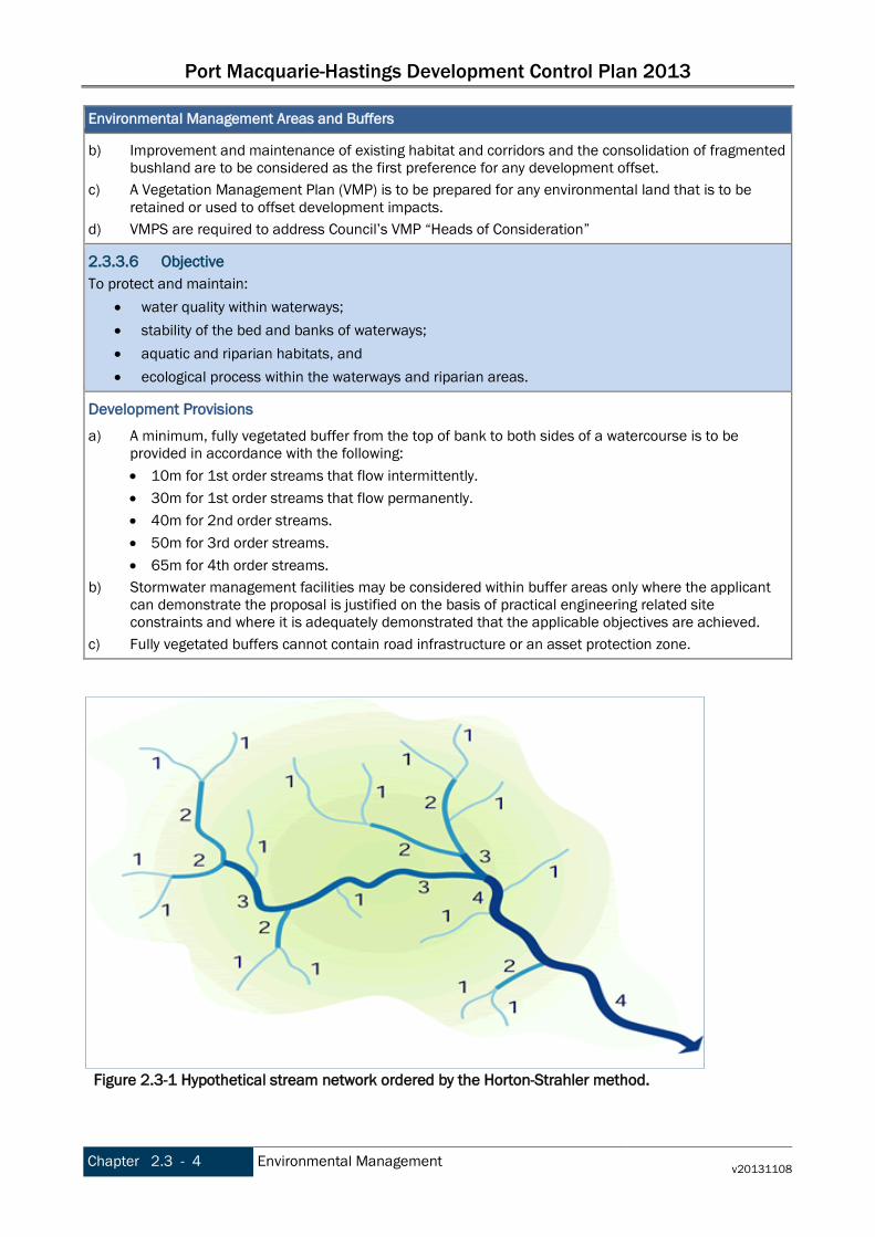
a) A minimum, fully vegetated buffer from the top of bank to both sides of a watercourse is to be provided in accordance with the following: • 10m for 1st order streams that flow intermittently. • 30m for 1st order streams that flow permanently. • 40m for 2nd order streams. • 50m for 3rd order streams. • 65m for 4th order streams.
b) Stormwater management facilities may be considered within buffer areas only where the applicant can demonstrate the proposal is justified on the basis of practical engineering related site constraints and where it is adequately demonstrated that the applicable objectives are achieved.
c) Fully vegetated buffers cannot contain road infrastructure or an asset protection zone.
Figure 2.3-1 Hypothetical stream network ordered by the Horton-Strahler method.
Port Macquarie-Hastings Development Control Plan 2013
v20131108 Environmental Management Chapter 2.3 - 5
Notes: The stream order method which is most frequently used to classify drainage networks is the Horton-Strahler classification system. A first-order stream is the smallest unbranched stream. Two first-order streams join to form a second order stream. When two streams of order w join, a stream order of w + 1 is created. However, when two segments of different orders, for example w and w +1, join the stream segment immediately downstream retains the higher of the orders of the two contributing streams, and will have the order w + 1.
Koala Habitat
2.3.3.7 Objective To encourage the proper conservation and management of areas of natural vegetation that provide habitat for koalas to ensure a permanent free-living population over their present range and reverse the current trend of koala population decline.
Development Provisions
a) For koala habitat refer to clause 7.5 of the Port Macquarie-Hastings LEP 2011. Hollow Bearing Trees
2.3.3.8 Objective To assist with the conservation of biological diversity and promote ecologically sustainable development. To assist in preventing the extinction and promote the recovery of threatened species and populations To protect the habitat of those threatened species and populations that are dependent on hollow-bearing trees for their survival. To assist in the elimination and/or management of processes that threaten the survival or evolutionary development of threatened species and populations. To ensure that the impact of any action affecting threatened species, populations and ecological communities is properly assessed. To encourage the conservation of threatened species and populations by the adoption of measures involving co-operative management. To ensure that risk to people and property is minimised.
Development Provisions
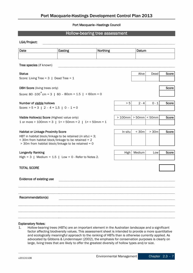
a) All hollow bearing trees within the development area are to be accurately located by survey and assessed by an appropriately qualified ecologist in accordance with Council’s Hollow-bearing tree assessment (HBT) protocol.
b) Any tree that scores less than 8 using the HBT assessment protocol may be considered for removal subject to compensatory measures specified below.
c) Any tree that scores 8-12 using the HBT assessment protocol may be considered for removal if management measures are ‘impractical to allow retention’
d) Any tree that scores more than 12 using the HBT assessment protocol the assessment must be retained and afforded a development exclusion buffer or located within environmental lands.
e) Where a development exclusion buffer is proposed it shall have a radius of 1.25 times the height of the tree measured from its base.
Notes: i) The HBT assessment protocol is included at the end of this Chapter. ii) “Impractical to allow retention” means where the hazard rating, assessed under the Tree Hazard
Evaluation Form (2nd Edition, as adopted by the International Society of Arboriculture) results in a long term rating of more than 10.
Port Macquarie-Hastings Development Control Plan 2013
Chapter 2.3 - 6 Environmental Management v20131108
Hollow Bearing Trees
2.3.3.9 Objective To ensure that where a HBT cannot be retained and managed safely within the future developed landscape, satisfactory and effective ameliorative and compensatory measures shall be implemented prior to removal of the tree
Development Provisions
a) A strategy for tree removal (timing and methodology) that minimises impacts on native wildlife shall accompany any development that proposes the removal of HBTs.
b) The removal of HBTs is to be offset by the retention of recruitment trees. Compensatory recruitment trees shall be provided at the rate of two for one for trees that scored 8-12, and at the rate of one for one for trees that scored less than 8. A tree can be considered to be a compensatory recruitment tree under the following criteria: 1. Does not have any major structural defects or is suffering from disease that would lead to
premature death; and 2. Is from the same vegetation community and same genus; and 3. Are to be located within environmental lands and managed in accordance with a VMP; and 4. Have a DBH of 50cm or greater and do not possess hollows. For Blackbutt Eucalyptus pilularis
a DBH of 100cm or greater applies. c) The removal of HBTs are to be offset by the installation of nesting boxes of similar number and size
as those to be removed. d) Nesting boxes are to be installed like for like (both type and number, and host tree to genus level)
and must be located within proposed open space or environmental lands. Nesting Boxes are to be installed and maintained within environmental lands in accordance with a VMP. Nesting Boxes to be inspected and maintained by a qualified ecologist.
e) Any HBT that will not afford protection via an exclusion buffer or within environmental lands will attract the same offsetting requirements as if it was to be removed.
2.3.4 Amendment history The Development Control Plan is a dynamic document. Please make sure you are using the most recent version for each Chapter. The version reference is printed in the footer of the document. The DCP page on Council’s website lists the current version reference for each Chapter. The Table below lists the dates of adoption and commencement and subsequent amendments for this Chapter.
Date adopted Date commenced Description Version
16/10/2013 08/11/2013 Port Macquarie-Hastings Development Control Plan 2013 v20131108
Port Macquarie-Hastings Development Control Plan 2013
v20131108 Environmental Management Chapter 2.3 - 7
Port Macquarie–Hastings Council
Hollow-bearing tree assessment LGA/Project:
Date Easting Northing Datum
Tree species (if known)
Status Alive Dead Score Score: Living Tree = 3 | Dead Tree = 1
DBH Score (living trees only) Score
Score: 80 -100+cm = 3 | 60 – 80cm = 1.5 | < 60cm = 0
Number of visible hollows > 5 2 - 4 0 - 1 Score Score: > 5 = 3 | 2 – 4 = 1.5 | 0 – 1 = 0
Visible Hollow(s) Score (Highest value only) > 100mm > 50mm < 50mm Score 1 or more > 100mm = 3 | 1+ > 50mm = 2 | 1+ < 50mm = 1
Habitat or Linkage Proximity Score In situ < 30m > 30m Score HBT in habitat block/linkage to be retained (in situ) = 3; < 30m from habitat block/linkage to be retained = 2 > 30m from habitat block/linkage to be retained = 0
Longevity Ranking High Medium Low Score High = 3 | Medium = 1.5 | Low = 0 - Refer to Notes 2.
TOTAL SCORE
Evidence of existing use
Recommendation(s)
Explanatory Notes: 1. Hollow-bearing trees (HBTs) are an important element in the Australian landscape and a significant
factor affecting biodiversity values. This assessment sheet is intended to provide a more quantitative and ecologically meaningful approach to the ranking of HBTs than is otherwise currently applied. As advocated by Gibbons & Lindenmayer (2002), the emphasis for conservation purposes is clearly on large, living trees that are likely to offer the greatest diversity of hollow types and/or size.
Port Macquarie-Hastings Development Control Plan 2013
Chapter 2.3 - 8 Environmental Management v20131108
Hollow-bearing tree assessment continued The assessment does not include provision for a formal survey of HBTs for use by native wildlife. This omission is deliberate and simply reflects the difficulties in accurately representing use of the HBT resource over time, aspects of which may be seasonal and/or periodic. Having said this, any observations about existing use at the time of assessment may be of some importance in the case of low scoring trees when recommendations relating to removal and/or longer- term management are being considered.
2. Longevity Ranking
High: Living tree (any species) with inclination from vertical of less than 10°. Medium: Living tree with shallow adventitious root system (e.g. Blackbutt - Scribbly Gum – Bloodwoods - White Mahoganies) on skeletal soils and with an inclination from the vertical of 10 – 15°. Low: Any dead tree and/or living trees in Medium category that have an inclination from the vertical of > 15°. This is intended to provide an ecological perspective on the extent of likely hazard (in a developed landscape) presented by the tree in question; hence the risk of a dead tree or shallow rooted Eucalyptus spp. on a skeletal soil that has a distinct ‘lean’ on it must be taken into account.
3. The Scoring System
The scoring system is relatively straight forward and serves to facilitate a total score for a given HBT that could fall anywhere between 2 -18. The total score should be interpreted as follows:
Total Score > 12: mandatory retention in landscape required, no disturbance of substrate within radius prescribed by dripline, no habitable dwellings or other structures within buffer area (radius 1.25 x tree height measured from tree base); fencing and hazard/interpretive signposting as required.
Total Score 8 – 12: retention in landscape desirable if objectively assessed hazard rating (see Note 4) can be managed long-term at 10 or less; removal subject to identification of at least 2 recruitment trees of same species & size class elsewhere on land to which DA applies + formal strategy for tree removal that minimizes impact(s) on native wildlife + compensatory nestboxes in immediate vicinity.
Total Score < 8: removal possible subject to identification of at least 1 recruitment tree of same species & size class elsewhere on land to which DA applies + formal strategy for tree removal that minimizes impact(s) on native wildlife + compensatory nestboxes in immediate vicinity.
4. Hazard rating - as determined by use of Tree Hazard Evaluation Form (2nd Ed) – International Society
of Aboriculture. 5. Nothing in these pages is intended to diminish the underlying importance of HBTs in the Australian
landscape generally; rather, it is a tool by which the most important trees can be identified and protected in the first instance, while also offering (for lower scoring HBTs) some flexibility for planning purposes that must also be met by compensatory measures.
References Gibbons, P., and Lindenmayer, D. 2002. Tree Hollows and Wildlife Conservation in Australia. CSIRO Publishing. © biolink 2007.
Port Macquarie-Hastings Development Control Plan 2013
v20170329 Hazards Management Chapter 2.4 - 1
Chapter 2.4 Hazards Management 2.4.1 DCP Context
Land to which this Chapter applies This Chapter applies to all land within the Port Macquarie-Hastings Local Government Area.
Application This Chapter applies to development applications generally
Applicable EPIs Notes: Other relevant controls are: • State Environmental Planning Policy No 33—Hazardous and Offensive Development • State Environmental Planning Policy No 55—Remediation of Land • Manual of Standards Part 139 – Aerodromes, Civil Aviation Safety Authority, regarding proposed
activities within the vicinity of the airport that may involve potentially hazardous or obtrusive lighting or result in emissions that may impair visual conditions or create air turbulence.
• LEP clause 7.1 Acid sulfate soils • LEP clause 7.3 Flood planning • LEP clause 7.4 Floodplain risk management • LEP clause 7.6 Coastline hazards • LEP clause 7.7 Airspace operations • LEP clause 7.8 Development in areas subject to aircraft noise • LEP clause 7.9 Development subject to acoustic controls.
Relationship to other sections of the DCP These provisions apply in addition to any other applicable provisions within other Chapters of this DCP. Refer to Chapter 1.1 Preamble section 1.1.4 Structure for the list of other Chapters.
Purpose The purpose of this Chapter is to outline guidelines for development in areas subject to hazards.
2.4.2 Strategic Context The proper management of hazards is an important issue to ensure that development is not subject to hazards from a range of past and present human activities, as well from natural hazards.
2.4.3 Objectives and Development Provisions
Airspace Protection
2.4.3.1 Objective To minimise risk of obstacles to aircraft such as bird strike.
Development Provisions
a) Development shall not result in land use or activities that attract flying vertebrates such as birds and bats within proximity of flight paths associated with airport operations.

Port Macquarie-Hastings Development Control Plan 2013
Chapter 2.4 - 2 Hazards Management v20170329
Airspace Protection
2.4.3.2 Objective To restrict development that results in emissions that may impair visual conditions or create air turbulence in the vicinity of the airport
Development Provisions
a) Development shall not result in emission of airborne particulate or produce a gaseous plume with a velocity exceeding 4.3m per second that penetrates operational airspace. Refer Manual of Standards Part 139 – Aerodromes, Civil Aviation Safety Authority.
2.4.3.3 Objective To control potentially hazardous or obtrusive lighting within the vicinity of the airport.
Development Provisions
a) Lighting to comply with Section 9.21 of the Manual of Standards Part 139 – Aerodromes, Civil Aviation Safety Authority.
Bushfire Hazard management
2.4.3.4 Objective To ensure bushfire management measures do not result in the loss of important habitat areas. To ensure that Council is not burdened with the ongoing costs associated with the maintenance of Asset Protection Zones. To provide a public interface to environmental assets.
Development Provisions
a) Asset Protection Zones are to be located outside of environmental protection zones and wholly provided within private land. Note perimeter roads provided as part of a residential subdivision are classified as being part of the subdivision and not a separate permissible land use within environment protection zones.
b) Perimeter roads are to be provided to all urban areas adjoining environmental management areas and their buffers.
Refer to Figure 2.4-1.
Figure 2.4-1 Road Section - Indicative Bushland or Riparian Edge Street.
Source: Anterra Design Pty Ltd, 2007

Port Macquarie-Hastings Development Control Plan 2013
v20170329 Hazards Management Chapter 2.4 - 3
Flooding
2.4.3.5 Objective To maintain the existing flood regime and flow conveyance capacity. To enable evacuation of land subject to flooding. To avoid significant adverse impacts on flood behaviour. To avoid significant adverse effects on the environment that would cause avoidable erosion, siltation, destruction of riparian vegetation or a reduction in the stability of the river banks or watercourses. To limit uses to those compatible with flow conveyance function and flood hazard. To limit the cost of evacuation on the general public.
Development Provisions a) Development must comply with Council’s Floodplain Management Plan and Flood Policies.
Stormwater
2.4.3.6 Objective To control and manage all stormwater generated within the development. To control and manage all stormwater passing through the development from the surrounding catchment. To provide an effective legal point of discharge for all collected stormwater, from the development to a natural watercourse, Council’s drainage system or approved outfall. To achieve these objectives without detrimentally affecting the environment, surface and subsurface water quality, groundwater infiltration characteristics, the adjoining landowners and other landowners downstream of the development. To provide a safe and convenient environment for pedestrians and traffic. To incorporate principles of ecological sustainable development. To provide detailed design provisions in line with ecologically sustainable development, water sensitive urban design and total water cycle management and principles. To provide an effective major and minor stormwater system that is cost effective and incorporates life cycle costs of investigation, design, operation, maintenance and replacement of stormwater infrastructure.
Development Provisions a) All stormwater infrastructure is designed in accordance with the Council’s Auspec Design
Specification Documents
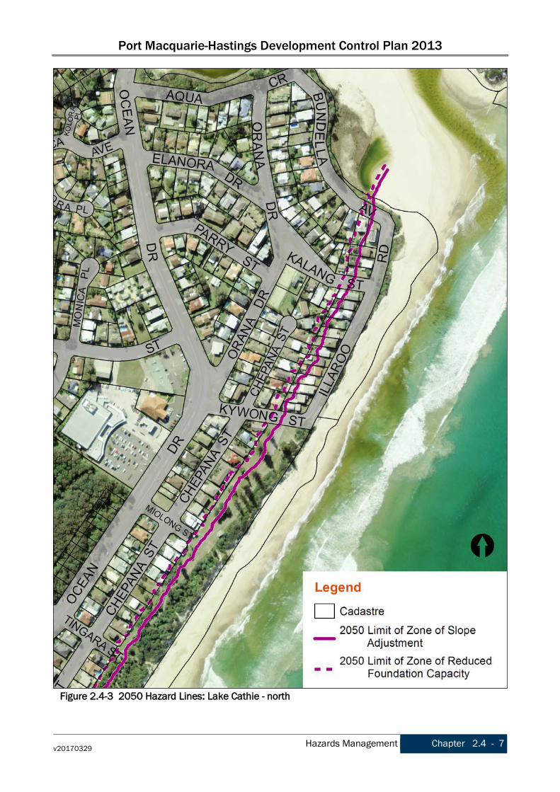
Coastal Hazard Management Clause 7.6 Coastline hazards, in Port Macquarie-Hastings Local Environmental Plan 2011, contains provisions that must be considered prior to the grant of development consent on land mapped as subject to Coastal Erosion Risk. The following DCP provisions are intended to assist in the consideration and interpretation of Coastal Hazard lines for areas covered by the Lake Cathie Coastal Zone Management Plan (2016). A diagram of the development zone provisions relating to the 2050 planning horizon is shown on Figure 2.4.2. The key coastal hazard lines for Lake Cathie are shown on Figures 2.4-3 & 2.4-4 and are defined as: • 2050 Zone of Reduced Foundation Capacity (2050 ZRFC) - shown by dashed magenta line, and • 2050 Zone of Slope Adjustment (2050 ZSA) - shown by solid magenta line.

Port Macquarie-Hastings Development Control Plan 2013
Chapter 2.4 - 4 Hazards Management v20170329
These define the coastal hazard area into: A landward of the 2050 ZRFC - no restrictions B between the 2050 ZRFC and 2050 ZSA - restrictions C seaward of the 2050 ZSA - restrictions
Lake Cathie Coastal Hazard Management
2.4.3.7 Objective To assist in the consideration of coastline hazards, as required by clause 7.6 of LEP 2011, relating to:
• avoiding significant adverse impacts from coastal hazards, • enabling evacuation of coastal risk areas in an emergency, • ensuring uses are compatible with coastal risks.
To facilitate adaptive planning for natural hazard and risk of coastline erosion. To ensure new development or redevelopment of existing properties avoids significant adverse impacts from coastal hazards. To ensure land use that reduces exposure to risks from coastal hazards, including through siting, design, construction and operation decisions. To ensure uses are compatible with coastal risks. To mitigate current and future risk from coastal hazards by taking into account the effects of coastal processes and climate change.
Development Provisions a) Development shall not proceed unless it can be demonstrated that the provisions of each applicable
development zone can be met.
Figure 2.4-2 2050 Hazard Zones and Stable Foundation Zone calculation guidelines

Port Macquarie-Hastings Development Control Plan 2013
v20170329 Hazards Management Chapter 2.4 - 5
Lake Cathie Coastal Hazard Management
Table 2.4-1 2050 Development zone provisions ZONE A No coastal hazard development restrictions apply. Normal relevant planning controls apply. ZONE B The following controls apply for properties behind the 2050 zone of slope adjustment and
forward of the 2050 zone of reduced foundation capacity. 1. Development to existing dwellings be limited to a one off maximum 10% increase in
Gross Floor Area (refer to PM-H LEP 2011 definition), calculated from the ground floor footprint only, unless provided with foundation footings extending into the stable foundation zone or the development is undertaken as relocatable structures.
ZONE C The following controls apply for properties forward of the 2050 zone of slope adjustment. 1. Development to existing dwellings be limited to a maximum 10% increase in Gross
Floor Area (calculated from the ground floor footprint only) or be undertaken as relocatable structures.
2. Ancillary development (decks/patios, carports, detached garages outbuildings and structures (including pools) must be undertaken as relocatable structures).
For engineering calculation requirements refer to Figure 6.1 on page 67 of Lake Cathie Coastline Management Study (Stage 1), available under Lake Cathie Management on Council's website.
2.4.3.8 Objective To enable removal of relocatable structures in coastal risk areas in an emergency. To adopt coastal management strategies that reduce exposure to coastal hazards. To improve the resilience of coastal development and communities by improving adaptive capacity and reducing reliance on emergency responses.
Development Provisions
a) Relocatable structures must be designed and constructed so that they can be quickly and easily removed from the site by road vehicle.
b) Relocatable structures must be modular in construction and installation. Each relocatable structure module must be single storey.
c) Confirmation must be provided that the relocatable structures can be legally transported on NSW public roads in accordance with applicable regulations and legislation, notably the Heavy Vehicle National Law and Regulations (NSW). Specific details on escort vehicles requirements, road closure notices and traffic management permits shall be provided in the Relocation Management Plan.
d) A certificate is to be provided from a structural engineer as to the adequacy of the relocatable structure and its capacity to be easily dismantled and readily removed.
e) Plans and specifications accompanying the structural engineering certificate for the building must be provided which demonstrate that the building can be easily dismantled, prepared for removal and that removal is practical and achievable.
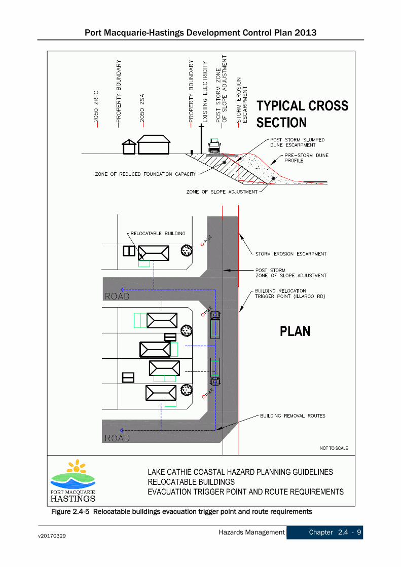
f) Removal of the building must be undertaken using the existing NSW public road network. Trigger Points g) For sites with direct frontage to Illaroo Road, relocation of the building must be initiated once the
erosion escarpment reaches the seaward edge of the existing formed road surface (i.e. the sealed bitumen edge) directly seaward of the site frontage, or if the erosion escarpment reaches such a point on the last available relocation route that would inhibit relocation of buildings offsite.
h) For sites located on a corner block (i.e. corner of Illaroo Road and Kywong Street, Kalang Street or Bundella Avenue), relocation of the building must be initiated once the erosion escarpment is within 10m of the relocatable building.
i) The erosion escarpment distance is to be measured from the closest point of the site, or for corner sites, the closest point of the relocatable building.
j) All approvals will include a condition of consent requiring the removal of structures if the above trigger points occur.

Port Macquarie-Hastings Development Control Plan 2013
Chapter 2.4 - 6 Hazards Management v20170329
Lake Cathie Coastal Hazard Management
k) Refer to Figure 2.4.5 for evacuation trigger point and removal route information.
Relocation Management Plan l) The proposed removal route and destination shall be identified and detailed on a Relocation
Management Plan. m) The Relocation Management Plan shall detail the following matters (Note: this list is not considered
to be exhaustive): • The removal route for the relocatable structure • The final or temporary destination for the relocatable structure • Dimensions of the relocatable structure modules • Any requirements of the Roads and Maritime Services (RMS) and National Heavy Vehicle
Regulator (NHVR) • Method of relocating/removing the structure modules • Proposed timeframe for relocating/removing the structure modules • Any impacts to services (eg. water mains, power poles, etc)
n) How ancillary structures/developments/infrastructure/vegetation (eg. decks, patios, detached garages/sheds, fences, water tanks trees and the like) will be managed during relocating/removing the structure modules. Temporary storage areas for ancillary items requiring relocation/removal to enable relocation/removal of the structure modules shall be identified on the Relocation Management Plan.
Notes For further information about the operation of trigger points, evacuation and relocation, refer to Lake Cathie Management on Council's website.
Port Macquarie-Hastings Development Control Plan 2013
v20170329 Hazards Management Chapter 2.4 - 7
Figure 2.4-3 2050 Hazard Lines: Lake Cathie - north

Port Macquarie-Hastings Development Control Plan 2013
Chapter 2.4 - 8 Hazards Management v20170329
Figure 2.4-4 2050 Hazard Lines: Lake Cathie - south
Port Macquarie-Hastings Development Control Plan 2013
v20170329 Hazards Management Chapter 2.4 - 9
Figure 2.4-5 Relocatable buildings evacuation trigger point and route requirements

Port Macquarie-Hastings Development Control Plan 2013
Chapter 2.4 - 10 Hazards Management v20170329
Amendment history The Development Control Plan is a dynamic document. Please make sure you are using the most recent version for each Chapter. The version reference is printed in the footer of the document. The DCP page on Council’s website lists the current version reference for each Chapter. The Table below lists the dates of adoption and commencement and subsequent amendments for this Chapter. Date adopted Date commenced Description Version
16/10/2013 08/11/2013 Port Macquarie-Hastings Development Control Plan 2013 v20131108
15/03/2017 29/03/2017 Port Macquarie-Hastings Development Control Plan 2013 (Amendment No 7) v20170329

Port Macquarie-Hastings Development Control Plan 2013
v20131108 Transport, Traffic Management, Access and Car Parking Chapter 2.5 - 1
Chapter 2.5 Transport, Traffic Management, Access and Car Parking
2.5.1 DCP Context
Land to which this Chapter applies This Chapter applies to all land within the Port Macquarie-Hastings Local Government Area.
Application These provisions relate to all traffic generating development.
Applicable EPIs The Local Environmental Plans applying to the land are: • Port Macquarie-Hastings Council Local Environmental Plan 2011, and • Port Macquarie-Hastings Council (Area 13 Thrumster) Local Environmental Plan 2008. Clause 104 and Schedule 3 of SEPP (Infrastructure) 2007 (the “Infrastructure SEPP”) require consultation with Roads and Maritime Services for some developments. For specific development types other SEPPs may contain relevant provisions.
Relationship to other sections of the DCP These provisions apply in addition to any other applicable provisions within other Chapters of this DCP. Refer to Chapter 1.1 Preamble section 1.1.4 Structure for the list of other Chapters.
Purpose The purpose of this Chapter is to encourage well functioning roads and facilitate a vital economy by ensuring the efficient movement of freight and services and by providing access to business and commercial centres by the regions residents.
2.5.2 Strategic Context The transport network is primarily about bringing people, goods and services together. Most Australian regional areas rely heavily on the private vehicle to move from place to place. Bus patronage is low and heavily subsidised and light rail is economically unviable. With increasing population, competition for ‘road space’ will mean longer journey times, greater congestion, higher pollution, shorter pavement lives and higher maintenance costs. The planning and development process has a key role to play in protecting the transport network by encouraging consolidated towns and cities and centrally locating employment, commercial and recreational resources to maximise access and to reduce private car trips. Good planning will also support sustainable transport modes and encourage the use of public transport. Planning controls need to balance parking provision with other development outcomes such as amenity, streetscape and site function. Parking must be adequate to support the economic viability of a development but not excessive to the point where streetscape, amenity or function are compromised. Parking provisions also have an important role in encouraging the use of public transport and other alternative modes. Developments need to accommodate service vehicles, such as waste collection and delivery vehicles. Therefore site design needs to ensure adequate access and manoeuvrability is provided within the site to accommodate the maximum design vehicle. Site design should accommodate all manoeuvring on the site to ensure that there is not obstruction of roads and pathways external to the site. Loading bays also need to be located to ensure that the amenity of the site and the design of the building is not compromised and that noise impacts are managed for adjoining sensitive land uses where these exist.
Port Macquarie-Hastings Development Control Plan 2013
Chapter 2.5 - 2 Transport, Traffic Management, Access and Car Parking v20131108
Car parking areas can detract from the streetscape and site by creating large areas of impervious, unbroken surfaces and by disconnecting the building from the street with excessive setbacks. Landscaping is an opportunity to soften the parking areas by providing vertical elements, shade and visual interest. It also provides a transition from the built environment to the public domain. Stormwater from car parks can be directed to rain gardens, bio retention areas and swales. This assists in the watering of landscaped areas, allows infiltration to groundwater, removes pollutants and reduces the volume and peak flow of stormwater to Council’s stormwater infrastructure.
2.5.3 Objectives and Development Provisions
Road Hierarchy
2.5.3.1 Objective To reinforce the road hierarchy and priorities for these roads.
Development Provisions a) In new areas (as distinct from established areas with a pre-existing road pattern) each class of route
should reflect its role in the road hierarchy by its visual appearance and related physical design standards, including varying levels of vehicle and pedestrian access.
b) Routes should differ in alignment and design standard according to the volume and type of traffic they are intended to carry, the desirable traffic speed, and other factors.
c) All new roads are designed in accordance with Council’s Aus-Spec design specification documents.
2.5.3.2 Objective To manage the network to ensure effective and efficient movement of people and goods. To protect the road network from incompatible land uses and inappropriate access.
Development Provisions a) New direct accesses from a development to arterial and distributor roads is not permitted. Routes
should differ in alignment and design standard according to the volume and type of traffic they are intended to carry, the desirable traffic speed, and other factors.
b) Existing direct accesses from a development to arterial and distributor roads are rationalised or removed where practical.
c) Vehicle driveway crossings are minimal in number and width (while being adequate for the nature of the development), and positioned: • to avoid driveways near intersections and road bends, and • to minimise streetscapes dominated by driveways and garage doors, and • to maximise on-street parking.
Parking provision
2.5.3.3 Objective Adequate provision is made for off-street parking commensurate with volume and turnover of traffic likely to be generated by the development. To ensure no adverse impacts on traffic and road function.
Development Provisions a) Off-street Parking is provided in accordance with Table 2.5-1, located at the end of this Chapter. b) Where a proposed development does not fall within any of the listed definitions, the provision of on-
site parking shall be supported by a parking demand study. c) Where a proposed development falls within more than one category Council will require the total
parking provision for each category.

Port Macquarie-Hastings Development Control Plan 2013
v20131108 Transport, Traffic Management, Access and Car Parking Chapter 2.5 - 3
Parking provision
Council may consider a reduced level of parking where it is supported by a parking demand study that assesses the peak parking demands for the overall development and completed by a suitably qualified and experienced person.
2.5.3.4 Objective The redevelopment of an existing building for a new use responds to the new use in terms of parking and access.
Development Provisions
a) A development proposal to alter, enlarge, convert or redevelop an existing building, whether or not demolition is involved, shall provide the total number of parking spaces calculated from the schedule for the proposed use, subject to a credit for any existing deficiency, including any contributions previously accepted in lieu of parking provision.
2.5.3.5 Objective The capacity of on street parking to address peak or acute demands is not compromised by individual developments unable to provide car parking within their sites.
Development Provisions
a) On street parking, for the purposes of car parking calculations, will not be included unless it can be demonstrated that: • there is adequate on street space to accommodate peak and acute parking demands of the
area; • parking can be provided without compromising road safety or garbage collection accessibility; • parking can be provided without jeopardising road function; and • that streetscape improvement works, such as landscaped bays and street trees are provided to
contribute to the streetscape. b) Council may allow on street visitor parking for dual occupancies where it is demonstrated that:
• there is sufficient space on street to accommodate the car spaces; • the street is a cul-de-sac (but not at the turning head) or one with low traffic volumes; • where there is no other major parking generating development in the immediate area; and • where on street parking will not compromise road safety; and • parking can be provided without jeopardising road function.
c) On street parking is provided in accordance with AS2890.5.
2.5.3.6 Objective On street parking contributes to the streetscape.
Development Provisions
a) On street parking will not be permitted unless it can be demonstrated that: • parking does not detract from the streetscape; and • that streetscape improvement works, such as landscaped bays and street trees are provided.
Parking Layout
2.5.3.7 Objective Parking areas and access-ways are easy and safe to use by vehicles and pedestrians without conflict.
Development Provisions a) Visitor and customer parking shall be located so that it is easily accessible from the street.
Port Macquarie-Hastings Development Control Plan 2013
Chapter 2.5 - 4 Transport, Traffic Management, Access and Car Parking v20131108
Parking Layout
b) Internal signage (including pavement markings) should assist customers and visitors to find parking and circulate efficiently and safely through a car park.
c) Parking spaces shall generally be behind the building line but may be located between the building line and the street when: • it is stacked parking in the driveway; or • it can be demonstrated that improvements to the open space provided will result; and • the spaces are screened (densely landscaped or similar) from the street by a landscaping with a
minimum width of 3.0m for the entire length of the parking area. d) Parking design and layout is provided in accordance with AS/NZS 2890.1 - Parking facilities - Off-
street car parking and AS/NZS 2890.2 - Parking facilities - Off-street commercial vehicle facilities. e) Stack or tandem parking spaces will not be included in assessment of parking provision except
where: • the spaces are surplus to that required; • in motor showrooms; • for home business; • for exhibition homes; • in car repair stations; • staff parking spaces are separately identified and delineated; • it is visitor parking in a Torrens titled dual occupancy directly in front of the garage with a
minimum depth of 5.5m.
2.5.3.8 Objective Aged and disabled persons and persons wheeling prams or trolleys are provided with suitable access.
Development Provisions
a) Parking is provided in accordance with AS/NZS 2890.1 - Parking facilities - Off-street car parking and AS/NZS 2890.2 - Parking facilities - Off-street commercial vehicle facilities and AS 1428 - Design for access and mobility.
b) Additional spaces may be required where Council considers the development will generate a higher volume of aged or disabled traffic.
2.5.3.9 Objective Parking is provided for other forms of transport
Development Provisions
a) Bicycle and motorcycle parking shall be considered for all developments. b) Bicycle parking areas shall be designed generally in accordance with the principles of AS2890.3 -
Parking facilities - Bicycle parking facilities. c) Motorcycle parking areas shall be 1.2m (wide) x 2.5m (long).
Redevelopment of Heritage Items - Conservation Incentives
2.5.3.10 Objective To allow the consideration of reduced parking provision to protect heritage items where applicable.
Development Provisions a) Council will consider discounting (i.e. exclude from calculations) the floor space of the heritage
building/item when determining the total number of parking spaces to be provided on site. This will be considered in line with clause 5.10 of PMH LEP 2011, which requires the variation to be considered in the context of a heritage conservation management plan. This will only apply if Council
Port Macquarie-Hastings Development Control Plan 2013
v20131108 Transport, Traffic Management, Access and Car Parking Chapter 2.5 - 5
Redevelopment of Heritage Items - Conservation Incentives
is satisfied that the conservation of the heritage item is dependent upon Council making that exclusion. If applicants intend to seek such consideration, a detailed parking analysis of the site is to be submitted with the development application.
Section 94 Contributions
2.5.3.11 Objective Parking requirements of the community are met without imposing an additional liability on general rating revenue. To provide a mechanism to offset parking shortfalls.
Development Provisions a) Section 94 of the Environmental Planning and Assessment Act 1979 permits Council, at its
discretion, to accept a monetary contribution in lieu of on-site parking where it is considered impractical or undesirable to provide parking facilities on the site of the proposed development. Generally, contributions will not be accepted for the total amount of parking to be provided and will only be accepted in the commercial areas of Port Macquarie, Gordon Street, Laurieton, North Haven and Wauchope, as identified in Council's Contribution Plan 1993, as amended. Contribution rates are indexed (CPI) each quarter with variations in the contribution rate for each area. Applicants are advised to consult Council's staff at the time of preparing the DA application shall a contribution for parking be proposed.
Landscaping of Parking Areas
2.5.3.12 Objective Parking areas are visually pleasing and easily accessible. Parking areas shall be landscaped to:
• provide shade; • improve the visual amenity of large, unrelieved hard stand areas; • provide a buffer between the road and neighbouring land uses.
Development Provisions a) Landscaping areas shall be provided in the form of large tree planting, understorey plantings, mulch
areas, mounding, lawns and the like b) Landscaping shall be used throughout the car park and on the perimeters of the property where it
addresses the public domain. c) Tree planting shall:
• improve parking areas visually; • provide shade; • reflect the physical area in which they are located.
d) Understorey planting shall: • be used to both screen parking areas and provide a layering effect; • not adversely interfere with sight lines for traffic on adjacent properties or streets; • shall have reduced heights adjacent to entry/exit points.
e) Garden beds shall: • be a minimum of 3m in width between car parking areas and street boundaries; • include improved garden soil to a minimum depth of 200mm; • include mulching to a minimum depth of 75mm; and

Port Macquarie-Hastings Development Control Plan 2013
Chapter 2.5 - 6 Transport, Traffic Management, Access and Car Parking v20131108
Landscaping of Parking Areas
• have sub grades ripped to allow drainage and proper root penetration
2.5.3.13 Objective To contribute to the creation of functional corridors between different vegetation communities through the urban realm. Landscaping minimises the risk of damage to pavements, services and infrastructure.
Development Provisions a) All plantings on public lands are to be selected from Council's Indigenous Street and Open Space
Planting List from the relevant vegetation community adjacent to the Development. b) Trees are to be grown and installed in accordance with NATSPEC Specifying Trees and Council’s Aus-
Spec Design Specifications Surface Finishes
2.5.3.14 Objective Car parking and manoeuvring on the site does not generate dust, erosion or contaminated runoff.
Development Provisions a) All parking and manoeuvring areas shall be constructed with a coarse base of sufficient depth to suit
the amount of traffic generated by the development, as determined by Council. It shall be sealed with either bitumen, asphaltic concrete, concrete or interlocking pavers. Preliminary details of construction materials for access and car parking areas shall be submitted with the development application. Detailed plans shall be prepared for the construction certificate by a practising qualified Civil Engineer.
b) In special cases (e.g. where traffic volumes are very low) Council may consider the use of consolidated unsealed gravel pavement for car parks. However, this should not be assumed and will need to be justified by the applicant at the development application stage.
Driveway Grades
2.5.3.15 Objective Driveway grades are to be designed to achieve a safe transition from the car park to the road and road to the car park.
Development Provisions
a) Driveways crossing the footpath and for the first 6m of the parking area shall have a maximum grade of 5% (1 in 20).
2.5.3.16 Objective To ensure the underside of vehicles do not scrape where driveways change grade.
Development Provisions
a) Transitional grades shall be a minimum of 2m long.

Port Macquarie-Hastings Development Control Plan 2013
v20131108 Transport, Traffic Management, Access and Car Parking Chapter 2.5 - 7
Drainage
2.5.3.17 Objective Stormwater volumes and peak flows are reduced from impervious car park surfaces.
Development Provisions
a) All parking and manoeuvring spaces shall be designed to avoid concentrations of water runoff on the surface.
b) Vehicle washing facilities are provided for developments on permeable surfaces or grassed areas. Where there is a risk of polluted runoff, a roofed and bunded wash bay must be provided with appropriate treatment mechanisms to meet applicable standards.
c) Council will not permit the discharge of stormwater directly into kerbing and guttering or table drains for any development other than that of a minor nature.
2.5.3.18 Objective Landscaping is to incorporate water sensitive urban design principles and where practical be integrated into the water management of the site.
Development Provisions
a) Car parking areas should be drained to swales, bio retention, rain gardens and infiltration areas. Loading Bays
2.5.3.19 Objective Loading bays are provided to accommodate the maximum design vehicle likely to service the proposed development. To maintain traffic flow and parking on and off site.
Development Provisions
a) Off street commercial vehicles facilities are provided in accordance with AS/NZS 2890.2 - Parking facilities - Off-street commercial vehicle facilities.
b) Loading bays will be provided in accordance with the following requirements; • Minimum dimensions to be 3.5m wide x 6m long. (This may increase according to the size and
type of vehicle). • Vertical clearance shall be a minimum of 5m. • Adequate provision shall be made on-site for the loading, unloading and manoeuvring of delivery
vehicles in an area separate from any customer car parking area. • A limited number of ‘employee only’ car parking spaces may be combined with loading facilities. • Loading areas shall be designed to accommodate appropriate turning paths for the maximum
design vehicle using the site. • Vehicles are to be capable of manoeuvring in and out of docks without causing conflict with
other street or on-site traffic. • Vehicles are to stand wholly within the site during such operations.
c) Industrial development shall provide adequate heavy vehicle access to building entries, or alternatively, external bays located appropriately for goods distribution.
d) For external bays, one bay is required for 500m² of floor space or 1000m² of site area. e) Commercial development having a floor space less than 500m² need not provide a loading bay. f) Other commercial development shall provide one loading bay for the first 1,000m² floor space and
one additional bay for each additional 2,000m². g) If parcel pickup facilities are provided on-site they shall be located so as to avoid conflict with
general traffic flow within parking areas. Parcel pickup lanes shall be separate from through traffic lanes in major shopping developments.

Port Macquarie-Hastings Development Control Plan 2013
Chapter 2.5 - 8 Transport, Traffic Management, Access and Car Parking v20131108
Loading Bays
2.5.3.20 Objective Loading bays do not adversely impact upon the design integrity of the building or the streetscape. Loading bays do not impact on visual or acoustic privacy for nearby residents.
Development Provisions
a) The location and design of loading bays should integrate into the overall design of the building and car parking areas.
b) Where visible from the public domain, loading bays are located behind the building. c) Where loading bays are located close to a sensitive land use, adequate visual and acoustic
screening is provided. Industrial development
2.5.3.21 Objective To ensure the specific access and loading requirements of industrial developments is provided.
Development Provisions
a) Detailed plans are required for proposed vehicular access and circulation, vehicular movement, layout and turning circles in accordance with AUSTROADS and AS/NZS 2890 - Parking Facilities.
b) An adequate area is to be shown on the plan for the loading/unloading and manoeuvring of B-Doubles on site where the industrial estate is accessed by roads approved as B-Double routes. B-Double uncoupling and lay-by areas are to be provided.
c) Sufficient area is to be provided for adequate turning circles on site to enable ingress and egress to be in a forward direction.
d) Vehicle driveways, ingress and egress are to be a minimum of 6 metres from the tangent point of the kerb radius and to be greater than 1.5 metres from the common side boundary with another lot.
e) Generally access driveways are not to be located within the intersection and restricted areas as identified within AS/NZS 2890 - Parking Facilities Parts 1 and 2, and adequate sight distance is to be provided for vehicles and pedestrians.
Traffic Generating Development
2.5.3.22 Objective Developments that generate significant levels of traffic are referred to the Roads and maritime Services for consideration.
Development Provisions
a) Traffic Generating Development as defined under SEPP (Infrastructure) 2007 is referred to Roads and Maritime Services. (Refer to Clause 104 and Schedule 3 of the SEPP.)
2.5.3.23 Objective Provision of sufficient parking spaces for different land uses.
Development Provisions
a) On-site parking is provided in accordance with Table 2.5-1. b) Requirements for different components of a development will be combined, subject to any Council
decision for a reduction based on peak parking loads at different times.

Port Macquarie-Hastings Development Control Plan 2013
v20131108 Transport, Traffic Management, Access and Car Parking Chapter 2.5 - 9
Table 2.5-1 Car Parking Requirements
Land Use Car Parking Requirements
Primary industry land uses
agriculture animal boarding or
training establishments 2 per establishment [min] (up to 10 animals), + 1
per 10 animals thereafter
Accommodation land uses
residential accommodation
dwelling houses dual occupancies
1 per dwelling
secondary dwellings 1 per secondary dwelling semi-detached dwellings 1 per dwelling attached dwellings 1 per 1 or 2 bedroom unit + 1 visitors’ space per 4
per units 1.5 per 3-4 bedroom unit + 1 visitors’ space per 4 per units
multi dwelling housing 1 per 1 or 2 bedroom unit + 1 visitors’ space per 4 per units 1.5 per 3-4 bedroom unit + 1 visitors’ space per 4 per units
residential flat buildings 1 per 1 or 2 bedroom unit + 1 visitors’ space per 4 per units 1.5 per 3-4 bedroom unit + 1 visitors’ space per 4 per units
seniors housing residential care facilities
See SEPP (Housing for Seniors or People with a Disability) 2004
hostels 1 per 5 beds boarding houses 1 per 2 bedrooms + 1 per employee/manager group homes See SEPP (Affordable Rental Housing) 2009 shop top housing Dwelling requirement + Shop requirement rural worker's dwellings 1 per dwelling
Home activity land uses
home business home industry home occupation (sex services)
Dwelling requirements + 1 for visitors + 1 per 2 employees
Tourist accommodation
Tourist and visitor accommodation
hotel or motel accommodation
1.1 per unit + 1 per 2 employees (onsite at any one time) + 1 for on-site manager. If public restaurant/function room included - see restaurants.
For major developments, coach parking may be provided in lieu of car spaces at a rate of 1 coach space per 5 car spaces
serviced apartments See hotel or motel accommodation bed and breakfast
accommodation 1 per bedroom + 1 manager
backpackers' accommodation
1 per 5 beds
Port Macquarie-Hastings Development Control Plan 2013
Chapter 2.5 - 10 Transport, Traffic Management, Access and Car Parking v20131108
Land Use Car Parking Requirements
caravan parks camping ground manufactured home estates moveable dwelling
See Local Government (Manufactured Home Estates, Caravan Parks, Camping Grounds and Moveable Dwellings) Regulation 2005
exhibition homes 2 per home external to garage / dwelling parking space
Commercial land uses business premises
office premises public administration buildings restricted premises retail premises sex services premises
(excl subtypes specifically listed)
1 per 30 m² GLFA or 1.5 spaces per office (min), whichever is the greater. An application for a major commercial development must be accompanied by a Traffic Impact Study that makes adequate provision for public transport facilities and motorcycle and bicycle parking.
bulky goods premises < 500 m² GFA - 1 per 70 m² Gross Floor Area (GFA) >500 m² GFA - 1 per 100 m² GFA for display + 1 per 2 employees (warehouse area)
cellar door premises See pubs funeral homes 2 plus either 1 per 30 m² GFA or 1 per 5 seats in
chapel, whichever is the greater garden centres
hardware and building supplies landscaping material supplies plant nurseries rural supplies timber yards
1 per 70m² display (incl. accessories). Where landscape supplies are included, 1 per employee + 2 visitor [min] + adequate loading/unloading area, to Council's satisfaction
Kiosks In commercial zones: 1 per 30 m² serviced floor area. Outside commercial zones: 1 per 6 m² serviced floor area
markets 2.5 per stall (must be off street) neighbourhood shops 1 per 30 m² GLFA or 1.5 spaces per shop, whichever
is the greater plus secure cycle parking for a minimum of 5 bicycles. Secure cycle parking does include street furniture such as light or sign poles etc.
roadside stalls 2.5 per stall (must be off street) shops See retail premises vehicle sales or hire
premises 1 per 100 m² display area + 1/70 m² spare parts sales area + 1 per employee + adequate loading/unloading area for vehicle carriers.
food and drink premises (This group is a subtype of retail premises)
pubs 1 per 6 m² serviced floor area (including beer garden) + 1 per 2 employees
restaurants In commercial zones: 1 per 30 m² serviced floor area. Outside commercial zones: 1 per 6 m² serviced floor area
Take-away food and drink premises No on-site seating
12 per 100 m² GFA + queuing area for minimum of 8 cars from pickup point 12 per 100 m² GFA + greater of either;
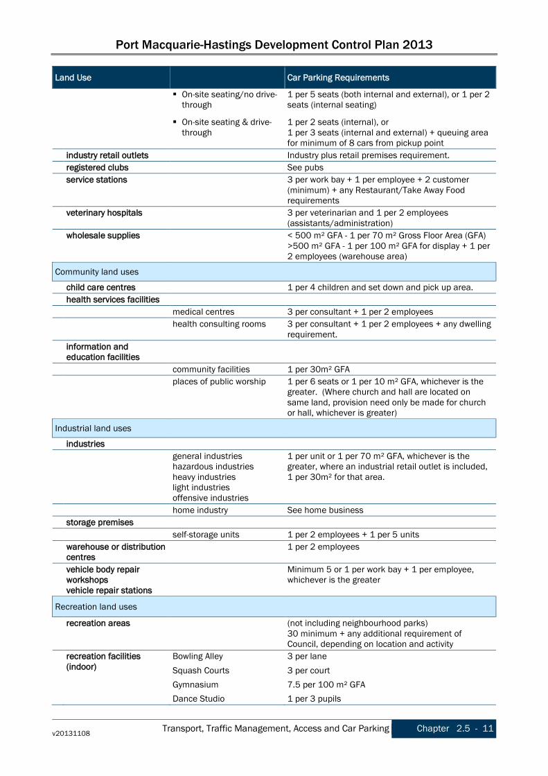
Port Macquarie-Hastings Development Control Plan 2013
v20131108 Transport, Traffic Management, Access and Car Parking Chapter 2.5 - 11
Land Use Car Parking Requirements
On-site seating/no drive-through
1 per 5 seats (both internal and external), or 1 per 2 seats (internal seating)
On-site seating & drive-through
1 per 2 seats (internal), or 1 per 3 seats (internal and external) + queuing area for minimum of 8 cars from pickup point
industry retail outlets Industry plus retail premises requirement. registered clubs See pubs service stations 3 per work bay + 1 per employee + 2 customer
(minimum) + any Restaurant/Take Away Food requirements
veterinary hospitals 3 per veterinarian and 1 per 2 employees (assistants/administration)
wholesale supplies < 500 m² GFA - 1 per 70 m² Gross Floor Area (GFA) >500 m² GFA - 1 per 100 m² GFA for display + 1 per 2 employees (warehouse area)
Community land uses
child care centres 1 per 4 children and set down and pick up area. health services facilities medical centres 3 per consultant + 1 per 2 employees health consulting rooms 3 per consultant + 1 per 2 employees + any dwelling
requirement. information and
education facilities
community facilities 1 per 30m² GFA places of public worship 1 per 6 seats or 1 per 10 m² GFA, whichever is the
greater. (Where church and hall are located on same land, provision need only be made for church or hall, whichever is greater)
Industrial land uses
industries general industries
hazardous industries heavy industries light industries offensive industries
1 per unit or 1 per 70 m² GFA, whichever is the greater, where an industrial retail outlet is included, 1 per 30m² for that area.
home industry See home business storage premises self-storage units 1 per 2 employees + 1 per 5 units warehouse or distribution
centres 1 per 2 employees
vehicle body repair workshops vehicle repair stations
Minimum 5 or 1 per work bay + 1 per employee, whichever is the greater
Recreation land uses
recreation areas (not including neighbourhood parks) 30 minimum + any additional requirement of Council, depending on location and activity
recreation facilities (indoor)
Bowling Alley Squash Courts Gymnasium Dance Studio
3 per lane 3 per court 7.5 per 100 m² GFA 1 per 3 pupils

Port Macquarie-Hastings Development Control Plan 2013
Chapter 2.5 - 12 Transport, Traffic Management, Access and Car Parking v20131108
Land Use Car Parking Requirements
recreation facilities (outdoor)
Tennis Courts
Golf Course
Bowling Club:
3 per court
4 per hole on course + restaurant + pub requirements.
21 per green + restaurant + pub requirements.
Other land uses
mortuaries See funeral chapels
2.5.4 Amendment history The Development Control Plan is a dynamic document. Please make sure you are using the most recent version for each Chapter. The version reference is printed in the footer of the document. The DCP page on Council’s website lists the current version reference for each Chapter. The Table below lists the dates of adoption and commencement and subsequent amendments for this Chapter.
Date adopted Date commenced Description Version
16/10/2013 08/11/2013 Port Macquarie-Hastings Development Control Plan 2013 v20131108
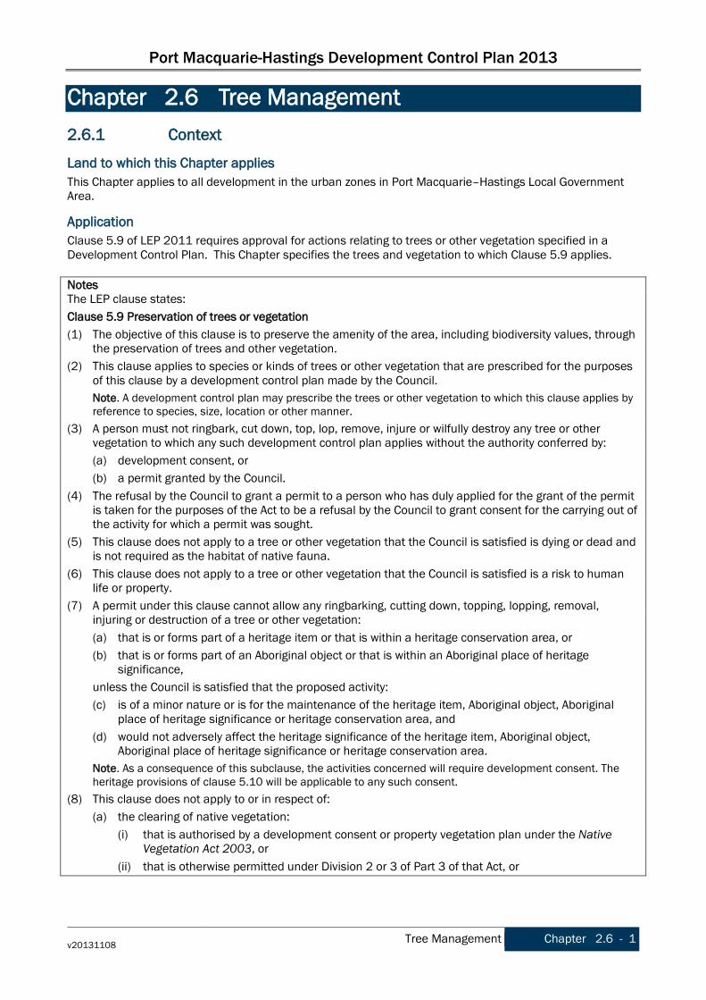
Port Macquarie-Hastings Development Control Plan 2013
v20131108 Tree Management Chapter 2.6 - 1
Chapter 2.6 Tree Management 2.6.1 Context
Land to which this Chapter applies This Chapter applies to all development in the urban zones in Port Macquarie–Hastings Local Government Area.
Application Clause 5.9 of LEP 2011 requires approval for actions relating to trees or other vegetation specified in a Development Control Plan. This Chapter specifies the trees and vegetation to which Clause 5.9 applies. Notes The LEP clause states: Clause 5.9 Preservation of trees or vegetation (1) The objective of this clause is to preserve the amenity of the area, including biodiversity values, through
the preservation of trees and other vegetation. (2) This clause applies to species or kinds of trees or other vegetation that are prescribed for the purposes
of this clause by a development control plan made by the Council. Note. A development control plan may prescribe the trees or other vegetation to which this clause applies by
reference to species, size, location or other manner. (3) A person must not ringbark, cut down, top, lop, remove, injure or wilfully destroy any tree or other
vegetation to which any such development control plan applies without the authority conferred by: (a) development consent, or (b) a permit granted by the Council. (4) The refusal by the Council to grant a permit to a person who has duly applied for the grant of the permit
is taken for the purposes of the Act to be a refusal by the Council to grant consent for the carrying out of the activity for which a permit was sought.
(5) This clause does not apply to a tree or other vegetation that the Council is satisfied is dying or dead and is not required as the habitat of native fauna.
(6) This clause does not apply to a tree or other vegetation that the Council is satisfied is a risk to human life or property.
(7) A permit under this clause cannot allow any ringbarking, cutting down, topping, lopping, removal, injuring or destruction of a tree or other vegetation:
(a) that is or forms part of a heritage item or that is within a heritage conservation area, or (b) that is or forms part of an Aboriginal object or that is within an Aboriginal place of heritage
significance, unless the Council is satisfied that the proposed activity: (c) is of a minor nature or is for the maintenance of the heritage item, Aboriginal object, Aboriginal
place of heritage significance or heritage conservation area, and (d) would not adversely affect the heritage significance of the heritage item, Aboriginal object,
Aboriginal place of heritage significance or heritage conservation area. Note. As a consequence of this subclause, the activities concerned will require development consent. The
heritage provisions of clause 5.10 will be applicable to any such consent. (8) This clause does not apply to or in respect of: (a) the clearing of native vegetation: (i) that is authorised by a development consent or property vegetation plan under the Native
Vegetation Act 2003, or (ii) that is otherwise permitted under Division 2 or 3 of Part 3 of that Act, or

Port Macquarie-Hastings Development Control Plan 2013
Chapter 2.6 - 2 Tree Management v20131108
(b) the clearing of vegetation on State protected land (within the meaning of clause 4 of Schedule 3 to the Native Vegetation Act 2003) that is authorised by a development consent under the provisions of the Native Vegetation Conservation Act 1997 as continued in force by that clause, or
(c) trees or other vegetation within a State forest, or land reserved from sale as a timber or forest reserve under the Forestry Act 1916, or
(d) action required or authorised to be done by or under the Electricity Supply Act 1995, the Roads Act 1993 or the Surveying and Spatial Information Act 2002, or
(e) plants declared to be noxious weeds under the Noxious Weeds Act 1993. Note. Permissibility may be a matter that is determined by or under any of these Acts. Subclause (8)(a) excludes most, but not all, clearing of native vegetation on land within Zones RU1, RU2, RU6 and R5.
Applicable EPIs Development is not exempt or complying development in accordance with the SEPP (Exempt and Complying Development Codes) 2008 where the development involves the removal or pruning of a tree or other vegetation that would otherwise require a permit or development consent for removal or pruning, unless that removal or pruning is undertaken in accordance with a permit or development consent. Notes: SEPP (Exempt and Complying Development Codes) 2008 includes provisions that allow the removal of a tree associated with a CDC where, it is not a heritage item or on a significant tree register, and has a height of less than 6m and located within 3m of the proposed development (within the subject lot). This overrides the operation of clause 5.9 of the LEP and these DCP provisions. The Native Vegetation Act 2003 applies to management of vegetation on rural land. However rural landowners should be aware that exemptions for routine agricultural activities (RAMA) under the Act do not apply broadly to rural small holdings less than 10 hectares or land zoned for rural residential purposes.
Relationship to other sections of the DCP These provisions apply in addition to any other applicable provisions within other Chapters of this DCP. Refer to Chapter 1.1 Preamble section 1.1.4 Structure for the list of other Chapters.
Purpose The purpose of this Chapter is to ensure that proper consideration is given to trees and native vegetation in designing, planning and constructing development.
2.6.2 Strategic Context Vegetation and landscape elements are one of the key character elements of the regions urban precincts, contributing significantly to local views, urban character, and public domain and enhancing the experience of residents and visitors. Management of urban vegetation is fundamental to retaining the unique character of the area and adjacent rural landscapes.
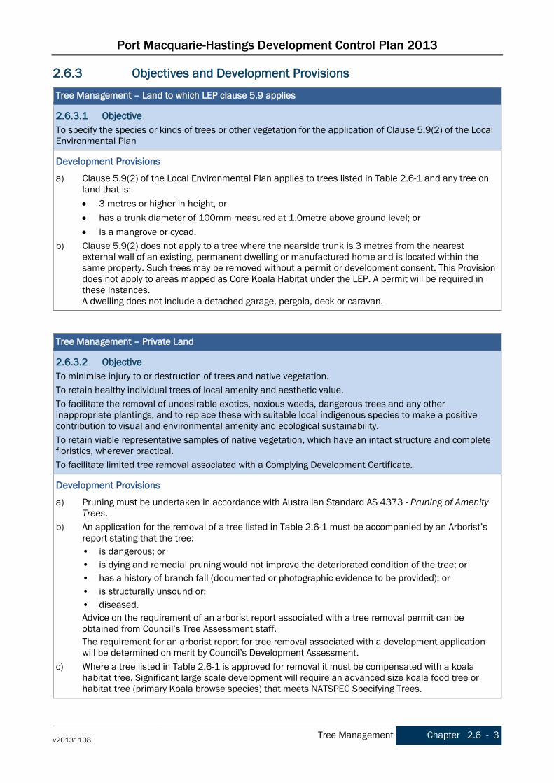
Port Macquarie-Hastings Development Control Plan 2013
v20131108 Tree Management Chapter 2.6 - 3
2.6.3 Objectives and Development Provisions
Tree Management – Land to which LEP clause 5.9 applies
2.6.3.1 Objective To specify the species or kinds of trees or other vegetation for the application of Clause 5.9(2) of the Local Environmental Plan
Development Provisions a) Clause 5.9(2) of the Local Environmental Plan applies to trees listed in Table 2.6-1 and any tree on
land that is: • 3 metres or higher in height, or • has a trunk diameter of 100mm measured at 1.0metre above ground level; or • is a mangrove or cycad.
b) Clause 5.9(2) does not apply to a tree where the nearside trunk is 3 metres from the nearest external wall of an existing, permanent dwelling or manufactured home and is located within the same property. Such trees may be removed without a permit or development consent. This Provision does not apply to areas mapped as Core Koala Habitat under the LEP. A permit will be required in these instances. A dwelling does not include a detached garage, pergola, deck or caravan.
Tree Management – Private Land
2.6.3.2 Objective To minimise injury to or destruction of trees and native vegetation. To retain healthy individual trees of local amenity and aesthetic value. To facilitate the removal of undesirable exotics, noxious weeds, dangerous trees and any other inappropriate plantings, and to replace these with suitable local indigenous species to make a positive contribution to visual and environmental amenity and ecological sustainability. To retain viable representative samples of native vegetation, which have an intact structure and complete floristics, wherever practical. To facilitate limited tree removal associated with a Complying Development Certificate.
Development Provisions a) Pruning must be undertaken in accordance with Australian Standard AS 4373 - Pruning of Amenity
Trees. b) An application for the removal of a tree listed in Table 2.6-1 must be accompanied by an Arborist’s
report stating that the tree: • is dangerous; or • is dying and remedial pruning would not improve the deteriorated condition of the tree; or • has a history of branch fall (documented or photographic evidence to be provided); or • is structurally unsound or; • diseased. Advice on the requirement of an arborist report associated with a tree removal permit can be obtained from Council’s Tree Assessment staff. The requirement for an arborist report for tree removal associated with a development application will be determined on merit by Council’s Development Assessment.
c) Where a tree listed in Table 2.6-1 is approved for removal it must be compensated with a koala habitat tree. Significant large scale development will require an advanced size koala food tree or habitat tree (primary Koala browse species) that meets NATSPEC Specifying Trees.

Port Macquarie-Hastings Development Control Plan 2013
Chapter 2.6 - 4 Tree Management v20131108
Tree Management – Private Land
The compensation tree is to be planted in a suitable location as determined by the Director of Infrastructure Services or his delegate.
d) Removal of dead branches including palm fronts and the selective removal of branches up to and including a diameter of 50mm may be undertaken without a permit or development consent where the removal: • Does not alter the canopy of the tree, and • Does not destroy the aesthetic appearance of the tree canopy; and • Does not alter the growth structure of the tree, and • Is carried out in accordance with Australian Standard AS 4373 - Pruning of Amenity Trees.
e) The pruning of large garden shrubs in excess of 3 metres in height for the purpose of ornamental shaping is permitted without a permit or development consent.
f) Where a development is proposed adjoining Council controlled land, the plans must identify all trees that fall within 6.0m of the property boundary and any trees proposed to be removed, identified on that plan.
g) Any pruning or removal of any tree on private land must be undertaken in accordance with Council’s tree management specifications.
h) A tree removal permit can be sought for tree removal associated with a Complying Development Certificate (CDC), subject to the tree removal meeting the following criteria: 1. Must be associated with CDC and removal must not occur until CDC issued. 2. Application must identify and locate all trees within proximity to the development. 3. No more than 3 trees over 6m in height to be removed. Trees taken to be impacted on by the
development are to be determined in accordance with AS 4970 - Protection of trees on development sites (i.e 12 x DBH tree protection zone required for those trees to be retained).
4. Must not involve removal of hollow bearing trees. 5. The removal of any koala browse tree species are to be replaced at a ratio of 2:1 on site or at a
secure off site location agreed to by Council. Any on site replanting is to have regard for services and buildings and is to be agreed to by Council.
Notes: Public land means any land (including a public reserve) vested in or under the control of the council, … [excluding public roads, Crown land and some other minor cases]. (Local Government Act 1993) Council controlled land means public land and any other land in Council ownership or custodianship, such as road reserves, and some Crown land, footways, beach amenities, foreshore reserves, cemeteries. Tree Management – Council Controlled Land
2.6.3.3 Objective To ensure that proper consideration is given to trees and native vegetation in designing, planning and constructing development. To minimise injury to or destruction of trees and native vegetation. To retain healthy individual trees of local amenity and aesthetic value. To facilitate the removal of undesirable exotics, noxious weeds, dangerous trees and any other inappropriate plantings, and to replace these with suitable local indigenous species to make a positive contribution to visual and environmental amenity and ecological sustainability. To retain viable representative samples of native vegetation, which have an intact structure and complete floristics, wherever practical.
Development Provisions a) Trees on Council controlled land shall not be pruned or removed unless:
• Written consent is provided by Council; and

Port Macquarie-Hastings Development Control Plan 2013
v20131108 Tree Management Chapter 2.6 - 5
Tree Management – Council Controlled Land
• They are dead, dying, diseased or dangerous, or • They are causing damage to infrastructure on public land, or • They are impacting on pedestrian or traffic conditions; or • They are interfering with services on private property; or • They impact on the outlook from historic sites or significant public viewing areas, or • The growth habit or mature size of the tree is undesirable in a particular situation, as determined
by the General Manager or his delegates; or • The trees require removal to fulfil the requirements of section 100C of the Rural Fires Act 1997,
as determined by the General Manager or his delegates. b) Where a tree removal on Council land is approved, the removal is to be supervised by the Director of
Infrastructure Services or their delegate and undertaken in accordance with Council’s tree management specifications.
c) A tree removed on Council land is to be replaced by an approved species in a suitable location as determined by the Director of Infrastructure Services or his delegate.
d) Council will not consider the pruning or removal of trees where the intent is to enhance the views of or from private property.
e) Adhoc planting of trees or other vegetation within the road reserve (including public footpaths) is not permitted. Any planting that occurs in this manner will be removed and the road reserve restored at no cost to the Council.
f) Council may consider permitting planting on public land by an Incorporated Community Group where accompanied by a detailed report.
g) Council has no statuary obligation or onus to treat termites, however where a tree on public land is affected by termites, Council may grant permission for adjoining landowners to enter upon public land to treat termites where treatment does not include the destroying, pruning or removal of trees on public land.
h) Any pruning, removal or treatment of any tree on public land must be undertaken in accordance with Council’s tree management specifications.
i) Council, or contractors working on behalf of Council are exempt from requiring an approval to remove or kill non-native or non indigenous native trees from public bushland reserves.
Table 2.6-1 Koala Food Trees Koala Food Trees Common Name Scientific Name Primary browse species Cabbage Gum Eucalyptus amplifolia Orange Gum Eucalyptus bancrofti Tallowwood Eucalyptus microcorys Parramatta Red Gum Eucalyptus parramattensis Swamp Mahogany Eucalyptus robusta Forest Red Gum Eucalyptus tereticornis Secondary / Supplementary browse species Blue-leaved Stringybark Eucalyptus agglomerata Grey Gum Eucalyptus biturbinata Diehard Stringybark Eucalyptus cameroni Large-fruited Grey Gum Eucalyptus canaliculata Thin-leaved Stringybark Eucalyptus eugenioides Slaty Red Gum Eucalyptus glaucina White Stringybark Eucalyptus globoidea Craven Grey Box Eucalyptus largeana Yellow Box Eucalyptus melliodora

Port Macquarie-Hastings Development Control Plan 2013
Chapter 2.6 - 6 Tree Management v20131108
Koala Food Trees Common Name Scientific Name Grey Box Eucalyptus moluccana Mountain Mahogany Eucalyptus notabilis Small-fruited Grey Gum Eucalyptus propinqua White-topped Box Eucalyptus quadrangulata Red Mahogany Eucalyptus resinifera Rudder’s Box Eucalyptus rudderi Steel Box Eucalyptus rummeryi Narrow-leaved Red Gum Eucalyptus seeana Tindale’s Stringybark Eucalyptus tindaliae Other browse species Smooth Bark Apple Angophora costata Lemon Scented Gum Corymbia citriodora Apple Box Stringybark Eucalyptus bridgesiana River Red Gum Eucalyptus camaldulensis Argyle Apple Eucalyptus cinerea Tasmanian Blue Gum Eucalyptus globulus Flooded Gum Eucalyptus grandis Narrow Leaf Black Peppermint Eucalyptus nicholii Messmate Stringybark Eucalyptus obliqua Blackbutt Eucalyptus pilularis Grey Gum Eucalyptus punctata Narrow-leaved Scribbly Gum Eucalyptus racemosa Sydney Blue Gum Eucalyptus saligna Wallangarra White Gum Eucalyptus scoparia Pink Flowering Mugga Ironbark Eucalyptus sideroxylon Northern Scribbly Gum Eucalyptus signata Broad leaf Paperbark Melaleuca quinquenervia Ribbon or Manna gum Eucalyptus viminalis
Notes: Primary browse species and Secondary / Supplementary browse species - As detailed for the North Coast Koala Management Area in Appendix 2 of the (Approved) Recovery for the Koala Phascolarctos cinereus. Dept. of Environment & Climate Change (NSW) 2008. Other browse species - source: Jason Berrigan; NSW Koala Preservation Society, Port Macquarie
2.6.4 Amendment history The Development Control Plan is a dynamic document. Please make sure you are using the most recent version for each Chapter. The version reference is printed in the footer of the document. The DCP page on Council’s website lists the current version reference for each Chapter. The Table below lists the dates of adoption and commencement and subsequent amendments for this Chapter.
Date adopted Date commenced Description Version
16/10/2013 08/11/2013 Port Macquarie-Hastings Development Control Plan 2013 v20131108

Port Macquarie-Hastings Development Control Plan 2013
v20131108 Social Impact Assessment and Crime Prevention Chapter 2.7 - 1
Chapter 2.7 Social Impact Assessment and Crime Prevention
2.7.1 Context
Land to which this Chapter applies This Chapter applies to all land within the Port Macquarie-Hastings Local Government Area.
Application Section 79C of the Environmental Planning and Assessment Act provides for consideration of a range of matters before a decision can be made on a development application. Included in section 79C are subsections requiring the consent authority to consider the likely impacts of that development, including the environmental impacts on the natural and built environment, social and economic impacts on the locality, and the public interest. These encompass Social impact Assessment and Crime Prevention.
Relationship to other sections of the DCP These provisions apply in addition to any other applicable provisions within other Chapters of this DCP. Refer to Chapter 1.1 Preamble section 1.1.4 Structure for the list of other Chapters.
Purpose To ensure the public interest and potential social impacts resulting from a development are considered in the determination of development applications.
2.7.2 Objectives and Development Provisions
Social Impact Assessment
2.7.2.1 Objective To ensure adverse impacts are identified and mitigation or avoidance measures are adopted to minimise or eliminate social impact on individuals and the community.
Development Provisions a) A social impact assessment shall be submitted in accordance with the Council’s Social Impact
Assessment Policy. Note: Council’s Social Impact Assessment policy includes guidelines to assist applicants in preparing a SIA.
Crime Prevention
2.7.2.2 Objective Development should be designed to deter crime and vandalism and facilitate:
• personal and property security; • casual surveillance of public areas; • activity and interaction within public spaces and movement networks.
Development Provisions a) The development addresses the generic principles of crime prevention:
• Casual surveillance and sightlines; • Land use mix and activity generators; • Definition of use and ownership; • Basic exterior building design;
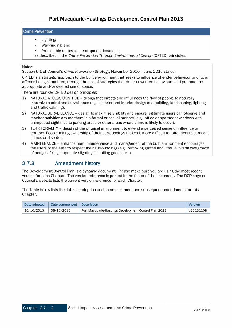
Port Macquarie-Hastings Development Control Plan 2013
Chapter 2.7 - 2 Social Impact Assessment and Crime Prevention v20131108
Crime Prevention
• Lighting; • Way-finding; and • Predictable routes and entrapment locations; as described in the Crime Prevention Through Environmental Design (CPTED) principles.
Notes: Section 5.1 of Council’s Crime Prevention Strategy, November 2010 – June 2015 states: CPTED is a strategic approach to the built environment that seeks to influence offender behaviour prior to an offence being committed, through the use of strategies that deter unwanted behaviours and promote the appropriate and/or desired use of space. There are four key CPTED design principles: 1) NATURAL ACCESS CONTROL – design that directs and influences the flow of people to naturally
maximize control and surveillance (e.g., exterior and interior design of a building, landscaping, lighting, and traffic calming).
2) NATURAL SURVEILLANCE – design to maximize visibility and ensure legitimate users can observe and monitor activities around them in a formal or casual manner (e.g., office or apartment windows with unimpeded sightlines to parking areas or other areas where crime is likely to occur).
3) TERRITORIALITY – design of the physical environment to extend a perceived sense of influence or territory. People taking ownership of their surroundings makes it more difficult for offenders to carry out crimes or disorder.
4) MAINTENANCE – enhancement, maintenance and management of the built environment encourages the users of the area to respect their surroundings (e.g., removing graffiti and litter, avoiding overgrowth of hedges, fixing inoperative lighting, installing good locks).
2.7.3 Amendment history The Development Control Plan is a dynamic document. Please make sure you are using the most recent version for each Chapter. The version reference is printed in the footer of the document. The DCP page on Council’s website lists the current version reference for each Chapter. The Table below lists the dates of adoption and commencement and subsequent amendments for this Chapter.
Date adopted Date commenced Description Version
16/10/2013 08/11/2013 Port Macquarie-Hastings Development Control Plan 2013 v20131108

Port Macquarie-Hastings Development Control Plan 2013
v20131108 Preamble Chapter 3.1 - 1
PART 3 DEVELOPMENT SPECIFIC PROVISIONS
Chapter 3.1 Preamble 3.1.1 Context
Land and LEPs to which this Part applies This Part applies to all land in the Port Macquarie–Hastings Local Government Area. The Local Environmental Plans applying to the land are: • Port Macquarie-Hastings Council Local Environmental Plan 2011, and • Port Macquarie-Hastings Council (Area 13 Thrumster) Local Environmental Plan 2008.
Application These provisions relate to the types of development referred to in each of the Chapters in this Part, as listed below. An application for one or more of these development types should include an assessment of the relevant development provisions of each. A mixed use development should provide an assessment against the relevant development types in the relevant Chapters within this Part.
Relationship to other sections of the DCP These provisions apply in addition to any other applicable provisions within other Chapters of this DCP. Refer to Chapter 1.1 Preamble section 1.1.4 Structure for the list of other Chapters.
3.1.2 Content of Part 3 Part 3 contains the following Chapters:
Chapter 3.1 Preamble Chapter 3.2 Low Density Residential Development - covering dwelling houses, dual
occupancies, multi dwelling houses (such as villas and town houses) and ancillary development
Chapter 3.3 Residential Flat Development, Tourist and Visitor Accommodation, Mixed Use Development - covering residential flat development, tourist and visitor accommodation, shop top housing and other mixed use development
Chapter 3.4 Business and Commercial Development Chapter 3.5 Industrial Development Chapter 3.6 Subdivision
3.1.3 Amendment history The Development Control Plan is a dynamic document. Please make sure you are using the most recent version for each Chapter. The version reference is printed in the footer of the document. The DCP page on Council’s website lists the current version reference for each Chapter. The Table below lists the dates of adoption and commencement and subsequent amendments for this Chapter.
Date adopted Date commenced Description Version
16/10/2013 08/11/2013 Port Macquarie-Hastings Development Control Plan 2013 v20131108

Port Macquarie-Hastings Development Control Plan 2013
Chapter 3.1 - 2 Preamble v20131108
This page is left intentionally blank
Port Macquarie-Hastings Development Control Plan 2013
v20131108 Low Density Residential Development Chapter 3.2 - 1
Chapter 3.2 Low Density Residential Development 3.2.1 Context
Land to which this Chapter applies This Chapter applies to all land within the Port Macquarie-Hastings Local Government Area.
Application This section applies to applications for development consent for the erection of, or additions to the following low density residential development types as defined by the Port Macquarie-Hastings Local Environment Plan 2011: • dwellings (where not part of a high density residential, commercial or industrial development), • dwelling houses, • exhibition homes, • exhibition villages, • semi-detached dwellings, • dual occupancies; • multi dwelling housing; • and ancillary development associated with these developments as defined by State Environmental
Planning Policy – (Exempt and Complying Development Codes) 2008. Notes: SEPP (Exempt and Complying Development Codes) 2008 (the “Codes SEPP”) has provisions that allow most low density development to proceed as either: • exempt development - with no approval requirements under the Environmental Planning and
Assessment Act 1979, or • complying development - with a simplified approval process under the Act. Subject to satisfying the requirements of the Codes SEPP, complying development includes: • General Housing Code - single and two storey dwelling houses and ancillary development - new,
alterations and additions; • Rural Housing Code - single and two storey dwelling houses and ancillary development - new,
alterations and additions; and • Housing Alterations Code This DCP does not apply to development carried out in accordance with the Codes SEPP, nor SEPP (Housing for Seniors or People with a Disability) 2004.
Relationship to other sections of the DCP These provisions apply in addition to any other applicable provisions within other Chapters of this DCP. Refer to Chapter 1.1 Preamble section 1.1.4 Structure for the list of other Chapters.
Purpose The purpose of the provisions of this chapter is to encourage development to: • Have regard to the desired scale, bulk and height of existing residential development as well as
streetscape and landscape in the locality; • Be attractive and functional, • Not unduly affect the amenity of neighbours; • Be landscaped to complement its appearance from the street, adjoining properties and vantage points
in the area, and retain existing vegetation where possible;
Port Macquarie-Hastings Development Control Plan 2013
Chapter 3.2 - 2 Low Density Residential Development v20131108
• Have adequate and functional onsite parking; • Have adequate and functional common and private open space areas on site; • Ensure that access to the property is safe and convenient for residents, visitors and at the
public/private property interface (i.e. line of sight, etc). • Consider the principles of crime prevention in the design of developments. • Be sited and designed to have regard to adjoining and nearby existing structures, street facades and
public open space. • Respond in a positive manner to the skyline • Preserve the building’s relationship to natural features. • Provide optimum solar access to public open spaces within the development and adjoining properties. • ensure ongoing privacy of neighbouring properties. • ensure view sharing opportunities from nearby properties and vantage points are taken into account so
that adverse impacts are minimised.
3.2.2 Objectives and Development Provisions
Dwellings, Dual Occupancies, Dwelling Houses, Multi Dwelling Houses and Ancillary Development
3.2.2.1 Objective To facilitate and sustain certain development as ancillary development.
Note: Ancillary development is development that is ancillary or subordinate to the core purpose of the development being carried out
Development Provisions a) For ancillary development in R1, R2, R3, R4, R5 and RU5 zones:
• The height of an outbuilding or the alterations and additions to an existing outbuilding on a lot should not be more than 4.8m above ground level (existing).
• The building should be single storey construction with a maximum roof pitch of 24 degrees. • The maximum area of the building should be 60m2. • The maximum area of the building should be 60m2 for lots less than 900m² and maximum of
100m² for larger lots. • Ancillary development that is a garage, or an outbuilding, or a rainwater tank should not be
located in front of the main building line.
3.2.2.2 Objective Front setbacks should support an attractive streetscape.
Development Provisions a) Dwellings may incorporate an articulation zone to a street frontage at no less than 3m from property
boundary. The following building elements are permitted within the articulation zone: • an entry feature or portico, • a balcony, deck, patio, pergola, terrace or verandah, • a window box treatment, • a bay window or similar feature, • an awning or other feature over a window, • a sun shading feature. These building elements should not extend above the eave gutter line, other than a pitched roof to an entry feature or portico that has the same pitch as the roof on the dwelling house.
b) In all other cases the primary front setback should be provided as follows:

Port Macquarie-Hastings Development Control Plan 2013
v20131108 Low Density Residential Development Chapter 3.2 - 3
Dwellings, Dual Occupancies, Dwelling Houses, Multi Dwelling Houses and Ancillary Development
The primary frontage is that which addresses the road with the higher volume of traffic.
Street Frontage Setback (min) Classified road – any frontage 6.0m Primary Frontage 4.5m Secondary Frontage 3.0m Ancillary Lane 2.0m Large lot residential and rural zones 10.0m
3.2.2.3 Objective
To minimise the impact of garages and driveways on the streetscape, on street parking and amenity.
To minimise the visual dominance of garages in the streetscape.
Development Provisions a) A garage, carport or car parking space should: b) be at least 1m behind the building line, where the dwelling(s) has a setback from a front boundary of
4.5m or more, or c) be at least 5.5m from a front boundary, where the dwelling(s) has a setback of less than 4.5m. d) Note: The distance to the garage/carport or parking space may be measured to the entry point of the
garage/carport or parking space. e) The total width of the garage/carport opening should not be more than 6m and not more than 50 per
cent of the width of the building. f) Driveway crossovers are a maximum of 1/3 of the site frontage and no greater than 5.0m in width. g) Where a dual occupancy or attached dwelling is proposed on a corner lot a garage and driveway is
provided on each road frontage.
3.2.2.4 Objective
To allow adequate natural light and ventilation between dwellings/buildings and to private open space areas.
To provide useable yard areas and open space.
Development Provisions a) A minimum rear boundary setback of 4m is to be provided to dwellings (including verandas, patios
and decks). A minimum rear boundary setback of 900mm applies to sheds and swimming pools subject to achieving minimum required private open space area
b) Council may consider varying rear setback requirements where it is demonstrated that the private open space could achieve better solar access between the building and the side setback.
c) In that instance one side setback should be a minimum 4.0m in width (for an equivalent length of rear boundary, behind building line) and the rear setback may be reduced to 900mm.
d) A detailed site analysis is to be provided indicating the impact of the design on adjoining dwellings and open space areas.
Note: In relation to setback requirements for low density development, corner blocks do not have a rear boundary.
Table 3.2-1 Street setbacks to dual occupancy or attached dwellings.

Port Macquarie-Hastings Development Control Plan 2013
Chapter 3.2 - 4 Low Density Residential Development v20131108
Dwellings, Dual Occupancies, Dwelling Houses, Multi Dwelling Houses and Ancillary Development
3.2.2.5 Objective
To reduce overbearing and perceptions of building bulk on adjoining properties and to maintain privacy.
To provide for visual and acoustic privacy between dwellings.
Development Provisions a) Ground floors should be setback a minimum of 900mm from side boundaries. b) First floors and above should be setback minimum of 3m from the side boundary or reduced down to
900mm where it can be demonstrated that the adjoining property primary living areas and primary private open space areas should not be adversely overshadowed for more than 3hrs between 9am-3pm on 21 June.
c) Building walls are to step in and out at least every 12m by a minimum of 500mm.
3.2.2.6 Objective To encourage useable private open space for dwellings to meet the occupants requirements for privacy, safety, access, outdoor activities and landscaping.
Development Provisions a) All dwellings should have a minimum area of private open space of 35m2 in one area, with b) a minimum dimension of 4m x 4m; and c) a maximum grade of 5% for minimum 4m x 4m of the total open space requirement; and d) direct accessibility from a ground floor living area. e) Private open space may include clothes drying areas and garbage storage.
3.2.2.7 Objective
To define the edge between public and private land and to provide privacy and security.
To ensure the adequate sight lines are provided for vehicles leaving the site.
To ensure front fencing does not impact on the public domain.
To encourage surveillance of the street and other public places.
Development Provisions a) Front fences built forward of the building line for the primary road frontage should be detailed on the
development application plans. b) Solid Front fences should be:
• A maximum of 1.2m in height, and • Setback 1.0m from the front boundary, and • Suitably landscaped to reduce visual impact, and • Provide a 3m x 3m splay for corner sites.
c) Where a front fence is proposed to be more than 1.2m high: • be a maximum of 1.8m in height, above existing front property boundary level, and • either:
• Include landscaped recesses having minimum dimensions of 1.8m long x 900mm deep which occupy no less than 50% of the total length of the fence, or
• be erected up to the front boundary for a maximum length of 6.0m or 50% of the street frontage,
• have openings which make it not less than 25% transparent; • provide a 3m x 3m splay for corner sites, and • provide a 900mm x 900mm splay for vehicle driveway entrances.
Port Macquarie-Hastings Development Control Plan 2013
v20131108 Low Density Residential Development Chapter 3.2 - 5
Dwellings, Dual Occupancies, Dwelling Houses, Multi Dwelling Houses and Ancillary Development
3.2.2.8 Objective
To encourage dwellings, dual occupancies, multi dwellings and ancillary development to respond in a positive manner to the architectural character of the street.
To encourage casual surveillance of the street.
To reduce opportunity for graffiti or vandalism by minimising solid fence components.
Development Provisions a) Fences along the primary road frontage should be complementary to the existing streetscape and
not be constructed of chain wire, solid timber/masonry/steel.
3.2.2.9 Objective
To define the boundaries between areas within the development having different functions or owners.
To minimise the visual impact of fencing.
Development Provisions a) For tennis courts or other similar areas, chain wire fences should be black or dark green plastic
coated mesh. b) Solid fences enclosing these facilities should not be permitted over 1.8m.
3.2.2.10 Objective To protect the visual privacy of on-site and nearby residents.
Development Provisions a) Direct views between primary indoor and outdoor living areas of adjacent dwellings, including
possible dwellings on future lots, should be obscured or screened where: • ground and first floor windows are within a 9m radius from any part of the window of the
adjacent dwelling; • other floor windows are within a 12m radius; • direct views from living rooms of dwellings into the principle area of private open space of other
dwellings should be screened or obscured where they are within a 12m radius. • A deck, patio, pergola, terrace or verandah has a setback of less than 3m from a side or rear
boundary, and is greater than 3m2 and more than 1m above ground level b) Direct views described above may be reduced or obscured by one of the following measures (details
to be submitted with the development application): • 1.8m high fence or wall between ground-floor level windows or between a dwelling and open
space; • Screening that has 25% openings (max), is permanently fixed and is made of durable materials.
c) Privacy screens are encouraged for: • Windows in a habitable room, other than a bedroom, that has a floor level of more than 1m
above ground level (existing), and • The wall in which the window is located has a setback of less than 3 metres from a side or rear
boundary, and • The window has a sill height of less than 1.5m.
d) A balcony, deck, patio, pergola, terrace or veranda should have a privacy screen if: • ground and first floor windows are within a 9m radius from any part of the window of the
adjacent dwelling; • other floor windows are within a 12m radius;
Port Macquarie-Hastings Development Control Plan 2013
Chapter 3.2 - 6 Low Density Residential Development v20131108
Dwellings, Dual Occupancies, Dwelling Houses, Multi Dwelling Houses and Ancillary Development
• direct views from living rooms of dwellings into the principle area of private open space of other dwellings should be screened or obscured where they are within a 12m radius.
• A deck, patio, pergola, terrace or verandah has a setback of less than 3m from a side or rear boundary, and is greater than 3m2 and more than 1m above ground level
Roof Terraces
3.2.2.11 Objective
• To encourage minimum impact from noise and light from roof terraces.
• To encourage maintenance of visual privacy of adjoining properties.
• To promote an interesting and articulated building form.
• To minimise the impact on building design of temporary or non-fixed structures.
Development Provisions a) Direct views between roof terraces and windows or decks of adjacent dwellings should be screened
where: • ground and first floor windows are within a 9m radius from any part of the window of the
adjacent dwelling; • other floor windows are within a 12m radius; • direct views from living rooms of dwellings into the principle area of private open space of other
dwellings should be screened or obscured where they are within a 12m radius. b) Screening should only be considered where:
• the height of the screen does not exceed the maximum building height; and • the screening contributes to the building form, and • the screening is integrated into the design of the roof; and • is constructed and designed with materials complementary to the building.
c) The trafficable area of the roof terraces should be set back so that there is no direct line of sight to neighbouring open space or to the windows of the habitable rooms of adjoining dwellings within a distance of 12m as measured from the external face of the building with the roof terrace to the external face of the adjoining building.
d) Lighting installations on roof terraces should be: • contained within the roof terrace area and located at a low level, and • appropriately shaded and fixed in a non-adjustable manner so that light is projected downwards
onto the floor surface of the terrace. e) The lighting of roof terraces should be designed in compliance with Australian Standards AS4282 -
Control of obtrusive effects of outdoor lighting. Note: In relation to the following, boat ramps and jetties that are proposed to be located on an allotment with a frontage to the Hastings River, owners should note that the Department of Lands is the consent authority for structures that extend over the Hastings River boundary.

Port Macquarie-Hastings Development Control Plan 2013
v20131108 Low Density Residential Development Chapter 3.2 - 7
Water Recreation Structure (Boat Launching Ramp, Jetty and Mooring)
3.2.2.12 Objective To facilitate private boat usage, where a reasonable depth of water can be obtained without dredging.
Development Provisions
a) The design of any jetty or boating structure should be in accordance with Council’s adopted design specification documents
3.2.2.13 Objective To maintain the amenity and function of waterways through appropriately designed and constructed waterfront infrastructure. To ensure structures do no increase flood risk or become an obstruction in a flood event.
Development Provisions a) Mooring piles are to be set at a level no lower than the level which ensures that the floating structure
is retained during the design 1:100 year flood event. b) The width of a jetty walkway leading to a platform should not be greater than 1.0 metres. c) The area of a platform at the end of a walkway should not exceed 10m². d) The overall length of a jetty when measured from the existing revetment wall should not exceed
17m. e) Boating ramps should have a maximum overall width of 3.0 metres and a maximum overall length of
10.0 metres when measured from the existing revetment wall unless associated with a boatshed where the boat ramp should not exceed 2.7m in width.
f) Pontoons moored at right angles to the revetment wall should not extend beyond a point 17 metres from the wall.
g) Pile cut off levels should not be lower than RL3.0m AHD. h) Fixed jetties may only extend to a point 7m from the revetment wall. i) Any extension beyond a point 7m from the revetment wall is to be by way of a pivoting walkway to a
floating pontoon. j) The deck of the jetty is to be above and not resting on the revetment wall and the top surface is not
to be above RL 1.4m AHD. k) Pontoons moored parallel to the revetment wall should not extend beyond a point 12 metres from it. l) Floating moorings should be located between 17m from the revetment wall. m) Fixed mooring poles should not be greater than 17m from the revetment wall.
3.2.2.14 Objective To promote an equitable use of the waterway amongst adjoining landowners through the minimisation of encroachments by individual waterfront structures in front of adjoining waterfront properties.
Development Provisions a) Jetties and moorings (both fixed and floating) should be located a minimum of 10m from any jetty or
mooring (both fixed and floating) located on any adjacent property. b) Boat ramps and jetties should be located in such a way that vessels using the boat ramp or moored
on a jetty do not project past a line which is a prolongation of the side boundaries of the development site.
3.2.2.15 Objective To promote innovative design and the use of shared structures to minimise the extent of individual residential waterfront development
Development Provisions
Port Macquarie-Hastings Development Control Plan 2013
Chapter 3.2 - 8 Low Density Residential Development v20131108
Water Recreation Structure (Boat Launching Ramp, Jetty and Mooring)
a) For a dual occupancy development only one shared jetty is permitted. b) For multi dwelling housing and residential flat building development only one boat ramp and one
jetty should be permitted, however where such development is carried out on a site with a frontage to a waterway exceeding 25m, then one additional jetty and one additional boat ramp may be permitted.
3.2.3 Amendment history The Development Control Plan is a dynamic document. Please make sure you are using the most recent version for each Chapter. The version reference is printed in the footer of the document. The DCP page on Council’s website lists the current version reference for each Chapter. The Table below lists the dates of adoption and commencement and subsequent amendments for this Chapter.
Date adopted Date commenced Description Version
16/10/2013 08/11/2013 Port Macquarie-Hastings Development Control Plan 2013 v20131108

Port Macquarie-Hastings Development Control Plan 2013
v20150402 Residential Flat Development, Tourist and Visitor
Accommodation, Mixed Use Development Chapter 3.3 - 1
Chapter 3.3 Residential Flat Development, Tourist and Visitor Accommodation, Mixed Use Development
3.3.1 Context
Land to which this Chapter applies This Chapter applies to all land within the Port Macquarie-Hastings Local Government Area.
Application This Chapter applies to applications for development consent for the erection of, or additions to the following the following residential development types as defined by the Port Macquarie-Hastings Local Environment Plan 2011: • Residential flat buildings, Hostels and Shop top housing, • Tourist and visitor accommodation (which encompasses Backpackers’ accommodation, Bed and
breakfast accommodation, Farm stay accommodation, Hotel or motel accommodation, and Serviced apartments), and
• Any residential component of a mixed use development including ‘shop top housing’. Development that is defined as ‘residential flat building’ under State Environmental Planning Policy 65 - Design Quality of Residential Flat Development is subject to the provisions of that policy and the Residential Flat Building Code. The provisions apply to:
• the erection of a new residential flat building, and • the substantial redevelopment or the substantial refurbishment of an existing residential flat
building, and • the conversion of an existing building to a residential flat building.
Applicable EPIs The Chapter follows closely the 10 principles of the State Environmental Planning Policy – Design Quality of Residential Flat Development. For more detailed information or for an explanation of terms used in this Chapter you may refer to the SEPP which is available at www.legislation.nsw.gov.au. Applications for residential flat buildings are to formally address the SEPP. Note: LEP 2011 contains this definition: residential flat building means a building containing 3 or more dwellings, but does not include an
attached dwelling or multi dwelling housing. SEPP No 65 - Design Quality of Residential Flat Development contains this definition: residential flat building means a building that comprises or includes: (a) 3 or more storeys (not including levels below ground level provided for car parking or storage, or
both, that protrude less than 1.2 metres above ground level), and (b) 4 or more self-contained dwellings (whether or not the building includes uses for other purposes,
such as shops), but does not include a Class 1a building or a Class 1b building under the Building Code of Australia. Note. Class 1a and Class 1b buildings are commonly referred to as town houses or villas where the
dwelling units are side by side, rather than on top of each other. Each definition applies in relation to the provisions within each planning instrument.

Port Macquarie-Hastings Development Control Plan 2013
Chapter 3.3 - 2 Residential Flat Development, Tourist and Visitor Accommodation, Mixed Use Development v20150402
Relationship to other sections of the DCP These provisions apply in addition to any other applicable provisions within other Chapters of this DCP. Refer to Chapter 1.1 Preamble section 1.1.4 Structure for the list of other Chapters. In relation to associated strata subdivision, refer to Chapter 3.6, in particular the section Strata / Community Title Subdivision.
Purpose The purpose of the provisions of this chapter is to encourage development to:
• Have regard to the desired scale, bulk and height of existing residential development as well as streetscape and landscape in the locality;
• Be attractive and functional, • Not unduly affect the amenity of neighbours; • Be landscaped to complement its appearance from the street, adjoining properties and vantage
points in the area, and retain existing vegetation where possible; • Have adequate and functional onsite parking; • Have adequate and functional common and private open space areas on site; • Provide safe and convenient access to property for residents, visitors and at the public/private
property interface (i.e. line of sight, etc). • Consider the principles of crime prevention in the design of developments. • Be sited and designed to have regard to adjoining and nearby existing structures, street facades and
public open space. • Preserve the skyline and the building’s relationship to natural features. • Provide optimum solar access to public open spaces within the development and adjoining
properties. • Ensure ongoing privacy of neighbouring properties. • Ensure view sharing opportunities from nearby properties and vantage points to minimise adverse
impacts.
3.3.2 Objectives and Development Provisions
Context Good design responds and contributes to its context. Context is everything that has an impact on an area, its key natural and built features. Context includes social, economic and environmental factors as well as the physical form of the area and its surrounds. Understanding context means understanding how the interrelationships between all these factors, and between the local area and the region, should have an impact on the area in the future. Responding to the local context involves identifying the desirable elements of current character or the key aspects of character that are important to its future. Understanding the local context is a key step in the process of establishing a robust urban structure which can support change and help to identify the appropriate building types and development controls for a particular situation. Residential flat development is an important component of the urban form. Decisions about the location, size and type of residential flat development should be informed by:
• Regional context and urban centres • Neighbourhood and precinct areas • Open space • Views • Topography • Street layout
Port Macquarie-Hastings Development Control Plan 2013
v20150402 Residential Flat Development, Tourist and Visitor
Accommodation, Mixed Use Development Chapter 3.3 - 3
• Streetscape • Blocks • Lots • Heritage buildings and significant elements • Existing uses.
More information on preparing a response to this Chapter can be found in Appendix 4 of the Residential Flat Design Code at www.planning.nsw.gov.au. A site analysis is mandatory to encourage high quality development that is sensitive to its environment and positively contributes to its context. A thorough site analysis should ensure that site layout and building design address existing and possible future opportunities and constraints of both the principle site and its surrounds. An analysis of the site and context is a fundamental stage of the design process, and should support many key design decisions relating to the proposal. The site analysis should assist in minimising issues relating to noise, overshadowing, community safety, access, views, privacy, energy consumption and waste generation. The applicant should demonstrate to Council that a site analysis has been utilised in preparing the design for the site and that due consideration has been given to the opportunities and constraints identified. The analysis may then be used by Council and the applicant to assess the merit of the proposal in its response to the features of the site and its context. A site analysis drawing should be based on a survey drawing produced by a qualified surveyor and contain a reference number and date. The site analysis should be prepared to scale and accurately show the following required information. Site Design and Analysis
3.3.2.1 Objective To encourage consideration of site attributes and constraints during the design phase of the development.
Development Provisions a) A site analysis plan is required for all development and should illustrate:
• microclimate including the movement of the sun and prevailing winds; • lot dimensions; • north point; • existing contours and levels to AHD; • flood affected areas; • overland flow patterns, drainage and services; • any contaminated soils or filled areas, or areas of unstable land; • easements and/or connections for drainage and utility services; • any existing trees and other significant vegetation; • any existing buildings and other structures, including their setback distances; • heritage and archaeological features; • fences, boundaries and easements; • pedestrian and vehicle access; • views to and from the site; • overshadowing by neighbouring structures; and • any other notable features or characteristics of the site.

Port Macquarie-Hastings Development Control Plan 2013
Chapter 3.3 - 4 Residential Flat Development, Tourist and Visitor Accommodation, Mixed Use Development v20150402
Site Design and Analysis
3.3.2.2 Objective To promote consideration of characteristics of adjacent and surrounding sites and the neighbourhood at the outset of the design process.
Development Provisions a) A site analysis plan is required for all development and should illustrate:
• the location, height and use of buildings surrounding the site, and those across any road adjacent to the site, including their setback distances;
• views and solar access to surrounding residents; • private open space and windows of habitable rooms of nearby properties which have an outlook
to the site; • location, height and materials of walls built to the boundary of the site; • difference in levels between the site and adjacent properties at their boundaries; • major and significant trees on adjacent properties, particularly those within 9 m of the site; • street frontage features including poles, trees, kerb crossovers, bus stops and other services; • the built form, scale and character of surrounding and nearby development, including fencing
and landscaping; • heritage features and buildings of the surrounding locality and landscape; • direction and distance to local facilities including local shops, schools, public transport and
recreation and community facilities; • characteristics of, and distance to any nearby public open space; • any nearby bushland or environmentally sensitive land; and • any significant local noise, odour or pollution sources.
Site Layout
3.3.2.3 Objective To achieve a layout that provides a pleasant, manageable and functional living environment that integrates with the neighbourhood. To encourage consideration of energy-efficiency and solar access issues at the outset of the design process.
Development Provisions a) All applications are to include a site plan which annotates the manner in which site attributes and
constraints have been considered, as follows: • appropriateness of built form and landscape in relation to the site context, topography and urban
character; • building arrangement and relationship to streets and open space; • access ways within and beyond the site; • location, function and opportunities for casual surveillance of open space; • ongoing site management considerations (i.e. garbage, mail collection, stormwater etc); • location of existing and proposed stormwater and sewer pipes; • private open space and security; • parking arrangements and reduced dominance of driveways; • heritage and conservation opportunities and constraints (where relevant). • energy efficiency in building design and siting; • solar access to subject development and adjoining residences

Port Macquarie-Hastings Development Control Plan 2013
v20150402 Residential Flat Development, Tourist and Visitor
Accommodation, Mixed Use Development Chapter 3.3 - 5
Streetscape and Front Setback
3.3.2.4 Objective Front setbacks are to provide adequate open space for landscaping, visual and acoustic privacy. To provide a streetscape that is consistent and complementary to existing development.
Development Provisions a) In an established street, the primary setback should be within 20% of the average setback of the
adjoining buildings or 2m for secondary frontages. b) Where there is no adjoining development a minimum setback of 3.0m is required from all street
frontages. c) Where tourist accommodation is proposed a maximum setback of 9 metres is permitted to allow for
a swimming pool within the front setback.
3.3.2.5 Objective To promote buildings of articulated design and massing, with useable private external open spaces
Development Provisions a) Balconies and other building extrusions may encroach up to 600mm into the required front setback. b) Buildings should generally be aligned to the street boundary. c) Primary openings on all developments are aligned to the street boundary or to the rear of the site.
Side and Rear Setbacks
3.3.2.6 Objective To allow flexibility in the siting of buildings while limiting the extent to which any building overshadows or overlooks adjacent properties. To allow adequate natural light and ventilation between dwellings/buildings and to private open space areas. To provide acoustic and visual privacy. To provide adequate area for deep soil planting.
Development Provisions a) The following setbacks (Refer Figure 3.3-1) apply to all sites, except where the side boundary is a
secondary street frontage: • Buildings should be set back a minimum of 1.5m from side boundaries, for a maximum of 75%
of the building depth. • Windows in side walls should be set back 3m from side boundaries. • Where the site is adjacent to an existing strata-titled building, buildings should be set back a
minimum of 3m from side boundaries. b) Side walls adjacent to existing strata-titled buildings should be articulated and modulated to respond
to the existing buildings. c) A minimum rear setback of 6.0m from the building and sub basements is required.
3.3.2.7 Objective To encourage high density outcomes in those areas identified as medium and high density residential.
Development Provisions a) A party wall development may be required if site amalgamation is not possible and higher density
development is envisaged by these controls.

Port Macquarie-Hastings Development Control Plan 2013
Chapter 3.3 - 6 Residential Flat Development, Tourist and Visitor Accommodation, Mixed Use Development v20150402
Side and Rear Setbacks
3.3.2.8 Objective To encourage good interim building design for party walls.
Development Provisions a) Party wall development can occur only with the agreement and consent of the adjoining property
owner. Exposed party walls should be finished in a quality comparable to front facade finishes
3.3.2.9 Objective To provide good streetscape for secondary streets. To encourage quality urban design outcomes for corner sites.
Development Provisions a) Corner sites should be consolidated with adjacent sites, so that the building should turn the corner. b) If this is not possible a minimum setback of 6.0m should extend to the secondary street. Refer
Figure 3.3-2 and Error! Reference source not found..
3.3.2.10 Objective To encourage good quality urban design outcomes for sites that address open space. To encourage casual surveillance of public spaces.
Development Provisions a) Where sites adjacent to open space are to be developed the edge of the open space should be
defined with a public road and buildings address the open space.
Figure 3.3-1 Side setback provisions for two scenarios.

Port Macquarie-Hastings Development Control Plan 2013
v20150402 Residential Flat Development, Tourist and Visitor
Accommodation, Mixed Use Development Chapter 3.3 - 7
Figure 3.3-2 Deep soil requirements for development scenarios on corner lots.
Building Depth and Deep Soil Zone
3.3.2.11 Objective To enhance the appearance, amenity and energy and water efficiency of housing through integrated landscape design. To preserve natural drainage and subsoil water.
Development Provisions
a) Deep soils zones should extend for the width of the site and should have a minimum depth of 6.0m. b) Deep soil zones are to be contiguous across sites and within blocks. Refer to Figure 3.3-3.
3.3.2.12 Objective To improve the visual amenity of Port Macquarie by retaining, and where possible increasing the coverage of substantial vegetation.
Development Provisions
a) Deep soil zones should accommodate existing advanced trees, and allow for advanced tree planting.
3.3.2.13 Objective To increase the capacity of the site and locality for water infiltration to assist with management of the water table and water quality.
Development Provisions
a) Deep soil zones should be integrated into the stormwater management measures for the development and the site

Port Macquarie-Hastings Development Control Plan 2013
Chapter 3.3 - 8 Residential Flat Development, Tourist and Visitor Accommodation, Mixed Use Development v20150402
Figure 3.3-3 Preferred deep soil zone provision.
Resource, energy and water efficiency Good design makes efficient use of natural resources, energy and water throughout the full life cycle of the building, including construction. Sustainability is integral to the design process. Aspects include demolition of existing structures, recycling of materials, selection of appropriate and sustainable materials, adaptability and reuse of buildings, layouts and built form, passive solar design principles, efficient appliances and mechanical services, soil zones for vegetation and reuse of water. Energy Conservation and Solar Access
3.3.2.14 Objective To avoid the potential for significant overshadowing of habitable rooms and private open spaces
Development Provisions a) Sunlight to the principal area of ground-level private open space of adjacent properties should not be
reduced to less than 3 hours between 9.00am and 3.00pm on June 22. Where existing overshadowing by buildings and fences is greater than this, sunlight should not be reduced by more than 20%.
b) Buildings should not reduce the sunlight available to the windows of living areas that face north in existing adjacent dwellings to less than the above specification.
3.3.2.15 Objective To reduce total energy use in residential buildings by reducing heat loss and energy consumption for heating and cooling.
Development Provisions a) Apartments are to provide an internal clothes drying space to discourage the use of mechanical
clothes drying. b) Ceiling fans are to be provided in preference to air conditioning.
(Except in instances where mechanical ventilation is required because of noise, pollution or where natural adequate ventilation cannot be achieved.)
c) Solar hot water systems (or equivalent technology) should be provided. d) Photovoltaic arrays should be installed where practical. Refer to Figure 3.3-4.
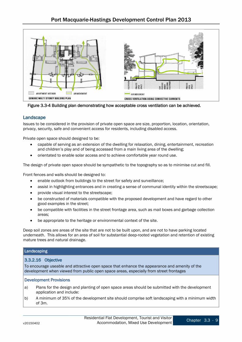
Port Macquarie-Hastings Development Control Plan 2013
v20150402 Residential Flat Development, Tourist and Visitor
Accommodation, Mixed Use Development Chapter 3.3 - 9
Landscape Issues to be considered in the provision of private open space are size, proportion, location, orientation, privacy, security, safe and convenient access for residents, including disabled access. Private open space should designed to be:
• capable of serving as an extension of the dwelling for relaxation, dining, entertainment, recreation and children’s play and of being accessed from a main living area of the dwelling;
• orientated to enable solar access and to achieve comfortable year round use. The design of private open space should be sympathetic to the topography so as to minimise cut and fill. Front fences and walls should be designed to:
• enable outlook from buildings to the street for safety and surveillance; • assist in highlighting entrances and in creating a sense of communal identity within the streetscape; • provide visual interest to the streetscape; • be constructed of materials compatible with the proposed development and have regard to other
good examples in the street; • be compatible with facilities in the street frontage area, such as mail boxes and garbage collection
areas; • be appropriate to the heritage or environmental context of the site.
Deep soil zones are areas of the site that are not to be built upon, and are not to have parking located underneath. This allows for an area of soil for substantial deep-rooted vegetation and retention of existing mature trees and natural drainage. Landscaping
3.3.2.16 Objective To encourage useable and attractive open space that enhance the appearance and amenity of the development when viewed from public open space areas, especially from street frontages
Development Provisions a) Plans for the design and planting of open space areas should be submitted with the development
application and include: b) A minimum of 35% of the development site should comprise soft landscaping with a minimum width
of 3m.
Figure 3.3-4 Building plan demonstrating how acceptable cross ventilation can be achieved.
Port Macquarie-Hastings Development Control Plan 2013
Chapter 3.3 - 10 Residential Flat Development, Tourist and Visitor Accommodation, Mixed Use Development v20150402
Landscaping
c) Existing vegetation and proposed general planting and landscape treatment (including species, irrigation and maintenance systems).
d) Design details of hard landscaping elements and major earth cuts, fills and any mounding. e) Location and design of any communal recreational facilities, including methods of protecting the
privacy of nearby dwellings, where applicable. f) Species which will not obscure doors, windows and major paths, unless used to assist visual privacy
of residents. g) Street trees in accordance with Council's Indigenous Street and Open Space Planting List.
3.3.2.17 Objective To retain substantial trees and existing landscape elements, where practically possible.
Development Provisions a) Existing vegetation is to be retained and habitat and ecology enhanced. b) Indigenous trees, shrubs and ground covers are to be retained and incorporated where appropriate. c) Nutrient rich water is to be stopped from leeching into native gardens from non-native gardens,
driveways or buildings.
3.3.2.18 Objective To contribute to the energy efficiency of the development
Development Provisions a) The landscape plan should demonstrate how trees and vegetation contribute to the energy efficiency
of the building. b) The landscape plan should minimise impact of winter shading on neighbouring properties.
3.3.2.19 Objective To soften the visual impacts of urban development and to enhance the urban environment.
Development Provisions a) Street trees are to be provided along the full frontage/s of the site in accordance with Council's
Indigenous Street and Open Space Planting List. Private Open Space
3.3.2.20 Objective To encourage useable private open space which meets the occupants requirements for privacy, safety, access, outdoor activities and landscaping.
Development Provisions a) All dwellings at ground floor level are encouraged to have a total minimum area of 35m2 in one area
with minimum dimension of 4m x 4m: • have a maximum grade of 5%; and • be directly accessible from a ground floor living area.
b) Private open space may include clothes drying and garbage storage areas. c) The private open space provisions may be reduced where it can be demonstrated that open space
for the development is concentrated on communal facilities for use by holiday-makers e.g. such as swimming pools, spas, cabanas, tennis courts.
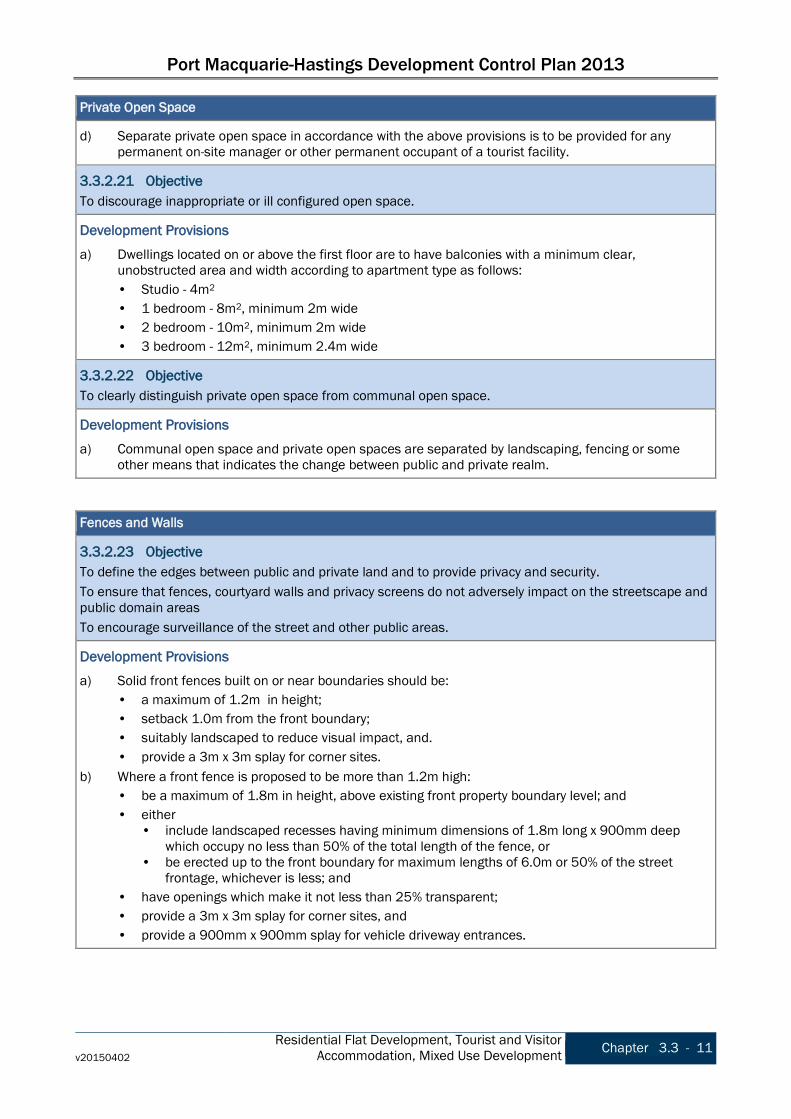
Port Macquarie-Hastings Development Control Plan 2013
v20150402 Residential Flat Development, Tourist and Visitor
Accommodation, Mixed Use Development Chapter 3.3 - 11
Private Open Space
d) Separate private open space in accordance with the above provisions is to be provided for any permanent on-site manager or other permanent occupant of a tourist facility.
3.3.2.21 Objective To discourage inappropriate or ill configured open space.
Development Provisions a) Dwellings located on or above the first floor are to have balconies with a minimum clear,
unobstructed area and width according to apartment type as follows: • Studio - 4m2 • 1 bedroom - 8m2, minimum 2m wide • 2 bedroom - 10m2, minimum 2m wide • 3 bedroom - 12m2, minimum 2.4m wide
3.3.2.22 Objective To clearly distinguish private open space from communal open space.
Development Provisions a) Communal open space and private open spaces are separated by landscaping, fencing or some
other means that indicates the change between public and private realm. Fences and Walls
3.3.2.23 Objective To define the edges between public and private land and to provide privacy and security. To ensure that fences, courtyard walls and privacy screens do not adversely impact on the streetscape and public domain areas To encourage surveillance of the street and other public areas.
Development Provisions a) Solid front fences built on or near boundaries should be:
• a maximum of 1.2m in height; • setback 1.0m from the front boundary; • suitably landscaped to reduce visual impact, and. • provide a 3m x 3m splay for corner sites.
b) Where a front fence is proposed to be more than 1.2m high: • be a maximum of 1.8m in height, above existing front property boundary level; and • either
• include landscaped recesses having minimum dimensions of 1.8m long x 900mm deep which occupy no less than 50% of the total length of the fence, or
• be erected up to the front boundary for maximum lengths of 6.0m or 50% of the street frontage, whichever is less; and
• have openings which make it not less than 25% transparent; • provide a 3m x 3m splay for corner sites, and • provide a 900mm x 900mm splay for vehicle driveway entrances.
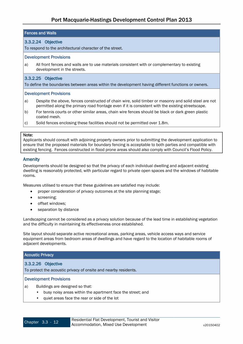
Port Macquarie-Hastings Development Control Plan 2013
Chapter 3.3 - 12 Residential Flat Development, Tourist and Visitor Accommodation, Mixed Use Development v20150402
Fences and Walls
3.3.2.24 Objective To respond to the architectural character of the street.
Development Provisions a) All front fences and walls are to use materials consistent with or complementary to existing
development in the streets.
3.3.2.25 Objective To define the boundaries between areas within the development having different functions or owners.
Development Provisions a) Despite the above, fences constructed of chain wire, solid timber or masonry and solid steel are not
permitted along the primary road frontage even if it is consistent with the existing streetscape. b) For tennis courts or other similar areas, chain wire fences should be black or dark green plastic
coated mesh. c) Solid fences enclosing these facilities should not be permitted over 1.8m.
Note: Applicants should consult with adjoining property owners prior to submitting the development application to ensure that the proposed materials for boundary fencing is acceptable to both parties and compatible with existing fencing. Fences constructed in flood prone areas should also comply with Council’s Flood Policy.
Amenity Developments should be designed so that the privacy of each individual dwelling and adjacent existing dwelling is reasonably protected, with particular regard to private open spaces and the windows of habitable rooms. Measures utilised to ensure that these guidelines are satisfied may include:
• proper consideration of privacy outcomes at the site planning stage; • screening; • offset windows; • separation by distance
Landscaping cannot be considered as a privacy solution because of the lead time in establishing vegetation and the difficulty in maintaining its effectiveness once established. Site layout should separate active recreational areas, parking areas, vehicle access ways and service equipment areas from bedroom areas of dwellings and have regard to the location of habitable rooms of adjacent developments. Acoustic Privacy
3.3.2.26 Objective To protect the acoustic privacy of onsite and nearby residents.
Development Provisions a) Buildings are designed so that:
• busy noisy areas within the apartment face the street; and • quiet areas face the rear or side of the lot

Port Macquarie-Hastings Development Control Plan 2013
v20150402 Residential Flat Development, Tourist and Visitor
Accommodation, Mixed Use Development Chapter 3.3 - 13
Acoustic Privacy
• bedrooms have line of sight separation of minimum 3m from parking areas, streets and shared driveways.
b) Openings of adjacent dwellings should be separated by a distance of at least 6m.
3.3.2.27 Objective To protect the acoustic privacy within the apartments and in private open space
Development Provisions a) Buildings are designed so that the noise transition between apartments is minimised. b) Uses are to be coupled internally and between apartments i.e. noisy internal and noisy external
spaces should be placed together. Refer to Figure 3.3-5.
3.3.2.28 Objective To protect residents from high levels of external noise.
Development Provisions a) Development complies with AS/NZS2107:2000 Acoustic – Recommended design sound levels and
reverberation times for building interiors for residential development.
3.3.2.29 Objective To protect public spaces and the activities that occurs in these spaces from complaints by residents.
Development Provisions a) Any residential development affected by noise generated by intermittent activities and events from
key public spaces should demonstrate how permanent residents will be made aware of these impacts. Note: Key public spaces include, but are not limited to, the Port Macquarie Town Green, Westport Park, Oxley Oval, Bain Park, Observatory Park, Town Beach Park and other beach reserves.
Figure 3.3-5 Noisy spaces coupled.

Port Macquarie-Hastings Development Control Plan 2013
Chapter 3.3 - 14 Residential Flat Development, Tourist and Visitor Accommodation, Mixed Use Development v20150402
Visual Privacy
3.3.2.30 Objective To protect the visual privacy of on-site and nearby residents.
Development Provisions a) Direct views between living area windows of adjacent dwellings should be screened where:
• ground and first floor windows are within a 9m radius from any part of the window of the adjacent dwelling;
• other floor windows are within a 12m radius; • direct views from living rooms of dwellings into the principle area of private open space of other
dwellings should be screened or obscured where they are within a 12m radius. b) Direct views described above may be reduced or obscured by one of the following measures (details
to be submitted with the development application): • 1.8m high fence or wall between ground-floor level windows or between a dwelling and open
space; • Screening that has 25% openings (max), is permanently fixed and is made of durable materials. Note: Living area includes lounge room, dining room or kitchen but does not include a bedroom, bathroom or utility room.
c) A window in a dwelling(s) should have a privacy screen if: • It is a window in a habitable room, other than a bedroom, that has a floor level of more than 1m
above ground level (existing), and • The wall in which the window is located has a setback of less than 3 metres from a side or rear
boundary, and • The window has a sill height of less than 1.5m.
d) A balcony, deck, patio, pergola, terrace or veranda should have a privacy screen if it: • Has a setback of less than 3m from a side or rear boundary, and • Has a floor area more than 3m2, and • Has a floor level more than 1 metre above ground level (existing).
Accessibilty
3.3.2.31 Objective To ensure residents are able to reach and enter their apartment and use communal areas via minimum grade ramps, paths, access ways or lifts.
Development Provisions a) Developments should be designed in accordance with Australian Standard AS1428.
3.3.2.32 Objective To maximise the number of accessible, visitable and adaptable apartments in a building.
Development Provisions a) Barrier free access to at least 20% of dwellings in the development is provided.
Social Dimensions and Housing Affordability Good design responds to the social context and needs of the local community in terms of lifestyles, affordability, and access to social facilities. New developments should optimise the provision of housing to suit the social mix and needs in the neighbourhood or, in the case of precincts undergoing transition, provide for the desired future community.
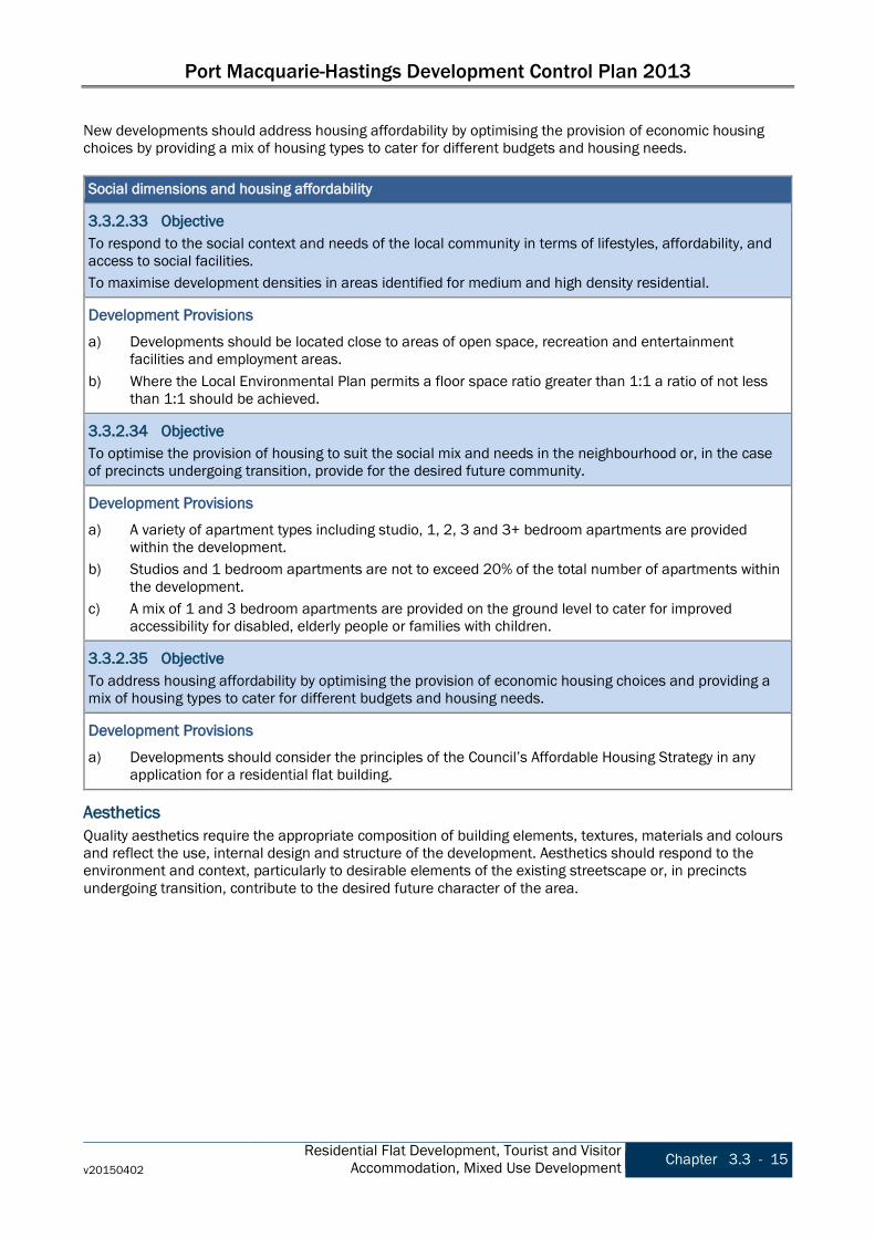
Port Macquarie-Hastings Development Control Plan 2013
v20150402 Residential Flat Development, Tourist and Visitor
Accommodation, Mixed Use Development Chapter 3.3 - 15
New developments should address housing affordability by optimising the provision of economic housing choices by providing a mix of housing types to cater for different budgets and housing needs. Social dimensions and housing affordability
3.3.2.33 Objective To respond to the social context and needs of the local community in terms of lifestyles, affordability, and access to social facilities. To maximise development densities in areas identified for medium and high density residential.
Development Provisions a) Developments should be located close to areas of open space, recreation and entertainment
facilities and employment areas. b) Where the Local Environmental Plan permits a floor space ratio greater than 1:1 a ratio of not less
than 1:1 should be achieved.
3.3.2.34 Objective To optimise the provision of housing to suit the social mix and needs in the neighbourhood or, in the case of precincts undergoing transition, provide for the desired future community.
Development Provisions a) A variety of apartment types including studio, 1, 2, 3 and 3+ bedroom apartments are provided
within the development. b) Studios and 1 bedroom apartments are not to exceed 20% of the total number of apartments within
the development. c) A mix of 1 and 3 bedroom apartments are provided on the ground level to cater for improved
accessibility for disabled, elderly people or families with children.
3.3.2.35 Objective To address housing affordability by optimising the provision of economic housing choices and providing a mix of housing types to cater for different budgets and housing needs.
Development Provisions a) Developments should consider the principles of the Council’s Affordable Housing Strategy in any
application for a residential flat building.
Aesthetics Quality aesthetics require the appropriate composition of building elements, textures, materials and colours and reflect the use, internal design and structure of the development. Aesthetics should respond to the environment and context, particularly to desirable elements of the existing streetscape or, in precincts undergoing transition, contribute to the desired future character of the area.
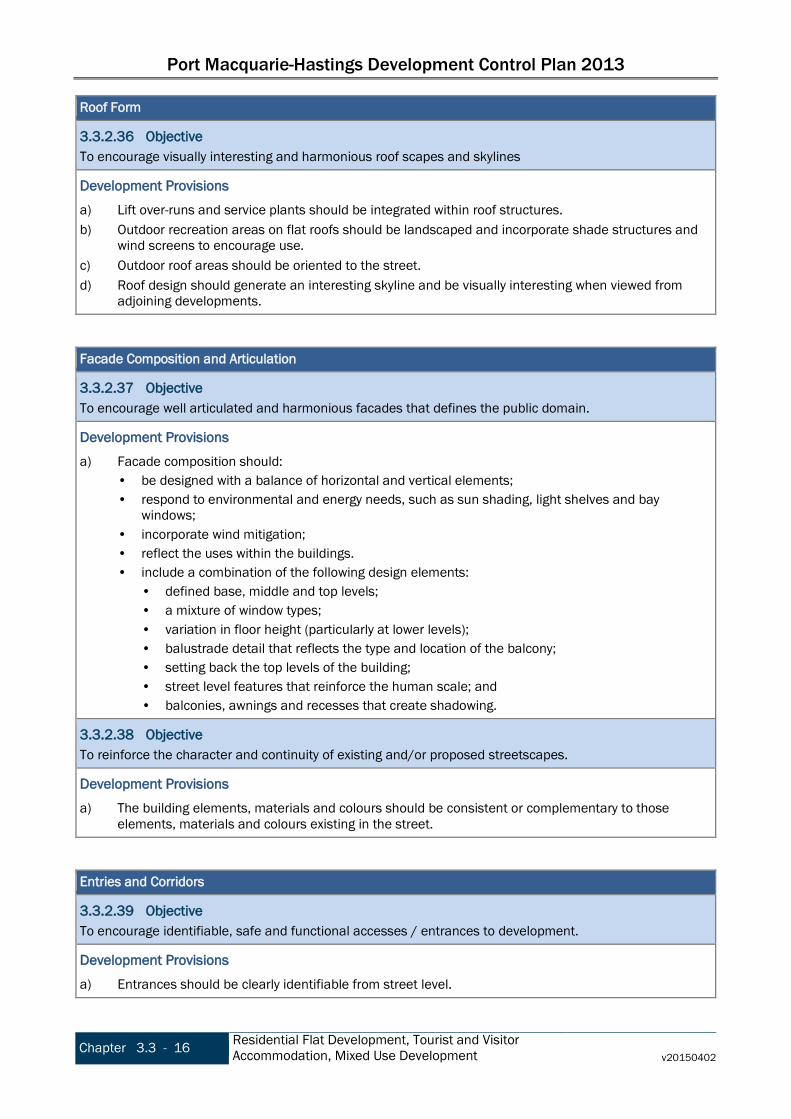
Port Macquarie-Hastings Development Control Plan 2013
Chapter 3.3 - 16 Residential Flat Development, Tourist and Visitor Accommodation, Mixed Use Development v20150402
Roof Form
3.3.2.36 Objective To encourage visually interesting and harmonious roof scapes and skylines
Development Provisions a) Lift over-runs and service plants should be integrated within roof structures. b) Outdoor recreation areas on flat roofs should be landscaped and incorporate shade structures and
wind screens to encourage use. c) Outdoor roof areas should be oriented to the street. d) Roof design should generate an interesting skyline and be visually interesting when viewed from
adjoining developments. Facade Composition and Articulation
3.3.2.37 Objective To encourage well articulated and harmonious facades that defines the public domain.
Development Provisions a) Facade composition should:
• be designed with a balance of horizontal and vertical elements; • respond to environmental and energy needs, such as sun shading, light shelves and bay
windows; • incorporate wind mitigation; • reflect the uses within the buildings. • include a combination of the following design elements:
• defined base, middle and top levels; • a mixture of window types; • variation in floor height (particularly at lower levels); • balustrade detail that reflects the type and location of the balcony; • setting back the top levels of the building; • street level features that reinforce the human scale; and • balconies, awnings and recesses that create shadowing.
3.3.2.38 Objective To reinforce the character and continuity of existing and/or proposed streetscapes.
Development Provisions a) The building elements, materials and colours should be consistent or complementary to those
elements, materials and colours existing in the street. Entries and Corridors
3.3.2.39 Objective To encourage identifiable, safe and functional accesses / entrances to development.
Development Provisions a) Entrances should be clearly identifiable from street level.
Port Macquarie-Hastings Development Control Plan 2013
v20150402 Residential Flat Development, Tourist and Visitor
Accommodation, Mixed Use Development Chapter 3.3 - 17
Entries and Corridors
b) Entries should provide a clear line of transition between the public street, the shared private circulation spaces and the residential apartments.
c) Entries should provide clear line of sight between one circulation space and the next. d) Entries should avoid ambiguous and publically accessible small spaces in entry areas. e) Entries should be sheltered and well lit. f) Entries and circulation spaces should be sized appropriately to encourage adequate area for the
movement of furniture. g) Lobby widths should be a minimum of 2.5m wide and 3.0m high. h) Lobby lengths should be minimised and avoid tight corners. i) Longer lobbies should be articulated by:
• changing the direction or width of a corridor; • using a series of foyer areas; • providing windows along or at the end of corridor.
Balconies
3.3.2.40 Objective To encourage enjoyment of indoor/outdoor living. To encourage useable outdoor living areas.
Development Provisions a) A minimum of one balcony (including enclosed balcony or terrace) is to be provided per apartment. b) The main balcony is to be directly accessible from the living area. c) The balconies should be designed to take advantage of favourable climatic conditions. d) Balconies and balustrades should be designed to balance views out of the building while affording
adequate privacy to the residents of the apartment.
3.3.2.41 Objective To contribute to the architectural form and scale of residential buildings.
Development Provisions a) Balconies should include sunscreens, pergolas, shutters and operable walls. b) Balconies should be recessed to provide shadowing to the facade of the building to create visual
interest and articulation. c) Solid balustrades are discouraged but may be considered where it is demonstrated that outlook and
privacy is achieved and that there is sufficient articulation or visual interest in the building facade to accommodate the solid element.
d) Air conditioning units are not visible from the street.
Security, Site Facilities and Services The design and location of site facilities and services should vary with the scale, size and future tenure of the development. For example, dual occupancies should not require communal bin storage or in some cases, lighting of communal areas and footpaths. However, in larger developments, issues of garbage disposal, security, lighting etc are important in the design of the development.

Port Macquarie-Hastings Development Control Plan 2013
Chapter 3.3 - 18 Residential Flat Development, Tourist and Visitor Accommodation, Mixed Use Development v20150402
Laundries and Clothes Drying Facilities
3.3.2.42 Objective To provide opportunities for secure and accessible air drying. To promote effectively integrated and unobtrusive site facilities. To reduce energy consumption
Development Provisions a) Secure open air clothes drying facilities that:
• are easily accessible; • are screened from the public domain and communal open spaces; and • have a high degree of solar access.
Mailboxes
3.3.2.43 Objective To encourage integration of mailboxes into the building design.
Development Provisions a) mailboxes should be integrated into building design and sighted to ensure accessibility and security.
Safety and Security
3.3.2.44 Objective To encourage safe and secure housing for residents and visitors.
Development Provisions a) Developments should establish a hierarchy of space and clearly define the transition from public
through to private space. b) Entrances should:
• be orientated towards the public street and encourage visibility between entrances, foyers and the street.
• provide direct and well-lit access between car parks and dwellings, between car parks and lift lobbies, and to all unit entrances.
• optimise security by grouping clusters to a maximum of eight, around a common lobby. c) Surveillance is to be facilitated by:
• views over public open spaces from living areas where possible. • casual views of common internal areas, such as lobbies and foyers, hallways, recreation areas,
and car parks. • the provisions of windows and balconies. • separate entries to ground level apartments
d) Concealment should be avoided by: • preventing blind or dark alcoves which might conceal intruders particularly near lifts and
stairwells, at the entrance and within indoor car parks, along corridors and walkways. • providing appropriate levels of illumination for all common areas. • providing graded car park illumination, with the lighting of entrances higher than the minimum
acceptable standard. e) Access to all parts of the building (including, apartments, different floors, balconies, common areas)
is to be controlled.
Port Macquarie-Hastings Development Control Plan 2013
v20150402 Residential Flat Development, Tourist and Visitor
Accommodation, Mixed Use Development Chapter 3.3 - 19
Site Storage
3.3.2.45 Objective To encourage sufficient storage space. To encourage dwellings with dedicated storage areas. To encourage safe and secure storage space.
Development Provisions a) Accessible storage facilities provided as part of the basement or garage area should be secure and
only accessible to the unit tenant. b) One dedicated bike stowage space should be provided per dwelling as part of the basement, garage
area or dwelling area. Waste Management
3.3.2.46 Objective To provide and integrate waste management facilities in a sensitive manner such as they relate to the development. To enable easy access to waste management facilities. To minimise the maintenance requirements of waste management facilities. To minimise the impact of waste management facilities on adjoining properties. To manage waste so as to optimise the potential for recycling by occupants.
Development Provisions a) In developments not exceeding six dwellings, individual waste management facilities may be
permitted. A designated area should be provided to store waste and recycling bins that: • is not visible from the street; • is easily accessible to dwelling occupants; • does not immediately adjoin private or communal open space, windows or clothes drying areas; • is to be a hard-stand areas; and • have direct access to the street and close to a tap and hose facility for cleaning and
maintenance; and • is maintained to be free of pests.
b) Communal bulk waste facilities are required in the following circumstances: • Where the number of dwellings in a development exceeds six; or • Where the number of bins would not fit on the street frontage; or • Where the topography and/or distance to street collection point makes access difficult for
individual dwelling occupants; or • Where such arrangements suit the collection service provider.
c) Communal bulk waste facilities should be stored in a designated area that is physically and visually integrated into the development at ground or sub-basement level that: • is not visible from the street; • is easily accessible to dwelling occupants; • can be serviced by collection vehicles; • has water and drainage facilities for cleaning and maintenance; and • does not immediately adjoin private or communal open space, windows or clothes drying areas;
and
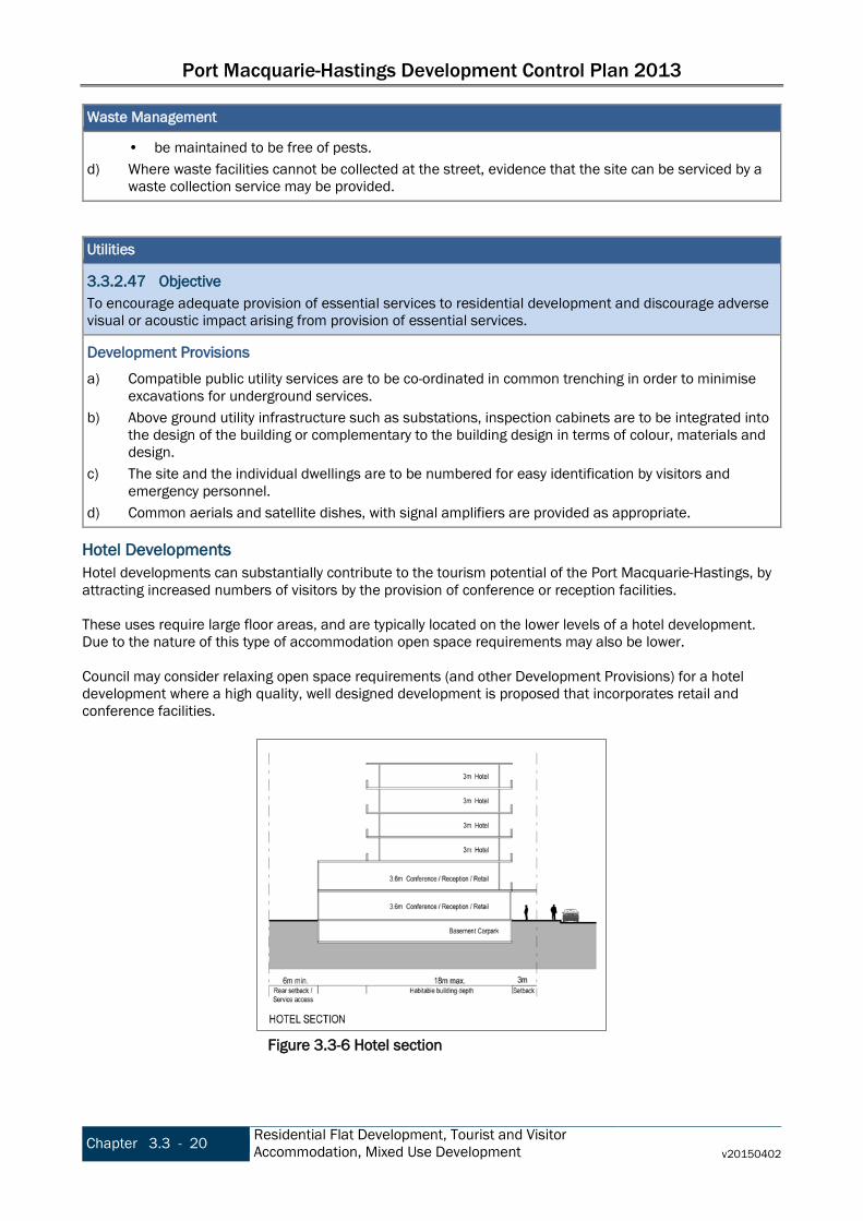
Port Macquarie-Hastings Development Control Plan 2013
Chapter 3.3 - 20 Residential Flat Development, Tourist and Visitor Accommodation, Mixed Use Development v20150402
Waste Management
• be maintained to be free of pests. d) Where waste facilities cannot be collected at the street, evidence that the site can be serviced by a
waste collection service may be provided. Utilities
3.3.2.47 Objective To encourage adequate provision of essential services to residential development and discourage adverse visual or acoustic impact arising from provision of essential services.
Development Provisions a) Compatible public utility services are to be co-ordinated in common trenching in order to minimise
excavations for underground services. b) Above ground utility infrastructure such as substations, inspection cabinets are to be integrated into
the design of the building or complementary to the building design in terms of colour, materials and design.
c) The site and the individual dwellings are to be numbered for easy identification by visitors and emergency personnel.
d) Common aerials and satellite dishes, with signal amplifiers are provided as appropriate.
Hotel Developments Hotel developments can substantially contribute to the tourism potential of the Port Macquarie-Hastings, by attracting increased numbers of visitors by the provision of conference or reception facilities. These uses require large floor areas, and are typically located on the lower levels of a hotel development. Due to the nature of this type of accommodation open space requirements may also be lower. Council may consider relaxing open space requirements (and other Development Provisions) for a hotel development where a high quality, well designed development is proposed that incorporates retail and conference facilities.
Figure 3.3-6 Hotel section

Port Macquarie-Hastings Development Control Plan 2013
v20150402 Residential Flat Development, Tourist and Visitor
Accommodation, Mixed Use Development Chapter 3.3 - 21
3.3.3 Amendment history The Development Control Plan is a dynamic document. Please make sure you are using the most recent version for each Chapter. The version reference is printed in the footer of the document. The DCP page on Council’s website lists the current version reference for each Chapter. The Table below lists the dates of adoption and commencement and subsequent amendments for this Chapter. Date adopted Date commenced Description Version
16/10/2013 08/11/2013 Port Macquarie-Hastings Development Control Plan 2013 v20131108
17/12/2014 02/04/2015 Port Macquarie-Hastings Development Control Plan 2013 (Amendment No 3) v20150402

Port Macquarie-Hastings Development Control Plan 2013
Chapter 3.3 - 22 Residential Flat Development, Tourist and Visitor Accommodation, Mixed Use Development v20150402
This page is left intentionally blank
Port Macquarie-Hastings Development Control Plan 2013
v20140711 Business and Commercial Development Chapter 3.4 - 1
Chapter 3.4 Business and Commercial Development 3.4.1 DCP Context
Land to which this Chapter applies This Chapter applies to all land within the Port Macquarie-Hastings Local Government Area zoned B1, B2, B3, B4, B5, B7) in the Port Macquarie-Hastings Local Environment Plan 2011 or Port Macquarie-Hastings (Area 13 Thrumster) Local Environmental Plan 2008. This Chapter also applies to land subject to applications for development consent for the erection of, or additions to business and commercial development types as defined by the Port Macquarie-Hastings Local Environment Plan 2011.
Application This chapter applies to business and commercial development proposed for land within business zones (B1, B2, B3, B4, B5, B7) in the Port Macquarie-Hastings Local Environment Plan 2011 or Port Macquarie-Hastings (Area 13 Thrumster) Local Environmental Plan 2008.
Applicable EPIs Port Macquarie-Hastings LEP 2011 contains the key controls, and provides a hierarchy of business and commercial zones that cater for a range of needs and uses. Other relevant controls include:
• SEPP No 22 - Shops and Commercial Premises. • SEPP (Exempt and Complying Development Codes) 2008, particularly Part 5 General Commercial
and Industrial Code.
Relationship to other sections of the DCP These provisions apply in addition to any other applicable provisions within other Chapters of this DCP. Refer to Chapter 1.1 Preamble section 1.1.4 Structure for the list of other Chapters.
Purpose The purpose of this Chapter is to specify development guidelines for commercial land uses. This includes:
• Commercial premises (which encompasses business premises, office premises and retail premises and their ‘child’ terms) and
• Other business or commercial uses (excluding industrial-type uses).
3.4.2 Strategic Context
Introduction The provision of a hierarchy of business and commercial centres throughout the region is essential to ensure that most of the residents have access to some retail and commercial uses, to take pressure off the CBD for lower order needs and to reduce the number of private vehicle trips. At the small scale, B1 Neighbourhood Centre zones provide a range of small-scale retail, business and community services that serve the needs of people who live or work in the surrounding neighbourhood. Examples of these in the region are: Waniora Parkway, Watonga Street, Clifton and local shopping centres at Bonny Hills, North Haven and Kew. These centres should be located and designed to encourage walking and cycling rather than using the private vehicle. B2 Local Centre zones, such as the Wauchope and Laurieton Town Centres, provide a wider range of services to a greater number of people within a wider catchment. The B3 Commercial Core zone is applied exclusively to the Port Macquarie Town Centre and the Settlement City Precinct. The role of the commercial core is to provide a wide range of retail, business, office,

Port Macquarie-Hastings Development Control Plan 2013
Chapter 3.4 - 2 Business and Commercial Development v20140711
entertainment, community and other suitable land uses that serve the needs of the local and regional community in a centralised (and established) location. The function of business and commercial zones is largely to service the retail and commercial needs of the area’s residents; however they also provide a range of other functions that are imperative to economic, social and environmental health of the Port Macquarie-Hastings. Commercial and business zones create an environment that provides opportunities for social interaction and engagement, for recreation and for entertainment. This occurs formally in designated venues such as hotels, cafes and restaurants and informally and spontaneously on the street, in public places and in shopping centres. In terms of urban form, business and commercial centres contribute most to an area’s identity and importantly to a visitors’ perception of the town. This is particularly relevant to the Port Macquarie-Hastings as tourism is such a significant contributor to the local economy. The Port Macquarie Town Centre has a very specific function. It services the highest order retail and commercial needs of the LGA’s 77,000 residents as well as being the area’s premier tourist precinct. The need to access services and employment places specific demands on CBD infrastructure such as roads, parking and access. Providing this infrastructure, particularly additional parking, whilst maintaining a highly aesthetic and attractive urban realm is an ongoing challenge. B4 Mixed Use zone provides a mixture of compatible land uses within a single building or area. Mixed use buildings typically contain commercial or retail on the ground and first floors and residential land uses above. This type of development helps to activate commercial areas after hours leading to greater surveillance and safety and reduces reliance of private vehicle trips. Two other business and commercial zones exist in the region – B5 Business Development and B7 Business Park. Each of these zones supports specific commercial uses and development and should be consistent with the objectives of those zones.
3.4.3 Objectives and Development Provisions
Setbacks
3.4.3.1 Objective To provide an appropriate sense of enclosure and scale to all streets and reinforce their particular character.
Development Provisions a) A zero metre or consistent setback to ground floor is preferred in all business zone developments.
3.4.3.2 Objective To ensure that the development provides adequate pedestrian areas and integrates into the adjoining sites. To ensure that structures and queues do not undermine pedestrian movement.
Development Provisions a) Where a zero setback cannot be achieved, such as where parking can only be provided between the
building and the street, a minimum 3.0m pedestrian setback is provided between the edge of the car park and the building. The 3.0m pedestrian setback: • is open and accessible for pedestrians for its entire length and width; • is clear of columns (other than awning posts where provided) and other obstructions; • has a pavement matching the gradient of the adjoining footpath and connects pedestrian areas
on neighbouring sites; and
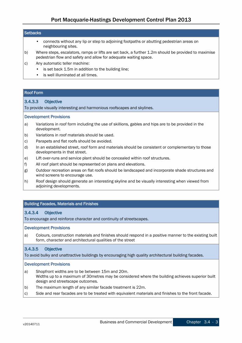
Port Macquarie-Hastings Development Control Plan 2013
v20140711 Business and Commercial Development Chapter 3.4 - 3
Setbacks
• connects without any lip or step to adjoining footpaths or abutting pedestrian areas on neighbouring sites.
b) Where steps, escalators, ramps or lifts are set back, a further 1.2m should be provided to maximise pedestrian flow and safety and allow for adequate waiting space.
c) Any automatic teller machine: • is set back 1.5m in addition to the building line; • is well illuminated at all times.
Roof Form
3.4.3.3 Objective To provide visually interesting and harmonious roofscapes and skylines.
Development Provisions a) Variations in roof form including the use of skillions, gables and hips are to be provided in the
development. b) Variations in roof materials should be used. c) Parapets and flat roofs should be avoided. d) In an established street, roof form and materials should be consistent or complementary to those
developments in that street. e) Lift over-runs and service plant should be concealed within roof structures. f) All roof plant should be represented on plans and elevations. g) Outdoor recreation areas on flat roofs should be landscaped and incorporate shade structures and
wind screens to encourage use. h) Roof design should generate an interesting skyline and be visually interesting when viewed from
adjoining developments. Building Facades, Materials and Finishes
3.4.3.4 Objective To encourage and reinforce character and continuity of streetscapes.
Development Provisions a) Colours, construction materials and finishes should respond in a positive manner to the existing built
form, character and architectural qualities of the street
3.4.3.5 Objective To avoid bulky and unattractive buildings by encouraging high quality architectural building facades.
Development Provisions a) Shopfront widths are to be between 15m and 20m.
Widths up to a maximum of 30metres may be considered where the building achieves superior built design and streetscape outcomes.
b) The maximum length of any similar facade treatment is 22m. c) Side and rear facades are to be treated with equivalent materials and finishes to the front facade.

Port Macquarie-Hastings Development Control Plan 2013
Chapter 3.4 - 4 Business and Commercial Development v20140711
Building Facades, Materials and Finishes
d) Building facades should be designed to reflect the orientation of the site incorporating environmental control devices, e.g. sun shades, ventilation vents, overhangs, building recesses, eaves, as an integrated design feature of the building.
e) An articulation zone of between 1.8m - 4.0m is provided for the front facade of all floors containing residential and tourist uses.
3.4.3.6 Objective To promote a positive sense of space, safety and openness in the public domain.
Development Provisions a) Any security grilles should be provided inside the building, behind glazing and designed to ensure
transparency to the interior.
3.4.3.7 Objective To create a coherent streetscape,
Development Provisions a) Infill development or alterations should respect the form, scale and massing of existing traditional
buildings. b) Where traditional frontages and facades set the architectural theme for parts of a Centre, infill
buildings or alterations respect and reflect the architectural qualities and traditional materials of those buildings, but do not necessarily imitate historical architectural styles.
Active Frontages
3.4.3.8 Objective To encourage an active street experience for pedestrians by promoting streets which are evenly edged with high quality and easily accessible buildings and businesses.
Development Provisions a) Ground floor levels should not be used for residential purposes in zones B1 Neighbourhood Centre,
B2 Local Centre, B3 Commercial core and B4 Mixed use.
3.4.3.9 Objective To encourage and enable direct contact (visual and physical) between the street and the interior of a building.
Development Provisions a) Active frontages should consist of one or more of the following:
• A shop front. • Commercial and residential lobbies. • Café or restaurant if accompanied by an entry from the street. • Public building if accompanied by an entry from the street.
b) A minimum of 50% of the ground floor level front facade should be clear glazed. c) Active ground floor uses are to be accessible and at the same level as the footpath. d) Restaurants, cafés and the like should provide openable shop fronts to the footpath but should not
encroach into footpath. e) Colonnade structures should not be used unless it is demonstrated that the design would not restrict
visibility into the shop or commercial premise or limit natural daylight along footpaths and do not create opportunities for concealment.
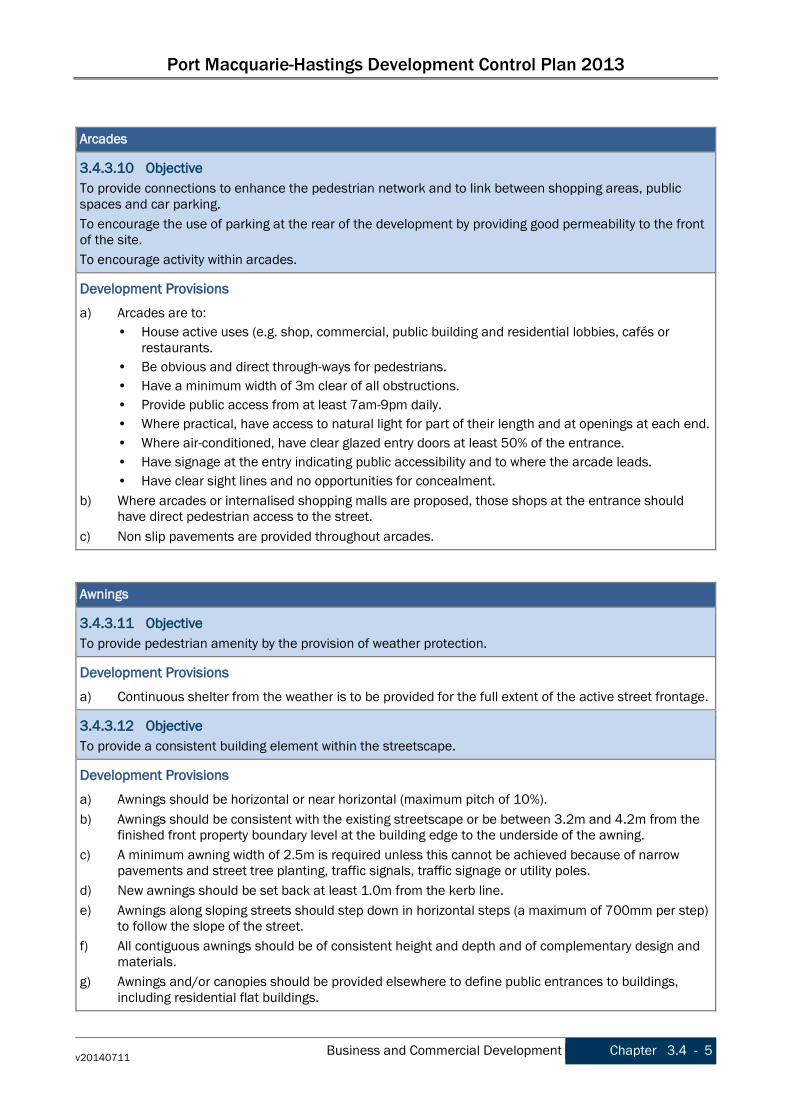
Port Macquarie-Hastings Development Control Plan 2013
v20140711 Business and Commercial Development Chapter 3.4 - 5
Arcades
3.4.3.10 Objective To provide connections to enhance the pedestrian network and to link between shopping areas, public spaces and car parking. To encourage the use of parking at the rear of the development by providing good permeability to the front of the site. To encourage activity within arcades.
Development Provisions a) Arcades are to:
• House active uses (e.g. shop, commercial, public building and residential lobbies, cafés or restaurants.
• Be obvious and direct through-ways for pedestrians. • Have a minimum width of 3m clear of all obstructions. • Provide public access from at least 7am-9pm daily. • Where practical, have access to natural light for part of their length and at openings at each end. • Where air-conditioned, have clear glazed entry doors at least 50% of the entrance. • Have signage at the entry indicating public accessibility and to where the arcade leads. • Have clear sight lines and no opportunities for concealment.
b) Where arcades or internalised shopping malls are proposed, those shops at the entrance should have direct pedestrian access to the street.
c) Non slip pavements are provided throughout arcades. Awnings
3.4.3.11 Objective To provide pedestrian amenity by the provision of weather protection.
Development Provisions a) Continuous shelter from the weather is to be provided for the full extent of the active street frontage.
3.4.3.12 Objective To provide a consistent building element within the streetscape.
Development Provisions a) Awnings should be horizontal or near horizontal (maximum pitch of 10%). b) Awnings should be consistent with the existing streetscape or be between 3.2m and 4.2m from the
finished front property boundary level at the building edge to the underside of the awning. c) A minimum awning width of 2.5m is required unless this cannot be achieved because of narrow
pavements and street tree planting, traffic signals, traffic signage or utility poles. d) New awnings should be set back at least 1.0m from the kerb line. e) Awnings along sloping streets should step down in horizontal steps (a maximum of 700mm per step)
to follow the slope of the street. f) All contiguous awnings should be of consistent height and depth and of complementary design and
materials. g) Awnings and/or canopies should be provided elsewhere to define public entrances to buildings,
including residential flat buildings.

Port Macquarie-Hastings Development Control Plan 2013
Chapter 3.4 - 6 Business and Commercial Development v20140711
Awnings
h) Awning should wrap around street corners and contribute to the articulation and focal design of corner buildings.
i) Materials should encourage high quality design and amenity in the public domain. j) New awning fascias should be coordinated with adjacent awning fascias where they exist. In all
other instances fascias are to be solid, flat and between 300mm and 700mm in height.
3.4.3.13 Objective To promote safety and encourage the use of streets by pedestrians at all times of day and night.
Development Provisions a) Skylights may be provided in the awning for a maximum depth of 1/3 of the total awning depth. b) Under awning lighting should comply with AS/NZS1158 - Lighting for roads and public spaces.
3.4.3.14 Objective To encourage the use of outdoor spaces for active uses in association with ground level uses.
Development Provisions a) Awnings are designed and constructed to encourage pavement dining in areas identified for
pavement dining, along the foreshore and in piazzas. Landscaping
3.4.3.15 Objective Planting should be utilised to provide shade, soften the built form of the proposal and enhance its appearance from public viewpoints.
Development Provisions a) A landscape plan should be submitted with the development application and include:
• Existing vegetation; and • Existing vegetation proposed to be removed; and • Proposed general planting and landscape treatment; and • Design details of hard landscaping elements and major earth cuts, fills and any mounding; and • Street trees; and • Existing and proposed street furniture including proposed signage.
b) Vegetation is provided on top of podium levels, on tops of car parks, and on balconies and verandahs fronting the street below podium level.
3.4.3.16 Objective To contribute to the creation of functional corridors between different vegetation communities through the urban realm.
Development Provisions a) All street plantings are to be selected from Council's Indigenous Street and Open Space Planting List
from the relevant vegetation community adjacent to the Development.
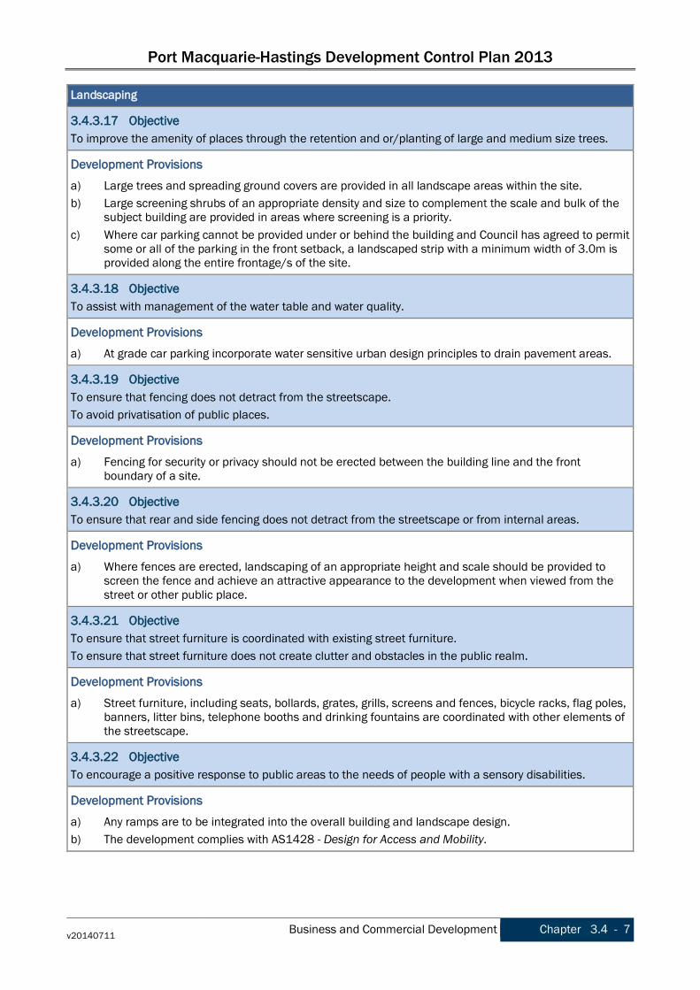
Port Macquarie-Hastings Development Control Plan 2013
v20140711 Business and Commercial Development Chapter 3.4 - 7
Landscaping
3.4.3.17 Objective To improve the amenity of places through the retention and or/planting of large and medium size trees.
Development Provisions a) Large trees and spreading ground covers are provided in all landscape areas within the site. b) Large screening shrubs of an appropriate density and size to complement the scale and bulk of the
subject building are provided in areas where screening is a priority. c) Where car parking cannot be provided under or behind the building and Council has agreed to permit
some or all of the parking in the front setback, a landscaped strip with a minimum width of 3.0m is provided along the entire frontage/s of the site.
3.4.3.18 Objective To assist with management of the water table and water quality.
Development Provisions a) At grade car parking incorporate water sensitive urban design principles to drain pavement areas.
3.4.3.19 Objective To ensure that fencing does not detract from the streetscape. To avoid privatisation of public places.
Development Provisions a) Fencing for security or privacy should not be erected between the building line and the front
boundary of a site.
3.4.3.20 Objective To ensure that rear and side fencing does not detract from the streetscape or from internal areas.
Development Provisions a) Where fences are erected, landscaping of an appropriate height and scale should be provided to
screen the fence and achieve an attractive appearance to the development when viewed from the street or other public place.
3.4.3.21 Objective To ensure that street furniture is coordinated with existing street furniture. To ensure that street furniture does not create clutter and obstacles in the public realm.
Development Provisions a) Street furniture, including seats, bollards, grates, grills, screens and fences, bicycle racks, flag poles,
banners, litter bins, telephone booths and drinking fountains are coordinated with other elements of the streetscape.
3.4.3.22 Objective To encourage a positive response to public areas to the needs of people with a sensory disabilities.
Development Provisions a) Any ramps are to be integrated into the overall building and landscape design. b) The development complies with AS1428 - Design for Access and Mobility.
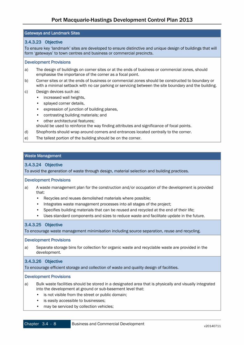
Port Macquarie-Hastings Development Control Plan 2013
Chapter 3.4 - 8 Business and Commercial Development v20140711
Gateways and Landmark Sites
3.4.3.23 Objective To ensure key ‘landmark’ sites are developed to ensure distinctive and unique design of buildings that will form ‘gateways’ to town centres and business or commercial precincts.
Development Provisions a) The design of buildings on corner sites or at the ends of business or commercial zones, should
emphasise the importance of the corner as a focal point. b) Corner sites or at the ends of business or commercial zones should be constructed to boundary or
with a minimal setback with no car parking or servicing between the site boundary and the building. c) Design devices such as:
• increased wall heights, • splayed corner details, • expression of junction of building planes, • contrasting building materials; and • other architectural features; should be used to reinforce the way finding attributes and significance of focal points.
d) Shopfronts should wrap around corners and entrances located centrally to the corner. e) The tallest portion of the building should be on the corner.
Waste Management
3.4.3.24 Objective To avoid the generation of waste through design, material selection and building practices.
Development Provisions a) A waste management plan for the construction and/or occupation of the development is provided
that: • Recycles and reuses demolished materials where possible; • Integrates waste management processes into all stages of the project; • Specifies building materials that can be reused and recycled at the end of their life; • Uses standard components and sizes to reduce waste and facilitate update in the future.
3.4.3.25 Objective To encourage waste management minimisation including source separation, reuse and recycling.
Development Provisions a) Separate storage bins for collection for organic waste and recyclable waste are provided in the
development.
3.4.3.26 Objective To encourage efficient storage and collection of waste and quality design of facilities.
Development Provisions a) Bulk waste facilities should be stored in a designated area that is physically and visually integrated
into the development at ground or sub-basement level that: • is not visible from the street or public domain; • is easily accessible to businesses; • may be serviced by collection vehicles;

Port Macquarie-Hastings Development Control Plan 2013
v20140711 Business and Commercial Development Chapter 3.4 - 9
Waste Management
• has water and drainage facilities for cleaning and maintenance; and • does not immediately adjoin onsite employee recreation area; and • be maintained to be free of pests.
b) Cardboard compactors are provided for large retail and commercial developments. c) Where waste facilities cannot be collected at the street, evidence that the site can be serviced by a
waste collection service should be provided. Vehicular Access Location and Design
3.4.3.27 Objective To ensure that business and commercial development is pedestrian orientated whilst providing for appropriate vehicular access.
Development Provisions a) No direct vehicular access to at grade or basement car parking from the active street frontage
should be permitted in B1 zones. b) The number of vehicular crossovers should be kept to a minimum and appropriate sight lines
provided to encourage safe integration of pedestrian and vehicular movement. c) Any car park ramps are located largely within the building footprint. d) Underground car parks should be designed to enable all vehicles to access and egress in a forward
direction. e) Vehicular entrances to underground car parks are to be:
• Located on minor streets; • Have a maximum crossover of 6.0m; • Should be signed and lit appropriately; • Should be designed so that exiting vehicles have clear sight of pedestrians and cyclists.
f) At-grade / surface car parking areas adjacent to streets should be generally avoided or at least adequately softened by appropriate landscaping.
g) All stairs and elevators in the parking structure are clearly visible.
3.4.3.28 Objective To ensure that car parking does not deactivate public space, including streets, laneways and share ways.
Development Provisions a) The street level frontage of car parking structures (including multi level car parks) where adjoining
public places, including streets, share ways and laneways, should present an active frontage along the entire frontage less any car park entry.
3.4.3.29 Objective To integrate underground car parking into the building design and streetscape.
Development Provisions a) Internal finishes of underground car parks should be consistent with the external materials where
they are visible from the public realm. b) Underground car parks should generally be designed for natural ventilation. Ventilation ducts/grilles
should integrate with the streetscape, be unobtrusive and/or appropriately screened. c) Garage doors to underground parking should be designed to complement the materials used
elsewhere on the development.

Port Macquarie-Hastings Development Control Plan 2013
Chapter 3.4 - 10 Business and Commercial Development v20140711
Pedestrian Entries and Access
3.4.3.30 Objective To encourage and promote equity for all street users
Development Provisions a) The development complies with AS1428 - Design for Access and Mobility.
3.4.3.31 Objective To separate and clearly distinguish between pedestrian and vehicle access ways. To minimise potential conflict between pedestrians and vehicles.
Development Provisions a) Pedestrian and vehicle movement areas are separated to minimise conflict. b) Changes in pavement material, levels, lining or tactile treatments are used to distinguish changes
between vehicle and pedestrian access ways.
3.4.3.32 Objective The design of buildings and spaces should promote legibility to help users find their way.
Development Provisions a) Pedestrian and vehicle movement areas are separated to minimise conflict. b) Changes in pavement material, levels, lining or tactile treatments are used to distinguish changes
between vehicle and pedestrian access ways. c) Parking areas are adequately illuminated (naturally and/or artificially) during the time period the
centre is open. d) Signage is provided at the entries to the development detailing the services available within the
centre and where they are located. e) Signage to key public spaces accessible from the centre such as car parks, food courts should be
provided within the centre. f) Signage to key facilities such as rest rooms, Centre Management, baby change rooms should be
provided within the centre. g) Secure and convenient parking/storing for bicycles is provided close to the entrance of the
development and with good surveillance.
3.4.3.33 Objective To encourage walking and cycling.
Development Provisions a) Secure and convenient parking/storing for bicycles is provided close to the entrance of the
development and with good surveillance.

Port Macquarie-Hastings Development Control Plan 2013
v20140711 Business and Commercial Development Chapter 3.4 - 11
Outdoor Dining
3.4.3.34 Objective To encourage appropriate outdoor dining associated with food and drink premises on public footpath areas. To promote vitality and interest t-in the streetscape. To promote security by activating streets. To allow the unobstructed movement of people and goods along all public footpaths. To minimise conflict between vehicles and diners.
Development Provisions a) A minimum footpath clearance width of:
• 1.8m for high volume pedestrian areas; or • 1.5m in all other circumstances; is to be maintained between the immediate front of the building (shoreline) and the proposed outdoor dining area.
b) A risk assessment should accompany any application for footpath dining that considers the risk of conflict between vehicles and diners. The assessment should recommend adequate measures to minimise any risk identified.
c) The suitability of the footpath for outdoor dining is at Council’s discretion. Note: Footpath clearance measurements are taken from the edge of the building (shoreline) or property boundary to the back of the chair (at a distance out from the table to equate with someone seated in the chair). An outdoor dining area includes all items such as umbrellas, tables and chairs, planter boxes associated with the use.
Commercial development adjoining Residential Land uses
3.4.3.35 Objective To promote compatibility between business and commercial development and preserve the amenity of adjoining residential areas. To ensure that the interface between business and commercial development and adjoining residential areas is of a high quality and achieves adequate visual and acoustic privacy.
Development Provisions a) The development is designed so that all vehicle movement areas and servicing areas are located
away from adjoining residential areas. b) Where this cannot be achieved visual and acoustic treatment of the interface is required. c) The building elevation adjoining the residential area should be:
• Articulated, with changes in setback at intervals no greater than 10m; • Use a variety of materials and treatments; • Be setback a minimum of half the height of the wall or a minimum of 3.0metres whichever is
greater. d) Waste areas are located and managed to minimise pests, noise and odour.
Mixed Use Development Mixed use development means a building or place comprising 2 or more different land uses. Mixed use buildings typically contain commercial or retail on the ground and first floors and residential land uses above. This type of development helps to activate the commercial areas after hours leading to greater surveillance and safety and reduces reliance of private vehicle trips.
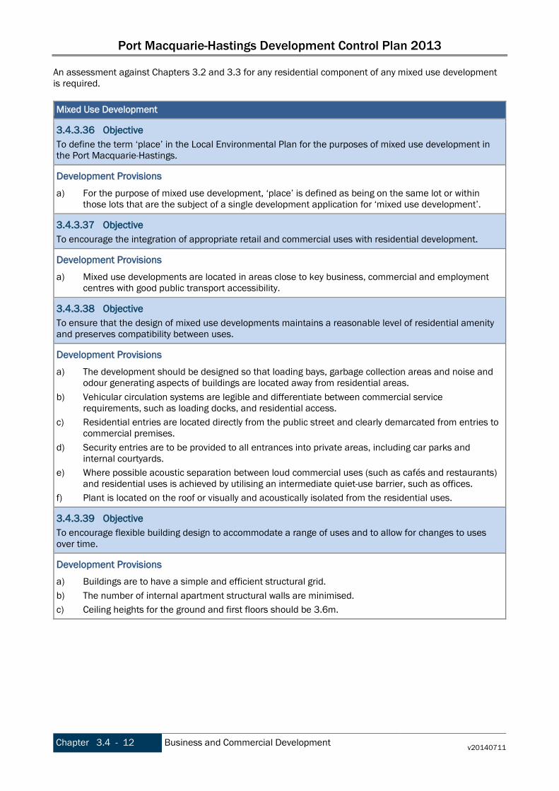
Port Macquarie-Hastings Development Control Plan 2013
Chapter 3.4 - 12 Business and Commercial Development v20140711
An assessment against Chapters 3.2 and 3.3 for any residential component of any mixed use development is required. Mixed Use Development
3.4.3.36 Objective To define the term ‘place’ in the Local Environmental Plan for the purposes of mixed use development in the Port Macquarie-Hastings.
Development Provisions a) For the purpose of mixed use development, ‘place’ is defined as being on the same lot or within
those lots that are the subject of a single development application for ‘mixed use development’.
3.4.3.37 Objective To encourage the integration of appropriate retail and commercial uses with residential development.
Development Provisions a) Mixed use developments are located in areas close to key business, commercial and employment
centres with good public transport accessibility.
3.4.3.38 Objective To ensure that the design of mixed use developments maintains a reasonable level of residential amenity and preserves compatibility between uses.
Development Provisions a) The development should be designed so that loading bays, garbage collection areas and noise and
odour generating aspects of buildings are located away from residential areas. b) Vehicular circulation systems are legible and differentiate between commercial service
requirements, such as loading docks, and residential access. c) Residential entries are located directly from the public street and clearly demarcated from entries to
commercial premises. d) Security entries are to be provided to all entrances into private areas, including car parks and
internal courtyards. e) Where possible acoustic separation between loud commercial uses (such as cafés and restaurants)
and residential uses is achieved by utilising an intermediate quiet-use barrier, such as offices. f) Plant is located on the roof or visually and acoustically isolated from the residential uses.
3.4.3.39 Objective To encourage flexible building design to accommodate a range of uses and to allow for changes to uses over time.
Development Provisions a) Buildings are to have a simple and efficient structural grid. b) The number of internal apartment structural walls are minimised. c) Ceiling heights for the ground and first floors should be 3.6m.

Port Macquarie-Hastings Development Control Plan 2013
v20140711 Business and Commercial Development Chapter 3.4 - 13
Public Art - additional requirements for land zoned for Business and Tourism
3.4.3.40 Objective To make a positive contribution to the built environment of the Port Macquarie-Hastings region and promote the inclusion and integration of public art work in development that is responsive to and reflects the local culture and character of the Port Macquarie-Hastings region; including the area’s indigenous cultural history and traditions; European heritage and contemporary culture, as well as the area’s unique natural environment.
Development Provisions a) Development proposed on land zoned Business or Tourist on sites over 5,000sqm, or where the total
project capital costs exceed $5M, is to provide a Public Art Strategy for consideration as part of a DA. b) The Strategy is to make provision for quality artwork(s) within the development in publicly accessible
location(s) and take into account the links and connections between the development and the area’s natural and cultural heritage.
c) The public art is to be 1% of the total cost of the development to provide works of art for appreciation from the public domain.
3.4.4 Amendment history The Development Control Plan is a dynamic document. Please make sure you are using the most recent version for each Chapter. The version reference is printed in the footer of the document. The DCP page on Council’s website lists the current version reference for each Chapter. The Table below lists the dates of adoption and commencement and subsequent amendments for this Chapter. Date adopted Date commenced Description Version
16/10/2013 08/11/2013 Port Macquarie-Hastings Development Control Plan 2013 v20131108
17/07/2013 11/07/2014 Port Macquarie-Hastings Development Control Plan 2011 (Amendment No 8) - associated with PM-H LEP 2011 (Amendment No 21) v20140711

Port Macquarie-Hastings Development Control Plan 2013
Chapter 3.4 - 14 Business and Commercial Development v20140711
This page is left intentionally blank

Port Macquarie-Hastings Development Control Plan 2013
v20131108 Industrial Development Chapter 3.5 - 1
Chapter 3.5 Industrial Development 3.5.1 DCP Context
Application and land to which this Chapter applies This Chapter applies to: • all development in land zoned IN1, IN2, IN3, IN4 and W3, and • Industries, Heavy industrial storage establishments and Storage premises, Boat building and repair
facilities, Vehicle body repair workshops and Vehicle repair stations in any zone. It does not apply to Rural Industries. Notes: Industries include: • heavy industries • hazardous industry • offensive industry • light industries • high technology industries • home industry • general industries Heavy industrial storage establishments include: • hazardous storage establishments • liquid fuel depots • offensive storage establishments Storage premises include Self storage units.
Relationship to other sections of the DCP These provisions apply in addition to any other applicable provisions within other Chapters of this DCP. Refer to Chapter 1.1 Preamble section 1.1.4 Structure for the list of other Chapters.
Purpose The purpose of these provisions is to enhance the amenity of the areas industrial precincts and discourage inappropriate use of industrial land for uses not associated with industrial development, such as retail, business, office and recreation facilities can undermine the integrity of the region’s industrial zones.
3.5.2 Strategic Context
Introduction Industrial lands are important employment generators with approximately 15% of the working population of the Port Macquarie-Hastings employed in industrial and supporting industries. Industrial lands have specific requirements such as access and often include noisy or offensive activities that require buffering from sensitive land uses. Industrial areas support large workforces however they are sometimes poorly serviced by supporting infrastructure and services. This results in significant lunchtime traffic into and out of the industrial area and a high reliance on personal transport. Therefore it is important that each industrial area has a range of centrally located, supporting services such as food outlets, medical facilities and banks to service the needs of the workers in that area. The amenity of industrial areas including the design of buildings and streetscape works is often considered secondary to function. However, industrial areas are an important part of the urban fabric, they are the sites

Port Macquarie-Hastings Development Control Plan 2013
Chapter 3.5 - 2 Industrial Development v20131108
of public transactions and employ 15% of the Port Macquarie-Hastings’ workforce. Therefore it is important that the amenity and aesthetics are considered in addition to the functioning of the site. Industrial development often has specific challenges such as stormwater from large areas of impervious surfaces and roofing, pollutants from onsite activities, noise, waste, access and servicing. Industrial development also has many opportunities to reduce energy consumption through careful site and building design. Stormwater capture and reuse and the use of water sensitive urban design principles also present significant opportunities for industrial development aiming for sustainability.
3.5.3 Objectives and Development Provisions
Setbacks
3.5.3.1 Objective To promote an aesthetic streetscape that reflects the functions and characteristics of the street and the land use. To ensure buildings and parking do not dominate the streetscape. To ensure adequate area is available at the front of buildings to accommodate satisfactory landscaping, access, parking and manoeuvring of vehicles. To reduce the visual impact of development on the streetscape.
Development Provisions a) Minimum setbacks are provided as follows:
• 10m from a classified road; • 7.6m from any other road boundary; • 3m from any secondary road frontage.
Building Design
3.5.3.2 Objective Industrial development is attractive and functional.
Development Provisions a) Elevations of building which are visible from a public road, reserve or adjacent or adjoining
residential areas are to be constructed using: • brick, masonry, pre-coloured metal cladding, or • appropriately finished ‘tilt-slab’ concrete; or • a combination of a number of these materials.
b) Large unrelieved expanses of wall or building mass are not favoured, and as such should be broken up by the use of suitable building articulation, fenestration or alternative architectural enhancements.
Open Storage and Work Areas
3.5.3.3 Objective To minimise the impact of open storage and work areas in the locality.
Development Provisions a) Where storage of materials is proposed to be undertaken outside the confines of a building, full
details of the areas to be used and the materials/volumes to be stored should be provided with the application.
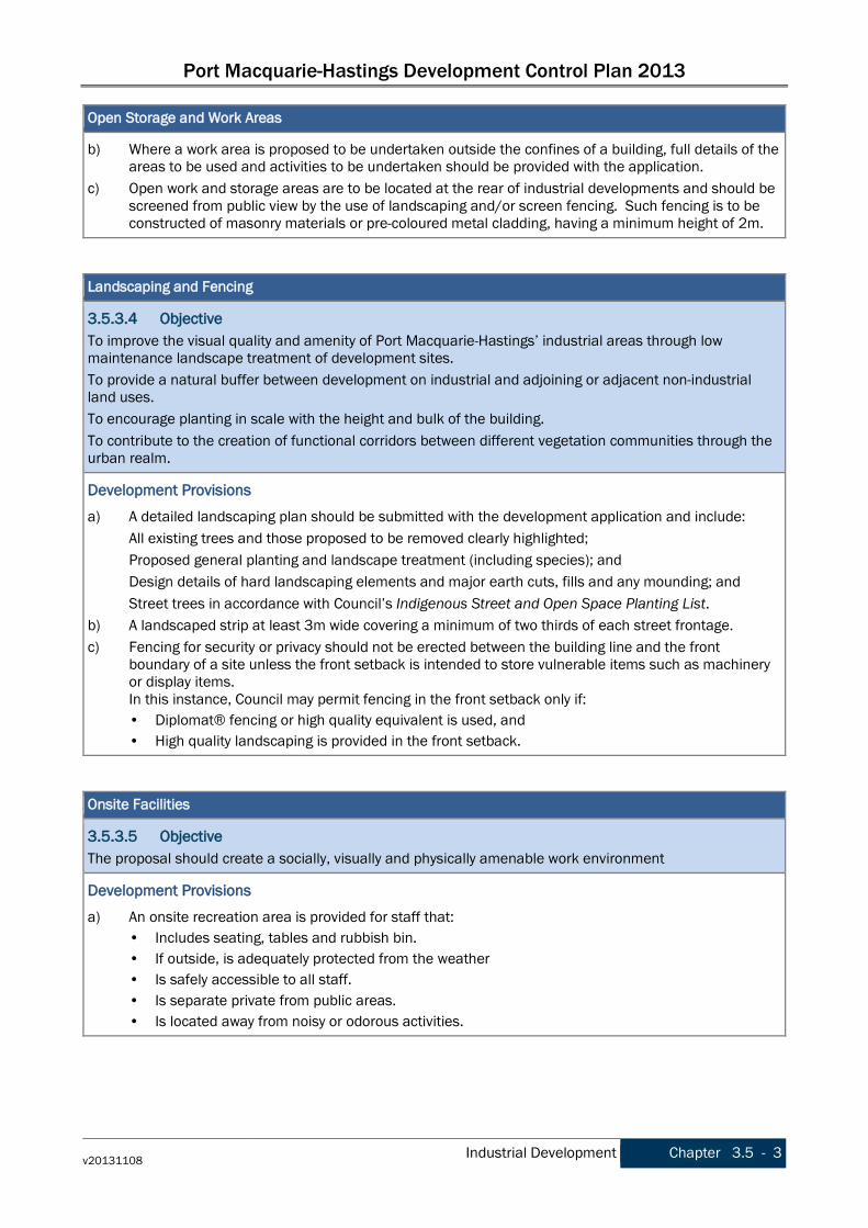
Port Macquarie-Hastings Development Control Plan 2013
v20131108 Industrial Development Chapter 3.5 - 3
Open Storage and Work Areas
b) Where a work area is proposed to be undertaken outside the confines of a building, full details of the areas to be used and activities to be undertaken should be provided with the application.
c) Open work and storage areas are to be located at the rear of industrial developments and should be screened from public view by the use of landscaping and/or screen fencing. Such fencing is to be constructed of masonry materials or pre-coloured metal cladding, having a minimum height of 2m.
Landscaping and Fencing
3.5.3.4 Objective To improve the visual quality and amenity of Port Macquarie-Hastings’ industrial areas through low maintenance landscape treatment of development sites. To provide a natural buffer between development on industrial and adjoining or adjacent non-industrial land uses. To encourage planting in scale with the height and bulk of the building. To contribute to the creation of functional corridors between different vegetation communities through the urban realm.
Development Provisions a) A detailed landscaping plan should be submitted with the development application and include:
All existing trees and those proposed to be removed clearly highlighted; Proposed general planting and landscape treatment (including species); and Design details of hard landscaping elements and major earth cuts, fills and any mounding; and Street trees in accordance with Council’s Indigenous Street and Open Space Planting List.
b) A landscaped strip at least 3m wide covering a minimum of two thirds of each street frontage. c) Fencing for security or privacy should not be erected between the building line and the front
boundary of a site unless the front setback is intended to store vulnerable items such as machinery or display items. In this instance, Council may permit fencing in the front setback only if: • Diplomat® fencing or high quality equivalent is used, and • High quality landscaping is provided in the front setback.
Onsite Facilities
3.5.3.5 Objective The proposal should create a socially, visually and physically amenable work environment
Development Provisions a) An onsite recreation area is provided for staff that:
• Includes seating, tables and rubbish bin. • If outside, is adequately protected from the weather • Is safely accessible to all staff. • Is separate private from public areas. • Is located away from noisy or odorous activities.

Port Macquarie-Hastings Development Control Plan 2013
Chapter 3.5 - 4 Industrial Development v20131108
Onsite Facilities
3.5.3.6 Objective To reduce parking pressure in industrial areas and promote the use of sustainable transport by industrial workers.
Development Provisions a) Provide onsite facilities for changing, showering and secure bike storage.
Industrial Land Adjoining Sensitive Land Uses
3.5.3.7 Objective To minimise the impact of industrial development on adjoining/adjacent residential areas.
Development Provisions a) Industrial development should comply with the provisions of the NSW Industrial Noise Policy,
Environment Protection Authority 2000. b) Windows, doors and other wall openings should be arranged to minimise noise impacts on
residences where an industrial development is located within 400m of a residential zone. c) External plant such as generators, air conditioning plant and the like, should be enclosed to
minimise noise nuisance and located away from residences. d) External and security lighting should be directed and shielded to avoid light spillage to adjoining
residential areas. e) Driveways should be arranged or screened to avoid headlight glare on residential windows.
Retailing and Offices in Industrial Areas
3.5.3.8 Objective Promote the efficient and economic use of industrial resources by ensuring that development proposed is appropriate in industrial areas and does not undermine the commercial areas of the Port Macquarie-Hastings Local Government Area.
Development Provisions a) Office space ancillary to the industrial use is permissible with consent, subject to satisfaction of the
following matters: • That the office component of a proposed development is ancillary to the functions carried out in
the factory, warehouse or other industrial use. • That the office area is not leased to a separate company or entity. • That parking facilities are adequate to cater for the size of the office development.
Servicing, Waste Management and Stormwater
3.5.3.9 Objective To ensure that the site is adequately serviced by sewer and water infrastructure and telecommunications.
Development Provisions a) The site should be serviced by reticulated water (and dual reticulation where this is available), sewer
and telecommunications.

Port Macquarie-Hastings Development Control Plan 2013
v20131108 Industrial Development Chapter 3.5 - 5
Servicing, Waste Management and Stormwater
3.5.3.10 Objective To minimise the impact of waste storage on public areas.
Development Provisions a) Garbage storage areas are not visible from a public place.
3.5.3.11 Objective To control and manage all stormwater generated within the development. To provide an effective legal point of discharge for all collected stormwater, from the development to a natural watercourse, Council drainage system or approved outfall. To achieve these objectives without detrimentally affecting the environment, surface and subsurface water quality, groundwater infiltration characteristics, the adjoining landowners and other landowners near the drainage outlet and watercourses either upstream or downstream of the subdivision.
Development Provisions a) An application for industrial development should be accompanied by a Stormwater Management
Strategy prepared by a certified practicing engineer and in accordance with Council’s adopted Aus-Spec design specification documents.
b) Rainwater tanks and a dual reticulation system providing water to non potable uses (e.g. toilet flushing, landscape watering and vehicle wash down facilities) are to be provided on the site.
3.5.4 Amendment history The Development Control Plan is a dynamic document. Please make sure you are using the most recent version for each Chapter. The version reference is printed in the footer of the document. The DCP page on Council’s website lists the current version reference for each Chapter. The Table below lists the dates of adoption and commencement and subsequent amendments for this Chapter.
Date adopted Date commenced Description Version
16/10/2013 08/11/2013 Port Macquarie-Hastings Development Control Plan 2013 v20131108

Port Macquarie-Hastings Development Control Plan 2013
Chapter 3.5 - 6 Industrial Development v20131108
This page is left intentionally blank
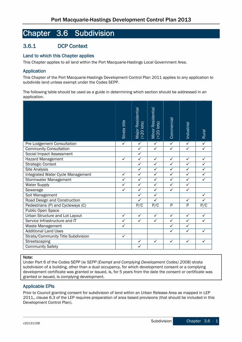
Port Macquarie-Hastings Development Control Plan 2013
v20131108 Subdivision Chapter 3.6 - 1
Chapter 3.6 Subdivision 3.6.1 DCP Context
Land to which this Chapter applies This Chapter applies to all land within the Port Macquarie-Hastings Local Government Area.
Application This Chapter of the Port Macquarie-Hastings Development Control Plan 2011 applies to any application to subdivide land unless exempt under the Codes SEPP. The following table should be used as a guide in determining which section should be addressed in an application.
St
rata
title
Maj
or R
esid
entia
l (>
20 lo
ts)
Min
or R
esid
entia
l (<
20 lo
ts)
Com
mer
cial
Indu
stria
l
Rura
l
Pre Lodgement Consultation Community Consultation Social Impact Assessment Hazard Management Strategic Context Site Analysis Integrated Water Cycle Management Stormwater Management Water Supply Sewerage Soil Management Road Design and Construction Pedestrians (P) and Cycleways (C) P/C P/C P P P/C Public Open Space Urban Structure and Lot Layout Service Infrastructure and IT Waste Management Additional Land Uses Strata/Community Title Subdivision Streetscaping Community Safety
Note: Under Part 6 of the Codes SEPP (ie SEPP (Exempt and Complying Development Codes) 2008) strata subdivision of a building, other than a dual occupancy, for which development consent or a complying development certificate was granted or issued, is, for 5 years from the date the consent or certificate was granted or issued, is complying development.
Applicable EPIs Prior to Council granting consent for subdivision of land within an Urban Release Area as mapped in LEP 2011,, clause 6.3 of the LEP requires preparation of area based provisions (that should be included in this Development Control Plan).
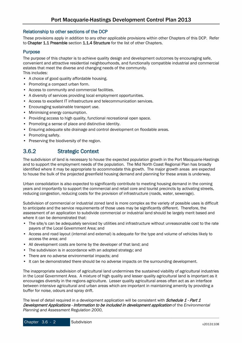
Port Macquarie-Hastings Development Control Plan 2013
Chapter 3.6 - 2 Subdivision v20131108
Relationship to other sections of the DCP These provisions apply in addition to any other applicable provisions within other Chapters of this DCP. Refer to Chapter 1.1 Preamble section 1.1.4 Structure for the list of other Chapters.
Purpose The purpose of this chapter is to achieve quality design and development outcomes by encouraging safe, convenient and attractive residential neighbourhoods, and functionally compatible industrial and commercial estates that meet the diverse and changing needs of the community. This includes: • A choice of good quality affordable housing. • Promoting a compact urban form. • Access to community and commercial facilities. • A diversity of services providing local employment opportunities. • Access to excellent IT infrastructure and telecommunication services. • Encouraging sustainable transport use. • Minimising energy consumption. • Providing access to high quality, functional recreational open space. • Promoting a sense of place and distinctive identity. • Ensuring adequate site drainage and control development on floodable areas. • Promoting safety. • Preserving the biodiversity of the region.
3.6.2 Strategic Context The subdivision of land is necessary to house the expected population growth in the Port Macquarie-Hastings and to support the employment needs of the population. The Mid North Coast Regional Plan has broadly identified where it may be appropriate to accommodate this growth. The major growth areas are expected to house the bulk of the projected greenfield housing demand and planning for these areas is underway. Urban consolidation is also expected to significantly contribute to meeting housing demand in the coming years and importantly to support the commercial and retail core and tourist precincts by activating streets, reducing congestion, reducing costs for the provision of infrastructure (roads, water, sewerage). Subdivision of commercial or industrial zoned land is more complex as the variety of possible uses is difficult to anticipate and the service requirements of those uses may be significantly different. Therefore, the assessment of an application to subdivide commercial or industrial land should be largely merit based and where it can be demonstrated that: • The site/s can be adequately serviced by utilities and infrastructure without unreasonable cost to the rate
payers of the Local Government Area; and • Access and road layout (internal and external) is adequate for the type and volume of vehicles likely to
access the area; and • All development costs are borne by the developer of that land; and • The subdivision is in accordance with an adopted strategy; and • There are no adverse environmental impacts; and • It can be demonstrated there should be no adverse impacts on the surrounding development. The inappropriate subdivision of agricultural land undermines the sustained viability of agricultural industries in the Local Government Area. A mixture of high quality and lesser quality agricultural land is important as it encourages diversity in the regions agriculture. Lesser quality agricultural areas often act as an interface between intensive agricultural and urban areas which are important in maintaining amenity by providing a buffer for noise, odours and spray drift. The level of detail required in a development application will be consistent with Schedule 1 - Part 1 Development Applications - Information to be included in development application of the Environmental Planning and Assessment Regulation 2000,

Port Macquarie-Hastings Development Control Plan 2013
v20131108 Subdivision Chapter 3.6 - 3
Supporting information may include (but not limited to) the following: • Site Analysis Plan. • Vegetation Management Plan. • Utility services plan. • Street Layout. • Lot layout plan. • Transport report for all modes of transport. • Traffic Impact Assessment Report. • Stormwater Management Plan. • Erosion and Sediment Control Plan. • Flood impact assessment. • Water Sensitive Urban Design (WSUD) plan. • Streetscape report. • Ecological Assessment Report. • Bushfire Assessment Report. • Geotechnical Report. • Building Envelope Plan. Notes All new Land Titles in NSW are issued under the Torrens Title System, introduced in 1863. Prior titles, e.g., original Portions, were issued under Old System (or Common Law) Title. The Torrens system is based on a plan of survey, or a plan compiled from a survey, which defines the boundaries of a parcel of land at the date upon which it was registered. When new land parcels are created (e.g., by Deposited Plan subdivision) or when all or part of an existing parcel is to be used for a specific purpose (e.g., easement, lease or Strata Plan), a survey plan should be prepared, lodged and registered with the NSW Department of Lands. In defining new parcel boundaries, the plan creates the legal identity of the land and contains information regarding any relevant restrictions. The main plan types include: • Deposited Plans: which most commonly depict a subdivision of a parcel of land under the Real
Property Act 1900; • Strata Plans: which depict the subdivision of a parcel of land to allow multiple occupancy and separate
ownership of individual units, (e.g. home unit and town house developments) under the Strata Schemes (Freehold Development) Act 1973 or Strata Schemes (Leasehold Development) Act 1986; and
• Community Plans: which depict the development of planned communities of any type where the use of some land is shared, under the Community Land Development Act 1989.
Staged Subdivision Where it is proposed to carry out a subdivision, or particular elements of a subdivision in stages, it is necessary to identify these details within the Development Application. In this way the Development Consent issued can be structured so that relevant conditions and developer contributions are applied at the appropriate time. Any staging of development is to take into account the orderly and efficient extension of infrastructure services, including transport services.
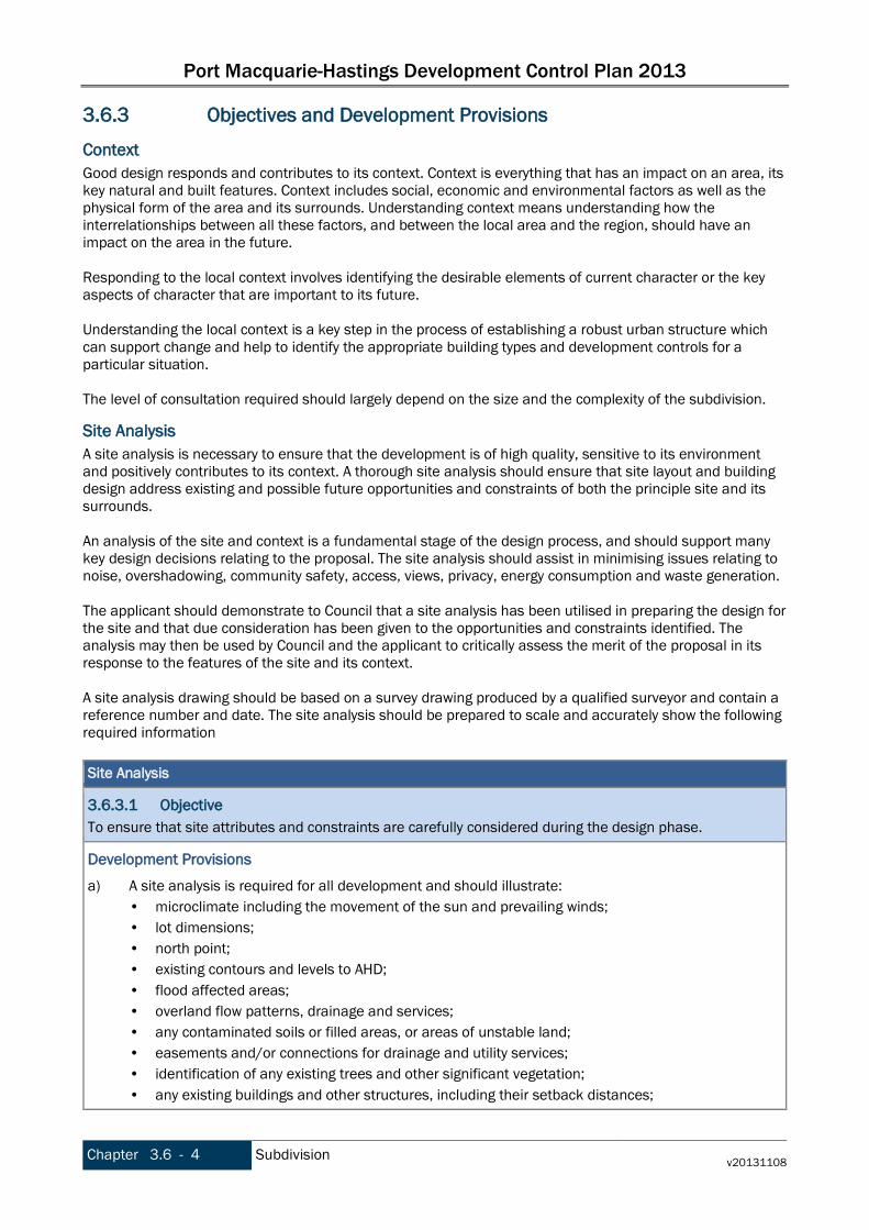
Port Macquarie-Hastings Development Control Plan 2013
Chapter 3.6 - 4 Subdivision v20131108
3.6.3 Objectives and Development Provisions
Context Good design responds and contributes to its context. Context is everything that has an impact on an area, its key natural and built features. Context includes social, economic and environmental factors as well as the physical form of the area and its surrounds. Understanding context means understanding how the interrelationships between all these factors, and between the local area and the region, should have an impact on the area in the future. Responding to the local context involves identifying the desirable elements of current character or the key aspects of character that are important to its future. Understanding the local context is a key step in the process of establishing a robust urban structure which can support change and help to identify the appropriate building types and development controls for a particular situation. The level of consultation required should largely depend on the size and the complexity of the subdivision.
Site Analysis A site analysis is necessary to ensure that the development is of high quality, sensitive to its environment and positively contributes to its context. A thorough site analysis should ensure that site layout and building design address existing and possible future opportunities and constraints of both the principle site and its surrounds. An analysis of the site and context is a fundamental stage of the design process, and should support many key design decisions relating to the proposal. The site analysis should assist in minimising issues relating to noise, overshadowing, community safety, access, views, privacy, energy consumption and waste generation. The applicant should demonstrate to Council that a site analysis has been utilised in preparing the design for the site and that due consideration has been given to the opportunities and constraints identified. The analysis may then be used by Council and the applicant to critically assess the merit of the proposal in its response to the features of the site and its context. A site analysis drawing should be based on a survey drawing produced by a qualified surveyor and contain a reference number and date. The site analysis should be prepared to scale and accurately show the following required information Site Analysis
3.6.3.1 Objective To ensure that site attributes and constraints are carefully considered during the design phase.
Development Provisions a) A site analysis is required for all development and should illustrate:
• microclimate including the movement of the sun and prevailing winds; • lot dimensions; • north point; • existing contours and levels to AHD; • flood affected areas; • overland flow patterns, drainage and services; • any contaminated soils or filled areas, or areas of unstable land; • easements and/or connections for drainage and utility services; • identification of any existing trees and other significant vegetation; • any existing buildings and other structures, including their setback distances;

Port Macquarie-Hastings Development Control Plan 2013
v20131108 Subdivision Chapter 3.6 - 5
Site Analysis
• heritage and archaeological features; • fences, boundaries and easements; • existing and proposed road network, including connectivity and access for all adjoining land
parcels; • pedestrian and vehicle access; • views to and from the site; • overshadowing by neighbouring structures; and • any other notable features or characteristics of the site.
Urban Structure and Lot Layout Lot layout
3.6.3.2 Objective To provide a range of lot sizes to suit a variety of dwelling and household types To ensure the lot layout plan reflects the site’s opportunities and constraints.
Development Provisions a) Any residential allotments created by Torrens title subdivision should satisfy the following standards:
• A minimum width of 15 metres when measured at a distance of 5.5 metres from the front property boundary;
• A minimum width of 7 metres measured when side boundaries are extended to the kerb line; • A minimum depth of 25 metres; • For lots where the average slope of the development site is equal to, or exceeds 16%, indicative
road and driveway grades are required demonstrating satisfactory access. b) Subdivision of dual occupancy development or multi dwelling housing where permissible in the LEP
may create allotments smaller than 450m2 if: • Each allotment to be created is part of a community or strata title scheme, or • Is carried out as part of an integrated Torrens title housing development.
3.6.3.3 Objective To ensure subdivision design and road layout responds to the topography of the land and the site constraints. To prevent servicing costs (associated with access, utilities and services) from being transferred to the land owner because of poor subdivision design. To reduce the impacts of battleaxe allotments in infill areas on adjoining landowners, the streetscape and the final landowner. To ensure that development of rear lots of battleaxe allotments does not result in the impacts greater than would be expected from a single dwelling in terms of:
• Traffic generation; • Noise; • Privacy; • Utilities; • Waste management; and • Amenity.
Development Provisions a) Battleaxe allotments are discouraged in greenfield development.
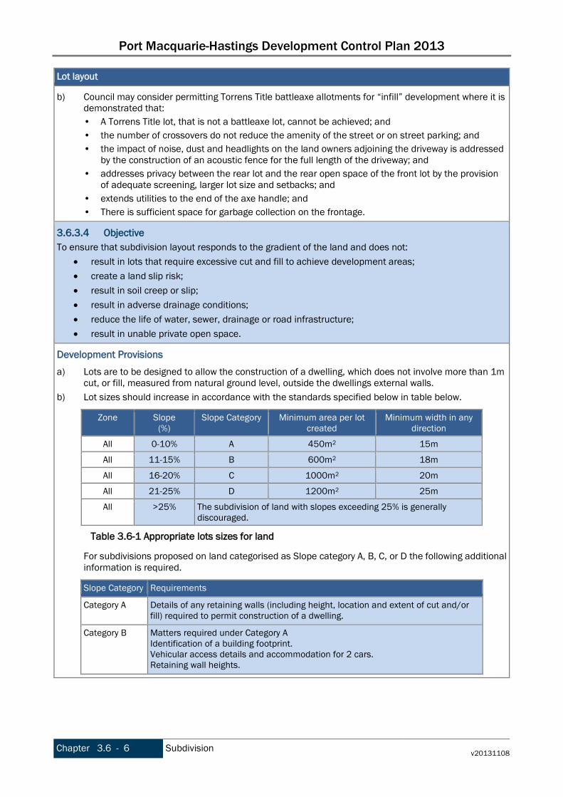
Port Macquarie-Hastings Development Control Plan 2013
Chapter 3.6 - 6 Subdivision v20131108
Lot layout
b) Council may consider permitting Torrens Title battleaxe allotments for “infill” development where it is demonstrated that: • A Torrens Title lot, that is not a battleaxe lot, cannot be achieved; and • the number of crossovers do not reduce the amenity of the street or on street parking; and • the impact of noise, dust and headlights on the land owners adjoining the driveway is addressed
by the construction of an acoustic fence for the full length of the driveway; and • addresses privacy between the rear lot and the rear open space of the front lot by the provision
of adequate screening, larger lot size and setbacks; and • extends utilities to the end of the axe handle; and • There is sufficient space for garbage collection on the frontage.
3.6.3.4 Objective To ensure that subdivision layout responds to the gradient of the land and does not:
• result in lots that require excessive cut and fill to achieve development areas; • create a land slip risk; • result in soil creep or slip; • result in adverse drainage conditions; • reduce the life of water, sewer, drainage or road infrastructure; • result in unable private open space.
Development Provisions a) Lots are to be designed to allow the construction of a dwelling, which does not involve more than 1m
cut, or fill, measured from natural ground level, outside the dwellings external walls. b) Lot sizes should increase in accordance with the standards specified below in table below.
Zone
Slope (%)
Slope Category Minimum area per lot created
Minimum width in any direction
All 0-10% A 450m2 15m
All 11-15% B 600m2 18m
All 16-20% C 1000m2 20m
All 21-25% D 1200m2 25m
All >25% The subdivision of land with slopes exceeding 25% is generally discouraged.
For subdivisions proposed on land categorised as Slope category A, B, C, or D the following additional information is required.
Slope Category Requirements
Category A Details of any retaining walls (including height, location and extent of cut and/or fill) required to permit construction of a dwelling.
Category B Matters required under Category A Identification of a building footprint. Vehicular access details and accommodation for 2 cars. Retaining wall heights.
Table 3.6-1 Appropriate lots sizes for land
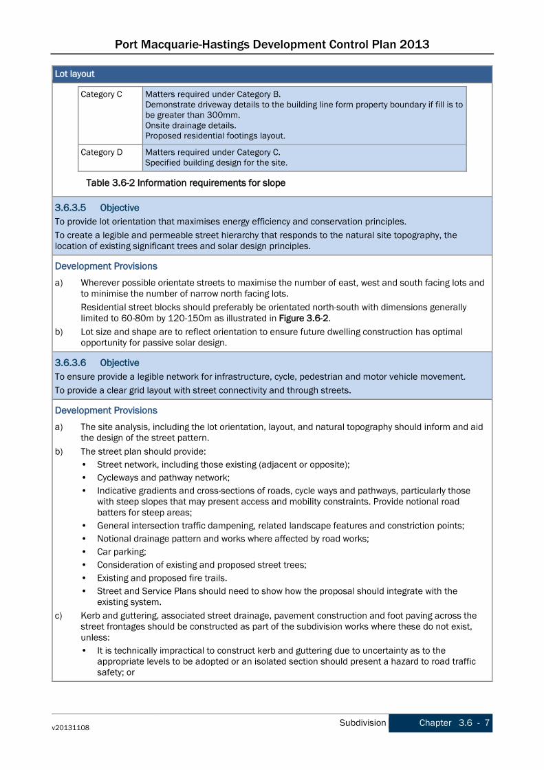
Port Macquarie-Hastings Development Control Plan 2013
v20131108 Subdivision Chapter 3.6 - 7
Lot layout
Category C Matters required under Category B. Demonstrate driveway details to the building line form property boundary if fill is to be greater than 300mm. Onsite drainage details. Proposed residential footings layout.
Category D Matters required under Category C. Specified building design for the site.
3.6.3.5 Objective To provide lot orientation that maximises energy efficiency and conservation principles. To create a legible and permeable street hierarchy that responds to the natural site topography, the location of existing significant trees and solar design principles.
Development Provisions a) Wherever possible orientate streets to maximise the number of east, west and south facing lots and
to minimise the number of narrow north facing lots. Residential street blocks should preferably be orientated north-south with dimensions generally limited to 60-80m by 120-150m as illustrated in Figure 3.6-2.
b) Lot size and shape are to reflect orientation to ensure future dwelling construction has optimal opportunity for passive solar design.
3.6.3.6 Objective To ensure provide a legible network for infrastructure, cycle, pedestrian and motor vehicle movement. To provide a clear grid layout with street connectivity and through streets.
Development Provisions a) The site analysis, including the lot orientation, layout, and natural topography should inform and aid
the design of the street pattern. b) The street plan should provide:
• Street network, including those existing (adjacent or opposite); • Cycleways and pathway network; • Indicative gradients and cross-sections of roads, cycle ways and pathways, particularly those
with steep slopes that may present access and mobility constraints. Provide notional road batters for steep areas;
• General intersection traffic dampening, related landscape features and constriction points; • Notional drainage pattern and works where affected by road works; • Car parking; • Consideration of existing and proposed street trees; • Existing and proposed fire trails. • Street and Service Plans should need to show how the proposal should integrate with the
existing system. c) Kerb and guttering, associated street drainage, pavement construction and foot paving across the
street frontages should be constructed as part of the subdivision works where these do not exist, unless: • It is technically impractical to construct kerb and guttering due to uncertainty as to the
appropriate levels to be adopted or an isolated section should present a hazard to road traffic safety; or
Table 3.6-2 Information requirements for slope

Port Macquarie-Hastings Development Control Plan 2013
Chapter 3.6 - 8 Subdivision v20131108
Lot layout
• The street drainage necessary to provide kerb and guttering is an unreasonable imposition on the development; or
• An alternative treatment is preferred by Council having regard to Water Sensitive Urban Design (WSUD) principles; or
• Kerb and guttering is not the most suitable streetscape treatment for the area on the basis of existing and anticipated development.
In these cases, an alternative treatment to kerb and gutter such as mountable kerb, concrete dish drain, cemented paving stones or other treatment should be required with the exact type based upon the characteristics of the site.
3.6.3.7 Objective To establish a clear urban structure that maximises the sense of neighbourhood and encourages walking and cycling over private car use.
Development Provisions a) Subdivision applications close to urban centres should achieve a high-medium population yield
(>35 dwellings per hectare). b) Subdivisions along arterial roads and serviced by public transport should achieve a high-medium
population yield (>35 dwellings per hectare).

Port Macquarie-Hastings Development Control Plan 2013
v20131108 Subdivision Chapter 3.6 - 9
Figure 3.6-1 Indicative Block Configurations
Figure 3.6-2 Preferred lot layout and orientation.
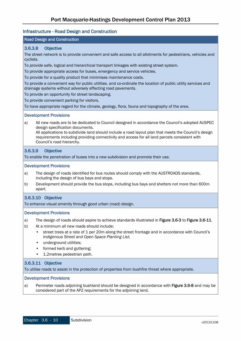
Port Macquarie-Hastings Development Control Plan 2013
Chapter 3.6 - 10 Subdivision v20131108
Infrastructure - Road Design and Construction Road Design and Construction
3.6.3.8 Objective The street network is to provide convenient and safe access to all allotments for pedestrians, vehicles and cyclists. To provide safe, logical and hierarchical transport linkages with existing street system. To provide appropriate access for buses, emergency and service vehicles. To provide for a quality product that minimises maintenance costs. To provide a convenient way for public utilities. and co-ordinate the location of public utility services and drainage systems without adversely affecting road pavements. To provide an opportunity for street landscaping. To provide convenient parking for visitors. To have appropriate regard for the climate, geology, flora, fauna and topography of the area.
Development Provisions a) All new roads are to be dedicated to Council designed in accordance the Council’s adopted AUSPEC
design specification documents. All applications to subdivide land should include a road layout plan that meets the Council’s design requirements including providing connectivity and access for all land parcels consistent with Council’s road hierarchy.
3.6.3.9 Objective To enable the penetration of buses into a new subdivision and promote their use.
Development Provisions a) The design of roads identified for bus routes should comply with the AUSTROADS standards,
including the design of bus bays and stops. b) Development should provide the bus stops, including bus bays and shelters not more than 600m
apart.
3.6.3.10 Objective To enhance visual amenity through good urban (road) design.
Development Provisions a) The design of roads should aspire to achieve standards illustrated in Figure 3.6-3 to Figure 3.6-11. b) At a minimum all new roads should include:
• street trees at a rate of 1 per 20m along the street frontage and in accordance with Council’s Indigenous Street and Open Space Planting List;
• underground utilities; • formed kerb and guttering; • 1.2metres pedestrian path.
3.6.3.11 Objective To utilise roads to assist in the protection of properties from bushfire threat where appropriate.
Development Provisions a) Perimeter roads adjoining bushland should be designed in accordance with Figure 3.6-8 and may be
considered part of the APZ requirements for the adjoining land.

Port Macquarie-Hastings Development Control Plan 2013
v20131108 Subdivision Chapter 3.6 - 11
Road Design and Construction
3.6.3.12 Objective To utilise roads to protect natural assets and promote public enjoyment of these assets where appropriate.
Development Provisions a) Perimeter roads should be designed in accordance with Figure 3.6-8
Figure 3.6-3 Road Section - Indicative Neighbourhood Avenue
Source: Anterra Design Pty Ltd, 2007
Figure 3.6-4 Road Section - Indicative Neighbourhood Avenue with On Road Cycleway (Option 1).
Source: Anterra Design Pty Ltd, 2007

Port Macquarie-Hastings Development Control Plan 2013
Chapter 3.6 - 12 Subdivision v20131108
Figure 3.6-5 Road Section - Indicative Neighbourhood Avenue with On Road Cycleway (Option 2).
Source: Anterra Design Pty Ltd, 2007
Figure 3.6-6 Road Section - Indicative Shareway (servicing 6-8 dwellings maximum).
Source: Anterra Design Pty Ltd, 2007
Figure 3.6-7 Road Section - Indicative Neighbourhood Avenue with On Road Cycleway (Option 3).
Source: Anterra Design Pty Ltd, 2007
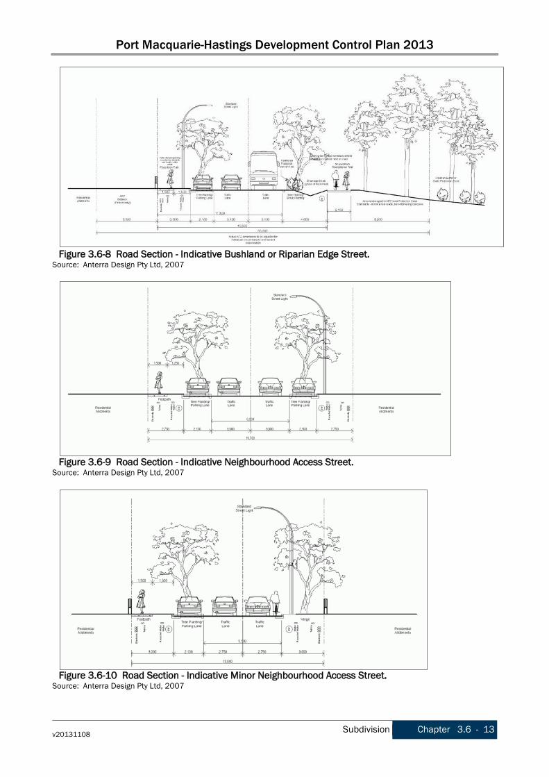
Port Macquarie-Hastings Development Control Plan 2013
v20131108 Subdivision Chapter 3.6 - 13
Figure 3.6-8 Road Section - Indicative Bushland or Riparian Edge Street.
Source: Anterra Design Pty Ltd, 2007
Figure 3.6-9 Road Section - Indicative Neighbourhood Access Street.
Source: Anterra Design Pty Ltd, 2007
Figure 3.6-10 Road Section - Indicative Minor Neighbourhood Access Street.
Source: Anterra Design Pty Ltd, 2007
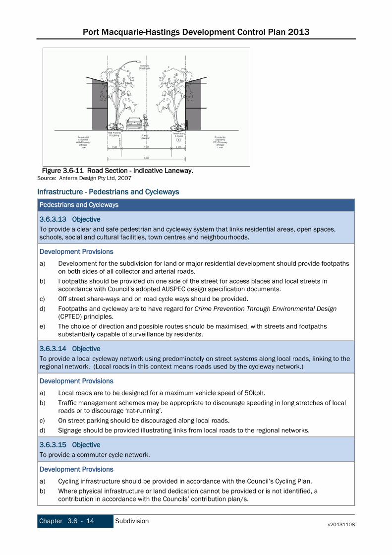
Port Macquarie-Hastings Development Control Plan 2013
Chapter 3.6 - 14 Subdivision v20131108
Figure 3.6-11 Road Section - Indicative Laneway.
Source: Anterra Design Pty Ltd, 2007
Infrastructure - Pedestrians and Cycleways Pedestrians and Cycleways
3.6.3.13 Objective To provide a clear and safe pedestrian and cycleway system that links residential areas, open spaces, schools, social and cultural facilities, town centres and neighbourhoods.
Development Provisions a) Development for the subdivision for land or major residential development should provide footpaths
on both sides of all collector and arterial roads. b) Footpaths should be provided on one side of the street for access places and local streets in
accordance with Council’s adopted AUSPEC design specification documents. c) Off street share-ways and on road cycle ways should be provided. d) Footpaths and cycleway are to have regard for Crime Prevention Through Environmental Design
(CPTED) principles. e) The choice of direction and possible routes should be maximised, with streets and footpaths
substantially capable of surveillance by residents.
3.6.3.14 Objective To provide a local cycleway network using predominately on street systems along local roads, linking to the regional network. (Local roads in this context means roads used by the cycleway network.)
Development Provisions a) Local roads are to be designed for a maximum vehicle speed of 50kph. b) Traffic management schemes may be appropriate to discourage speeding in long stretches of local
roads or to discourage ‘rat-running’. c) On street parking should be discouraged along local roads. d) Signage should be provided illustrating links from local roads to the regional networks.
3.6.3.15 Objective To provide a commuter cycle network.
Development Provisions a) Cycling infrastructure should be provided in accordance with the Council’s Cycling Plan. b) Where physical infrastructure or land dedication cannot be provided or is not identified, a
contribution in accordance with the Councils’ contribution plan/s.

Port Macquarie-Hastings Development Control Plan 2013
v20131108 Subdivision Chapter 3.6 - 15
Infrastructure - Integrated Water Cycle Management Integrated Water Cycle Management (IWCM) seeks to integrate water supply, wastewater and stormwater thereby promoting the sustained health and maintenance of waterways and catchment areas. Water Sensitive Urban Design (WSUD) is also a key component of IWCM by minimising impervious surfaces and mitigating changes to the natural water balance through on-site reuse of water and temporary storage. IWCM has extensive benefits by reducing the construction and ongoing maintenance costs of hard infrastructure, by reducing demand on the treated water supply and therefore the river systems and water storage and reticulation infrastructure, by maintaining groundwater, by reducing volumes of fresh water and pollutants (including sediment and nutrients) into waterways and the ocean. Water Cycle Management
3.6.3.16 Objective To reduce the lifecycle cost of public infrastructure (potable water supply, reclaimed water supply, waste water and stormwater) through efficient and effective resource use.
Development Provisions a) An application for subdivision should be accompanied by an a Integrated Water Cycle Management
Strategy prepared by a certified practicing engineer and in accordance with Council’s adopted design specification documents.
Infrastructure - Stormwater Management The urban environment alters the natural flow of storm water by increasing impervious surfaces, reducing groundwater infiltration, reducing evapo-transpiration by vegetation and by introducing pollutants such as sediment and nutrients to waterways. This results in a range of management issues including flooding, peak flows and stormwater quality that need to be addressed in any new subdivision. Stormwater Management
3.6.3.17 Objective General To control and manage all stormwater generated within the development. To control and manage all stormwater passing through the development from the surrounding catchment. To provide an effective legal point of discharge for all collected stormwater, from the development to a natural watercourse, Council drainage system or approved outfall. To achieve these objectives without detrimentally affecting the environment, surface and subsurface water quality, groundwater infiltration characteristics, the adjoining landowners and other landowners near the drainage outlet and watercourses either upstream or downstream of the subdivision. To encourage the protection and enhancement of natural watercourses, aquatic habitat and riparian vegetation. To ensure that stormwater runoff meets specified quality objectives during all phases of a development. To provide a safe and convenient environment for pedestrians and traffic. To incorporate principles of Ecological Sustainable Development.
Development Provisions a) An application for subdivision should be accompanied by a Stormwater Management Strategy
prepared by a certified practicing engineer and in accordance with Council’s adopted Aus-Spec design specification documents.

Port Macquarie-Hastings Development Control Plan 2013
Chapter 3.6 - 16 Subdivision v20131108
Stormwater Management
The Designer should adopt the ‘major/minor’ approach to urban drainage systems as outlined in Australian Rainfall and Runoff. The ‘Minor’ system generally refers to the underground system but also applies to surface structures. The minor system is designed to an Average Recurrence Interval (ARI) as shown in Council’s Aus-Spec design specification documents. The ‘Major’ system refers to overland flow paths that are to be designed to convey the major storm flows when the capacity of the minor system is exceeded. The major drainage system is designed to handle flows resulting from rare storm events up to and including a 100-year ARI. These flows should follow a designated overland flow path, which should be: • A road if the catchment area is small; and/or • A drainage reserve if it is impractical for unsafe for a road to carry the excess flows. The finished floor level of buildings should be above the 100 year ARI flood level (plus freeboard) and in accordance with the council’s current flood policy.
3.6.3.18 Objective Minor Flows To prevent stormwater damage to property. To contain nuisance flows to a level, which is acceptable to the community. To provide a stormwater system, which can be economically maintained. To provide a stormwater system which utilises open space and other open land for infiltration of runoff and stormwater retention in a manner, which does not detract from its principal function. To minimise the occurrence of traffic accidents during minor storm events. To minimise increases in stormwater runoff and protect the environmental values and physical characteristics of receiving watercourses from degradation by urban runoff.
Development Provisions a) An application for subdivision should be accompanied by a Stormwater Management Strategy
prepared by a certified practicing engineer and in accordance with Council’s adopted Aus-Spec design specification documents. The Designer should adopt the ‘major/minor’ approach to urban drainage systems as outlined in Australian Rainfall and Runoff. The ‘Minor’ system generally refers to the underground system but also applies to surface structures. The minor system is designed to an Average Recurrence Interval (ARI) as shown in Council’s Aus-Spec design specification documents. The ‘Major’ system refers to overland flow paths that are to be designed to convey the major storm flows when the capacity of the minor system is exceeded. The major drainage system is designed to handle flows resulting from rare storm events up to and including a 100-year ARI. These flows should follow a designated overland flow path, which should be: • A road if the catchment area is small; and/or • A drainage reserve if it is impractical for unsafe for a road to carry the excess flows. The finished floor level of buildings should be above the 100 year ARI flood level (plus freeboard) and in accordance with the council’s current flood policy.
Port Macquarie-Hastings Development Control Plan 2013
v20131108 Subdivision Chapter 3.6 - 17
Stormwater Management
3.6.3.19 Objective Major Flows To prevent flood damage to the built and natural environment and prevent both short-term and long-term inundation of dwellings. To ensure the street system operates adequately during and after major storm events. To provide a stormwater system which minimises erosion and which utilises open space in a manner that does not detract from it principal function. To protect the environmental values and physical characteristics of receiving watercourses.
Development Provisions a) An application for subdivision should be accompanied by a Stormwater Management Strategy
prepared by a certified practicing engineer and in accordance with Council’s adopted Aus-Spec design specification documents. The Designer should adopt the ‘major/minor’ approach to urban drainage systems as outlined in Australian Rainfall and Runoff. The ‘Minor’ system generally refers to the underground system but also applies to surface structures. The minor system is designed to an Average Recurrence Interval (ARI) as shown in Council’s Aus-Spec design specification documents. The ‘Major’ system refers to overland flow paths that are to be designed to convey the major storm flows when the capacity of the minor system is exceeded. The major drainage system is designed to handle flows resulting from rare storm events up to and including a 100-year ARI. These flows should follow a designated overland flow path, which should be: • A road if the catchment area is small; and/or • A drainage reserve if it is impractical for unsafe for a road to carry the excess flows. The finished floor level of buildings should be above the 100 year ARI flood level (plus freeboard) and in accordance with the council’s current flood policy.
Infrastructure - Water Supply Port Macquarie-Hastings Council is responsible for the provision of a reliable, safe, clean and cost effective water supply to Council’s customers in a manner sympathetic and responsible to the environment. In the Local Government Area, the delicate balance between harvesting water and the commitment to its preservation depends on a three-tiered approach – conservation through education and application of water efficiency regulations, environmentally sustainable infrastructure and water reclamation. Embracing technology that should play a crucial role in ensuring the future sustainability of regional water supplies across Australia and the health of our rivers has never been more important. A separate reticulated reclaimed water supply network should be provided in suitable areas to provide fit for purpose (non drinking) water to new and existing customers. Clause 7.13 of LEP 2011 requires the consent authority to be satisfied that essential utility infrastructure is available or adequate arrangements have been made for it to be available. This includes the supply of water.

Port Macquarie-Hastings Development Control Plan 2013
Chapter 3.6 - 18 Subdivision v20131108
Water Supply
3.6.3.20 Objective To provide a regular supply of potable water, with sufficient capacity for peak usage, fire fighting and long term development.
Development Provisions a) A reticulated water supply should be required for all subdivisions except rural zoned areas greater
than 40 hectares or where deemed financial unviable by the Manager Water Supply Services or equivalent.
b) A water supply strategy should be required where there are more than 20 lots and may be required for sub-divisions of less than 20 lots as directed by the Manager Water Supply Services or equivalent.
c) All water supply systems should be designed to meet Council’s design specification documents for infrastructure external to the property.
d) All water supply systems should be designed to meet the NSW Code of Practice Plumbing & Drainage 2006 and Australian Standard AS3500 and related standards for infrastructure within property boundaries.
3.6.3.21 Objective To provide a regular supply of reclaimed water in suitable areas, with sufficient capacity for peak usage and long term development.
Development Provisions a) A reclaimed water supply should be constructed in accordance with Council’s strategy for the
provision of reclaimed water supply. b) Where a reclaimed water reticulation system is available to the site, connection to that system
should be provided and a reclaimed reticulation system within the site should be provided. c) Where a reclaimed water reticulation system is planned to be available to the site a reclaimed
reticulation system should be provided within the site. d) Where a reclaimed water reticulation system is not currently planned for the site consideration of
providing a reclaimed reticulation system within the site is not required. e) Public areas such as parks created by the subdivision, are to be connected to a reclaimed water
reticulation system. f) Any amenities provided in public areas, such as toilets, should maximise the utilisation of reclaimed
water where appropriate.
3.6.3.22 Objective To protect public health by ensuring potable water is utilised where appropriate and by ensuring reclaimed water is of the highest possible quality.
Development Provisions a) Where a reclaimed water reticulation system is available or planned to be available to the site,
reclaimed water should be used for: • Garden watering/irrigation; • Toilet flushing; • Hot water systems; • Washing machine cold water tap; • Other non potable uses as permitted. Where a reclaimed water reticulation system is available or planned to be available to the site, potable water should be used for: • Kitchen, bathroom and laundry tub cold water taps;

Port Macquarie-Hastings Development Control Plan 2013
v20131108 Subdivision Chapter 3.6 - 19
Water Supply
• Pool filling; • Fire fighting.
b) Ensure infrastructure is designed to minimise the risk of cross-connection of potable and non-potable systems, for both public and private infrastructure.
3.6.3.23 Objective To reduce the lifecycle costs of public infrastructure (potable water supply, reclaimed water supply, wastewater & stormwater) through efficient and effective resource use.
Development Provisions a) Proponents should be required to extend and meet full cost of water reticulation. b) Any water supply assets required prior to the timing in Council’s Corporate Plan are to be funded by
the developer.
Infrastructure - Sewerage A sewerage system is primarily intended to efficiently remove all domestic and other approved wastes and to dispose of treated wastes in an environmentally satisfactory way. Port Macquarie-Hastings Council currently operates five (5) separate sewerage schemes to serve the urban areas of Port Macquarie & Lighthouse Beach, Lake Cathie/Bonny Hills, Camden Haven, Wauchope and Kew/Kendall. Each Sewerage Scheme has been individually designed using the best technology available at the time of construction, and each process is slightly different and unique. The general sewerage treatment process can be divided up into the four main areas being Collection, Pre-treatment, Main Treatment (includes Primary, Secondary and Tertiary), and Sludge Treatment. Council maintains an up-to-date comprehensive dynamic simulation of the system to determine sewer main sizes required for new subdivisions, augmentation or amplification of existing reticulation, and requirements for future treatment works, pumping stations and rising mains. This should ensure that development is not projected for areas which are beyond the capacity of available sewerage disposal systems and that there are adequate sites for sewerage installations. Council has a number of schemes for contribution to the installation of sewer mains and for the upgrading of headworks. Reference should be made to the detail of such applicable area schemes. Clause 7.13 of PMH LEP 2011 requires the consent authority to be satisfied that essential utility infrastructure is available or adequate arrangements have been made for it to be available. This includes the disposal and management of sewage.

Port Macquarie-Hastings Development Control Plan 2013
Chapter 3.6 - 20 Subdivision v20131108
Sewerage
3.6.3.24 Objective Sewerage systems should be designed to achieve the following:
• a level of service to Councils' customers in accordance with Councils' policies • a single gravity connection for each property • relatively immune from breakdown or blockage • zero level of infiltration on commissioning of sewers • minimise installation and maintenance costs • keep sewage aerobic • adequate hydraulic capacity to service the full catchment • allow for the impact of the total discharge on the downstream system outside the subdivision.
Development Provisions a) Sewerage systems should be designed in accordance with Councils adopted design specification
documents and the Sewerage Code of Australia (WSA02-1999). b) A sewerage strategy should be provided for an application for subdivision of 20 or more lots. c) The strategy should include the proposed method of servicing and any staging proposed. d) Sewerage systems should be planned to provide for anticipated future requirements over a period of
at least twenty (20) years. e) Each lot is to have a separate sewer junction and connection to Council’s main.
3.6.3.25 Objective To reduce the lifecycle costs of public infrastructure through efficient and effective resource use.
Development Provisions a) Proponents should be required to extend and meet full cost of sewerage systems. b) Any sewerage system required prior to the timing in Council’s Corporate Plan is to be funded by the
developer.
Soil Management Urbanisation affects the quality and quantity of runoff. Peak discharges and velocities are increased causing a greater potential for scouring of land surfaces. During construction, the removal of vegetation and reshaping of the land creates a surface which is prone to erosion. Runoff contains sediment, oxygen-demanding organic matter, nutrients, bacteria, toxic organic chemicals, oil and litter. There is an acute risk of impact on water quality and the aquatic environment during the construction phase and a lower, on going risk during the occupation of the site. Soil Management
3.6.3.26 Objective To minimise erosion and sediment loss before, during and after construction.
Development Provisions a) An erosion and sediment control plan should be provided for a development application to subdivide
land in accordance with Council’s adopted Aus-Spec design specification documents.
Port Macquarie-Hastings Development Control Plan 2013
v20131108 Subdivision Chapter 3.6 - 21
Soil Management
3.6.3.27 Objective To minimise water pollution due to erosion, siltation, sedimentation and acid sulfate soils.
Development Provisions a) An erosion and sediment control plan should be provided for a development application to subdivide
land in accordance with Council’s adopted design specification documents. b) Land identified on the acid sulfate soils map are subject to the provisions under clause 7.1 the LEP.
3.6.3.28 Objective To minimise the requirement for imported fill for landscaping.
Development Provisions a) Saving and re-using top soil and the incorporation of additives to improve existing soils is preferred
to the importation of soils for landscaping.
Public Open Space Public Open Space
3.6.3.29 Objective To provide active and passive open spaces areas that are accessible and meet the needs of the population.
Development Provisions a) Neighbourhood parks area to be provided so that all residential areas are generally within 500m of
the nearest park. b) The location of neighbourhood parks is to be optimised so that a minimal number of parks are
required. c) Neighbourhood parks and playing fields should be connected to the cycleway and pedestrian path
networks. d) Neighbourhood parks should provide a range of facilities. e) Sports fields should be located close to school facilities. f) As a minimum 1.5 hectares active open space (sportsfields); 5000m2 neighbourhood park; 1
hectare of linkage/amenity space (total 3 hectares open space) to be provided per 1,000 people.
3.6.3.30 Objective To ensure that new, public open space is of a high quality that is sustainable into the future.
Development Provisions a) Neighbourhood parks are to be dedicated as development occurs, and are to include the following:
• Minimum size of 5,000m2. • At least 2000m2 should be level to gently sloping land. • Street frontage to the same standard as adjoining residential areas (i.e. kerb and gutter, or
drainage swales where appropriate). • Any landform grooming to ensure the park is to a standard to suit Council’s maintenance regime. • Any drainage works to ensure the functionality of the park. • Access via more than one street. • Integration with other community facilities. • Should be located to cause minimal disruption to traffic.

Port Macquarie-Hastings Development Control Plan 2013
Chapter 3.6 - 22 Subdivision v20131108
Public Open Space
b) Neighbourhood park embellishment is to incorporate: • Park furniture including seats with shelters, barriers and any appropriate path and cycleway
linkages along desire lines or linking to the cycleway network. • Any boardwalks necessary to achieve the required functionality of the park. • Works should generally be required to be undertaken prior to dedication to Council.
3.6.3.31 Objective To develop open space that connects to natural linkages, drainage and wildlife corridors; and that also enhances these natural values through appropriate protective measures and management.
Development Provisions a) An open space management strategy should accompany any subdivision application where open
space that connects to natural linkages, drainage and wildlife corridors.
3.6.3.32 Objective To contribute to the creation of functional corridors between different vegetation communities through the urban realm.
Development Provisions a) All street plantings are to be selected from Council's Indigenous Street and Open Space Planting List
from the relevant vegetation community adjacent to the Development.
3.6.3.33 Objective To provide open space in locations that benefit from casual surveillance to promote user safety.
Development Provisions a) Lot layout should address areas of open space or public environmental management areas. b) Perimeter roads should border any area of open space or public environmental management areas. c) An assessment against the generic elements of crime prevention through environmental design
described in the Crime Prevention Through Environmental Design (CPTED) principles is provided with the subdivision application.
Service Infrastructure and Information Technology Service Infrastructure and Information Technology
3.6.3.34 Objective The proposed lots are adequately serviced by service infrastructure including electricity and telecommunications and provision for fibre optic cabling.
Development Provisions a) All service infrastructure should be underground unless otherwise approved by Council. b) All service infrastructure should be installed in a common trench. c) Conduits for the main technology network system should be provided in all streets. d) Conduits are to be installed in accordance with the National Broadband Network Company Limited’s
‘Guidelines for Fibre to the Premises Underground Deployment’. e) Access pits are to be installed at appropriate intervals along all streets.

Port Macquarie-Hastings Development Control Plan 2013
v20131108 Subdivision Chapter 3.6 - 23
Waste Management Waste Management
3.6.3.35 Objective To ensure that lot layout and road design enable access by waste collection vehicles.
Development Provisions a) All new roads are to be designed in accordance the Council’s Aus-Spec design specification
documents. All applications to subdivide land should include a road layout plan that meets the Council’s design requirements.
Additional Land Uses
Commercial and Retail Subdivision
3.6.3.36 Objective To maintain and enhance where possible the quality of the streetscape.
Development Provisions a) Lots are to front constructed roads. b) All water and sewer services are to be in accordance with current Council’s Aus-Spec design
specifications.
3.6.3.37 Objective To encourage business development for employment generating zones by providing a variety of lot sizes for development opportunities.
Development Provisions a) Subdivision applications for commercial areas should include details of proposed development of
the area including car parking and service access. Industrial Subdivision
3.6.3.38 Objective To provide industrial lots that are sufficient in size to cater for construction and building development, vehicle parking, access and loading facilities.
Development Provisions a) Any industrial allotment created by Torrens title subdivision should satisfy the following standards:
• Comply with minimum subdivision requirements of clause 4.1 of LEP 2011. • Minimum width of 20m. • Minimum depth of 40m. • The depth to width ratio should not exceed 3 to 1.
b) Lots are to be generally rectangular in shape and lot boundaries should have regard to the landform and the character of the site.
c) Battleaxe allotments should not be permitted.
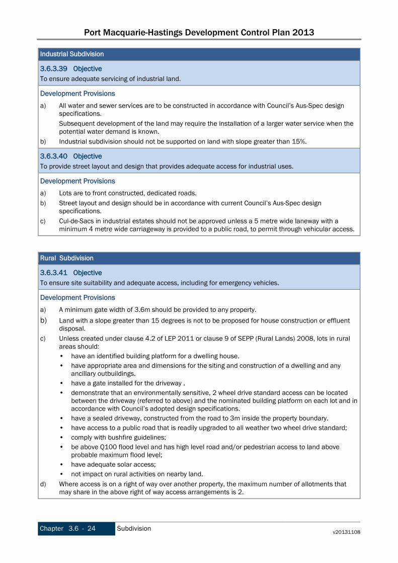
Port Macquarie-Hastings Development Control Plan 2013
Chapter 3.6 - 24 Subdivision v20131108
Industrial Subdivision
3.6.3.39 Objective To ensure adequate servicing of industrial land.
Development Provisions a) All water and sewer services are to be constructed in accordance with Council’s Aus-Spec design
specifications. Subsequent development of the land may require the installation of a larger water service when the potential water demand is known.
b) Industrial subdivision should not be supported on land with slope greater than 15%.
3.6.3.40 Objective To provide street layout and design that provides adequate access for industrial uses.
Development Provisions a) Lots are to front constructed, dedicated roads. b) Street layout and design should be in accordance with current Council’s Aus-Spec design
specifications. c) Cul-de-Sacs in industrial estates should not be approved unless a 5 metre wide laneway with a
minimum 4 metre wide carriageway is provided to a public road, to permit through vehicular access. Rural Subdivision
3.6.3.41 Objective To ensure site suitability and adequate access, including for emergency vehicles.
Development Provisions a) A minimum gate width of 3.6m should be provided to any property. b) Land with a slope greater than 15 degrees is not to be proposed for house construction or effluent
disposal. c) Unless created under clause 4.2 of LEP 2011 or clause 9 of SEPP (Rural Lands) 2008, lots in rural
areas should: • have an identified building platform for a dwelling house. • have appropriate area and dimensions for the siting and construction of a dwelling and any
ancillary outbuildings. • have a gate installed for the driveway . • demonstrate that an environmentally sensitive, 2 wheel drive standard access can be located
between the driveway (referred to above) and the nominated building platform on each lot and in accordance with Council’s adopted design specifications.
• have a sealed driveway, constructed from the road to 3m inside the property boundary. • have access to a public road that is readily upgraded to all weather two wheel drive standard; • comply with bushfire guidelines; • be above Q100 flood level and has high level road and/or pedestrian access to land above
probable maximum flood level; • have adequate solar access; • not impact on rural activities on nearby land.
d) Where access is on a right of way over another property, the maximum number of allotments that may share in the above right of way access arrangements is 2.
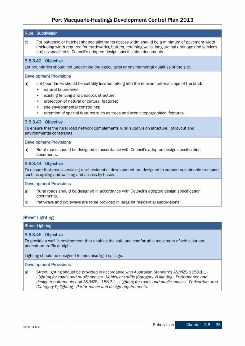
Port Macquarie-Hastings Development Control Plan 2013
v20131108 Subdivision Chapter 3.6 - 25
Rural Subdivision
e) For battleaxe or hatchet shaped allotments access width should be a minimum of pavement width (including width required for earthworks, batters, retaining walls, longitudinal drainage and services etc) as specified in Council’s adopted design specification documents.
3.6.3.42 Objective Lot boundaries should not undermine the agricultural or environmental qualities of the site.
Development Provisions a) Lot boundaries should be suitably located taking into the relevant criteria slope of the land:
• natural boundaries; • existing fencing and paddock structure; • protection of natural or cultural features; • site environmental constraints; • retention of special features such as trees and scenic topographical features.
3.6.3.43 Objective To ensure that the rural road network complements rural subdivision structure, lot layout and environmental constraints.
Development Provisions a) Rural roads should be designed in accordance with Council’s adopted design specification
documents.
3.6.3.44 Objective To ensure that roads servicing rural residential development are designed to support sustainable transport such as cycling and walking and access by buses.
Development Provisions a) Rural roads should be designed in accordance with Council’s adopted design specification
documents. b) Pathways and cycleways are to be provided in large lot residential subdivisions.
Street Lighting Street Lighting
3.6.3.45 Objective To provide a well lit environment that enables the safe and comfortable movement of vehicular and pedestrian traffic at night. Lighting should be designed to minimise light spillage.
Development Provisions a) Street lighting should be provided in accordance with Australian Standards AS/NZS 1158.1.1 -
Lighting for roads and public spaces - Vehicular traffic (Category V) lighting - Performance and design requirements and AS/NZS 1158.3.1 - Lighting for roads and public spaces - Pedestrian area (Category P) lighting - Performance and design requirements.

Port Macquarie-Hastings Development Control Plan 2013
Chapter 3.6 - 26 Subdivision v20131108
Street Lighting
3.6.3.46 Objective To effectively manage lighting so that the electricity costs incurred in the lighting of urban roads and other public thoroughfares are minimised.
Development Provisions a) All new development should use energy efficient street lighting.
3.6.3.47 Objective To discourage anti social behaviour along corridors and in public spaces.
Development Provisions a) Lighting should be provided along pathways, cycleways and in public places.
Street naming Street naming
3.6.3.48 Objective Street names are in accordance with Council’s policy and guidelines.
Development Provisions a) As the relevant road Authority, Council must approve any proposed names to streets in new
subdivisions in accordance with Council’s policy and guidelines for naming of roads issued by the Geographical Names Board, AS1742.5-1997 - Manual of uniform traffic control devices - Street name and community facility name signs, the Roads Act 1993 and the Roads Regulation 2008.
b) The proposed names of roads and streets are to be shown on the detailed engineering plans.
Strata / Community Title Subdivision
Strata / Community Title Subdivision
3.6.3.49 Objective To promote consideration of strata subdivision with the development application. To clearly identify future ownership patterns for private and communal spaces.
Development Provisions a) Strata subdivision may be applied for:
• as part of a development application for a new proposal. • existing development, currently not subject to a strata. For new developments applicants are advised to apply for strata title subdivision at the development application stage. Otherwise a separate and new application is required, accompanied by new fees. Applicants are to submit an indicative concept plan with the development application showing private and common property. This does not have to be a formal strata plan at this stage. Where it is proposed to develop in stages, this should be indicated on the concept plans. The development should be completed in accordance with the consent prior to the release of the linen plan.
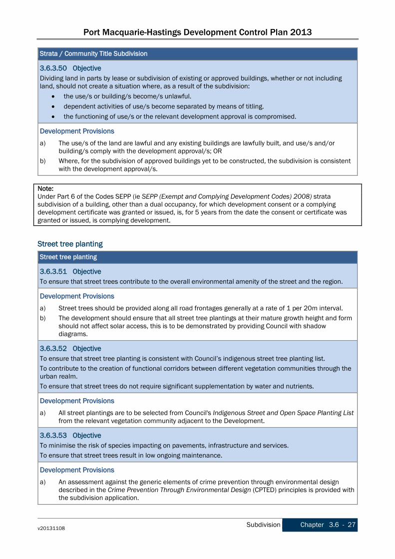
Port Macquarie-Hastings Development Control Plan 2013
v20131108 Subdivision Chapter 3.6 - 27
Strata / Community Title Subdivision
3.6.3.50 Objective Dividing land in parts by lease or subdivision of existing or approved buildings, whether or not including land, should not create a situation where, as a result of the subdivision:
• the use/s or building/s become/s unlawful. • dependent activities of use/s become separated by means of titling. • the functioning of use/s or the relevant development approval is compromised.
Development Provisions a) The use/s of the land are lawful and any existing buildings are lawfully built, and use/s and/or
building/s comply with the development approval/s; OR b) Where, for the subdivision of approved buildings yet to be constructed, the subdivision is consistent
with the development approval/s. Note: Under Part 6 of the Codes SEPP (ie SEPP (Exempt and Complying Development Codes) 2008) strata subdivision of a building, other than a dual occupancy, for which development consent or a complying development certificate was granted or issued, is, for 5 years from the date the consent or certificate was granted or issued, is complying development.
Street tree planting Street tree planting
3.6.3.51 Objective To ensure that street trees contribute to the overall environmental amenity of the street and the region.
Development Provisions a) Street trees should be provided along all road frontages generally at a rate of 1 per 20m interval. b) The development should ensure that all street tree plantings at their mature growth height and form
should not affect solar access, this is to be demonstrated by providing Council with shadow diagrams.
3.6.3.52 Objective To ensure that street tree planting is consistent with Council’s indigenous street tree planting list. To contribute to the creation of functional corridors between different vegetation communities through the urban realm. To ensure that street trees do not require significant supplementation by water and nutrients.
Development Provisions a) All street plantings are to be selected from Council's Indigenous Street and Open Space Planting List
from the relevant vegetation community adjacent to the Development.
3.6.3.53 Objective To minimise the risk of species impacting on pavements, infrastructure and services. To ensure that street trees result in low ongoing maintenance.
Development Provisions a) An assessment against the generic elements of crime prevention through environmental design
described in the Crime Prevention Through Environmental Design (CPTED) principles is provided with the subdivision application.
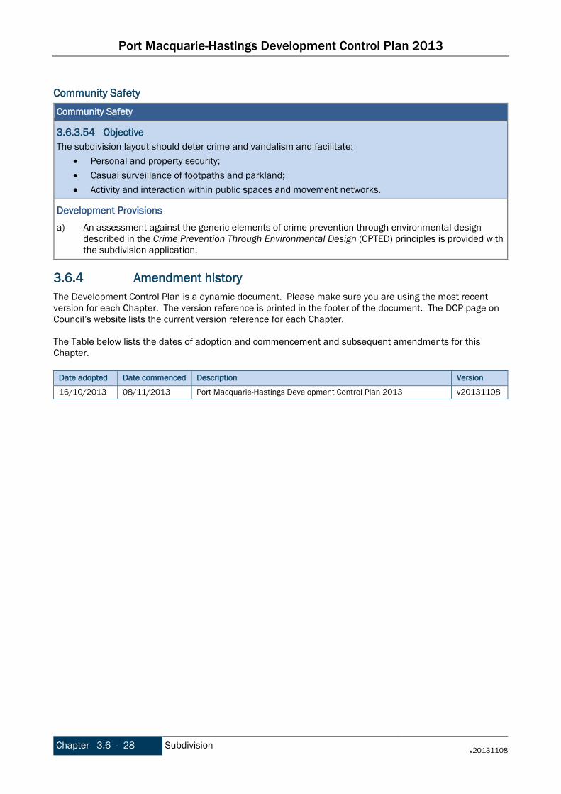
Port Macquarie-Hastings Development Control Plan 2013
Chapter 3.6 - 28 Subdivision v20131108
Community Safety
Community Safety
3.6.3.54 Objective The subdivision layout should deter crime and vandalism and facilitate:
• Personal and property security; • Casual surveillance of footpaths and parkland; • Activity and interaction within public spaces and movement networks.
Development Provisions a) An assessment against the generic elements of crime prevention through environmental design
described in the Crime Prevention Through Environmental Design (CPTED) principles is provided with the subdivision application.
3.6.4 Amendment history The Development Control Plan is a dynamic document. Please make sure you are using the most recent version for each Chapter. The version reference is printed in the footer of the document. The DCP page on Council’s website lists the current version reference for each Chapter. The Table below lists the dates of adoption and commencement and subsequent amendments for this Chapter.
Date adopted Date commenced Description Version
16/10/2013 08/11/2013 Port Macquarie-Hastings Development Control Plan 2013 v20131108

Port Macquarie-Hastings Development Control Plan 2013
v20131108 Subdivision Chapter 3.6 - 29
This page is left intentionally blank