Embed Size (px)
Citation preview

UNA Arquitetos est. 1996
Cristiane Muniz | Fábio Valentim | Fernanda Barbara | Fernando ViégasSão Paulo, Brazil
PARQUE DOM PEDRO II Category: Urban Plan
Location: São Paulo, Brazil Surface: N/A
Project Year: 2011
dms - 23° 32’ 49” S / 46° 37’ 47” W
elevation - 799 m / 2,493 ft
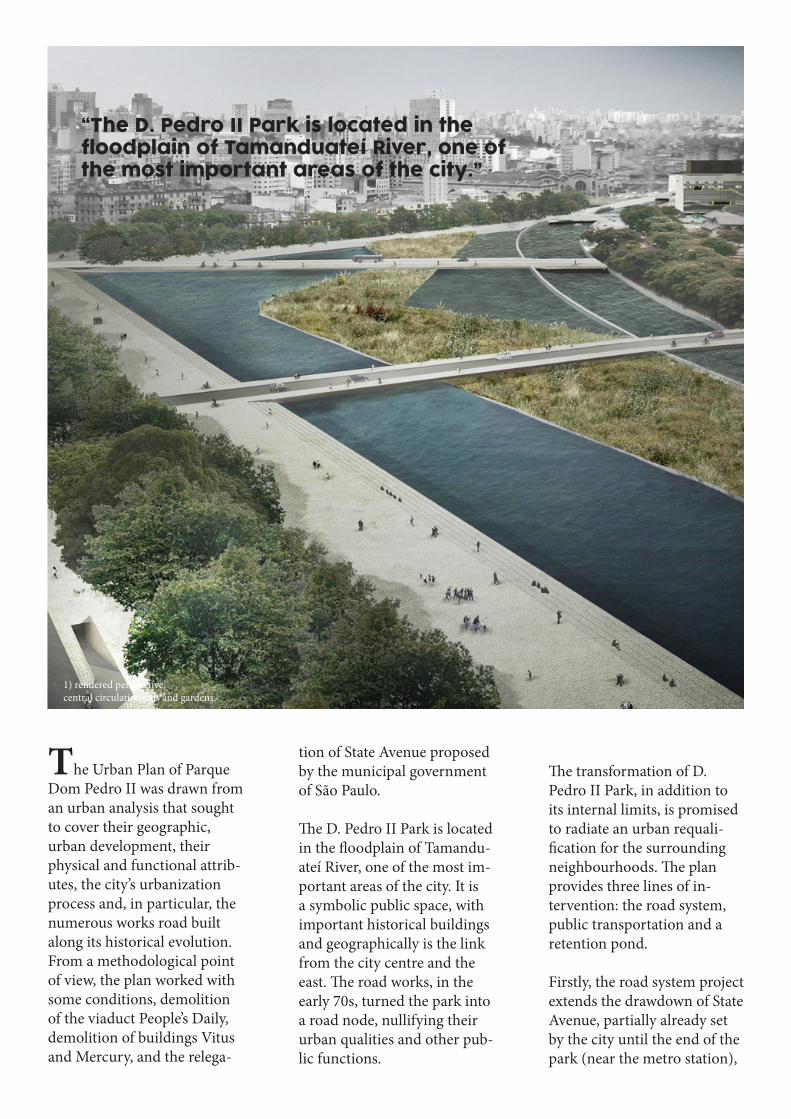
The Urban Plan of Parque Dom Pedro II was drawn from an urban analysis that sought to cover their geographic, urban development, their physical and functional attrib-utes, the city’s urbanization process and, in particular, the numerous works road built along its historical evolution. From a methodological point of view, the plan worked with some conditions, demolition of the viaduct People’s Daily, demolition of buildings Vitus and Mercury, and the relega-
tion of State Avenue proposed by the municipal government of São Paulo.
The D. Pedro II Park is located in the floodplain of Tamandu-ateí River, one of the most im-portant areas of the city. It is a symbolic public space, with important historical buildings and geographically is the link from the city centre and the east. The road works, in the early 70s, turned the park into a road node, nullifying their urban qualities and other pub-lic functions.
The transformation of D. Pedro II Park, in addition to its internal limits, is promised to radiate an urban requali-fication for the surrounding neighbourhoods. The plan provides three lines of in-tervention: the road system, public transportation and a retention pond.
Firstly, the road system project extends the drawdown of State Avenue, partially already set by the city until the end of the park (near the metro station),
1) rendered perspective,central circulation axis and gardens.
“The D. Pedro II Park is located in the floodplain of Tamanduateí River, one of the most important areas of the city.”

allowing the demolition of four bridges that cross the park. This is turn broadens the permeability of the park, with the creation of new pedestrian crossings and the significant improvement of local accessi-bility.
The public transportation proposals for the road sys-tem allowed the reordering of the three existing public transport systems today in the park. The project proposes an inter-modal station next to the station Parque Dom Pedro subway, linking more appro-priately, both the demands of trade lines and systems. The new station is developed around a leafy square and the organization provides a situa-tion more comfort to all users.
Finally, the retention pond in the park has several func-tions. It is a key element in the design of public space, its
organization and the creation of a new urban landscape. This pond was designed to retain the surplus of rain water in times of heavy rainfall, preventing flood-ing in the region. The pond has a natural filtration system through constructed wetlands.region.
The plan also provides for two specific interventions in north-ern and western sector of the Park. The northern sector of the Park is characterized by the presence of important historical buildings, especially the Munic-ipal Market, the Palace Indus-tries and the House of retorts. Despite the physical proximity of these buildings, the insula-tion between them is complete, resulting in a disjointed urban space. Starting from the road interventions and public trans-port already defined by the plan, the design reintegrates this sector with the park and the city itself.
2) rendered perspective,proposed plaza.
3) retention pond intervals.
“This pond was designed to retain the surplus of rain water in times of heavy rainfall, preventing flooding
in the region.”
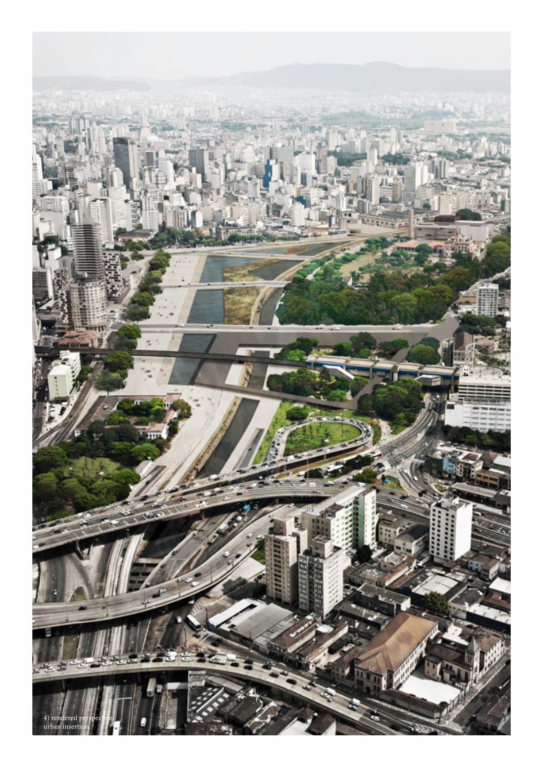
5) south-eats view. 4) rendered perspective, urban insertion.
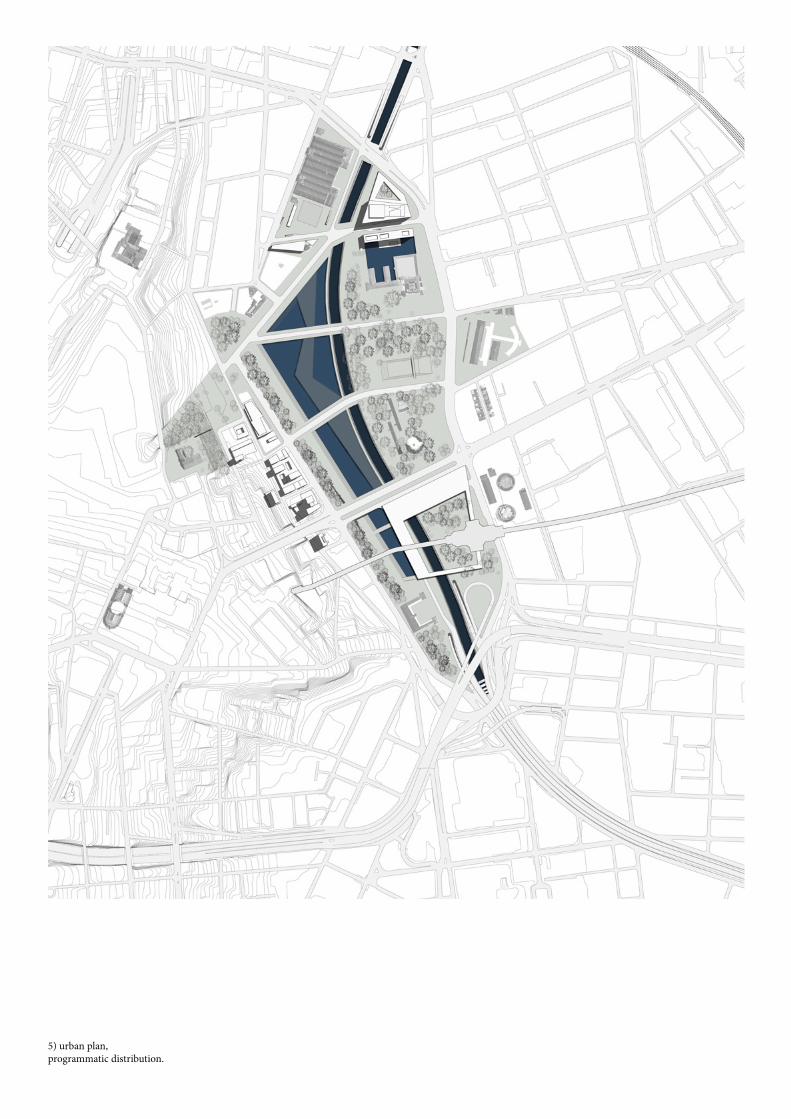
5) urban plan,programmatic distribution.

6) site diagramming.obstacles, areas and program.
5) south-eats view. 7) site section. retention pond occupied as plaza.