Embed Size (px)
Citation preview

PARMELEE FARM ROUTE 81, KILLINGWORTH, CONNECTICUT
Existing conditions photograph of the 1847 farmhouse at Parmelee Farm, Nov. 2010
SCHEMATIC LANDSCAPE MASTER PLAN
ELMORE DESIGN COLLABORATIVE, INC. Historical Landscape Architects
Suffield, Connecticut
December 2010

PARMELEE FARM SCHEMATIC LANDSCAPE MASTER PLAN
prepared for
The Town of Killingworth and the
Parmelee Farm Steering Committee Killingworth, Connecticut
prepared by ELMORE DESIGN COLLABORATIVE, INC.
Historical Landscape Architects 615 Mather Street
Suffield, Connecticut 860. 254-5498
Principal-in-Charge
Thomas J. Elmore, ASLA, LEED AP
© Copyright December 2010

TABLE OF CONTENTS __________
I. INTRODCUTION .....................................................................................................................1 A. Executive Summary..............................................................................................................1 B. Goals and Objectives ...........................................................................................................2 II. HISTORICAL BACKGROUND...............................................................................................4 A. Brief History of the Parmelee Farm ....................................................................................4 B. Bosco Era History................................................................................................................9 C. Historic Aerial Photographs..............................................................................................18 III. THE SECRETARTY OF THE INTERIOR’S STANDARDS................................................29 IV. LONG RANGE PLANNING and RECOMMENDATIONS..................................................31 A. Articulated Vision ..............................................................................................................31 B. Rehabilitation Policy for Parmelee Farm..........................................................................34 C. Schematic Landscape Master Plan....................................................................................40 1. Background Information..............................................................................................40 2. Existing Conditions......................................................................................................49 3. The Planned Improvements..........................................................................................52 4. Additional Features .....................................................................................................70 APPENDICIES A. Recommendations For Landscape Improvement.....................................................................80 B. Connecticut Invasive Plant List, September 2010 C. Maps
1. Parmelee Farm in Context 2. Historic Farm Core & Outer Acreage 3. Wetlands and Upland Review Areas 4. Potential Archaeological Sites 5a. Existing Conditions – Landscape Features (black and white rendering 5b. Existing Conditions – Landscape Features (color rendering) 6a. Schematic Landscape Master Plan (black and white rendering) 6b. Schematic Landscape Master Plan (color rendering)

Parmelee Farm - Schematic Landscape Master Plan 1
I. INTRODUCTION A. EXECUTIVE SUMMARY The Parmelee Farm is an unusual surviving farm that is important to the history of Killingworth and also to the State of Connecticut. The Town of Killingworth owns Parmelee Farm and operates it as community open space. This site is located on Route 81, just north of the Haddam-Killingworth Middle School. It retains agricultural heritage and human activity over several centuries including an 18th century road, 19th century farmhouse, 20th century farm buildings, 21st century community gardens, stone walls, open fields and pastures, and woodland. The site is approximately 131 acres in size and, for purposes of this report, has been divided into two landscape units – the Historic Farm Core Landscape that contains most of the historic farming activities and the Outer Acreage that contains the woodland and recently added hiking trails. This farm represents a continuum of farming activities that coincides with the growth and development of Killingworth, farming technologies in New England farming, and the organizational patterns of farm design and its evolution – from organic and scattered to designed and formalized. This is a significant historical site with extant buildings, landscape features, and spatial organization. This report is the culmination of a two-month project conducted by Elmore Design Collaborative, Inc., Historical Landscape Architects. The purpose for developing this Schematic Landscape Master Plan is to layout a road map for creating a long-range plan for Parmelee Farm that encourages its use while preserving its heritage. The Town purchased the farm in 2000 and did not start making improvements and modifications to it until 2007. Since then, a flurry of activity has taken place including the removal of several buildings for safety reasons, the clearing and removal of overgrown and volunteer vegetation, and the creation of a well-organized and active Community Garden. The Killingworth Historical Society has just signed a long-term lease with the Town to use the farmhouse as their headquarters. The Town established a Steering Committee to develop long-range plans for the park and secured funding to undertake the development of this Schematic Landscape Master Plan. The Steering Committee and the idea of developing programs at Parmelee Farm are relatively new. The programmatic planning process and thoughts of developing the farm for public use is in its infancy and will continue to evolve and mature. A lot has been accomplished in a short period of time, which is both exciting and encouraging. As more is done, more people will get involved and a greater awareness of the farm and its history will develop, which in turn will increase visitation and interest in its preservation. In general, little is known about Parmelee Farm. A brief discussion of the known history of the site and its owners is included herein. This discussion provides a general understanding of the farm’s overall history and will continue to be expanded as ongoing research identifies new information. While this Master Plan was evolving, conversations with a former owner took place that expanded the knowledge and understanding of the farm, its use, and general activities during this owner’s residency. He and other members of his extended family have provided their personal photographs of the property to be scanned and returned. The transcribed conversation

Parmelee Farm - Schematic Landscape Master Plan 2
and accompanying photographs are included herein for documentation purposes as a means of spreading the knowledge and history of Parmelee Farm. Additional periods of the farm’s history are being pursued, but will not be available for inclusion into the report. This Schematic Landscape Master Plan is presented in a manner to educate and inform the reader about history of the farm, and develops an argument for explaining how and why the final layout of recommended improvements evolved. First, as mentioned above, are two discussions about the farm’s history. This is followed by a presentation of historic aerial photographs that illustrate how the farm and its context changed overtime. Then, a brief discussion of The Secretary of the Interior Standards for the Treatment of Historic Properties with Guidelines for the Treatment of Cultural Landscapes is provided to explain our nationally recognized approach for working on historic landscapes. The final section is the long range planning and recommendations for improving and developing the farm. This section begins with an articulated vision for the farm that is followed by a rehabilitation policy that is to be used when planning and implementing the recommendations of the Master Plan and all future programs. Then a detailed discussion of the Master Plan addresses the ‘List of Priorities’ developed by the Steering Committee with a series of recommendations for each item. This is followed by additional features that were not on the list but need to be addressed in order for this Master Plan to be complete and provide a thorough approach for addressing all aspects of improving Parmelee Farm. Finally, all of the recommendations were copied and placed in Appendix A at the end of the report so they can easily be found and followed in the future. The format of this report was developed to meet the needs of the Steering Committee. Its contents meet the contractual requirements and have been expanded to provide additional and more detailed guidance to the Committee. All of the recommendations herein follow the guidelines established by The Secretary of the Interior. B. GOALS, OBJECTIVES and REQUIREMENTS The main goal for this Schematic Landscape Master Plan is to layout a road map that will guide the Parmelee Farm Steering Committee and the community at large with a means to which they can achieve their mission for Parmelee Farm. To accomplish this goal, a series of objectives were met including: 1. Meet with the Steering Committee and other interested stakeholders to develop an
understanding of their vision for the farm and their overlapping issues, while striving to meet everyone’s use needs and desires.
2. Create a Landscape Master Plan that enables the creative and flexible use of Parmelee Farm. 3. Incorporate the ‘List of Priorities' developed by the Steering Committee onto the farm
landscape in a manner that preserves and respects the site’s heritage, without limiting its use. 4. Encourage the active use of the farm, while maintaining its heritage and restoring its spatial
configuration and historic sense of place over time.

Parmelee Farm - Schematic Landscape Master Plan 3
The Parmelee Farm Steering Committee’s Mission Statement is:
The Parmelee Farm connects our community to the natural environment and cultural heritage of Killingworth through education, agriculture, preservation, passive recreation and the arts.
The Steering Committee’s vision is to save the farm and its heritage while encouraging its use through a variety of programs, means, and methods that will meet the changing needs of the Town. As the Steering Committee matures, it must keep its Mission Statement in the forefront and use it as a sounding board for all proposed improvements, activities, and changes to the landscape and the programs at the farm. By doing this, the Committee will maintain its originating ideals. However, if in the future, the Committee finds that its Mission Statement needs to be changed, then it should be changed with input from the entire Committee only to make the mission at the farm better and stronger as a means to preserve Parmelee Farm, to promote the farm’s new uses, and to further illustrate Killingworth’s heritage.

Parmelee Farm - Schematic Landscape Master Plan 4
II. HISTORICAL BACKGROUND A. BRIEF HISTORY OF THE PARMELEE FARM (updated history Dec. 9, 2010) By Thomas L. Lentz, Municipal Historian The Horace Parmelee house, formerly known as the Bosco house, was built in 1847 and occupied by Horace and Eunice Parmelee. Architecturally, the house is a late example of the post-colonial or Federal style. Horace L. Parmelee was born June 28, 1819, the son of Moses and Ruth Parmelee. Eunice Maria Parmelee was born on August 2, 1822, the daughter of Rufus and Eunice Parmelee. They were married on June 11, 1843, by the Rev. E. Swift. H. L. Parmelee is shown as occupant of the house on the 1859 map of Middlesex County. Horace died August 5, 1898 and Eunice November 8, 1905.
The Parmelee House, 2009
The house is set back some distance from Route 81, then the Haddam and Killingworth Turnpike. The Turnpike was chartered in October, 1813 and completed in 1817. Tolls were collected on the Turnpike until 1850. Immediately behind the house is an old road, now abandoned. This road was possibly part of the original north-south road prior to the Turnpike. The Parmelee Farm was a large and active farm in the nineteenth century. The 1880 census lists Horace’s occupation as “Farmer.” Horace and Eunice Parmelee acquired additional lands until their farm was 150 acres in size. Although it is not known what specific crops were grown on the farm, exhibits at the Agricultural Fairs, ledgers, and old newspaper articles shed some light on the agricultural activities in Killingworth at the time. The major crops were corn, oats, rye, flax, wheat, turnips, beans, potatoes, onions, grapes, strawberries, and a variety of vegetables. Crops were often followed by a planting of clover, timothy, and other grasses to replenish the

Parmelee Farm - Schematic Landscape Master Plan 5
soil. Animals included horses, cattle, sheep, oxen, swine, and poultry. Hay was grown to feed animals. Killingworth was a supplier of beef, pork, mutton, leather, wool, eggs, cheese, and butter. Most farms had an orchard with apple, pear, and peach trees. Apples were used to make cider at local cider mills. Witch hazel grows abundantly in Killingworth and was harvested to supply manufacturers of medicinal witch hazel extracts in Essex and Clinton. It is likely that many of these crops were grown on the Parmelee Farm. Much of the land is flat and suitable for growing crops. Rocky and hilly sections of land were used for pasturage. Other buildings on the property included a large red English barn with hewn timber frame, a stone barn, and a pole barn. The large barn was used for housing animals, storage of hay, and threshing. The Boscos related a story that the doors were large enough that a pair of Percheron horses and a hay wagon could be outfitted inside the barn and driven out through the double doors. This barn was in poor condition and underwent further deterioration during a storm in 2010. It was removed for safety reasons. An older barn stood to the east of the house where the Community Gardens are now located. This barn had also deteriorated and was destroyed by hurricane Gloria in 1985 and removed by the Boscos. During an Environmental Review of the property in 2000, the Office of State Archaeology noted that the area has a high probability of Native American resources. It would be expected to locate a series of small hunting and gathering camps that may date back to as long as 6,000 years ago. These would be camps where Native Americans were utilizing the natural resources of the area especially the area where the brook flows into the Menunketesuck River. Confluences of two water systems were often desirable as campsites for Native American populations. The junction of the two waterways is within Cockaponset State Forest but the Parmelee farm property is in close proximity. An archaeological survey of the property has not been done so the archeological remnants are relatively unknown. Horace Parmelee died in 1898 and left no last will and testament so that there is no inventory of his estate. The property went to his wife, Eunice, who sold the property to William Kathotka of Manhattan, New York in 1904. In the latter part of the nineteenth century, many of the descendants of the original families left Killingworth for better farmland in the Midwest. The old homesteads were sold to land agents who sold the farms to European immigrants. The Parmelee farm was sold to the Pavelka family in 1906 who continued to farm the property. In the 1950s, the house was run by the McGraths as a summer resort known as “Farm in the Dell.” There was a pool slightly to the northwest of the house. A lighted shuffleboard court was located just south of the house. A small building referred to as the “lodges” was located at the northeast corner of the house. This building had three boarding rooms with sinks and toilets. The building was demolished in 2006. Later, the Boscos ran a turkey farm on the property. It was known as Bosco’s Turkey Farm and sold turkeys as “Bosco’s Birds of Killingworth, Prime Young Native Turkey.” The property was walked with Greg and Betty Bosco in August 2010. They related some history of the farm that was recorded by Bruce Dodson. Turkeys were raised to eight weeks in the English barn (which they called the animal barn), then let outside during the day for free range in the area of the Community Gardens. The pole barn was used for raising capons, a later and larger business.

Parmelee Farm - Schematic Landscape Master Plan 6
There was a grain silo on the southwest end of the pole barn. The stone barn was used for processing turkeys. The pond southeast of the house was dug around 1964 and stocked with trout. Another pond, now dry, called the “turkey gut pond” was located southwest of the stone barn along the old highway. The Town of Killingworth purchased the house and 131 acres in 2000. The property was named the Parmelee Farm to reflect its historical past. Peg Scofield established the Killingworth Community Gardens in 2008. The gardens provide residents the opportunity to maintain a garden for food production. In 2009, the Board of Selectmen established the Parmelee Farm Steering Committee (PFSC) to develop long-range plans for the use of this unique property. The Steering Committee supports the continued use by the Killingworth Community Gardens, use of the Parmelee Farmhouse by the Killingworth Historical Society, creation of walking trails, restoration of the farm buildings and hayfields, conducting workshops, and additional projects being discussed and developed on an on-going basis. In 2008, the Town was awarded two Historic Preservation Technical Assistance Grants from the Connecticut Trust for Historic Preservation to conduct a Conditions Survey and feasibility studies of the house and the English barn. The Killingworth Land Conservation Trust has established hiking trails on the land under the direction of Bruce Dodson. Painting and repairs to the house were done in 2009. In 2010, a 99-year lease was signed granting use of the house to the Killingworth Historical Society. The Historical Society plans on restoring the interior of the farmhouse and using it to store and exhibit its collections. Also in 2010, the Town of Killingworth obtained the Pine Orchard District schoolhouse built in 1853. The schoolhouse, which stood on Route 148, was dismantled and moved to the Parmelee Farm. After selection of a suitable site, the schoolhouse will be reconstructed and used for community events. The records of ownership of the property are shown below.
Town of Killingworth, 2000-present Anthony J. Bosco, 1961-2000 Maria Bosco, 1956-1961 Edward T. and Martha McGrath, 1948-1956 Anna Bertha Pavelka, 1936-1948 Frank Pavelka, 1922-1936 John Pavelka, 1906-1922 William Kathotka, 1904-1906 “…being homestead lately occupied by Horace Parmelee and
jointly owned by Horace Parmelee and Eunice M. Parmelee.” Horace L. Parmelee and Eunice M. Parmelee, 1847-1904
Horace L. Parmelee to Eunice Parmelee. Three and a half acres “together with one half of the dwelling house thereon standing which is now in process of building, during her natural life for her the said Eunice Parmelee to use and occupy…” Vol. 29, p. 519, July 29, 1847. Eunice Parmelee to Horace L. Parmelee. Three and a half acres. The parcel is described as bounded westerly by the Killingworth and Haddam Turnpike, northerly by the heirs of Oren Parmelee, easterly by highway, and southerly by Eunice Parmelee. The south line is a stone wall

Parmelee Farm - Schematic Landscape Master Plan 7
that runs the greater part of the way between the turnpike and old road (highway). Vol. 28, p264, July 28, 1847. The above deeds show that Eunice Parmelee, mother of Horace’s wife Eunice M. Parmelee, sold property to Horace Parmelee bounded on the west by the Killingworth and Haddam Turnpike (now Route 81). Horace then deeded to Eunice half of the property and half of a house in the “process of building.” This indicates the house was built in 1847 and that Eunice Parmelee was allowed to occupy the house. Prior to this, Eunice, and probably Horace and Eunice M., lived in a house to the south, presumably the Josiah Parmelee house (1752). Traces of the “highway” or “old road” that ran behind the house can still be seen.
Horace L. Parmelee

Parmelee Farm - Schematic Landscape Master Plan 8
Parmelee House, 1899. Eunice M. Parmelee is standing in front.
Gravestone of Horace and Eunice Maria Parmelee, Evergreen Cemetery.

Parmelee Farm - Schematic Landscape Master Plan 9
B. BOSCO ERA, SUMMARY OF CONVERSATION WITH TONY BOSCO, JR. Friday, 12/10/10, Brattleboro, VT, Revised Dec. 16, 2010 via a follow-up telephone conversation. By Bruce Dodson
In an effort to document more of the farm’s history, Bruce Dodson, a member of the Steering Committee, contacted Tony Bosco, Jr. and spoke with him about the farm. On Friday, Dec. 10, 2010, these two men met in Brattleboro, Vermont for several hours discussing the farm’s history during Tony Bosco’s residency. His mother, Maria Bosco, purchased the farm in 1956 and started the turkey farm with her husband and son. Tony, Jr. purchased the farm in 1961 and maintained ownership until 2000, when he sold it to the Town of Killingworth. The information that follows is Tony, JR’s responses and elaboration to a series of questions and subsequent follow-up questions that were asked. All of this information is new information to members of the public outside the Bosco family. It is very enlightening and thus important enough to include in this Master Plan as it is part of the farm’s heritage and that of the Town of Killingworth. Bosco Family Farming Anthony (Sr.) and Maria Bosco raised turkeys in the Mt. Carmel section of Hamden on a 3-acre property and needed a larger farm to expand. They purchased the Parmelee Farm in 1956. Tony (Jr.), then 21, had recently graduated from the University of Connecticut with a degree in agriculture and was the first to move to the farm. The turkey business was his parents’ and although it was a substantial operation, it was never able to fully support two generations of Boscos. At its peak the operation produced 7,500 free-range (bronze) turkeys and 6,000 capon chickens each year. The birds were raised in two batches. The turkeys were started out in the English/red barn, and chickens were raised in the pole barn. Later on white turkeys were raised. When young, the turkey’s beaks were seared (blunted), to minimize injury from pecking one another, and a right wing joint tendon was cut to prevent them from flying, although they could still fly up into trees for safety at night. Tom turkeys for the restaurant trade weighed as much as 50 pounds, but many of the hens weighed 12 to 16 pounds. At one time the Boscos also had a small breeding operation and kept between 200 and 250 breeding hens to supply fertilized bronze turkey eggs to Gozzi’s Turkey Farm in Guilford. The turkey farm was in operation from 1957 to about 1980, when “western birds” from Ohio and other states could be purchased for 29 cents a pound. Bosco turkeys had sold for 59 to 69 cents a pound. The Boscos built the 40’ x 140’ pole barn to raise chickens and had a feed silo on a concrete pad on the west end of the building to store pelleted feed. The capons were processed at 6 months of age. Tony had a full-time job but worked as many as 40 hours on weekends when they were processing birds. About 8 people were involved catching birds and processing them. After the birds throats were slit, they were put in an automatic dunking machine which would take 2 toms and 3 hens. A cyclone device removed 99% of the feathers. Maria and Betty Bosco (Tony’s mother and wife) removed the remaining pinfeathers. They had an ice machine that would

Parmelee Farm - Schematic Landscape Master Plan 10
quickly cool the birds. Birds were packed in sealed plastic bags that were shrunk in a heated water bath. They were then frozen and packed in cardboard boxes. Processing was a major undertaking on weekends and took place initially in a shed attached to the English/red barn, and then later in the stone barn and later still in the cinder block addition to the stone barn. Initially, packaged birds were moved to rented freezer space in Wallingford every week; later a freezer was built into the north end of the stone barn. A smaller section of the freezer was a room at the northeast corner of the building that was used for initial chilling. Liquid from bird processing drained into the small pond to the southwest of the stone barn. All solid waste material (feathers and innards), were picked up every Monday by a rendering company which produced animal feed. Tony owned a milk cow and his mother sold raw milk. He maintained “a subsistence operation” and in addition to the milk cow had sheep, pigs, goats and two beef animals that were butchered on alternating years. The animals were kept in the English/red barn that the family called the animal barn. English/red barn [The main part of the red barn, razed in 2010, was in the form of a classic English barn with a central aisle with two double doors in the center of both sides of the barn.] Tony said the mix of materials in the foundation was the work of masons hired to replace the flat stones under the barn that had shifted around. He said the masons dug out a short section of the foundation and rebuilt it, then dug out and rebuilt another section. He said the barn was never moved or jacked up. The foundation and poured floor were added to it where it was standing. The English barn was the barn in which it is said a team of Percheron horses could be harnessed and driven out with a wagon. The double doors in the north and south sides of the barn are clear in the old photographs. The Boscos built a second floor, covered with plywood, and added the large addition on the east end for turkeys. The large double doors were no longer used after the second floor was built. Stone barn The stone barn superstructure (wood above the stone) had deteriorated before the Boscos purchased the property and was completely rebuilt by them in the late 1950s or early 1960s. There were originally three animal stalls or stanchions in the north end of the building. Later, they dug out the floor and installed the poured concrete floor, then the freezer. The shed on the west side of the barn, above the concrete slab, was a compressor shed.

Parmelee Farm - Schematic Landscape Master Plan 11
Old barn The old barn which stood on the east side of the highway north of the stone barn was in such bad shape when the Boscos purchased the property that it was never used by them and it blew down in a hurricane. There was a huge summer beam that was about one foot square that was too heavy to move, so it was cut up. Any material that might have been saved from this building would have been stored or used in the English barn. Pole barn The pole barn was built in the early 1960s. [The poles supporting the pole barn are pressure treated, four feet deep, on cement pads.] When the pole barn was no longer used for raising chickens, it was rented to a local building restorer who stored beams, woodwork and other materials in the barn. In the end, the restorer failed to pay the rent and some of the material was left behind. Most of the material in the barn in 2010 came from other sites. The Lodges The McGraths, who owned the property from 1948 to 1956, told Tony “the lodges”, the building to the immediate northeast of the farmhouse, was originally a carriage house. The McGraths said they converted it into four rooms with porcelain sinks and toilets to provide rentable lodging for workers who were employed in the construction of Route 95 – The Connecticut Turnpike. Three rooms opened to the dooryard behind the house and one room opened towards Route 81. When Route 95 was completed the McGraths created a resort for vacationers called “Farm in the Dell” to provide continued rental income. Sheds Tony has no recollection of a shed or small barn at the end of the driveway. The buildings he remembers are the farmhouse, the lodges, garage, the old barn that blew down in the hurricane, the English barn, pole barn and stone barn. He said there were lean-to sheds on the south side of the old barn and English barn. He built a small greenhouse on the south side of the English barn, and a small pen was built on the east side of the stone barn (off the cinder block addition), for turkeys Ponds The farm pond is 10 feet deep, and was excavated when Tony and Betty built their house at 459 Route 81 in 1962 - 1963. Their house was built on ledge, and material was needed to cover the ledge. There was a federal program to help farmers build farm ponds at that time, so the pond was designed and built with federal assistance. It was designed and contracted to be 10 feet deep, and Tony is certain it is no deeper since they encountered a 2 inch spring or water seam

Parmelee Farm - Schematic Landscape Master Plan 12
when they were digging and pumps had to be brought in so the digging could continue. The pond was never used as a water supply because the well at the house supplied all the water they needed. The pond was stocked with trout, which did not thrive and later with bass by neighbor Andy Kuczma. The pile of dirt to the north of the pond came from the pond. The pond along the old highway south of the stone barn was there when the Boscos purchased the property. Tony does not know about the pile of dirt and stones south of the stone barn along the old highway. Farmhouse Tony said there were two matching maples in front of the house, which Tony called husband and wife trees. He said the husband (north) tree had died. When asked why that one was the husband (and not the wife) tree, he said the husband usually died first… He has no recollection of the house having been painted any color other than red. Tony rebuilt the kitchen and made all the cabinets by hand. He built out the walls in the upstairs to add insulation. He also built out the walls in the downstairs bathroom and kitchen and insulated those walls, and replaced all the windows upstairs and in his mother’s room and bathroom downstairs. The paneling in the living room was there when the Boscos purchased the property. The second floor door in the back of the house opened onto the small deck on the small back entry that has removed in 2009. Tony thinks it is possible that there might have been outside stairs at one time but does not know. Tony said the cellar often had water in it and they had a sump pump running a lot of the time. He said there is an old drain, which could be original to the house, which runs from the cellar to the old highway to the northeast. He remembers his mother having to clear it out fairly often. [A similar drain exists in the Broach house northwest of the farmhouse - at 476 Route 81 – also an old Parmelee house.] Underground utilities/etc. There is a black plastic pipe from the house to the pole barn, with a “T” approximately where the old barn (blown down in a hurricane), was located. The “T” took water to the English barn and stone barn. The well in front of the kitchen provided all of the water for the entire farm, and operated with only a ¾ horsepower pump. Tony described this as a “fantastic well” – probably a pounded well. He said the pipe to the barns developed a leak near where the old barn was located. There are turn-off valves underground at the bottom of vertical black plastic pipes at each of the barns [the valves for the English and pole barns have been identified on the west end of both barns]. The two-inverted “U” shaped black plastic pipes on the east and north sides of the stone barn are vents for the rock layer below the concrete floor of the stone barn.

Parmelee Farm - Schematic Landscape Master Plan 13
The vertical pipe that comes out of the ground on the south side of the stone barn was not there to Tony’s recollection. [This may have been a test pipe for monitoring and may have been installed during the environmental review when the Town purchased the property.] Tony does not know of any septic tanks or leach fields anywhere on the property other than the system north of the house [which is documented in the Town building records]. The drain from the stone barn is through a black plastic “sewer” pipe to the small pond to the west of the old highway. The vault to the northeast of the swimming pool was for the pool “mechanicals” (pump, filter, etc.). The Boscos had painted the pool once and intended to fill it but it took too long so they abandoned the idea. Tony said they didn’t have any free time to go swimming anyway. Tony knows of no underground electrical service or wires. When asked about possible hazards in the ground or on the property, he pointed out the well on the east side of the old highway on school property [which Greg has identified]. Tony is unaware of the possible foundation site southwest of the well. The dump site northeast of the farmhouse (on the east side of the old highway) is the only old dump Tony is aware of. He said he’d been asked to let someone dig there for bottles. Stonewalls Tony said that a former neighbor…stole a lot of stone from the walls along the old highway, as well as the boundary stone wall on the north side of the old road which runs towards Chester. This means that this old road once had walls on both sides [indicating it was probably more than a simple farm or wood road]. Tony said after removing the old boundary wall the former neighbor had his property surveyed and tried to claim ownership of land to the remaining wall on the south side of the road. He said he had the First Selectman come out to talk to the neighbor. Woods Tony said the woods were selectively timbered in 1957 and again 30 years later by the Rossi Corporation, which manufactures wood pallets. He said the McGraths were going to timber the property before selling it to the Boscos but his father told them that if they did timber the land he wouldn’t buy it - then the Boscos timbered it themselves after buying the property. He said he didn’t spend a lot of time in the woods, but remembers an old mound of charcoal, several feet high and about 8 feet in diameter, which he believed was to the east of the wood road on the Pavelka Trail. [This may be the site of 19th century charcoal making and should be identified if at all possible.]

Parmelee Farm - Schematic Landscape Master Plan 14
Miscellaneous Tony had no knowledge of the mounds of dirt northeast of the pool, but guessed they came from the construction of the pool. He had a cornfield for animal feed to the northwest of the pool. He said the area in front of the farmhouse used to be a hayfield that was mowed by the Marquand (Linda Dudek’s) family. He said it grew up quickly after they stopped mowing it. Turkeys used to be moved to the field where the newer house now stands (459 Route 81). He said his mother used to herd them from one place to another with two long sticks with flags or cloths tied at the ends. The objects in the north field in the aerial photograph when the Boscos owned the property were turkey feeders and waterers. The feeders were galvanized and about 5’ in diameter [one was saved from the English barn). What appears to be a pile of building material along the old highway opposite the stone barn, in a photograph of Maria Bosco and in an old aerial photograph, is probably material removed from an area Tony was clearing for a garden east of the old highway. [Brackets = observations of the writer.] TONY BOSCO’S PHOTOGRAPHS The following photographs were obtained from Tony Bosco, Jr. and are included here to illustrate how the farm looked during their residency. Dates and other information will be added to these photographs once it is provided.
Farmhouse during the winter. Another view of the farmhouse during winter.

Parmelee Farm - Schematic Landscape Master Plan 15
Family picnic in lawn area south of farmhouse. Maria Bosco, Tony, JR’s mother, in old road next to the old barn.
The old barn was in poor condition and was never used The old barn came down during a hurricane and by the Bosco family. removed by Tony, Jr.
Looking east with the red barn on the right. Sheep in pasture with Bosco addition onto the east end of the red barn.

Parmelee Farm - Schematic Landscape Master Plan 16
The southwest façade of the red barn. View of the northeast corner of the stone barn.
Sheep at the west end of the red barn. Looking at the north end of the stone barn from the old road.
Looking at the stone barn on the left, the red barn with addition on the right, the roof peek of the old barn over the
addition, and the pile of dirt from excavating the farm pond in the foreground (left photo). The overhead wires extend to the pole barn behind the photographer (left photo).

Parmelee Farm - Schematic Landscape Master Plan 17
Winter scene of the north façade of the pole barn with Nighttime view of the pole barn. pasture and access drive.
The farm pond shortly after it was dug. This pond is spring fed.

Parmelee Farm - Schematic Landscape Master Plan 18
C. HISTORIC AERIAL PHOTOGRAPHS The following series of aerial photographs were located at the Connecticut State Library in Hartford, CT and online at GoogleEarth.com. These images are presented here in chronological order to document and illustrate how the farm and its context changed between 1934 and 2010. Look closely to see building come and go, and how the fields and woods changed over time. The last image is how the farm looked in September 2010 and shows the Community Gardens and fields that were recently cleared (between 2008 and 2010) of overgrown and volunteer vegetation.
1934 Aerial Photograph, CT State Library, Digital Collection, Photo # 09692)

Parmelee Farm - Schematic Landscape Master Plan 19
Detail view of the 1934 aerial photograph (CT State Library, Digital Collection – Photo # 09692)

Parmelee Farm - Schematic Landscape Master Plan 20
1951 Aerial Photograph (CT State Library, Archives - Flight Line CNF 2H, Photo #56)

Parmelee Farm - Schematic Landscape Master Plan 21
This photograph was taken shortly after Tony Bosco, Jr. purchased the farm from his mother.
1965 Aerial Photograph (CT State Library, Digital Collection – online - http://cslib.cdmhost.com/cdm4/item_viewer.php?CISOROOT=/p4005coll10&CISOPTR=9486&DMSCALE=33&DMWIDTH=700&DMHEIGHT=700&DMX=2461&DMY=1635&DMMODE=viewer&DMTEXT=&REC=1&DMT
HUMB=1&DMROTATE=0)

Parmelee Farm - Schematic Landscape Master Plan 22
1970 Aerial Photograph (CT State Library, Archives - Flight Line 39, Photo #1684)

Parmelee Farm - Schematic Landscape Master Plan 23
1980 Aerial Photograph (CT State Library, Archives - Flight Line 51, Photo #0071)
Parmelee Farm - Schematic Landscape Master Plan 24
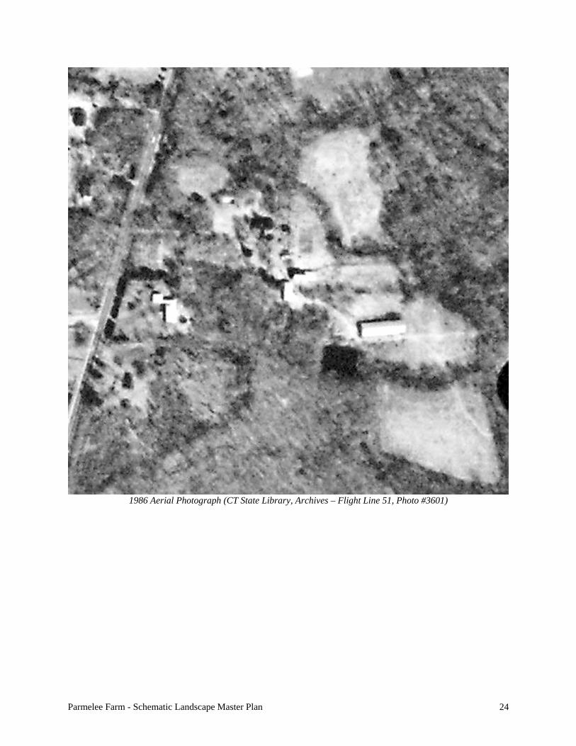
1986 Aerial Photograph (CT State Library, Archives – Flight Line 51, Photo #3601)

Parmelee Farm - Schematic Landscape Master Plan 25
1990 Aerial Photograph (CT State Library, Archives – Flight Line 51, Photo #1689)

Parmelee Farm - Schematic Landscape Master Plan 26
2000 Aerial Photograph (CT State Library, Archives – Flight Line 39, Photo #39)

Parmelee Farm - Schematic Landscape Master Plan 27
Ca. 2005 Aerial Photograph (BingMaps.com)

Parmelee Farm - Schematic Landscape Master Plan 28
Notice the farm buildings, Community Gardens, open fields, and farm pond. The Haddam Killingworth Middle School is in the lower left corner with Maria Bosco’s ‘new house’, ca. 1960s, immediately north of the baseball
field. September 11, 2010 Aerial Photograph (GoogleEarth.com)

Parmelee Farm - Schematic Landscape Master Plan 29
III. THE SECRETARY OF THE INTERIOR STANDARDS Before jumping into the master plan, a brief discussion on this country’s national standards and guidelines as they pertain to preserving cultural landscapes is warranted. The following is a condensed version of our nationally recognized standards and guidelines to preserving cultural landscapes. These standards and guidelines strive to protect the significant features on cultural landscapes, thereby saving the entire landscape and its individual features from well-meaning but destructive use, change, and repair. These standards and guidelines DO NOT restrict using these landscapes. Rather, they provide caretakers with recommendations to save and use cultural landscapes in sympathetic ways without doing non-reversible damage, thereby losing such important and iconoclastic landscapes or their individual character-defining landscape features. To protect the significant features Parmelee Farm while any work is done the following standards and guidelines should be utilized: The Secretary of the Interior Standards for the Treatment of Historic Properties With Guidelines for the Treatment of Cultural Landscapes, edited by Charles A. Birnbaum with Christine Capella Peters, published by the U.S. Department of the Interior in 1996. These guidelines recognize that historic materials and details have proven records for durability and compatibility, and that routine maintenance avoids costly repairs. The careful consideration of materials, finishes, proportions, and design elements, consistent with the style of the feature or structure will maintain or add value to the property and enhance its character. Inappropriate replacement of materials detracts from the landscape’s character. If new materials are incorporated, care must be taken to assure that their physical properties do not conflict with the physical properties of the surrounding materials. If materials are improperly applied, it may cause or accelerate physical deterioration of historic fabric. The National Park Service has identified four broad philosophical approaches that can be applied to this historic property. Often referred to as “treatments” for historic resources, they include preservation, rehabilitation, restoration, and reconstruction. Recommendations for the landscape are based on the design philosophy of the period of significance and suggested materials are appropriate to the period, but do not necessarily replicate all materials that once existed. This philosophy takes into account the need for modern conveniences and ongoing maintenance allowing the landscape to continue to change, and maintain the historic significance through landscape features appropriate to the period or the landscape’s continuum. Preservation and rehabilitation are usually the most appropriate treatments for vernacular landscapes that now provide other functions, as accurate restoration to an earlier period is rare and reconstruction may not be appropriate. The implications of each treatment are summarized below: Preservation is defined by the Secretary of the Interior’s Standards as “the process of applying measures to sustain the existing form, integrity, and materials of an historic property” through the maintenance and repair of historic materials rather than extensive replacement and new construction. Preservation requires the retention of the greatest amount of historic fabric and may be appropriate if distinctive materials and features are intact. The goal of a preservation project is to stop deterioration. Preservation is the least intrusive approach to repairing a landscape feature or structure, and is generally reserved for features and buildings that will function as examples of their period, such as house museums. New exterior additions are not included in preservation.

Parmelee Farm - Schematic Landscape Master Plan 30
Rehabilitation is defined by the Secretary of the Interior’s Standards “as the act or process of making possible a compatible use for a property through repair, alterations, and additions, while preserving those portions or features that convey its historic, cultural, or architectural values.” Features can be repaired or altered to make their use compatible with the site’s historic value and program, while preserving those features that are important in defining its significance. Restoration is defined by the Secretary of the Interior’s Standards “as the process of returning a building or landscape to a particular period of time, which is chosen for historic or architectural reasons.” Restoration allows for the depiction of a building or landscape at a particular time by preserving materials from the significant period and removing materials from other periods. Due to the expense involved, restoration is often limited to buildings and sites with irreplaceable historic and architectural significance. Reconstruction is defined by the Secretary of the Interior’s Standards “as the recreation or reproduction of a vanished building with new materials following the exact form and detail of the building as it appeared at a specific period of time and in its historic location.” Reconstruction of a building or landscape is used primarily for interpretive purposes.

Parmelee Farm - Schematic Landscape Master Plan 31
IV. LONG RANGE PLANNING & RECOMMENDATIONS This section of the report is the culmination and synthesis of the work that has been completed to date and lays out the development of a Schematic Landscape Master Plan for a mixed-use facility that is achievable. The first section is the articulated vision, which builds off of the Steering Committee’s mission for the site and establishes five tenets that are intertwined and attainable. The Rehabilitation Policy follows and was developed specifically for the Parmelee Farm Steering Committee to be adapted to the farm. This Rehabilitation Policy is a set or series of general recommendations for the entire site (buildings and landscape) that are presented here as a means to guide all future work outlined and illustrated by the Master Plan. The goal is to do work in the proper order so it does not have to be redone, while respecting the heritage of this significant historic site and its extant features. All of the work falls under the guidance of ‘Rehabilitation’ and may include preservation, restoration, rehabilitation and reconstruction of individual features for use to provide programmatic space or usable space by the Town. A. ARTICULATED VISION The vision for the Parmelee Farm site begins with the Parmelee Farm Steering Committee’s mission statement and builds a Master Plan as a road map for implementation.
The mission of the Parmelee Farm is to connect our community to the natural environment and cultural heritage of Killingworth through education, agriculture, preservation, passive recreation and the arts.
The following five tenets were established to articulate the vision for this site. This Master Plan envisions that this historic landscape will become a multi-faceted public facility that provides for a variety of activities at the farm, while increasing public awareness, encouraging the community’s use, and preserve its heritage. The five tenets are: 1. Proper Siting of Activities and Respect of Heritage The main objective of the Master Plan is to provide guidance for developing Parmelee Farm for public use while preserving its heritage and sense of place. To achieve this objective, a ‘List of Priorities” was prepared by the Steering Committee as a starting point for developing the plan. Each priority was located on the site with input and review by the Steering Committee and discussed herein to help guide its implementation while respecting the site’s heritage.

Parmelee Farm - Schematic Landscape Master Plan 32
The Master Plan recommends that the Historic Farm Core Landscape be developed to its highest and best use, so long as that use is respectful and sympathetic to the historic landscape and individual features, pastoral setting, and sense of place. This farm wants and needs to be used. Its heritage as a working landscape encourages its use, but understanding and respecting its heritage is also important for it to survive. 2. Increase Visibility and Public Use To increase the visibility and public use of this site, its building and landscape facilities must be improved, though in a sensitive and methodical manner. The farm has only recently been open to the public; consequently public use is low because awareness is low. As buildings are rehabilitated, restored and adapted for various but appropriate uses and accompanying programs are developed, more people will visit on a regular basis. Programs for the buildings and landscape will evolve and will encourage more public use. Increased opportunities for indoor and outdoor spaces and supporting programs will be provided and improved as well. As a result, visibility and public use will increase and will further aid the Steering Committee in fulfilling its mission for Parmelee Farm. 3. Improve Site Organization and Site Circulation Improvements to site organization and site circulation are critical components of the Master Plan. These components should begin immediately by restricting vehicular access and parking within the dooryard. These improvements are coordinated with other improvements to develop the site in a methodical and sympathetic manner. As improvements are made more programmatic features will come on line, which in turn will expand opportunities for increased public use, visibility and better public awareness of the site’s heritage and the available activities. Each improvement and/or component of the Master Plan builds upon that which has already been completed. In the end, the site will be well organized and the patterns of pedestrian and vehicular circulation will enhance the visitor’s experience. Visitor and bus parking will be at the front of the property. All guests will be encouraged to enter the site at the existing drive. By having guests walk into the site on the existing driveway they will use the historic arrival sequence of the 1847 farmhouse and have time to decompress and see the landscape unfold in front of them. This time of decompression will enhance the visitor’s experience of the site and will set the stage for what literally lies ahead of them. Special event visitors will park in the overflow parking and off-site and either walk to the event or, in the case of large events, use a planned shuttle-service, thereby reducing the visual impact and visual intrusion of vehicles on this historic landscape. 4. Establish Methodical Rehabilitation Sensitive and methodical rehabilitation of the buildings and landscape is paramount for the fiscally responsible expenditure of money. This Master Plan lays out an approach that will save these historic buildings and the landscape around them, while encouraging their use. This work

Parmelee Farm - Schematic Landscape Master Plan 33
should start with emergency repairs and stabilization (such as closing the roof on the stone barn) to retain the buildings and site features so they are not lost. The next step is to strategically improve the site’s facilities to increase their use as well as to maximize visitor experience and educational, interpretive, and recreational opportunities. In the end, the entire site (buildings and landscape) will be improved thereby enabling the Steering Committee ton achieve its mission. As buildings and landscape come on-line after being conserved, restored, and/or rehabilitated they will be occupied. Programming opportunities will increase, as more interior and exterior spaces become available for use, along with public use and visibility. As the buildings are being improved, the landscape around them is being improved as well, which in turn improves everyone’s on-site experience. The intent here is to encourage public use while retaining the important aspects of the site’s heritage. This approach will enable the Steering Committee to interpret the buildings and landscape through its extant continuum of farming activities, thereby enriching everyone’s on-site experience. 5. Establish Long-Term Patterns of Use Another overriding goal of this Master Plan is to establish long-term patterns of use across the site. This accomplishment is an indication that the planning and implementation was done with good foresight. When financial resources are spent wisely and appropriately the first time to achieve the intended purpose it indicates that the planning preparation and sequence of improvements were sensible and well-thought out. Establishing long-term patterns of use also means that monetary expenditures will not have to be spent again to accommodate future changes in use. Summary Parmelee Farm’s buildings and landscape are underutilized and not fulfilling their potential for educational, interpretive, or recreational opportunities. The vision for this Master Plan is to achieve maximum utilization across the entire site so that the Steering Committee can fulfill its mission. The tenets described herein are intensely intertwined. One cannot be achieved without the others also being achieved. Our approach has been to layout a means to improve this historic site for its long-term viability. Along the way, each methodical and sensitive improvement will provide more than a monetary return. Aesthetically, the site will come to life and its sense of place will be re-established. This site will once again be a living entity where people’s activities and voices fill the spaces and the air. Upon implementation, the vision that is presented in this Master Plan will have successfully turned this farm into a valued heritage site and community resource with high visibility and increased public use. It will be a major asset to the Town of Killingworth.

Parmelee Farm - Schematic Landscape Master Plan 34
B. REHABILITATION POLICY FOR PARMELEE FARM The Rehabilitation Policy for the Parmelee Farm is intended to provide a theoretical underpinning of principles to guide the preservation of the historic patrimony embodied in the site for the long term. This Policy establishes overall intent with regard to rehabilitating and preserving historic resources, as well as providing a stable and internally consistent framework of principles by which to evaluate proposed plans and actions that will affect the historic resources and their context. The following principles delineate the policy for rehabilitating Parmelee Farm. These principles are not separable, but taken together comprise an integrated statement of policy that is to be adapted to the farm. 1. Stewardship
The Town of Killingworth and the Parmelee Farm Steering Committee are the stewards of an important cultural resource and historical record embodied in the Farm. The Town undertakes the care of this resource in a responsible manner to preserve it for future generations, while the Steering Committee plans for its long-term use. • It is the intention of the Town and Steering Committee to preserve the entity of Parmelee
Farm and its setting as a whole, as well as its individual parts. • The first priority of stewardship shall be to ensure the overall health and integrity of the
historic buildings, features and landscape. • In order to increase knowledge about, and understanding of, the historic site, the Steering
Committee and the Historical Society will continue to undertake research on the history and historic resources of the farm.
• For best practices and expertise in caring for the site, the Town and Steering Committee
will consult with professionals experienced in the rehabilitation and conservation of historic resources, including but not necessarily limited to architects, engineers, landscape architects, archeologists, and conservators.
• Income generated from the rental of the farm’s facilities for private uses and events shall
be directed first to the stewardship of this site. • All future hasty reactions to ‘improve’ or work on the farm’s heritage features without
careful consideration must stop immediately so no undo harm is created. All future work and improvements must be approved by the Steering Committee after careful consideration of the impact on the farm’s heritage features and must be consistent with its Mission Statement as well as The Secretary of the Interior Standards for the Treatment of Historic Properties With Guidelines for the Treatment of Cultural Landscapes.

Parmelee Farm - Schematic Landscape Master Plan 35
2. Historic Context The Town and Steering Committee will continue to advocate for activities and decisions by public and private entities that will positively impact the preservation of the historic structures and landscapes of the farm, and to advocate against activities and decisions that may negatively impact such preservation.
3. Maintenance
The first responsibility of stewardship is the timely maintenance and appropriate protection of historic resources, to prevent loss of historic fabric, to slow deterioration and to ensure the longevity of the historic site and its historic resources. • An ongoing and systematic program of maintenance shall be established to ensure
cyclical maintenance of and timely repairs to all of the extant historic fabric of the site. • To safeguard and preserve the integrity of the site, maintenance of historic structures
shall be provided even when they serve no current useful function.
4. Interactive Historic Site (this addresses the level of use and the interaction of users with the resource) It is the intent of the Town and the Steering Committee to not only preserve, but to occupy and use the farm for the betterment of the general public. • It is the policy to adapt the historic buildings for appropriate uses that support the stated
Mission of the Steering Committee and that support its and the Town’s stewardship of the site, at the same time taking care to limit damage to the historic resources. In planning for interpretation and education activities, and for the occupation of buildings, the Town and the Steering Committee will take into account the physical impact of such activity on the historic resource.
• The Parmelee Farm grounds shall be free and open to pedestrian access and passive
recreational use by the public, consistent with public safety and the protection of the historic resources from undue damage.
• It is intended that visitors to the site gain not only specific knowledge of its history but
also a palpable experience of its historic architecture and landscape, which includes the enjoyment and appreciation of the setting, and structured access to the interior of historic buildings through such programs as tours, public events, and educational programs.
• Reasonable measures shall be taken to protect vulnerable historic building fabric and
artifacts regularly exposed to human use, providing such measures do not unduly diminish the integrity, functionality or appreciation of the building or artifact.

Parmelee Farm - Schematic Landscape Master Plan 36
5. Equivalence In respect of the farm site as an historical document and an historical whole, encompassing the continuum of agricultural development over several centuries, all of the extant historic buildings, structures, site features and artifacts are deemed equivalent in significance, without regard to aesthetics, scale or function. • All historic periods of construction comprise a continuous historical record and are
worthy of preservation. • In establishing priorities for action, due respect shall be accorded to the principle of
equivalence.
6. Conservation In-Situ (this addresses preserving context) Historic cultural resources are integral with the time in which they were created and the physical place in which they exist. Therefore, the Town’s and Steering Committee’s policy will be to rehabilitate historic buildings, structures, site features and their individual components in-situ. • Structures or fragments that have been relocated from their original locations shall be so
identified, to avoid misinterpretation. • Structures which were not historically part of Parmelee Farm, shall be relocated or
reconstructed with extreme care to improve the farm’s visual character, sense of place, and spatial character.
• When offered or available, the Town and Steering Committee shall accept or seek to
acquire artifacts and documents formerly associated with, but previously removed from the farm. Artifacts repatriated to site shall be placed in the context in which they were originally used or displayed in a similar historic context and identified as to their original context.
• Moveable artifacts and documents historically associated with the Town’s history may be
added to the collections of, and displayed within an appropriate context at, the farm, provided their origin or original context is visibly identified. The Town and Steering Committee shall not accept artifacts or documents that currently remain in the original context within the Town of Killingworth unless such artifacts or documents are at risk of imminent loss.
• Care will be taken to not let Parmelee Farm become the collection and depository site for
unwanted items of the Town’s heritage, as such collecting will create an unacceptable intrusion on the farm’s visual character, aesthetic setting, and pastoral sense of place that presently exists.

Parmelee Farm - Schematic Landscape Master Plan 37
7. Appropriate Use this (addresses how buildings will generally be used and the preservation of architectural form) It is essential to the long-term preservation of Parmelee Farm that the buildings be safe and legal for human use, that the Town, Steering Committee, and Historical Society are able to operate their core programs effectively. It is also recognized that human use is a core attribute of architecture and that appropriate use of an historic building contributes to preservation of its formal integrity and the understanding of its meaning. • Appropriate use for the farm’s buildings means either the original use, or a use that both
supports the Mission of the Steering Committee and is appropriate to the building’s form, scale, spatial organization and character. Adaptation in use that is inconsistent with the historic form or damaging to historic fabric shall be avoided.
• Further, alterations and adaptations in use shall follow the principles established for
Materials and New Construction in this policy. 8. Materials
The materials of which the farm’s buildings are constructed ground the architecture in its cultural context and in the philosophy of the previous owners that built them. In part, the materials, and their aesthetic expression define the history and architectural character of the site as a part of the farm’s heritage. • In the repair or replacement of historic materials, the first principle shall be to match the
historic material and construction system.
• Where the historic material or technology is unavailable, or human safety, or functional necessity, or strength or durability requirements indicate, the use of new compatible materials shall not be discouraged. New materials shall not be misrepresented as old materials, and shall be documented and noted, where an interpretive misunderstanding could arise.
• All intervention work on historic structures and landscape features shall be thoroughly
documented. Documentation shall include photographs, notation in record drawings and other records maintained, as well as physical dating on replacement components when feasible. The keeper of such records must be identified and documented.
9. New Construction
Additions to historic buildings and new construction within historic sites both are suitable and time-honored means for satisfying contemporary functional needs, thereby prolonging the life of the historic resource. New construction may also eliminate the need for inappropriately adapting historic buildings or otherwise intervening in historic fabric. • Proposed new structures and site features for the farm should, in the first instance, meet
the standard of providing a well-defined and significant overall benefit to the preservation

Parmelee Farm - Schematic Landscape Master Plan 38
and interpretation of the site. The design of new structures and features also shall respect the historic resource as a whole and its physical context.
• Additions to, or within, historic structures should respect the scale and form of the
historic building, complement historic materials, and respect the specific context of the building.
• New construction for a contemporary purpose shall be clearly identifiable as
contemporary to its own time and shall not seek to copy the historic architecture, but rather to enhance it through sensitivity to the historic context and through superior quality of design.
10. Interpretation The historic objects, buildings, structures, ruins, landscape and site features of Parmelee Farm are primary mechanisms for education about and interpretation of the history, architecture and cultural significance of this site in particular and culture in Connecticut, and the Town of Killingworth in general. An interpretive plan for the farm shall be developed to guide activities at the site, consistent with the Mission of the Steering Committee and the following principles. • The Town and Steering Committee embrace the concept of broad interpretive programs
that include the use of drawings, exhibits, presentations, video, participatory programs, interpretive signage, research archives and other such non-destructive means to interpret the history, architecture and way of life at the farm and in the Town.
• When replacement of historic fabric becomes necessary, such replacement shall be
documented and the lost fabric shall be represented in-situ, through the retention of a portion of the fabric, where possible, as well as through photographic or other interpretive means.
• As a general policy and in an effort to prevent vandalism, the location of archeological
sites should not be identified in interpretive materials for the public. In limited circumstances, such as the location of a lost building, or for a clearly defined interpretive or educational purpose, an archeological site may be identified.
11. Archeology
A portion of the historical document of Parmelee Farm resides in the archeological record, which may provide depth and texture to the understanding of the historic record. This record includes sites of no longer extant buildings, areas of historic activities such as agricultural, refuse disposal sites and evidence of former land use and modification within the site. • The Town and Steering Committee undertakes to identify sites of archeological
sensitivity at Parmelee Farm.

Parmelee Farm - Schematic Landscape Master Plan 39
• Survey and excavation of archeological resources shall conform to currently accepted professional standards.
• Recognizing that archeological investigations may provide valuable data, field
investigation of archeological resources shall be permitted within limited circumstances, such as a defined research question, as part of a systematic survey, or where ground disturbance from construction activity is expected.
• When excavation is undertaken, a portion of the resource shall remain undisturbed so that
future investigators can apply more advanced and perhaps less destructive investigation techniques, as well as to permit future research in areas yet to be defined.

Parmelee Farm - Schematic Landscape Master Plan 40
C. SCHEMATIC LANDSCAPE MASTER PLAN 1. BACKGROUND INFORMATION The Parmelee Farm is first and foremost community open space that is owned, operated, and managed by the Town of Killingworth. The Parmelee Farm Steering Committee was established to develop long-range plans for the farm site. The Steering Committee is comprised of individuals who are members of other Town Boards, organizations, and/or private individuals. Interested stakeholders include members of the Community Gardens, Historical Society, Municipal Land Use Committee, Conservation Commission, Land Conservation Trust, Evergreen Garden Club, Lion’s Club, and residents of the Town. This open space provides many opportunities to celebrate Killingworth’s history and the lifestyles of the farm’s previous owners, while providing opportunities for a wide variety of activities. This Master Plan will save this iconic and historically important agricultural and pastoral landscape while encouraging contemporary programs and activities. The Master Plan is purposely designed to be flexible, thereby allowing it to evolve and grow as existing programs expand or new programs are developed. This landscape is to be used while keeping its heritage for future generations to enjoy. This can be done while preserving the essence and “sense of place” that has brought the community together to save and develop Parmelee Farm. The following ‘List of Priorities’ was developed by the Steering Committee to identify aspects of the property or proposed features or activities that they wanted included in the future development of the farm. The list is presented in priority format based on votes by each committee member and/or interested stakeholder. Since the following list was developed three features have surfaced and have been included into the development of this plan – the schoolhouse, the shuffleboard court, and the underground power service and related transformer. These three features have been added to the end of the list for the purposes of this Master Plan, but they are nonetheless significant to the success of the Committee’s mission and vision for the farm. 1. Stone Barn 9. Footbridge over creek 17. Bocce, Concert area, and
fairgrounds 2. Killingworth Historical Society
in the farmhouse 10. Secondary access road to HK
Middle School 18. Playground
3. Pole Barn – Covered Pavilion 11. Green Energy 19a. Outdoor classroom 19b. Art Trail
4. Dedicated picnic area 12a. Amphitheater 12b. Landscaping around
farmhouse
20a. Horse shoe 20b. Croquet
5. Town-wide picnic area 13. Level pole barn 21. Skate 6. Replace red barn 14. Orchard 22. Schoolhouse 7. Clear around farm pond 15a. Expand Community Garden
15b. Greenhouse 23. Shuffleboard Court
8. Footpath to Haddam Killingworth Middle School
16. Sugar Shack 24. Underground utility service corridor and location of transformer

Parmelee Farm - Schematic Landscape Master Plan 41
At the second meeting between the Steering Committee and this consultant, we discussed each of the above priorities (features or activities) at length. During this discussion, several items were dropped from the list because it was determined they do not require a stand-alone location. Rather, they are activities that may be part of the larger activity, such as horseshoe, croquet, and bocce might be part of the larger Town Picnic or other such special events. It was determined also that skating on the farm pond would not be allowed because its 10-foot depth makes it potentially dangerous for skating. Skating opportunities do exist at other locations in Town. And finally, the biggest discussion focused on an item that did not make it on the list of priorities – parking and circulation. It quickly became apparent that different people had different ideas based on their experiences or individual vision for the farm and/or the program or other municipal boards to which they are attached. During the many formal and informal conversations pertaining to this Master Plan and the development of Parmelee Farm, several other features of program development were discussed and are worth noting and discussing in detail. The items on the ‘List of Priorities’ are largely related to specific activities and functional use(s) of various features - almost a wish list for the members on the Steering Committee and other interested stakeholders. The following more functional items related to other day to day aspects of the farm will have a high impact on overall experience. These items are important enough to include in this planning discussion, and include:
1. Arrival sequence 2. Parking 3. Vegetation Removal 4. Universal access 5. Vehicular access into the Historic Farm Core Landscape and beyond 6. Signage 7. Site Lighting 8. Stone walls and misc. piles of stone 9. Dirt pile adjacent to the farm pond
Based on the understanding of the long-range planning needs and desires for developing Parmelee Farm, the review of existing site conditions, spatial relationships to adjacent off-site land uses, and an underlying desire to preserve Parmelee Farm, the following Schematic Landscape Master Plan was developed.

Parmelee Farm - Schematic Landscape Master Plan 42
Schematic Landscape Master Plan – Historic Farm Core Landscape portion of the entire Farm
(Elmore Design, Dec. 2010)
Vehicular access to Parmelee Farm is by Route 81, which runs north and south along the farm’s west boundary. The Haddam-Killingworth Middle School and a private residence owned by the Boscos and are located south of the farm, the Walsh’s own the property immediately to the north of the farm, and the Cockaponset State Forest is the farm’s eastern neighbor. The farm is approximately 131 acres in size. Most of the historic farming activities took place in the northwestern portion of the site, owing to its flatter terrain and better soil conditions. In 2000, the Town of Killingworth purchased the farm from the Bosco family and sought to develop a sports field complex. As a result, a site survey of the entire property was completed and a series of designs with construction cost estimates were developed and presented to the community for approval and bonding. The vote(s) for bonding this use was defeated and the property sat idle for several years. In 2008, Peg Scofield saw the vacant farm as an opportunity to develop Community Gardens. Interest grew. People started to come to the farm and some became interested in the broader landscape beyond the confines of the Community Garden. Within a short time, the Parmelee Farm Steering Committee was created. As the Community Gardens grew and membership expanded, members of the Steering Committee with the help of other Town residents began to clear away years of tangled, overgrown, volunteer vegetation and uncovered the farm landscape that has inspired the Town to develop this Master Plan.

Parmelee Farm - Schematic Landscape Master Plan 43
131± Acre Parmelee Farm (Elmore Design, Dec. 2010)
The entire farm is irregularly shaped and enjoys a great deal of topographic variation. Several fingers of wetlands, a running stream or two and many rock outcropping exist beyond the cleared fields of the old farm. This area, referred to in the report as the Outer Acreage, is mostly wooded and a series of nature trails has been laid out for hikers to enjoy the natural and varied landscape. Presently, three trails of different length and level of difficulty exist. This Master Plan does not focus on the Outer Acreage; rather its energy focuses on the historic farm landscape, referred to in this report as the Historic Farm Core Landscape, which is approximately 19 acres in size. The distinct differences and the existing features along their mutual boundary, such as stone walls and re-established farm fields helped to determined the division between these two landscapes units. It was determined that all of the activities on the List of Priorities could and would be located within the Historic Farm Core Landscape.

Parmelee Farm - Schematic Landscape Master Plan 44
19 ± acres Historic Farm Core Landscape (Green) and the 131 ± acres Outer Acreage (Tan)
(Elmore Design, Dec. 2010)

Parmelee Farm - Schematic Landscape Master Plan 45
Detail view of the Historic Farm Core Landscape (Elmore Design, Dec. 2010)
Natural and man-made features in the Historic Farm Core Landscape were investigated to help understand it better and help guide the ultimate layout of the different items on the List of Priorities. The site survey that was completed earlier in the decade and the wetlands that were mapped as an overlay on that survey helped to identify some of the limitations or constraints that exist. These same limitations and/or constraints may turn into educational and interpretative opportunities in the future as programs at the Farm are developed. With the site survey and wetlands information available a wetlands map was prepared along with the 100’ Upland Review Area that surrounds the wetlands. A vernal pool has been identified and is mapped in ‘red’ along with its 500’ Upland Review Area. These Upland Review Areas do not

Parmelee Farm - Schematic Landscape Master Plan 46
mean that these areas are off limits to disturbance or site improvement. Rather it means that any proposed activities within these review areas must be reviewed and approved by the Killingworth Inland Wetlands Commission. Therefore, the following map was prepared to illustrate the extent of the wetlands and their corresponding upland review areas that exist within the Historic Farm Core Landscape.
Wetlands (dark blue) with their 100’ Upland Review Area (light blue) and the Vernal Pool (red) with its 500’
Upland Review Area (red circle). (Elmore Design, Dec. 2010) Most often wetlands are perceived as hindrances to ‘developing’ a landscape. However, in this case, this natural feature adds to the interest and beauty of the farm’s appearance. The varied vegetation and wildlife within these areas are another asset that may be utilized in future educational programs at the Farm. Another feature, though not a natural feature, that may provide some insight into the workings of previous farms and the community at large are potential archaeological sites. Several such sites have been identified and are illustrated on the next map. These sites include areas of previous human activity related to the previous families that farmed this site and as well as an historic road, about which little seems to be known.

Parmelee Farm - Schematic Landscape Master Plan 47
Potential archaeological sites (Elmore Design, Dec. 2010)
From top to bottom and west to east, the potential archaeological sites include: 1. An area of disturbance that appears on the 1934 aerial photograph located at the Connecticut
State Library. At the time the aerial photo was taken, this portion of the site was an open field and appeared to have been disturbed. This site is worth noting because it may be the location of another house or building site.
2. The area immediately around the farm house, which was built in 1847, may have significant buried features. This area is worth noting because this house was occupied almost constantly between 1847 and 2000, when the Town purchased the property.
3. The area south of the farmhouse and the driveway appears to have been a garden in the 19th century and possibly into the 20th century. This area is worth noting because it may hold evidence of what was grown for personal consumption or exhibit the remains of garden paths and beds with seeds and nuts from different eras.
4. The old road is rumored to be a 17th-century road that was built between the shore and towns to the north. This road displays stone walls on both sides and an irregular alignment to the north and south of the farmhouse. This corridor is worth noting owing to its age and potential significance to the town’s and possibly the state’s history and development. Also, there are two sets of old stone bridges providing access across the small watercourses to the north and south of the farmhouse/barn complex area, known as the dooryard.
5. The refuse / dump area located north of the garage and south of the wetlands crossing the old road are from the families that lived in the farmhouse. This site is worth noting because this pile may hold some clues about the different families that lived here. This pile should not be removed or cleaned up until an archaeologist has a chance to go through it.

Parmelee Farm - Schematic Landscape Master Plan 48
6. The old barn and shed locations along the eastern side of the old road, between the garage and the concrete pad from the former red barn appears to show evidence of the foundations for two or more structures. The stones that remain in the old road at this location should not be removed until an archaeologist has had a chance to look at them and investigate further. These stone may identify the locations of the historic foundations.
7. The barnyard, located east of the stone barn and south of the red barn may hold some information about how this area of the farm was used. This site is worth noting because of its proximity to both barns and that at one time it was fenced-in.
8. The last site, like the first site, shows evidence of human disturbance in the 1934 aerial photograph. The old aerial photograph shows stone walls, open fields, and tree lines that suggest the possibility of human occupation.
There may be other sites worth noting as potential archaeological sites, especially in the Outer Acreage. However, these have not been identified at the time this report was prepared. Care must be taken on how to map and identify potential Native American sites, if any exist, as vandals or robbers might damage these sites if they are precisely mapped.

Parmelee Farm - Schematic Landscape Master Plan 49
2. EXISTING CONDITIONS By the time this master-planning project started in early November 2010, a lot of physical work had been completed on the Historic Farm Core Landscape. This worked included, but is not limited to, establishing and fencing in the Community Gardens, clearing volunteer and overgrown vegetation to re-establish former fields and lawn areas, the removal of the small building known as the Lodges adjacent to the farm house, painting and restoring the exterior of the farmhouse, removal of the old red barn, minor improvements to the driveway, installation of a wooden bridge to the rear Community Garden and two pedestrian timber-tie bridges across the watercourse south of the pole barn. In general, this site is safe, accessible, and enjoyed by many. A series of hiking trails have been created in the Outer Acreage. These trails start near the garage and extend out, around and through the forest. These trails are a wonderful addition to the landscape and provide a means for people to get out and enjoy the site’s natural setting.
Existing Conditions Map (Elmore Design, Dec. 2010)
Buildings The extant buildings on the site include the farmhouse, garage, stone barn and the pole barn. Each of these structures existed prior to the Town’s purchase of the property and are part of the site’s heritage. They all appear to be from different eras and thus were built by different owners of the farm. Each is stylistically different. Together they represent architectural heritage of the farm. According to period photographs, several building have been removed including the lodges from adjacent to the farmhouse, a small shed and old barn from within the old road, and

Parmelee Farm - Schematic Landscape Master Plan 50
the red barn, which stood just north of the stone barn – its concrete pad survives. Two small lean-to style sheds also have been removed from the stone barn. Arrival Sequence and Circulation The main arrival sequence into the property, seemingly since the 1847 farmhouse was built, is from the driveway. Residents and guests would see the house in front of them as they exited Route 81 and the farm would unfold in front of them as they proceeded down the drive. Everyone appears to have exited the site in the same manner. However, today, the sight lines from the end of the driveway looking south are fairly short considering the rise of the road and the speed of the traffic. Vehicular access into the site is from Route 81 that runs north and south along the west boundary of the site. A stone and gravel drive provide access eastward past the 1847 farmhouse and into the dooryard, the former old road, which runs north and south. Vehicles can access a bit further east by driving through old fields and barnyards. Vehicular access beyond the Historic Farm Core Landscape does not exist. Pedestrian access into the site can be via the driveway or from adjacent properties via hiking trails and the old road. The old road connects to the Haddam Killingworth Middle School to the south via a small section of modern trail. Hikers frequently enter the site in this manner. Vehicular parking is somewhat adhoc and not well controlled. Most people park in one of two places - directly in front of the Community Gardens or in the former garden space immediately south of the farmhouse. A small directional parking sign points people to park in the former garden, but not everyone follows these instructions. The old road is more convenient and has quick direct access to the Community Garden and the central core or dooryard of the farm. Open Lawn and Field Areas The front lawn is located west of the farmhouse and extends nearly half way to Route 81. The rest of the front yard is overgrown with volunteer vegetation except for some specimen trees along the driveway. The area between the driveway and the south boundary line was cleared earlier this fall (2010), except for some specimen trees that were saved. Immediately south of the house is an open lawn area. This appears to have been a garden and/or open lawn for various homeowners. This area is tucked between the driveway, stone walls to the south and east, and an old concrete shuffleboard court and stone fence posts to the west. Open fields and the Community Gardens are located east of the old road. The Community Gardens, I believe, were the first areas cleared and improved. The first garden was so successful that a second garden was added further east and across the wetlands, in a former field and turkey pasture. The open fields east and southeast of the stone barn and south of the Community Gardens also were cleared. These open areas provide wonderful opportunities for extended views through and across this portion of the site.

Parmelee Farm - Schematic Landscape Master Plan 51
Farm Pond The farm pond was dug by the Bosco Family to provide fill material for their new house located east of the pond, on Route 81. This pond is 10 feet deep and spring fed.1 Today, the pond provides fishing opportunities for children and is enhanced with a casual picnic area with one table and a couple of benches. Community Gardens The Community Garden was the first improvement at the farm. It started in 2008 and quickly expanded to include the initial garden located just east of the old road and behind the garage, and the second garden located further east and across the wetlands. These gardens are successful, well defined with a protective fence, paths, and precisely defined garden beds. Compost piles are located about the gardens, adding to its purpose, use and function. Concrete Pads Several concrete pads exist and all are related to buildings. The stone barn once had two sheds attached to it. The existing concrete pads were the floors for those sheds. The large concrete pad adjacent to the stone barn is the floor of the former red barn, which was taken down earlier this year because it was deemed a hazard. This pad is presently occupied with a dismantled schoolhouse that is covered with a tarp. The final concrete pad is located on the west end of the pole barn, northeast of the farm pond. This pad was the base to a silo that stored feed for the capons that were once grown in this barn by the Bosco’s. Wood Bridges Two pedestrian bridges and one pedestrian/vehicular bridge exists – all are recent additions. The two pedestrian bridges are built with three 6”x6” pressure treated timbers laid across the watercourse south of the pole barn. One is near the farm pond and other is further east and downhill. The pedestrian/vehicular bridge is built with telephone poles as its structural base and pressure treated lumber provide its surface. This bridge spans the watercourse between the two Community Gardens. Stone Walls Killingworth is known for its stone. The Parmelee Farm has numerous stone walls, most are old and some walls are in better condition than other walls. Two new stone walls were built south of the farmhouse and west of the old road as part of stone wall workshops that were conducted at the farm. These new walls replaced historic walls, but not in their historic locations. Many of the old walls stand on their original location. These historic walls are part of the farm’s heritage and must remain. They are built with the stones from the adjacent fields, an indication of earlier farming activity, hard work, open fields, and the amount of stone found on site. The historic stone walls are an asset to the property and should remain as an important cultural feature. 1 Personal conversation between Anthony Bosco and Bruce Dodson, a member of the Steering Committee, Dec. 10, 2010.

Parmelee Farm - Schematic Landscape Master Plan 52
3. THE PLANNED IMPROVEMENTS Our Approach Historic farms are living, working landscapes that have been changing since the first seeds were sown, and thus are in constant flux. The best way to preserve the appeal and value of such a place can be found in the correct preservation approach. In most cases, such as at Parmelee Farm, preservation of a farm landscape will fall under The Secretary of the Interior’s Standards treatment of rehabilitation, which allows for the adaptive reuse of a property, while preserving those features that convey its historical, cultural, or architectural values. Under rehabilitation, alterations, additions, and repairs needed to keep the property in use should be compatible with the historically significant components or features of the landscape. For instance, at Parmelee Farm, this might mean converting the extant structures to new uses, such as the house to the home of the Killingworth Historical Society and the barns supporting the park’s programs, and maintaining field patterns while introducing new crops, such as a community garden. Rehabilitation may focus on updating systems and technologies, such as bringing in new underground power and cable into the site, or adding new single purpose structures to meet current operational needs, such as sheds for the Community Garden, the old schoolhouse, and the reconstruction of missing barns and shed(s). This farm, this agricultural landscape represents a continuum of agricultural practices. This type of landscape is among the most iconic landscapes we have and Killingworth is fortunate to have saved it. Yes, its primary use as a farm with the farm family living on it has changed. However, because of the hard work to cut back nature and open the landscape back up, the Town and the Steering Committee have saved it and plan to use it in a variety of ways. A well-preserved historic farm is surrounded by stonewalls and hedgerows, not velvet ropes.2 As such, what follows are our recommendations for improving and developing Parmelee Farm into an active open space that retains its agricultural heritage, its sense of place, and its scenic beauty while providing opportunities and specific places for the diverse activities identified on the Steering Committee’s List of Priorities. It is important to state that this landscape is significant, very important, and worth preserving in a careful and sympathetic manner. Our goal, as stated above, is to preserve this cultural landscape while at the same time use it in a variety of ways. It is important to remember that all of the following recommendations meet The Secretary of the Interior’s Standards treatment guidelines of Rehabilitation while promoting the Steering Committee’s Mission. We want to restore the character of this historic farm while being sympathetic to the site’s heritage by rebuilding missing buildings that will restore the sense of space and enclosure, maintain the historic arrival sequence, prevent the vehicle from overtaking the site, provide opportunities for the town to gather for various activities, and to promote and celebrate green energy and green technologies. For the purposes of this Master Plan, the farm has been divided into two landscape units – the Historic Farm Core Landscape and the Outer Acreage, as noted above. The Farm Core
2 Massachusetts Department of Conservation and Recreation (DCR) and the Executive Office of Energy and Environmental Affairs (EOEEA), Terra Firma – Rooted in History: Preserving Historic Farms (Boston, MA: Historic Landscape Preservation Initiative) 2009.

Parmelee Farm - Schematic Landscape Master Plan 53
Landscape (approx. 19 acres) is what we know as the active farm landscape between Route 81 to the west, the Community Gardens to the east, an old road to the north, and the open field to the south. The Outer Acreage is all of the rest of the property – approx. 112 acres. All of the proposed improvements for this Master Plan are focused on the Historic Farm Core Landscape (See enclosed maps) because this is where most of the historical farming activity occurred, where the families lived, and where the land has been cleared in recent years and most of today’s activities occur. A holistic and sympathetic approach to this site’s heritage helped realize the planned improvements. Each feature has been carefully allocated its future location so that scarce resources can be used wisely to improve the farm for public use and enjoyment. In this manner, the improvements will not be installed and then removed and rebuilt because proper sequential construction was not considered ahead of time. This Plan focuses on the spatial allocation of each feature. The details pertaining to programming, use, and specific material choices for implementing these features are beyond the scope of this Plan. Sometimes various materials or more detailed design ideas have been developed, depending upon the feature, and therefore have been included here for additional guidance. In the following presentation, items from the List of Priorities will be identified with their corresponding number from that list, such as Stone Barn (1) Existing Buildings The existing buildings on the farm include the Stone Barn (1), Farmhouse (2), Pole Barn (3), and the Garage. The garage is not mentioned in the List of Priorities. Also, because this Master Plan is prepared by a Landscape Architect, there are no discussions or specific recommendations for improving any of these buildings. That type of discussion is beyond the professional capacity of a Landscape Architect. Stone Barn (1) The stone barn is historic and unique. It was built with local material and has been updated and/or modernized over time to meet the changing needs of each owner. A concrete block addition was added to the south end by the Bosco family for the turkey processing needs and the coolers/freezers were added inside of the original structure. Recommendations
1. The stone portion of this structure should remain and programming should be developed to provide a use for this structure. This building needs to be repaired and restored in a sympathetic manner that preserves its character-defining features – the stone.
2. The Stone Barn may be an ideal spot for on-site bathroom facilities. Future programming and site planning will aide in this decision process.

Parmelee Farm - Schematic Landscape Master Plan 54
3. The concrete block addition may be removed and rebuilt, or just removed –again a program for use must be developed.
4. Consider installing lights in the gable ends for security and general-purpose use. Farmhouse (2) The Farmhouse has been leased to the Killingworth Historical Society. It will serve as their headquarters, and provide archival and museum space. This is the 1847 farmhouse that was home to the farm families noted above in the site’s history. It is a significant feature in the landscape. Recommendations
1. The landscape around the farmhouse (12b) should be designed in a manner that is sympathetic to the house and its new/future use. Period photographs show fences with gates, a flag pole, and plantings that existed at different times. An overall plan should be developed with period appropriate plantings and material choices.
2. One ADA and universal code compliant parking space with a code compliant access route to the main entrance must be provided by the time the Historical Society opens its doors. Initially, it is proposed to construct the parking space in the location of the former ‘Lodges’ and include the space and its accessible route into the overall design for the rear yard/garden.
3. If and when the Lodges is rebuilt or the other accessible parking area and code compliant accessible route are built, remove this accessible parking, as it is no longer needed.
4. The rear yard/garden space will be the Historical Society’s main entrance and can act, not only as its main entrance, but also provide outdoor gathering and/or display space. Period appropriate materials and a sympathetic design should be carefully considered for this area and the entire area around the Farmhouse.
Covered Pavilion – Pole Barn (3) The Covered Pavilion – Pole Barn was built by the Bosco family in the mid-twentieth century and was used to grow capons. While this barn is more utilitarian than an architectural gem, it is part of the farm’s history and a major landscape feature built by one of the longer residing family’s at Parmelee Farm. This barm MUST stay and must be used in a manner to accentuate its many possibilities. Recommendations
1. Stabilize this barn to prevent it from falling down. 2. Develop long-range plans for its many possible uses. 3. This barn may be a good location to provide on-site bathroom facilities, considering its
proximity to the amphitheater (discussed below) and its location in the rear portion of the Historic Farm Core Landscape.
Parmelee Farm - Schematic Landscape Master Plan 55
4. Testing should be done on the capon manure. If it comes back clean, this manure should be used as compost for the Community Gardens, (discussed below).
5. A gravel drive and small gravel parking area should be provided at the Pole Barn. These non-intrusive features will encourage less stormwater runoff than asphalt pavement and is more in keeping with the character of the site.
6. A stone retaining wall with several sets of stairs might be built on the barn’s north side. This stone wall could be part of future stone wall workshops. This wall will hold back the grade, provide informal seating for all activities within the barn, extend the usable space of the barn, and be more appropriate than removing the grade altogether or constructing a timber retaining that will need to be replaced in the future.
7. A careful selection and placement of shade trees might be considered on the uphill side of the retaining wall to provide some natural shade and to break up the length of the barn’s façade. It is not recommended to install a dense screen to hide this barn as such a screen will prevent people watching during major events and also providing hiding opportunities for those people wishing to do harm to this rear portion of the site.
8. Security lights should be considered for both the west and east ends of the barn. These lights can provide additional light during special events.
Garage The garage was not on the List of Priorities, but considering its proximity to the farmhouse and its prominent location within the dooryard; it needs to be discussed. This utilitarian building must be saved and must be restored. It is understood that the lease for the Historical Society will include this structure and it will house their 19th-century hearse, along with other artifacts. Recommendations
1. Restore this building and use it for museum display space. 2. Take into consideration the area around the building, as it is the setting for the building.
Missing Buildings At least three missing buildings are known to have adorned this landscape including the English-style Red Barn (6), the “old barn” (as named by the Pavelka family) – located north of the red barn, and a small shed – located north of the old barn. Red Barn (6) The red barn was taken down earlier this year (2010) because it was in poor condition. This barn had presence on the dooryard because of its size and location. The Bosco family built an addition on its east end to accommodate their farming activities. The Bosco’s poured the concrete floor in the barn, which remains as one of the concrete pads discussed above.

Parmelee Farm - Schematic Landscape Master Plan 56
Recommendations 1. If and when another large structure is deemed necessary for program development,
rebuild the red barn in its historic location as determined by the concrete pad. 2. Proper programming will determine if the rear addition should be built at the same time,
or held back for future consideration. 3. The Conditions Survey prepared by Noyes-Vogt Architects in 2009 should be consulted
as it provides a thorough historic record of the barn’s construction. 4. The historic proportions, openings, and steep roof angles should match the previous barn
to restore the character and proportions of this building. 5. After reconstruction, consider fencing in the barnyard as it once had been. Provide gates
as needed to accommodate both pedestrians and vehicles. 6. This barn can provide additional storage space as well as unique educational and
interpretive opportunities as covered indoor space that exemplifies historic construction materials and techniques.
7. Consider installing a light in the west gable end for security and general-purpose use. Old Barn The Bosco family removed the Old Barn because it had been damaged by a hurricane. Tony Bosco said in his interview, that they never used the old barn because of its poor condition. Their photographs of the barn document its size and proportions, materials, openings, steep roof and approximate location. Recommendations
1. Conduct archaeological investigation to determine where the foundation of the old barn was located. This will help determine its actual size.
2. Realign the west boundary of the Community Garden to accommodate the reconstruction of the old barn.
3. Rebuild the old barn when space allocation and programming necessitate its construction. Build this barn in its historic location – projecting out into the old road. This will restore the character and spatial definition of this portion of the dooryard.
4. The reconstructed barn should match the size, proportion, materials, openings and steep roof of the old barn.
5. This reconstructed barn can provide additional storage space as well as unique educational and interpretive opportunities as covered indoor space that exemplifies historic construction materials and techniques.
6. Consider installing a light in the west gable end of the barn for security and general-purpose use.
Small Shed A small shed once stood in the dooryard between the old barn and the garage. This shed is documented by at least two historic photographs that show it’s western façade and its steep roof, door and window above.
Parmelee Farm - Schematic Landscape Master Plan 57
Recommendations
1. Conduct archaeological investigation to determine where the foundation of the old barn was located. This will help determine its actual size.
2. Rebuild this shed sooner than later to accommodate the needs of the Community Garden 3. The rebuilt shed should match the size, proportion and materials of the old shed and
should have the same steep roof and single door with a window above on its western façade.
Proposed New or Reconstructed Buildings Several new or reconstructed buildings have been proposed including the Sugar Shack (16), the Pine Orchard Schoolhouse (22), the Lodges and shed(s) for the Community Garden. Sugar Shack (16) The Sugar Shack was an idea that was discussed with the Steering Community because they had run a maple-sugaring workshop at the farm. This activity was deemed a success. However, it was learned that most people attended this workshop to learn how do this late winter and early spring activity at their own homes. It was later determined that the construction of an on-site sugar shack would not be sustainable at Parmelee Farm and therefore would not be built. Nonetheless, future maple-sugaring workshops may be held at the farm and would be considered a very appropriate, non-intrusive activity. Recommendations
1. Not needed at this time Pine Orchard Schoolhouse (22) The Pine Orchard Schoolhouse was given to the Historical Society in October 2010 with the understanding that it would be rebuilt at Parmelee Farm. The schoolhouse was disassembled and brought to the farm. A location to reconstruct the building was not agreed upon by the Steering Committee and the Historical Society. As a result, the schoolhouse was placed on the concrete pad of the former red barn and covered with tarps. The Steering Committee is committed to finding an appropriate location at the farm to re-erect this piece of the Town’s heritage. This temporary storage solution meets the needs of the previous owner who wanted the building saved and removed from their property and saves the building for reconstruction. During several meetings and miscellaneous conversations with members of the Steering Committee and interested stakeholders, two potential locations have been identified for reconstructing the schoolhouse. Historically, one-room schoolhouses were built on donated land, typically at or near crossroads, and always outside the immediate confines of the family yard or

Parmelee Farm - Schematic Landscape Master Plan 58
active farmyard. Therefore, the proposed locations are outside the dooryard area of the farm and away from Route 81, which would be the front yard of this farm. It is understood that this schoolhouse has no historical connection or association with Parmelee Farm. However, it also is understood that the schoolhouse is part of the Town’s heritage, the Town wants to save it from destruction, and an appropriate location at the farm will be identified. The programmatic planning for using the schoolhouse and potential property allocation or acquisition are the main factors for determining its ultimate location. The two sites for rebuilding the schoolhouse are the north end of the old road and just south of the Parmelee farm property on the south end of the old road. The North Site The north site was selected because there are two extant historic roads – the old road that runs north and south and the old road that heads east toward Chester. The schoolhouse could be placed just inside the slightly overgrown field, beyond the existing stone wall. The ground here is high and dry, and outside of the immediate confines of the family farm. However, the site is slightly removed from the center of activity. This location could have been a site of a period schoolhouse owing to the intersection of the two roads. The South Site The southern site was selected because it appears that this site had been disturbed by human activity as illustrated in the 1934 aerial photograph, be outside the confines of the family farm, and be in proximity of the nearby school. The site would be just south of the Parmelee Farm property line, east of the stone wall running along the old road, and east of the baseball field at the Haddam-Killingworth Middle School. This site would require the allocation or acquisition of the property from the school. However, both the farm and school properties are public and therefore a solution may be attainable. If this property issue can be resolved and the building can legally be reconstructed off of the present Parmelee Farm, then this site would be the first choice because:
1. This location would immediately support educational programs sponsored by the farm, the Historical Society, and the School for educational and interpretive purposes.
2. This location would enable the schoolhouse to act as a gateway and/or wayfinding structure for people who parked at the school and are walking to attend special events at the farm.
If property allocation or acquisition at the Middle School site does not happen, then the schoolhouse should be built at the north site. Its educational programs might change slightly and it would not act as a gateway or wayfinding for special events, but it still could be incorporated into the larger activities and interpretations at the farm. Most importantly, constructing the schoolhouse at either site will save this important piece of Killingworth’s heritage. Recommendations
1. Reconstruct the schoolhouse facing the old road. This precise location must be determined in the field.

Parmelee Farm - Schematic Landscape Master Plan 59
2. All site improvements relating to the schoolhouse should be visually and aesthetically appropriate to the era of the building.
3. All programming should support the building’s history, special events occurring at the farm, or the Historical Society.
The Lodges The Town of Killingworth removed the Lodges in 2007, one-year before the Community Gardens began. The unfortunate removal of this structure changed the character and sense of enclosure of the farmhouse’s rear yard. It has been reported that the Lodges were originally a carriage house and then converted into four single rooms in the mid-twentieth century, each with a sink and toilet. Recommendations
1. The Lodges should be rebuilt if and when additional covered storage, display, interpretive, or educational space is needed.
2. Rebuild the Lodges on the original location of the former building – within close proximity of the farmhouse’s northeast corner. The size, scale, roof angle, openings and material choices should match the historic structure. This approach will re-establish the sense of space and sense of enclosure that previously existing in this location.
3. Relocate the accessible parking space as needed to maintain code compliance. Community Garden Shed(s) During the early meetings with the Steering Committee the necessity of two sheds for the Community Garden arose. In an effort to ensure that sheds are stylistically and aesthetically appropriate to the historical character of the farm, several recommendations were made including: the new shed(s) should have a steep roof; they should be carefully sited because they will be seen from various locations; and they should be architecturally consistent with the historical character of the farm. Recommendations
1. Carefully select shed designs that will fit into this historic setting. Use pictures of the historic barns and sheds as inspiration.
2. Consider rebuilding the former small shed in the dooryard to support the needs of the western Community Garden. (See shed recommendations above.) This would eliminate the construction of a shed inside the garden, rebuild an historic shed, and meet the current needs of the garden.
3. Consider building the second shed at the north end of the east Community Garden, in the location of the present, plastic, green water storage container. Use the shed to mask this container, if desired. Design or select a shed that can be expanded to meet future/changing needs of the Community Garden and could also provide animal habitation if the north field was cleared and used as a pasture.
4. Construct both sheds with the gable end facing west, matching the orientation of the historic barns.
5. Both sheds should have steep angled roofs.

Parmelee Farm - Schematic Landscape Master Plan 60
Dedicated Picnic Area (4) The dedicated picnic area is at the farm pond. The northeast corner of the pond has been cleared of overgrown vegetation, making this a tranquil and scenic location. A few groups of nearby trees remain and provide shade. At least one picnic table and a couple of benches already exist in this location. This location can be a potential destination for a family with kids because the kids can fish in the pond or play in the nearby wetlands/watercourse, which flows out of the east end of the pond. Recommendations
1. Add a couple more picnic tables, though on an as needed basis. Take care not to clutter this area up with furniture.
2. Maintain the clumps of trees for shade and the vegetation around the pond to maintain the natural and tranquil setting.
3. Consideration should be made for beautifying and enhancing the landscape around the pond.
Town-wide Picnic Area (5) The Town of Killingworth is known for having an annual picnic to which the entire town is invited. It is hoped the Parmelee Farm can provide a home for such activities. This type and size of ‘special event’ will take a great deal of planning and lots of temporary facilities, such as potable water, bathrooms, trash collection, activities, etc. Considering the large number of people who attend these town-wide picnics, the entire Historic Farm Core Landscape may be needed to host it properly. As such, the area for the main location of this picnic should be in and around the field, pole barn, amphitheater, and possibly the south field. It is expected that the dooryard and the farmhouse/Historical Society will be other areas of great activity. Recommendations
1. Do not plan to provide on-site parking for all guests attending the picnic. Parking for this picnic will be limited to on-site and off-site locations. A shuttle service will need to be created.
2. Do provide some on-site parking in dedicated areas, taking care to protect historically sensitive areas and features. Special considerations may be made for handicap parking.
3. Do be prepared to provide for emergency vehicle access between Route 81 and the back portion of the site by mobilizing staff to clear the emergency access route.
4. Do plan for poor weather contingencies. 5. Identify the dooryard and the area east of the red barn as the main locations for public
activity. These areas are the most open and can provide the greatest opportunities to experience this historic landscape.

Parmelee Farm - Schematic Landscape Master Plan 61
6. Do encourage guests to walk to the farm from off-site parking locations. This slow approach will allow them time to decompress and to see this historic landscape unfold in front of them.
7. Encourage people to walk around the Farm Core and the trails in the Outer Acreage. This may encourage more people to get involved with preserving this historic landscape.
Clear Around Farm Pond (7) The Bosco family dug the pond and took a photograph shortly after it was completed. This photograph shows the pond with no vegetation near the edge or hanging over the water. It appeared almost sterile. Today, the pond’s edge is adorned with volunteer vegetation where it was removed around the northeast corner. Recommendations
1. Do not clear the vegetation around the entire edge of the pond. This will encourage people to walk around as well create an unnatural appearance. A vegetated buffer around the pond will help maintain water quality.
2. If the edges of the pond are cleared, you will encourage geese to the pond. You do not want to encourage geese. Their droppings will change the character of the picnic area as well as the water.
3. Maintain the natural appearance of the pond’s edge by keeping the existing vegetation, though the selective removal of invasive species is encouraged.
4. Consideration should be made for beautifying and enhancing the landscape around the pond.
Footpath to Haddam-Killingworth Middle School (8) This Master Plan encourages the development of the footpath to the Middle School along the route of the old road. A cleared path that is clearly defined will encourage academic use of the farm and lend opportunities for expanding the farm’s educational mission. Recommendations
1. The path should be 5’ to 6’ wide with and provide at least 7’ to 8’ of head clearance. 2. Create a meandering path, as these are more enjoyable than straight paths because sight
lines are shortened and people have to be aware of their hanging environment. 3. Where it is needed, remove existing vegetation within the old road – starting with the
dead, dying and leaning. Then remove the small trees and different vegetation. 4. Encourage the school to use the farm for educational purposes with proper staff
supervision. 5. Do not pave the path – leave it in its natural state.

Parmelee Farm - Schematic Landscape Master Plan 62
Footbridge over creek (9) Presently there are three bridges on the Farm Core Landscape. Two cross the watercourse exiting the pond, south of the pole barn and one larger bridge crosses the wetlands and watercourse between the two Community Gardens. The two smaller bridges are built with three 6-inch square pressure treated timbers with chainsaw marking on top to rough up the walking surface. These two bridges provide a short-term and inexpensive solution to crossing the creek. However, as more people learn about the trails and have different levels of mobility, better bridges will need to be built. Recommendations
1. Replace the two small timber-tie bridges with more substantial bridges when needed. 2. The existing timber bridges have a low impact on the landscape and a small footprint.
The replacement bridges also should have a low impact on the landscape, thereby maintaining the natural environment.
3. The replacement bridges should be long enough to span the creek, which will reduce the need to disturb the wetlands to provide access at both ends.
4. Do not plan to make these two pedestrian bridges wide enough for vehicular traffic. Such a design will encourage vehicular traffic, which in turn may harm the adjacent wetlands and the park’s circulation plan.
Secondary access road to Haddam-Killingworth Middle School (10) The idea of a secondary access road from Haddam-Killingworth Middle School was to provide vehicular access to the south field for special events, such as the town-wide picnic. This road is planned to be about 15 feet wide and extend from the school drive by the baseball field, down the old road, take a sharp right-hand turn, run along the south side of the stone wall on school property, and extend into the south field. It is planned to be for one-way traffic only. This means that people leaving the event during the event have to exit through the event or this same access road would be used to exit the event. Either way, this concept presents issues for people who want to leave the event half way through or for those who arrive late. During early discussions in this master planning process, it became apparent that this road enabled emergency vehicle access into the rear portion of the site if needed during special events. However, upon further discussion and consideration, it was determined that this road also would allow general vehicle access into the rear portion of the site, which is not to be encouraged. To prevent such activity, a large gate would need to be erected at the entrance by the school. Also, it is felt that the large impact and disturbance on the landscape of the road’s footprint and the financial considerations for this road does not necessitate its construction for such infrequent use. It was agreed that the Town would try different special events and see if vehicular access to the south field is warranted. If the road were deemed necessary, then further discussions should be considered.

Parmelee Farm - Schematic Landscape Master Plan 63
Recommendations 1. Do not build the secondary access road to Haddam-Killingworth Middle School until it is
deemed necessary.
Green Energy (11) and Sustainable Ideas This Master plan encourages the use and implementation of green energy and sustainable products and materials at Parmelee Farm, so long as they do not harm the visual and aesthetic appearance of the pastoral landscape. With that said, such a statement and its determination is very subjective. Therefore, the type, placement, and installation technique of these various opportunities must be carefully considered and agreed to by the Steering Committee. Initial green energy ideas that might be considered include:
A. Solar power – photovoltaic panels to generate electrical power, thereby reducing the overall electrical cost for the Town.
B. Geothermal fields and deep wells to help with heating various buildings. C. Water collection systems from roofs and storage for non-potable water use in the
Community Gardens and other similar activities. This approach will reduce the need to draw water from the underground aquifer.
D. Motion detection lights that are programmed to go on when they are activated. These lights can be used to discourage vandalism and let people know that someone or something is moving around in the farm and such activity should be investigated. These lights also can be used to access the farm at night without getting out of your vehicle to turn them on and off. Each motion detection light has a timer that can be set to longer or shorter times for maximum flexibility.
E. Lights on photocells that are programmed to come on at dusk and turn off at dawn. These lights can be used to discourage vandalism. These lights turn themselves on and off automatically.
F. Compost for the Community Gardens. The Community Gardens should encourage the use of compost piles to offset the used of artificial fertilizers. The capon manure that is in the pole barn should be tested. If it is deemed clean, it should be used in the gardens as compost or sprinkled about the lawn areas to offset the use of artificial fertilizers.
G. Once the poison ivy is under control, reduce mowing by encouraging slightly longer grass in the lawn and open field areas. While ticks are an issue at the farm, longer grass will reduce erosion, water evaporation, and retard weed growth and development.
H. Wind energy should be considered, though carefully because of viewshed intrusion(s). I. Compost and low flow toilets and other low flow water fixtures. These are good ways to
reduce water consumption. J. Reuse gray water to offset the consumption of fresh potable water.
Several sustainable ideas come to mind and can be incorporated at the farm including:
A. Re-use of on-site materials, such as 1. Stones for retaining walls, rebuilding stone walls, and walkways if they are flat
enough

Parmelee Farm - Schematic Landscape Master Plan 64
2. Trees for timber to build and/or restore some of the barns and sheds 3. Trees mulched or chipped for naturally covered walkways in the garden or on the
trails to restrict weed growth and reduce maintenance. 4. Place all leaves and grass clippings in the compost piles for use in the gardens and
planting beds. B. Any good and viable idea that reduces periodic maintenance can be considered
sustainable because energy usage is reduced. C. Use the best quality materials you can afford the first time because these types of
materials typically last longer, require less maintenance, and are cheaper over time. Amphitheater (12a) An amphitheater is proposed in the low area east of the pole barn. The terrain in this location is conducive to such a feature. It has been proposed to have the stage on the east side of the amphitheater and the semi-circular seating to the west, facing the stage. The semi-circular seating platforms would be built of stone with a wide turf landing behind on which guests can spread out and enjoy the show, concert of other special event. Initially, the stage might be a flatbed trailer and no formal seating would be built. If the idea catches on, then a more formal stage would be built and the semi-circular platform seating would follow. Recommendations
1. Try the flatbed trailer and general lawns seating initially to make sure the amphitheater idea is sufficiently utilized prior to building out the entire feature.
2. Carefully design and layout the stage so it is large enough to be flexible for a variety of activities, yet small enough to not dominate this area of the site. Height considerations should be part of the design process as well.
3. Carefully design and layout the semi-circular seating platforms with the height and depths of each platform to conform to the natural terrain, thereby reducing construction costs and minimizing disturbance of the landscape.
4. Consider using low growing grass on the platforms to reduce mowing frequency and related maintenance costs.
5. Try to use stones found on-site that are not part of existing stone walls in pursuit of sustainable design and the use of green energy ideas – reduction of trucking costs related to the stone and the reuse of natural, durable materials found on-site.
6. Consider the need for electrical service and water in and around the amphitheater during the early design phase(s).
Orchard (14) The idea of an orchard is a good one for a farm landscape. However, orchards require special care and lots of maintenance if they are to be productive. In early discussions of the Master Plan, it was determined that an orchard might be considered in the future. In the meantime, fruit trees and shrubs may be planted in and around the Community Garden and/or elsewhere about the

Parmelee Farm - Schematic Landscape Master Plan 65
Historic Farm Core Landscape so long as the location and species are appropriate and someone agrees to care for them. Recommendations
1. Do not develop an orchard in the early stages of developing the farm owing to care and maintenance considerations.
2. Identify locations for various fruiting trees and shrubs that are period appropriate. Keep the number of plants small to insure they are cared for properly.
3. Consider planting Mock orange and heritage pears along the Community Garden fence as an initial step toward fruit production.
4. When the Steering Committee is ready for an orchard and the proper location has been selected, heritage species are recommended. Careful considerations have to be made for maintenance and pest control as they relate to education, interpretation, and fruit production.
Expand Community Garden (15a) The Community Gardens began in 2007 with the initial garden adjacent to the old road. This idea evolved and grew to necessitate the development of a second garden, east of the first garden and across the wetlands. Both gardens are enclosed with a 7’ high fence and have clearly defined beds and paths. A series of rules for the gardeners has been developed and is posted in the garage. A small, nearly portable solar panel has been acquired to power a well for watering the gardens. This panel sits on a concrete pad south of and adjacent to the garage. During early discussions of this Master Plan, it was determined that the gardens may be of maximum size, owing to maintenance and operational considerations. Recommendations
1. If and when the Community Garden needs to expand, it is recommended they expand the eastern garden in a northerly direction – into the overgrown field. The initial garden appears to be occupying the natural limits of its space.
Greenhouse (15b) During initial Master Plan discussions, it was learned that the idea of a greenhouse was not to be part of the Community Gardens. This structure would be a stand-alone feature. However, upon further discussion, this idea had not been developed beyond the initial idea stage. Greenhouses require a lot of energy and are labor intensive to maintain. Recommendations
1. Hold off on building a greenhouse until its need is fully understood and its program is developed.

Parmelee Farm - Schematic Landscape Master Plan 66
2. Plan and design any future greenhouse using state of the art, green energy and sustainable technologies to offset its operational costs. Or, plan and design a low-tech greenhouse that is off the power grid and easily maintainable.
3. Make careful choices on construction materials so the greenhouse fits into the vernacular character of this farm’s landscape setting.
Bocce, Concert Area and Fairgrounds (17) As stated above, a bocce court does not need a stand-alone location because it can be part of or associated with other activities and/or events taking place. However, its location should be considered carefully to insure proper placement depending upon the event to which it is associated. Recommendations
1. None at this time Concert Area The idea of holding concerts at the farm is exciting. Large fund-raising concerts that benefit the farm have already occurred and have been successful. It is believed that the amphitheater would be an ideal location for future outdoor concerts of various sizes. The only considerations would be for accommodations for poor weather. The farm has several other opportunities for smaller concert area, such as the farmhouse’s rear yard, the former garden area south of the farmhouse, or depending upon the type and style of music, a band could play in one the of the barns. There are several different opportunities for concerts and or bands at Parmelee Farm. Recommendations 1. Consider the type of concert, music, or band and the potential size of audience to
determine where it might best be held. This farm has several different opportunities for such events.
2. Plan each event carefully to make sure all incidentals are considered, such as parking, bathrooms, potable water, trash collection, emergency services, etc. See Town Picnic above for more considerations.
Fairgrounds The idea of a fairground has been suggested, but does not seem to have been more fully developed. While the farm appears to be an ideal location for such an activity, such as the Common Ground Fair in Unity, Maine, more programmatic planning needs to be done and presented to the Steering Committee for further consideration. Such specialty fairs are short in duration, which might work well here, but require a lot of planning and manpower to setup and breakdown.

Parmelee Farm - Schematic Landscape Master Plan 67
Recommendations 1. Develop the idea of the Common Ground Fair more fully and present it to the Steering
Committee for consideration.
Playground (18) The idea of developing a playground was discussed during an early meeting with the Steering Committee, but it was determined not be appropriate for development at the farm because other playgrounds already exist in Town. This idea has not been developed further. Recommendations
1. None at this time. Outdoor Classroom (19a) The idea of an outdoor classroom is exciting and perfectly suited of the farm and its mission. There are numerous opportunities for various classroom setting depending upon the topic of discussion – history of the farm, town, farming in the town, nature, wildlife, early schoolhouses, wetlands, vernal pools, geology, etc. This type of program should be encouraged for all ages of students and adults. The stone wall and maple syrup workshops have been conducted and seem to have been successful. Recommendations
1. Work with the Historical Society and the local school to develop and expand the idea of using the farm as an outdoor classroom.
2. Consider offering the outdoor classroom idea to the general public and consider their program ideas so long as they are well developed and properly suited for the farm and its buildings and landscape.
Art Trail (19b) The art trail idea is in line with the outdoor classroom and in keeping with the mission of education and the arts. This is an intriguing idea that has unique potential and should be studied further. Recommendations
1. Develop the idea of the art trail further and consider what types of art, their location, and their duration of display and present it to the Steering Committee for consideration.
2. Trail maps and interpretation signage must be part of the design and program planning consideration for any art trail, especially if it is to be successful.
3. Potential sites for an art trail to be considered might include the wooded plateau south of the south field along the existing trail and along the watercourse between the old road and the farm pond.

Parmelee Farm - Schematic Landscape Master Plan 68
Shuffleboard Court (23) The concrete shuffleboard court is the last remaining feature of the ‘Farm in the Dell’ era. The court is located south of the farmhouse and entry drive, and on the west side of the former garden area. It is in poor condition with many cracks and several broken pieces. Recommendations
1. Consider retaining and restoring the shuffleboard court as the last feature relating to the ‘Farm in the Dell’ era. This flat, hard, durable surface could provide unknown opportunities for using the adjacent lawn area and former garden.
2. If the court is to be removed, proper documentation of its size, original purpose, location and condition should be undertaken for future interpretation and education of the site’s history.
Underground Utility Service and Transformer Location (24) Presently there is no electrical service into the farm. Historically, electrical service came into the site via overhead lines and freestanding poles. This fall (2010), the Steering Committee and other members of Town staff worked with Connecticut Light and Power (CL&P) to review various routing options for providing power to the farm and the farmhouse. The different considerations included overhead on poles along the north and south property lines and underground along the north and south property lines and down the existing driveway. The pole-mounted ideas were abandoned owing to the visual intrusion of the poles and overhead wires on this historic landscape. Upon further review of the underground options, the southern route was selected. Along with the underground conduit, a 10 foot wide stone access route has to be built to provide a durable surface for CL&P trucks if they need to service the line or transformer in the future. The transformer and underground conduit must be with 10 feet of the stone access. This selected solution minimizes site disturbance because the vegetation in this area was cleared earlier this fall. Several in-field discussions were held to establish an appropriate location for the transformer so it is convenient, accessible, and out of eyesight once screening is installed. The transformer will be located just south of the bend in the southern property line that runs along the common boundary with the Bosco property. From here CL&P will run the line north through the old road and then turn left just beyond the farmhouse and enter the north end of the farmhouse. Recommendations
1. CL&P has numerous requirements that accompany the installation of underground electrical service. With their help, a suitable location for the access route, conduit and transformer was established. Consideration should be made during excavation of the access route and the trenches to reduce the visual impact of the final installation.
2. Screen the transformer with historically appropriate vegetation that will provide year-round interest. DO NOT INSTALL A LINE OF ARBORVITAE SHRUBS!

Parmelee Farm - Schematic Landscape Master Plan 69
3. Place several empty and capped conduits in trenches that cross the old road to eliminate the need to excavation the historic road in the future. Carefully document the locations of the empty conduits so they can be located easily in the future.
4. During excavation in the old road, actually everywhere, someone should watch the excavations to see if any underground features are uncovered. If some are found, careful documentation of those items should be made with a camera, marked on a map, and measured in depth for future consideration.

Parmelee Farm - Schematic Landscape Master Plan 70
4. ADDITIONAL FEATURES As mentioned above, several additional features or aspects of the farm have been identified beyond the original ‘List of Priorities.' These items are worth discussing in greater detail to help guide the Steering Committee and interested stakeholders improve the overall visitor experience. Arrival sequence Presently, most people arrive at Parmelee Farm in their vehicles and thus from Route 81 and the existing driveway. Upon entering the site, the 1847 farmhouse and future home of the Killingworth Historical Society is the first main feature they see. However, it is not the only feature they see. The farm landscape is presented in front of them. Unfortunately, most people underestimate the value of farm or agricultural landscapes and take them for granted because they have been (past tense) a common feature in our everyday environment. These landscapes are disappearing at a rapid rate and are not highly valued until they are gone, at which time it is too late to appreciate them or to save them. Considering the aesthetic and emotional value and physical importance of this farm’s landscape and its connection to Killingworth’s heritage, the arrival sequence of visitor’s is important. A main goal of this Master Plan is to maintain the historic arrival sequence so guests can experience the approach into this landscape in much the same way each of the families that lived here experienced it. As such, the historic drive and main farm entrance will continue to be the main entrance into the Parmelee Farm. However, in order to limit vehicular access into the Historic Farm Core Landscape, all vehicles will take an immediate left off the entry drive and park in a new parking area located along the farm’s north boundary. The one exception is handicap parking. (See below for a detailed discussion on parking.) Once guests have parked, they will be directed to walk back to the main drive and approach the farmhouse by foot. During this walk, which is slower than driving, they will experience the landscape unfold in front of them and catch glimpses of the farm landscape all around them and beyond the house in front of them. At the same time and unbeknownst to them they will leave their worries behind and decompress as they slowly enter this pastoral landscape. Upon their arrival at the farmhouse, into the dooryard, or their specific destination, they will have walked nearly three centuries back in time, into a farm landscape that has existing features from each century displayed all around them. This is where interpretation will greatly impact a visitor’s experience. Each guest should learn about the:
• 18th century road, • 19th century farmhouse and former farm buildings, • 20th century farm buildings and site improvements, and • 21st century Community Gardens and site-related improvements.
This landscape illustrates a continuum of farming practices and human occupation. It is historic and very significant to the Town’s heritage. By maintaining the historic arrival sequence for all guests the history of this farm will unfold as they move east and experience it in a slow and methodic manner.

Parmelee Farm - Schematic Landscape Master Plan 71
Parking Parking is a contentious issue. Everyone wants to park directly in front of his or her destination. We have become a lazy society and expect to be able to park so that we can jump out, do our task, jump back into our vehicle and take off. Then it’s on to the next task at hand. As a result, parking areas are typically centrally located for convenience purposes. In the past forty of fifty years, many historical sites laid out their parking for their guests’ convenience, only to regret later the physical intrusion of the vehicle on that historic landscape. To solve this issue, they relocated their parking outside their historic core and spent money twice to provide parking. As mentioned above, arrival sequence is important. People are coming to see the feature at hand, not a parking lot filled with vehicles. We have learned, albeit slowly, that if we remove the vehicle from its desired prominent and central location at historic sites that the visitor’s experience is greatly improved. An added benefit is that vehicles do not overrun the historic site, are not omnipresent, and the visual experience of guests is greatly improved. The parking solution at Parmelee Farm is multi-faceted and may take several years to be realized. Presently, everyone parks in the old road or the former garden area south of the farmhouse. The goal of this Master Plan is to remove all vehicles out of the central core to improve visitor experience. The one exception is handicap parking, which is discussed below. Visitors have been identified in several different categories, which directly relates to their length of stay and the proposed parking program and restrictions. These categories include:
1. Community Gardeners – their length of stay varies depending upon the time of year. Typically, these gardeners will be able bodied. In the spring they will tend to be at the farm longer because they are setting up and establishing their garden beds. Throughout the rest of the gardening season, they are harvesting and maintaining their plots. During harvest time, they may stay five to ten minutes. It all depends upon the time needed to accomplish their task. Recommendations - Eventually, all Community Gardeners will be required to park in their designated parking area that will restrict its use by the general public and enable them to park closer to the gardens. The following changes or restrictions should be employed immediately to limit vehicles in the dooryard and on the old road. Initially, Gardeners and the general public will be encouraged to park in the former garden area south of the house. The driveway will be blocked off and all traffic will be directed into this area. After the parking area is built, all parking in this location will be eliminated and the traffic barrier will be moved closer to Route 81, about even with the west edge of the shuffleboard court. Gardeners will be permitted to park for short periods of time (using the honor system) along the southern section of the entry drive. Within two seasons, it is hoped that the entire parking area will be built and the gardener’s then can park in their designated spots, just north of the farmhouse and have direct access to the gardens from that location.

Parmelee Farm - Schematic Landscape Master Plan 72
2. Hikers and General Public– Parmelee Farm has three very well laid out trails that enable hikers to experience the diverse and varied landscape. Hikers by definition, are able bodied, and will tend to be at the park for an hour or more. Their purpose for visiting is to enjoy it, not for work, but for pleasure and leisure. Typically, they will stay a while and are not in a hurry to leave. As a multi-purpose community site, the general public will have a variety of reasons for visiting the farm.
Recommendations - The following changes or restrictions should be employed immediately to limit vehicles in the dooryard and on the old road. Initially, all hikers and the general public will be encouraged to park in the area south of the house. The driveway will be blocked off and all traffic will be directed into this area. Parking in this location will be eliminated once the general parking area is built. The hikers come to the site to walk and hike and thus parking in the parking area should not be an issue for them. The general public will vary in their mobility and perceptual capabilities and must be accommodated as directed by code and design considerations.
3. Killingworth Historical Society – Once the Historical Society is up and running their
length of stay will vary owing to staffing needs, guests visiting their archives or their museum and artifacts, or for meetings. Historical Society members and the general public will vary in their mobility capabilities and must be accommodated as directed by code as well as design considerations.
Recommendations - The following changes or restrictions should be employed immediately to limit vehicles in the dooryard and on the old road. Initially, all members of the Historical Society will be encouraged to park in the former garden area south of the house. The driveway will be blocked off and all traffic will be directed into this area. Parking in this location will be eliminated once the general parking area is built. Historical Society staff will park in the general parking area. The only time they will be permitted to park in the dooryard, on the old road, is at night during their meetings when few to no visitors will be on-site. The one exception is parking in the accessible parking spaces. Access to this space will be on an as needed basis and will always be permitted.
4. School Buses and School Groups – It is highly encouraged that school children visit
Parmelee Farm and take part in future educational programs.
Recommendations – 1. No buses will be permitted to park in the dooryard – on the old road and should not
be encourage to visit the farm until after the parking area is built. 2. All school buses will be directed to park in the parking area for logistical purposes.
This approach will keep these large vehicles out of the dooryard. The parking area is sufficiently sized for parking and maneuvering these large vehicles.
3. School kids from Haddam-Killingworth Middle School can walk to the farm depending upon seasonal conditions. Parking for these kids is not an issue.
4. School groups will typically stay a couple of hours depending upon their specific program. Most kids are able bodied. Access considerations will be made for special needs children.

Parmelee Farm - Schematic Landscape Master Plan 73
5. The looped section of the parking area in NOT designed for large vehicles. The turning radius is too tight. No large vehicles will be permitted in the restricted parking area and signs will be posted indicating this restriction.
5. Special Event Parking – Parking for special events will be limited on site depending on
the size of the event and thus off-site parking arrangements and shuttle service may need to be considered. This Master Plan DOES NOT encourage providing sufficient on-site parking for the large infrequent special events because the result will be a large empty parking area that is under utilized and costly, both in terms of financial considerations for construction and also for physical disturbance of this historic landscape. The length of stay for special events is individually dependent upon each event.
The Parking Program The multi-facet-parking program moves vehicles out of the central core by locating them in a new parking area as shown on the Master Plan. This lot has been laid out with general parking near the road and restricted parking a bit east for accessible and Community Gardener parking. Parking Code Requirements – The Town’s parking requirements do not easily apply to a property of this type. These regulations are designed mostly for single purpose or clearly defined use properties. Owing to the diverse use of this property it is unique and difficult to categorize and fit into the Town’s regulations. Town Code – One code that does fit this site pertains to the Historical Society. The code
reads that eight (8) parking spaces have to be provided for every 800 square feet or portion thereof for usable space. A precise calculation of useable and defined space will have to be made in the near future to ensure sufficient parking is provided.
Accessible Parking Code (per the current State Building Code and 2005 Connecticut
Supplement) – the code reads that one accessible parking spaces must be provide for every twenty five (25) parking spaces provided with the total number of accessible spaces being determined on the total number of parking spaces provided (Section 1106 Parking and Passenger Loading Facilities, Table 1106.1 Accessible Parking Spaces). The code also states that one in every six accessible spaces or fractions thereof at least one space shall be designated “van accessible” and an access aisle shall service these spaces (Section 1160.5 Van Spaces). All accessible parking spaces shall be designated with a code compliant freestanding sign (AMD Section 110.1 Signs).
Size and location requirements - accessible parking spaces and aisle(s) shall be as near
as possible to a building entrance (Section 1106.6 Location) and shall be the following minimum widths: • Automobile parking spaces shall be 15’ wide, which includes a 5’ cross-hatched aisle
(Section 1106.1.1 Automobile accessible parking spaces); • Van parking spaces shall be 16’ wide, which includes an 8’ wide crosshatched aisle.
(Section 1106.5.1 Van accessible parking spaces).

Parmelee Farm - Schematic Landscape Master Plan 74
Parking Area Design and Layout – First and foremost, this entire site is NOT planned to be and will NOT be designed for complete universal access. Code compliant parking and an accessible and direct route to the Historical Society’s main entrance will be provided. Presently, 26 parking spaces are planned and shown on the Master Plan. However, after complete build-out, only 25 spaces will be provided including one van accessible space. The difference between these two numbers of spaces is directly related to the initial need and implementation of parking versus the ultimate build-out. Initially, one van accessible parking space will be built adjacent to the farmhouse (in the general location of the former Lodges) and provide accessible parking for the Historical Society and meet code requirements for total parking of 25 spaces of less. The general parking area will provide parking for 19 vehicles. If time, money and energy are available, the entire parking design will be built at the same time. However, if this is not the case, the small restricted lot will be built in the future and provide parking for 6 more vehicles, which includes one van parking space. When this van space is built, the van space near the Historical Society will be eliminated or remain to provide an additional accessible if its use justifies a second space. However, if and when the Lodges is ever rebuilt, the space near the Historical Society will be eliminated or relocated. Time will help determine how and where accessible parking will ultimately be located. The parking area is designed and laid out with some special event and/or overflow parking spaces on the adjacent lawn areas. If and when the need arises to expand the gravel parking area because of code requirements or the popularity of the site justifies more parking, it is recommended to expand the parking into these turf-parking areas. This approach will maintain an organized parking area and keep vehicles in this general location. No parking is recommended or encouraged on the front lawn of the farmhouse - unless needed for special events. The reason for this approach is that parking in this area will restrict views of the farmhouse will reduce the pastoral scene of the front yard. Recommendations
1. Establish parking rules and guidelines for everyone to follow. Modify them as needed when it is determined they are not working as planned, while striving to maintain the integrity of the central core.
2. Establish movable barriers across the main drive to direct parking until the gravel parking lot is constructed.
3. Install a set of double swinging gates across the main drive in line with the picket fence in front of the farmhouse and the restored stone post fence in front of the shuffleboard court. Consider making these gates self closing and easy to open because the accessible parking space will be east or inside of the gates.
4. Permit vehicular access into and beyond the dooryard to setup and breakdown special events. Such vehicles should be removed from the site’s interior during all special events to maintain the site’s integrity.

Parmelee Farm - Schematic Landscape Master Plan 75
Vegetation Removal A lot of hard work has been undertaken in the last three years to cut and remove overgrown tangles and volunteer vegetation in an effort to open this landscape back up and to restore the historic field patterns within the Historic Farm Core Landscape. Considering the amount of work that has been accomplished in such a short time, it is now time to slow down before any irreplaceable harm is done. Additional vegetation can be removed. However, replacing trees takes time. The following areas have been identified where additional vegetation can be removed, albeit carefully. These areas include the front yard, the future parking area(s), and the old road. The front yard was once so overgrown that travelers along Route 81 could not see into the farm property. Today, the area south of the drive has been cleared, except for a couple of specimen trees and several large trees along the drive. The area north of the drive has been worked, but in close proximity of the drive and only the scrub growth has been removed. In order to construct the new driveway and the parking area(s), more removal work will be needed in the front yard. However, care should be taken not to clear cut everything. The process of selective removal should be implemented. This is where removals are done slowly and methodically, allowing time for the selective removal of trees and other vegetation. All specimen trees are to be identified and saved. The old road has become overgrown with trees and various types of vegetation. Here, the selective removal process should be implemented. This road is a significant historic feature in the landscape. The goal is to carefully remove the vegetation in an effort to restore its sense of character – an open corridor lined with stone walls of both sides. However, it may be determined in the field not to remove all of the trees for shade or other advantageous considerations. The removal of vegetation in the wetlands is not encouraged, unless invasive species are being removed. These natural corridors are important environmentally and help sustain native flora and fauna. Selective removals with the permission if the Killingworth Inland Wetlands Commission is recommended so no undue harm is created. Invasive species are a growing problem. These species should be removed carefully using state of the art techniques and approved materials. Recommendations
1. Carefully open up the front yard to build the new driveway and parking areas with as little disturbance as possible beyond the immediate work area.
2. Consider making the front yard almost park-like to encourage visitor’s to Parmelee Farm. Remove enough trees to open up the view into the farm and to permit the use of a mowing machine, but do not remove everything. Remember you can always remove more but cannot easily replace what you removed accidentally.

Parmelee Farm - Schematic Landscape Master Plan 76
3. Selectively remove trees and other types of vegetation in the old road. Clearly define what is to be cut and what is to be saved.
4. Carefully remove vegetation from the wetlands with the permission of the Killingworth Inland Wetlands Commission. Care must be taken to use approved materials and techniques.
5. Invasive Species A. Obtain the latest copy of the CT Invasive Species List for reference. See Appendix B
for the September 2010 list and the following web site: http://www.hort.uconn.edu/cipwg/pdfs/invplantsCT09commonname.pdf
B. DISPOSE OF ALL INVASIVE MATERIALS OFF SITE. DO NOT USE INVASIVE MATERIALS FOR COMPOST.
6. When clearing vegetation, start with the dead, dying, and leaning. Then remove the smaller materials working your way up to the large ones. Know ahead of time which trees and/or type of vegetation you are going to keep and maintain.
7. Be proactive with tree removal. It is recommended to remove a tree that is a standing hazard or a potential standing hazard before it can fall and damage property, buildings, or people. All trees have a life expectancy. They do not live forever. BE PROACTIVE, NOT REACTIVE.
Signage Signs are important and must be considered as part of future planning. A consistent signage program should be developed for Parmelee Farm and will inform, educate, and direct visitors accordingly and help with site interpretation programs. Possible thematic signs include:
• Identification Signs • Informational and Kiosk Signs • Welcome and Interpretive Signs • Parking and No Parking Signs • Directional Signs • Rules and Safety Signs
Frequently, signs are misleading or confusing to people who were not involved with designing or installing them. Sometimes well-intentioned and well-placed signs do not clearly illustrate the designer’s intended purpose. Therefore, all signs should be reviewed before and after installation to ensure they are correct and give proper instructions, information, or directions. Recommendations - General
1. Establish a thematic sign program that insures compatibility of style, materials, colors, and font appropriate for Parmelee Farm. All text must be clear, easily read and be code compliant.
2. Relocate the existing sign kiosk to the new parking area as shown on the Master Plan.

Parmelee Farm - Schematic Landscape Master Plan 77
Recommendations – Design 1. Character Proportions
• Letters and numbers on signs shall have a width-to-height ration of 3:5 and 1:1 and a stroke-width-to-height ratio between 1:5 and 1:10.
2. Character Height • Minimum character height is 3”, but may be larger depending upon viewing distance. A. Raised and Brailled Characters and Pictorial Symbol Signs
• Letters and numbers raised 1/32 in, upper case, sans serif or simple type and shall be accompanied with Grade 2 Braille.
• Raised characters shall be between 5/8 inch high and 2inches high. • Pictograms shall be accompanied by the equivalent verbal description placed
directly below pictogram. • Border dimension of pictogram shall be 6-inch minimum height.
B. Finish and Contrast • Characters and background shall be eggshell, matte or other non-glare finish. • Characters and background shall have contrasting colors, light versus dark.
C. Mounting Location • Signs shall be located so a person can approach within 3 inches without
encountering protruding objects or standing within the swing of a door. D. Mounting Height
• Signs shall be mounted so center of sign is 60 inches above finished grade to the centerline.
Site Lighting Site lighting is another tricky landscape feature for historic landscapes. For sites, such as Parmelee Farm, that will focus most activities during daylight hours, site lighting can be limited. Too much light and the site’s sense of place will be out of character. Too little light and it will be dark and potentially dangerous. So, just the right balance needs to be determined in order to provide a sufficiently lighted site that is not dominated by light. Design considerations for site lighting should include safety, task, directional, and emergency lighting. All lighting should be respectful of the dark sky initiative – no lights pointing upward thereby encouraging dark skies so people can see the stars. Stargazing might be possible here considering the site’s rural location. Recommendations
1. Limit site lighting to key locations and key destinations. 2. Do not plan to provide lighting throughout the central core. 3. Provide task and safety lights only at critical locations, such as at the main entrance to
the Historical Society and under the gable ends of barn roofs. 4. Consider placing lights on motion detectors or have them controlled by light sensors so
they can be controlled automatically.

Parmelee Farm - Schematic Landscape Master Plan 78
Stone Walls and Misc. Piles of Stone Stone walls are a physical reminder of an agricultural landscape and the hard work that it took to establish crop fields in New England. In fact, it is often said that stone is the best crop of a farmer in New England. Killingworth seems to have an abundance of stone. Stones walls are a common landscape feature at Parmelee Farm and clearly define the historic field patterns. Mr. Tony Bosco told Bruce Dodson, during their interview, (See Bosco Era History, above) that during his residency a neighbor took stone from some of the walls on the property. Those locations have not been identified. The extant stone walls are in various conditions. Some walls are recent additions to the landscape but most are historic. The recently constructed walls are located south of the farmhouse and create the east and south enclosures of the former garden area. These walls were part of a series of stone wall workshops conducted recently. Neither of these walls is in their historic location. The eastern wall was rebuilt a few feet further east to get if off the roots of the nearby trees. The southern wall was moved north several feet to prevent workshop participants from encroaching on the neighbors property. These are beautiful stone walls with battered sides and vertical stone caps. The historic stone walls are easily located and illustrate their diverse condition. Some seem to have maintained themselves well over the years, while others appear to have been ravaged by the weather or picked apart over time. These walls vary in height and width. All of these walls must be saved for their heritage to this site and the labor intense livelihood of the farmers that worked these fields. Miscellaneous piles of stone exist in different locations across the Historic Core Landscape, mostly around the active central core. Some of the piles are attributable to previous activities by the Town, such as the stones on the south side of the pole barn. These came from the foundation of the Lodges that the Town removed in 2007. Another pile of stone exists at the north end of the stone wall immediately south of the stone barn. This pile may have been created when the concrete block addition was added to the stone barn. Several smaller piles are located west of the stone barn, across the old road. Regardless of where these piles of stone are located, they are a valuable resource. Such stones should be used first when repairing other stone walls. Stone is expensive to purchase and the reuse of on-site stone will save the Town money and support the concept of sustainability. Recommendations
1. Maintain all historic stone walls that exist. 2. Repair and rebuild the historic stone walls as needed. However, care must be taken to
match the style and character of the original wall during the repair or reconstruction. 3. In time and when stone becomes available remove the vertical capstones and replace
with horizontal capstones. 4. Reuse existing stones from the miscellaneous piles found on-site, when needed. 5. Consider building a low stone retaining wall with several sets of stairs immediately north
of the pole barn to provide additional seating for activities in the pole barn. The stairs will allow people to move between the field north of this barn and the barn itself.

Parmelee Farm - Schematic Landscape Master Plan 79
Misc. Piles of Dirt Two piles of dirt exist within the central core. One is located just north of the farm pond and the other is on the old road, just south of the stone barn and east of the vernal pool. The Boscos created the pile near the pond when they had the pond dug. The source of the other pile has not been confirmed. However, its size suggests that it came out of what is now the vernal pool. This pile is filled with dirt, stone and volunteer vegetation. Recommendations
1. Consider using the pile of dirt near the farm pond to fill low areas, not wetlands or the vernal pool, such as depressions and tire ruts, to smooth out and level off various locations of the site. This type of work will improve vehicular and pedestrian circulation.
2. Consider removing the pile of dirt and related materials from the old road to improve circulation up and down the old road. It is anticipated that this section of the old road will be used frequently for special events, hikers, and school groups from the Middle School.

Parmelee Farm - Schematic Landscape Master Plan 80
APPENDIX A - RECOMMNEDATIONS FOR LANDSCAPE IMPROVEMENTS The following list of recommendations for landscape improvements is copied from the body of this report. Stone Barn (1)
1. The stone portion of this structure should remain and programming should be developed to provide a use for this structure. This building needs to be repaired and restored in a sympathetic manner that preserves its character-defining features – the stone.
2. The Stone Barn may be an ideal spot for on-site bathroom facilities. Future programming and site planning will aide in this decision process.
3. The concrete block addition may be removed and rebuilt, or just removed –again a program for use must be developed.
4. Consider installing lights in the gable ends for security and general-purpose use. Farmhouse (2)
1. The landscape around the farmhouse (12b) should be designed in a manner that is sympathetic to the house and its new/future use. Period photographs show fences with gates, a flag pole, and plantings that existed at different times. An overall plan should be developed with period appropriate plantings and material choices.
2. One ADA and universal code compliant parking space with a code compliant access route to the main entrance must be provided by the time the Historical Society opens its doors. Initially, it is proposed to construct the parking space in the location of the former ‘Lodges’ and include the space and its accessible route into the overall design for the rear yard/garden.
3. If and when the Lodges is rebuilt or the other accessible parking area and code compliant accessible route are built, remove this accessible parking, as it is no longer needed.
4. The rear yard/garden space will be the Historical Society’s main entrance and can act, not only as its main entrance, but also provide outdoor gathering and/or display space. Period appropriate materials and a sympathetic design should be carefully considered for this area and the entire area around the Farmhouse.
Covered Pavilion – Pole Barn (3)
1. Stabilize this barn to prevent it from falling down. 2. Develop long-range plans for its many possible uses. 3. This barn may be a good location to provide on-site bathroom facilities, considering its
proximity to the amphitheater (discussed below) and its location in the rear portion of the Historic Farm Core Landscape.
4. Testing should be done on the capon manure. If it comes back clean, this manure should be used as compost for the Community Gardens, (discussed below).

Parmelee Farm - Schematic Landscape Master Plan 81
5. A gravel drive and small gravel parking area should be provided at the Pole Barn. These non-intrusive features will encourage less stormwater runoff than asphalt pavement and is more in keeping with the character of the site.
6. A stone retaining wall with several sets of stairs might be built on the barn’s north side. This stone wall could be part of future stone wall workshops. This wall will hold back the grade, provide informal seating for all activities within the barn, extend the usable space of the barn, and be more appropriate than removing the grade altogether or constructing a timber retaining that will need to be replaced in the future.
7. A careful selection and placement of shade trees might be considered on the uphill side of the retaining wall to provide some natural shade and to break up the length of the barn’s façade. It is not recommended to install a dense screen to hide this barn as such a screen will prevent people watching during major events and also providing hiding opportunities for those people wishing to do harm to this rear portion of the site.
8. Security lights should be considered for both the west and east ends of the barn. These lights can provide additional light during special events.
Garage
1. Restore this building and use it for museum display space. 2. Take into consideration the area around the building, as it is the setting for the building.
Red Barn (6)
1. If and when another large structure is deemed necessary for program development, rebuild the red barn in its historic location as determined by the concrete pad.
2. Proper programming will determine if the rear addition should be built at the same time, or held back for future consideration.
3. The Conditions Survey prepared by Noyes-Vogt Architects in 2009 should be consulted as it provides a thorough historic record of the barn’s construction.
4. The historic proportions, openings, and steep roof angles should match the previous barn to restore the character and proportions of this building.
5. After reconstruction, consider fencing in the barnyard as it once had been. Provide gates as needed to accommodate both pedestrians and vehicles.
6. This barn can provide additional storage space as well as unique educational and interpretive opportunities as covered indoor space that exemplifies historic construction materials and techniques.
7. Consider installing a light in the west gable end for security and general-purpose use.
Parmelee Farm - Schematic Landscape Master Plan 82
Old Barn
1. Conduct archaeological investigation to determine where the foundation of the old barn was located. This will help determine its actual size.
2. Realign the west boundary of the Community Garden to accommodate the reconstruction of the old barn.
3. Rebuild the old barn when space allocation and programming necessitate its construction. Build this barn in its historic location – projecting out into the old road. This will restore the character and spatial definition of this portion of the dooryard.
4. The reconstructed barn should match the size, proportion, materials, openings and steep roof of the old barn.
5. This reconstructed barn can provide additional storage space as well as unique educational and interpretive opportunities as covered indoor space that exemplifies historic construction materials and techniques.
6. Consider installing a light in the west gable end of the barn for security and general-purpose use.
Small Shed
1. Conduct archaeological investigation to determine where the foundation of the old barn was located. This will help determine its actual size.
2. Rebuild this shed sooner than later to accommodate the needs of the Community Garden 3. The rebuilt shed should match the size, proportion and materials of the old shed and
should have the same steep roof and single door with a window above on its western façade.
Sugar Shack (16)
1. Not needed at this time Pine Orchard Schoolhouse (22)
1. Reconstruct the schoolhouse facing the old road. This precise location must be determined in the field.
2. All site improvements relating to the schoolhouse should be visually and aesthetically appropriate to the era of the building.
3. All programming should support the building’s history, special events occurring at the farm, or the Historical Society.

Parmelee Farm - Schematic Landscape Master Plan 83
The Lodges
1. The Lodges should be rebuilt if and when additional covered storage, display, interpretive, or educational space is needed.
2. Rebuild the Lodges on the original location of the former building – within close proximity of the farmhouse’s northeast corner. The size, scale, roof angle, openings and material choices should match the historic structure. This approach will re-establish the sense of space and sense of enclosure that previously existing in this location.
3. Relocate the accessible parking space as needed to maintain code compliance. Community Garden Shed(s)
1. Carefully select shed designs that will fit into this historic setting. Use pictures of the historic barns and sheds as inspiration.
2. Consider rebuilding the former small shed in the dooryard to support the needs of the western Community Garden. (See shed recommendations above.) This would eliminate the construction of a shed inside the garden, rebuild an historic shed, and meet the current needs of the garden.
3. Consider building the second shed at the north end of the east Community Garden, in the location of the present, plastic, green water storage container. Use the shed to mask this container, if desired. Design or select a shed that can be expanded to meet future/changing needs of the Community Garden and could also provide animal habitation if the north field was cleared and used as a pasture.
4. Construct both sheds with the gable end facing west, matching the orientation of the historic barns.
5. Both sheds should have steep angled roofs. Dedicated Picnic Area (4)
1. Add a couple more picnic tables, though on an as needed basis. Take care not to clutter this area up with furniture.
2. Maintain the clumps of trees for shade and the vegetation around the pond to maintain the natural and tranquil setting.
3. Consideration should be made for beautifying and enhancing the landscape around the pond.
Town-wide Picnic Area (5)
1. Do not plan to provide on-site parking for all guests attending the picnic. Parking for this picnic will be limited to on-site and off-site locations. A shuttle service will need to be created.
2. Do provide some on-site parking in dedicated areas, taking care to protect historically sensitive areas and features. Special considerations may be made for handicap parking.

Parmelee Farm - Schematic Landscape Master Plan 84
3. Do be prepared to provide for emergency vehicle access between Route 81 and the back portion of the site by mobilizing staff to clear the emergency access route.
4. Do plan for poor weather contingencies. 5. Identify the dooryard and the area east of the red barn as the main locations for public
activity. These areas are the most open and can provide the greatest opportunities to experience this historic landscape.
6. Do encourage guests to walk to the farm from off-site parking locations. This slow approach will allow them time to decompress and to see this historic landscape unfold in front of them.
7. Encourage people to walk around the Farm Core and the trails in the Outer Acreage. This may encourage more people to get involved with preserving this historic landscape.
Clear Around Farm Pond (7)
1. Do not clear the vegetation around the entire edge of the pond. This will encourage people to walk around as well create an unnatural appearance. A vegetated buffer around the pond will help maintain water quality.
2. If the edges of the pond are cleared, you will encourage geese to the pond. You do not want to encourage geese. Their droppings will change the character of the picnic area as well as the water.
3. Maintain the natural appearance of the pond’s edge by keeping the existing vegetation, though the selective removal of invasive species is encouraged.
4. Consideration should be made for beautifying and enhancing the landscape around the pond.
Footpath to Haddam-Killingworth Middle School (8)
1. The path should be 5’ to 6’ wide with and provide at least 7’ to 8’ of head clearance. 2. Create a meandering path, as these are more enjoyable than straight paths because sight
lines are shortened and people have to be aware of their hanging environment. 3. Where it is needed, remove existing vegetation within the old road – starting with the
dead, dying and leaning. Then remove the small trees and different vegetation. 4. Encourage the school to use the farm for educational purposes with proper staff
supervision. 5. Do not pave the path – leave it in its natural state.
Footbridge over creek (9)
1. Replace the two small timber-tie bridges with more substantial bridges when needed. 2. The existing timber bridges have a low impact on the landscape and a small footprint.
The replacement bridges also should have a low impact on the landscape, thereby maintaining the natural environment.

Parmelee Farm - Schematic Landscape Master Plan 85
3. The replacement bridges should be long enough to span the creek, which will reduce the need to disturb the wetlands to provide access at both ends.
4. Do not plan to make these two pedestrian bridges wide enough for vehicular traffic. Such a design will encourage vehicular traffic, which in turn may harm the adjacent wetlands and the park’s circulation plan.
Secondary access road to Haddam-Killingworth Middle School (10)
1. Do not build the secondary access road to Haddam-Killingworth Middle School until it is deemed necessary.
Green Energy (11) and Sustainable Ideas Initial green energy ideas that might be considered include:
1. Solar power – photovoltaic panels to generate electrical power, thereby reducing the overall electrical cost for the Town.
2. Geothermal fields and deep wells to help with heating various buildings. 3. Water collection systems from roofs and storage for non-potable water use in the
Community Gardens and other similar activities. This approach will reduce the need to draw water from the underground aquifer.
4. Motion detection lights that are programmed to go on when they are activated. These lights can be used to discourage vandalism and let people know that someone or something is moving around in the farm and such activity should be investigated. These lights also can be used to access the farm at night without getting out of your vehicle to turn them on and off. Each motion detection light has a timer that can be set to longer or shorter times for maximum flexibility.
5. Lights on photocells that are programmed to come on at dusk and turn off at dawn. These lights can be used to discourage vandalism. These lights turn themselves on and off automatically.
6. Compost for the Community Gardens. The Community Gardens should encourage the use of compost piles to offset the used of artificial fertilizers. The capon manure that is in the pole barn should be tested. If it is deemed clean, it should be used in the gardens as compost or sprinkled about the lawn areas to offset the use of artificial fertilizers.
7. Once the poison ivy is under control, reduce mowing by encouraging slightly longer grass in the lawn and open field areas. While ticks are an issue at the farm, longer grass will reduce erosion, water evaporation, and retard weed growth and development.
8. Wind energy should be considered, though carefully because of viewshed intrusion(s). 9. Compost and low flow toilets and other low flow water fixtures. These are good ways to
reduce water consumption. 10. Reuse gray water to offset the consumption of fresh potable water.

Parmelee Farm - Schematic Landscape Master Plan 86
Several sustainable ideas come to mind and can be incorporated at the farm including: 1. Re-use of on-site materials, such as
a. Stones for retaining walls, rebuilding stone walls, and walkways if they are flat enough
b. Trees for timber to build and/or restore some of the barns and sheds c. Trees mulched or chipped for naturally covered walkways in the garden or on the
trails to restrict weed growth and reduce maintenance. d. Place all leaves and grass clippings in the compost piles for use in the gardens and
planting beds. 2. Any good and viable idea that reduces periodic maintenance can be considered
sustainable because energy usage is reduced. 3. Use the best quality materials you can afford the first time because these types of
materials typically last longer, require less maintenance, and are cheaper over time. Amphitheater (12a)
1. Try the flatbed trailer and general lawns seating initially to make sure the amphitheater idea is sufficiently utilized prior to building out the entire feature.
2. Carefully design and layout the stage so it is large enough to be flexible for a variety of activities, yet small enough to not dominate this area of the site. Height considerations should be part of the design process as well.
3. Carefully design and layout the semi-circular seating platforms with the height and depths of each platform to conform to the natural terrain, thereby reducing construction costs and minimizing disturbance of the landscape.
4. Consider using low growing grass on the platforms to reduce mowing frequency and related maintenance costs.
5. Try to use stones found on-site that are not part of existing stone walls in pursuit of sustainable design and the use of green energy ideas – reduction of trucking costs related to the stone and the reuse of natural, durable materials found on-site.
6. Consider the need for electrical service and water in and around the amphitheater during the early design phase(s).
Orchard (14)
1. Do not develop an orchard in the early stages of developing the farm owing to care and maintenance considerations.
2. Identify locations for various fruiting trees and shrubs that are period appropriate. Keep the number of plants small to insure they are cared for properly.
3. Consider planting Mock orange and heritage pears along the Community Garden fence as an initial step toward fruit production.
4. When the Steering Committee is ready for an orchard and the proper location has been selected, heritage species are recommended. Careful considerations have to be made for maintenance and pest control as they relate to education, interpretation, and fruit production.

Parmelee Farm - Schematic Landscape Master Plan 87
Expand Community Garden (15a)
1. If and when the Community Garden needs to expand, it is recommended they expand the eastern garden in a northerly direction – into the overgrown field. The initial garden appears to be occupying the natural limits of its space.
Greenhouse (15b)
1. Hold off on building a greenhouse until its need is fully understood and its program is developed.
2. Plan and design any future greenhouse using state of the art, green energy and sustainable technologies to offset its operational costs. Or, plan and design a low-tech greenhouse that is off the power grid and easily maintainable.
3. Make careful choices on construction materials so the greenhouse fits into the vernacular character of this farm’s landscape setting.
Bocce, Concert Area and Fairgrounds (17)
1. None at this time Concert Area 1. Consider the type of concert, music, or band and the potential size of audience to
determine where it might best be held. This farm has several different opportunities for such events.
2. Plan each event carefully to make sure all incidentals are considered, such as parking, bathrooms, potable water, trash collection, emergency services, etc. See Town Picnic above for more considerations.
Fairgrounds
1. Develop the idea of the Common Ground Fair more fully and present it to the Steering Committee for consideration.
Playground (18)
1. None at this time.

Parmelee Farm - Schematic Landscape Master Plan 88
Outdoor Classroom (19a)
1. Work with the Historical Society and the local school to develop and expand the idea of using the farm as an outdoor classroom.
2. Consider offering the outdoor classroom idea to the general public and consider their program ideas so long as they are well developed and properly suited for the farm and its buildings and landscape.
Art Trail (19b)
1. Develop the idea of the art trail further and consider what types of art, their location, and their duration of display and present it to the Steering Committee for consideration.
2. Trail maps and interpretation signage must be part of the design and program planning consideration for any art trail, especially if it is to be successful.
3. Potential sites for an art trail to be considered might include the wooded plateau south of the south field along the existing trail and along the watercourse between the old road and the farm pond.
Shuffleboard Court (23)
1. Consider retaining and restoring the shuffleboard court as the last feature relating to the ‘Farm in the Dell’ era. This flat, hard, durable surface could provide unknown opportunities for using the adjacent lawn area and former garden.
2. If the court is to be removed, proper documentation of its size, original purpose, location and condition should be undertaken for future interpretation and education of the site’s history.
Underground Utility Service and Transformer Location (24)
1. CL&P has numerous requirements that accompany the installation of underground electrical service. With their help, a suitable location for the access route, conduit and transformer was established. Consideration should be made during excavation of the access route and the trenches to reduce the visual impact of the final installation.
2. Screen the transformer with historically appropriate vegetation that will provide year-round interest. DO NOT INSTALL A LINE OF ARBORVITAE SHRUBS!
3. Place several empty and capped conduits in trenches that cross the old road to eliminate the need to excavation the historic road in the future. Carefully document the locations of the empty conduits so they can be located easily in the future.
4. During excavation in the old road, actually everywhere, someone should watch the excavations to see if any underground features are uncovered. If some are found, careful documentation of those items should be made with a camera, marked on a map, and measured in depth for future consideration.

Parmelee Farm - Schematic Landscape Master Plan 89
ADDITIONAL FEATURES Arrival Sequence
1. Utilize the main drive as the primary entrance to maintain the historic arrival sequence. Parking
Community Gardeners Eventually, all Community Gardeners will be required to park in their designated parking area that will restrict its use by the general public and enable them to park closer to the gardens. The following changes or restrictions should be employed immediately to limit vehicles in the dooryard and on the old road. Initially, Gardeners and the general public will be encouraged to park in the former garden area south of the house. The driveway will be blocked off and all traffic will be directed into this area. After the parking area is built, all parking in this location will be eliminated and the traffic barrier will be moved closer to Route 81, about even with the west edge of the shuffleboard court. Gardeners will be permitted to park for short periods of time (using the honor system) along the southern section of the entry drive. Within two seasons, it is hoped that the entire parking area will be built and the gardener’s then can park in their designated spots, just north of the farmhouse and have direct access to the gardens from that location.
Hikers and General Public
The following changes or restrictions should be employed immediately to limit vehicles in the dooryard and on the old road. Initially, all hikers and the general public will be encouraged to park in the area south of the house. The driveway will be blocked off and all traffic will be directed into this area. Parking in this location will be eliminated once the general parking area is built. The hikers come to the site to walk and hike and thus parking in the parking area should not be an issue for them. The general public will vary in their mobility and perceptual capabilities and must be accommodated as directed by code and design considerations.
Killingworth Historical Society
The following changes or restrictions should be employed immediately to limit vehicles in the dooryard and on the old road. Initially, all members of the Historical Society will be encouraged to park in the former garden area south of the house. The driveway will be blocked off and all traffic will be directed into this area. Parking in this location will be eliminated once the general parking area is built. Historical Society staff will park in the general parking area. The only time they will be permitted to park in the dooryard, on the old road, is at night during their meetings when few to no visitors will be on-site. The one exception is parking in the accessible parking spaces. Access to this space will be on an as needed basis and will always be permitted.
School Buses and School Groups
1. No buses will be permitted to park in the dooryard – on the old road and should not be encourage to visit the farm until after the parking area is built.

Parmelee Farm - Schematic Landscape Master Plan 90
2. All school buses will be directed to park in the parking area for logistical purposes. This approach will keep these large vehicles out of the dooryard. The parking area is sufficiently sized for parking and maneuvering these large vehicles.
3. School kids from Haddam-Killingworth Middle School can walk to the farm depending upon seasonal conditions. Parking for these kids is not an issue.
4. School groups will typically stay a couple of hours depending upon their specific program. Most kids are able bodied. Access considerations will be made for special needs children.
5. The looped section of the parking area in NOT designed for large vehicles. The turning radius is too tight. No large vehicles will be permitted in the restricted parking area and signs will be posted indicating this restriction.
Special Event Parking
Parking for special events will be limited on site depending on the size of the event and thus off-site parking arrangements and shuttle service may need to be considered. This Master Plan DOES NOT encourage providing sufficient on-site parking for the large infrequent special events because the result will be a large empty parking area that is under utilized and costly, both in terms of financial considerations for construction and also for physical disturbance of this historic landscape. The length of stay for special events is individually dependent upon each event.
Parking Area Design and Layout
1. Establish parking rules and guidelines for everyone to follow. Modify them as needed when it is determined they are not working as planned, while striving to maintain the integrity of the central core.
2. Establish movable barriers across the main drive to direct parking until the gravel parking lot is constructed.
3. Install a set of double swinging gates across the main drive in line with the picket fence in front of the farmhouse and the restored stone post fence in front of the shuffleboard court. Consider making these gates self closing and easy to open because the accessible parking space will be east or inside of the gates.
4. Permit vehicular access into and beyond the dooryard to setup and breakdown special events. Such vehicles should be removed from the site’s interior during all special events to maintain the site’s integrity.
Vegetation Removal
1. Carefully open up the front yard to build the new driveway and parking areas with as little disturbance as possible beyond the immediate work area.
2. Consider making the front yard almost park-like to encourage visitor’s to Parmelee Farm. Remove enough trees to open up the view into the farm and to permit the use of a mowing machine, but do not remove everything. Remember you can always remove more but cannot easily replace what you removed accidentally.

Parmelee Farm - Schematic Landscape Master Plan 91
3. Selectively remove trees and other types of vegetation in the old road. Clearly define what is to be cut and what is to be saved.
4. Carefully remove vegetation from the wetlands with the permission of the Killingworth Inland Wetlands Commission. Care must be taken to use approved materials and techniques.
5. Invasive Species C. Obtain the latest copy of the CT Invasive Species List for reference. See Appendix B for
the September 2010 list and the following web site: http://www.hort.uconn.edu/cipwg/pdfs/invplantsCT09commonname.pdf
D. DISPOSE OF ALL INVASIVE MATERIALS OFF SITE. DO NOT USE INVASIVE MATERIALS FOR COMPOST.
6. When clearing vegetation, start with the dead, dying, and leaning. Then remove the smaller materials working your way up to the large ones. Know ahead of time which trees and/or type of vegetation you are going to keep and maintain.
7. Be proactive with tree removal. It is recommended to remove a tree that is a standing hazard or a potential standing hazard before it can fall and damage property, buildings, or people. All trees have a life expectancy. They do not live forever. BE PROACTIVE, NOT REACTIVE.
Signage General
1. Establish a thematic sign program that insures compatibility of style, materials, colors, and font appropriate for Parmelee Farm. All text must be clear, easily read and be code compliant.
2. Relocate the existing sign kiosk to the new parking area as shown on the Master Plan. Design 1. Character Proportions
• Letters and numbers on signs shall have a width-to-height ration of 3:5 and 1:1 and a stroke-width-to-height ratio between 1:5 and 1:10.
2. Character Height • Minimum character height is 3”, but may be larger depending upon viewing distance. A. Raised and Brailled Characters and Pictorial Symbol Signs
• Letters and numbers raised 1/32 in, upper case, sans serif or simple type and shall be accompanied with Grade 2 Braille.
• Raised characters shall be between 5/8 inch high and 2inches high. • Pictograms shall be accompanied by the equivalent verbal description placed
directly below pictogram. • Border dimension of pictogram shall be 6-inch minimum height.
B. Finish and Contrast • Characters and background shall be eggshell, matte or other non-glare finish. • Characters and background shall have contrasting colors, light versus dark.
C. Mounting Location • Signs shall be located so a person can approach within 3 inches without
encountering protruding objects or standing within the swing of a door.

Parmelee Farm - Schematic Landscape Master Plan 92
D. Mounting Height • Signs shall be mounted so center of sign is 60 inches above finished grade to the
centerline. Site Lighting
1. Limit site lighting to key locations and key destinations. 2. Do not plan to provide lighting throughout the central core. 3. Provide task and safety lights only at critical locations, such as at the main entrance to
the Historical Society and under the gable ends of barn roofs. 4. Consider placing lights on motion detectors or have them controlled by light sensors so
they can be controlled automatically. Stone Walls and Misc. Piles of Stone
1. Maintain all historic stone walls that exist. 2. Repair and rebuild the historic stone walls as needed. However, care must be taken to
match the style and character of the original wall during the repair or reconstruction. 3. In time and when stone becomes available remove the vertical capstones and replace
with horizontal capstones. 4. Reuse existing stones from the miscellaneous piles found on-site, when needed. 5. Consider building a low stone retaining wall with several sets of stairs immediately north
of the pole barn to provide additional seating for activities in the pole barn. The stairs will allow people to move between the field north of this barn and the barn itself.
Misc. Piles of Dirt
1. Consider using the pile of dirt near the farm pond to fill low areas, not wetlands or the vernal pool, such as depressions and tire ruts, to smooth out and level off various locations of the site. This type of work will improve vehicular and pedestrian circulation.
2. Consider removing the pile of dirt and related materials from the old road to improve circulation up and down the old road. It is anticipated that this section of the old road will be used frequently for special events, hikers, and school groups from the Middle School.

APPENDIX B The following information was found online at http://www.hort.uconn.edu/cipwg/pdfs/invplantsCT09commonname.pdf.


APPENDIX C – MAPS