Embed Size (px)
Citation preview

Parent Materials and Paleosols in the Teays River Valley, Ohio1
MICHAEL L. THOMPSON, NEIL E. SMECK, AND JERRY M. BIGHAM*ABSTRACT
Soils in the preglacial Teays River Valley of southern Ohio werestudied to identify their parent materials and to investigate thepresence of paleosols. At each of four sites, soils formed partly in amantle identified as loess. The loess mantled the landscape to auniform depth of 50 to 60 cm and was characterized by 45 to 50%medium silt on a clay-free basis as well as by Ti/Zr values of 10 to 12in the total silt fraction. At sites near the old valley walls, the sola ex-tended into colluvium. At sites near the center of the valley, the solaextended into silty alluvium or colluvium. Clay-free particle-size pro-files and total silt Ti/Zr values generally supported the field identifica-tion of a lithologic discontinuity between the loess and underlyingmaterial. Finally, the soils were underlain by a third material: eitherlacustrine clay (Minford Clay), old alluvium (Gallia Sand), orweathered sandstone bedrock, depending on position in the valley.
Paleosols were developed in materials underlying the loess. In thefield, paleosols were identified by continuous argillans on ped sur-faces. Laboratory determination of total clay revealed the presence oftwo argillic horizons in the soils: (i) in the loess (22 to 26 % clay), and(ii) in the underlying materials (27 to 35% clay). More intense mineralweathering in the paleosol compared to overlying or underlyinghorizons was indicated by its higher ratios of mica weathering pro-ducts to mica in the clay fractions, higher exchangeable Al, and lowerK/Zr values in the fine silt fractions. The presence of a paleosol in onepedon was supported by two subsurface accumulations of ami no acidnitrogen.
Additional Index Words: colluvium, lithologic discontinuities,loess, Minford Clay.
Thompson, M. L., N. E. Smeck, and J. M. Bigham. 1981. Parentmaterials and paleosols in the Teays River Valley, Ohio. Soil Sci. Soc.Am. J. 45:918-925.
SOILS IN THE ancient Teays River Valley of southernOhio are developed in a variety of parent materials
of different ages. In this paper, we suggest that modernsola are significantly influenced not only by these varia-tions in parent material, but also by the presence of aheretofore unrecognized paleosol beginning <1 mbelow the surface. We propose to identify the materialsand characterize the paleosols at four sites in the TeaysValley.
Prior to Pleistocene glaciation, the ancient TeaysRiver drained a significant portion of eastern NorthAmerica (Tight, 1903; Horberg, 1945; Fig. 1). The deep-ly entrenched main channel was 1.5 to 2.5 km wide insouthern Ohio and had a maximum relief (from valleyfloor to top of valley wall) of about 100 m (Stout andLamb, 1938). Flowing north and west, the river and itsassociated tributaries crossed both Pennsylvanian andMississippian bedrock in the south-central Ohio studyarea.
1 Contribution from the Agron. pep., Ohio Agric. Res. andDevelopment Center, Wooster, and Ohio State Univ., Columbus. Ap-proved for publication as Journal Article no. 48-81. Portions of thispaper were presented before Div. S-5, Soil Science Society ofAmerica, Chicago, 111., on 7 Dec. 1978. Received 3 Feb. 1981. Ap-proved 18 May 1981.2 Graduate Research Associate, Associate Professor, and AssistantProfessor, respectively. Senior Author is presently Assistant Pro-fessor, Agron. Dep., Iowa State Univ., Ames, IA 50011.
As an early Pleistocene ice sheet moved into theMidwest, the Teays River drainage was blocked, form-ing a large proglacial lake, Lake Tight, which coveredsignificant portions of Kentucky, Ohio, and WestVirginia. A zone of alluvium up to 12 m in thickness,called Gallia Sand (Hoyer, 1976), commonly overliesthe bedrock channels and rock terraces of the TeaysRiver and its tributaries (Rhodehamel and Carlston,1963; Norris and Spicer, 1958). This loamy materialmay be composed of both preglacial stream alluviumand deltaic deposits constructed as Lake Tight formed.
The glacier was the primary source of silt- and clay-size sediments which drifted out into the lake before set-tling on the valley floor. The thickness of the deposit in-dicates that lacustrine clay was deposited in the valleyover several thousand years. This material is termedMinford Clay (Stout and Schaaf, 1931; Hoyer, 1976),and it ranges in thickness from < 1 to >30 m. MinfordClay occurs in the main Teays channel, tributary chan-nels, and upland valleys and saddles. It is usuallycalcareous, laminated, and devoid of fossils. MinfordClay is consistently 75 to 80% <2-^m material that is50 to 80% mica (Ettensohn and Glass, 1978; Hoyer,1976).
Lake Tight's duration is uncertain, but it probably ex-isted for 10,000 to 20,000 years (Hoyer, 1976). The lakedrained slowly, either as erosion breached upland colsand sent lake water into deeper drainage basins or as ice-marginal streams diverted water to the west (Teller,1973). As the water receded, new drainage patterns wereestablished throughout southern Ohio, and significantamounts of Minford Clay were eroded from the valleys.Lacustrine remnants were left at high elevations in bothmajor and minor valleys, but in many places the clayand underlying Gallia Sand were completely removed bysubsequent erosion. The Teays River Valley in Illinois,Indiana, and western Ohio was deeply buried by the till
Fig. 1— Pre-Pleistocene drainage patterns in southern Ohio, easternKentucky, and West Virginia (adapted from Ray, 1974).
918

THOMPSON ET AL.: PARENT MATERIALS AND PALEOSOLS IN THE TEAYS RIVER VALLEY, OHIO 919
of subsequent Illinoian and Wisconsinan glaciations. Inthe unglaciated portions of the valley, weathering, ero-sion, and deposition of new materials have occurredsince Lake Tight drained. Materials younger than Min-ford Clay have been collectively referred to as "col-luvium, alluvium, and loess" by geologists (e.g., Hoyer,1976). A major part of the modern solum commonlyhas developed in these younger materials. The intensityof geomorphic activity in the Teays Valley has limitedthe preservation of paleosols since there are few reallystable land surfaces.
The ease with which buried soils may be positivelyidentified as paleosols is significantly dependent ondepth of burial. Where overlying sediments are thickenough that modern soil processes are relatively inactivein the buried soil zone, paleosols may be identified onthe basis of texture, color, organic matter content,mineralogy, plasmic fabric in thin section, or lateralcontinuity on the landscape (Valentine and Dalrymple,1976; Working Group, 1971). In southern Indiana, forexample, deeply buried paleosols have been identified inloess (Ruhe and Olson, 1978), in till (Steinhardt andFranzmeier, 1979), and in weathered bedrock (Ruhe etal., 1974). Rutledge et al. (1975a and b) describedsimilar phenomena in southern Ohio. In these cases,loess mantled previously developed soils.
In contrast, paleosols which are buried by depositsthinner than about one meter are difficult to identifysince modern soil-forming processes may have alteredthe buried soils' properties. Such soils have been calledpolypedomorphic by Bos and Sevink (1975) or weldedby Ruhe and Olson (1980). In this case, lithologicdiscontinuities may be noted in a pedon description, butformal recognition of a buried soil is often omitted. Ineffect, the buried soil commonly is treated as ageologically weathered zone instead of a pedologicallytransformed zone (Valentine and Dalrymple, 1976).Studies of paleocatenas or stratigraphic relations aregreat aids to identifying buried pedological features orweathered zones, even if they are shallow. Buntley et al.(1977), for example, traced a weathered zone across thewest Tennessee landscape from deeply buried sites intopositions of shallow burial. They concluded thatfragipans coincided with the brittle, weathered zone.Micromorphology is also useful in identifying shallowlyburied paleosols since pedological features like relictargillans or peds may be observed (Bullock, 1974;
Bullock and Murphy, 1979; Verstraten and Sevink,1979; Kwaad and Miicher, 1979).
In the present paper, we identify key lithologic breaksin Teays Valley soils and describe evidence for paleosolsburied at shallow depths.
INVESTIGATION PROCEDURESThe study area in Jackson County, Ohio, is schematically
represented in Fig. 2. A detailed soil map and several transect studies,both across and within the valley, were made. These observations andadditional observations in other parts of the main Teays channel,tributary channels, and nearby uplands were used to select fourpedons for detailed description and sampling. The four pedons werechosen to represent both typical landscape positions and the range ofparent materials observed in the valley. Topographic relations areshown schematically in Fig. 2. Pedons JK-4 and JK-5 were on op-posite sides of the valley; pedons JK-12 and JK-13 were near thecenter. Pedons JK-4 and JK-5 were sampled from backhoe-dugtrenches, and pedons JK-12 and JK-13 were sampled from hand-dugpits. Complete pedon descriptions are included in the senior author'sdissertation (Thompson, 1980). JK-4 is a fine-loamy, mixed, mesicTypic Fragiudalf. JK-5, JK-12, and JK-13 are fine-silty, mixed, mesicTypic Fragiudults.
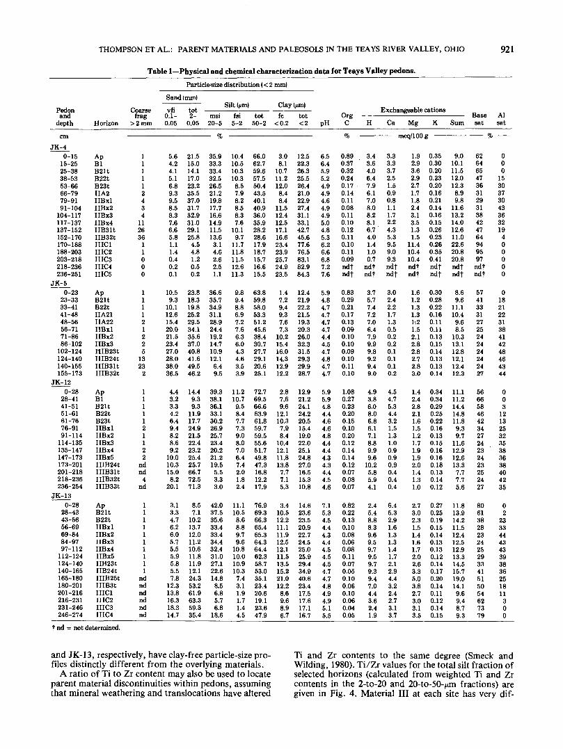
Soil samples were dried, ground between wooden rollers, sieved toremove material >2 mm, and throughly mixed. Coarse fragmentswere determined by weighing the >2-mm fraction. The followinganalyses of the <2-mm fraction were made in duplicate: Particle-sizedistribution was determined according to the method of Kilmer andAlexander (1949) after dispersion with sodium hexametaphosphate.Sample pHs were measured after equilibration with water in a 1:1 soil-to-solution ratio, and total carbon was determined by dry combustionat 950°C in a method similar to that of Allison et al. (1965).Potassium chloride-exchangeable Al was determined by atomic ab-sorption spectrophotometry after equilibrating a 5-g soil sample withtwo successive 30-ml aliquots of \N KC1 and separating sample andsolution by centrifugation. Exchangeable bases were determined in 17VNH^OAc (pH 7.0) extracts by atomic absorption (Ca, Mg) or flameemission (K) spectrophotometry. Extractable acidity was determinedaccording to the method of Peech et al. (1947). The physical andchemical characterization data are given in Table 1. Samples frompedon JK-5 were analyzed for amino acid nitrogen content accordingto the method of Stevenson and Cheng (1970) as modified by Cheng etal. (1975).
Fifty-gram samples of selected horizons were separated into sand,silt, and clay fractions for elemental analysis and clay mineralogystudies by standard methods similar to those given by Jackson (1975).Elemental analysis of fine (2 to 20 fan) and coarse (20 to 50 /im) siltfractions followed the method of Rutledge et al. (1975b). Pressedpellets representing both fractions were analyzed by x-ray fluorescencefor Ti and Zr. K was similarly determined on the 2- to-20-^m fraction.Clay (<2 /an) was Mg-saturated, dialyzed against water to removesalts, and freeze-dried. Total clay from each of the selected horizonswas analyzed by x-ray diffraction using methods similar to those
LoessRecent AlluviumMinford ClayGallia SandSandstone BedrockLoamy ColluviumSilty Colluvium
Fig. 2—Diagrammatic cross-section of Teays Valley stratigraphy in study area (not drawn to scale).

920 SOIL SCI. SOC. AM. J., VOL. 45, 1981
described by Wilding et al. (1971). Two tile mounts of Mg-saturatedclay were made for each horizon: one was air-dried, and the other wassaturated with glycerol. K-saturated clay mounts were irradiated afterair drying, after heating at 350 °C for 2 hours, and after heating at550 °C for 2 hours. Semiquantitative estimates of clay mineralogywere made from the five diffractograms thus obtained according to amethod based on the procedures of Johns et al. (1954) and Rutledge etal. (1975b).
RESULTS AND DISCUSSIONParent Material Discontinuities
Three parent materials were identified at each site inthe field. The surficial material (I) at each site was iden-tified as loess, based on its silty texture, bright color(usually 10YR 5/6) in the B horizons, and its consistentdepth (^50 to 60 cm) across the Teays Valley landscape.
Material II at sites JK-4 and JK-5 was designatedloamy colluvium in the field. At JK-4, this materialpossessed a number of characteristic features of col-luvium in Ohio. Coarse fragments, for instance, werehigher than in overlying horizons (Table 1), and theywere lithologically similar to sandstone bedrock out-crops further upslope. Transect work demonstrated thatthe material was closer to the surface upslope andgradually thinned downslope from the site. There was astone line at the top of the IIB31t horizon (137 cm), andfrom 137 to 170 cm, coarse fragments were mixed with aclayey, fine-earth fraction which was apparently derivedfrom the underlying lacustrine clay. Stratigraphic rela-tionships for material II were similar on the slope whereJK-5 was located.
Material II at JK-12 and JK-13 contained few coarsefragments and had silt loam textures. At JK-12,material II could have been either silty alluvium or siltycolluvium, based on its texture and landscape position.Micromorphological evidence to be presented in asubsequent paper (Thompson and Smeck, in prepara-tion) led us to identify it as colluvium; we use that ten-tative identification in this paper. Because JK-13 wasnear a topographic high in the center of the valley,material II there was originally classified in the field asloess older than material I. Material II did not possessstratification typical of alluvial deposits at any site.
The underlying, III materials at the sites were Min-ford Clay, weathered sandstone bedrock, or GalliaSand. Field observations identified Minford Clay inpedon JK-4 (IIIC) by its fine texture, rhythmitic lamina-tions, and the presence of carbonates in lower horizons.Weathered bedrock in pedon JK-5 (IIIB2 and IIIB3)was distinguished by an increase in coarse fragmentscompared to the overlying loamy colluvium, thepresence of argillans and matrices with 7.SYR colors,and a weak structural grade. Gallia Sand was identifedat the other two sites by distinct changes in texture orstratification. In pedon JK-12, the Gallia Sand was asandy loam; in pedon JK-13, the IIIC horizons weremore heterogeneous, falling into several loamy classes.The high clay content of IIIB25t in JK-13 (Table 1) mayrepresent a beta horizon overlying the coarse alluvium(Bartelli and Odell, 1960) or it could be a thin remnantof Minford Clay.
To test the field identification of parent materials,particle-size distributions were recalculated on a clay-free basis to remove the effect of translocated clay.Plots similar to those in Fig. 3 were made for all
60-
ino.0
2a><o
20
•m
JK-4 JK-5
a
o
,40-
ca>20-
a>0.
vfs csi msi fsi
JK-12
vfs csi msi fsi
JK-
vfs csi msi fsi vfs csi msi fsi
Par t ic le Size FractionsFig. 3—Clay-free particle-size profiles of the Teays Valley pedons.
horizons of each pedon. These detailed plots allowedclusters of similar clay-free particle-size profiles to beidentified. The clusters were found to correlate well withfield designations I, II, and III. Figure 3 is composed ofsimplified diagrams constructed by averaging the valuesfor groups of horizons which had similar clay-freeparticle-size profiles. (The IIIC horizons of JK-13 werequite heterogeneous but were grouped together on thebasis of their contrast to other horizons.) Because thesegroups correspond with the field designations, Fig. 3shows average clay-free particle-size profiles for theparent materials at each site. Lozet and Herbillon (1971)used a similar test of parent material uniformity forloess in Belgium. On a clay-free basis, Wisconsinanloess in Ohio typically is dominated by medium silt par-ticles (Rutledge et al., 1975a).
At JK-4, the three parent materials—loess, loamy col-luvium, and Minford Clay (I, II, and III,respectively)—may be distinguished by their significant-ly different, clay-free particle-size profiles. Similarly,three materials—loess, silty colluvium, and GalliaSand—are delineated at JK-12. The colluvial horizonsat JK-5 were split into two groups. The IIA2 horizons(D) have a transitional clay-free particle-size profile,possibly indicating a mixed zone between the loess (I)and underlying loamy colluvium (II). At JK-13, the IIBxzone (D) also has a profile similar to the overlying loess,whereas the IIB2 profile (•) may represent loess, siltycolluvium like that at JK-12, or a transition betweenIIBx and IIIC horizons. On the basis of clay-freeparticle-size profiles, material II at JK-13 may thus beidentified as loess or as colluvium with a high propor-tion of incorporated loess. Some postdepositonal mix-ing or silt translocation also may have occurred betweenmaterial I and the upper horizons of material II. In con-trast, the weathered bedrock and Gallia Sand at JK-5
THOMPSON ET AL.: PARENT MATERIALS AND PALEOSOLS IN THE TEAYS RIVER VALLEY, OHIO 921
Table 1—Physical and chemical characterization data for Teays Valley pedons.
Particle--size distribution ( < 2 mm)
Sand (mm)
Pedonand
depth
cmJK-4
0-1515-2525-3838-5353-6666-7979-9191-104
104-117117-137137-152152-170170-188188-203203-218218-236236-251
JK-50-23
23-3333-4141-4848-5656-7171-8686-102
102-124124-140140-155155-173
JK-120-28
28-4141-5151-6161-7676-9191-114
114-135135-147147-173173-201201-218218-236236-254
JK-130-28
28-4343-5656-6969-8484-9797-112
112-124124-140140-165165-180180-201201-216216-231231-246246-274
Horizon
ApBlB21tB22tB23tIIA2IIBxlIIBx2IIBx3IIBx4IIB3HIIB32tIIIC1IIIC2IIIC3IIIC4IIIC5
ApB21tB22tIIA21IIA22IIBxlIIBx2IIBx3IIIB23tIIIB24tIIIB31tIIIB32t
ApBlB2HB22tB23tIIBxlIIBx2IIBxSIIBx4118x5IIIB24tIIIB3HIIIB32tIIIB33t
ApB21tB22tIIBxlIIBx2IIBxSIIBx4IIBxSIIB23tIIB24tIIIB25tIIIB3tIIIC1IIIC2IIIC3IIIC4
Coarsefrag
>2mm
111112434
11263611000
111121225
1323
2
1111121122
ndnd
4nd
1111111111
ndndndndndnd
vfi0.1-0.05
5.64.24.15.16.89.39.58.58.37.66.65.81.11.40.40.20.1
10.59.3
10.112.615.420.021.523.427.028.038.036.5
4.43.23.34.26.49.48.28.69.2
10.010.315.08.2
20.1
3.13.34.76.26.05.75.55.95.85.57.8
12.313.816.318.314.7
tot2-
0.05
21.515.014.117.023.235.537.031.732.931.029.125.84.54.81.20.50.2
23.818.319.825.229.534.135.637.040.841.649.546.2
14.49.39.3
11.917.724.921.522.423.225.425.766.772.571.3
8.57.1
10.213.712.011.210.611.811.912.124.353.261.963.359.335.4
Silt (fim)msi
20-5
— %
35.933.333.432.526.521.219.817.716.614.911.513.63.14.62.62.51.1
36.635.734.931.128.924.419.214.710.912.16.49.5
39.338.136.133.130.226.925.723.420.221.219.55.53.33.0
42.037.535.633.433.434.432.431.027.122.614.88.56.85.76.8
18.6
fsi5-2
10.410.510.310.38.57.98.28.58.37.6
10.19.7
11.711.811.512.611.3
9.89.48.86.97.27.66.36.04.34.63.53.9
11.210.79.58.47.77.39.08.07.06.47.42.01.82.4
11.110.58.68.89.79.6
10.810.010.910.37.43.11.91.71.44.5
tot50-2
66.062.759.657.550.443.540.140.936.035.928.228.617.918.715.716.615.5
63.859.858.053.351.245.638.430.727.729.120.625.1
72.769.566.663.961.859.759.555.651.749.847.316.812.217.9
76.969.366.365.465.364.364.462.358.753.035.123.420.619.123.647.9
Clay (pm)fc
<0.2
3.08.1
10.711.212.08.48.4
11.512.412.517.116.623.423.925.724.923.5
1.47.29.49.37.67.3
10.215.416.014.312.912.2
2.87.69.6
12.110.37.98.4
10.412.111.813.87.77.15.3
3.410.512.211.111.912.512.111.513.515.221.012.28.69.68.96.7
tot<2
12.522.326.325.526.421.022.927.431.133.142.745.677.676.583.182.984.3
12.421.922.221.519.320.326.032.331.529.329.928.7
12.921.224.124.220.515.419.022.025.124.827.016.515.310.8
14.623.623.520.922.724.525.025.929.434.940.623.417.517.617.116.7
pH
6.56.45.95.24.94.94.64.94.95.04.85.36.26.66.87.27.6
5.94.84.74.74.74.74.44.54.74.84.74.7
5.95.94.84.44.64.64.84.44.44.34.34.44.54.6
7.15.34.54.44.34.44.54.54.54.74.74.84.94.95.15.5
OrgC
%
0.890.370.320.240.170.140.110.080.110.100.120.110.100.110.09ndtndt
0.830.290.210.170.130.090.100.100.090.100.110.10
1.080.270.230.200.150.100.200.120.140.140.120.070.080.07
0.820.220.130.100.080.060.080.110.070.050.100.060.100.060.040.05
Exchangeable cations
H
3.43.64.06.47.96.17.08.08.28.16.74.01.41.00.7
ndtndT
3.75.77.47.27.06.47.99.99.89.29.49.0
4.93.86.08.06.86.17.18.89.99.6
10.25.85.94.1
2.45.48.88.39.69.59.79.59.79.39.47.04.43.62.41.9
Ca
3.33.33.72.51.50.90.81.11.72.24.35.39.59.09.3ndtndt
3.02.42.21.71.30.50.20.20.10.10.10.2
4.54.75.34.43.21.51.31.00.90.90.90.40.40.4
6.45.32.91.61.31.31.41.72.12.94.43.22.42.73.13.7
Mg
meq/100 g
1.92.93.62.92.71.71.82.43.13.51.31.5
11.410.410.4ndtndt
1.61.21.31.31:21.52.12.82.82.72.83.0
1.42.42.82.11.61.51.21.71.91.92.01.41.31.0
2.73.02.31.51.41.61.72.02.63.35.03.82.73.03.13.5
K
0.350.300.200.230.200.160.210.140.160.150.260.230.260.350.41ndtndt
0.300.280.220.160.110.110.130.150.140.130.130.14
0.340.340.290.250.220.160.130.150.160.160.180.130.140.12
0.270.250.190.150.140.130.130.120.140.170.200.140.110.120.140.15
Sum
9.010.111.512.012.38.99.8
11.613.214.012.611.022.620.820.8ndtndt
8.69.6
11.110.49.68.5
10.313.112.812.112.412.3
11.111.214.414.811.89.39.7
11.612.912.613.37.77.75.6
11.813.914.211.512.412.512.913.314.515.719.014.19.69.48.79.3
Basesat
95
626465473631293138424764949597ndtndt
574133312725242424242427
5666584642342724232423252427
80613828232425293341515054627379
Alsat
'•> ——
000
1530373043363219400000
01821223138414248464344
003
1213253235383638404235
02
2333444343393836251811300
t nd = not determined.
and JK-13, respectively, have clay-free particle-size pro-files distinctly different from the overlying materials.
A ratio of Ti to Zr content may also be used to locateparent material discontinuities within pedons, assumingthat mineral weathering and translocations have altered
Ti and Zr contents to the same degree (Smeck andWilding, 1980). Ti/Zr values for the total silt fraction ofselected horizons (calculated from weighted Ti and Zrcontents in the 2-to-20 and 20-to-50-/*m fractions) aregiven in Fig. 4. Material III at each site has very dif-

922 SOIL SCI. SOC. AM. J., VOL. 45, 1981
Ti/Zr12 14 16 44 56
-—————.——————V^-V*——10 12
JK-5 V
2-
Fig. 4—Ti/Zr values for the total silt fraction of selected horizonsfrom the Teays Valley pedons.
ferent Ti/Zr values from the overlying materials. GalliaSand (JK-12 and 13) and weathered bedrock (JK-5) haveratios that are lower than those of overlying horizons.In contrast, the Ti/Zr values are higher for MinfordClay (and superjacent transitional horizons) than forthe overlying horizons.
Distinctions between material I and II at each site arenot as obvious as those between materials II and III.Drees and Wilding (1973) have suggested that, with asampling scheme like the one used in this study, Ti/Zr
Table 2 — Semiquantitative estimates of clay mineralogyin selected horizons of study pedons.
Pedon andhorizons
JK-4:B2HB23tIIA2IIBx2IIBx3IIB3HIIIC1IIIC4
JK-5:B22tIIA21IIBxlIIBxSIIIB23tIIIB24tIIIB3H
JK-12:ApBlB22tIIBxlIIBxSIIBxSIIIB33t
JK-13:ApB22tIIBxl
IIBxSIIBxSIIB24tIIIC1IIIC3
Vermic-Mica
2020151515254555
155
1020102020
2020
55
252030
1010-
1015201525
ulite
n55
205
102010
--T15-2010
-5-..5
10
T-..
..-101010
Smec-tite
51515201015T-§
5_-10101515
--55..-
--10
1010151020
Hydroxy-interlayered
vermiculite and Kao-smectite
5055453550301510
65707040703540
65608075656055
658075
7560405525
linite
105
101010105
T
10151010101010
5555
101010
555
5555
15
Quartz
155
105555
T
55
105555
10555555
155
10
5101055
MWP/Mf
34454210
51473843
33
1716342
68
unde-fined
85352
values should, for lithologic discontinuities to be iden-tified, have a relative difference of at least 20%. Such a. difference occurs between the loess and underlying siltycolluvium at JK-12 and JK-13. Even though Ti/Zrvalues across the I-II breaks at the other sites do not dif-fer by 20%, there is an evident difference from the sur-face downward. The similarity in Ti/Zr values betweenmaterials I and II may be due to silt translocation.Thick, continuous siltans on vertical ped faces weredescribed in the field in each of II zones. Alternatively,the similar ratios may indicate that material I (loess) wasderived from sediments lithologically similar to the IImaterials. The general uniformity of Ti/Zr values (10 to12) for material I across all four soils supports thehypothesis that it is a fairly uniform deposit whichblankets all the sites.
Clay mineralogy, estimated by x-ray diffraction(XRD) techniques for selected horizons, is generallysimilar in all pedons (Table 2). The clay fractions aredominated by hydroxyinterlayered forms of ver-miculite and smectite. Only Minford Clay is clearlydistinguishable from the other materials by claymineralogy. According to the XRD estimate, the IHChorizons of JK-4 are 40 to 55% clay mica. These valuesare similar to the mica contents of Minford Clayreported by Hoyer (1976).
To summarize, field identification of Minford Clay(lacustrine clay), weathered sandstone bedrock, andGallia Sand (alluvium) is substantiated by clay-freeparticle-size distributions, Ti/Zr values, and claymineralogy in the study pedons. Our best evidence thatmaterials I and II at the sites are lithologically discon-tinuous is the uniform depth of the bright-colored, siltloam material I throughout the valley. Its uniform prop-erties are characteristic of loess. Clay-free particle-sizeprofiles of pedons JK-4, JK-5, and JK-12 also suggestthe discontinuity, and Ti/Zr values support the discon-tinuity at JK-12 and JK-13.
Buried PaleosolsThe loess which constitutes material I in the Teays
Valley soils must have blanketed preexisting soils.3Evidence that paleosols are buried beneath the loesscomes from total clay distributions and indexes ofmineral weathering and biological activity. These databy themselves are not conclusive, however, and our in-terpretations also depend on the presence of lithologicdiscontinuities established in the previous section.
Total clay contents in the pedons suggest that argillichorizons in the loess (B2 horizons) overlie older argillichorizons in material II (IIBx and IIB2 horizons; Table1). Although buried argillic horizons are expressedsomewhat differently in each pedon, a minimum in totalclay content near the I-II boundary separates two zonesof accumulation in each case. In JK-4, the highest claycontents are in the Minford Clay and the IIB3 horizons;the latter are mixed colluvium and Minford Clay. Therewas no field evidence of the IIBx horizons mixing withMinford Clay; thus the clay contents around 30% prob-ably represent a zone of clay illuviation. In JK-13, theclay content is highest near the II-III boundary; as noted
t Mica weathering products/mica (see text).t Trace.§ Not detected.
3 We have chosen to omit lower case fe from the horizon designa-tions of paleosol horizons to emphasize that not all pedologic featuresof those horizons were inherited from the paleosol.

THOMPSON ET AL.: PARENT MATERIALS AND PALEOSOLS IN THE TEAYS RIVER VALLEY, OHIO 923
30 50K/Zr
190 20
Amino Acid N (pg/gsoil)4O
20 40 60 20 40
Fig. 5-K/Zr values for the 2-to-20 ^m fraction of selected horizonsfrom the Teays Valley pedons.
earlier, this horizon may be a beta horizon or a MinfordClay remnant. The IIBx horizons, on the other hand,have a clay maximum like that of the overlying B2horizons in loess. Buried argillic horizons with clay con-tents of 25 to 30% are also suggested in the clay profilesof JK-5 and JK-12. Continuous argillans of variablethickness were noted in the field descriptions of materialII in each of the pedons.
Three indexes of the degree of mineral weatheringdemonstrate that material II is significantly moreweathered than the overlying loess. First, claymineralogy may be used to assess degrees of mineralweathering among horizons of a pedon. Clay mica istransformed to vermiculite, smectite, and hydroxy-interlayered forms of vermiculite and smectite in soil en-,vironments (Wilding et al., 1971). Thus, in soilsdeveloped from uniform parent materials, the micacomponent of clay fractions normally increases withdepth while the weathering products noted abovedecrease with depth. Since the soils of this study weredeveloped in several parent materials, changes in claymica content with depth could (and, in certain cases, do)correspond to parent material discontinuities. But therelative intensity of mica weathering may still beevaluated by calculating a ratio of total mica weatheringproducts to mica (MWP/M in Table 2; Bilzi andCiolkosz, 1977). High MWP/M values indicate a moreintensely weathered material than do low values.
In general, MWP/M values peak in material II andare lower in materials I and III, suggesting that the IImaterials are more weathered than the overlying andunderlying horizons. The most extreme weathering ofclay minerals measured by MWP/M values is at the topof the II materials in JK-5, 12, and 13. Mica is complete-ly depleted from the IIBxl horizon of JK-13. DecreasingMWP/M values with depth in the paleosols is com-parable to modern sola which also exhibit maximumweathering in surficial horizons. Alternatively, thehighest values may indicate that weathering immediatelyabove the old argillic horizons is intensified when wateris perched there and ferrolysis occurs (Brinkman, 1970).Clay in the B22t horizon of JK-12, for example, mayhave been weathered by this mechanism. Similarweathering phenomena have been reported in horizonsabove fragipans in northeastern Ohio by Ritchie et al.
0 80 160 240 320 400
0.5.
1
.cl.O-
0.0)Q
1.5
Ap
B2t
EA2
HBx
HIB2t
B3t
R
^^
I
1\
•v JK-5
'̂ s<̂
^^
/
1Fig. 6— Amino acid nitrogen profile of pedon JK-5.
(1974).As a second index of mineral weathering, ex-
changeable Al as a percentage of cation exchangecapacity was calculated (Table 1). (The procedures todetermine exchangeable Al and exchangeable bases wereassumed to be sufficiently similar to allow this com-parison.) At each site, the loess has a high base satura-tion and a low Al saturation compared to underlyinghorizons. This relationship is reversed in the I IBhorizons: base saturation drops to about 25%, while Alsaturation increases to 35 to 45%. Since Al is a commonproduct of mineral weathering, these results suggest amarked weathering discontinuity between the loess andthe colluvial zone (material II) at each site. Belowmaterial II, Al and base saturations depend upon thecharacteristics of material III. At JK-4, the return tohigh base status in IIIC horizons corresponds to the in-fluence of Minford Clay. High base saturation in IIIChorizons of JK-13 appears to result from theunweathered nature of the materials (cf. claymineralogy, Table 2). In contrast, the weatheredbedrock at site JK-5 and the Gallia Sand at site JK-12 re-tain low base saturations and high Al saturations.
Finally, elemental analysis of fine silt fractions sug-gests probable weathering differences among thematerials composing the Teays Valley pedons (Fig.5).Assuming that K represents easily weatheredfeldspars and mica and that Zr represents highly stablezircon, K/Zr values may denote lithologic discon-tinuities or weathering phenomena—or both. In thisstudy, K/Zr minima always occur in material II; usuallythe loess and the various III materials have higher K/Zrvalues. In lithologically similar materials, lower K/Zrvalues indicate more intense weathering than highervalues. Thus, even if the indications of parent materialdiscontinuities discussed earlier were not accepted, themineralogy of the fine silt fractions implies that IImaterials are significantly more weathered than Imaterials.
We recognize that the clay profiles and mineralweathering indexes could be explained by alternativeprocesses. The total clay minimum percentages, for ex-ample, and the high MWP/M ratios in the upperhorizons of material II could be due to clay weatheringand destruction during ferrolysis (Brinkman, 1970).

924 SOIL SCI. SOC. AM. J., VOL. 45, 1981
Moreover, low exchangeable Al in the loess may resultfrom biocycling of basic cations. It is likely, in fact, thatthese processes occur to some extent. Consideredtogether with the evidence of parent material discon-tinuities, however, the three parameters of mineralweathering support the idea that loess has buried amuch older, more weathered paleosol. Pedologic discon-tinuities coincide with parent material discontinuities.
Another way to characterize buried paleosol horizonsis to identify some index of biological activity.Biological activity in buried soil horizons may bemeasured by accumulations of amino acids, becausethose which are trapped within clay mineral structuresare not easily susceptible to microbial attack (Stevensonand Cheng, 1970; Goh, 1972). Amino acid-N was deter-mined for JK-5 (Fig. 6). There are three horizons ofamino acid-N accumulation, and they do not coincidewith the clay accumulations shown in Table 1 for JK-5.The greatest amount of amino acid-N is in the modernsurface horizon. We interpret the secondary peaks insubsurface horizons to represent biological activity inburied paleosols. At this site, a soil which was developedin weathered bedrock (IIIB horizons) was truncated byerosion and buried by colluvium (material II). We sug-gest that a new soil which formed in the colluvium wassubsequently buried by loess. Amino acid accumula-tions reflect biological activity in this pedon during eachstage of soil genesis.
Several lines of evidence, then, lead to the conclusionthat material II in Teays Valley soils is a weatheredpaleosol. Total clay distributions appear to reflectburied argillic horizons. Clay mineralogy, Al satura-tion, and K/Zr values suggest that the II materials aremore intensely weathered than the overlying loess.Finally, the amino acid distribution of one pedonstudied indicates possibly two periods of soil genesisprior to the present.
Our studies of soils in the Teays Valley of JacksonCounty, Ohio suggest that, although underlying soilparent materials may vary, modern sola are developedin a thin mantle of loess and underlying paleosols. Thepaleosols immediately beneath the loess were developedin colluvium. We have not presented data which con-clusively identify colluvium in the middle of the valley(at JK-12 and JK-13), but in an associated article(Thompson and Smeck, in preparation), micromor-phological evidence suggests that these materials, too,are colluvium.
ACKNOWLEDGMENTSWe appreciate the field assistance of Lyle Jones, formerly of the
Division of Lands and Soil, Ohio Department of Natural Resources,in the initial design of this project. We thank workers of the Ohio SoilCharacterization Laboratory for assistance with the analyses. We alsothank the reviewers whose suggestions helped to improve themanuscript's readability. Finally, we appreciate Susan Henderson'scareful typing of the manuscript.

PARSONS ET AL.: THE SOIL SEQUENCE OF LATE PLEISTOCENE GLACIAL OUTWASH TERRACES 925