Embed Size (px)
Citation preview

PAPUA NEW GUINEA:
POVERTY ASSESSMENT
Annexes
30 June 2004

TABLE OF CONTENTS
ANNEX 1: MAPS OF PAPUA NEW GUINEA............................................................. 3
ANNEX 2: PESD DATA AT A GALANCE................................................................. 14
2

ANNEX 1: MAPS OF PAPUA NEW GUINEA
Table A1.1 The least developed districts based on World Bank study and the District
Development Index (DDI)
Source: World Bank staff calculations and NEFC (2004)
Rank
(1= least
developed)
Rank
(1= least
developed)
District Province District Province
1 Middle Fly Western 1 Telefomin Sandaun
2 Telefomin Sandaun 2 Nuku Sandaun
3 Vanimo-Green River Sandaun 3 Vanimo-Green River Sandaun
4 Nuku Sandaun 4 Aitape-Lumi Sandaun
5 Rai Coast Madang 5 Middle Ramu Madang
6 Aitape-Lumi Sandaun 6 Rai Coast Madang
7 Central Bougainville Bougainville 7 Menyamya Morobe
8 South Fly Western 8 Obura-Wonenara Eastern Highlands
9 Middle Ramu Madang 9 Usino Bundi Madang
10 Jimi Western H’lands 10 Kompiam Enga
11 Goilala Central 11 Komo-Margarima Southern Highlands
12 Bogia Madang 12 Ambunti-Drekikir East Sepik
13 Koroba-Kopiago Southern H’lands 13 Goilala Central
14 Obura-Wonenara Eastern H’lands 14 Koroba- Lake Kopiago Southern Highlands
15 Kagua-Erave Southern H’lands 15 Jimi West Highlands
16 Ambunti-Drekikir East Sepik 16 Bogia Madang
17 Kabwum Morobe 17 Kagua-Erave Southern Highlands
18 Tambul-Nebilyer Western H’lands 18 Kerema Gulf
19 Karimui-Nomane Simbu 19 Kandep Enga
20 Abau Central 20 Angoram East Sepik
World Bank poverty mapping District Development Index (DDI)
3

Table A1.2 Income poverty, education, health and district development indices
Province District “Income” poverty Education Health District
Percent of poor
population
Adult literacy rate Gross enrolment
rate
Composite education
indicator
Life expectancy at
birth
Development
Index
% Ranking
(1=poor
est)
% Ranking
(1=least
developed)
% Ranking
(1=least
developed)
Index Ranking
(1=least
developed)
Years Ranking
(1=least
developed)
Ranking
(1=least
developed)
1 Western North Fly 25 75 66 58 58 66 0.71 66 54 38 69
1 Western South Fly 54 8 83 81 55 81 0.84 81 54 38 48
1 Western Middle Fly 66 1 66 59 50 60 0.65 60 54 38 25
2 Gulf Kikori 29 62 60 54 39 53 0.53 53 46 6 21
2 Gulf Kerema 26 71 55 51 33 42 0.44 42 46 6 18
3 Central Kairuku-Hiri 24 79 82 79 56 80 0.83 80 56 67 81
3 Central Goilala 51 11 25 6 22 6 0.1 6 56 67 13
3 Central Rigo 27 69 80 77 52 74 0.8 74 56 67 78
3 Central Abau 46 20 78 74 59 78 0.82 78 56 67 66
5 Milne Bay Samarai-Murua 36 44 82 80 48 73 0.78 73 54 35 63
5 Milne Bay Esa'ala 25 76 77 71 49 68 0.74 68 54 35 72
5 Milne Bay Kiriwina-Goodenough 38 40 71 62 41 59 0.64 59 54 35 54
5 Milne Bay Alotau 30 57 81 78 55 79 0.82 79 54 35 73
6 Northern Ijivitari 43 26 76 70 43 64 0.7 64 55 40 53
6 Northern Sohe 36 45 63 57 36 54 0.53 54 55 40 50
7 Southern H’lands Koroba-Kopiago 50 13 33 18 20 13 0.16 13 55 48 14
7 Southern H’lands Tari-Pori 43 29 49 39 23 27 0.32 27 55 48 32
4

7 Southern H’lands Komo-Margarima 44 22 24 2 13 2 0.03 2 55 48 11
7 Southern H’lands Nipa-Kutubu 42 31 32 15 19 10 0.14 10 55 48 23
7 Southern H’lands Mendi-Munihu 38 39 38 22 29 18 0.26 18 55 48 33
7 Southern H’lands Imbonggu 33 52 42 29 31 26 0.31 26 55 48 39
7 Southern H’lands Kewabi Rural 29 59 46 36 29 30 0.33 30 55 48 47
7 Southern H’lands Kagua-Erave 48 15 33 16 18 9 0.14 9 55 48 17
8 Enga Lagaip-Porgera 26 73 28 9 26 11 0.15 11 53 31 28
8 Enga Kandep 30 58 24 4 19 4 0.07 4 53 31 19
8 Enga Wapenamanda 29 61 50 42 39 40 0.44 40 53 31 40
8 Enga Wabag 26 70 43 32 43 38 0.4 38 53 31 42
8 Enga Kompiam 40 33 30 12 24 12 0.16 12 53 31 10
9 Western H’lands Dei 38 37 28 10 29 14 0.17 14 56 63 31
9 Western H’lands North Waghi 35 46 41 27 39 32 0.35 32 56 63 45
9 Western H’lands Tambul-Nebilyer 46 18 31 13 29 15 0.2 15 56 63 27
9 Western H’lands Mul-Baiyer 44 24 33 17 38 20 0.27 20 56 63 34
9 Western H’lands Mt Hagen 34 47 51 44 49 51 0.51 51 56 63 57
9 Western H’lands Anglimp-South Waghi 38 38 43 31 37 33 0.36 33 56 63 43
9 Western H’lands Jimi 52 10 27 8 23 7 0.12 7 56 63 15
10 Simbu Kerowagi 32 54 50 41 42 45 0.45 45 57 75 58
10 Simbu Gumine 37 43 36 21 36 23 0.29 23 57 75 44
10 Simbu Karimui-Nomane 46 19 24 5 27 8 0.13 8 57 75 24
10 Simbu Chuave 28 65 35 19 43 29 0.32 29 57 75 55
10 Simbu Sina Sina-Yonggomugl 28 66 39 24 49 37 0.4 37 57 75 61
10 Simbu Kundiawa-Gembogl 25 74 55 50 54 56 0.58 56 57 75 75
5

11 Eastern H’lands Okapa 44 23 35 20 37 21 0.29 21 55 56 29
11 Eastern H’lands Henganofi 25 77 39 23 32 22 0.29 22 55 56 52
11 Eastern H’lands Unggai-Benna 17 84 46 35 40 39 0.4 39 55 56 67
11 Eastern H’lands Asaro-Watabung 18 83 42 28 44 36 0.39 36 55 56 64
11 Eastern H’lands Lufa 39 36 32 14 32 17 0.23 17 55 56 30
11 Eastern H’lands Goroka 9 85 60 55 54 58 0.62 58 55 56 80
11 Eastern H’lands Kainantu rural 27 67 53 47 40 47 0.47 47 55 56 59
11 0 1Eastern H’lands Obura-Wonenara 50 14 21 1 13 1 55 56 8
12 Morobe Tewae-Siassi 37 41 68 60 41 57 0.62 57 52 20 38
12 Morobe Finschafen 20 82 75 69 45 65 0.71 65 52 20 65
12 Morobe Nawae 34 50 72 63 49 63 0.7 63 52 20 49
12 Morobe Huon 27 68 74 64 45 62 0.69 62 52 20 56
12 Morobe Markham 29 64 54 48 35 44 0.44 44 52 20 37
12 Morobe Kabwum 47 17 51 43 41 46 0.46 46 52 20 22
12 Morobe Menyamya 40 34 26 7 13 3 0.05 3 52 20 7
12 Morobe Bulolo 43 30 52 45 37 43 0.44 43 52 20 26
13 Madang Middle Ramu 52 9 24 3 20 5 0.07 5 51 12 5
13 Madang Usino Bundi 45 21 39 25 28 19 0.27 19 51 12 9
13 Madang Rai Coast 60 5 45 33 32 31 0.34 31 51 12 6
13 Madang Madang 41 32 75 68 52 69 0.75 69 51 12 41
13 Madang Sumkar 33 53 71 61 46 61 0.67 61 51 12 46
13 Madang Bogia 51 12 59 53 38 49 0.5 49 51 12 16
14 East Sepik Angoram 43 27 45 34 28 28 0.32 28 52 26 20
14 East Sepik Wewak 32 55 79 75 58 77 0.82 77 52 26 62
6

14 East Sepik Ambunti-Drekikir 47 16 40 26 33 24 0.31 24 52 26 12
14 East Sepik Maprik 34 48 49 40 41 41 0.44 41 52 26 36
14 East Sepik Wosera Gawi 33 51 46 37 38 35 0.39 35 52 26 35
14 East Sepik Yangoro Saussia 26 72 54 49 49 55 0.54 55 52 26 51
15 Sandaun Aitape-Lumi 59 6 53 46 41 48 0.47 48 46 4 4
15 Sandaun Telefomin 64 2 30 12 31 16 0.21 16 46 4 1
15 Sandaun Nuku 64 4 42 30 30 25 0.31 25 46 4 2
15 Sandaun Vanimo-Green River 64 3 48 38 30 34 0.36 34 46 4 3
16 Manus Manus 29 63 86 83 63 83 0.92 83 59 82 83
17 New Ireland Namatanai 40 35 78 73 51 72 0.77 72 58 81 76
17 New Ireland Kavieng 44 25 77 72 50 70 0.75 70 58 81 70
18 East New Britain Pomio 37 42 56 52 43 50 0.51 50 57 79 60
18 East New Britain Gazelle 31 56 85 82 56 82 0.87 82 57 79 79
18 East New Britain Rabaul 22 81 95 85 62 1 8585 57 79 85
18 East New Britain Kokopo 29 60 89 84 62 84 0.95 84 57 79 82
19 West New Britain Kandrian-Gloucester 24 78 61 56 37 52 0.52 52 57 69 71
19 West New Britain Talasea 34 49 75 67 50 67 0.73 67 57 69 74
20 Bougainville North Bougainville 43 28 80 76 55 76 0.81 76 60 85 77
20 Bougainville Central Bougainville 55 7 75 67 54 71 0.76 71 60 85 68
20 Bougainville South Bougainville 23 80 75 67 61 75 0.81 75 60 85 84
Minimum 66 1 21 1 13 0 11 46 4 1
Maximum 9 85 1 8595 85 63 85 60 85 85
Sources: “Income” poverty estimates based on World Bank Poverty Mapping exercise; National Statistics Office, 2000 Census CD (for data on adult literacy and gross enrolment rates); and
National Statistics Office, 2003, Recent Fertility and Mortality Indices and Trends in Papua New Guinea: A Report Based on the Analysis of the 2000 Census Data, April (for data on life
expectancy at birth)
7
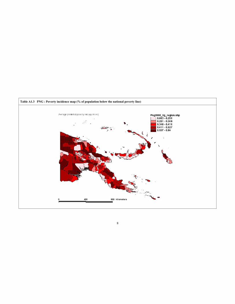
Table A1.3 PNG : Poverty incidence map (% of population below the national poverty line)
8

Table A1.4 PNG : “Income” inequality map (Gini index of consumption per adult equivalent)
9

Table A1.5 PNG : Adult literacy map (% of population age 10 and above who are literate)
10

Table A1.6 PNG : Gender gap in literacy (male minus female literacy rate)
11

Table A1.7 PNG : Average years of schooling map (years of schooling of household head)
12

Table A1.8 PNG : Wage employment map (% of household heads in wage employment)
13

ANNEX 2: PESD DATA AT A GALANCE
Table A2.1: PESD data at a glance
Total population (2000) 5.2 million
School-age population (2000) 1.5 million
Growth rate of school-age population 3 % per annum
Government expenditure on education as % of GDP (avg. 2000-2003) 5%
Government expenditure on education as % national budget (avg. 2000-2003) 15%
Relative contribution to overall spending education of …
… government 70%
… donors 20%
… parents 10%
Size of the education sector
Number of students: Number of teachers: Number of schools:
Total 1,014,779 Total 32,022 Total 8,284
Primary education 890,680 Primary education 26,731 Primary education 7,916
Size of primary education sector (up to Grade 8)
% of students 87%
% of schools 93%
% of teachers 83%
% of national education budget 60%
2002
14

Table A2.1: PESD data at a glance
School facilities
All Poor Not Poor Remote Accessible
Classrooms
Number of classrooms per 100 students 3.46 3.47 3.45 3.53 3.40
Proportion of classrooms
… which need to be completely rebuilt? 0.33 0.32 0.34 0.36 0.29
... with a roof that leaks when it rains? 0.37 0.37 0.36 0.40 0.33
... with electricity that works? 0.07 0.04 0.12 0.01 0.13
Other infrastructure
Adequate or good provision (0/1) of …
… clear radio reception 0.28 0.27 0.30 0.24 0.32
… sports equipment 0.42 0.34 0.54 0.36 0.48
… specialist science classroom 0.01 0.00 0.03 0.01 0.02
Electricity, water, and sanitation services
Usable water tank (0/1) 0.55 0.55 0.54 0.41 0.70
Toilet facilities …
… need at least 1 for boys(0/1) 0.42 0.44 0.40 0.34 0.51
… need at least 1 for girls(0/1) 0.49 0.49 0.48 0.42 0.56
Access to facilities
Time to nearest …(hours)
… High school or Secondary school 3.93 4.79 2.64 5.67 2.18
… Bank 4.51 5.17 3.50 7.31 1.73
School closure and security
Total number of days the school closed in …
… 2001 14.65 16.30 12.27 16.69 12.32
Teaching resources
Resource availability … (0/1)
… sufficient textbooks for student use 0.23 0.24 0.21 0.25 0.21
… enough desks for all students 0.52 0.54 0.49 0.54 0.50
Poverty Status Remoteness
Subsidy leakage
2001 2002
What the school should have received (Kina/student):
Budget disbursement b/ 90
Estimate I 25
Estimate II 29
What the school actually received (Kina/student): 21 84
Leakage rate (%), based on:
Budget disbursement b/ 7
Estimate I 16
Estimate II 29
Delays in receiving subsidies
Schools Total Schools Total Schools Total Schools Total
receiving delay receiving delay receiving delay receiving delay
positive (weeks) positive (weeks) positive (weeks) positive (weeks)
subsidies subsidies subsidies subsidies
(%) (%) (%) (%)
2001 82 9 58 14 36 14 37 15
2002 97 5 73 3
Quarter 1 Quarter 2 Quarter 3 Quarter 4
15

Table A2.1: PESD data at a glance
"Ghost" teachers
Number Number Net Net
of teachers of teachers "Ghost" "Ghost"
per school per school teachers teacher
in payroll reported per school rate
(1) (2) (1) - (2) %
All schools 7.5 6.4 1.1 14.7
Teacher absence
All teachers Male teachers Female teachers
% of teachers absent
on the day of the school visit 15.1 16.3 13.3
Teacher salaries and allowances
Salary
Average salary (Kina/fortnight) 436
% of teachers paid by cheques 19.4
% of teachers paid by direct deposits 80.6
Average salary payment delay (days, incl. zeros) 3.3
Average salary payment delay (days, for those reporting a delay) 20.9
Average salary access delay period (weeks) 0.9
Allowances
% of teachers receiving additional monetary allowances 43.7
Average amount of monetary allowances (Kina/year), including zeros 194
Average amount of monetary allowances (Kina/year), excluding zeros 443
% of teachers who did not receive allowances they were eligible for 43.6
Type of allowance not received
…Responsibility/disadvantaged school/multi-grade/housing 36.9
…Higher duty 4.3
…Mining or leave fare or domestic market 2.3
Student attendance rate
(percent)
Community Schools Primary Schools All Schools
Grade 1&2 Grade 3-6 Grade 3-6 Grade7-8 Grade1-8
All students 79.5 88.4 83.8 83.6 85.1
Male students 77.8 88.0 83.0 82.7 84.8
Female students 84.5 89.5 86.0 85.1 85.6
Inspector visitsYear
2000 2001 2002 (to date)
% of schools with no inspector visits 38.3 35.7 69.1
Parents' perception of fees
% of parents All schools
Schools in poor
areas
Schools in remote
areas
...who think ___ should pay for the cost of education
…government 21 19 20
…parents 22 22 20
…both 57 59 60
…who found school or project fees too high 41 44 46
…were able to pay the fees set by the school 64 62 56
16

17
Table A2.1: PESD data at a glance
Consequence of not paying school fees
(% of schools)
Exempted
Allowed to pay
according to ability
Must leave
school
Not allowed to go
to next grade Other
Response by
... head teacher 10 77 5 1 7
… grade5 teacher 6 67 10 0 18
Board of management
Average number of meetings in 2001 3.8
Average number of members 8.7
Chair of BOM is the parent of a student (% of schools) 84
Parent participation
Percent of schools with a PNC 95
Average number of times PNC met in 2001 3
Percent of schools where parents collect assessment reports 57
Percent of parents in those schools who collect reports 65
Percent of parents who attend school meetings when called 57
Community partnership
Percent of schools where …… children go out to learn in community 35
… community members help develop school programs/activities 60
… teachers organise activities for community members 50
… community members teach cultural activities 27
… school uses village land for agricultural classes 45
… school is used for community meetings 63
… school is used for adult classes 17
… school use for community sports events 71