Embed Size (px)
Citation preview

1 of 15 BLM_139_PALUMA_EEC_Sci_Y04_U2_ LP13_ PicnicBay_FieldWorkbook
Paluma Environmental Education Centre Science (Biology) Field Workbook for Picnic Bay Year 4 Unit 2
Mapping the life cycle and survival of the Bush sto ne-curlew
My Name:
My Class Teacher:
My Class:
Dates:
Part One: Part Two: Part Three:
My working group:
For Teachers This field workbook scaffolds three learning experiences at Picnic Bay on Magnetic Island near Townsville. The learning experiences are closely based on lessons drawn from Unit 2, Year 4, C2C Biological Sciences. The data collected during these learning experiences beyond the classroom will inform the students’ completion of their in-class assessment tasks, i.e.
• Construction of a display that shows the curlew’s habitat • Preparing a report on the curlew, including information on relationships that help/ hinder the curlew’s
survival and actions taken by humans to protect the curlew Purpose The student describes the relationships between the living and non-living components of ecosystems that assist or hinder survival of living things, in this case the Bush stone-curlew. The student sequences the stages of the curlew’s life cycle and identifies threats to the curlew’s survival. Field study tasks Part One – A Field Walk Looking at Habitat and Magn etic Island Life Cycles - pages 2-4, 13-14 Note any evidence of the Bush Stone-Curlew e.g. tracks, scats, signs and access to shelter and breeding sites, food and water. Add to the table on page 13. Take photographs and describe the features of the Bush stone-curlew and its habit at Note evidence of disturbance to the Bush stone-curlew’s habitat e.g. feral plants, clearing, roads Identify the stages of the Bush stone-curlew’s life cycle and record this as a scientific diagram (pages 2-4) Create a concept map to illustrate relationships and effect on the Bush stone-curlew’s survival (page 14) Optional – Note access to shelter, food and water of other local protected species i.e.Koala, Rock Wallaby, Dugong. Add to the table on page 13. ______________________________________________________________________________ Part Two – A Field Walk - pages 5-9, 13-14 Identify environmental factors that could affect the growth and/or survival of a Bush stone-curlew . Add to the table on page 13. Use a Kestrel weather meter and a light meter to measure and record abiotic environmental factors such as wind speed, temperature, humidity and sunlight (page 5) Construct a simple food chain that includes the Bush stone-curlew (page 7) Understand the different roles of producers, consumers and dec omposers within the Bush stone-curlew’s habitat and predict what might happen if one of these relations hips is interrupted (pages 8-9) Create a concept map to illustrate relationships and effect on the Bush stone-curlew’s survival (page14) Optional – Note access to shelter, food and water of other local protected species i.e.Koala, Rock Wallaby, Dugong. Add to the table on page 13. ______________________________________________________________________________ Part Three – Visit to the Magnetic Island Museum – pages 10-12, 13-14 Explore natural and human causes of changes over time to the Bush stone-curlew’s habita t by comparing historical photographs of Picnic Bay with the same scenes today (kit provided). Take photographs and describe the changes to the Bush stone-curlew’s hab itat Recognise that human behaviours have had an impact on the Bush stone-curlew and list current threats to its survival Create a concept map to illustrate relationships and effect on the Bush stone-curlew’s survival (page 14)

2
2 of 15 BLM_139_PALUMA_EEC_Sci_Y04_U2_ LP13_ PicnicBay_FieldWorkbook
PART ONE – A FIELD WALK LOOKING AT HABITAT AND MAGN ETIC ISLAND LIFE CYCLES
There are three stages of development in the Koala’ s life cycle. Write them here:
1. …………………………………………………………………….
2. …………………………………………………………………….
3. ……………………………………………………………………. The newborn koala is not very well-developed. Where does it spend the first months of its life? Make sure your answer is a complete sentence. ……………………………………………………………………………………………………… ……………………………………………………………………………………………………… ……………………………………………………………………………………………………… The koala belongs to a special group of mammals called
___ ___ ___ ___ ___ ___ ___ ___ ___ ___
3
3 of 15 BLM_139_PALUMA_EEC_Sci_Y04_U2_ LP13_ PicnicBay_FieldWorkbook
4
4 of 15 BLM_139_PALUMA_EEC_Sci_Y04_U2_ LP13_ PicnicBay_FieldWorkbook
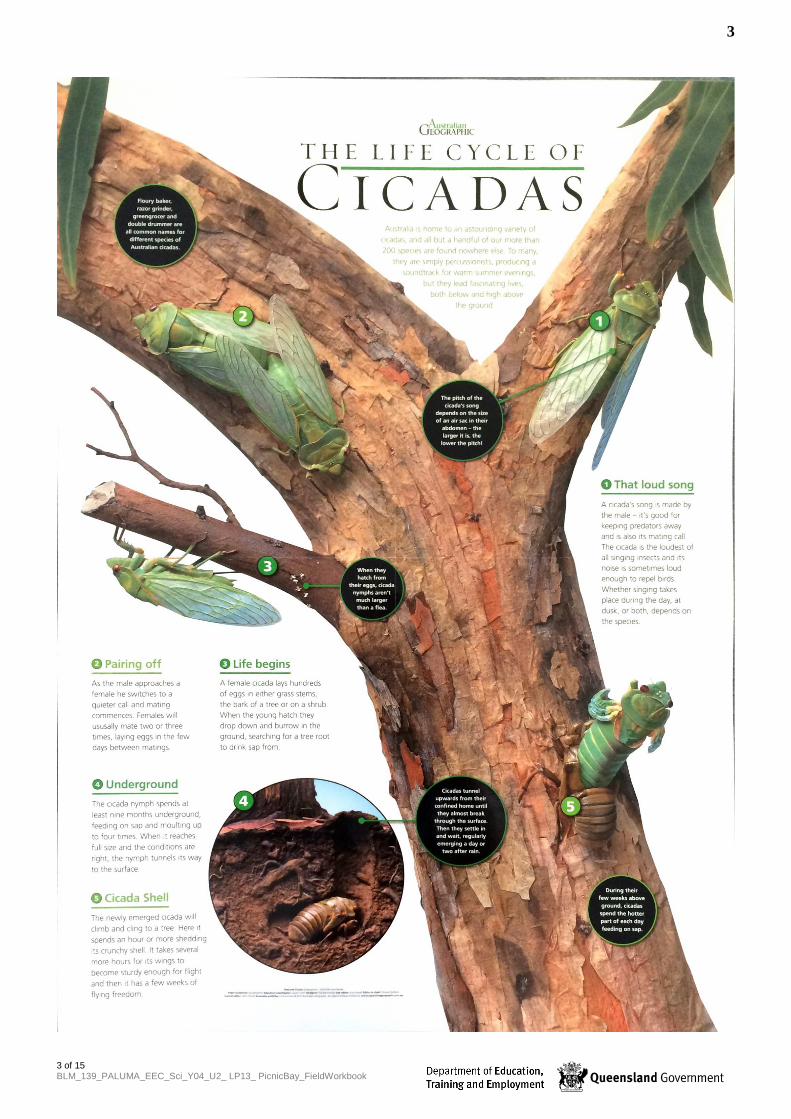
There are also three main stages of development in the Cicada’s life cycle. Write them here:
1. …………………………………………………………………….
2. …………………………………………………………………….
3. ……………………………………………………………………. Cicada eggs are laid on a branch, but where does the cicada spend most of its life cycle? Make sure your answer is a complete sentence. ……………………………………………………………………………………………………… ……………………………………………………………………………………………………… ……………………………………………………………………………………………………… The cicada belongs to the group of animals called
___ ___ ___ ___ ___ ___ ___ Amazing Cicada Life Cycle – David Attenborough http://www.youtube.com/watch?v=tjLiWy2nT7U
Call of the Bush stone-curlew http://www.youtube.com/watch?v=RZWHUU41gsk

5
5 of 15 BLM_139_PALUMA_EEC_Sci_Y04_U2_ LP13_ PicnicBay_FieldWorkbook
PART TWO – A FIELD WALK LOOKING AT ENVIRONMENTAL FA CTORS OF HABITATS, FOOD CHAINS AND FOOD PYRAMIDS On your second field walk, stop and observe an area of relatively undisturbed “bush” that could be habitat for the Bush stone-curlew. Record your observations of the environmental facto rs that could affect this habitat: Environmental factor Measurement/ Observation Measured by using Wind speed
Temperature
Humidity
Sunlight
Access to water
Observation

6
6 of 15 BLM_139_PALUMA_EEC_Sci_Y04_U2_ LP13_ PicnicBay_FieldWorkbook
FOOD CHAINS - Relationships and roles within the en vironment of the Bush stone-curlew Your Connected Map and your retrieval charts are two ways of showing the relationships between living things in an environment. A food chain is another way. The drawing below shows a simple food chain. The arrows indicate the flow of energy.
We can also show the same information in text. When you show relationships between living things, don’t forget to show where all of our energy comes from – where do you think that is? This should be the beginning of your food chain. An example of a food chain (……….. THE START OF ALL OUR ENERGY?) ���� GREEN LEAF ���� CATERPILLAR ���� BIRD ���� SNAKE ���� EAGLE Read the information on the Bush stone-curlew below .
Where does it live? The Bush Stone-curlew prefers relatively undisturbed grassland and grassy woodlands which have a good groundcover of leaf litter, fallen branches and tussock grasses for shelter, foraging and nesting. Roosting on the ground during the day, stone-curlews may travel up to 3km at night to feed. How does it nest? The Bush Stone-curlew nests under trees in open woodland, generally in a “scrape” on bare ground near fallen timber. Each breeding pair returns to the same area to nest year after year. As curlews nest on the ground, they can be eaten by predators which hunt by smell eg dogs, cats, goannas, snakes. What does it eat? Bush Stone-curlews feed mostly on insects, molluscs, centipedes, crustaceans, spiders, frogs, lizards, snakes, small rodents as well as some seeds and fruit.

7
7 of 15 BLM_139_PALUMA_EEC_Sci_Y04_U2_ LP13_ PicnicBay_FieldWorkbook
Look back at any information you have collected so far: • Your retrieval charts (pages 12 and 13) • Your Connected Map (page 14)
Use this information to make a food chain below for the Bush stone-curlew. If you have enough time, you can also try making fo od chains for these animals too: Koala Rock wallaby Dugong Cicada

8
8 of 15 BLM_139_PALUMA_EEC_Sci_Y04_U2_ LP13_ PicnicBay_FieldWorkbook
FOOD PYRAMIDS - Relationships and roles within the environment of the Bush stone-curlew A food pyramid connects lots of food chains together, and show “who eats who” in a habitat. The food pyramid below shows who eats who in the marine habitat (the sea) around Magnetic Island. Because humans eat fish, crabs and prawns, we are represented in this food pyramid. We may not be represented in all food pyramids. The food pyramid has several “levels”. Marine plants like seagrass, seaweeds and mangroves, process the Sun’s energy into food for the next level up. Green plants are called producers . All of the animals shown within the pyramid are called consumers . Each level feeds on the levels below them. Once an animal dies, or the leaves from the mangroves fall into the sea, they are broken down into nutrients by fungi and bacteria living in the water. The fungi and bacteria are called decomposers.
Decom
posers – fungi and bacteria – break down leaf
litter and dead animals
9
9 of 15 BLM_139_PALUMA_EEC_Sci_Y04_U2_ LP13_ PicnicBay_FieldWorkbook
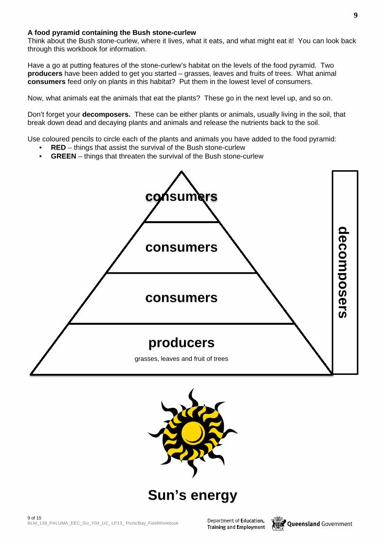
A food pyramid containing the Bush stone-curlew Think about the Bush stone-curlew, where it lives, what it eats, and what might eat it! You can look back through this workbook for information. Have a go at putting features of the stone-curlew’s habitat on the levels of the food pyramid. Two producers have been added to get you started – grasses, leaves and fruits of trees. What animal consumers feed only on plants in this habitat? Put them in the lowest level of consumers. Now, what animals eat the animals that eat the plants? These go in the next level up, and so on. Don’t forget your decomposers. These can be either plants or animals, usually living in the soil, that break down dead and decaying plants and animals and release the nutrients back to the soil. Use coloured pencils to circle each of the plants and animals you have added to the food pyramid:
• RED – things that assist the survival of the Bush stone-curlew • GREEN – things that threaten the survival of the Bush stone-curlew
Sun’s energy
consumers
consumers
consumers
producersgrasses, leaves and fruit of trees
decom
posers

10
10 of 15 BLM_139_PALUMA_EEC_Sci_Y04_U2_ LP13_ PicnicBay_FieldWorkbook
PART THREE – A WALK AROUND THE STREETS OF PICNIC BA Y LOOKING AT CHANGES OVER TIME & A VISIT TO THE MAGNETIC ISLAND MUSEUM PICNIC BAY – THEN AND NOW We will walk around the streets of Picnic Bay, exploring the changes that have taken place over the last 120 years since European settlers have been coming to Magnetic Island.
• We will use old photographs of Picnic Bay to help us see those changes. These photographs have been supplied by the Museum and are available in the Paluma Environmental Education Centre’s activity called Picnic Bay – Then and Now.
• We will make some notes and take some photographs to help us remember what we’ve seen. • We will look particularly for changes to the habitat of endangered animals that l ive here , like
the Koala, the Allied Rock Wallaby, the Dugong and the Bush stone-curlew. Our walk around Picnic Bay will take us past:
• Cottages in Magnetic Street, Barbarra Street and Wansfell Street • The location of the first holiday “resort” on the Island • A house and other buildings along the Esplanade, including the Hotel Magnetic • The beach, the jetty and the original Picnic Bay Life Saving Club • Damage caused by 1971 Cyclone Althea • We will end our tour at the former Picnic Bay State School, now a museum and craft centre
Make some notes to help you remember the things you see. Question My notes 1. What changes to the original native
vegetation were made by the establishment and plantings of the gardens, yards and street gardens?
2. What introduced garden plants have become pests in Picnic Bay?
•
Electricity and town water only came to Magnetic Island many years after European settlement of Picnic Bay. Sewage is still to be provided to every bay. 3. Before electricity, people cooked on
wood-burning stoves and buried the waste from their pan toilets. How would these arrangements (collecting firewood from the bush, disposing of “effluent”) have affected the habitat of local animal species like the curlew and koala?
•
Note the changes in building materials for the holiday houses over the years e.g. bush timber, corrugated iron and a thatched roof. 4. Where did the bush timber and palm
fronds (for the thatched roof) come from?
•

11
11 of 15 BLM_139_PALUMA_EEC_Sci_Y04_U2_ LP13_ PicnicBay_FieldWorkbook
Question My notes The huts of the “health resort” and the lifesaving club house were built right on the beach. 5. How did building on the sand dune
affect the beach?
•
6. Why do you think this beach was called Picnic Bay ?
7. What services were provided along the Esplanade for tourists and visitors?
8. How would the construction of ever bigger jetties have affected the coral reef in Picnic Bay?
•
9. What changes have humans made to the habitat of animals living in Picnic Bay, like the curlew and koala, over time?
•
Buildings and the bush in Picnic Bay have been damaged by extreme weather events like cyclones over the 120 years we are studying. 12. What damage was caused by Cyclone
Althea in 1971?
•
Now, add to your concept map on page 14 the effect any of these habitat changes have had on the Bush stone-curlew’s survival.

12
12 of 15 BLM_139_PALUMA_EEC_Sci_Y04_U2_ LP13_ PicnicBay_FieldWorkbook
Instructions for completing the Connected Map The Connected Map is a visual way of reflecting upon your observations and making connections between them. It is a quick way of making “mental notes” for ourselves. We will add to this each time we go for a field walk. When making notes on your Connected Map, work in a small group of three or four. Each of you needs a pencil to build your own thinking map. These questions will help your group start a conversation about everything you saw during this learning experience:
• What’s one animal or plant that you observed during this activity? • What do you think it needs to survive? • Write the animal’s (or plant’s) name down (or draw a quick picture – your choice).
Now write or draw the things the Bush stone-curlew needs to survive (for example, water). How can you record these connections? Draw a line from each to the things it needs to survive, for example, if it’s something the stone-curlew eats, write ‘eats’ on the connecting line. Add in any other animals and/or plants that you observe in the environment. See how many connections you can make in your map. Once your Connected Map has sufficient information recorded, sit in a shady spot and make some notes for yourself on these connections in the retrieval chart below. The first one is done for you, as an example. This l iving thing Connects with or has a
relationship with That living thing
Example: A frog
Catches and eats
Insects

13
13 of 15 BLM_139_PALUMA_EEC_Sci_Y04_U2_ LP13_ PicnicBay_FieldWorkbook
ANIMAL Bush stone -curlew Koala Allied Rock Wallaby Dugong FIELD WALKS On Magnetic Island
Conservation Status Of Least Concern http://magneticisland.s4space.com.au/curlew.html
Regionally Vulnerable (in SE Queensland) Of least Concern elsewhere in its range
Of Least Concern Vulnerable
Features of the Habitat I observed
Curlew Walk A Curlew Walk B Anything I noticed about these other local animals
Shelter & breeding sites
Food & water
Threats to the animal’s survival
Any observations or evidence of the animal – tracks, scats or sings

14
14 of 15 BLM_139_PALUMA_EEC_Sci_Y04_U2_ LP13_ PicnicBay_FieldWorkbook
Connected MapConnected MapConnected MapConnected Map Instructions and accompanying retrieval chart on pa ge 12

15 of 15 Paluma_EEC_Sci_Y5-7_U1_AT_Y7_ClassifyingCreatures