Embed Size (px)
Citation preview

Palestine in Geography and Fiction:
An Interdisciplinary Perspective
Dr. Naeema Alhosani
Chair of the Department of Geography and Urban
Sustainability
UAE University
DOI: 10.21608/qarts.2021.54573.1024
بدالآ اية
كلة
جلم
نابق
ة(
كمح م
يةلم
عة
ميدي
كا أية
ور)د
https://qarts.journals.ekb.eg

- 19 -
Palestine in Geography and Fiction: An Interdisciplinary
Perspective
Dr. Naeema Alhosani
Chair of the Department of Geography and Urban
Sustainability - UAE University
Abstract :
Using critical cartography studies as theoretical basis and
argumentative entry, this paper examines the role played by mapmaking in
essentializing the Palestinian-Israeli conflict, expanding the gap between the
two peoples and maintaining the current dilemma in the Middle East. The
paper also draws on political/historical data and fictional narratives written
by the Palestinian writer Ghassan Kanafani particularly his seminal novel
Returning to Haifa to demonstrate that mapping and cartography are
manipulated to achieve dubious political and military purposes. The
argument in the paper emphasizes that imperial cartography leads to the
mapping production of Palestine as a territorial space of ownership and
control by non-Palestinian invaders. In his response to the colonial mapping
of Palestine, which aimed to eliminate the country’s Arabi identity, Kanafani
provides in his fiction alternative cartographies of Palestine to subvert the
colonial mapping of his homeland. In other words, Kanafani attempted to
reclaim his indigenous territory or part of it through literary maps drawn in
his novel discussed in the paper1.
___________________________________________________
1 The author of the paper emphasizes that all the arguments related to the changing maps of Palestine reflect the views of their authors in the original
Palestine in Geography and Fiction Dr.Naeema Alhosani
- 20 -
Introduction:
Historically, critical cartography emerged during the late 1980s
and early 1990s in opposition to the hegemonic tradition of
mapmaking. Maps according to Rhiannon Firth are not impartial
mechanisms but rather strategic weapons that signify power1. For him,
critical cartography shows that maps like other texts such as the written
word, images or film are not neutral. Maps reflect and perpetuate
relations of power, more often in the interests of dominant groups.
(Firth 2014: 156). In a recent study, Jeremy Crampton and John
Krygier explore the function of critical cartography suggesting that it
challenges academic cartography by linking geographic knowledge
with power, and thus is political. (Crampton-Krygier 2010: 11). In a
similar context, Firth argues that maps embody power relations
illustrating that the history of mapping provides evidence that maps are
intricately tied up in nineteenth century colonialism and imperialism.
On this basis, cartographers drew boundaries that separate people and
resources. In another article, John Krygier demonstrates that critical
cartography is an umbrella term that refers to discourses about and
approaches to the meanings of maps and how maps and the systems for
creating them fit into social, cultural, and technical processes.
Krygier proceeds to confirm that critical cartography is an
umbrella term that refers to discourses about and approaches to the
meanings of maps. Thereupon, critical cartography
engages theoretical critique of the social relevance, politics and ethics
of mapping. By emphasizing the social aspects of mapping, critical
cartography has triggered multiple mapping discourses which throw
doubts on the objectivity in spatial representation, the processual nature
of map production and interpretation, and participatory methods that
question the purportedly objective, neutral views of institutional and
state cartographers (Krygier 2019:25). In the same vein, critical
cartography challenges professional cartography by situating the map
as a discourse of power/knowledge undermining the map as neutral
scientific document according to Foucault2. Similarly, Derek Gregory
acknowledges that, within the discipline of geography, there exists a

- 21 -
cartographic anxiety about the map’s complicity in imperial/colonial
power3 and the chronic persistence of this relation in present
assumptions about cartography4.
Unequivocally, the map is a medium for conceptualizing space
and mapping may reflect the intersections of space and power5.
Subsequently, cartography produces space as an object for ownership
and control, and, in the process, renders people’s lives invisible in their
role in the production of space6. This trend occurred under colonialism
which attempted to produce a “Palestine without Palestinians”. Since
our perspective of space is bound to the politics, we adopt according to
Massey7, then the map’s significant role in the Palestinian-Israeli
dispute makes cartography itself a question worthy of interrogation.
Since all places are not territories because territory is linked with
power, it is significant to differentiate between a place as territory and
other types of places8. On this basis, the map becomes a conceptual
terrain and alternative or imaginative mappings provide other terrains.
During the nineteenth-century when the Ottomans were in a
state of decline, the crumbling empire opened its borders to western
travelers. Many of these new visitors were religious scholars who
advocated a literal interpretation of the Old Testament and struggled to
emphasize Biblical events throughout scientific accuracy. Accordingly,
their maps became instruments for imperial allegations to the
ownership of Palestine (the Holy Land)9.These nineteenth-century
cartographic practices removed the indigenous Palestinians from their
land and helped engender the premise that Palestine was a country
without people prior to the Zionist settlement at the turn of the century.
In response, Palestinians created Counter-maps to underline
their presence. Counter-maps are effective in disrupting truth claims
but are interesting in themselves for their ability to engender notions
that non-state actors can make competing and equally powerful maps as
Palestinian scholars and artists have done in recent years10. Explicitly,
the mapping of Palestine was impacted by what Antonio Gramsci calls
“hegemony” which focuses upon how power relations become taken
for granted or viewed as “common sense.11” Drawing on the concept of
hegemony, Nabil Matar argues that sixteenth-century Renaissance
cartography of the “Holy Land” serves as an important starting point to
the Question of Palestine (Matar1999:141).

Palestine in Geography and Fiction Dr.Naeema Alhosani
- 22 -
Mapping Palestine: Cartographic Perspective:
Categorically, the evolvement of nation-states is attributed to the
emergence of the map, which is manipulated as an ideological
mechanism to bring the nation-state into existence according to
Pickles12 . Ironically, the Palestinian political negotiators participating
with their Israeli counterparts in the Oslo accord in the 1990s
advocated cartography, or professional map-making as a strategy of
independence, which unfortunately limits both space (the occupied
territories) and power (the exclusive realm of the Palestinian authority)
Nevertheless, the provisions of the Oslo accord were not realized in
reality and Palestinian voices were muted in world media. Moreover,
the rights of return for more than seven million Palestinian refugees
were denied in Oslo.
The post-Oslo accord era witnessed the evolvement of a new
movement which attempted to make a case for the return of refugees by
collecting maps, narratives and photographs of a pre-Israel Palestine.
However, the Palestinian writer Ghassan Kanafani (prior to Oslo)
started this trend in fiction in the aftermath of the 1948 war and the
occupation of most of the Palestinian territories. Kanafani belongs to a
generation of writers who witnessed the loss of their country and the
rejection of their rights by international institutions, which opposed the
establishment of an independent Palestinian state. Undoubtedly, these
institutions refused to acknowledge the existence of a Palestinian map.
Observing the abandonment of the Arab existence in Palestine in
western history and cartography, Kanafani provided counter-maps of
Palestine in his fiction to refute arguments of the land’s emptiness
before Zionist immigration. Though the Arabs conquered Palestine in
634 A.D. their existence was barely mentioned in western annals after
thirteen centuries of physical presence in the region.
Historically, the first map of Palestine13 was created by the
cartographers of France, an ex-colonial power. During the colonial
reign of Napoleon Bonaparte, the French in 1801 created a
historical/geographical encyclopedia (Description of Egypt) delineating
the Eastern Mediterranean. It contains cartographic information
describing the coastal area region extending from Al-Arish to Saida
(Sidon), which becomes the first map of Palestine according to Gavis.14
In details, the map of Palestine, created by the French, includes the

- 23 -
following: Al-Arish (currently located in northern Sinai -Egypt), Gaza
(currently in the Palestinian territory), Jerusalem, Jaffa, Caesarea,
ancient port south of Haifa and Nazareth, a historic town in lower
Galilee (currently all these places are part of the map of Israel). The
map of Palestine also includes the entire region that is currently known
as Jordan in addition to both Tyre (Sour) and Sidon (Saida) located at
southern Lebanon).
Although the first official map was created by French
cartographer during the reign of Bonaparte, other western hegemonic
powers were interested in Palestine (the Holy Land) since the sixteenth
century for religious purposes. Drawing on the argument of Nabil
Matar, who reveals that the “Question of Palestine” 15 was originated
cartographically in the sixteenth-century before it was disseminated
politically in the nineteenth, it is clear that the concept of pilgrimage to
“the Holy Land” appeared after the Protestant Reformation in the West
when Europeans map Palestine as a homogenous biblical space that
should be purified of its native (mostly Muslim) communities.
In the first instance, the European determination in the sixteenth-
century to control Palestine was triggered by religious activities of
historical and biblical purposes. In their religious endeavor to reach
Palestine, the Europeans created maps of the Holy Land which turn into
mechanisms for colonial hegemony in the nineteenth-century. In their
pursuit to map the Holy Land, the Europeans, according to Silberman16,
re-created Palestine as a biblical vestige and territorial site for western
colonial sovereignty. In both conditions, the Palestinian people are
completely ignored or confined to the colonial ghetto. In this sense,
cartography, a neutral science, is transformed into an oppressive
apparatus displacing the Palestinians.
Confirming Matar’s previous suggestion that the map of
Palestine was basically founded during the sixteenth-century, it is
obvious that in Renaissance cartography Palestine (the Holy Land) was
depicted in Theatrum Orbis Terrarum or the Theater of the World by
Abraham Ortelius. The manuscript, published in 1570, was considered
the Atlas of the Renaissance17. While the Atlas, from an ultimately
geographical perspective, provides details about navigation routes,
travels locations commerce destinations and harbors crucial for sailors
and merchants, its delineation of the map of Palestine (the holy land)
Palestine in Geography and Fiction Dr.Naeema Alhosani
- 24 -
was heavily impacted by biblical conceptions. The map is neither
navigational nor topographical according to Matar. Whereas most of the
Atlas views sixteenth-century trading routes and commercial harbors,
the map of Palestine describes the passage the Jews followed when they
escaped the tyranny of Pharaonic Egypt into the Promised Land18.
Surprisingly, the map of Palestine in the 16th century Atlas has no
relevance to the real map of historical Palestine. Palestine in this map
includes the Red Sea on the Egyptian borders, which witnessed the
crossing of the Jews fleeing Egypt during the exodus, then the
wilderness where the Jews resided before they tramped over the River
Jordan on their way to enter Canaan, the Promised Land.
Matar argues that while the author of the 16th century Atlas, A.
Ortelius, sold maps to his customers which provided information about
“their global commerce, he had no qualms about presenting Palestine as
meta-Palestine, a holy land without contemporary accuracy”. Matar
proceeds to state that in the sixteenth-century “Palestine had been
mapped as far as biblical times and therefore its cartographic borders
had been finalized by divine authority” (Matar 2011: 63). Thereupon,
Palestine was delineated as a legendary destination processed by a
cartography integrated into western biblical sources, which is not able
to separate geographical facts from religious mythology.
Palestine also appeared in western maps during the crusade era
and after the Napoleon’s invasion of the region in 1798. Robinson and
Smith started their exploration of Palestine after France’s three-year
occupation of Egypt and invasion of Palestine. They observed that the
Ottoman Empire was on the verge of collapse. The strong army of
Mohamed Ali, the governor of Egypt, was able to take Palestine from
Istanbul in 1831as a result of French military support, but Ali forced to
withdraw from Palestine in 1840 due to the British interference on the
side of the Ottomans. This shows that Palestine was caught up in the
crossfire of battling European colonial forces and their local proxies.
In the nineteenth-century, Edward Robinson and Eli Smith
created a map for Palestine, which appeared in his narrative travel book
titled Biblical Researches in Palestine and the Adjacent Regions.
Published in 1841, the book was addressed to the English-speaking
world according to Long (Long 2002: 133). Instead of focusing on

- 25 -
geographical data, the book includes details about the miracles of
prophet Moses as he parted the Red Sea to allow God’s Chosen People
to cross on dry ground, then God directed Moses to close the waters
that they may engulf the Pharaoh’s chariots and horsemen in pursuit19.
A similar narrative was narrated in the Quran: Then We (Allah) told
Moses by inspiration: "Strike the sea with thy rod/ So, it divided, and
each separate part became like the huge, firm mass of a mountain”20.
According to Muslim scholars, the Red Sea was divided into twelve
paths, one for each of the tribes of the Israelis, the followers of Moses.
Furthermore, Robinson and Smith, in their travel accounts, considered
the study of the historical geography of Palestine as an initial attempt to
explore “the treasures of Biblical Geography and History still
remaining in the Holy Land; treasures which have lain for ages
unexplored, and had become so covered with the dust and rubbish of
many centuries, that their very existence was forgotten”21.
The mapping of Palestine in the nineteenth-century was
impacted by biblical tales about the invasion of the holy land. In the
Book of Joshua, there is a narrative about Joshua’s reception of God’s
orders to invade Palestine after the death of Moses. God told Joshua to
lead the Israelite army across the Jordan river into the holy land
(Canaan)22. According to the Jewish bible, the children of Israel are
thus to receive “Every place that the sole of your foot shall tread
upon”23. A bloody narrative from the bible unfolds that the Israelites
must annihilate the indigenous Canaanites city by city according to
God’s orders. After their victory, Canaan will be divided among the
twelve tribes of Israel. Another narrative shows that according to God’s
commands the indigenous people of Canaan should be enslaved rather
than demolished and slaughtered. In both narratives, the Promised
Land’s boundaries are determined to be from Dan24 to Beer Sheba25.
Apparently, the nineteenth-century cartographic obsession with
Palestine was profoundly influenced by “Biblical antiquities served as a
subtle means of Western penetration and inter-European competition;
(Silberman 1982: 4).
In the middle of the nineteenth-century, “Dan and Beer Sheba”,
the biblical borders of Palestine are inserted in the map of Palestine
once more at the hands of the London-Based Palestine Exploration
Fund, that came into existence “at a time when Britain was struggling

Palestine in Geography and Fiction Dr.Naeema Alhosani
- 26 -
to define its colonial purpose and secure its imperial frontiers”
according to Moscrop26. Apparently, the modern borders of Palestine
were inspired by biblical cartography endorsed by western surveys of
the country. Many modern European cartographers mapped Jerusalem,
the Dead Sea, and other religiously oriented locations producing a
bounded Holy Land map that extends from Dan to Beer Sheba.
The Changing Map of Palestine:
Apparently, cartography has immensely participated in the
displacement of Palestinians since the nineteenth-century. During an
era of colonial conquest, the imperialist powers particularly the British
government conspired with fanatic protestants to marginalize the
Palestinians using maps and cartography as weapons. Accordingly, the
borders of Palestine were radically transformed in the aftermath of
British Mandate following the decline of the Ottomans in 1923.
Unfortunately, the British took the side of the Zionists in Europe and
changed the map of Palestine to satisfy the ambitions of the Zionist
movement. After the map of Palestine was altered and the borders were
metamorphosed, the British surrendered the Palestinian issue to the
United Nations.
Historically, Palestine became a British colony (zone of
influence) in the early twentieth-century. According to the clandestine
Sykes-Picot Agreement (1916), Palestine fell under British mandate.
The British occupation of Palestine fulfilled commercial purposes for
England. The Palestinian harbors of at Haifa and Akka were used to
export oil coming from Iraq throughout pipelines reaching the
Mediterranean. Under occupation, Palestine and its native population
fell prey to the British apocalyptic vision. Many British protestant
movements believed in the Second Coming of Christ27 foreshadowing
the end of this epoch. According to this biblical vision, Christ will
return to Jerusalem and the Jews will return “to the land of their fathers
and their immediate conversion, or, alternatively, their recognition of
the Messianic claims of the Christian Savior” (Perry 2003: 3). The
evacuation of Palestine from its indigenous people is a pre-text to the
fulfillment of the Messianic prophecy. The London Society for
Promoting Christianity Amongst the Jews (the London Jews Society), a
Christian Zionist organization established in the beginning of the

- 27 -
nineteenth century, was among the protestant movements mentioned
above.
Some protestant movements considered the Jews as an
instrument in the process of accelerating the return of the Messiah
(Christ) therefore, they support their return to Palestine for religious
reasons. Others were active in assisting Jewish immigration to Palestine
as a means of atonement for the sins committed by the Church against
the Jews throughout centuries. In 1917, after the troops of General
Allenby occupied Jerusalem, the evangelical British prime minister,
Lloyd George, urged Arthur Balfour, the foreign secretary, to declare
the foundation of a national homeland for the Jews in Palestine. After
the end of WWI and at the Paris peace conference (1919), the British
prime minister invited a delegation from the Zionist Organization to
suggest the post-war official borders of Palestine. During the
Conference, the evangelical British prime minister informed the French
that the British forces would control Palestine “as defined in
accordance with its ancient boundaries of Dan to Beer Sheba”28 and the
French accepted the declaration after investigating the biblical maps of
Palestine. Surprisingly, the Zionist Organization representatives were
hesitant. They wanted to expand the northern boundaries of Palestine
eastwards in order to have all of Mount Hermon’s waters inside
Palestine. They argue that their emerging state needs more water
resources because agriculture will be the backbone of the country’s
economy. The French did not accept the Jewish request and
consequently the biblical borders of Palestine were approved by all
parties. In 1923, the borders of Mandate Palestine, from Dan to Beer
Sheba were officially endorsed.
Under the British Mandate of Palestine, cartography played a
hegemonic role in the dispossession of the Palestinian people. The map
of Palestine was altered after the issuance of the Peel Commission
report29. After WWII, the Peel Commission had suggested the United
Nations’ partition of Palestine into two nation-states excluding
Jerusalem, which remained an international zone. The U.N. Partition
plan exceeded the geographical boundaries authorized by the Peel
Committee. In other words, the U.N. map cuts significant parts from
the Palestinian territories approved by the Peel Committee. The Israelis
were given more land and the Arabs logically rejected the biased

Palestine in Geography and Fiction Dr.Naeema Alhosani
- 28 -
partition plan. Ironically, the United Nations’ partition plan paved the
way for the 1948 war. Prior to the 1948 war, the Palestinian map
included Jewish settlements scattered across Palestinian cities and
towns. Most of the landscape constitutes Palestinian towns and villages,
which were largely demolished and eliminated in the future. In fact, the
borders of Palestine were radically metamorphosed by the United
Nations’ 1947 partition plan rejected by the Arabs and resulted into the
1948 war.
The armed conflict, subsequently led to the creation and
implementation of the armistice zone between the Arabs and the Israelis
in 1949, what was called (the Green Line). In the post-1948 war era, the
boundaries of Palestine included the emerging state of Israel recognized
by the United Nations. Furthermore, the consequences of the 1967 war
impacted the map of Palestine after Israel annexed the entire city of
Jerusalem and the West bank towns in addition to Gaza. With the
passage of time, the Israelis annexed more Palestinian territories. When
the Palestinian leadership started the peace talks with the Israelis in
Camp David in 1988, they were negotiating for 22 percent of Palestine
(Hanieh 2001: 95).
After the establishment of the state of Israel in 1948, there was
no map for Palestine. The only map posted on world-wide sites and
recognized by international institutions is the map of Israel. Zionist
cartographers created a map of Israel/Palestine reminiscent of the
biblical maps of their colonial Christian predecessors. On the new map
they changed the Palestinian names of villages, cities and other
geographical destinations to abide with the Hebrew names mentioned in
Israeli religious sources. All the Arabic names of places and locations
that were found on the Palestinian maps drawn by the British during the
Mandate were erased and replaced by Hebrew names with biblical
oriented shades. In this context, Benvenisti argues that when the Israeli
cartographers found Arabic names of geographical or historical or any
other location on the maps of Palestine handled to them by the British
Mandate authority, they erased the Arabic names adding the Hebrew
word (harus) which means “destroyed”. (Benvenisti 2000:41). After the
foundation of Israeli, Zionist cartographers created nation-state maps
which correspond to the biblical maps of antiquity.
- 29 -
Prior to the 1967 war Israeli map-makers created maps
according to the 1949 armistice lines without any mention of the
Palestinians. Whereas the map of Palestine disappeared completely
after the 1967 war, the map of Israel included the Gaza Strip, the West
Bank, East Jerusalem, the Golan Heights, and the Sinai Peninsula. In
the post-1967 war era, Israeli cartographers removed the 1949 armistice
lines from their maps. For military reasons, the map of Palestine
changed with the Zionist settlement project in the Occupied Territories
coming into effect. On the new map, “the West Bank” did not exist and
was replaced by the biblical “Judea and Samaria” ignoring the existence
of the indigenous Palestinian population. Apparently, Israel has used
cartography to help legitimize it as a well-established state.
Contesting the Colonial Mapping of Palestine:
In his response to the Oslo Accord in the early 1990s between
the Palestinian Authority representatives and the Israelis, Edward Said
lamented the lack of maps in the hands of the Palestinian delegation
engaged in the negotiations. Said demonstrated that geography is the art
of war but can also be the art of resistance if there is a counter-map and
a counter-strategy30. The “counter-map” premise or the counter-
narrative is advocated by Palestinian writers since the early 1950s,
particularly Kanafani who delineates a map of Palestine in his novels
insisting on using Arabic names of geographical locations, streets,
towns, names and other destinations to refute the colonial and
orientalist cartography that aimed to undermine the Arabic identity and
history of Palestine viewing it as a wasteland or a country without
people.
Moreover, western cartography of Palestine aims to justify colonization
by depicting the colonial process as a historically inevitable movement
of progress toward bringing civilization to the land of the barbarians.
Originated in Orientalism and western imperialism the ancient map of
Palestine either removes the Palestinian subaltern out of his homeland
or conflates him with a status of cultural inferiority and barbarism by
assigning him a role which conforms to his image in the colonial
taxonomy of inferior races. In other words, cartography was
manipulated to silence the Palestinian subaltern or consider him as
invisible, or conflate him with a status of cultural decadence and
Palestine in Geography and Fiction Dr.Naeema Alhosani
- 30 -
backwardness. After the occupation of Palestine by the British forces
during WWI, the colonizers immediately used geography to blur facts
and distort history by producing a new map of Palestine/Israel. There is
no doubt that cartography was largely utilized by the invaders to
measure and map the territories they were determined to control
ushering into an era of cooperation between colonialism and the science
of geography31.
In his famous novel Returning to Haifa (1969), Kanafani
introduces a narrative which reminds the readers with Haifa when it fell
a prey to Zionist attacks during the 1967 war. However, the novel,
which emphasizes the Arabic identity of Haifa, humanized the eastern
Jews and the indigenous Jewish communities in the city who lived in
harmony with their Arab neighbors for centuries prior to the conquest
of the Zionists. Kanafani’s Returning to Haifa (1969) marks a turning
point in Arabic literature after 1948 because the author deploys positive
images of the Jews challenging orthodox Arabic narratives. Unlike
writers who either romanticize or demonize the Jew, Kanafani
underlines human issues of common interest between the two sides of
the conflict foreshadowing the political agenda of the novel. In
Returning to Haifa, Ghassan Kanafani introduces the Arab-Israeli
conflict not only by incorporating Palestinian suffering and
displacement, as in traditional Arabic literature, but also through an
engagement with the Jewish history of Diaspora and genocide. The
Jewish motif, in the novel, has precipitated the emergence of a new
pattern of Jewish characters in Arabic literature associated with the
nature of the cultural other. The awareness of such a motif which
results from an encounter between the Palestinians and the Jews
emerged as an outburst of literary consciousness characterizing major
Palestinian literature on the conflict.
The novel comprises the journey of the Palestinian
protagonist, Said S. who returned to his occupied city (Haifa),
many years after its occupation by the Zionists supported by
the British in 1948 war. Said was forced to escape the city
during war leaving behind his little baby who was later adopted
by childless Jewish settlers who lived in his house. Said and
his wife came from the occupied territory with permission to
visit the city that used to be their habitat and to look for their

- 31 -
forgotten son. In the novel, Kanafani focused on using the
Arabic names of the city’s locations and destinations that
existed prior to occupation. Said was traveling north, across the
plain which was called Ibn Amar twenty years ago: “When he
reached the edge of Haifa, approaching by car along the
Jerusalem road, had the sensation that something was binding
his tongue, compelling him to keep silent, and he felt grief well up
inside of him. For one moment he was tempted to turn back, and
without even looking at her he knew that his wife had begun to cry
silently. Then suddenly came the sound of the sea, exactly the way
it used to be. Oh no, the memory did not return to him little by
little. Instead, it rained down inside his head the way a stone wall
collapses. He told himself that Safiyya, his wife, felt exactly the
same, and that was why she was crying” (Kanafani 149)32.
The protagonist recalled past memories in a nostalgic manner:
“Ever since he left Ramallah that morning he had not stopped
talking, nor had she. He spoke to his wife about everything- about the
war and about the defeat, about the Mandelbaum Gate, demolished
by bulldozers. And about the enemy, who reached the river, then
the canal, then the edge of Damascus in a matter of hours”
(Kanafani 150). He remembered the bitter memories of the 1948 war
“the neighbor who gathered his things and fled, and the three Arab
soldiers who fought alone for two days on the hill near Augusta
Victoria Hospital, and the men who took off their army uniforms
and fought in the streets of Jerusalem, and the peasant who was
killed the minute they saw him near the largest hotel in Ramallah.
His wife spoke of many other matters. Throughout the entire jour-
ney neither of them stopped talking. Now, as they reached the
entrance to Haifa, they both fell silent.” (151).
When Said reached the city at noon, in June 30, 1967, he heard
himself say to his wife, “This is Haifa, Safiyya!” “I know this Haifa,
You know, for twenty long years I always imagined that the
Mandelbaum Gate would be opened some day, but I never, never
imagined that it would be opened from the other side” (150). The
Mandelbaum Gate divided Jerusalem into two parts since the
British Mandate but after the 1967 war the Jews removed the
barrier between the two sides of Jerusalem.
When Said reached the city at noon, in June 30, 1967, he heard
Palestine in Geography and Fiction Dr.Naeema Alhosani
- 32 -
himself say to his wife, “This is Haifa, Safiyya!” “I know this Haifa,
you know, for twenty long years I always imagined that the
Mandelbaum Gate would be opened some day, but I never, never
imagined that it would be opened from the other side” (150). The
Mandelbaum Gate divided Jerusalem into two parts since the
British Mandate but after the 1967 war the Jews removed the
barrier between the two sides of Jerusalem: “They opened the
border as soon as they completed the occupation, suddenly and
immediately. That has never happened in any war in history. You
know the terrible thing that happened in April 1948, so now, why
this? Just for our sakes alone? 3 No! This is part of the war. They’re
saying to us, ‘Help yourselves, look and see how much better we are
than you, how much more developed. You should accept being our
servants” (151).
The protagonist was still obsessed with the 1948 war memories
regardless of the time span: As he drove the car through the center of
Haifa, the smell of war was still strong enough to make the city
seem to him dark and excited and agitated, the faces harsh and
savage. After a little while he realized that he was driving the car
through Haifa with the feeling that nothing in the streets had changed”
(151). Said started to remember the names of the city destinations
prior to the conquest: “The names began to rain down inside his head
as though a great layer of dust had been shaken off them: Wadi Nisnas,
King Faisal Street, Hanatir Square, Halisa, Hadar.” (152).
Some of the names are associated with the Jewish districts in
the city.
Said describes the city during the war emphasizing the
Arabic names of the city’s surroundings: “ Thunder came
abruptly from the east, from the heights of Mount Carmel. Mortar shells
flew across the city’s center, pelting the Arab quarters. The streets of
Haifa turned into chaos. Alarm swept through the city as it closed its
shops and the windows of its houses. Said He went down the side
streets in an attempt to cross the road to Halisa, where he lived, but the
fighting had already spread. As he quickened his pace, he knew for
certain that he had to avoid the high sections of town adjoining
Herzl Street, where the Jews had been headquartered from the
beginning. The names became tangled up in his head: Halisa, Wadi
Rushmiyya, the Burj, the Old City, Wadi Nisnas” (153).

- 33 -
While delineating the battle, Said refers to the interference of the
British in the battle: “The explosions intensified. Even though he
was far enough away from the site of the shooting he could still make
out British soldiers who were boarding up some windows and opening
others. Somehow, he found himself in the Old City and from there he
raced with a strength he didn’t know he possessed toward South
Stanton Street. And then he knew he was less than two hundred
meters away from Halul Street, and he began to catch the scent of the
sea” (154).
Despite the passage of time, Sais is still able to view the
geography of the embattled town: “He didn’t know how many hours
had passed as he rushed from street to street, but it was clear that he
was being propelled toward the port. All the side streets leading off the
main road were closed. He kept plunging down side streets trying to
get to his house, but he was always driven back, sometimes by rifle
muzzles, sometimes by bayonets. People were pouring from the side
streets into the main street leading down to the port—men, women
and children, empty-handed or carrying a few small possessions,
crying or being floated along in a paralyzed silence in the midst of the
clamor and confusion” (155).
Said, the protagonist recalled the final moments in Haifa before
he was thrown into a boat in the sea to start his journey as a refugee:
“He went through the Iron Gate to the port where British soldiers
were restraining people. From the gate he could see masses of people
tumbling one over the other, falling into the small rowboats
waiting near the wharf. Said forged ahead, using his shoulders and
forearms, his thighs, even his head. The current carried him a few
steps backward, but he pushed on wildly like some hunted creature
hopelessly trying to forge a path through a thick tangle of
undergrowth. Above him the smoke and the wailing of bombs and
hail of gunfire fused with the screams, the footsteps, the sea’s
pounding, and the sound of oars slapping the surface of the waves”
(155).
Then, Said experienced a moment of contemplation: “All the way
from Ramallah to Jerusalem to Haifa he talked about everything,

Palestine in Geography and Fiction Dr.Naeema Alhosani
- 34 -
without stopping for a moment. But when he reached the entrance
to Bat Gallim, silence bound his tongue. Here he was in Halisa,
listening to the sound his car wheels always made when they
turned. Twenty years of absence had dwindled away and
suddenly, incredibly, things were right back to where they had
been, despite all reason and logic” (156). He recalled how he
decided to come to Haifa: “A week ago, in their house in Ramallah,
Safiyya had said to him: “They’re going everywhere now. Why don’t
we go to Haifa?”. He replied: “Let’s go to Haifa tomorrow. At least take
a look. Maybe we can pass near our house. I think they’re going to
issue an order prohibiting it soon. Their calculations were wrong.” He
was quiet for a moment. He wasn’t sure whether he wanted to
change the subject, but “Let’s go to Haifa tomorrow. At least take a
look. Maybe we can pass near our house. I think they’re going to issue
an order prohibiting it soon. He heard himself continue: "In Jerusalem
and Nablus and here people talk every day about their visits to Jaffa,
Acre, Tel Aviv, Haifa, Safad, towns in Galilee and in Muthallath”
(157).
Throughout the journey, Said and his wife talked about
everything except their son Khaldun. Finally, nearing Bat Gallim,
they fell silent: “Here they were, gazing silently at the road they
both knew so well, its memory stuck fast in their heads like part of
their very flesh and bones. As he used to do twenty years before, he
slowed the car down to its lowest gear before reaching the curve that
he knew concealed a difficult rocky surface behind it. He turned the
car the way he always did and climbed the slope, watching out for
the exact spot on the narrowing road” (159).
When they reached their house in Haifa, they found a Jewish
family there. The house was inhabited by a childless couple Iphrat
Koshen and his wife Miriam who rescued his baby and adopted him
as their son naming him Dov. The Jewish family told Said and his
wife what happened: “In April 21, 1948, when Said S. left Haifa on
a British boat, pushed aboard with his wife, to be cast off an hour later
on the empty shore of Acre, and Thursday, April 29, 1948, when a
member of the Haganah, accompanied by a man who looked like a
chicken, opened the door of Said S.’s house in Halisa. With that
opening, the way was cleared for Iphrat Koshen and his wife, who
- 35 -
had both come from Poland, to enter what from then on became
their house, rented from the Bureau of Absentee Property in
Haifa. Iphrat Koshen reached Haifa via Milan early in the month of
March under the auspices of the Jewish Agency.’ He had left Warsaw
with a small convoy of people in early November of 1947. He lived
in a temporary residence on the outskirts of the Italian port, which at the
time was fraught with unaccustomed activity. At the beginning of
March, he was transferred by ship with some of the other men and
women to Haifa” (165).
Underlining the indigenous geographical locations whether
Arabic or Jewish, Kanafani allows Iphrat Koshen to narrate his
journey after reaching Palestine and settled in the Jewish district in
Haifa (Hada): “At Hadar he lived in a small room in a building
choked with people.
Iphrat Koshen soon realized that most of the rooms in the building
were packed with new emigres waiting for eventual transfer to
some other place. In truth, he believed that when things calmed
down, he’d go to live in a quiet house in the country at the foot of
some hill in Galilee. He’d read Thieves in the Night by Arthur
Koestler15 while in Milan; a man who came from England to
oversee the emigration operation had lent it to him. This man had
lived for a while on the very hill in Galilee that Koestler used as
the background for his novel. Actually, not much was known about
Palestine at that time. In truth, he believed that when things
calmed down, he’d go to live in a quiet house in the country at the
foot of some hill in Galilee. He’d read Thieves in the Night by
Arthur Koestler15 while in Milan; a man who came from England
to oversee the emigration operation had lent it to him. This man had
lived for a while on the very hill in Galilee that Koestler used as
the background for his novel. Actually, not much was known about
Palestine at that time” 169).
Kanafani gives Iphrat a space in the text to react to Said’s
version of the war in Haifa: “Only on Friday morning, April 23, could
he tell for sure that it was all over in Haifa; the Haganah controlled
the entire area. Colonel Moshe Karmati1 was directing three
battalions in Hadar Ha-Carmel and the business district. One of the
battalions was to sweep through Halisa, the bridge and Wadi
Rushmiyya, toward the port” (170). Moreover, Iphrat narrated his
Palestine in Geography and Fiction Dr.Naeema Alhosani
- 36 -
own story after listening to Said’s narrative about his expulsion
from the town. Said and his wife were not able to take their son
who was left alone in their house due to the intensity of the battle:
“In Thursday evening, April 22, 1948, Tura Zonshtein, the
divorced woman who lived with her small son on the third floor,
right above Said S., heard a sound coming from the second floor of a
baby weakly crying. Thursday, the 29th23 of April, 1948, was the
day when Iphrat Koshen and his wife Miriam, accompanied by the
chicken-faced man from the Jewish Agency carrying a five-month-
old baby, entered the house of Said S. in Halisa” (171).
During the conversation, Said and his wife were informed that
their son became a soldier in the Israeli army and was converted to
Judaism. Afterwards, Dove returned in his military suit and in the
confrontation with his biological parents, he blamed them for
leaving him behind and abandoning him as a child. He admitted that
his real parents are the Jewish couple and he insisted on staying with
them as a Jew faithful to the state of Israel. Through the character of
Dov and his encounter with his parents, Kanafani throws light on
many political issues symbolically which are not the topics of this
paper. However, the author castigates the Palestinian leadership who
neglected the Palestinian cause leaving Palestine to the Jews and
their allies to create and recreate the map of Palestine to fulfill their
colonial ambitions. At the end of the novel the author insists on the
Arabic identity of Palestine by referring to streets in Haifa that had
Arabic names: “The road outside was nearly empty. He headed for
the car and let it coast noiselessly to the foot of the slope. Only at
the bend did he start the engine and head for King Faisal Street” (188).
Conclusion:
In the context of the above-mentioned argument, this paper
explored the Palestinian question from a cartographic perspective
merging political geography with fictional narratives in order to
underline the crippling impact of biblical and colonial mapping on the
current destiny of the Palestinian people. The paper started with a
survey of the mapping history of the Palestinian territories since ancient
times until the Oslo agreements in the 1990’s in order to emphasize that
the map of Palestine was historically subjected to a systematic process
of intended restructuring and modifications leading to the exodus and

- 37 -
immigration of the native inhabitants of the land and the transformation
of the Palestinians into a nation of refugees since 1948.
The issue of immigration and the tragedy of the Palestinian
refugees resulting from a conspiracy of colonial re-mapping of their
country was illustrated through tracking the cartographic trajectories of
Palestine back to ancient times. The paper also revealed the reaction of
the Palestinian novelist, Kanafani toward the distortion of the map of
his country by delineating a literary map of Palestine on the eve of the
1948 war, a map which emphasized the co-existence between Arab
Palestinians and eastern Jews in addition to other ethnic minorities in
the land of Palestine prior to the arrival of the European Zionists. On
one hand, the paper argues that Kanafani’s Returning to Haifa
epitomizes the consequences of colonial mapping reflecting the
crippling effect of the partition of Palestine on the psyche of the
Palestinians who were forced to immigrate to surrounding Arab
countries seeking potential sources of income for their families and
leaving behind them a country that did not have recognized political
borders and did not exist on official maps. In order to clarify the
preceding points, the argument of the paper uses critical cartography
studies as a point of departure followed by a textual analysis of
Kanafani’s Returning to Haifa.
Moreover, In Returning to Haifa, Kanafani revealed that, the
map of Palestine was victimized by domineering imperialistic forces
that occupied the country for decades. Kanafani also illustrates that
both Arabs and Jews were historically devastated by different types of
colonization whether the colonizers came from the West or the East.
The invaders were keen on disintegrating the multi-ethnic Palestinian
populations and changing the map of Palestine on perpetual and regular
basis. Due to these colonial aggressions, parts of historical Palestine
were given to other countries such as Jordan, Lebanon and Syria.
Kanafani also emphasizes the historical rights of the Jews and the
Arabs in Palestine. In Returning to Haifa, the immigrant Jewish couple,
Miriam and Iphrat Koshen, victims of the holocaust, saved the
Palestinian child from imminent death after his parents abandoned him
and escaped from the city of Haifa. The Jewish couple brought up the
child as a Jew named Dov who became a soldier in the Israeli army.
When Dov confronted his biological Arab parents, he refused to return

Palestine in Geography and Fiction Dr.Naeema Alhosani
- 38 -
with them to Ramallah and preferred to continue his life as an Israeli.
Kanafani signifies here that the Jews who stayed in the country and did
not flee and the Jews who came from Diaspora / the holocaust survivors
deserve to have Palestine as their homeland. The journey of the novel’s
protagonist, Said, S. the father of the Khaldun/Dov forth and back from
Ramallah to Haifa provided him with more insights about the Jewish-
Arab existence in Palestine and illuminates many issues for him and his
wife. Apparently, Kanafani aims to humanize the Jews by showing
sympathy toward the victims of the holocaust whereas he denounces all
kinds of violence. Kanafani symbolically castigates the violence
committed by all colonial powers (France, England and Turkey) who
occupied Palestine and changed its map several times ignoring the
rights of the indigenous population including the Arabs and the Jews.
Notes:
1 Firth, Rhiannon (15 April 2015). Critical Cartography. The Occupied Times of
London (27). Retrieved 16 February2018.
2 Foucault, Michel. Power/Knowledge: Selected Interviews and Other Writings,
1972-197: New York: Pantheon, 1980.
3 Gregory, Derek. Geographical Imaginations. Oxford: Wiley-Blackwell, 1998.
4 Sparke, Matthew. A Map that Roared and an Original Atlas: Canada,
Cartography, and the Narration of Nation. Annals of the Association of American
Geographers (1998) 88: 463-495.
5 Crampton, Jeremy. The Political Mapping of Cyberspace. Chicago: University
of Chicago Press, 2004.
6 Lefebvre, Henri. The Production of Space. Oxford: Wiley-Blackwell, 1991.
7 Massey, Doreen. For Space. London: Sage, 2005.
8 Sack, Robert David. Human territoriality: its theory and history. New York:
Cambridge University Press, 1986.

- 39 -
9 Long, Burke O. Imagining the Holy Land: Maps, Models, and Fantasy Travels.
Bloomington:
Indiana University Press, 2002.
10 Wood, Denis. The Power of Maps: New York: The Guilford Press, 1992.
11 Gramsci, Antonio. Selections from the Prison Notebooks. New York:
International Publishers Co. 1971.
12 Pickles, John. A History of Spaces: Cartographic Reason, Mapping and the
Geo-Coded World: London: Routledge, 2003.
13 For more details about the changes in the map of Palestine throughout history see
the six maps in the appendix at the end of the paper. 14 Gavish, Dov. A Survey of Palestine under the British Mandate, 1920-1948.
London:
Routledge, 2005.
15 Matar, Nabil. Renaissance Cartography and the Question of Palestine (1999).
16 Silberman, Neil Asher. Digging for God and Country: Exploration, archeology,
and the secret struggle for the Holy Land, 1799-1917. New York: Random House,
1982.
17 For more details on this point, see Linda Elizabeth Quiquivix. The Political
Palestine (Diss). Chapel Hill: University of North Carolina, 2012.
18 Matar, Nabil. Renaissance Cartography and the Question of Palestine (1999). 19 Exodus 14: 21-30
20 The Holy Quran- AlShuaraa/the Poets Sura, verse 63.
21 Robinson, Edward and Eli Smith. Biblical researches in Palestine, and the
adjacent regions. Boston: Crocker and Brewster, 1856. P.10.
22 The land known as Canaan was situated in the territory of the southern Levant,
which today encompasses Israel, the West Bank and Gaza, Jordan, and the
southern portions of Syria and Lebanon. 23 Joshua 1: 3

Palestine in Geography and Fiction Dr.Naeema Alhosani
- 40 -
24 Dan (Mound of the Judge or Tal El Qadi in Arabic) is situated in the area
known as the Galilee Panhandle. To the west is the southern part of Mount
Lebanon; to the east and north are the Hermon mountains. The name appears in a
proverbial expression, ‘from Dan to Beersheba,’ signifying the whole length of
the Promised Land.
25 Judges 20: 1 (Beersheba is located on the northern edge of the Negev desert
115 kilometers south-east of Tel Aviv and 120 kilometers south-west of
Jerusalem. The city is located on the main route from the center and north of the
country to Eilat in the far south).
26 Moscrop, John James. Measuring Jerusalem: The Palestine Exploration Fund
and British Interests in the Holy Land. London: Leicester University Press, 2000.
27 The Second Coming is a Christian concept regarding the return of Jesus to
Earth after his "first coming" and his believed ascension to heaven about two
thousand years ago. The belief is based on messianic prophecies found in the
canonical gospels and is part of most Christian sects.
28 McTague Jr., John J. Anglo-French Negotiations over the Boundaries of
Palestine, 1919-1920. Journal of Palestine Studies (1982) 11:100-112
29 It is a British Royal commission of inquiry chaired by Lord Peel. The
commission published a report recommending the partition of Palestine into two
states. The report was endorsed by the League of Nations prior to the outburst of
the 1948 war.
30 Said, Edward. Facts, facts, and more facts. in Peace and Its Discontents: Essays
on Palestine in the Middle East Peace Process. New York: Vintage, 1996. PP. 26-
31.
31 Edney, Matthew. Mapping an Empire: The Geographical Construction of
British India. Chicago: University of Chicago Press, 1997.
32 All subsequent citations are quoted from Kanafani Ghassan. Palestine’s
Children: Returning to Haifa and Other Stories, Ed/Trans. Barbara Harlow and
Karen E. Riley. Boulder, Colorado: Lynne Rienner Publishers Inc., 2000. (PP.
149-196).

- 41 -
Appendix:

Palestine in Geography and Fiction Dr.Naeema Alhosani
- 42 -
Map of Palestine according to the Sykes-Picot accord 1916 (adapted by
the author from Biger, Gideon. The Boundaries of Modern Palestine,
1840-1947. London & New York: Routledge, 2004.)

- 43 -
Map of Palestine under the British mandate in the early 1920’s
(adapted by the author from OpenStreetMap)

Palestine in Geography and Fiction Dr.Naeema Alhosani
- 44 -
Map of Palestine according to the Peel Commission in 1937
(adapted by the author from OpenStreetMap).

- 45 -
Map of Palestine according to the United Nations Partition Plan in 1947
(adapted by the author from OpenStreetMap).
Palestine in Geography and Fiction Dr.Naeema Alhosani
- 46 -
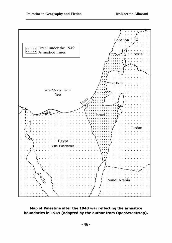
Map of Palestine after the 1948 war reflecting the armistice
boundaries in 1949 (adapted by the author from OpenStreetMap).

- 47 -
Works Cited:
Benvenisti, M. Sacred Landscape: The buried history of the Holy Land since 1948. Berkeley: University of California Press, 2000.
Biger, Gideon. The Boundaries of Modern Palestine, 1840-1947. London and New York: Routledge, 2004.
Crampton, Jeremy and Krygier, John. An Introduction to Critical Cartography. ACME: An International E-Journal for Critical Geographies, 4 (1), 11-33 2010.
Crampton, Jeremy. The Political Mapping of Cyberspace. Chicago: University of Chicago Press, 2004.
Edney, Matthew. Mapping an Empire: The Geographical Construction of British India. Chicago: University of Chicago Press, 1997.
Firth, Rhiannon. Critical Cartography (15 April 2015). The Occupied Times of London (27). Retrieved 16 February2018.
-----------------“Critical Cartography as Anarchist Method? Utopian Extrapolation and Pedagogy” Interface: A journal by and for Social Movements (2014) 6:156-184.
Foucault, Michel. Power/Knowledge: Selected Interviews and Other Writings, 1972-197: New York: Pantheon, 1980.
Hanieh, Akram. The Camp David Papers. Journal of Palestine Studies (2001) 30:75-97.
Gavish, Dov. A Survey of Palestine under the British Mandate, 1920-1948. London: Routledge, 2005.
Gramsci, Antonio. Selections from the Prison Notebooks. New York: International Publishers Co. 1971.
Gregory, Derek. Geographical Imaginations. Oxford: Wiley-Blackwell, 1998.
Kanafani Ghassan. Palestine’s Children: Returning to Haifa and Other Stories, Ed/Trans. Barbara Harlow and Karen E Riley. Boulder, Colorado: Lynne Rienner Publishers Inc., 2000. (PP. 149-196).
Krygier, John . Critical Cartography. International Encyclopedia of Human Geography, 2nd edition, Volume 3 (25-29) 2019

Palestine in Geography and Fiction Dr.Naeema Alhosani
- 48 -
Lefebvre, Henri. The Production of Space. Oxford: Wiley-Blackwell, 1991.
Long, Burke O. Imagining the Holy Land: Maps, Models, and Fantasy Travels. Bloomington: Indiana University Press, 2002. Massey, Doreen. For Space. London: Sage, 2005.
Matar, Nabil. "Renaissance Cartography and the Question of Palestine." Pp. 139-151 in The Landscape of Palestine: Equivocal Poetry, edited by I. Abu-Lughod, R. Heacock, and K. Nashef. Ramallah: Birzeit University Press, 1999. Pp.139-151.
McTague Jr., John J. Anglo-French Negotiations over the Boundaries of Palestine, 1919-1920. Journal of Palestine Studies (1982) 11:100-112.
Moscrop, John James. Measuring Jerusalem: The Palestine Exploration Fund and British Interests in the Holy Land. London: Leicester University Press, 2000.
Pickles, John. A History of Spaces: Cartographic Reason, Mapping and the Geo-Coded World: Oxford: Routledge, 2003.
Quiquivix, Linda Elizabeth. The Political Palestine (Diss). Chapel Hill: University of North Carolina, 2012.
Robinson, Edward and Eli Smith. Biblical researches in Palestine, and the adjacent regions. Boston: Crocker and Brewster, 1856. P.10.
Sack, Robert David. Human territoriality: its theory and history. New York: Cambridge University Press, 1986.
Said, Edward. Facts, facts, and more facts. in Peace and Its Discontents: Essays on Palestine in the Middle East Peace Process. New York: Vintage, 1996. PP. 26-31.
Silberman, Neil Asher. Digging for God and Country: Exploration, archeology, and the secret struggle for the Holy Land, 1799-1917. New York: Random House, 1982.
Sparke, Matthew. A Map that Roared and an Original Atlas: Canada, Cartography, and the Narration of Nation. Annals of the Association of American Geographers (1998) 88: 463-495.
Wood, Denis. The Power of Maps: New York: The Guilford Press, 1992.

- 49 -
الملخص العربي: