Embed Size (px)
Citation preview

Palaeogeography, Palaeoclimatology, Palaeoecology, 17(1975): 77--85 © Elsevier Scientific Publishing Company, Amsterdam -- Printed in The Netherlands
P A L E O C U R R E N T A N D P A L E O S L O P E - - A CASE S T U D Y
MOMINUL HOQUE Department of Geology, University of Nigeria, Nsukka (Nigeria) (Received March 5, 1974; accepted July 16, 1974)
ABSTRACT
Hoque, M., 1975. Paleocurrent and paleoslope -- a case study. Palaeogeogr., Palaeoclimatol., Palaeoecol., 17: 77--85.
The relationship between the paleocurrent pattern and the paleoslope in several con- tinental and marine environments has been reviewed. This relationship in shelf sediment is not adequately established, and appears to be more complex than is now understood. The paleocurrent pattern of the Mississippian Loyalhanna--Trough Creek Limestone (a shelf calcarenite) is presented here as a case study. The study shows that the sediment dispersal system and the current pattern are independent of the paleoslope, and that the vector orientation is polymodal. It is, however, argued that before a precise paleocurrent model for shelf carbonate is formulated, more investigation in recent and ancient rocks is necessary.
INTRODUCTION
Pa leocu r ren t analysis has b e c o m e a rou t ine and invaluable too l in the s tudy o f a s e d i m e n t a r y basin. I t is used to r econs t ruc t t he p a l e o g e o g r a p h y and basin g e o m e t r y , t o de l inea te s ed i m en t dispersal s y s t em and f low pa t t e rn , to loca te p r o v e n a n c e and sand b o d y or ien ta t ion . I t has been used to deduce the regional s lope on the a s s u m p t i o n t ha t d i rec t iona l cu r r en t vec to rs po in t t o w a r d s the pa leos lope a long which s ed imen t s were t r anspo r t ed . This led P r y o r (1961) to def ine the pa leos lope as " a n in fe r red s lope or gravi ty gradient , d o w n which anc ien t s ed imen t s have been t r a n s p o r t e d " . A l though this a s s u m p t i o n is genera l ly valid for m a n y env i ronmen t s , the re are cases where it is no t t enable .
Pa l eocu r r en t analysis o f eol ian depos i t s m a y indica te the d i rec t ion, the in tens i ty and the d y n a m i c s of the depos i t ing wind (Bagnold, 1964; Sharp, 1963, 1966; MacKenzie , 1964) . The high-angle eol ian c ross -s t ra t i f ica t ion is t h o u g h t to be t he m o s t rel iable ind ica to r o f wind d i rec t ion and dips in the d i rec t ion o f prevai l ing winds (Land, 1964) . Sharp (1966) has, however , c a u t i o n e d t h a t rel iable i n t e rp r e t a t i on o f pa leowind d i rec t ions f r o m the analysis o f c ross -s t ra t i f i ca t ion az imu tha l vec to rs in anc ient eol ian sands tones requires k n o w l e d g e o f t he t ypes o f dunes r ep re sen t ed and the i r r esponse to a poss ib ly var ied wind pa t t e rn , such as prevai l ing wind, s t o r m wind, and local o rograph ic

78
controlled wind. The dispersal system of eolian sediment is, however, unrelated to regional paleoslope.
Although wide ranges of divergence in the paleocurrent azimuthal pattern have been observed in most alluvial, point-bar, fluvial, deltaic and flood-plain deposits, an overall general correspondence exists between the largely unimodal paleocurrent direction and the paleoslope (Frazier and Osanik, 1961; Potter and Pryor, 1961; Pryor, 1961; Potter, 1962, 1963, 1967; Potter and Pettijohn, 1963; McKee et al., 1967; Selley, 1967; Hoque, 1968; Meckel, 1970; and many others). In the lower recess of a fluvial environment of a delta, however, where onshore fluvial currents meet marine currents, the sediment dispersal system, deduced from current structures, may not correspond in direction with the paleoslope. An anomalous situation may arise whereby paleocurrent direction as deduced from the current structures may point towards a paleo- slope which is altogether different from the one established independently, or the sediment transport could be quite unrelated to an established paleoslope.
Six different paleocurrent models for shore-line sedimentary environment were suggested by Selly (1968). The rose diagram of cross-stratification dip azimuths may show unimodal, bimodal or polymodal patterns. The sediment transport may, therefore, be upslope, downslope or perpendicular to the slope (McKee, 1962, 1964; Potter, 1967; Selley, 1967; Newton, 1968; Mothersill, 1969; Adams, 1970; Klein, 1967, 1970a, b; Clifton et al., 1971; Stricklin and Smith, 1973; and many others).
The relationship between the orientation of current structures ancl the paleoslope may become very complicated in a marine shelf. Here, the sediment dispersal system is subjected to various factors, such as onshore currents entering into the marine shelf, tidal currents directed towards land, longshore currents, density currents, etc. From the study of linear sand banks on continental shelves of the southern North Sea, Caston (1972) reported that sand move- ments were both normal and parallel to the direction of dominant bottom currents, and that the sand movement normal to the current was towards the crest of the bank, i.e. upslope, and that the sand movement parallel to the current was apparently slope independent.
In deep-sea sediments, such as flysch and turbidites, the proximal and the distal facies and the contourites are characterized by different lithologic and structural attributes (S.E.P.M. Short Course, 1973). Both transverse and longitudinal current patterns were reported; the sediment transport pattern in one part of the basin was found to be parallel with the downslope, and in another and more distal part of the basin, the sediment travelled along the basin axis at normal to the paleoslope (Crowell, 1955; Kuenen and Sanders, 1956; Kuenen, 1958; Hsu, 1960, 1964; McBride, 1962; Bouma and Brouwer, 1964; Walker, 1967; Fisher et al., 1970; Lajoie, 1970; Curray and Moore, 1971). The recognition of paleoslope is, therefore, dependent upon our understand- ing and recognition of different lithologic units, structural features and facies relationship in deep-sea sediments. The vector analysis of current structures will not obviously point to the paleoslope of the basin.
79
The relationship of paleoslope to the paleocurrent pattern in an ancient marine sediment is not adequately established. Before a precise model concept is developed, more investigation in recent as well as in ancient environments is necessary. The present paper illustrates a case where marine shelf calcarenite shows a paleocurrent pattern which is oriented oppositely to the established paleoslope, and the polymodal vector distributions may be subjected to different interpretations.
GEOLOGIC SETTING
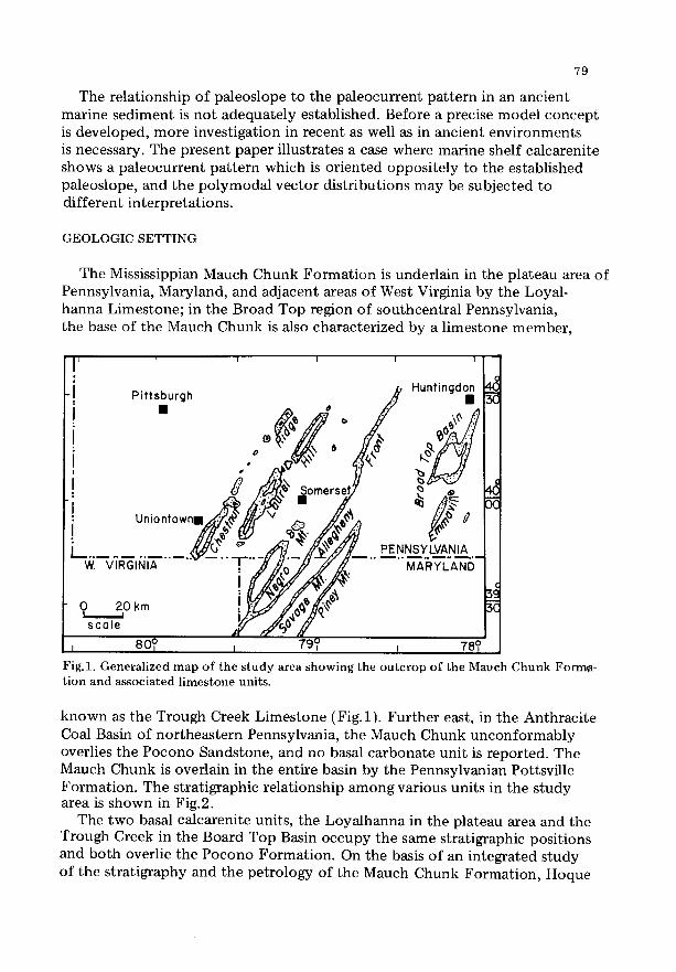
The Mississippian Mauch Chunk Formation is underlain in the plateau area of Pennsylvania, Maryland, and adjacent areas of West Virginia by the Loyal- hanna Limestone; in the Broad Top region of southcentral Pennsylvania, the base of the Mauch Chunk is also characterized by a limestone member,
F ~ ? T t F'~
-I Pittsburgh
J 0 /~&~ S omsrs( ~IC • ~ I
L ~ 9 ' e " ~ , , ~ "~ x / / ~ V PENNSYLVANIA "-~.--V'iRdIQ~ . . . . . . T"~(,//~-//Y ~///'~ --"" MARYLAND
!
~scole I ~ x 8°0 L , 78°
Fig.l. Generalized map of the study area showing the outcrop of the Mauch Chunk Forma- tion and associated limestone units.
known as the Trough Creek Limestone (Fig.l). Further east, in the Anthracite Coal Basin of northeastern Pennsylvania, the Mauch Chunk unconformably overlies the Pocono Sandstone, and no basal carbonate unit is reported. The Mauch Chunk is overlain in the entire basin by the Pennsy]vanian Pottsville Formation. The stratigraphie relationship among various units in the study area is shown in Fig.9.
The two basal calcarenite units, the LoyaJhanna in the plateau area and the Trough Creek in the Board Top Basin occupy the same stratigraphic positions and both overlie the Pocono Formation. On the basis of an integrated study of the stratigraphy and the petrology of the Mauch Chunk Formation, Hoque

8O
, - P L A T E A U A R E A B R O A D T O P R E G I O N western south - centra l
< P e n n s y l v a n i a P e n n s y l v a n i a ..LI ) - Z P O T T S V I L L E F O R M A T I O N
z z
I A-I . . . . . : .
Upper :." ".':; i:::::":':: . . . . . . : - : . - ,
Mouch . . . . . . ~C~.': :.. . . . . . . . ,
¢~ Chunk .::: "-:
.,~ Clostics :': .:." ¢= • ' . . . . . : , ~
• G r e e n b r i e r [ .--.- .~:.. ~a t~ L i m e s t o n e I . M o u c h ._~...~ I~ " t •
Chunk . . . , :
-~ =:.:..: " C l o s t i c s ":" "7"4:.. """ L o w e r = '
Z ~ " ' : ' - ~ - : " "~ ' " " ,~ M a u c h .: :'.: ':. • ! ' '
a. C h u n k "':'..-~'. ' - "~
0" ~: C l a s t i c s -.' . : . ' . ".~ ~ . :
.=- '2-.: . ; . , ' . ' . ' : . = . ,
~ ~ ::":. cn Deer Volley I! '-"':--::....:.
=E Limestone I I .~.'.'".~ ; :~: ,~ . . . . . :.'1-. • "1: "
Loyolhanno ::h.'"l Trough Creek .I..!1-..I :~ Limestone 4 . . t L i m e s t o n e " l . - . I
.:.1.. ... [ -. I I - . ~ J . - L
. . . . . . . . . . . . . . : : _ t - ~ : : ~ - - dJ~ . . J . J ,
P O C O N O F O R M A T I O N
F i g . 2 . The stratigraphic relationship among various units in the s tudy area. No vertical scale.
(1968) has earlier concluded that the Trough Creek is an eastern extension of a thicker Loyalhanna Limestone, and that these units should, therefore, be treated as a single unit. In this paper the unit is referred to informally as the Loyalhanna--Trough Creek Limestone.
PALEOZOIC PALEOCURRENT PATTERN AND PALEOSLOPE
The regional paleocurrent systems, established from the study of directional sedimentary structures, notably of cross-stratification in clastics of the Pocono, the Mauch Chunk and the Pottsville Formations, are shown in Fig.3. The current vectors are generally oriented westward and northwestward; and the vector means are 290 ° for the Pocono (Pelletier, 1958), 265 ° for the Mauch Chunk (Hoque, 1968), and 327 ° for the Pottsville (Meckel, 1970).
Several workers have shown that the paleocurrent systems, as well as basin morphology and dispersal pattern of several clastic formations in the central

81
Appalachians of the Paleozoic Era, ranging from the Ordovician to the Pennsylvanian, did not change appreciably (Pelletier, 1958; McBride, 1962; Yeakel, 1962;Hoque, 1968; Meckel, 1970; Pettijohn et al., 1972). An enormous amount of clastic sediment was shed from an unstable source region lying east of the fall-line (Meckel, 1970, fig.5), and was brought in by one or more fluvial systems down the west-dipping paleoslope during most of the Paleozoic Era. This clastic wedge, further west, was followed laterally by a marine shelf facies, dominantly carbonate, such as, for example, the Mississippian Loyalhanna--Trough Creek Limestone in Pennsylvania, and the Greenbrier Limestone in West Virginia.
The main characteristic feature of the depositional model for the thick alluvial clastic deposit in the central Appalachians is that the paleocurrent
7 / : I i I '~"
/ / i "~ Po. ~ . " " o.l~.- / - ~ .~ . > : - ' ~ - ~ . ~ . .,V. W. Vo ' ",
Mean 3 2 7 °
P O T T S V I L L E F O R M A T I O N Readings 2 4 6
i x /" "\
Ohio • L_ . _ .~._ . _--~. . . . . . . _(. ./W. VO !.f .... ,I Md.
~/ "2..~ M e a n 2 6 5 °
M A U C H C H U N K F O R M A T I O N Read ings 2 4 9
~e I~0 ~ _ ~ ~ . . . . . . 1 . . . . .
. . / i ~" ' ~ Po . . J ' )
l .- w.vo"-v' ~'~ M d ' i ' " i
0 I 0 0 K m M e 0 n 2 9 0 °
P O C O N O F O R M A T I O N R e a d i n g s 4 9 6 8
Fig.3. Regional paJeocurrent maps and rose diagrams to show sediment dispersal patterns during the Pocono, the Mauch Chunk and the Pottsville time (based on Pelletier, 1958; Hoque, 1968; and Meeke], 1970).
82
system, the paleoslope and the dispersal pattern are all parallel to one another and are oriented towards the west and northwest.
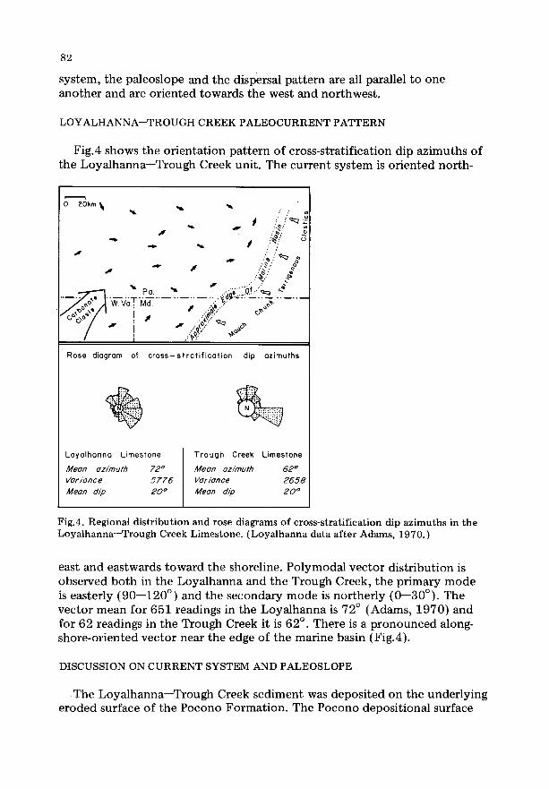
LOYALHANNA--TROUGH CREEK PALEOCURRENT PATTERN
Fig.4 shows the orientation pattern of cross-stratification dip azimuths of the Loyalhanna--Trough Creek unit. The current system is oriented north-
~ r
..~.." .¢,
- . . ; { . .o~ J~,~,~r . ,:,,T . . . . . . : - i : ~ " . . . . . . . , ~ -
I "-~-" ~,~ I ~ L ,"~'3'
Rose diagram of cross- st rat i f icat ion dip azimuths
Loyalhonna Limestone Trough Creek Limestone
Mean azimuth 72 ° Mean azimuth 6 2 °
Variance 5 7 7 6 Variance 2658
Mean dip 20 ° Mean dip 20 °
Fig.4. Regional distribution and rose diagrams of cross-stratification dip azimuths in the Loyalhanna--Trough Creek Limestone. (Loyalhanna data after Adams, 1970.)
east and eastwards toward the shoreline. Polymodal vector distribution is observed both in the Loyalhanna and the Trough Creek, the primary mode is easterly (90--120 ° ) and the secondary mode is northerly (0--30°). The vector mean for 651 readings in the Loyalhanna is 72 ° (Adams, 1970) and for 62 readings in the Trough Creek it is 62 °. There is a pronounced along- shore-oriented vector near the edge of the marine basin (Fig.4).
DISCUSSION ON CURRENT SYSTEM AND PALEOSLOPE
The Loyalhanna--Trough Creek sediment was deposited on the underlying eroded surface of the Pocono Formation. The Pocono depositional surface

83
a p p a r e n t l y was incl ined wes tward ( the mean a z i m u t h 290 °). The eas ter ly o r i en ted p a l e o c u r r e n t p a t t e r n o f the c a r b o n a t e uni t cou ld no t have resul ted f r o m a sudden reversal o f long-es tab l i shed pa leos lope; nor can we assume tha t the distal end o f t he Mauch C h u n k s e d i m e n t a r y basin was incl ined eas tward . The mar ine s e d i m e n t of the L o y a l h a n n a - - T r o u g h Creek uni t was, the re fo re , t r a n s p o r t e d ups lope , p r o b a b l y as s u b m a r i n e sand waves, and the cu r r en t p a t t e r n as es tabl i shed f r o m the c ross-s t ra t i f ica t ion dip az imu ths is no t indica- tive o f t he d o w n s l o p e o f the depos i t iona l plain.
The case s t udy o f t he L o y a l h a n n a - - T r o u g h Creek L imes tone , a mar ine shelf ca lcareni te , leads us to t abu l a t e the fo l lowing salient features :
(1) the az imu tha l d i s t r ibu t ion is p o l y m o d a l ; (2) the re la t ionsh ip b e t w e e n the m o d e s is pe rpendicu la r , the p r i m a r y m o d e
is sho reward and the s e c o n d a r y m o d e is shore-paral lel (a seaward m o d e can also be recognised) ;
(3) the m e a n o r i e n t a t i o n o f cu r r en t p a t t e r n does no t po in t t owards the pa leos lope; and
(4) the s ed imen t dispersal s y s t em is i n d e p e n d e n t o f the so-called "g rav i ty gradient d o w n which anc ien t sed iments have been t r a n s p o r t e d " .
CONCLUDING REMARKS
Whethe r the a b o v e - m e n t i o n e d charac ter i s t ics o f the L o y a l h a n n a - - T r o u g h Creek mar ine s ed im en t are valid fo r all shelf mar ine sed imen t s is d i f f icul t to conc lude due to lack of a d e q u a t e l y d o c u m e n t e d cases f r o m b o t h anc ien t and m o d e r n env i ronme n t s . F r o m our unde r s t and i n g o f the L o y a l h a n n a - - T r o u g h Creek L imes tone , as well as f r o m the review of l i te ra ture on shelf sed iments as p re sen ted in the i n t r o d u c t o r y sec t ion o f this paper , we may , however , conc lude t h a t the cu r ren t p a t t e r n o f mar ine shelf s ed imen t c a n n o t be inter- p re t ed for pa leos lope and p a l e o g e o g r a p h y unless o the r i n d e p e n d e n t ev idence , such as de ta i led facies analysis , is evaluated. We m a y also add t h a t f o r m u l a t i o n o f any p a l e o c u r r e n t m o d e l for the shelf s e d i m e n t a t i o n is still conjec tura l , and t ha t m o r e da t a are needed to u n d e r s t a n d the re la t ionsh ip a m o n g the paleo- cu r ren t sys t em, the dispersal p a t t e r n and the paleos lope.
REFERENCES
Adams, R. W., 1970. Loyalhanna Limestone cross-bedding and provenance. In: G. W. Fisher, F. J. Petti]ohn, J. C. Reed Jr. and K. N. Weaver (Editors), Studies of Appala- chian Geology: Central and Southern. John Wiley, New York, N.Y., pp. 83--100.
Bagnold, R. A., 1941. The Physics of Blown Sand and Desert Dunes. Methuen, London, 265 pp.
Bouma, A. H. and Brouwer, A. (Editors), 1964. Turbidites. Elsevier, Amsterdam, 264 pp. Caston, V. N. D., 1972. Linear sand banks in the southern North Sea. Sedimentology,
18: 63--78. Clifton, H. E., Hunter, R. E. and Phillips, R. L., 1971. Depositional structures and
processes in the non-barred high-energy nearshore. J. Sediment. Petrol., 41: 651--670.
84
Crowell, J. C., 1965. Directional current structures from the Prealpine flysch, Switzerland. Bull. Geol. Soc. Am., 66: 1351--1384.
Curray, J. R. and Moore, D. G., 1971. Growth of the Bengal Deep-Sea Fan and denudation in the Himalayas. Bull. Geol. Soc. Am., 82: 563--572.
Fisher, G. W., Pettijohn, F. J., Reed Jr., J. C. and Weaver, K. N. (Editors), 1970. Studies of Appalachian Geology: Central and Southern. John Wiley, New York, N.Y., 460 pp.
Frazier, D. F. and Osanik, A., 1961. Point-bar deposits, Old River Locksite, Louisiana. Trans. Gulf Coast Assoc. Geol. Soc., 11: 121--137.
Hoque, M., 1968. Sedimentologic and paleocurrent s tudy of Mauch Chunk sandstones (Mississippian), south-central and western Pennsylvania. Bull. Am. Assoc. Pet. Geol., 52: 246--263.
Hsu, K. J., 1960. Paleocurrent structures and paleogeography of the Ultrahelvetic Flysch Basins, Switzerland. Bull. Geol. Soc. Am., 71: 577--610.
Hsu, K. J., 1964. Cross-laminations in graded bed sequence. J. Sediment. Petrol., 34: 379--388.
Klein, G. de V., 1967. Paleocurrent analysis in relation to modern marine dispersal pat- terns. Bull. Am. Assoc. Pet. Geol., 51: 366-382 .
Klein, G. de V., 1970a. Tidal origin of a Precambrian quartzite - - the lower fine-grained quartzite (Middle Dalradian) of Islay, Scotland. J. Sediment. Petrol., 40 :973- -985 .
Klein, G. de V., 1970b. Depositional and dispersal dynamics of intertidal sand bars. J. Sediment. Petrol., 40: 1095--1127.
Kuenen, P. H., 1958. Problems concerning the source and transportat ion of flysch sediments. Geol. Mijnb., 20: 329--339.
Kuenen, P. H. and Sanders, J. E., 1956. Sedimentat ion phenomenon in Kulm and Flozleeras graywackes, Sauerland and Oberharz, Germany. Am. J. Sci., 254: 649--671.
Lajoie, J. (Editor), 1970. Flysch Sedimentology in North Amer ica Geol. Assoc. Can., Spec. Pap. 7.
Land, L. S., 1964. Eolian cross-bedding in the beach dune environment, Sapelo Island, Georgia. J. Sediment. Petrol., 34: 389--394.
MacKenzie, F. T., 1964. Bermuda Pleistocene eolianites and paleowinds. Sedimentology, 3: 52--64.
McBride, E. F., 1962. Flysch and associated beds of the Martinsburg Format ion (Ordovi- cian), Central Appalachians. J. Sediment. Petrol., 32: 39--91.
McKee, E. D., 1962. Origin of the Nubian and similar sandstones. Geol. Rundsch., 52: 551--587.
McKee, E. D., 1964. Inorganic sedimentary structures. In: J. Imbrie and N. Newell (Editors), Approaches to Paleoecology. John Wiley, New York, N.Y., pp. 275--295.
McKee, E. D., Crosby, E. J. and Berryhill Jr., H. L., 1967. Flood deposits, Bijou Creek, Colorado, June 1965. J. Sediment. Petrol., 37: 829-851 .
Meckel, L. D., 1970. Paleozoic alluvial deposition in the Central Appalachians: A summary. In: G. W. Fisher et al. (Editors), Studies of Appalachian Geology: Central and Southern. John Wiley, New York., N.Y., pp. 49--67.
Mothersill, J. S., 1969. A grain size analysis of longshore-bars and troughs, Lake Superior, Ontario. J. Sediment. Petrol., 39: 1317--1324.
Newton, R. S., 1968. Internal structure of wave-formed ripple marks in the near-shore zone. Sedimentology, 11: 275--292.
Pelletier, B. R., 1958. Pocono paleocurrents in Pennsylvania and Maryland. Bull. Geol. Soc. Am., 69: 1033--1064.
Pettijohn, F. J., Potter, P. E. and Siever, R., 1972. Sand and Sandstone. Springer-Verlag, Berlin, 618 pp.
Potter, P. E., 1962. Late Mississippian sandstones of Illinois. Ill. State Geol. Surv. Circ. 340.
Potter, P. E., 1963. Late Paleozoic sandstones of the Illinois Basin. Ill. Geol. Surv. Rept. Inv. 217.

85
Potter, P. E., 1967. Sand bodies and sedimentary environments: a review. Bull. Am. Assoc. Pet. Geol., 51: 337--365.
Potter, P. E. and Pettijohn, F. J., 1963. Paleocurrents and Basin Analysis. Academic Press, New York, N.Y., 296 pp.
Potter, P. E. and Pryor, W. A., 1961. Dispersal centers of Paleozoic and later clastics of the Upper Mississippi Valley and adjacent areas. Bull. Geol. Soc. Am., 72:1195--1250.
Pryor, W. A., 1961. Sand trends and paleoslope in Illinois Basin and Mississippi Embayment. In: J. A. Peterson and J. C. Osmond (Editors), Geometry of Sandstone Bodies. Am. Assoc. Pet. Geol., Tulsa, Okla., pp. 119--133.
Selley, R. C., 1967. Paleocurrents and sediment transport in nearshore sediments of the Sirte Basin, Libya. J. Geol., 75: 215--223.
Selley, R. C., 1968. A classification of paleocurrent models. J. Geol., 75: 99--110. S.E.P.M. Short Course, 1973. Turbidites and Deep-Water Sedimentation. Pacific Section
of S.E.P.M., Los Angeles, Calif., 157 pp. Sharp, R. P., 1963. Wind ripples. J. Geol., 71: 617--636. Sharp, R. P., 1966. Kelso Dunes, Mojave Desert, California. Bull. Geol. Soc. Am., 77:
1045--1074. Stricklin Jr., F. L. and Smith, C. I., 1973. Environmental reconstruction of a carbonate
beach complex: Cow Creek (Lower Cretaceous) Formation of central Texas. Bull. Geol. Soc. Am., 84: 1349--1368.
Walker, R. G., 1967. Turbidite sedimentary structures and their relationship to proximal and distal depositional environment. J. Sediment. Petrol., 37: 25--43.
Yeakel, L. S., 1962. Tuscarora, Juniata, and Bald Eagle paleocurrents and paleogeography in the central Appalachians. Bull. Geol. Soc. Am., 73: 1515--1540.