Embed Size (px)
Citation preview

SAFETY ELEMENT
CITY OF RANCHO MIRAGE GENERAL PLAN PAGE VIII-I
V I I I
TABLE OF CONTENTS
INTRODUCTION ...................................................................................................... VIII-1
GEOTECHNICAL HAZARDS ........................................................................................VIII-3
PURPOSE.............................................................................................................. VIII-3
BACKGROUND ....................................................................................................... VIII-3 Major Fault Hazards in the Rancho Mirage Area ................................................VIII-3 Other Seismically Induced Hazards .....................................................................VIII-7
GOALS, POLICIES, AND PROGRAMS ........................................................................ VIII-20
FLOODING AND HYDROLOGY HAZARDS ................................................................... VIII-23
PURPOSE............................................................................................................ VIII-23
BACKGROUND ..................................................................................................... VIII-23 Desert Conditions and Flood Hazards................................................................VIII-23 Land Use Planning as a Flood Control Strategy ................................................VIII-24 National Pollutant Discharge Elimination System (NPDES) ............................VIII-25
GOALS, POLICIES, AND PROGRAMS ........................................................................ VIII-29
FIRE HAZARDS .................................................................................................... VIII-33
PURPOSE............................................................................................................ VIII-33
BACKGROUND ..................................................................................................... VIII-33 Wildland Fire Hazards .......................................................................................VIII-33 Urban and Structural Fires .................................................................................VIII-34 Table VIII-1 Water Flow Requirements for Fire Protection............................VIII-37 Emergency Preparedness ...................................................................................VIII-37
GOALS, POLICIES, AND PROGRAMS ........................................................................ VIII-38
HAZARDOUS AND TOXIC MATERIALS ....................................................................... VIII-39
PURPOSE............................................................................................................ VIII-39
BACKGROUND ..................................................................................................... VIII-39 Community Hazardous Wastes Risks ................................................................VIII-39 Hazardous Waste Management Plans ................................................................VIII-40 Hazardous Materials Response ..........................................................................VIII-41
GOALS, POLICIES, AND PROGRAMS ........................................................................ VIII-41

SAFETY ELEMENT
PAGE VIII-II CITY OF RANCHO MIRAGE GENERAL PLAN
LIST OF EXHIBITS
Exhibit VIII-1 Faults in the Rancho Mirage General Plan Area .............................VIII-5
Exhibit VIII-2 Liquefaction Susceptibility.......................................................... VIII-11
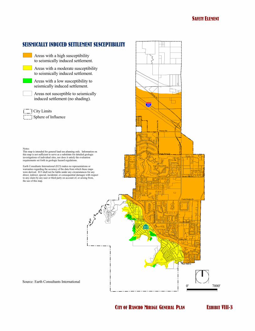
Exhibit VIII-3 Seismically Induced Settlement Susceptibility............................... VIII-13
Exhibit VIII-4 Seismically Induced Rock Falls and Landslide Susceptibility ......... VIII-15
Exhibit VIII-5 Wind Erosion Hazard Zones Map ................................................. VIII-17
Exhibit VIII-6 Flood Map ................................................................................. VIII-27
Exhibit VIII-7 Fire Threat Map..........................................................................VIII-35
LIST OF TABLES
Table VIII-1 Water Flow Requirements for Fire Protection............................... VIII-37

SAFETY ELEMENT
CITY OF RANCHO MIRAGE GENERAL PLAN PAGE VIII-1
INTRODUCTION
The Safety Element addresses natural and manmade environmental hazards that might occur in the City of Rancho Mirage and surrounding areas. It provides information, as well as goals, policies, and programs to protect the general health, safety and welfare of the community from seismic, geological, flooding and hydrology, and hazardous and toxic materials hazards. The assessment of and planning for these hazards or constraints is the primary purpose of the Safety Element. The policies and programs of this Element should also be coordinated with the Public Services and Facilities Element, which includes a discussion of emergency services and facilities, as well as the City’s Emergency Preparedness Plan.

SAFETY ELEMENT
PAGE VIII-2 CITY OF RANCHO MIRAGE GENERAL PLAN
This page intentionally left blank.

SAFETY ELEMENT
CITY OF RANCHO MIRAGE GENERAL PLAN PAGE VIII-3
GEOTECHNICAL HAZARDS
PURPOSE
The City of Rancho Mirage and its Sphere of Influence are located in an area subject to substantial seismic and geological hazards such as strong ground shaking, seismic induced settlement, seismic induced landslides, collapsible and expansive soils, ground subsidence, and wind-blown sands hazards. These seismic and geological hazards can affect the structural integrity of buildings and utilities and, in turn, cause severe property damage and potential loss of life.
The purpose of the Geotechnical Hazards section is to provide information, as well as goals, policies, and programs to protect the general health, safety, and welfare of the City from seismic and other geotechnical hazards and to educate the community and its residents about seismic and related geologic hazards.
BACKGROUND
Major Fault Hazards in the Rancho Mirage Area
The City of Rancho Mirage is located in an area where numerous active faults are present. At least two active faults extend through portions of the City’s Sphere of Influence: the Banning fault, at the northern edge, and the Garnet Hill fault in the central part. Both fault zones are capable of causing damage to the City. Other faults in the region, such as the San Andreas, San Jacinto, and San Gorgonio Pass faults, also have the potential to produce strong seismic shaking in Rancho Mirage. Currently, ground shaking during an earthquake is the most significant seismic hazard that will impact the City. Exhibit VIII-1 displays faults surrounding the City.
The most important piece of legislation related to seismic hazards is the Alquist-Priolo Earthquake Fault Zoning Act. The Act prohibits the location of structures for human occupancy across active fault lines until geotechnical investigations determine that a prospective site is safe for habitation. The Act also requires cities to disclose to the general public, through the use of maps and other appropriate materials, areas that are subject to seismic hazards.
An effective seismic hazard reduction program should include the identification and mapping of geologic and seismic hazards, the enforcement of building and fire codes, and the expedient retrofitting and rehabilitation of weak structures. Programs should also be developed to help City residents to provide for themselves and their families in the aftermath of an earthquake.

SAFETY ELEMENT
PAGE VIII-4 CITY OF RANCHO MIRAGE GENERAL PLAN
This page intentionally left blank.

�����������
���� �������
��������� ������
�������� ������������� ���� ��
����
��
����������
��� � �������
��� ����
��� ����������
��� ���� ������
�������������
� ���������� ��� �������
��� ����!�
�� ������"#
��������
����"�� ���!�
!� � �!�
��� ���!�
�������������
����������������������������
��������
���������������������������������� ���
���������������� ���!�������"���
#����$% ����������������&�������������������������������'(��)�&������������ �������������&&����������*���������+�������&�������������������*�����������&���*���������,���������������&'�� ���*������������������������&��� ���������� ����������������(
��������������� ��������������������'���������������� ��&�����������(��% ����� ������������&�� ��&������� ���������+��������������&��������&��*���������,��*�������,���������(
-���������������*���������,������������ ���������,���'���!�������+��������&���� ���������������*�'���������&���&����(�� ���&��������'����+��� ���(��% ������� �����+����������������������+������*���+����������*�������(
���� �������������)������������.��)/���!������������������������������������������� ������'��&�� �������&����� �� �����������������*��(��)�� ��������+����+�����������'�����������&�����'�����,������,������,�������,�������������������������� �������������'�����+'���'��������� �������'�����������&,����������&���,�� �������&�� �����(
��'�����0� �����&�)�&�����
0����$����� �������������)�����������
������������� �
12 31112
��������� ����� ������������������������
�� ��������������� ������������������������� � ����� ������

SAFETY ELEMENT
PAGE VIII-6 CITY OF RANCHO MIRAGE GENERAL PLAN
This page intentionally left blank.
SAFETY ELEMENT
CITY OF RANCHO MIRAGE GENERAL PLAN PAGE VIII-7
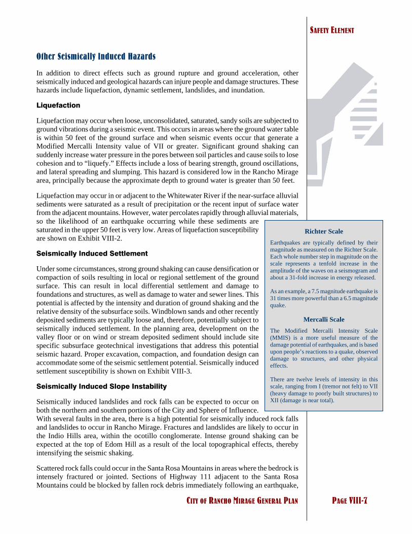
Richter Scale Earthquakes are typically defined by their magnitude as measured on the Richter Scale. Each whole number step in magnitude on the scale represents a tenfold increase in the amplitude of the waves on a seismogram and about a 31-fold increase in energy released.
As an example, a 7.5 magnitude earthquake is 31 times more powerful than a 6.5 magnitude quake.
Mercalli Scale The Modified Mercalli Intensity Scale (MMIS) is a more useful measure of the damage potential of earthquakes, and is based upon people’s reactions to a quake, observed damage to structures, and other physical effects.
There are twelve levels of intensity in this scale, ranging from I (tremor not felt) to VII (heavy damage to poorly built structures) to XII (damage is near total).
Other Seismically Induced Hazards
In addition to direct effects such as ground rupture and ground acceleration, other seismically induced and geological hazards can injure people and damage structures. These hazards include liquefaction, dynamic settlement, landslides, and inundation.
Liquefaction
Liquefaction may occur when loose, unconsolidated, saturated, sandy soils are subjected to ground vibrations during a seismic event. This occurs in areas where the ground water table is within 50 feet of the ground surface and when seismic events occur that generate a Modified Mercalli Intensity value of VII or greater. Significant ground shaking can suddenly increase water pressure in the pores between soil particles and cause soils to lose cohesion and to “liquefy.” Effects include a loss of bearing strength, ground oscillations, and lateral spreading and slumping. This hazard is considered low in the Rancho Mirage area, principally because the approximate depth to ground water is greater than 50 feet.
Liquefaction may occur in or adjacent to the Whitewater River if the near-surface alluvial sediments were saturated as a result of precipitation or the recent input of surface water from the adjacent mountains. However, water percolates rapidly through alluvial materials, so the likelihood of an earthquake occurring while these sediments are saturated in the upper 50 feet is very low. Areas of liquefaction susceptibility are shown on Exhibit VIII-2.
Seismically Induced Settlement
Under some circumstances, strong ground shaking can cause densification or compaction of soils resulting in local or regional settlement of the ground surface. This can result in local differential settlement and damage to foundations and structures, as well as damage to water and sewer lines. This potential is affected by the intensity and duration of ground shaking and the relative density of the subsurface soils. Windblown sands and other recently deposited sediments are typically loose and, therefore, potentially subject to seismically induced settlement. In the planning area, development on the valley floor or on wind or stream deposited sediment should include site specific subsurface geotechnical investigations that address this potential seismic hazard. Proper excavation, compaction, and foundation design can accommodate some of the seismic settlement potential. Seismically induced settlement susceptibility is shown on Exhibit VIII-3.
Seismically Induced Slope Instability
Seismically induced landslides and rock falls can be expected to occur on both the northern and southern portions of the City and Sphere of Influence. With several faults in the area, there is a high potential for seismically induced rock falls and landslides to occur in Rancho Mirage. Fractures and landslides are likely to occur in the Indio Hills area, within the ocotillo conglomerate. Intense ground shaking can be expected at the top of Edom Hill as a result of the local topographical effects, thereby intensifying the seismic shaking.
Scattered rock falls could occur in the Santa Rosa Mountains in areas where the bedrock is intensely fractured or jointed. Sections of Highway 111 adjacent to the Santa Rosa Mountains could be blocked by fallen rock debris immediately following an earthquake,

SAFETY ELEMENT
PAGE VIII-8 CITY OF RANCHO MIRAGE GENERAL PLAN
which would hinder rescue and evacuation operations. Rock falls could also impact developments adjacent to mountain slopes, especially those at the mouth of Magnesia Springs and Bradley Canyons. Throughout the City, manufactured slopes of significant height could also be susceptible to failure if not engineered to resist seismically induced failure. Seismically induced rock falls and landslide susceptibility are shown on Exhibit VIII-4.
Seismically Induced Inundation
Seismic events can cause failure of water tanks, reservoirs, retention basins, recharge basins, and other water storage structures, especially in areas susceptible to ground failure. There are several above ground water storage tanks in the City that could be subject to damage in an earthquake. Damage to these tanks could significantly hinder efforts to suppress fires and could greatly limit supply and availability of potable water after a major earthquake. Only limited opportunities for seismically induced inundation down grade of stormwater retention basins currently exist in the City. The infrequency of stormwater retention and the limited likelihood of stormwater storage substantially reduce, but do not eliminate, this potential hazard. The design engineering of future major detention/retention facilities will need to focus on the seismic hazards of the area when planning for and constructing these facilities.
Geologic Hazards
The physiographic and geologic history of the Rancho Mirage area are important in that they control to a great extent the geologic hazards, as well as the natural resources, within the City. These hazards include collapsible soils, ground subsidence, and wind erosion and wind-blown sand. For example, wind-blown sand erosion poses a significant hazard in the Coachella Valley due to funneling of fierce winds by the steep mountain barriers, whereas locations at the base of the mountains are more sheltered from this hazard. Alternatively, areas in and adjacent to the mountains are more likely to be impacted by rock falls and unstable slopes. Regional tectonic subsidence along the valley floor, concurrent with uplift of the adjacent mountains, is responsible to a great extent for the rapid deposition of poorly consolidated alluvium that is susceptible to consolidation and/or collapse. On the other hand, the deep alluvium-filled basin, which is bounded by relatively impermeable rock and faults, provides a natural underground reservoir (aquifer) for ground water, one of the City’s primary sources of domestic water. The extraction of water from these aquifers may cause the ground to settle or sink.
Collapsible Soils
Soils are an important component of the geological conditions in the City of Rancho Mirage. The potential of soils to collapse or to expand can cause damage to structures. Soil collapse typically occurs in recently (Holocene) deposited sediments laid down by wind or water. When saturated, collapsible soils undergo a rearrangement of their grains and a loss of cohesion or cementation, resulting in a substantial and rapid settlement even under relatively low loads. The alluvial and aeolian sediments in the planning area are prone to collapse, and this potential should be evaluated on a site specific basis as part of geotechnical studies for development. Mitigation can be accomplished through a variety of design and construction methods.

SAFETY ELEMENT
CITY OF RANCHO MIRAGE GENERAL PLAN PAGE VIII-9
Coachella Valley PM10 State Implementation Plan
The latest in dust control efforts and requirements can be seen in the 2003 Coachella Valley PM10 State Imple-mentation Plan that was adopted by South Coast Air Quality Management District on August 1, 2003.
Ground Subsidence
Ground subsidence is the gradual settling or sinking of the ground surface with little or no horizontal movement. Several regions of subsidence have been documented in Riverside County – all of them in deep, alluvium-filled valleys. In most cases, the cause of the subsidence was attributed to declining groundwater levels. The rate of subsidence in some areas of the Coachella Valley appears to have accelerated recently because of groundwater extraction. Recognizing that significant subsidence in the area could pose a major environmental constraint, several agencies (including the U.S. Geological Survey and the Coachella Valley Water District) are currently devoting resources to the study and mitigation of this potential hazard.
Regional ground subsidence from groundwater withdrawal is a potential hazard that the City of Rancho Mirage can proactively mitigate by supporting the proper management of the groundwater supplies, creating water conservation programs, encouraging water recycling, and educating the public. With the expected increases in population, overdraft of the aquifers underlying the Coachella Valley will be one of the most serious challenges ahead for maintaining the region’s environmental quality.
Wind Erosion and Wind-Blown Sand
Most of the City of Rancho Mirage is highly susceptible to wind erosion. The geo-morphology of the Coachella Valley, its extreme aridity, and the marine air masses funneled from the west through the San Gorgonio Pass conspire to create strong and persistent winds in the valley. These strong winds have been blowing and redistributing sand deposits in the area for thousands of years. Lands disturbed by flooding, grading or agricultural activities are, therefore, subject to significant erosive forces that suspend fine dust and transport sand over great distances.
In addition to damage to vehicles, structures and other improvements, blowing sand collects on streets, driveways and in other areas where it must be removed at considerable expense. The presence of dust particles in the air is also the source of several major health problems. Atmospheric dust causes respiratory discomfort and may carry pathogens that cause eye infections and skin disorders. Dust storms reduce highway and air traffic visibility. Exhibit VIII-5 shows the wind erosion hazard zones occurring within the City of Rancho Mirage and Sphere of Influence.
Mitigation measures that are currently being used in Rancho Mirage focus on the application of the Coachella Valley PM10 State Implementation Plan. Some other physical measures that are or have been used in the area include hedges, walls, and other barriers to wind. Water is typically sprayed at construction sites to reduce dust in the air by weighting down the soil. Development projects and individual structures can be designed to protect occupants and property from the damage of blowing sand. Vegetation covers, such as a desert hydroseed mix, can be used to reduce wind erosion of the topsoil. However, all these efforts are only partially effective in mitigating the wind erosion hazard. Furthermore, grass covers require intense watering to thrive, and in an area where water is such a vital commodity, the need for water preservation needs to be weighted against the need to control airborne dust.

SAFETY ELEMENT
PAGE VIII-10 CITY OF RANCHO MIRAGE GENERAL PLAN
This page intentionally left blank.

����
��
����������
��� � �������
��� ����
��� ����������
��� ���� ������
�������������
� ���������� ����������
��� ����!�
�� ������"#
��������
����"�� ���!�
!� � �!�
��� ���!�
��������������� ���������� ��������������������������������������� ����� ��������������������������������������������������� ������������������������� �� �����������������������������������������������
����������!�������"������
����#$��������������� ������������� �������������������"��������������������������������������������%�������������������� ���� ��������%��������������� �%� �������������� �����������������%��������������������������������������&�� �����������
'����� �����������"������������(' ")���*��������������������������������� ��������������������� �������������������������� ��% ���' "��������������������� �������������������������� �������� ������������������ ��������������������� ���������������������������������������������� �������������������������������������������������������
������������� � ��������������������� ������� ���������
������������������������
+���,�,
������������
!����#�'����� �����������"�����������
SAFETY ELEMENT
PAGE VIII-12 CITY OF RANCHO MIRAGE GENERAL PLAN
This page intentionally left blank.
���������
��������� ��
����
����������
�������� �
���������
���������
�������������
�������������
����������������
������ ������
���!����
�����"�������
��������#���
��
����
����������������� ���������������� ��������� ��������������������������������� ���������������� ��������� ����������������������������� ���������������� ��������� ����������������������� ��������������� �������� �����������������������
������������������������� �
����� �������������������������������������������������������������������������������������� ���������!���������������������������������� ��!�����������������!����������"����������������������!���������#�������������������������� ��$���������������
%��������������������������%������&��������������������������������������������� ��� ������������������ ������������������!�����%������������������������������� �� ����� �������������� "������� "���� ���"��� ������"���� ����#����������������������� ������ ��������������������������������� ������"����������������"����������������
���� ���%������������������������
������������� �
'( )'''(
����������� ��� ����������������������
�� ����������������������������������������� ������� ������

SAFETY ELEMENT
PAGE VIII-14 CITY OF RANCHO MIRAGE GENERAL PLAN
This page intentionally left blank.

���������
��������� ��
����
����������
�������� �
���������
���������
�������������
�������������
����������������
������ ������
���!����
�����"�������
��������#���
��
����
�������������� ������������������������������������������������� ��� ������������������ �������������� ��������������� ����� �������������� ������������������������������������������������������ ��������� �������� ����� ����������������������������������������������������������������� ������������������������������������� ��� !"���� ���� ��� �������� ���#��� ��������� ����������������������� ���������� ���� ������� ��������� �������� �������������� ����������������� �������������� ����� �������������� ����������������������������������������������$��������%�&� ��'�� ������������������
(� ��)*����������� ����������������������������������������� ���� ����������� ��������� � �����+����������� � � �������� ���������������+�� ��� ����������+�������� ������������� ��� ����� ����+���� ���������� ���� ���� ���������������,���������� ����
-�� ��&���� � ��� ��� �����$-&�%��������������� � ����������� ������������� ��������������� ����� ������������ �����������������+�����-&��������� ������������������������� ���������������� �������� ���������������� �������������� ������������� �������� ������������������������ �������� ��������� ������������������� ���������� �������
������)�-�� ��&���� � ��� ��� ����
������������� �
". /""".
����������� ��� ������������ �� �� ��������������
�� ����������������������������������������� ������� ������

SAFETY ELEMENT
PAGE VIII-16 CITY OF RANCHO MIRAGE GENERAL PLAN
This page intentionally left blank.

���������
��������� ��
����
����������
�������� �
���������
���������
�������������
�������������
����������������
������ ������
���!����
�����"�������
��������#���
��
����
������������������ ��������������� ����� �������� ����� ����������� �� � ���������� ������������������������������������������������� ���������������� ������������������ ��������������� ����� �������� ����� ����������� �� � ����� ������������������������������������������������ � ����������� �����!�������������� ���������������� ��������������������������� ����� ����������� �� � ������������������������������������������������ ������� ����� ���������������� ����������������������� �� ��������������������������� ����� ������������� �����������"����������� �������� ������� �� ��������� ����������� �����������#���� �����������#���� �������������������������$�� ����%�
&���'�� ����������(������
)��� *&������"���������������� ����������������
+� ����� ����������������������� �������������(����������� ����� ���� ���������� ������ ��� �" ��������������������������� ����� ����������� �� #������� ��� �� �����������������,������ � ��������������������������������� �
-�����&� ����� �(���������$-&(%����� �������� ����� ���������� ����������������������������������������������� ����� ��������������-&(� ��������"����"���������������� ���� ������������#������#� �����#�������#������ �,������������ ������� ���������������"������ ����������������������������#������ ������#����� ������� �����
������*�-�����&� ����� �(��������
������������� �
./ 0.../
�� ������������ ����
�� ����������������������������������������� ������� ������
SAFETY ELEMENT
PAGE VIII-18 CITY OF RANCHO MIRAGE GENERAL PLAN
This page intentionally left blank.

SAFETY ELEMENT
CITY OF RANCHO MIRAGE GENERAL PLAN PAGE VIII-19
Open Space for Public Health and Safety
An important function of open space is its use as a buffer to separate people and buildings from hazards that could cause injury, damage, or death. Open space for public health and safety includes areas requiring special management or regulation because of hazardous or special conditions. These include earthquake fault zones, unstable soil or slope areas, flood plains, watersheds, areas presenting high fire risks, areas required for the protection of water quality and water reservoirs, and areas required for the protection and enhancement of air quality. Although these lands remain open due to hazardous situations, they have potential for other uses. Land along fault lines can be retained in its natural condition as a wildlife corridor, and flood control facilities may be usable for natural open space, wildlife habitat, and recreation.
SAFETY ELEMENT
PAGE VIII-20 CITY OF RANCHO MIRAGE GENERAL PLAN
GOALS, POLICIES, AND PROGRAMS
The development review process of the City must assure that development proposals are thoroughly evaluated with regard to seismic and geological safety, that all necessary special studies are conducted and reviewed, and that comprehensive mitigation measures are developed and implemented. The City will need to take a proactive role to manage seismic and geological hazards. Developing a groundwater management and water conser-vation program and encouraging the use of recycled water will be important in mitigating ground subsidence. The City should also work with State, Regional, and County agencies to establish and maintain an up to date database on seismic geological conditions in the region, legislation affecting the City's regulatory responsibilities, and changing technical assessments that refine or re-characterize the seismic hazards affecting the region.
GOAL 1 A community that plans for and is protected from the effects of seismic and geological hazards.
Policy 1 The City shall consult and cooperate with surrounding communities and applicable State and federal agencies to improve and update information on regional seismic and geological conditions.
Program 1.A
Coordinate with the California Division of Mines and Geology and the United States Geological Survey (USGS) to establish and maintain maps illustrating the location of seismic and geological hazard zones occurring within the City boundaries and Sphere of Influence.
Program 1.B
Coordinate with the National Earthquake Hazard Reduction Program of the Federal Emergency Management Agency to identify earthquake risks and available mitigation techniques.
Policy 2 The City shall establish ordinances and guidelines to reduce the hazards from wind-blown sand and dust.
Program 2.A
Coordinate with the South Coast Air Quality Management District and other local agencies to develop and maintain appropriate large particulate (PM10) mitigation practices.
Policy 3 Appropriate geotechnical analysis shall be required for development proposals within designated Alquist-Priolo Earthquake Fault Zones.

SAFETY ELEMENT
CITY OF RANCHO MIRAGE GENERAL PLAN PAGE VIII-21
Program 3.A
Should annexation of the Alquist-Priolo designated areas occur, prepare an informational handout that specifies the format and contents of geotechnical and fault investigations for development sites within Alquist-Priolo Earthquake Fault Zones.
Program 3.B
Establish a cooperative arrangement with the County Geologist, the State Geologist, or contract State Certified Geologist or geological engineer to review and determine the adequacy of geotechnical and fault hazard studies prepared within the City.
Policy 4 The Garnet Hill Fault shall be regulated as an active Fault Hazard Management Zone, according to the Alquist-Priolo Earthquake Fault Zones requirements.
Policy 5 The City shall require the removal or rehabilitation of hazardous or substandard structures that may collapse in the event of an earthquake.
Program 5A
Progressively maintain and update the City's program to encourage the rehabilitation of structures that pose a threat or hazard due to inadequate seismic design, engineering, or construction.
Policy 6 The City shall cooperate and coordinate with public and quasi-public agencies to assure seismically strengthened or relocated facilities and other appropriate measures to safeguard water, electricity, natural gas, and other transmission and distribution systems.
Program 6.A
Encourage and cooperate with CalTrans to stabilize susceptible slopes and strengthen bridges, elevated roadways and other structures along state highways, which may be subject to failure during major seismic events, thereby isolating portions of the community from emergency aid and assistance.
Policy 7 The City shall play an active role in the development or distribution of earthquake preparedness information and materials to residents and local businesses.
Program 7.A
Confer and cooperate with local utility companies, the Coachella Valley Water District, the Palm Springs Unified School District, police and fire departments, and others to coordinate public education regarding appropriate action before, during, and after earthquakes and other disasters.
Program 7.B
Keep the City’s public awareness programs on natural disaster management and emergency preparedness up-to-date on current hazards and issues.

SAFETY ELEMENT
PAGE VIII-22 CITY OF RANCHO MIRAGE GENERAL PLAN
Policy 8 New septic tank leach fields, seepage pits, drainage facilities and heavily irrigated areas shall be located away from foundations and other structural supports to minimize the creation of a localized collapse of soils and associated hazards.
Policy 9 Development in areas identified as being subject to a rockfall or landslide hazard shall prepare detailed geotechnical analysis, including site response to seismic events, and require mitigation measures that reduce associated hazards to insignificant levels.
Program 9.A
Require that engineered slopes be designed to resist earthquake-induced failure.
Program 9.B
Require that lifelines crossing a fault be designed to resist the occurrence of a fault rupture.
Policy 10 The City shall encourage the incorporation of wind barriers, architectural design or features, and drought resistant ground coverage in new development site designs to mitigate the impacts from erosion and wind-blown sand.
Policy 11 Where appropriate, hazard zones (earthquake fault lines, floodways and floodplains, steep or unstable slopes, etc.) shall be designated as open space, and incorporated into land use map.
SAFETY ELEMENT
CITY OF RANCHO MIRAGE GENERAL PLAN PAGE VIII-23
FLOODING AND HYDROLOGY HAZARDS
PURPOSE
The City of Rancho Mirage and surrounding areas are, like most of southern California, subject to unpredictable seasonal rainfall. Most years, the scant winter rains are barely sufficient to turn the hills green for a few weeks, but every few years the region is subjected to periods of intense and sustained precipitation that result in flooding. The potential for flooding is a safety concern that Rancho Mirage continues to address. It is the intention of the community to plan and implement the phased development of flood control facilities, both project-specific and Citywide. Provisions for open space and multiple uses, wildlife, and pedestrian and equestrian corridors within major drainages are also planned.
BACKGROUND
Desert Conditions and Flood Hazards
The City of Rancho Mirage and the Coachella Valley enjoy a subtropical desert climate. Mean annual rainfall is very low on the desert floor, ranging from 4 to 6 inches per year and an average of 25.3 inches for Mount San Jacinto. High intensity thunderstorms and tropical storms can, however, occur suddenly and create flood hazards. Although the ground may be generally dry at the beginning of a storm, sufficient amounts and intensities of rainfall can saturate the desert surface and substan-tially reduce percolation, pushing the water farther downstream. Development also increases runoff by creating large areas of impervious surfaces. Increased runoff upstream can be a significant contributor to downstream damage.
Areas of potential flooding are generally associated with the Whitewater River and its tributaries, mountain canyons and their alluvial fans, as well as runoff associated with the Indio Hills drainage (including Edom Hill). Exhibit VIII-6 identifies areas subject to flooding both along the Whitewater River drainage and along the fan area between Interstate 10 (I-10) and the Indio Hills (identified as the I-10 Wash). The 100-year flood zone for the Whitewater River is generally confined along the channel of the river and its tributaries, although at the bottom of Magnesia Spring Canyon, the 100-year flood limits extend to several of the residential streets in the area. The 500-year flood limits cover a large residential and commercial section of the City and extend across Highway 111.
Flooding in the Sphere of Influence is primarily associated with the wash north of the I-10 and the alluvial fans draining the Indio Hills. Flooding in this area is generally shallow, between one and three feet deep, but the floodwaters move at relatively high velocities with the potential to do considerable damage. According to the Federal Emergency Management Agency (FEMA) maps, the velocity of the floodwaters in this area varies between five and seven feet per second (fps).
Benchmark Storms Benchmark storms used by the Army Corps of Engineers to calculate flood potential includes the storm of September 24, 1939. This intense storm generated 6.45 inches of rain in a period of 6 hours. Another example of the storm runoff potential in the area, the tropical storm Kathleen of September 9-11, 1976, gene-rated very heavy general rainfall, with Rancho Mirage receiving 3 inches. The surrounding hills and mountains received as much as 14 inches.

SAFETY ELEMENT
PAGE VIII-24 CITY OF RANCHO MIRAGE GENERAL PLAN
FEMA also reports that most of the streams in the Rancho Mirage area have the potential to carry large amounts of debris. This increases the volume of peak discharges, and when flows reach the valley, the debris is deposited, compounding the flooding problem. Debris
has the potential to fill or plug structures designed to collect and convey runoff, forcing floodwaters into the adjacent areas. Rapidly moving flows heavily laden with debris are also extremely dangerous.
Increased urbanization of the northern portions of the Coachella Valley can and will result in increased amounts of runoff during large storms. Local agencies have realized that unless adequate flood control measures are implemented, this increased runoff can damage improvements and endanger life.
The Coachella Valley Water District (CVWD) is the primary agency responsible for the management of regional drainage within the vicinity of Rancho Mirage, including rivers, major streams and their tributaries, and areas of significant sheet flooding. The District is empowered with broad management functions,
including flood control planning and construction of drainage improvements for regional flood control facilities, as well as watershed and watercourse protection related to those facilities. An unpopulated portion of the City also falls into the Riverside County Flood Control District.
Land Use Planning as a Flood Control Strategy
One of the most effective and direct methods of controlling flooding and limiting threats to lives and property is proper land use planning. Consistent with other primary goals of the community, land use planning can call for the preservation of natural vegetation in the foothills and mountains, which function as natural watersheds for local drainage and groundwater recharge and can affect the volume of stormwater and debris that reach downstream facilities.
Land use planning can also limit the exposure of people and improvements to storm hazards and damage. Restrictions on the type and location of structures in the vicinity of major drainages within the community can greatly reduce potential losses. Within the limits of improved and unimproved 100-year floodplains, development should be severely limited and regulated, with the prohibition of the construction of structures for human habitation. To promote sound land use and floodplain development, FEMA provides Flood Insurance Rate Maps (FIRMs) for local and regional planners and civil engineers. These maps provide more detailed flood hazard map information, including the boundaries of the 100-year and 500-year flood zones.
Within flood zones subject to sheet flooding, development approvals should be conditioned to assure protection of improvements from flood damage. Protection measures may include raising the finished floor level above the flood depth projected for the surrounding area and providing protection against scouring. Until such time as flood protection that removes areas from severe threats of flooding is provided, development in these areas should be carefully regulated.
100-Year Floodplain Land that is subject to flooding by a 100-year flood or the flood elevation that has a one percent chance of being equaled or exceeded each year.
500-Year Floodplain Land that has the potential to be flooded in a storm that has a 0.2 percent chance of occurring every year.
Aftermath of a Flash Flood in 1979 Source: Joel Sternfeld Subsequent to the 1979 flood, the Army Corps of Engineers installed the West Magnesia Stormwater Channel (see Exhibit VIII-6) to improve flood protection.

SAFETY ELEMENT
CITY OF RANCHO MIRAGE GENERAL PLAN PAGE VIII-25
National Pollutant Discharge Elimination System (NPDES)
The NPDES implements the federal Clean Water Act and was adopted in 1990. It requires the development, adoption, and implementation of plans and programs for storm water management, which must, among other things, effectively prohibit non storm water discharge into the storm drain and require controls to reduce the discharge of pollutants from stormwater systems to waters of the United States.
Currently, Riverside County municipalities and agencies, including the City of Rancho Mirage, Riverside Flood Control and Water Conservation District, and CVWD, joined together to develop and implement the 2001-2006 Stormwater Management Plan, as part of NPDES permitting requirements. This Plan was designed to manage and control stormwater runoff to the maximum extent practical. One of the primary strategies to comply with the provisions of NPDES is the use of on-site stormwater retention or detention basins within any new developments of one acre or larger. These facilities have long been required by the City and may in some instances include artificial wetlands that use a biologically active zone to break down potential pollutants before they can contaminate surface runoff or reach the water table through percolation. These intercept structures will also be important in capturing sand and sediment before it is discharged into drainage facilities.

SAFETY ELEMENT
PAGE VIII-26 CITY OF RANCHO MIRAGE GENERAL PLAN
This page intentionally left blank.
��
�
��
���
���������
���������
������
����������
�������� �
���������
� ��������
�������������
�������������
����������������
������ ������
���!����
�����"������
�
��������#���
��
����
����������������
��������
����
������������
�� ��� ���� � �
�������� ������ ���������� �
����������� ���! �������� ������ �
�������� ������ � ��� �!� ���
"�� ����� ������
������������� �� ��������������������������������������� �������������� ���������������������������������� �� ����������������������������������������������� � �!�� �����"�! ������� ��������!���������#�����������$������������!���� ���������� ��������������%��������� ������������������������&��������������� �����"�!�� ������"����� ����� ����� ������������! ��������������"�������"����������� ����� �������'������� ����������������������� ������������ ������� ���������(������������%��������� ����������������������� ����!�� ������"����� ���� ����� �������������!�� ������"�������� ����� ������'������� ����������������������������������� ������� ������
� ������"������!������������������������������������"�������� ��)�� � ��*� ���+�����,�������
)����-������ �������.�� ����
/����01 ����������������������"����� � �������� �����"��� ����.�������������� ��������������������������������������������������������� ���"�� �"��������"������������������� ������2���������������������� ����� ��������'������������������ ����"�� �"�� ��������"� �������
3��� �)���� ������.����������� �43).5���6�����������������������!������������"�����"�� ������������ ������������! � �� �������!��������������3).�� � �������� ��� �����������������������������������2��������2����� 2��������� 2��������'������ �����"���!�� ������������� �������������������� ��������������������2����������"�����2� ���������� ������
�����0�3��� �)���� ������.�����������
������������� �
�7 8���7
��������
� ����������������������������������������� ������� ������

SAFETY ELEMENT
PAGE VIII-28 CITY OF RANCHO MIRAGE GENERAL PLAN
This page intentionally left blank.

SAFETY ELEMENT
CITY OF RANCHO MIRAGE GENERAL PLAN PAGE VIII-29
GOALS, POLICIES, AND PROGRAMS
The principle and direct implementation of this section will be through the implementation and enforcement of FEMA’s National Flood Insurance Plan (NFIP) guidelines and mitigation measures as well as the application of Coachella Valley Water District’s regional plans and policies. These measures and their improvements help control and confine the area wide drainage pattern to more discreet and focused routes where it can be better managed. It may also point to facilities that complement land use patterns, provide cost effective flood control alternatives, and maximize opportunities for multiple uses, including enhanced groundwater recharge.
The NFIP flood plain maps and guidelines will also set critical parameters for future development along areas subject to area wide flooding. This section will also be implemented through the development guidelines and regulations of the Rancho Mirage Zoning Ordinance, Grading Ordinance, and Subdivision Ordinance.
GOAL 1 Protection of lives, property, and essential facilities from flooding and other hydrologic hazards in the City of Rancho Mirage.
Policy 1 The City shall ensure that updated and effective Master Drainage Plans are implemented in a timely fashion for the near and long term protection of the community and its residents.
Program 1.A
Proactively participate with the Coachella Valley Water District and the Riverside County Flood Control District in the development and updating of Rancho Mirage Regional Master Drainage Plans, providing land use and other relevant data and information.
Policy 2 The City shall provide drainage controls and improvements that enhance local conditions and are consistent with and complement the Master Drainage Plans.
Program 2.A
Establish and/or update local regulations and guidelines to direct the management of runoff and provide for local drainage facilities that tie into and maximize the effective use of regional drainage facilities.
Program 2.B
Adopt or update local drainage policies and development standards that reduce the rate of runoff from developed lands, consistent with capacities of public facilities and local and regional management plans, while providing opportunities for open space enhancement and multi use.
Program 2.C
Confer and consult with the Coachella Valley Water District and CalTrans to assure adequate all weather crossings/facilities at appropriate locations along Highway 111 and I-10, especially those serving as emergency evacuation/access routes.

SAFETY ELEMENT
PAGE VIII-30 CITY OF RANCHO MIRAGE GENERAL PLAN
Program 2.D
Ensure emergency evacuation routes are constructed to appropriate all-weather standards.
Policy 3 The City shall provide direction and guidelines for the development of on-site stormwater retention facilities consistent with local and regional drainage plans and community design standards.
Program 3.A
Establish and enforce regulations and guidelines for the development and maintenance of project-specific on-site retention/detention basins that implement the NPDES program, enhance groundwater recharge, complement regional flood control facilities, and address applicable community design policies.
Policy 4 The City shall cooperate in securing FEMA map amendments recognizing the appropriate redesignation of the 100-year flood plains within the City boundaries and Sphere of Influence.
Program 4.A
Working with the Coachella Valley Water District, coordinate and cooperate in the filing of appropriate FEMA application materials to incrementally secure amendments to the Flood Insurance Rate Maps for the City, consistent with existing and proposed improvements.
Policy 5 Design major drainage facilities, including debris basins and flood control washes and channels, to balance their enhancement as wildlife habitat and community open space amenities with the functional requirements of these facilities.
Program 5.A
Work closely with the Coachella Valley Water District to assure that design opportunities for enhanced open space and recreation amenities, including habitat enhancement and hiking and equestrian trails, are fully explored and incorporated when designing and constructing channels, debris and detention basins, and other major drainage facilities, to the greatest extent practical.
Policy 6 The City shall establish Area Drainage Plans or Benefit Assessment Districts for purposes of funding needed drainage improvements benefiting defined tributary areas of the community.

SAFETY ELEMENT
CITY OF RANCHO MIRAGE GENERAL PLAN PAGE VIII-31
Policy 7 Development proposals located in areas that are subject to flooding shall be evaluated to minimize the exposure of life and property to potential flood risks. All development proposed on lands of one acre or larger shall be designed such that all storm water to the level of a 100-year frequency storm, worst case of the 3, 6, 12, or 24 hour duration, shall be retained on site.

SAFETY ELEMENT
PAGE VIII-32 CITY OF RANCHO MIRAGE GENERAL PLAN
This page intentionally left blank.

SAFETY ELEMENT
CITY OF RANCHO MIRAGE GENERAL PLAN PAGE VIII-33
FIRE HAZARDS
PURPOSE
The Fire Hazards section identifies existing fire hazards located in or near the City of Rancho Mirage and describes the regulatory environment established to safely manage these hazards. The intention of the Fire Hazard section is to reinforce the City’s concern and planning for the protection of all Rancho Mirage residents. The section sets forth goals, policies, and programs that will help assure an effective management of fire hazards in the City of Rancho Mirage and help ensure the general health, safety, and welfare of the community from possible impacts associated with fire hazards.
BACKGROUND
Fires can occur in urban environments as well as unpopulated area that may contain brush or grassland. The central and northern portion of Rancho Mirage are urbanized with a few remaining vacant lands. The remaining southern area of the City is located within an undeveloped mountain and hillside reserve. These two area types include two fire hazard categories that are of interest to Rancho Mirage and its Sphere of Influence: vegetation fires and urban or structural fires. With large portions of the City’s fringe adjoining uninhabited mountain and hillside reserve areas that are rated as high fire threats, the potential for wildfires is of concern. The urban areas within the City also face common fire hazards.
Wildland Fire Hazards
Large areas of southern California are particularly susceptible to wildfire due to the region’s weather, topography, and native vegetation. The typically mild, wet winters characteristic of the region’s Mediterranean climate result in an annual growth of grasses and plants that dry out during the hot summer months. This dry vegetation provides fuel for wildfires in the autumn, when the area is intermittently impacted by Santa Ana winds—the hot, dry winds that blow across the region in the late fall. These winds often fan and help spread the fires.
The undeveloped areas in Rancho Mirage are characterized by steep topographic gradients that are generally conducive to spreading wildfires. Furthermore, the area’s hot, dry summer and autumn weather is ideal to generate the dry vegetation that fuels most wildfires. Fortunately, the only recorded historical wildfire near the planning area is the Dry Falls fire that occurred in August 1980 to the southeast of the City. The reason that most of the undeveloped areas of Rancho Mirage have not been impacted by wildland fire is that most of the rugged terrain is so steep, rocky, and dry that few plants thrive in the area. As a result, the amount of fuel available for wildland fires is very limited, and the distance between stands of vegetation is too great for fires to spread easily. In the developed areas of the City, the landscape
Source: Earth Consultants International

SAFETY ELEMENT
PAGE VIII-34 CITY OF RANCHO MIRAGE GENERAL PLAN
vegetation is carefully maintained and watered regularly, creating conditions that limit the possibility for vegetation fires to ignite and spread.
The California Board of Forestry (CDF) ranks fire hazard of wildland areas of the State using four main criteria: fuels, weather, assets at risk, and level of service. Although there are Very High Fire Hazard Severity Zones mapped in the Rancho Mirage area, the historical record indicates that the wildland fire hazard in the City is relatively low. The CDF has mapped several Fire Threat Zones in the City of Rancho Mirage and Sphere of Influence. These are shown on Exhibit VIII-7.
Urban and Structural Fires
To quantify the structural fire risk in a community, it is necessary for the local fire depart-ments to evaluate all occupancies based upon their product type, size, construction type, built-in protection (such as internal fire sprinkler systems) and risk (high-occupancy versus low-occupancy) to assess whether or not they are capable of controlling a fire in the occupancy types identified. In newer residential areas where construction includes fire-resistant materials and internal fire sprinklers, most structural fires can be confined to the building or property of origin. In older residential areas where the building materials may not be fire-rated and the structures are not fitted with fire sprinklers, there is a higher probability of a structural fire impacting adjacent structures. With the varied type and age of structures in Rancho Mirage, structural fire risk is divided into four categories:
High Probability/High Consequences (Example: multi-family dwellings, high-occupancy hotels and resorts, single-family residential homes in the older sections of the City, hazardous materials occupancies, and large shopping centers;
Low Probability/High Consequences (Example: hospitals and other medical facilities, mid-size shopping malls, industrial occupancies, office complexes and upscale homes in the hills or mountains, within or adjacent to high to very high fire threat areas);
High Probability/Low Consequences (Example: older detached single-family dwellings with properly maintained landscaping); and
Low Probability/Low Consequences (Example: newer detached single-family dwellings and small office buildings with properly maintained landscaping).
Peak Water Demand and Supply
The availability of water is critical to effective fire suppression. The Coachella Valley Water District (CVWD) provides water services to the City of Rancho Mirage. CVWD has a total groundwater storage capacity of 30 million acre-feet (one acre-foot equals 325,850 gallons) in the Indio Subbasin. The City of Rancho Mirage and Sphere of Influence maintains a peak summer daily water demand of 41 million gallons per day. The CDF has a general water flow requirements of 1,500 gallons per minute (gpm) for new development and 3,000 gpm for new commercial development. Table VII-1 lists fire suppression water flow requirements by land use.
����
��
����������
��� � �������
��� ����
��� ����������
��� ���� ������
�������������
� ���������� ����������
��� ����!�
�� ������"#
��������
����"��
���!�
!� � �!�
��� ���!�
�������
����� ��� ��������
���������
����������������������������
������������������������������ ���������������������� ���������������������������������������������������� ���������!�������������������� ���� ���� ���� �������������� �����������"������������������������ ���������#��������������������� ���� �����$���� ���������
%�����������������������������&%��'���(���������������������)��������� ���� ����������������������������)���������������)������ �����%�������������!�����!����������������������������������"��������"��������"�����������"��������#������������ ���)����������������������!��������������������������������"�������� ����"��������������������
�������%����������������������������
������������� �
*+ ,***+
������ ��������
�� ��������������� ������������������������� � ����� ������

SAFETY ELEMENT
PAGE VIII-36 CITY OF RANCHO MIRAGE GENERAL PLAN
This page intentionally left blank.

SAFETY ELEMENT
CITY OF RANCHO MIRAGE GENERAL PLAN PAGE VIII-37
According to the Insurance Services Office (ISO), the fire suppression system rating for Rancho Mirage, including fire dispatch (operators, alarm dispatch circuits, telephone lines available), fire department (equipment available, personnel, training, distribution of companies, etc.), and water supply (adequacy, condition, number and installation of fire hydrants) is rated at Class 3. The worse rating is a Class 10, and the best rating is a Class 1. The CDF has a five-year plan that outlines fire hazards and risks, cost effectiveness and present and future fire protection needs.
Table VIII-1 Water Flow Requirements for Fire Protection
Land Use Fire Flow
Agricultural/Open Space 1,000 gpm for 2 hours
Single-Family Residential 1,500 gpm for 2 hours
Multi-Family Residential/High Density 2,500 gpm for 2 hours
Commercial/Industrial 3,000 gpm for 3 hours Source: California Department of Forestry and Fire Protection, June 2004.
Emergency Preparedness
The purpose of emergency preparedness is to protect the health, safety, and welfare of the general public before, during, and after natural and human emergencies. These emergencies include flooding, high winds, earthquakes, hazardous material accidents, wildfire, and other natural and man-made events. The City maintains a Multi-Hazard Functional Plan, which addresses the planned response to extraordinary emergency situations associated with natural or human caused disasters, technological incidents, and nuclear defense operations. Additionally, the City and Eisenhower Medical Center have partnered to establish an Emergency Operations Center (EOC) at the Annenberg Center.
In addition to emergency services provided by the Riverside County Fire Department, the California Department of Forestry, and the Sheriff’s Department, the American Red Cross provides a wide range of emergency response support services within the City, ranging from a single residential fire to community-wide disasters.
Evacuation Routes
The availability of evacuation routes is critical in times of emergencies. Rancho Mirage’s location in the Coachella Valley allows for two main evacuation routes (I-10 and Highway 111) along with primary and minor arterial streets serving as secondary routes. Since earthquakes, floods, fires, or other disasters may render certain routes impassible, specific evacuation routes may need to be designated during an emergency.

SAFETY ELEMENT
PAGE VIII-38 CITY OF RANCHO MIRAGE GENERAL PLAN
GOALS, POLICIES, AND PROGRAMS
GOAL 1 Protection of the lives and property of residents, businesses owners, and visitors from structural and wildland fires.
GOAL 2 Emergency preparedness and response programs that provide for fast and effective response to daily emergencies and major catastrophes.
Policy 1 The City shall minimize the exposure of residents, business owners, and visitors to the impacts of structural and wildland fires.
Program 1.A
Maintain a weed abatement program to ensure clearing of dry brush areas.
Policy 2 The City shall conduct long-range fire safety planning, including enforcement of stringent building, fire, subdivision and other Municipal Code standards, improved infrastructure, and mutual aid agreements with other public agencies and the private sector.
Program 2.A
Require property adjacent to Very High Threat Zones to comply with Riverside County Fire Department Wild Fire Safety Recommendations for fuel modification plans and defensible space.
Program 2.B
Evaluate the adequacy of access routes to and from hazard areas relative to the degree of development or use (e.g., road width, road type, length of dead-end roads, etc.).
Program 2.C
Maintain the City’s emergency plan including an inventory and evaluation of all local and regional emergency resources.
Policy 3 The City shall support area-wide mutual aid agreements and communication links with Riverside County authorities and other participating jurisdictions.
Policy 4 The City shall ensure adequate provision of public information to residents and businesses on actions to minimize damage and facilitate recovery from a natural disaster.
SAFETY ELEMENT
CITY OF RANCHO MIRAGE GENERAL PLAN PAGE VIII-39
HAZARDOUS AND TOXIC MATERIALS
PURPOSE
The Hazardous and Toxic Materials section identifies existing hazardous and toxic material locations in the community and describes the regulatory environment established to safely manage these materials. The intent of the section is to reinforce the City’s concern and planning for the protection of all Rancho Mirage residents and visitors from adverse impacts due to the presence of hazardous and toxic materials. The section sets forth goals, policies, and programs that will help assure an effective response to and protection from the use, storage, or transport of hazardous and toxic materials in the City of Rancho Mirage.
BACKGROUND
A wide variety of products, chemical and purified chemical compounds, and elements that are considered hazardous or toxic are used in households, commercial businesses, and industrial operations and processes. They range through home and pool related chlorine products, chemical fertilizers, herbicides and pesticides, stored fuels and waste oil, chemical solvents and lubricants, and a variety of medical materials. The improper use and management of hazardous materials can pose a significant potential threat to the community and its environment.
Community Hazardous Wastes Risks
In the City of Rancho Mirage, there are only a few identified hazardous/toxic material generators associated with commercial, quasi industrial, and medical operations, which have the potential to be connected to accidental spills, purposeful illegal dumping, air emission, and other uncontrolled discharges into the environment. All are considered “small quantity generators,” and some of those identified in the City include the Eisenhower Medical Center, Desert Orthopedic Center, and American Industrial Manufacturing.
Eisenhower Medical Center (EMC) is a “small quantity generator” of hazardous medical wastes associated with various procedures and treatments provided at the facility. Management and disposal of these materials is primarily the responsibility of the U.S. Environmental Protection Agency, with additional regulatory responsibility given to the California Office of Health Planning and Development and the Riverside County Department of Health. EMC has developed and implemented both a Medical Waste Management Plan and a Hazardous Materials Management Program, which set forth policies, programs, and procedures for handling, storage, use, and disposal of these materials. Wastes are stored in controlled conditions on-site and removed every 90 days, with storage typically limited to less than 100 gallons each 90 days.
Additionally, there are other sites that have been or should be monitored. These include other waste generating medical clinics and facilities, gasoline service stations, equipment and fuel storage yards, and waste haulers.
Source: Robert A. Eplett-OES CA

SAFETY ELEMENT
PAGE VIII-40 CITY OF RANCHO MIRAGE GENERAL PLAN
The U.S. EPA requires all service stations to retrofit or replace underground storage tanks with double walled construction. All sites in the City have achieved compliance with this rule. In the City Sphere of Influence, various industrial activities, including sand and gravel operations and automobile dismantling, also have the potential for uncontrolled discharge of hazardous materials.
A sanitary landfill was operated on a 57-acre site located in the southwest quarter of Section 11 in the City Sphere of Influence, south of the Southern Pacific Railroad lines. This landfill was operated by the Cathedral City Sanitary District between 1955 and 1967 using the then standard “burn and bury” technique. From 1983 to the end of 1988, the easterly 40 acres of the site were used as a domestic sewage disposal field.
Hazardous Waste Management Plans
The City of Rancho Mirage has the opportunity to coordinate with appropriate County, State and federal agencies in the identification of hazardous material sites and the active regulation of their timely cleanup. Management strategies may include establishing and maintaining information on these sites, periodic monitoring facilities, and operations that produce, utilize, or store hazardous materials in the City. Involvement in multi agency monitoring of illegal dumping in the City, conferring in the regulation of underground storage tanks and septic systems, and regulating the transport of hazardous materials through the community is also appropriate.
In response to the need for safe management of hazardous materials and waste products, the Riverside County Hazardous Waste Management Plans (HWMP) was adopted by the Board of Supervisors and approved by the California Department of Health Services in 1990. The County HWMP identifies the types and amounts of waste generated in the County and establishes programs for managing this waste. The HWMP also assures that adequate treatment and disposal capacity is available to manage the hazardous wastes generated within the jurisdiction and addresses issues related to manufacture and use. The City of Rancho Mirage hazardous waste management policies for the General Plan are essentially an extension of the County Plan.
Several sources provide information concerning hazardous waste sites in the City of Rancho Mirage. The California Regional Water Quality Control Board (CRWQCB), as well as the Coachella Valley Water District, maintains information concerning contaminated wells and groundwater. The State and federal Environmental Protection Agencies (EPA) and the State Department of Health also supply information concerning specific hazardous waste sites and their locations.

SAFETY ELEMENT
CITY OF RANCHO MIRAGE GENERAL PLAN PAGE VIII-41
Hazardous Materials Response
Hazardous and toxic materials are determined to be of critical importance by the County Department of Health, and the County and the City can require property owners to test, temporarily close, and/or remove all hazardous liquids, solids, or sludge located on-site. Leaking underground storage tanks must be removed by contractors having Hazardous Waste Certification and a General Engineering license. Between cessation of storage and actual closure, monitoring is generally required by the site’s operating permit. When soils contamination is detected, the County Health Hazardous Materials Division and/or the Regional Water Quality Control Board will direct the clean up procedure to be followed, the degree or level of cleanliness required by the regulator, and the method of treatment (if permitted).
GOALS, POLICIES, AND PROGRAMS
The City of Rancho Mirage has the responsibility to coordinate with the appropriate agencies in the identification of hazardous material sites and the active regulation of their timely cleanup. This section’s programs of oversight and management between responsible agencies can most efficiently be implemented through regular consultation with the RWQCB and the County Health Department and by updating information on hazardous material sites and monitoring facilities that utilize or produce hazardous materials within the City. The City should also remain current regarding the monitoring and regulating of underground storage tanks and septic systems and regulating the transport of hazardous materials through the City.
GOAL 1 The continued safety of Rancho Mirage residents and visitors through the regulation of the manufacture, transport, use, and disposal of toxic and hazardous materials.
Policy 1 The City shall regulate, to the extent empowered, the delivery, use, and storage of hazardous materials within the City limits and Sphere of Influence.
Program 1.A
Compile and maintain an inventory of all hazardous waste sites in the City and surrounding jurisdictions.
Program 1.B
Confer with the appropriate responsible agencies to determine the need for, and the appropriateness of, developing a permitting process for the establishment of facilities which manufacture, store, use, or dispose of hazardous and toxic materials within the community or adjacent areas.
Policy 2 The City shall require and facilitate the safe and responsible disposal and cleanup of all hazardous/toxic waste and waste sites within the City of Rancho Mirage and Sphere of Influence.

SAFETY ELEMENT
PAGE VIII-42 CITY OF RANCHO MIRAGE GENERAL PLAN
Program 2.A
Coordinate with the appropriate state and federal agencies to activate procedures for the cleanup of existing and future hazardous and toxic waste sites.
Program 2.B
Prepare and/or disseminate information and instructive education program materials for residents, including direction on the identification and proper management and disposal of household hazardous waste.
Program 2.C
To the extent empowered, prohibit the disposal of automotive and household hazardous and toxic materials in landfills.
Program 2.D
Coordinate with Waste Management of the Desert and other appropriate public and quasi public agencies to sponsor and develop drop off locations for hazardous or toxic household products for all Rancho Mirage residents.
Program 2.E
Coordinate with appropriate agencies to identify the location and monitor the use of all underground fuel storage tanks located within the City limits with the potential to release hazardous or toxic materials into the environment.
Policy 3 The City shall coordinate with the Fire and Sheriff’s Department to develop a system for roadway management and for alerting emergency and medical facilities to the impending transport of hazardous and toxic materials.
Program 3.A
Coordinate with appropriate departments and agencies to establish transportation management and contingency emergency procedures and training programs for police, fire, medical, and other organizations that would be involved in an airborne release or ground spill of hazardous and toxic materials or waste.
Program 3.B
Follow the response procedures outlined within the Riverside County Fire Department’s Hazardous Materials Area Plan in the event of hazardous materials emergency.
Policy 4 The City shall coordinate with the Regional Water Quality Control Board and the Coachella Valley Water District to monitor and regulate the use and phased removal of subsurface sewage disposal systems.
Program 4.A
Through the subdivision and development review process, encourage or require, to the greatest extent practical, the connection of new development to the sewage collection system of the Coachella Valley Water District.

SAFETY ELEMENT
CITY OF RANCHO MIRAGE GENERAL PLAN PAGE VIII-43
Program 4.B
Cooperate to help assure that all subsurface sewage disposal systems, upon completion of their use, are properly removed from service in accordance with the requirements of the California Regional Water Quality Control Board and other regulating agencies.
Policy 5 The City shall actively oppose any plan or attempt to establish hazardous and toxic waste dumps/landfills or hazardous industrial processes with the potential to adversely affect the City or its Sphere of Influence.
Program 5.A
Coordinate with the Coachella Valley Association of Governments (CVAG) and its member cities to actively organize against and oppose any County, State, federal, or private effort to build or operate hazardous or toxic waste dumps/landfills or to operate hazardous industrial processes, which cannot be mitigated and have the potential to adversely affect the City or its Sphere of Influence.

SAFETY ELEMENT
PAGE VIII-44 CITY OF RANCHO MIRAGE GENERAL PLAN
This page intentionally left blank.