Embed Size (px)
Citation preview
SFG 2021 - Level 3 | Test 8 – Solutions | ForumIAS
ForumIAS Offline
2nd Floor, IAPL House, 19, Pusa Road, Karol Bagh, New Delhi – 110005 | [email protected]
Q.1) Consider the following statements with respect to the Dharwar rock system:
1. They are highly metamorphosed sedimentary rock-system.
2. The system occurs in the Himalayas and the Meghalaya Plateau.
3. Dharwar rocks are known for uranium and manganese deposits.
Which of the statements given above is/are correct?
a) 1 and 2 only
b) 1 and 3 only
c) 2 and 3 only
d) 1, 2 and 3
Ans) d
Exp) Option d is correct.
Option d is correct. The Dharwar Rock System derived its name from the rocks found in the Dharwar district of
Karnataka.
Statement 1 is correct. They are highly metamorphosed sedimentary rock-system (formed due to the
metamorphosis of sediments of Archaean gneisses and schists).
1) The major rocks of the Dharwar system are hornblende, schists, quartzite, phyllites, slates, crystalline lime
stones and dolomites.
2) The system is very well developed in Dharwar-Bellary-Mysore belt of Karnataka. It also occurs in Jharkhand
(Ranchi, Hazaribagh), Madhya Pradesh (Balaghat, Rewa), Chattisgarh (Bastar, Dantewara, Kanker), Odisha
(Sundergarh, Keonjhar) and in the Aravalli between Jaipur and Palanpur.
Statement 2 is correct. In the extra-Peninsular region, the Dharwar system is well represented in the Himalayas
both in the central and northern zones as well as in the Meghalayas Plateau.
Statement 3 is correct. They are economically the most important rocks because they possess valuable minerals
like high-grade iron-ore, manganese, copper, lead, gold, etc. Manganese deposits are found in almost all geological
formations, however, it is mainly associated with Dharwar system. Uranium deposits occur in the Dharwar rocks.
Source: Geography, NCERT-XII, Chapter-7, Pg. 73-75, 81
Geography, D. R. Khullar, Chapter-2, Pg. 41-43
Page 1 of 45

SFG 2021 - Level 3 | Test 8 – Solutions | ForumIAS
ForumIAS Offline
2nd Floor, IAPL House, 19, Pusa Road, Karol Bagh, New Delhi – 110005 | [email protected]
Q.2) Consider the following pairs:
Himalayan Faults Location
1. Main Central Thrust Separates the lesser
Himalayas from the
Sub-Himalayas
2. Main Boundary Thrust Separates the higher
Himalayas from the
lesser Himalayas
3. Himalayan Frontal
Thrust
Separates the Siwaliks
and the Indo-Gangetic
Plain
Which of the pairs given above is/are correctly matched?
a) 1 only
b) 2 and 3 only
c) 3 only
d) 1 and 3 only
Ans) c
Exp) Option c is correct.
A fault is a fracture along which the blocks of crust on either side have moved relative to one another parallel to
the fracture. The tectonic architecture of the Himalayas is built on three prominent intra-crustal thrusts. From
north to south these thrusts are: Main Central Thrust, Main Boundary Thrust and the Himalayan Frontal Thrust.
Pair 1 is incorrectly matched. Main Central Thrust (MCT) separates the crystalline rocks of the Higher Himalayas
from the low-grade metamorphic rocks of the Lesser Himalayas.
Pair 2 is incorrectly matched. Main Boundary Thrust (MBT) separates the Lesser Himalayas from the Sub-
Himalayas.
Pair 3 is correctly matched. Himalayan Frontal Thrust (HFT) marks the tectonic and physiographic boundary
between the Siwaliks and the Indo-Gangetic Alluvium Plain (IGAP). HFT, also known as the Main Frontal
Thrust (MFT), is a geological fault along the boundary of the Indian and Eurasian tectonic plates.
Knowledge Base:
The Kopili Fault is a 300-km northwest-southeast trending fault from the Bhutan Himalaya to the Burmese arc.
Source: https://www.sciencedirect.com/topics/earth-and-planetary-sciences/himalayas
Page 2 of 45
SFG 2021 - Level 3 | Test 8 – Solutions | ForumIAS
ForumIAS Offline
2nd Floor, IAPL House, 19, Pusa Road, Karol Bagh, New Delhi – 110005 | [email protected]
Q.3) With reference to Star Campaigners in India, consider the following statements:
1. There is no law governing who can or cannot be made a star campaigner.
2. Expenditure incurred by the star campaigner is always added to a candidate’s poll expenditure.
3. A political party can nominate any number of star campaigners.
Select the correct answer using the code given below:
a) 1 and 2 only
b) 1 only
c) 2 and 3 only
d) 1, 2 and 3
Ans) b
Exp) Option b is correct.
Statement 1 is correct. Currently there is no law governing who can or cannot be made a star campaigner. They
are nominated by the concerned political parties specifying their constituencies and duration of the status. The
ECI issues guidelines under the Model Code of Conduct regulating poll campaigns.
Statement 2 is incorrect. Expenditure incurred on electioneering by the star campaigner is not added to a
candidate’s poll expenditure giving him/her more scope for expenditure. However, for an individual candidate
to get relief from campaign expenditure, the star campaigner has to limit oneself to general campaigning for the
party.
Statement 3 is incorrect. A ‘recognised’ party declared as such by the Election Commission -- can nominate a
maximum of 40-star campaigners. An un-recognised political party can nominate a maximum of 20-star
campaigners.
Source: https://www.indiatoday.in/india/story/who-is-a-star-campaigner-why-is-this-status-significant-in-
elections-1737308-2020-11-02
https://www.thehindu.com/elections/tamil-nadu-assembly/election-commission-bars-dmks-a-raja-from-
campaigning-for-48-hours/article34213233.ece
Q.4) In the context of the deserts in India, the term “Rohi” refers to:
a) Sand dunes with an elevation of 150 m moving in considerable shapes and sizes.
b) Tracts of infertile land north of the Luni river.
c) Fertile tracts of the Rajasthan plains.
d) Red and yellow soils found in the Punjab and Haryana plains.
Page 3 of 45

SFG 2021 - Level 3 | Test 8 – Solutions | ForumIAS
ForumIAS Offline
2nd Floor, IAPL House, 19, Pusa Road, Karol Bagh, New Delhi – 110005 | [email protected]
Ans) c
Exp) Option c is correct.
Option c is correct. The Indian desert, also known as the Thar Desert or the Great Indian Desert, are located to
the north-west of the Aravali hills. It covers Western Rajasthan and extends to the adjacent parts of Pakistan.
1) Bagar refers to the semi-desert area which is west of Aravallis. It is drained by Luni in the south whereas the
northern section has a number of short seasonal streams.
2) The tract north of the Luni river is known as thali or sandy plain. Luni is a seasonal stream which flows
towards the south-west to the Rann of Kutch.
3) Rohi are the fertile tract of the Rajasthan plains (Green patches).
4) Bluffs, locally known as dhaya, are the main topographical feature of the Punjab-Haryana plains.
Source: Geography, D. R Khullar, Chapter-3, Pg. 76
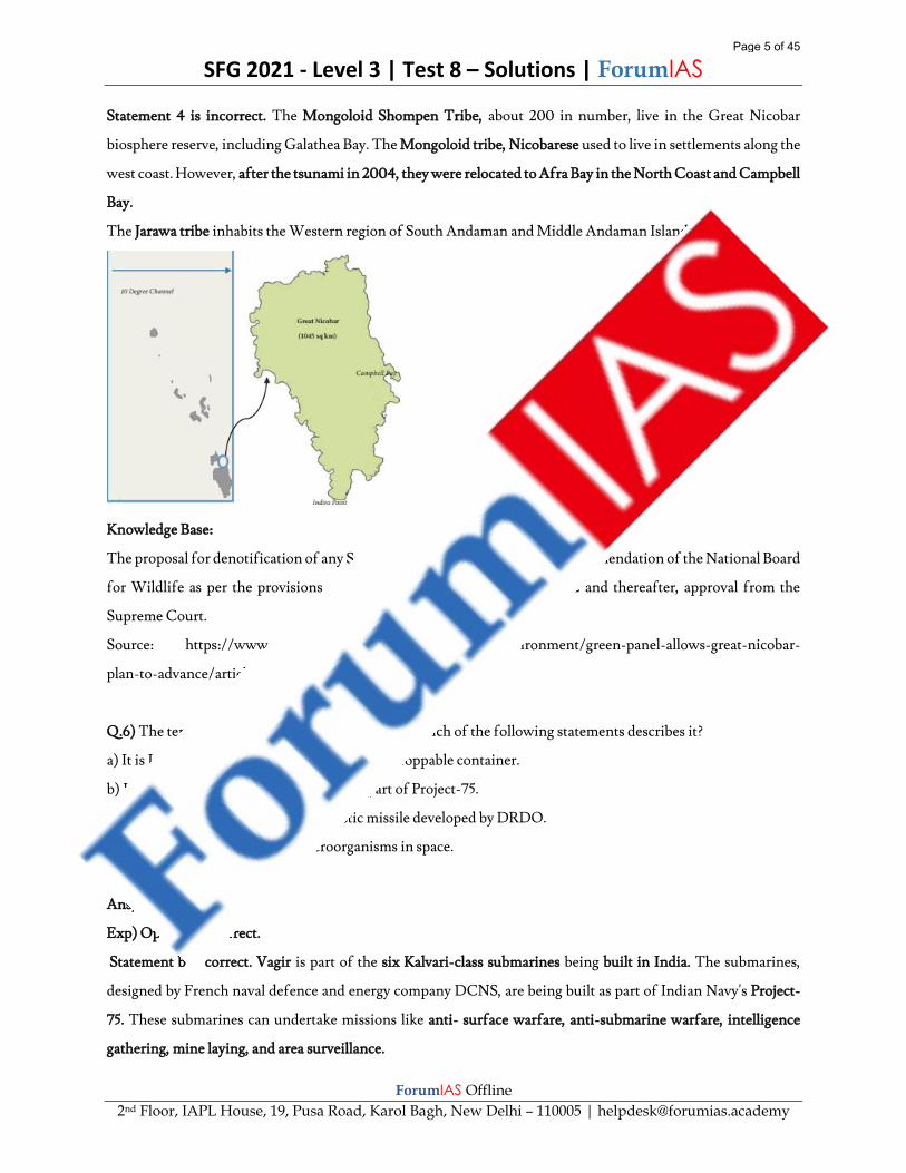
Q.5) Consider the following statements about the Galathea Bay:
1. The bay is located in the Great Nicobar Islands.
2. It is a nesting site of Giant Leatherback turtle species.
3. The entire Galathea Bay Wildlife Sanctuary was recently de-notified.
4. The Jarawas are the indigenous tribes inhabiting near the Galathea Bay.
Which of the statements given above is/are correct?
a) 1 and 2 only
b) 1, 2 and 3 only
c) 2 and 4 only
d) 3 and 4 only
Ans) b
Exp) Option b is correct.
Statement 1 is correct. The Galathea Bay is found adjacent to Galathea National Park in Great Nicobar Island.
Great Nicobar Biosphere Reserve (GNBR), which has been declared as one of the World Network of Biosphere
Reserves by UNESCO, comprises of the Galathea National Park and the Campbell Bay National Park.
Statement 2 is correct. It is an iconic nesting site of the Giant Leatherback, the world’s largest marine turtle, in
India.
Statement 3 is correct. The Standing Committee of the National Board for Wildlife (NBWL) denotified the entire
Galathea Bay Wildlife Sanctuary based on the NITI Aayog’s Great Nicobar Development plan. The plan aims to
promote the holistic development of Greater Nicobar by building port and other related infrastructure.
Page 4 of 45
SFG 2021 - Level 3 | Test 8 – Solutions | ForumIAS
ForumIAS Offline
2nd Floor, IAPL House, 19, Pusa Road, Karol Bagh, New Delhi – 110005 | [email protected]
Statement 4 is incorrect. The Mongoloid Shompen Tribe, about 200 in number, live in the Great Nicobar
biosphere reserve, including Galathea Bay. The Mongoloid tribe, Nicobarese used to live in settlements along the
west coast. However, after the tsunami in 2004, they were relocated to Afra Bay in the North Coast and Campbell
Bay.
The Jarawa tribe inhabits the Western region of South Andaman and Middle Andaman Islands.
Knowledge Base:
The proposal for denotification of any Sanctuary/National Park requires recommendation of the National Board
for Wildlife as per the provisions of the Wild Life (Protection) Act, 1972 and thereafter, approval from the
Supreme Court.
Source: https://www.thehindu.com/sci-tech/energy-and-environment/green-panel-allows-great-nicobar-
plan-to-advance/article34521310.ece
Q.6) The term ‘Vagir’ was seen recently in news, which of the following statements describes it?
a) It is India's first indigenously developed air droppable container.
b) It is a Kalvari-class submarine built as a part of Project-75.
c) It is a close-range air to surface ballistic missile developed by DRDO.
d) It is a nano satellite to study microorganisms in space.
Ans) b
Exp) Option b is correct.
Statement b is correct. Vagir is part of the six Kalvari-class submarines being built in India. The submarines,
designed by French naval defence and energy company DCNS, are being built as part of Indian Navy's Project-
75. These submarines can undertake missions like anti- surface warfare, anti-submarine warfare, intelligence
gathering, mine laying, and area surveillance.
Page 5 of 45
SFG 2021 - Level 3 | Test 8 – Solutions | ForumIAS
ForumIAS Offline
2nd Floor, IAPL House, 19, Pusa Road, Karol Bagh, New Delhi – 110005 | [email protected]
Source: https://economictimes.indiatimes.com/news/defence/indian-navys-fifth-scorpene-class-submarine-
vagir-launched/articleshow/79188295.cms
Q.7) Consider the following pairs:
Lakes States
1. Deepor Beel Assam
2. Tso Kar Lake Sikkim
3. Agastya Lake Karnataka
Which of the pairs given above is/are correctly matched?
a) 1 and 3 only
b) 1 only
c) 2 and 3 only
d) 3 only
Ans) a
Exp) Option a is correct.
Pair 1 is correctly matched. Deepor Beel is located to the south-west of Guwahati city, in Kamrup district of
Assam. It is a permanent freshwater lake and drains into the Brahmaputra river. It was designated a Ramsar site
in 2002 for sustaining a range of aquatic life forms besides 219 species of birds.
Pair 2 is incorrectly matched. The Tso Kar Basin is a high-altitude wetland complex, consisting of two principal
waterbodies, Startsapuk Tso, a freshwater lake of about 438 hectares to the south, and Tso Kar itself, a hypersaline
lake of 1800 hectares to the north, situated in the Changthang region of Ladakh. It is called Tso Kar, meaning
white lake, because of the white salt efflorescence found on the margins due to the evaporation of highly saline
water. India has added Tso Kar Wetland Complex as its 42nd Ramsar site, which is a second one in the Union
Territory (UT) of Ladakh.
Pair 3 is correctly matched. The Agastya Lake is a lake bounded to the south by the Badami Cave Temples and to
the north by the Badami Fort (Karnataka).
Source: https://pib.gov.in/PressReleasePage.aspx?PRID=1683303
https://blog.forumias.com/community-fishing-banned-at-deepor-beel/
Page 6 of 45
SFG 2021 - Level 3 | Test 8 – Solutions | ForumIAS
ForumIAS Offline
2nd Floor, IAPL House, 19, Pusa Road, Karol Bagh, New Delhi – 110005 | [email protected]
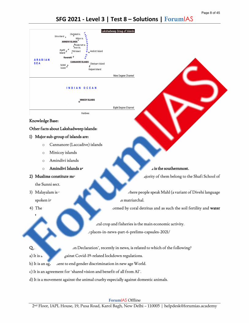
Q.8) With reference to the Lakshadweep islands, consider the following statements:
1. Lakshadweep forms a part of vast submarine mountain ridge together with Maldives and Chagos islands.
2. Nine-degree channel separates the main Lakshadweep archipelago from Minicoy islands.
3. No Particularly Vulnerable Tribal Groups (PVTGs) are identified in Lakshadweep.
4. The entire island has been declared as an organic agricultural area under the Participatory Guarantee System.
Which of the statements given above is/are correct?
a) 1 and 2 only
b) 1, 3 and 4 only
c) 3 and 4 only
d) 1, 2, 3 and 4
Ans) d
Exp) Option d is correct.
Statement 1 is correct. Lakshadweep islands is a group of 36 coral islands located in the Arabian Sea. These are
coral islands located off the coast of Kerala. It is a uni-district Union Territory (UT) and comprises 12 atolls, three
reefs, five submerged banks, and ten inhabited islands.
Maldives, Lakshadweep and Chagos are three island groups in the Indian Ocean that together form a vast
submarine mountain range, the Chagos-Laccadive Plateau.
The Maldives-Lakshadweep-Chagos Archipelago is composed entirely of low atolls, associated coralline
structures, and sandy islands, which have grown upon the crest of the submarine Chagos-Laccadive Ridge.
Statement 2 is correct. Nine-degree channel separates the main Lakshadweep archipelago from Minicoy islands.
It is so named as it lies on the 9-degree Latitude, north of the equator.
Eight-degree channel separates Minicoy group of islands with Maldives. It is so named as it lies on the 8-degree
Latitude, north of the equator.
Statement 3 is correct. The entire indigenous population has been classified as Scheduled Tribes because of their
economic and social backwardness. There are no Scheduled Castes in this Union Territory. Also, there are no
Particularly Vulnerable Tribal Group (PVTGs) found in the area.
Statement 4 is correct. Recently, the entire Lakshadweep group of islands has been declared as an organic
agricultural area under the Participatory Guarantee System (PGS) of India.
Page 7 of 45
SFG 2021 - Level 3 | Test 8 – Solutions | ForumIAS
ForumIAS Offline
2nd Floor, IAPL House, 19, Pusa Road, Karol Bagh, New Delhi – 110005 | [email protected]
Knowledge Base:
Other facts about Lakshadweep islands:
1) Major sub-group of islands are:
o Cannanore (Laccadive) islands
o Minicoy islands
o Amindivi islands
o Amindivi Islands are the northernmost while Minicoy Island is the southernmost.
2) Muslims constitute more than 93% of the population and the majority of them belong to the Shafi School of
the Sunni sect.
3) Malayalam is spoken in all the islands except Minicoy where people speak Mahl (a variant of Divehi language
spoken in the Maldives). The society in all islands is matriarchal.
4) The soils of these islands are structure less, formed by coral detritus and as such the soil fertility and water
holding capacity are extremely poor.
5) Coconut trees are the main agricultural crop and fisheries is the main economic activity.
Source: https://blog.forumias.com/places-in-news-part-6-prelims-capsules-2021/
Q.9) The ‘Great Barrington Declaration’, recently in news, is related to which of the following?
a) It is a movement against Covid-19-related lockdown regulations.
b) It is an agreement to end gender discrimination in new age World.
c) It is an agreement for ‘shared vision and benefit of all from AI’.
d) It is a movement against the animal cruelty especially against domestic animals.
Page 8 of 45
SFG 2021 - Level 3 | Test 8 – Solutions | ForumIAS
ForumIAS Offline
2nd Floor, IAPL House, 19, Pusa Road, Karol Bagh, New Delhi – 110005 | [email protected]
Ans) a
Exp) Option a is correct.
Statement a is correct. As many as 6,000 researchers and health experts and around 50,000 members of the
public have joined hands to start a movement called the Great Barrington Declaration against Covid-19-related
lockdown regulations. It is believed that lockdown policies have debilitating effects on physical, mental well-
being of individuals and can do ‘irreparable damage, with the underprivileged disproportionately harmed. The
movement started in the United States and soon it gained momentum across the world.
Source: https://www.thehindubusinessline.com/news/6000-researchers-health-experts-join-hands-for-anti-
covid-19-lockdown-movement/article32801274.ece
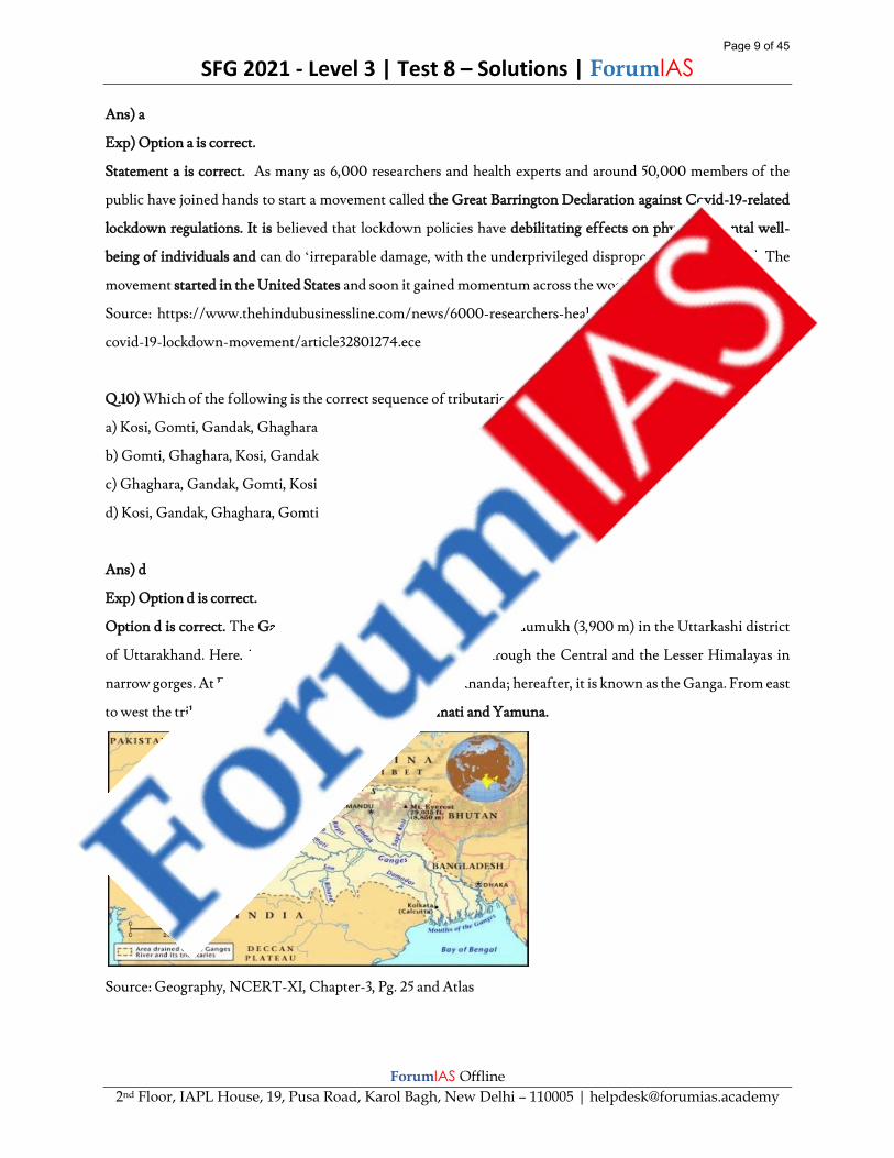
Q.10) Which of the following is the correct sequence of tributaries of Ganga from east to west?
a) Kosi, Gomti, Gandak, Ghaghara
b) Gomti, Ghaghara, Kosi, Gandak
c) Ghaghara, Gandak, Gomti, Kosi
d) Kosi, Gandak, Ghaghara, Gomti
Ans) d
Exp) Option d is correct.
Option d is correct. The Ganga rises in the Gangotri glacier near Gaumukh (3,900 m) in the Uttarkashi district
of Uttarakhand. Here, it is known as the Bhagirathi. It cuts through the Central and the Lesser Himalayas in
narrow gorges. At Devprayag, the Bhagirathi meets the Alaknanda; hereafter, it is known as the Ganga. From east
to west the tributaries of Ganga are: Kosi, Gandak, Gomati and Yamuna.
Source: Geography, NCERT-XI, Chapter-3, Pg. 25 and Atlas
Page 9 of 45
SFG 2021 - Level 3 | Test 8 – Solutions | ForumIAS
ForumIAS Offline
2nd Floor, IAPL House, 19, Pusa Road, Karol Bagh, New Delhi – 110005 | [email protected]
Q.11) Which of the following geological events have shaped the present drainage system of Peninsular India?
1. Slight tilting of the Peninsular block from northwest to the south eastern direction
2. Submergence of the western flank of the Peninsula below the sea
3. Upheaval of the Himalayas
Select the correct answer using the code given below:
a) 1 and 2 only
b) 2 only
c) 2 and 3 only
d) 1, 2 and 3
Ans) d
Exp) Option d is correct.
Option d is correct. Peninsular rivers are characterised by fixed course, absence of meanders and non-perennial
flow of water. Three major geological events in the distant past have shaped the present drainage systems of
Peninsular India:
Statement 1 is correct. Slight tilting of the Peninsular block from northwest to the south eastern direction gave
orientation to the entire drainage system towards the Bay of Bengal during the same period.
Statement 2 is correct. Subsidence of the western flank of the Peninsula leading to its submergence below the sea
during the early tertiary period. Generally, it has disturbed the symmetrical plan of the river on either side of the
original watershed.
Statement 3 is correct. Upheaval of the Himalayas when the northern flank of the Peninsular block was subjected
to subsidence and the consequent trough faulting. The Narmada and the Tapi flow in trough faults and fill the
original cracks with their detritus materials. Hence, there is a lack of alluvial and deltaic deposits in these rivers.
Knowledge Base:
Most of the major peninsular rivers except Narmada and Tapi flow from west to east.
1) The Chambal, the Sind, the Betwa, the Ken, the Son, originating in the northern part of the Peninsula belong
to the Ganga River system.
2) The other major river systems of the peninsular drainage are – the Mahanadi, the Godavari, the Krishna and
the Kaveri.
Source: Geography, NCERT-XI, Chapter-3, Pg. 27
Q.12) With reference to Negative Yield Bonds, consider the following statements:
1. At maturity, the investor receives less money than the original price of the bond.
Page 10 of 45
SFG 2021 - Level 3 | Test 8 – Solutions | ForumIAS
ForumIAS Offline
2nd Floor, IAPL House, 19, Pusa Road, Karol Bagh, New Delhi – 110005 | [email protected]
2. These bonds can used to hedge funds against volatility in the currency's exchange rate.
3. India recently floated negative-yield bonds for the first time in international markets.
Which of the statements given above is/are correct?
a) 1 and 2 only
b) 2 and 3 only
c) 1 only
d) 1, 2 and 3
Ans) a
Exp) Option a is correct.
Statement 1 is correct. A negative bond yield is when an investor receives less money at the bond's maturity than
the original purchase price for the bond. A negative bond yield is an unusual situation in which issuers of debt are
paid to borrow. Negative-yielding bonds are purchased as safe-haven assets in times of turmoil and by pension
and hedge fund managers for asset allocation.
Statement 2 is correct. Many hedge funds and investment firms that manage mutual funds invest in negative
bonds in order to diversify their investment. Foreign investors might believe the currency's exchange rate will
rise, which would minimize the effect of the negative bond yield.
Statement 3 is incorrect. China sold its negative-yield bonds for the first time, and this saw a high demand from
investors across Europe. Majority of the large economies are facing a contraction in their GDP for 2020-21 while
China is one country that is set to witness positive growth of its GDP.
Source: https://www.investopedia.com/terms/n/negative-bond-yield.asp
https://indianexpress.com/article/explained/explained-why-chinas-negative-yield-bonds-are-in-demand-
7063061/
Q.13) With reference to the Pacific decadal oscillation (PDO), consider the following statements:
1. It is a recurring pattern of ocean-atmosphere climate variability centred in the North Pacific Ocean.
2. It is a short-term ocean fluctuation lasting from 6 to 18 months.
3. It is similar to El Nino-Southern Oscillation (ENSO) in character, consisting of a warm and cool phase.
4. It is responsible for deficit in annual rainfall in some parts of India.
Which of the statements given above is/are correct?
a) 3 and 4 only
b) 1, 2 and 3 only
c) 1, 3 and 4 only
Page 11 of 45
SFG 2021 - Level 3 | Test 8 – Solutions | ForumIAS
ForumIAS Offline
2nd Floor, IAPL House, 19, Pusa Road, Karol Bagh, New Delhi – 110005 | [email protected]
d) 1, 2, 3 and 4
Ans) c
Exp) Option c is correct.
Statement 1 is correct. Pacific decadal oscillation (PDO) is a robust, recurring pattern of ocean-atmosphere
climate variability centered over the mid-latitude Pacific basin. The PDO is detected as warm or cool surface
waters in the North Pacific (poleward of 20°N).
Statement 2 is incorrect. Unlike El Nino and La Nina, which may occur every 3 to 7 years and last from 6 to 18
months, the PDO can remain in the same phase for 20 to 30 years. It is a long-term ocean fluctuation of the Pacific
Ocean. The multi-year Pacific Decadal Oscillation ‘cool’ trend can intensify La Nina or diminish El Nino impacts
around the Pacific basin. The shift in the PDO can have significant implications for global climate, affecting
Pacific and Atlantic hurricane activity, droughts and flooding around the Pacific basin, the productivity of marine
ecosystems, and global land temperature patterns.
Statement 3 is correct. The PDO, similar to El Nino-Southern Oscillation (ENSO) in character, like ENSO,
consists of a warm and cool phase which alters upper-level atmospheric winds.
Statement 4 is correct. Rainfall in the Northeast India is largely dependent on monsoon rainfall and the impact
of Pacific decadal oscillation (PDO) is clearly visible in the region in the form of deficit rainfall over the years.
Source: https://earthobservatory.nasa.gov/images/8703/la-nina-and-pacific-decadal-oscillation-cool-the-
pacific
https://blog.forumias.com/why-is-northeast-india-drying-up-rapidly/
Q.14) Which of the following factors are responsible for the increase in number and intensification of cyclones
in the Arabian Sea?
1. Increase in sea surface temperature of Arabian sea.
2. Excess energy availability and moisture in Arabian sea due to global warming.
3. Arabian Sea provides conducive wind shear for cyclones.
4. Increase in frequency of El Nino in the region.
Select the correct answer using the code given below:
a) 1 and 4 only
b) 2, 3 and 4 only
c) 1, 2 and 3 only
d) 1, 2, 3 and 4
Page 12 of 45
SFG 2021 - Level 3 | Test 8 – Solutions | ForumIAS
ForumIAS Offline
2nd Floor, IAPL House, 19, Pusa Road, Karol Bagh, New Delhi – 110005 | [email protected]
Ans) c
Exp) Option c is correct.
The Arabian Sea has been comparatively less prone to cyclonic storms than the Bay of Bengal. In the usual course,
there was an occurrence of one extremely severe cyclone every four-five years in the Arabian Sea. However, the
changing climate and rising global warming have converted the Arabian Sea into a new hotbed for cyclonic
activities.
Statement 1 is correct. Sea surface temperatures in the Arabian Sea have increased rapidly during the past century
due to global warming. Temperature now is 1.2–1.4 °C higher than the temperature witnessed four decades ago.
These warmer temperatures support active convection, heavy rainfall, and intense cyclones.
Statement 2 is correct. The rising temperature is also enabling the Arabian Sea to supply ample energy for the
intensification of cyclones. Currently, seawater up to depths of 50 metres has been very warm that allowed
Cyclone tauktae to become a very severe cyclonic storm (VSCS) in only 2 days.
Storms intensify and sustain depending on the energy availability through heat load in oceans and moisture. The
study has also highlighted that accumulated cyclone energy in Arabian Sea has nearly tripled, indicating the extent
of global warming that it might have undergone in recent years.
Statement 3 is correct. The Arabian Sea is providing conducive wind shear for cyclones. For instance, a higher
level easterly wind drove the depression of Cyclone Ockhi from the Bay of Bengal to the Arabian Sea.
Statement 4 is incorrect. Increase in cyclones is also because of greater occurrence of El Nino Modoki. It is a
climate phenomenon that means ‘pseudo El Niño’ and creates conditions that are not conducive for cyclogenesis
in the Bay of Bengal. However, this condition is conducive for the formation of cyclones in the Arabian Sea.
El Nino is associated with suppressing cyclone formation in the Arabian Sea.
Source: https://blog.forumias.com/why-arabian-sea-is-transforming-into-a-new-cyclonic-hotbed-explained-
pointwise/
https://indianexpress.com/article/explained/explained-in-cyclone-tauktae-a-continuing-new-trend-from-
the-arabian-sea-7317913/
Q.15) Consider the following statements:
1. Hydrological Drought results when the availability of water in different storages falls below what the
precipitation can replenish.
2. Agricultural drought is when the productivity of a natural ecosystem fails due to shortage of water.
Which of the statements given above is/are incorrect?
a) 1 only
b) 2 only
Page 13 of 45
SFG 2021 - Level 3 | Test 8 – Solutions | ForumIAS
ForumIAS Offline
2nd Floor, IAPL House, 19, Pusa Road, Karol Bagh, New Delhi – 110005 | [email protected]
c) Both 1 and 2
d) Neither 1 nor 2
Ans) b
Exp) Option b is correct.
Statement 1 is correct. The term ‘drought’ is applied to an extended period when there is a of water availability
due to inadequate precipitation, excessive rate of evaporation and over-utilization of water from the reservoirs
and other storages, including the ground water. Hydrological drought results when the availability of water in
different storages and reservoirs like aquifers, lakes, reservoirs, etc. falls below what the precipitation can
replenish.
Statement 2 is incorrect. Agricultural drought, also called as soil moisture drought, characterized by low soil
moisture that is necessary to support the crops, thereby resulting in crop failures. Moreover, if an area has more
than 30 per cent of its gross cropped area under irrigation, the area is excluded from the drought-prone category.
Source) NCERT, Indian physical environment, class XI, page no. 89, 90.
Q.16) Which of the following are the reasons for drying up of Northeast India in the last 30 years?
1. Long-term ocean fluctuation of the Pacific Ocean.
2. Northward shift of monsoon trough during summers.
3. Weakening of Bay of Bengal branch of south-west monsoon.
Select the correct answer using the code given below:
a) 1 and 2 only
b) 2 and 3 only
c) 1 and 3 only
d) 1, 2 and 3
Ans) c
Exp) Option c is correct.
Statement 1 is correct. A recent study has concluded that northeast India has been experiencing rapid drying
especially in the last 30 years. This is due to the natural changes associated with the Pacific decadal oscillation
(PDO) in the subtropical Pacific Ocean. The Pacific Decadal Oscillation (PDO) is a long-term ocean fluctuation
of the Pacific Ocean. The PDO waxes and wanes approximately every 20 to 30 years.
Its impact on the sea surface temperatures and its interaction with the atmosphere affects the northeast Indian
summer monsoon.
Page 14 of 45

SFG 2021 - Level 3 | Test 8 – Solutions | ForumIAS
ForumIAS Offline
2nd Floor, IAPL House, 19, Pusa Road, Karol Bagh, New Delhi – 110005 | [email protected]
Statement 2 is incorrect. The intense activity of southwest monsoon season in the region is behind the floods in
Assam.
According to the India Meteorological Department (IMD), there are two reasons for the intense monsoon
activity. First, the northward shift of monsoon trough that runs from north Punjab to northwest Bay of Bengal.
Monsoon rains are generally clustered around such troughs.
Second, the coming together of strong winds from the south and southwest directions carrying moisture from
the Bay of Bengal.
Statement 3 is correct. The Bay of Bengal branch of the south-west monsoon, which brings in all the rainfall to
the region, has been weakening over time. Depression in Bay of Bengal cut off moisture to the entire north-
eastern region, reducing the rainfall and increasing temperatures.
Source: https://www.thehindu.com/sci-tech/science/why-is-northeast-india-drying-up-
rapidly/article27033907.ece
https://www.downtoearth.org.in/news/climate-change/north-eastern-states-live-in-fear-of-drought-61273
Q.17) Consider the following statements:
1. The laterite soils are rich in organic matter but have poor amount of iron oxide.
2. Peaty Soils have high humus and organic content.
3. Forest Soils are loamy in the upper slopes and coarse-grained on valley sides.
Which of the following statements given above is/are correct?
a) 1 and 2 only
b) 2 only
c) 2 and 3 only
d) 1, 2 and 3
Ans) b
Exp) Option b is correct.
Statement 1 is incorrect. The laterite soils develop in areas with high temperature and high rainfall. These are the
result of intense leaching due to tropical rains. These soils are poor in organic matter, nitrogen, phosphate and
calcium, while iron oxide and potash are in excess. Hence, laterites are not suitable for cultivation; however,
application of manures and fertilisers are required for making the soils fertile for cultivation.
Statement 2 is correct. Peaty Soils are found in the areas of heavy rainfall and high humidity, where there is a good
growth of vegetation. Thus, large quantity of dead organic matter accumulates in these areas, and this gives a rich
humus and organic content to the soil. Organic matter in these soils may go even up to 40-50 per cent. These soils
Page 15 of 45
SFG 2021 - Level 3 | Test 8 – Solutions | ForumIAS
ForumIAS Offline
2nd Floor, IAPL House, 19, Pusa Road, Karol Bagh, New Delhi – 110005 | [email protected]
are normally heavy and black in colour. At many places, they are alkaline also. It occurs widely in the northern part
of Bihar, southern part of Uttaranchal and the coastal areas of West Bengal, Orissa and Tamil Nadu.
Statement 3 is incorrect. Forest Soils are formed in the forest areas where sufficient rainfall is available. They are
loamy and silty on valley sides and coarse-grained in the upper slopes. In the snow-bound areas of the Himalayas,
they experience denudation, and are acidic with low humus content. The soils found in the lower valleys are
fertile.
Source: Geography, NCERT XI, Chapter-6, Pg. 71-72
Q.18) The ‘Project Kirana’, recently seen in news, aims at:
a) Providing interest free loans to small traders under the Atmanirbhar Bharat package.
b) Promoting adoption of digital payment methods by women owned kirana shops.
c) Legalizing small kirana shops through registration with the local administration.
d) Providing skill training to Kirana shop owners in small towns.
Ans) b
Exp) Option b is correct.
Project Kirana is a two-year programme, and initially, it will be rolled out in select cities of Uttar
Pradesh, including Lucknow, Kanpur and Varanasi.
Global payments technology major Mastercard has joined hands with development agency USAID for the
Project Kirana that will help increase revenue streams, expand financial inclusion and digital payments adoption
of kirana shops that are owned or operated by women.
The objective of Project Kirana:
1) Build financial and digital literacy skills;
2) Improve basic business management skills including inventory management, accounting, budget
management and customer loyalty;
3) Addressing cultural and other barriers to women becoming successful Kirana entrepreneurs;
4) It will work to increase revenue streams, expand financial inclusion and digital payments adoption of Kirana
shops that are owned or operated by women.
Source: Mastercard, USAID join hands for Project Kirana to empower women through financial inclusion
(livemint.com).
mastercard: Mastercard and USAID partner to launch ‘Project Kirana’ for women entrepreneurs - The Economic
Times (indiatimes.com).
Page 16 of 45

SFG 2021 - Level 3 | Test 8 – Solutions | ForumIAS
ForumIAS Offline
2nd Floor, IAPL House, 19, Pusa Road, Karol Bagh, New Delhi – 110005 | [email protected]
Q.19) Consider the following events in the geological history of India:
1. Formation of Gondwana coal
2. Formation of Himalayas
3. Marine transgression in western India
4. Formation of Deccan traps
What is the correct chronological order of the above events, starting from the earliest time?
a) 4 – 3 – 1 – 2
b) 3 – 1 – 4 – 2
c) 1 – 3 – 4 – 2
d) 1 – 4 – 2 – 3
Ans) c
Exp) Option c is correct.
Some of the important events in the recent geological history of India from earliest to latest time are:
1) Formation of ‘basement complex’ (Pre-Cambrian) – formation of the stable shield like region that forms the
base of Indian land mass.
2) Formation of Gondwana rock system
3) Marine transgression in western India (Jurassic) – It led to deposition of thick series of shallow water deposits
in Rajasthan and Gujarat.
4) Formation of Deccan traps (Cretaceous) – Series of basaltic lava flows took place when Indian plate passed
over a volcanic hotspot.
5) Formation of Himalayas (Tertiary) due to collision of Indian plate with Eurasian plate.
6) Formation of Indo-Gangetic plains (Quaternary)
Source: https://www.patnauniversity.ac.in/e-content/social_sciences/geography/MAGeog30.pdf
Q.20) With reference to the mangrove vegetation, consider the following:
1. The mangroves are mainly found between latitudes 25 °N and 25 °S.
2. In general soil substratum in mangrove is characterized by fine grained sediments with high organic content.
3. Rising sea level will act as a blessing in disguise for mangroves expansion.
4. Pichavaram mangrove forest is located between the Vellar and Coleroon Estuaries.
Which of the statements given above is/are correct?
a) 1 and 3 only
b) 2, 3 and 4 only
Page 17 of 45

SFG 2021 - Level 3 | Test 8 – Solutions | ForumIAS
ForumIAS Offline
2nd Floor, IAPL House, 19, Pusa Road, Karol Bagh, New Delhi – 110005 | [email protected]
c) 1, 2 and 3 only
d) 1,2 and 4 only
Ans) d
Exp) Option d is correct.
Statement 1 is correct. Mangroves are not found everywhere. They are found only in the tropical and subtropical
regions, mainly between latitudes 25 °N and 25 °S. They grow along the land–sea interface, in bays, estuaries,
lagoons, and backwaters.
Statement 2 is correct. Mangrove soil composes of coarse sand (~ 4%), fine sand (~48%), silt (~31%), Clay (~4%).
In general soil substratum in mangrove is characterized by low oxygen, high salt content and fine-grained
sediments with high organic content.
Statement 3 is incorrect. Sea level rise is a major potential climate change threat to mangrove ecosystems, because
mangroves are sensitive to changes in inundation duration and frequency as well as salinity levels that exceed a
species-specific physiological threshold of tolerance.
Statement 4 is correct. The Pichavaram mangrove ecosystem is located between the Vellar and Coleroon
Estuaries in TamilNadu. It is home to 200 species of birds as well as seaweed, prawns, crabs, fish, oysters, turtles
and otters.
Knowledge Base: According to the Forest Survey of India, 2019, Mangroves’ cover in the country has increased
by 54 sq km (91.10 percent) in comparison to the 2017 assessment.
Source: https://portals.iucn.org/library/sites/library/files/documents/2010-041.pdf
https://forest.goa.gov.in/sites/default/files/ch3_man.pdf
https://www.mangrovealliance.org/news/mangrove-cover-is-on-the-rise-in-india/
http://164.100.117.97/WriteReadData/userfiles/ISFR2019%20Vol-I.pdf
https://www.theverge.com/2020/6/4/21280580/sea-level-rise-mangroves-climate-change-2050
https://esajournals.onlinelibrary.wiley.com/doi/10.1002/ehs2.1211
Q.21) Regarding the implementation of India’s first Green Energy Convergence Project, consider the following
statements:
1. It primarily aims to generate renewable energy for rural consumption.
2. The project involves the establishment of decentralized solar power plants.
3. Under the project, agriculture pumps will be distributed to farmers.
Which of the statements given above is/are correct?
a) 1 only
Page 18 of 45
SFG 2021 - Level 3 | Test 8 – Solutions | ForumIAS
ForumIAS Offline
2nd Floor, IAPL House, 19, Pusa Road, Karol Bagh, New Delhi – 110005 | [email protected]
b) 1 and 2 only
c) 2 and 3 only
d) 1, 2 and 3
Ans) d
Exp) Option d is correct.
Statement 1 is correct. India’s first convergence project to generate green energy for rural and agriculture
consumption is set to come up in the state of Goa.
Energy Efficiency Services Limited (EESL) and the Government of Goa, have signed a memorandum of
understanding for rolling out of India’s first Convergence Project in the State. Through its convergence initiative,
EESL seeks to connect seemingly independent sectors like Solar Energy, Energy Storage and LED lights to
provide solutions, which can enable in decarbonisation and affordable energy access.
Statements 2 and 3 are correct. Under the project, EESL shall implement the solar energy projects, which include
- establishment of 100 MW of decentralized ground mounted Solar Power projects on government lands to be
used for agricultural pumping, replace approximately 6,300 agricultural pumps with BEE star rated energy
efficient pumps and distribute approximately 16 Lakh LED bulbs for rural domestic households.
Source: What is India’s first Green Energy Convergence Project? – The Leading Solar Magazine In India
(eqmagpro.com)
Q.22) With reference to the forest types, consider the following:
1. Parkland landscape in India can be seen in Tropical thorn forests.
2. Dry deciduous forests are found in regions having annual rainfall less than 50 cm.
3. Shola forests are found at the base of Southern Western Ghat mountains.
Which of the statements given above is/are incorrect?
a) 1 and 2 only
b) 2 and 3 only
c) 1 and 3 only
d) 1, 2 and 3
Ans) d
Exp) Option d is correct.
Statement 1 is incorrect. Dry deciduous forest covers vast areas of the country, where rainfall ranges between 70
-100 cm. These forests are found in rainier areas of the Peninsula and the plains of Uttar Pradesh and Bihar. In
Page 19 of 45
SFG 2021 - Level 3 | Test 8 – Solutions | ForumIAS
ForumIAS Offline
2nd Floor, IAPL House, 19, Pusa Road, Karol Bagh, New Delhi – 110005 | [email protected]
the higher rainfall regions of the Peninsular plateau and the northern Indian plain, these forests have a parkland
landscape with open stretches in which teak and other trees interspersed with patches of grass are common.
Statement 2 is incorrect. Dry deciduous forest covers vast areas of the country, where rainfall ranges between 70
-100 cm.
Tropical thorn forests occur in the areas which receive rainfall less than 50 cm. These consist of a variety of grasses
and shrubs.
Statement 3 is incorrect. The shola forest-grassland is the tropical montane forest found in the upper reaches of
India’s Western Ghats. This mosaic ecosystem is native only to the southern Western Ghats and found in the
high altitude mountains of Kerala, Tamil Nadu and Karnataka. This is a unique system where the vast grassland
is interspersed with the forest. The forest is made up of evergreen native trees which are dwarf in nature and the
hill slopes are covered with native grass species. The vegetation is double layered storey with closed canopy. These
ecosystems have high water retention capacity, absorb rains and retain them within their soil.
Knowledge Base: Natural vegetation refers to a plant community that has been left undisturbed over a long time,
so as to allow its individual species to adjust themselves to climate and soil conditions as fully as possible.
Source: NCERT Class 11 India Physical Environment Ch:5 Natural Vegetation
https://www.downtoearth.org.in/blog/forests/why-south-india-needs-the-shola-forests-of-the-nilgiris-68948
https://www.intechopen.com/chapters/74357
Q.23) Which of the following rivers are the tributaries of Krishna River?
1. Koyna
2. Bhima
3. Kabini
4. Bhavani
5. Manjra
6. Tungabhadra
Select the correct answer using the code given below:
a) 2, 3, 5 and 6 only
b) 3, 4 and 6 only
c) 1, 2 and 6 only
d) 1, 2, 3, 5 and 6 only
Ans) c
Exp) Option c is correct.
Page 20 of 45
SFG 2021 - Level 3 | Test 8 – Solutions | ForumIAS
ForumIAS Offline
2nd Floor, IAPL House, 19, Pusa Road, Karol Bagh, New Delhi – 110005 | [email protected]
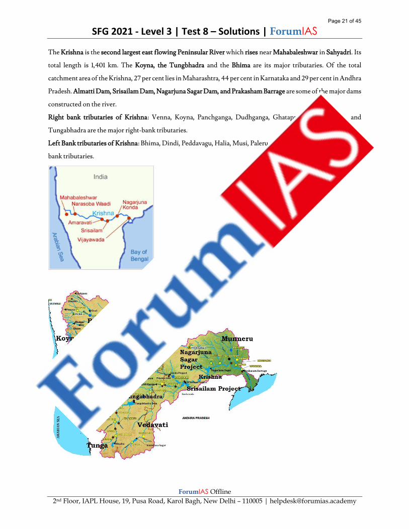
The Krishna is the second largest east flowing Peninsular River which rises near Mahabaleshwar in Sahyadri. Its
total length is 1,401 km. The Koyna, the Tungbhadra and the Bhima are its major tributaries. Of the total
catchment area of the Krishna, 27 per cent lies in Maharashtra, 44 per cent in Karnataka and 29 per cent in Andhra
Pradesh. Almatti Dam, Srisailam Dam, Nagarjuna Sagar Dam, and Prakasham Barrage are some of the major dams
constructed on the river.
Right bank tributaries of Krishna: Venna, Koyna, Panchganga, Dudhganga, Ghataprabha, Malaprabha and
Tungabhadra are the major right-bank tributaries.
Left Bank tributaries of Krishna: Bhima, Dindi, Peddavagu, Halia, Musi, Paleru, and Munneru are the major left-
bank tributaries.
Page 21 of 45

SFG 2021 - Level 3 | Test 8 – Solutions | ForumIAS
ForumIAS Offline
2nd Floor, IAPL House, 19, Pusa Road, Karol Bagh, New Delhi – 110005 | [email protected]
Kabini and Bhavani are tributaries of Kaveri River.
Manjra is tributary of Godavari River.
Knowledge Base: Godavari River is called the ganga of south or dakshin ganga.
Source: NCERT Class 11 India Physical Environment Ch:3 Drainage System
https://www.britannica.com/place/Krishna-River
India: A Comprehensive Geography by D.R.Khullar
Q.24) Consider the following statements with reference to the protection of wild animals in India:
1. In India, 'exotic animals' are defined under the Wild Life (Protection) Act, 1972.
2. Indian laws prohibit the export or import of any 'exotic animal'.
Which of the statements given above is/are correct?
a) 1 only
b) 2 only
c) Both 1 and 2
d) Neither 1 nor 2
Ans) d
Exp) Option d is correct.
Statement 1 is incorrect. Recently, the Ministry of Environment, Forest and Climate Change (MoEFCC) has
come out with an advisory on exotic animal. The advisory has defined exotic live species as those animals that are
mentioned under the Appendices I, II and III of the CITES. The term 'exotic animal' is not defined under the
Wild Life (Protection) Act 1972. The advisory excludes exotic birds from the amnesty scheme.
Statement 2 is incorrect. Indian laws do not prohibit the export or import of 'exotic animals'. A person trying to
import a live exotic animal will have to submit an application for grant of a licence to the Director-General of
Foreign Trade (DGFT), under the Ministry of Commerce and Industry. The importer will also have to attach
a No Objection Certificate (NOC) of the chief wildlife warden of the state concerned along with the application.
Source: Environment ministry issues advisory to import live exotic animals (downtoearth.org.in)
Declare exotic pets, avoid prosecution: how one-time scheme works (forumias.com)
Q.25) Which of the following pairs have been correctly matched?
Plains Region
1. Barind West of Ghaghara
River.
Page 22 of 45

SFG 2021 - Level 3 | Test 8 – Solutions | ForumIAS
ForumIAS Offline
2nd Floor, IAPL House, 19, Pusa Road, Karol Bagh, New Delhi – 110005 | [email protected]
2. Mithila East of Gandak and
north of Ganga.
3. Magadh East of Son and
south of Ganga
Select the correct answer using the code given below:
a) 1 and 2 only
b) 2 and 3 only
c) 1 and 3 only
d) 1, 2 and 3
Ans) b
Exp) Option b is correct.
Pair 1 is incorrectly matched. Barind plain is a division of Indo-Gangetic plains, a tract of old alluvium between
the Kosi-Mahananda corridor in the west and the river Sankosh in the east. It forms a part of the lower ganga
plain. It lies in the state of West Bengal.
Pair 2 is correctly matched. Mithila is a geographical and cultural region of the Indian subcontinent bounded by
the Mahananda River in the east, the Ganges in the south, the Gandaki River in the west and by the foothills of
the Himalayas in the north. It comprises certain parts of Bihar of India and adjoining districts of the eastern Terai
of Nepal.
Pair 3 is correctly matched. Magadh plain is the area lying in modern day Bihar that is east of the Son and south of
Ganga river and part of middle ganga plains.
Source: India: A Comprehensive Geography by D.R.Khullar
Q.26) With reference to the molasses basin, which of the following statements is correct?
a) It can be found in the north eastern states.
b) It refers to a physical landform made up of soft unconsolidated deposits.
c) It refers to the basins in the longitudinal valleys formed as a result of folding.
d) They are the alluvial floodplains that lie south of the outer foothills of the Himalayas.
Ans) b
Exp) Option b is correct.
Statement a is incorrect. Molassis basin in India is generally found in the state of Mizoram.
Page 23 of 45

SFG 2021 - Level 3 | Test 8 – Solutions | ForumIAS
ForumIAS Offline
2nd Floor, IAPL House, 19, Pusa Road, Karol Bagh, New Delhi – 110005 | [email protected]
Statement b is correct. Molassis basin is made up of soft unconsolidated deposits.
Statement c is incorrect. Duns refers to the longitudinal valleys formed as a result of folding when Eurasian plate
and Indian plate collided. Example like Dehradun.
Statement d is incorrect. Duars are the alluvial floodplains in eastern-northeastern India that lie south of the outer
foothills of the Himalayas and north of the Brahmaputra River basin. They are good for tea gardens.
Source: NCERT Class 11 India Physical Environment Ch:2 Structure and Physiography
Q.27) With reference to the 'Bru community', which one of the following statements is incorrect?
a) The community is recognized as a Particularly Vulnerable Tribal Group in Tripura.
b) The Hojagiri folk dance is the popular dance of the Bru community.
c) Bru tribes are found in all the North-eastern states except Mizoram.
d) The most popular festival of the Bru tribe is Buisu.
Ans) c
Exp) Option c is incorrect.
Option a is correct. Brus or Reang is a community indigenous to Northeast India living mostly in Tripura,
Mizoram and Assam. In Tripura, they are recognised as a Particularly Vulnerable Tribal Group.
Option b is correct. The Hojagiri folk dance of the Reang sub tribe is well known all over the world. It is performed
by women and young girls, about 4 to 6 members in a team, singing, balancing on an earthen pitcher and managing
other props such as a bottle on the head and earthen lamp on the hand, while only the lower half of the body is
moved.
Option c is incorrect. The Brus, aka Reangs, are spread across Tripura, Mizoram and southern Assam. In
Mizoram, they are scattered in Kolasib, Lunglei and Mamit districts. While many Brus of Assam and Tripura are
Hindu, the Brus of Mizoram converted to Christianity over the years.
Option d is correct. The most popular festival of the Bru tribes is Buisu. It is one of the ancient Tripuri festivals
celebrated with lot of joy and enthusiasm in every Tripuri household. The word buisu has been derived from the
Tripuri language Kokborok root word bisi which means a year.
Knowledge Base: Bru community, fled from Mizoram to Tripura in 1997 in the wake of inter-community
violence. Over 5,000 Bru families, displaced from Mizoram, are currently housed in temporary camps in Tripura.
Many of them are set to be repatriated to Mizoram from Tripura after a tripartite agreement signed between the
Centre, Tripura and Mizoram.
Source: Brus reject resettlement sites proposed by Tripura non-Brus -ForumIAS Blog
Page 24 of 45
SFG 2021 - Level 3 | Test 8 – Solutions | ForumIAS
ForumIAS Offline
2nd Floor, IAPL House, 19, Pusa Road, Karol Bagh, New Delhi – 110005 | [email protected]
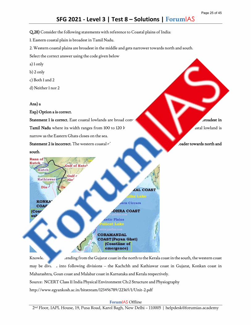
Q.28) Consider the following statements with reference to Coastal plains of India:
1. Eastern coastal plain is broadest in Tamil Nadu.
2. Western coastal plains are broadest in the middle and gets narrower towards north and south.
Select the correct answer using the code given below
a) 1 only
b) 2 only
c) Both 1 and 2
d) Neither 1 nor 2
Ans) a
Exp) Option a is correct.
Statement 1 is correct. East coastal lowlands are broad compared to the western lowlands and it is broadest in
Tamil Nadu where its width ranges from 100 to 120 km. North of the Godawari Delta the coastal lowland is
narrow as the Eastern Ghats closes on the sea.
Statement 2 is incorrect. The western coastal plains are narrow in the middle and get broader towards north and
south.
Knowledge Base: Extending from the Gujarat coast in the north to the Kerala coast in the south, the western coast
may be divided into following divisions – the Kachchh and Kathiawar coast in Gujarat, Konkan coast in
Maharashtra, Goan coast and Malabar coast in Karnataka and Kerala respectively.
Source: NCERT Class 11 India Physical Environment Ch:2 Structure and Physiography
http://www.egyankosh.ac.in/bitstream/123456789/22365/1/Unit-2.pdf
Page 25 of 45
SFG 2021 - Level 3 | Test 8 – Solutions | ForumIAS
ForumIAS Offline
2nd Floor, IAPL House, 19, Pusa Road, Karol Bagh, New Delhi – 110005 | [email protected]
Q.29) With reference to the important glaciers in the Himalayas, consider the following:
1. Bara shigri glacier is the source for Jhelum River.
2. Bandarpunch glacier is located in the gharwal division of the Himalayas.
3. Milam glacier is located in Kumaon Himalayas.
Which of the statements given above is/are correct?
a) 1 and 2 only
b) 2 and 3 only
c) 1 and 3 only
d) 1, 2 and 3
Ans) b
Exp) Option b is correct.
Statement 1 is incorrect. Bara Shigri feeds the Chandra River which after its confluence at Tandi with the Bhaga
River is known as Chandrabhaga or Chenab. Bara Shigri glacier lies on the northern slopes of the main Pir Panjal
Range of the Inner Himalayas.
Statement 2 is correct. Bandarpunch is a mountain massif of the Garhwal division of the Himalayas, in the Indian
state of Uttarakhand. The name literally means "tail of the monkey". Bandarpunch is located at the western edge
of the high Himalayan range where it turns the corner to the northwest. It is part of the Sankari Range and lies
within the Govind Pashu Vihar National Park and Sanctuary. It is a major watershed for the headwaters of the
Yamuna River, whose source lies above Yamunotri, on the west end of the massif below White Peak.
Statement 3 is correct. Milam Glacier is a major glacier of the Kumaon Himalaya. The glacier is the source of the
Goriganga River.
Knowledge Base: A glacier is a large, perennial accumulation of crystalline ice, snow, rock, sediment, and often
liquid water that originates on land and moves down slope under the influence of its own weight and gravity.
Source: https://www.thehindubusinessline.com/blink/cover/find-me-a-glacier/article24054615.ece
http://www.uttaranchaltourism.in/glaciers-of-uttaranchal.html
https://hplahaulspiti.nic.in/glaciers/
http://kumaon.gov.in/pages/display/76-milam-glacier
Q.30) Consider the following statements, regarding RT-PCR tests:
1. It is used to detect pathogens, such as viruses and bacteria, that already contain DNA for amplification.
2. It can be used to detect past infections in order to understand the development and spread of the virus.
Page 26 of 45

SFG 2021 - Level 3 | Test 8 – Solutions | ForumIAS
ForumIAS Offline
2nd Floor, IAPL House, 19, Pusa Road, Karol Bagh, New Delhi – 110005 | [email protected]
Which of the statements given above is/are correct?
a) 1 only
b) 2 only
c) Both 1 and 2
d) Neither 1 nor 2
Ans) d
Exp) Option d is correct.
Statement 1 is incorrect. RT–PCR is a variation of PCR, or polymerase chain reaction. The two techniques use
the same process except that RT–PCR has an added step of reverse transcription of RNA to DNA, or RT, to allow
for amplification. This means PCR is used for pathogens, such as viruses and bacteria, that already contain DNA
for amplification, while RT–PCR is used for those containing RNA that needs to be transcribed to DNA for
amplification.
Statement 2 is incorrect. Real time RT–PCR cannot be used to detect past infections, which is important for
understanding the development and spread of the virus, as viruses are only present in the body for a specific
window of time.
Knowledge Base: PCR is one of the most widely used diagnostic tests for detecting pathogens, including viruses,
that cause diseases such as Ebola, African swine fever and foot-and-mouth disease. Since the COVID-19 virus
only contains RNA, real time or conventional RT–PCR is used to detect it.
Source: How is the COVID-19 Virus Detected using Real Time RT-PCR? | IAEA
Q.31) Which of the following statements is correct with reference to Teesta River?
a) The river originates in Tibet.
b) It drains directly into the Bay of Bengal.
c) Subansiri and Dhansiri are the tributaries of Teesta River.
d) The hill station of Kalimpong is situated at the banks of this river.
Ans) d
Exp) Option d is correct.
Statement a is incorrect. The Teesta River originates from the Pahunri or Zemu or Teesta Kangse glacier near
Chunthang, Sikkim and flows southward through gorges and rapids in the Sikkim Himalaya.
Statement b is incorrect. It does not drain directly into the Bay of Bengal but it joins Brahmaputra in Bangladesh.
Page 27 of 45

SFG 2021 - Level 3 | Test 8 – Solutions | ForumIAS
ForumIAS Offline
2nd Floor, IAPL House, 19, Pusa Road, Karol Bagh, New Delhi – 110005 | [email protected]
Statement c is incorrect. Subansiri and Dhansiri are the tributaries of Brahmaputra River and not Teesta River.
Rangeet and Rangpo are the main tributaries of Teesta River.
Statement d is correct. The hill station of Kalimpong in the state of West Bengal is situated at the banks of Teesta
River.
Knowledge Base: There is river water sharing dispute going on over Teesta River between India and Bnagladesh.
Source: https://www.darjeeling-tourism.com/darj_000171.htmv
India: A Comprehensive Geography by D.R.Khullar
Q.32) This national park is situated at high altitude. Conditions are generally dry with low annual precipitation,
but there is heavy monsoon rainfall from late June to early September. Prevailing mist and low cloud during the
monsoon keep the soil moist, hence the vegetation is lusher than is usual in the drier inner Himalayan valleys. It
lies completely in the temperate alpine zone.
Identify the national park from the above paragraph.
a) Jim Corbett National Park
b) Valley of Flowers National Park
c) Namdapha National Park
d) Keibul Lamjao National Park
Ans) b
Exp) Option b is correct.
Statement a is incorrect. The Jim corbett national park is part of the sub-Himalayan ecosystem. The elevation of
the park fluctuates between 1,300 feet to 4,000 feet (400 to 1,220 m) above sea level. The elevation brings cooler
evenings; however, the day delivers outstanding temperatures to explore the region. The elevation variations
deliver an array of ravines, plateaus, ridges, valleys, streams and rivers. Almost three-quarters of the park is
encompassed by deciduous forest including peepal, rohini, and mango trees.
Statement b is correct. Valley of Flowers National Park is an Indian national park, located in the state of
Uttarakhand and is known for its meadows of endemic alpine flowers and the variety of flora. It is located next
to the Nanda Devi national park and together they encompass a unique transition zone between the mountain
ranges of the Zanskar and Great Himalaya. The Park lies completely in the temperate alpine zone. Both parks are
encompassed in the Nanda Devi Biosphere Reserve.
Statement c is incorrect. Namdapha NP is located in Arunachal Pradesh. It is a biodiversity hotspot in the Eastern
Himalayas. The national park harbours the northernmost lowland evergreen rainforests in the world at 27°N
latitude. It falls within the geographical sub-tropical zone and enjoys the sub-tropical climate. However, the
Page 28 of 45

SFG 2021 - Level 3 | Test 8 – Solutions | ForumIAS
ForumIAS Offline
2nd Floor, IAPL House, 19, Pusa Road, Karol Bagh, New Delhi – 110005 | [email protected]
climate of the area varies from place to place inside the Protected Area due to variation of altitude from 200 m to
4571m and the area also being the zone of heavy rainfall. The mountainous part of the area enjoys what is known
as mountain type of climate while the low-lying plains and valleys experience tropical climate.
Statement d is incorrect. Keibul Lamjao NP is located in Manipur and is famous for sangai deer and phumdi grass.
Loktak lake is also there. Climate is pleasant with neither excessively cold winters nor hot summers.
Knowledge Base:
Source: http://www.ecoindia.com/parks/dachigam-national-park.html
https://changlang.nic.in/namdapha-national-park/
https://uttarakhandtourism.gov.in/destination/valley-of-flowers
https://whc.unesco.org/en/tentativelists/6086/
Q.33) “The virus is generally carried by rats. It can be transmitted through direct contact with the infected rodent,
its urine and droppings or through contact with an infected person. It is caused by the same arenavirus family that
is responsible for illnesses such as the Ebola virus disease. It was first discovered in 2004 in Bolivian province.”
Which one of the following viruses is correctly described in the above paragraph?
a) Monkey B virus
b) Chapare virus
c) Nipah Virus
Page 29 of 45

SFG 2021 - Level 3 | Test 8 – Solutions | ForumIAS
ForumIAS Offline
2nd Floor, IAPL House, 19, Pusa Road, Karol Bagh, New Delhi – 110005 | [email protected]
d) Zika Virus
Ans) b
Exp) Option b is correct.
Chapare Virus - It is caused by the same arenavirus family that is responsible for illnesses such as the Ebola virus
disease (EVD). It was first discovered in 2004 in Bolivian province of Chapare, from where it gets its name.
Though it disappeared in 2004, an outbreak last year infected at least five people. Chapare virus are generally
carried by rats and can be transmitted through direct contact with the infected rodent, its urine and droppings or
through contact with an infected person. Some symptoms of Chapare are fever, abdominal pain, vomiting,
bleeding gums, skin rash and pain.
Option a is incorrect. Monkey B virus is an alpha herpesvirus enzootic in macaques of the genus Macaca. B virus
is the only identified old-world-monkey herpesvirus that displays severe pathogenicity in humans. The infection
can be transmitted via direct contact and exchange of bodily secretions of monkeys and has a fatality rate of 70
per cent to 80 per cent.
Option c is incorrect. Nipah virus (NiV) is a zoonotic virus, meaning that it can spread between animals and
people. Fruit bats, also called flying foxes, are the animal reservoir for NiV in nature. Nipah virus is also known
to cause illness in pigs and people.
Option d is incorrect. The Zika virus is most often spread to people through mosquito bites. Symptoms are
generally mild and include fever, rash, conjunctivitis, muscle and joint pain, malaise or headache. Symptoms
typically last for 2–7 days. Most people with Zika virus infection do not develop symptoms.
Source: Factly articles for November 19, 2020 | | Factly (forumias.com)
Zika virus -ForumIAS Blog
What is Monkey B virus? (indianexpress.com)
Q.34) Which of the following pairs are correctly matched?
River Waterfall
1. Narmada Dudhsagar falls
2. Mondovi Dhuandhar falls
3. Kaveri Shivasamundram
falls
4. Sharavati Jog falls
Page 30 of 45
SFG 2021 - Level 3 | Test 8 – Solutions | ForumIAS
ForumIAS Offline
2nd Floor, IAPL House, 19, Pusa Road, Karol Bagh, New Delhi – 110005 | [email protected]
Select the correct answer using the code given below:
a) 1 and 2 only
b) 2 and 4 only
c) 1 and 3 only
d) 3 and 4 only
Ans) d
Exp) Option d is correct.
Pair 1 is incorrectly matched. The Dhuandhar Falls are located on Narmada River in Bhedaghat and are 30 meters
high. The Narmada River, making its way through the world-famous Marble Rocks, narrows down and then
plunges in a waterfall known as Dhuandhaar.
Pair 2 is incorrectly matched. The Dudhsagar falls is located on Mondovi river in Goa in the Bhagwan Mahaveer
Sanctuary and Mollem National Park among the Western Ghats.
Pair 3 is correctly matched. Shivanasamudra Falls is a waterfall in Chamarajanagar district of the state of
Karnataka, India. It is situated along the river Kaveri. The island town of Shivanasamudra divides the river into
twin waterfalls.
Pair 4 is correctly matched. Jog Falls is a waterfall on the Sharavati river located in the Western Ghats Uttara
Kannada district of Karnataka. Associated with the waterfall is the nearby Linganamakki Dam across the
Sharavati River.
Knowledge Base: Angel Falls in Venezuela is the highest waterfall in the world.
Source: https://www.karnataka.com/shimoga/jog-falls/
https://www.karnataka.com/mysore/shivanasamudra-falls/
https://jabalpur.nic.in/en/tourist-place/dhuadhar-water-fall/
https://www.goa-tourism.com/waterfall_tour
Q.35) With reference to the Indian monsoon and its linkages with various geographical phenomenon, consider
the following:
1. The presence of the high-pressure area, east of Madagascar creates favorable conditions for monsoon.
2. Southward migration of monsoon trough results in active/vigorous monsoon over major part of India.
3. Strengthening of Somali jet gives rise to strong monsoon over peninsular India.
Which of the statements given above is/are correct?
a) 1 and 2 only
b) 2 and 3 only
Page 31 of 45

SFG 2021 - Level 3 | Test 8 – Solutions | ForumIAS
ForumIAS Offline
2nd Floor, IAPL House, 19, Pusa Road, Karol Bagh, New Delhi – 110005 | [email protected]
c) 1 and 3 only
d) 1, 2 and 3
Ans) d
Exp) Option d is correct.
Statement 1 is correct. The presence of the high-pressure area, east of Madagascar, approximately at 20°S over the
Indian Ocean. The intensity and position of this high-pressure area affects the Indian Monsoon.
Statement 2 is correct. Monsoon Trough is an elongated low-pressure area which extends from heat low over
Pakistan to Head Bay of Bengal. Monsoon trough may be a characteristic of east west orientation of Himalayan
ranges and north south orientation of Khasi-Jaintia Hills. Southward migration of monsoon trough results in
active/vigorous monsoon over major part of India. In contrast, the northward migration of this trough leads to
break monsoon condition over major part of India and heavy rains along foothills of Himalayas and sometimes
floods in Brahmaputra River.
Statement 3 is correct. Somali jet is low level (1 to 1.5 km asl) inter hemispheric cross equatorial flow of air, attains
Jet speed at the west end of monsoon regime along the east coast of Africa. This Jet originates near Mauritius and
northern part of Madagascar in the southern Hemisphere.
During May, it moves further into eastern Africa, then into Arabian sea and reaches west coast of India in June.
It attains maximum strength in July. Short period (8-10 days) fluctuations are observed in Low Level Jet stream.
Its strengthening gives rise to strong monsoon over peninsular India.
Knowledge Base: It has also been noticed that changes in the pressure conditions over the southern oceans also
affect the monsoons. Normally when the tropical eastern south Pacific Ocean experiences high pressure, the
tropical eastern Indian Ocean experiences low pressure. But in certain years, there is a reversal in the pressure
conditions and the eastern Pacific has lower pressure in comparison to the eastern Indian Ocean. This periodic
change in pressure conditions is known as the Southern Oscillation or SO. A feature connected with the SO is
the El Nino phenomenon in which a warm ocean current that flows past the Peruvian Coast, in place of the cold
Peruvian current, every 2 to 5 years. The changes in pressure conditions are connected to the El Nino. Hence, the
phenomenon is referred to as ENSO (El Nino Southern Oscillations).
Source: NCERT geography class IX – Ch-4 Climate
https://mausam.imd.gov.in/imd_latest/monsoonfaq.pdf
Page 32 of 45
SFG 2021 - Level 3 | Test 8 – Solutions | ForumIAS
ForumIAS Offline
2nd Floor, IAPL House, 19, Pusa Road, Karol Bagh, New Delhi – 110005 | [email protected]
Q.36) Consider the following pairs:
Space Mission Objective/Purpose
1. Chang’e-4
mission
To study the
Martian
atmosphere and
geology.
2. Ariel Space
mission
To observe
exoplanets through
space telescope
3. Sentinel-3
mission
To survey the
terrain and
landforms of
moon.
Which of the pairs given above is/are correctly matched?
a) 1 and 2 only
b) 2 only
c) 3 only
d) 2 and 3 only
Ans) b
Exp) Option b is correct.
Pair 1 is incorrectly matched. Chang’e-4 mission, launched by China, is a robotic spacecraft mission with an aim
of surveying the terrain and landforms of lunar surface, detecting the mineral composition, shallow lunar surface
structure and measuring the neutron radiation and neutral atoms to study the environment.
Pair 2 is correctly matched. Atmospheric Remote-sensing Infrared Exoplanet Large-survey (ARIEL): It is a space
telescope planned for launch in 2029 by the European Space Agency.
Objective: To observe at least 1,000 known exoplanets using the transit method, studying and characterising the
planets’ chemical composition and thermal structures.
Pair 3 is incorrectly matched. Sentinel-3 mission is an Earth observation satellite constellation developed by the
European Space Agency (ESA) as part of the Copernicus Programme. Sentinel-3 uses the satellite data to plot the
number of fires occurring monthly. The sensors on satellites measure thermal infrared radiation to take the
temperature of Earth’s land surfaces.
Page 33 of 45

SFG 2021 - Level 3 | Test 8 – Solutions | ForumIAS
ForumIAS Offline
2nd Floor, IAPL House, 19, Pusa Road, Karol Bagh, New Delhi – 110005 | [email protected]
Source: Sentinel-3 World Fire Atlas -ForumIAS Blog
Factly articles for November 16, 2020 | | Factly (forumias.com)
China’s Chang’e-4 lunar rover lands on moon’s far side, sends back images - The Hindu
Q.37) With reference to the nor westers and western disturbances, consider the following:
1. Western Disturbances is characterised by higher night temperatures and unusual rain.
2. Nor Westers are evening thunderstorms prevalent in Bengal.
3. Western Disturbances are low pressure systems that flow under the influence of the westerlies.
Which of the statements given above is/are correct?
a) 1 only
b) 2 only
c) 1 and 3 only
d) 1, 2 and 3
Ans) d
Exp) Option d is correct.
Statement 1 is correct. The western cyclonic disturbances which enter the Indian subcontinent from the west and
the northwest during the winter months, originate over the Mediterranean Sea and are brought into India by the
westerly jet stream. An increase in the prevailing night temperature generally indicates an advance in the arrival
of these cyclones disturbances.
Statement 2 is correct. Nor Westers are evening thunderstorms prevalent in Assam and Bengal. They are also
called ‘Kalbaisakhi’, a calamity of the month of Baisakh in Bengal. These showers are useful for tea, jute and rice
cultivation. In Assam, these storms are known as “Bardoli Chheerha”
Statement 3 is correct. Western Disturbances are low pressure systems that under the influence of the western
winds (westerlies), flow from west to the east.
Knowledge Base: The word 'Western' refers to the direction from which they originate with regard to India. The
word 'disturbance' is used because the air within the low pressure systems tends to be unstable or disturbed.
Source: NCERT Class 11 India Physical Environment Ch-4 Climate
Q.38) Which of the following statements is correct with reference to the characteristics of monsoon rainfall?
a) The monsoon rainfall generally shows a declining trend with increasing distance from the sea.
b) Spatial distribution of monsoon is considerably even across the country.
c) The precipitation goes on increasing from west to east in the plains.
Page 34 of 45

SFG 2021 - Level 3 | Test 8 – Solutions | ForumIAS
ForumIAS Offline
2nd Floor, IAPL House, 19, Pusa Road, Karol Bagh, New Delhi – 110005 | [email protected]
d) Relief or topography has negligible effect on monsoon rains.
Ans) a
Exp) Option a is correct.
The monsoon rainfall has a declining trend with increasing distance from the sea. Kolkata receives 119 cm during
the southwest monsoon period, Patna 105 cm, Allahabad 76 cm and Delhi 56 cm.
Option b is incorrect. Its spatial distribution is also uneven which ranges from 12 cm in areas like Thar desert of
Rajasthan to more than 250 cm in western ghats and Meghalaya.
Option c is incorrect. The precipitation goes on decreasing from west to east in the plains and from north to south
in the mountains.
Option d is incorrect. Monsoonal rainfall is largely governed by relief or topography. For instance, the windward
side of the Western Ghats register a rainfall of over 250 cm. Again, the heavy rainfall in the north-eastern states
can be attributed to their hill ranges and the Eastern Himalayas.
Knowledge Base: The retreating southwest monsoon season is marked by clear skies and rise in temperature. The
land is still moist. Owing to the conditions of high temperature and humidity, the weather becomes rather
oppressive. This is commonly known as the ‘October heat’.
Source: NCERT Class 11 India Physical Environment Ch-4 Climate
Q.39) Consider the following statements regarding the ‘Nurturing Neighbourhoods Challenge’:
1. The programme aims to enable Indian cities to focus on early childhood development.
2. The challenge is open only to cities with a population above 5 lakhs.
3. The programme is hosted by NITI Aayog in collaboration with the Ministry of Women and Child
Development.
Which of the statements given above are correct?
a) 1 and 2 only
b) 2 and 3 only
c) 1 and 3 only
d) 1, 2 and 3
Ans) a
Exp) Option a is correct.
Page 35 of 45
SFG 2021 - Level 3 | Test 8 – Solutions | ForumIAS
ForumIAS Offline
2nd Floor, IAPL House, 19, Pusa Road, Karol Bagh, New Delhi – 110005 | [email protected]
Statement 1 is correct. The Nurturing Neighbourhoods Challenge aims to enable Indian cities to focus on early
childhood development (0-5-year-old children). The focus will incorporate into the planning and management
of Indian cities.
Statement 2 is correct. The challenge is open to all Smart Cities, capitals of States and UTs, and other cities with
a population above 5 lakhs. Cities will receive technical assistance and capacity building. It will be helpful to
develop, pilot and scale solutions that enhance the quality of life of young children.
Statement 3 is incorrect. The Nurturing Neighbourhoods Challenge is a three-year initiative hosted by the Smart
Cities Mission, Ministry of Housing and Urban Affairs, in collaboration with the Bernard van Leer Foundation
and World Resources Institute (WRI) India.
Source: Govt announces "Nurturing Neighbourhoods Challenge"|ForumIAS Blog
Q.40) Which of the following statements regarding the nature of vegetation in the Himalayan region is/ are
correct?
1. The species diversity and vegetation density decrease on moving from Eastern Himalayas to Western
Himalayas.
2. Coniferous Forest are the dominant vegetation in Eastern Himalayas.
Select the correct option using the code given below:
a) 1 only
b) 2 only
c) Both 1 and 2
d) Neither 1 nor 2
Ans) a
Exp) Option a is correct.
Statement 1 is correct: Having greater rainfall, the Eastern Himalayas have more dense and greater variety of
natural vegetation than Western Himalayas.
Statement 2 is incorrect: Eastern Himalayas have more tropical vegetation due to being on a lower latitude than
Western Himalayas. So Eastern Himalayas have more oaks and moist deciduous vegetation. Whereas Western
Himalayas, being on higher latitudes are cooler and have more coniferous types of trees.
Knowledge Base:
Eastern Himalayas have a more diverse, dense and tropical vegetation. Reasons include:
1) Being closer to the equator (lower latitude) than Western Himalayas therefore higher temperature.
Page 36 of 45
SFG 2021 - Level 3 | Test 8 – Solutions | ForumIAS
ForumIAS Offline
2nd Floor, IAPL House, 19, Pusa Road, Karol Bagh, New Delhi – 110005 | [email protected]
2) Having more rainfall due to humid conditions and being nearer to Bay of Bengal Branch of monsoons.
Western Himalayas are quite farther away from the Bay of Bengal branch of monsoons, and some areas in
Western Himalayas, like Ladakh, even fall in rain-shadow areas, making them dry.
Source: NCERT Geography Class 11th, Ch-2, Ch-3, Ch-5
Q.41) Which among the following is the defining characteristic of the ‘Zone of Eluviation’, a Soil Horizon?
a) It contains a great concentration of dead organic matter in various stages of decay.
b) In this zone; silicates, carbonates, iron and aluminum have been leached and lost.
c) The humified organic matter is very well mixed with mineral components and the original parent rock is all
gone.
d) It contains huge pieces of un-weathered parent bedrock, but hardly contains any organic matter.
Ans) b
Exp) Option b is correct.
The capital letters H. O. A, E, B. C and R represent the master horizons and layers of soils.
Statement a is incorrect. Horizon O - One of the topmost layers in soil profile containing abundance of
undecomposed or partially decomposed litter, such as leaves, needles, twigs, moss, and lichens, which has
accumulated on the surface. It has very low mineral content.
Statement b is correct. Horizon E is known as the Zone of Eluviation. It is generally a layer below Horizon H and
Horizon O and above Horizon B. It is characterized by loss of clay (Silica), carbonates, aluminum, iron, etc
(leaching)- minerals that move down in soil profile as colloidal particles, under the effect of heavy tropical rains.
When the rains increase the amount of water in the soil, much more than that being taken away as evaporation,
leaching occurs.
Statement c is incorrect. Horizon A is also known as the topsoil. It is the layer in which humus and minerals are
well blended such that they appear one, making the section very fertile. This soil only contains fully weathered
material which has taken the form of soil. No leftover chunks/ pieces from parent rock material are visible.
Statement d is incorrect. Horizon C is one of the lowest layers of soil profile which contains the still un-weathered
parent rock/ bedrock. The parent rock has begun to be broken and changed in this section but no loosening of
minerals has taken place. It is devoid of any sort of organic material.
Knowledge Base:
1) Soil profile is the vertical section of soil from ground surface upto parent rock.
2) Each individual layer in the soil profile is known as Soil Horizon.
3) Soil Horizons - H, O, A, B, C and E and R.
Page 37 of 45

SFG 2021 - Level 3 | Test 8 – Solutions | ForumIAS
ForumIAS Offline
2nd Floor, IAPL House, 19, Pusa Road, Karol Bagh, New Delhi – 110005 | [email protected]
4) Horizon B - The material is a mixture of loosened silt like mineralized material and pieces from parent
bedrock. Some organic matter is present.
5) Horizon R - This contains absolutely hard and solid and cemented geological formations and rocks which have
not weathered even a bit.
Source: http://www.fao.org/3/w8594e/w8594e0g.htm
NCERT Geography, Class 11th, Physical Environment, Ch - 6
Q.42) In the context of medieval history of India, consider the following statements with reference to the ‘Battle
of Saraighat’:
1. It led to the establishment of Mughal dominance in the Northeast India.
2. During the Battle of Saraighat, the Ahom forces were led by general Lachit Borphukan.
Which of the statements given above is/are correct?
a) 1 only
b) 2 only
c) Both 1 and 2
d) Neither 1 nor
Ans) b
Exp) Option b is correct.
Statement 1 is incorrect. The Battle of Saraighat was fought on the banks of the Brahmaputra in Guwahati in 1671.
It is considered as one of the greatest naval battles on a river which resulted in the victory of Ahoms over the
Mughals.
Statement 2 is correct. Lachit Borphukan is remembered as the greatest military hero of Assam. He was a general
during the 17th Century period of the Ahom dynasty. He is best known for the Battle of Saraighat on the
Brahmaputra, where he beats the Mughals.
Source: Borphukan & BJP: 17th-century Ahom General as a ‘Hindu’, ‘swadeshi’ warrior | Explained News, The
Indian Express
Lachit Borphukan: Assam’s Great General (livehistoryindia.com)
Q.43) “These forests are found in regions where the annual rainfall varies from 70cm to 200cm. Some of the
trees found here are teak, sal, shisham, tendu and bel. The trees shed their leaves during the dry season.”
Which type of forest is being described above?
a) Tropical Evergreen Forest
Page 38 of 45
SFG 2021 - Level 3 | Test 8 – Solutions | ForumIAS
ForumIAS Offline
2nd Floor, IAPL House, 19, Pusa Road, Karol Bagh, New Delhi – 110005 | [email protected]
b) Montane Forest
c) Littoral Forest
d) Tropical Deciduous Forest
Ans) d
Exp) Option d is correct.
Statement a is incorrect: These types of forests are found in warm and humid areas with annual rainfall of more
than 200 cm. The trees in these forests don’t shed all their leaves at one particular time of the year, so the forest
appears covered with green foliage year-round giving it the name evergreen. Example of trees- rosewood,
mahogany, ebony, etc.
Statement b is incorrect: These are the forests found in mountainous regions. The special feature is that the
altitude decides the type of vegetation. So, the vegetation ranges from deciduous trees in the foothills to
coniferous pines and firs at very high altitude to ultimately tundra vegetation like mosses at extremely high
altitudes.
Statement c is incorrect: These are the forests found in coastal wetlands in areas that are hot and humid with
plenty of rainfall. Found in coastal lagoons, tidal creeks and mangroves, the trees in these forests are water tolerant
and can bear a high level of salinity as well. Such forests are also found in waterlogged and marshy wetland areas.
Statement d is correct: Deciduous forests are the most widespread type of forests in India. They generally shed all
their leaves in the dry season to conserve moisture, thus giving the landscape a bare look. These forests have two
sub-classifications:
1) Moist Deciduous Forests: Found in areas where annual rainfall ranges between 100-200 cm. Tree species
include Teak, Sal, Shisham, Sandalwood, hurra, mahua, semul, kusum, etc.
2) Dry Deciduous Forests: Found in areas where annual rainfall ranges between 70-100 cm. Tree species include
Tendu, Palash, Amaltas, Bel, Khair, axlewood, etc
Knowledge Base:
Distribution of Forest Types in India:
1) Tropical Evergreen Forests: Western Slope of Western Ghat, hills of north east region, Andaman & Nicobar
Islands.
2) Montane Forests: Himalayan Ranges (J&K, Ladakh, Himachal Pradesh, Uttarakhand, Sikkim, North east
states); Southern Montane Forests (Western Ghats, Vindhyas, Niligiris - especially Shola type forest.)
3) Littoral/ Swamp Forests: wetlands on mainland, coastal lagoons like Chilika, mangroves like Sunderbans, etc,
deltas of Mahanadi, Godavari & Krishna.
Page 39 of 45

SFG 2021 - Level 3 | Test 8 – Solutions | ForumIAS
ForumIAS Offline
2nd Floor, IAPL House, 19, Pusa Road, Karol Bagh, New Delhi – 110005 | [email protected]
4) Moist Deciduous Forests: Northeastern states along foothills of Himalayas, eastern slopes of Western Ghats,
Odisha
5) Dry Deciduous Forest: Rainier areas of Peninsula, Uttar Pradesh, Bihar.
Source: NCERT Geography Class 11th, Physical Environment, Ch-5
Q.44) Which of the following statements regarding the Montane Type of Forests in India are correct?
1. These forests contain grasslands, deciduous trees as well as alpine vegetation.
2. The ‘Shola’ forests are a type of Montane Forests found in Nilgiris.
3. Rhododendron, chinar and deodar can be found growing in these forests.
Select the correct option using the code given below:
a) 1 and 2 only
b) 2 and 3 only
c) 1 and 3 only
d) 1, 2 and 3
Ans) d
Exp) Option d is correct.
Statement 1 is correct. The vegetation in Montane forests varies according to the altitude. So, these forests have -
from foothill to high altitude - evergreen trees, deciduous trees, evergreen broadleaf trees, coniferous trees, as
well as alpine vegetation. They also have temperate grasslands in Northern Montane Forests.
Statement 2 is correct. The Shola forests of South India are classified as ‘Southern Montane Wet Temperate
Forest’ by experts. The Sholas are found in the upper reaches of the Nilgiris, Anamalais, Palni hills, Kalakadu,
Mundanthurai and Kanyakumari in the states of Tamil Nadu and Kerala.
These forests are found sheltered in valleys with sufficient moisture and proper drainage, at an altitude of more
than 1,500 metres. The upper reaches are covered with grasslands, known as Shola grasslands. The vegetation that
grows in Shola forests is evergreen. The trees are stunted and have many branches. Their rounded and dense
canopies appear in different colours.
Statement 3 is correct. Rhododendron, chinar and deodar are found in Montane forests.
Deodar, a highly valued endemic species grows mainly in the western part of the Himalayan range. Deodar is a
durable wood mainly used in construction activity. Similarly, the chinar and the walnut, which sustain the famous
Kashmir handicrafts, belong to montane forests. Blue pine and spruce appear at altitudes of 2,225-3,048 m.
Page 40 of 45
SFG 2021 - Level 3 | Test 8 – Solutions | ForumIAS
ForumIAS Offline
2nd Floor, IAPL House, 19, Pusa Road, Karol Bagh, New Delhi – 110005 | [email protected]
At many places in this zone, temperate grasslands are also found. But in the higher reaches there is a transition to
Alpine forests and pastures. Silver firs, junipers, pines, birch and rhododendrons, etc. occur between 3,000-
4,000 m.
Source: NCERT Geography Class 11th, Physical Environment, Ch-5
Q.45) Consider the following statements:
1. India accounts for more than half of the undernourished people in the world.
2. Between 2005 and 2015, there has been an overall increase in the proportion of underweight children in India.
3. POSHAN scheme aims at reducing the extent of stunting to 5% by 2022.
Which of the statements given above is/are incorrect?
a) 1 and 2 only
b) 2 and 3 only
c) 3 only
d) 1, 2 and 3
Ans) d
Exp) Option d is correct.
Statement 1 is incorrect. The report, “The state of Food Security and Nutrition in the World” for 2017-19, states
that there were 673 million undernourished people around the globe. Out of this, India accounts for 189.2 million
which is 28 percent of the total (and not more than half).
Statement 2 is incorrect. According to National Family Health Survey, over the decade between 2005 and 2015,
there has been an overall reduction in the proportion of underweight children in India, mainly on account of an
improvement in stunting. While the percentage of stunted children under 5 reduced from 48% in 2005-06 to
38.4% in 2015-16, there has been a rise in the percentage of children who are wasted from 19.8% to 21% during this
period.
Statement 3 is incorrect. The Poshan Abhiyaan (National Nutrition Mission) targets to reduce stunting, under-
nutrition, anemia (among young children, women and adolescent girls) and reduce low birth weight by 2%, 2%,
3% and 2% per annum respectively. Although the target to reduce Stunting is atleast 2% p.a., Mission would strive
to achieve reduction in Stunting from 38.4% (NFHS-4) to 25% by 2022 (Mission 25 by 2022).
Knowledge Base: To improve nutritional outcome, POSHAN 2.0 was announced in 2021 Budget.
New guidelines of POSHAN 2.0-
1) POSHAN scheme focuses on the 1,000 days between a mother’s pregnancy and her child’s second birthday.
Page 41 of 45

SFG 2021 - Level 3 | Test 8 – Solutions | ForumIAS
ForumIAS Offline
2nd Floor, IAPL House, 19, Pusa Road, Karol Bagh, New Delhi – 110005 | [email protected]
2) POSHAN tracker- The Ministry of Women and Child Development has developed a new software tool called
the Poshan Tracker. The aim is to streamline the supply side of the scheme. This will replace the earlier ICDS
CAS, because the data generated by it was not usable.
Source: Malnutrition in India: The National Nutrition Strategy explained (prsindia.org)
POSHAN 2.0 and tackling malnutrition in India-ForumIAS Blog
What is the status of malnutrition in India? |ForumIAS Blog
Q.46) Which of the following statements regarding the Boreal Summer Intra Seasonal Oscillation (BSISO) is/
are correct?
1. It refers to an irregular transfer of heat between the Western and Eastern parts of India Ocean during Summer.
2. It affects the occurrence of ‘breaks’ in the monsoon rainfall in India.
3. The phenomena can induce high wave activity in the Arabian Sea.
Select the correct option using the code given below:
a) 1 and 2 only
b) 2 and 3 only
c) 1 and 3 only
d) 1, 2 and 3
Ans) b
Exp) Option b is correct.
Statement 1 is incorrect. Boreal Summer Intra Seasonal Oscillation (BSISO) is the movement of convection (heat)
from Indian Ocean to western Pacific Ocean roughly every 10-50 days during the monsoon (June-September).
Statement 2 is correct. They represent the monsoon’s ‘active’ and ‘break’ periods, in which weeks of heavy
rainfall give way to brilliant sunshine before starting all over again. The active phase also enhances monsoon
winds and hence the surface waves.
Statement 3 is correct. Some phases of boreal summer intra seasonal oscillation or BSISO induce high wave
activity in north Indian Ocean and Arabian Sea, the researchers claimed. This will help improve wave forecasts
along India’s coasts and mitigate adverse impacts of high waves (coastal flooding, erosion, etc). Sea-navigation
routes can also be better planned.
Source: https://www.downtoearth.org.in/news/science-technology/indian-researchers-may-improve-wave-
forecasts-72723
Page 42 of 45
SFG 2021 - Level 3 | Test 8 – Solutions | ForumIAS
ForumIAS Offline
2nd Floor, IAPL House, 19, Pusa Road, Karol Bagh, New Delhi – 110005 | [email protected]
Q.47) What is the most appropriate reason behind the low humus content of Alluvial soils in India?
a) Leaching of humic contents to lower layers of soil profile due to heavy rainfall.
b) Slow decomposition rate of dead organic matter in regions where alluvial soil is found.
c) Formation due to the process of erosion and deposition as opposed to in-situ weathering.
d) Hot and dry climate destroys humic nutrients.
Ans) c
Exp) Option c is correct.
Statement a is incorrect. Leaching of organic matter which is the precursor of humus, due to heavy tropical rains
is a feature of Laterite Soils
Statement b is incorrect. Low humus content due to tiny leaves (needle-like in coniferous trees) and very low
rates of decomposition due to cold temperatures is a characteristic feature of Forest/ Montane Soils.
Statement c is correct. Alluvial soils are formed by continuous erosion of the Himalayas and subsequent
transportation and deposition of silt. Thus, it does not lie undisturbed enough to accumulate dead organic matter
which may later convert into humus. Thus, Alluvial soils are ahumic.
Statement d is incorrect. Hot and dry climate, with insufficient moisture causes destruction of organic matter,
rather than normal decomposition which occurs in Arid Soils of desert regions.
Source: NCERT Geography Class 11th, Physical Environment, Ch - 6
Q.48) Which of the following statements regarding Cloudburst is/are correct?
1. It refers to extreme amounts of rainfall in a short span of time over a relatively small area.
2. High relative humidity and low temperatures have been associated with cloudbursts.
Select the correct option using the code given below:
a) 1 only
b) 2 only
c) Both 1 and 2
d) Neither 1 nor 2
Ans) c
Exp) Option c is correct.
Statement 1 is correct: A rainfall of more than 100 mm/h over a geographical area of approx 20-30 square
kilometres has been defined by the Indian Meteorological Department as a cloudburst event.
Page 43 of 45

SFG 2021 - Level 3 | Test 8 – Solutions | ForumIAS
ForumIAS Offline
2nd Floor, IAPL House, 19, Pusa Road, Karol Bagh, New Delhi – 110005 | [email protected]
Statement 2 is correct: High relative humidity causes clouds and the raindrops within them to accumulate and
increase in size and volume. Low temperatures cause sudden condensation of this huge amount of raindrops,
which cannot stay in air, and fall all of a sudden over a small area over a short duration. Other conditions that
studies have shown to be associated with cloudbursts are slow winds (doesn’t let clouds move over big areas), and
high cloud cover.
Source: https://indianexpress.com/article/explained/explained-cloudbursts-frequent-jk-uttarakhand-
himachal-pradesh-imd-7428954/
https://ndma.gov.in/Governance/Guidelines
Q.49) Which of the following statements regarding Bhagwan Mahaveer Wildlife Sanctuary, seen often in news,
is incorrect?
a) It is a part of the Western Ghat complex.
b) The river Tungabhadra flows through it.
c) Leopards can be found in this sanctuary.
d) It includes tropical evergreen, semi evergreen and moist deciduous forests.
Ans) b
Exp) Option b is correct.
Statement a is correct. It is located in the Dharbandora taluk of Goa, 57 km from the town of Mollem, near Goan
border with Karnataka. The Western Ghats run through this wildlife sanctuary (WLS).
Statement b is incorrect: The River Mondovi flows through this wildlife Sanctuary.
Statement c is correct: It has a very diverse biodiversity like Leopards, especially Black Panthers, Gaur (Indian
Bison), elephants, deer, Bengal Tiger, slender loris, pangolin, Malabar giant squirrel, and bonnet macaque - not
lion tailed macaque.
Statement d is correct: This sanctuary situated in Western Ghats receives heavy rainfall and has hot and humid
temperature which gives rise to tropical and moist deciduous vegetation.
Knowledge Base:
Bhagwan Mahaveer Wildlife Sanctuary:
1) Contains Mollem National Park within it.
2) Has the famous Dhudhsagar waterfall, Tambdi waterfalls, and Devil’s Canyon.
3) Was ruled by the Kadambas in medieval times and has the Mahadeo Temple and TAmbdi Surla temples within
it.
Page 44 of 45

SFG 2021 - Level 3 | Test 8 – Solutions | ForumIAS
ForumIAS Offline
2nd Floor, IAPL House, 19, Pusa Road, Karol Bagh, New Delhi – 110005 | [email protected]
4) It was recently in news due to the state & MoEFCC’s decision to widen highways and permission for double
a railway track (Hospet-Vasco Da Gama project) that will disturb this pristine and biodiversity rich section of
Western Ghats.
Source: https://www.downtoearth.org.in/news/wildlife-biodiversity/moef-cc-chooses-minerals-over-
biodiversity-clears-rail-track-in-western-ghats-despite-red-flags-76563
https://www.goa.gov.in/places/bhagwan-mahavir-wildlife-sanctuary/
Q.50) Consider the following statements about Malwa Plateau:
1. Vindhyan Hills lie at the southern edge of the plateau.
2. The plateau has drainage systems, both, towards the Arabian sea and the Bay of Bengal.
3. The plateau is covered with black soils.
Which of the statements given above are correct?
a) 1 and 2 only
b) 2 and 3 only
c) 1 and 3 only
d) 1, 2 and 3
Ans) d
Exp) Option d is correct.
Statement 1 is correct – Vindhyan hills form the southern edge of the Malwan plateau. The plateau is bounded by
the Aravali Range in the west and Madhya Bharat Pathar to the north and Bundelkhand to the east.
Statement 2 is correct – This plateau has two systems of drainage; one towards the Arabian sea (The Narmada,
the Tapi and the Mahi), and the other towards the Bay of Bengal (Chambal and Betwa, joining the Yamuna).
Statement 3 is correct – The plateau is composed of extensive lava flow and is covered with black soils.
Source: DR Khullar, India: A comprehensive Geography, Chapter 3, Page 82
https://www.britannica.com/place/Vindhya-Range
Page 45 of 45