Embed Size (px)
Citation preview

1
STATE OF CALIFORNIA STATE WATER RESOURCES CONTROL BOARD
In the Matter of Water Quality Certification for the
PACIFIC GAS AND ELECTRIC COMPANY RELIEF REACH-KENNEDY MEADOWS RIPARIAN RESTORATION
AND STREAMBANK STABILIZATION PROJECT
SOURCE: Middle Fork Stanislaus River COUNTY: Tuolumne WATER QUALITY CERTIFICATION FOR FEDERAL PERMIT OR LICENSE
BY THE EXECUTIVE DIRECTOR:
1. Background and Project Description On January 4, 2017, Pacific Gas and Electric Company (PG&E or Applicant) filed an application for a permit under Section 404 of the Clean Water Act (CWA) with the United States Army Corps of Engineers for the Relief Reach – Kennedy Meadows Riparian Restoration and Streambank Stabilization Project (Project). The Project is required by Article 401 of the Federal Energy Regulatory Commission’s (Commission or FERC) license for the Spring Gap-Stanislaus Hydroelectric Project1 (Spring Gap Project). The Spring Gap Project FERC license condition requiring the Project is derived from United States Forest Service (Forest Service) 4(e) condition 39 and condition 9 in the State Water Resources Control Board’s (State Water Board) water quality certification (Spring Gap certification). Per those conditions, PG&E is required to evaluate riparian and streambank conditions in upper Kennedy Meadows on the Middle Fork Stanislaus River below Relief Dam (Project Reach) and to develop and to implement vegetation restoration and streambank stabilization measures to improve riparian vegetation and habitat, aquatic habitat, and bank stability. PG&E completed several studies to inform the development of the Project. The main components of the Project include: (1) construction of streambank stabilization bioengineering design elements (including improvements and planting of riparian vegetation) in seven treatment areas within the Project Reach; (2) implementation of best management practices (BMPs) and avoidance, protection, and minimization measures (APMMs) for potential construction impacts; and (3) implementation of a maintenance and monitoring plan (MMP). The Project is located in Tuolumne County along Highway 108, approximately 57 miles east of Sonora, approximately six miles east of the town of Dardanelle, and 50 miles south of South Lake Tahoe at an elevation of approximately 6,500 feet (mean sea level). The Project Reach is located along the Middle Fork Stanislaus River approximately 2.5 miles downstream of Relief Dam (Figure 1). Streambank stabilization and riparian restoration will occur along a 3,000-linear-foot Project Reach along the Middle Fork Stanislaus River on land that is owned by 1 Project No. 2130 issued on April 24, 2009.

Relief Reach – Kennedy Meadows Riparian Restoration and Streambank Stabilization Project Water Quality Certification
2
Tuolumne County. The property is surrounded by public land managed by the Stanislaus National Forest. Seven locations were selected for bank stabilization and riparian restoration treatments within the Project Reach. The seven locations (treatment areas) have vulnerable or unstable streambanks and lack riparian vegetation cover. These locations are shown on Attachment 2. Attachment 2 shows the type of activities proposed within each treatment area, including the portions of the treatment areas with planting only and where digging and grading will occur. Table 1 identifies issues at the treatment areas, lists proposed restoration and enhancement activities, and includes recent photographs of each treatment area. A description of bank stabilization and riparian restoration treatment activities, equipment to be used, and the source of materials are included in Table 2. The proposed treatments include a combination of bioengineering techniques, including streambank grading, wood and rock placement, and native vegetation planting. Toe rock additions and root wad series are recommended in areas with more recent and severe active streambank erosion, and where flow velocities and shear forces are greater during high flows compared to the other treatment areas. Areas with lower flow velocities and shear forces will be treated with riparian vegetation plantings. Two of the treatment areas with unstable streambanks and lack of riparian vegetation (Treatment Areas 5 and 6) are located adjacent to a popular recreation trail and river access for cattle and recreationists. To protect the restored vegetation and log structures and promote the successful establishment of riparian vegetation along the streambanks, fencing will be installed in Treatment Areas 5 and 6 at the downstream end of the Project Reach on the east meadow. These fenced areas are separated by an approximate 80-foot bank section without fencing, which is currently used for river access by recreationists and cattle. Fencing will focus access in this section, and reduce pressure on the newly restored areas. To compensate for construction impacts, PG&E will fund fish stocking activities early in the construction schedule. 2. Regulatory Authority 2.1 Water Quality Certification The Federal Clean Water Act (33 U.S.C. §§ 1251-1387) was enacted “to restore and maintain the chemical, physical, and biological integrity of the Nation’s waters.” (33 U.S.C. § 1251(a).) Section 101 of the Clean Water Act (33 U.S.C. § 1251 (g)) requires federal agencies to “co-operate with the State and local agencies to develop comprehensive solutions to prevent, reduce and eliminate pollution in concert with programs for managing water resources.” Section 401 of the Clean Water Act (33 U.S.C. §1341) requires every applicant for a federal license or permit which may result in a discharge into navigable waters to provide the licensing or permitting federal agency with certification that the project will be in compliance with specified provisions of the Clean Water Act, including water quality standards and implementation plans promulgated pursuant to section 303 of the Clean Water Act. (33 U.S.C. § 1313). Clean Water Act section 401 directs the agency responsible for certification to prescribe effluent limitations and other limitations necessary to ensure compliance with the Clean Water Act and with any other appropriate requirement of state law. Section 401 further provides that state certification conditions shall become conditions of any federal license or permit for the project. The State Water Board is designated as the state water pollution control agency for all purposes stated in the Clean Water Act and any other federal act. (Wat. Code Section 13160.). The State Water

Relief Reach – Kennedy Meadows Riparian Restoration and Streambank Stabilization Project Water Quality Certification
3
Board’s Executive Director has been delegated the authority to issue a decision on a water quality certification (certification) application. (Cal. Code Regs., tit. 23, § 3838, subd. (a).) On April 8, 2016, the State Water Board received the water quality certification application for the Project. On May 5, 2016, the State Water Board provided notice of receipt of a complete application for the Project to the applicable parties pursuant to California Code of Regulations, title 23, section 3835, subdivision (c). On February 24, 2017, the State Water Board provided public notice of the application pursuant to California Code of Regulations, title 23, section 3858 by posting information describing the Project on the State Water Board’s website and by sending out an email notification to the “Water Rights Water Quality Certification” Email Subscription List. On March 9, 2017, one comment letter was received, submitted by Central Sierra Environmental Resource Center (CSERC), which expressed concerns with focusing all river access down to a single point with the installation of split-rail fencing. State Water Board staff considered the comment and determined that limiting access to one area will provide more protection to the newly restored riparian area than allowing multiple access points that would potentially compromise streambank stability. On July 21, 2017, the Central Valley Regional Water Quality Control Board (Central Valley Regional Water Board) reviewed a draft certification and provided comments, which have been considered and incorporated as appropriate. 2.2 Water Quality Standards and Water Quality Control Plans The California Regional Water Quality Control Boards adopt, and the State Water Board and the United States Environmental Protection Agency (USEPA) approve, water quality control plans (basin plans) for each watershed basin in the State. The basin plans designate the beneficial uses of waters within each watershed basin, and water quality objectives designed to protect those uses pursuant to Section 303 of the Clean Water Act. (33 U.S.C. § 1313.) The State Water Board may also adopt water quality control plans. The beneficial uses and water quality objectives that are contained in the water quality control plans, together with state and federal anti-degradation requirements, constitute California’s water quality standards. The Central Valley Regional Water Board adopted, and the State Water Board and the USEPA approved, the Water Quality Control Plan for the Sacramento River and San Joaquin River Basins (SR/SJR Basin Plan). The SR/SJR Basin Plan designates the beneficial uses of water to be protected along with the water quality objectives necessary to protect those uses. The existing beneficial uses for the Stanislaus River above New Melones Reservoir identified in the SR/SJR Basin Plan include: municipal and domestic supply; agricultural; power; contact recreation; noncontact recreation; warm freshwater habitat; cold freshwater habitat; and wildlife habitat. 2.3 Construction General Permit The State Water Board has adopted a Construction General Permit2, which is required for activities that disturb one or more acres of soil. Construction activities subject to the Construction General Permit include clearing, grading and disturbances to the ground such as stockpiling or excavation, but do not include regular maintenance activities performed to restore the original line, grade, or capacity of a facility.
2 Water Quality Order 2009-0009-DWQ and National Pollutant Discharge Elimination System No. CAS000002, as amended by Order No. 2010-0014-DWQ and Order No. 2012-0006-DWQ.

Relief Reach – Kennedy Meadows Riparian Restoration and Streambank Stabilization Project Water Quality Certification
4
2.4 California Environmental Quality Act The State Water Board is the lead agency under the California Environmental Quality Act (CEQA) for the Project. (Pub. Resources Code, §§ 21000-21177.) On June 8, 2017, the State Water Board provided, for public comment, an Initial Statement (IS) and Notice of Intent to Adopt a Negative Declaration (ND) (SCH No. 2017062016) for the Project. A total of two comments were received. Included with the comment received from CSERC was a request for a pre-construction site visit. A site visit occurred on July 26, 2017. The ND and IS, together with the CEQA findings and Maintenance and Monitoring Plan in Attachment 1 of this certification, reflect the State Water Board’s independent judgment and analysis. The State Water Board filed a Notice of Determination for the Project on September 1, 2017. 3. Conclusion State Water Board staff have reviewed comments and considered a wide range of information in analyzing the PG&E’s certification application, including the plans and submissions of PG&E, the SR/SJR Basin Plan, the existing water quality conditions, Project-related controllable factors, and the Project’s CEQA documents. The State Water Board finds that, with the conditions and limitations imposed by this certification, the proposed Project will be protective of state water quality standards and other appropriate requirements of state law. All documents and other information that constitute the public record for this Project will be maintained by the Division of Water Rights and will be available for public review at the following address: State Water Board, Division of Water Rights, 1001 I Street, Sacramento, CA 95814. // // // // // // // // // // // // // // // // // // // // // // // // // //

Relief Reach – Kennedy Meadows Riparian Restoration and Streambank Stabilization Project Water Quality Certification
5
ACCORDINGLY, BASED ON ITS INDEPENDENT REVIEW OF THE RECORD, THE STATE WATER RESOURCES CONTROL BOARD CERTIFIES THAT THE RELIEF REACH – KENNEDY MEADOWS RIPARIAN RESTORATION AND STREAMBACK STABILIZATION PROJECT will comply with sections 301, 302, 303, 306, and 307 of the Clean Water Act, and with applicable provisions of State law, if Pacific Gas and Electric Company complies with the following terms and conditions during the Project activities certified herein.
CONDITION 1. Waters shall be free of changes in turbidity (due to Project activities) that cause nuisance or adversely affect beneficial uses. Increases in turbidity attributable to Project controllable water quality factors shall not exceed the following limits as defined in the SR/SJR Basin Plan:
Background Level or Natural Turbidity
Downstream Turbidity (after starting construction)
Less than 1 NTU Total turbidity shall not exceed 2 NTU Between 1 and 5 NTU Increases shall not exceed 1 NTU Between 5 and 50 NTU Increases shall not exceed 20 percent Between 50 and 100 NTU Increases shall not exceed 10 NTUs Greater than 100 NTU Increases shall not exceed 10 percent
Standard turbidity limits may be eased during in-water working periods to allow a turbidity increase of up to 15 Nephelometric Turbidity Units (NTU) over the background turbidity as measured in surface waters no greater than 300 feet downstream from the working area. For in-water working periods, turbidity shall not exceed 15 NTU over background turbidity for more than four consecutive hours or 24 hours total for the Project.
The Deputy Director for Water Rights (Deputy Director) and the Central Valley Regional Water Board Executive Officer (Executive Officer) shall be notified promptly and in no case more than 24 hours after monitoring results indicate an averaged turbidity limit exceedance. Activities associated with these exceedances may not resume without approval from the Deputy Director.
Monitoring Equipment Turbidity shall be measured using nephelometry. All turbidity meters used shall be calibrated and maintained in accordance with the manufacturer’s instructions. For each meter used for monitoring, a calibration and maintenance log shall be maintained onsite and provided to State Water Board or Central Valley Regional Water Board staff upon request.
Turbidity Monitoring Procedure The Applicant shall establish two turbidity-monitoring locations at: (1) a suitable reference location approximately 50 feet upstream of the influence of the Project to establish natural turbidity levels flowing into the Kennedy Meadows Reach; and (2) a location approximately 300 feet downstream of the Project Reach to calculate the increases in turbidity. These locations shall be established by pin flag and used as the monitoring locations throughout the monitoring period. A global positioning system (GPS) point and a photograph of each location shall be taken at the time of initial sampling. Two recorders shall be established at the upstream location and two recorders shall be established at the downstream location. Turbidity data shall be logged at hourly time intervals. Unless approved by the Deputy Director the initial monitoring locations may not be changed.

Relief Reach – Kennedy Meadows Riparian Restoration and Streambank Stabilization Project Water Quality Certification
6
Visual Monitoring Procedure Onsite monitors shall be present to visually monitor for turbidity plumes created by Project activities during daylight hours. If a visible plume occurs during daylight hours, the Applicant shall perform hourly grab sample turbidity measurements using a hand-held turbidity meter to supplement the turbidity recorders. The grab sampling shall continue for the remainder of that day.
Unless otherwise approved by the Deputy Director, the grab samples shall be collected as follows. The grab samples shall be collected by immersing the sampling vial into the stream surface water at each monitoring location. Prior to placing the vial into the meter to collect the turbidity measurement, the vial shall be cleaned with the cloth provided with the meter. After each turbidity measurement is collected, the sample shall be discarded and the vial cleaned prior to drawing a new sample for measurement.
Data Recording and Reporting Data Recording – A visual turbidity monitoring form shall be completed daily when in-water work is in progress; completed forms shall remain on file during the construction period, and thereafter be kept in the long-term Applicant files. Daily observational data shall include the date and time of day, the name of the monitor, weather conditions, visual observations of water quality conditions, and any other remarks or observations made that have the potential to affect water quality conditions. Turbidity data shall be reviewed daily and 24-hour daily averages calculated.
Reporting – The Applicant shall provide the State Water Board reports and tabular turbidity data within two weeks of initiation of monitoring activities and on a bi-weekly basis thereafter until the Project is complete. The reports shall include a summary table of daily water quality monitoring results, a summary of the daily observations, and the turbidity monitoring forms. The reports shall also include a brief description of the Project activities covered during the dates of the report. Abnormal weather or other unusual conditions or occurrences unrelated to Project activities that could cause increases in turbidity shall also be reported.
CONDITION 2. The Applicant shall implement the MMP (dated April 2016) developed for the Project (included in Attachment 1) to address long-term maintenance and monitoring of the Project Reach. The MMP shall be implemented immediately upon completion of the Project’s construction.
CONDITION 3. The Applicant shall inspect, photograph, and document the condition of Kennedy Meadows Road prior to and after construction of the Project. Any degradation due to the Project construction shall be restored to pre-construction conditions. The Applicant shall coordinate with the appropriate landowner(s) (Stanislaus National Forest, Tuolumne County) to address potential damage.
CONDITION 4. All dewatering activities within the bed and banks of the Middle Fork Stanislaus River shall be performed in accordance with the Dewatering and Diversion Plan (PG&E, August 2017) and the Applicant shall ensure the following:
• In order to support fish and other aquatic life, flows downstream of the Project Reach shall be in accordance to Conditions 2 and 6 (if necessary) in the State Water Board certification (State Water Board Order WR 2009-0039) for the Spring Gap Project (FERC Project No. 2130).

Relief Reach – Kennedy Meadows Riparian Restoration and Streambank Stabilization Project Water Quality Certification
7
• During the diversion period, weather conditions and stream flow shall be evaluated daily or more often if conditions warrant. If a precipitation event is forecast (greater than 50 percent chance within a 48-hour period), the Applicant shall consult with the California Department of Fish and Wildlife (CDFW) and the State Water Board to determine if additional site protective actions or an emergency diversion removal is warranted.
• Normal flows shall be restored to the de-watered reach immediately upon completion of work. For the de-watered portion of the channel, the original surface of the streambed shall be restored according to the Project specifications and drawings.
• Equipment, waders, boots, and any other equipment used during fish capture and relocation shall be decontaminated prior to being brought on site. All fish collection equipment shall be cleaned of aquatic invasive species, oil, and grease. All equipment shall be well-maintained. Decontamination protocols developed by the CDFW Declining Amphibian Task Force shall be implemented prior to any instream work.
• Any native fish occurring within the temporary work area shall be recovered and relocated outside the Project Reach prior to diverting water to dewater the Project Reach. Fish shall be excluded from areas near pump intakes.
• All pump intakes shall be screened to avoid potential for entrainment.
• Rescued fish shall be moved to previously identified relocation pools and/or the nearest appropriate aquatic habitat outside of the Project Reach.
• A record shall be maintained of all fish rescued, moved, injured, and dead. For fish rescued and moved, records shall include species, date of capture and relocation, method of capture, location of relocation, and total number of fish captured and relocated. For fish injured or dead, records shall include species, date, and disposal location or action taken. Any dead fish shall be disposed of properly. The fish records shall be provided to CDFW and the State Water Board upon request.
• During dewatering activities, the Applicant shall pump water to a waterproof bag (silt bag) or portable tank located above the ordinary high water mark (OHWM) of the Middle Fork Stanislaus River. The Applicant shall allow sufficient time for sediment to settle out of the water in the silt bag or portable tank. The water shall be used for dust control on the existing access roads via a water truck or shall be hauled off-site and disposed of in compliance with federal, state, and local laws, ordinances, and regulations. Turbid water generated on-site shall not contact or enter surface waters.
CONDITION 5. Construction access and construction site staging for the Project shall be as shown in Attachment 2. Upon completion of construction activities, all access routes and disturbed areas shall be restored to their pre-construction conditions. Restoration of disturbed areas shall include ripping and scarification to remove compaction caused by heavy equipment, seeding with native species, and slope stabilization. All disturbed areas shall be seeded with the appropriate native seed mix (whether meadow or riparian).
CONDITION 6. Signage shall be used during construction to help warn the public of hazards and clearly delineate work areas. Signage shall be used to educate recreationists on the restoration activities and to discourage people from climbing or walking on the treatment measures. Advance notice of the construction schedule shall be provided to the Kennedy Meadows Resort and Pack Station (Pack Station). Signage shall be placed at the campground facilities, the Kennedy Meadows trailheads parking area, the gate across Kennedy Meadows

Relief Reach – Kennedy Meadows Riparian Restoration and Streambank Stabilization Project Water Quality Certification
8
Road at the Pack Station, the Project site, and on the trail south of the Project site. A public notice shall also be placed in the local newspaper.
CONDITION 7. The Applicant shall take all necessary measures in preconstruction planning to minimize construction impacts on riparian habitat. Prior to construction, the Applicant shall install construction fencing along the outer edges of the construction zone, where necessary, to prevent accidental entry of construction equipment and/or personnel into riparian habitat and limit the disturbance to the minimum necessary to complete the Project. Construction fencing shall be maintained in good condition for the duration of the Project. No grading shall occur within the dripline of trees that will not be removed as part of the Project, unless approved by the Deputy Director. Mats or other means to prevent sinking and rutting shall be used in areas where meadow soils are soft.
CONDITION 8. Disturbance within the bed and bank of the Middle Fork Stanislaus River associated with Project activities shall be limited to August 1 through October 31.
CONDITION 9. Prior to ground-disturbing activities, adequate erosion and sediment control BMPs shall be installed around the periphery of all tributaries, swales, and wetlands within the construction area, and managed at least weekly to avoid sediment or other materials from entering these areas. If soils or other materials build up along the erosion and sediment controls, these materials shall be graded away from the tributaries, swales, and wetlands routinely and prior to a storm event. Removed sediment shall be contained and not allowed to enter any surface waters or sensitive habitats.
CONDITION 10. The Applicant shall fund additional fish stocking, up to a total of 250 catchable rainbow trout, in the late summer/early fall the year(s) of construction. Stocking shall take place downstream of the dewatered areas, in coordination with CDFW.
CONDITION 11. Vehicles, heavy equipment, and all power equipment shall be refueled in designated areas, located away from the riparian area and stream corridor. Drip pans or absorbent pads shall be used during refueling. Absorbent spill clean-up materials and spill kits shall be available at all designated refueling areas. Foreign materials, such as petroleum or other fuels, shall not be released.
CONDITION 12. All material stockpiles shall be protected, covered, and surrounded with coil rolls, straw wattles, or equivalent, to prevent sediment runoff. Stockpiles shall be located outside of riparian habitat and above the OHWM.
CONDITION 13. Appropriate spill containment, absorbent spill clean-up materials, and spill kits shall be available on-site at all times. Any spills shall be cleaned up immediately and shall not be buried or washed with water. Initial containment shall be with absorbent material or, if necessary, the construction of berms. Used clean-up materials, contaminated materials, and recovered spilled materials that are no longer suitable for clean-up shall be stored and disposed of properly. Hazardous and non-hazardous material shall be disposed of in the manner specified by the manufacturer. Contaminated soil shall be excavated, contained, and transported to an approved disposal site.
The Applicant and its contractors shall notify all applicable agencies as soon as feasible, as to the type, date, time, and actions taken in response to all spills within their jurisdiction. In the event of major spill affecting plant, wildlife, or aquatic resources or creating public health concerns, notification shall be according to all applicable requirements.

Relief Reach – Kennedy Meadows Riparian Restoration and Streambank Stabilization Project Water Quality Certification
9
CONDITION 14. Vehicle use within riparian areas and waterways shall be limited to the designated work areas and access routes as specified in Attachment 2. Vehicles must be inspected and maintained daily for leaks. All equipment temporarily staged within the OHWM shall be placed within secondary containment.
CONDITION 15. The Applicant shall comply with the State Water Board’s Construction General Permit and amendments thereto.
CONDITION 16. Prior to a rain event or when there is greater than 50 percent chance of rain forecasted by the National Weather Service during the next 24 hours, erosion control BMPs shall be applied to all exposed areas upon completion of the day’s activities.
CONDITION 17. Control measures for erosion, excessive sedimentation and turbidity shall be implemented and in place at the commencement of and throughout any ground clearing activities, excavation, or any other Project activities that could result in erosion or sediment discharges to surface waters. Erosion control blankets, liners with berms, and/or other erosion control measures shall be used for any stockpile of excavated material to control runoff resulting from precipitation, and prevent material from contacting or entering surface waters.
CONDITION 18. All imported riprap, rocks, and gravels used for construction within or adjacent to any watercourses shall be pre-washed. Wash water generated on-site shall not contact or enter surface waters. Wash water shall be contained and disposed of off-site in compliance with federal, state, and local laws, ordinances, and regulations.
CONDITION 19. Construction material, debris, spoils, soil, silt, sand, bark, slash, sawdust, rubbish, steel, or other inorganic, organic, or earthen material, and any other substances from any Project-related activity shall be prevented from entering surface waters. All construction debris and trash shall be contained and regularly removed from the work area to the staging area during construction activities. Upon completion of construction, all Project-generated debris, building materials, excess material, waste, and trash shall be removed from all the Project sites for disposal at an authorized landfill or other disposal site in compliance with state and local laws, ordinances, and regulations.
CONDITION 20. No unset cement, concrete, grout, damaged concrete, concrete spoils, or wash water used to clean concrete surfaces shall contact or enter surface waters. Any area containing wet concrete shall be completely bermed and isolated. The berm shall be constructed of sandbags or soil and shall be lined with plastic to prevent seepage. No leachate from truck or grout mixer cleaning stations shall percolate into Project area soils. Cleaning of concrete trucks or grout mixers shall be performed in such a manner that wash water and associated debris is captured, contained and disposed of in compliance with state and local laws, ordinances and regulations. Washout areas shall be of sufficient size to completely contain all liquid and waste concrete or grout generated during washout procedures. Hardened concrete or grout shall be disposed at an authorized landfill, in compliance with federal, state, and local laws, ordinances and regulations.
CONDITION 21. All equipment shall be washed prior to transport to the Project site and be free of sediment, debris, and foreign matter. Any equipment used in direct contact with surface water shall be cleaned prior to use. All equipment using gas, oil, hydraulic fluid, or other petroleum products shall be inspected for leaks prior to use and shall be monitored for leakage. Stationary equipment (e.g., motors, pumps, generators, etc.) shall be positioned over drip pans

Relief Reach – Kennedy Meadows Riparian Restoration and Streambank Stabilization Project Water Quality Certification
10
or other types of containment. Spill and containment equipment (e.g., oil spill booms, sorbent pads, etc.) shall be maintained onsite at all locations where such equipment is used or staged.
CONDITION 22. Onsite containment for storage of chemicals classified as hazardous shall be away from watercourses and include secondary containment and appropriate management as specified in California Code of Regulations, title 27, section 20320.
CONDITION 23. Unless otherwise specified in this certification or at the request of the Deputy Director, data and/or reports shall be submitted electronically in a format accepted by the State Water Board to facilitate the incorporation of this information into public reports and the State Water Board's water quality database systems in compliance with Water Code section 13167.
CONDITION 24. The Applicant, including its contractors and subcontractors, shall report any noncompliance to the conditions of this certification to the Deputy Director within 24 hours of the time when the Applicant, or its contractors, or subcontractors become aware of the circumstances of noncompliance.
CONDITION 25. The Applicant shall comply with all applicable requirements of the SR/SJR Basin Plan. If at any time an unauthorized discharge to surface waters (including river or streams) occurs or monitoring indicates that the Project has or could soon be in violation of water quality objectives, the associated Project activities shall cease immediately and the Deputy Director and the Executive Officer shall be notified. Associated activities may not resume without approval from the Deputy Director.
CONDITION 26. Notwithstanding any more specific conditions in this certification, the Project shall be conducted in a manner consistent with all water quality standards and implementation plans adopted or approved pursuant to section 303 of the Clean Water Act. The Applicant must take all reasonable measures to protect the beneficial uses of waters of the Middle Fork Stanislaus River.
CONDITION 27. This certification does not authorize any act which results in the taking of a threatened, endangered or candidate species or any act, which is now prohibited, or becomes prohibited in the future, under either the California Endangered Species Act (ESA) (Fish & Game Code §§ 2050-2097) or the federal ESA (16 U.S.C. §§ 1531 - 1544). If a “take” will result from any act authorized under this certification or water rights held by the Applicant, the Applicant must obtain authorization for the take prior to any construction of the portion of the Project that may result in a take. The Applicant is responsible for meeting all requirements of the applicable ESAs for the Project authorized under this certification.
CONDITION 28. In the event of any violation or threatened violation of the conditions of this certification, the violation or threatened violation is subject to all remedies, penalties, processes, or sanctions as provided for under applicable state or federal law. For the purposes of section 401(d) of the Clean Water Act, the applicability of any state law authorizing remedies, penalties, process, or sanctions for the violation or threatened violation constitutes a limitation necessary to ensure compliance with the water quality standards and other pertinent requirements incorporated into this certification.

Relief Reach – Kennedy Meadows Riparian Restoration and Streambank Stabilization Project Water Quality Certification
11
CONDITION 29. In response to a suspected violation of any condition of this certification, the Deputy Director or the Executive Officer may require the holder of any federal permit or license subject to this certification to furnish, under penalty of perjury, any technical or monitoring reports the Deputy Director or the Executive Officer deems appropriate, provided that the burden, including costs, of the reports shall bear a reasonable relationship to the need for the reports and the benefits to be obtained from the reports. (Wat. Code, §§ 1051, 13165, 13267 & 13383). The State Water Board may add to or modify the monitoring and/or reporting conditions of this certification as appropriate to ensure compliance.
CONDITION 30. The Applicant is responsible for compliance with all applicable federal, state, or local laws or ordinances and shall obtain authorization from applicable regulatory agencies prior to the commencement of construction activities.
CONDITION 31. Upon request, a construction schedule shall be provided to State Water Board staff. The Applicant shall provide State Water Board and Central Valley Regional Water Board staff reasonable access to Project sites to document compliance with this certification.
CONDITION 32. This certification is subject to modification or revocation upon administrative or judicial review, including review and amendment pursuant to California Water Code section 13330 and California Code of Regulations, title 23, division 3, chapter 28, article 6 (commencing with section 3867).
CONDITION 33. The State Water Board shall provide notice and an opportunity to be heard in exercising its authority to add to or modify the conditions of this certification.
CONDITION 34. Activities associated with construction and maintenance of the Project that threaten or potentially threaten water quality shall be subject to further review by the Deputy Director and Executive Officer.
CONDITION 35. Nothing in this certification shall be construed as State Water Board approval of the validity of any water rights, including pre-1914 claims. The State Water Board has separate authority under the Water Code to investigate and take enforcement action if necessary to prevent any unauthorized or threatened unauthorized diversions of water.
CONDITION 36. This certification is not intended and shall not be construed to apply to any activity involving a hydroelectric facility and requiring a FERC license or an amendment to a FERC license unless the pertinent certification application was filed pursuant to California Code of Regulations, title 23, section 3855, subdivision (b) and that application specifically identified that a FERC license or amendment to a FERC license for a hydroelectric facility was being sought.
CONDITION 37. This certification is conditioned upon total payment of any fee required under California Code of Regulations, title 23, division 3, chapter 28.

Relief Reach - Kennedy Meadows Riparian Restoration and Streambank Stabilization ProjectWater Qual ity Certification
CONDITION 38. A copy of this certification shall be provided to any contractor and allsubcontractors conducting Project-related work, and copies shall remain in their possession atthe Project site. The Applicant shall be responsible for work conducted by its contractors,subcontractors, or other persons conducting Project-related work.
llzl?*ot?Date
Executive Director
Enclosures:
Figure 1:
Table 1:
Table 2:Attachment 1:
Attachment 2:
Project Location and Project VicinityTreatment Techniques and Vegetation lssuesDescription of Activities, Equipment, and Sources of MaterialMaintenance and Monitoring Plan (dated April 2016)10Qo/o Design Plans, Sheet R-1'
12

Figure 1 Project Location and Project Vicinity
Kennedy Meadows Riparian Restoration and 1 July 2017 Streambank Stabilization Project
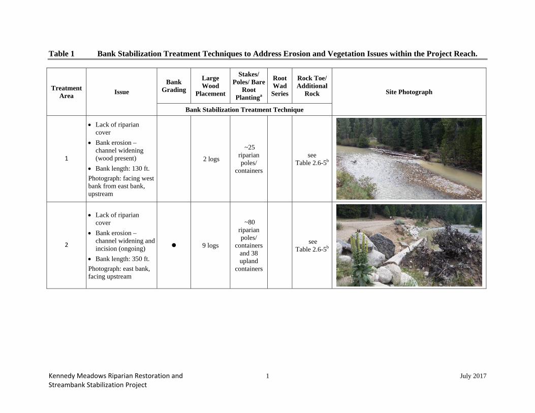
Table 1 Bank Stabilization Treatment Techniques to Address Erosion and Vegetation Issues within the Project Reach.
Treatment Area Issue
Bank Grading
Large Wood
Placement
Stakes/ Poles/ Bare
Root Plantinga
Root Wad Series
Rock Toe/ Additional
Rock Site Photograph
Bank Stabilization Treatment Technique
1
Lack of riparian cover
Bank erosion – channel widening (wood present)
Bank length: 130 ft. Photograph: facing west bank from east bank, upstream
2 logs
~25 riparian poles/
containers
see Table 2.6-5b
2
Lack of riparian cover
Bank erosion – channel widening and incision (ongoing)
Bank length: 350 ft. Photograph: east bank, facing upstream
9 logs
~80 riparian poles/
containers and 38 upland
containers
see Table 2.6-5b

Kennedy Meadows Riparian Restoration and 2 July 2017 Streambank Stabilization Project
Treatment Area Issue
Bank Grading
Large Wood
Placement
Stakes/ Poles/ Bare
Root Plantinga
Root Wad Series
Rock Toe/ Additional
Rock Site Photograph
Bank Stabilization Treatment Technique
3
Lack of riparian cover
Bank erosion –channel widening and undercut banks
Bank length: 500 ft. Photograph: east bank, facing downstream
18 logs
~260 riparian poles/
containers
see Table 2.6-5b
4
Lack of riparian cover
Bank erosion –channel widening (minimal vegetation present)
Bank length: 130 ft. Photograph: facing west bank from east bank
~25 riparian poles/
containers
5
Lack of riparian cover
Bank erosion – channel widening, bank slumping/ block failure
Bank length: 200 ft. Photograph: east bank, facing upstream
3 logs
~157 riparian poles/
containers
see Table 2.6-5b

Kennedy Meadows Riparian Restoration and 3 July 2017 Streambank Stabilization Project
Treatment Area Issue
Bank Grading
Large Wood
Placement
Stakes/ Poles/ Bare
Root Plantinga
Root Wad Series
Rock Toe/ Additional
Rock Site Photograph
Bank Stabilization Treatment Technique
6
Lack of riparian cover
Bank erosion –channel widening, bank slumping/ block failure
Bank length: 400 ft. Photograph: east bank, facing downstream
~295 riparian poles/
containers
7
Lack of riparian cover
Bank erosion –channel widening (meander bend)
Bank length: 250 ft. Photograph: facing west bank from east bank, upstream
~87 riparian poles/
containers
14 logs see Table 2.6-5b
a Quantities are minimum numbers, and may be modified during the permitting process and site conditions. b Refer to Relief Reach – Kennedy Meadows Riparian Restoration and Streambank Stabilization Project Initial Study/Negative Declaration (PG&E) for table.

Kennedy Meadows Riparian Restoration and 1 July 2017 Streambank Stabilization Project
Table 2 Description of Streambank Stabilization and Riparian Restoration Activities, Equipment, and Sources of Material.
Activitya Description Equipment Source
Bank grading Prepare streambank slopes by grading them to a more stable angle. Prepare a relatively uniform, smooth surface suitable for vegetation planting.
Excavator No imported fill
Large wood
Suitable tree (i.e., of adequate size and with root wads and branches or boles) will be delivered to and stockpiled in the temporary staging area. Trees will be delivered by the PG&E contractor. They will be moved to the designated work areas within the Project Reach via the access routes shown on Figure 2.6-1. Trees will be hauled with the excavator, and/or placed on a flatbed truck and transported to the sites from the staging area. Salvaged upland trees (described below under Vegetation Removal) will also be incorporated into the stabilization treatments. An excavator will be used to place the large wood in each treatment area. There will be approximately 25 round trips by trucks to complete this activity.
Excavator, ten-wheel dump truck (or similar), and flatbed truck
Tuolumne County property in the vicinity of the Project, and PG&E vegetation management projects in the vicinity of the Spring Gap-Stanislaus Hydroelectric Project. None will be obtained from floodplain or riparian areas. Trees will be delivered to the Project Reach. Any trees that need to be removed for implementation of the treatments will also be incorporated into the treatments (described below under Vegetation Removal).
Live stake/pole planting
Installation involves the collection and planting of live willow, alder, and/or cottonwood branches. Prior to harvesting, a qualified biologist will identify suitable source areas for collecting the live plant material. Final selection will be coordinated with the appropriate landowner (e.g., Tuolumne County). The branches will be stripped of all side branches, tips, and leaves when salvaged. Stakes are typically three to six feet in length with diameters that vary from ½ inch to four inches. Live stakes may be driven in place or set in holes dug with a digging bar, soil auger, or similar tool. Poles are longer with larger diameters and will be used in areas where depths to groundwater are greater. Live stakes/poles will be inter-planted with bare root plants in the treatment areas where streambank erosion is less severe,
Cuttings will be harvested with hand tools and transported by pickup truck or similar vehicle, as needed. Soil augers or similar tools will be used to dig the holes.
Live plant materials will be cut from existing riparian stands found within the Project Reach or in the vicinity on Tuolumne County property.

Kennedy Meadows Riparian Restoration and 2 July 2017 Streambank Stabilization Project
Activitya Description Equipment Source but currently lacks vegetated cover. The roots will provide soil reinforcement and top growth will enhance vegetated cover.
Bare root planting Willow/alder/cottonwood/red osier dogwood and upland tree/shrub bare root container stock will be inter-planted with the live stakes/poles.
Shovel, hand trowels. Plantings will be delivered by pickup truck or similar vehicle.
Local nursery.
Toe rock
Toe rock is rock placed at the toe of the bank to provide additional strength to the bank to reduce scouring of the toe and banks during high velocity flows. It is most effective when combined with other bioengineering techniques, and is recommended for several treatment areas to provide additional strength at the toe of the bank. Large rock (approximately 10 inches in diameter) will be incorporated as part of the stabilization treatments. Rock will range in size from 1- to 3-inch river cobble to 1-ton boulders. The smaller rock will also be used to fill voids within the bank treatments. Ten-wheel dump trucks will haul the rock onsite and dump it close to the treatment areas. From that location, an excavator will place the rock. An estimated 25 dump truck trips will be required to haul the material to the site.
Excavator, ten-wheel dump truck.
Expected to be sourced from excess rock material from other PG&E construction projects in the vicinity of the Spring Gap-Stanislaus Hydroelectric Project or from Sonora, California.
Root wad series
Root wad series are a sequence of interlocking uprooted hardwood trees that are typically used in combination with other revegetation methods such as planting, to protect and enhance fish habitat. The bottom segment containing the root mass is placed into an excavated hole into the bank (trunk-first) and the root wad section protrudes perpendicular to the flow. The hole is then backfilled. The root wads deflect the flow away from the streambank so that the bank is less susceptible to erosion. Root wads have the potential to enhance instream habitat by promoting the formation of pool habitat and providing instream habitat.
Same as for large wood. Same as for large wood.
Vegetation removal (Treatment Area 2 only; see Table 1)
Salvage any existing riparian and upland trees that need to be removed for the construction of the treatments. Riparian trees (approximately 0.014 acre in Treatment Area 2) will be salvaged for use in revegetation as appropriate. Upland trees, including root wads, will be salvaged and used as the large wood. Based on surveys conducted in summer 2015, five (5) Jeffrey pine trees, three (3) white fir trees, and three (3) incense cedar trees
Backhoe or similar equipment, and hand tools. Not applicable.

Kennedy Meadows Riparian Restoration and 3 July 2017 Streambank Stabilization Project
Activitya Description Equipment Source (10-30 inch diameter at breast height)2 may need to be removed from Treatment Area 2 for construction of the treatment. Salvaged riparian vegetation will be lifted and removed concurrent with construction activities. Based on surveys conducted in summer 2015, six (6) cottonwood trees (15- to 25-inch diameter at breast height)b in Treatment Area 2 will need to be transplanted. Soils surrounding the plants will be moistened prior to removal and will be gently removed by excavating around the root zone with hand tools, a backhoe bucket, or other similar equipment. The root wad will be kept as intact as possible and damaged roots shall be pruned as needed. Burlap will be used to wrap and protect the root zone during transport, which will be kept moist/watered to maintain viability. The salvaged plants will be replanted in a suitable location within one of the treatment areas.
Split rail fence (east meadow near Treatment Areas 5 and 6 only)
A split rail fence (stained pressure treated wood or similar product) (~ 36 inches high, with 3 rungs approximately 8 inches apart) will be installed along the top of the bank to protect the restored banks and revegetated areas approximately two to three feet from the planted vegetation. The fence will be installed in two segments (480 ft. along Treatment Area 5 and 440 ft. along Treatment Area 6), with an open area between these two segments for river access by recreationists and cattle. Large boulders (approximately 4-ft. wide; 2 to 3 ft. in height) will be placed from the end of the fence angling down to the OHWM to discourage access into the treatment areas from the bank slope. Six-foot fence posts will be placed approximately 10 ft. apart and secured with concrete footings. The holes (approximately 95 in total) will be dug approximately 2.5 ft. in depth using a backhoe with an auger attachment. Six inches of clean gravel will be placed at the bottom of the hole to facilitate water infiltration. Concrete will be mixed using a small mixer adjacent to the fence and shoveled into the holes. The top of the concrete will be finished to slope away from the post for drainage. The holes will be filled with concrete to approximately three to four inches below the ground surface, backfilled with existing topsoil, and seeded with the riparian/meadow seed mix. BMPs will be implemented to ensure resource protection.
Cement mixer, backhoe with auger attachment, and hand tools
Expected to be sourced from Sonora, California.
a Additional information on treatment activities can be found in the 100% Design Report (PG&E 2016a). b Refer to Table 1; a minimum of 80 riparian species poles/containers and 38 species upland containers will be planted in Treatment Area 2 as part of the treatment.

Relief Reach Riparian Vegetation Restoration
and Streambank Stabilization Project Description -
100% Design Level April 2016
Spring Gap-Stanislaus Project, FERC No. 2130
© 2016, Pacific Gas and Electric Company
APPENDIX G
MAINTENANCE AND MONITORING PLAN

Relief Reach Riparian Vegetation Restoration
and Streambank Stabilization Project Description -
100% Design Level 1 April 2016
Spring Gap-Stanislaus Project, FERC No. 2130
© 2016, Pacific Gas and Electric Company
APPENDIX G
MAINTENANCE AND MONITORING PLAN
This Maintenance and Monitoring Plan (MMP) has been developed for the Relief Reach Riparian
Vegetation and Streambank Stabilization Project (Project) in Kennedy Meadows for PG&E. The
purpose of the MMP is to help achieve the Project goals and objectives through periodic
maintenance and monitoring of specific channel and riparian attributes.
The primary goals of the Project are to:
Provide streambank stabilization, and
Enhance the riparian and aquatic habitats within the Project reach of the Middle Fork
Stanislaus River.
The objectives of the Project to meet these goals are to:
Reduce the extent of actively eroding streambanks, and
Increase riparian cover on the streambanks within the reach.
This MMP, addressing maintenance (including inspections and repair) and monitoring, will be
implemented upon completion of the Project’s construction (i.e., “post-construction”).
Maintenance will be performed to identify problems needing remedial action (e.g., repairing
damage from floods, winds, or snow; weeding; irrigation; re-seeding of areas disturbed during
construction, etc.) until success criteria are met and through the remainder of the license term
(2039; see schedule below). Monitoring will be performed to provide information to assess
progress of the Project toward meeting the success criteria; monitoring will conclude when success
criteria are met or as agreed upon by the resource agencies (described below). As the Project goals
and objectives are focused on improving conditions within the Kennedy Meadows reach, the
monitoring will focus on evaluating bank and riparian conditions for the reach as a whole, and will
not monitor each treatment area as an individual area.

Relief Reach Riparian Vegetation Restoration
and Streambank Stabilization Project Description -
100% Design Level 2 April 2016
Spring Gap-Stanislaus Project, FERC No. 2130
© 2016, Pacific Gas and Electric Company
Maintenance and monitoring will be conducted by qualified personnel1. The most intensive
maintenance and monitoring period will be take place immediately after the restoration work over
a two-year period to quickly identify potential issues with survival and disturbance.
Success Criteria
The following criteria will be used as the basis for determining the success of the Project:
Establish approximately 1,885 feet (38 percent) of new riparian habitat within the Kennedy
Meadows reach by Year 5 after construction (based on cumulative linear distance from the
combined restoration treatment areas).
Improve bank stability along approximately 1,885 feet (38 percent) of streambank within
the Kennedy Meadows reach by Year 5 after construction (based on cumulative linear
distance from the combined restoration treatment areas).
If success criteria for the increase in riparian cover and/or improved bank stability conditions are
not achieved after five years, PG&E will consult with the resource agencies to determine the
appropriate next actions. Additional actions (e.g., more planting or more bank treatments) may
not be required if it is agreed that the Project objectives have been achieved (reduced extent of
eroding streambanks and enhanced cover of riparian vegetation). If it is determined that additional
planting or installation of new stabilization treatments is required to meet Project objectives,
maintenance and monitoring will be required until success criteria are achieved.
Schedule
The most intensive maintenance period will take place over a two-year period immediately after
the restoration work is completed to quickly identify potential areas within the restored reach that
may require additional actions due to plant losses or presence of unstable areas of the bank (see
Figure G-1 for schedule).
1 Personnel conducting maintenance activities will review the MMP, previous completed forms, and photo point
locations prior to the completing the activities.

Relief Reach Riparian Vegetation Restoration
and Streambank Stabilization Project Description -
100% Design Level 3 April 2016
Spring Gap-Stanislaus Project, FERC No. 2130
© 2016, Pacific Gas and Electric Company
Figure G-1. Maintenance and Monitoring Schedule through the Remainder of the License Term (through year 2039).

Relief Reach Riparian Vegetation Restoration
and Streambank Stabilization Project Description -
100% Design Level 4 April 2016
Spring Gap-Stanislaus Project, FERC No. 2130
© 2016, Pacific Gas and Electric Company
Maintenance:
- Year 1: Once per month between May (or later depending on Highway 108 access)
and October.
- Year 2: Three times in May (or later depending on Highway 108 access); in August
and October after the cattle have left Kennedy Meadows.
- Years 3, 4, and 5: Twice pear year, in May and October, after the cattle have left
Kennedy Meadows.
- Remainder of License Term: Once per year, every five years, and the first summer
after a high flow that exceeds 950 cfs on a daily average basis (measured at the USGS
gage 11292000)2 known as gage S-52 in PG&E nomenclature.
Monitoring:
- Year 1: Baseline monitoring to establish as-built conditions
- Years 1, 2, and 5 (or until success criteria are met as described above): conducted in
August
Maintenance
The purpose of maintenance is to help ensure the overall quantity and quality of survival of the
plantings and structural integrity of the bioengineering treatments to achieve success criteria and
maintain conditions through the license term.
Maintenance will be accomplished by periodically inspecting the treatment areas post-construction
until success criteria are met, including:
Bioengineered structures for damage or displacement
Installed vegetation for insect and/or disease infestations, moisture stress, damage by high
flows, herbivory, damage by other uses of the meadow, and other conditions that could
impact survival
Need for irrigation or plant protections (e.g., wire cages)
2 This flow occurs about every 2.5 years on a daily average flow basis.

Relief Reach Riparian Vegetation Restoration
and Streambank Stabilization Project Description -
100% Design Level 5 April 2016
Spring Gap-Stanislaus Project, FERC No. 2130
© 2016, Pacific Gas and Electric Company
Removal of invasive weeds included on the target list in the approved Spring Gap-
Stanislaus Hydroelectric Project Invasive Weed Management Plan (PG&E 2011e) or other
competing vegetation using manual methods (within a 3-foot radius of the planting)
Additional fencing and other exclusion features on the meadow and in the riparian area and
signage, particularly after winter
Need for additional permanent exclusion features after removal of the temporary fencing
Maintenance for the remainder of the license term after success criteria are met will involve
periodically inspecting:
Bioengineered structures for damage or displacement
General condition of riparian vegetation (damage by high flows, other uses of the meadow,
or other conditions that could be affecting condition)
Fencing and other exclusion features on the meadow and in the riparian area and signage
Repairs to the bioengineered structures will not be made if the treatment is still stable and continues
to function by stabilizing the streambank. The condition of the features will continue to be
monitored during subsequent maintenance. If the features are non-functional due to flows, repairs
will be made as soon as practicable (see additional consultation that may be required in
Section 5.0). Repairs may require use of large equipment to adjust large wood and/or rock into
more stable positions. PG&E will consult with the resource agencies if the damage or
displacement is caused by non-Project uses of the meadow/ riparian corridor, high flows, or other
potential causes to discuss potential other options.
Vegetation maintenance will be focused on plant survival until the success criteria are met.
Vegetation that is not in acceptable growing condition during the first three years after construction
will be noted, removed, and replaced with materials of the same species and size as originally
specified when conditions are suitable for re-planting (typically late fall). PG&E will hand weed
aggressive invasive plants within the treatment areas. PG&E will water/irrigate or install plant
protections (e.g., wire cages) if growing conditions are limited by water availability or deer
browsing. Watering is only initially proposed to enhance initial survival of the plantings and

Relief Reach Riparian Vegetation Restoration
and Streambank Stabilization Project Description -
100% Design Level 6 April 2016
Spring Gap-Stanislaus Project, FERC No. 2130
© 2016, Pacific Gas and Electric Company
should be infrequent to encourage deep rooting of the plantings. If plantings show indications of
stress during a maintenance visit (e.g., leaf drop or failure of several pole plantings), the plantings
will be watered during that maintenance visit. If herbivory by deer and other animals is resulting
in planting mortality such that success criteria may not be achieved, PG&E will install plant
protections as soon as practicable.
PG&E will consult with the resource agencies on remedial actions required to address low plant
survival beyond typical required maintenance. Once success criteria are met, vegetation
maintenance will no longer be conducted.
Damage or displacement of the fencing and other exclusion features on the meadow and in the
riparian corridor by flows or winter weather conditions will be repaired by PG&E as soon as
practicable. PG&E will consult with the agencies on any excessive or repeated damage to these
features to determine if other actions may be required. If observations indicate that non-Project
land uses are adversely affecting the condition of the vegetation or treatment features, PG&E will
discuss potential actions at the next agency meeting. Specifically, if these uses are resulting in
vegetation mortality and/or bank erosion, PG&E will discuss installation of temporary or
permanent fencing and signage at these locations. The temporary fencing would likely remain in
place in the summer/fall until the damage to the vegetation recovers. Additional permanent
fencing would be discussed as an option if the temporary fencing were not successful in addressing
use through the riparian corridor.
Maintenance will also include inspection of the disturbed areas that were seeded after construction,
and re-seeding if necessary. Seeded areas will be inspected for percent cover once approximately
one year after construction in the fall. If percent cover meets or exceeds 70 percent, the seeding
will be determined to be successful and no additional maintenance will be required. If percent
cover of the seeded areas does not exceed 70 percent, the area will be reseeded, maintenance
inspections will continue the following year, and until the 70 percent success criteria are met. The
areas will be photographed to document cover.
The maintenance datasheet is provided in Appendix G, Attachment A.

Relief Reach Riparian Vegetation Restoration
and Streambank Stabilization Project Description -
100% Design Level 7 April 2016
Spring Gap-Stanislaus Project, FERC No. 2130
© 2016, Pacific Gas and Electric Company
Permanent photo-monitoring stations will be established at each treatment area as part of the
Monitoring (see Photo Point section described below under Monitoring). Photographs will also
be taken to document any areas that may require repairs or replacement plantings. The
photographs will document overall condition of the treatment structures, vegetation condition,
condition of exclusion features, and any other notable feature through the license term.
Photographs will also be taken to document any damage that occurs within the treatment areas.
Photographs of the treatment areas at the photo-point locations will continue as part of the periodic
maintenance through the license term.
A brief summary memo, including photographs, will be prepared to document the maintenance
that will include general condition of the treatment areas, any damage or plant mortality identified,
and remedial actions taken to address deficiencies. The summary memo will also include the
photographs and completed datasheets. This memo will be incorporated into a Maintenance and
Monitoring Memorandum (Memo), as described below.
Responsibility for Repairs
Table G-1 identifies the repairs that PG&E will be responsible for providing and those that will
require consultation with the resource agencies. PG&E will not be financially responsible for
repairing damage or displacement that is attributable to non-Project uses of the meadow/ riparian
corridor.

Relief Reach Riparian Vegetation Restoration
and Streambank Stabilization Project Description -
100% Design Level 8 April 2016
Spring Gap-Stanislaus Project, FERC No. 2130
© 2016, Pacific Gas and Electric Company
Table G-1. Summary of Responsible Parties for Repairs of Stabilization Treatment Areas.
Issue Cause Responsible Party
Damage to or Displacement of Bioengineered Structures (see below for vegetation survival)
Flows or winter weather conditions PG&E; discuss with agencies if repeated damage by
flows
Non-Project uses of meadow/ riparian corridor Discuss with resources agencies
Vegetation Survival until Success Criteria are Met
Insect/disease infestations PG&E
Moisture stress PG&E
High flows or winter weather conditions PG&E; discuss with agencies if repeated damage by
flows
Aggressive invasive plants PG&E
Deer herbivory PG&E
Non-Project uses of meadow/ riparian corridor Discuss with resources agencies
Vegetation Survival (through license term)
High flows or winter weather conditions PG&E; discuss with agencies if repeated damage by
flows
Non-Project uses of meadow/ riparian corridor Discuss with resources agencies
Exclusion Features (temporary and permanent fencing)
Flows or winter weather conditions PG&E
Non-Project uses of meadow/ riparian corridor Discuss with resources agencies

Relief Reach Riparian Vegetation Restoration
and Streambank Stabilization Project Description -
100% Design Level 9 April 2016
Spring Gap-Stanislaus Project, FERC No. 2130
© 2016, Pacific Gas and Electric Company
Monitoring
The purpose of the monitoring is to track the progression of the restoration activities toward meeting
the Project success criteria described above. If anything that may compromise the success of the
restoration is identified, appropriate remedial actions may be implemented and will be documented
in the Memo. Baseline monitoring will initially be conducted to document the as-built conditions of
the Project and to identify any initial potential threats to Project success. Subsequent monitoring
will be conducted as specified in Figure G-1 above. The following methods will be used to determine
if the Project success criteria are being met:
Improved Streambank Stability – Stream Condition Inventory (SCI) surveys (Forest
Service 2005) and photo points
New Riparian Habitat – Longitudinal transects (greenline3 surveys [Winward 2000]) and
photo points
Streambank stability and cover may decrease in other portions of the reach due to circumstances
beyond the control of PG&E (e.g., high flows, wind throw, other uses of the meadow). If any of
these types of events occur, the circumstances will be documented and PG&E will consult with the
agencies.
Improved Streambank Stability
A SCI streambank survey will be conducted to document streambank stability conditions within
the reach. The survey will begin at the upstream end of the Treatment Area 1 and extend
downstream to the downstream end of Treatment Area 7. Both left and right streambanks will be
surveyed in their entirety.
Survey protocols will follow those outlined in the Forest Service Region Stream Condition
Inventory Guidebook (Forest Service 2005), and are provided in Appendix G, Attachment B. The
entire reach will be surveyed on foot. The streambank condition will be categorized as “Stable,”
“Vulnerable,” or “Unstable,” as described in Forest Service (2005). The results will be mapped in
3 The greenline is defined as: ‘The first perennial vegetation that forms a lineal grouping of community types on or
near the water’s edge. Most often it occurs at or slightly below the bankfull stage’ (Winward 2000).

Relief Reach Riparian Vegetation Restoration
and Streambank Stabilization Project Description -
100% Design Level 10 April 2016
Spring Gap-Stanislaus Project, FERC No. 2130
© 2016, Pacific Gas and Electric Company
GIS. Photopoints will also be used to document bank conditions over time; those methods are
outlined below.
New Riparian Habitat
New riparian habitat within the Kennedy Meadows Reach will be monitored over time using the
greenline method (horizontal transect) (Winward 2000). The greenline intercepts the permanent
vegetation closest to the channel. This line may be at, below, or above bankfull depending on
where vegetation is established. The survey will begin at the upstream end of the Treatment Area
1 and extend downstream to the downstream end of Treatment Area 7. Both left and right
streambanks will be surveyed in their entirety. This method is consistent with the vegetation
surveys completed for the relicensing (PG&E 2002) and for the 2011 Riparian Progress Report
(PG&E 2012a).
Data collected using the longitudinal transect method will be used to characterize the species
distributions, and cover of litter, woody debris, woody trees and shrubs4, and substrate particle
size5 along the streambank (Winward 2000). Composition data (dominant groundcover, shrub,
and tree species present) will be obtained by walking along the stream margins, measuring, and
recording the length of cover of each dominant or co-dominant species that intersects the greenline.
Sub-dominant species found with the dominant species also will be recorded. When a change in
the dominant species is observed, a new data entry will be recorded. In addition, the length of
areas of bare ground, leaf litter, and large wood will be recorded along each transect. If the lengths
of these attributes are different from the vegetation coverage lengths, these attributes will be
recorded as separate entries on the datasheet. The lengths of the vegetation and other corridor
attributes are then related to the length of the greenline survey to determine the proportion of each
along the streambank (Winward 2000). A sample datasheet is provided in Appendix G,
Attachment C.
4 All cover measurements will be made with a densiometer.
5 See Appendix G, Attachment C for substrate size classes.

Relief Reach Riparian Vegetation Restoration
and Streambank Stabilization Project Description -
100% Design Level 11 April 2016
Spring Gap-Stanislaus Project, FERC No. 2130
© 2016, Pacific Gas and Electric Company
Evidence of unusual stress or mortality, and/or evidence of wildlife use, also will be noted. In
addition, invasive weed and special-status plant species will be documented if encountered during
field surveys. Photopoints will also be used to document bank conditions over time; those methods
are outlined below.
Photo Points
Photo documentation provides a visual record of the conditions of the riparian community and
streambank and land use (Elzinga et al. 1998; Burton et al. 2007). The photographs will document
changes in vegetation cover along the streambank and bank stability for monitoring until success
criteria are met, and will continue through the license term as part of the maintenance. The photo
point procedures are described in Appendix G, Attachment D.
Permanent photo point locations will be selected to document conditions at each of the stabilization
treatment areas. One or two photo point locations will be selected for each treatment area. The
location of each photo point will initially be documented in relation to a permanent landmark
feature (reference point) and with a Global Positioning System (GPS). If a photo point marker is
eroded or removed, an attempt will be made to relocate the marker using the previous photographs,
reference points, and GPS coordinates. If the location cannot be identified, a new location in close
proximity will be established.
Photographs from the previous year will be taken into the field each year to assist in orienting the
camera. The photographs will be taken from the same location. The photographs will be stored
electronically in a photo log with pertinent information such as date, time, number, environmental
information (such as recent high flows, land uses, etc.).
Reporting and Consultation
Report Consultation
PG&E will prepare a Maintenance and Monitoring Memo to document installation of the
stabilization treatments and summarize results of the maintenance and monitoring as specified in
Table G-2.
Relief Reach Riparian Vegetation Restoration
and Streambank Stabilization Project Description -
100% Design Level 12 April 2016
Spring Gap-Stanislaus Project, FERC No. 2130
© 2016, Pacific Gas and Electric Company
The memos will be provided to the resource agencies at least 30 days prior to the Forest Service
Annual Consultation meeting (between March 15 and April 15) and the results and
recommendations will be discussed at a time corresponding with the Forest Service Annual
Consultation meeting. The memos will be subsequently filed with FERC.
Repair Consultation
If the bioengineered structures are damaged by high flows such that they no longer stabilize the
banks, repair work may require construction activities within the channel. PG&E will notify the
USACE, State Water Board, and CDFW of the required repair work, and discuss the appropriate
next steps to most efficiently and effectively implement the necessary repairs.
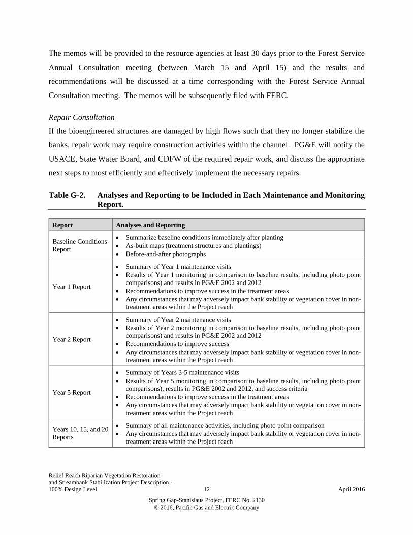
Table G-2. Analyses and Reporting to be Included in Each Maintenance and Monitoring
Report.
Report Analyses and Reporting
Baseline Conditions
Report
Summarize baseline conditions immediately after planting
As-built maps (treatment structures and plantings)
Before-and-after photographs
Year 1 Report
Summary of Year 1 maintenance visits
Results of Year 1 monitoring in comparison to baseline results, including photo point
comparisons) and results in PG&E 2002 and 2012
Recommendations to improve success in the treatment areas
Any circumstances that may adversely impact bank stability or vegetation cover in non-
treatment areas within the Project reach
Year 2 Report
Summary of Year 2 maintenance visits
Results of Year 2 monitoring in comparison to baseline results, including photo point
comparisons) and results in PG&E 2002 and 2012
Recommendations to improve success
Any circumstances that may adversely impact bank stability or vegetation cover in non-
treatment areas within the Project reach
Year 5 Report
Summary of Years 3-5 maintenance visits
Results of Year 5 monitoring in comparison to baseline results, including photo point
comparisons), results in PG&E 2002 and 2012, and success criteria
Recommendations to improve success in the treatment areas
Any circumstances that may adversely impact bank stability or vegetation cover in non-
treatment areas within the Project reach
Years 10, 15, and 20
Reports
Summary of all maintenance activities, including photo point comparison
Any circumstances that may adversely impact bank stability or vegetation cover in non-
treatment areas within the Project reach

Relief Reach Riparian Vegetation Restoration
and Streambank Stabilization Project Description -
100% Design Level 13 April 2016
Spring Gap-Stanislaus Project, FERC No. 2130
© 2016, Pacific Gas and Electric Company
APPENDIX G - ATTACHMENT A
MAINTENANCE DATASHEET

Relief Reach Riparian Vegetation Restoration
and Streambank Stabilization Project Description -
100% Design Level 14 April 2016
Spring Gap-Stanislaus Project, FERC No. 2130
© 2016, Pacific Gas and Electric Company
Kennedy Meadows Streambank Stabilization
Maintenance Datasheet – Until Success Criteria are Met
(Page 1; Date:___________)
Name: _____
General Site Conditions & Overall Observations:
Describe:
Disturbed Area Re-seeding:
Reseeded Area Photograph ID Percent Cover and Notes
Photograph Descriptions of Each Treatment Area
Treatment Area Photograph ID Description
1
2
3
4
5
6
7

Relief Reach Riparian Vegetation Restoration
and Streambank Stabilization Project Description -
100% Design Level 15 April 2016
Spring Gap-Stanislaus Project, FERC No. 2130
© 2016, Pacific Gas and Electric Company
Kennedy Meadows Streambank Stabilization
Maintenance Datasheet – Until Success Criteria are Met
(Page 2; Date:___________)
Natural/Fenced Exclusion Structures & Signage:
Any damage? (circle one) Y or N
If yes, Photograph damage (photograph ID)
Describe:
Potential cause of damage:
Actions/Recommendations (circle all that apply)
None required Fixed damage on-site
Return trip required to repair Discuss at next agency consultation meeting
Other:
Invasive Species
Weeding required
in treatment areas?
(circle one) Y or N
If yes, Identify treatment area(s) where work was performed:
Approximate area(s):

Relief Reach Riparian Vegetation Restoration
and Streambank Stabilization Project Description -
100% Design Level 16 April 2016
Spring Gap-Stanislaus Project, FERC No. 2130
© 2016, Pacific Gas and Electric Company
Kennedy Meadows Streambank Stabilization
Maintenance Datasheet – Until Success Criteria are Met
(Page 3; Date:___________)
Vegetation Condition
Is the vegetation in good condition? (circle one) Y or N
If no, Photograph vegetation (photograph IDs)
Identify treatment area with issues:
Degree of plant mortality or reduced vigor:
(select one)
Severe: 50% or greater mortality within treatment
area.
Moderate: Reduced vigor or mortality of up to 50%
of cover; potential to reduce project success.
Minor: A few individuals with reduced vigor or
dead; but minimal effect on overall coverage within
treatment area.
Describe potential cause of plant condition:
Actions/Recommendations (circle all that apply)
Irrigation Plant protection
Additional weeding Discuss at next agency consultation meeting
Replant as soon as practicable Other:
Bioengineered Structures
Any observed damage to or displacement of bioengineered treatment structures? (circle one) Y or N
If yes, Photograph (photograph IDs)
Identify treatment area(s) with damage or displacement:
Degree of damage or displacement (select) Severe: Loss of function to stabilize banks
Moderate: Failure of substantial portion of
structure, but function of structure is not threatened
Minor: Some minor scour of small issues observed
but are not considered to be a threat to the structure.
Cause of failure (choose all that apply)
Toe scour Scour behind structure
Overtopping Scour of vegetation
Displacement of wood High flows
Other meadow uses Other:
Recommendations (circle one)
Detailed examination required – possible repair
Continue to watch – immediate action not
Discuss at next agency annual consultation meeting

Relief Reach Riparian Vegetation Restoration
and Streambank Stabilization Project Description -
100% Design Level 17 April 2016
Spring Gap-Stanislaus Project, FERC No. 2130
© 2016, Pacific Gas and Electric Company
Kennedy Meadows Streambank Stabilization
Maintenance Datasheet – After Success Criteria are Met
(Page 1; Date:___________)
Name: _____
General Site Conditions & Overall Observations:
Describe:
Photograph Descriptions of Each Treatment Area
Treatment Area Photograph ID Description
1
2
3
4
5
6
7
Natural/Fenced Exclusion Structures & Signage:
Any damage? (circle one) Y or N
If yes, Photograph damage (photograph ID)
Describe:
Potential cause of damage:
Actions/Recommendations (circle all that apply)
None required Fixed damage on-site
Return trip required to repair Discuss at next agency consultation meeting
Other:

Relief Reach Riparian Vegetation Restoration
and Streambank Stabilization Project Description -
100% Design Level 18 April 2016
Spring Gap-Stanislaus Project, FERC No. 2130
© 2016, Pacific Gas and Electric Company
(Page 2; Date:___________)
Vegetation Condition
Is the vegetation in good condition? (circle one) Y or N
If no, Photograph vegetation (photograph IDs)
Identify treatment area with issues:
Degree of plant mortality or reduced vigor:
(select one)
Severe: 50% or greater mortality within treatment
area.
Moderate: Reduced vigor or mortality of up to 50%
of cover; potential to reduce project success.
Minor: A few individuals with reduced vigor or
dead; but minimal effect on overall coverage within
treatment area.
Describe potential cause of plant condition:
Actions/Recommendations (circle all that apply)
Discuss at next agency annual consultation
meeting
Other:
None required
Bioengineered Structures
Any observed damage to or displacement of bioengineered treatment structures? (circle one) Y or N
If yes, Photograph (photograph IDs)
Identify treatment area(s) with damage or displacement:
Degree of damage or displacement (select) Severe: Loss of function to stabilize banks
Moderate: Failure of substantial portion of
structure, but function of structure is not threatened
Minor: Some minor scour of small issues observed
but are not considered to be a threat to the structure.
Cause of failure (choose all that apply)
Toe scour Scour behind structure
Overtopping Scour of vegetation
Displacement of wood High flows
Other meadow uses Other:
Recommendations (circle one)
Detailed examination required – possible repair
Continue to watch – immediate action not
Discuss at next agency annual consultation meeting

Relief Reach Riparian Vegetation Restoration
and Streambank Stabilization Project Description -
100% Design Level 19 April 2016
Spring Gap-Stanislaus Project, FERC No. 2130
© 2016, Pacific Gas and Electric Company
APPENDIX G - ATTACHMENT B
FOREST SERVICE REGION STREAM
CONDITION INVENTORY (SCI)
GUIDEBOOK – STREAMBANK
STABILITY SURVEY METHODS
(FOREST SERVICE 2005)

Relief Reach Riparian Vegetation Restoration
and Streambank Stabilization Project Description -
100% Design Level 20 April 2016
Spring Gap-Stanislaus Project, FERC No. 2130
© 2016, Pacific Gas and Electric Company

Relief Reach Riparian Vegetation Restoration
and Streambank Stabilization Project Description -
100% Design Level 21 April 2016
Spring Gap-Stanislaus Project, FERC No. 2130
© 2016, Pacific Gas and Electric Company

Relief Reach Riparian Vegetation Restoration
and Streambank Stabilization Project Description -
100% Design Level 22 April 2016
Spring Gap-Stanislaus Project, FERC No. 2130
© 2016, Pacific Gas and Electric Company

Relief Reach Riparian Vegetation Restoration
and Streambank Stabilization Project Description -
100% Design Level 23 April 2016
Spring Gap-Stanislaus Project, FERC No. 2130
© 2016, Pacific Gas and Electric Company
Geomorphic Conditions Assessment and Streambank Stability Focused Study Component
DRAFT Streambank Stability Datasheet
Study Site: Date: Name: Survey/ Plot Interval (ft):
Bank L R L R L R L R L R
Survey/
Plot No. 1 2 3 4 5
Stability
Rating1:
Survey/
Plot No. 6 7 8 9 10
Stability
Rating:
Survey/
Plot No. 11 12 13 14 15
Stability
Rating:
Survey/
Plot No. 16 17 18 19 20
Stability
Rating:
Survey/
Plot No. 21 22 23 24 25
Stability
Rating:
Survey/
Plot No. 26 27 28 29 30
Stability
Rating:
Survey/
Plot No. 31 32 33 34 35
Stability
Rating:

Relief Reach Riparian Vegetation Restoration
and Streambank Stabilization Project Description -
100% Design Level 24 April 2016
Spring Gap-Stanislaus Project, FERC No. 2130
© 2016, Pacific Gas and Electric Company
Study Site: Date: Name: Survey/ Plot Interval (ft):
Bank L R L R L R L R L R
Survey/
Plot No. 36 37 38 39 40
Stability
Rating:
Survey/
Plot No. 41 42 43 44 45
Stability
Rating:
Survey/
Plot No. 46 47 48 49 50
Stability
Rating:
1 Stability Rating-: 1: >75% cover; 2: >75% cover with instability elements (cracking, bank failure, etc.), 3: <75% cover.

Relief Reach Riparian Vegetation Restoration
and Streambank Stabilization Project Description -
100% Design Level 25 April 2016
Spring Gap-Stanislaus Project, FERC No. 2130
© 2016, Pacific Gas and Electric Company
APPENDIX G - ATTACHMENT C
LONGITUDINAL TRANSECT
(GREENLINE) DATASHEETS

Relief Reach Riparian Vegetation Restoration
and Streambank Stabilization Project Description -
100% Design Level 26 April 2016
Spring Gap-Stanislaus Project, FERC No. 2130
© 2016, Pacific Gas and Electric Company
Riparian Vegetation Focused Study Component
Greenline Datasheet
Stream Segment and Site: ____________________________ Date: __________________ Name: ______________________________
GPS Waypoint: __________ River Mile: __________________________
Left Bank Greenline Length (m): ______________ Left bank transect crosses greenline at (m):_____________________ Left bank: zero = US or DS
Right Bank Greenline Length (m): _____________ Right bank transect crosses greenline at (m):____________________ Right bank: zero = US or DS
L or R
Bank
Attribute1
Distance on
Greenline
(m)
Notes2 Dominant Species
Sub-Dominant Species Other3 Species
%
Cover4
Tree
Height5
Start
Stop
Start
Stop
Start
Stop
Start
Stop
Start
Stop
Start
Stop
1. Species, community type, or attribute (litter, bare ground, substrate, woody debris, dead vegetation). 2. Fluvial landform, decadence, senescence, grazing, other land use activities. 3. Litter, duff, woody debris, bedrock, boulder, cobble, gravel, sand, fines, dead vegetation. 4. Percent cover for the species. 5. Average tree height of the species.

Relief Reach Riparian Vegetation Restoration
and Streambank Stabilization Project Description -
100% Design Level 27 April 2016
Spring Gap-Stanislaus Project, FERC No. 2130
© 2016, Pacific Gas and Electric Company
APPENDIX G - ATTACHMENT D
PHOTO POINT PROCEDURES

Relief Reach Riparian Vegetation Restoration
and Streambank Stabilization Project Description -
100% Design Level 28 April 2016
Spring Gap-Stanislaus Project, FERC No. 2130
© 2016, Pacific Gas and Electric Company
Photo Point Procedures
Images taken at the photo points will be landscape photographs that will be taken each monitoring
period from the same locations. The views in the photographs will be the same so that differences
between monitoring periods can be compared.
Photo point locations will be established at each treatment area. The locations will be established
at a location from which multiple view photographs could be taken, if possible. Within each view,
an identifiable object, such as a large rock, will be included, if possible, to assist with scale and
orientation during the monitoring periods. The photo point markers will be located in places that
will likely not be eroded easily by high floods or disturbed by other activities, such as vandalism.
Markers will be as inconspicuous as possible to minimize the potential for vandalism.
This appendix describes the procedure for documenting the photo point locations and for retaking
the photographs each monitoring period. A field datasheet is provided. One datasheet will be
filled out for each photo point location. For those locations where more than one view is taken
from the same photo point location, all the views can be recorded on the same datasheet.
Documenting Photo Point Locations
A site marker, such as a stake or a permanent feature each treatment area will be selected at each
treatment area. During the first monitoring period, the photo point locations will be established,
using the following procedure:
The photographer will stand immediately over the site marker/permanent feature, if
possible. If this is not possible, the location of the photographer relative to the marker will
be recorded on the datasheet (distance and angle from the marker).
The time of the photograph, camera type, focus distance, height of the camera above the
ground, compass bearing, and vertical angle of the view will be recorded on the datasheet.
At least one reference point will be established for each photo point location. The reference
point will be within 200 feet of the photo point location. A reference point could be a large
tree outside of the flood zone or a large rock. The distance, compass bearing, and vertical

Relief Reach Riparian Vegetation Restoration
and Streambank Stabilization Project Description -
100% Design Level 29 April 2016
Spring Gap-Stanislaus Project, FERC No. 2130
© 2016, Pacific Gas and Electric Company
angle will be measured and recorded from the reference point to the photo point location.
A marker will be placed on the reference point. The reference point will be described on
the datasheet and a site sketch will be drawn showing major landmarks and the locations
of the photo points and reference points. The information from the initial sketch with the
reference point locations identified, will be transferred to GIS for display over a high-
resolution aerial image and stored electronically.
Additional photographs will be taken of the reference point and the photo point locations.
The locations of each will be marked and labeled on the photographs for future use in the
field. All information on the location of the photo points and reference points will be stored
electronically.
The locations of the photo and reference points will be recorded with GPS. These locations
will be overlain on aerial photographs of each monitoring site to document the approximate
locations of the points. The maps will be completed at a scale with sufficient detail to
identify obvious landmarks and trees. These maps will be electronically stored for future
use.
Each photo point will be given an identification number, which will be used through the
duration of the monitoring.
Repeat Photography
The procedures for the photo points that will be followed during the subsequent monitoring periods
are described below:
For each photo point monitoring period, the field crew will take copies of the original photo
point documentation on the locations of the photo and reference point markers, copies of
the photographs, and maps. The same camera will be used, if possible. If it is not available,
a camera similar to the original one will be used. The new camera type will be noted on
the datasheet.
The photographer will stand at the same place and height as that which the first photographs
were taken. The camera will be aligned with the view at the same compass bearing as

Relief Reach Riparian Vegetation Restoration
and Streambank Stabilization Project Description -
100% Design Level 30 April 2016
Spring Gap-Stanislaus Project, FERC No. 2130
© 2016, Pacific Gas and Electric Company
recorded during the initial photographs. The view will be compared with the previous
photographs to ensure that it is as close as possible to the original.
The time of the photograph, camera type, focus distance, height of the camera above the
ground, compass bearing and vertical angle of the view will be recorded for this monitoring
period.
If the photo point marker cannot be located, an attempt will be made to locate a new photo
point as close as possible to the original location using the reference point documentation,
maps, and previous photographs. This will be noted in the summary memorandum.
The new photographs will be catalogued with the previous photographs and stored
electronically. The photographs will be compared with the previous photographs in the
summary memorandum.

Relief Reach Riparian Vegetation Restoration
and Streambank Stabilization Project Description -
100% Design Level 31 April 2016
Spring Gap-Stanislaus Project, FERC No. 2130
© 2016, Pacific Gas and Electric Company
Photo Point Datasheet
Site Name: ________________________Photo Point Identification Number:_______
Date: ________ Time: _______________Weather Conditions: ___________________
GPS Coordinates: ___________________Photographer:________________________
Camera Type:___________________________________________________________
Subject of Photograph and Purpose of Photographs:
Photo 1 Photo 2 Photo 3
Camera Height (ft): Camera Height (ft): Camera Height (ft):
Camera Angle: Camera Angle: Camera Angle:
Azimuth: o Azimuth: o Azimuth: o
Focus Distance: Focus Distance: Focus Distance:
Photo No.: Photo No.: Photo No.:
Camera No.: Camera No.: Camera No.:
Photo 4 Photo 5 Photo 6
Camera Height (ft): Camera Height (ft): Camera Height (ft):
Camera Angle: Camera Angle: Camera Angle:
Azimuth: o Azimuth: o Azimuth: o
Focus Distance: Focus Distance: Focus Distance:
Photo No.: Photo No.: Photo No.:
Camera No.: Camera No.: Camera No.:
Reference Point 1 Sketch of Photo and Reference Point Locations:
Description:
Marking:
Azimuth: o Angle:
Distance to photo point marker (ft):
Reference Point 2
Description:
Marking:
Azimuth: o Angle:
Distance to photo point marker (ft):
Reference Point 3
Description:
Marking:
Azimuth: o Angle:
Distance to photo point marker (ft):

Relief Reach Riparian Vegetation Restoration
and Streambank Stabilization Project Description -
100% Design Level 32 April 2016
Spring Gap-Stanislaus Project, FERC No. 2130
© 2016, Pacific Gas and Electric Company
This Page Intentionally Left Blank

RE
VIS
IO
NS
DATE:
DRAWN BY:
CHECKED BY:
SCALE: AS SHOWN
SAP ORDER
FIGURE NO.
DA
TE
NO
.
RE
LIE
F R
EA
CH
- K
EN
NE
DY
M
EA
DO
WS
RIP
AR
IA
N R
ES
TO
RA
TIO
N A
ND
ST
RE
AM
BA
NK
S
TA
BILIZ
AT
IO
N
TU
OLU
MN
E C
OU
NT
Y, C
A
JC
KRS
2028978
RE
VE
GE
TA
TIO
N S
HE
ET
File:
R:\R
eno P
rojec
ts\E3
1493
0710
- Ke
nned
y Mea
dows
\Auto
CAD\
Shee
ts\KM
_Plan
.dwg T
ab: R
-1Pl
ot St
amp:
6/15/2
017 7
:49 A
M - J
esse
Car
lson
100% DESIGN
PLANS
R-1
0 100 200
SCALE IN FEET
Map ID Treatment Type Vegetation Planting Method Timing of Planting
0
Avoid, protect, minor
treatment
Protect and conserve existing
vegetation and no change
N/A
1
Bars (potential, dependent upon dewatering and diversion approach
determined by Contractor based on site conditions)
1a Access routes
Restore to natural topography
At end of construction
2
Streambanks (up to 3 feet above summer water)
2a
Planting
Plant willow poles and stakes
At end of construction
Plant container alder, willow
Plant at variable spacing, with 6 x
6 foot spacing on average for
willows and alders except in
Treatment Areas 5 and 6, plant
willows and alders with 4 x 4 foot
spacing.
Plant clustered and scattered with
open areas between clumps.
2b
Bioengineered
structure (wood,
rock and wood, or
rock only)
Inter-plant willow poles and stakes
within the structure
During construction of
treatment
Place salvaged sod at lowest
elevations on graded bank behind
installed wood or rock
Inter-plant container alder and
willow
Plant at variable spacing, with 6 x
6 foot spacing on average for
willows and alders.
Plant clustered and scattered with
open areas between clumps.
2c
Bioengineered
structure (rock or
rock and wood)
Leave Barren N/A
Map ID Treatment Type Vegetation Planting Method Timing of Planting
3
Upper Riparian Zone (>3 feet above summer water)
3a
Graded banks
above wood
structure, rock/wood,
and rock treatments
Plant container alder, willow,
cottonwood
At end of construction
Plant quaking aspen at Treatment
Area 7
Plant willow/cottonwood poles and
stakes
Plant at variable spacing, with 6 x
6 foot spacing on average for
willows and alders and 10 x 10
foot spacing for cottonwoods
Plant clustered and scattered with
open areas between clumps.
3b
Planting only
Plant willow/cottonwood poles and
stakes
At end of construction
Plant container alder, willow,
cottonwood
Plant at variable spacing, with 6 x
6 foot spacing on average for
willows and alders and 10 x 10
foot spacing for cottonwoods,
except in Treatment Areas 5 and
6, plant willows and alders with 4 x
4 foot spacing
Plant clustered and scattered with
open areas between clumps.
3c Access routes
Decompaction (e.g., ripping and
scarification to insure compacted
surfaces are fractured in areas of
intense construction related use)
At end of construction
Broadcast Seeding (Riparian)
Map ID Treatment Type Vegetation Planting Method Timing of Planting
4
Meadow and
Floodplain
4aStaging and storage
Decompaction (e.g., ripping and
scarification to insure compacted
surfaces are fractured in areas of
intense construction related use)
At end of construction
Seeding (meadow seed mix)
4b Access routes
Decompaction (e.g., ripping and
scarification to insure compacted
surfaces are fractured in areas of
intense construction related use)
At end of construction
Seeding (meadow seed mix)
5
Upland
5b
Seeding and
planting
Plant at variable spacing, with 10
x 10 foot spacing for trees and 6 x
6 foot spacing for shrubs; as
shown by Owner. Placement
dependent upon slope.
At end of construction
Broadcast Seeding (upland seed
mix)
At end of construction
Existing Road
Regrade road to pre-existing
condition
N/A
F
L
O
W
D
I
R
E
C
T
I
O
N
1a
0
2b
2c
3a
3c
4b
4a
5b
EXISTING ROAD
3b
2a
TREATMENT AREA 7
TREATMENT AREA 6
TREATMENT AREA 5
TREATMENT AREA 4
TREATMENT AREA 3
TREATMENT AREA 2
TREATMENT AREA 1
NOTES:
1. ALL CONTAINER PLANTS TO BE PROVIDED BY PG&E.
2. PLANTING TO BE SUPERVISED BY RESTORATION ECOLOGIST OR RESTORATION ENGINEER.
3. SALVAGE BLACK COTTONWOOD TO BE REPLANTED IN TREATMENT AREA 2.
4. PLANT AT LEAST 1-3 POLES/STAKES PER HOLE.
Woody Species Planting Quantities by Treatment Area
Species and Type
Treatment Area
Total
1 2 3 4 5 6 7
Poles / Stakes (minimum quantity)
Willow 17 58 145 14 105 211 50 600
Mountain Alder 20 6 12 5 43
Black Cottonwood 30 3 6 12 5 56
TOTAL (minimum)
17 58 195 17 117 235 60 699
Salvaged/transplant
Black Cottonwood (estimate)
6 6
Container Plants
Willow (mix, Salix jepsonii, S. lemmonii,
S. lucida, and S. lutea) (1-5 gal.)
8 30 2 15 30 6 91
Mountain Alder, Alnus incana (1-5 gal.)
4 8 10 2 15 15 6 60
Black Cottonwood, Populus balsamifera
ssp. trichocarpa (5-15 gal)
4 25 4 10 15 7 65
Quaking Aspen, Populus tremuloides
(5-15 gal.)
8 8
Jeffrey Pine, Pinus jeffreyi (5-15 gal.)
6 6
Incense Cedar, Calocedrus decurrens
(5-15 gal.)
6 6
White Fir, Abies concolor (5-15 gal.)
6 6
Whitethorn, Ceanothus sp. (1 gal.)
10 10
Sierra Gooseberry, Ribes roezlii (1 gal.)
10 10
TOTAL 8 54 65 8 40 60 27 262
GRAND TOTAL (minimum)
25 118 260 25 157 295 87
EXISTING WETLAND
9/30/17
6/14/17