Embed Size (px)
Citation preview

GSICS – May 2012 Washington
CNES Report
GSICS 12 th Executive Panel Meeting
Patrice Henry, Bertrand Fougnie, Sophie Lachérade, Denis Jouglet, Eric Péquignot

2 GSICS – March 2012 Beijing
Overview of the main activities performed since the last Executive Panel Meeting
■ Crosscalibration of visible channels over stable sites w Improvement of sites characterization (desert + Antarctica)
• BRDF modeling using PARASOL/POLDER • DTM and Structure using Pleiades
w LEO/GEO crosscalibration ■Lunar Calibration w Intensive lunar acquisitions with Pleiades
■Calibration over Rayleigh Scattering w Improvement of calibration zones climatology and application to SeaWiFS calibration w Method adaptation for GEO calibration w Assessment of the error budget
■SADE database w Reprocessing and populating with new data w Opening to calibration community users
■ IASI calibration w Operational IASI/AIRS crosscalibration w Preparation for IASIB calibration

3 GSICS – March 2012 Beijing
CrossCalibration of Visible Channels
over Stable Sites

4 GSICS – March 2012 Beijing
Calibration sites characterization
■Whatever the (cross)calibration method, a refined knowledge of the surface reflectance of calibration sites is needed
■ Improve radiometric characterization w Spectral behavior for the full reflective domain (extension to UV or SWIR)
• MODIS or MERIS from SADE database + GOME, Hyperion, Sciamachy
w Bidirectional properties (solar and viewing geometries) • PARASOL data from SADE database
w Seasonal variation and long term stability
• time series from SADE database
w Spatial homogeneity
• MODIS or MERIS full resolution images, SPOT images
w Surface structure
• highresolution images: stereoscopic acquisitions (SPOT), SRTM data, Pléiades

5 GSICS – March 2012 Beijing
Bidirectional properties of desert sites
■Bidirectional properties w Investigation using PARASOL data w Which BRDF model best fits measurements à Snyder w Derive Snyder model’s parameters for all sites
Algeria3 – Parasol 490nm
Reflectance Difference Measure Model
black dots = measurements

6 GSICS – March 2012 Beijing
Bidirectional properties of Antarctica sites
Huge amount of PARASOL data (x 2.5 comparing to desert)
PARASOL geometry over Dôme C BRDF model over Dôme C (SZA=60°)
Dôme C – Parasol 565nm

7 GSICS – March 2012 Beijing
Desert sites seen by PLEIADES
ARABIA1 MODIS
SRTM

8 GSICS – March 2012 Beijing
Calibration sites ALGERIA5 MODIS
SRTM
Desert sites seen by PLEIADES

9 GSICS – March 2012 Beijing
DOME C
Antarctica sites seen by PLEIADES

10 GSICS – March 2012 Beijing
DOME C
Antarctica sites seen by PLEIADES

11 GSICS – March 2012 Beijing
DOME 1
Antarctica sites seen by PLEIADES

12 GSICS – March 2012 Beijing
■ Crosscalibration over desert sites = operational method for LEO w still improving method w updated results: VGT, MODIS, PARASOL, MERIS… w extension to SeaWiFS: in progress w uncertainty assessment w operational environment SADE database (+ Muscle tools)
■Extension to GEO w SEVIRI data = new type of data (fixed VZA, variable SZA) w Data to be inserted into SADE w Method to be adapted: initiated in 2010 (presented at Eumetsat conf.), ongoing activity
■Crosscalibration LEO/GEO w Method will probably need some optimization (geometrical coupling)
LEO/GEO crosscalibration over desert sites

13 GSICS – March 2012 Beijing
Lunar Calibration
GSICS – March 2012 Beijing
A new site (for us…)

GSICS – March 2012 Beijing
Starting Moon calibration with Pléiades
380 m resolution

GSICS – March 2012 Beijing
Full Moon
Native PAN + XS acquisitions – no need for geometrical resampling agility + very accurate steering of LOS
Regular acquisition of the Moon – fixed phase of 40° every month 2 views in 50 min – phase step = 0.4°
Experimental acquisitions:
daily acquisitions over one lunar cycle : from 92° to 104° 2 views per day in 50 min – phase step = 0.4° 30 images from 31/01/12 to 15/02/12 à document the error budget for each phase
+ investigate extrapolation slightly over 90° Has been reproduced with the March lunar cycle
stereoscopic acquisition allowed using the 2 views

GSICS – March 2012 Beijing
PLEIADES Acquisitions of the MOON

18 GSICS – March 2012 Beijing
Lunar calibration: first results
Preliminary Pléiades calibration (blue band) using ROLO model
0.92
0.94
0.96
0.98
1
1.02
1.04
1.06
150 100 50 0 50 100 150 Moon phase angle
Ak(t)/Ak(to)
Feb. cycle April cycle
Relative calibration results normalized by the first Moon acquisition in January 2012

19 GSICS – March 2012 Beijing
Calibration over
Rayleigh Scattering

20 GSICS – March 2012 Beijing
Fougnie et al., "Climatology of Oceanic Zones Suitable for In flight Calibration", 2010.
Oceanic sites for calibration

21 GSICS – March 2012 Beijing
Comparison historical/operational versus updated climatology • Historical-operational = 1999 Recent update = 1999-2007 • SeaWiFS reprocessing (calib. adjustment + algo improvements)
From Fougnie et al., "Climatology of Oceanic Zones Suitable for Inflight Calibration", 2010.
Blue = ope clim 99 Red = new clim 9907
SouthEast Pacific 4 subareas
Surface refle
ctan
ce 443nm
Month
Depending on bands and sites • smoother seasonal variation (more realistic) • small bias (direct impact of
cal update) North Pacific 3 subareas
Climatology updating

22 GSICS – March 2012 Beijing
510 490
443 412
555 670
Statistics: 3463 points year 2000
band ratio stdev 412 1.003 0.018 443 0.995 0.017 490 1.004 0.011 510 0.990 0.009 555 0.993 0.009 670 0.999 0.008
Calibration results plotted vs measured radiance (year 2000)
Perfect consistency - within 0.5 to 1% - very small dispersion - for all bands
1/ Validation of cal method (part of error budget)
2/ Confirmation of SeaWiFS official calibration
SeaWiFS calibration over Rayleigh Scattering

23 GSICS – March 2012 Beijing
Absolute Calibration over Rayleigh Scattering • same method can be used
for MODIS and SEVIRI • currently used for MERIS,
PARASOL, VGT, SeaWiFS…
Experimental phase (2009) • from Jolivet et al. from a CNES R&T • Extension to extreme airmass
Processing transferred to SADE (Muscle) • SEVIRI archive into SADE • operational processing • to be completed end 2012
From Jolivet et al., Rayleigh calibration of SEVIRI, Eumetsat conference, 2009.
SEVIRI Red band
SEVIRI calibration over Rayleigh Scattering

24 GSICS – March 2012 Beijing
Identification of contributors • first, global contributions are quantified for predefined datasets:
0
0.1
0.2
0.3
0.4
0.5
0.6
0.7
0.8
0.9
1
1.1
VGT / B0
VGT / B2
VGT / B3
PARASOL / 443
PARASOL / 490
PARASOL / 565
PARASOL / 670
PARASOL / 765
PARASOL / 865
MERIS / 412
MERIS / 442
MERIS / 490
MERIS / 510
MERIS / 560
MERIS / 620
MERIS / 665
SEVIRI / R
Absorption gazeuse
Contribution marine
Contribution aérosols
Contribution Rayleigh
Gaseous absorption
Marine contribution
Aerosol contribution
Rayleigh contribution
Assessing the error budget

25 GSICS – March 2012 Beijing
Prelim
inar
y ve
rsion

26 GSICS – March 2012 Beijing
SADE Database

27 GSICS – March 2012 Beijing
■ Few feedbacks from betausers but positive…
■ Complete reprocessing of SADE exported files up to end 2011 w VGT1 updated calibration w New sensors (Terra/Modis, Landsat 7, Theos, SeaWiFS) w New MERIS reprocessing (3 rd )
■ SADE access through CNES scientific mission website w http://smsc.cnes.fr/CALIBRATION/ (free access) w Password mandatory (for “SADE data” downloading only) w Password delivery : contact Aimé Meygret (limited to CEOS & GSICS space agencies)
SADE opening to GSICS and CEOS

28 GSICS – March 2012 Beijing

29 GSICS – March 2012 Beijing

30 GSICS – March 2012 Beijing
IASI Calibration

31 GSICS – March 2012 Beijing
IASI / AIRS : some results
■ Tool operational for systematic download and comparison of data
■ SNO with a large tolerancy on the time delay between IASI & AIRS (< 20min)
■ Monitoring of calibration with time: è IASI and AIRS radiometric calibration
are very close and stable
■ Dependency of ΔT with w Scene temperature (surface or atmo) w Scene temperature heterogeneity w IASI / AIRS temporal delay w …
■ Possibility to focus the studies on an data subset (selection criteria: temperature, heterogeneity, etc.)
Example – Comparison Channels 5 & 32 using broad pseudochannel approach

32 GSICS – March 2012 Beijing
MetopA/IASI1 MetopB/IASI2
~39°
Common zone
16km
10km
IASIA & IASIB intercalibration
■ MetOpA / MetOpB ■Same orbit but time delay of 50 min

33 GSICS – March 2012 Beijing
■ Relative location of the tracks :
èIASIA and IASIB have common observations • For each IASIA line, with the IASIB previous and following tracks • Possible for all latitudes • Offnadir observations (except at the poles à Nadir Observations) • 50 min systematic delay between IASIA and IASIB
IASIA / IASIB : method
IASIA IASIB
Nadir IASIA 1
Nadir IASIA 2
Nadir IASIB 1
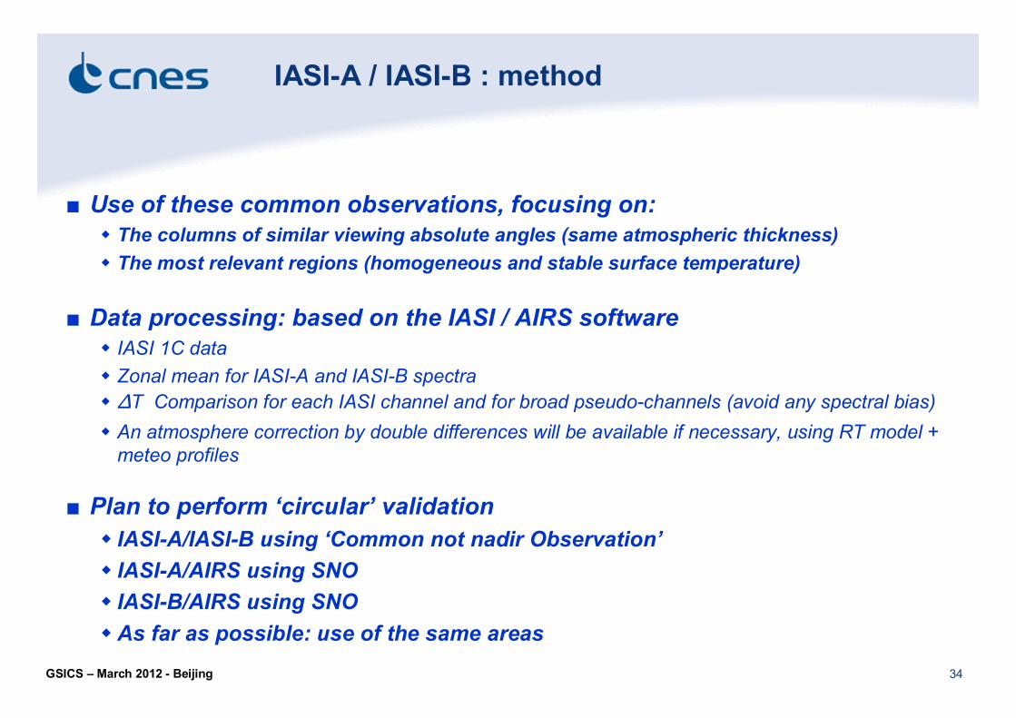
34 GSICS – March 2012 Beijing
■ Use of these common observations, focusing on: w The columns of similar viewing absolute angles (same atmospheric thickness) w The most relevant regions (homogeneous and stable surface temperature)
■ Data processing: based on the IASI / AIRS software w IASI 1C data w Zonal mean for IASIA and IASIB spectra w ΔT Comparison for each IASI channel and for broad pseudochannels (avoid any spectral bias) w An atmosphere correction by double differences will be available if necessary, using RT model + meteo profiles
■ Plan to perform ‘circular’ validation w IASIA/IASIB using ‘Common not nadir Observation’ w IASIA/AIRS using SNO w IASIB/AIRS using SNO wAs far as possible: use of the same areas
IASIA / IASIB : method

35 GSICS – March 2012 Beijing
IASI/2 (dν/ν=10 6 ) Absolute calibration
IASI (1km) Geolocation accuracy Navigation
IASI (25km) Spatial sampling
IASI (12km) Spatial resolution Geometry
IASI/2 (0.25K@280K) Absolute calibration
IASI/2 NedT@280K (α 1/SNR) Radiometry
IASI/2 (0.25 cm1 ) i.e. 16921 channels Spectral sampling
IASI/2 (0.125 cm 1 ) Spectral resolution
IASI ([6452760] cm 1 or [15.53.62] µm) Continuous spectral coverage Spectral
Objective Specification (L1C)
Preparing IASI New Generation
■ Performances improvement for IASING
■ CNES commitment to provide IASING to EUMETSAT ■2 industrial phase A studies in parallel (2 different instrument concept…)

36 GSICS – March 2012 Beijing
Thank you for your attention