Embed Size (px)
Citation preview

Overview of ArcGIS Online Applications
Champaign County
Updated: April 2017
Champaign County GIS Consortium

Champaign County GIS Consortium ArcGIS Online Application Overview
Page 2 of 16
Table of Contents ArcGIS Online Application Overview ....................................................................... 3
Map Interface Symbology and Terminology ........................................................................ 3
General Functionality ......................................................................................................... 3
Map Navigation ..................................................................................................................................... 3
Pop-ups ................................................................................................................................................. 4
Tools .................................................................................................................................. 5
Zoom ..................................................................................................................................................... 5
Home ..................................................................................................................................................... 5
Extent Navigate ..................................................................................................................................... 5
Measurement ........................................................................................................................................ 5
Query..................................................................................................................................................... 6
Search Box ............................................................................................................................................. 8
Print ....................................................................................................................................................... 8
Layers .................................................................................................................................................... 9
Google Street View ............................................................................................................................... 9
Swipe ................................................................................................................................................... 10
Legend ................................................................................................................................................. 10
Bookmark ............................................................................................................................................ 10
Draw .................................................................................................................................................... 11
Address Query Application Overview .................................................................... 12
Address Search Interface .................................................................................................. 12
Enhanced Search ................................................................................................................................. 12
CCSO Department Application Overview .............................................................. 14
CCSO Interface ................................................................................................................. 14
Edit ...................................................................................................................................................... 14
Filter .................................................................................................................................................... 15
Available Applications ............................................................................................. 16

Champaign County GIS Consortium ArcGIS Online Application Overview
Page 3 of 16
ArcGIS Online Application Overview The ArcGIS Online Application is a web application that is configured to work similar to ArcReader. Users are able to search and navigate GIS layers. The ArcGIS Online Application is fixed, meaning every time a user refreshes their browser the map will reset.
Map Interface Symbology and Terminology
A link to the CCGISC Public Web Map is included in this application at the top, center of the window.
General Functionality
Map Navigation
To Zoom In: Roll the mouse roller away from you to Zoom In To Zoom Out: Roll the mouse roller toward you to Zoom Out To Pan: Hold down the right mouse button and drag
Layers
Search Box
Legend
Bookmarks
Search Print
Home
Zoom
Measurement
Swipe
Google Street View
Extent Navigate
Draw

Champaign County GIS Consortium ArcGIS Online Application Overview
Page 4 of 16
Pop-ups Pop-ups display the attribute information for specific layers. This application contains Pop-ups for the following layers:
• Subdivision • Tax Parcel • Taxing Districts (County Clerk Application only) • Tax Parcel ROW (Highway Department Application only)
NOTE: Pop-ups are only accessible when the layer associated to a Pop-up is visible on the map. To View a Pop-up:
1. Click on a Tax Parcel and/or a Subdivision. 2. If the tax parcel is within a subdivision, the pop-up will show information about the subdivision
first. To view the tax parcel information in the Pop-up window, click the arrow at the top right of the pop-up window to advance to the next pop-up (see illustration below).
The Subdivision Pop-up contains a document hyperlink to the recorded subdivision plat.
To View Pop-up Document Hyperlinks:
Click on “More Info” to open the Subdivision Plat. Note: The plat will open up on the CCGISC Document Server. Log in to the Document Server using your County login and password.
To enlarge the pop-up window: Click
To return the pop-up window to the default view: Click
To close the pop-up window:
Click
Next Pop-up
Document Hyperlink
Champaign County GIS Consortium ArcGIS Online Application Overview
Page 5 of 16
Tools
Zoom
Provides the user with another way to zoom in and out on the map
Provides the user with another way to zoom in and out by drawing a rectangle around an area on the map Home
Returns the map to the default extent
Extent Navigate
Provides the user the ability to move back and forth between map extents. Note: Clicking the Home tool resets this navigation tool.
Measurement
Measures an area or a distance Allows the user to specify the unit of measurement
Area Measure
Length Measure
Units
Location
Ruler Icon

Champaign County GIS Consortium ArcGIS Online Application Overview
Page 6 of 16
To use the Measurement tool: 1. Click on the Ruler Icon. The “Measurement” dialog box displays. 2. Choose to measure an area or distance. 3. Choose the measurement units. 4. Click the starting point on the map. 5. Drag the mouse to the next point and click. Continue this step until the line or polygon is drawn. 6. Double-click to end the drawing. 7. The results will display in the “Measurement” window. 8. Click the ruler icon again or the X in the right corner to close the tool.
Note: The location option will find the longitude and latitude of a point. Choose this option and then click a location on the map. The results will display in the “Measurement” window.
Query
Searches the map by tax payer name or subdivision name To activate the Query Tool:
1. Click on the Query Icon. 2. The “Query” window will display. 3. Select the feature to search by:
• Tax Payer Search • Subdivision Search
Tax Payer Search: 1. Enter the full or partial name of the tax payer.
The query can also be performed on a partial Name.
2. Click “Execute”. • The map will zoom to show all tax
parcels that contain the entered data and create a layer in the layer list.
• A results window will display listing all the selected parcels that contain the query string. If multiple parcels are listed, the user can click on one of listed features to zoom to a specific tax parcel.
3. Click icon next to the results layer drop down box to see the manipulation options for the layer displayed in the drop down list box.
4. Choose “Remove This Result” to remove the queried records from the Results tab and map. 5. Click the Task tab to return to the search options.
Champaign County GIS Consortium ArcGIS Online Application Overview
Page 7 of 16
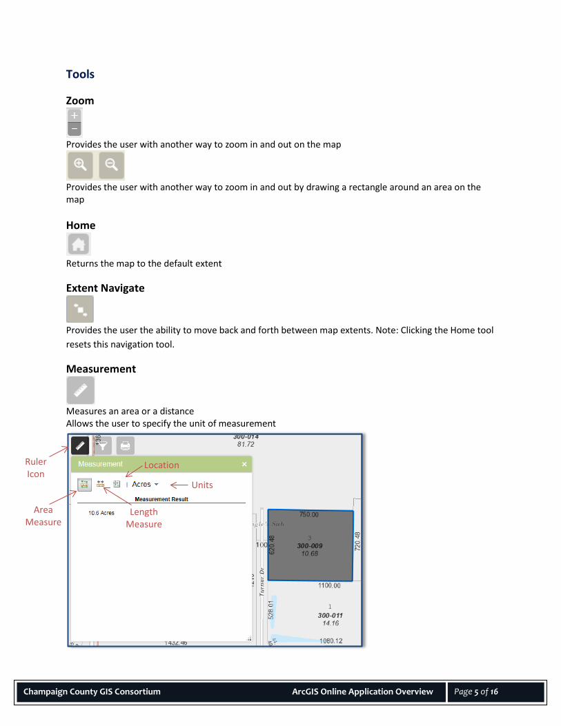
6. Click the arrow next to Tax Payer Search to return to all search options.
Subdivision Search: 1. Enter the full or partial name of a subdivision 2. Click “Execute”.
• The map will zoom to show all subdivisions that include the entered data and create a layer in the layer list.
• A results window will display listing all the selected subdivisions. To zoom to a specific subdivision, click the subdivision name in the results window.
3. Click icon next to the results layer drop down box to see the manipulation options for the layer displayed in the drop down list box.
4. Choose “Remove This Result” to remove the queried records from the Results tab and map.
5. Click the Task tab to return to the search option. 6. Click the arrow next to Subdivision Search to return to all search options.
Other Search Options: Return features within full extent of the map This is the default. The option allows the query to search the complete layer data. Only return features that intersect the shape drawn on the map When this option is chosen draw options will display to allow the query to be limited to the area within the shape drawn on the map. Only return features within current map extent This option will only query the viewable map area.

Champaign County GIS Consortium ArcGIS Online Application Overview
Page 8 of 16
Search Box Searches PINs, addresses, and street intersections
To use the Search Box Tool:
1. Click on the down arrow next to the magnifying glass and select a specific search type: • All • PIN • Leasehold PIN • PPS (Parcel Platted Sub) PIN • Address Search • Intersection Search
Note: Selecting All allows you to search by all options. The default is all.
2. Type the street intersection or address. Use the example shown in the search box as a guide. Note: Available options will appear while typing in the search information.
3. Select an option or click the magnifying glass. The map will zoom to the item being searched. 4. Click the “X” to clear the box and perform another search.
Creates a map layout for printing
To use the Print Tool:
1. Click on the Print Icon. 2. A Print window will display giving the user options to
create their print page. The user can change the map title, layout, and specify a print format (PDF, JPEG, etc.) TIP: Selecting “MAP_ONLY” as the layout option will export only the map image at a size specified by the user in the advanced options. No map collar information will be inlcluded – title, scalebar, etc.
3. Click the “Advanced” button to view more print options. The user can set the map scale, include a legend, and change print quality.
4. Click the “Print” button. A link to the created map will be listed in the print window.
5. Click the link to view and print the map.
6. Click File --> Save as on your browser menu to save the print to your computer.
Note: The Layout metadata settings have entries by default and should not be altered.
Print Window

Champaign County GIS Consortium ArcGIS Online Application Overview
Page 9 of 16
Layers
Turns layers on and off in the map view
To use the Layer Tool:
1. Click on the Layer Icon to display a window that lists all the layers included in the map. • Some layers are grouped in categories. To expand or
collapse the group, click on the arrow shown in the red circle.
2. To turn on a layer (make it visible in the map), click on the box next to the layer name – a checkmark will appear in the box.
3. To turn off a layer, click on the box next to the layer name – this will remove the checkmark.
4. Click the arrow shown in the blue circle to display additional layer options. These option will allow the user to:
• Zoom to the layer extent • Change the transparency on the layer or group • Move the layer above or below another layer • Enable pop-ups (Available when drilling down to
lowest layer of operational layer.) 5. Click the “X” in the upper right corner, to close the layer
list tool.
Google Street View
Connects to Google’s street view which shows images of a streets surroundings To use Google Street View:
1. Click on the icon, then drag and drop the yellow street view man to a street location 2. A pop up window will display with an image of the street view.
Note: If an image is not available, a message stating this will display in the pop up window. 3. If an image is available, the following Google tools will also be available to navigate the street
view. • Rotate • Zoom In/Out • Move forward/backward • Full Screen
4. To remove the street view man from the map, click the ‘X’ in the Google Street View icon window.
5. To close the pop up window, click the ‘X’ in the upper right corner.

Champaign County GIS Consortium ArcGIS Online Application Overview
Page 10 of 16
Swipe
Allows users to view layers side by side To use the Swipe Tool:
1. Turn on the layers to compare using the Layers tool. For instance, the 2014 Imagery and the 2008 High Imagery layers.
2. Click on the Swipe Icon 3. Choose one of the layers to swipe back and forth
in the selection box. 4. After clicking the Swipe Icon, a bar will display on
the map, move it from left to right to compare layers.
5. Click the Swipe Icon again to remove the bar.
Legend
Displays the legend window that lists the layer names and corresponding cartography
Note: The legend window only displays the layers that are visible at the map extent the user is viewing.
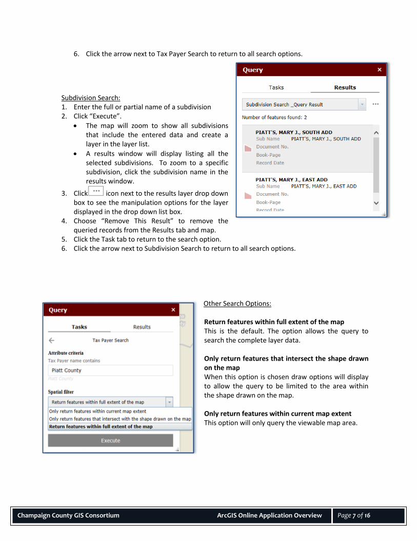
Bookmark
Zooms to predefined bookmarks Allows user to create temporary bookmarks
To use a predefined Bookmark:
1. Click on the Bookmark Icon to display a window that lists all the predefined bookmarks.
2. Click on a bookmark and the map will zoom to that location.
To create a temporary Bookmark:
1. The box at the top of the window allows the user to create a new bookmark.
2. Zoom to an area on the map 3. Enter a name in the box 4. Click the plus sign button. A new bookmark will display in the window.
To delete a Bookmark:
1. Click on a predefined or temporary bookmark to select it.
Champaign County GIS Consortium ArcGIS Online Application Overview
Page 11 of 16
Enter Temporary Bookmark Name
2. Scroll to the end of the bookmark list to view the “Delete” button
3. Click the “Delete” button to delete the selected bookmark.
To close the Bookmark window: Click the “X” to close the window. Note: The bookmarks will reset. Temporary bookmarks will only be in the Bookmarks window during the user’s session.
Draw
Allows users to add a sketch or text to the map To add a sketch to the map:
1. Click the Draw Icon to display drawing options. 2. Select a point, line, or polygon type. 3. Choose a color or symbol from the preset options or click the colored panel next to ‘Color’ and
‘Outline Color’ (for polygons only). 4. Set the transparency using the scale.
5. Set the line width. Note: The ‘Show Measurements’ check box will give the user options to set unit types and then calculate the measurements after the sketch is complete.
6. Click on the map to draw the sketch.
7. The user can choose to undo, redo, or clear the sketches using the buttons at the bottom of the draw window.
To add text to the map: 1. Click the ‘A’ icon under ‘Select drawing mode’. 2. Enter text in the text box. A preview will display above the box. 3. Choose a color and font size. 4. Click a location on the map to add the text.

Champaign County GIS Consortium ArcGIS Online Application Overview
Page 12 of 16
Address Query Application Overview Address Search Interface
The Active Address Query application allows users to select addresses and export address data to a spreadsheet format (csv) using the enhanced search widget. The selection can be defined using a buffer, creating a drawing, or by a defined address feature.
Enhanced Search
Allows users to make a selection by shape, value, or layer
To select by shape: 1. Click on the Enhanced Search icon to display
the window. Click on the “By Shape” tab. 2. Choose a layer in the “Search layer” drop
down list. 3. Select a feature shape 4. Check the box next to “Enable multi-part
graphics” if the selection will include multiple areas
5. Check the box next to “Buffer Graphic” and choose a buffer distance if a specific distance is required for selection. Note: It is best to use the “Select features by”
(point) when using this option. 6. Draw the shape on the map in the desired area(s). The addresses will appear selected on the
map and the “Results” tab will list all addresses selected. 7. Click “Export All to CSV” to create a spreadsheet list. Save in desired location.
To select by value:
1. Click on the Enhanced Search icon to display the window. Click on the “By Value” tab. 2. Choose the “Search layer” in the drop down box. 3. Choose the “Search alias” in the drop down box if this option is provided for the selected search
layer. 4. Choose from the drop down list or type in the desired feature to search by. 5. Check the box next to “Limit search to map extent” if the desired area to search in is viewable in
the map window. 8. Click the “Search” button. Any addresses match the defined query they will appear selected on
the map and the “Results” tab will list all addresses selected. 6. Click “Export All to CSV” to create a spreadsheet list. Save in desired location.

Champaign County GIS Consortium ArcGIS Online Application Overview
Page 13 of 16
To select by spatial: Select by Spatial works in conjunction with Select by Value.
1. Click on the Enhanced Search icon to display the window. Perform a selection by value first. For example, select a municipal boundary by value by choosing ‘Municipal Boundaries’ in the “Search layer” drop down list on the “By Value” tab. Then choose a municipality and click the “Search” button.
2. Click on the “By Spatial” tab. Choose the ‘Address Points’ layer in the drop down list under “Search entities of”
3. If desired, apply a buffer by entering the distance under “Apply a search distance” and clicking the “Apply Buffer” button next to distance area.
4. Click the “entirely contained in” button to perform the selection. The addresses will appear selected on the map and the “Results” tab will list all addresses selected.
5. Click “Export All to CSV” to create a spreadsheet list. Save in desired location. Other features: • The “By Shape” and “By Value” tabs allow for choosing a selection result type by clicking the
icon next to the “Search layer” drop down list. The options are to create new results, add to current results, and remove from current results. By default the tool is set to “Create new results”.
• The “Results” tab allows for the removal of addresses from the selection by clicking on the red X to the right of the address data. This tab also has the option to zoom to the selection.
• The csv export will include all the data for each address listed in the “Results” tab.
• Each tab includes clear options to reset settings to the default setting. Instructions for the other tools included in the application are provided in other sections of this document. Please see the table of contents.

Champaign County GIS Consortium ArcGIS Online Application Overview
Page 14 of 16
CCSO Department Application Overview CCSO Interface
The CCSO Interface has many of the same functionalities as previously described. The added functionality includes the ability to edit points and filter those edits by user input. A login is required to view the layer used in these functionalities.
Edit
Edit Icon - allows users to make simple edits in applications that contain editable layers. The editable layers must be turned on in the Layer list to use the Edit functions.
To select multiple features:
1. Click on the “Edit” icon. 2. Use the black arrow in the “Edit” window to select multiple features by drawing a box around
the features of interest. 3. Selecting the down arrow next to the black arrow in the Edit window will give more options to
change the selection (New Selection, Add to Selection, and Subtract from Selection).
To add features to the layer: 1. Click on the “Edit” icon. 2. Choose the appropriate feature type template from the “Edit” window. 3. Zoom to the location on the map and click on the map to add the feature.
To edit attributes: 1. Click on a feature in the map. A pop up will display. 2. Make necessary changes to the fields. 3. Click the ‘X’ at the top right corner of the pop up window to finish editing. 4. Click the eraser symbol on the edit window to remove the feature from selection.
To move a feature: 1. Select the feature on the map. 2. Click on the feature again and hold the mouse button down. 3. Drag and drop the feature to its new location.
To delete a feature: 1. Select the feature on the map. 2. In the pop up window, click the ‘Delete’ button. 3. If the pop up window is not open, click the red ‘X’ at the bottom of the “Edit” window.
To undo or redo a delete or move action:
1. Clear selections with the eraser symbol in the “Edit” window. 2. Click the ‘Undo’ or ‘Redo’ arrow located in the same window.
Note: The Undo and Redo arrows do not affect the attributes in the layer.

Champaign County GIS Consortium ArcGIS Online Application Overview
Page 15 of 16
Filter
Allows users to filter a layer by an attribute so it only shows those features that include the specified attribute on the map
To apply a filter: 1. Click on the “Filter” icon to open the window. 2. Choose an option in the drop down menu. 3. Click apply.
To remove a filter:
1. Click on the checkmark icon in the filter window.

Champaign County GIS Consortium ArcGIS Online Application Overview
Page 16 of 16
Available Applications Application Name Application Link
Supervisor of Assessments http://www.maps.ccgisc.org/soa/ County Clerk http://www.maps.ccgisc.org/countyclerk/ Highway Department http://www.maps.ccgisc.org/highway/ Village of Mahomet http://www.maps.ccgisc.org/mahomet/ Village of Savoy http://www.maps.ccgisc.org/savoy/ University of Illinois http://www.maps.ccgisc.org/uofi/ Willard Airport http://www.maps.ccgisc.org/willard/ Active Address Query http://www.maps.ccgisc.org/addressquery County Zoning http://www.maps.ccgisc.org/zoning/ UCSD http://www.maps.ccgisc.org/ucsd/