Embed Size (px)
Citation preview
Outstanding Balkan River landscapes – a basis for wise
development decisions
Albania
1
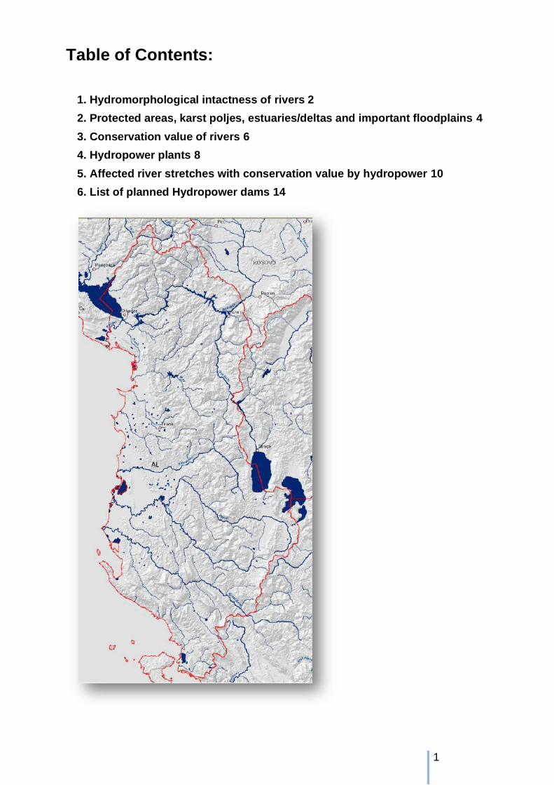
Table of Contents:
1. Hydromorphological intactness of rivers 2
2. Protected areas, karst poljes, estuaries/deltas and important floodplains 4
3. Conservation value of rivers 6
4. Hydropower plants 8
5. Affected river stretches with conservation value by hydropower 10
6. List of planned Hydropower dams 14
2
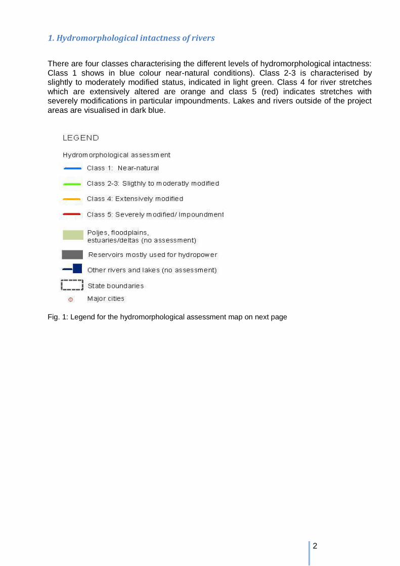
1. Hydromorphological intactness of rivers
There are four classes characterising the different levels of hydromorphological intactness: Class 1 shows in blue colour near-natural conditions). Class 2-3 is characterised by slightly to moderately modified status, indicated in light green. Class 4 for river stretches which are extensively altered are orange and class 5 (red) indicates stretches with severely modifications in particular impoundments. Lakes and rivers outside of the project areas are visualised in dark blue.
Fig. 1: Legend for the hydromorphological assessment map on next page

3
Fig. 2: Hydromorphological assessment for AL. Albania has still together with Montenegro the largest free flowing and mostly untouched river stretches of all Balkan countries. Even large rivers like Vjosa, the Seman system with Devoll and Osam as well as Skumbin are still not interrupted by dams. Only Drin river is
4
mostly turned into a chain of hydropower reservoirs (red). But also many deltas and estuaries still provide excellent hydromorphological conditions.
Fig. 3: Hydromorphological assessment in rkm and percentage for AL.
2. Protected areas, karst poljes, estuaries/deltas and important floodplains The inventory of protected areas contains in particular Natura2000 for EU Member States (EC 2010) and Croatia (State Institute for Nature protection Croatia 2010), national parks, biosphere reserves, nature reserves, EMERALD network areas (as far as available) and Important Bird Areas as well as Ramsar sites for other countries. Major important floodplains were used continuously, meaning for the large rivers such as Danube, Drava and Sava they are subdivided in upper, middle and lower parts. In addition the map includes all assessed karst poljes, estuaries/deltas as well as other wetlands. Fig. 4 next page: Protected areas (incl. planned and proposed areas) in dark green (light green are poljes and large floodplain areas)

5

6
3. Conservation value of rivers The conservation value is assessed in three levels: Very high conservation value (in blue), high conservation value (in dark green) and low conservation value (in light green). Karst poljes, major floodplains as well as deltas and estuaries with very high conservation value are visualized in dark blue-green and high conservation value in light green and low in light turquoise. Karst poljes and deltas are from particular interest for nature protection, therefore nearly all fall in the first two conservation classes. Hydro-
morphological assessment class
Conservation value (assessment as result of overlay of hydromorphological assessment + protected areas + floodplains)
Class 1 Near-natural Very high Class 2-3 Slightly to
moderately modified
High (river stretches crossing important floodplains/poljes/estuaries/deltas or overlapping with protected areas or both belonging to the “Very
high” conservation value stretches) Class 4 Extensively
modified Low, but important for longitudinal continuum (river stretches crossing important floodplains/poljes/estuaries/deltas or overlapping with protected areas or both belonging to the “High” conservation value stretches)
Class 5 Impoundments
Severely modified Not assessed
Fig. 5: Definition of conservation value (additional biological data will be included in the study update 2012)
Fig. 6: Legend for the map on conservation value on next page

7
Fig. 7: Conservation value for AL. The ecological intactness of rivers in general reaches in several cases from the headwater to the deltas into the Adriatic Sea, which is mostly unique for Adriatic or even European Mediterranean catchments and rivers of this size. Due to limited coherent protection network some rivers fall in the lowlands only in the second class.
8
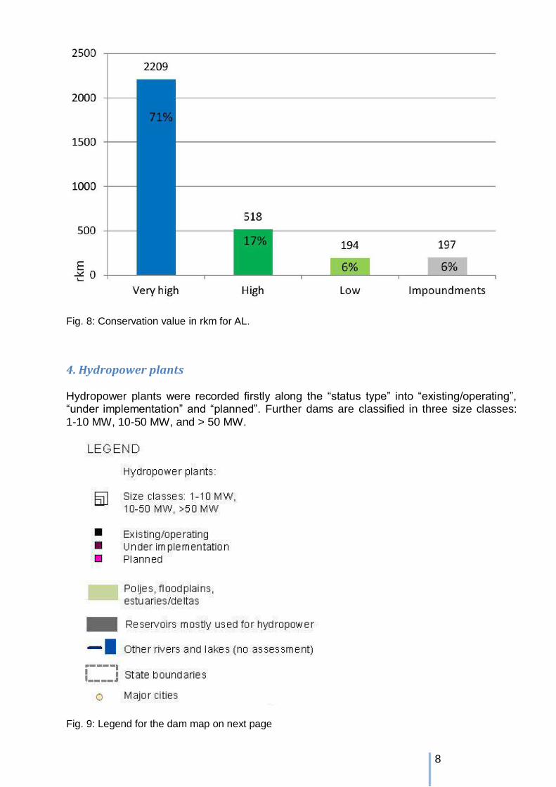
Fig. 8: Conservation value in rkm for AL.
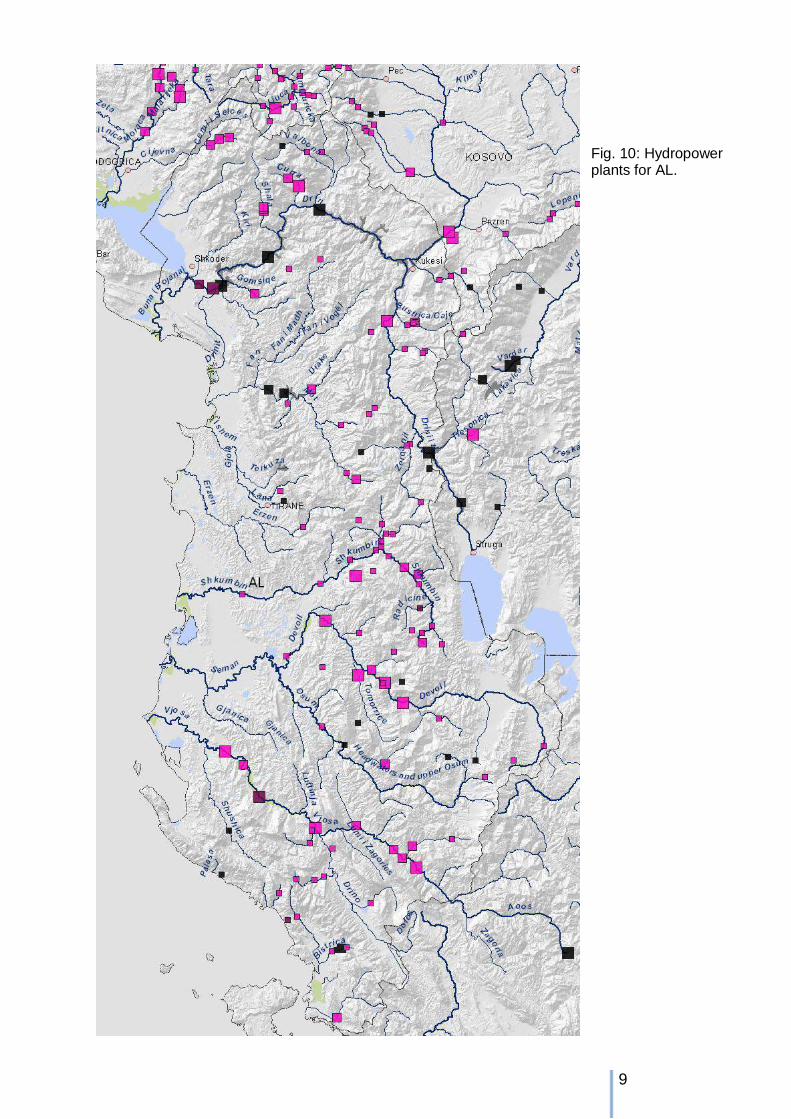
4. Hydropower plants Hydropower plants were recorded firstly along the “status type” into “existing/operating”, “under implementation” and “planned”. Further dams are classified in three size classes: 1-10 MW, 10-50 MW, and > 50 MW.
Fig. 9: Legend for the dam map on next page
9
Fig. 10: Hydropower plants for AL.
10
The Drin river is the largest used river in Albania for hydropower and the chain of major dams summed up to more than the half of the Iron gate 1 impoundment with some 170 rkm. Other major dams can be so far find only in the northern part of the country. All rivers in mountainous reaches are subject of hydropower development.
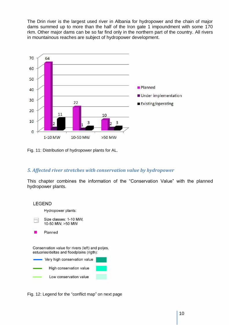
Fig. 11: Distribution of hydropower plants for AL.
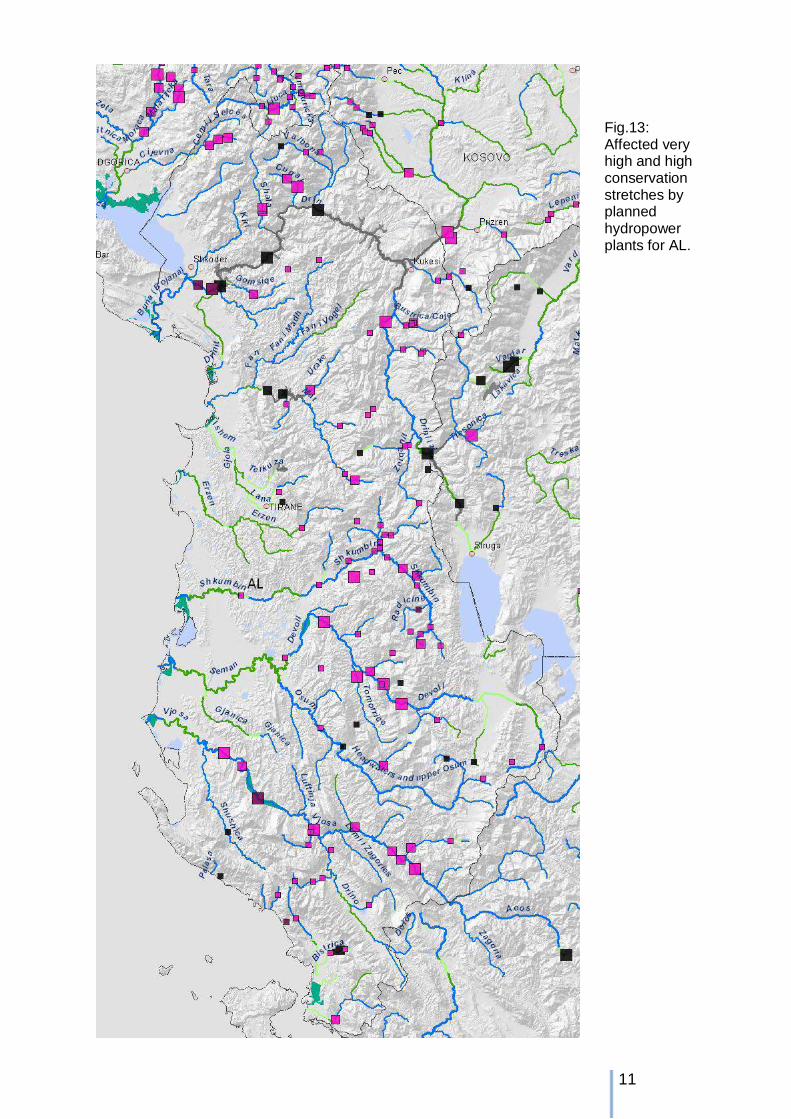
5. Affected river stretches with conservation value by hydropower This chapter combines the information of the “Conservation Value” with the planned hydropower plants.
Fig. 12: Legend for the “conflict map” on next page
11
Fig.13: Affected very high and high conservation stretches by planned hydropower plants for AL.
12
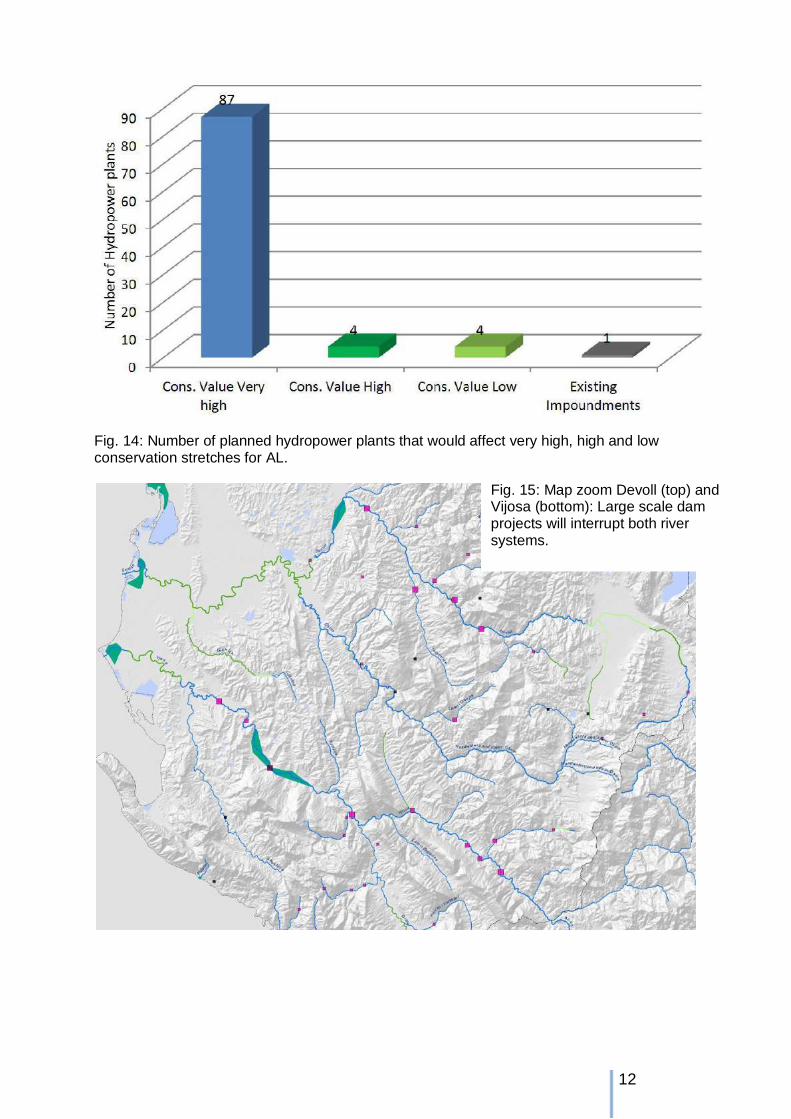
Fig. 14: Number of planned hydropower plants that would affect very high, high and low conservation stretches for AL.
Fig. 15: Map zoom Devoll (top) and Vijosa (bottom): Large scale dam projects will interrupt both river systems.
13
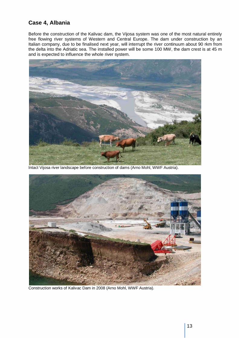
Case 4, Albania Before the construction of the Kalivac dam, the Vijosa system was one of the most natural entirely free flowing river systems of Western and Central Europe. The dam under construction by an Italian company, due to be finalised next year, will interrupt the river continuum about 90 rkm from the delta into the Adriatic sea. The installed power will be some 100 MW, the dam crest is at 45 m and is expected to influence the whole river system.
Intact Vijosa river landscape before construction of dams (Arno Mohl, WWF Austria).
Construction works of Kalivac Dam in 2008 (Arno Mohl, WWF Austria).
14
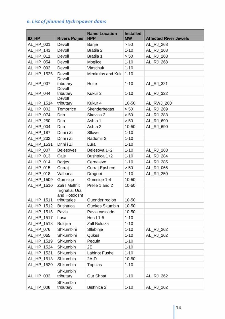
6. List of planned Hydropower dams
ID_HP Rivers Poljes Name Location HPP
Installed MW Affected River Jewels
AL_HP_001 Devoll Banje > 50 AL_RJ_268 AL_HP_143 Devoll Bratila 2 1-10 AL_RJ_268 AL_HP_011 Devoll Bratila 1 > 50 AL_RJ_268 AL_HP_054 Devoll Moglice 1-10 AL_RJ_268 AL_HP_092 Devoll Vlaschuk 1-10
AL_HP_1526 Devoll Menkulas and Kuk 1-10
AL_HP_037 Devoll tributary Holte 1-10 AL_RJ_321
AL_HP_044 Devoll tributary Kukur 2 1-10 AL_RJ_322
AL_HP_1514 Devoll tributary Kukur 4 10-50 AL_RWJ_268
AL_HP_002 Tomorrice Skenderbegas > 50 AL_RJ_269 AL_HP_074 Drin Skavica 2 > 50 AL_RJ_283 AL_HP_250 Drin Ashta 1 > 50 AL_RJ_690 AL_HP_004 Drin Ashta 2 10-50 AL_RJ_690 AL_HP_187 Drini i Zi Sllove 1-10
AL_HP_232 Drini i Zi Radomir 2 1-10 AL_HP_1531 Drini i Zi Lura 1-10 AL_HP_007 Belesoves Belesova 1+2 1-10 AL_RJ_268
AL_HP_013 Caje Bushtrica 1+2 1-10 AL_RJ_284 AL_HP_014 Borjes Cernaleve 1-10 AL_RJ_285 AL_HP_015 Curraj Curraj-Epshem > 50 AL_RJ_066 AL_HP_018 Valbona Dragobi 1-10 AL_RJ_250 AL_HP_1509 Gomsiqe Gomsiqe 1-4 10-50
AL_HP_1510 Zali I Melthit Prelle 1 and 2 10-50
AL_HP_1511
Egnatia, Ura and Hotolosht tributaries Quender region 10-50
AL_HP_1512 Bushtrica Quekes Skumbin 10-50 AL_HP_1515 Pavla Pavla cascade 10-50 AL_HP_1517 Lusa Hec I 1-5 1-10 AL_HP_1518 Bulqiza Zall Bulqiza 1-10 AL_HP_076 Shkumbini Sllabinje 1-10 AL_RJ_262
AL_HP_065 Shkumbini Qukes 1-10 AL_RJ_262 AL_HP_1519 Shkumbin Pequin 1-10
AL_HP_1524 Shkumbin 2E 1-10 AL_HP_1521 Shkumbin Labinot Fushe 1-10 AL_HP_1513 Shkumbin 2A-D 10-50 AL_HP_1520 Shkumbin Topcias 1-10
AL_HP_032 Shkumbin tributary Gur Shpat 1-10 AL_RJ_262
AL_HP_008 Shkumbin tributary Bishnica 2 1-10 AL_RJ_262
15
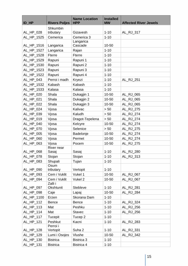
ID_HP Rivers Poljes Name Location HPP
Installed MW Affected River Jewels
AL_HP_028 Shkumbin tributary Gizavesh 1-10 AL_RJ_317
AL_HP_1525 Cemerica Cemerica 3 1-10
AL_HP_1516 Langarica Langarica Cascade 10-50
AL_HP_1527 Langarica Rajan 1-10 AL_HP_1528 Fterre Fterre 1-10 AL_HP_1529 Rapuni Rapuni 1 1-10 AL_HP_1530 Rapuni Rapuni 2 1-10 AL_HP_1523 Rapuni Rapuni 3 1-10 AL_HP_1522 Rapuni Rapuni 4 1-10 AL_HP_043 Perroi i madh Kryezi 1-10 AL_RJ_251
AL_HP_1532 Kabash Kabash 1-10 AL_HP_1533 Kalasa Kalasa 1-10 AL_HP_020 Shala Dukagjin 1 10-50 AL_RJ_065
AL_HP_021 Shala Dukagjin 2 10-50 AL_RJ_065 AL_HP_022 Shala Dukagjin 3 10-50 AL_RJ_065 AL_HP_024 Vjosa Kalivac > 50 AL_RJ_275 AL_HP_039 Vjosa Kaludh > 50 AL_RJ_274 AL_HP_019 Vjosa Dragot-Tepelena > 50 AL_RJ_274 AL_HP_040 Vjosa Kelcyre 10-50 AL_RJ_274 AL_HP_070 Vjosa Selenice > 50 AL_RJ_275 AL_HP_005 Vjosa Badelonje 10-50 AL_RJ_274 AL_HP_060 Vjosa Permet 10-50 AL_RJ_274 AL_HP_063 Vjosa Pocem 10-50 AL_RJ_275
AL_HP_068 River near Sasaj Sasaj 1-10 AL_RJ_280
AL_HP_078 Stojan Stojan 1-10 AL_RJ_313 AL_HP_083 Shupali Tujan 1-10
AL_HP_090
Osum tributary Vertopit 1-10
AL_HP_093 Cem i Vuklit Vukel 1 10-50 AL_RJ_067 AL_HP_094 Cem i Vuklit Vukel 2 10-50 AL_RJ_067
AL_HP_097 Zalli i Okshtunit Stebleve 1-10 AL_RJ_281
AL_HP_098 Caje Lapaj 10-50 AL_RJ_284 AL_HP_1100 Erzen Skorana Dam 1-10
AL_HP_112 Bence Bence 1-10 AL_RJ_324 AL_HP_113 Mat Peshku 1-10 AL_RJ_256 AL_HP_114 Mat Stavec 1-10 AL_RJ_256 AL_HP_117 Tucepit Tucep 2 1-10
AL_HP_121 Peshkut Kacni 1-10 AL_RJ_283
AL_HP_128 Perroi i Vertopit Suha 2 1-10 AL_RJ_331
AL_HP_129 Lumi i Osojes Vlushe 10-50 AL_RJ_342 AL_HP_130 Bistrica Bistrica 3 1-10
AL_HP_131 Bistrica Bistrica 4 1-10

16
ID_HP Rivers Poljes Name Location HPP
Installed MW Affected River Jewels
AL_HP_132 Perroi i Madh, Murra Selishte 1-10 AL_RJ_283
AL_HP_142 Valbona Bradoshnica 1-10 AL_RJ_309 AL_HP_221 Curraj Curraj-Eperm 10-50 AL_RJ_066 AL_HP_234 Zerqanit Cerenec 1-10 AL_RJ_281 AL_HP_240 Dardha Dardhe 1-10 AL_RJ_266 AL_HP_241 Gostima Gostima > 50 AL_RJ_262 AL_HP_243 Bence Veliqote 1-10 AL_RJ_324 AL_HP_251 Orenja Orenja 2 1-10 AL_RJ_317 AL_HP_253 Caje Caja 1-10 AL_RJ_284 AL_HP_254 Caje Shkinak 1-10 AL_RJ_284 AL_HP_255 Caje Lusna 1-10 AL_RJ_284
Pictures cover: Left: Ulrich Eichelmann (Vjosa), Rigth: Goran Šafarek (Valbona valley) Prepared by FLUVIUS, Vienna 2010-2014


![Outstanding Balkan River landscapes a basis for wise ...smallpdf.com].pdf2 1. Hydromorphological intactness of rivers There are four classes characterising the different levels of](https://img.dokumen.tips/doc/110x75/607055892f8058439e131268/outstanding-balkan-river-landscapes-a-basis-for-wise-smallpdfcompdf-2-1.jpg)


![WELCOME [] · •Programme integration group. Aquatic microbiology •RESERVOIRS ... sapo/norovirus rotavirus. Do the bubbles represent intact/infective viruses? Intactness inferred](https://img.dokumen.tips/doc/110x75/5fb6382d6124397f8808b739/welcome-aprogramme-integration-group-aquatic-microbiology-areservoirs-.jpg)