Embed Size (px)
Citation preview

Planning and Development Department
October 2017 Page 1
Outline Plans (Neighbourhood Plans)
_______________________________________________________
2.1 Introduction
In accordance with the Municipal Government Act Section (636) the City of Lethbridge and/or consultants prepare Area Structure Plans (ASPs) to define future growth in sectors of the City. The Area Structure Plan must comply with Provincial Legislation and Regulations such as the South Saskatchewan Regional Plan and higher order Statutory Plans (the Integrated Community Sustainability Plan/Municipal Development Plan). Following the adoption of an ASP by City Council, landowners may begin the process of completing an Outline Plan in accordance with the policies outlined in the ASP.
2.2 Outline Plan Purpose
The Outline Plan focuses on smaller, discreet areas of land (called a Stage) than the ASP and provides a finer level of technical engineering detail as to how the land will be further subdivided, serviced and developed. A Stage is typically defined as a neighbourhood1 area that is no less than 40 acres and is typically not greater than 160 acres. These areas must fit into overall City infrastructure capacities and provide for the needs of the market while being economically developable for landowners and fiscally responsible to the existing residents of Lethbridge.
While the Outline Plan looks at a specific area of land, the planning and engineering must take into account the adjacent lands whether developed or not in terms of not only constraints and opportunities but servicing, transportation networks and land use compatibility. Adjacent lands within Lethbridge County must also be taken into account and the County staff consulted during the Outline Plan process, in accordance with the Intermunicipal Development Plan.
Contemporary Area Structure Plans undertaken or presented to the City of Lethbridge for review after January 1, 2013 are designed to include sufficient levels of technical engineering detail so as to avoid the duplication of cost, time and effort
1 A neighbourhood should include a balance of housing, recreation and employment based uses.

Planning and Development Department October 2017 Page 2
at the subsequent Outline Plan stage. ASPs approved prior to 2013 were not required to provide the same level of details and in other cases Outline Plans were allowed to proceed outside the boundaries of an ASP. As such, the information requirements to be provided in the Outline Plan may vary based on these circumstances.
• Outline Plans within ASPs approved after January 1, 2013 will follow the requirements and process outlined below2.
• Outline Plans within an ASP approved prior to January 1, 2013 will continue to follow the “Gated Outline Plan” process outlined at http://www.lethbridge.ca/Doing-Business/Planning-Development/Documents/Gated%20Process%20Guideline.pdf
2.3 Content
Part 1
All new Outline Plans shall take into account, and describe how the Outline Plan complies with the following policy plans:
South Saskatchewan Regional Plan Statutory Plans that have been approved by Lethbridge City Council
1) Integrated Community Sustainability Plan/Municipal Development Plan 2) Intermunicipal Development Plan 3) The relevant Area Structure Plan containing the Outline Plan area
Non-Statutory Master Plans approved by resolution of City Council including: 1) Bikeways and Pathways Master Plan 2) Parks Master Plan 3) Recreation and Culture Master Plan 4) Transportation Master Plan 5) Fire Master Plan 6) Transit Master Plan3 7) Cycling Master Plan
Part 2 An Outline Plan template (Appendix C) is provided as an addendum to this document understanding that the unique circumstances of a piece of land may
2 Some variation to the new Outline Plan process may be required for the West Lethbridge Employment
Centre ASP and the Waterbridge ASP as these plans were “in progress” at the time of new ASP and Outline Plan guidelines coming into effect.
3 As of October 2017 the Transit Master Plan is in progress, but is expected to be complete soon.

Planning and Development Department October 2017 Page 3
necessitate additions or deletions to the content. It is expected that the Consultant has reviewed the governing ASP through the application form/checklist (Appendix B) and is using the background and technical information as provided in the ASP when writing the Outline Plan. A confirmation statement of such is required. The Outline Plan shall provide for a written discussion around the following topic headings and be accompanied by illustrative maps and/or concept drawings. Maps and drawings must be clear and legible and properly labelled with a legend, north arrow and title block. If two adjacent Outline Plans are being worked on simultaneously it is expected that there will be communication between the consultants and developers in regards to the integration of open space and pathways, boundary conditions, infrastructure design, transportation systems and the transitioning between the two Outline Plan areas.
Opportunities and Constraints – must clearly articulate both in written and visual form the topography of the area along with natural or man-made constraints or opportunities to the development. This shall include, but is not limited to: adjacent development and land use interface, oil and gas wells and underground lines; electrical or telecommunications infrastructure, extensive and intensive agricultural operations, dugouts, existing buildings or structures, roads and access points, drainage corridors, wetlands, wildlife habitat areas, historic resource sites, coulees, natural grasslands, and vegetation. If such information was provided in the ASP then the Outline Plan should reference and present this information contextually in the Plan. Development Concept – general land uses (i.e. low, medium or high density residential use) and densities proposed at the Outline Plan stage should not diverge substantially from the ASP. Minor variations in use are acceptable recognizing that markets and demands change over time. However, such changes cannot substantially alter the servicing or transportation requirements resulting from significant changes in planned density (e.g. single family to multi-family) or major changes in use categories (e.g. Residential to Commercial), which would require amendments to the ASP if not already addressed or anticipated within the ASP. It is not anticipated that specific land use districts will be assigned a part of the Outline Plan but rather a range of options may be presented with zoning to occur later closer to the time of subdivision. Open Space Concept – the layout of parks and school sites identified in the ASP shall be refined at the Outline Plan to clearly show concepts for the layout of school, parks amenities and linear pathway connections within the Outline Plan and to existing and future neighbourhoods. Open space should attempt to incorporate natural features where possible. Parks and schools should be incorporated into the

Planning and Development Department October 2017 Page 4
earliest phases as are practical and not left to the final phases of the Outline Plan area. Communication between the developer and the school districts is required throughout the OP process and City staff should be present when this occurs. Creditable and non-creditable reserve lands4 should be acknowledged.
Servicing Network – shall include identification of the location of required electrical, major storm water facilities (ponds, storm sewer lines), sanitary sewer facilities (sewer lines and lift stations), water facilities (water lines and reservoirs) and size requirements, address any off site funded requirements, and outline any alternative designs that may have been considered by other City Master Plans or identified by higher order Policy Plans. The servicing network shall also consider lands adjacent to the Outline Plan area and how the servicing will interface with existing and future neighbourhoods. If two adjacent Outline Plans are being worked simultaneously it is expected that there will be communication between the consultants and developers in regards to the transition between areas, boundary conditions and the design of required systems. Transportation Network- shall describe and illustrate the planned location and capacity of roads, how multi-modal options are being included, any traffic control devices such as roundabouts or right in/right outs that are being employed, the interface with existing and future road networks and the effects of any proposed alternative designs that may have been considered in an approved ASP.
Phasing Strategy – the Outline Plan shall clearly show the proposed phases of subdivision and sequence of development that the landowner or developer intends to follow in constructing new subdivisions. Clear language articulating which infrastructure requirements must be constructed for each phase to begin must be included. Rezoning of lands will occur concurrent with a subdivision application or in anticipation of a subdivision application within the year. Implementation Strategy – the information and strategies approved in the Outline Plan shall be used by the consultant when providing detailed design drawings to the City at the time of subdivision. In the event of a change to the Outline Plan involving a minor adjustment to a roadway or laneway or switching between specific land use districts within the broader category (ie. low density or medium density residential) staff can approve an adjustment to the Outline Plan. Depending upon the nature of the proposed adjustment, this may still require the proponent to submit the necessary changes to the Outline Plan (i.e. revised text, maps etc.), but does not require the approval of the Municipal Planning Commission.
4 Dry ponds, wet ponds (below the high water mark), and linear connections that are less than 15m in width are non-creditable reserve.

Planning and Development Department October 2017 Page 5
In general terms, modifying the following components of an Outline Plan will result in an amendment to the Outline Plan:
• one land use category to another (i.e. Residential to Commercial) • the classification of a roadway (i.e. local to a collector)
An Outline Plan amendment is considered to be more impactful than an adjustment and requires staff to provide review and comments on the change as well as public notification and approval by Municipal Planning Commission. This requires the proponent to submit a fee for the amendment and follow the processes of the Municipal Planning Commission.
Part 3
The following supporting documentation is required to be presented as part of the Outline Plan and may be included as an Appendix to the Outline Plan if:
• it has not been previously been provided to a sufficient level of detail, or • if previous reports surfaced matters/issues that require further deliberation
and/or • there is a policy direction to obtain such information set up in higher order
Policy Plans (the ASP).
1. Geotechnical Reports – These reports must be at a sufficient level of detail to confirm that there are no major underground conditions that will affect the ability of the development to take place. It is recommended that geotechnical reports include sufficient borehole samples to confirm significant changes in conditions and to reduce the requirement for site specific sampling at subsequent subdivision and development stages.
2. Environmental Reports – This includes any Environmental Site Assessments
(ESAs) Phase 1, 2 or 3 and Wetland Assessment (in accordance with the Alberta Water Act) that are required, as well as a Biophysical Impact Assessment (BIA).
3. Historical Resource Assessments or Historic Resource Impact Assessment –
Prior to approval of the Outline Plan, clearance under the Alberta Historic Resources Act must be granted by the Province. This includes a review of Alberta Culture Historic and Archaeological known site (the assessment) and, if required, a Historic Resource Impact Assessment (HRIA). If Historic Resources Act clearance has been granted at the previous ASP stage a new HRIA is not required.
4. Traditional Knowledge and Land Use Study - This includes an analysis of the
Outline Plan area to determine the presence and significance of Indigenous

Planning and Development Department October 2017 Page 6
traditional knowledge and land use. This includes identifying and documenting the following types of sites and use areas: native vegetation, animal habitat and corridors, resource extraction, human habitation and economic use, human spiritual and ceremonial use, as well as ecological knowledge and places of history, legend and other accounts. If a Traditional Knowledge and Land Use Study has been completed at the ASP stage a new Study is not required, unless specified in the ASP.
5. Traffic Impact Assessment - This includes outlining local road networks and verifying and supporting traffic impact assessments (TIA) work undertaken within an ASP. The TIA completed for the Outline Plan shall be done according to the City’s Traffic Impact Study Guidelines concerning the Outline Plan level TIAs and at the discretion of the City’s Transportation department.
6. Servicing Master Plan – This includes defining local area servicing networks and
connection points and verifying that they are consistent with servicing information presented through City Master Plans and/or the ASP.
2.4 City Outline Plan Review Body On behalf of the City of Lethbridge, the review body for all Outline Plans and any amendments is the Planning Review Team (PRT). PRT is comprised of technical experts from Planning and Development Services, Infrastructure Services and Community Services. The Terms of Reference for PRT is found in Appendix A and includes roles and responsibilities of the committee as well as a delineation of what departments are represented, regular meeting times for PRT and how PRT functions in terms of the review process.
2.5 OP Document development and Review Process
The steps of the process are listed below in chronological order. a. Start-up meeting
At this meeting the applicant and their consulting team will meet with the City of Lethbridge Planning Review Team (PRT) to discuss the area intended for development (the stage). The landowner/developer will contact the Senior Subdivision Officer to be scheduled onto a PRT Agenda. The landowner/applicant will review the application form/checklist (Appendix B) with PRT members for completeness. The vision for the plan area is discussed, specific requirements, issues, concerns or challenges are identified from the application form/checklist. This meeting should take place at the start of the Outline Plan process.
Planning and Development Department October 2017 Page 7
b. Plan visioning meeting
The landowner/developer is afforded the opportunity to present additional information and any preliminary conceptual drawings to PRT for discussion in terms of conformity with the overall planning framework of the City and any Infrastructure Master Plans or other Master Plans that may be in place. The landowner/developer may also take the opportunity at this time or shortly thereafter to host a design and visioning charette with PRT members and other applicable City staff.
c. Agreement to Proceed
Once the applicant has outlined the intended vision and confirmed that the Outline Plan aligns with any applicable policies of the ASP in regards to infrastructure availability, then the applicant can proceed with preparation of the Outline Plan.
d. Submission
The Applicant then submits a completed Application form and required fees, (Appendix B) along with a work plan and timeline demonstrating planning and technical milestones and a PRT check in at each milestone. The purpose of the PRT check in is to ensure that the developer/consultant does not complete technical work that requires adjustment at a later time wasting time and resources in the process. The Outline Plan template (Appendix C) may be used as the workplan.
e. Municipal Planning Commission Presentation (Optional) The landowner/developer is afforded the opportunity to present information to the Municipal Planning Commission (MPC) about the company, the vision and the overall intent of the planning process for the Outline Plan area. This is intended to afford the developer the opportunity to engage MPC in a discussion about the conditions (e.g. market) and values that will influence the Outline Plan’s development.
f. Review
The draft Outline Plan shall be submitted according to the format as agreed to and may follow the format laid out in the Outline Plan template (Appendix C). The Outline Plan shall be drafted based on goals and policies of the overarching planning documents (i.e. SSRP, ICSP/MDP, ASP), the

Planning and Development Department October 2017 Page 8
plan visioning that was previously conducted (see section 2.5 b) above) and the results of the technical investigation and documentation conducted as background information for the Outline Plan. It is expected that when the document is submitted at each milestone to PRT for review it will be formatted in the final version so each section is populated much like a book with chapters. Submissions are made to the Senior Subdivision Planner and will be distributed to PRT members for review at the next PRT meeting which occur every Thursday afternoon (exceptions occur during the holidays). PRT members are afforded 2 weeks to review a submission and provide the Chairman with comments. The comments will be circulated in the form of a letter to the developer/consultant. The developer/consultant is welcome to book a time on the regular PRT agenda to discuss any comment or concerns and work though any of those as a group if appropriate. Should resolution to a comment or concern not be achieved the matter can be referred first to the Business Unit Manager for resolution. In the event that a resolution is still not forthcoming then the Director of Planning and Development and the Director of Infrastructure Services can be brought in to the discussion. The applicant shall make agreed upon changes to the necessary plans, concepts and documentation as required and submit completed changes to the Senior Subdivision Planner. Outline Plans are complex documents that usually go through multiple revisions based on new information and feedback.
g. Public Consultation Upon completion of a land use concept and a draft of the Outline Plan that is acceptable to PRT the Applicant shall proceed to arrange a minimum of one Open House with the public. The land use concept and draft of the Outline Plan shall be presented at this Open House and the applicant shall receive feedback on the draft Outline Plan and land use concept. This feedback shall be shared with PRT and any necessary revisions to the draft Outline Plan and land use concept shall be made with the guidance of PRT. Please note that the Outline Plan Open House should be held in conjunction with any other City projects in the area that also require an Open House, if possible. The Senior Subdivision Planner will determine this prior to the

Planning and Development Department October 2017 Page 9
Outline Plan Open House being confirmed.
h. Decision After final revisions to the plan are made, the applicant shall submit a final draft of the Outline Plan to the Senior Subdivision Planner for inclusion on a Municipal Planning Commission (MPC) Agenda. This final draft will include any technical reports that were required as appendices in addition to the Outline Plan document. Upon reviewing the OP and hearing presentations from the Chairman of PRT and from the applicant MPC will make a decision.
Processing Time Depending on the degree to which an Outline Plan conforms to an ASP and information has previously been reviewed it can be anticipated that the City staff processing time for an Outline Plan will be about 12 months (270 working days). It should be noted that this does not take into account delays from the landowner/developer/developer’s consultant based on market or other externalities and does not take into account the time required by the applicant to draft, make changes or adjustments to the Outline Plan or its supporting documents. Finally, the above does not apply to Outline Plans that are within areas that have a previously approved ASP prior to January 1, 2013 or no ASP. Dispute Resolution A proponent can appeal a decision of the PRT by submitting a formal request to the Chairperson. The appeal will then be discussed by the PRT and a response generated. If unsatisfied by this appeal decision, the proponent can then escalate the decision to the PRT Lead. If still unsatisfied with the decision of the PRT Lead, the proponent can then escalate this decision to Senior Management, involving the director of planning and the director responsible for the area of concern, for a final decision on the matter.

Planning and Development Department October 2017 Page 10
Total: Up to 12 months5
5 This does not include applicant time to prepare and submit materials and respond to municipal review comments.
Regular OP submissions for PRT
review
Review Submission Comments
Allow 2 weeks
Revisions made by Applicant
Review of Revisions Allow 3 weeks
Public Consultation Revisions
Overview of the Process
Meetings of Applicant/City (PRT) -
Discuss Comments
Escalate to Management
Visioning meeting, Permission to Proceed
Start-up Meeting Applicant/City (PRT)
MPC for Decision Allow up to 2 months


Name of Registered Owner(s) of Land to be Planned Name:
Address:
Phone Number:
Name:
Address:
Phone Number:
Name:
Address:
Phone Number:
Name:
Address:
Phone Number:
Name:
Address:
Phone Number:
OUTLINE PLAN APPLICATION Within an Area Structure Plan adopted previous in 2013 or later
APPENDIX B
FILE NO.:
Date of receipt of completed form:
Fee Submitted:

Consultant(s) Name:
Address:
Phone Number:
Name:
Address:
Phone Number:
Legal Description and Area of Land to be Planned
All/Part of the ¼ sec. twp. range west of 4th meridian
All/Part of the ¼ sec. twp. range west of 4th meridian
All/Part of the ¼ sec. twp. range west of 4th meridian
All/Part of the ¼ sec. twp. range west of 4th meridian
All/Part of the ¼ sec. twp. range west of 4th meridian
Being all/parts of Lot(s) Block Plan
Being all/parts of Lot(s) Block Plan
Being all/parts of Lot(s) Block Plan
C.O.T. No(s).
Area of the above parcel of land to be planned hectares.
Area map included: Yes ☐ No ☐
Area to be shadow planned
Outline Plan name/identifier
Municipal Address(s)
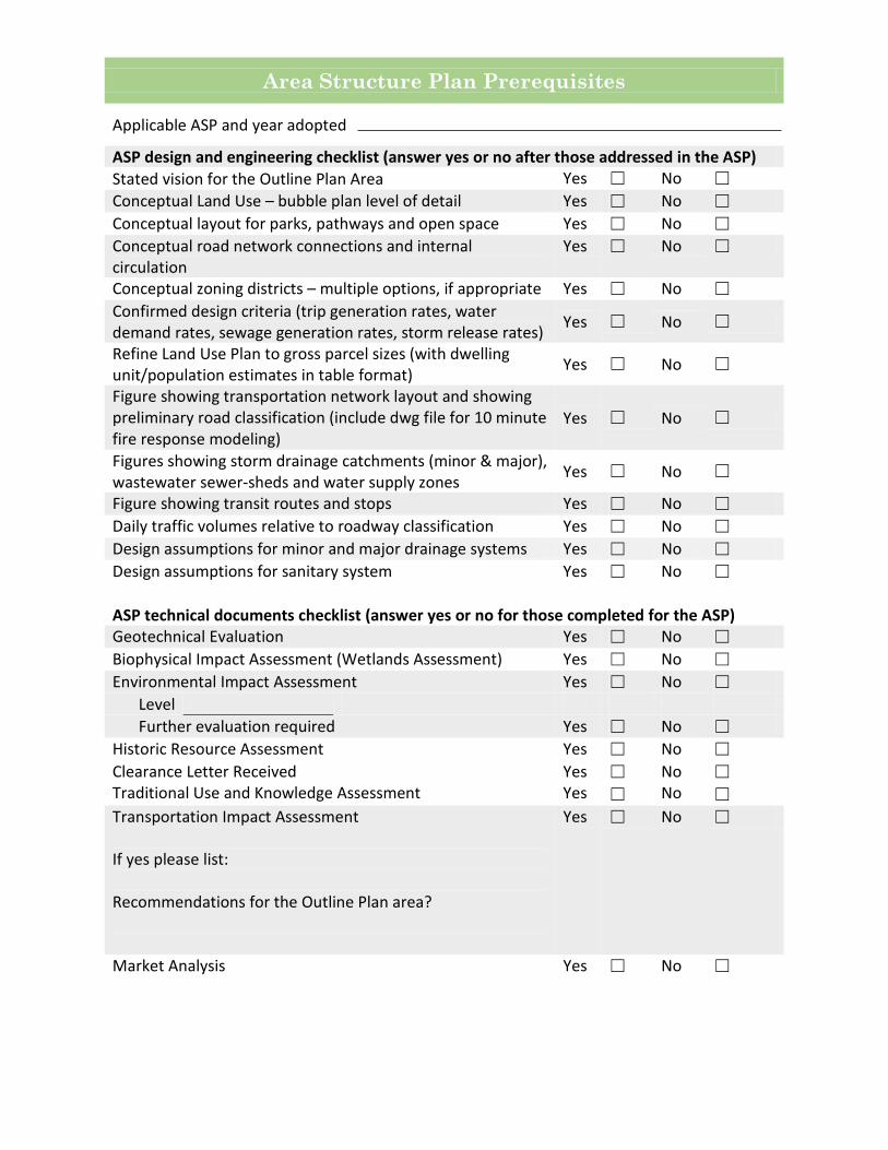
Area Structure Plan Prerequisites
Applicable ASP and year adopted
ASP design and engineering checklist (answer yes or no after those addressed in the ASP) Stated vision for the Outline Plan Area Yes ☐ No ☐ Conceptual Land Use – bubble plan level of detail Yes ☐ No ☐ Conceptual layout for parks, pathways and open space Yes ☐ No ☐ Conceptual road network connections and internal circulation
Yes ☐ No ☐
Conceptual zoning districts – multiple options, if appropriate Yes ☐ No ☐ Confirmed design criteria (trip generation rates, water demand rates, sewage generation rates, storm release rates) Yes ☐ No ☐
Refine Land Use Plan to gross parcel sizes (with dwelling unit/population estimates in table format) Yes ☐ No ☐
Figure showing transportation network layout and showing preliminary road classification (include dwg file for 10 minute fire response modeling)
Yes ☐ No ☐
Figures showing storm drainage catchments (minor & major), wastewater sewer-sheds and water supply zones Yes ☐ No ☐
Figure showing transit routes and stops Yes ☐ No ☐ Daily traffic volumes relative to roadway classification Yes ☐ No ☐ Design assumptions for minor and major drainage systems Yes ☐ No ☐ Design assumptions for sanitary system Yes ☐ No ☐ ASP technical documents checklist (answer yes or no for those completed for the ASP) Geotechnical Evaluation Yes ☐ No ☐ Biophysical Impact Assessment (Wetlands Assessment) Yes ☐ No ☐ Environmental Impact Assessment Yes ☐ No ☐
Level Further evaluation required Yes ☐ No ☐
Historic Resource Assessment Yes ☐ No ☐ Clearance Letter Received Traditional Use and Knowledge Assessment
Yes Yes
☐ ☐
No No
☐ ☐
Transportation Impact Assessment If yes please list: Recommendations for the Outline Plan area?
Yes ☐ No ☐
Market Analysis Yes ☐ No ☐

What are the adjacent Outline Plans? Are there transitional issues with adjacent Outline Plans that require addressing? If “yes”, please list the issues: What are the adjacent neighbourhoods or subdivisions?
Are there transitional issues with adjacent neighbourhoods or subdivisions that require addressing?
If “yes”, please list the issues:
Existing and Proposed Off-Site Funded Infrastructure Required
Describe and list date of construction if proposed (CIP):
Arterial Roadways
Water
Sanitary Sewer
Storm Water Management
Electrical Utilities
Do you have a digital tracking form for ease of addressing City comments during the process?

Address
Signed
Phone Number
Date
Further Information May Be Provided by the Applicant as an Attachment
Do the proposed systems and facilities conform with accepted practice, standards, regulations and guidelines of the City of Lethbridge? Has the same population and land use been used for all analysis? Conformance with standard practice, previous documents, studies, master plans and reports? Have you highlighted anything that does not conform with standard practice, previous documents, studies, master plans and reports?
Registered Owner or Person Acting on the Registered Owners Behalf
I
(full name) hereby certify that
☐ I am the registered owner, or ☐ I am the consultant/agent authorized to act on behalf of the registered owner
and that the information given on this form is full and complete and is, to the best of my knowledge, a true statement of the facts relating to this application for subdivision.

Name of Registered Owner(s) of Land to be Planned Name:
Address:
Phone Number:
Name:
Address:
Phone Number:
Name:
Address:
Phone Number:
Name:
Address:
Phone Number:
Name:
Address:
Phone Number:
OUTLINE PLAN APPLICATION Within an Area Structure Plan adopted previous to 2013
APPENDIX B
FILE NO.:
Date of receipt of completed form:
Fee Submitted:

Consultant(s) Name:
Address:
Phone Number:
Name:
Address:
Phone Number:
Legal Description and Area of Land to be Planned
All/Part of the ¼ sec. twp. range west of 4th meridian
All/Part of the ¼ sec. twp. range west of 4th meridian
All/Part of the ¼ sec. twp. range west of 4th meridian
All/Part of the ¼ sec. twp. range west of 4th meridian
All/Part of the ¼ sec. twp. range west of 4th meridian
Being all/parts of Lot(s) Block Plan
Being all/parts of Lot(s) Block Plan
Being all/parts of Lot(s) Block Plan
C.O.T. No(s).
Area of the above parcel of land to be planned hectares.
Area map included: Yes ☐ No ☐
Municipal Address(s)

Area Structure Plan Prerequisites
Applicable ASP and year adopted
ASP design and engineering checklist (answer yes or no after those addressed in the ASP) Stated vision for the Outline Plan Area Yes ☐ No ☐ Conceptual Land Use – bubble plan level of detail Yes ☐ No ☐ Conceptual layout for parks, pathways and open space Yes ☐ No ☐ Conceptual road network connections and internal circulation
Yes ☐ No ☐
Conceptual zoning districts – multiple options, if appropriate Yes ☐ No ☐ Confirmed design criteria (trip generation rates, water demand rates, sewage generation rates, storm release rates) Yes ☐ No ☐
Refine Land Use Plan to gross parcel sizes (with dwelling unit/population estimates in table format) Yes ☐ No ☐
Figure showing transportation network layout and showing preliminary road classification (include dwg file for 10 minute fire response modeling)
Yes ☐ No ☐
Figures showing storm drainage catchments (minor & major), wastewater sewer-sheds and water supply zones Yes ☐ No ☐
Figure showing transit routes and stops Yes ☐ No ☐ Daily traffic volumes relative to roadway classification Yes ☐ No ☐ Design assumptions for minor and major drainage systems Yes ☐ No ☐ Design assumptions for sanitary system Yes ☐ No ☐ ASP technical documents checklist (answer yes or no for those completed for the ASP) Geotechnical Evaluation Yes ☐ No ☐ Biophysical Impact Assessment (Wetlands Assessment) Yes ☐ No ☐ Environmental Impact Assessment Yes ☐ No ☐
Level Further evaluation required Yes ☐ No ☐
Historic Resource Assessment Yes ☐ No ☐ Clearance Letter Received Yes ☐ No ☐ Transportation Impact Assessment If yes please list: Recommendations for the Outline Plan area?
Yes ☐ No ☐
Market Analysis Yes ☐ No ☐

What are the adjacent Outline Plans? Are there transitional issues with adjacent Outline Plans that require addressing? If “yes”, please list the issues: What are the adjacent neighbourhoods or subdivisions?
Are there transitional issues with adjacent neighbourhoods or subdivisions that require addressing?
If “yes”, please list the issues:
Existing and Proposed Off-Site Funded Infrastructure Required
Describe and list date of construction if proposed (CIP):
Arterial Roadways
Water
Sanitary Sewer
Storm Water Management
Electrical Utilities
Do you have a digital tracking form for ease of addressing City comments during the process?

Address Signed
Phone Number
Date
Further Information May Be Provided by the Applicant as an Attachment
Do the proposed systems and facilities conform with accepted practice, standards, regulations and guidelines of the City of Lethbridge? Has the same population and land use been used for all analysis? Conformance with standard practice, previous documents, studies, master plans and reports? Have you highlighted anything that does not conform with standard practice, previous documents, studies, master plans and reports?
Registered Owner or Person Acting on the Registered Owners Behalf
I
(full name) hereby certify that
☐ I am the registered owner, or ☐ I am the consultant/agent authorized to act on behalf of the registered owner
and that the information given on this form is full and complete and is, to the best of my knowledge, a true statement of the facts relating to this application for subdivision.


Outline Plan Template Appendix C
1 of 2
Outline Plan Template Section Outline The following outline describes the required content to be included for sign off of each Section. Application review (by form, not part of the Outline Plan document)
• Confirm/modify Process Template • Agreed change process • Establish time lines
Section #1 Plan Format
• Develop a Table of Contents • List applicable appendices and figures • Establish need for, and type of public consultation
Existing Context
• Confirm approved plan policy directions (ICSP/MDP, ASP, Master Plans) • Note any deviations with rationale for deviation • Confirm Infrastructure assumptions/capacities from the ASP
Neighbourhood Design
• Developer’s vision and principles for the area and how they align with the ASP • Draft Land Use with proposed uses and densities • Draft layout for parks, pathways and open space • Draft local road network connections and internal circulation • Draft land uses
Section #2A Draft Design
• Figure showing pathway/bikeway network classification and playground locations • Figure showing Infrastructure and transportation connection point details
(locations, flow rates, capacities) • Table showing wastewater flows • Figures & tables showing major storm system flow routes, major and minor storm
system flows, storm pond sizing • Figure showing future adjacent service area – services to be provided • Documentation of all variances from design standards and standard practice
Check List: - Daily traffic volumes relative to roadway classification - Design assumptions for minor and major drainage systems

Outline Plan Template Appendix C
2 of 2
- Design assumptions for sanitary system - Do the proposed systems and facilities conform with accepted practice,
standards, regulations and guideline - Has the same population and land use been used for all analysis - Conformance with standard practice, previous documents, studies, master
plans and reports - Anything that does not conform with standard practice, previous documents,
studies, master plans and reports or is significant in nature. Section #2B Final Design
• Location & size/capacity of major facilities (roads, storm, sanitary, water, parks classification and playground sites)
• Connection points and their characteristics for existing and future areas (roads, storm, sanitary, water, pathways
• Confirmation of offsite servicing requirements (indicate facilities to be funded by offsite levy)
• All supporting documentation (geotechnical, environmental, historical resources, etc.) and information from all previous Sections.
• Proposed staging - order of development/construction • Public consultation results/feedback
Section #3 Final Submission
• Confirm previous Sections • Presentation & review of final document • Set MPC date