Embed Size (px)
Citation preview

MINISTRY OF ENERGY AND MINERAL RESOURCES
GEOLOGICAL AGENCYCENTER OF GROUNDWATER AND ENVIRONMENTAL GEOLOGY
Diponegoro Street Nr. 57 Bandung (40122)- INDONESIA
By:Haryadi Tirtomihardjo
Presented at:
Asia Pacific Water Forum (APWF) Regional Water Knowledge Hub for Groundwater Management
Launch Meeting
Plaza Athenee Bankok, A Royal Meridien Hotel 61Wireless Road Road, Bangkok 10330 Thailand
June 2sd – 3rd 2011
- Introduction
- Groundwater basin in Indonesia and their potency
- Groundwater exploitation
- Impacts of groundwater exploitation
- Groundwater management
- Closing remarks
16/06/2011
Outline

Introduction- Water, including groundwater (Gw), is indispensable for life, but
its availability at a sustainable quality & quantity is threaten bymany factors, mainly by climate pattern (free Gw system) & Gwabstraction (artesian Gw system).
- Since the last four decades, in the era of developing of thecountry, populous cities serving as centers of development forservices, education, tourism and other sectors are growing inthe whole of Indonesia, primarily in Java. The need for water(including Gw), therefore, is increasing correspondingly to thepopulation & economic growth.
- As stipulated in Article 13 of Law No. 7/2004 on WaterResources which was issued by the Government of the Republicof Indonesia, management of gw resource should be based onGroundwater Basin (GB).
- Detailed information on Gw potency of each GB which wereidentified should be provided by the central government andlocal governments (province, regency/city) for planning andmanagement.
16/06/2011
Groundwater Basins in Indonesiaand their Potency
Groundwater basin (GB) is a region which is bordered by hydrologeologicalboundaries where the hydrogeological processes such as recharging, flowing,and discharging of groundwater occured.
In Indonesia, 421 groundwater basins were identified, but only a few numberof the basins have been assessed in detail their gw potency (GeologicalAgency, 2010).
Fig. 3 Map of Gw Basin in Indonesia
Total number of GB inIndonesia = 421
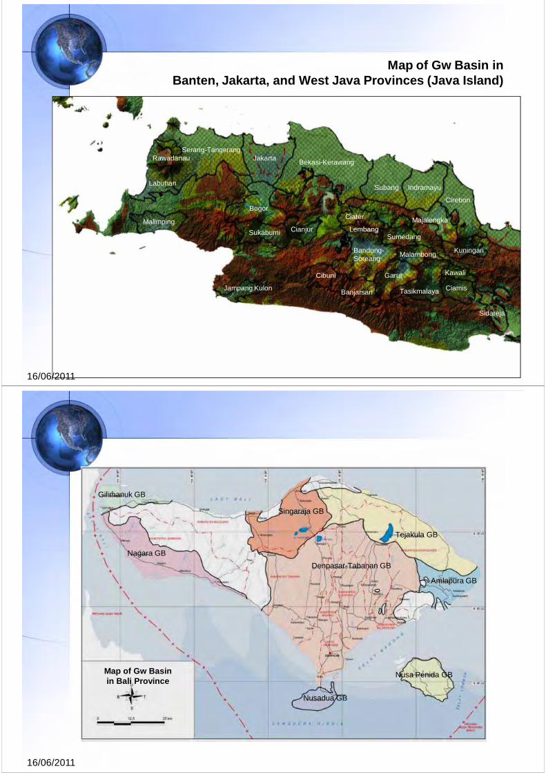
Map of Gw Basin inBanten, Jakarta, and West Java Provinces (Java Island)
Serang-TangerangJakartaRawadanau
Labuhan
Malimping
Bogor
Sukabumi
Jampang Kulon
Bandung-Soreang
Lembang
Cibuni
Banjarsari
Garut
Bekasi-Kerawang
Subang Indramayu
Cirebon
Tasikmalaya
Malambong
Ciamis
Kawali
Majalengka
Kuningan
Sidareja
Ciater
SumedangCianjur
16/06/2011
16/06/2011
Map of Gw Basin in Bali Province
Nagara GB
Denpasar-Tabanan GB
Singaraja GB
Tejakula GB
Amlapura GB
Nusa Penida GB
Nusadua GB
Gilimanuk GB

Gw Potency in Indonesia
Based on mean annual rainfall which were analysed by Meteorological andGeophysical Agency – MGA (1975) and recharge percentage of variousaquifer formation, total gw quantity in Indonesia at unconfined aquifer system(R1) were roughly calculated 496,217x106 m3/year, whereas at confinedaquifer system (Q2) which were calculated by applying Darcy’s Law attains20,906x106 m3/year (Table 1, Geological Agency, 2008).
Table 1 Recapitulation of Gw Basin in Indonesia
16/06/2011
Nr. Region
Groundwater Basin (GB)
Number of GBArea Gw Quantity [million m3/year[Km2] Free Gw
(Q1)Confined Gw
(Q2)
1 Sumatera 65 272,843 123,528 6,551
2 Java & Madura 80 81,147 38,851 2,046
3 Kalimantan 22 181,362 67,963 1,102
4 P. Sulawesi 91 37,778 19,694 550
5 Bali 8 4,381 1,577 21
6 West Nusa Tenggara 9 9,475 1,908 107
7 East Nusa Tengara 38 31,929 8,229 200
8 Maluku 68 25,830 11,943 1,231
9 Papua 40 262,870 222,524 9,098
TOTAL 421 907,615 496,217 20,906
Note:- Gw basin in regency/city : 206 GBs- Regency/city border crossing Gw basin : 176 GBs
- Province border crossing Gw basin : 35 GBs- Country border crossing Gw basin : 4 GBs
Groundwater Exploitation
16/06/2011
1 Drinking Water in Rural Areas
+ 80% of the Indonesian population live in rural area.
Drinking water demand in rural areas + 100 L/person/day.
The utilization of groundwater (dugwells or driven wells) is roughlyestimated about 70% of total water resources.
2 Drinking Water & Industrial Requirements in Urban Areas
Drinking water demand in urban areas + 200 L/person/day.
Less than 30% of the population in large cities (Jakarta, Bandung,Semarang, Surabaya, Medan, Ujung Pandang) used fresh water from thecity water supply (the remaining still rely on Gw).
Qabs in Jakarta, Bandung, & Semarang areas (see figures) .
3 Irrigation Water
Gw for irrigation purpose was utilized since 1970 in Java (Yogyakarta, Est Java,& Central Java) ‐ its use for large scale irrigation.

0
500
1000
1500
2000
2500
3000
3500
4000
4500
-
5.00
10.00
15.00
20.00
25.00
30.00
35.00
40.00
Nu
mb
er
of w
ells
Gw
Ab
stra
ctio
n [m
illio
n
m3 ]
Period
Gw Absraction [million m3] Number of wells
Jakarta GB

Total Number of Wells and Volume of Abstraction in Semarang GB
Province
Deep Wells Medium Wells Shallow Wells Total
Number of wells
Irrigated lands (Ha)
Number of wells
Irrigated lands (Ha)
Number of wells
Irrigated lands (Ha)
Number of wells
Irrigated lands (Ha)
W. Java - - 14 162 - - 14 162
C. Java 12 379 10 163 - - 22 542
E. Java 494 23.38 60 488 90 537 644 24,405
Yogyakarta 36 1,150 - - - - 36 1,150
Bali 3 91 - - - - 3 91
W. Nusa Tenggara
126 1,717 - - - - 126 1,717
S. Sulawesi - - 15 176 1 3 16 179
C. Sulawesi - - 20 132 - - 20 132
Total 671 26.71 119 1,121 81 540 881 28,370
Irrigation by Groundwater in Indonesia (Haryadi, 2009)
Note:
Deep wells (100-200 m) equiped with deep pumpsMedium wells (30-100 m) equiped with centrifugal pumpsShallow wells (<30 m) equiped with centrifugal pumps

Impacts of Groundwater Exploitation
1 Degradation on Gw Quantity
Lowering of Gw level & cone of Gw depression.
Decreasing of spring discharge/underground stream.
2 Degradation on Gw Quality
Incresing of Gw salinity
Salt water intrusion/Gw contamination.
Decreasing of Gw quality.
3 Land Subsidence
Lowering of land elevation.
Expansion of flooded area.
Infrastructure damage.
Normal consolidation and/or over Gw abstraction.
16/06/2011
Map of Piezometric Heads of Upper Confined Aquifer System [40-140 mbls]
JAKARTA GB
Scale
Scale

16/06/2011
Jakarta GBPiezometric Heads of Lower
Confined Aquifer System [ >140 mbls]
Scale
Scale
16/06/2011
Map of Piezometric Heads
SEMARANG CITY

16/06/2011
Zone of Brackish/Salty Groundwater
Scale
Brackish/salty Gw
Fresh Gw
Contour line of EC, in uS/Cm
Land Subsidence phenomena in Kamal Muara area (1) and Tongkol area (2), North of Jakarta
(1) (2)

Flooded way due to land subsidence in Cengkareng area, Tangerang
Zone of Land Subsidence in the North of Jakarta

> 8 Cm
6-8 Cm
4-6 Cm4-6 Cm
2-4 Cm
0-2 Cm
Zone of Land Subsidence(Geological Agency, 2000-2001)
Semarang GB, Central Java
1 Law Nr. 7 of 2004 on Water Resources.
2 Government Decree Nr. 43 of 2008 on Groundwater.
3 Presidential Decree on Gw Basin (draft, will be issued by the end of 2011).
4 Decree of Minister of Energy & Mineral Resources Nr. 1451K/10/MEM/2000 on Technical Guidelines on Gw Management.
5 Decree of Minister of Energy & Mineral Resources Nr. 716K/40/MEM/2003 on Horizontal Boundary of Gw Basins in Java and Madura Islands.
6 Decree of Minister of Energy & Mineral Resources Nr. 13 of 2009on Guideline for Establishment of Decree Draft on Gw Basin.
16/06/2011
Regulations for Gw Managementin Indonesia

Gw Inventory1 Hydrogeological mapping scale 1:250,000 (see status in 2010).2 Deliniation and evaluation of Gw Basin Boundaries.3 Mapping on Gw recharge and discharge areas.4 Assessment on Gw resource potential of the Gw Basin.5 Establish zone of gw condition 6 Gw modeling for urban Gw Basins.
16/06/2011
Technical Efforts on Gw Management
Monitoring of Gw Quantity and Quality(Assessment on change of Gw quantity and quality)
Gw Modeling (Gw flow simulation model, scenario of Gw abstraction)
Gw Database and Information Management System
16/06/2011
Gw Inventory

Status of Hydrogeological Mapping at Scale 1:250,000Desember 2010
16/06/2011
16/06/2011
Monitoring of Gw Quantity and Quality
Jakarta GB
KEDUDUKAN MUKA AIR TANAH DI DAERAH DUREN SAWIT
-18
-16
-14
-12
-10
-8
-6
-4
-2
0
1982 1983 1984 1985 1986 1987 1988 1989 1990 1991 1992 1993 1994 1995 1996 1997 1998 1999 2000 2001 2002 2003 2004 2005 2006 2007 2008 2009
Mu
ka A
ir T
anah
( m
Duren Sawit I (155-226 m) Duren Sawit II (72.5-75.5 m)
KEDUDUKAN MUKA AIR TANAH DI DAERAH CILANDAK, JAGAKARSA, DAN PASAR MINGGU,
-30
-25
-20
-15
-10
-5
0
1982 1983 1984 1985 1986 1987 1988 1989 1990 1991 1992 1993 1994 1995 1996 1997 1998 1999 2000 2001 2002 2003 2004 2005 2006 2007 2008 2009
Mu
ka A
ir T
anah
( m
Cilandak (13-15 m) Pasar Minggu I (193-250 m) Jagakarsa (60-67 m)
Gw Hydrographs of unconfined to confined aquifer systems in South Jakarta
Gw Hydrographs of confined aquifer systems in East Jakarta

16/06/2011
Bandung-Soreang GB (West Java)
Well Hydrograph of piezometric level in the East Bandung, 1994-2006
16/06/2011
Zone of Gw Abstraction ControlingBandung-Soreang GB (West Java)

29
Case Study : Denpasar GB, BALI
16/06/2011
CAT DENPASAR-TABANAN
16/06/2011

Daerah Imbuhan AT(Gw Recharge Area)
Daerah Lepasan AT(Gw Discharge Area)
Zone transisi(horizontal flowing)
16/06/2011
Daerah Gianyar (MAT > -50 mdml)
Daerah Sanur (MAT > -70 mdml)
Daerah Kuta(MAT >-70 mdml)

16/06/2011
ZONE III
ZONE II
ZONE I.2ZONE I.1
ZONE IV
Smr BaruW1-1 s.d. W1-10
Smr BaruW2-1 s.d. W2-10
ZONE Qabs
2009 2012
ΣsumurQabs
[m3/hari]% Σsumur
Qabs [m3/hari]
%
I.1 16 -56875 17 16 -28484 9I.2 15 -39942 12 15 -15408 5II 31 -45644 14 41 -70175 21III 155 -184395 56 155 -184396 56IV 4 -2166 1 14 -30558 9
JUMLAH 221 -329022 100 241 -329022 100
16/06/2011
Daerah Badung (MAT relatif tetap)Daerah Kuta
(MAT > 2 maml)

16/06/2011
Daerah Kuta(MAT pulih dari -70 mdml
menjadi - 2 mdml)
Daerah Sanur(MAT pulih dari -70 mdml menjadi - 1 mdml)
Daerah BadungCone of gw depresion
(>18 maml)
MAT pulih(umumnya di
atas muka laut)
Jakarta GB
16/06/2011
CONFIGURATION OF GROUNDWATERABSTRACTION 1900 -2005
CALCULATED GW HEADS [msl]

37
Closing Remarks1 Gw has a significant role in providing water for various purposes in Indonesia
(drinking water, industry, & irrigation purposes).
2 The increased rate of gw exploitation in the major cities in Indonesia had ledto negative impacts on gw and on the environment surroundings (decliningof gw level, salt water intrusion, and land subsidence).
3 Gw potency of each gw basin in Indonesia need to be assessed in detail(already planned for future activities).
4 Monitoring & analysis of gw conditions should be continuously performedespecially in urban groundwater basins (e.g. Jakarta GB, Bandung‐SoreangGB, and Semarang‐Demak GB) in order to know the change of theiravailability.
5 Plan for future activites relating to gw management in Indonesia:
1) Gw quantity & quality monitoring in urban gw basins (network designon gw monitoring wells, installation & expertise, budget)
2) Gw quantitication & modeling in all urban gw basins.
3) Hydrogeological research for determining critical Gw discharge in urbanGw basins.
16/06/2011
16/06/2011