Embed Size (px)
Citation preview
1
OUR WORLD AND GEOGRAPHY
THIS CHAPTER IS ABOUT:
Global, regional, and local worlds
Events in diverse worlds: political,economic, cultural, demographic, andenvironmental issues
The importance of geography inunderstanding diverse worlds
The special nature of regionalgeography
How major world regions are chosen inthis book
How world regions developed throughhistory
FIGURE 1.1 Global view of Earth and themajor world regions. Views of Earth fromspace led to a wider global consciousness andconcern for the planet. The globes show themajor world regions that are the subject of this book.
Ch
ap
ter
EUROPE
NORTHERN AFRICA &SOUTHWESTERN ASIA
AFRICA SOUTH
OF THE
SAHARA
EASTERN
ASIASOUTHERNASIA
SOUTH
PACIFIC
COMMONWEALTHOF INDEPENDENT
STATES (C.I.S.)
ANGLO
AMERICA
LATIN
AMERICA
1

GLOBAL, REGIONAL, AND LOCALWORLDS
A Variety of WorldsThe opening of the new century, and our increasingawareness of worlds and events beyond our ownlocality call out for everyone to develop their geo-graphic knowledge and understanding. The media,particularly television, bring us in close contact withstorm and earthquake disasters in Africa, Turkey,India, and Latin America. They alert us to the horrorsof ethnic cleansing in Balkan Europe and Indonesia,aircraft hijackings, and the drug trades out of Asia andLatin America, often with background informationabout the lives of the people affected.
There is much talk of globalization, but otherscales of geographic places remain important (Figure1.1). Globalization, the growing interdependence ofthe world’s peoples and the integration of economies,technologies, and even some aspects of cultures,gained significance throughout the 1900s. It includesthe widespread realization that collective actions arenecessary to address global political, economic, andenvironmental problems. It has been suggested that inthe 1990s, after the end of the Cold War, we entered a“Global Age”: globalization processes produced a newglobal order.
The opposing trend, localization, is the continuingdifferentiation of places and the increasing demandsfor local decision-making and the devolution ofpower within countries. It does not cancel out global-ization but is part of the process, since global interde-pendence has uneven results and tends to enhancedifferences between places.
Diversity is a key to studying world geography.Although global effects are increasing and modifyingmany places, there is no possibility that we will reach astage when geography becomes irrelevant. On the con-trary, globalization makes it increasingly vital for us toknow about and understand how people live in otherparts of our world and how their ways interact with usin our own locality. What happens at the larger scale ofplace impacts the more local and vice versa. For exam-ple, top-down global economic activity results in somericher and some poorer places; bottom-up develop-ments initiated by local groups influence country gov-ernment policies; country actions have variedinteractions with the global.
We recognize four levels of geographic space foranalyzing these interactions (Figure 1.2)—the global(worldwide) level, the major world regions level, the
countries level, and the local regions (including majorcities) within countries level. Political, economic, andcultural human activities and environmental changesrelate in dynamic ways to each of these levels.
EVENTS IN DIVERSE WORLDS
The Country Basis of Political ActivityPolitics is about power and the ways in which coun-tries are governed and relate to each other. During the1990s, the divisive, although established, geopoliticalorder of the Cold War dissolved, but overall globalgovernment—removing borders between countries—remained a distant dream that few people maintain.Although global institutions and major world regionallinkages exist and sometimes override a country’swishes, countries remain the main places where politi-cal decisions are made and implemented. Countriesretain powers to tax, provide for defense, and negoti-ate with other countries. Each has its own legal andinstitutional system. They continue to encouragenational sentiments through educational programsand rivalries in sporting events. Within countries,devolution, federal state issues, and expanding citiesprovide additional political forums at the local leveland occupy politicians as much as global issues.
Cold War Rivalries
In the Cold War from 1950 to 1990, political ideolog-ical rivalries divided the world (Figure 1.3). TheUnited States led the First World—the “free world”countries with their market economies and Westernvalues. The Soviet Union and China led the SecondWorld—the communist, planned economy, coun-tries. First and Second World rivals competed forinfluence among countries in the Third World. Ini-tially comprised of countries searching for anapproach that avoided the pitfalls of the other twoworlds, the Third World later became a general termfor the world’s poorest countries (Figure 1.4) thatwere either “aligned” to the First or Second World, or“unaligned.”
The two rival groups fought each other in Korea inthe early 1950s and in Vietnam from the 1950s to the1970s. Civil wars in Third World countries such asMalaysia, Angola, and Mozambique were instigatedand supported by the two sides. The nightmare of a“hot war,” in which the leaders of the two groupsfought each other with nuclear weapons, was, how-ever, averted.
2

Events in Diverse Worlds 3
FIGURE 1.2 Geographic facets of globalization. The relationships of human activities to geographic scale.
GEOGRAPHICSCALE
POLITICAL LAW & ORDER ECONOMIC CULTURAL ENVIRONMENTAL
GLOBAL/WORLDWIDE
United NationsNGOs(No united will for a global government)
InternationalCriminal Court.Issues: drugs, nuclear testing, weapons, war criminals, terrorists
BorderlessCAPITALIST MARKETSYSTEM: World Bank, IMF, OECD, G8, Multinational corporations
Westernization resisted. Olympic Games
global warming, ozone hole, ocean resources
WORLDREGION/SUBREGION
European Union, CIS,original ASEAN
Hague Court ofHuman Rights
regional tradinggroups: EU, NAFTA,Mercosur, ASEAN, APEC, etc. Regional emphases within the capitalist system.
CULTURAL GROUPINGS:N Africa/SW Asia; Africa S of Sahara; S Asia; China; Japan; CIS; Latin America; Anglo America; etc.
acid rain,rain forest
COUNTRY(NATION/STATE)
BASIC POLITICALUNIT: acceptedborders; taxing, defense, international relations powers
distinctive legalsystems
fiscal and monetarypolicies; rich/poor countries
“nation-state”concept
public health; airand water quality;conservation of soils, forests; national parks
LOCALREGION/MAJOR CITY
devolution of administration; world cities; federal stateswithin countries
variations inapplication of a country’s legal system
regional productspecialization;economic and physical planning;rich/poor areas
long-term traditions; way of life distinctive; basis for political pressures
physical planning impacts

The 1990s
The 1991 breakup of the Soviet bloc ended the Three Worldsscenario. The United States became the sole world political,military, and economic superpower and tried to extend theWestern concepts of democracy and human rights. The1990s showed, however, that no single country could imposeits ideas on the rest of the world or by itself maintain a role aspoliceman to the world.
Although almost every country is a member of the UnitedNations, that body does not have the ability to control civilwars or nuclear weapon testing. It cannot police the internetor global crimes such as terrorist activities and the drug,weapons, and slave traffics. Increasingly at the global level,non-government organizations (NGOs) became responsiblefor government-like activities such as disaster emergenciesand poverty treatment.
The world remains politically divided into countries andgroups of countries. It is a dangerous place of multiple rival-ries. In the 1990s, some commentators suggested that theterm “New Global Disorder” would be appropriate for worldpolitics since no system of global governance exists to con-trol growing economic inequalities or criminal activities. In
the new century, challenges to the political leadership of theUnited States may come from a revived Russia that retainspretensions to world power, from the growth of Chinese aspi-rations, or from a grouping of Muslim countries. The difficul-ties experienced in assembling such a Muslim pressure groupillustrate the continuing significance of individual countries.
The Global Basis of Economic ActivitiesThe end of the Cold War, the breakup of the Soviet bloc andthe rejection of communist political-economic ideology, notonly left the United States as the single world political super-power, but also enabled the capitalist economic system—ofwhich the United States and multinational corporations arethe most powerful exponents—to dominate the world. Allthe other geographic levels of economic activity began torelate to the global.
Capitalism v. Communism in the Cold War
An economic system is a way in which goods and servicesare produced, distributed, and consumed. Capitalism is theeconomic system that marks Western countries and empha-
4 CHAPTER ONE Our World and Geography
FIGURE 1.4 Third World city: midday street scene in Bangalore, southern India. Compare this view of a main shopping street in Bangalore with ashopping area or main street with which you are familiar. What ways do people use to get about in each place?
© Michael Bradshaw
sizes the private or corporate organization of business andinvestment. The “capital” is finances that are invested tomake profits. Market forces determine the prices, production,and distribution of goods. Capitalism is essentially competi-tive among corporations and countries based on sales in themarket. A political world order could end such competition;the continued existence of countries maintains capitalism.
In theory, governments intervene in capitalist economiesmainly to regulate terms of trade. In practice, many countriessupport corporations in their country by providing socialwelfare services and building infrastructure (such as roads,bridges, airports, water supplies, waste disposal facilities).This economic system is linked to the growth of urban-industrial activities that are central to the “modernization”that most countries aspire to.
For much of the 1900s, the opposing centrally controlled,communist-country economies, exemplified by the formerSoviet bloc and China, gave priority to government provisionof universal medical care, comprehensive educational sys-tems, and strong military defense. Competition to be moreproductive and profitable was replaced by production of“essential goods,” whatever the cost. Despite an outward aimto prevent disparities of wealth, they failed to generate thehigh levels of consumer goods and tourism options thatbecame a mark of most Western countries, and did little toreduce the numbers of poor.
Global Economic System
Following the breakup of the Soviet Union in 1991, the capi-talist system became the global economic system. Few coun-tries, apart from the People’s Republic of China, attempt tomaintain the central government control of a planned econ-omy. Even they are being drawn increasingly into the capital-ist system. Russia and the other countries that were part ofthe former Soviet bloc are in traumatic transition from theircentrally planned economies to market-related systems thatcontradict so many of their past assumptions.
From the 1990s, the United States and other Westerncountries not only encouraged democratic governments butalso promoted the geographic expansion of capitalist activi-ties, thus strengthening their own economies and those oftheir multinational corporations. They encouraged formerSoviet bloc countries, and those that had been aligned tothem, to become part of the world economic system. Theprocess of reorienting to the global economy often broughthardships to the countries in transition, because of theimpacts of removing protective trade barriers, the unfetteredexpansion of multinational corporations, and the almost freereign given to international criminal activities.
Other variants of capitalism and responses to it result inworld regional differences. The “Asian Way” emphasizesfamily linkages rather than the importance of independentlyverified banking and legal systems. The “European Way”makes much of providing social welfare to support thosewho do not make the most of the capitalist system.
A few exceptions to the expansion of economic globaliza-tion occur in the remotest parts of the world, including iso-lated areas of the Amazon rain forest and Papua New Guinea.Peoples there still live outside the world economy. In parts ofAfrica, many people in countries failing to become part of theworld economy are returning to hunting and gathering orsubsistence farming modes of livelihood.
As more of the world becomes involved in the global eco-nomic order, the rich countries get richer—especially therich people within those countries—while poor countries(and poor people) get relatively poorer. This increases geo-graphic diversity around the world. Even though the world’spoorest countries as a whole experienced relative economicgrowth in the 1990s, those in Africa did not and neither didlarge groups of people in Asian and Latin American coun-tries. The World Bank and the International MonetaryFund—both headquartered in the United States—often baseloans on agreements requiring the opening of a country’sinternal economy to external investment and foreign goodsand the reduction of its bureaucracies. Aid agencies followsuch policies in assigning priorities to funding projects inpoorer countries.
The World Trade Organization (WTO), which was estab-lished to make world trade easier, appears to favor the richercountries and multinational corporations at the expense ofthe poor in both richer and poorer countries. For example,richer countries tend to discriminate against poor countries’agricultural products and textile manufactures. At the sametime, the richer countries squabble among themselves oversuch issues as banana or beef “wars” and trade in geneticallymodified foods.
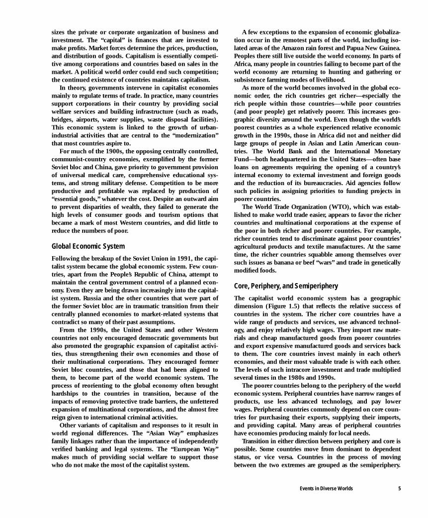
Core, Periphery, and Semiperiphery
The capitalist world economic system has a geographicdimension (Figure 1.5) that reflects the relative success ofcountries in the system. The richer core countries have awide range of products and services, use advanced technol-ogy, and enjoy relatively high wages. They import raw mate-rials and cheap manufactured goods from poorer countriesand export expensive manufactured goods and services backto them. The core countries invest mainly in each other’seconomies, and their most valuable trade is with each other.The levels of such intracore investment and trade multipliedseveral times in the 1980s and 1990s.
The poorer countries belong to the periphery of the worldeconomic system. Peripheral countries have narrow ranges ofproducts, use less advanced technology, and pay lowerwages. Peripheral countries commonly depend on core coun-tries for purchasing their exports, supplying their imports,and providing capital. Many areas of peripheral countrieshave economies producing mainly for local needs.
Transition in either direction between periphery and core ispossible. Some countries move from dominant to dependentstatus, or vice versa. Countries in the process of movingbetween the two extremes are grouped as the semiperiphery.
Events in Diverse Worlds 5
They retain dependent relationships with core countries, buthave peripheral countries dependent on them. At present newlyindustrializing countries (NICs), such as South Korea, Mexico,and Argentina, are parts of the semiperiphery, moving towardthe core. Former Soviet bloc countries, including Russia and itsneighbors, are either in the periphery or the semiperiphery.
Major World Regions and Cultural ActivitiesCultural characteristics modulate the influences of wider polit-ical and global economic pressures. The culture of a group ofpeople living in a particular part of the world results from theideas, beliefs, and practices they hold in common and pass onfrom one generation to the next. It is demonstrated especiallyin religion, but also in language and the ways in which thepeople do things socially, the design of the items they make,and the level of technology involved (Figure 1.6). Differentcultures have distinctive approaches to family life, the roles ofwomen, the structure and decoration of houses, and the valuesplaced on communal and individual actions. Cultural factorsmay also be important in defining country boundaries and cre-ating nation-state values. They often provide a basis for devo-lution at the local level within countries.
Cultural groupings are important in defining the majorworld regions that provide a basic level of diversity in worldgeography. These regions retain a distinctiveness despite
efforts to broaden Western culture to a global basis. Theexpansion of Westernization sets off reactions that strengthencultures at the world regional and local levels. One such reac-tion is the resurgence of identity with Islamic ways.
One World?
The One World idea is the assumption that Western culture,with its emphasis on democracy, individualism, and humanrights, can (or should) be extended to the rest of the world inthe wake of the capitalist world economic system. Thisprocess is often referred to as “Westernization,” or “Euro-peanization.” It generated the modernization that has urban-industrialization at its heart and includes the so-called“Cocacola-ization” of eating and drinking habits, the world-wide extension of Western TV programs and popular music,and the global presence of the same personal computers,cars, and other consumer goods.
Cultural Differences
In the 1990s, cultural forces often replaced political-economic ideologies as causes of differences among andwithin countries. While many countries try to adopt andadapt to both Westernization and modernization, some—especially the Muslim and Eastern Asian countries—try tomodernize while rejecting Western culture. Major cultural
6 CHAPTER ONE Our World and Geography
0°150° 120° 90° 30° 0° 60° 90° 120° 150°
30°
60°
30°
60°
60°
30°
0°
30°
Tropic of Cancer
Equator
Antarctic Circle
ArcticCircle
Tropic of Capricorn
BRANDT LINE
BRANDT LINE
EastWest
North
SouthPACIFIC
OCEAN
PACIFIC
OCEAN
ARCTIC
ATLANTIC
OCEAN
INDIAN
OCEAN
OCEAN
Core
Semiperiphery
Periphery
FIGURE 1.5 New global economic order: core and periphery. The core countries are the rich countries of the world that dominate world trade: they have awider range of products, use advanced technology, pay high wages, and consume massive amounts of resources. The countries of the periphery are poor, have alimited range of products, and often depend on trade with the richer countries. Countries in the semiperiphery are moving up or down in this order. Discuss changesyou might make to the country placings shown on this map.
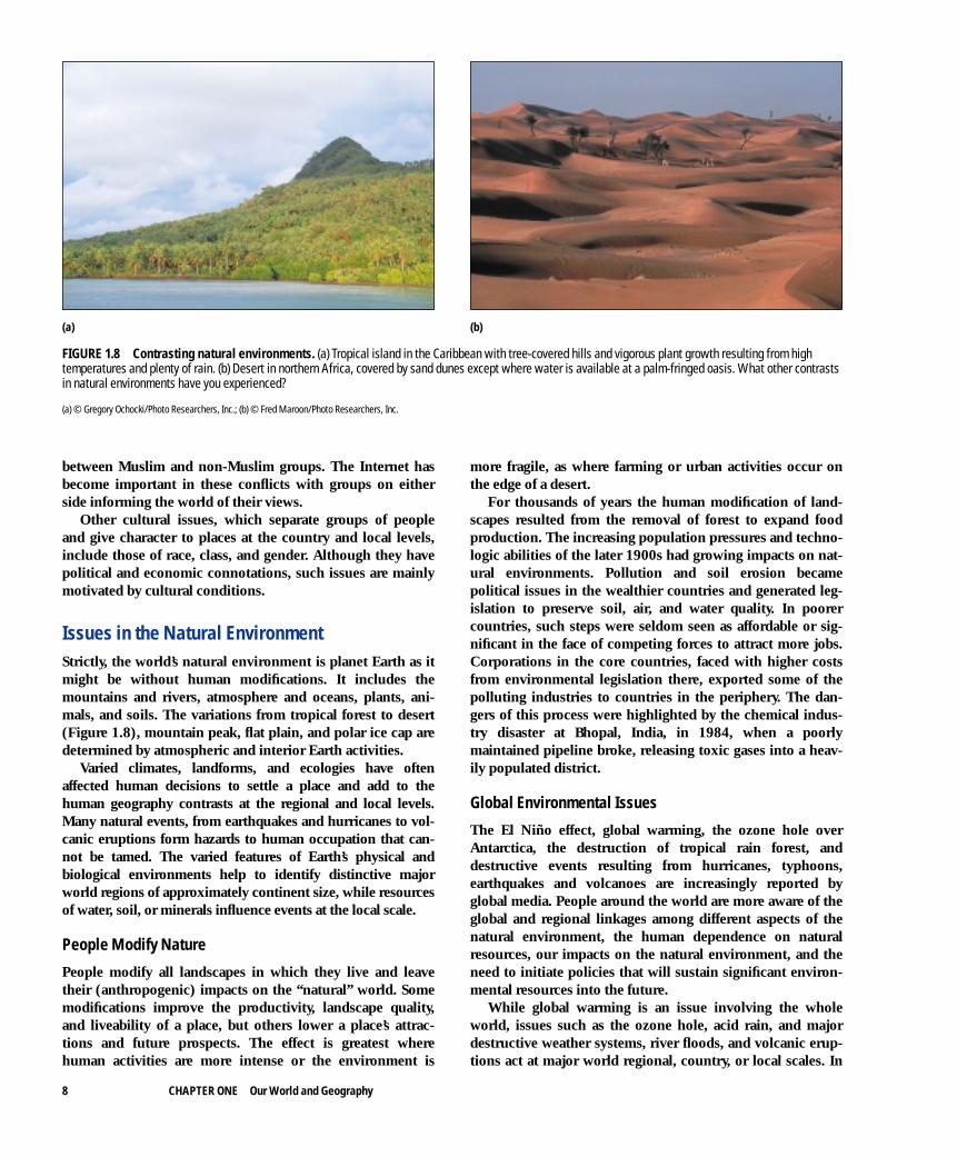
differences make it possible to divide the world into nine dis-tinctive groupings, or civilizations (Figure 1.7): African,Buddhist, Hindu, Islamic, Japanese, Latin American, Ortho-dox, Sinic (Chinese), and Western. These approximatelycoincide with the common divisions of major world regions.
As cultural factors replaced political ideologies in generat-ing regional differences, after a period when they were sup-
pressed, the border zones between cultural regions became“fault lines” of tension and conflict. The fault lines betweenMuslim and non-Muslim countries and ethnic groupsresulted in most conflicts as the Muslim Resurgence encour-aged militant groups. Conflicts in Bosnia, Kosovo, Chechnya,Kashmir, Sudan, Chad, Cyprus, westernmost China, Israel,Thailand, Indonesia, and the Philippines all lie in zones
Events in Diverse Worlds 7
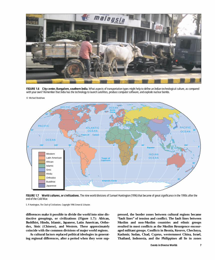
FIGURE 1.6 City center, Bangalore, southern India. What aspects of transportation types might help to define an Indian technological culture, as comparedwith your own? Remember that India has the technology to launch satellites, produce computer software, and explode nuclear bombs.
© Michael Bradshaw
FIGURE 1.7 World cultures, or civilizations. The nine world divisions of Samuel Huntington (1996) that became of great significance in the 1990s after theend of the Cold War.
S. P. Huntington, The Clash of Civilizations. Copyright 1996 Simon & Schuster.
0°150° 120° 90° 0° 60° 150°
30°
60°
30°
60°
60°
30°
0°
30°
Tropic of Cancer
Equator
Antarctic Circle
ArcticCircle
Tropic ofCapricorn
PACIFIC
OCEAN
PACIFIC
OCEAN
ARCTIC
ATLANTICOCEAN
INDIANOCEAN
OCEAN
Western
Latin American
African
Islamic
Sinic
Hindu
Orthodox
Buddhist
Japanese
8 CHAPTER ONE Our World and Geography
between Muslim and non-Muslim groups. The Internet hasbecome important in these conflicts with groups on eitherside informing the world of their views.
Other cultural issues, which separate groups of peopleand give character to places at the country and local levels,include those of race, class, and gender. Although they havepolitical and economic connotations, such issues are mainlymotivated by cultural conditions.
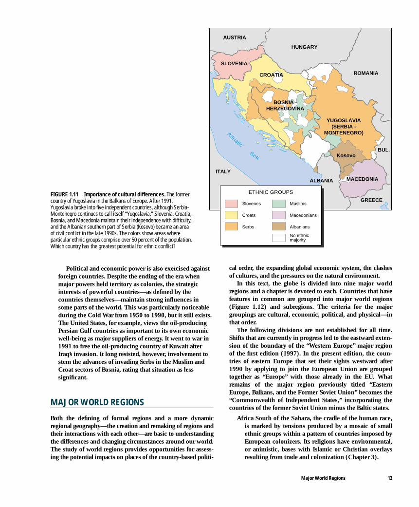
Issues in the Natural Environment Strictly, the world’s natural environment is planet Earth as itmight be without human modifications. It includes themountains and rivers, atmosphere and oceans, plants, ani-mals, and soils. The variations from tropical forest to desert(Figure 1.8), mountain peak, flat plain, and polar ice cap aredetermined by atmospheric and interior Earth activities.
Varied climates, landforms, and ecologies have oftenaffected human decisions to settle a place and add to thehuman geography contrasts at the regional and local levels.Many natural events, from earthquakes and hurricanes to vol-canic eruptions form hazards to human occupation that can-not be tamed. The varied features of Earth’s physical andbiological environments help to identify distinctive majorworld regions of approximately continent size, while resourcesof water, soil, or minerals influence events at the local scale.
People Modify Nature
People modify all landscapes in which they live and leavetheir (anthropogenic) impacts on the “natural” world. Somemodifications improve the productivity, landscape quality,and liveability of a place, but others lower a place’s attrac-tions and future prospects. The effect is greatest wherehuman activities are more intense or the environment is
more fragile, as where farming or urban activities occur onthe edge of a desert.
For thousands of years the human modification of land-scapes resulted from the removal of forest to expand foodproduction. The increasing population pressures and techno-logic abilities of the later 1900s had growing impacts on nat-ural environments. Pollution and soil erosion becamepolitical issues in the wealthier countries and generated leg-islation to preserve soil, air, and water quality. In poorercountries, such steps were seldom seen as affordable or sig-nificant in the face of competing forces to attract more jobs.Corporations in the core countries, faced with higher costsfrom environmental legislation there, exported some of thepolluting industries to countries in the periphery. The dan-gers of this process were highlighted by the chemical indus-try disaster at Bhopal, India, in 1984, when a poorlymaintained pipeline broke, releasing toxic gases into a heav-ily populated district.
Global Environmental Issues
The El Niño effect, global warming, the ozone hole overAntarctica, the destruction of tropical rain forest, anddestructive events resulting from hurricanes, typhoons,earthquakes and volcanoes are increasingly reported byglobal media. People around the world are more aware of theglobal and regional linkages among different aspects of thenatural environment, the human dependence on naturalresources, our impacts on the natural environment, and theneed to initiate policies that will sustain significant environ-mental resources into the future.
While global warming is an issue involving the wholeworld, issues such as the ozone hole, acid rain, and majordestructive weather systems, river floods, and volcanic erup-tions act at major world regional, country, or local scales. In
FIGURE 1.8 Contrasting natural environments. (a) Tropical island in the Caribbean with tree-covered hills and vigorous plant growth resulting from hightemperatures and plenty of rain. (b) Desert in northern Africa, covered by sand dunes except where water is available at a palm-fringed oasis. What other contrastsin natural environments have you experienced?
(a) © Gregory Ochocki/Photo Researchers, Inc.; (b) © Fred Maroon/Photo Researchers, Inc.
(a) (b)

the 1990s, world environment conferences at Rio de Janeiro,Brazil (1992) and Kyoto, Japan (1997) adopted policies toavert environmental crises, but it is left to individual coun-tries to implement (or not) those policies. Environmentaland natural resource issues are likely to increase global andlocal political and economic tensions in the 2000s.
Population-Resource Issues
Rapid population growth was a feature of the 1900s, withworld population rising from 1.6 billion in 1900 to 6 billionby 2000. The rise is likely to continue, with a slight slowing,so that the world population reaches around 9 billion by2050. This 50 percent increase on the present population willbe almost entirely concentrated in the world’s poorer coun-tries, making it more difficult for them to improve the qualityof life for their people. There will be major increases indemand for natural resources, more degradation of naturalenvironments, and more people living in areas subject to nat-ural hazard disasters.
In the 1990s, such global concerns resulted in world pop-ulation conferences. They concluded that population growthshould be reduced through political, economic, and culturalmeans. Better family incomes and education were linked toimproving women’s place in society. This required new gov-ernment policies by countries, but cultural factors often lim-ited the prospects. In particular, Muslim countries resistedimposing restrictions on family size and lagged in femaleeducation provision.
A feature of all human history, population migrationsincreased in scale as transportation and knowledge of otherplaces improved. People migrate from places where life ismade difficult by poverty and harsh regimes; they migrate toplaces of greater opportunity where incomes are higher, jobsare more plentiful, and social service provisions are more
supportive. In the 1800s and early 1900s, huge migrationsfrom Europe expanded the populations of the Americas.Migration rates around the world increased again in the later1900s. In the mid-1990s, 150 million people worldwide livedoutside their countries of birth, a number that increased by 2to 4 million people a year. Refugees, migrating for politicalreasons, are an increasing group.
GEOGRAPHY OF A DIVERSE WORLD
Geography is the study of how human beings live in variedways on the different parts of Earth’s surface. Defining whereplaces are on the globe and how they differ from other placesis a start, but geographers are particularly interested inexplaining the diversity in the distributions of people, eco-nomic activities, cultural distinctions, and environmentalconditions around the world. Geographers compare places tolink the political, economic, and cultural phenomena at dif-ferent scales from the global to world region, country andlocal areas within countries. The physical and biologicalenvironments provide significant contexts.
The features and products of each region complement oth-ers. For example, people living in small towns in coastal Chinawork in new factories built since the 1980s to make goods thatwill be sold in America, often financed by money from Japan orTaiwan. Yet they still depend on local farms for their food andare subject to both communist governmental controls and acultural heritage from the more distant past. The global, worldregional, country, and local linkages, together with inputs frompast and present give character to each part of Earth’s surface.
Geography is about PlacesGeographers study places on Earth’s surface as the environ-ments and spaces in which humans live. When we say we visita place, it might be an individual building (ski center), smalltown (Freeport, Maine), large city (New York), rural area (Mid-west), another state, or another country. Places may be pointson a map or areas of several thousand square kilometers.
A place’s location is defined by reference either to its posi-tion on Earth’s surface—absolute location, often recorded asits latitude and longitude—or by its level of interactions withother places—relative location. The increasing availability ofrapid transportation facilities and the “global informationhighway” bring people into easier contact with each other,making them relatively—but not absolutely—closer.
The two basic geographic concepts of place and locationare combined in three main approaches to geographic studies.
• Regional geography evaluates the differences amongplaces. A region is an area of Earth’s surface with similarphysical and human characteristics that distinguish itfrom other regions and cause it to interact with otherregions in specific ways (Figure 1.9a). Regional geographyinvolves the description of the characteristics within eachregion that give rise to distinctive landscapes. It places
Geography of a Diverse World 9
R E C A P 1 A : A New Global Order
Globalization is changing world geography, but the diversity oflocal, country, and major world regions remains. Interdependentpolitical, economic, cultural, and environmental dimensions inter-act to produce a mosaic of places at these varied geographicscales. Global economic and technologic changes broughtplaces closer over time through the 1900s, but the differentiatingroles of culture and environment assumed greater significance inthe 1990s.
1A.1 What do you think are the main elements of globalizationand localization? Support your answer with examples ofrecent events.
Key Terms. Make sure you understand the meaning of the following(see definitions in the text and Glossary in the Reference Section):
globalization Third World peripherylocalization economic system semiperipheryFirst World capitalism cultureSecond World core natural environment

each region and its location in a country, world region, orglobal context. Regional geographers recognize theuniqueness of some places and the features that severalplaces may have in common.
• Spatial analysis highlights the relationships among placesthat are based on linkages across Earth’s surface (Figure1.9b). The character and location of places can beconsidered as geometrical points, lines, and areas.Statistical links among places add to the mathematicalbasis of spatial analysis. Studies often focus on a particularaspect of geographic significance, such as economic orpopulation changes, or on geographic relationships amongdifferent sectors of towns or rural areas. Spatial analysishelps to assess linkages within and among regions.
• In investigating human-environment relationships(Figure 1.9c), geographers consider relationships betweenphysical and human geography. Physical geography is thestudy of nonhuman processes and environments acrossEarth’s surface (e.g., the distribution of climate variety,plant ecology, and soil types; the location of mountainbuilding or river action). Human geography is the studyof the distribution of people and their activities (e.g.,economies, cultures, politics, and urban changes).Although it helps to study aspects of geography separatelyand systematically, the links between human activities andthe natural environment are important.
Earlier in the 1900s, the study of the interactionsbetween human activities and the natural environment
was concerned mainly with the impacts of climate,mountain and lowland relief, and soil types on humanaffairs. More recent studies assess the impacts of humanactivities on the environment. Geographers seelandscapes as summarizing the outcomes of interactionsbetween people and natural environments over time.Distinctive elements in urban and rural landscapes help todefine regional characteristics.
REGIONS IN A NEW GLOBAL ORDER
The tensions between globalization and localization focusattention on regional geography, which this text adopts as itsapproach to world geography. Political, economic, cultural,and environmental tendencies in the post-Cold War worldinteract in different ways with local areas, countries, andmajor world regions. They give a new significance to regionaldistinctions that evolved through human history.
Regional ScalesRegions within the overall global realm are of varied scalesfrom local to continental. In this text, we identify threeregional scales within the global (see Figure 1.2).
• Major world regions each encompass several countriesand occupy a major part or all of a continent. Nine suchregions are identified, largely on the basis of their cultural
10 CHAPTER ONE Our World and Geography
(A) REGIONS
(C) HUMAN-ENVIRONMENT RELATIONSHIPS
(B) SPATIAL ANALYSIS
Areas ofEarth's surface
Small Town
Largecity
Village
Village
Movements ofpeople and goods
Concentrationof people
Few peopleFew people
Fertile soil
Humid midlatitudePlains
Few peopleDifficult transportation
Industrialcity
Desert
Coal and minerals
Mountain
Commercialfarms
FIGURE 1.9 Geographers studyhow people use Earth’s surface.(a) By dividing the surface intoregions. (b) By analyzing spatialrelationships among places. (c) Byevaluating human-environmentrelationships.

features. Their human and physical geography areconsidered together with studies of distinctive subregionswithin each major region in Chapters 3 through 11.Groups of countries, or very large countries such asRussia, Canada, China, the United States of America,Brazil, and India, form subregions.
• Countries are self-governing political entities withinmajor world regions. Their borders provide theboundaries of major world regions and subregions.
• Local regions are subdivisions of countries that may varyin size from cities to urban neighborhoods or from an areaof distinctive farm products to places with less humanimprint that are distinguished by their physical features.
Formal and Functional RegionsTwo complementary concepts of regions operate at each ofthe geographic scales.
Regional Differences Described
Formal regions are distinctive parts of Earth’s surface thathave characteristic combinations of physical and human geo-graphic features. Each region is unique and treated as if it isunconnected to the rest of the world (Figure 1.10a). It maybe defined by such criteria as the arrangement and type ofphysical features, descriptions of local landscapes, or eco-nomic characteristics. Business and government bodies uti-lize formal regional divisions in defining their marketing andadministrative areas.
Linkages and Changes in Dynamic Regions
Functional regions are dynamic geographic entities that havedistinctive patterns of internal movements of goods and peo-ple and interactions with other regions (Figure 1.10b). Thegrowth of worldwide trading and communications systems
results in regions changing their roles and relative locationswithin the systems. Some become political, economic, or cul-tural cores, while others become parts of peripheries. Interac-tions between cores and peripheries result in continuingchanges of political significance, economic products, and cul-tural attitudes over time. Each set of changes leaves behindrelic features in the landscapes and built environments ofregions as much of their land is recycled into new uses.
Seen from a viewpoint of rapid changes in the late 1900s,the components of the complex mosaic of geographic regionshave five characteristics that combine the past, present, andpossible future character of each region.
• People create regions. The people who live in a regionhave a dominating role in determining its characteristics.The relative importance of regions is determined less bycriteria such as the possession of natural resources andmore by human actions at critical phases of history. Peoplestrengthen this regional identity by creating their ownimages of their country’s or local region’s role, portrayingtheir idea of its importance and relating other parts of theworld to it as friendly or “other.”
The greater importance of human agency is shownwhere people act in different ways in similar naturalenvironments and regard each type of natural environmentas having different potentials for development. Forexample, the margins of the Sahara desert of northernAfrica remained home to nomadic tribes into the 1900s,while British engineers from the late 1800s reclaimed thedeserts of Pakistan in Southern Asia for commercialagriculture (see Chapters 4 and 5). The expansion of LosAngeles in southern California was an American urbanresponse to a desert environment (see Chapter 9).
Furthermore, similar patterns of human organizationare applied across different environments. For example,within the United States, similar economic, social, andpolitical systems occur across the arid, humid, subtropical,and temperate environments.
Regions in a New Global Order 11
(b) Functional Regions
Movements of peopleand goods
Externalforces of change
Internal forcesof change
Internalcharacteristics
of naturalenvironmentand human
systems
Interactionbetween people
andenvironment
(a) Formal Regions
FIGURE 1.10 Formal andfunctional regions. (a) Formalregions reflect a staticunderstanding of regions, each oneseen as separate and different fromothers. (b) Functional regions are adynamic concept that involvesexchanges of raw materials,products, people, and information,and considers the relativeinfluences of regions on each other.This understanding is moreappropriate to world regionalgeography.

• Regions shape people’s activities. Each region is anenvironment for human activity. People in a region liveand work within limits imposed by the economic, social,and political systems and the natural environments thatoperate there. People living in very dry or cold regionshave more limited options than those in humidmidlatitudes. People living in New York are constrainedby the way in which it is built and how the differentneighborhoods have developed.
There is thus a two-way process at work. While peopleare the main forces creating the distinctive features ofregions, they are themselves affected by the regionalcharacteristics that others established. Regionalcharacteristics are perpetuated through people developingcultural traits and social habits in a place.
• People remake regions. Regions change over time atvarying rates. A sequence of changes may leave relics(buildings, street or field patterns, derelict factories) andintroduce new features in continuously recycled landscapes.
An example of changes generated internally over a longperiod of time began with people in medieval Europecutting down forest to expand farmland. They built markettowns that became the basis for craft industries and trade(see Chapter 7). From the 1800s, manufacturing industries,together with the expansion of some towns and cities,created contrasting urban and rural regional identities.
As an example of external market conditions altering thebasic features of a region during the 1950s, farmers innorthern Nigeria largely abandoned the traditionalsubsistence economies that evolved over centuries to copewith climatic fluctuations on the Sahara margins. Instead,they grew commercial crops such as peanuts and cotton forworld markets (see Chapter 3). They turned all their landover to the new crops. Education and health both improvedas the sale of crops generated income to supply the need forhealthy, educated workers. The economy, social structures,and political influences in this part of Nigeria changed alongwith the land uses and communal practices.
Within a country, particular groups or individuals mayhave such an influence that they determine the course andpace of regional changes. The former Soviet Union arose outof the revolution of 1917 that brought communists to powerthrough leaders such as Vladimir Lenin. During the next 70years, successors such as Josef Stalin changed the way inwhich the country’s economy functioned. MikhailGorbachev in the late 1980s and Boris Yeltsin in the 1990shad important roles in the breakup of the Soviet Union.
• Regions interact with other regions. No region is an isolatedentity. Each region interacts with other regions throughprocesses that encourage political, economic, and culturalexchanges on a global scale. Coal miners in Appalachia andfarmers in the American Midwest see their jobs and incomesaffected by world market prices for fuels and farm products(see Chapter 9). Even the world’s remotest regions, such asthe upper Amazon River basin and interior Borneo
(Indonesia), are being increasingly affected by externaleconomic influences.
Changes in regions generated by the people who live in aregion often have impacts on other regions. When worldmarkets for cotton and peanuts collapsed and droughtbrought poverty, the people of northern Nigeria moved intourban areas, affecting both urban areas in other parts of thecountry and the abandoned farmland. From 1950 to 1990,the countries of Eastern Europe and the Balkans were tied tothe Soviet bloc, which tried to isolate itself economicallyfrom the world economic system. When the Soviet Unioncollapsed in 1991, the other countries suddenly had toreorient their economies toward the global economic system(see Chapters 7 and 8).
Some places have continuing strategic roles that affectsurrounding regions. Those with positions at narrowthroughways on ocean trade routes may be termed globalchoke points. Examples include the Suez and PanamaCanals, Straits of Hormuz (entrance to the Persian Gulf),Dardanelles and Bosporus (entrance to the Black Sea inTurkey), and Malacca Straits (near Singapore). Such strategicplaces are held or defended by core countries to maintainaccess to their markets and raw material sources.
Interactions among countries may result in them workingclosely together in trade or defense agreements. Regionswithin countries often have complementary exchanges ofgoods and ideas to each other’s benefit.
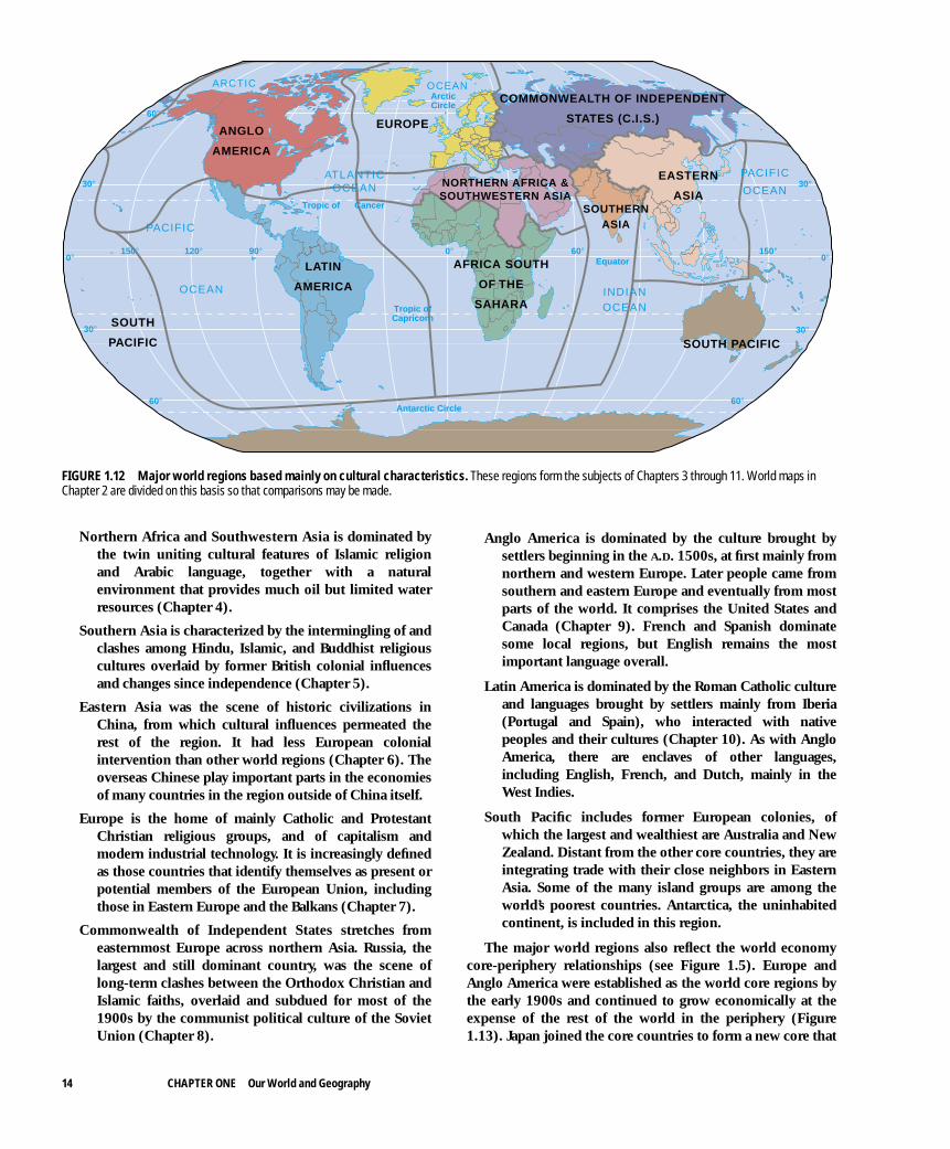
Interactions among countries and local regions may resultin conflicts. The presence of several cultural groups within acountry, each having territorial claims, often means that onegroup becomes dominant and others are discriminatedagainst. The Bosnian and Kosovan conflicts stemmed fromdifferences among Serbs, Croats, and Muslims (Figure 1.11).Each group had supporters outside Bosnia and Kosovo thatsupplied them with arms and so kept the conflict going.Conflicts over the ownership and allocation of waterresources, as along the Nile River Valley or over the sourcesof pollution, as in northwestern Europe, lead to politicaltensions among countries and regions. Regional differencesthus become sources of separation instead of integration.
• Regions are used by those in power. Regional characteroften reflects the deliberate actions of powerfulgovernments. Regions were manipulated to changepeople’s lives in the former Soviet Union, where ruralareas were industrialized on a major scale, even north ofthe Arctic Circle. Groups of people were moved from theirtraditional homes to other parts of the country for statesecurity reasons (see Chapter 8). In other countries,attempts to modernize regions that lag behind ineconomic development may destroy local characteristicsof culture and discourage local enterprise. In the UnitedStates, federal government attempts to develop theeconomically lagging region of Appalachia were criticizedbecause the modernization introduced was accompaniedby the decline of distinctive local cultures (see Chapter 9).
12 CHAPTER ONE Our World and Geography
Political and economic power is also exercised againstforeign countries. Despite the ending of the era whenmajor powers held territory as colonies, the strategicinterests of powerful countries—as defined by thecountries themselves—maintain strong influences insome parts of the world. This was particularly noticeableduring the Cold War from 1950 to 1990, but it still exists.The United States, for example, views the oil-producingPersian Gulf countries as important to its own economicwell-being as major suppliers of energy. It went to war in1991 to free the oil-producing country of Kuwait afterIraq’s invasion. It long resisted, however, involvement tostem the advances of invading Serbs in the Muslim andCroat sectors of Bosnia, rating that situation as lesssignificant.
MAJOR WORLD REGIONS
Both the defining of formal regions and a more dynamicregional geography—the creation and remaking of regions andtheir interactions with each other—are basic to understandingthe differences and changing circumstances around our world.The study of world regions provides opportunities for assess-ing the potential impacts on places of the country-based politi-
cal order, the expanding global economic system, the clashesof cultures, and the pressures on the natural environment.
In this text, the globe is divided into nine major worldregions and a chapter is devoted to each. Countries that havefeatures in common are grouped into major world regions(Figure 1.12) and subregions. The criteria for the majorgroupings are cultural, economic, political, and physical—inthat order.
The following divisions are not established for all time.Shifts that are currently in progress led to the eastward exten-sion of the boundary of the “Western Europe” major regionof the first edition (1997). In the present edition, the coun-tries of eastern Europe that set their sights westward after1990 by applying to join the European Union are groupedtogether as “Europe” with those already in the EU. Whatremains of the major region previously titled “EasternEurope, Balkans, and the Former Soviet Union” becomes the“Commonwealth of Independent States,” incorporating thecountries of the former Soviet Union minus the Baltic states.
Africa South of the Sahara, the cradle of the human race,is marked by tensions produced by a mosaic of smallethnic groups within a pattern of countries imposed byEuropean colonizers. Its religions have environmental,or animistic, bases with Islamic or Christian overlaysresulting from trade and colonization (Chapter 3).
Major World Regions 13
ETHNIC GROUPS
Slovenes
Croats
Serbs
Muslims
Macedonians
Albanians
No ethnic majority
Adriatic
Sea
AUSTRIA
HUNGARY
ROMANIA
ALBANIA
ITALY
BUL.
GREECE
SLOVENIA
CROATIA
YUGOSLAVIA(SERBIA -
MONTENEGRO)
BOSNIA -HERZEGOVINA
MACEDONIA
Kosovo
FIGURE 1.11 Importance of cultural differences. The formercountry of Yugoslavia in the Balkans of Europe. After 1991,Yugoslavia broke into five independent countries, although Serbia-Montenegro continues to call itself “Yugoslavia.” Slovenia, Croatia,Bosnia, and Macedonia maintain their independence with difficulty,and the Albanian southern part of Serbia (Kosovo) became an areaof civil conflict in the late 1990s. The colors show areas whereparticular ethnic groups comprise over 50 percent of the population.Which country has the greatest potential for ethnic conflict?
Northern Africa and Southwestern Asia is dominated bythe twin uniting cultural features of Islamic religionand Arabic language, together with a naturalenvironment that provides much oil but limited waterresources (Chapter 4).
Southern Asia is characterized by the intermingling of andclashes among Hindu, Islamic, and Buddhist religiouscultures overlaid by former British colonial influencesand changes since independence (Chapter 5).
Eastern Asia was the scene of historic civilizations inChina, from which cultural influences permeated therest of the region. It had less European colonialintervention than other world regions (Chapter 6). Theoverseas Chinese play important parts in the economiesof many countries in the region outside of China itself.
Europe is the home of mainly Catholic and ProtestantChristian religious groups, and of capitalism andmodern industrial technology. It is increasingly definedas those countries that identify themselves as present orpotential members of the European Union, includingthose in Eastern Europe and the Balkans (Chapter 7).
Commonwealth of Independent States stretches fromeasternmost Europe across northern Asia. Russia, thelargest and still dominant country, was the scene oflong-term clashes between the Orthodox Christian andIslamic faiths, overlaid and subdued for most of the1900s by the communist political culture of the SovietUnion (Chapter 8).
Anglo America is dominated by the culture brought bysettlers beginning in the A.D. 1500s, at first mainly fromnorthern and western Europe. Later people came fromsouthern and eastern Europe and eventually from mostparts of the world. It comprises the United States andCanada (Chapter 9). French and Spanish dominatesome local regions, but English remains the mostimportant language overall.
Latin America is dominated by the Roman Catholic cultureand languages brought by settlers mainly from Iberia(Portugal and Spain), who interacted with nativepeoples and their cultures (Chapter 10). As with AngloAmerica, there are enclaves of other languages,including English, French, and Dutch, mainly in theWest Indies.
South Pacific includes former European colonies, ofwhich the largest and wealthiest are Australia and NewZealand. Distant from the other core countries, they areintegrating trade with their close neighbors in EasternAsia. Some of the many island groups are among theworld’s poorest countries. Antarctica, the uninhabitedcontinent, is included in this region.
The major world regions also reflect the world economycore-periphery relationships (see Figure 1.5). Europe andAnglo America were established as the world core regions bythe early 1900s and continued to grow economically at theexpense of the rest of the world in the periphery (Figure1.13). Japan joined the core countries to form a new core that
14 CHAPTER ONE Our World and Geography
0°150° 120° 90° 0° 60° 150°
30°
60°
30°
60°
60°
30°
0°
30°
Tropic of Cancer
Equator
Antarctic Circle
ArcticCircle
Tropic ofCapricorn
ANGLO
AMERICA
LATIN
AMERICA
EASTERN
ASIASOUTHERN
ASIA
SOUTH PACIFIC
SOUTH
PACIFIC
EUROPE
COMMONWEALTH OF INDEPENDENT
STATES (C.I.S.)
NORTHERN AFRICA &SOUTHWESTERN ASIA
AFRICA SOUTH
OF THE
SAHARA
PACIFIC
OCEAN
PACIFIC
OCEAN
ARCTIC
ATLANTICOCEAN
INDIANOCEAN
OCEAN
FIGURE 1.12 Major world regions based mainly on cultural characteristics. These regions form the subjects of Chapters 3 through 11. World maps inChapter 2 are divided on this basis so that comparisons may be made.
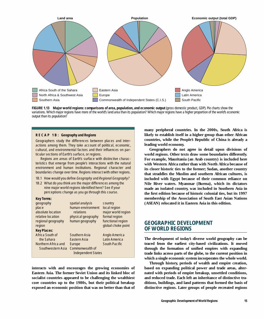
interacts with and encourages the growing economies ofEastern Asia. The former Soviet Union and its linked bloc ofsocialist countries appeared to be challenging the wealthiestcore countries up to the 1980s, but their political breakupexposed an economic position that was no better than that of
many peripheral countries. In the 2000s, South Africa islikely to establish itself in a higher group than other Africancountries, while the People’s Republic of China is already aleading world economy.
Geographers do not agree in detail upon divisions ofworld regions. Other texts draw some boundaries differently.For example, Mauritania (an Arab country) is included herewith Western Africa rather than with North Africa because ofits closer historic ties to the former; Sudan, another countrythat straddles the Muslim and southern African cultures, isincluded with Egypt because of their common reliance onNile River waters. Myanmar (Burma), which its dictatorsmade an isolated country, was included in Southern Asia inthe first edition because of historic colonial ties, but its 1997membership of the Association of South East Asian Nations(ASEAN) relocated it in Eastern Asia in this edition.
GEOGRAPHIC DEVELOPMENT OF WORLD REGIONS
The development of today’s diverse world geography can betraced from the earliest city-based civilizations. It movedthrough the formation of unified empires with expandingtrade links across parts of the globe, to the current position inwhich a single economic system incorporates the whole world.
Through history, periods of wealth and empire creation,based on expanding political power and trade areas, alter-nated with periods of empire breakup, unsettled conditions,and reduced trade. Each left an inheritance of distinctive tra-ditions, buildings, and land patterns that formed the basis ofdistinctive regions. Later groups of people recreated regions
Geographic Development of World Regions 15
Commonwealth of Independent States (C.I.S.)
Africa South of the Sahara
North Africa & Southwest Asia
Southern Asia
Eastern Asia
Europe
Anglo America
Latin America
South Pacific
Land area Population Economic output (total GDP)
FIGURE 1.13 Major world regions: comparisons of area, population, and economic output (gross domestic product, GDP). Pie charts show thevariations. Which major regions have more of the world’s land area than its population? Which major regions have a higher proportion of the world’s economicoutput than its population?
R E C A P 1 B : Geography and Regions
Geographers study the differences between places and inter-actions among them. They take account of political, economic,cultural, and environmental factors and their influences on par-ticular sections of Earth’s surface, or regions.
Regions are areas of Earth’s surface with distinctive charac-teristics that emerge from people’s interactions with the naturalenvironment and human institutions. Regional character andboundaries change over time. Regions interact with other regions.
1B.1 How would you define Geography and Regional Geography?1B.2 What do you think are the major differences among the
nine major world regions identified here? See if yourperceptions change as you go through this course.
Key Terms:geography spatial analysis countryplace human-environment local regionabsolute location relations major world regionrelative location physical geography formal regionregional geography human geography functional regionregion global choke pointKey Places: Africa South of Southern Asia Anglo America
the Sahara Eastern Asia Latin AmericaNorthern Africa and Europe South Pacific
Southwestern Asia Commonwealth of Independent States

by modifying older regional characteristics or incorporatingthem in the changes they brought.
Three distinctive ways emerged, in which peoples pro-duced goods and organized societies.
• For much of human history, people lived in small groupsby hunting, gathering, or low-productivity agriculture.Limited specialization and the exchange of goodsoperated on a local bartering basis. Such small-group andlocal scales of activity are typical of mini-systems.
• With greater organization, world regional empires replacedmini-systems. Technical advances increased agriculturalproductivity so that surpluses of food supported craftartisans and administrative-priestly-military ruling classes.Empires traded and warred with each other across areas thatexpanded or contracted over time.
• Capitalism led to the evolution of the current worldeconomic system from the A.D. 1400s. The criterion ofprofitability led to new forms of accumulating surpluswealth in a single world market, but the global basis ofcompetition demanded individual countries andcorporations and worked against an overriding globalpolitical order. This system replaced mini-systems andempires by the 1800s.
Making some huge generalizations and simplifications, thehistory of world regions can be summarized in five major phases.
Phase I. Local Systems: Hunting and FarmingAround 10,000 years ago (8000 B.C.), humans formed mini-systems of small hunting and gathering bands, the numbers ineach and the distribution of which depended on the naturalproductivity of the local ecosystems. Productivity could beraised in places by increasing the edible plants and animals, aswhere human-set fire extended natural grassland into forestedareas to sustain more larger, meat-providing animals.
Settled farming began in southwestern Asia some timebefore 9000 B.C., at first located in the subhumid hilly areasbetween mountains and plains. Farming based on early irriga-tion techniques spread from the surrounding hills to theTigris–Euphrates River valleys after 5000 B.C. The economic,political, and technological changes that followed spread toother areas with similar natural environments—the lower NileRiver valley (modern Egypt) and the Indus River valley (mod-ern Pakistan).
Within another millennium, China and southeastern Asiabecame important centers for settled farming based on thedomestication of plants and animals. Africa and Europe werelater on the scene and settled farming did not reach north-western Europe until 4000 B.C. Although the Americas wereisolated from these developments, recorded plant cultivationthere began around 7000 B.C. By 1500 B.C., corn formed thebasic crop of settled villages and some larger towns with craftindustries and local trades.
The first agriculture was based on selected species of plantsand animals that varied from southwestern Asia (wheat, bar-
ley), to China (millet, rice), the Americas (corn, squashes,beans, potatoes, peppers, tomatoes, cotton), and Africa(sorghum, yams). Animals were herded near cultivated fields,providing meat, wool, and milk, were used in field work, andcarried loads. Some of the domestic animals, especially thehorse and camel, gave mobility to nomadic herders. Villagesgrew into the first small towns, such as Jericho (c. 8000 B.C.),that produced pottery, textiles, and metal goods.
The geographic scale of interaction in this phase was domi-nantly local. The first broad human regional distinctionsemerged between places that depended on settled farming andthose that remained dependent on hunting and collecting.
Phase II. First World Regional Empires: City Civilizations and the Bronze Age, 2500 to 1000 B.C.This phase saw the formation of the first world empires,together with increased levels of interaction among them.The massive human interventions in the irrigated lowlandsof Mesopotamia—drained by the Tigris and EuphratesRivers—formed the central core and periphery of worldregional empires. Such empires stretched from the Mediter-ranean Sea to China (Figure 1.14). Successive city-basedstates in Mesopotamia, such as Sumer, Ur, and Akkad, con-trolled the irrigation farming, and Akkad created the world’sfirst empire. At times, the onslaught of peoples from the hin-terland broke down the processes of wealth accumulationand trade. From 2000 to 1000 B.C., the Babylonians and theHittites took control of parts or all of southwestern Asia.
This phase was marked by the first writing—to keep trackof economic transactions including trade; the further exten-sion of arts in warlike human likenesses, animal paintings, andstatues; the foundations of complex mathematics; technologi-cal innovations in metalworking, pottery, and constructionmaterials, and the invention of the wheel; the development ofreligious beliefs linked to mythical prehistories; and a codifica-tion of laws, including those giving rights to women.
Mesopotamia became the center of a trading networkbased on exporting its agricultural and craft products andimporting timber, metal ores, stone, and gemstones from thelocal periphery. Longer routes dealt in luxuries, with connec-tions to Egypt, Persia, the Indus River valley, and, after 1500B.C., to China. Slavery provided the main source of labor—often men and women captured in warfare and moved towork in the core area cities.
Other cores imitated developments in Mesopotamia, butMesopotamia remained central to trade links. Irrigationfarming also formed the basis of wealth accumulation inEgypt, where a series of kingdoms controlled the lower NileRiver valley and built huge memorials in the pyramids. Threeperiods of Egyptian kingdoms were separated by local rebel-lions or invasions of outsiders, including the Hyksos, whocaptured the northern delta region around 1750 B.C.
The island of Crete flourished as the center of the Minoancivilization from 1900 to 1600 B.C. Less is known about the civ-ilization in the Indus River valley around Harappa and
16 CHAPTER ONE Our World and Geography

Mohenjo-Daro, but its influence extended widely and its prod-ucts have been found in Mesopotamian sites. It ended around1550 B.C. after invasions from the north. In China, a confedera-tion of cities and states gradually drew together, but it was notuntil the Shang dynasty (1523–1028 B.C.) that there was widercontrol and an opening of trade relations to the north and west.
The first empires arose where the combination of waterand sun allowed extra productivity. Most of the worldremained outside the core-periphery areas with mini-systemeconomies, and was only occasionally caught up in the affairsof the core regions of wealth accumulation.
Phase III. New World Regional Empires: Classical Civilizations of the Iron Age, 1000 B.C. to A.D. 600 During this phase, “classical” periods that formed the culturalbasis of modern world regions and originated several majorworld universal religions occurred in Persia, Greece, Rome,India, and China. Confucius, Zoroaster, Buddha, many of theHebrew prophets and Greek philosophers, Jesus Christ, andMohammed all lived between the 500s B.C. and the 600s A.D.The Greek pantheon of gods (taken up by the Romans), theCeltic druidical religion, Scandinavian gods under Wotan, andthe Egyptian Isis, however, failed to sustain a major role. Only inHinduism did more ancient traditions and polytheism remain.
The geographic coverage of political and commercialactivities spread from the centers established in Phase II and
shifted outward from Mesopotamia into new empires (Figure1.15). In the west, Rome’s legions incorporated much ofnorthern Africa, modern Spain, France, and Britain into itsempire. New controlling interests took over Egypt, Persia,and India. In China, the Zhou, Qin, and Han dynastiesexpanded the empire, opening the route through CentralAsia to Persia and Rome by A.D. 200. Slavery remained themain form of labor in the fields, workshops, and domesticrealms of life in the empires.
Indian empires emerged from a phase of complex move-ments of people and changes after the invasion of Aryan peo-ples, becoming a region of settled farmers concentrated alongthe Ganges River valley. After 800 B.C., Aryans penetratedinto southern India and Ceylon, clearing woodland withtheir iron implements. Seafaring ties to southwestern Asiaincreased. By A.D. 100, Indian merchants established linkswith southwestern Asia and Egypt, exporting preciousstones, indigo, and silk yarn on their way to Rome.
China suffered a long period of internal disorder asemperors became figureheads without power and a hundredfeudal states fought for power. Yet this was also a time whenChinese culture was consolidated and spread into surround-ing lands. Warring states within China continued to vie forpower. The scale of destruction increased as iron weaponscame into use alongside the implements that brought newland into cultivation. China combined a rising population,innovative technology, and expanding trade at a time whenthe Roman Empire reached its greatest extent in the west.
Geographic Development of World Regions 17
CC
CC
CC C
0°150° 120° 90° 0° 60° 90° 150°
30°
60°
30°
60°
60°
30°
0°
30°
Tropic of Cancer
Equator
Antarctic Circle
ArcticCircle
Tropic of Capricorn
Core-Periphery
Trade Routes
Hinterland
C
PACIFIC
OCEAN
PACIFIC
OCEAN
ARCTIC OCEAN
ATLANTIC
OCEAN
INDIAN
OCEAN
HUNTING
MESOPOTAMIA
HUNTING
HUNTING
HUNTING
PEASANT FARMING
PEASANTFARMING
PEASANTFARMING
PEASANTFARMING
PEASANTFARMING
NOMADS
NOMAD HINTERLAND
NOMADSEGYPT
NOMADS
NOMADS
(NO SETTLEMENT)
HUNTING
INDUS2500 BC
PEASANT FARMINGHINTERLAND
SHANG CHINA1500 BC
NOMADS
FIGURE 1.14 First world regional empires, about 2500 to 1000 B.C. The first civilizations of southwestern Asia and the Nile and Indus River valleys, withsomewhat later developments in China. The core-periphery areas were the main centers of world trade and development, linking with each other along sea andoverland routes. The near hinterland supplied some raw materials, but most of the world lay beyond in an unconnected outer hinterland.

Economic and cultural contacts from one end of Eurasia tothe other had never been so close. Later, the combination of acourt weakened by factions and child emperors, incursionsby nomadic Xiongnu from the north, and poor harvests ledto the breakdown and division of the empire.
Phase IV. Feudal Empires: Medieval Times, A.D. 600 to 1450 Although the term medieval is applied mainly to Europe, itsignifies a middle phase in the development of world systemsbetween the classical and modern eras. Interruptions towealth accumulation and trade earned it the term, “DarkAges.” Invasions from central Asia affected the core areas inRome, Greece, northern China, Persia, and India. WesternEurope remained disorganized and backward as the result ofcontinuous invasions from the east. The uncertainties of thistime resulted in the spread of feudalism, by which a hierar-chy of emperors, kings, princes, barons, and local warlordsprovided protection for their serfs and local peasants inexchange for labor and military service.
New Empires
Byzantium, centered on Constantinople, became the centerof the Roman Empire following the collapse of Rome in A.D.300. New empires arose in Persia, northern India, China,Indo-China, Korea, and Japan. The Muslim expansion fromthe A.D. 600s out of southwestern Asia to Persia and northern
Africa—one of the most important events in history—wasfollowed by Arab traders penetrating across the Sahara innorthern Africa and taking a major role in the MediterraneanSea and Indian Ocean. In western Africa, the empires ofGhana, Mali, and Songhai followed each other. In the Ameri-cas, the Maya, Aztec, and Incan empires established military-economic control over large areas (Figure 1.16).
Mass Migrations
Invading hordes set off huge movements of peoples from thesteppe grasslands of central Asia. Mobile mounted archerswith light armaments successfully attacked crucial centers ofpower. As they moved out of central Asia, they often pushedother groups ahead of them into southern China, India, andwestern Europe. They spread Turkish languages westwardbut were seldom able to govern settled peoples for long.
In the westward movements caused by such pressures dur-ing the A.D. 300s to 500s, German and Slavic tribes moved onto former Roman Empire lands. Further disruption and reset-tlement followed the Magyar invasions of Hungary in the late800s. The Great Wall of China, however, proved an effectivedefense frontier for the Chinese. The most significant and finalinvaders were the Mongols in the 1200s and 1300s, conquer-ing and ruling China for 200 years. In India, Muslims gainedpolitical control of the north by the 1200s, setting up the Sul-tanate of Delhi, which lasted until European conquests.
From the late 700s to the 1100s, the Vikings of northernEurope set out by sea to raid and settle lands. They reached
18 CHAPTER ONE Our World and Geography
CC
C C
CC
C
C C
0°150° 120° 90° 0° 60° 90° 150°
30°
60°
30°
60°
60°
30°
0°
30°
Tropic of Cancer
Equator
Antarctic Circle
ArcticCircle
Tropic of Capricorn
Core-Periphery
Trade Routes
Hinterland
C
PACIFIC
OCEAN
PACIFIC
OCEAN
ARCTIC OCEAN
ATLANTIC
OCEAN
INDIAN
OCEAN
HUNTING
HUNTING
HUNTING
PEASANT FARMING
PEASANTFARMING
PEASANTFARMING
NOMADSNOMADS
NOMAD HINTERLAND
NOMADS
NOMADS
NOMADS
(NO SETTLEMENT)
HUNTING
HUNTINGPEASANT FARMING
HINTERLAND
FIGURE 1.15 New world regional empires, about 1000 B.C. to A.D. 600. During this phase, the Greek and Roman empires expanded westward, the centralPersian empire and northern India provided new cores, and the Chinese empires became organized and expansionist. By A.D. 200, there was a considerable east-west trade in luxury goods and a major growth of trade within the core-periphery zones.

Iceland, Greenland, and the British Isles in the west, enteredFrance and northern Europe, and sailed down the VolgaRiver valley in present-day Russia—where they traded fursand slaves with Muslims.
New Geographic Patterns
Toward the end of this phase, the future cultural and territor-ial patterns of European and other powers began to emerge.The Christian church, previously confined to the RomanEmpire, sent missions to northern Europe, resulting in theconversion of most of the region by A.D. 1000. The eastern(Orthodox) church centered in Constantinople spread itsinfluence northward and eastward. Muslim advances, how-ever, swamped the church in southwestern Asia, India, andnorthern Africa. By the end of phase IV, Muslim armies con-quered the Balkan Peninsula, southern Italy, and Iberia(Spain and Portugal), as well as northern Africa. In northernEurope, the Franks of central Germany established controlover modern France and Germany by A.D. 800, while theSaxons moved into England and tried to fight off the Vikings.Slavic states emerged in eastern Europe, including the firstRussian state in the mid-800s.
China again became the world’s most prosperous empirewith extensive sea power. Hangzhou was the world’s greatestcity, with 1.5 million inhabitants. China’s visual arts, literature,philosophy, science, technology (first printing), and educationwere in advance of the rest of the world. Rich merchants and agrowing middle class emerged through the increasing numbersof trained state officials, bankers, and independent peasants.
The basics of Chinese culture (language and political organiza-tion) were adopted by surrounding states in Korea, Japan,Manchuria, and Yunnan (southern China). Southeastern Asiabecame a world crossroads between India and China, lateraffected by Muslim trading and military missions.
Links to the Future
By the 1100s, Europe was climbing out of political and eco-nomic dislocation. In a period of warmer climate, the popula-tion increased, especially in (modern) France, Germany, andEngland. Farmers opened new lands by cutting woodlandand draining marshes. In western Europe, the feudal systemcame under stresses during the 1400s, when many serfsbecame freeholders or wageworkers. Peasant farmers gainedmore independence, and towns expanded with craft indus-tries and markets, some of which had international signifi-cance through their trade fairs.
The end of phase IV was marked by the attacks of GenghisKhan and his Mongol hordes, the expansion of the OttomanTurks, the Black Death, and the worsening climate leading to theLittle Ice Age (approx. A.D. 1450 to 1850). The resultant eco-nomic recession and population decimation (up to one-third insome parts of western Europe) reduced trade across Eurasia.
Phase V. Capitalist World System and ModernTimes: A.D. 1450 to the Present The final phase of world history built on the past to producedetailed geographic differences among places in A.D. 2000.
Geographic Development of World Regions 19
0°150° 120° 90° 0° 60° 90° 150°
30°
60°
30°
60°
60°
30°
0°
30°
Tropic of Cancer
Equator
Antarctic Circle
ArcticCircle
Tropic of Capricorn
C
C
C C C
CC
CC
C CC C
C C
C
CC
C
CC
Core-Periphery
Trade Routes
Hinterland
C
PACIFIC
OCEAN
PACIFIC
OCEAN
ARCTIC OCEAN
ATLANTIC
OCEAN
INDIAN
OCEAN
HUNTING
HUNTING
HUNTING
PEASANTFARMING
PEASANT FARMING HINTERLAND
PEASANTFARMING
NOMADSHUNTING
NOMAD HINTERLAND
NOMADS
AZTECS
INCAS
(NO SETTLEMENT)
HUNTING
FIGURE 1.16 Feudal empires, about A.D. 600 to 1450. This period began with disruptions in Europe and included invasions from the Eurasian steppes andViking homelands. It also saw the development of new empires outside the previous world systems, including the Americas. Some regions experienced importantperiods of political consolidation and wealth accumulation.

The growth of capitalism and associated colonialism paral-leled the centralization of economic and political power inwestern Europe. The whole world became incorporated in asingle system of production and trade facilitated by theincreased speed and capacity of transportation and commu-nications. The modern pattern of countries emerged. Interac-tions among regions and countries increased. Environmentalrestrictions on production gradually gave way to changingeconomic and political priorities. Modernization, seen asdesirable by most people in the world, involved increasingproduction and trade based on new technologies.
The new form of wealth accumulation spread outward tothe Americas, Africa, the South Pacific, and parts of Asia. Bythe late 1800s, much of the world was ruled by Europeancountries and incorporated in dependent trade relations. Thisphase of globalization was slowed by the aloofness of theUnited States until 1940, the disruptions of two world wars,the economic depression of the 1930s, decolonization after1945, and the Cold War. In the 1990s virtually the entireglobe became part of the capitalist world economic system.
Mercantile Capitalism
Capitalism, the dominant world economic system of wealthaccumulation since the late 1400s, developed when technolo-gies of production and communication expanded the geo-
graphic scope of exchange and control. In the period A.D. 1450to 1750 (Figure 1.17), mercantile capitalism, or mercantilism,replaced the European land-ownership based wealth and per-sonal ties of feudalism. Merchants in independent markettowns and ports traded local products, such as wool and cloth,for spices and dried fish from overseas. The products of thefishing, timber, mining, and farming industries were the maingoods distributed through mercantile capitalism.
Mercantilism made possible the accumulation of mone-tary wealth. Favorable balances of trade were often based onmonopolies granted by kings or on the increasing productiv-ity of agriculture and craft manufactures. Some regions spe-cialized in producing cloth from local wool, at first inpeople’s homes with merchants collecting and selling the out-put. Owners of capital invested it in land and farmingimprovements, such as the drainage of wetlands in Hollandand England, or in trading expeditions to the new colonies.
Trading linkages grew among market towns within Euro-pean countries and led to the overseas colonization of newterritories to provide sources of new products. Europeancountries, beginning with Spain and Portugal in the 1500s,but giving way to French, Dutch, and British merchants andmilitary in the 1600s, invested in exploration and trade withAfrica, Asia, and the Americas. Western Europe became thecore of the new capitalist economic system, while its colonies
20 CHAPTER ONE Our World and Geography
AZ
T ECS
IN
CAS
AFRICAN
KINGDOMS
RUSSIAN
CORE
PERSIAN
DELHISULTANATE
HOLYROMANEMPIRE
MING/MANCHUEMPIRES
OTTOMAN
F
E
SP
0°150° 120° 90° 0° 60° 90° 150°
30°
60°
30°
60°
60°
30°
0°
30°
Tropic of Cancer
Equator
Antarctic Circle
ArcticCircle
Tropic of Capricorn
Initial European core ofexploration and trade
Other world empires
E England
F France
P Portugal
S Spain
PACIFIC
OCEAN
PACIFIC
OCEAN
ARCTIC OCEAN
ATLANTIC
OCEAN
INDIAN
OCEAN
FIGURE 1.17 Capitalist world system, part 1, about A.D. 1450 to 1750. This phase was dominated by the capitalist means of wealth accumulation. In the firstperiod, about A.D. 1450 to 1750, mercantile capitalism led to the exploration from Europe of new lands, along with some colonization. Other empires existed outsidethe European realm and traded with each other (see also Figures 1.18 and 1.22).

Geographic Development of World Regions 21
and trading stations were its periphery. Other parts of theworld remained in the hinterland of isolated subsistence(mini-systems) or feudal empire systems until the 1800s.
The Four Revolutions of Industrial Capitalism
The mid-1700s formed another watershed in the develop-ment of the world economic system. From A.D. 1750 untilthe early 1900s, the first industrial revolutions set off growthin factory-based manufacturing industries, bringing a newimpetus to the capitalist economic system and hastening itsworld dominance (Figure 1.18). Rates of change increasedand new parts of the world were incorporated as interactionsamong regions increased.
Industrial capitalism is based on the concentration of manu-facturing production in factories (Figure 1.19), involving highlevels of investment in buildings and machinery and, in manycases, increased profit margins for investors. Production in fac-tories added significant value to the raw materials and compo-nents. Manufacturing also required investment in transportationfacilities linking the factories to their sources of raw materials,component producers, and markets. New social groups emergedout of the production processes, from the owners to the man-agers, foremen, and workers. New distinctive patterns of towns,new functional areas within towns, transportation links, andregional wealth inequalities marked this phase.
Industrial capitalism experienced alternating periods ofexpansion and stagnation from the mid-1700s to the present(Figure 1.20). During periods of expansion, new technolo-gies of production and transportation caused a series of fur-ther industrial revolutions and spread the influence ofcapitalism. These processes had major geographic impacts.Cities expanded as more factories and homes were built toaccommodate workers moving from the countryside to workin factory jobs. Overseas exploration from the core countriesopened new lands to provide the raw materials for factoriesand markets for their manufactured goods that entered worldtrade. Places still dominated by subsistence and feudal eco-nomic systems were reoriented as the world economic sys-tem advanced further in each phase of expansion. Duringperiods of stagnation, technological innovation slowed,while surpluses of labor, productive capacity, and capitalresulted in economic recession.
• First industrial revolution, 1750 to 1850. The first factorieswere in Britain, powered by water mills and then steamengines. They processed agricultural and mine outputs.The early manufacturing industries includedironworking, cotton textiles, leather goods, and pottery.This was a period of competition among family-ownedmanufacturing firms. Transportation was mainly by wateracross oceans, around the coasts, up rivers, and along
0°150° 120° 90° 30° 0° 60° 90° 150°
30°
60°
30°
60°
60°
30°
0°
30°
Tropic of Cancer
Equator
Antarctic Circle
ArcticCircle
Tropic of Capricorn
PACIFIC
OCEAN
PACIFICOCEAN
ARCTIC
OCEAN
ATLANTIC
OCEANINDIAN
OCEAN
From1870
USA
R U S S I A N E M P I R E
MANCHU
CHINAJAPAN
WESTERNEUROPE OTTO
MA
N
Britain
France
Belgium
Germany
Netherlands
CORE AREAS
Colonies of Core Areasby 1914
Former colonies,independent by 1914
Formerly Portuguese
Formerly Spanish
Other
Russian empire
Other empires
FIGURE 1.18 Capitalist world system, part 2,about A.D. 1750 to 1910. The growth of industrialcapitalism, the consolidation of the core in Europe andAnglo America, and the expansion of European empiresin the periphery.
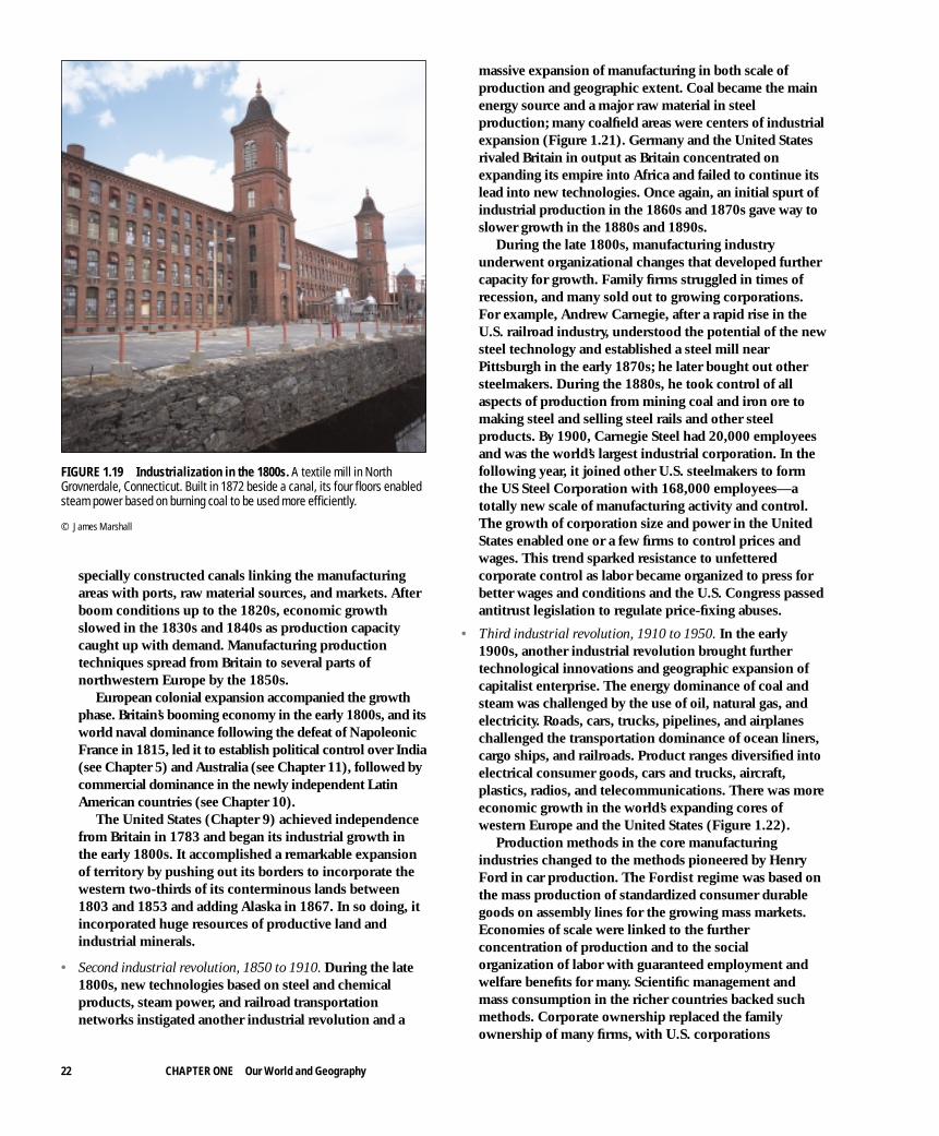
specially constructed canals linking the manufacturingareas with ports, raw material sources, and markets. Afterboom conditions up to the 1820s, economic growthslowed in the 1830s and 1840s as production capacitycaught up with demand. Manufacturing productiontechniques spread from Britain to several parts ofnorthwestern Europe by the 1850s.
European colonial expansion accompanied the growthphase. Britain’s booming economy in the early 1800s, and itsworld naval dominance following the defeat of NapoleonicFrance in 1815, led it to establish political control over India(see Chapter 5) and Australia (see Chapter 11), followed bycommercial dominance in the newly independent LatinAmerican countries (see Chapter 10).
The United States (Chapter 9) achieved independencefrom Britain in 1783 and began its industrial growth inthe early 1800s. It accomplished a remarkable expansionof territory by pushing out its borders to incorporate thewestern two-thirds of its conterminous lands between1803 and 1853 and adding Alaska in 1867. In so doing, itincorporated huge resources of productive land andindustrial minerals.
• Second industrial revolution, 1850 to 1910. During the late1800s, new technologies based on steel and chemicalproducts, steam power, and railroad transportationnetworks instigated another industrial revolution and a
massive expansion of manufacturing in both scale ofproduction and geographic extent. Coal became the mainenergy source and a major raw material in steelproduction; many coalfield areas were centers of industrialexpansion (Figure 1.21). Germany and the United Statesrivaled Britain in output as Britain concentrated onexpanding its empire into Africa and failed to continue itslead into new technologies. Once again, an initial spurt ofindustrial production in the 1860s and 1870s gave way toslower growth in the 1880s and 1890s.
During the late 1800s, manufacturing industryunderwent organizational changes that developed furthercapacity for growth. Family firms struggled in times ofrecession, and many sold out to growing corporations.For example, Andrew Carnegie, after a rapid rise in theU.S. railroad industry, understood the potential of the newsteel technology and established a steel mill nearPittsburgh in the early 1870s; he later bought out othersteelmakers. During the 1880s, he took control of allaspects of production from mining coal and iron ore tomaking steel and selling steel rails and other steelproducts. By 1900, Carnegie Steel had 20,000 employeesand was the world’s largest industrial corporation. In thefollowing year, it joined other U.S. steelmakers to formthe US Steel Corporation with 168,000 employees—atotally new scale of manufacturing activity and control.The growth of corporation size and power in the UnitedStates enabled one or a few firms to control prices andwages. This trend sparked resistance to unfetteredcorporate control as labor became organized to press forbetter wages and conditions and the U.S. Congress passedantitrust legislation to regulate price-fixing abuses.
• Third industrial revolution, 1910 to 1950. In the early1900s, another industrial revolution brought furthertechnological innovations and geographic expansion ofcapitalist enterprise. The energy dominance of coal andsteam was challenged by the use of oil, natural gas, andelectricity. Roads, cars, trucks, pipelines, and airplaneschallenged the transportation dominance of ocean liners,cargo ships, and railroads. Product ranges diversified intoelectrical consumer goods, cars and trucks, aircraft,plastics, radios, and telecommunications. There was moreeconomic growth in the world’s expanding cores ofwestern Europe and the United States (Figure 1.22).
Production methods in the core manufacturingindustries changed to the methods pioneered by HenryFord in car production. The Fordist regime was based onthe mass production of standardized consumer durablegoods on assembly lines for the growing mass markets.Economies of scale were linked to the furtherconcentration of production and to the socialorganization of labor with guaranteed employment andwelfare benefits for many. Scientific management andmass consumption in the richer countries backed suchmethods. Corporate ownership replaced the familyownership of many firms, with U.S. corporations
22 CHAPTER ONE Our World and Geography
FIGURE 1.19 Industrialization in the 1800s. A textile mill in NorthGrovnerdale, Connecticut. Built in 1872 beside a canal, its four floors enabledsteam power based on burning coal to be used more efficiently.
© James Marshall

beginning to transfer their cost advantages in car andconsumer goods manufacture to new factories in Europe.
During the early 1900s, large new areas of agriculturaland mineral production opened in southwestern Asia,South America, South Pacific, and parts of Africa, thusexpanding the resource base and increasing competitionamong peripheral resource providers. Raw material costswere reduced for core-country manufacturers. The corecountries produced nearly all the manufactured goodsand sold their products in reciprocal trade to peripheralcountries after having benefited from the added value inmanufacturing. Core countries gained further wealth,often invested in urban expansion through the building ofsuburbs. Public transportation and private cars providedaccess to suburban housing. More people could afford thenew mass-produced consumer products.
Up to 1950, the world economic core remained inwestern Europe and Anglo America, while most of Africaand southwestern Asia were drawn into the peripheralcolonial linkages that dominated the rest of the worldoutside of Latin America, China, and Japan. Japan wentthrough its own period of industrialization but had limitedparticipation in the expanding world economic systembefore 1950. Ex-colonial or largely uncolonized areasentered the periphery as their commercial relations withthe core countries grew, leading to greater dependency.
The gap between core and periphery increased.The years of core country economic growth ended
temporarily in the economic depression of the 1930s,followed by World War II in the 1940s. Government andtrade unions became more involved in the greaterregulation and mediation of industrial affairs during thisperiod, while governments achieved further prominencethrough organizing the production of war materials.
• Fourth industrial revolution, 1950 on. The breakup of theEuropean colonial empires after World War II transferredpolitical power to over 100 newly independent countries.The Cold War established a new form of ideologicalcompetition between the capitalist and communist Firstand Second Worlds. Countries that defied the expansionof capitalism, however, were forced to come to terms withit by the 1990s.
Technological innovation and diffusion resumed, oftenbased on products developed during the war—jet engines,electronics, and aerospace—together with expandedranges of consumer goods and increasingly packagedfoods. Technological advances increased the extent andfrequency of changes. The service sector grew insignificance as additional jobs were created in expandedhealth, education, professional, business, recreation, andespecially government services. More manufacturing andservice industry employment led to further urban growth
Geographic Development of World Regions 23
Long waves:Distinctiveeconomicepochs of
corecountries
Phasesofcapitalism Industrial Advanced Industrial
Laborprocesses
Role ofgovernment
Technologysystems
Cycles ofinfrastructure
building incore
countries
IndustrialRevolution
Flexible Production Systems
Diminished: Partner/Facilitator
MicroelectronicsDigital TelecommunicationsRoboticsBiotechnologyInformation Systems
SecondAutomobileBoom
FirstAutomobileBoom
Streetcar Boom
SecondRailwayBoom
FirstRailwayBoom
CanalBuilding
Strong: Manager/Regulator
“Fordism”
Internal Combustion EngineOil and PlasticsElectrical EngineeringHeavy EngineeringAutomobiles, Aircraft,Radio and Telecommunications
“Machinofacture”
Increasing: Regulator
Coal-Powered Steam EngineSteelRailwaysMachine ToolsWorld Shipping
Manufacture
Rising Limb
Falling Limb
Negligible
Water PowerSteam EnginesCotton TextilesIron Works
VictorianBoom
Depressionof 1890s
GreatDepression
“SwingingSixties”
“ReaganEra”
“RoaringTwenties”
“HungryForties”
“Era of GoodFeelings”
“Gilded Age”1815 1865 1920 1980
FIGURE 1.20 Capitalist world system: economic fluctuations. This summary mainly reflects experiences in the United States. The rising limb of eachlong wave was accompanied by the development and use of new technologies of manufacture and transportation that enlarged productive capacity. Core-periphery relations expanded into new world areas. During the falling limb, costs to manufacturers (such as the price of raw materials from peripheralcountries) increased, and there was less money for new investments. Suggest how these fluctuations affected countries in the world periphery.
Adapted from P. Knox and J. Agnew, Geography of the World Economy, 1989. Copyright © 1989 Edward Arnold Publishers, Ltd., London.

in both core and periphery countries. During the late 1900s, the huge assembly factories
built for Fordist economies of scale declined inprofitability. Their inflexibility could not keep up withnew products, new technologies, increasing competitionfrom cheaper sources, or changing tastes. They weregradually replaced, following Japanese practice, byflexible, lean-production systems of manufacturing in apost-Fordist production phase. Robots replaced humanworkers, while new products could be developed morequickly and marketed before competitors crowded themarkets and reduced profitability.
Large corporations, beginning with those in the UnitedStates and extending to their counterparts in westernEurope and Japan, controlled production and distributionin many countries. Such multinational corporationsbegan to maneuver governments and labor interests bysiting new production plants in countries where labor andtaxation costs were low. Manufacturing employmentshifted to newly industrializing countries, mainly inEastern Asia and Latin America (South Korea, Taiwan,Hong Kong, Singapore, Malaysia, Thailand, Brazil, andMexico). These countries competed with the corecountries of the West, and the new core forming in
24 CHAPTER ONE Our World and Geography
PACIFIC
OCEAN
PACIFICOCEAN
ARCTIC OCEAN
ATLANTIC
OCEANINDIAN
OCEAN
0°150° 120° 90° 30° 0° 60° 90° 150°
30°
60°
30°
60°
60°
30°
0°
30°
Tropic of Cancer
Equator
Antarctic Circle
ArcticCircle
Tropic of Capricorn
P E R I P H E R Y
Oil
WESTERNEUROPE
ANGLOAMERICA
S O V I E T B L O C
C H I N A
SEMIPERIPHERY AND
PERIPHERY
COREOUTLIER
JAPANOilWealth
P E RI P
HE
RY
AN
D
S E MI P
ER
I PH
ER
Y
FIGURE 1.22 Capitalist world system, part 3, about A.D. 1910 to present. Central planning in communist countries, advanced industrial capitalism, twoworld wars, independence of former European colonies, expansion of world trade, and technologic developments in manufacture, transportation, andcommunications marked this period.
AT L A N T I CO C E A N
AT L A N T I CO C E A N
Nor th
Sea
English Channel
CENTRALSCOTLAND
(ships, textiles)
NORTHEAST (ships)
YORKSHIRE(woolen textiles)
MIDLANDS(metal goods)
London
Belfast(ships)
LANCASHIRE(cotton textiles)
SOUTH WALES(iron, steel)
10° 5° 0°
55°
50°
Coal producing areas
FIGURE 1.21 Industrialization in the 1800s and coalfield locations.Areas of Britain that produced coal were industrialized and urbanized,growing rapidly in wealth and population. They suffered setbacks in the1900s as their products competed at a disadvantage with new areas in otherparts of the world.

eastern Asia, centered on Japan.In the 1970s, world economic growth faltered as raw
material, and especially energy, prices rose. New prospectsfor economic growth emerged in the 1980s. Thedevelopment of microelectronics, biotechnology, robotics,and information systems may signal the start of anotherperiod of industrial revolution and world economicgrowth at the beginning of the new century. Another viewof the current situation, however, is that the post-Fordist,or postmodern, period is one of uncertainty andconfusion resulting from the global extension of theworld economic system.
Conclusions
The modern, capitalist phase was marked by the globalexpansion of modernization from Europe in the 1600s and1800s, and then from the increased cores in Europe, AngloAmerica, and Japan during the 1900s. Each phase created orrecreated regions, increased interactions among places, andwidened the scope of the capitalist world economy. At thesame time, the country basis of political activity was estab-lished and strengthened and the long-term cultural distinc-tiveness of major world regions resisted the onslaught of
Chapter Review Questions 25
R E C A P 1 C : Growing Global Order
World history records how civilizations spread their geographicimpact through core and peripheral regions. Periods of wealthaccumulation and expansion of empires and trade alternatedwith periods of disruption. During the 1900s the world’s coreregions expanded their periphery to include the whole world inthe capitalist economy.
1C.1 Construct a chart to summarize the main features of theexpanding global order, based on the geographicdifferentiation of local, regional, countrywide, and globallevels.
1C.2 Why is a knowledge of the growth of the global orderessential to our understanding of modern worldgeography?
Key Terms:mini-system modernization Fordist regimeworld regional empire mercantile capitalism post-Fordistworld economic system industrial capitalism production
cultural Westernization alongside economic modernization.
5. Settled farming began (a) in Egypt about 3000 B.C. (b)in the Tigris-Euphrates Valley around 5000 B.C. (c) inAfrica around A.D. 100 (d) in hill lands of SouthwestAsia around 8000 B.C.
6. The core of the first world empire system was in (a)Mesopotamia (b) Egypt (c) China (d) Greece
7. Which of the following was not a characteristic of theSecond Industrial Revolution? (a) use of electricity (b)importance of coal (c) growth of railroad networks (d)development of large industrial corporations throughvertical and horizontal integration
8. Which of the following countries is in the “North”according to the “Brandt Line” but is in the peripheryin the New World Order? (a) Russia (b) China (c)Kazakstan (d) Mexico
9. The major world region with the largest share of popu-lation is (a) Europe (b) Commonwealth of Indepen-dent States (c) Anglo America (d) Eastern Asia
10. Which of the following is not a characteristic of coun-tries with socialist economic systems? (a) state-directedcentral economic planning (b) health care and educa-tion for a large portion of the population (c) widespreadownership of consumer goods (d) most of the popula-tion in the lower-income group
C H A P T E R R E V I E WQ U E S T I O N S
1. Before 1990, the Second World consisted of countriesthat (a) placed individual rights as the first priority ofgovernment (b) tried to implement the communistprinciples of Marx and Lenin (c) had democratic gov-ernments (d) were newly independent
2. A group’s culture includes (a) ideas (b) beliefs (c) gen-der roles (d) all of the above
3. To a geographer, a landscape is (a) pretty scenery, suit-able for an artist to paint (b) planting flowers andshrubbery in front of one’s house (c) the result of inter-action between people and environment over time (d)the design of a new park
4. Which of the following is not an example of a globalchoke point? (a) Strait of Malacca near Singapore (b)Davis Strait in northern Canada (c) Panama Canal inCentral America (d) Strait of Hormuz at the entrance tothe Persian Gulf

11. After 1990, Russia was the sole remaining superpower.True / False
12. The spread of Western food and drink, popular culture,and consumer goods has completely obliterated cul-tural differences in the world.
True / False
13. Because of an increasingly interconnected world, inwhich global forces impact local events, geography nolonger matters.
True / False
14. “Classical” periods that formed the basis of modernworld systems occurred in Persia, Greece, Rome, India,and China between 1000 B.C. and A.D. 600.
True / False
15. The rise of Islam and expansion of the Muslims tookplace in a period considered “backward” in Europe.True / False
16. The first phase of the Industrial Revolution began inthe United States.
True / False
17. In the Third Industrial Revolution, more parts of theworld were drawn into the capitalist industrial system,and the gap between core and peripheral countriesnarrowed.
True / False
18. In the Fourth Industrial Revolution, production anddistribution of many goods began to be controlled bylarge multinational corporations.
True / False
19. During the Cold War, countries of the First World com-peted with countries of the Second World for influenceover countries of the Third World.
True / False
20. The economic system that emphasizes private or cor-porate organization of business and investment is the____________________ system.
21. Poor countries that have a narrow range of products,less advanced technology, and poorly paid workers aresaid to be in the ____________________.
22. The growing interdependence of the world’s peoples,and the increasing integration of economies, technolo-gies, and some aspects of culture is known as____________________.
23. The first form of capitalism, developing from the 1450sand involving European merchants trading local prod-ucts for fish and spices overseas, was ________________capitalism.
24. The use of assembly lines and scientific management inmanufacturing is called ____________________.
25. In the 1900s, the world population increased from__________ billion in 1900 to __________ billion in2000.
26. Countries that are in the process of moving betweenbeing in the core and being in the periphery are called____________________.
27. The world as it would be without human modificationconstitutes the ____________________.
28. The location of a place as defined by its position on theEarth’s surface, usually in terms of latitude and longi-tude, is its ____________________.
29. Distinctive parts of the Earth’s surface with characteris-tics determined by a combination of physical andhuman geographic features are ____________________regions.
30. Where people live in small groups by hunting, gather-ing, or low-productivity agriculture, and have mainlylocal contacts with others, their mode of life is known asa __________________.
26 CHAPTER ONE Our World and Geography