Embed Size (px)
Citation preview

This permit does not address the right of entry or settlement of surface damages. The duration of this permit is SIX MONTHS, except as otherwise provided by Rule 165: 10-3-1. Rule 165: 10-3-4 (c) (7) (e) - The Operator shall give 24 Hours notice by telephone to the appropriate District Office of the Conservation Division as to when Surface Casing will be run.
Page 1 of 3
400 7TH STREET SW
JAMES G. BOLES
CHILDRESS TX 79201
OKLAHOMA CORPORATION COMMISSION OIL & GAS CONSERVATION DIVISION
P.O. BOX 52000 OKLAHOMA CITY, OK 73152-2000
(Rule 165:10-3-1)
21360API NUMBER: 029
WELL LOCATION:
Approval Date: 05/09/2017
Expiration Date: 11/09/2017
Sec: 02 Twp: 2N Rge: 8E County: COAL
SPOT LOCATION: SE SE NE SE FEET FROM QUARTER: SOUTHFROM FROM
SECTION LINES:2771443
EAST
Lease Name: BOLES Well No: #1-2/11/14H
Operator Name:
Telephone:CANYON CREEK ENERGY OPERATING LLC 9185616737 OTC/OCC Number: 23443
2431 E 61ST ST STE 400
CANYON CREEK ENERGY OPERATING LLC
TULSA, OK 74136-1237
0
Formation(s) (Permit Valid for Listed Formations Only):
3 HUNTON 6600
4
5
2 WOODFORD 6450
1 MISSISSIPPIAN 6200
Name Depth
8
9
10
7
6
Name Depth
PERMIT TO DRILL
Spacing Orders:
Special Orders:
Total Depth: 16000 Ground Elevation: 668 Surface Casing: 1000
Location Exception Orders:
201702727
201702726
201702725Pending CD Numbers:
Depth to base of Treatable Water-Bearing FM: 410
PIT 1 INFORMATION
Type of Pit System:
Type of Mud System:
Pit is not located in a Hydrologically Sensitive Area.
Category of Pit:
Liner not required for Category: 4
Pit Location is NON HSA
Pit Location Formation: BOGGY
Mud System Change to Water-Based or Oil-Based Mud Requires an Amended Intent (Form 1000).
4
ON SITE
AIR
Is depth to top of ground water greater than 10ft below base of pit?
Within 1 mile of municipal water well?
Wellhead Protection Area? N
N
Y
Approved Method for disposal of Drilling Fluids:
Fresh Water Supply Well Drilled: No Surface Water used to Drill: YesUnder Federal Jurisdiction: No
No Spacing
F. Haul to Commercial soil farming facility: Sec. 17 Twn. 7N Rng. 9E Cnty. 63 Order No: 551649
H. SEE MEMO
Oil & GasHorizontal Hole
Increased Density Orders:
Well will be feet from nearest unit or lease boundary.277

This permit does not address the right of entry or settlement of surface damages. The duration of this permit is SIX MONTHS, except as otherwise provided by Rule 165: 10-3-1. Rule 165: 10-3-4 (c) (7) (e) - The Operator shall give 24 Hours notice by telephone to the appropriate District Office of the Conservation Division as to when Surface Casing will be run.
Page 2 of 3
029 21360 BOLES #1-2/11/14H
PIT 3 INFORMATION
Type of Pit System:
Type of Mud System:
Pit is not located in a Hydrologically Sensitive Area.
Category of Pit:
Liner not required for Category: C
Pit Location is NON HSA
Pit Location Formation: BOGGY
C
CLOSED Closed System Means Steel Pits
OIL BASED
Chlorides Max: 300000 Average: 200000
Is depth to top of ground water greater than 10ft below base of pit?
Within 1 mile of municipal water well?
Wellhead Protection Area? N
N
Y
PIT 2 INFORMATION
Type of Pit System:
Type of Mud System:
Pit is not located in a Hydrologically Sensitive Area.
Category of Pit:
Liner not required for Category: C
Pit Location is NON HSA
Pit Location Formation: BOGGY
C
CLOSED Closed System Means Steel Pits
WATER BASED
Chlorides Max: 8000 Average: 5000
Is depth to top of ground water greater than 10ft below base of pit?
Within 1 mile of municipal water well?
Wellhead Protection Area? N
N
Y
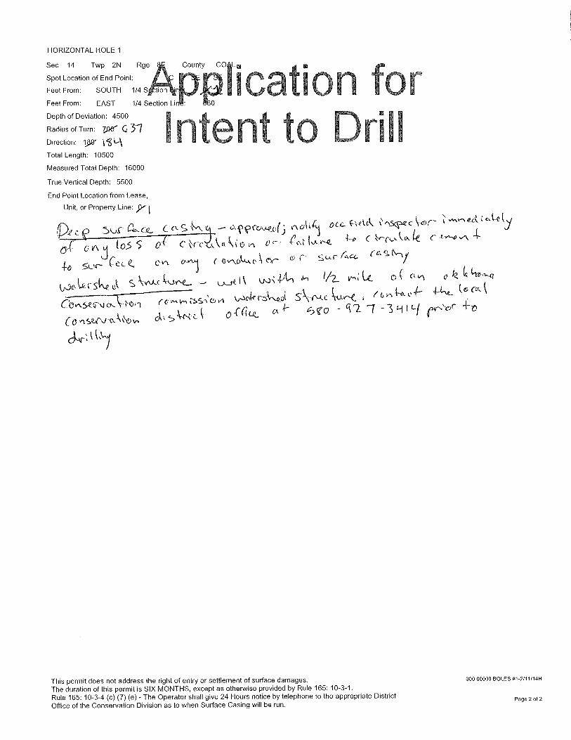
14Sec Twp 2N Rge 8E County COAL
Spot Location of End Point: S2 S2 SE SE
Feet From:
Feet From:
Depth of Deviation: 4500
Radius of Turn: 637
Direction: 184
Total Length: 10500
Measured Total Depth: 16000
6600True Vertical Depth:
End Point Location from Lease,
Unit, or Property Line: 1
HORIZONTAL HOLE 1
SOUTH 1/4 Section Line: 1
EAST 1/4 Section Line: 660
DEEP SURFACE CASING 5/3/2017 - G71 - APPROVED; NOTIFY OCC FIELD INSPECTOR IMMEDIATELY OF ANY LOSS OF CIRCULATION OR FAILURE TO CIRCULATE CEMENT TO SURFACE ON ANY CONDUCTOR OR SURFACE CASING
HYDRAULIC FRACTURING 5/3/2017 - G71 - OCC 165:10-3-10 REQUIRES: 1) THE CHEMICAL DISCLOSURE OF HYDRAULIC FRACTURING INGREDIENTS FOR ALL WELLS BE REPORTED TO FRACFOCUS USING THE FOLLOWING LINK HTTP://FRACFOCUS.ORG/ WITH NOTICE GIVEN 48 HOURS IN ADVANCE OF FRACTURING TO THE LOCAL OCC DISTRICT OFFICE; AND, 2) PRIOR TO COMMENCEMENT OF FRACTURING OPERATIONS FOR HORIZONTAL WELLS, NOTICE ALSO GIVEN FIVE BUSINESS DAYS IN ADVANCE TO OFFSET OPERATORS WITH WELLS COMPLETED IN THE SAME COMMON SOURCE OF SUPPLY WITHIN 1/2 MILE
Category Description
Notes:

This permit does not address the right of entry or settlement of surface damages. The duration of this permit is SIX MONTHS, except as otherwise provided by Rule 165: 10-3-1. Rule 165: 10-3-4 (c) (7) (e) - The Operator shall give 24 Hours notice by telephone to the appropriate District Office of the Conservation Division as to when Surface Casing will be run.
Page 3 of 3
WATERSHED STRUCTURE 5/3/2017 - G71 - WELL WITHIN 1/2 MILE OF AN OKLAHOMA CONSERVATION COMMISSION WATERSHED STRUCTURE. CONTACT THE LOCAL CONSERVATION DISTRICT OFFICE AT (580) 927-3414 PRIOR TO DRILLING
PENDING CD - 201702727 5/4/2017 - G60 - (E.O.) 2, 11, 14-2N-8E X201702725 MSSP, WDFD, HNTN COMPL. INT. (2-2N-8E) NCT 2640' FNL, NCT 0' FSL, NCT 330' FEL COMPL. INT. (11-2N-8E) NCT 0' FNL, NCT 0' FSL, NCT 330' FEL COMPL. INT. (14-2N-8E) NCT 0' FNL, NCT 165' FSL, NCT 330' FEL CANYON CREEK ENERGY OPERATING, LLC. REC. 5/9/17 (MCKEOWN)
TEMP AUTH TO DRILL 5/5/2017 - G60 - EXPIRES 5/11/17
PENDING CD - 201702726 5/4/2017 - G60 - (E.O.) 2, 11, & 14-2N-8E EST MULTIUNIT HORIZONTAL WELL X201702725 MSSP, WDFD, HNTN (MSSP AND HNTN ARE ASSOCIATED COMMON SOURCES OF SUPPLY TO WDFD) 42% 14-2N-8E 44% 11-2N-8E 14% 2-2N-8E CANYON CREEK ENERGY OPERATING, LLC. REC. 5/9/17 (MCKEOWN)
MEMO 5/3/2017 - G71 - PITS 2 & 3 - CLOSED SYSTEM=STEEL PITS PER OPERATOR REQUEST, PIT 3 - OBM RETURNED TO VENDOR, CUTTINGS PERMITTED PER DISTRICT
PENDING CD - 201702725 5/4/2017 - G60 - (E.O.)(640)(HOR) 2, 11 & 14-2N-8E EST MSSP, WDFD, HNTN COMPL. INT. (MSSP, HNTN) NLT 660' FB COMPL. INT. (WDFD) NLT 165' FNL/FSL, NLT 330' FEL/FWL (COEXIST WITH SP. ORDER 282388 HNTN -SECTION 2; SP. ORDER 146310 HNTN SECTION 11; SP. ORDER 243181 HNTN W2 SECTION 14; SP. ORDER 172779 S2 SE4 SECTION 14) REC. 5/9/17 (MCKEOWN)
Category Description

OKLAHOMA CORPORATION COMMISSIONOIL & GAS CONSERVATION DIVISION
API NUMBER: 000 00000Approval Date:P.O. BOX 52000
OKLAHOMA CITY, OK 73152-2000 Expiration Date:
Horizontal Hole Oil & Gas(Rule 165:10-3-1)
WELL LOCATION: Sec: 02 Twp: 2N
SPOT LOCATION: SW
Lease Name: BOLES
OperatorName:
SE
e: 8E
PERMIT TO DRILL
lcatii on forWell No: #1 -2111/14H Well will be 277 feet from nearest unit or lease boundary.
I t t
CANYON CREEK ENERGY ERATING lepho 91 616737
n en 0CANYON CREEK ENERGY OPERATING LLC
' 2431 E 61ST ST STE 400
TULSA, OK 74136-1237
rlli /OCC Number:
JAMES G. BOLES
400 7TH STREET SW
CHILDRESS
Formation(s) (Permit Valid for Listed Formations Only):
Name Depth Name
1 MISSISSIPPIAN 6200 6
2 WOODFORD 6450 7
3 HUNTON 6600 8
4 9
5 10
Spacing Orders: Location Exception Orders:No Spacing
Pending CD Numbers: 201702725
201702726
201702727
Total Depth: 16000
Under Federal Jurisdiclion: No
Ground Elevation: 668 Surface Casing: 1000
Fresh Water Supply Well Drilled: No
TEMPORMIT. tt- OnlZMION
Tú DIULL
EXPiratiOn Data: 5 11 I I/
SignatureadjW-165:10-
t-
TX
23443 0
79201
Depth
Increased Density Orders:
Special Orders:
Depth to base of Treatable Water-Bearing FM: 410
Approved Method for disposal of Drilling Fluids:
Surface Water used to Drill: Yes
ctn.5516 ill
E. Haul to Commercial pit facility: Sec. 14 Twn. 7N Rng. 9E Cnty. 63 Order No:.55.169—.
A 's(" \-‹-
t06,1-e bascd — dosedr-t.,,c goo° j yoer av.c. pc)
(r.) 6asfLot C (osett3ooj000- 20o0oo fc
(1),1-s 4 s `2. 4- 3 ctose-Ck S S(9.-P C 0?e cOT feiLtes
eT:-1-. - og(A c-e.-Itt.xrint4 10 vev-xotorThis permit does not address the right of entry or settlement of surface damages.
Co, 4)i'itvut
The duration of this permit is SIX MONTHS, except as otherwise provided by Rule 165: 10-3-1.Rule 165: 10-3-4 (c) (7) (e) - The Operator shall give 24 Hours notice by telephone to the appropriate DistrictOffice of the Conservation Division as to when Surface Casing will be run.
cerPage 1 of 2
HORIZONTAL HOLE 1
Sec 14 Twp 2N Rge County CO L EI •
Ica ion forFeet From: SOUTH 1/4 S
Spot Location of End Point:
Feet From: EAST 1/4 Section L.
Depth of Deviation: 4500
Radius of Turn: 7.,Der G 3-1Direction: yg
Total Length: 10500
Measured Total Depth: 16000
True Vertical Depth: 5500
End Point Location from Lease,
Unit, or Property Line: 51,
tyk OLL ••••Sc\-.1e.c.- cor- yP.e (c) 5vs-- a-cc
GAJ t 0.5 5 0-{ c ,-, 0 et),Z r,e 4-0 C (-e c
So-r- t- Q, ovv 0-'11 evv.Itkke,\ or- r s a(11\
wcAJ“---skR.ek — o_n k
tss:c, v, kp.5ate / 6 "1--a.. .1-- ( 6 Cck
CO ,ISQ,N eLkkkov, d" \4,-.Q lc 0 -(aciz_ (V2 -7 -3 1-1 i Li ,f),-,,e,r 4-0
Intent to Drill
This permit does not address the right of entry or settlement of surface damages.
The duration of this permit is SIX MONTHS, except as otherwise provided by Rule 165: 10-3-1.
Rule 165: 10-3-4 (c) (7) (e) - The Operator shall give 24 Hours notice by telephone to the appropriate District
Office of the Conservation Division as to when Surface Casing will be run.
000 00000 BOLES 01-2/11/14H
Page 2 of 2

Ow" Well L ocation P/atS.H.L. Sec. 2-2N-8EB.H.L. Sec. 14-2N-8E
Operator: CANYON CREEK ENERGYLease Name and No. : BOLES 1-2/11/14HFootage : 1443' FSL - 277' FEL GR. ELEVATION : 668' Good Site? YES
Section: 2 Township: 2N Range: 8E I.M.County : Coal State of OklahomaTerrain at Loc. : Location fell in open pasture, slopes down from South side of location tothe North.Accessibility : From the South.Directions : From the intersection of Hwy 3 and Hwy 48 in the town of Tupelo, OK, go 4.8miles North on Hwy 48 to be at proposed lease road entrance in the SE/4 of Section2-2N-8E.
X 2437015Y 488428X 246861198382.
— _ — — —
2649
§gzi-cC . o
a) 16 8
X 2437076Y 483138X2498977'Y 483092
11 'EW f 62 RD.'
—
1
IX 2442317Y 491150
S401133W(Gnd Br - NAD 83) 590'__sE
1 st PERF:
1000'FSL - 660' FEL
2649'-
— — — — —NE —
277
1443'
1 1
—
-\
/
(CB CIVN
*i£1
PUO)M.I.
OON
X:2437164Y 477828X 2498760survey and plat by,
477782
'EW 163 RD.'
2645'
26 0
—NE — — 1— —
BOTTOM HOLE LOC
0' FSL - 660'FEL
11 14
Arkoma Surveying and Mapping, PLLCP.O. Box 238 Wilburton, OK 74578Ph. 918-465-5711 Fax 918-465-5030Certificate of Authorization No. 5348Expires June 30, 2018invoice #6978-BDate Staked : 02/28/17 By : H.S.Date Drawn : 03/02/17 By : K.B.
2645
X'2442312Y 488502X.2473908Y 488457
X 2442376Y 4831944,39%2
X 2442454Y 4,987
Certification:This is to certify that this Well LocationPlat represents the results of a surveymade on the ground performed under thesupervision of the undersigned.
03/08/17
750' 1500' 2250'
LANCE G. MATHIS OK LPLS 1664
1'.1500'
GPS DATUMNAD - 83
OK SOUTH ZONE
GPS DATUMNAD - 27
OK SOUTH ZONE
Surface Hole Loc.:Lat: 34°40'10.07"NLon: 96°25'30.21"WX: 2442037Y: 489941
Surface Hole Loc.:Lat: 34°40'09.74"NLon: 96°25'29.20"WX: 2473633Y: 489895
1st Perf:Lat: 34°40'05.70"NLon: 96°25'34.88"WX: 2441653Y: 489493
1st Perf:Lat: 34°40'05.37"NLon: 96°25'33.87"WX: 2473249Y: 489447
Bottom Hole Loc.:Lat: 34°38'10.81"NLon: 96°25'35.37"WX: 2441794Y: 477879
Bottom Hole Loc.:Lat: 34°3810.48"NLon: 96°25'34.36"WX: 2473390Y: 477834