Embed Size (px)
Citation preview

Osprey Nesting Platform HIP Evaluation of
Potential Locations for Additional Platforms in the Niagara River Corridor
Niagara Power Project (FERC No. 2216)
PREPARED FOR: NEW YORK POWER AUTHORITY PREPARED BY: RIVEREDGE ASSOCIATES AND KLEINSCHMIDT ASSOCIATES
September 2009
©Copyright 2009. New York Power Authority. All Rights Reserved
OSPREY HIP ADDITIONAL PLATFORM LOCATIONS
For Copies of this Document
Please Contact:
Stephen Schoenwiesner Licensing Manager
New York Power Authority 123 Main Street
White Plains, NY 10601 (914) 287-3457
©Copyright 2009. New York Power Authority. All Rights Reserved

OSPREY HIP ADDITIONAL PLATFORM LOCATIONS
i
TABLE OF CONTENTS
1.0 INTRODUCTION ...................................................................................................... 1-1 2.0 METHODS .............................................................................................................. 2-1 3.0 SITE-SPECIFIC OPPORTUNITIES .............................................................................. 3-5 4.0 SITE EVALUATION AND RANKING .......................................................................... 4-1 5.0 RECOMMENDED SITES ........................................................................................... 5-1
5.1 TIFFT NATURE PRESERVE ................................................................................... 5-1 5.2 LITTLE BEAVER ISLAND HIP MARSH RESTORATION .......................................... 5-1 5.3 102ND STREET LANDFILL ................................................................................... 5-2 5.4 ADAMS SLIP, NYPA BOAT LANDING ................................................................. 5-2 5.5 ALTERNATE SITES .............................................................................................. 5-2 5.6 NEXT STEPS ....................................................................................................... 5-3
6.0 REFERENCES .......................................................................................................... 6-1
APPENDIX A Memo from NYPA soliciting public suggestions for platform locations

OSPREY HIP ADDITIONAL PLATFORM LOCATIONS
1-1
1.0 INTRODUCTION
The New York Power Authority (NYPA) is pursuing several habitat improvement
projects (HIPs) related to the relicensing of the Niagara Power Project. One of these HIPs
involves the construction and monitoring of six osprey platforms along the Niagara River in
compliance with the Niagara Power Project Comprehensive Relicensing Settlement Agreement.
The purpose of this study is to systematically identify and evaluate potential platform
installation locations along the Niagara River corridor that are based on a variety of key
biological, installation, and acceptability criteria. From this list of potential installation
locations, NYPA will pursue discussions with landowners, resource agencies, and engineering
staff to target efforts towards the best locations. To date, NYPA has installed two of the six
osprey platforms under this HIP at opportunistic sites that arose during the early stages of this
HIP. The remaining four installation locations will be based on the results of this site selection
effort, and will be determined by NYPA and the Ecological Standing Committee (ESC) during
2009.
The first nesting platform installed under this HIP was placed on Buckhorn Weir on the
northern end of Grand Island in 2007. The second platform was installed in June 2009 within an
offshore breakwater at the East River Marsh, in Beaver Island State Park on the southeastern tip
of Grand Island.
OSPREY HIP ADDITIONAL PLATFORM LOCATIONS
2-1
2.0 METHODS
Potential new locations for osprey platforms were identified in the spring of 2009 through
a review of nesting requirements (e.g., Poole et al., 2002) and aerial photos, discussions with the
ESC and other knowledgeable individuals, nominations from the general public solicited from
the ESC and others (Appendix A), and a site assessment. This information was used to estimate
the suitability of the location and the probability of success.
Site selection considerations included:
a) distance from water or foraging areas, b) proximity to other nesting raptors, c) proximity to thickly forested woodlands, d) height of nearest adjacent trees, e) ease of public viewing, f) potential disturbance by people, industry, or pets, g) land ownership, h) condition of soils at the site, i) ease of access for pole installation, and j) potential impacts to sensitive areas from installation.
These considerations are discussed briefly below and summarized in Table 2-1. In
addition, consideration was given to areas where ospreys may be attempting to nest on
inadequate structures (e.g., power lines or structures scheduled for demolition, such as the coal
elevator at Tonawanda Coke) and to existing platforms that are not currently in use by ospreys.
A description of each criterion follows.
Distance from water or foraging areas: A site close to water or foraging areas (river, lake,
large pond) is generally more desirable than a site far from water or foraging areas.
Although some osprey nest a mile or more from water and foraging areas, most nests are
located close to water and foraging areas. In general, closer is better. The best sites would
likely be within one-half mile or less of water or foraging areas.
Proximity to other nesting raptors (bald eagle, peregrine falcon, other osprey): Other
nesting raptors, such as bald eagle, peregrine falcon, and other osprey, may hinder the
occupation of a new osprey nesting pole due to the general territorial nature of these birds.
Sites more distant from known nests of these raptors are more desirable than sites close to

OSPREY HIP ADDITIONAL PLATFORM LOCATIONS
2-2
known nests of these raptors. Peregrine falcons nest on tall buildings, bridges and cliffs.
Bald eagles nest in large trees, often pine trees near water, and generally distant from human
disturbance.
Proximity to thickly forested woodlands: Osprey nest sites near thickly forested woodlands
are generally less successful than osprey nest sites distant from these areas. Thickly forested
woodlands may have competing raptors or predators such as great horned owls. Sites that are
not close to thickly forested woodlands are more desirable.
Height of nearest adjacent trees: Ospreys often prefer to nest in trees at least as tall as or
taller than the closest surrounding trees. The most desirable sites have trees that are lower
than a pole-mounted platform installed at the site. In general, sites with tall trees nearby are
less desirable.
Ease of public viewing: Nesting ospreys are interesting to view for birders and non-birders
alike, especially with binoculars or spotting scopes. The most desirable sites have clear
viewing opportunities for the enjoyment of the general public. The best sites might be those
that could be observed from land or water. Remote locations that are not easily observed are
less desirable.
Potential disturbance by people, industry, or pets: Disturbance from people, industry, or
pets is an important consideration in selecting an osprey pole location. Although some
ospreys may be surprisingly tolerant of limited or brief disturbances, it is generally most
desirable to select sites where such disturbances are minimized. Sites directly adjacent to
busy industrial sites, highways, or where large numbers of people and pets congregate are
generally less desirable than sites with less disturbance.
Land ownership: Public land is more desirable than private land to facilitate pole
installation, management, monitoring, and the enjoyment of the site by the general public.
Private land may be acceptable, but would require legally binding agreements for access. In
general, private land is typically less desirable than public land.
OSPREY HIP ADDITIONAL PLATFORM LOCATIONS
2-3
Condition of soils at site: The condition of soils at the site of installation is an important
consideration as well. The most desirable soils are firm, dry, clean, upland soils that would
provide adequate support for the pole and for the vehicles required for installation. In
general, wet, soft, or potentially contaminated soils are not suitable sites for an Osprey pole.
Ease of access to pole installation location: Osprey poles are tall and heavy and their
installation requires access for large wheeled or tracked vehicles. These vehicles will bore
holes in the ground and set the poles in place. A wide access route is necessary for these
vehicles to reach the installation site. The most desirable locations require the least
disturbance to lawns, fences, trees, shrubs, or other local features. Sites with close proximity
to deeper water may provide access for installation barges. Sites with difficult access are less
desirable.
Potential impacts to sensitive areas from installation (wetlands; rare, threatened,
endangered species; cultural resources): The most desirable sites for an osprey pole
installation have no potential impacts from the pole installation on wetlands, sensitive species
or habitats, and cultural resources. Although all sites will be restored, particularly sensitive
areas are not suitable for the installation of an osprey pole and should be avoided.

OSPREY HIP ADDITIONAL PLATFORM LOCATIONS
2-4
TABLE 2-1. CRITERIA FOR SELECTING OSPREY PLATFORM LOCATIONS.
Criteria More Desirable Less Desirable
Distance from water or foraging areas
Near (On shoreline) Moderate Far
(> 1 mile)
Proximity to other raptors (Bald Eagle, Peregrine Falcon, other Osprey)
Osprey observed in area and no other raptors known to
nest nearby
Osprey observed in area but other
raptors known to nest nearby
No Osprey nearby but other raptors known to nest
nearby Proximity to thickly forested woodlands Far Moderate Near
Height of nearest adjacent trees Low Moderate High
Ease of public viewing Excellent from land or water Good Limited
Potential disturbance by people, industry, or pets Low Moderate High
Land ownership Public
Private with easement or not-
for-profit conservation organization
Purchase Private Land
Condition of soils at site Firm, clean upland soils
Potentially contaminated or
moderately unstable soils
Very unstable soils or high potential for contaminants
Ease of access to pole installation location Easy Moderate Difficult
Potential impacts to sensitive areas from installation (wetlands; rare, threatened, endangered species; cultural resources)
Low Moderate High
OSPREY HIP ADDITIONAL PLATFORM LOCATIONS
3-5
3.0 SITE-SPECIFIC OPPORTUNITIES
Based on field surveys and input received from a variety of agency and public
stakeholders, 18 sites were considered as potential locations for osprey platforms. Two of the
sites evaluated (Tifft Nature Preserve and Strawberry Island) were proposed in the conceptual
HIP identification process (NYPA, 2005). Three of the 18 locations have existing osprey
platforms that have not been utilized by osprey, possibly because the platforms are lower than
the surrounding trees. Replacing these poles with taller ones may make them more attractive to
nesting ospreys.
The 18 sites considered were located in Buffalo Harbor, the Buffalo River, the Niagara
River, and on Lake Ontario as follows:
Buffalo Harbor and Buffalo River
• Tifft Nature Preserve (replace existing platform not currently being used) • Seneca Bluffs, Buffalo River
Upper Niagara River
• Strawberry Island • Beaver Island State Park, Little Beaver Island HIP marsh restoration • Tonawanda Coke • West River Parkway, Fix Road Overlook • Big Six Mile Creek Marina • Spicer Creek • Buckhorn Island State Park (replace one of two existing platforms in marsh) • Gratwick Park (north end) • 102nd Street Landfill • Adams Slip, NYPA boat landing
Lower Niagara River
• Lewiston Reservoir • Earl W. Brydges Artpark State Park • Stella Niagara shoreline • Joseph Davis State Park • Fort Niagara State Park, US Coast Guard station

OSPREY HIP ADDITIONAL PLATFORM LOCATIONS
3-6
Lake Ontario
• Four Mile Creek State Park
Each of the 18 sites is illustrated on the following pages with a location map, photograph,
a short description of the site, and potential issues or constraints.

OSPREY HIP ADDITIONAL PLATFORM LOCATIONS
3-7
Location: Tifft Nature Preserve Ownership: City of Buffalo; managed by Buffalo Museum of Science Description: A popular nature preserve in the City of Buffalo. The existing osprey pole is
short and has not been utilized by osprey; this pole would be replaced with a taller pole and new platform. New pole would be located at the same site as existing pole and would be readily visible from the observation deck at the visitor’s center.
Key Issues: Site for new pole is surrounded by firm upland soils with good access to site.
Some vegetation, all non-native, will need to be trimmed for access. Adjacent woodland is not dense and most vegetation is not too tall.
OSPREY HIP ADDITIONAL PLATFORM LOCATIONS
3-8
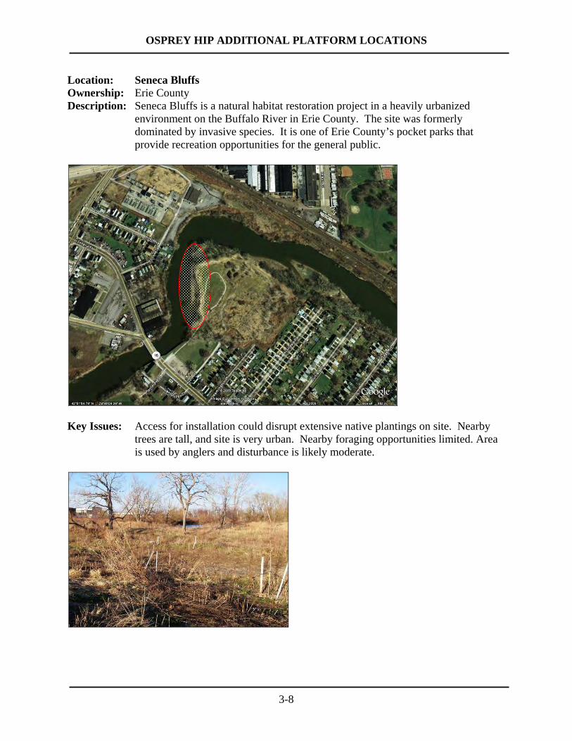
Location: Seneca Bluffs Ownership: Erie County Description: Seneca Bluffs is a natural habitat restoration project in a heavily urbanized
environment on the Buffalo River in Erie County. The site was formerly dominated by invasive species. It is one of Erie County’s pocket parks that provide recreation opportunities for the general public.
Key Issues: Access for installation could disrupt extensive native plantings on site. Nearby
trees are tall, and site is very urban. Nearby foraging opportunities limited. Area is used by anglers and disturbance is likely moderate.
OSPREY HIP ADDITIONAL PLATFORM LOCATIONS
3-9
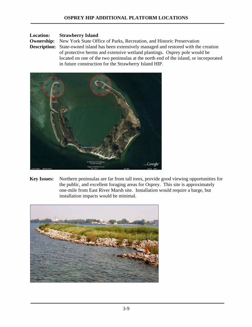
Location: Strawberry Island Ownership: New York State Office of Parks, Recreation, and Historic Preservation Description: State-owned island has been extensively managed and restored with the creation
of protective berms and extensive wetland plantings. Osprey pole would be located on one of the two peninsulas at the north end of the island, or incorporated in future construction for the Strawberry Island HIP.
Key Issues: Northern peninsulas are far from tall trees, provide good viewing opportunities for
the public, and excellent foraging areas for Osprey. This site is approximately one-mile from East River Marsh site. Installation would require a barge, but installation impacts would be minimal.
OSPREY HIP ADDITIONAL PLATFORM LOCATIONS
3-10
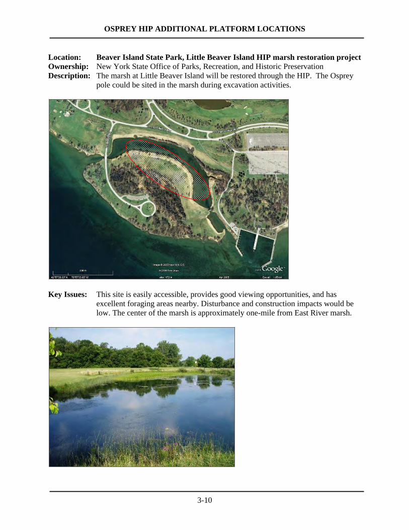
Location: Beaver Island State Park, Little Beaver Island HIP marsh restoration project Ownership: New York State Office of Parks, Recreation, and Historic Preservation Description: The marsh at Little Beaver Island will be restored through the HIP. The Osprey
pole could be sited in the marsh during excavation activities.
Key Issues: This site is easily accessible, provides good viewing opportunities, and has
excellent foraging areas nearby. Disturbance and construction impacts would be low. The center of the marsh is approximately one-mile from East River marsh.

OSPREY HIP ADDITIONAL PLATFORM LOCATIONS
3-11
Location: Tonawanda Coke Ownership: Tonawanda Coke Description: Circular steel cells formerly used to moor ships unloading coal. Ospreys are
nesting on the tower of the coal elevator, which will be dismantled. An osprey pole and platform could be installed on one of the steel mooring cells.
Key Issues: The site provides good viewing opportunities and excellent foraging areas nearby.
Barge required for installation. Privately owned and the future of this industrial site is unknown. Site is approximately 0.8 miles from East River marsh.
OSPREY HIP ADDITIONAL PLATFORM LOCATIONS
3-12
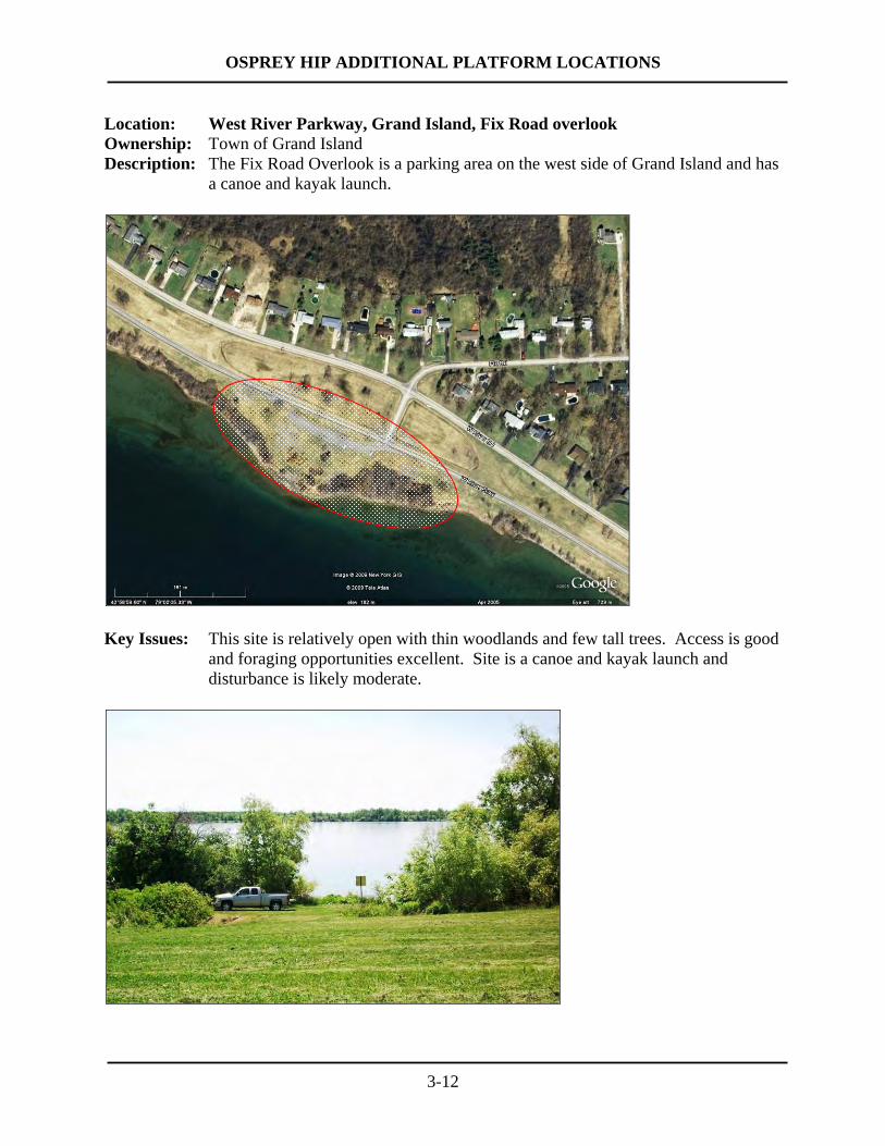
Location: West River Parkway, Grand Island, Fix Road overlook Ownership: Town of Grand Island Description: The Fix Road Overlook is a parking area on the west side of Grand Island and has
a canoe and kayak launch.
Key Issues: This site is relatively open with thin woodlands and few tall trees. Access is good
and foraging opportunities excellent. Site is a canoe and kayak launch and disturbance is likely moderate.
OSPREY HIP ADDITIONAL PLATFORM LOCATIONS
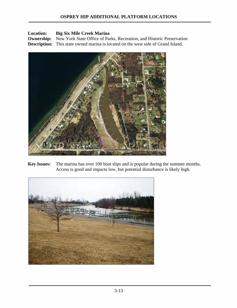
3-13
Location: Big Six Mile Creek Marina Ownership: New York State Office of Parks, Recreation, and Historic Preservation Description: This state owned marina is located on the west side of Grand Island.
Key Issues: The marina has over 100 boat slips and is popular during the summer months.
Access is good and impacts low, but potential disturbance is likely high.
OSPREY HIP ADDITIONAL PLATFORM LOCATIONS
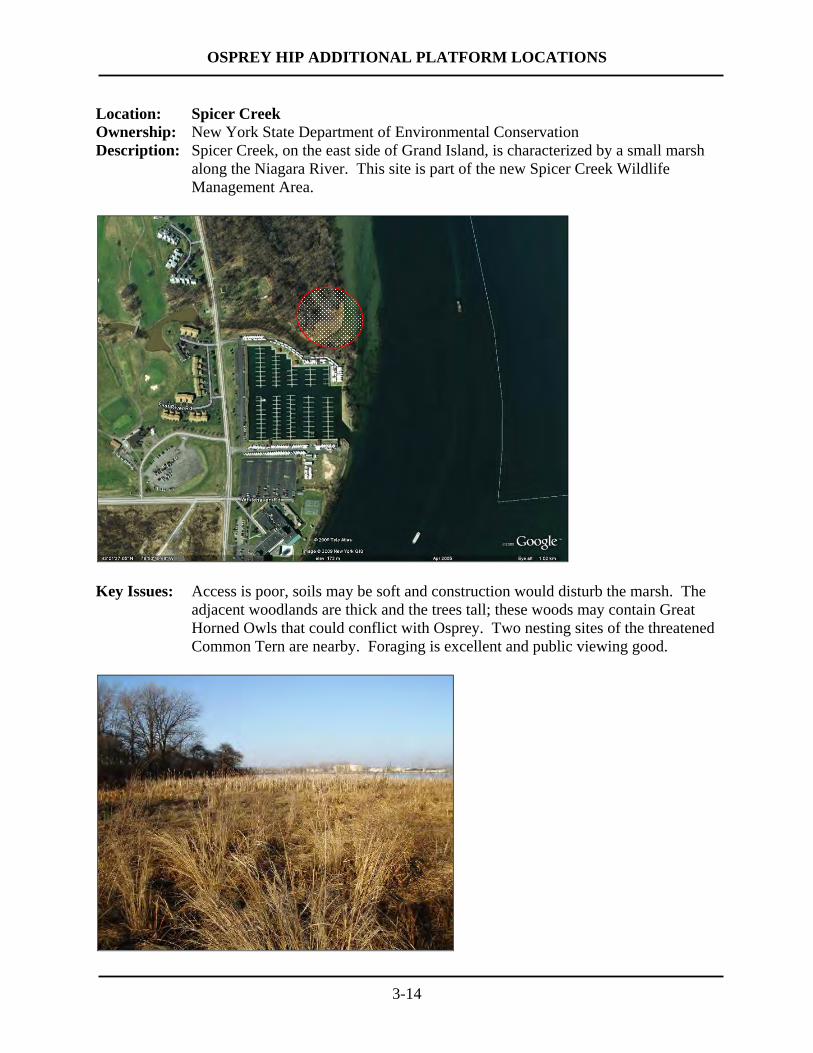
3-14
Location: Spicer Creek Ownership: New York State Department of Environmental Conservation Description: Spicer Creek, on the east side of Grand Island, is characterized by a small marsh
along the Niagara River. This site is part of the new Spicer Creek Wildlife Management Area.
Key Issues: Access is poor, soils may be soft and construction would disturb the marsh. The
adjacent woodlands are thick and the trees tall; these woods may contain Great Horned Owls that could conflict with Osprey. Two nesting sites of the threatened Common Tern are nearby. Foraging is excellent and public viewing good.

OSPREY HIP ADDITIONAL PLATFORM LOCATIONS
3-15
Location: Buckhorn Island State Park Ownership: New York State Office of Parks, Recreation, and Historic Preservation; portions
managed in cooperation with NYSDEC Description: The marsh of Buckhorn Island State Park has two Osprey poles previously
installed by NYSDEC and OPRHP. These poles have not been occupied by Osprey. One of these poles would be replaced with a new taller pole.
Key Issues: This site is sheltered and quiet. Access is difficult and construction impacts high
causing significant disturbance to the soft soils of the marsh. Adjacent woodlands are thick and trees are tall. The Buckhorn Weir nest is less than one mile away.

OSPREY HIP ADDITIONAL PLATFORM LOCATIONS
3-16
Location: Gratwick Riverside Park Ownership: City of North Tonawanda Description: Gratwick is a popular park that offers local residents parking, picnicking, a boat
launch, recreation trail, and shoreline angling. Offshore berms have been constructed to provide wildlife habitat and shoreline angling opportunities.
Key Issues: Gratwick is a wide-open park with no tall trees, and has excellent viewing
opportunities and nearby foraging habitat. Access is easy and construction impacts would be low if soils are clean. Disturbance is likely moderate. Tripod design may be required to avoid subsurface excavation.
OSPREY HIP ADDITIONAL PLATFORM LOCATIONS
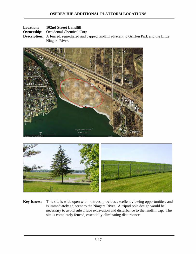
3-17
Location: 102nd Street Landfill Ownership: Occidental Chemical Corp Description: A fenced, remediated and capped landfill adjacent to Griffon Park and the Little
Niagara River.
Key Issues: This site is wide open with no trees, provides excellent viewing opportunities, and
is immediately adjacent to the Niagara River. A tripod pole design would be necessary to avoid subsurface excavation and disturbance to the landfill cap. The site is completely fenced, essentially eliminating disturbance.

OSPREY HIP ADDITIONAL PLATFORM LOCATIONS
3-18
Location: Adams Slip Ownership: New York Power Authority Description: This site harbors NYPA tugs and is adjacent to the Robert Moses Parkway near
Niagara Falls. A popular recreation trail runs along the river nearby.
Key Issues: This site provides excellent viewing opportunities from both the recreational trail
and the Robert Moses Parkway. It is generally open with scattered trees of medium height. Access is good, and the site is posted and patrolled, minimizing potential disturbance.

OSPREY HIP ADDITIONAL PLATFORM LOCATIONS
3-19
Location: Lewiston Reservoir Ownership: New York Power Authority Description: The reservoir holds water used for power generation. The perimeter of the
reservoir is used by walkers and anglers. Adjacent parklands below the reservoir are used for a variety of recreational activities.
Key Issues: This site is wide open with no surrounding woodlands. The installation of an
Osprey platform here would require a design that does not require boring into the reservoir dikes. Disturbance is likely moderate. This site is somewhat off the beaten path and public viewing opportunities are not extensive.
OSPREY HIP ADDITIONAL PLATFORM LOCATIONS
3-20
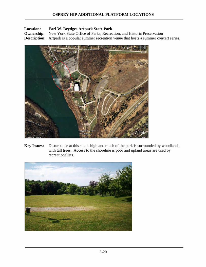
Location: Earl W. Brydges Artpark State Park Ownership: New York State Office of Parks, Recreation, and Historic Preservation Description: Artpark is a popular summer recreation venue that hosts a summer concert series.
Key Issues: Disturbance at this site is high and much of the park is surrounded by woodlands
with tall trees. Access to the shoreline is poor and upland areas are used by recreationalists.

OSPREY HIP ADDITIONAL PLATFORM LOCATIONS
3-21
Location: Stella Niagara shoreline on lower Niagara River Ownership: Town of Lewiston, Stella Niagara Franciscans Description: Often referred to as the Stella “flats,” this area is characterized by a relatively low,
broad, open shelf on the shoreline of the lower Niagara River.
Key Issues: Adjacent woodlands contain tall trees. Public viewing from land would be from a
distance. Access to the shoreline is potentially difficult and construction impacts would be moderate. Disturbance would likely be relatively low.

OSPREY HIP ADDITIONAL PLATFORM LOCATIONS
3-22
Location: Joseph Davis State Park Ownership: New York State Office of Parks, Recreation, and Historic Preservation Description: This park is a popular recreation area with several small ponds and access to the
lower Niagara River.
Key Issues: The western portion of the park is characterized by tall trees and no open areas
along the river. Access would be difficult with moderate impacts. The eastern portions of the park are being restored and managed as open grassland and shrubland habitats. OPRHP feels that other park locations may be more suitable.
OSPREY HIP ADDITIONAL PLATFORM LOCATIONS
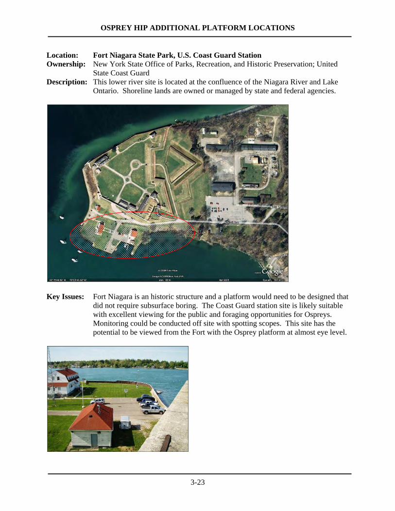
3-23
Location: Fort Niagara State Park, U.S. Coast Guard Station Ownership: New York State Office of Parks, Recreation, and Historic Preservation; United
State Coast Guard Description: This lower river site is located at the confluence of the Niagara River and Lake
Ontario. Shoreline lands are owned or managed by state and federal agencies.
Key Issues: Fort Niagara is an historic structure and a platform would need to be designed that
did not require subsurface boring. The Coast Guard station site is likely suitable with excellent viewing for the public and foraging opportunities for Ospreys. Monitoring could be conducted off site with spotting scopes. This site has the potential to be viewed from the Fort with the Osprey platform at almost eye level.
OSPREY HIP ADDITIONAL PLATFORM LOCATIONS
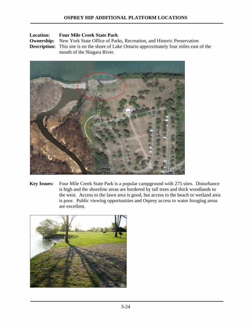
3-24
Location: Four Mile Creek State Park Ownership: New York State Office of Parks, Recreation, and Historic Preservation Description: This site is on the shore of Lake Ontario approximately four miles east of the
mouth of the Niagara River.
Key Issues: Four Mile Creek State Park is a popular campground with 275 sites. Disturbance
is high and the shoreline areas are bordered by tall trees and thick woodlands to the west. Access to the lawn area is good, but access to the beach or wetland area is poor. Public viewing opportunities and Osprey access to water foraging areas are excellent.
OSPREY HIP ADDITIONAL PLATFORM LOCATIONS
4.0 SITE EVALUATION AND RANKING
Using the criteria listed in Table 2-1, information gathered from stakeholders, and
observations made during site visits, this broad list of potential locations was reviewed and each
site was assigned a narrative rating for each criterion (Table 4-1). At some sites, for example,
potential disturbance was high, adjacent trees tall, access difficult, or potential construction
impacts substantial. These sites received lower ratings than other sites.
In order to integrate the results of the various evaluation criteria and prioritize sites, the
narrative ratings were converted to a numerical scoring system. The first step in this process was
to convert the narrative ratings for each criterion to a numeric value. With one exception,
narrative ratings that were in the “More Desirable” column of Table 2-1 were assigned a score of
5, ratings in the middle column were assigned a score of 3, and ratings in the “Less Desirable”
column were assigned a score of 1. Scores for Land ownership were scored slightly differently
due to uncertainty in knowing the owner’s receptiveness at this early stage in the process and
how legal access would be provided; in these cases, public lands were assigned a score of 4 and
private lands were assigned a 2. Next, the numerical criterion scores for each site were then
added to generate a Total Score. Sites were then sorted by the Total Score, from high to low,
with the highest Total Scores representing the best opportunities for osprey platforms (Table 4-
2).
4-1
OSPREY HIP ADDITIONAL PLATFORM LOCATIONS
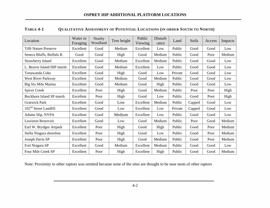
TABLE 4-1 QUALITATIVE ASSESSMENT OF POTENTIAL LOCATIONS (IN ORDER SOUTH TO NORTH)
Location Water or Foraging
Nearby Woodland Tree height Public
Viewing Disturb-ance Land Soils Access Impacts
Tifft Nature Preserve Excellent Good Medium Excellent Low Public Good Good Low Seneca Bluffs, Buffalo R. Good Good High Good Medium Public Good Poor Medium
Strawberry Island Excellent Good Medium Excellent Medium Public Good Good Low
L. Beaver Island HIP marsh Excellent Good Medium Excellent Low Public Good Good Low Tonawanda Coke Excellent Good High Good Low Private Good Good Low West River Parkway Excellent Good Medium Good Medium Public Good Good Low Big Six Mile Marina Excellent Good Medium Good High Public Good Good Low Spicer Creek Excellent Poor High Good Medium Public Poor Poor High Buckhorn Island SP marsh Excellent Poor High Good Low Public Good Poor High Gratwick Park Excellent Good Low Excellent Medium Public Capped Good Low 102nd Street Landfill Excellent Good Low Excellent Low Private Capped Good Low
Adams Slip, NYPA Excellent Good Medium Excellent Low Public Good Good Low
Lewiston Reservoir Excellent Good Low Good Medium Public Poor Good Medium Earl W. Brydges Artpark Excellent Poor High Good High Public Good Poor Medium Stella Niagara shoreline Excellent Poor High Good Low Public Good Poor Medium Joseph Davis SP Excellent Poor High Good Medium Public Good Poor Medium Fort Niagara SP Excellent Good Medium Excellent Medium Public Good Good Low Four Mile Creek SP Excellent Poor High Excellent High Public Good Good Medium
Note: Proximity to other raptors was omitted because none of the sites are thought to be near nests of other raptors
4-2
OSPREY HIP ADDITIONAL PLATFORM LOCATIONS
4-3
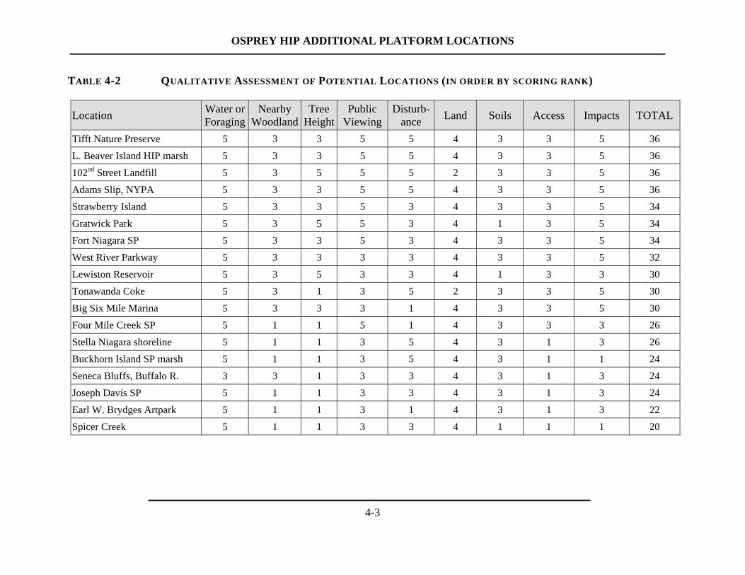
TABLE 4-2 QUALITATIVE ASSESSMENT OF POTENTIAL LOCATIONS (IN ORDER BY SCORING RANK)
Location Water or Foraging
Nearby Woodland
Tree Height
Public Viewing
Disturb-ance Land Soils Access Impacts TOTAL
Tifft Nature Preserve 5 3 3 5 5 4 3 3 5 36 L. Beaver Island HIP marsh 5 3 3 5 5 4 3 3 5 36 102nd Street Landfill 5 3 5 5 5 2 3 3 5 36 Adams Slip, NYPA 5 3 3 5 5 4 3 3 5 36 Strawberry Island 5 3 3 5 3 4 3 3 5 34 Gratwick Park 5 3 5 5 3 4 1 3 5 34 Fort Niagara SP 5 3 3 5 3 4 3 3 5 34 West River Parkway 5 3 3 3 3 4 3 3 5 32 Lewiston Reservoir 5 3 5 3 3 4 1 3 3 30 Tonawanda Coke 5 3 1 3 5 2 3 3 5 30 Big Six Mile Marina 5 3 3 3 1 4 3 3 5 30 Four Mile Creek SP 5 1 1 5 1 4 3 3 3 26 Stella Niagara shoreline 5 1 1 3 5 4 3 1 3 26 Buckhorn Island SP marsh 5 1 1 3 5 4 3 1 1 24 Seneca Bluffs, Buffalo R. 3 3 1 3 3 4 3 1 3 24 Joseph Davis SP 5 1 1 3 3 4 3 1 3 24 Earl W. Brydges Artpark 5 1 1 3 1 4 3 1 3 22 Spicer Creek 5 1 1 3 3 4 1 1 1 20

OSPREY HIP ADDITIONAL PLATFORM LOCATIONS
5-1
5.0 RECOMMENDED SITES
The assessment and ranking process resulted in a prioritized list of 18 candidate locations
for installing osprey platforms that were based on a variety of biological, installation, and
cultural criteria. At the top of the prioritized list, four sites each had a Total Score of 36. These
four sites represent the best opportunities for osprey platforms, and the recommendation of this
study is to pursue implementation of NYPA’s remaining osprey platforms at these locations:
• Tifft Nature Preserve
• Little Beaver Island HIP marsh restoration
• 102nd Street Landfill
• Adams Slip, NYPA boat landing
These sites, and their merits, are discussed in the following sections.
5.1 Tifft Nature Preserve
At Tifft Nature Preserve, the existing short (approximately 25 feet) osprey pole and
platform is not utilized by birds and would be replaced to provide a much taller pole that would
be more attractive to ospreys. The installation location would provide excellent foraging habitat
with few tall trees nearby. This site has excellent viewing opportunities for the public on the
Tifft Preserve, and foraging osprey would most likely be seen along the nearby shoreline of Lake
Erie as well. An osprey platform at this location would be an asset to this important nature
preserve. Dave Spiering, the Staff Ecologist at Tifft Nature Preserve, provided the suggestion
for an Osprey HIP pole at this site and noted that a preliminary investigation indicated site access
would be relatively straightforward and disturbance to sensitive areas would be low; there is
some fill and construction debris near the installation location and soil borings would need to be
done to ensure that a pole could be readily installed at this location.
5.2 Little Beaver Island HIP Marsh Restoration
The Little Beaver Island marsh restoration HIP at the southern end of Grand Island would
provide an excellent opportunity for an osprey pole and platform. This location would provide
OSPREY HIP ADDITIONAL PLATFORM LOCATIONS
5-2
excellent opportunities for public enjoyment and would be a valuable addition to the marsh
restoration project. This location provides an excellent foraging location, with few tall trees
nearby. Disturbance to sensitive areas is expected to be low, and access to the installation
location is good. A platform at Beaver Island State Park was requested by OPRHP staff.
5.3 102nd Street Landfill
The wide-open, grassy area on top of the remediated 102nd Street Landfill would provide
a good location for an osprey platform with no tall trees nearby. The landfill area is enclosed by
a fence that would limit disturbance to osprey nesting at this site. However, the adjacent park,
nearby recreation trails, and proximity to popular boating areas would provide excellent viewing
opportunities for the public. Because of the history of this site, a design for the pole may be
based on a tripod design rather than a single monopole to avoid subsurface excavation.
5.4 Adams Slip, NYPA Boat Landing
NYPA’s Adams Slip, used as a tugboat landing area along the Upper Niagara River, is
another excellent location for an osprey platform. This location provides excellent habitat right
on the river, has firm upland soils, and is highly visible to the public because it is adjacent to the
Robert Moses Parkway and a recreational trail. This site is over two-miles from the osprey
platform on the weir at Buckhorn Marsh and would be readily visible to visitors to Niagara Falls
traveling on the Robert Moses Parkway.
5.5 Alternate Sites
Three other locations, Strawberry Island, Gratwick Park, and Fort Niagara State Park,
ranked just below the first four sites listed above, may serve as good alternatives should other
factors preclude installation of a platform at the top four sites. Strawberry Island is located just
upstream of Beaver Island State Park. An osprey platform at Strawberry Island would be visible
from land and the river, and complement the island restoration HIP scheduled for Strawberry
Island. This site was one originally suggested in the initial Osprey Nesting Platform HIP
(NYPA, 2005).

OSPREY HIP ADDITIONAL PLATFORM LOCATIONS
5-3
Further downstream, Gratwick Park is also a candidate site for platform installation. This
site, however, is likely to have higher disturbance than most of the sites listed above (Table 4-2).
At Gratwick, an osprey pole could be installed at either the north end or the south end of the
park, depending on the findings of soil borings prior to installation and discussions with the City
of North Tonawanda.
Fort Niagara State Park and the adjacent U.S. Coast Guard life boat station is another
good location. This is the most suitable of the Lower Niagara River sites since the area is
relatively open and not surrounded by tall trees. It is worth noting that the river and Fort can be
quite busy during the spring and summer breeding season, and the platform would need to be
located a sufficient distance away from the Fort to minimize the noise from musket or cannon
fire demonstrations.
5.6 Next Steps
This list of prioritized sites will serve to focus subsequent efforts by NYPA, in
consultation with the ESC and resource agencies, to pursue four sites for osprey platform
installation. In particular, landowner cooperation and more detailed site-level feasibility
assessments (e.g., soil borings, site access, etc.) will likely be needed to help develop and refine
an installation approach and design for each of the selected sites.
The remaining four osprey platforms to be installed as part of this HIP are tentatively
scheduled to be installed over the next few years, and be completed by 2011. The remainder of
the sites on the list may serve as a guide for future osprey platform installation activities by
others.

OSPREY HIP ADDITIONAL PLATFORM LOCATIONS
6-1
6.0 REFERENCES
New York Power Authority. 2005. Investigation of habitat improvement projects for the Niagara
Power Project, Niagara Power Project, FERC No. 2216 – Volume 1: Public. Prepared by
Kleinschmidt Associates and Riveredge Associates. Prepared for New York Power Authority,
White Plains, NY. August.
Poole, A. F., R. O. Bierregaard, and M. S. Martell. 2002. Osprey (Pandion haliaetus). In The
Birds of North America, A. Poole and F. Gill (Eds). The Birds of North America, Inc.,
Philadelphia, Pennsylvania.
OSPREY HIP ADDITIONAL PLATFORM LOCATIONS
APPENDIX A
Memo from NYPA soliciting public suggestions for platform locations
- 1 -
Memo
To: Niagara Power Project – Ecological Standing Committee
From: Ed Alkiewicz, Licensing Manager
Date: 3/12/2009
Re: Guidance for selecting candidate locations for additional Osprey Nesting Platforms along
the Niagara River corridor
As mentioned at the December 10, 2008 Ecological Standing Committee (ESC) meeting, the NYPA is working to identify potential locations for the four remaining Osprey nesting platforms. As part of this process, we developed the following criteria to guide the identification and selection of potential platform locations.
Over the next few weeks, we will be actively searching for potential platform locations using a combination of data sources. We would like to utilize the ESC’s extensive local knowledge of the area as one of the sources of information. Therefore, if you are aware of a place that fits well with the attached criteria and might make a good platform location along either the Upper or Lower Niagara River, we would like to hear about it using the form provided at the end of this memo.
We ask that you please provide any recommendations you may have to me in writing by April 24, 2009. The project team will then review and evaluate the candidate list of sites using the selection criteria to identify the most promising Osprey platform locations along the river. This will help focus subsequent efforts to provide future nesting platforms for the Osprey Habitat Improvement Project.
Thank you for your help and we look forward to your suggestions.
Ed Alkiewicz New York Power Authority 123 Main Street White Plains, NY 10601 [email protected] Fax: (914) 681-6613 Phone: (914) 287-3247
White Plains Office 123 Main Street White Plains, NY 10601
914. 287. 3247 914. 287. 3294(Fax)

- 2 -
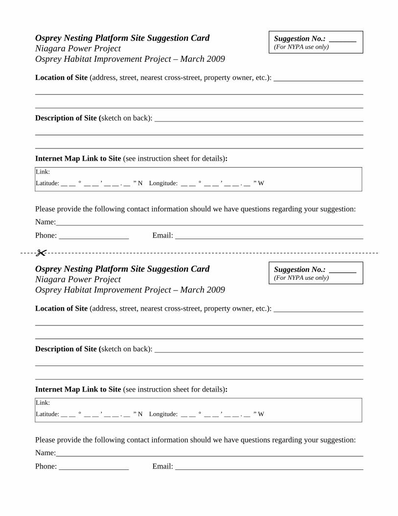
Instructions for Identifying Potential Osprey Nesting Platform Locations
1. Using your knowledge of the area, and the criteria below, identify candidate site locations for Osprey platforms.
2. Record your suggested location(s) on the attached cards. Please provide as much information as possible to help identify the site location. In addition, please provide your contact information in the event that we have follow-up questions.
3. Please point out your suggested site location using an internet map link. a. Go to: http://www.flashearth.com/
b. Click the map to explore the Earth…
c. Under “// Map Source”, select “Microsoft Virtual Earth”
d. Under “// Options”, select “Show crosshair”
e. Under “// Search”, type in “Niagara River, NY” (or another search term of your choice)
f. Navigate to your suggested site, zooming (+) the crosshairs in to the maximum extent.
g. Under “// Location”, click on “// Permanent Link”
h. Copy the Web Address from your browser into the suggestion form (Alternatively, you may write in the Latitude and Longitude values shown).
4. Please return your completed suggestion card(s) to me by April 24, 2009. Selection Criteria for Osprey Nesting Platforms
Each of the criteria described below, and summarized in Table 1, is a potentially important factor in selecting sites for the installation of new nesting poles and platforms for Osprey. These criteria are general in nature. Osprey nest sites may vary widely in their characteristics and there are always exceptions to any rule, but the table outlines factors that may be more or less desirable in most situations. These factors may be more important in attracting Ospreys to new nesting areas than they might be for a well-established or dense local Osprey nesting population.
Distance from water or foraging areas: A site close to water or foraging areas (river, lake, large pond) is generally more desirable than a site far from water or foraging areas. Although some Osprey nest a mile or more from water and foraging areas, most nests are located close to water and foraging areas. In general, closer is better, especially in a population that is just getting established. The best sites would likely be within one-half mile or less of water or foraging areas. Proximity to other nesting raptors (Bald Eagle, Peregrine Falcon, other Osprey): Other nesting raptors, such as Bald Eagle, Peregrine Falcon, and other Osprey, may hinder the occupation of a new Osprey nesting pole due to the general territorial nature of these birds. Sites more distant from known nests of these raptors are more desirable than sites close to known nests of these raptors. Peregrine Falcons nest on tall buildings, bridges and cliffs.

- 3 -
Bald Eagles nest in large trees, often pine trees near water, and generally distant from human disturbance. Ospreys are known to nest at Buckhorn Marsh and Tonawanda Coke; a platform is located at Buckhorn and one will be installed soon at East River Marsh. Proximity to thickly forested woodlands: Osprey nest sites near thickly forested woodlands are generally less successful than Osprey nest sites distant from these areas. Thickly forested woodlands may have competing raptors or predators such as Great Horned Owls. Sites that are not close to thickly forested woodlands would be more desirable. Height of nearest adjacent trees: Ospreys often prefer to nest in trees at least as tall as or taller than the closest surrounding trees. The most desirable sites would have trees that are lower than a pole-mounted platform installed at the site. In general, sites with tall trees nearby would be less desirable. Ease of public viewing: Nesting Ospreys are a joy to watch, especially with binoculars or spotting scopes. The most desirable sites would provide clear viewing opportunities for the enjoyment of the general public. The best sites might be those that could be observed from land or water. Remote locations that are not easily observed would be less desirable. Potential disturbance by people, industry, or pets: Disturbance from people, industry, or pets is an important consideration in selecting an Osprey pole location. Although some Ospreys may be surprisingly tolerant of limited or brief disturbances, it is generally most desirable to select sites where such disturbances are minimized. Sites directly adjacent to busy industrial sites, highways, or where large numbers of people and pets congregate are generally less desirable than sites with less disturbance. Land ownership: Public land is more desirable than private land to facilitate pole installation, management, monitoring, and the enjoyment of the site by the general public. Private land may be acceptable, but would require legally binding agreements for access Condition of soils at site: The condition of soils at the site of installation is an important consideration as well. The most desirable soils would be firm, dry, clean, upland soils that would provide adequate support for the pole and for the vehicles required for installation. In general, wet, soft, or potentially contaminated soils would not be suitable sites for an Osprey pole, both because of engineering (stability) issues and because of permitting and environmental impact issues. Ease of access to pole installation location: Osprey poles are tall and heavy and their installation requires access for large wheeled or tracked vehicles. These vehicles will bore holes in the ground and set the poles in place. An access route at least ten feet wide will be necessary for these vehicles to reach the installation site. The most desirable locations would require the least disturbance to lawns, fences, trees, shrubs, or other local features. Sites with close proximity to deeper water may provide access for installation barges. Sites with difficult access would be less desirable.
- 4 -
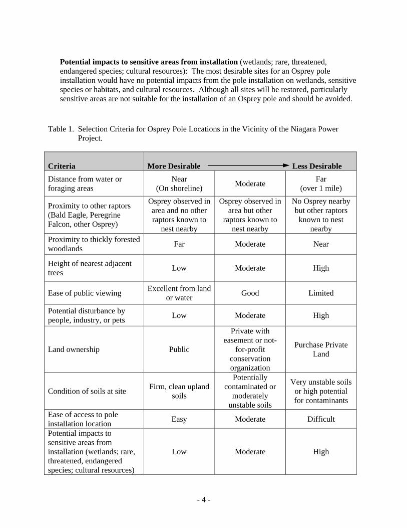
Potential impacts to sensitive areas from installation (wetlands; rare, threatened, endangered species; cultural resources): The most desirable sites for an Osprey pole installation would have no potential impacts from the pole installation on wetlands, sensitive species or habitats, and cultural resources. Although all sites will be restored, particularly sensitive areas are not suitable for the installation of an Osprey pole and should be avoided.
Table 1. Selection Criteria for Osprey Pole Locations in the Vicinity of the Niagara Power
Project.
Criteria
More Desirable Less Desirable
Distance from water or foraging areas
Near (On shoreline) Moderate Far
(over 1 mile)
Proximity to other raptors (Bald Eagle, Peregrine Falcon, other Osprey)
Osprey observed in area and no other raptors known to
nest nearby
Osprey observed in area but other
raptors known to nest nearby
No Osprey nearby but other raptors known to nest
nearby Proximity to thickly forested woodlands Far Moderate Near
Height of nearest adjacent trees Low Moderate High
Ease of public viewing Excellent from land or water Good Limited
Potential disturbance by people, industry, or pets Low Moderate High
Land ownership Public
Private with easement or not-
for-profit conservation organization
Purchase Private Land
Condition of soils at site Firm, clean upland soils
Potentially contaminated or
moderately unstable soils
Very unstable soils or high potential for contaminants
Ease of access to pole installation location Easy Moderate Difficult
Potential impacts to sensitive areas from installation (wetlands; rare, threatened, endangered species; cultural resources)
Low Moderate High
Osprey Nesting Platform Site Suggestion Card Niagara Power Project Osprey Habitat Improvement Project – March 2009 Location of Site (address, street, nearest cross-street, property owner, etc.):
Description of Site (sketch on back):
Internet Map Link to Site (see instruction sheet for details):
Link:
Latitude: __ __ º __ __ ’ __ __ . __ ” N Longitude: __ __ º __ __ ’ __ __ . __ ” W
Please provide the following contact information should we have questions regarding your suggestion:
Name:
Phone: Email:
Suggestion No.: _______ (For NYPA use only)
Suggestion No.: _______ (For NYPA use only)


![[Micro] opportunistic mycosis](https://img.dokumen.tips/doc/110x75/55d6fc6bbb61ebfa2a8b47ec/micro-opportunistic-mycosis.jpg)