Embed Size (px)
Citation preview

ORSU METALS CORPORATION
NI 43-101 TECHNICAL REPORT FOR THE SERGEEVSKOE PROPERTY, ZABAIKALSKIY KRAI,
RUSSIAN FEDERATION
10 March 2017

Wardell ArmstrongBaldhu House, Wheal Jane Earth Science Park, Baldhu, Truro, Cornwall, TR3 6EH, United KingdomTelephone: +44 (0)1872 560738 Fax: +44 (0)1872 561079 www.wardell-armstrong.com
Wardell Armstrong is the trading name of Wardell Armstrong International Ltd,Registered in England No. 3813172.
Registered office: Sir Henry Doulton House, Forge Lane, Etruria, Stoke-on-Trent, ST1 5BD, United Kingdom
UK Offices: Stoke-on-Trent, Cardiff, Carlisle, Edinburgh, Greater Manchester, London, Newcastle upon Tyne,Sheffield, Taunton, Truro, West Bromwich. International Offices: Almaty, Moscow
ENERGY AND CLIMATE CHANGE
ENVIRONMENT AND SUSTAINABILITY
INFRASTRUCTURE AND UTILITIES
LAND AND PROPERTY
MINING AND MINERAL PROCESSING
MINERAL ESTATES
WASTE RESOURCE MANAGEMENT
DATE ISSUED: 15 March 2017
JOB NUMBER: ZT61-1569
VERSION:
REPORT NUMBER:
STATUS:
V1.0
MM1117
Final
ORSU METALS CORPORATION
NI 43-101 TECHNICAL REPORT FOR THE SERGEEVSKOE PROPERTY, ZABAIKALSKIY KRAI, RUSSIAN
FEDERATION
MARCH 2017
PREPARED BY:
Phil Newall BSc (ARSM), PhD (ACSM), CEng, FIMMM
APPROVED BY:
Mark Mounde Technical Director
.

ORSU METALS CORPORATIONNI 43-101 TECHNICAL REPORT FOR SERGEEVSKOE PROPERTY, ZABAIKALSKIY KRAI,RUSSIAN FEDERATION
ZT61-1569/MM1117
10 March 2017
Final V1.0 Page i
CONTENTS
EXECUTIVE SUMMARY ................................................................................................................. 1
1 INTRODUCTION ................................................................................................................... 4
1.1 Scope of Work............................................................................................................................4
1.2 Independent Consultant ............................................................................................................5
1.3 Source of Information................................................................................................................5
1.4 Personal Inspection....................................................................................................................6
1.5 Units and Currency ....................................................................................................................6
1.6 Limitations, Reliance, and WAI Declaration...............................................................................6
2 RELIANCE ON OTHER EXPERTS.............................................................................................. 8
3 PROPERTY DESCRIPTION AND LOCATION.............................................................................. 9
3.1 Location......................................................................................................................................9
3.2 Mineral Tenure ........................................................................................................................10
4 ACCESSIBILITY, CLIMATE, LOCAL RESOURCES, INFRASTRUCTURE AND PHYSIOGRAPHY ........ 14
4.1 Accessibility..............................................................................................................................14
4.2 Climate .....................................................................................................................................14
4.3 Local Resources and Infrastructure .........................................................................................15
4.4 Physiography............................................................................................................................16
5 HISTORY ............................................................................................................................ 17
5.1 Introduction .............................................................................................................................17
5.2 Kluchevskoye ...........................................................................................................................17
5.3 Sergeevskoe .............................................................................................................................18
5.4 Resource Potential of the Sergeevskoe Property ....................................................................30
6 GEOLOGICAL SETTING AND MINERALISATION..................................................................... 31
6.1 Regional Geology .....................................................................................................................31
6.2 Sergeevskoe Property ..............................................................................................................33
6.3 Mineral Occurrences................................................................................................................35
7 DEPOSIT TYPES .................................................................................................................. 46
8 EXPLORATION.................................................................................................................... 49
9 DRILLING ........................................................................................................................... 51
10 SAMPLE PREPARATION, ANALYSES AND SECURITY.............................................................. 52
11 DATA VERIFICATION........................................................................................................... 53
12 MINERAL PROCESSING AND METALLURGICAL TESTING ....................................................... 54
13 MINERAL RESOURCE ESTIMATES ........................................................................................ 55
14 MINERAL RESERVE ESTIMATES ........................................................................................... 56
15 MINING METHODS............................................................................................................. 57
16 RECOVERY METHODS......................................................................................................... 58
17 PROJECT INFRASTRUCTURE ................................................................................................ 59
18 MARKET STUDIES AND CONTRACTS.................................................................................... 60
19 ENVIRONMENTAL STUDIES, PERMITTING AND SOCIAL OR COMMUNITY IMPACT................. 61
20 CAPITAL AND OPERATING COSTS........................................................................................ 62
21 ECONOMIC ANALYSES........................................................................................................ 63
22 ADJACENT PROPERTIES ...................................................................................................... 64

ORSU METALS CORPORATIONNI 43-101 TECHNICAL REPORT FOR SERGEEVSKOE PROPERTY, ZABAIKALSKIY KRAI,RUSSIAN FEDERATION
ZT61-1569/MM1117
10 March 2017
Final V1.0 Page ii
22.1 Introduction ..........................................................................................................................64
22.2 The Kluchevskoe Deposit ......................................................................................................64
22.3 The Alexandrovka Project .....................................................................................................66
23 OTHER RELEVANT DATA AND INFORMATION...................................................................... 69
24 INTERPRETATION AND CONCLUSIONS ................................................................................ 70
25 RECOMMENDATIONS......................................................................................................... 71
25.1 Introduction ..........................................................................................................................71
25.2 Budget and Work Programme ..............................................................................................71
26 REFERENCES ...................................................................................................................... 74
TABLES
Table 3.1: Sergeevskoe Concession Area Coordinates .........................................................................12
Table 5.1: Historical Exploration Activities ...........................................................................................19
Table 8.1: Orsu Exploration Results ......................................................................................................49
Table 22.1:Recorded Historical Production from Kluchevskoye...........................................................66
Table 25.1: Sergeevskoe Phase 1 Exploration Budget ..........................................................................72
Table 25.2: Sergeevskoe Phase 2 Exploration Budget ..........................................................................73
FIGURES
Figure 3.1: Location Map of the Sergeevskoe Property..........................................................................9
Figure 3.2: Concession Area..................................................................................................................12
Figure 4.1: Route Map from Davenda to Chita Airport (579km via M58/AH30)..................................14
Figure 5.1: Typical Drilling Passport from Soviet Era ............................................................................22
Figure 5.2: Composite Geological/Sampling Map Over Zone 23..........................................................23
Figure 5.3: Shallow Shaft 28 and 29 Showing Geological Logging, Kozie .............................................24
Figure 5.4: Cross Section for Borehole C-139 and C-140 at Kozie Occurrence.....................................26
Figure 5.5: Kozie Occurrence, Sampling for Gold .................................................................................26
Figure 5.6: 3D View of Sampling Activity, Kozie Occurrence ................................................................27
Figure 5.7: Sampling Plan at Ore Zone 23 Occurrence .........................................................................28
Figure 5.8: 3D View of Ore Zone 23 Occurrence ..................................................................................29
Figure 5.9: Vein 7-38 Structure Sampling Plan, Karamaevskoe Occurrence ........................................30
Figure 6.1: Regional Geology, Kluchevskoye District ............................................................................32
Figure 6.2: Geological Map of Concession Area ...................................................................................34
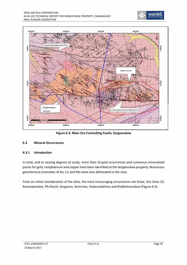
Figure 6.3: Main Ore Controlling Faults, Sergeevskoe..........................................................................35
Figure 6.4: Main Mineral Occurrences in the Sergeevskoe License .....................................................36
Figure 6.5: Geology and Exploration Works, Kozie...............................................................................37
Figure 6.6: Simplified 3D Model for Zone 23 and Kozie Occurences, (Orsu Metals, 2016)..................38
Figure 6.7: Ore Zone 23 Occurrence (Eastern Part, Adit-5) ..................................................................38
Figure 6.8: Ore Zone 23 Occurrence (Western Part) ............................................................................39
Figure 6.9: Pik Kluchi Occurrence .........................................................................................................41
Figure 6.10: Karamaevskoe Occurrence, Geological Plan.....................................................................42
Figure 7.1: Comparison of Tonnage and Tenor for RIRGS Deposits .....................................................46

ORSU METALS CORPORATIONNI 43-101 TECHNICAL REPORT FOR SERGEEVSKOE PROPERTY, ZABAIKALSKIY KRAI,RUSSIAN FEDERATION
ZT61-1569/MM1117
10 March 2017
Final V1.0 Page iii
Figure 7.2: Generalised Model for RIRGS Deposits...............................................................................47
Figure 7.3: Global Distribution of RIRGS Deposits ................................................................................47
Figure 22.1: Location of Adjacent Properties .......................................................................................64
PHOTOGRAPHS
Photo 4.1: Kluchevskiy Village with Open Pit in Background ...............................................................15
Photo 5.1: Adit Portal, Kluchevskoye....................................................................................................17
Photo 5.2: Trench K996, Zone 23, from the Soviet Era.........................................................................20
Photo 5.3: Shaft 28 at Kozie..................................................................................................................21
Photo 5.4: Collar of Hole C142, Kozie ...................................................................................................25
Photo 22.1: The Alexandrovka Project Area (Zapadnaya, 2016) .........................................................67

ORSU METALS CORPORATIONNI 43-101 TECHNICAL REPORT FOR SERGEEVSKOE PROPERTY, ZABAIKALSKIY KRAI,RUSSIAN FEDERATION
ZT61-1569/MM1117
10 March 2017
Final V1.0 Page 1
EXECUTIVE SUMMARY
The Sergeevskoe Property is located in the Zabaikalsky Region in the Russian Federation. The property
is situated 40km to the southwest of Mogocha town – the district capital with a large railway station
on the Trans-Siberian Railway. The newly built Chita-Khaborovsk motorway passes within 8km to the
south of the property. The distance from Chita to Sergeevskoe is 560km.
As the result of an auction held 22.11.2013, LLC SC "Alexandrovskoe", a subsidiary of Sibzoloto
Investments Limited (“Sibzoloto”), a Cyprus registered company and the sole owner of LLC GK
Alexandrovskoe, acquired the license from the Russian Government. The shares of Sibzoloto are
owned by four arm’s length parties. The license was issued on 31 December 2013 and it is valid until
31 December 2031. In 2016, the license (Licence CHIT 02454 BR) was actualised by the Ministry of
Natural Resources of the Russian Federation. This confirmed the validity of the license.
The terms of the acquisition of the Sergeevskoe Project are tied to Orsu’s successful completion of the
sale of Orsu’s interest in its Karchiga Project located in Kazakhstan for US$7.75 million by June 30,
2017.
Closing of the Sergeevskoe Project acquisition is subject to the receipt of regulatory approval from
TSX-V for this fundamental acquisition. On closing, Orsu will purchase 300 (30%) of the €1 par value
shares of Sibzoloto from the Sellers by the issue of 146,605,683 new common shares in Orsu and
payment of US$180,000 cash. If the sale of Karchiga completes prior to June 30, 2017, then within 10
days, the Sellers will sell and Orsu will purchase the remaining 700 (70%) of the shares of Sibzoloto for
consideration of €700 and US$420,000 cash.
At that point, Orsu will own 100% of Sibzoloto and the Sellers will own in aggregate 44.5% of Orsu. No
one Seller will own more than 20% of Orsu and the Sellers have confirmed they will individually govern
their investment in Orsu.
The license is irregular in shape, covers some 7.6km2 and is approximately 6km in an east-west
direction and 3km north-south. Orsu advises that the license is currently valid and in good standing
according to the rules, regulations, and laws of the Russian Federation.
The Sergeevskoe licence area is located within the Mogocha Mineral Field, within a major tectonic
Proterozoic to Mesozoic fold belt of the southwestern margin of the Aldan-Stanovoi Shield of the
Siberian Craton. The region predominantly comprises various intrusive granites surrounded by
metamorphic rocks. Plutons from the Middle Palaeozoic (Olekminskiy Complex), Permian (Bichurskiy
Complex) and Jurassic (Amudzhikano-Sretenskiy and Amanansky Complexes) intrude the fold belt
sediments and host a number of gold and molybdenum deposits and occurrences.
The granitoid complexes are located adjacent to a marked flexure (dilational jog) in the regional east-
west trending “Latitudinal Fault”, a segment of the regional Mogocha-Bushuleysk Fault Zone, marking
the contact between Proterozoic and Mesozoic granitoids.
ORSU METALS CORPORATIONNI 43-101 TECHNICAL REPORT FOR SERGEEVSKOE PROPERTY, ZABAIKALSKIY KRAI,RUSSIAN FEDERATION
ZT61-1569/MM1117
10 March 2017
Final V1.0 Page 2
The deposit cluster in the area is hosted by the Davenda granite massif which has a strike length of
50km and a width of 2-3km. Gold and molybdenum mineralisation is related with the porphyry
intrusions of Amudzhikano-Sretenskiy complex and associated with the zones of north-west
endocontact and exocontact of the Davenda massif.
The Sergeevskoe license lies immediately to the west of the historic Kluchevskoye open pit gold mine
which has produced well over 1Moz Au, and has a resource potential of several more million ounces
gold and which is now the focus of a BRICS consortium looking to re-start the project. Furthermore,
to the west of Sergeevskoe lies the recently opened Alexandrovskoe open pit gold mine.
The major ore-controlling faults at Kluchevskoye pass westwards into the Sergeevskoe license and it
is quite clear that the mineralising structures that were mined at Kluchevskoye are continuous to a
greater or lesser extent into the Sergeevskoe area, although the information is not necessarily
indicative of the mineralisation on the property that is the subject of the technical report.
Previous works at Sergeevskoe included geochemical sampling and geophysical surveys, trenching and
limited core drilling resulting in the delineation of a number of gold, copper and molybdenum
anomalous areas.
In total, and to varying degrees of study, more than 10 gold occurrences and numerous mineralised
points for gold, molybdenum and copper have been identified at the Sergeevskoe property. Numerous
geochemical anomalies of Au, Cu and Mo were also delineated in the area.
The gold mineralisation is generally related to quartz vein-veinlet system/zone which is often
accompanied by alteration (tourmalinisation, pyritisation, sericitisation) together with sulphide
polymetallic mineralisation.
However, due to the age of the data (often more than 50 years old), little reliance can be placed on
the absolute values seen from trenches, outcrops and drillholes, although the structures and
lithologies defined by the work hold good to this day. Certainly, no resources can be defined at this
time, nor any of the Soviet estimates incorporated into internationally acceptable reporting codes
without further reconciliation work.
Thus, Orsu has possession of a highly attractive exploration license containing many of the structural,
mineralogical and lithological controls as are seen at Kluchevskoye, but with the added advantage of
a number of drill-ready targets.
It is likely that some of these will be mineralised extensions from ore zones mined at the western end
of the Kluchevskoye pit whilst others might represent faulted continuations of the same Kluchevskoye
system. Either way, the magnitude of the Kluchevskoye body should not be underestimated and as
such, Sergeevskoe presents an excellent opportunity to develop near surface oxide mineralisation
with the possibility of deeper primary mineralisation development.

ORSU METALS CORPORATIONNI 43-101 TECHNICAL REPORT FOR SERGEEVSKOE PROPERTY, ZABAIKALSKIY KRAI,RUSSIAN FEDERATION
ZT61-1569/MM1117
10 March 2017
Final V1.0 Page 3
Furthermore, WAI believes that the budgeted work programmes put forward by Orsu are both
practical and prudent and will greatly enhance the understanding of this exciting area.

ORSU METALS CORPORATIONNI 43-101 TECHNICAL REPORT FOR SERGEEVSKOE PROPERTY, ZABAIKALSKIY KRAI,RUSSIAN FEDERATION
ZT61-1569/MM1117
10 March 2017
Final V1.0 Page 4
1 INTRODUCTION
1.1 Scope of Work
Wardell Armstrong International (WAI) was commissioned by Orsu Metals Corporation (“Orsu” or the
“Client”) to prepare a Baseline Technical Report under the Requirements of the Canadian National
Instrument 43-101 (NI 43-101) for the Sergeevskoe Property, located in the Mogocha District,
Zabaikalskiy Krai of Russia.
Orsu Metals Corporation is a base and precious metals exploration and development company, with
its headquarters in London and is listed on the Toronto Stock Exchange.
Sergeevskoe is considered as a greenfield site, even though the previously operated large
Kluchevskoye open pit lies immediately to the east of the licence area. Previous works at Sergeevskoe
included geochemical sampling and geophysical surveys, trenching and limited core drilling resulting
in the delineation of a number of gold, copper and molybdenum anomalous areas.
However, the majority of the data stem from the Soviet era, and although very useful for delineating
targets, cannot be incorporated into internationally acceptable reporting codes without further
reconciliation work.
The report has been prepared in accordance with the guidelines of the Canadian Institute of Mining,
Metallurgy and Petroleum (CIM) Mineral Resource and Mineral Reserve definitions and in conformity
with generally accepted CIM “Exploration Best Practices” guidelines. However due to the early stage
nature of a greenfield site, WAI has only considered the following aspects of the Property:
Location;
Historical work done;
Regional geology;
Local geology stratigraphy, rock types, structural control;
Mineralogy and physical properties;
Overburden and weathering profiles;
Geological interpretation and mineralisation morphology;
Exploration and drilling to date;
Sampling methods;
Assay testwork;
Current exploration programme;
Database review;
Mineral Resource Potential; and
Conclusions.

ORSU METALS CORPORATIONNI 43-101 TECHNICAL REPORT FOR SERGEEVSKOE PROPERTY, ZABAIKALSKIY KRAI,RUSSIAN FEDERATION
ZT61-1569/MM1117
10 March 2017
Final V1.0 Page 5
Orsu plans to undertake further trenching and limited drilling during the next few months to better
define the mineralised targets, and in particular test the near surface, oxide portions of the
mineralisation.
1.2 Independent Consultant
WAI has provided the mineral industry with specialised geological, mining, and processing expertise
since 1987, initially as an independent company, but from 1999 as part of the Wardell Armstrong
Group. WAI’s experience is worldwide and has been developed in the coal and metalliferous mining
sector.
Our parent company is a mining engineering/environmental consultancy that services the industrial
minerals sector from ten regional offices in the UK and international offices in Almaty, Kazakhstan,
and Moscow, Russia. Total worldwide staff complement is now close to 500.
WAI, its directors, employees and associates neither has nor holds:
Any rights to subscribe for shares in Orsu Metals Corporation either now or in the future;
Any vested interests in any concessions held by Orsu Metals Corporation;
Any rights to subscribe to any interests in any of the concessions held by Orsu Metals
Corporation either now or in the future;
Any vested interests in either any concessions held by Orsu Metals Corporation or any
adjacent concessions; or
Any right to subscribe to any interests or concessions adjacent to those held by Orsu Metals
Corporation, either now or in the future.
WAI’s only financial interest is the right to charge professional fees at normal commercial rates, plus
normal overhead costs, for work carried out in connection with the investigations reported here.
Payment of professional fees is not dependent on the success of the Admission or linked to the value
of the Company.
1.3 Source of Information
This report is based on information provided by Orsu and collected by WAI during the site visit, as well
as personal knowledge of the adjacent Kluchevskoye deposit.
Although the majority of the data viewed derives from the Soviet era, WAI has no reason to doubt the
reliability and robustness of information provided by the Client.
The information in this technical report is based on the following sources:
Technical discussion with Orsu personnel on site visit;
Inspection of the Sergeevskoe Property area, including geological investigation;
Review of exploration data provided by Orsu; and

ORSU METALS CORPORATIONNI 43-101 TECHNICAL REPORT FOR SERGEEVSKOE PROPERTY, ZABAIKALSKIY KRAI,RUSSIAN FEDERATION
ZT61-1569/MM1117
10 March 2017
Final V1.0 Page 6
Additional information from public domains such as company news, presentation and reports.
1.4 Personal Inspection
In compliance with National Instrument 43-101 guidelines, Phil Newall, BSc (ARSM), PhD (ACSM),
CEng, FIMMM, Managing Director of WAI, conducted a personal inspection of the Sergeevskoe
property between 02 to 03 November 2016, primarily covering the geology, exploration and the
previous drilling programmes.
1.5 Units and Currency
All units of weight and measurement in this report are metric, unless otherwise noted. Units of
currency are in US dollars, unless otherwise specified. Specific abbreviations used include:
Abbreviation Unit
m Metre
km Kilometre
g Gramme
t Tonne
oz Ounce
lb Pound
% Percentage
cm CentimetreoC Degrees centigrade
1.6 Limitations, Reliance, and WAI Declaration
WAI’s opinion contained herein is based on information collected throughout the course of WAI’s
work, which in turn reflects various technical and economic conditions as of the effective date. Given
the nature of the mining business, these conditions can change significantly over relatively short
periods of time. Consequently, actual results may be significantly more or less favourable than
assumed according to changes in metal prices or other variables.
This report may include technical information that requires subsequent calculations to derive sub-
totals, totals and weighted averages. Such calculations inherently involve a degree of rounding, and
consequently introduce a margin of error. Where these occur, WAI does not consider them to be
material.
WAI is not an insider, associate, or affiliate of Orsu, (or the vendor Sibzoloto Investments Limited) nor
has WAI acted as an advisor to this company or its subsidiaries or affiliates in connection with this
Project. The results of the technical review by WAI are not dependent on any prior agreements
concerning the conclusions to be reached, nor are there any undisclosed understandings concerning
any future business dealings.

ORSU METALS CORPORATIONNI 43-101 TECHNICAL REPORT FOR SERGEEVSKOE PROPERTY, ZABAIKALSKIY KRAI,RUSSIAN FEDERATION
ZT61-1569/MM1117
10 March 2017
Final V1.0 Page 7
Except as specifically required by law, WAI does not assume any responsibility and will not accept any
liability to any other person for any loss suffered by any such other person as a result of, arising out
of, or in connection with this Technical Report or statements contained herein, except required by
and given solely for the purpose of complying with the mandate as outlined in this Technical Report
and compliance with NI 43-101. WAI has no reason to believe that any relevant additional information
or material facts have been withheld by Orsu.
The authors hereby acknowledge Orsu for assistance with field review and data gathering.

ORSU METALS CORPORATIONNI 43-101 TECHNICAL REPORT FOR SERGEEVSKOE PROPERTY, ZABAIKALSKIY KRAI,RUSSIAN FEDERATION
ZT61-1569/MM1117
10 March 2017
Final V1.0 Page 8
2 RELIANCE ON OTHER EXPERTS
This technical report has been prepared by WAI on behalf of Orsu Metals Corporation.
For the purposes of this report, WAI has relied on ownership information provided by Orsu Metals
Corporation, and although WAI has not researched property title or mineral rights, WAI believes the
asset to be secure and unencumbered.
This is supported by a title opinion document, provided to Orsu in November 2016 by Saveliev,
Batanov & Partners, a Russian legal firm. This document opines on the overall validity of the license
as well as whether there were any grounds for early revocation, following the successful Auction.
The conclusions from this work were that Orsu does have secure title to the property and is in full
compliance with Russian regulations.
WAI has seen this document and it is on this opinion that WAI relies in respect of Section 3.2 of this
report.

ORSU METALS CORPORATIONNI 43-101 TECHNICAL REPORT FOR SERGEEVSKOE PROPERTY, ZABAIKALSKIY KRAI,RUSSIAN FEDERATION
ZT61-1569/MM1117
10 March 2017
Final V1.0 Page 9
3 PROPERTY DESCRIPTION AND LOCATION
3.1 Location
The Sergeevskoe Property is located in the Zabaikalsky Region in the Russian Federation (Figure 3.1).
The property is situated 40km to the southwest of Mogocha town – the district capital with a large
railway station on the Trans-Siberian Railway. The newly built Chita-Khaborovsk motorway passes
within 8km to the south of the property. The distance from Chita to Sergeevskoe is 560km.
Figure 3.1: Location Map of the Sergeevskoe Property

ORSU METALS CORPORATIONNI 43-101 TECHNICAL REPORT FOR SERGEEVSKOE PROPERTY, ZABAIKALSKIY KRAI,RUSSIAN FEDERATION
ZT61-1569/MM1117
10 March 2017
Final V1.0 Page 10
3.2 Mineral Tenure
The Sergeevskoe license area occupies 7.6km2. The LLC SC "Alexandrovskoe", a subsidiary of Sibzoloto
Investments Limited (“Sibzoloto”), a Cyprus registered company and the sole owner of LLC GK
Alexandrovskoe, acquired the license at a public auction from the Russian Government that took place
on 22 November 2013. The shares of Sibzoloto are owned by four arm’s length parties together
defined as the Sellers. The license was issued on 31 December 2013 and it is valid until 31 December
2031. In 2016, the license was actualised by the Ministry of Natural Resources of the Russian
Federation. This confirmed the validity of the license.
On the 21 September 2016, Orsu Metals Corporation announced the terms of the Exclusive and
Binding Heads of Agreement. On the 12 January 2017, Orsu announced amended terms of the
agreement and signed a definitive share purchase agreement.
The terms of the acquisition of the Sergeevskoe Project are tied to Orsu’s successful completion of the
sale of Orsu’s interest in its Karchiga Project located in Kazakhstan for US$7.75 million by June 30,
2017.
Closing of the Sergeevskoe Project acquisition is subject to the receipt of regulatory approval from
TSX-V for this fundamental acquisition. On closing, Orsu will purchase 300 (30%) of the €1 par value
shares of Sibzoloto from the Sellers by the issue of 146,605,683 new common shares in Orsu and
payment of US$180,000 cash. If the sale of Karchiga completes prior to June 30, 2017, then within 10
days, the Sellers will sell and Orsu will purchase the remaining 700 (70%) of the shares of Sibzoloto for
consideration of €700 and US$420,000 cash.
At that point, Orsu will own 100% of Sibzoloto and the Sellers will own in aggregate 44.5% of Orsu. No
one Seller will own more than 20% of Orsu and the Sellers have confirmed they will individually govern
their investment in Orsu.
If the sale of Karchiga does not complete prior to June 30, 2017 then Orsu will own 100% of the
Karchiga project located in Kazakhstan and a 30% participating interest in Sibzoloto. Orsu and the
Sellers will negotiate the terms of a shareholder’s agreement at that time to govern the operations of
Sibzoloto, the terms of which will provide for an option for Orsu to acquire, and the Sellers to sell, the
remaining 700 (70%) shares of Sibzoloto on terms to be negotiated at that time. Prior regulatory
approval will be obtained in the event the parties determine that the consideration for the remaining
700 shares of Sibzoloto be paid and settled in shares of Orsu.
The Sergeevskoe license was granted by Zabaikalnedra, a local administrative branch of Rosnedra, a
Federal Agency responsible for issuing such licenses. The license is not listed as a strategic asset by the
Russian Government. There is no previous ownership in relation to the territory or its part covered by
the Sergeevskoe license. The surface rights belong to the Russian Government, which granted a license
to LLC SC "Alexandrovskoe". The license holder obtained all necessary permits, including a consent
from the Forest Protection Authorities, to conduct exploration works. This permit allows to undertake
trenching and drilling works.

ORSU METALS CORPORATIONNI 43-101 TECHNICAL REPORT FOR SERGEEVSKOE PROPERTY, ZABAIKALSKIY KRAI,RUSSIAN FEDERATION
ZT61-1569/MM1117
10 March 2017
Final V1.0 Page 11
The license was issued for geological study, exploration and mining and has no limitation to the depth
of mining. In addition, there is no obligation on financial expenditure at the license, although the
license holder has to achieve certain milestones:
Completion of resource assessment to Russian-style “C2 and P1” standards by 31.12.2018;
Completion of resource assessment to Russian-style “C1 and C2” standards by 31.12.2022;
Construction to start by 31.12.2024; and
Production to start by 31.12.2025.
During geological study, the license holder must pay 208 Rubles per km2 per annum. This will increase
to 10,115 Rubles per km2 during the detailed exploration stage. Taxes during mining will be applied in
accordance with the typical practices in the Russian Federation.
The license holder must obey all environmental regulations of the Russian Government, such as water
and forest protection, contamination of the ground. The license holder must conduct background
environmental monitoring.
To comply, in late 2016, GK Aleksandrovskoe contracted a Chita-based Laboratory of Environmental
Problems (“LEP”) to undertake a baseline study, which involved assessment of the environmental
situation prior to the new exploration works. As part of the programme, chemical, radiometric and
physical property studies of 126 soil samples from 12 sites were undertaken. Also, 50 water samples
from 12 sites were collected in different parts around the license area. Seven samples were collected
from stream bed sediments draining different parts of the license area.
A final report from LEP was received in mid-February 2017. Its main conclusions are as follows:
Surface waters are insignificantly contaminated due to the technogenic impact of the
historical operations. Their chemical and physical properties are similar to natural
concentrations;
Some soil and stream bed samples contain elevated concentrations of copper, zinc,
arsenic and sulphur due to the influence of historical mining works.
No other permits are necessary to conduct exploration works at the Sergeevskoe license area.
A plan view of the concession area is shown in Figure 3.2 below and coordinates are presented in
Table 3.1.

ORSU METALS CORPORATIONNI 43-101 TECHNICAL REPORT FOR SERGEEVSKOE PROPERTY, ZABAIKALSKIY KRAI,RUSSIAN FEDERATION
ZT61-1569/MM1117
10 March 2017
Final V1.0 Page 12
Figure 3.2: Concession Area
Table 3.1: Sergeevskoe Concession Area Coordinates
No Easting Northing
1 20659841 5936878
2 20659899 5936261
3 20659945 5935860
4 20659141 5936297
5 20658758 5936748
6 20658475 5936445
7 20657809 5936734
8 20657107 5936765
9 20656565 5937274
10 20656033 5937440
11 20654659 5937296
12 20654655 5937565
13 20656414 5938357
14 20656841 5938322
15 20657961 5937934
16 20658415 5937276
17 20658572 5937297
18 20658123 5937930
19 20658735 5937918
20 20658729 5938002
21 20657926 5938064
22 20656712 5938491
23 20657608 5938888
24 20660062 5938467
Klyuchevskoe
Open Pit

ORSU METALS CORPORATIONNI 43-101 TECHNICAL REPORT FOR SERGEEVSKOE PROPERTY, ZABAIKALSKIY KRAI,RUSSIAN FEDERATION
ZT61-1569/MM1117
10 March 2017
Final V1.0 Page 13
WAI notes that the concession coordinates are presented in the Pulkovo 1942 GK Zone 20 coordinates
system.
WAI Comment: WAI has seen the license for the Sergeevskoe area and can confirm the license
number, coordinates and expiry date. In addition, WAI has also seen legal opinion on the
property and therefore can conclude that all documentation is in place for Orsu to have legal
tenure over the property.

ORSU METALS CORPORATIONNI 43-101 TECHNICAL REPORT FOR SERGEEVSKOE PROPERTY, ZABAIKALSKIY KRAI,RUSSIAN FEDERATION
ZT61-1569/MM1117
10 March 2017
Final V1.0 Page 14
4 ACCESSIBILITY, CLIMATE, LOCAL RESOURCES, INFRASTRUCTURE AND PHYSIOGRAPHY
4.1 Accessibility
The Sergeevskoe property is accessed via a recently constructed M58 road from Chita (560km) which
runs approximately 8km south of the site (Figure 4.1); or alternatively from the town of Mogocha
(36km) which has regular train services to Chita, Moscow and other major Russian cities.
The regional transport infrastructure includes the Trans-Siberian and BAM rail-roads which provide
links to the Far East and Central Russia. The region also has direct rail connections with China and
Mongolia.
All principal cities and towns are connected by paved and all-season gravel roads. There is an airport
in Chita with regular flights to Moscow and other major Russian cities.
Figure 4.1: Route Map from Davenda to Chita Airport (579km via M58/AH30)
4.2 Climate
The climatic conditions in the Zabaikalsky Region are extreme continental, exhibiting long cold winters
and short cool summers. Historical weather observation records are available from a weather station
situated in Mogocha, along with a weather station installed at site during the summer of 2013.
The coldest recorded annual month is January with an average temperature of -28°C; the warmest
annual average month is July with an average temperature of +17°C. The overall average temperature
of the region is -4.8°C.
Sergeevskoe
Mogocha

ORSU METALS CORPORATIONNI 43-101 TECHNICAL REPORT FOR SERGEEVSKOE PROPERTY, ZABAIKALSKIY KRAI,RUSSIAN FEDERATION
ZT61-1569/MM1117
10 March 2017
Final V1.0 Page 15
The recorded data indicates that the region is subject to relatively low snowfall during the winter
period, with the maximum annual precipitation occurring in July (430mm), with variations ranging
between 269.4mm (1954) and 691.5mm (1934). Precipitation in the form of snowfall occurs on
average between the end of October and March, giving an average snow-cover thickness of between
0.15m and 0.20m. The snow-cover typically melts between March and April.
The location of the project is within a transitional zone of permafrost and seasonal ground-frost. The
maximum depth of ground/permafrost is recorded to be between 70m and 120m below ground level.
However, notwithstanding the harsh climate, exploration and mining operations are possible all year
round. In reality, much exploration drilling is preferably done in winter when the ground is frozen.
4.3 Local Resources and Infrastructure
The property is located between the Davenda and Kluchevskiy villages (Photo 4.1). Davenda has a
population of 978 and is located approximately 4km west of the property area. Kluchevskiy has a
population of 1,200, the property is approximately 3km east of the property area. The roads to the
camp from the villages are graded dirt roads.
Photo 4.1: Kluchevskiy Village with Open Pit in Background
The main industries in the region are alluvial and hard rock gold mining, with forestry enterprises and
railway maintenance. The populations of Kluchevskiy village and the nearby settlement of Davenda

ORSU METALS CORPORATIONNI 43-101 TECHNICAL REPORT FOR SERGEEVSKOE PROPERTY, ZABAIKALSKIY KRAI,RUSSIAN FEDERATION
ZT61-1569/MM1117
10 March 2017
Final V1.0 Page 16
are in part populated by former employees of closed and operating mining enterprises and provide a
pool of skilled labour. The main power grid is available through 110kV transmission lines.
Aggregate, dimension stone, construction sand and refractory clays are all available locally.
4.4 Physiography
The region has an elevation of 900-1,200m above sea level (mASL), in the drainage basin of the Shilka
River. The project area comprises moderate relief hills with approximate peaks of 1,200mASL and river
valleys at 900mASL.
Vegetation comprises coniferous and broadleaf forest, typical of the boreal zone. Areas of permafrost
in the area are discontinuous and can extend to depths of 120m below the surface. It is reported that
permafrost is not present in the area of the current open pit at Kluchevskoye, but is in some areas of
the waste dumps. Seasonal freezing within the soil profile is reported to reach depths of 2.3m to 3.6m.
In terms of the license area to sustain the infrastructure required for mining, although the project is
at a very early stage of exploration, the author believes there will be sufficient space for plant, tailings
and waste dumps should a viable operation be developed.
ORSU METALS CORPORATIONNI 43-101 TECHNICAL REPORT FOR SERGEEVSKOE PROPERTY, ZABAIKALSKIY KRAI,RUSSIAN FEDERATION
ZT61-1569/MM1117
10 March 2017
Final V1.0 Page 17
5 HISTORY
5.1 Introduction
Much of the history of the Sergeevskoe licence area is intimately related to the exploration and
development of the adjacent Kluchevskoye deposit as many of the mineralised occurrences at
Sergeevskoe are thought to be continuations or off-sets from the Kluchevskoye ore zones, although
the information is not necessarily indicative of the mineralisation on the property that is the subject
of this technical report.
5.2 Kluchevskoye
In the second half of the 19th century alluvial gold mining operations commenced within the Mogocha
region, within the Zheltuga River and its tributaries. In 1860, alluvial gold was mined from the Bolshaya
Kudech River, to the south of the project area. In 1901 a joint Anglo-Russian company, the
Nerchinskoye Gold Production Society commenced hardrock mining of the Kluchevskoye deposit by
an underground system of drives, cross-cuts and rises on the 848mASL and 818mASL. The main targets
of this mining were the quartz-tourmaline veins with the ore being processed by mercury
amalgamation. The operational mine life between 1901 and 1910 produced approximately 688kg of
gold at an unknown grade.
Further exploration commenced in the 1930s and continued through to 1941, and it was during this
period that the first formal reserve statements were produced. Underground mining operations
restarted in 1936 and continued until 1952 (Photo 5.1) using shrink stoping and “Glory Hole” mining
to extract pipe-shaped high grade shoots. Between 1936 and 1952 a reported 5,855kg of gold was
produced by mercury amalgamation, with the plant having a throughput of 150t/day.
Photo 5.1: Adit Portal, Kluchevskoye

ORSU METALS CORPORATIONNI 43-101 TECHNICAL REPORT FOR SERGEEVSKOE PROPERTY, ZABAIKALSKIY KRAI,RUSSIAN FEDERATION
ZT61-1569/MM1117
10 March 2017
Final V1.0 Page 18
By 1955 the open pit mining had reached the sulphide reserves. During the initial operation of the
open pit, the ore was processed in a new flotation plant, which was decommissioned in 2002. The
derelict building shell remains on site. It is reported that when operational, these processing facilities
had a capacity of 530,000tpa of ore. The concentrate produced was shipped to the Ural copper
smelters for further processing and gold recovery.
Underground exploration was advanced between 1947 and 1951 with the development and sampling
on the 888mASL, 848mASL, 830mASL and 780mASL levels. These exploration activities resulted in five
separate levels of underground sampling (including those developed in 1901) which were sampled
and estimated for both vein-type and stockwork-type mineralisation. To complement the sampling,
underground drilling was completed, resulting in a revised reserve estimate in 1955.
Exploration work in 1970 included underground development on the 730mASL and 630mASL levels. A
new reserve in 1977 formed the basis for the more recent open pit gold mining.
Exploitation at the Kluchevskoye deposit spanned a period of 25 years, from 1977 to 2002. During this
period approximately 8.9Mt or ore was milled at an average grade of 1.68g/t Au. In 2003 production
ceased due to increased processing and transportation costs against the background of lower gold
prices. The third stage of the open pit design projected in 1982 to reach an elevation of 680mASL
(depth of 250m below surface) was not completed.
5.3 Sergeevskoe
5.3.1 General
Prior to the issue of the license to the LLC SC “Alexandrovskoe”, the property was owned by the
Russian Government. No other ownership is recorded for this property.
Historical exploration works were conducted in the 1950-60s. They consisted of geological mapping,
geophysical surveys, exploration trenching (>16,000 m) and drilling (8,500 m). The exploration works
were conducted by the geological party affiliated to the mining enterprise that operated an open pit
at the nearby Klyuchevskoe gold deposit. No exploration works of any kind were conducted at the
property since the 1970s.
Table 5.1 below details the works completed.

ORSU METALS CORPORATIONNI 43-101 TECHNICAL REPORT FOR SERGEEVSKOE PROPERTY, ZABAIKALSKIY KRAI,RUSSIAN FEDERATION
ZT61-1569/MM1117
10 March 2017
Final V1.0 Page 19
Table 5.1: Historical Exploration Activities
Year Project and work stage Basic operations Unit Scope
1960 Geological surveying 1:200,000 Survey km2 8
1962 Geological surveying 1:50,000 Survey km2 8
1966-1978
Prospecting works Geophysical operations:MR 1:10 000
Resistivity method 1:10,000IP 1:10,000
Lithochemical survey 1:10,000Analytical works
km2
km2
km2
LMsample
88
2.380
4,000
1951-1954
Project for geophysicaloperations 1:10,000 Davenda
exploration crew
Core drillingDriving 2 pits (40.8 LM)Roadway driving (38 m)
Coring acquisitionTrench sampling
Analytical operations
LMm3
m3
samplesLM
samples
40040.81528052
130
1953-1955
Project for geophysicaloperations 1:10,000, Davenda
exploration crew
TrenchingCore drilling (underground)
Tunneling (195m)Cross cutting (38m)
Trench samplingCoring acquisition
Chemical analytical operations
m3
LMm3
m3
LMsamplessamples
2,650240780152
1,001100
1,101
1952-1955
Project for geologicalexploration, Davenda
exploration crew
TrenchingCore drilling
Driving 2 adits (305m)Shaft sinking (50m)
Driving 5 pits (120 m)Trench sampling
Coring acquisitionChemical analytical operations
m3
LMm3
m3
LMsamplessamplessamples
45,0006,1001,120380120650370
1,020
1961-1962
Project for verification oflithogeochemical anomalies by
ChSU Eastern Expedition
TrenchingTrench sampling
Chemical analytical operations
m3
LMsamples
1,5002929
1963-1967
Project for geologicalexploration, Kluchi exploration
crew
TrenchesCore drilling
Trench samplingCoring acquisition
Chemical analytical operations
m3
LMLM
samplessamples
26,8002,10053080
610
1972 Project for geologicalexploration, Kluchi exploration
crew
TrenchesTrench sampling
Chemical analytical operations
m3
LMsamples
3,990532532
Due to the very historical nature of the data described above, it is difficult to read too much into the
data other than as preliminary target delineation work.
Although Sergeevskoe remains a greenfield site, previous works have included soil-geochemistry and
sampling at 1:10,000 scale as well as different ground and airborne geophysical survey methods
resulting in the delineation of a number of gold, copper and molybdenum anomalous areas. From
these, the most promising occurrences include:
Ore Zone 23;
Kozie;
Karamaevskoe;

ORSU METALS CORPORATIONNI 43-101 TECHNICAL REPORT FOR SERGEEVSKOE PROPERTY, ZABAIKALSKIY KRAI,RUSSIAN FEDERATION
ZT61-1569/MM1117
10 March 2017
Final V1.0 Page 20
Vodorasdelnoe (Peak Kluchi);
Sergeeva;
Severnoe; and
Kladbischenskoe.
The prospecting/exploration activities at the occurrences include surface trenching (Photo 5.2),
restricted amounts of drilling and underground developments (shallow shafts (Photo 5.3) and adits
with cross-cuts). Predominately the exploration activities were between 1950s-1970s.
Photo 5.2: Trench K996, Zone 23, from the Soviet Era

ORSU METALS CORPORATIONNI 43-101 TECHNICAL REPORT FOR SERGEEVSKOE PROPERTY, ZABAIKALSKIY KRAI,RUSSIAN FEDERATION
ZT61-1569/MM1117
10 March 2017
Final V1.0 Page 21
Photo 5.3: Shaft 28 at Kozie
In summary, the exploration activities included >8,500m of historical drilling to a maximum depth of
300m, but more typically 50-70m, with grades similar to those historically exploited at Kluchevskoye
immediately to the east, although the information is not necessarily indicative of the mineralisation
on the property that is the subject of this technical report.
Importantly, the majority of the original trenches, drillholes and shafts/adits could be located at
surface, although as most are around 50 years’ old, the absolute location was not always completely
accurate.
An example of the sample records for Hole 197 at Karamaevskoe, drilled in 1967, can be seen in Figure
5.1 whilst a snap shot of the composite sampling plan is shown in Figure 5.2 below.

ORSU METALS CORPORATIONNI 43-101 TECHNICAL REPORT FOR SERGEEVSKOE PROPERTY, ZABAIKALSKIY KRAI,RUSSIAN FEDERATION
ZT61-1569/MM1117
10 March 2017
Final V1.0 Page 22
Figure 5.1: Typical Drilling Passport from Soviet Era
The author was able to undertake a circuit of the main occurrences and can confirm that the sampling
plan (Figure 5.2) appears to be an accurate representation of the works done.

ORSU METALS CORPORATIONNI 43-101 TECHNICAL REPORT FOR SERGEEVSKOE PROPERTY, ZABAIKALSKIY KRAI,RUSSIAN FEDERATION
ZT61-1569/MM1117
10 March 2017
Final V1.0 Page 23
Figure 5.2: Composite Geological/Sampling Map Over Zone 23
5.3.2 Kozie
A gold anomaly (at 0.025g/t Au level) was detected on the Kozie property based on soil geochemistry
sampling, whilst geophysical SP (up to 150mV) and IP (up to 7%) anomalies were also recorded.
However, the magnetic field was rather subdued (190-230 gamma) with few local anomalies above
the background level.
As a result, the eastern part of the Kozie area was explored by trenches and two shallow shafts (No 28
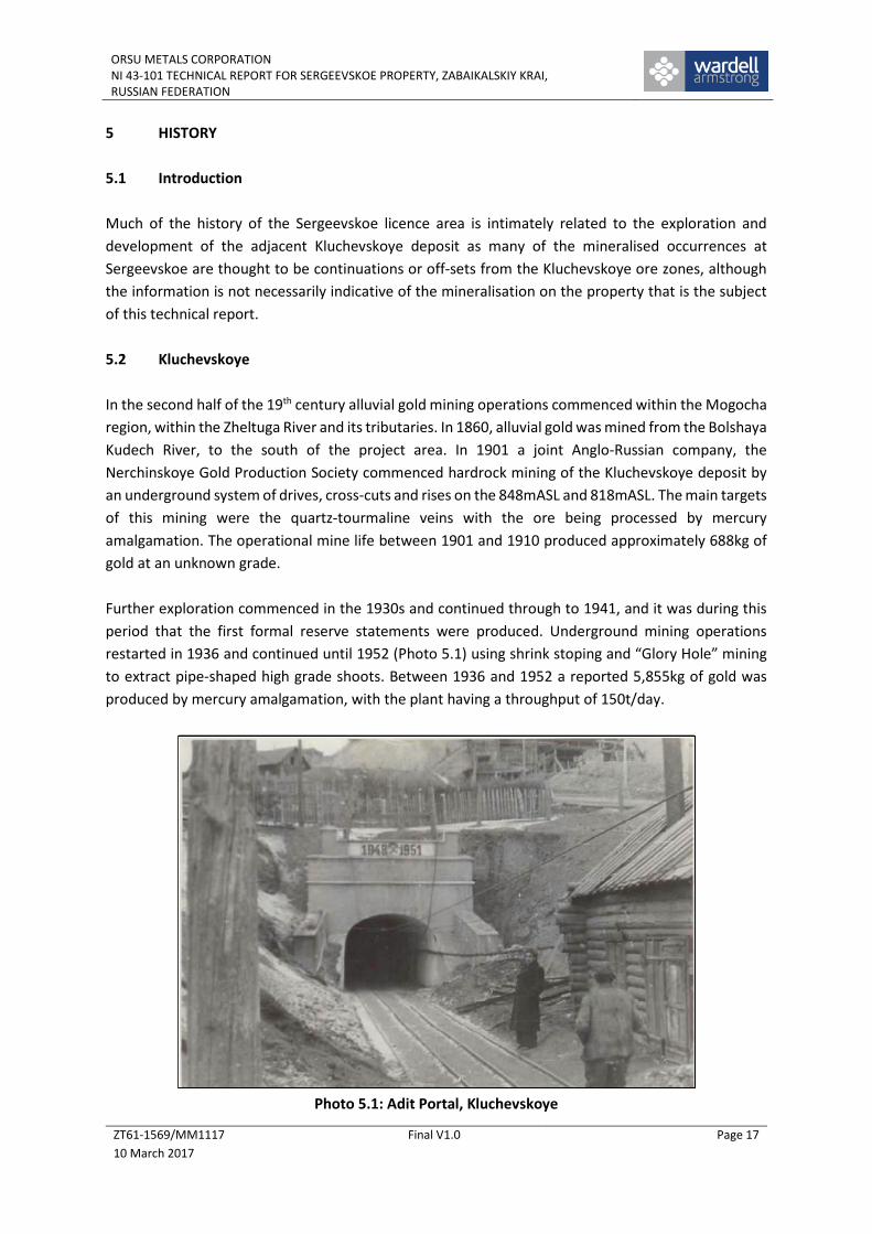
and 29 excavated in 1951-54) which had depths of 15.8 and 25.6m respectively (Figure 5.3). The
shallow shafts were sunk along a quartz-tourmaline vein which demonstrated high gold grades (up to
19.8g/t Au). Three drives were developed out from the shafts with a cumulative length of 38m (10m,
10m and 18m). Sampling showed irregular gold distribution within the vein and wallrock, with grades
varying from 0.1g/t Au to 30.0g/t Au for 1m sampling intervals.
ORSU METALS CORPORATIONNI 43-101 TECHNICAL REPORT FOR SERGEEVSKOE PROPERTY, ZABAIKALSKIY KRAI,RUSSIAN FEDERATION
ZT61-1569/MM1117
10 March 2017
Final V1.0 Page 24
Figure 5.3: Shallow Shaft 28 and 29 Showing Geological Logging, Kozie
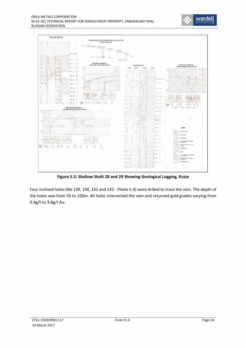
Four inclined holes (No 139, 140, 141 and 142 - Photo 5.4) were drilled to trace the vein. The depth of
the holes was from 50 to 100m. All holes intersected the vein and returned gold grades varying from
0.4g/t to 3.8g/t Au.
ORSU METALS CORPORATIONNI 43-101 TECHNICAL REPORT FOR SERGEEVSKOE PROPERTY, ZABAIKALSKIY KRAI,RUSSIAN FEDERATION
ZT61-1569/MM1117
10 March 2017
Final V1.0 Page 25
Photo 5.4: Collar of Hole C142, Kozie
In general gold grades in trenches and boreholes were from 0.1 to 1.0g/t Au with some isolated
intervals which demonstrated gold grades from 3.8g/t Au to 8.67g/t Au. Again, sampling was carried
out selectively focusing mainly on the quartz-tourmaline vein ignoring wall-rock intervals. The cross-
section through boreholes 139 and 140 and shallow shaft 29 is presented below, in Figure 5.4.
Considering the trench results for the eastern part of the occurrence, the gold grades in most cases
were poor. Using the sampling results of the stringer-disseminated zones, a few intervals showed gold
grades from 0.1g/t to 3.0g/t Au with thicknesses of a few metres (Figure 5.5).

ORSU METALS CORPORATIONNI 43-101 TECHNICAL REPORT FOR SERGEEVSKOE PROPERTY, ZABAIKALSKIY KRAI,RUSSIAN FEDERATION
ZT61-1569/MM1117
10 March 2017
Final V1.0 Page 26
Figure 5.4: Cross Section for Borehole C-139 and C-140 at Kozie Occurrence
Figure 5.5: Kozie Occurrence, Sampling for Gold

ORSU METALS CORPORATIONNI 43-101 TECHNICAL REPORT FOR SERGEEVSKOE PROPERTY, ZABAIKALSKIY KRAI,RUSSIAN FEDERATION
ZT61-1569/MM1117
10 March 2017
Final V1.0 Page 27
The northwest trending fault zone was also trenched in 1965. The trenches crossed a few narrow
zones with stringer-disseminated mineralisation, but these could not be linked together due to the
sparse trenching grid. Typical grade values were from 0.1g/t to 2.0-3.0g/t Au.
A few trenches and two boreholes were drilled in the western part of the Kozie Occurrence in 1965.
They intersected a few quartz-tourmaline veins which were accompanied by zones of intensively
altered (tourmalinisation and pyritisation) explosive breccia.
Sampling of drill core and trenches returned lower gold grades from 0.1g/t to 0.4-0.6g/t Au. The very
few higher grade gold intervals (2-3g/t Au) could not be linked together. The best intersection was
one interval of 4.3m thickness with an average gold grade of 5.0g/t in a trench.
Boreholes drilled to check this interval at depth returned lower gold grades of 0.1-0.5g/t. Only one
sample at a depth of 163.5m showed a gold grade of 5.5g/t over a true thickness of 0.6m. The average
grade for the whole western section was estimated at 0.5g/t Au.
A 3D view of the sampling plan at Kozie is shown in Figure 5.6 below.
Figure 5.6: 3D View of Sampling Activity, Kozie Occurrence
It is likely that the perceived increase in the gold grade in the eastern part of the Kozie occurrence is
related to superimposition of the quartz-polymetallic mineral association onto the quartz-tourmaline-
pyrite mineralisation. Therefore, in general, the geochemical feature of the eastern part of Kozie is
similar to that seen at Ore Zone 10 which belong to the western extension of the main Kluchevskoe
gold deposit, although the information is not necessarily indicative of the mineralisation on the
property that is the subject of this technical report.

ORSU METALS CORPORATIONNI 43-101 TECHNICAL REPORT FOR SERGEEVSKOE PROPERTY, ZABAIKALSKIY KRAI,RUSSIAN FEDERATION
ZT61-1569/MM1117
10 March 2017
Final V1.0 Page 28
WAI Comment: As with all the data from the Sergeevskoe project, the age of the information
(in many cases more than 50 years), coupled with the uncertainty of both the exploratory
techniques used as well as the quality of the assays returned, means that at best the Kozie
area has been identified as a major target for future exploration. This is due to the presence
of similar mineralisation and structures that have been identified and mined in the
Kluchevskoye open pit, although the information is not necessarily indicative of the
mineralisation on the property that is the subject of the technical report. The unspectacular
assays seen in trenches and drillholes are indicative of mineralisation, but should not be taken
as a guide to the tenor of mineralisation likely to be encountered.
5.3.3 Zone 23
The historical sampling data for Zone 23 has been captured by Orsu and is presented on the sampling
plans of the occurrence in Figure 5.7 and a 3D image in Figure 5.8 below.
Figure 5.7: Sampling Plan at Ore Zone 23 Occurrence
Results from the trenching and drilling as well as geophysics (self-potential electric survey method),
show that Ore Zone 23 appears fragmentary and separated by negative anomalies of -225mV intensity
which correspond to the sections of hydrothermally altered and sulphidised rock. The geophysical
data allows Zone 23 to be traced for 600m in a northwest direction where some individual soil
geochemical anomalies with gold grades from 1g/t Au and above were noted.
±

ORSU METALS CORPORATIONNI 43-101 TECHNICAL REPORT FOR SERGEEVSKOE PROPERTY, ZABAIKALSKIY KRAI,RUSSIAN FEDERATION
ZT61-1569/MM1117
10 March 2017
Final V1.0 Page 29
Figure 5.8: 3D View of Ore Zone 23 Occurrence
5.3.4 Pik Kluchi
Historically, Pik Kluchi has only attracted minimum exploration. Based on the trenching data, there
were 6 separate sub-zones which have strike lengths from 100m to 305m and thicknesses from 2.58m
to 14.0m and with average gold grades from 1.0g/t Au to 3.45g/t Au.
5.3.5 Karamaevskoe Occurrence
The Daveendinskaya Exploration Team performed prospecting works in this area in 1952-1955. There
were various works undertaken, including numerous surface trenches (6,000m), a number of test pits,
two adits, a shallow shaft and few tens of boreholes (about 6,100m of drilling).
As a result of this work, preliminary indications were that the mineralisation is complex and has a
multi-stage sequence.
Most of the exploration activity was focused on exploring for quartz-molybdenite veins; part of them
were also sampled for gold. Some of the developments were sampled by 5m long interval or by
combined/group samples. This sampling method for gold is not able to give a realistic impression of
the intensity, or otherwise, of the gold mineralisation.
In 1963-1967, the Kluchevskaya Exploration Team carried out additional exploration (mainly in the
southwestern part of the area) where work focused on the gold mineralisation. Some old trenches
were cleaned up as well as new trenches developed. In addition, 10 boreholes from 50m to 150m
depth were drilled at Karamaevskoe.

ORSU METALS CORPORATIONNI 43-101 TECHNICAL REPORT FOR SERGEEVSKOE PROPERTY, ZABAIKALSKIY KRAI,RUSSIAN FEDERATION
ZT61-1569/MM1117
10 March 2017
Final V1.0 Page 30
The gold grade varied from 0.2g/t Au to 117.1g/t Au (Figure 5.9). The sampling was focused on the
vein itself leaving intra-vein altered rock unsampled. Thus, the high grade sections were detected as
isolate intervals in the trenches. The average gold grade for the whole zone is from 0.2g/t Au to 0.8g/t
Au.
Figure 5.9: Vein 7-38 Structure Sampling Plan, Karamaevskoe Occurrence
Similar results were received from borehole samples. The gold grade varied from 0.3g/t Au to 0.8g/t.
In some intervals, gold grade reached 5.4g/t, although the average zone grade was 0.5g/t Au.
5.4 Resource Potential of the Sergeevskoe Property
License holder GK Aleksandrovskoe LLC has produced a prognostic potential for the Sergeevskoe
License area in accordance with the existing Russian methodology for estimation of greenfield
projects. However, this estimation is not in accordance with international standards and is not
reported further here.

ORSU METALS CORPORATIONNI 43-101 TECHNICAL REPORT FOR SERGEEVSKOE PROPERTY, ZABAIKALSKIY KRAI,RUSSIAN FEDERATION
ZT61-1569/MM1117
10 March 2017
Final V1.0 Page 31
6 GEOLOGICAL SETTING AND MINERALISATION
6.1 Regional Geology
The Sergeevskoe licence area is located within the Mogocha Mineral Field, within a major tectonic
Proterozoic to Mesozoic fold belt of the southwestern margin of the Aldan-Stanovoi Shield of the
Siberian Craton. The region predominantly comprises various intrusive granites surrounded by
metamorphic rocks. Plutons from the Middle Palaeozoic (Olekminskiy Complex), Permian (Bichurskiy
Complex) and Jurassic (Amudzhikano-Sretenskiy and Amanansky Complexes) intrude the fold belt
sediments and host a number of gold and molybdenum deposits and occurrences.
Lithologies include biotitic granites, granodiorites, diorites, quartz-diorites and granitic-porphyries,
with swarms of late northwest-trending granite porphyries. Some later dolerite dykes and porphyries
have intruded the granitoid and granitic rock sequences, as illustrated in Figure 6.1.
The granitoid complexes are located adjacent to a marked flexure (dilational jog) in the regional east-
west trending “Latitudinal Fault”, a segment of the regional Mogocha-Bushuleysk Fault Zone, marking
the contact between Proterozoic and Mesozoic granitoids.
The deposit cluster in the area is hosted by the Davenda granite massif which has a strike length of
50km and a width of 2-3km. Gold and molybdenum mineralisation is related with the porphyry
intrusions of Amudzhikano-Sretenskiy complex and associated with the zones of north-west
endocontact and exocontact of the Davenda massif.
There are seven deposits and several other occurrences of gold, molybdenum or copper
mineralisation, the most important being the Kluchevskoye and Alexandrovskoye gold deposits, and
the mined out Davenda molybdenum deposit.
Intrusive formations of the Amudzhikanskiy and Sretenskiy complexes can be subdivided into the
following three phases:
Phase I (qμЈ3аs) – quartz monzonites, quartz diorites, quartz monzonite-porphyry, diorites,
subalkalic quartz diorites;
Phase II (γδπ2Ј3 аs) – granodiorite-porphyry and diorite porphyry, granite-porphyry,
porphyritic granodiorite, quartz syenite, granites; and
Phase III (γ3Ј3аs) – magnophyric granite, granodiorite, granite-porphyry, granodiorite-
porphyry, quartz syenite-porphyry.
The final dyke series of the complex is quite diverse. It is represented by granite-porphyry, microdiorite
(crowded) porphyry, quartz diorite porphyry, microsyenite (hybrid) porphyry, sub-alkalic leucocratic
granite-porphyry, and orthoclasite.

ORSU METALS CORPORATIONNI 43-101 TECHNICAL REPORT FOR SERGEEVSKOE PROPERTY, ZABAIKALSKIY KRAI,RUSSIAN FEDERATION
ZT61-1569/MM1117
10 March 2017
Final V1.0 Page 32
Figure 6.1: Regional Geology, Kluchevskoye District
Legend

ORSU METALS CORPORATIONNI 43-101 TECHNICAL REPORT FOR SERGEEVSKOE PROPERTY, ZABAIKALSKIY KRAI,RUSSIAN FEDERATION
ZT61-1569/MM1117
10 March 2017
Final V1.0 Page 33
Hybrid porphyry can be found only in the form of dykes and, similar to granite-porphyry, they are
associated to the Davendinskiy massif, although their area of distribution is much broader. They are
peculiar rocks, composition of their impregnations (quartz, potassic feldspar) is inherent for acidic
mineralisation and composition of ground mass (glass, plagioclase, protobase) is inherent to the basic
mineralisation.
Gold mineralisation in the zones of sericitisation, tourmalinisation and silicification is associated with
the late dykes – microdiorite (crowded) porphyry, microsyenite (hybrid) porphyry and lamprophyres.
6.2 Sergeevskoe Property
The Sergeevskoe property is part of Davenda-Kluchevskoe metallogenic zone (Figure 6.2). More than
60% of Sergeevskoe area is occupied by Early Jurassic Davendinskaya intrusion of the Amanskiy
intrusion complex which is represented by biotite-hornblende diorite, diorite, quartz diorite, granite
and porphyry granite.
Proterozoic granitoid occupies the northern part of the area. The intrusive rock is represented by
biotite granite, granite-diorite and migmatite. The contact of the Davendinskaya intrusion and
Proterozoic granitoid has a northeast strike.
Both the granitoid and Amankan intrusion are protruded by porphyry stocks and dykes of the
Amudzhikanskiy complex of Late Jurassic age.
The largest tectonic structure in the area is the Kluchevsko-Davendinskaya tectonic zone. It is
represented by sequenced bands of rock which in various degrees are crushed, cataclasised,
carbonised, ocherised, and in some places, tourmalinised and sulphidised. The eastern extent of
Kluchevsko-Davendinskaya fault is the Glavnyi (Main) west-east fault. This fault is one of the main ore
controlling structures of the Kluchevskoe gold deposit.
In addition, the Alekseevsko-Glubokinskiy east-west trending fault is located to the north of the
Kluchevsko-Davendinskaya fault. Both these large regional faults are accompanied by numerous splay
structures which have predominately northwest strike for the Kluchevsko-Davendinskaya fault and
northeast strike for the Alekseevsko-Glubokinskiy fault (Figure 6.3).
Intensively fractured rocks occur along the northwest contact of the Davendiskiy intusion and
Proterozoic granitoid.

ORSU METALS CORPORATIONNI 43-101 TECHNICAL REPORT FOR SERGEEVSKOE PROPERTY, ZABAIKALSKIY KRAI, RUSSIAN FEDERATION
ZT61-1569/MM1117
10 March 2017
Final V1.0 Page 34
Figure 6.2: Geological Map of Concession Area
ORSU METALS CORPORATIONNI 43-101 TECHNICAL REPORT FOR SERGEEVSKOE PROPERTY, ZABAIKALSKIYKRAI, RUSSIAN FEDERATION
ZT61-1569/MM1117
10 March 2017
Final V1.0 Page 35
Figure 6.3: Main Ore Controlling Faults, Sergeevskoe
6.3 Mineral Occurrences
6.3.1 Introduction
In total, and to varying degrees of study, more than 10 gold occurrences and numerous mineralised
points for gold, molybdenum and copper have been identified at the Sergeevskoe property. Numerous
geochemical anomalies of Au, Cu and Mo were also delineated in the area.
From an initial consideration of the data, the most encouraging occurrences are Kozie, Ore Zone 23,
Karamaevskoe, Pik Kluchi, Sergeeva, Severnoe, Vodorazdelnoe and Kladbishsenskoe (Figure 6.4).
Sergeevskoe
Licence

ORSU METALS CORPORATIONNI 43-101 TECHNICAL REPORT FOR SERGEEVSKOE PROPERTY, ZABAIKALSKIYKRAI, RUSSIAN FEDERATION
ZT61-1569/MM1117
10 March 2017
Final V1.0 Page 36
Figure 6.4: Main Mineral Occurrences in the Sergeevskoe License
The description of the individual occurrences is given below.
6.3.2 Kozie Occurrence
The Kozie occurrence (0.208km2) is located on the eastern slope of Kluchi hill some 200m to the
northwest from the western border of the Kluchevskoe gold deposit. The predominant host rock is
granite-diorite-porphyry of sub-volcanic type with varying amounts of explosive breccia.
Medium-grained granite of the Shakhmatino-Davendiskiy sub-complex occupies the eastern part of
the occurrence. In some places the contact between granite-diorite-porphyry and granite is along
tectonic structures with steep dips to the west. The younger formation is represented by dykes of
hybrid porphyry or diorite porphyry composition.
There are two main faults in the area which may be the boundaries of the occurrence. One of them
has a strike of 330-340° with a steep dip to the southwest, and is presumably a feather structure off
the east-west trending Kluchevsko-Davendinskiy fault, which is considered to be a major ore
controlling structure.
The other major tectonic structure is represented by a series of sub-parallel faults/fractures with
azimuth strike of 030-040° and dip to the northwest at 60-85°.
Thus, the fracturing system in the area is related to both faults, although the predominant fracturing
has a northwest strike, with northeast fractures also well-developed.

ORSU METALS CORPORATIONNI 43-101 TECHNICAL REPORT FOR SERGEEVSKOE PROPERTY, ZABAIKALSKIYKRAI, RUSSIAN FEDERATION
ZT61-1569/MM1117
10 March 2017
Final V1.0 Page 37
Figure 6.5 below shows the geology, structure and exploration works over the Kozie area.
Figure 6.5: Geology and Exploration Works, Kozie
Most of the dykes and quartz-tourmaline veins are located in fractures with a northwest strike. Vein
minerals are mainly represented by quartz, tourmaline and disseminated pyrite. Chalcopyrite,
arsenopyrite and galena are not common within the veins.
Veins are accompanied by zones of altered rock (tourmalinisation and pyritisation); the width of these
zones is from a few centimetres to individual metres. Zones with stringer porphyry mineralisation are
also present and the thickness of these zones can reach tens of metres.
6.3.3 Ore Zone 23 Occurrence (Adit No5)
The Ore Zone 23 Occurrence (0.316km2) is located on the southeastern slope of Kluchi Hill in the
footwall of the main Kluchevsko-Davendinskaya fault (Figure 6.6). The occurrence is hosted by
medium grained biotite-granite of the Davendinskiy complex which is intruded by a number of
porphyry diorite and hybrid porphyry dykes.

ORSU METALS CORPORATIONNI 43-101 TECHNICAL REPORT FOR SERGEEVSKOE PROPERTY, ZABAIKALSKIYKRAI, RUSSIAN FEDERATION
ZT61-1569/MM1117
10 March 2017
Final V1.0 Page 38
Figure 6.6: Simplified 3D Model for Zone 23 and Kozie Occurences, (Orsu Metals, 2016)
(Looking northwest , showing lump samples-red stars,)
The occurrence can be traced for a distance of 600-650m having a width of 100-150m. The
southeastern part of the zone has a strike of 300-320°, whereas the western part has an east-west
strike (Figure 6.7 and Figure 6.8).
Figure 6.7: Ore Zone 23 Occurrence (Eastern Part, Adit-5)

ORSU METALS CORPORATIONNI 43-101 TECHNICAL REPORT FOR SERGEEVSKOE PROPERTY, ZABAIKALSKIYKRAI, RUSSIAN FEDERATION
ZT61-1569/MM1117
10 March 2017
Final V1.0 Page 39
Figure 6.8: Ore Zone 23 Occurrence (Western Part)
In broad terms, the zone is comprised of quartz-tourmaline and tourmaline veins which belong to a
gold-quartz-pyrite and gold-quartz-tourmaline association. Veins have a predominately northwest
strike, dipping to the northeast at 80-85°.
Some large-size veins have a north-south or east-west strike. The veins in the western part of the
occurrence have significant strike lengths of 100-150m and thicknesses from tens of centimetres to a
few metres. Some veins are branching, merging with each other, forming splay structures, or pinching
out both in strike and dip direction.
The veins in the eastern part (Adit 5 area) are relatively short in strike (a few tens of metres, up to
100m), although having significant thickness (1-4m).
In addition, all veins are accompanied by wide zones of intensive tourmalinisation which often makes
the definition of the vein thickness itself difficult. Zones of intensive tourmalinisation often have
thicknesses of 10-15m, or greater.
The distance between individual veins within the zone is variable. There is a dense system of
predominately narrow sub-parallel stringers, the distance between stringers is tens of centimetres.
The distance between bigger veins varies from 1-2m to 20-15m. The intra vein space comprises
tourmalinised, in some places silicified, intensively bleached and in different degrees pyritised granite.

ORSU METALS CORPORATIONNI 43-101 TECHNICAL REPORT FOR SERGEEVSKOE PROPERTY, ZABAIKALSKIYKRAI, RUSSIAN FEDERATION
ZT61-1569/MM1117
10 March 2017
Final V1.0 Page 40
There is permanent presence of disseminated and veinlet pyrite within both veins and intra vein space.
Apart from the pyrite, some chalcopyrite, arsenopyrite and tetrahedrite also occur within zones.
Gold grades within the zone vary from 0.1g/t to 22.6g/t Au. Within this, sub-zones have thicknesses
from 2 to 11.6m and strike lengths up to 627m with an average grade of more than 1g/t Au.
WAI comment: The mineralisation type and alteration seen at Zone 23 is similar to the
Kluchevskoye deposit, although the information is not necessarily indicative of the
mineralisation on the property that is the subject of the technical report. Moreover, the
occurrence already has encouraging sampling results. Structurally, it does look as though the
occurrence is a southern extension of the Kluchevskoye gold deposit through dislocation to the
west along the Glavnyi Shirotnyi Fault. However, additional drilling and trenching will allow a
better understanding of the internal structure and gold grade distribution.
6.3.4 Pik Kluchi Occurrence
The Pik Kluchi Occurrence (0.105km2) occupies the south-eastern slope and the peak area of Kluchi
hill. There is a distinct step up in the slope gradient around the peak area.
The occurrence comprises a granite-diorite of porphyry appearance with large bodies of explosive
breccia. The large isometric body of porphyry diorite was mapped on the top of the peak. Dykes of
hybrid porphyry are widespread having a strike of 300-320° with steep dips to the northeast.
A fault zone of northeast strike with a dip to the northwest at 70-85° crosses the area as well as a
number of higher order northwest striking faults.
In general, the occurrence represents a few zones of intensively tourmalinised, sometimes oxidised,
kaolinised and in some place silicified, sub-volcanic porphyry-granite-diorite with impregnations of
pyrite. There are numerous quartz-tourmaline, tourmaline, quartz-pyrite, narrow pyrite (from a few
millimetres to 1cm) and discontinuous stringers in these zones. In addition, there are a few continuous
quartz-tourmaline veins which have a northwest strike (300-320°) and dip to the northeast at 80-85°.
The structure of these zones is similar and the differences are related only to shape and size. In
general, there are bands of hydrothermally altered rock, affected by faulting and minor intrusions,
which presents a package of variably altered rocks. However, on the whole these individual zones form
the single mineralised zone with a thickness of 100-120m (Figure 6.9).
The thickness of individual sub-zones varies from 5-10m to 60m. The gold grade in sub-zones and veins
varies from traces to 13.6g/t Au.

ORSU METALS CORPORATIONNI 43-101 TECHNICAL REPORT FOR SERGEEVSKOE PROPERTY, ZABAIKALSKIYKRAI, RUSSIAN FEDERATION
ZT61-1569/MM1117
10 March 2017
Final V1.0 Page 41
Figure 6.9: Pik Kluchi Occurrence
WAI comment: The Pik Kluchi occurrence has an intermediate position between Zone 23 and
Kozie occurrences, although historically only limited sampling has taken place. However, the
structural position of the occurrence is analogous to a similar intrusion related zone to the
northwest of main mineralisation at Kluchevskoye, although the information is not necessarily
indicative of the mineralisation on the property that is the subject of the technical report.
Under this hypothesis, Pik Kluchi could be a northwest off-shoot extension of Zone 23, although
its relation to the Glavnyi Shirotnyi Fault is unclear.
6.3.5 Karamaevskoe Occurrence
The occurrence (0.855km2) is located in the watershed of the upper stream of the Glubokiy and
Alekseevskiy springs and is considered to have potential for molybdenum mineralisation.
Mineralisation is represented by veins and veinlets of complex composition due to multi-phase fluid
deposition in the same fractures.
Wallrock alteration is related to silicification with sulphide dissemination and sericitisation with an
average thickness of 0.7m. Quartz-molybdenite (quartz-molybdenite association) veins and veinlets
are the most abundant in the area. The mineralisation of later quartz-polysulphide and quartz-barite-
carbonate association are superimposed onto these veins.

ORSU METALS CORPORATIONNI 43-101 TECHNICAL REPORT FOR SERGEEVSKOE PROPERTY, ZABAIKALSKIYKRAI, RUSSIAN FEDERATION
ZT61-1569/MM1117
10 March 2017
Final V1.0 Page 42
The ore bodies comprise a complex mineral association including quartz, pyrite, chalcopyrite,
tennantite-tetrahedrite, galena and sphalerite.
More than 40 veins are known at the Karamaevskoe occurrence. The largest strike length is seen by
veins 8, 5, 38, 21, 22, 1, 19, 36 and 61 (Figure 6.10). Most of these veins have lengths from 50m to
100m-150m. Two veins were traced for 300m and 500m. The vein thickness varies from centimetres
to a few metres.
Figure 6.10: Karamaevskoe Occurrence, Geological Plan
The bulk of the veins are located within fractures trending in a northwesterly direction (310-320°)
dipping to the northeast at 75-85°. Some veins have northwest or east-west strike. Almost all veins
are related to the zone of intensive fracturing striking in a northwest direction.
This zone represents a wide section of granite intensively crossed by veins, dykes of late lamprophyre
and dislocated by tectonic structures which have different thickness and strike.
Further work in 1963-1967 demonstrated that the mineralised vein zone was uncovered and is
represented by separate veins and veinlets. The zone width including wallrock alteration is from 0.15m
to 4m with an average thickness of 0.51m. The vein minerals are represented by quartz, tourmaline,
pyrite, molybdenite, chalcopyrite and tetrahedrite.

ORSU METALS CORPORATIONNI 43-101 TECHNICAL REPORT FOR SERGEEVSKOE PROPERTY, ZABAIKALSKIYKRAI, RUSSIAN FEDERATION
ZT61-1569/MM1117
10 March 2017
Final V1.0 Page 43
The gold grade in veins varied from 0.2g/t Au to 117.1g/t Au, whilst the average gold grade for the
whole zone was from 0.2g/t Au to 0.8g/t Au. Similar results were received from borehole samples.
WAI comment: Historically only one vein structure (Vein 7 - Vein 38) out of nine large veins
was explored and sampled for gold. Although the actual vein grade results are encouraging,
as stand-alone targets, these are of little interest. Therefore, it is imperative to ascertain
whether the intra-vein host rocks are weakly mineralised, i.e. enough to begin to carry
potentially economic mineralisation over a reasonable width. Therefore, at this time, WAI
would place the Karamaevskoe occurrence as lower priority than Kozie, Zone 23 and Pik Kluchi.
6.3.6 Other Occurrences
6.3.6.1 Sergeeva Occurrence
The Sergeeva Occurrence (0.271km2) is located in the area of Sergeeva Hill and comprises of
mineralised zones No22 and No29 and a number of veins and veinlet-disseminated mineralisation
located in between the zones.
The area is comprised of rocks of the Davenda complex: medium- and fine-grained aplite-like granite
protruded by porphyry granite-diorite of sub-volcanic profile with large bodies of explosive breccia.
The porphyritic grano-diorite was mapped in the southern part of the area in the footwall of the
Glavny latitudinal fault. All these formations are crossed by dykes of different composition: porphyritic
grano-diorite, diorite porphyry and dykes of the late lamprophyre.
The faults are represented by a fragment of the Glavny latitudinal fault which is accompanied by east-
west and northwest striking faults of higher order. Most of these faults control quartz-tourmaline
veins, which are located in east-west (270-290°) and northwest (300-310°) trending fractures with
steep dips to the north and northeast.
The key element of the occurrence is the presence of a few sub-parallel zones of intensively
tourmalinised and pyritised rock which often contains quartz-tourmaline veins and veinlets. The
thickness of such zones is varying from a few metres to 20m. The thickness of the quartz-tourmaline
veins is inconsistent and is varying from tens of centimetres to a few metres and having a strike length
up to 150-200m.
There are sharp changes in vein thickness over short distances as well as branching and re-joining, and
breccia texture is often observed.
In general, these veins are characteristic of the quartz-tourmaline-pyrite mineral association which is
widespread in the southern part of the Kluchevskoye ore field. They are separated into two
mineralised zones of 100-120m thickness.
Gold grade within veins is varies from trace to 8.1g/t Au. Unfortunately, the sampling was carried out
only for the quartz-tourmaline veins, whereas the near-contact altered rock was not sampled.
ORSU METALS CORPORATIONNI 43-101 TECHNICAL REPORT FOR SERGEEVSKOE PROPERTY, ZABAIKALSKIYKRAI, RUSSIAN FEDERATION
ZT61-1569/MM1117
10 March 2017
Final V1.0 Page 44
6.3.6.2 Severnoe Occurrence
The Severnoe occurrence (0.322km2) is located on the right slope of the Glubokiy stream valley, some
1.8km to the east of the Zapadnoe deposit which occurs to the north of the Sergeevskoe license area.
The occurrence is related to a zone of intensive fracturing of northeast strike (050-060°). This zone is
developed within Lower Proterozoic granitoid and controlled by dykes of the Amanskiy complex. The
zone is apparently a splay structure of the Alekseevsko-Glubokinskiy fault.
The rock is intensively limonitised and in some areas cataclasised and silicified. The zone width is
124m, the zone strike is to the northeast (080-085°) with steep dips (80-85°) to the northwest.
A 1.2m wide mineralised zone was intersected with an average gold grade of 2.0g/t Au within
fractured rock on the contact with a quartz porphyry dyke. The mineralised zone is represented by
silicified, intensively limonitised and kaolinised rock with numerous quartz-sulphide stringers. The
zone width is increased up to 3m in the south, whilst the average grade is 3.8g/t Au with a maximum
grade of 9.2g/t Au over 1m thickness.
The zone width to the northeast increases to 6.5m, although the gold grade does not exceed 0.1g/t.
The total strike length of the zone is 200m.
Apart from this mineralised zone, other areas of veinlet-disseminated mineralisation within sections
of fractured rock were identified. The rock alteration here is represented by K-feldspar altered,
silicification and tourmalinisation. Quartz-tourmaline veins and veinlets as well as lens-like veins of
milk-white and grey quartz occur within the zone.
The veinlet-disseminated mineralisation is represented by pyrite, chalcopyrite, arsenopyrite, and in
some cases by molybdenite, bismuthine and oxidised forms of these minerals.
In general, the geological structure and structural position of the Severnoe occurrence is similar to the
structures of the Zapadnoe deposit. There is an impression that they are related echelon-like
structures.
6.3.6.3 Vodorazdelnoe Occurrence
The Vodorazdelnoe occurrence (1.111km2) is located on the watershed of the rivers Glybokaya and
Malaya Borovaya some 1.4km to the southeast of the Zapadnoe deposit.
The occurrence occupies the apical part of the Davedinskiy granitoid massif which is crossed by dykes
of porphyry granite-diorite and porphyry quartz-diorite, as well as dykes of late lamprophyre.
The ore bearing structures have a northwest and east-west strike.

ORSU METALS CORPORATIONNI 43-101 TECHNICAL REPORT FOR SERGEEVSKOE PROPERTY, ZABAIKALSKIYKRAI, RUSSIAN FEDERATION
ZT61-1569/MM1117
10 March 2017
Final V1.0 Page 45
Numerous quartz-tourmaline-pyrite veins with molybdenite were inserted by trenching. The host rock
has been subjected to silicification, K-feldspar altered and pyritisation. Thickness of the veins varies
from 0.1m to 0.3m, whilst the strike is 310-315°, dipping at 60-70° to the southwest.
Some 800m to the west of the intersected veins, one trench uncovered a zone in the granite which is
silicified, K-feldspar altered and pyritised. The zone width is 8m, with gold grades within the veins from
0.1-3.8g/t Au, and a gold grade for the zone averaging 3.0g/t.
6.3.6.4 Kladbischenskoe Occurrence
The Kladbischenskoe Occurrence (0.605km2) is located on the west slope of the river Malaya Pad
valley, some 7km to the west of the Kluchevskoye mine. The occurrence is situated within Proterozoic
granitoid which is cut by dykes of porphyritic diorite, lamprophyre and extended in a northeast
direction.
The occurrence is represented by a contiguous zone of veinlet-disseminated mineralisation type. The
host rock alteration is related to silicification, K-feldspar altered and pyritisation. Quartz-tourmaline
veins and veinlets occur within the zone. Mineralisation is represented by pyrite, chalcopyrite,
arsenopyrite, sometimes by molybdenite, bismuth and oxidised forms of these minerals – limonite,
malachite, azurite. The gold grade varies from 0.2g/t to 1.9g/t Au.
The combined thickness of the zones is 100-120m. In addition, quartz veinlets with a thickness of 3cm
containing bismuth and visible gold have been described on the left slope of the occurrence.
WAI Comment: The other occurrences within the Sergeevskoe area have very limited data
compared to Karamaevskoe, Kozie, Pik Kluchi and Zone 23 projects. Therefore, the potential of
these occurrences is not quantifiable at this time.

ORSU METALS CORPORATIONNI 43-101 TECHNICAL REPORT FOR SERGEEVSKOE PROPERTY, ZABAIKALSKIYKRAI, RUSSIAN FEDERATION
ZT61-1569/MM1117
10 March 2017
Final V1.0 Page 46
7 DEPOSIT TYPES
The Sergeesvkoe Deposit can be classified as a Reduced Intrusion Related Gold System (RIRGS) hosted
in Jurassic intrusions associated with well-preserved moderate to high-temperature Mesozoic
collisional belts.
RIRGS are a recently recognised class of gold only mineral deposit styles with a direct genetic link to
cooling felsic intrusion during their formation. Mineralisation in RIRGS may be present as skarns, veins,
disseminations, stockworks, replacements, and breccias.
The resource grade and tonnages of known RIRGS deposits are displayed in Figure 7.1 below, which
also notes the host of the mineralisation. However, it should be noted that the information contained
therein is not necessarily indicative of the mineralisation on the property that is the subject of this
technical report.
Figure 7.1: Comparison of Tonnage and Tenor for RIRGS Deposits
Most RIRGS consist of intrusion-hosted, sheeted arrays of thin, low-sulphide Au-Bi-Te-W quartz veins;
gold grade is mainly controlled by vein density, a generalised model for RIRGS deposits is displayed in
Figure 7.2.
The RIRGS model was developed from Au deposits in Alaska (USA) and Yukon (Canada) which were
discovered in the 1990s, including Fort Knox, Dublin Gulch, Scheelite Dome and Clear Creek, which are
found in the Tombstone Gold Belt that reaches 1,000km across central Yukon and Alaska.
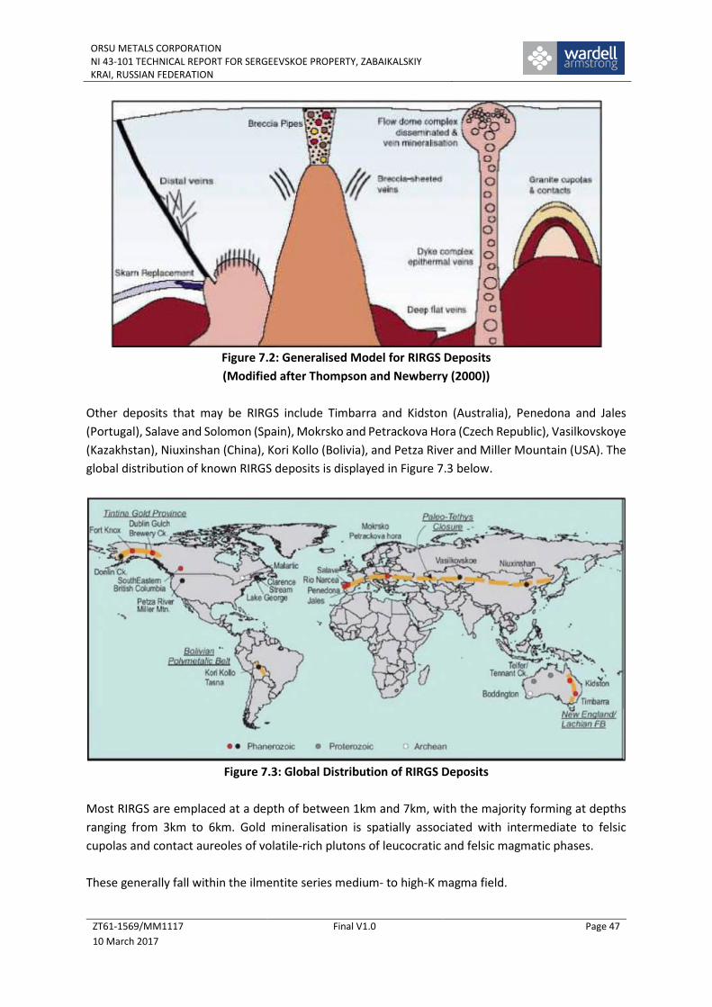
ORSU METALS CORPORATIONNI 43-101 TECHNICAL REPORT FOR SERGEEVSKOE PROPERTY, ZABAIKALSKIYKRAI, RUSSIAN FEDERATION
ZT61-1569/MM1117
10 March 2017
Final V1.0 Page 47
Figure 7.2: Generalised Model for RIRGS Deposits
(Modified after Thompson and Newberry (2000))
Other deposits that may be RIRGS include Timbarra and Kidston (Australia), Penedona and Jales
(Portugal), Salave and Solomon (Spain), Mokrsko and Petrackova Hora (Czech Republic), Vasilkovskoye
(Kazakhstan), Niuxinshan (China), Kori Kollo (Bolivia), and Petza River and Miller Mountain (USA). The
global distribution of known RIRGS deposits is displayed in Figure 7.3 below.
Figure 7.3: Global Distribution of RIRGS Deposits
Most RIRGS are emplaced at a depth of between 1km and 7km, with the majority forming at depths
ranging from 3km to 6km. Gold mineralisation is spatially associated with intermediate to felsic
cupolas and contact aureoles of volatile-rich plutons of leucocratic and felsic magmatic phases.
These generally fall within the ilmentite series medium- to high-K magma field.

ORSU METALS CORPORATIONNI 43-101 TECHNICAL REPORT FOR SERGEEVSKOE PROPERTY, ZABAIKALSKIYKRAI, RUSSIAN FEDERATION
ZT61-1569/MM1117
10 March 2017
Final V1.0 Page 48
Magnetite contents are low due to relatively low magmatic oxidation states; such conditions inhibit
early sulphide or SO2 formation, maintaining the solubility of gold in the melt fraction of the magma
until the magma is emplaced into shallow crustal levels.
RIRGS generally lack the vein stockworks characteristic of porphyry deposits due to their deeper levels
of emplacement. Fluid flow and mineralisation in most RIRGS systems is largely controlled by
structural features. The dominant structural control is arrays of parallel fractures infilled with thin
(0.1–5cm), auriferous, low-sulphide quartz veins in extensive intrusion-hosted sheeted arrays.
Melt inclusions taken from RIRGS mineralising intrusions contain gold, and are therefore suggestive
of a magmatic origin for the gold. Fluid inclusion evidence from RIRGS at shallow crustal levels (< km)
suggests a high temperature (>350°C) immiscible brines, and low-salinity CO2 vapours. At deeper
crustal levels (>5 km) the mineralising fluids are dominated by high temperature low-salinity, CO2-H2O
fluids. Isotopic data are indicative of a large crustal contamination component to the melt.
The RIRGS metal assemblage may contain high fineness Au (>700) with or without Bi, W, Mo, Te, As,
Sb, Cu, and Sn. Unlike porphyry-copper mineralisation, significant Cu is lacking. Scheelite-rich systems
(Mo-W or Sn-W) occur, but there does not appear to be a direct correlation with gold.
An overlapping metal zonation has been noted for RIRGS from the host Intrusion (Au-Bi-W-Te-Mo- As-
Cu) out through a Proximal Assemblage (Au-As-W-Sb) and a Distal Association (Au-As-Sb-Pb- Zn-Ag).
Deposits show evolution from early, high temperature magmatic stages to lower temperature
hydrothermal veins. Metal zonation occurs in response to a steep temperature and fluid chemical
gradient away from the mineralising pluton.
RIRGS consistently exhibit low sulphide contents (<5% by volume); sulphide minerals include pyrite,
arsenopyrite and pyrrhotite. RIRGS alteration mineralogy is highly variable both in style and intensity
due to the range of potential host lithologies and structural settings associated with steep
temperature and fluid chemical gradients away from the pluton.
Most notable alteration types range from potassic (K-feldspar), sodic (albite), sericitic, greisen, and
skarn. Tourmalinisation is rarely developed and trace element associations include B, F, Cs, Rb and Li.
Granites associated with RIRGS deposits exhibit subequal ratios of quartz, plagioclase and alkali
feldspar. Biotite is the dominant mafic mineral with lesser amounts of hornblende and pyroxene.
Associated with the intrusions are dykes of aplite and pegmatite, together with more mafic phases
such as lamprophyres. Pluton characteristics indicate high volatile contents, which are identified by
unidirectional solidification textures, miarolitic cavities, tourmaline veins, and greisen alteration.
RIRGS associated granitoids exhibit low aeromagnetic and gravity response, together with low
magnetic susceptibility readings. Elevated K and U signatures are characteristically associated with
highly fractionated granitoids, together with Th anomalies in metaluminous I-type granitoids.

ORSU METALS CORPORATIONNI 43-101 TECHNICAL REPORT FOR SERGEEVSKOE PROPERTY, ZABAIKALSKIYKRAI, RUSSIAN FEDERATION
ZT61-1569/MM1117
10 March 2017
Final V1.0 Page 49
8 EXPLORATION
To date, Orsu has done very limited work on site which has been restricted to some re-survey work
and grab sampling from selected trench intersections.
In 2016, Hand held GPS devices (with an 8m accuracy) were used to check the location of the historical
trenches. Several trenches with significant mineralised intercepts as shown on historical maps were
then selected for field inspection and grab sampling. The grab samples were then delivered to the SGS
Vostok laboratory for assaying (Table 8.1). In total, some forty-one samples (plus one laboratory and
two field duplicates) were collected from the Sergeevskoe area.
Table 8.1: Orsu Exploration ResultsSample # Easting Northing Au, g/t Ag, g/t
1 20659375 5937084 0.58 2
2 20659377 5937090 0.3 1
3 20659486 5937157 0.21 1.8
4 20659486 5937157 0.22 1.7
5 20659486 5937157 0.21 0.9
6 20659500 5937139 14.5 7.2
7 20659569 5937158 0.51 2
8 20659569 5937152 0.26 0.7
9 20659410 5937100 2.24 1.8
10 20659410 5937100 0.69 0.8
11 20659442 5937091 0.27 0.15
12 20659442 5937091 0.78 0.6
13 20659563 5937069 1.5 1.7
14 20659560 5937052 0.92 0.5
15 20659542 5936742 0.33 0.8
16 20659006 5936595 0.15 1.5
17 20659007 5936603 0.1 0.4
18 20659008 5936626 0.34 26.1
19 20659008 5936626 0.71 14.3
20 20659723 5936455 0.46 2.6
21 20659723 5936455 0.23 0.15
22 20659723 5936455 11.3 4.7
23 20660240 5936872 0.26 0.6
24 20660240 5936872 0.16 0.4
K-1 20659603 5938257 0.18 3
K-2 20659577 5938279 1.17 1.3
Ser-01 20659514 5936482 5.69 3.1
Ser-02 20659523 5936561 0.42 1.7
Ser-03 20659525 5936578 0.53 3.2
Ser-03 20659525 5936578 0.55 3.1
Ser-04 20659542 5936693 0.08 1.3
Ser-05 20659536 5936718 0.04 0.4
Ser-06 20659535 5936783 0.21 0.4
Ser-07 20659542 5936860 1.60 11.4
Ser-08 20659565 5936975 0.16 1.6
Ser-09 20659552 5937032 0.34 3.8
Ser-10 20659562 5937109 0.07 <0.3
Ser-11 20659564 5937145 0.18 0.5
Ser-12 20659751 5937014 0.35 1.2
Ser-13/28 20659529 5937078 1.25 2.7
Ser-TR 20659072 5937108 0.58 3.4
Ser-14 20659456 5938057 0.40 1.2

ORSU METALS CORPORATIONNI 43-101 TECHNICAL REPORT FOR SERGEEVSKOE PROPERTY, ZABAIKALSKIYKRAI, RUSSIAN FEDERATION
ZT61-1569/MM1117
10 March 2017
Final V1.0 Page 50
As samples were collected from poorly preserved trenches, they largely represent the randomly
available material and cannot be treated as representative material.
Furthermore, the samples were not collected using any specific spacing or density, although most
samples were collected from the historical trench K-679, one of the longest historical trenches which
exhibits several mineralised intervals across both Zone 23 and Kozie occurrences.
The samples were assayed using standard fire assay technique for gold and atomic absorption for
silver at the SGS Vostok Limited laboratory, which is independent from Orsu.
However, it should be noted that the grab samples are not representative and can be used only as an
indication for the presence of gold and silver mineralisation in the Sergeevskoe license area. As such,
Orsu is treating the assay results shown in Table 8.1 as indicative for the presence of gold
mineralisation, although further verification works are required.

ORSU METALS CORPORATIONNI 43-101 TECHNICAL REPORT FOR SERGEEVSKOE PROPERTY, ZABAIKALSKIYKRAI, RUSSIAN FEDERATION
ZT61-1569/MM1117
10 March 2017
Final V1.0 Page 51
9 DRILLING
As the majority of drill holes at the site are more than 50 years old, little reliance should be placed on
the absolute values indicated by the holes, particularly with the knowledge that the holes generally
had very poor core recovery.
No further information is available about the techniques used, nor is there any remaining core on
which to pass comment.

ORSU METALS CORPORATIONNI 43-101 TECHNICAL REPORT FOR SERGEEVSKOE PROPERTY, ZABAIKALSKIYKRAI, RUSSIAN FEDERATION
ZT61-1569/MM1117
10 March 2017
Final V1.0 Page 52
10 SAMPLE PREPARATION, ANALYSES AND SECURITY
Due to the historical nature of the data, no information is available other than to say that sample
preparation, analysis and security would have been undertaken following stringent Soviet protocols
which were common across the whole FSU.

ORSU METALS CORPORATIONNI 43-101 TECHNICAL REPORT FOR SERGEEVSKOE PROPERTY, ZABAIKALSKIYKRAI, RUSSIAN FEDERATION
ZT61-1569/MM1117
10 March 2017
Final V1.0 Page 53
11 DATA VERIFICATION
The Sergeevskoe property was recently acquired by Orsu, primarily on the basis of the location of the
area immediately to the west of the historically important large Kluchevskoe gold deposit which is
currently being re-evaluated by a consortium of companies.
Therefore, at the time of the visit, Orsu had yet to undertake any physical exploration, and historic
trenches were in a poor condition and snow filled. Thus, the author had no opportunity to collect any
direct samples for data verification purposes.
However, as part of the site visit, the author was able to follow a number of trenches, identify the
location of boreholes and collapsed shafts.
In detail, this involved identification of the collar of hole C222A at Zone 23 (Figure 5.7) which lies in
the western part of the area, then following trench K996 north into the Kozie area to drill hole C237
(Figure 6.5). Close to here, C238 collar was also observed.
Walking eastwards, many trenches were identified as well as the site of hole C141, Shaft 29, C139,
C140 and Shaft 28 and C142 (Figure 6.5).
Turning south, and returning down slope, hole C215 collar was observed in the heart of Zone 23
occurrence (Figure 5.7).
Therefore, the author can, to a large extent, verify the positions of the historic trenching and drilling
undertaken at Sergeevskoye.

ORSU METALS CORPORATIONNI 43-101 TECHNICAL REPORT FOR SERGEEVSKOE PROPERTY, ZABAIKALSKIYKRAI, RUSSIAN FEDERATION
ZT61-1569/MM1117
10 March 2017
Final V1.0 Page 54
12 MINERAL PROCESSING AND METALLURGICAL TESTING
Although no data are available at this time, Orsu will be concentrating efforts to define oxide gold
mineralisation that may be amenable to heap leach processing.

ORSU METALS CORPORATIONNI 43-101 TECHNICAL REPORT FOR SERGEEVSKOE PROPERTY, ZABAIKALSKIYKRAI, RUSSIAN FEDERATION
ZT61-1569/MM1117
10 March 2017
Final V1.0 Page 55
13 MINERAL RESOURCE ESTIMATES
The Sergeevskoe property is an early-stage exploration prospect, and as such, no Mineral Resources
have been defined at this time.

ORSU METALS CORPORATIONNI 43-101 TECHNICAL REPORT FOR SERGEEVSKOE PROPERTY, ZABAIKALSKIYKRAI, RUSSIAN FEDERATION
ZT61-1569/MM1117
10 March 2017
Final V1.0 Page 56
14 MINERAL RESERVE ESTIMATES
The Sergeevskoe property is an early-stage exploration prospect, and as such, no Mineral Reserves
have been defined at this time.

ORSU METALS CORPORATIONNI 43-101 TECHNICAL REPORT FOR SERGEEVSKOE PROPERTY, ZABAIKALSKIYKRAI, RUSSIAN FEDERATION
ZT61-1569/MM1117
10 March 2017
Final V1.0 Page 57
15 MINING METHODS
Sergeevskoe is not an advanced property, and therefore this section does not apply.

ORSU METALS CORPORATIONNI 43-101 TECHNICAL REPORT FOR SERGEEVSKOE PROPERTY, ZABAIKALSKIYKRAI, RUSSIAN FEDERATION
ZT61-1569/MM1117
10 March 2017
Final V1.0 Page 58
16 RECOVERY METHODS
Sergeevskoe is not an advanced property, and therefore this section does not apply.

ORSU METALS CORPORATIONNI 43-101 TECHNICAL REPORT FOR SERGEEVSKOE PROPERTY, ZABAIKALSKIYKRAI, RUSSIAN FEDERATION
ZT61-1569/MM1117
10 March 2017
Final V1.0 Page 59
17 PROJECT INFRASTRUCTURE
Sergeevskoe is not an advanced property, and therefore this section does not apply.

ORSU METALS CORPORATIONNI 43-101 TECHNICAL REPORT FOR SERGEEVSKOE PROPERTY, ZABAIKALSKIYKRAI, RUSSIAN FEDERATION
ZT61-1569/MM1117
10 March 2017
Final V1.0 Page 60
18 MARKET STUDIES AND CONTRACTS
Sergeevskoe is not an advanced property, and therefore this section does not apply.

ORSU METALS CORPORATIONNI 43-101 TECHNICAL REPORT FOR SERGEEVSKOE PROPERTY, ZABAIKALSKIYKRAI, RUSSIAN FEDERATION
ZT61-1569/MM1117
10 March 2017
Final V1.0 Page 61
19 ENVIRONMENTAL STUDIES, PERMITTING AND SOCIAL OR COMMUNITY IMPACT
To the best of our knowledge, WAI believes that Orsu are in compliance with local environmental and
social protocols.
WAI is aware that the company is waiting for a Forestry License to enable tree-felling as part of the
trench re-opening exercise, and a decision on this is due shortly.

ORSU METALS CORPORATIONNI 43-101 TECHNICAL REPORT FOR SERGEEVSKOE PROPERTY, ZABAIKALSKIYKRAI, RUSSIAN FEDERATION
ZT61-1569/MM1117
10 March 2017
Final V1.0 Page 62
20 CAPITAL AND OPERATING COSTS
Sergeevskoe is not an advanced property, and therefore this section does not apply.

ORSU METALS CORPORATIONNI 43-101 TECHNICAL REPORT FOR SERGEEVSKOE PROPERTY, ZABAIKALSKIYKRAI, RUSSIAN FEDERATION
ZT61-1569/MM1117
10 March 2017
Final V1.0 Page 63
21 ECONOMIC ANALYSES
Sergeevskoe is not an advanced property, and therefore this section does not apply.

ORSU METALS CORPORATIONNI 43-101 TECHNICAL REPORT FOR SERGEEVSKOE PROPERTY, ZABAIKALSKIYKRAI, RUSSIAN FEDERATION
ZT61-1569/MM1117
10 March 2017
Final V1.0 Page 64
22 ADJACENT PROPERTIES
22.1 Introduction
The following information comes from various sources including the public domain, although the
author has been unable to verify the information and that the information is not necessarily indicative
of the mineralisation on the property that is the subject of this technical report.
Sergeevskoe lies within the well-developed mining area in the Trans-Baikal region effectively
sandwiched between two significant gold assets hosting multi-million ounce deposits.
The eastern boundary of Sergeevskoe license lies immediately adjacent to the Kluchevskoe open pit
mine, which historically produced 1.3Moz of gold, whilst the recently commissioned (Dec 2014)
Alexandrovskoe gold mine, lies just to the west of the Sergeevskoe license (Figure 22.1).
Figure 22.1: Location of Adjacent Properties
22.2 The Kluchevskoe Deposit
22.2.1 Introduction
The abandoned Kluchevskoe mine is located immediately to the east of the Sergeevskoe licence area,
and it is the mineralisation extensions from this deposit that form the main target at Sergeevskoe.
The Kluchevskoe mining operations date back to the 1930s from which time open pit mining, crushing
and milling and floatation metallurgical operations were operated.

ORSU METALS CORPORATIONNI 43-101 TECHNICAL REPORT FOR SERGEEVSKOE PROPERTY, ZABAIKALSKIYKRAI, RUSSIAN FEDERATION
ZT61-1569/MM1117
10 March 2017
Final V1.0 Page 65
The village of Kluchevskoe, which is home to approximately 1,500 people, is established near the
abandoned open pit.
22.2.2 Geology & Mineralisation
The Kluchevskoye gold deposit is located within the Mogocha Mineral Field, within a major Mongol-
Okhotsk fold belt. The region predominantly comprises various intrusive granites surrounded by
metamorphic rocks. Plutons from the Middle Palaeozoic (Olekminskiy Complex), Permian (Bichurskiy
Complex) and Jurassic (Amudzhikano-Sretenskiy and Amanansky Complexes) intrude the fold belt
sediments and host a number of gold and molybdenum deposits.
Lithologies include biotitic granites, granodiorites, diorites, quartz-diorites and granitic-porphyries,
with swarms of late northwest-trending granite porphyries. Some later dolerite dykes and porphyries
have intruded the granitoid and granitic rock sequences, as illustrated in Figure 6.1.
At Kluchevskoye, the granitoid complexes are located adjacent to a marked flexure (dilational jog) in
the regional east-west trending “Latitudinal Fault”, a segment of the regional Mogocha-Bushuleysk
Fault Zone, marking the contact between Proterozoic and Mesozoic granitoids. The Kluchevskoye-
Davenda deposit cluster is hosted by the Davenda granite massif which has a strike length of 50km
and a width of 2-3km.
Gold and molybdenum mineralisation is related with the porphyry intrusions of Amudzhikano-
Sretenskiy complex and associated with the endocontact and exocontact zones of the Davenda massif.
There are seven deposits and several other occurrences of gold, molybdenum or copper
mineralisation, the most important being the Kluchevskoye and Alexandrovskoye gold deposits, and
the mined out Davenda molybdenum deposit.
22.2.3 Historic Production
The Kluchevskoye deposit has had a long history of mining and a summary of the production data is
given in Table 22.1 below.
However, over and above the reserves produced from Kluchevskoye, the deposit also still contains
significant resources which have formed the target of recent interest at the deposit, culminating in
the proposed deal signed October 16th 2016 (see below).
22.2.4 Current Status
Five players from BRICS nations have signed an agreement to develop the Kluchevskoye gold deposit
at a pre-production investment of US$400-500M.
The five players are SUN Gold Ltd, China National Gold Group Corp (China National Gold or CG), the
Russian Sovereign Investment Fund, Far East and Baikal Region Development Fund (FEDF), and

ORSU METALS CORPORATIONNI 43-101 TECHNICAL REPORT FOR SERGEEVSKOE PROPERTY, ZABAIKALSKIYKRAI, RUSSIAN FEDERATION
ZT61-1569/MM1117
10 March 2017
Final V1.0 Page 66
partners from Brazil and South Africa, SUN Gold said in a statement. The project, in the mining sector,
is the first BRICS investment project.
Table 22.1:Recorded Historical Production from Kluchevskoye
YearTonnage
(kt)Grade
(g/t Au)Au(oz)
1936-1976 8,130 3.65 954,057
1977 246 1.94 15,344
1978 322 1.86 19,256
1979 1,469 2.24 105,764
1980 1,002 2.25 72,484
1981 626 2.20 44,278
1982 238 1.79 13,697
1983 390 1.73 21,692
1894 279 1.77 15,877
1985 198 1.72 10,949
1986 164 1.46 7,698
1987 166 1.75 9,340
1988 239 1.95 14,984
1989 251 1.57 12,670
1990 332 1.55 16,545
1991 345 1.46 16,194
1992 308 1.58 15,646
1993 272 1.43 12,505
1994 355 1.59 18,147
1995 122 1.61 6,315
1996 34 1.56 1,705
1997 44 0.64 905
2000 170 1.49 8,144
2001 184 1.83 10,826
2002 81 1.15 2,995
Total from 1977-2002 7,837 1.88 473,965
Project Total 1936-2002 15,967 2.78 1,427,116
According to the feasibility study completed by Changchun Gold Design Institute, the proposed joint
venture aims to develop the Kluchevskoye gold deposit into a significant open pit mine and heap leach
operation with an expected production rate of 12 million tonnes of ore per year and gold doré
production of over 6.5 tonnes per annum. The pre-production investment is expected to be US$400-
500M.
22.3 The Alexandrovka Project
22.3.1 Introduction
The information herein is sourced from the Zapadnaya Gold Mining website
(http://www.zapadnaya.com/qa/assets.html). However, it should be noted that the information

ORSU METALS CORPORATIONNI 43-101 TECHNICAL REPORT FOR SERGEEVSKOE PROPERTY, ZABAIKALSKIYKRAI, RUSSIAN FEDERATION
ZT61-1569/MM1117
10 March 2017
Final V1.0 Page 67
presented here is not necessarily indicative of the mineralisation at Sergeevskoye that is the subject
of this technical report.
The Alexandrovka deposit is a large scale developing project which lies immediately to the west of the
Sergeevskoe licence (Photo 22.1).
Photo 22.1: The Alexandrovka Project Area (Zapadnaya, 2016)
In 2011, geological exploration works were completed at the Alexandrovka deposit, a report with
reserves calculation was prepared and a final mining feasibility study was done.
By the end of 2012, by Protocol No.2853 of State reserves committee, reserves at Alexandrovka gold
ore deposit were approved, amounting to approximately 7.9Mt (С1+С2), equivalent to around 24t of
Au. In addition, resources at Alexandrovskoye are estimated to be more than 2 million ounces of gold.
In 2013, State expertise approval for the ore processing plant was obtained, and in September of that
year, the processing plant with an annual processing output of 750kt of ore was commissioned. Annual
saleable production will amount to at least 1.5t.
In the long term it is planned to increase the capacity of the ore processing plant up to 1.5 million tons
of ore per annum, and production up to at least 3 tons of gold per annum.
22.3.2 Geology & Mineralisation
The Alexandrovskoye deposit occurs in the Mogocha Mineral Field within a major tectonic early
Palaeozoic fold belt of the southwestern part of the regional Aldan-Vitim Shelf.
Jurassic plutonic complexes intrude the fold belt sediments and host gold and molybdenum deposits.
They comprise biotitic granites, granodiorites, diorites, quartz-diorites and granitic-porphyries. A

ORSU METALS CORPORATIONNI 43-101 TECHNICAL REPORT FOR SERGEEVSKOE PROPERTY, ZABAIKALSKIYKRAI, RUSSIAN FEDERATION
ZT61-1569/MM1117
10 March 2017
Final V1.0 Page 68
swarm of northwest trending later granite porphyries occur in the eastern parts of the Mineral Field.
Some later dolerite dykes and porphyries have intruded the granitoid and granitic rock sequences.
The mineralisation is associated with a 3km long, northwest striking fault (the Main Fault), a second
order structure (the Alexandrovskoye Fault) and smaller, third order structures that are part of the
same fault system as the two larger faults.
Gold mineralisation at Alexandrovskoye occurs as pyritic quartz veins and quartz stockworks hosted
in coarse-grained biotite granites and dark green diorites. The quartz veins are surrounded by a halo
of intense quartz-sericite alteration. The quartz veins are structurally controlled, occurring in two NNE
striking zones (Eastern and Western) that are in second and third order splays off the main meridional
structure (the Main Fault).
More than 20 separate lodes and five stockworks have been interpreted. The mineralised lodes range
from 15m to 150m in strike length, and vary from 2m to 10m thick.
The strike extent of the lodes varies from 10-15m to almost 150m, with at least five lenses exceeding
100m. The quartz veins average 1.2m thick, and are surrounded by haloes of intense alteration
accompanied by bleaching of the host rock.

ORSU METALS CORPORATIONNI 43-101 TECHNICAL REPORT FOR SERGEEVSKOE PROPERTY, ZABAIKALSKIYKRAI, RUSSIAN FEDERATION
ZT61-1569/MM1117
10 March 2017
Final V1.0 Page 69
23 OTHER RELEVANT DATA AND INFORMATION
No other relevant data are available.

ORSU METALS CORPORATIONNI 43-101 TECHNICAL REPORT FOR SERGEEVSKOE PROPERTY, ZABAIKALSKIYKRAI, RUSSIAN FEDERATION
ZT61-1569/MM1117
10 March 2017
Final V1.0 Page 70
24 INTERPRETATION AND CONCLUSIONS
The Sergeevskoe license lies immediately to the west of the historic Kluchevskoye open pit gold mine
which has produced well over 1Moz Au and has resource potential of several million ounces gold (WAI
Technical Report) and which is now the focus of a BRICS consortium looking to re-start the project.
Furthermore, to the west of Sergeevskoe, lies the recently opened Alexandrovskoe open pit gold mine.
Although the similarity and direct connection to the large Kluchevskoye deposit immediately to the
east remains unproven at this time, results from historic exploration and recent Orsu check sampling
has shown that the potential of the Sergeevskoe area remains promising for further gold discoveries,
although the information is not necessarily indicative of the mineralisation on the property that is the
subject of the technical report.
This statement is corroborated by the fact that the major ore-controlling faults at Kluchevskoye pass
westwards into the Sergeevskoe license and it is clear that the mineralising structures that were mined
at Kluchevskoye are continuous to a greater or lesser extent into the Sergeevskoe area.
To date, historic Soviet work, done at a similar time as the Kluchevskoye deposit was being developed,
has identified a number of gold occurrences in the Sergeevskoe license, but only from relatively limited
exploration data comprising primarily trenching and limited drilling with associated geochemistry and
geophysics.
However, due to the age of the data (often more than 50 years old), little reliance can be placed on
the absolute values seen from trenches, outcrops and drillholes, although the structures and
lithologies defined by the work hold good to this day.
Thus, Orsu has possession of a highly attractive exploration license containing many of the structural,
mineralogical and lithological controls as are seen at Kluchevskoye, but with the added advantage of
a number of drill-ready targets.
It is likely that some of these will be mineralised extensions from ore zones mined at the western end
of the Kluchevskoye pit, whilst others might represent faulted continuation of the same Kluchevskoye
system. Either way, the magnitude of the Kluchevskoye body should not be underestimated and as
such, Sergeevskoe presents an excellent opportunity to develop near surface oxide mineralisation
with the possibility of later deeper primary mineralisation development.
In summary, although knowledge on the Sergeevskoe property is limited at this time, results are
encouraging and some drill targets are identified. The primary risk to the Project relates to the inability
to define a sufficient economically viable target suitable for open pit mining, although the potential
for more limited underground extraction should not be discounted at this time.

ORSU METALS CORPORATIONNI 43-101 TECHNICAL REPORT FOR SERGEEVSKOE PROPERTY, ZABAIKALSKIYKRAI, RUSSIAN FEDERATION
ZT61-1569/MM1117
10 March 2017
Final V1.0 Page 71
25 RECOMMENDATIONS
25.1 Introduction
Given the preliminary nature of the exploration works at Sergeevskoe, WAI supports the Company’s
plan to minimise the initial efforts during the winter months.
Therefore, WAI recommends that the Company:
Undertakes a license-wide ground magnetics survey to better define the structure and
metallogeny of the area;
Re-open a number of historic trenches at Zone 23 and Kozie;
Instigate a modest exploration drilling programme to define an Inferred resource at Zone 23
and to better define the target at Kozie;
Re-survey all historic trenches, drillholes and shafts;
Collect samples for preliminary metallurgical testwork; and
Proceed at an early stage to a Scoping Study to define the economic potential of the license
area.
25.2 Budget and Work Programme
25.2.1 Work Programme
Moving forward, Orsu plans to undertake further trenching and limited drilling during the next few
months, concentrated over the Kozie and Zone 23 areas, to better define the mineralised targets, and
in particular test the near surface oxide portions of the mineralisation.
In addition, Orsu is about to start a ground magnetics survey across the whole license, based on north-
south lines, 50m apart. This work is expected to take approximately 3 weeks.
More specifically, at Zone 23, Orsu plan to re-open K679 and sample the southern 400m of the trench
which hosted the historical best intersections, 250m of the southern end of K684 will be re-opened as
well as the central part (200m) of K996. At this time, due to the constraints of operating in winter, the
western trench (K697) will be left.
Samples will be sent to SGS laboratories in Chita and initial assays are expected in first half of 2017.
Assuming the results are successful, a modest 3,000m drill campaign will be instigated, including two
twin holes.
The main programme will have two holes per fence, with fences 100m apart which combined with the
trench data will be sufficient to demonstrate mineralisation continuity for Inferred resources.
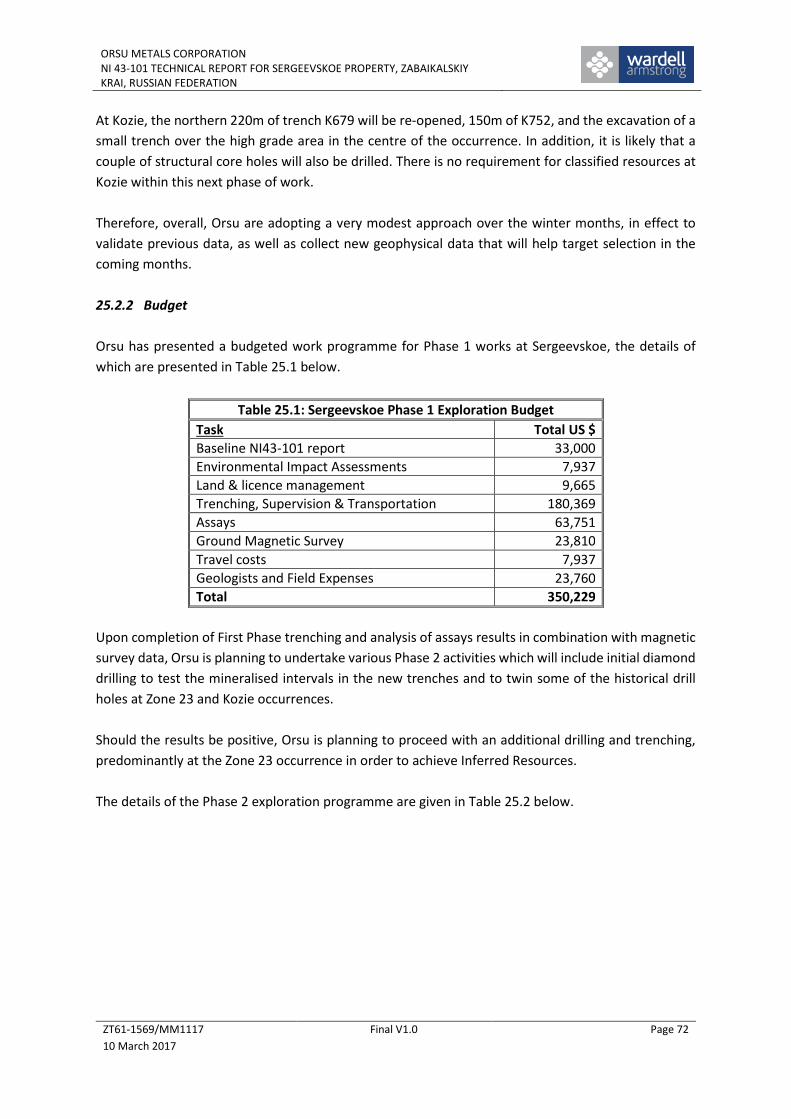
ORSU METALS CORPORATIONNI 43-101 TECHNICAL REPORT FOR SERGEEVSKOE PROPERTY, ZABAIKALSKIYKRAI, RUSSIAN FEDERATION
ZT61-1569/MM1117
10 March 2017
Final V1.0 Page 72
At Kozie, the northern 220m of trench K679 will be re-opened, 150m of K752, and the excavation of a
small trench over the high grade area in the centre of the occurrence. In addition, it is likely that a
couple of structural core holes will also be drilled. There is no requirement for classified resources at
Kozie within this next phase of work.
Therefore, overall, Orsu are adopting a very modest approach over the winter months, in effect to
validate previous data, as well as collect new geophysical data that will help target selection in the
coming months.
25.2.2 Budget
Orsu has presented a budgeted work programme for Phase 1 works at Sergeevskoe, the details of
which are presented in Table 25.1 below.
Table 25.1: Sergeevskoe Phase 1 Exploration Budget
Task Total US $
Baseline NI43-101 report 33,000
Environmental Impact Assessments 7,937
Land & licence management 9,665
Trenching, Supervision & Transportation 180,369
Assays 63,751
Ground Magnetic Survey 23,810
Travel costs 7,937
Geologists and Field Expenses 23,760
Total 350,229
Upon completion of First Phase trenching and analysis of assays results in combination with magnetic
survey data, Orsu is planning to undertake various Phase 2 activities which will include initial diamond
drilling to test the mineralised intervals in the new trenches and to twin some of the historical drill
holes at Zone 23 and Kozie occurrences.
Should the results be positive, Orsu is planning to proceed with an additional drilling and trenching,
predominantly at the Zone 23 occurrence in order to achieve Inferred Resources.
The details of the Phase 2 exploration programme are given in Table 25.2 below.

ORSU METALS CORPORATIONNI 43-101 TECHNICAL REPORT FOR SERGEEVSKOE PROPERTY, ZABAIKALSKIYKRAI, RUSSIAN FEDERATION
ZT61-1569/MM1117
10 March 2017
Final V1.0 Page 73
Table 25.2: Sergeevskoe Phase 2 Exploration Budget
Task Total US $
Electric Survey 16000m $48,000
Drilling 2000m $390,000
Assays (core samples) $79,200
Trenching 6500m $200,000
Assays (channel samples) $162,800
Preliminary Metallurgical studies $60,000
Geological support, transportation& other costs $150,000
NI43-101 report with Inferred Resources $60,000
Total $1,150,000
Taken together, for 2016-17, WAI believes that the work programmes outlined will provide key data
in being able to better understand the true potential of this exciting exploration area.

ORSU METALS CORPORATIONNI 43-101 TECHNICAL REPORT FOR SERGEEVSKOE PROPERTY, ZABAIKALSKIYKRAI, RUSSIAN FEDERATION
ZT61-1569/MM1117
10 March 2017
Final V1.0 Page 74
26 REFERENCES
Litvinov, V.L., Vovchenko RG et al. Report on" Study of the distribution of minerals with the
preparation of geological descriptions of fields, assessment of their prospects and recommendations
for the direction of search and exploration of gold Davendinskogo Klyuchevskoy-node. "LLC"
ZabNTGeo "- Lviv, 1978 - 408 ."
"Литвинов В.Л., Вовченко Р.Г. и др. Отчет по теме «Изучение
закономерностей размещения полезных ископаемых с
составлением геологических описаний месторождений, оценкой
их перспективности и рекомендации по направлению поисков и
разведки Ключевско-Давендинского золоторудного узла». ООО
«ЗабНТГео» - Львов, 1978 - 408 с."
WAI report for Sun Gold, NI 43-101 Compliant Mineral Resource Estimate for the Kluchevskoye Gold
Deposit, Zabaikalsky Region, Eastern Russia, January 2014.
Title Opinion Letter to the TSX Venture Exchange, Saveliev, Batanov & Partners, November 2016.
Yazkov NM, Greshilov AS "The explanatory note to the justification of forecast resources of gold ore
Sergeyevka area (Mogochinsky District Trans-Baikal Territory)," Chita 2015.
“Язков Н.М., Грешилов А.С. «Пояснительная записка к
обоснованию прогнозных ресурсов рудного золота сергеевской
площади (Могочинский район Забайкальского края)», Чита, 2015”
Yazkov NM, Truschenko IS "Project" Search engine - evaluation work on the gold ore to ore-bearing
area Sergeyevka "Limited Liability Company" Geoekspert "Chita 2014
“Язков Н.М., Трущенко И.С. «Проект «Поисково - оценочных работ
на рудное золото на Сергеевской рудоносной площади»,
Общество с ограниченной ответственностью «Геоэксперт», Чита,
2014”
Zapadnaya Gold Mining Limited-Company Website, Main Page-Alexandrovka
(Accessed November 04, 2016, at http://www.zapadnaya.com/qa/alexandrovka.html )

APPENDIX 1: CERTIFICATE OF AUTHOR

CERTIFICATE OF AUTHOR
I, Phil Newall, BSc (ARSM), PhD (ACSM), CEng, FIMMM do hereby certify that as author of this NI 43-
101 Technical Report for the Sergeevskoe Property, Zabaikalskiy Krai, Russian Federation (“Report”),
with an effective date of 18 November 2016 and dated 10 March 2017, I hereby make the following
statements:
I am the Managing Director of: Wardell Armstrong International Ltd Baldhu House, Wheal Jane
Earth Science Park, Baldhu, Truro, Cornwall, United Kingdom TR3 6EH;
I graduated with a Bachelor Degree in Geology from Imperial College, London, UK in 1983 and
with PhD – “The use of lithogeochemistry as an exploration tool at the Redmoor sheeted vein
Sn/W complex, east Cornwall”, Camborne School of Mines in 1991;
I am a Fellow and Chartered Engineer of the Institution of Materials, Minerals & Mining;
I have practised my profession as a Mining Geologist for the past 30 years in areas of gold and
base metals evaluation in a number of countries around the world;
I have read the definition of “qualified person” set out in National Instrument 43-101 (“NI 43-
101”) and certify that I am a “qualified person” for the purposes of NI 43-101;
I take full responsibility for all of the items, “NI 43-101 Technical Report for the Sergeevskoe
Property, Zabaikalskiy Krai, Russian Federation” with and effective date of 18 November
2016 and dated 10 March 2017;
I visited the Sergeevskoe site at Kluchevskoye that is the subject of this report from 2-3rd
November 2016;
As of the effective date of this report and to the best of my knowledge, information and belief,
the Report contains all scientific and technical information that is required to be disclosed to
make the Report not misleading;
I have had no prior involvement with the Sergeevskoe Project, which is the subject of this
Report;
I am independent of Orsu Metals Corporation, LLC SC Alexandrovskoe and Sibzoloto
Investments Limited, and I have not received, nor do I expect to receive, any interest, directly
or indirectly in the Sergeevskoe Property or securities of Orsu Metals Corporation; and
I have read the instrument NI-43-101 and the 2016 Report has been prepared in compliance
with NI 43-101.
Date: 10 March 2017
Name: P Newall, BSc (ARSM), PhD (ACSM), CEng, FIMMM


![Removal of Heavy Metals (Cd, Cu, Ni) by Electrocoagulationijesd.org/vol6/630-W0028.pdf · Removal of Heavy Metals (Cd, Cu, Ni) by Electrocoagulation . ... [14] were also studied the](https://img.dokumen.tips/doc/110x75/5aa58f367f8b9a517d8d665a/removal-of-heavy-metals-cd-cu-ni-by-ele-of-heavy-metals-cd-cu-ni-by-electrocoagulation.jpg)