Embed Size (px)
Citation preview

Departament de Geodinàmica i Geofísica, Facultat de Geologia, Universitat de BarcelonaMartí i Franquès s/n, 08028 Barcelona, Spain. Santanach E-mail: [email protected]
Departament d’Estratigrafia, Paleontología i Geociències marines, Facultat de Geologia, Universitat de BarcelonaMartí i Franquès s/n, 08028 Barcelona, Spain
Origin of a restraining bend in an evolving strike-slip system:The Cenozoic As Pontes basin (NW Spain)
The As Pontes basin (12 km2), NW Iberian Peninsula, is bounded by a double restraining bend of a dextralstrike-slip fault, which is related to the western onshore end of the Pyrenean belt. Surface and subsurface dataobtained from intensive coal exploration and mining in the basin since the 1960s together with additional struc-tural and stratigraphic sequence analysis allowed us to determine the geometric relationships between tectonicstructures and stratigraphic markers. The small size of the basin and the large amount of quality data make theAs Pontes basin a unique natural laboratory for improving our understanding of the origin and evolution ofrestraining bends. The double restraining bend is the end stage of the structural evolution of a compressiveunderlapping stepover, where the basin was formed. During the first stage (stepover stage), which began ca. 30Ma ago (latest Rupelian) and lasted 3.4 My, two small isolated basins bounded by thrusts and normal faultswere formed. For 1.3 My, the strike-slip faults, which defined the stepover, grew towards each other untiljoining and forming the double restraining bend, which bounds one large As Pontes basin (transition stage).The history of the basin was controlled by the activity of the double restraining bend for a further 3.4 My(restraining bend stage) and ended in mid-Aquitanian times (ca. 22 Ma).
Strike-slip basement fault. Restraining bend basin models. Oligocene-Miocene. Iberian Peninsula.
INTRODUCTION
Uplifting and subsiding along strike-slip fault zonesdepend on the geometry of the faults, their spatialarrangement and the fault kinematics (Wilcox et al., 1973;Christie-Blick and Biddle, 1985). In accordance withtheir orientation and spatial arrangement with respect tothe general displacement direction of the blocks separatedby the fault zone, bends and stepovers in strike-slip faultzones may give rise to 1) zones with a divergence compo-
nent, resulting in subsiding areas, or 2) zones with a con-vergence component, giving rise to uplifting areas devel-oping folds and thrusts (Mann et al., 1984, 1985, Wood-cock and Fisher, 1986; Curtis, 1999). Sedimentary basinsmay form in both cases. In the former case, pull-apartbasins form in stepovers, and extensional basins developalong releasing bends. In the latter case, pop-up structurescharacterize stepovers. Restraining bends cause one blockto override the other, and sedimentary basins may developon the overridden, subsiding block (Crowell, 1976;
Geologica Acta, Vol .3 , Nº3, 2005, 225-239
Avai lable onl ine at www.geologica-acta.com
© UB-ICTJA 225
KEYWORDS
A B S T R A C T
P. SANTANACH B. FERRÚS L. CABRERA and A. SÁEZ1 1 2 2
2
1

Sylvester and Smith, 1976; Steel et al., 1985; Namsonand Davis, 1988; Mann et al., 1991).
The influence exerted by the geometry of the faults,their spatial arrangement and the fault kinematics on theevolution of strike-slip systems has been stressed by earli-er studies (Wilcox et al., 1973; Crowell, 1976; Christie-Blick and Biddle, 1985). The complexity and variety ofsituations at diverse scales resulting from the interplaybetween the faults that make up strike-slip systems washighlighted by the most prominent case studies (Crowell,1974a and b, 1976; Sylvester and Smith, 1976; Aydin andNur, 1982; Mann et al., 1983; Royden, 1985; Steel et al.,1985; Schubert, 1986; Cabrera et al., 1988; Sarewitz andLewis, 1991; Nilsen and Sylvester, 1995). As pointed outby Crowell (1974a and b), fault geometry and/or blockmotions may change during the evolution of complexstrike-slip fault zones. Therefore, the present day configu-ration of faults and their relation to the sedimentaryrecord, as observed on outcrops, do not reflect the com-plexity of their structural and sedimentary evolution.Moreover, subsurface data (i.e. well core data base, seis-mic imaging) often cannot capture the 3D complexityinherent in these systems. To overcome this disadvantage,scaled sandbox models have been employed to simulateand analyze the geometries and the progressive evolutionof these kinds of structures and associated basins (Dooleyand McClay, 1996, 1997; McClay and Bonora, 2001).
In addition, although a considerable number of verylarge to small strike-slip systems and their associatedbasins have been described in outline, there are fewdetailed descriptions of natural cases regarding the struc-tural evolution of basins in strike-slip fault zones in theliterature (Christie-Blick and Biddle, 1985; Mann et al.,1984, 1991; Sarewitz and Lewis, 1991; McBride, 1994;Miller, 1994; Curtis, 1999). The aim of this paper is topresent the structural history of the As Pontes basin and tocompare it to analogue modelling results. The As Pontesbasin formation had been attributed to the geometry of thedouble restraining bend that bounds the basin at present(Bacelar et al., 1988; Cabrera et al., 1996). However, aswill be shown, the restraining bends developed during thelater stage of the structural evolution when the basin hadundergone a long history.
GEOLOGICAL SETTING
The small As Pontes basin (12 km2) formed in a NW-SE dextral strike-slip fault zone close to A Coruña, NWIberian Peninsula, during Late Oligocene and Aquitaniantimes (Santanach et al., 1988; Huerta et al., 1997). Thisfault zone is related to the building of the Pyrenean oro-gen, which extends from Provence, SE France, to KingsTrough in the Atlantic Ocean (Fig. 1). From the Late Cre-
taceous to Early Oligocene the convergence betweenAfrica and Europe caused the collision between Iberiaand Europe resulting in the Pyrenees between France andSpain, a doubly vergent continental collision orogen. Tothe West of the Pyrenees, along the northern coast of theIberian Peninsula, the oceanic crust of the Bay of Biscaymoderately subducted below the continental Iberian plate(Muñoz, 2002). The subduction started in the Late Creta-ceous and was blocked during the Paleogene, the defor-mation being transferred to the interior of the Iberianplate. Consequently, the large basement-cored uplift ofthe Cantabrian Mountains, which constitutes the northernmargin of the Duero basin, developed because of thrust-ing over a long ramp connected to a midcrustal detach-ment (Alonso et al., 1996; Pulgar et al., 1996; 1997;1999). To the West, this structure splays out in NE-SWsinistral strike-slip faults, and conjugate NW-SE dextralstrike-slip faults are located along the coast, further to theWest. Both strike-slip systems produce N-S shorteningand E-W extension (Santanach, 1994).
A number of small sedimentary basins developedalong the aforementioned strike-slip fault zones. The AsPontes basin is located in the Pedroso-As Pontes-Moi-ñonovo fault zone (As Pontes fault zone henceforth),which extends for 55 km from the coast to Moiñonovo,attaining a maximum width of 10 km. According to Here-dia et al. (2004), the As Pontes fault zone extends furtherto the East and was responsible for significant uplift andrelief generation in its northern block.
METHODOLOGY AND DATA BASE
The study of the As Pontes basin was based on a largeamount of surface and subsurface data obtained fromintensive coal exploration and mining in the basin fromthe 1960s to the present. The exploration surveys carriedout by ENDESA Mina Puentes resulted in detailed map-ping (1/2000 to 1/5000 scale) of the Precambrian andLower Paleozoic basement outcrops and structures aroundthe mine (Fig. 2A). Coal mining in the Oligocene-LowerMiocene basin fill successions, which were exhumed inthe successive open pit trenches, also allowed a detailedmapping of the coal bearing sequences (Figs. 2B and 2C).Furthermore, approximately 1400 continuously coredexploration wells reaching the basement were drilled,forming a nearly regular square grid spaced at about 105m (Fig. 3A). ENDESA Mina Puentes has stored the dataobtained from these activities in a comprehensive data-base that includes detailed lithological and structural coredescriptions, maps and geological cross sections. Thisdatabase was complemented by additional extensivestructural and stratigraphic sequence analyses to yieldfurther insight into the relative chronological relation-ships between the major basement structures and the
Restraining bend generation in a strike-slip system (NW Spain)P. SANTANACH et al.
226Geolog ica Acta , Vo l .3 , Nº3, 2005, 225-239

Restraining bend generation in a strike-slip system (NW Spain)P. SANTANACH et al.
227Geolog ica Acta , Vo l .3 , N º3, 2005, 225-239
syntectonic, coeval, basin infill. All the available strati-graphic and structural information was used to deter-mine the geometric relationships between tectonic struc-
tures and stratigraphic markers and to perform the struc-tural analysis and basin evolution reconstruction, inclu-ding the structure kinematics.
FIGURE 1 Location and geological setting of the As Pontes basin. A) Pyrenean convergent margin stretching from SE France as far as magnetic ano-maly AM 13. B) Major tectonic characteristics of NW Iberia. C) The As Pontes strike-slip Fault Zone.

THE AS PONTES BASIN
The As Pontes basin is the largest basin in the AsPontes fault zone. It extends for 8 km in a NW-SEdirection and its width varies between 1.5 and 2.5 km(Fig. 2). The basin is asymmetric. Along its southwest-ern margin the sedimentary fill onlaps the substratum,which descends progressively towards the northwesternmargin, where the basin is bounded by two gentle dou-ble restraining bends of the main fault (Bacelar et al.,1988). The Cenozoic-basement isobath map shows thatthe basin is formed by two subbasins separated by athreshold (Fig. 4).
The basin was developed on the Variscan basementmade up of gneisses, schists, quarzites and, mainly,phyllites. This basement is characterised by a multi-
phase deformation, which shows a strongly penetra-tive cleavage dipping 40º to 70º to the NW (ArceDuarte et al., 1975; Fernández et al., 1975; Aller andBastida, 1996). The cleavage bends to a more E-Wtrend close to the main fault (Manera et al., 1979).Moreover, in this area, the basement shows a majorNNE-SSW antiform, cored by cropping out Precam-brian gneisses (Ollo de Sapo facies), that crosses thesoutheastern part of the basin and constitutes a mar-ker for the lateral displacement of the As Pontesstrike-slip fault (Fig. 4). The subcrop map of thebasin shows approximately a 1 km long dextral sepa-ration of the strongly dipping (>70º) southeasternlimb of the antiform along the main fault, the relative-ly large N-S normal faults bounding the subbasins tothe East, and a large number of small south-directedthrusts (Ferrús, 1998).
Restraining bend generation in a strike-slip system (NW Spain)P. SANTANACH et al.
228Geolog ica Acta , Vo l .3 , N º3, 2005, 225-239
FIGURE 2 Overall features of the As Pontes Basin. A) Geological map of the basement surrounding the basin and of the open-pit outcrops of the basin fillin 1997. Based and modified from mapping data provided by the Geological Office of ENDESA Mina Puentes. B) Stratigraphic panel of the basin fill sho-wing the eastern and western subbasins and the major coal-alluvial sequences. C) Synthetic stratigraphic logs of the eastern and western subbasin fillswith indication of the chronology of bottom of the coal-alluvial sequences (based on Huerta et al., 1996, 1997, and on Ferrús, 1998).

Depositional framework and Stratigraphy
Basin depositional systems
The sedimentary fill of the As Pontes basin attains athickness of 400 m in the NW corners of both subbasins.This basin fill resulted from the interplay between alluvialfan, lacustrine and marsh-swamp sedimentation, and con-sists of major siliciclastic facies assemblages, interfin-gered with significant brown coal seams and minor car-bonate deposits. Several lithostratigraphic (Bacelar et al.,1988; Cabrera et al. 1995, 1996; Ferrús, 1998; Fig. 2),biostratigraphic (López et al., 1993; Cabrera et al., 1994)and magnetostratigraphic (Huerta et al., 1996, 1997) stu-dies have enabled detailed stratigraphic subdivision andaccurate dating of the basin fill (Ferrús, 1998).
Mainly mudstone, minor sandstone and very minorconglomerate make up the alluvial fan successions. Thewidespread mudstone and sandy mudstone facies indicatethat these systems were fed predominantly by finegrained sediments owing to the rock composition of thecatchment (major phyllites and schists and minorquartzites and gneisses; Barsó et al., 2000, 2003; Sáez etal., 2003). The textural and sedimentological features ofthese alluvial fine-grained facies indicate that mud flowsand more diluted, concentrated flash flows were the main
depositional processes on the fan surfaces. More dilutedaqueous flows (e.g. sheet flows, channelized flows)resulting in water laid sand-dominated deposits weremore restricted.
The lacustrine assemblages attained their maximumdevelopment in the eastern basin zones, in the earlier stagesof the basin evolution, and consist of cyclically arrangedshallow lacustrine mudstones and carbonates, and deeperlacustrine laminated mudstones and carbonate-clay rhyth-mites (Cabrera et al., 1995; Sáez and Cabrera, 2002).
The brown coal and coaly mudstone facies weredeposited in marsh-swamp zones closely related to thedistal-marginal alluvial mud flats. The coal seams and therelated coaly mudstone beds range from a few cm up toseveral tens of m in thickness and are often laterally wide-spread (from several hundred m up to a few km).
The interfingering and vertical transitions betweencoal and alluvial deposits record the settling, spreading,retreat and final obliteration of the coal generating envi-ronments. This evolution is closely related to coevalopposite alluvial fan trends of retreat and spreading,respectively (Fig. 2). Successive composite coal-alluvialsequences resulted from the spreading and retreat pulsesof the alluvial-fan systems and attained diverse thicknessand spread during the diverse evolutionary stages of thebasin. These stages resulted mainly from tectonosedimen-tary changes that modified the silicilastic sediment contri-bution and the basin subsidence rate (Ferrús, 1998).
The top of the basin fill is affected by an erosion sur-face. It has been estimated that approximately 60 m ofsediments were eroded (Ferrús, 1998).
Stratigraphic subdivision and correlation
The coal bearing basin fill has been split into 19 com-posite coal-alluvial sequences (Fig. 2C). Each sequenceincludes (1) a lower basin margin restricted alluvial fanassemblage that interfingers basinward with coal bearingand coal-dominated successions, characterised by later-ally extensive, continuous coal seams; and (2) an upperbasinward spread alluvial-fan assemblage almost exclu-sively made up of siliciclastics.
Extensive correlation surfaces are easily recognizedand traced in the inner basin zones, where coal depositsare widespread and can be used as stratigraphic markers.These correlation surfaces can be traced towards the mar-ginal basin zones, combining the use of marker beds withsequential trend analysis. Although some correlation sur-faces could not be precisely traced as far as the most mar-ginal basin zones, where coarse-grained alluvial depositsdominated, a fairly accurate correlation was obtained.
Restraining bend generation in a strike-slip system (NW Spain)P. SANTANACH et al.
229Geolog ica Acta , Vo l .3 , N º3, 2005, 225-239
FIGURE 3 Distribution of the sources of available information on thestructure and stratigraphy of the As Pontes basin. A) Coal explorationand exploitation well grid. B) Structural cross sections.

Restraining bend generation in a strike-slip system (NW Spain)P. SANTANACH et al.
230Geolog ica Acta , Vo l .3 , N º3, 2005, 225-239
FIGURE 4 Sub crop map, isobath (topographic, sea level datum in meters) and structural map of the As Pontes basin basement.
The dense grid of exploration wells together with theoccurrence of the laterally extensive coals and coaly mud-stones enables us to obtain a fairly precise stratigraphiccorrelation from the inner to the marginal basin zones(Figs. 2B, 2C and 3A). Likewise, it is possible to deter-mine the geometric relationships between the basementtectonic structures and the stratigraphic markers. More-over, the available lithostratigraphic (Bacelar et al., 1988;Cabrera et al., 1995, 1996; Ferrús, 1998) and magne-tostratigraphic data (Huerta et al., 1996, 1997) indicatethat the correlation surfaces are isochronous or nearlyisochronous (Ferrús, 1998). Thus, the As Pontes basinconstitutes a unique natural laboratory for improving ourunderstanding of the kinematic evolution of a strike-sliprestraining bend basin, from the nucleation of its earlieststructures until its mature stages.
Structure
The As Pontes basin is characterised by the coeval gen-eration of compressive and extensional structures during itsearly structural history. The most conspicuous structure isthe strike-slip fault, whose two gentle double restrainingbends bound the basin to the NE. This fault has an impor-tant thrust component to the N of both sub-basins, wherethe fault has an E-W orientation. A system of south-direct-ed thrusts affects the northern margin of each subbasin.N-S trending normal faults define the eastern limits of thesubbasins. This structural assemblage is consistent withN-S shortening and E-W extension.
A number of structural cross-sections forming anorthogonal net were drawn to study the compressivestructure of the northern margins and the normal faultsthat define both subbasins (Ferrús, 1998). One set of sec-tions is parallel to the shortening direction (approximatelyN-S) and the other one is parallel to the extension direc-tion (approximately E-W). Some of these sections willsuffice to illustrate the main characteristics of the AsPontes basin structure (Fig. 3B).
Sedimentary evidence of tectonic activity
Owing to its syntectonic character, the As Pontesbasin fill was deeply affected by the evolution of thebasin-related tectonic structures. As a consequence, thecoal-alluvial sequences display significant changes inthickness and lateral spreading and show different rela-tionships with the tectonic structures. This enables us todate and determine the evolution of these basement struc-tures. The following criteria have been useful to establishthe structural history of the basin.
1) Increasing thickness towards a fault provides evi-dence of the activity of this fault during sedimentation.The most prominent case of the thickness changes isthe one observed between sequences 1 and 10 (Figs.5A and 5B). The basin fill thickness increases east-ward, towards the N-S normal faults and wedges west-ward and southward with the development of an exten-sive basement onlap. This is mainly due to the activity

Restraining bend generation in a strike-slip system (NW Spain)P. SANTANACH et al.
231Geolog ica Acta , Vo l .3 , N º3, 2005, 225-239
FIGURE 5 Cross sections showing the main normal faults in the As Pontes basin and their relationships with the main stratigraphic markers A) Cross-section 6-2. B) Cross-section 7 (see Fig. 3 for location).
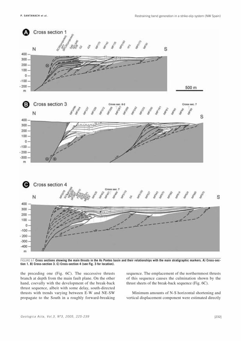
of the N-S normal faults, which tilted the basement inboth subbasins. Albeit with less intensity, the thicknessof the low basin fill increases towards the E-W thrusts(Figs. 6A to 6C), confirming the coeval activity ofthese thrusts and the normal faults. As a result, themaximum sediment thickness occurs at the toe of thenorthern ends of the normal faults, near their conver-gence with the E-W thrusts.
2) Very subtle thickness changes related to the deve-lopment of small growth strata systems reveal the devel-opment of local structural culminations caused by thrustslocated in the subbasins, resulting in supra-attenuatedfolds (central part of Fig. 6C).
3) Onlapping and overlapping the reliefs created bythe faults and the sealing of these faults by the coal-allu-vial sequences yield evidence of the cessation of faultactivity. The N-S normal faults were completely over-lapped by the basin infill during sedimentation ofsequences 11 to 13 (Fig. 5). The onlapping-overlapping ofthe E-W thrust to the North of the subbasins show thatthey became inactive following a hindward sequence (seesouthern part of cross-section 3 and northern part ofcross-section 4; Figs. 6A to 6C).
The thrusts
The thrust systems located to the North of bothsubbasins show similar geometry, despite their separatedevelopment (Fig. 6). To the West of each system, wherethe thrust trend is close to E-W, the thrust angle is low,and the N-S horizontal shortening produced by thrustingreaches the highest values (Table 1). Towards the East,their trend progressively changes to NW-SE, and thethrust-angle and the dextral component of their transportdirection increase (Ferrús, 1998). The thrust system rela-ted to the western subbasin links with the main strike-slipfault to the West, whereas the eastern one joins the mainstrike-slip fault to the East (Fig. 1C).
Both thrust systems started with the formation of amain thrust in the sense that the thrust accumulates thehighest amount of thrusting for each system (i.e. 700 mand 600 m for the western and eastern thrust systems,respectively). Starting from that thrust, two differentsequences developed. On the one hand, a number of suc-cessive thrust sheets piled up following a break-backsequence (sensu McClay, 1992). Each new thrust cutsyounger stratigraphic horizons, nucleates in the hanging-wall of the preceding thrust, and shows a higher dip than
Restraining bend generation in a strike-slip system (NW Spain)P. SANTANACH et al.
232Geolog ica Acta , Vo l .3 , N º3, 2005, 225-239
the preceding one (Fig. 6C). The successive thrustsbranch at depth from the main fault plane. On the otherhand, coevally with the development of the break-backthrust sequence, albeit with some delay, south-directedthrusts with trends varying between E-W and NE-SWpropagate to the South in a roughly forward-breaking
sequence. The emplacement of the northernmost thrustsof this sequence causes the culmination shown by thethrust sheets of the break-back sequence (Fig. 6C).
Minimum amounts of N-S horizontal shortening andvertical displacement component were estimated directly
FIGURE 6 Cross sections showing the main thrusts in the As Pontes basin and their relationships with the main stratigraphic markers. A) Cross-sec-tion 1. B) Cross-section 3. C) Cross-section 4 (see Fig. 3 for location).

Restraining bend generation in a strike-slip system (NW Spain)P. SANTANACH et al.
233Geolog ica Acta , Vo l .3 , N º3, 2005, 225-239
AR
TIC
LE
IN
PR
ES
S
from the horizontal and vertical separation of the base-ment/infilling boundary for each individual thrust alongeach cross-section (Ferrús, 1998). The amount of N-Shorizontal shortening caused by the western thrust systemclearly diminishes from West (cross-section 1) to East(cross-section 3) (Table 1). The thrust system of the east-ern subbasin progressively vanishes westward in thethreshold that separates both subbasins. In this way, theN-S shortening due to thrusting is small near its westernend (cross-section 3), increases in its central part (cross-section 4), and diminishes again towards its eastern end(cross-section 5) joining the main strike-slip fault. Theamount of shortening due to the thrusts that cause the cul-mination of the back-breaking pile (cross-section 1, Fig.6A) are not included in this estimation given that no pre-cise data were available for these lower thrusts. The verti-cal component of displacement for each thrust-system isminimum where the thrusts trend E-W and maximumwhere the thrusts become parallel to the main strike-slipfault (NW-SE) and the dip of the thrust planes increases(Table 1).
Although the general thrust trend is slightly obliquewith respect to the regional trend of the pervasiveVariscan cleavage, the dip of both structures is northward,and, locally, thrusts planes coincide with the Variscancleavage. The exclusive south-vergence of the thrusts wasprobably controlled by the Variscan anisotropy.
The normal faults
The eastern border of the western subbasin is definedby only one N-S trending normal fault, which dips 60º tothe West. This fault reaches its maximum vertical dis-placement (200 m) at its northern end. The vertical dis-placement peters out towards the South. Sediments fromthe middle part of the basin fill sealed this fault when itsactivity ceased (cross-section 6-2, Fig. 5A).
The basement of the eastern subbasin is disrupted by aset of N-S normal faults, whose dips range between 60ºand 75º (cross-section 7, Fig. 5B). The vertical displace-
ment of the easternmost fault, the most prominent, isnearly 200 m, whereas the displacements of the rest of thefaults do not reach 50 m, diminishing towards the West.Some of these normal faults define small N-S orientedgrabens. These faults were active in several episodesaccording to the separations evidenced by different corre-lation horizons and by the alluvial and lacustrine faciesdistribution in the lower part of the basin fill (Sáez andCabrera, 2002). Some of these normal faults affect thewhole basin fill, whereas others are sealed by sedimentsbelonging to the lower or to the middle part of the sedi-mentary basin infill.
The double restraining bend
The double restraining bend is the most striking struc-tural feature in map view since it was the last to form. Itenvelops the whole basin along its north-eastern margin,joining the NW-SE main strike-slip fault segments thatmerge from the NW and SE ends of the basin, thus cons-tituting part of the main As Pontes fault. Along thestretches where the restraining bend trends approximatelyE-W, this main fault coincides with the uppermost thrustsof the break-back sequences related to both subbasinsdescribed above. As a result, the whole structure, themain fault and the thrust pile depict an asymmetric,south-vergent positive flower structure. The NW-SEtrending fault segment between both thrust systemscorresponds to a late short-cut, which left the western-most part of the eastern subbasin thrust system inactive.The dip of the As Pontes fault along the double restrain-ing bend is interpreted to change progressively from near-ly vertical, where its trend is NW-SE (strike-slip), toapproximately 30º N where it trends E-W (thrust).
Structural history of the basin
The integration of all the aforementioned data led tothe drawing of a series of palinspastic maps correspond-ing to most (18) of the 19 sequences that show the mainactive faults and the extension of the preserved sedimen-tary area for each sequence (Fig. 7).
The basin history began around 30 Ma ago (lateRupelian, just before the beginning of the Chattian) withthe formation of two separate small basins caused bysimilar structural associations in an underlapping stepover(Figs. 7A to 7J, stepover stage). An E-W initial thrustends to the East against a N-S fault, which acted as atransfer fault with respect to the thrusts of the hanging-wall and affected the footwall as a normal fault. To theWest, the thrust of the eastern basin vanishes gradually.There are no sufficient data to affirm that the thrust of thewestern basin was connected to the West with the NW-SEstrike-slip fault. Immediately, thrusts in break-backsequences formed at the hangingwall of the initial thrusts,
N-S shortenning Vertical displacementCross (m) (m)
section W sub-basin E sub-basin W sub-basin E sub-basin 1 1140 250 2 515 380 3 470 450 455 230 4 815 420 5 335 340
TABLE 1 Range of values for N-S horizontal shortening and for verti-cal displacement.

Restraining bend generation in a strike-slip system (NW Spain)P. SANTANACH et al.
234Geolog ica Acta , Vo l .3 , N º3, 2005, 225-239

Restraining bend generation in a strike-slip system (NW Spain)P. SANTANACH et al.
235Geolog ica Acta , Vo l .3 , N º3, 2005, 225-239
FIGURE 7 Evolution of the As Pontes basin strike-slip system duringthe stepover, transition and restraining bend stage. Note the variety ofsituations in the stepover stage as a consequence of the interplaybetween the thrusts and the normal faults. The transitional and res-training bend stages show less variety. The thrust symbols along thenorthern basin margin do not indicate the precise position of the acti-ve thrusts in each time slice, due to limitation resulting from scale.

and the normal faults grew towards the South causing thecoeval southward propagation of the subsidence. As aconsequence, positive reliefs, which fed the detritic sedi-mentation, rose to the North of the basins. The maximumsubsidence was located in the vicinity of the junctionbetween the N-S normal faults and the E-W thrusts,where the maximum deposit accumulation also occurred.The coal-alluvial sequences onlapped the Variscan base-ment towards the SW. Coevally with the break-backthrust sequence, albeit with some delay, thrusts also prop-agated towards the South in a forward breaking sequence.The emergence of some of these thrusts generated localsupra-attenuated structural culminations that gave rise tointernal basin fill unconformities (sequences 7 to 10).This structural-sedimentary pattern (two small separatebasins bounded by thrusts and normal faults) lasted untilsequence 10 (27 Ma). At 28.6 Ma (sequence 6) the nor-mal fault of the western basin owing to its southern prop-agation, reached the thrust, which bounds the easternbasin to the North. The sediments overlapped the westernpart of this thrust system. The threshold surface thatemerged between both basins gradually decreased in size.
Between 26.6 and 25.3 Ma, three coal-alluvialsequences (11 to 13) were deposited while the structuralpattern began to change (Figs. 7K to 7M, transitionstage). The large normal faults became inactive. The sedi-mentary sequences onlapped the fault scarp and the faultswere overlapped by the basin infill. The onlap of thewestern normal fault began from the North and pro-gressed southward, whereas the sealing of the eastern nor-mal fault commenced at its southern end and progressedtowards the North. At the same time, the western thrustsystem propagated to the SE, bounding the extendingbasin to the NE, and the strike-slip fault located to the SEof the As Pontes basin propagated towards the NW,damming the expanding basin to the East. The doublerestraining bend was being formed. During this time bothsubbasins coalesced, and the sedimentation area of thesingle As Pontes basin remained fairly stable.
Between 25.3 and 22(?) Ma, the late basinal history ischaracterised by the occurrence of a short-cut that linkedboth northern thrust systems (Figs. 7N to 7R, restrainingbend stage). Thus, the structural-sedimentary history ofthe earlier stepover finished with the birth of the doublerestraining bend that linked the previously separatedstrike-slip faults and made up the northern As Pontesbasin margin. The sequences 14 to 19 are thicker in thebasin zones close to the northern margin than to theSouth. The maximum basin fill thickness also occurs inthe zones situated above the intersection of the formerlyactive normal faults and the E-W thrusts. An apparentofflap of the upper coal-alluvial sequences on the under-lying basin infill seems to reveal a persistent restriction ofthe depositional area towards the northern basin margins
during this time. However, the erosional surface on top of thebasin infill and the approx 60 m missing sediments (Ferrús,1998) prevent us from determining the evolution of the sedi-mentary area during the late basin history. The thickness ofthe estimated eroded deposits on top of the coal beds ofsequence 19 would represent 0.5 Ma and, therefore, thebasin history would reach mid-Aquitanian times.
The maximum N-S shortening due to cumulativethrusting attained a minimum of 1140 m and correspondsto a shortening rate of 0.25 mm yr-1. This was achievedmainly in the stepover and the transition stages (ca. 4.5Ma). The maximum cumulative vertical displacementscaused by thrusting north of each subbasin were 455 and420 m for the western and eastern subbasins, respectively.These values give us an idea of the currently eroded posi-tive relief that rose in the compressive stepover. The 200m maximum vertical displacement along the two mainnormal faults occurred during the stepover stage (3.4 Ma),and corresponds to an average vertical slip rate of 0.06mm yr-1. The dextral displacement along the restrainingbend can be estimated at approximately 1000 m repre-senting a strike-slip rate ranging from 0.2 mm yr-1 (iftransition and restraining bed stages are considered) to0.3 mm yr-1 (if only the restraining bend stage is takeninto account). These strike-slip rate values correspond toa N-S slip-component, parallel to the thrust shorteningand of 0.1 and 0.15 mm yr-1, respectively.
CONCLUDING REMARKS
1. The small size of the As Pontes basin togetherwith the surface and subsurface data base affectingalmost the whole basin makes it an excellent natural la-boratory for determining the geometric relationshipsbetween tectonic structures and stratigraphic markers inorder to reconstruct the evolution of the structuresinvolved in the basin history.
2. The double restraining bend that bounds the AsPontes basin is the end stage of the structural evolution ofa compressive underlapping stepover, where the basinwas formed. The basin and the positive reliefs to theNorth did not result from the activity of a pre-existingdouble restraining bend along the As Pontes fault. Bycontrast, the restraining bend formed after the basin andassociated reliefs had already undergone a long structural,erosive and sedimentary history.
3. The coeval development of E-W thrusts and ortho-gonal N-S normal faults in the As Pontes underlappingstepover is related to N-S shortening and coeval E-Wextension. Thrusting was responsible for uplifting to theNorth of the basin, whereas normal faulting caused basinsubsidence. The location of the normal faults may have
Restraining bend generation in a strike-slip system (NW Spain)P. SANTANACH et al.
236Geolog ica Acta , Vo l .3 , N º3, 2005, 225-239

been determined by the overburden due to the develop-ment of the thrust imbricates. The presence of these N-Snormal faults buried by the sedimentary fill and notobservable on the surface accounts for the relative impor-tance of the basin subsidence and extension with respectto the total deformed area in a compressive stepover.
4. The asymmetry of the compressive structures -thewide, asymmetric positive flower structure with exclusivesouth vergence of thrusts- was controlled by the Variscanbasement foliation, which dips northward.
5. Two main stages, which are separated by a shorttransition, can be distinguished in the As Pontes basinevolution. a) Stepover stage. During this stage two smallbasins developed in the underlapping stepover. Bothbasins were bounded by thrusts to the north and normalfaults to the east. This stage lasted ca. 3.2 Ma. b) Transi-tion stage. For 1.3 Ma, the strike-slip faults that definedthe stepover grew towards each other and reached thethrusts, forming the double restraining bend that boundsthe single As Pontes basin with two subbasins. c)Restraining bend stage. This last stage, which is charac-terised by the activity of the double restraining bend, last-ed a minimum of 2.9 Ma. Since the eroded upper basin-fill deposits may represent 0.5 Ma history, both thestepover and the restraining bend stages probably had asimilar duration, the total history of the basin lastingapprox 8 Ma.
6. The slip-rates of the faults involved in the evolutionof the underlapping stepover of As Pontes ranges between0.2 mm yr-1 (which corresponds to the strike-slip faultduring the restraining bend stage) and a maximum of ca.0.3 mm yr-1 (which corresponds to thrusting duringstepover and transition stages, the minimum horizontalshortening being 0.25 mm yr-1).
Analogue models have simulated the earlier geome-tries and the progressive evolution of strike-slip systems(Dooley and McClay, 1996, 1997; McClay and Bonora,2001). Nevertheless, the limitations inherent in this mo-delling approach do not allow the reproduction of somesignificant aspects of the structural evolution of strike-slipsystems (e.g. previous anisotropy of the deformed rocks).Thus, well documented studies of recent and ancientcases could provide a supplementary approach since theyshow factors that are not considered in these analoguemodels. From this perspective, the As Pontes basin caseshows how difficult it can be to infer the early structuralevolution of strike-slip related structural systems fromtheir present day outcropping configuration. A compari-son between some of the results obtained from the ana-logue models by McClay and Bobora (2001) and theobservations resulting from the As Pontes case studyunderline a number of significant differences.
a) In these analogue models, base plates, which simu-late the basement, designed in such a way as to producerestraining strike-slip stepovers, form the offset fault sys-tem at the base of the model. The sedimentary cover issimulated by a homogeneous sandpack with differentcolour layers (McClay and Bonora, 2001). The experi-ments model the structures that form in the cover over anisotropic basement affected by a strike-slip fault withdiverse stepover geometries. The case of As Pontes is radi-cally different, since it shows the formation of restrainingbends starting from an underlapping stepover in a meta-morphic basement devoid of sedimentary cover, displayinga penetrative anisotropy defined by a monoclinal foliation.
b) The experiment modelling structures that form on abasement underlapping restraining stepover results in adouble-vergent pop-up structure made up of reverse-oblique faults with opposite dips giving rise to a fairlysymmetric flower structure (fig. 4 in McClay and Bonora,2001). This contrasts with the compressive end structureof As Pontes, which is a wide, asymmetric flower struc-ture, all of whose reverse and oblique-reverse faults dip inthe same direction as the regional foliation.
c) The coeval development of E-W thrusts and N-Snormal faults at As Pontes during the stepover stage hasno equivalent in the published analogue models. Like-wise, the relatively extensive subsiding areas at As Pontesrelated to normal faulting, giving rise to the basin, arealso absent in the experiments. These features indicate adeformation field with horizontal shortening and exten-sion perpendicular to the shortening. Models do not simu-late such deformation fields.
Summing up, the case of As Pontes provides newinsights into the structural evolution of intracontinentalstrike-slip systems, namely the formation of restrainingbends in basement as an evolved stage of underlappingcompressive stepovers preceded by the formation ofthrusts and normal faults. Moreover, this case study alsohighlights the importance of the pre-existing anisotropy inthe attitude of the faults that form during this process.
ACKNOWLEDGEMENTS
This research was funded by the projects CARES (BTE2001-3650), MARCONI (REN2001-1734-C03-03/MAR) and MARES3D (CGL2004-05816-C02-02/BTE) of the Spanish Ministerio deEducación y Ciencia. Logistical and financial support was alsoprovided by ENDESA Mina Puentes (Fundació Bosch i Gimpera,Project 2149). The Grup de Recerca de Qualitat Consolidat ofGeodinàmica y Anàlisi de Conques (2001 SGR 00074) also sup-ported this research. The authors are also indebted to J. Galindo,F. Salvini and E. Roca for their critical comments and suggestionson the manuscript, which helped to improve this paper.
Restraining bend generation in a strike-slip system (NW Spain)P. SANTANACH et al.
237Geolog ica Acta , Vo l .3 , N º3, 2005, 225-239

REFERENCES
Aller, J., Bastida, F., 1996. Geology of the Ollo de Sapoantiform unit to the south of the Cabo Ortegal Complex(NW Spain). Revista de la Sociedad Geológica de España,9, 83-102.
Alonso, J.L., Pulgar, J.A., García-Ramos, J.C., Barba, P., 1996.Tertiary basins and Alpine tectonics in the CantabrianMountains (NW Spain). In: Friend, P.F., Dabrio, C.J. (eds.).Tertiary basins of Spain. The stratigraphic record of crustalkinematics. Cambridge University Press, 214-227.
Arce Duarte, J.M., Fernández Tomás, J., Álvarez Menéndez,J.M., López García, M.J., Capdevila, R., 1975. MapaGeológico de España, Scale 1:50.000, segunda serie, nº 23,Puentes de García Rodríguez. Madrid, Instituto Geológico yMinero de España, Memoria explicativa, 32 pp.
Aydin, A., Nur, A., 1982. Evolution of pull-apart basins andtheir scale independence. Tectonics, 1, 91-105.
Bacelar, J., Alonso, M., Kaiser, C., Sánchez, M., Cabrera, L.,Sáez, A., Santanach, P., 1988. La cuenca terciaria de AsPontes (Galicia): su desarrollo asociado a inflexiones con-tractivas de una falla direccional. II Congreso Geológico deEspaña, Simposios, Granada, Sociedad Geológica deEspaña, 113-121.
Barsó, D., Cabrera, L., Marfil, R., Ramos, E., 2000. Evoluciónde la procedencia y redes de drenaje de la cuenca continen-tal de As Pontes. Geotemas, 1, 151-154.
Barsó, D., Cabrera, L., Marfil, R., Ramos, E., 2003. Catchmentevolution of the continental strike-slip As Pontes basin (Ter-tiary, NW Spain): constraints from the heavy mineral analy-sis. Revista de la Sociedad Geológica de España, 16, 73-89.
Cabrera, L., Roca, E., Santanach, P., 1988. Basin formation atthe end of a strike-slip fault: the Cerdanya Basin (easternPyrenees). Journal of the Geological Society of London,145, 261-268.
Cabrera, L., Jung, W., Kirchner, M., Sáez, A., 1994. Crocodilianand paleobotanical findings from Tertiary lignites of AsPontes Basin (Galicia, NW Spain). Courier Forschungsinsti-tut Senckenberg, 173, 153-165.
Cabrera, L., Hagemann, H.W., Pickel, W., Sáez, A., 1995. Thecoal bearing Cenozoic As Pontes Basin (NW Spain): Geo-logical influence on its coal characteristichs. InternationalJournal of Coal Geology, 27, 201-226.
Cabrera, L., Ferrús, B., Sáez, A., Santanach, P.F., Bacelar, J.,1996. Onshore Cenozoic strike-slip basins in NW Spain. In:Friend, P.F., Dabrio, C.J. (eds.). Tertiary basins of Spain.The stratigraphic record of crustal kinematics. Cambridge,University Press, 247-254.
Christie-Blick, N., Biddle, K., 1985. Deformation and basin for-mation along strike-slip faults. In: Biddle, K.T., Christie-Blick, N. (eds.). Strike-slip deformation, basin formation,and sedimentation. Society of Economic Paleontologists andMineralogists Special Publication, 37, 1-34.
Crowell, J.C., 1974a. Origin of late Cenozoic basins in southernCalifornia. In: Dickinson, W.R. (ed.). Tectonics and Sedi-
mentation. Society of Economic Paleontologists and Miner-alogists Special Publication, 19, 292-303.
Crowell, J.C., 1974b. Sedimentation along the San AndreasFault, California. In: Dott Jr., R.H., Shaver, R.H. (eds.).Modern and Ancient Geosynclinal Sedimentation. Societyof Economic Paleontologists and Mineralogists Special Pub-lication, 19, 292-303.
Crowell, J.C., 1976. Implications of crustal stretching and short-ening of coastal Ventura basin, California. In: Howell, D.G.(ed.). Aspects of the geologic history of the California Bor-derland. Pacific Section American Association of PetroleumGeologists Miscelaneous Publication, 24, 365-382.
Curtis, M.L., 1999. Structural and kinematic evolution of aMiocene to Recent sinistral restraining bend: the Montejuntomassif, Portugal. Journal of Structural Geology, 21, 39-54.
Dooley, T., McClay, K., 1996. Strike-slip deformation in theConfidence Hills, southern Death Valley fault zone, easternCalifornia, USA. Journal of the Geological Society of Lon-don, 153, 375-387.
Dooley, T., McClay, K., 1997. Analog modeling of pull-apartbasins. American Association of Petroleum Geologists Bul-letin, 81, 1804-1826.
Ferrús, B., 1998. Análisis de cuenca y relaciones tectónica-sedi-mentación en la cuenca de As Pontes (Galícia). Doctoralthesis, Universitat de Barcelona, 351 pp.
Fernández, F., Piera, T., Peinado, M., Menéndez, J., Gómez, J.,Capdevila, R., 1975. Mapa Geológico de España, Scale1:50.000, segunda serie, nº 22, Puentedeume. Madrid, Insti-tuto Geológico y Minero de España. Memoria explicativa,45 pp.
Heredia, N., Rodríguez-Fernández, L.R., Vegas, R., de Vicente,G., Cloething, S., Giner, J., González Casado, J.M., 2004.Cadenas cenozoicas del Noroeste peninsular. In: Vera, J.A.(ed.). Geología de España. Madrid, Sociedad Geológica deEspaña, Instituto Geológico y Minero de España, 619-621.
Huerta, A., Parés, J.M., Cabrera, L. Ferrús, B., Sáez, A., 1996. Da-tación magnetostratigráfica de la cuenca terciaria de As Pontes(Galicia, NW de España). Geogaceta 20(5), 1021-1024.
Huerta, A., Parés, J.M., Cabrera, L. Ferrús, B., Sáez, A., 1997.Magnetocronología de las sucesiones cenozoicas de la cuen-ca de As Pontes (La Coruña, Noroeste de España). ActaGeologica Hispanica, 32, 127-145.
López-Martínez, N., Fernández, M.T., Peláez, P., de la Peña,A., 1993. Estudio paleontológico en las cuencas terciariasde Galicia. Revista de la Sociedad Geológica de España,6(3-4), 19-28.
Manera, A., Barrera, J.L., Cabal, J.M., Bacelar, J., 1979. Aspec-tos geológicos de la cuenca terciaria de Puentes de GarcíaRodríguez (provincia de La Coruña). Boletín Geológico yMinero, 45, 451-461.
Mann, P., Hempton, M.R., Bradley, D.C., Burke, K., 1983.Development of pull-apart basins. The Journal of Geology,91, 529-554.
Mann, P., Burke, K., Matumoto, T., 1984. Neotectonics of the His-paniola: Plate motion, sedimentation and seismicity at a restrai-ning bend. Earth and Planetary Science Letters, 70, 311-324.
Restraining bend generation in a strike-slip system (NW Spain)P. SANTANACH et al.
238Geolog ica Acta , Vo l .3 , N º3, 2005, 225-239

Mann, P., Draper, G., Burke, K., 1985. Neotectonics of a strike-slip restraining bend system, Jamaica. In: Biddle, K.T.,Christie-Blick, N. (eds.). Strike-slip deformation, basin for-mation, and sedimentation. Society of Economic Paleonto-logists and Mineralogists Special Publication, 37, 211-226.
Mann, P., Tyburski, S.A., Rosencrantz, E., 1991. Neogene deve-lopment of the Swan Island restraining-bend complex,Caribbean Sea. Geology, 19, 823-826.
McBride, J.H., 1994. Investigating the crustal structure of astrike-slip “step-over” zone along the Great Glen fault. Tec-tonics, 13, 1150-1160.
McClay, K.R., 1992. Glossary of thrust tectonics. In: McClay,K.R. (ed.). Thrust Tectonics. London, Chapman & Hall,419-433.
McClay, K., Bonora, M., 2001. Analog models of restrainingstepovers in strike-slip fault systems. American Associationof Petroleum Geologists Bulletin, 85, 233-260.
Miller, R.B., 1994. A mid-crustal contractional stepover zone ina major strike-slip system, North Cascades, Washington.Journal of Structural Geology, 16, 47-60.
Muñoz, J., 2002. The Pyrenees. In: Gibbons, W., Moreno, T.(eds.). The Geology of Spain. London, The Gelogical Soci-ety, 370-385.
Namson, J.S., Davis, T.L., 1988. Seismically active fold andthrust belt in the San Joaquin Valley, central California.Geological Society of America Bulletin, 100, 257-273.
Nilsen, T.H., Sylvester, A.G., 1995. Strike-slip basins. In: Bus-by, C.J, Ingersoll R.V. (eds.). Tectonics of sedimentarybasins. Cambridge MA, Blackwell Science, 425-457.
Pulgar, J.A., Gallart, J., Fernández-Viejo, G., Pérez-Estaún, A.,Álvarez-Marrón, J., ESCIN Group, 1996. Seismic image ofthe Cantabrian Mountains in the western extension of thePyrenean belt from integrated reflection and refraction data.Tectonophysics, 264, 1-19.
Pulgar, J.A., Alonso, J.L., Espina, R.G., Marín, J.A., 1999. Ladeformación alpina en el basamento varisco de la Zona Can-tábrica. Trabajos de Geología, 21, 283-294.
Pulgar, J.A., Pérez-Estaún, A., Gallart, J., Álvarez-Marrón, J.,Gallastegui, J., Alonso, J.L., ESCIN Group 1995. The ESCI-N2 deep seismic reflection profile: a traverse across theCantabrian Mountains and adjacent Duero basin. Revista dela Sociedad Geológica de España, 8, 383-394.
Royden, L.H., 1985. The Vienna basin: a thin skinned pull-apartbasin. In: Biddle, K.T., Christie-Blick, N. (eds.). Strike-slipdeformation, basin formation, and sedimentation. Society ofEconomic Paleontologists and Mineralogists Special Publi-cation, 37, 319-338.
Sáez, A., Cabrera, L., 2002. Sedimentological and paleohydro-logical responses to tectonics and climate in a small, closed,lacustrine system: Oligocene As Pontes Basin (Spain). Sedi-mentology, 49, 1073-1094.
Sáez, A., Inglès, M., Cabrera, L., de las Heras, A., 2003. Tecton-ic-palaeoenvironmental forcing of clay-mineral assemblagesin nonmarine settings: the Oligocene-Miocene As PontesBasin (Spain). Sedimentary Geology, 159, 305-324.
Santanach, P., 1994. Las Cuencas Terciarias gallegas en la ter-minación occidental de los relieves pirenaicos. CuadernosLaboratorio Xeolóxico de Laxe, 19, 57-71.
Santanach, P., Baltuille, J.M., Cabrera, Ll., Monge, C., Sáez, A.,Vidal-Romaní, J.R., 1988. Cuencas terciarias gallegas rela-cionadas con corredores de fallas direccionales. II CongresoGeológico de España, Simposios, Granada, SociedadGeológica de España, 123-133.
Sarewitz, D.R., Lewis, S.D., 1991. The Marinduque intra-arcbasin, Philippines: Basin genesis and in situ ophiolite devel-opment in a strike-slip setting. Geological Society of Ameri-ca Bulletin, 103, 597-614.
Schubert, C., 1986. Origin of the Yaracuy basin, Boconó-Morónfault system, Venezuela. Neotectonics, 1, 39-50.
Steel, R., Gjelberg, J., Helland-Hansen, W., Kleinsphen, K.,Nottvedt, A., Rye-Larsen, M., 1985. The Tertiary strike-slipbasins and orogenic belt of Spitsbergen. In: Biddle, K.T.,Christie-Blick, N. (eds.). Strike-slip deformation, basin for-mation, and sedimentation. Society of Economic Paleontol-ogists and Mineralogists Special Publication, 37, 227-264.
Sylvester, A.G., Smith, R.R., 1976. Tectonic transpression andbasement-controlled deformation in San Andreas fault zone,Salton Trough, California. American Association of Petrole-um Geologists Bulletin, 60, 2081-2102.
Wilcox, R.E., Harding, T.P., Seely, D.R., 1973. Basic wrenchtectonics. American Association of Petroleum GeologistsBulletin, 57, 74-96.
Woodcock, N.H., Fisher, M., 1986. Strike-slip duplexes. Journalof Structural Geology, 8, 725-735.
Restraining bend generation in a strike-slip system (NW Spain)P. SANTANACH et al.
239Geolog ica Acta , Vo l .3 , N º3, 2005, 225-239
Manuscript received February 2005;revision accepted June 2005.


![1966-1975 [WMEAT 1966-1975 185668]](https://img.dokumen.tips/doc/110x75/577cc16d1a28aba7119302de/1966-1975-wmeat-1966-1975-185668.jpg)


