Embed Size (px)
Citation preview
ORIGIN AND EVOLUTIONOF ILLINOIS COUNTIES
I PUB 15.10:Layout 1 3/16/10 8:54 AM Page 1
1
ORIGIN AND EVOLUTIONOF ILLINOIS COUNTIES
I PUB 15.10:Layout 1 3/16/10 8:54 AM Page 1

TABLE OF CONTENTS
Introduction and History........................................................................................3
Maps ....................................................................................................................14
Present Map .........................................................................................................59
Origin of County Names .....................................................................................60
JESSE WHITE • Secretary of State
Printed by the authority of the State of Illinois. March 2010 — 1 — I Pub 15.10
2
I PUB 15.10:Layout 1 3/16/10 8:54 AM Page 2

COUNTIES OF ILLINOIS
St. Clair and Randolph as Counties of Northwest Territory
In 1784, Virginia surrendered to the general government all claims to this territory and in1787 “An Act for the government of the territory of the United States northwest of the OhioRiver” was passed by the congress sitting under the articles of confederation. Under this ordi-nance General Arthur St. Clair was appointed governor of the territory, and, in 1790, organizedby proclamation, the county of St. Clair, named in honor of himself.
To understand the boundaries defined in this and subsequent proclamations, and in earlylegislative acts setting up counties in the Northwest Territory, Indiana Territory and the terri-tory of Illinois, it is necessary to know the geographical location of a number of points notfound on modern maps of Illinois. Some of these points are:
The “Little Michilimackinack;” The Mackinaw River flowing into the Illinois four orfive miles below Pekin in Tazwell County.
“The little river above Fort Massac;” now called Massac Creek, flowing into the Ohioimmediately east of the city of Metropolis, Massac County.
“Standing Stone Forks” of the Great Miami; near the present site of the village of Lo-ramie, in the western part of Shelby County, Ohio.
“Theokiki River;” the Kankakee.“Chicago River;” the DesPlaines.“Cahokia;” the northwest part of town 1 north, 10 west, St. Clair County.“Prairie du Rocher,” near the center of town 5 south, 9 west, Randolph County.“Cave Spring” and “Sink Hole Spring;” believed to be identical and located in Monroe
County, section 10, town 4 south, range 10 west, about 9 miles south and 1 mile west of thecity of Waterloo.
“The great Cave on the Ohio;” section 13, town 12 south, 9 east of the 3rd principalmeridian, near the present village of Cave-in-Rock, Hardin County.
“The Great Kennomic,” or “Kalamik,” or Calumet;” a small stream flowing into thesouthern bend of Lake Michigan in Lake County, Indiana, about 18 miles east of the IllinoisState Line.
“Mile’s Trace;” an old road or trail from Elizabethtown to Kaskaskia, a part of whichled from the head waters of Lusk Creek northwesterly through Crab Orchard and across thewestern line of Williamson County near its northern boundary.
“Lusk Creek;” a small stream still bearing that name, emptying into the Ohio immedi-ately above the city of Golconda, Pope County.
“Gagnic Creek;” the DeGagnia, a small creek emptying into the Mississippi in town 8south, 5 west, on the present boundary line between Randolph and Jackson Counties.
“Bompass,” “ Bompast” or “Bon Pas” creek or river; a small branch of the Wabash form-ing the present boundary between Edwards and Wabash Counties.
“Boon’s Mill;” west of the center of town 7 south, 10 east of the 3rd principal meridiannear the present site of New Haven.
3
I PUB 15.10:Layout 1 3/16/10 8:54 AM Page 3

The outlines of the latter counties formed after the territory had been brought under thefederal system of surveys, with boundaries described by township and range lines, are easilytraced.
1790 — St. Clair County
April 27, 1790, Governor St. Clair issued his proclamation organizing St. Clair as acounty of the Northwest Territory. It had for its boundaries a direct line from the mouth of theLittle Mackinaw to the mouth of the Massac Creek, thence down the Ohio to the Mississippi,up the Mississippi to the mouth of the Illinois and up the Illinois to the mouth of the Mackinaw.As thus constituted the county extended nearly two hundred fifty miles from north to southwith a maximum width of about eighty miles. It embraced the territory of twenty existingcounties and fractions of eleven others. But with all this wealth of territory St. Clair was asmall county as compared with Knox, created by proclamation June 20 of the same year,which included about half of the State of Illinois, the whole of Indiana, that part of the Ohiowest of the Great Miami River, the greater part of Michigan, and a considerable part of Wis-consin as these states exist at present. Knox was organized to meet the wants of the settlementsabout Vincennes. The outlines of St. Clair and of the Illinois portion of Knox are found onMap No. 1.
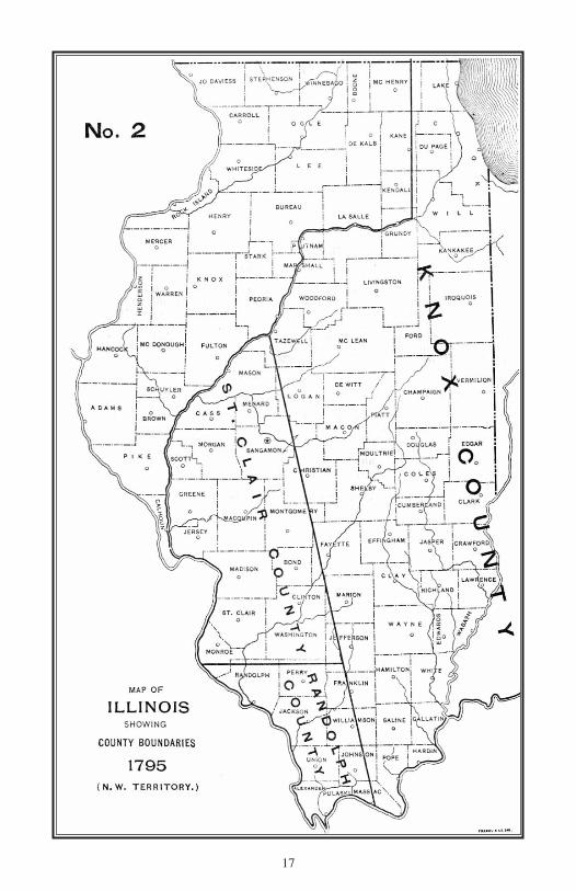
1795 — Randolph County
October 5, 1795, Randolph County was created a county of the Northwest Territory byproclamation of Governor St. Clair and included all that part of the then existing county ofSt. Clair lying south of a line running from the Mississippi directly east through “the cavespring a little south of the new Design” settlement to the boundary of Knox County. Assumingthe “cave spring” mentioned in this proclamation to be identical with the “Sink Hole Spring”of Governor Harrison’s later proclamation, this east and west line was about two miles southof the present southern boundary of St. Clair County. This division gave to Randolph aboutone-third of the territory of St. Clair as first established. These boundaries shown on Map No.2, remained unchanged until after the organization of Indiana Territory in 1800.
1801 — St. Clair and Randolph as Counties of Indiana Territory
February 9, 1801, William Henry Harrison, Governor of the Territory of Indiana, issuedhis proclamation continuing the counties of St. Clair and Randolph as counties of Indiana Ter-ritory, but changed their boundaries and enlarged their areas. The east and west line dividingSt. Clair and Randolph ran directly east from the Mississippi through the center of Sink Holespring until it intersected a line drawn directly north from the “Great Cave on the Ohio.” Thepoint of intersection of these two lines is in section 12, town 4 south, 9 east, in White Countyand was made the northeast corner of Randolph County, the eastern boundary of Randolphbeing this line north from the cave, while the Ohio and Mississippi formed the southeasternand southwestern boundaries respectively. St. Clair, as defined by this proclamation, had forits eastern boundary, a line drawn from the northeastern corner of Randolph to the “mouth ofthe Great Kennomic River,” and for its northern boundary, the Canada line. By the terms ofthis proclamation but little Illinois territory — a narrow strip along the Wabash — was left inKnox County. St. Clair contained not only the greater part of the present State of Illinois, butall of Wisconsin and a considerable part of Michigan and Minnesota as well. St. Clair andRandolph as counties of Indiana Territory are shown on Map No. 3, except the part of St. Clairextending beyond the present limits of the State.
4
I PUB 15.10:Layout 1 3/16/10 8:54 AM Page 4

1803 — St. Clair and Randolph — Boundaries Changed
In response to sundry petitions, Governor Harrison re-adjusted by proclamation of March25, 1803, the dividing line between Randolph and St. Clair. The dividing line thus establishedran from a point on the Mississippi, about four miles further south than the old boundary,northeast to Sink Hole spring; thence in a northeasterly direction till it intersected a line run-ning north from Cave-in-Rock. The point of intersection is in Jasper County, town six north,nine east of the third principal meridian, near the present site of Newton. The other boundariesof the two counties were unchanged and so remained until after the organization of the Ter-ritory of Illinois in 1809. The change of boundary is shown on Map No. 4.
1809 — St. Clair and Randolph Counties of Illinois Territory
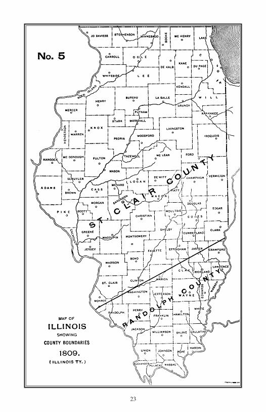
April 28, 1809, Nathaniel Pope, Secretary and Acting Governor of the new territory, is-sued his proclamation continuing St. Clair and Randolph Counties of Illinois Territory withoutchange of boundaries, except that the eastern boundary of each county was extended to theeastern boundary of Illinois Territory, now the eastern boundary of the State. This gave to Ran-dolph additional territory on the east and to St. Clair a triangular strip along the southern partand took from it a triangular strip from the northern part of its eastern side, and eliminatedKnox County from Illinois Territory. St. Clair still extended north to the Canada line. MapNo. 5 shows St. Clair and Randolph as the two original counties of Illinois Territory as re-es-tablished in 1809.
1812 — Madison, Gallatin and Johnson
September 12, 1812, by proclamation of Governor Ninian Edwards, three new counties,Madison, Gallatin and Johnson, were created. Madison included all that part of the territory ofIllinois lying north of the present southern boundary of Madison extended to the Wabash. Gal-latin was bounded on the north by this same line, on the east by the Wabash and Ohio Riversand on the west and southwest by the Big Muddy, Mile’s trace and Lusk creek. Johnson in-cluded all the territory bounded by the Big Muddy, Mississippi and Ohio Rivers, Lusk Creekand Mile’s trace. This proclamation cut St. Clair down to comparatively small dimensions andmade of it the smallest county of the Territory. These were the last counties created by procla-mation. In this year Illinois was raised to the second grade of territorial government, and thecreation of new counties and alterations of county lines devolved, thereafter, upon the TerritorialLegislature. Then outlines of these counties are shown on Map No. 6.
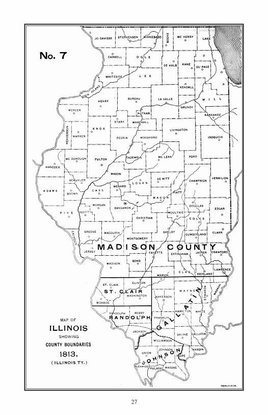
1813 — Boundaries Readjusted
December 11, 1813, two acts were passed by the first Territorial Legislature readjustingthe boundary lines of St. Clair, Randolph and Gallatin. The line running northeasterly fromSink Hole spring lost its importance as a landmark. Lines of the Federal survey had been es-tablished by this time, and the line between townships three and four south (extended from theMississippi to the third principal meridian) was made the dividing line between St. Clair andRandolph. The third principal meridian from the southern boundary of Madison to its inter-section with Mile’s trace was made the dividing line between Gallatin to the east and St. Clairand Randolph to the west. By these acts, those parts of St. Clair and Randolph east of the thirdprincipal meridian were added to Gallatin, nearly half of the remaining territory of Randolphwas added to St. Clair and a small triangle from the extreme southwestern part of St. Clair wasadded to Randolph. Madison and Johnson remained unchanged. The county boundaries estab-lished by these acts are shown on Map No. 7.
5
I PUB 15.10:Layout 1 3/16/10 8:54 AM Page 5

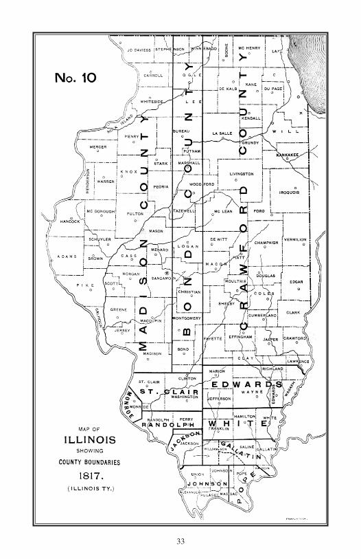
1814-1815 — Edwards and White
November 20, 1814, the Territorial Legislature passed “An Act for the division of GallatinCounty,” which act divided Madison County as well, and from the northern part of Gallatinand the part of Madison lying east of the third principal meridian, made Edwards the sixthcounty of the territory. December 9, 1815, Gallatin was further reduced by the creation ofWhite including besides the present area of White all the territory directly west of it to the thirdprincipal meridian. These two counties are shown on Map No. 8.
1816 — Monroe, Jackson, Pope and Crawford
January 16, 1816, Monroe County was created, Jackson and Pope January 10, and Craw-ford December 31, of the same year. Monroe, from St. Clair and Randolph, was given sub-stantially its present boundaries except that the eastern boundary across town three has sincebeen carried east to the Kaskaskia River. Several changes have since been made in the north-eastern and southeastern boundaries of Monroe, but all of a trifling character. Jackson, fromRandolph, included, besides its present area, the southern part of the present county of Perry.Pope, from Johnson and Gallatin, contained besides its present area, portions of the presentcounties of Massac, Johnson and Hardin. December 8 of the same year the northeasternboundary of Pope was carried east six miles, that is to a line running from the “Rock andCave” (Cave-in-Rock) on the Ohio to the southwest corner of town ten south, eight east.Crawford included all that part of the territory lying east of the third principal meridian, andnorth of the line dividing towns three and four north. The part of Johnson between Mile’strace and the third principal meridian was attached temporarily, the eastern part to Gallatinand the western part to Jackson. These changes of county lines are shown on Map No. 9.
1817 — Bond
January 4, 1817, Bond County was created, a parallelogram twenty-four miles wide fromeast to west and about 600 miles in length, reaching from a line six miles south of its presentsouthern boundary to Lake Superior on the north. The Illinois part of this county is shown onMap No. 10.
1818 — Franklin, Union and Washington
By acts of January 2, 1818, three new counties were created, the last counties of territorialorigin, Franklin included, besides its present area, all of Williamson. Union was given itspresent territory to which was temporarily attached the country lying south of it and betweenthe Mississippi and Ohio Rivers. Union was the first county of Illinois to which was given itspresent boundaries. Washington, formed from the eastern part of St. Clair, included besidesits present area, the greatest part of the present county of Clinton. Map No. 11 shows thecounties of Illinois as they existed at the close of the territorial period. The admission ofIllinois as a State in 1818 worked no change in county boundaries except that Madison, Bondand Crawford no longer extended north to the Canada line, but had for their northern limitthe present northern boundary of the State.
1819 — Alexander, Clark, Jefferson and Wayne
The second session of the first General Assembly of the State created four new counties,Alexander, Clark, Jefferson and Wayne. Alexander (March 4) from unorganized territory southof Union, included besides its present area, a portion of Pulaski, Clark, (March 22) from thenorth part of Crawford, extended from the third principal meridian to the Indiana state line andfrom the present southern county boundary to the Wisconsin state line on the north. Jefferson,
6
I PUB 15.10:Layout 1 3/16/10 8:54 AM Page 6
(March 26) from Edwards and White, included besides its present area, the greater part of Mar-ion. Wayne, (March 26) from Edwards, contained its present territory together with the southernpart of Clay and the western part of Richland. Map No. 12 shows the county boundaries asthey existed at the close of the first General Assembly of the State.
1821 — Lawrence, Greene, Sangamon, Pike, Hamilton and Montgomery
In 1821, six new counties were created. Lawrence, (January 16) from Crawford and Ed-wards, included, besides its present area, the greater part of Richland just west of it. Greene,(January 20) from Madison, included, besides its present area, that of Jersey. The unorganizedterritory to the north and east of Greene was temporarily attached to it. Sangamon, (January30) from Madison and Bond, included, besides its present area, all of the existing counties ofCass, Menard, Logan, Mason, Tazewell and parts of Christian, Macon, McLean, Woodford,Marshall and Putnam. Pike, (January 31) from Madison, Bond and Clark, included all thatpart of the State north and west of the Illinois and north of the Kankakee. Hamilton, (February8) from the western part of White, was given its present boundaries and White was reduced toits existing limits. Montgomery, (February 12) from Bond and Madison, extended north fromits present southern boundary to the county of Sangamon and included the southwestern partof Christian County. Town ten and part of town nine north, one west have since been added toMontgomery. Vandalia having been fixed upon as the future capital of the State, it was con-sidered necessary to surround it with a county of suitable dimensions, and Fayette, (February14) was created from Bond, Jefferson, Wayne, Crawford and Clark. It had for its southernboundary the line dividing townships two and three north, and extended north 180 miles, tothe Illinois River. It was 42 miles wide for a distance of 60 miles and 36 miles wide the re-maining 120 miles of its extent. It contained nearly 7,000 square miles of territory and includedwithin its boundaries, in whole or in part, 18 counties as they exist today. A strict constructionof the act creating Fayette would have made its entire western boundary the line between rangesone and two west of the third principal meridian, and its northern boundary the Wisconsin stateline; thus taking, south of the Illinois River, one range of townships from the east side of Sang-amon (formed January 30) and north of the river, cutting in two, Pike (formed January 31),and making its area about 11,000 square miles. It is probable, however, that the word “unor-ganized” should be read into the first section of the act, making it read, “all that tract of unor-ganized country lying north,” etc. Subsequent acts seem to agree with this construction. Theoutlines of these counties are shown on Map No. 13.
1823 — Edgar, Marion, Fulton and Morgan
In 1823, four new counties were created, Edgar, (January 3) from Clark, was given itspresent boundaries and unorganized territory, north and west of it was temporarily attachedto it. Marion, (January 24) from Fayette and Jefferson, was given its present boundaries, Ful-ton, (January 28) from Pike, included besides its present area, parts of Knox, Peoria andSchuyler, and the unorganized territory to the north and east was temporarily attached. Mor-gan, (January 31) from Sangamon and the unorganized territory north of Greene, includedthe present counties of Morgan, Scott and Cass. The boundaries of Pike were re-defined, re-stricting it to the territory between the Illinois and Mississippi south of a line drawn west fromthe present site of Beardstown. It contained the present counties of Pike and Calhoun, a smallpart of Schuyler and the greatest part of Brown and Adams. The unorganized territory westof Fulton and north of Pike was temporarily attached to Pike. For these changes of boundarysee Map No. 14.
7
I PUB 15.10:Layout 1 3/16/10 8:54 AM Page 7

1824 — Clay, Clinton and Wabash
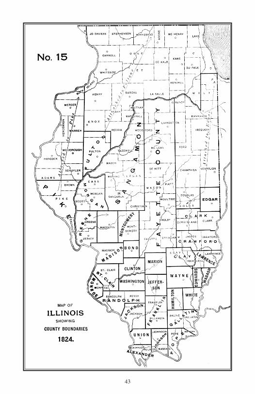
In 1824, three new counties were created. Clay, (December 23) from Fayette, Crawfordand Wayne, included besides its present area, parts of Jasper and Richland. Clinton andWabash, (December 27) the former from Washington, Fayette and Bond, and the latter, fromEdwards, were given their present boundaries. These acts also reduced Edwards, Wayne andWashington to their present limits. These changes of boundaries are shown on Map No. 15.
1825 — Ten New Counties
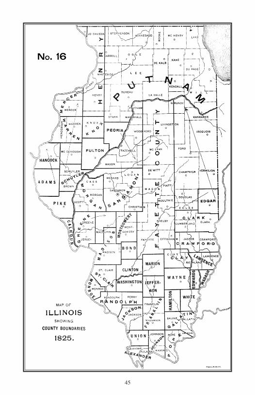
In 1825, ten new counties were added, all of them in the territory north and west of theIllinois River. Calhoun (January 10), Adams, Hancock, Henry, Knox, Mercer, Putnam,Schuyler and Warren by a single act of January 13, and Peoria by a separate act of the samedate. These acts gave to Adams, Hancock and Calhoun their present boundaries, included withWarren the present county of Henderson, gave to Mercer besides its present area, the part ofRock Island to the north of it, to Knox an area smaller by four townships than it now has, in-cluded with Schuyler the present county of Brown, and gave to Putnam all the unorganizedcountry north of the Illinois and Kankakee Rivers. Pike, Peoria and Fulton were reduced totheir present limits. Hancock was attached to Adams, and Mercer to Schuyler, until the organ-ization of these attached counties could be completed. The northern line of Sangamon was re-defined and the detached portion temporarily attached to Fulton. A considerable tract of theunorganized territory east of Greene was added to Madison. Henry County extended southfrom the Wisconsin line to a line six miles south of its present boundary and from the fourthprincipal meridian east to the line dividing ranges four and five. In defining Henry County,the Mississippi was not named as part of its western boundary, and as described in the act itextended beyond the Mississippi and included a considerable part of Iowa Territory. The easternboundary of Monroe County was carried east so as to include township three south, eight west,from St. Clair, and in 1827 was further extended to the Kaskaskia River, adding to it the frac-tional township three south, seven west from St. Clair, thus enlarging Monroe and reducingSt. Clair to existing limits. The changes described are shown on Map No. 16.
1826 — Vermilion and McDonough
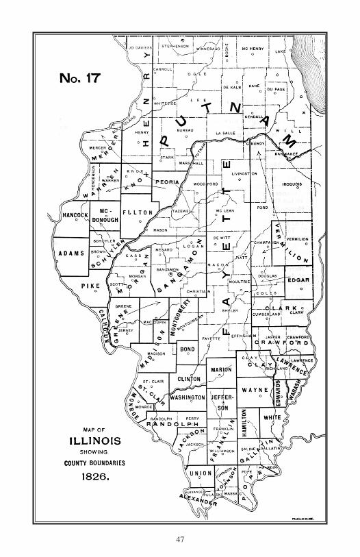
In 1826, but two new counties were established: Vermillion, (January 18) from unor-ganized territory attached to Edgar; and McDonough, with its present boundaries, from terri-tory attached to Schuyler. These two counties are shown on Map No. 17. The unorganizedterritory north and west of Vermilion was temporarily attached to that county. Mercer andWarren were attached to Peoria, and McDonough to Schuyler, until their respective organi-zations could be completed.
1827 — Shelby, Perry, Tazewell and JoDaviess
In 1827, four new counties were established: Shelby, (January 23) from Fayette, includingits present territory and portions of Moultrie and Christian; Perry, (January 29) from Randolphand Jackson, was given its present boundaries; Tazewell, (January 31) from the unorganizedterritory east of the Illinois, included the present counties of Tazewell and Woodford and partsof McLean, Livingston, DeWitt, Logan and Mason; JoDaviess, (February 17) from Mercer,Henry and Putnam, included a large area north of the “military tract” and west of the rangeline between ten and eleven east of the fourth principal meridian, including besides the presentcounty of JoDaviess, four entire counties and parts of five others. The country north of Shelby(formerly a part of Fayette) was temporarily attached to Shelby, that still further north toTazewell and that north of Tazewell to Peoria. Mercer was reduced to its present limits; but,not having completed its organization, remained, with Warren, attached to Peoria. A small tract
8
I PUB 15.10:Layout 1 3/16/10 8:54 AM Page 8

from St. Clair, lying west of the Kaskaskia was added to Monroe January 9. The county bound-aries at the close of 1827 are shown on Map No. 18.
1829-1831 — Nine New Counties
During this period nine new counties were created: Two in 1829, two in 1830 and fivein 1831. In 1829, Macoupin, (January 17) from Madison and unorganized territory attachedto Greene, was given its present boundaries, and Macon, (January 19) from territory attachedto Shelby, included the present area of Macon, together with portions of Piatt, Moultrie andDeWitt.
In 1830, Coles, (December 25) from the western part of Clark and the unorganized ter-ritory north of it, included the present counties of Douglas, Coles and Cumberland. McLean,(December 25) from the eastern part of Tazewell and territory east of it, included all its presentarea with parts of Piatt, DeWitt, Logan, Woodford and Livingston.
In 1831, Cook, (January 15) from Putnam, contained, besides its present territory, all ofLake and DuPage and parts of McHenry and Will. LaSalle, (January 15) from Putnam andunorganized territory south of the Illinois, contained, besides its present area, all of Grundyand parts of Livingston, Kendall and Marshall. Rock Island, (February 9) from JoDaviess,was given its present boundaries. Effingham and Jasper, (February 15) were given their presentboundaries, the first from Fayette and Crawford, and the latter from Crawford and Clay. Theboundaries of Henry, Putnam and Knox were altered, but neither county reduced to its presentlines, Mercer was attached to Warren until fully organized; Henry was attached to Knox, andthe unorganized country north of LaSalle was attached to that county. Towns twelve and thir-teen north, five east of the fourth principal meridian were included by acts of the same datein both Knox and Henry Counties. The section of the act including this tract in Henry was re-peated March 4, 1837. The county boundaries at the close of this period are shown on MapNo. 19.
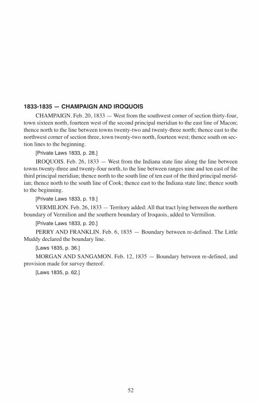
1833-1835 — Champaign and Iroquois
In 1833, Champaign, (February 20) from Vermillion and unorganized territory lyingwest of it, was given its present boundaries. Iroquois, (February 26) from unorganized territorynorth of Vermilion, included, besides its present area, nearly all of Kankakee and nearly halfof Will. By these two acts Vermillion was reduced to its present limits. The boundary betweenFranklin and Perry was re-adjusted, (March 1, 1935) making Little Muddy River the dividingline berween the counties. February 12, 1835, the line dividing Sangamon and Morgan wasre-defined and provision made for its survey. In 1833, (February 26) Vermillion was enlargedto its present limits by the addition of unorganized territory on the north. These changes areshown on Map No. 20.
1836 — Six New Counties
In 1836, six new counties were formed: Will, (January 12) from Cook and Iroquois, in-cluded, besides its present area, the part of Kankakee County lying north of the KankakeeRiver. Kane, McHenry, Ogle, Whiteside and Winnebago were created by a single act, (January16). Kane included the present counties of Kane and DeKalb and part of Kendall; McHenry,besides its present area, included Lake; Winnebago included Boone and part of Stephenson;Ogle consisted of the present counties of Ogle and Lee, while Whiteside was given its presentboundaries. The boundary of JoDaviess was re-defined and the area greatly reduced by theact of January 16. Winnebago, Ogle and Whiteside were attached to JoDaviess, and Kane toLaSalle, until their several organizations could be completed. See Map No. 21.
9
I PUB 15.10:Layout 1 3/16/10 8:54 AM Page 9

1837-1839 — Twenty-one New Counties
The changes made in the county boundaries in 1837 and 1839 are shown on Map No.22.
In 1837, six new counties were created: Livingston, (February 27) from LaSalle, McLeanand unorganized territory to the east; Bureau, (February 28) from Putnam; Cass, (March 3)from Morgan; Boone, (March 4) from Winnebago; DeKalb, (March 4) from Kane; andStephenson, (March 4) from Winnebago and JoDaviess. All of these were given their presentboundaries except Cass, whose southern boundary was fixed three miles further north thannow, and Winnebago was reduced to its present limits.
In 1839, fifteen new counties were formed, a greater number than in any other year ofthe State’s history, and equal to all that have since been created. Marshall, (January 9) fromPutnam, was given its present boundaries, except that the two townships (29 and 30 north,one east; from LaSalle) were attached in 1843; Brown, (February 1) from Schuyler; DuPage,(February 9) from Cook; and Dane renamed Christian, (February 15 and 26) from Shelby,Montgomery and Sangamon were given their present boundaries. Logan, (February 15) fromSangamon, was smaller than at present, three whole and three fractional townships fromTazewell, (1840) and a fractional township from DeWitt, (1845) having since been added tothe north. Menard, (February 15) from Sangamon, included, besides its present area, abouthalf of Mason County. Scott, (February 16) from Morgan; Carroll, (February 22) from Jo-Daviess; Lee, (February 27) from Ogle; Jersey, (February 28) from Greene, and Williamson,(February 28) from Franklin, were given their present boundaries. DeWitt, (March 1) fromMcLean and Macon, included, besides its present area; the northern part of Piatt and a smalltract since attached to Logan. Lake, (March 1) from McHenry, was given its present bound-aries. Hardin, (March 2) from Pope contained but about one-half of its present area; and Stark,(March 2) from Knox and Putnam, was given its present boundaries. These several acts re-duced the following ten counties to their present limits: Cook, Franklin, Greene, JoDaviess,Knox, McHenry, Montgomery, Putnam, Sangamon and Schuyler. The western boundary ofHardin was changed January 8, 1840, from the Grand Pierre Creek to the present line betweenPope and Hardin. The name of Dane County was changed to Christian February 1, 1840.
1841-1859 — Fifteeen New Counties
Since 1839 fifteen new counties have been created, making the total number at the pres-ent time 102. No new counties have been created since 1859 and no important changes madein county boundaries since that year. Map No. 23 shows the county boundaries as they existat the present time with the date of the formation of each.
In 1841, Henderson, (January 20) from Warren; Mason from Tazewell and Menard; Piatt,(January 27) from DeWitt and Macon; Grundy, (February 17) from LaSalle; Kendall, (Feb-ruary 19) from LaSalle and Kane; Richland, (February 24) from Clay and Lawrence; andWoodford, (February 27) from McLean and Tazewell, were given their present boundaries,and the following eight counties, Clay, Kane, LaSalle, Lawrence, McLean, Menard, Tazewelland Warren, were reduced to their present limits.
In 1843, four new counties were created: Massac, (February 8) from Pope and Johnson;Moultrie, (February 16) from Shelby and Macon; Cumberland, (March 2) from Coles; andPulaski, (March 3) from Johnson and Alexander, were given their present boundaries. Pope,Johnson, Shelby, Macon, and Alexander were reduced to their present limits.
In 1845, (February 16) part of Morgan was added to Cass; (February 26) part of DeWittwas added to Logan; the line between Fulton and Peoria was re-adjusted (February 28), butno new counties were created.
In 1847, Saline, (February 25) from Gallatin, was given its present boundaries and (Feb-
10
I PUB 15.10:Layout 1 3/16/10 8:54 AM Page 10

ruary 20) territory was added to Hardin. By these two acts, Gallatin was reduced to its presentlimits, and with the act of January 8, 1840, changing the eastern boundary of Pope, Hardinwas given its present boundaries.
In 1856, Kankakee, (February 11) from Iroquois and Will, was given its present bound-aries except that two townships (30 and 21 north, 9 east), were added to the western part, Feb-ruary 14, 1885. The act creating Kankakee reduced Iroquois and Will to their present limits.
In 1859, Douglas, (February 8) from Coles, was given its present boundaries and Colesreduced to its present limits; Ford, (February 17) the latest county to be created was formedfrom unorganized territory which had been attached to Vermilion since the creation of thatcounty in 1826. Ford was given its present boundaries and Vermilion reduced to its presentlimits.
During this period and in preceding years as well, a number of laws affecting countyboundaries were enacted which have not been referred to in this article for the reason that thechanges made by these acts have been so unimportant that they could not well be shown onmaps so small as those following this sketch and intending to illustrate it. Some of the lineson the maps are not beyond possible controversy. The acts establishing the lines are not alwaysclear and are sometimes plainly contradictory. When Crawford was established in 1816, itswestern boundary was described as “the meridian”; and it has been assumed that the thirdprincipal meridian was meant. The act creating Fayette in 1821 strictly construed, extendedits northern limit to the Wisconsin line; but subsequent acts indicate that no territory north ofthe Illinois River was at any time considered a part of Fayette. The act of 1825 adding territoryto Madison is contradictory in its terms, and a subsequent act, reciting how this act shall notbe construed, fails to clarify the original law. The provisions by which unorganized territorywas “attached” to organized counties vary greatly in terms, and possibly in meaning. Suchterritory is “temporarily attached” by one act, “attached for county purposes” by another, for“judicial purposes” by a third, and still other forms are used. One act provides that propertyin the attached territory shall not be taxed for the erection of public buildings in the county towhich the territory is attached, and another that “the inhabitants residing therein shall enjoyall the rights and privileges belonging to the citizens of the county” to which the territory isattached. The act creating Fulton in 1823 gave to it definite boundaries as shown on Map No.14, and declared that this territory “shall constitute a separate county;” but further declaredthat all the county east of the fourth meridian and north of the Illinois, formerly a part of Pike,“shall be attached to and be a part of said county until otherwise disposed of by the GeneralAssembly”, and it remained so attached until disposed of in 1825 by the creation of Peoriaand Putnam Counties. So it seems an open question whether the boundaries of Fulton for1823 should be represented as on Map No. 14, or whether the county should be shown asreaching east from the fourth meridian to Lake Michigan, and north from the Illinois River tothe Wisconsin line. Many such problems present themselves in considering these maps. Butreference is made in each case to the act establishing the county and the interested reader mayreadily consult the creative act and reconstruct the map to correspond with his interpretationof its meaning. The purpose of the maps and the descriptive matter accompanying them is togive to those interested in this branch of the State’s history, a reasonably correct idea of theevolution of the counties of Illinois. It is believed that the maps are substantially correct andthat few material errors will be found in the text explaining them.
Besides the 102 counties above enumerated, 13 other counties with names assigned andboundaries fixed, have been authorized by legislative enactment but failed to complete theirorganizations under the several enabling acts creating them: the counties of Coffee and Michi-gan in 1837: Allen and Okaw in 1841; Audubon, Benton, Marquette and Milton in 1843;Highland in 1847; Oregon in 1851; Harrison in 1855; Holmes in 1857 and Lincoln in 1867.Coffee, (March 1, 1837) was identical in boundaries with Stark, except that it contained one
11
I PUB 15.10:Layout 1 3/16/10 8:54 AM Page 11

more township, now the southeastern township of Henry. Michigan, (March 2, 1837) con-tained, besides the present territory of DuPage County, that part of Cook lying north of DuPageand south of Lake and McHenry. Audubon, (February 6, 1843) consisted of a rectangulartract, south of Christian County, running 12 miles south and 15 miles west, from the southeastcorner of Christian and included parts of the present counties of Shelby, Fayette and Mont-gomery. Okaw, (February 4, 1841) was almost identical in area with the present county ofMoultrie, but extended three miles farther west, and the zig-zag line forming its southwesternboundary was somewhat different. Marquette, (February 11, 1843) from Adams County, in-cluded townships one and two north and one, two and three south, ranges five and six westof the fourth principal meridian, with six sections off the east side of township one south,seven west. Highland, (February 27, 1847) included all the territory assigned to Marquette in1843, together with the eastern third of townships one and two north, seven west and six ad-ditional sections from township one south, seven west. Allen, Benton and Oregon includedmuch territory in common from the southwestern part of Sangamon, to the southeastern partof Morgan and the northern part of Macoupin. Allen, (February 27, 1841) contained townshipstwelve, thirteen, fourteen and south half of fifteen north, ranges seven and eight west; twelveand thirteen and part of fourteen, range nine; and the western third of twelve north, six west.It took nearly an equal amount of territory from each of the three counties of Macoupin, Sang-amon and Morgan. Benton, (March 4, 1843) extended farther west and south than Allen, butnot so far east; its eastern boundary being the line between Morgan and Sangamon Counties.Compared with Allen it took more territory from Morgan, less from Macoupin, a considerabletract from the northeastern part of Greene and none from Sangamon, but gained nearly enoughfrom Morgan and Greene to balance the loss from Sangamon. Oregon, (February 15, 1851)was very similar in outline to the old county of Allen, formed ten years earlier, but extendedfarther east, taking in township thirteen north, six west, and the eastern two-thirds of twelvenorth, six west, and its northern boundary extended a mile farther north than that of Allen.
Another group of proposed counties in the eastern part of the State also covered muchterritory in common. Milton, (February 21, 1843) from the southern part of Vermilion County,included nearly one-third of the area of that county. Harrison, (February 14, 1855) mostlyfrom the eastern part of McLean, included also portions of the present counties of Ford andChampaign. Holmes, (January 15, 1837) similar in shape to the present county of Ford, butlarger in area, reaching twelve miles farther north, six miles farther south and three miles far-ther east along its southern boundary, contained, besides the present area of Ford, portions ofKankakee, Champaign and Vermilion. Lincoln, (March 9, 1867) occupied a strip from two toeight miles wide and thirty-six miles in length, along the eastern side of Champaign, and asomewhat wider strip of the same length from the western side of Vermilion. This included apart of the territory assigned to Milton in 1843 and to Holmes in 1857, as Holmes had includeda part of Harrison formed in 1855.
12
I PUB 15.10:Layout 1 3/16/10 8:54 AM Page 12

COUNTIES OF ILLINOIS — DATES OF FORMATION
1790. St. Clair, April 27.1795. Randolph, October 5.1812. Gallatin, Johnson and Madison, September 14.1814. Edwards, November 28.1815. White, December 9.1816. Monroe, January 6; Jackson and Pope, January 10; Crawford, December 31.1817. Bond, January 4.1818. Franklin, Union and Washington, January 2.1819. Alexander, March 4; Clark, March 22; Jefferson and Wayne, March 26.1821. Lawrence, January 16; Greene, January 20; Sangamon, January 30; Pike, January
31; Hamilton, February 8; Montgomery, February 12; Fayette, February 14.1823. Edgar, January 3; Marion, January 24; Fulton, January 28; Morgan, January 31.1824. Clay, December 23; Clinton and Wabash, December 27.1825. Calhoun, January 10; Adams, Hancock, Henry, Knox, Mercer, Peoria, Putnam,
Schuyler and Warren, January 13.1826. Vermilion, January 18; McDonough, January 25.1827. Shelby, January 23; Perry, January 29; Tazewell, January 31; JoDaviess, February
27.1829. Macoupin, January 17; Macon, January 19.1830. Coles and McLean, December 25.1831. Cook and LaSalle, January 15; Rock Island, February 9; Effingham and Jasper,
February 15.1833. Champaign, February 20; Iroquois, February 26.1836. Will, January 12; Kane, McHenry, Ogle, Whiteside and Winnebago, January16.1837. Livingston, February 27; Bureau, February 28; Cass, March 3; Boone, DeKalb and
Stephenson, March 4.1839. Marshall, January 19; Brown, February 1; DuPage, February 9; Christian, Logan
and Menard, February 15; Scott, February 16; Carroll, February 22; Lee, February27; Jersey and Williamson, February 28; DeWitt and Lake, March 1; Hardin andStark, March 2.
1841. Henderson, Mason and Piatt, January 20; Grundy, February 17; Kendall, February19; Richland, February 24; Woodford, February 27.
1843. Massac, February 8; Moultrie, February 16; Cumberland, March 2; Pulaski,March 3.
1847. Saline, February 25.1853. Kankakee, February 11.1859. Douglas, February 8; Ford, February 17.
[NOTE. — The dates given above are the dates on which the proclamation was issued or theact approved without reference to the time of taking effect.]
13
I PUB 15.10:Layout 1 3/16/10 8:54 AM Page 13

1790 — ST. CLAIR AND KNOX
As counties of the Northwest Territory
April 27 — County of St. Clair set off as follows: Beginning at the mouth of the LittleMichilmacinack River, running thence southerly in a direct line to the mouth of the little riverabove Fort Massac, on the Ohio River; thence with the Ohio to its junction with the Missis-sippi; thence with the Mississippi to the mouth of the Illinois River; and so up the IllinoisRiver to the place of beginning with all the adjacent islands of the said Illinois and MississippiRivers. St. Clair County divided into three judicial districts, viz.: Cahokia, Prairie du Rocherand Kaskaskia; in each of which sessions of the several courts should be held during the yearin the same manner as if each district represented a distinct county.
[Territorial Records of the Northwest Territory, St. Clair Papers, volume 2, page 165.]
June 20 — A county named Knox was laid off with the following boundaries: Beginningat the Standing Stone Forks of the Great Miami River and down the said river to the conflu-ence with the Ohio River; thence with the Ohio River to the small stream or rivulet aboveFort Massac; thence with the eastern line of St. Clair County to the mouth of the LittleMichilmacinack; thence up the Illinois River to the fork or confluence of the Theokiki [Kanka-kee] and Chicago [DesPlaines]; thence by a line to be drawn due north to the boundary of theTerritory of the United States, and so far easterly upon said boundary line as that a due southline may be drawn to the place of beginning.
[Territorial Records of the Northwest Territory, St. Clair Papers, volume 2, page 166.]
14
I PUB 15.10:Layout 1 3/16/10 8:54 AM Page 14

15
I PUB 15.10:Layout 1 3/16/10 8:54 AM Page 15
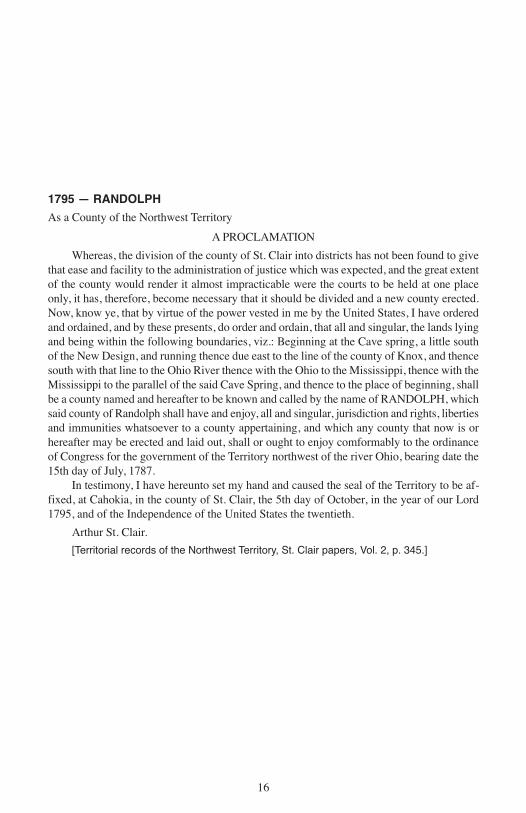
1795 — RANDOLPH
As a County of the Northwest Territory
A PROCLAMATION
Whereas, the division of the county of St. Clair into districts has not been found to givethat ease and facility to the administration of justice which was expected, and the great extentof the county would render it almost impracticable were the courts to be held at one placeonly, it has, therefore, become necessary that it should be divided and a new county erected.Now, know ye, that by virtue of the power vested in me by the United States, I have orderedand ordained, and by these presents, do order and ordain, that all and singular, the lands lyingand being within the following boundaries, viz.: Beginning at the Cave spring, a little southof the New Design, and running thence due east to the line of the county of Knox, and thencesouth with that line to the Ohio River thence with the Ohio to the Mississippi, thence with theMississippi to the parallel of the said Cave Spring, and thence to the place of beginning, shallbe a county named and hereafter to be known and called by the name of RANDOLPH, whichsaid county of Randolph shall have and enjoy, all and singular, jurisdiction and rights, libertiesand immunities whatsoever to a county appertaining, and which any county that now is orhereafter may be erected and laid out, shall or ought to enjoy comformably to the ordinanceof Congress for the government of the Territory northwest of the river Ohio, bearing date the15th day of July, 1787.
In testimony, I have hereunto set my hand and caused the seal of the Territory to be af-fixed, at Cahokia, in the county of St. Clair, the 5th day of October, in the year of our Lord1795, and of the Independence of the United States the twentieth.
Arthur St. Clair.
[Territorial records of the Northwest Territory, St. Clair papers, Vol. 2, p. 345.]
16
I PUB 15.10:Layout 1 3/16/10 8:54 AM Page 16
17
I PUB 15.10:Layout 1 3/16/10 8:54 AM Page 17

1801 — ST. CLAIR AND RANDOLPH
As Counties of the Territory of Indiana
February 3 — The Governor issued a proclamation altering the boundary lines of thecounties of Knox and Randolph and St. Clair as follows, to-wit: The boundary of the countyof RANDOLPH shall begin on the Ohio River at a place called the Great Cave below theSaline Lick, thence by a direct north line until it intersects an east and west line running fromthe Mississippi, through the Sink Hole spring, thence along the said line to the Mississippi,thence down the Mississippi to the mouth of the Ohio, and up the Ohio to the place of begin-ning.
The county of ST. CLAIR shall be bounded on the south by the before mentioned eastand west line running from the Mississippi through the Sink Hole spring to the intersectionof the north line running from the Great Cave aforesaid, thence from the said point of inter-section by a direct line to the mouth of the great Kennoumic River falling into the southerlybend of Lake Michigan, thence by a direct northeast line to the division line between the In-diana and Northwestern Territories, thence along the said line to the Territorial boundary ofthe United States and along the said boundary line to the intersection thereof with the Missis-sippi, and down the Mississippi to the place of beginning.
[Executive Journal of Indiana Territory, p.98.]
18
I PUB 15.10:Layout 1 3/16/10 8:54 AM Page 18

19
I PUB 15.10:Layout 1 3/16/10 8:54 AM Page 19

1803 — ST. CLAIR AND RANDOLPH
As counties of Indiana Territory; boundaries changed
JANUARY 24, 1803: Alteration by proclamation forming Wayne County, Indiana Ter-ritory, effective upon admission of Ohio to the Union.
BOUNDARY CHANGE: By the proclamation of January 24, 1803, that part of St. ClairCounty lying north and east of a line beginning at “the Southerly Extreame of Lake Michigan,”running thence due west until it “would intersect a North and South line passing through themost westerly bend of the said Lake, and thence north along the last mentioned line to theTerritorial Boundary of the United States,” was transferred to Wayne County. Territorial Ex-ecutive Journal, 115.
MARCH 25, 1803: Alteration by proclamation extending Randolph County, effectiveMay 1, 1803.
BOUNDARY CHANGE: “The line separating the Counties of Randolph and St. Clairshall begin on the Mississippi River four miles and thirty two Chains south of the point, wherethe present division line intersects the Mississippi Bottom, thence by a direct line to the SinkHole Springs, thence by a line north sixty degrees East until it intersects a north line runningfrom the Great Cave on the Ohio River.” Territorial Executive Journal, 118.
20
I PUB 15.10:Layout 1 3/16/10 8:54 AM Page 20

21
I PUB 15.10:Layout 1 3/16/10 8:54 AM Page 21

1809 — ST. CLAIR AND RANDOLPH
As counties of Illinois Territory
A PROCLAMATION BY NATHANIEL POPE, SECRETARY OF THE TERRITORY OFILLINOIS AND EXERCISING THE GOVERNMENT THEREOF
By virtue of the powers vested in the governor for the prevention of crimes and injuriesand for the execution of process civil and criminal within the Territory; I have thought properto, and by this proclamation do, divide the Illinois Territory into two counties to be called theCOUNTY OF ST. CLAIR and the COUNTY OF RANDOLPH. The county of Randolphshould include all that part of the Illinois Territory lying south of the line dividing the countiesof Randolph and St. Clair as it existed under the government of the Indiana Territory on thelast day of February in the year one thousand eight hundred and nine. And the county of St.Clair shall include all that part of the Territory which lies north of said line.
Done at Kaskaskia, the 28th day of April, 1809, and of the Independence of the UnitedStates the thirty-third.
NAT. POPE.
[Territorial Records of Illinois, p.3.]
22
I PUB 15.10:Layout 1 3/16/10 8:54 AM Page 22
23
I PUB 15.10:Layout 1 3/16/10 8:54 AM Page 23
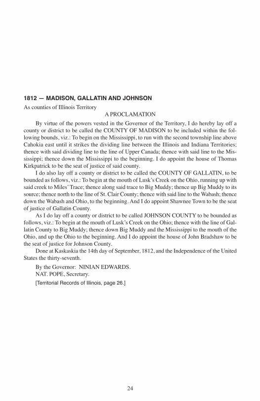
1812 — MADISON, GALLATIN AND JOHNSON
As counties of Illinois TerritoryA PROCLAMATION
By virtue of the powers vested in the Governor of the Territory, I do hereby lay off acounty or district to be called the COUNTY OF MADISON to be included within the fol-lowing bounds, viz.: To begin on the Mississippi, to run with the second township line aboveCahokia east until it strikes the dividing line between the Illinois and Indiana Territories;thence with said dividing line to the line of Upper Canada; thence with said line to the Mis-sissippi; thence down the Mississippi to the beginning. I do appoint the house of ThomasKirkpatrick to be the seat of justice of said county.
I do also lay off a county or district to be called the COUNTY OF GALLATIN, to bebounded as follows, viz.: To begin at the mouth of Lusk’s Creek on the Ohio, running up withsaid creek to Miles’ Trace; thence along said trace to Big Muddy; thence up Big Muddy to itssource; thence north to the line of St. Clair County; thence with said line to the Wabash; thencedown the Wabash and Ohio, to the beginning. And I do appoint Shawnee Town to be the seatof justice of Gallatin County.
As I do lay off a county or district to be called JOHNSON COUNTY to be bounded asfollows, viz.: To begin at the mouth of Lusk’s Creek on the Ohio; thence with the line of Gal-latin County to Big Muddy; thence down Big Muddy and the Mississippi to the mouth of theOhio, and up the Ohio to the beginning. And I do appoint the house of John Bradshaw to bethe seat of justice for Johnson County.
Done at Kaskaskia the 14th day of September, 1812, and the Independence of the UnitedStates the thirty-seventh.
By the Governor: NINIAN EDWARDS.NAT. POPE, Secretary.
[Territorial Records of Illinois, page 26.]
24
I PUB 15.10:Layout 1 3/16/10 8:54 AM Page 24

25
I PUB 15.10:Layout 1 3/16/10 8:54 AM Page 25
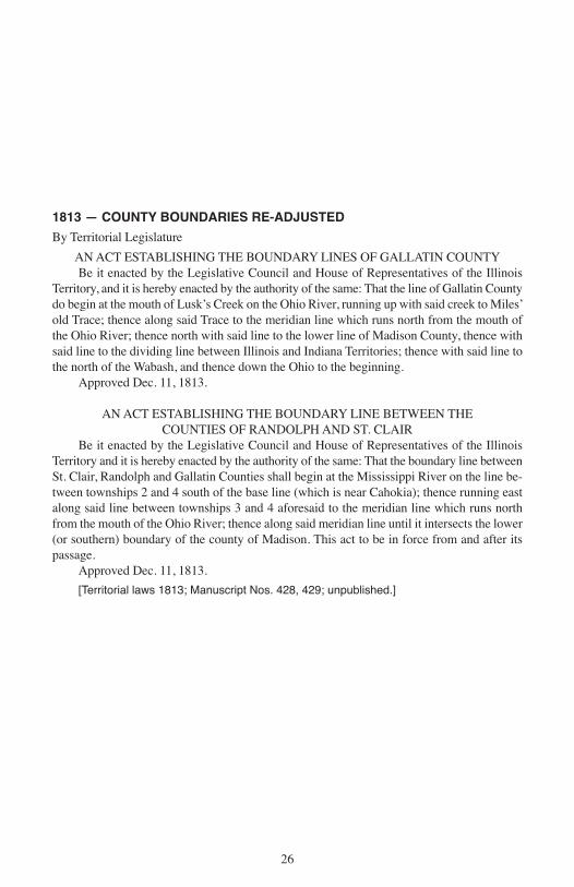
1813 — COUNTY BOUNDARIES RE-ADJUSTED
By Territorial Legislature
AN ACT ESTABLISHING THE BOUNDARY LINES OF GALLATIN COUNTYBe it enacted by the Legislative Council and House of Representatives of the Illinois
Territory, and it is hereby enacted by the authority of the same: That the line of Gallatin Countydo begin at the mouth of Lusk’s Creek on the Ohio River, running up with said creek to Miles’old Trace; thence along said Trace to the meridian line which runs north from the mouth ofthe Ohio River; thence north with said line to the lower line of Madison County, thence withsaid line to the dividing line between Illinois and Indiana Territories; thence with said line tothe north of the Wabash, and thence down the Ohio to the beginning.
Approved Dec. 11, 1813.
AN ACT ESTABLISHING THE BOUNDARY LINE BETWEEN THE COUNTIES OF RANDOLPH AND ST. CLAIR
Be it enacted by the Legislative Council and House of Representatives of the IllinoisTerritory and it is hereby enacted by the authority of the same: That the boundary line betweenSt. Clair, Randolph and Gallatin Counties shall begin at the Mississippi River on the line be-tween townships 2 and 4 south of the base line (which is near Cahokia); thence running eastalong said line between townships 3 and 4 aforesaid to the meridian line which runs northfrom the mouth of the Ohio River; thence along said meridian line until it intersects the lower(or southern) boundary of the county of Madison. This act to be in force from and after itspassage.
Approved Dec. 11, 1813.
[Territorial laws 1813; Manuscript Nos. 428, 429; unpublished.]
26
I PUB 15.10:Layout 1 3/16/10 8:54 AM Page 26
27
I PUB 15.10:Layout 1 3/16/10 8:54 AM Page 27
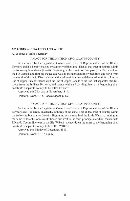
1814-1815 — EDWARDS AND WHITE
As counties of Illinois territory
AN ACT FOR THE DIVISION OF GALLATIN COUNTY
Be it enacted by the Legislative Council and House of Representatives of the IllinoisTerritory and it is hereby enacted by authority of the same. That all that tract of country withinthe following boundaries (to-wit): Beginning at the mouth of Bompast [Bon Pas] creek onthe big Wabash and running thence due west to the meridian line which runs due north fromthe mouth of the Ohio River; thence with said meridian line and due north until it strikes theline of Upper Canada; thence with the line of Upper Canada to the line that separates this Ter-ritory from the Indiana Territory; and thence with said dividing line to the beginning shallconstitute a separate county, to be called Edwards.
Approved this 28th day of November, 1814.
[Territorial Laws, 1814, Popeʼs Digest, p. 85.]
AN ACT FOR THE DIVISION OF GALLATIN COUNTY
Be it enacted by the Legislative Council and House of Representatives of the IllinoisTerritory, and it is hereby enacted by authority of the same, That all that tract of country withinthe following boundaries (to-wit): Beginning at the mouth of the Little Wabash, running upthe same to Joseph Boon’s mill; thence due west to the third principal meridian; thence withEdwards County line east to the Big Wabash, thence down the same to the beginning shallconstitute a separate county, to be called WHITE.
Approved this 9th day of December, 1815.
[Territorial Laws, 1815-16, p. 5.]
28
I PUB 15.10:Layout 1 3/16/10 8:54 AM Page 28

29
I PUB 15.10:Layout 1 3/16/10 8:54 AM Page 29

1816 — JACKSON, POPE MONROE AND CRAWFORD
As Counties of Illinois Territory
MONROE. Jan. 6 — Beginning on the Mississippi River where the base line, which isabout three-fourths of a mile below Judge Brigg’s present residence, strikes the said river;thence with the base line until it strikes the first township line therefrom; thence southeast tothe southeast corner of township two south, range nine west; thence south to the southeastcorner of township four north, range nine west; thence southwestwardly to the Mississippi,so as to include Alexander McNabb’s farm, and thence up the Mississippi to the beginningshall constitute a separate county, to be called MONROE.
[Territorial Laws, 1815-16, p. 25.]
JACKSON. Jan. 10 — Beginning at the mouth of the Big Muddy River and running upthe same to the township line between ten and eleven; thence east with said line to the principalmeridian line running from the mouth of the Ohio River; thence north with the meridian linethirty miles; thence west twenty-four miles to the corner of range between four and five westof the principal meridian line; thence south six miles to the township corner between six andseven; thence to the headwaters of the creek called Gagnic and down it to the Mississippi;thence down the Mississippi to the beginning shall be a separate and distinct county and calledand be known by the name of JACKSON.
[Territorial Laws, 1815-16, p. 62.]
POPE. Jan. 10 — Beginning on the Ohio River where the meridian line leaves it that di-vides ranges number three and four east of the third principal meridian; thence north to thetownship line dividing townships ten and eleven south; thence east eighteen miles; thence tothat point on the Ohio where the line dividing ranges eight and nine leaves it; thence downthe same to the beginning shall constitute a separate county, to be called and known by thename of POPE.
[Territorial Laws, 1815-16, p. 66.]*
CRAWFORD. Dec. 31 — Beginning at the mouth of the Embarras and running withsaid river to the intersection of the line dividing townships number three and four north, ofrange eleven west, of the second principal meridian; thence west with said township line tothe meridian and due north until it strikes the line of Upper Canada; thence to the line thatseparates this territory from the State of Indiana; and thence south with said dividing line tothe beginning shall constitute a separate county, to be called CRAWFORD.
[Territorial Laws, 1816-17, p. 21.]
________________
*NOTE — The northeastern line of Pope County was changed by act of Dec. 26, 1816, andestablished as follows: “Beginning at Rock and Cave [Cave-in-Rock] on the Ohio River; thencea straight line to the corner of townships number ten and eleven south and ranges numberseven and eight, east of the third principal meridian.”
[Territorial Laws, 1816-17, p. 10.]
30
I PUB 15.10:Layout 1 3/16/10 8:54 AM Page 30

31
I PUB 15.10:Layout 1 3/16/10 8:54 AM Page 31

32
BOND
As a county of Illinois Territory
BOND. Jan. 4 — Beginning at the southwest corner of township number three north ofrange four west; thence east to the southeast [west] corner of township number three north ofrange number one east, to the third principal meridian line; thence north to the boundary lineof the territory; thence west with said boundary line so far that a south line will pass betweenranges four and five west; thence south with said line to the beginning, shall constitute a sep-arate county to be called BOND.
[Territorial Laws, 1816-17, p. 28.]
I PUB 15.10:Layout 1 3/16/10 8:54 AM Page 32
33
I PUB 15.10:Layout 1 3/16/10 8:54 AM Page 33
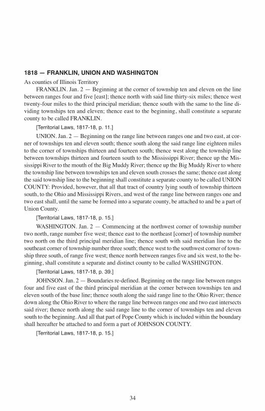
1818 — FRANKLIN, UNION AND WASHINGTON
As counties of Illinois TerritoryFRANKLIN. Jan. 2 — Beginning at the corner of township ten and eleven on the line
between ranges four and five [east]; thence north with said line thirty-six miles; thence westtwenty-four miles to the third principal meridian; thence south with the same to the line di-viding townships ten and eleven; thence east to the beginning, shall constitute a separatecounty to be called FRANKLIN.
[Territorial Laws, 1817-18, p. 11.]
UNION. Jan. 2 — Beginning on the range line between ranges one and two east, at cor-ner of townships ten and eleven south; thence south along the said range line eighteen milesto the corner of townships thirteen and fourteen south; thence west along the township linebetween townships thirteen and fourteen south to the Mississippi River; thence up the Mis-sissippi River to the mouth of the Big Muddy River; thence up the Big Muddy River to wherethe township line between townships ten and eleven south crosses the same; thence east alongthe said township line to the beginning shall constitute a separate county to be called UNIONCOUNTY: Provided, however, that all that tract of country lying south of township thirteensouth, to the Ohio and Mississippi Rivers, and west of the range line between ranges one andtwo east shall, until the same be formed into a separate county, be attached to and be a part ofUnion County.
[Territorial Laws, 1817-18, p. 15.]
WASHINGTON. Jan. 2 — Commencing at the northwest corner of township numbertwo north, range number five west; thence east to the northeast [corner] of township numbertwo north on the third principal meridian line; thence south with said meridian line to thesoutheast corner of township number three south; thence west to the southwest corner of town-ship three south, of range five west; thence north between ranges five and six west, to the be-ginning, shall constitute a separate and distinct county to be called WASHINGTON.
[Territorial Laws, 1817-18, p. 39.]
JOHNSON. Jan. 2 — Boundaries re-defined. Beginning on the range line between rangesfour and five east of the third principal meridian at the corner between townships ten andeleven south of the base line; thence south along the said range line to the Ohio River; thencedown along the Ohio River to where the range line between ranges one and two east intersectssaid river; thence north along the said range line to the corner of townships ten and elevensouth to the beginning. And all that part of Pope County which is included within the boundaryshall hereafter be attached to and form a part of JOHNSON COUNTY.
[Territorial Laws, 1817-18, p. 15.]
34
I PUB 15.10:Layout 1 3/16/10 8:54 AM Page 34
35
I PUB 15.10:Layout 1 3/16/10 8:54 AM Page 35

1819 — ALEXANDER, CLARK JEFFERSON AND WAYNE
As counties of the State of Illinois
ALEXANDER. March 4 — All that tract of country within the following boundaries,to-wit: West of the line between ranges one and two east of the third principal meridian andsouth of the line between townships thirteen and fourteen south of the base line to the bound-aries of this State on the Ohio and Mississippi, shall constitute a county to be called ALEXAN-DER.
[Laws 1819, p. 113.]
CLARK. March 22 — All that part of Crawford County lying north of a line beginningon the Great Wabash River dividing townships eight and nine north, running due west, shallform a new and separate county to be called CLARK.
[Laws 1819, p. 166.]
JEFFERSON. March 26 — Beginning where the line between ranges four and five eastintersects the base line; thence west with said line to the third principal meridian; thence southtwenty-four miles; thence east twenty-four miles; thence north to the place of beginning, shallconstitute a separate county to be called JEFFERSON.
[Laws 1819, p. 267.]
WAYNE. March 26 — Beginning on the White County line on the dividing ranges nineand ten east of the third principal meridian; thence north to the line dividing townships threeand four, to the Crawford County line, north of the base line; thence west to the line dividingranges four and five east of the third principal meridian line; thence south to the White Countyline; thence east to the beginning, shall constitute a separate county to be called WAYNE.
[Laws 1819, p. 268.]
36
I PUB 15.10:Layout 1 3/16/10 8:54 AM Page 36

37
I PUB 15.10:Layout 1 3/16/10 8:54 AM Page 37

1821 — LAWRENCE, GREENE, SANGAMON, PIKE, HAMILTON,MONTGOMERY AND FAYETTE
LAWRENCE. Jan. 16 — Beginning on the Great Wabash seven miles north of the baseline, thence west to the Wayne County line; thence north two miles north of town four; thenceeast to the Wabash; thence with that river to the place of beginning.
[Laws 1821, p. 16.]
GREENE. Jan. 20 — Beginning at the southeast corner town seven north, ten west of thirdprincipal meridian; thence north between ranges nine and ten to the northwest corner of towntwelve north; thence west along the line between towns twelve and thirteen to the middle of theIllinois; thence down said river to the Mississippi; thence down the middle of the river to a pointparallel with the southwest corner of town six north, ten west; thence north with the range linebetween ten and eleven, to the township line between six and seven; thence east with said town-ship line to the place of beginning.
[Laws 1821, p. 26.]
SANGAMON. Jan. 30 — From the northeast corner of town twelve north, one west ofthird principal meridian, north with that meridian to the Illinois River; down the middle of theriver to the mouth of Balance or Negro (Indian) creek; up said creek to its head; thence throughthe middle of the prairie dividing the waters of the Sangamon and Mauvaise Terre to the north-west corner of town twelve north, seven west of the third principal meridian; thence east alongthe north line of town twelve to the place of beginning.
[Laws 1821, p. 45.]
PIKE. Jan. 31 — Up the middle of the Illinois River from its mouth to the fork; up thesouth fork (Kankakee) to the Indiana state line; north with the state line to the north boundaryof the State; west with said state line to the west boundary of the State; thence with said bound-ary to the place of beginning.
[Laws 1821, p. 59.]
HAMILTON. Feb. 8 — South from the southern line of Wayne County, on the line di-viding ranges seven and eight east, to Gallatin County; thence west eighteen miles to Franklin;thence north to the Wayne County line; thence east to the beginning.
[Laws 1821, p. 113.]
MONTGOMERY. Feb. 12 — West from the southeast corner of section twenty-four,town seven north, two west, to the southwest corner section nineteen, town seven north, fourwest; thence south to southeast corner of town seven north, five west; thence west to southwestcorner of said township; thence north to northwest corner of town twelve north, five west;thence east to northeast corner of town twelve north, two west; thence south to the beginning.
[Laws 1821, p. 142.]
FAYETTE. Feb. 14 — All that tract of country lying north of a line running east fromthe southwest corner of town three north, one west, to the southeast corner of town three north,six east of the third principal meridian. *
[Laws 1821, p. 164.]
_________________*NOTE — A strict construction of this act would make the entire western boundary of FayetteCounty the line between ranges one and two west, and extend its northern boundary to theWisconsin line, thus taking one range of townships from the east side of Sangamon (formedJan. 30) and cutting Pike (formed Jan. 31) in two. It is probable that the word “unorganized”should be read into the act so as to make it read “all that tract of unorganized country lyingnorth,” etc. Subsequent acts seem to justify this theory.
38
I PUB 15.10:Layout 1 3/16/10 8:54 AM Page 38
39
I PUB 15.10:Layout 1 3/16/10 8:54 AM Page 39

1823 — EDGAR, MARION, FULTON, AND MORGAN
EDGAR. Jan. 3 — From the Indiana State line west twenty-four miles through the centerof township twelve north; thence north twenty-seven miles; thence east twenty-four miles;thence south to the beginning.
[Laws 1823, p. 74.]
MARION. Jan. 24 — From the intersection of the base line with the third principalmeridian, north along said meridian twenty-four miles; thence south twenty-four miles to thebase line; thence west to the beginning.
[Laws 1823, p. 49.]
FULTON. Jan. 28 — From the intersection of the fourth principal meridian with the Illi-nois River; thence up the middle of the river till intersected by the range line between rangesfive and six east; thence north with said range line to the line between towns nine and tennorth; thence west with said town line to the fourth principal meridian; thence south to thebeginning.
[Laws 1823, p. 88.]
MORGAN. Jan. 31 — From the northwest corner of Greene County, east to the rangeline between seven and eight west of the third principal meridian; thence northerly along themiddle of the prairie dividing the waters of the Sangamon from the Mauvaisterre, Apple andIndian creeks, to the middle of range eight; thence north to the middle of the main channel ofthe Sangamon; thence down to the middle of the main channel of the Illinois; thence downthe Illinois to the beginning.
[Laws 1823, p. 108.]
40
I PUB 15.10:Layout 1 3/16/10 8:54 AM Page 40
41
I PUB 15.10:Layout 1 3/16/10 8:54 AM Page 41

1824 — CLAY, CLINTON AND WABASH
CLAY. Dec. 23 — From the intersection of the line dividing ranges four and five eastwith the middle line of town two north; thence east with said line to the Fox River; thencenorth with said river to the line dividing towns five and six north; thence west with said lineto the range line dividing four and five east; thence south with said range line to the begin-ning.
[Laws 1825, p. 19.]
CLINTON. Dec. 27 — Down the Kaskaskia from the mouth of Crooked Creek to theline dividing St. Clair and Washington; thence north on the range line between five and sixwest to the northwest corner of town two north, five west; thence east to the southeast cornerof town three north, five west; thence north to the northwest corner of town three north, fourwest; thence east twenty-four miles; thence south along the third principal meridian sixteenmiles; thence west to Crooked Creek; thence down said creek to the beginning.
[Laws 1825, p. 27.]
WABASH. Dec. 27 — From the mouth of De Bon Pas Creek up the main branch of thesouth line of Lawrence County; thence east to the Wabash; thence down the Wabash to theplace of beginning.
[Laws 1825, p. 25.]
42
I PUB 15.10:Layout 1 3/16/10 8:54 AM Page 42
43
I PUB 15.10:Layout 1 3/16/10 8:54 AM Page 43

1825 — TEN NEW COUNTIES
CALHOUN. Jan.10 — All that tract of country between the Illinois and MississippiRivers south of the line between townships 7 and 8 south. [Laws 1825, p. 65.]
ADAMS. Jan. 13 — From the southeast corner town three south, five west of the fourthprincipal meridian, west to the Mississippi; thence up the river to the line between towns twoand three north; thence east to the northeast corner of town two north, five west; thence southto the beginning. [Laws 1825, p.98.]
HANCOCK. Jan. 13 — East from the Mississippi on the line between towns 2 and 3north, to the line between ranges 4 and 5 west of the fourth principal meridian; thence northto the line between towns 7 and 8 north; thence west to the Mississippi; thence down the riverto the beginning. [Laws 1825, p. 93.]
HENRY. Jan. 13 — East from the fourth principal meridian on the line between townstwelve and thirteen north, to the line between ranges four and five east; thence north to theWisconsin state line; thence west to the fourth principal meridian; thence south to the begin-ning. [Laws 1825, p. 94.]
KNOX. Jan. 13 — East from the fourth principal meridian on the line between townseight and nine north, to the line between ranges four and five east; thence north to the line be-tween towns twelve and thirteen north; thence west to the fourth principal meridian; thencesouth to the beginning. [Laws 1825, p. 94.]
MERCER. Jan. 13 — East from the Mississippi on the line between towns twelve andthirteen north, to the fourth principal meridian; thence north to the Wisconsin state line; thencewest to the Mississippi; thence down the river to the beginning. [Laws 1825, p. 93.]
PEORIA. Jan. 13 — West from the Illinois on the line between towns 11and 12 north,to the line between ranges 4 and 5 east; thence south to the line between towns 7 and 8 north;thence east to the line between ranges 5 and 6 east; thence south to the Illinois; thence up theriver to the beginning. [Laws 1825, p. 85.]
PUTNAM. Jan. 13 — Up the Illinois from the line between towns 11 and 12 north, tothe south fork [Kankakee]; thence up said fork to the Indiana state line; thence north alongsaid line to the northeast corner of the State; thence west to the line between ranges 4 and 5east; thence south to the line between towns 11 and 12 north; thence east to the beginning.[Laws 1825, p. 94.]
SCHUYLER. Jan. 13 — West from the Illinois on the line between towns 2 and 3 south,to the line between ranges 4 and 5 west; thence north to the line between towns 3 and 4 north;thence east to the fourth principal meridian; thence south to the line between towns 2 and 3north; thence east to the Illinois; thence down the river to the beginning. [Laws 1825, p. 92.]
WARREN. Jan. 13 — East from the Mississippi on the line between towns seven andeight north, to the fourth principal meridian; thence north to the line between towns twelveand thirteen north; thence west to the Mississippi; thence down the river to the beginning.[Laws 1825, p. 93.]
SANGAMON. Dec. 23 — Boundary re-defined, decreasing area. North from the south-east corner of town thirteen north, one west, to the north line of town twenty; thence west tothe middle of the Illinois; thence down to the mouth of the Sangamon; thence up the Sangamonto the middle of range eight west; thence south with east line of Morgan to the south line oftown thirteen north; thence east to the beginning. [Laws 1825, p. 20.]
MADISON. Jan. 3 — Territory added. [Laws 1825, p. 53.]MONROE. Jan. 15 — Territory added. [Laws 1825, p. 109. Also Jan. 9, Private laws
1827, p. 8, and Jan. 20, Laws 1829, p. 31.]
44
I PUB 15.10:Layout 1 3/16/10 8:54 AM Page 44
45
I PUB 15.10:Layout 1 3/16/10 8:54 AM Page 45

1826 — VERMILION AND MCDONOUGH
VERMILION. Jan. 18 — West from the Indiana state line on the line between townssixteen and seventeen north, to the line between ranges nine and ten east; thence north to theline between towns twenty-two and twenty-three north; thence east to the Indiana state line;thence south to the place of beginning.
[Laws 1826, p. 50.]
MCDONOUGH. Jan. 25 — West from the fourth principal meridian on the line betweentowns seven and eight north, to the line between ranges four and five west; thence south tothe line between towns three and four north; thence east to the fourth principal meridian;thence north to the place of beginning.
[Laws 1826, p. 76.]
46
I PUB 15.10:Layout 1 3/16/10 8:54 AM Page 46
47
I PUB 15.10:Layout 1 3/16/10 8:54 AM Page 47

1827 — SHELBY, PERRY, TAZEWELL AND JO DAVIESS
SHELBY. Jan. 23 — North thirty miles from the northwest corner of section nineteen,town nine north, one east of the third principal meridian to the northwest corner section ofnineteen, town fourteen north, one east; thence east thirty-six miles to the northeast corner ofsection twenty-four, town fourteen north, six east; thence south thirty miles to the southeastcorner of section thirteen, town nine north, six east; thence west thirty-six miles to the placeof beginning.
[Laws 1827, p.115.]
PERRY. Jan. 29 — West from the third principal meridian on the line between townsthree and four south to line between ranges four and five west; thence south to the line betweentowns six and seven south; thence east to the third principal meridian; thence north to theplace of beginning.
[Laws 1827, p.110.]
TAZEWELL. Jan. 31 — North from the northeast corner of town twenty north, [3] eastof the third principal meridian to the line between towns twenty-eight and twenty-nine north;thence west to the Illinois; thence down the river to the line between towns twenty and twenty-one north; thence east to the beginning.
[Laws 1827, p. 113.]
NOTE — This act does not clearly indicate the place of beginning, but the act of Jan. 22, 1829,fixes the initial point at the northeast corner of town twenty north, three east of the third principalmeridian.
JO DAVIESS. Feb. 17 — From the northwest corner of the State down the Mississippito the northern line of the Military Tract [the line between towns fifteen and sixteen north];thence east to the Illinois; thence north to the Wisconsin state line; thence west to the placeof beginning.
[Laws 1827, p. 117.]
NOTE — By this act Putnam was divided into two distinct tracts.
MONROE. Jan. 15 — Territory added. East line carried to the Kaskaskia.
[Private Laws 1827, p. 8.]
48
I PUB 15.10:Layout 1 3/16/10 8:54 AM Page 48

49
I PUB 15.10:Layout 1 3/16/10 8:54 AM Page 49

1829-1831 — NINE NEW COUNTIES
MACOUPIN. Jan. 17, 1829 — East from the southwest corner of town seven north, ninewest, to the southwest corner of Montgomery; thence north to the south line of Sangamon;thence west to the line between ranges nine and ten west; thence south to the beginning. [Laws1829, p. 26.]
MACON. Jan. 19, 1829 — North on the third principal meridian from the southwest cor-ner of section eighteen, town fourteen north, one east, to the line between towns twenty andtwenty-one north; thence east to the line dividing ranges six and seven east; thence south tothe southeast corner of section thirteen, town fourteen north, six east; thence west to the be-ginning. [Laws 1829, p. 28.]
COLES. Dec. 25, 1830 — West from the northeast corner of section 4, town 16 north, 14west, of second principal meridian to the line between ranges 6 and 7 east of the third principalmeridian; thence south to the southeast corner of town 9 north, 6 east, thence east to the south-east corner of section 31 (the east line of fractional range 11 east); thence north to the northeastcorner of section 19, town 12 north, 11 east of the third principal meridian; thence east to thenortheast corner of section 21, town 12 north, 14 west of the second principal meridian; thencenorth on the section lines through the middle of range 14 west to the beginning. [Laws 1831,p. 59.]
MCCLEAN. Dec. 25, 1830 — North from the southwest corner of town twenty-one north,one west, of the third principal meridian to the line dividing towns twenty-eight and twenty-nine north; thence east to the line dividing ranges six and seven east; thence south to the southeastcorner of town twenty-one north, six east; thence west to the beginning. [Laws 1831, p. 57.]
COOK. Jan. 15, 1831 — West from the Indiana state line on the line dividing towns thirty-three and thirty-four north to the line dividing ranges eight and nine east of the third principalmeridian; thence north to the Wisconsin state line; thence east to the northeast corner of theState; thence southwardly along the state line to the beginning. [Laws 1831, p. 54.]
LASALLE. Jan. 15, 1831 — South from the southwest corner of Cook thirty miles; thencewest to the third principal meridian; thence north forty-eight miles; thence east to Cook; thencesouth to the beginning. [Laws 1831, p. 54.]
PUTNAM (re-defined). Jan. 15, 1831 — East from the southwest corner of town 12 north,6 east to the Illinois; thence down the river to the south line of town 29 north; thence east tothe third principal meridian; thence north 22 miles; thence west to the northwest corner of town18 north, 6 east of the fourth principal meridian; thence south to the beginning. [Laws 1831, p.54.]
ROCK ISLAND. Feb. 9, 1831 — East from the middle of the main channel of the Mis-sissippi with the north line of town fifteen north to the fourth principal meridian; thence northto Rock River; thence up the middle of the main channel to its confluence with Marais d’ogeeslough; thence with the middle of said slough to the Mississippi; thence down the middle ofthe main channel of the river to the beginning. [Laws 1831, p. 52]
EFFINGHAM. Feb. 15, 1831 — South from the northwest corner of Jasper to the linebetween towns 5 and 6 north; thence west to the line between ranges 3 and 4 east of the thirdprincipal meridian; thence north to the northeast corner of section 24, town 9 north; 6 east;thence south to the southeast corner of town 9 north, 6 east; thence east to the line betweenranges 7 and 8 east; thence south to the beginning. [Laws 1831, p. 51.]
JASPER. Feb 15, 1831 — North with section lines from the southeast corner of section22, town 5 north, 14 west of the second principal meridian to the northeast corner of section 3town 8 north, 14 west; thence west to the northwest corner of section 6, town 8 north, 8 east ofthird principal meridian; thence south to the southwest corner of section 19, town 5 north, 8east; thence east to the beginning. [Laws 1831, p. 51.]
MONROE. Jan. 20 — Southern boundary re-adjusted. [Laws 1829, p. 31.]
50
I PUB 15.10:Layout 1 3/16/10 8:54 AM Page 50

51
I PUB 15.10:Layout 1 3/16/10 8:54 AM Page 51
1833-1835 — CHAMPAIGN AND IROQUOIS
CHAMPAIGN. Feb. 20, 1833 — West from the southwest corner of section thirty-four,town sixteen north, fourteen west of the second principal meridian to the east line of Macon;thence north to the line between towns twenty-two and twenty-three north; thence east to thenorthwest corner of section three, town twenty-two north, fourteen west; thence south on sec-tion lines to the beginning.
[Private Laws 1833, p. 28.]
IROQUOIS. Feb. 26, 1833 — West from the Indiana state line along the line betweentowns twenty-three and twenty-four north, to the line between ranges nine and ten east of thethird principal meridian; thence north to the south line of ten east of the third principal merid-ian; thence north to the south line of Cook; thence east to the Indiana state line; thence southto the beginning.
[Private Laws 1833, p. 19.]
VERMILION. Feb. 26, 1833 — Territory added: All that tract lying between the northernboundary of Vermilion and the southern boundary of Iroquois, added to Vermilion.
[Private Laws 1833, p. 20.]
PERRY AND FRANKLIN. Feb. 6, 1835 — Boundary between re-defined. The LittleMuddy declared the boundary line.
[Laws 1835, p. 36.]
MORGAN AND SANGAMON. Feb. 12, 1835 — Boundary between re-defined, andprovision made for survey thereof.
[Laws 1835, p. 62.]
52
I PUB 15.10:Layout 1 3/16/10 8:54 AM Page 52

53
I PUB 15.10:Layout 1 3/16/10 8:54 AM Page 53
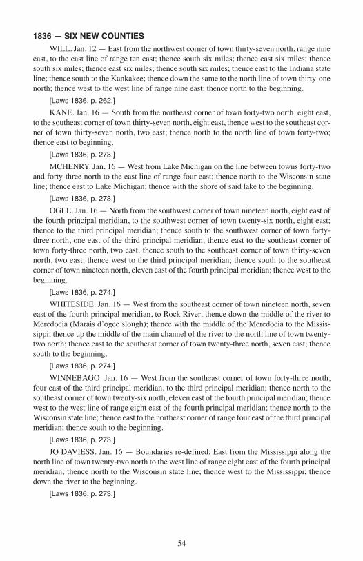
1836 — SIX NEW COUNTIES
WILL. Jan. 12 — East from the northwest corner of town thirty-seven north, range nineeast, to the east line of range ten east; thence south six miles; thence east six miles; thencesouth six miles; thence east six miles; thence south six miles; thence east to the Indiana stateline; thence south to the Kankakee; thence down the same to the north line of town thirty-onenorth; thence west to the west line of range nine east; thence north to the beginning.
[Laws 1836, p. 262.]
KANE. Jan. 16 — South from the northeast corner of town forty-two north, eight east,to the southeast corner of town thirty-seven north, eight east, thence west to the southeast cor-ner of town thirty-seven north, two east; thence north to the north line of town forty-two;thence east to beginning.
[Laws 1836, p. 273.]
MCHENRY. Jan. 16 — West from Lake Michigan on the line between towns forty-twoand forty-three north to the east line of range four east; thence north to the Wisconsin stateline; thence east to Lake Michigan; thence with the shore of said lake to the beginning.
[Laws 1836, p. 273.]
OGLE. Jan. 16 — North from the southwest corner of town nineteen north, eight east ofthe fourth principal meridian, to the southwest corner of town twenty-six north, eight east;thence to the third principal meridian; thence south to the southwest corner of town forty-three north, one east of the third principal meridian; thence east to the southeast corner oftown forty-three north, two east; thence south to the southeast corner of town thirty-sevennorth, two east; thence west to the third principal meridian; thence south to the southeastcorner of town nineteen north, eleven east of the fourth principal meridian; thence west to thebeginning.
[Laws 1836, p. 274.]
WHITESIDE. Jan. 16 — West from the southeast corner of town nineteen north, seveneast of the fourth principal meridian, to Rock River; thence down the middle of the river toMeredocia (Marais d’ogee slough); thence with the middle of the Meredocia to the Missis-sippi; thence up the middle of the main channel of the river to the north line of town twenty-two north; thence east to the southeast corner of town twenty-three north, seven east; thencesouth to the beginning.
[Laws 1836, p. 274.]
WINNEBAGO. Jan. 16 — West from the southeast corner of town forty-three north,four east of the third principal meridian, to the third principal meridian; thence north to thesoutheast corner of town twenty-six north, eleven east of the fourth principal meridian; thencewest to the west line of range eight east of the fourth principal meridian; thence north to theWisconsin state line; thence east to the northeast corner of range four east of the third principalmeridian; thence south to the beginning.
[Laws 1836, p. 273.]
JO DAVIESS. Jan. 16 — Boundaries re-defined: East from the Mississippi along thenorth line of town twenty-two north to the west line of range eight east of the fourth principalmeridian; thence north to the Wisconsin state line; thence west to the Mississippi; thencedown the river to the beginning.
[Laws 1836, p. 273.]
54
I PUB 15.10:Layout 1 3/16/10 8:54 AM Page 54
55
I PUB 15.10:Layout 1 3/16/10 8:54 AM Page 55
1837-1839 — TWENTY-ONE NEW COUNTIES
1837
Livingston ....................Established Feb. 27 .................Laws 1837, page ...........................83Bureau ..........................Established Feb. 28 .................Laws 1837, page ...........................93Cass ..............................Established Mar. 3...................Laws 1837, page .........................101Boone ...........................Established Mar. 4...................Laws 1837, page ...........................96DeKalb .........................Established Mar. 4...................Laws 1837, page ...........................97Stephenson ...................Established Mar. 4...................Laws 1837, page ...........................96
Winnebago, boundary re-defined .............. Mar. 4 ..................Laws 1837, page ................96McHenry, eastern boundary defined.......... Mar. 4 ..................Laws 1837, page ................89Henry, territory detached ........................... Mar. 4 ..................Laws 1837, page ................89Adams, Hancock, Warren and Mercer, western boundary defined ..... Mar. 4 ..................Laws 1837, page ................91
______________
1839
Marshall .......................Established Jan. 19 .................Laws 1839, page ...........................43Brown...........................Established Feb. 1...................Laws 1839, page ...........................52DuPage.........................Established Feb. 9...................Laws 1839, page ...........................73Dane (now Christian)...Established Feb. 15.................Laws 1839, page .........................104Logan ...........................Established Feb. 15.................Laws 1839, page .........................104Menard .........................Established Feb. 15.................Laws 1839, page .........................104Scott .............................Established Feb. 16.................Laws 1839, page .........................126Carroll ..........................Established Feb. 22.................Laws 1839, page .........................160Lee................................Established Feb. 27.................Laws 1839, page .........................170Jersey............................Established Feb. 28.................Laws 1839, page .........................208Warren..........................Established Feb. 28.................Laws 1839, page .........................110DeWitt ..........................Established Mar. 1 ..................Laws 1839, page .........................199Lake..............................Established Mar. 1 ..................Laws 1839, page .........................216Hardin ..........................Established Mar. 2 ..................Laws 1839, page .........................234Stark .............................Established Mar. 2 ..................Laws 1839, page .........................229
Ogle, territory added................................... Feb. 22 ................Laws 1839, page ..............162Dane, territory added.................................. Feb. 26 ................Laws 1839, page ..............188Macon, territory added ............................... Mar. 2..................Laws 1839, page ..............265Hardin-Pope, line defined .......................... Jan. 8, 1840.........Laws 1840, page ................38Logan, territory added ................................ Jan. 29, 1840.......Laws 1840, page ................39Dane, name changed to Christian............... Feb. 1, 1840 ........Laws 1840, page ................80
56
I PUB 15.10:Layout 1 3/16/10 8:54 AM Page 56
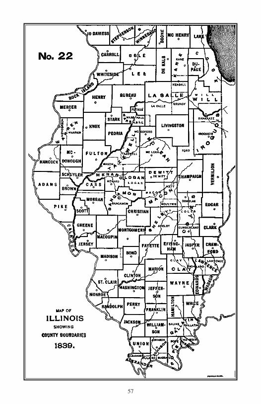
57
I PUB 15.10:Layout 1 3/16/10 8:55 AM Page 57
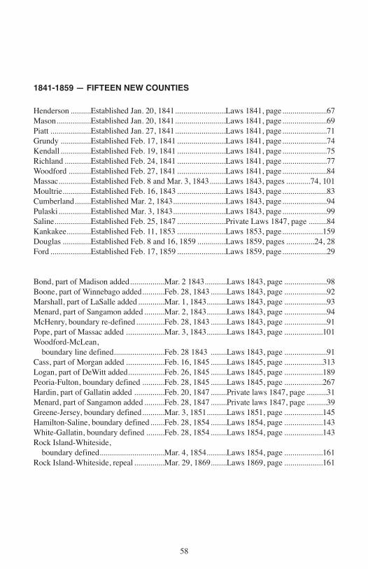
1841-1859 — FIFTEEN NEW COUNTIES
Henderson ..........Established Jan. 20, 1841.........................Laws 1841, page......................67Mason.................Established Jan. 20, 1841.........................Laws 1841, page......................69Piatt ....................Established Jan. 27, 1841.........................Laws 1841, page......................71Grundy ...............Established Feb. 17, 1841 ........................Laws 1841, page......................74Kendall ...............Established Feb. 19, 1841 ........................Laws 1841, page......................75Richland .............Established Feb. 24, 1841 ........................Laws 1841, page......................77Woodford ...........Established Feb. 27, 1841 ........................Laws 1841, page......................84Massac................Established Feb. 8 and Mar. 3, 1843........Laws 1843, pages ............74, 101Moultrie..............Established Feb. 16, 1843 ........................Laws 1843, page......................83Cumberland........Established Mar. 2, 1843..........................Laws 1843, page......................94Pulaski................Established Mar. 3, 1843..........................Laws 1843, page......................99Saline..................Established Feb. 25, 1847 ........................Private Laws 1847, page .........84Kankakee............Established Feb. 11, 1853 ........................Laws 1853, page....................159Douglas ..............Established Feb. 8 and 16, 1859 ..............Laws 1859, pages ..............24, 28Ford ....................Established Feb. 17, 1859 ........................Laws 1859, page......................29
Bond, part of Madison added.................Mar. 2 1843...........Laws 1843, page .....................98Boone, part of Winnebago added...........Feb. 28, 1843 ........Laws 1843, page .....................92Marshall, part of LaSalle added .............Mar. 1, 1843..........Laws 1843, page .....................93Menard, part of Sangamon added ..........Mar. 2, 1843..........Laws 1843, page .....................94McHenry, boundary re-defined..............Feb. 28, 1843 ........Laws 1843, page .....................91Pope, part of Massac added ...................Mar. 3, 1843..........Laws 1843, page ...................101Woodford-McLean,
boundary line defined.........................Feb. 28 1843 ........Laws 1843, page .....................91Cass, part of Morgan added ...................Feb. 16, 1845 ........Laws 1845, page ...................313Logan, part of DeWitt added..................Feb. 26, 1845 ........Laws 1845, page ...................189Peoria-Fulton, boundary defined ...........Feb. 28, 1845 ........Laws 1845, page ...................267Hardin, part of Gallatin added ...............Feb. 20, 1847 ........Private laws 1847, page ..........31Menard, part of Sangamon added ..........Feb. 28, 1847 ........Private laws 1847, page ..........39Greene-Jersey, boundary defined...........Mar. 3, 1851..........Laws 1851, page ...................145Hamilton-Saline, boundary defined.......Feb. 28, 1854 ........Laws 1854, page ...................143White-Gallatin, boundary defined .........Feb. 28, 1854 ........Laws 1854, page ...................143Rock Island-Whiteside,
boundary defined................................Mar. 4, 1854..........Laws 1854, page ...................161Rock Island-Whiteside, repeal ...............Mar. 29, 1869........Laws 1869, page ...................161
58
I PUB 15.10:Layout 1 3/16/10 8:55 AM Page 58

59
I PUB 15.10:Layout 1 3/16/10 8:55 AM Page 59

Name of Counties
Six counties of Illinois, Washington, Jefferson, Madison, Monroe, Adams, and Jackson,were named for Presidents of the United States; Adams for John Quincy Adams, sixth Presi-dent and not for John Adams, second President, as is sometimes stated.
Four counties, Bond, Coles, Edwards, Ford, were named, respectively for the first, sec-ond, third and seventh Governors of Illinois. Bond received its name the year before the elec-tion of the first Governor of the State.
Sixteen counties were named for other citizens of the State, prominent in different walksof life.
Alexander — for William M. Alexander, an early settler of the county bearing his nameand Senator in the second and third General Assemblies of the State.
Cook — for Daniel P. Cook, a pioneer lawyer, first Attorney General of the State andRepresentative in Congress from 1819 to 1827.
Douglas — for Stephen A. Douglas, an eminent lawyer, brilliant political orator, Secre-tary of State (1840), Representative in Congress (1843-1847), United States Senator (1847-1861), and candidate for the Presidency in 1860.
Edgar — for John Edgar, a pioneer merchant, politician and land speculator.Kane — for Elias Kent Kane, a pioneer lawyer, Territorial judge, prominent member of
the Constitutional Convention of 1818, first Secretary of State of Illinois, and later UnitedStates Senator.
Logan — for Dr. John Logan, a pioneer physician, father of General John A. Logan.McHenry — for William McHenry, a pioneer of White County, soldier of the War of
1812 and the Black Hawk war, Representative in the first, fourth, fifth and ninth General As-semblies, and Senator in the sixth.
McLean — for John McLean, a pioneer lawyer, Territorial judge, first Representative inCongress from Illinois (1818), and United States Senator (1824-1825).
Menard — for Pierre Menard, a pioneer Indian trader, Colonel of Territorial militia, andfirst Lieutenant Governor of the State.
Ogle — for Joseph Ogle, pioneer politician and Lieutenant of Territorial militia.Piatt — for James A. Piatt, Sr., who settled in that area in 1829, coming from Indiana.Pope — for Nathaniel Pope, first Territorial Secretary of State (1809-1816), and last Ter-
ritorial Delegate to Congress from Illinois.Stephenson — for Benjamin Stephenson, prominent pioneer, a Colonel Territorial militia,
and Adjutant General of the Territory (1813-1814).White — for Leonard White, pioneer of Gallatin County, Major of Territorial militia,
member of Constitutional Convention of 1818, State Senator in second and third General As-semblies.
Whiteside — for Samuel Whiteside, a Colonel of Territorial militia, Representative inthe First General Assembly, and Brigadier General of militia during Black Hawk War.
Will — for Conrad Will, a pioneer politician, Territorial Recorder of Jackson County,member of the Constitutional Convention of 1818, and member of the General Assembliesof the State from the first to ninth inclusive.
Twenty-two counties were named in honor of military heroes, generally of the Revolu-tion, but some of later wars.
Brown — for Jacob Brown, Major General during the War of 1812, who won distinctionat Sackett’s Harbor, Chippewa and Niagara.
Clark — for George Rogers Clark, a soldier of the Revolution, who, as a Colonel of Vir-ginia militia, established Colonial control in the Illinois country, by the capture of Kaskaskiaand Fort Vincennes.
60
I PUB 15.10:Layout 1 3/16/10 8:55 AM Page 60
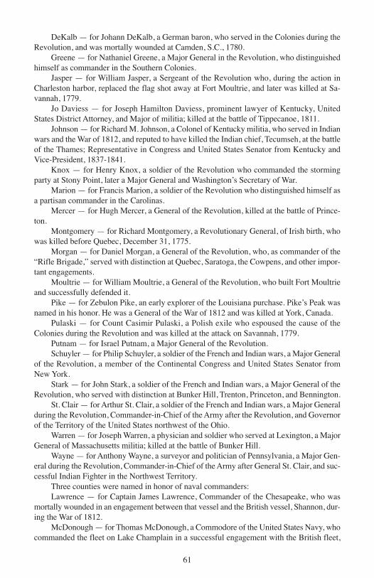
DeKalb — for Johann DeKalb, a German baron, who served in the Colonies during theRevolution, and was mortally wounded at Camden, S.C., 1780.
Greene — for Nathaniel Greene, a Major General in the Revolution, who distinguishedhimself as commander in the Southern Colonies.
Jasper — for William Jasper, a Sergeant of the Revolution who, during the action inCharleston harbor, replaced the flag shot away at Fort Moultrie, and later was killed at Sa-vannah, 1779.
Jo Daviess — for Joseph Hamilton Daviess, prominent lawyer of Kentucky, UnitedStates District Attorney, and Major of militia; killed at the battle of Tippecanoe, 1811.
Johnson — for Richard M. Johnson, a Colonel of Kentucky militia, who served in Indianwars and the War of 1812, and reputed to have killed the Indian chief, Tecumseh, at the battleof the Thames; Representative in Congress and United States Senator from Kentucky andVice-President, 1837-1841.
Knox — for Henry Knox, a soldier of the Revolution who commanded the stormingparty at Stony Point, later a Major General and Washington’s Secretary of War.
Marion — for Francis Marion, a soldier of the Revolution who distinguished himself asa partisan commander in the Carolinas.
Mercer — for Hugh Mercer, a General of the Revolution, killed at the battle of Prince-ton.
Montgomery — for Richard Montgomery, a Revolutionary General, of Irish birth, whowas killed before Quebec, December 31, 1775.
Morgan — for Daniel Morgan, a General of the Revolution, who, as commander of the“Rifle Brigade,” served with distinction at Quebec, Saratoga, the Cowpens, and other impor-tant engagements.
Moultrie — for William Moultrie, a General of the Revolution, who built Fort Moultrieand successfully defended it.
Pike — for Zebulon Pike, an early explorer of the Louisiana purchase. Pike’s Peak wasnamed in his honor. He was a General of the War of 1812 and was killed at York, Canada.
Pulaski — for Count Casimir Pulaski, a Polish exile who espoused the cause of theColonies during the Revolution and was killed at the attack on Savannah, 1779.
Putnam — for Israel Putnam, a Major General of the Revolution.Schuyler — for Philip Schuyler, a soldier of the French and Indian wars, a Major General
of the Revolution, a member of the Continental Congress and United States Senator fromNew York.
Stark — for John Stark, a soldier of the French and Indian wars, a Major General of theRevolution, who served with distinction at Bunker Hill, Trenton, Princeton, and Bennington.
St. Clair — for Arthur St. Clair, a soldier of the French and Indian wars, a Major Generalduring the Revolution, Commander-in-Chief of the Army after the Revolution, and Governorof the Territory of the United States northwest of the Ohio.
Warren — for Joseph Warren, a physician and soldier who served at Lexington, a MajorGeneral of Massachusetts militia; killed at the battle of Bunker Hill.
Wayne — for Anthony Wayne, a surveyor and politician of Pennsylvania, a Major Gen-eral during the Revolution, Commander-in-Chief of the Army after General St. Clair, and suc-cessful Indian Fighter in the Northwest Territory.
Three counties were named in honor of naval commanders:Lawrence — for Captain James Lawrence, Commander of the Chesapeake, who was
mortally wounded in an engagement between that vessel and the British vessel, Shannon, dur-ing the War of 1812.
McDonough — for Thomas McDonough, a Commodore of the United States Navy, whocommanded the fleet on Lake Champlain in a successful engagement with the British fleet,
61
I PUB 15.10:Layout 1 3/16/10 8:55 AM Page 61
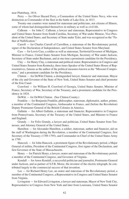
near Plattsburg, 1814.Perry — for Oliver Hazard Perry, a Commodore of the United States Navy, who won
distinction as Commander of the fleet in the battle of Lake Erie, in 1813.Twenty-one counties were named for statesman and politicians, not citizens of Illinois,
some of whom had distinguished themselves in military as well as civil life.Calhoun — for John C. Calhoun, a lawyer and statesman, Representative in Congress
and United States Senator from South Carolina, Secretary of War under Monroe, Vice-Pres-ident of the United States, and Secretary of State under Tyler, and was recognized as the “Fa-ther of Nullification.”
Carroll — for Charles Carroll of Carrollton, a statesman of the Revolutionary period,signer of the Declaration of Independence, and United States Senator from Maryland.
Cass — for Lewis Cass, a soldier as well as statesman, Territorial Governor of Michigan,Minister to France, United States Senator from Michigan, Secretary of War under Jackson,Secretary of State under Buchanan, and at one time a prominent candidate for the Presidency.
Clay — for Henry Clay, a statesman and political orator, Representative in Congress andUnited States Senator from Kentucky, three times Speaker of the United States House of Rep-resentatives, famous as the author of the political measures known as the “Missouri Compro-mise,” and a prominent candidate for the Presidency.
Clinton — for DeWitt Clinton, a distinguished lawyer, financier and statesman, Mayorof the city and Governor of the State of New York, United States Senator and chief promoterof the Erie Canal.
Crawford — for William H. Crawford of Georgia, United States Senator, Minister ofFrance, Secretary of War, Secretary of the Treasury, and a prominent candidate for the Pres-idency in 1824.
DeWitt — for DeWitt Clinton. (See Clinton County.)Franklin — for Benjamin Franklin, philosopher, statesman, diplomatist, author, printer,
a member of the Continental Congress, Ambassador to France, and (before the Revolution)Deputy Postmaster General of the British Colonies in America.
Gallatin — for Albert Gallatin, a statesman and financier, Representative in Congressfrom Pennsylvania, Secretary of the Treasury of the United States, and Minister to Franceand England.
Grundy — for Felix Grundy, a lawyer and politician, United States Senator from Ten-nessee, and Attorney General of the United States.
Hamilton — for Alexander Hamilton, a soldier, statesman, author and financier, aid onthe staff of Washington during the Revolution, a member of the Continental Congress, firstSecretary of the Treasury (1789-1795), and Commander-in-Chief of the United States Armyin 1799.
Hancock — for John Hancock, a prominent figure of the Revolutionary period, a MajorGeneral of militia, President of the Continental Congress, first signer of the Declaration, andfirst Governor of the State of Massachusetts.
Henry — for Patrick Henry, a lawyer, orator and statesman of the Revolutionary period,a member of the Continental Congress, and Governor of Virginia.
Kendall — for Amos Kendall, a successful politician and journalist, Postmaster Generalunder Jackson, and as partner of S.F.B. Morse, the inventor of the electric telegraph, he con-tributed largely to the commercial success of that invention.
Lee — for Richard Henry Lee, an orator and statesman of the Revolutionary period, amember of the Continental Congress, a Representative in Congress and United States Senatorfrom Virginia.
Livingston — for Edward Livingston, a lawyer and statesman, Mayor of New York City,Representative in Congress from New York and later from Louisiana, United States Senator
62
I PUB 15.10:Layout 1 3/16/10 8:55 AM Page 62

from the latter state, Secretary of State under Jackson, and United States Minister to France.Macon — for Nathaniel Macon, a Colonel during the Revolution and later a Represen-
tative and United States Senator in Congress from North Carolina. He strenuously opposedthe adoption of the United States Constitution as conferring powers on the Federal governmentwhich should be reserved to the States.
Marshall — for John Marshall, a soldier of the Revolution, statesman, author and jurist,Ambassador to France, Representative in Congress from Virginia, Secretary of State and ChiefJustice of the United States Supreme Court.
Randolph — for Edmund Randolph, a soldier of the Revolution, a lawyer and statesman,member of the Continental Congress, Attorney General and Governor of Virginia, Secretaryof State of the United States and Attorney General under Washington.
Shelby — for Isaac Shelby, a soldier of the Revolution and Indian wars, Governor ofKentucky (1792-1796) and again (1812-1816). He commanded the Kentucky troops in thebattle of the Thames in the War of 1812.
Tazewell — for Lyttleton W. Tazewell, an eminent lawyer, Governor, Representative inCongress, and United States Senator from Virginia.
Nine counties of Illinois adopted the names of counties of other states through the influ-ence of emigrants from the counties whose names were thus adopted: Champaign and Rich-land from Ohio; Christian, Hardin, Henderson, Mason, Scott, and Woodford from Kentucky;and Williamson from Tennessee.
Seven counties bear Indian names, given originally, as a general rule, to a creek, river orlake, and afterward transferred to the county. These named are Iroquois, Kankakee, Macoupin,Peoria, Sangamon, Wabash and Winnebago.
Fourteen other counties derive their names from sources so diverse that they cannoteasily be classified under any special head.
Boone — for Daniel Boone, a pioneer hunter, Indian fighter and pathfinder of the earlydays.
Bureau — for Pierre Buero, a French trader with the Indians.Cumberland — from the Cumberland road, named in its turn from the town of Cumber-
land, Maryland, which derived its name from the mountain range of the same name adopted,presumably, from the Cumberland mountains of Great Britain.
DuPage — from a small river of the same name said to have derived its name from aFrench trapper and trader of that region.
Effingham — for Lord Edward Effingham, who resigned his commission as general inthe British army, 1775, refusing to serve in the war against the colonies.
Fulton — for Robert Fulton, the first successful builder of steamboats on American wa-ters.
Jersey — for the State of New Jersey, which derived its name from the Isle of Jersey,Great Britain.
Lake — for Lake Michigan.LaSalle — for Robert de LaSalle, the French explorer who effected the first white set-
tlements in Illinois and explored the Mississippi to the Gulf.Massac — from Fort Massac, a corruption of a French surname, Massiac.Rock Island — from the rock island of that name in the Mississippi.Saline — from Saline creek, so called on account of numerous salt springs in that local-
ity.Union — from the federal union of the American States.Vermilion — from the river of that name, the principal branches of which flow through
the county.
63
I PUB 15.10:Layout 1 3/16/10 8:55 AM Page 63


![TRANSITION TO DEVOLVED GOVERNMENT ACTRev. 2014] Transition to Devolved Government No. 1 of 2012 3 NO. 1 OF 2012 TRANSITION TO DEVOLVED GOVERNMENT ACT ARRANGEMENT OF SECTIONS PART I](https://img.dokumen.tips/doc/110x75/5aad27177f8b9aa06a8df495/transition-to-devolved-government-rev-2014-transition-to-devolved-government-no.jpg)