Embed Size (px)
Citation preview

ORGANIZATION STRUCTURE AND WEATHER FORECASTING
India Meteorological Department Ministry of Earth Sciences

Meteorological Observations
Organisation Structure
Forecast & Warnings product and its dissemination
Warnings skill score
Future schemes
PRESENTATION LAYOUT

METEOROLOGICAL OBSERVATIONS
Weather Monitoring Assessment of synoptic condition of the
atmosphere for analysing the characteristics of weather systems in terms of their genesis, evolution, intensification, movement, decay and associated adverse weather
Assimilation in various global and regional numerical weather prediction models
Development of climatology Verification of forecast

OUR OBSERVATIONAL NETWORK Type of Observatory Nos.
Doppler Weather Radars (DWRs) 23 Automatic Weather Systems (AWS) 725 Automatic Rain Gauges (ARG) 1124 Upper Air Radiosonde Observatories 39 Pilot Balloon Observatories 62 Surface Observatories 559 Aviation Current Weather Observatories 71 High Wind Speed Recording Stations 13 INSAT-based Data Collection Platforms 100 Hydrometeorological Observatories 701 Non-Departmental Raingauge Stations: - Reporting 3540 - Non-Reporting 5039 Non-Departmental Glaciological Observatories (Non-reporting): - Snowgauges 21 - Ordinary Raingauges 10 - Seasonal Snow Poles 6 Agrometeorological Observatories 219 Evaporation Stations 222 Soil Moisture Recording Stations 49 Dew-fall Recording Stations 80 Evapotranspiration Stations 39 Ozone Stations 6 Radiation Stations 45 Air Pollution Observatories: - Background Pollution Observatories 10 - Urban Climatological Units 2 - Urban Climatological Observatories 13 Ships of the Indian Voluntary Observing Fleet 203

WEATHER RELATED NATURAL HAZARDS OCCUR THROUGHOUT THE YEAR
WINTER (JAN-FEB)
PRE-MONSOON (MAR-MAY)
MONSOON (JUN-SEP)
POST-MONSOON (OCT-DEC)
WD COLD WAVE, FOG,
HEAVY SNOW, FROST
CYCLONIC DISTURBANCES
HEAT WAVE THUNDER STORMS,
SQUALLS HAIL STORM TORNADO HEAVY RAINFALL, FLOODS/FLASH FLOODS DROUGHTS CYCLONIC
DISTURBANCES NORTHEAST MONSOON (HEAVY RAINFALL)
Near 90 % of loss of life due to natural disasters is caused by Weather, Climate and Water related hazards

North Region
Central Region
South Region
West Region
East Region
North East Region
Regional Centres Delhi, Kolkata, Guwahati, Nagpur, Mumbai, Chennai
Pune Centre for Research /Training, Agromet, and surface instrumentation
NWFC at New Delhi and WF at Pune
Meteorological Centres 1. Srinagar 2. Chandigarh 3. Shimla 4. Dehra Dun 5. Lucknow 6. Patna 7. Itanagar 8. Jaipur 9. Ranchi 10. Agartatala 11. Ahmedabad 12. Bhopal 13. Raipur 14. Bhuvaneshwar 15. Hyderabad 16. Bangalore 17. Thiruvananthapuram 18. Panjim 19. Gangtok

Satellite Observations Sat. Met Division, IMD
(Deployed by Department of Space)
Aircraft Reports
Ship Reports
Ocean Buoys data (Deployed by Dept. of Ocean
Development)
Global Data
Data-flow at Three Hourly Intervals on 24x7 Mode
Regional Telecom
Hub (RTH)
Delhi National Weather Forecasting Centre
Pune Weather Central
IMD, Delhi
NWP forecasts
Regional Centres – 6
Met. Centres - 19
Cyclone Centres - 6
State Level Met.
Centres
Airport Met. Offices
Central / State Govt/ M
edia/ Public Communication Analyses & Forecasting Dissemination Observations
16 DWR Networks
Weather Forecasting System
Data ported to NCMRWF for
medium range weather forecasts
Upper-Air Observations
(62 PB stations + 39 RS/RW)
Surface Observations
Manned (559) + AWS (725) +ARG (1124)
There are total 2664 (Scientists, AM, SA) trained manpower. In all the centres, trained forecasters are working on 24X7 basis

FORECASTING WORK STATION
Global plotting Conditional plotting
Profile
Gauges
Plane trajectories
T-Phaigram

VIDEO- CONFERENCING
• Daily between NWFC, DDGM (WF), RWFCs
• To improve accuracy of Weather Forecast and Warnings
• To remove contradictions in Weather Forecast and warnings

THREE TIER FORECASTING STRUCTURE Level Responsibility
National NWFC Met Subdivision Forecasting/Warning,
Guidelines Developmental work PUNE Documentation , Reports
Regional
RMCs District-wise Forecasting/warning, other Forecasts
Local
MCs District-wise Forecasting/warning, other Forecasts

SPATIAL AND TEMPORAL DOMAINS OF FORECAST
Nowcasting for next few hours (Venue/ location specific) Short Range for next 120 hour (Location/District/ State/Met Sub-division) Medium Range for next 3-10 days (District/Block) Extended range for 10-30 days (Met Subdivision/State/ Homogeneous regions) Long range for month/season (Homogeneous regions/country)
Customized Forecasts- Power, Defense, Adventure,
Road/Railway transports, Highway, Expedition, pilgrimage, Public Utility, VIP functions, Strategic operations, City, Tourism, Space, event based etc
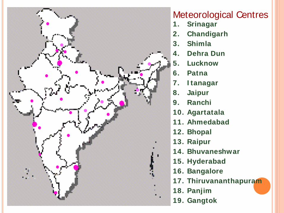
OUR SERVICE STANDARDS
No. Our Services and Transactions
How we measure our performance in this area
Service Standard
1 Weather Forecasts and Warnings
Timely release of 5 day Weather Forecast and Warnings 6 Hours
2 Agro-meteorological advisories and Forecast at district level
Issue of 5 day Agro-meteorological advisories and Forecast at district Level (625)
Bi-Weekly
3 Meteorological support for Civil Aviation purpose
Meteorological support for Civil Aviation purpose
60 Minutes
4 Rainfall monitoring Rainfall Monitoring (District/subdivision wise) 1 Day
5 City Forecast 5 day Forecast for 324 locations 6 hourly
6 Tourism Forecast 5 day Forecast for 106 Locations 6 hourly
7 Nowcast 3 hourly warnings from for 156 Locations 3 Hourly

SUB-DIVISION WISE FORECAST & WARNINGS
21 April(Day 1) : ♦ Heat wave conditions at many places with severe heat wave at a few places over Jharkhand; heat wave at a few places
with isolated severe heat wave over Odisha. ♦ Heat wave conditions at a few places over Bihar and East Uttar Pradesh; at isolated places over East Madhya Pradesh,
Vidarbha, Chhattisgarh, Gangetic West Bengal, Telangana and Rayalaseema. ♦ Warm night conditions likely at isolated places over Punjab, Haryana, Chandigarh & Delhi. ♦ Heavy rain at isolated places over Sub-Himalayan West Bengal & Sikkim, Arunachal Pradesh, Assam & Meghalaya,
Nagaland, Manipur, Mizoram & Tripura. ♦ Thunderstorm accompanied with squall/hail likely at isolated places over Assam & Meghalaya. ♦ Dust/thunderstorm likely at isolated places over Punjab, Haryana, Chandigarh & Delhi, north Rajasthan and West Uttar
Pradesh.

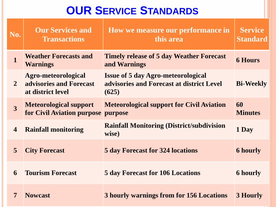
ALL INDIA SEVERE WEATHER WARNINGS
Heavy Rainfall Heat Wave & Thundersquall Fog/Visibility
Heavy Snow Cold wave/ visibility & frost Heat Wave
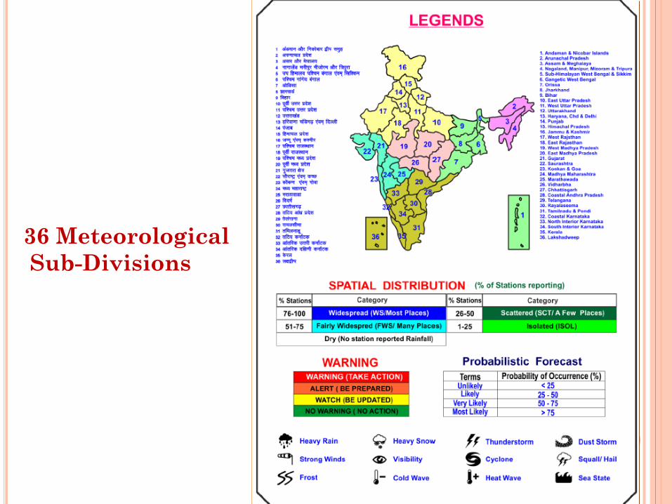
36 Meteorological Sub-Divisions

DISTRICT WARNINGS

5 day City Forecast (for 324 cities)
Year
Temperature(oC) Rainfall (mm)
Highest Maximum(Date
)
Lowest Minimum(Date)
24 Hours Highest (Date) Monthly Total
2011 35.9( 13) 18.7 (07) 25.5 ( 20 ) 55.4 2010 35.5( 08) 20.7 (18) 62.8( 30 ) 155.7 2009 39.1 ( 26) 18.7 (01) 17.6 ( 03 ) 53.0 2008 37.6(23) 18.2 (04) 20.3 ( 04 ) 29.5 2007 37.0(30) 15.5(13 ) 198.0 ( 11 ) 458.6 2006 37.1(29 ) 18.8 (04) 68.7 ( 04 ) 136.5 2005 35.8(21) 19.2 (04 ) 29.9 ( 29 ) 109.5 2004 34.0(30) 17.4(13) 82.9 ( 19 ) 384.3 2003 35.0 (27) 18.2 (23) 48.8 ( 02 ) 217.4 2002 34.4( 20) 14.2 (03 ) 34.2 ( 11 )� 184.4
ALL TIME RECORD
41.5� (30 , 1960) 14.2 ( 03, 2002) 198.0 (11, 2007) 537.3 ( 1977 )
Month
Mean Temperature(oC)
Mean Total
Rainfall (mm)
Mean Number of Rainy
Days
Mean Number of days with
Daily Minimum
Daily Maximum HAIL Thunder FOG SQUALL
Jan 10.0 25.5 5.6 0.5 0.1 0.5 7.1 0.1 Feb 13.1 27.9 24.9 2.5 0.0 1.8 2.0 0.0 Mar 18.6 32.2 72.0 3.5 0.1 4.3 1.1 1.0 Apr 22.2 33.1 206.8 8.9 0.0 11.0 0.4 2.2 May 23.3 32.4 352.6 13.7 0.0 13.0 0.1 2.8 Jun 24.8 32.0 359.3 15.2 0.0 8.9 0.1 0.4 Jul 24.9 31.4 369.4 16.1 0.0 6.7 0.0 0.2 Aug 25.0 31.9 257.9 15.2 0.0 8.7 0.1 0.2 Sep 24.4 31.8 227.6 11.9 0.0 9.4 0.6 0.2 Oct 22.2 31.2 157.0 6.8 0.0 4.5 1.3 0.1 Nov 17.1 29.5 39.5 1.8 0.0 0.6 3.0 0.0 Dec 11.4 26.4 14.8 0.7 0.0 0.1 6.3 0.0
Annual 19.8 30.5 2087.5 96.9 0.3 69.5 22.1 7.2
EXTREME WEATHER EVENTS IN THE MONTH OF APRIL
CLIMATOLOGICAL TABLE (PERIOD: 1971-2000)

5 day Tourism Forecast (106 places)

District Forecast (All Districts)

All India Thunderstorm Nowcast (156 stations)


Expedition Forecast

ADVANCES IN DISSEMINATION MECHANISM Telephone, Tele-fax Mobile Phones (SMS) VHF/HFRT/Police Wireless Satellite based warning dissemination System Global telecommunication system (GTS) :
(International Telecom centres) Internet (e-mail), ftp Websites Radio/TV, News Paper network (AM, FM,
Community Radio, Private TV) : Prasar Bharati and private broadcasters

Specialized Divisions
Agricultural Meteorology
Aviation Meteorology
Regional Climate Centre
(SASCOF)
Hydro meteorology
Instrumentation
Regional Telecom
Hub Regional
Specialised Meteorological Centre, New Delhi
Positional Astronomy
Satellite Meteorology
Seismology
Services
Regional Training Centre, Pune

• Provides cyclone advisories and daily outlooks to 8 Members countries Bangladesh India (RSMC, New-Delhi) Maldives Myanmar Oman Pakistan Sri Lanka Thailand
WMO/ESCAP RECOGNISED Regional Specialised Meteorological Centre, New Delhi
• For national purpose, IMD has 3 tier organisation to provide cyclone warning
• Area Cyclone Warning Centres at Mumbai, Kolkata and Chennai
• Cyclone Warning Centre at Ahmedabad, Visakhapatnam and Bhubaneswar
• Cyclone Warning Division at New Delhi

FOREIGN TRAINEE TRAINED IN RSMC, NEW DELHI
Year Name of Training Period Countries 2007 WMO cyclone forecasters
training 12-23 Feb. Bangladesh, Myanmar and Sri
Lanka 2008 WMO cyclone forecasters
training 14-25 Feb Thailand and Sri Lanka
2009 WMO cyclone forecasters training
09-20 Feb. Bangladesh and Maldives
2010 WMO cyclone forecasters training
1-12 feb. Myanmar and Sri Lanka
2011 WMO cyclone forecasters training
28Feb.-11 March
Bangladesh, Oman, Myanmar, India
2012 WMO cyclone forecasters training
20 Feb-02 March
Thailand, Srilanka, Maldives, India
2013 WMO cyclone forecasters training
1-12 April Bangladesh, Myanmar, Oman, India
2014 WMO cyclone forecasters training
17-28 February
Myanmar, Sri Lanka, Thailand, India
2015 ITWTCF-International Training Workshop on Tropical Cyclone Forecasting
03-14 August Myanmar, Sri Lanka, Thailand, India, Maldieves, Oman, Bangladesh, Laos, Cambodia.


WARNINGS SKILL SCORES

Heavy rainfall warning (2002-15)

Heavy rainfall warning (2002-15)

Trend in heavy rainfall warning (2002-15)

Advances in Cyclone Forecasting : Improvement in Track forecast accuracy
Reduction in error from 2006-10 to 2011-15 :
12 hr : 26%, 24 hr : 31% 36 hr : 41%, 48 hr : 49% 60 hr : 56%, 72 hr : 60%
Average error in km (2011-15) Lead Error Lead Error 12 hr – 59.1 24 hr- 97.5 36 hr – 120.0 48 hr- 145.5 60 hr – 160.4 72 hr- 183.2 km
050
100150200250300350400450500550
2003 2004 2005 2006 2007 2008 2009 2010 2011 2012 2013 2014 2015
Trac
k Fo
reca
st E
rror
(km
)
Year
Annual Average Track Forecast Error (km) 12 hr forecast error(km) 24 hr forecast error (km)36 hr forecast error (km) 48 hr forecast error (km)60 hr forecast error (km) 72 hr forecast error (km)84 hr forecast error (km) 96 hr forecast error (km)108 hr forecast error (km) 120 hr forecast error (km)Linear (12 hr forecast error(km)) Linear (24 hr forecast error (km))

Average error in km (2011-15) Lead Error Lead Error 12 hr – 36.5 24 hr- 56.3 km, 36 hr – 60.6 48 hr- 93.5 km 60 hr – 95.2 72 hr- 105.7 km
Advances in Cyclone Forecasting : Improvement in landfall point forecast
-100
0
100
200
300
400
500
600
2003 2004 2005 2006 2007 2008 2009 2010 2011 2012 2013 2014 2015
Land
fall
Poin
t Err
or (k
m)
Year
Annual Average Landfall Point Error (km)
12 hr 24 hr36 hr 48 hr60 hr 72 hrLinear (12 hr) Linear (24 hr)

Intensity forecast skill (%) Improvement (AE) Average Skill (%) - (2011-15) Lead Skill Lead Skill 12 hr- 20.9 24 hr- 36.4 36 hr- 49.4 48 hr- 55.8 60 hr- 62.3 72 hr- 67.3
Advances in Cyclone Forecasting :
Improvement in skill from 2006-10 to 2011-15
12 hr : 26.7% 24 hr: 7.0%, 36 hr : 5.2%, 48 hr : 9.9% 68 hr : 17.8%, 72 hr : 0.3%
-40
-20
0
20
40
60
80
100
120
2005 2006 2007 2008 2009 2010 2011 2012 2013 2014 2015
Skill
(%)
Year
Skill (%) of maximum sustained surface wind forecast based on absolute error compared to persistence forecast error
12hr 24hr 36hr 48hr60hr 72hr 84hr 96hr108hr 120hr Linear (12hr) Linear (24hr)

FUTURE SCHEMES

COMMISSIONING OF 9 DWRS
C-band DWRs at Jammu, Shimla & Mussoorie/Dehradun and X-band DWRs at other locations

COMMISSIONING 18 MRRS
Useful for measurement of rain rate, liquid water content and drop size distribution from near ground to several hundred metres. Also used for now-casting of precipitation i.e., it may detect the start of rain from ground level (in 10 Km radius) to high above the radar several minutes before the start of rain at ground level.

COMMISSIONING OF 12 COMPACT SEVERE WEATHER DETECTION RADAR SYSTEMS
Useful for the detection of rainfall intensity at short ranges and ideally suited to provide forecasters with detailed information about local rainfall and early warnings of approaching storms.
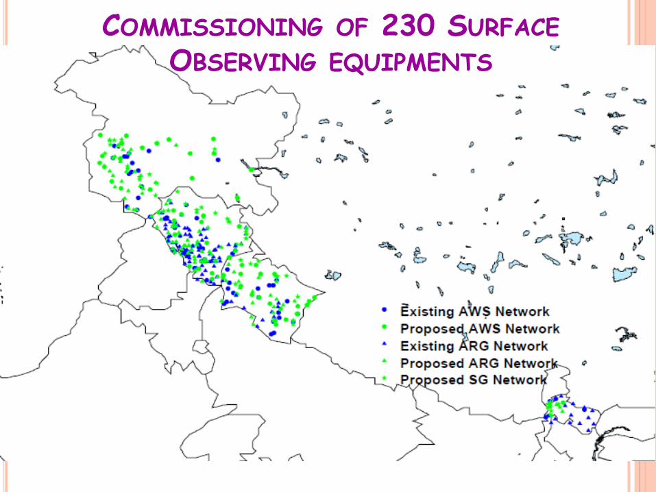
COMMISSIONING OF 230 SURFACE OBSERVING EQUIPMENTS

Commissioning of 270 Surface Observing equipments

Commissioning of 14 Doppler Weather Radars One C-band DWR at Guwahati and X-band DWRs at other 13 places

Commissioning 40 MRRs

Commissioning of 10 Lightning Detection Systems (LDS)
This helps in tracking the thunderstorm activity in real time and thus is very useful in nowcasting especially in aviation sector, planning sport events and functioning of high risk establishments etc.

Commissioning of 8 Microwave Radiometers

Commissioning of 8 Doppler Wind Lidars/Wind Profilers
Used for wind shear, low level jet identification, clear air turbulence, fog detection, PBL dynamics monitoring etc.

PROPOSED NETWORK
Type of Equipment Integrated Himalayan
Scheme High Impact
Severe Weather Warning
Modelling of Changing
Water cycle Western & Central
North-eastern
( C/X Band DWRs) 9 14 2 - Micro Rain Radars (MMRs) 18 40 - - Cloud/Precipitation Radar - - 2 - GPS based Upper Air 7 9 2 - (AWS)/ (ARG)/ (SG) 230 270 200 200 Compact Severe Weather Detection Radar Systems
12 - - -
Lightning Detection - 10 - - Heliport AWOS 9 19 - - Microwave Radiometers - 8 4 - Wind LIDARs - 8 3 - Mobile AWS 7 20 10 - UAV - - 6 - Disdrometer - - 6 - SODAR - - 1 -
Surface/Snow Observatory 15 - - 40

PROPOSED NETWORK-MODERNIZATION PHASE-11
S.N. Item Number 1 Automatic Weather Station (AWS) 500 2 Automatic Rain Guages (ARG) 4000 3 Portable Upper Air stations 5
4-a Wind Profiler (tropospheric) 5 4-b Wind Profiler (boundary layer type) for aviation 5 5 Electrolyzers for H2 generation 38
6-a Doppler Weather Radar- S-band 17 6-b Doppler Weather Radar- C/X-band 12 6-c Doppler Weather Radar- Portable 2 7 Microwave Radiometer for aviation 4 8 Heliport AWOS for aviation 20
9-a Public weather systems (PWS) full 7 9-b Public weather systems (PWS) truncated 27* 10 Forecasting System 102* 12 Video wall 1*

Thanks