Embed Size (px)
Citation preview

ACCEPTED MANUSCRIPT
ACCE
PTED
MAN
USCR
IPT
1
Influence of pre-salt alignments in post-Aptian magmatism in the Cabo Frio High and its
surroundings, Santos and Campos basins, SE Brazil: An example of non–plume-related
magmatism
Sérgio Goulart Oreiro1*, José Antônio Cupertino2, Peter Szatmari3, and Antônio
Thomaz Filho4
1Petrobras, E&P/EXP, Av República do Chile, 65, Centro, Rio de Janeiro, RJ, sala 1301. 2Petrobras, E&P/EXP, Av. República do Chile, 65, Centro, Rio de Janeiro, RJ, sala 1302. 3Petrobras, CENPES/PDEXP/GEOF, Av1, quadra 7, Cidade Universitária, Ilha do Fundão, Rio de Janeiro, RJ. 4UERJ, Rua São Francisco Xavier, 524 Maracanã, Rio de Janeiro, RJ- Bloco 'A' - Sala 4030. *Corresponding author. E-mail addresses: [email protected] (S.G. Oreiro), [email protected] (J.A. Cupertino), [email protected] (P. Szatmari), [email protected] (A.T. Filho) Abstract
This study, based on interpretations of 2D and 3D seismic data, onshore satellite data, and offshore
seismic mapping and well data, addresses the geological evolution of Late Cretaceous and Early
Tertiary magmatism in the offshore Cabo Frio area, at the border between the Santos and Campos
basins, SE Brazil. The analysis of the available data set suggests an alternative genesis for this
magmatism, different from the classic mantle plume model. Seismic mapping of the main feeder dikes
reveals a predominant SE-NW orientation, coincident with the alignment of the Cruzeiro do Sul
deformation zone, in which the Cabo Frio High is included. This observation is coherent with the
characteristics of the major onshore Precambrian strike-slip faults, which were reactivated during the
Cenozoic. The largest offshore volumes of magmatic rocks occur intercalated in the sedimentary
section and at the intersections of two fault alignments: a SE-NW, strike-slip fault trend and a SW-
NE, normal fault trend, similar to the onshore alkaline bodies of the Poços de Caldas–Cabo Frio
alignment. The possibly reactivated faults (mainly SE-NW transfer faults) could have cut through the
whole lithosphere, reached the asthenosphere, and caused partial melting simply by pressure release.
Resumo
O estudo do magmatismo do Neocretáceo e Eoterciário na área offshore de Cabo Frio, situada no
limite entre as bacias de Santos e de Campos, foi baseado na interpretação de dados sísmicos 2D e 3D
processados com o auxílio da Técnica VA (volume de amplitudes), mapeamentos em terra e no mar e
ACCEPTED MANUSCRIPT
ACCE
PTED
MAN
USCR
IPT
2
dados de poços. Os dados sugerem interpretações para explicar a gênese desse magmatismo, as quais
não levam em conta o modelo clássico de plumas mantélicas. O mapeamento dos principais diques
alimentadores, em seções sísmicas de reflexão, revelou que eles têm direção predominante NW-SE,
coincidente com o alinhamento da Zona de Deformação Cruzeiro do Sul, à qual pertence o Alto de
Cabo Frio. Essa observação é coerente com as características das falhas de rejeito direcional mais
importantes em terra, as quais são de idade Pré-Cambriana e sofreram reativação. Além disso, os
volumes mais expressivos de rochas magmáticas, intercaladas na seção sedimentar, ocorrem próximos
a áreas de interseção entre zonas de falhamentos de direção SE-NW (falhas de rejeito direcional) e
SW-NE (falhas normais), assim como os maciços alcalinos pertencentes ao alinhamento Poços de
Caldas–Cabo Frio. Esses dados sugerem que o magmatismo em questão não foi originado por plumas
mantélicas, uma vez que as falhas reativadas (principalmente as falhas de rejeito direcional com
orientação SE-NW) parecem ter rompido toda a litosfera, atingindo a astenosfera, onde causaram
fusão parcial por simples alívio de pressão.
1. Introduction
The purpose of this paper is to present a brief summary of what is presently known about post-Aptian
magmatism in the area of the Cabo Frio High and its surroundings, as well as to provide new
interpretations for its genesis. Aptian (125–112 My) is the time of deposition of the salt sequence in
the area, which is shown in Fig. 1. The methodology for this work uses interpretations of 2D and 3D
seismic data, correlated with well logs, and investigations of cuttings and cores of wells that drill
magmatic rocks.
The mantle plume model is widely questioned. We present unpublished data that may provide new
insights into that debate and enrich interpretations of the magmatism that occurs in southeast Brazil.
Our data point to a non-plume origin for this magmatism.
2. Geologic setting
The breakup of Pangaea in the Early Cretaceous led to the separation and drift of the South American
and African continents. That event, called the Wealdenian Reactivation by Almeida (1967), created an

ACCEPTED MANUSCRIPT
ACCE
PTED
MAN
USCR
IPT
3
extensive system of intracontinental rifts. The maximum crustal extension was reached when the
faults cut through the whole lithosphere, becoming conduits for basaltic lava flows, which formed one
of the largest Phanerozoic volcanic provinces, the Paraná–Etendeka Province. Hawkesworth et al.
(2000) determine that the climax of this volcanism happened between 133 and 125 My. Younger ages
were obtained in tholeiitic dikes parallel to the current coast line. These dikes are parallel to Atlantic
rifts that are currently under the marginal basins of Pelotas, Santos, Campos, and Espírito Santo,
which probably contain basaltic rocks of similar ages at the time of largest mechanical subsidence in
the area. A detailed study of the basaltic rocks of the rift phase in the Campos Basin was presented by
Mizusaki (1986); in the proximal area of Santos Basin, they have been described by Fodor et al.
(1983). The rifts gave rise to lacustrine depositional systems; the shales deposited during this phase
are the main source rocks for oil and gas.
Strike-slip faults orthogonal to the rift propagation direction were responsible for jumps in the
geographical positioning of the rifts. During a period of tectonic quiescence in the Aptian, marine
ingression formed a large gulf with evaporite deposition. Afterward, during the evolution of the
continental margin, vigorous salt tectonics formed salt windows, anticlines, and minibasins, creating
favorable conditions for migration and the entrapment of oil and gas. The progressive drowning of the
basins formed a wide carbonate platform in the Albian.
In the Late Cretaceous, a major siliciclastic inflow into the Santos Basin came from the
uplifting of a proto-Serra do Mar Mountain Range that Almeida and Carneiro (1998) and Zalán
(2004) locate in the area of the present-day continental shelf.
A tectonic event of great importance occurred in the Early Tertiary (Almeida and Carneiro,
1998). This event originated the Serra do Mar mountain complex and corresponded to a new pulse of
magmatism, with ankaramitic flows in the Volta Redonda (Riccomini et al., 1983; Riccomini et al.,
2004; Oreiro, 2004) and Itaboraí (Klein and Valença, 1984) basins, dated 48 My and 44 My,
respectively. At the same time, intrusive and extrusive submarine magmatism occurred offshore.
Extrusive magmatism was stronger on and around the Cabo Frio High. The climax of this magmatic
event occurred at around 50 My (Rangel et al., 1990).

ACCEPTED MANUSCRIPT
ACCE
PTED
MAN
USCR
IPT
4
The Cenozoic rift basins of southern and southeastern Brazil all formed, according to
Almeida and Carneiro (1998) and Zalán (2004), by a major tectonic event that began in the Paleocene.
This event caused the reactivation of the main Precambrian shear zones of southeastern Brazil. This
rift system comprises the Curitiba, São Paulo, Taubaté, Resende, and Volta Redonda basins (Amador
and Castro, 1976; Almeida, 1976; Riccomini, 1989; Riccomini et al., 2004), as well as the São João
Graben (Mohriak and Barros, 1990). The Itaboraí (Leinz, 1938; Beurlen and Sommer, 1954) and
Macacu (Meis and Amador, 1977; Ferrari and Silva, 1997) basins are included in the Guanabara
Graben (Ruellan, 1944; Almeida, 1976; Ferrari, 2001). The occurrence of Quaternary sediments in
many of these basins indicates these reactivations are still in course. This event might have
conditioned channelized features in the adjacent offshore basins. Moreira and Carminatti (2004)
show, in an offshore area close to that studied herein, a complete slope-basin depositional system in
which the channels have the same NW-SE direction of the tectonic alignments observed in the
northern Santos Basin. During an eustatic rise, a mud system developed (Fig. 2), showing a chaotic
seismofacies (which may be defined as the set of characteristics of the seismic reflections, including
amplitudes, frequencies, and continuity). The chaotic seismofacies probably relates to earthquakes
that occurred at the same time and/or just after the intrusive and mainly extrusive Early Tertiary
magmatism.
3. Ages of magmatism
Cordani (1970) presents 80 previously unpublished geochronologic analyses of rocks collected on
many South Atlantic islands, using the K/Ar method. Cordani suggests occurrences of alkaline rocks
in the southern and southeastern Brazilian shelf, where the alkaline massifs of São Sebastião, Montão
do Trigo, Vitória, and Cabo Frio occur on nearshore islands. His hypothesis was reinforced by recent
gravimetric and magnetometric data, according to the interpretation of Zalán and Oliveira (2005).
Almeida (1991) suggests that both the Brazilian volcanic islands and the seamounts of the
Abrolhos volcanic complex/Vitória–Trindade fracture zone and the magmatic alignment of Poços de
Caldas (82 Ma, Ar/Ar)–Cabo Frio (53 Ma, Ar/Ar) are located over extensive fracture zones, where the
magma ascended during reactivations. However, several authors attribute such alignments to mantle
ACCEPTED MANUSCRIPT
ACCE
PTED
MAN
USCR
IPT
5
plumes and hotspots (e.g., Sadowsky and Dias Neto, 1981; Herz, 1987; Thompson et al., 1998;
Szatmari et al., 2000; Cobbold et al., 2001; Assumpção et al., 2004; Thomaz Filho et al., 2005). In
carefully analyzing the strike-slip faults inferred by Cobbold et al (2001), we conclude that the
igneous bodies are placed at the intersections of the SE-NW–trending strike-slip faults with the SW-
NE–trending normal ones.
Alves et al. (2005) analyze both normal and strike-slip faults along the Vitória–Trindade
fracture zone and conclude that this zone acts as a conduit for the Trindade mantle plume. We agree
that the faults shown by Alves et al. are deep structures that reach the asthenospheric mantle and
cause partial melting by simple pressure release, as Foulger (2003) states: “Volcanism requires both a
source of melt (apparently without exceptionally high temperatures) and extension of the Earth’s
surface, to allow it to escape.”
The magmatism in offshore, SE Brasil has been studied by many authors (e. g. Rangel et al.,
1990; Mizusaki and Mohriak, 1992; Rangel and Barros, 1994; Mohriak et al., 1995; Thomaz Filho
and Rodrigues, 1999; Thomaz Filho et al., 2000; Mizusaki et al., 2002; Oreiro, 2002; Esteves and
Rodrigues, 2003; Oreiro et al., 2003, 2004, 2005). In the onshore area, Valente (1997) pioneered the
description of the geochemistry and petrography of the basaltic and alkaline dikes in the city of Rio de
Janeiro. Valença (1980) offers a detailed petrogenetic study of the alkaline massifs located east of
Guanabara Bay.
4. Characteristics of the volcanic bodies in the study area
The Early Tertiary (Paleocene and Eocene) magmatic rocks mainly arose from a central conduit
system with volcanic edifices of conic form characterized by a chaotic seismofacies. The base of the
volcanoes is marked by a single strong positive reflection, which comprised the seafloor at the time of
formation of these volcanoes (Oreiro, 2002, Fig. 3). All wells previously drilled into these features in
the Santos and Campos basins have sampled hyaloclastites and volcaniclastic rocks.
The dikes are easily identified in seismic data, where they reveal a set of strong, positive
reflections with abrupt lateral terminations, discordant to the reflections related to the sedimentary
strata into which they intruded. It is important to emphasize that subvertical dikes are rarely seen in
conventional seismic data.

ACCEPTED MANUSCRIPT
ACCE
PTED
MAN
USCR
IPT
6
Seismic attributes help ease the visualization of subvertical dikes, in that they may be the
most abundant feature in the areas of ample magmatic manifestations. For example, contrasts in
acoustic impedance, expressed as root mean square (RMS) amplitude, can be used to identify changes
in otherwise uniform seismic data. The RMS amplitudes can be extracted from any time window of
the seismic data by the equation
2
1
1 n
ii
rms xn
X=
= ,
where xi represents the seismic amplitudes inside a given time window that comprises n samples. In
this paper, all the seismic data are in time, and therefore, the RMS amplitude values are extracted
from time windows defined both between chronostratigraphic units (isochrons) and encompassing
some milliseconds (ms) above and below a given horizon (Fig. 4). Fig. 5 shows an example of a RMS
amplitude map.
Another seismic attribute we use is the volume of amplitudes (VA). This method, developed
by Bulhões (1999) and improved by Bulhões and Amorim (2005), allows for a better seismic
visualization of volcanic systems, as well as sedimentary sequences in general. The equations used to
obtain the VA attribute are shown in Fig 4. This attribute, represented by an appropriate black-and-
white color pattern, can provide images that reinforce structural and stratigraphic features contained in
seismic data, such as unconformities, faults, fractures, and different seismofacies. In this context,
subvertical volcanic dikes appear as interruptions in the continuity of the horizontal or relatively
gently dipping reflections. The VA attribute with –90° of phase rotation makes conventional seismic
sections resemble actual vertical outcropping planes, which may be useful in mapping, because this
attribute seems to enhance seismic contrasts and enable a better visualization of geological features in
seismic data.
Beneath each of the volcanic edifices, identified by their conic geometry and chaotic internal
seismofacies, is a group of continuous, subvertical features that may represent fracture or fault zones,
either filled or not by magmatic rocks. These features may represent feeder dikes of the volcanic and
intrusive structures in the sedimentary section and the acoustic basement (Fig. 6).
ACCEPTED MANUSCRIPT
ACCE
PTED
MAN
USCR
IPT
7
Some feeder dikes are inclined and can be visible in conventional seismic sections, mainly in
3D surveys and marginal basins in which there was active post-salt magmatism.
The sills are more difficult to visualize in seismic sections; according to Pedro Victor Zalán
(pers. comm., 2005), the feature shown in Fig. 7 is a sill intruded into unconsolidated sediments
deposited at shallow depths. These water-saturated sediments may cause cooling and contraction of
the central portion of the magmatic body, creating a feature similar to the classic circular to hexagonal
geometry of a mud crack.
Finally, thicker magmatic bodies can appear in seismic sections as packages with well-
defined tops and poorly defined bases, as well as low seismic amplitudes in their inner part. In the
case of the well shown in Figs. 8 and 9, in its last 300 m, a homogeneous body of holocrystalline
dolerite is sampled (Souza et al., 2001). This body may be either a shallow intrusion, comprising the
magmatic reservoir of the volcano 2 km north of the well, or a set of submarine lava flows that
erupted in a short time interval. This characterization may explain the absence of intercalated
siliciclastic sediments. Figs. 8 and 9 show the position of the volcano in relation to the well, poorly
defined in Fig. 8 but clearly visible in Fig. 9 (processed with VA technique with phase rotation of 90°,
see Fig. 4). Fig. 9 shows a subvertical dike below the center of the volcanic edifice V2 that probably
corresponds to the conduit that transported the magma from its reservoir, at uncertain depth, to the
seafloor at the time of volcano formation. In the normal seismic section of Fig. 8, the feeder dikes are
mostly invisible. However, the top and the base of the magmatic body are well marked by strong
positive reflectors, defining a relatively homogeneous, low amplitude zone.
5. Genetic model for the post-Aptian magmatism in the area
The detailed information provided by the three-dimensional seismic survey between the Santos and
Campos basins reveals the presence of dikes, sills, lava flows, and volcanic edifices at several
chronostratigraphic levels, from the Albian to the Middle Eocene. Such features are aligned with SE-
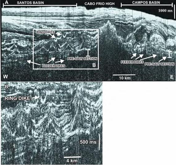
NW faults and fractures, interpreted here as subvertical feeder dikes. For example, Fig. 10 shows a
concentration of ring dikes intruded into the Campanian sequence along a NW alignment observed in
a time slice corresponding to the level of the pre-salt sediments.

ACCEPTED MANUSCRIPT
ACCE
PTED
MAN
USCR
IPT
8
Some dikes observed in the Santonian and Campanian sections have a “boomerang” form in
seismic profiles. These dikes are expressed by strong amplitude anomalies in a window corresponding
to the Campanian isochron RMS amplitude map (Fig. 11).
SE-NW strike-slip fault and fracture zones have been observed in practically all areas of the
Campos and Santos basins, as well as in adjacent continental areas. Such features have acted as
transfer zones since the formation of these basins and were reactivated during periods of major
tectonic activity in the Late Cretaceous and Tertiary. Szatmari and Mohriak (1995) correlate major
tectonic pulses of the Andean orogeny with magmatic phases in the post-salt section of the Santos and
Campos basins.
Igneous activity is widespread in the Late Cretaceous and Eocene in the SW Campos Basin,
as can be deduced from the RMS amplitude maps extracted from the seismic horizons windows
corresponding to the tops of Maastrichtian and Santonian. The main source of magmatism is not the
Cabo Frio High. Practically all volcanic edifices and intrusive bodies have their own corresponding
subvertical feeder dikes, which are visible in the VA attribute sections. Strong evidence, based on
seismic and well data, indicates that the greatest thickness of magmatic rocks coincides with
intersections of NE fault zones with NW ones (Fig. 12). All volcanic edifices found in the SW portion
of the Campos Basin are aligned along both SW-NE and SE-NW trends, parallel to the direction of
the main fault zones (Fig. 12).
Some faults, mainly those of larger offsets, seem to displace the salt base. The evolution of
these SW-NE faults is synsedimentary, and they displace the Late Cretaceous magmatic section, but
they do not seem directly related to the genesis of this section. The fault heaves at the salt base are
visible in some of the normal faults with NW-SE directional component, whose seismic signatures are
flower structures. The directional component of such faults displaces the pre-salt, Late Cretaceous,
and Tertiary sedimentary depocenters, as well as the SW-NE alignments of the salt diapirs (Fig. 13).
The branches of these faults tend to converge inside the seismic basement in a single trace that can be
mapped to the limit of the vertical seismic resolution (Fig. 14).
The SE-NW faults and fractures in this work represent the main conduits of post-Aptian
magmatism. It is very important to note that magmatic bodies of different ages are superposed in the

ACCEPTED MANUSCRIPT
ACCE
PTED
MAN
USCR
IPT
9
area. The cuttings and cores of well B (Fig. 7, after Oreiro, 2002) reveal the presence of Eocene
hyaloclastites and basalts, together with Santonian dolerite dikes that cut through the Cenomanian
section. In the SW extreme of Campos Basin, the heights of the volcanic edifices reach hundreds of
meters (Rangel and Barros, 1994).
On the basis of this evidence, we can infer that post-salt magmatism is more abundant where
the occurrence of pre-salt faults is more frequent; this claim is also valid for the adjacent continental
alkaline magmatism, represented by massive bodies generally placed at the intersection of SE-NW
and SW-NE fault zones. This hypothesis is corroborated by the analysis of satellite images from
NASA. Moreover, some alkaline intrusive bodies have their longer axis oriented NW, such as the
Tinguá and Itatiaia massifs. Fig. 15 shows that the Tinguá body has, in plant, a grossly rectangular
shape (10 km ! 6.6 km) with limits marked by N45E and N45W alignments. The Passa-Quatro–
Itatiaia intrusive bodies form a complex structure displaced by a well-marked fault zone (Bueno,
2000). This fault zone also displaces the crest lines of the Serra da Mantiqueira Mountain Range and
creates deep talvegs for the recent drainage in the region (Fig 16). The fault zone can be traced from
the Mantiqueira Mountain Range to the shoreline, as first described by Almeida (2001) as “the Funil
Transfer Zone” (Figs. 15 and 16). Most post-Aptian magmatic features, observed in seismic sections
and maps, in the offshore area have a generally SE-NW orientation (Figs. 11 and 12). Therefore, we
posit that the main magmatic control in the marginal basins of SE Brazil and their adjacent continental
areas is the reactivation of SE-NW, deep strike-slip fault zones and their intersections with SW-NE
reactivated normal fault zones. This information supports the interpretation of Almeida (1991).
The petrographic characteristics of the igneous rocks in the offshore areas close to the Cabo
Frio High (SW of Campos Basin, NE of Santos Basin), according to the data analyzed (Szatmari et
al., 2003), show that it is basaltic magmatism. Most of the well samples analyzed in the area indicate
that the Late Cretaceous basaltic rocks are tholeiitic, which supports our inference that the strike-slip
faults that were the conduits for the magma reached the asthenosphere.
An alternative to the classic plume model is the model defined by Cañón-Tapia and Walker
(2004), shown in Fig. 17. Melting of a mantle portion begins in a low velocity zone (LVZ), where the
interconnectivity among the mineral grains allows for the eventual formation of a vertical conduit
ACCEPTED MANUSCRIPT
ACCE
PTED
MAN
USCR
IPT
10
entirely contained in the melting zone. When that conduit reaches the critical height, which depends
on the density and lithostatic pressure of the overlying rocks, the magma ascends vertically, feeding
itself from the supply of melted rock from the LVZ. If the amount of melted rock is great enough, the
magma eventually can reach the surface. Thus, a volcanic edifice will form if the minimum regional
stress is horizontal. If the amount of melted rock is not enough to allow the magma to reach the
surface, the process will be aborted and form vertical dikes when 3 is horizontal and sills when !3 is
vertical. Any other combination of stresses will produce dikes with different dip angles. A third
situation, in which the amount of interconnected magma is not enough to sustain the pressure in the
open conduit, is shown in Fig. 18. Cañón-Tapia and Walker (2004) conclude that it is possible to
explain most of the volcanic features around the world by analyzing the degree of interconnectivity in
the melting zone and the regional stress field. They mention that many authors define the magma
chamber as mush columns from the melting zone. In our point of view, this theory is more suitable to
explain the genesis of magmatism than the mantle plume in the study area.
According to Anderson (2000), the asthenosphere is chemically heterogeneous, and its long
wavelength temperature variations in relation to its average temperature are ±200°C. Such variations
include temperature excesses that have been attributed to mantle plumes (Anderson, 2000, 2001).
Moreover, because a large portion of the upper mantle is near its melting point, the criteria for dike
intrusion are as follows: (1) the minimum compressional stress of the lithosphere should be horizontal
and (2) the buoyancy of the melted material should overcome the active stress inside the plate.
Anderson and Natland (2005) argue that the effects of pressure on the properties of the materials are
not considered in experiments or computational simulations of mantle plumes. Their conclusion
accords with our opinion that magmatic events may occur without an associated mantle plume.
We also note the difference between the interpretations of Anderson (2001) and Cañon Tapia
and Walker (2004). The former assert that crustal movements play an important role in the mantle
fusion, with partial asthenospheric melting produced by reactivations of older fault zones, and thus
cause pressure relief. Cañon Tapia and Walker instead infer that the magma can create its own
pathway when there is partial melting of a mantle area in which the spaces among the mineral grains

ACCEPTED MANUSCRIPT
ACCE
PTED
MAN
USCR
IPT
11
allow magma ascention, provided that the hydrostatic pressure of the magma overcomes the lithostatic
pressure of the overlying rocks and that the regional !1 is mainly horizontal.
Almeida’s (1991) hypothesis states that a change in the pole of rotation between the South
American and African plates occurred from 80 My and was responsible for deep faulting in the crust.
These faults could have reached the asthenospheric mantle and caused partial melting by pressure
release. Similar processes during Santonian/Campanian and Paleocene/Eocene times could explain the
overlap of igneous rocks in the Cabo Frio area (Fig. 7), as is proposed in the general model of
Anderson (2001).
Recent petrologic studies in plutonic and volcanic rocks of the Serra do Mar igneous province
point to a non-plume origin for this magmatism (Brotzu et al, 2005).
Klein (1993) asserts that the intrusive and extrusive alkaline rocks of the Mendanha Massif
(Fig. 15) were emplaced along a N80°E alignment, reactivated during Cretaceous–Tertiary periods.
He concludes that this alignment was the pathway for the magma ascent.
The volcanic activities in the North Sea show some similarities with those of the SE Brazilian
“passive” margin, despite their different ages of formation. There, Foulger and Anderson (2005) and
Gernigon et al. (2006) propose a non-plume origin for Iceland and VØring Basin magmatism,
respectively.
Finally, Fairhead and Wilson (2005) provide a detailed study of deformation processes in the
South Atlantic Ocean using high-resolution satellite data. They suggest that faults parallel to the
motion of the South American plate and orientated NW are most susceptible to reactivation at both
micro and macro scales. They also argue that the Rio Grande rise probably suffered dextral shear and
extension. The feature they call the Rio Grande rise is the same as the Cruzeiro do Sul deformation
zone (CSDZ) described by Souza (1991) (Fig. 19). We interpret the Cabo Frio High as the landward
continuation of the CSDZ. Thus, the interpretation of Fairhead and Wilson (2005) is in agreement
with the general conclusion presented here, namely, that the intensification of magmatic events on and
around the Cabo Frio High was caused by the reactivation of SE-NW strike-slip zones that can be
mapped by 3D and 2D data.
6. Conclusions

ACCEPTED MANUSCRIPT
ACCE
PTED
MAN
USCR
IPT
12
Post-salt magmatic events in the study area resulted from the reactivation of deep fault zones, many of
which had been created by the breakup of the Pangaea supercontinent. The accurate mapping of
magmatic sections in the area, using 2D and 3D conventional seismic data and some of their
attributes, such as the VA technique, shows that the dikes and volcanic edifices formed at various
ages in Late Cretaceous and Early Tertiary times and frequently overlap along SW-NE and SE-NW
fault and fracture zones formed by accommodation to the movements of the South American plate. At
the intersections of these two fault systems, the magmatic sections become wider and thicker,
reaching thicknesses of 500 m or more.
The reactivation of deep fault zones seems to be the main cause of partial melting of portions
of the asthenosphere by pressure release. The magma generated by this process rises in subvertical
columns and sheets and reaches the surface, forming volcanic edifices, or intrudes the sediments.
Therefore, we strongly believe in a non-plume origin for the magmatism in the study area and its
surroundings.
Acknowledgments
The authors acknowledge Petrobras S. A. for granting permission to publish this paper. We are
grateful to Carlos Lopo Varela and Valéria Lopes dos Santos, who first revised this paper, and to João
Batista Françolin for providing the images in Figs. 15 and 16. We also thank Mario Ernesto Macedo
Alves and his coworkers for their help in preparing some of the figures, as well Bianca de Miranda
Fernandez for Fig. 12. Special gratitude is due to Renato Darros de Matos, Marta Mantovani, and Luis
Otávio Aguiar Oliveira for their useful criticisms of the manuscript.
References
Almeida, F. F. M, 1967. Origem e evolução da Plataforma Brasileira, Rio de Janeiro, DNPM - DGM,
Boletim 241, 36 p.
Almeida, F. F. M., 1976. The system of continental rifts bordering the Santos Basin, Brasil. An.
Academ. Bras. de Ciênc., 48 (supl.) p. 15-26.

ACCEPTED MANUSCRIPT
ACCE
PTED
MAN
USCR
IPT
13
Almeida, F. F. M., 1991. O alinhamento magmático de Cabo Frio. Atas do 2o Simpósio de Geologia
do Sudeste, São Paulo, p. 423-428.
Almeida, F. F.M., Carneiro, C. D. R., 1998. Origem e Evolução da Serra do Mar. Rev. Bras. de Geoc.
28, p. 135- 150.
Almeida, S. H. S., 2001. Gravimetria e tectônica do Cinturão Ribeira na região limítrofe entre os
estados de São Paulo e Rio de Janeiro. UNESP, tese de doutoramento, 201 p.
Alves, E. C., Maia, M., Sichel, S. E., 2005. Zona de Fratura de Vitória-Trindade no Atlântico Sudeste
e suas implicações tectônicas e magmáticas com o Bordo Continental Sudeste. Anais do III Simpósio
de Vulcanismo e Ambientes Associados, Cabo Frio-RJ, p. 325-330.
Amador, E. S., Castro, M. I. B., 1976. Depósitos neocenozóicos da Bacia de Volta Redonda, RJ. In
Anais do 29º Congresso Brasileiro de geologia, SBG, Vol. 1, p. 307-327. Ouro Preto, MG.
Anderson, D. L., 2000. The thermal state of the upper mantle: no role for mantle plumes. Geophy.
Res. Letters, V. 27, nº 22, pp. 3623 - 3626.
Anderson, D. L., 2001. Top – Down Tectonics? Science, V. 93, p. 2016- 2018.
Anderson, D. L., Natland, J. H., 2005. A brief history of the plume hypothesis and its competitors:
concepts and controversy. In Foulger, G. R., Natland, J. H., Presnall, D. C., Anderson, D. L., eds,
Plates, Plumes & Paradigms, Geological Society of America, p. 119-145.
Assumpção, M., Schimmel, M., Escalante, C., Barbosa, J. R., Rocha, M., Barros, L. V., 2004.
Intraplate seismicity in SE Brazil: stress concentration in lithospheric thin spots.
Geophys. J. Int., V. 159, p. 390-399.

ACCEPTED MANUSCRIPT
ACCE
PTED
MAN
USCR
IPT
14
Beurlen, K. and Sommer, F.W., 1954. Restos vegetais fósseis e tectônica da Bacia Calcárea de
Itaboraí, Estado do Rio de Janeiro. Bol. 149, DNPM/DGM, 27p.
Brotzu, P., Melluso, L, d’Amelio, F., Lustrino, M., 2005. Potassic dykes and intrusions of the Serra do
Mar Igneous Province (SE Brazil). In Comin-Chiaramonti, P., Gomes, C. B. Mesozoic to Cenozoic
alkaline magmatism in the Brazilian Platform. EdUSP, São Paulo, SP, Brasil.
Bueno, J. M. R., 2000. Análise estrutural, morfoestrutural e modelagem tridimensional dos maciços
de Itatiaia e Passa Quatro: uma comparação com a evolução tectônica cenozóica do Rift do Sudeste
Brasileiro. Trabalho de Formatura 9, UNESP, Rio Claro, SP, 61 p.
Bulhões, E. M., 1999. Técnica “VOLUME DE AMPLITUDES” para mapeamento de feições
estruturais. Anais do VI Congresso Internacional da Sociedade Brasileira de Geofísica, Salvador, Ba.
Bulhões, E. M., Amorim, W. N. de, 2005. Princípio da Sismocamada Elementar e sua Aplicação à
Técnica de Volume de Amplitudes (tec. VA). Ninth International Congress of the Brazilian
Geophysical Society, Salvador, Brasil.
Cañón-Tapia, E., Walker, G. P. L., 2004. Global Aspects of Volcanism: the Perspectives of “Plate
Tectonics and “Volcanic Systems”. Earth-Science Rewiews, Vol. 66 p. 163-182.
Cobbold, P. R., Meisling, K. E., Mount, V. S., 2001. Reactivation of an obliquely rifted margin,
Campos and Santos basins, Southeastern Brazil. AAPG Bulletin, Vol. 85, nº 11, p. 1925-1944.
Cordani, U. G., 1970. Idade do vulcanismo no Oceano Atlântico Sul. Boletim do Instituto de Geologia
e Astronomia, São Paulo, Vol. 1, p. 9-76.

ACCEPTED MANUSCRIPT
ACCE
PTED
MAN
USCR
IPT
15
Esteves, C. A., Rodrigues, J. J. G., 2003. Ocorrência de ígneas no norte da Bacia de Santos.
PETROBRAS S. A., Relatório Interno, 28 p.
Fairhead, M. J., Wilson, M. (2005). Plate tectonic processes in the South Atlantic ocean: Do we need
Mantle Plumes? In Foulger, G. R., Natland, J. H., Presnall, D. C. and Anderson, D. L., (eds), Plates,
Plumes and Paradigms, Geological Society of America, p. 537-554, .
Ferrari, A. L., 2001. Evolução tectônica do Graben de Guanabara. São Paulo, IGC-USP, Tese de
Doutoramento, 412 p.
Ferrari, A. L., Riccomini, C., Vasconcelos, P., 2001. Ocorrência de rochas vulcânicas na porção
central do Graben de Guanabara (RJ) e suas implicações para a evolução do relevo no Sudeste do
Brasil. 7º Simpósio de Geologia do Sudeste, S. B. G., RJ, p. 82.
Ferrari, A. L. e Silva, M. A. M, 1997. Bacia do Macacú (RJ): proposta de uma nova bacia do Rift
Continental do Sudeste do Brasil. In Atas do 5º Simpósio de Geologia do Sudeste, Penedo, Itatiaia-RJ,
p. 32- 34.
Fodor, R. V. J., McKee, E. H., Asmus, H. E., 1983. K-Ar ages and the opening of the South Atlantic
Ocean: basaltic rock from the Brazilian margin. Marine Geology, Vol. 54, Issues 1-2, p. M1- M8.
Fouger, G. R., 2003. Plates, plumes and Popper. The Geological Society of London Great Plumes
Online Debate. In www.geolsoc.or.uk/plumesdebate website.
Foulger, G. L., Anderson, D. L., 2005. A cool model for the Iceland hotspot. Journal of Volcanology
and Geothermal Research, Vol. 141, p. 1-22.
ACCEPTED MANUSCRIPT
ACCE
PTED
MAN
USCR
IPT
16
Gernigon, L., Lucazeau, F., Brigaud, F. Ringenbach, J-C,Planke, S., Le Gall, B., 2006. A moderate
melting model for the VØring margin (Norway) based on structural observations and a thermo-
kinematical modeling: Implication for the meaning of lower crustal bodies. Tectonophysics, nº 412, p.
255-278.
Hawkesworth, C. J., Gallagher, K., Kirstein, L., Mantovani, M., Peate, D., Turner, S., 2000. Tectonic
controls on flood basalt magmatism in the Parana-Etendeka Province. Earth and Planetary Science
Letters. 179, p. 335-349.
Herz, N., 1987. Timing of spreading in the South Atlantic: information from Brazilian alkalic rocks.
Geol. Soc. Am. Bull., 88, p. 101-112.
Klein, V. C. (1993). O Vulcão Alcalino de Nova Iguaçu (Estado do Rio de Janeiro): Controle
Estrutural e Processo de Erupção. Tese de Doutoramento, Universidade Federal do Rio de Janeiro,
108 p.
Klein, V. C., Valença, J. G., 1984. Estruturas Almofadadas em Derrame Ankaramítico na Bacia de
São José de Itaboraí, Rio de Janeiro. Anais do 33o Congr. Bras. de Geol., Rio de Janeiro, RJ, SBG/RJ,
p. 43-48.
Leinz, V., 1938. Os calcários de São José, Niterói, Estado do Rio de Janeiro. Mineração e Metalurgia,
nº 3, p. 153 – 155.
Leslie, S. C., Moore, G. F., Morgan, J. K., Hills, D. J., 2002. Seismic Stratigraphy of the Frontal
Hawaiian Moat: Implications for Sedimentary Processes at the Leading Edge of an Oceanic Hotspot
Trace. Marine Geology, 184, p. 143-162.

ACCEPTED MANUSCRIPT
ACCE
PTED
MAN
USCR
IPT
17
Meis, M. R. M., Amador, E. S., 1977. Contribuição ao estudo do Neocenozóico da Baixada da
Guanabara: Formação Macacu. Revista Brasileira de Geociências, vol. 7, nº 2, p. 150-174.
Mizusaki, A. M. P., 1986. Rochas Ígneo-básicas do Neocomiano da Bacia de Campos –
Caracterização e Comportamento como Reservatório para Hidrocarbonetos. Dissertação de Mestrado,
UFRJ, Rio de Janeiro, 104 p.
Mizusaki, A. M. P., Mohriak, W. U., 1992. Seqüências Vulcano-sedimentares na Região da
Plataforma Continental de Cabo Frio, RJ. Anais do XXXVII Congresso Brasileiro de Geologia
Resumos Expandidos, São Paulo, SP, Vol. 2, p. 468-469, 1992.
Mizusaki, A. M. P., Thomaz Filho, A., Milani, E. J., Cesero, P. de, 2002. Mesozoic and Cenozoic
igneous activity and its tectonic control in northeastern Brazil. Journal of South American Earth
Sciences., 15, p. 183-198.
Mohriak, W. U., Barros, A. Z. N. de, 1990. Novas evidências de tectonismo cenozóico na região
Sudeste do Brasil: O Graben de Barra de São João, na plataforma de Cabo Frio, RJ. Rev. Bras. De
Geoc., 20(1-4), p. 187-196.
Mohriak, W. U., Macedo, J. M., Castelani, R. T., Rangel, H. D., Barros, A. Z. N., Latgé, M. A. L.,
Ricci, J. A , Mizusaki, A. M. P., Szatmari, P., Demercian, L. S., Rizzo, J. G., Ayres, J. R., 1995. Salt
Tectonics and Structural Styles in the Deep - Water Province of the Cabo Frio Region, Rio de Janeiro,
Brazil. In Jackson D. G., Roberts, D. G., Snelson S., eds., Salt Tectonics: a Global Perspective. AAPG
Memoir 65, p. 273-304.
Moreira, J. L. P, Carminatti, M., 2004. Sistemas Deposicionais de Talude e de Bacia no Eoceno da
Bacia de Santos. Bol. Geoc. da PETROBRAS, Rio de Janeiro, V. 12, n. 1. p. 73-87.

ACCEPTED MANUSCRIPT
ACCE
PTED
MAN
USCR
IPT
18
Oreiro, S. G., 2002. Magmatismo e Sedimentação em uma Área na Plataforma Continental de Cabo
Frio, Rio de Janeiro, Brasil, no Intervalo Cretáceo Superior – Terciário. Dissertação de Mestrado,
UERJ, Rio de Janeiro, 94 p.
Oreiro, S. G. (2004). Relatório de visita a um dos afloramentos dos ankaramitos de Volta Redonda,
Rio de Janeiro, Brasil. PETROBRAS, Relatório Interno, 8 p.
Oreiro, S. G., Cupertino, J. A., Thomaz Filho, A., 2003. Diagnostic Features of Volcanic and
Volcaniclastic Rocks in Seismic Sections on the Continental Shelf of Cabo Frio Area, SE Brazil.
SBGF, International Congress of Brazilian Geophysical Society, nº 8. Rio de Janeiro, RJ.
Oreiro, S. G., Cupertino, J. A., Szatmari, P., 2004. O magmatismo pós-Aptiano da Bacia de Santos.
Anais do 42º Congr. Bras. de Geol., S. 28, p. 940. Araxá, MG.
Oreiro, S. G., Cupertino, J. A., Szatmari, P., Thomaz Filho, A., 2005. Estudo sobre o magmatismo no
limite entre as bacias de Santos e de Campos. Anais do III Simpósio de Vulcanismo e Ambientes
Associados. Cabo Frio, RJ, p. 189-194.
Rangel, H. D., Barros, A. Z. N., 1994. Estratigrafia e evolução estrutural da área sul (adjacente ao
Alto de Cabo Frio) da Bacia de Campos. PETROBRAS, DEPEX, DISUL, Relatório Interno.
Rangel, H. D, Mohriak, W. U.; Richter, A; Barros, A. Z. N., Appi, C. J., 1990. Evolução Estrutural e
Estratigráfica da Porção Sul da Bacia de Campos: 4º Congresso Brasileiro de Petróleo, Rio de Janeiro,
TT 207, p. 1-10.
Riccomini, C., 1989. O Rift continental do Sudeste do Brasil. Tese de doutoramento, IGC-USP, São
Paulo, Brasil, 256 p.

ACCEPTED MANUSCRIPT
ACCE
PTED
MAN
USCR
IPT
19
Riccomini, C., Melo, M. S., Almeida, F. F. M. de, Carneiro, C. D. C., Mioto, J. A., Hasui, Y., 1983.
Sobre a ocorrência de um derrame de ankaramito na Bacia de Volta Redonda (RJ) e sua importância
na datação das bacias tafrogênicas do sudeste brasileiro. Simpósio Regional de Geologia IV,
Resumos. SBG, São Paulo, SP, p. 23-24.
Riccomini, C., Sant’Anna, L. G., Ferrari, A. L., 2004. Evolução geológica do rift continental do
Sudeste do Brasil. In Mantesso - Neto, V., Bartorelli, A., Carneiro, C. D. R., Brito-Neves, B. B. (eds.),
2004. Geologia do Continente Sul Americano: evolução da obra de Fernando Flávio Marques de
Almeida. Ed. Beca, São Paulo, 647 p., p. 383-405.
Rizzo, J. G., Mohriak, W. U., Aires, J. R., Barros, A. Z. N. de, 1990. Modelagem Física de
Falhamentos Antitéticos em Águas Profundas da Região de Cabo Frio na Bacia de Campos, RJ. Anais
do 36o Congr. Bras. de Geol., SBG, Natal-RN.
Ruellan, F., 1944. A evolução geomorfológico da Baía de Guanadara e das regiões vizinhas. Revista
Brasileira de Geografia, ano VI, nº 4, p. 445-508.
Sadowski, G. R., Dias Netto, C. de M., 1981. O Lineamento Tectônico de Cabo Frio. Rev. Bras.
Geoc., V.11 (4), p. 209-212.
Sandwell, D. T. and Smith, W. H. F., 1997. Marine gravity anomaly from Geosat and ERS-1 satellite
altimetry. J. Geophys. Res., 102:10039-10050.
Souza, K. G., 1991. La Marge Continentale Brèsilienne Sud Orientale et les Domaines Oceaniques
Adjacents: Structure et Evolution. Tèse de Doctorat, Université Pierre et Marie Curie, Villefranche
Sur Mer, France, 230 p.

ACCEPTED MANUSCRIPT
ACCE
PTED
MAN
USCR
IPT
20
Souza, R. S., Braga, O., Calazans, M. Souza, M. K., 2001. Petrography of volcaniclastic rocks of the
block BC - 20, Campos Basin. Comunicação Técnica TRO –37/01. PETROBRAS - CENPES,
Internal Technical Report, 22 p.
Szatmari, P., Conceição, J. C. de J., Destro, N., Evensen, N. M., York, D., Smith, P. E., 2000.
Tectonic and sedimentary effects of a hotspot track of alkali intrusions defined by Ar-Ar dating in SE
Brazil. International Geological Congress, 31, Rio de Janeiro- RJ, Abstracts, CD-ROM.
Szatmari, P., Mohriak, W. U., 1995. Plate model of post - breakup tectono-magmatic activity in SE
Brazil and the adjacent Atlantic. 5º. Simp. Nacional de Estudos Tectônicos. Gramado-RS, Brazil, p.
213-214.
Szatmari, P., Guerra, M., Pequeno, M. A., 1996, Genesis of large counter-regional normal fault by
flow of Cretaceous salt in the South Atlantic Santos Basin - Brazil. In Alsop, G. I., Blundell, D.J.,
Davison I., eds Salt Tectonics, Geological Society Publ. House, Bath, England.
Szatmari, P., Mohriak, W. U., Lobo, J. T. (2003). Magmatismo Pós-Rifte no Sul-Sudeste Brasileiro.
PETROBRAS-CENPES, RT GEOF 010/03, Relatório interno, 40 p.
Thomaz Filho, A., Cesero, P., Mizusaki, A. M. P.; Leão, J. G., 2005. Hot Spot volcanic tracks and
their implications for South American plate motion, Campos Basin (Rio de Janeiro State), Brazil.
Journal of South America Earth Sciences V. 18, p. 383 - 389.
Thomaz Filho, A., Rodrigues, A. L., 1999. O alinhamento das rochas alcalinas de Poços de Caldas -
Cabo Frio e sua continuidade na cadeia Vitória-Trindade. Revista Brasileira de Geociências, 29, p.
189–194.
Thompson, R. N., Gibson, S. A. Mitchell, J. G, Dickin, A. P., Leonardos, O. H., Brod, J. A.,
Greenwood, J. C., 1998. Migrating Cretaceous – Eocene Magmatism in the Serra do Mar Alkaline

ACCEPTED MANUSCRIPT
ACCE
PTED
MAN
USCR
IPT
21
provinces, SE Brazil: melts from the deflected Trindade Mantle Plume? J. Petrol. Vol. 39 (8), p. 1493-
1526.
Valença, J. G., 1980. Geology, Petrography and Petrogenesis of Some Alkaline Igneous Complexes of
Rio de Janeiro State, Brasil. PHD Thesis, The University of Western Ontario, London, Ontario, 248
pp.
Valente, S. C., 1997. Geochemical and isotopic constraints on the petrogenesis of the Cretaceous
dykes of Rio de Janeiro, Brazil. PHD Thesis, The Queen’s University of Belfast, Belfast, 297 p.
Valeriano, C. M., Heilbron, M., 1993. A Zona de Transtensão de Volta Redonda e sua importância na
junção entre os riftes do Vale do Paraíba e o da Guanabara. Atas do III Simpósio de Geologia do
Sudeste. Rio de Janeiro. p. 09-15.
Zalán, P. V., 2004. Evolução Fanerozóica das Bacias Sedimentares Brasileiras, in Mantesso-Neto, V.,
Bartorelli, A, Carneiro, C. D. R., Neves, B. B. B., (eds.), Geologia do Continente Sul-Americano –
Evolução da Obra de Fernando Flávio Marques de Almeida. Beca Produções Culturais Ltda., São
Paulo, p. 595-612.
Zalán, P. V. e Oliveira, J. A. B., 2005. Origem e Evolução Estrutural dos Riftes Cenozóicos do
Sudeste do Brasil, Boletim de Geociências da Petrobras, 13 (2), p. 269-300.
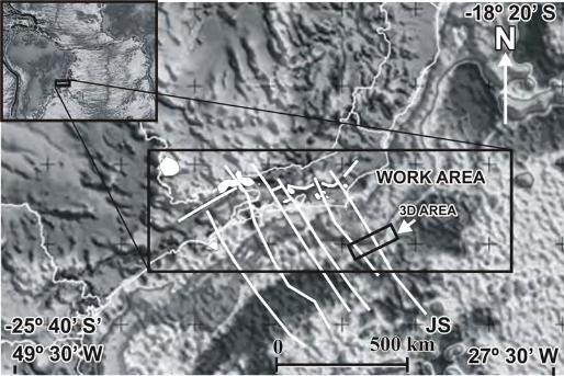
Figure captions Fig. 1. Map of gravimetric anomalies from satellite altimetry, showing the location of 3D seismic
survey (smaller black rectangle) and its surroundings (larger black rectangle). Some regional
structural interpretations are also shown, such as the direction of great strike-slip (transfer) faults
(modified from Cobbold et al., 2001; Thomaz Filho et al., 2005), the Jean Charcot Submarine Mounds
(JS, lower right), and the alkaline massifs of southern Brazil (white). The interpretation of the transfer

ACCEPTED MANUSCRIPT
ACCE
PTED
MAN
USCR
IPT
22
faults is also based on regional seismic mapping in the northern Santos Basin. The satellite altimetry
map is from http://ucsd/topex/edu (after Sandwell and Smith, 1997).
Fig. 2. Seismic section in time located in the northern Santos Basin. The black arrow points to a
Middle Eocene chaotic seismofacies, considered to result from earthquake activity. The lower left
contains a time structural map of the top of the Lower–Middle Eocene. The canyons (C) are parallel
to the direction of the feeder dikes shown in Fig. 10. (after Moreira and Carminatti, 2004).
Fig. 3. Comparison of seismofacies defined in offshore Hawaii by Leslie et al. (2002) and
seismostratigraphic aspects of the magmatic section in Cabo Frio. In the upper left, seismofacies A is
interpreted to correspond to proximal slumps originating from volcanic edifices; seismofacies B to
distal slumps; and seismofacies C to volcaniclastic turbidites. The upper right shows a seismic section
(A) and its interpretation (B). The actual seafloor is composed of lava flows, and the chaotic
seismofacies represents intercalations between older lava flows and volcaniclastic sediments
originating from nearby volcanic cones. The lower panel shows a 2D seismic section from the Cabo
Frio area, in which it is clear that the seismofacies situated near the cones is similar to seismofacies A
defined by Leslie et al. (2002), which indicates both were formed by slumping. The strong positive
reflections, adjacent to the cones, compose the seismic signature of older lava flows that comprised
the seafloor at the time of formation of the volcanic edifices. The plane-parallel seismofacies over the
magmatic section in the Cabo Frio area is composed of epiclastic sediments unrelated to the post-salt
magmatic pulses.
Fig. 4. Equations of the volume of amplitudes (VA) technique. (1) Root mean square (RMS), (2)
inverse Hilbert’s Transform with –90° phase rotation, (3) weighting window of the elementary
seismic bed (ESB). The ESB is the thinner bedrock layer (M) that can be detected by the seismic
method and the key element for weighting and computing the seismic data with VA. This technique is
a post-stack seismic processing. Equation (2) makes the seismic section resemble a vertical
outcropping surface (Fig. 9) by enhancing seismic contrasts, which allows better visualization of
geological features such as channels, faults fractures, and volcanic bodies (after Bulhões and Amorim,
2005).

ACCEPTED MANUSCRIPT
ACCE
PTED
MAN
USCR
IPT
23
Fig. 5. Root mean square (RMS) amplitude map extracted from a 3D seismic volume with a 24 ms
time window centered at the top of Cretaceous (1). The map shows that the seismic signature of a
channelized lava flow is a strong positive reflection (black) (2). The strong reflection corresponds to a
light gray channelized feature in (1). The amplitude scale (1) shows values on the right side varying
from 0 to n (RMS amplitudes) and on the left side from 127 to –128; standard amplitude values for
seismic lines displayed in 8 bits. See Fig. 4.
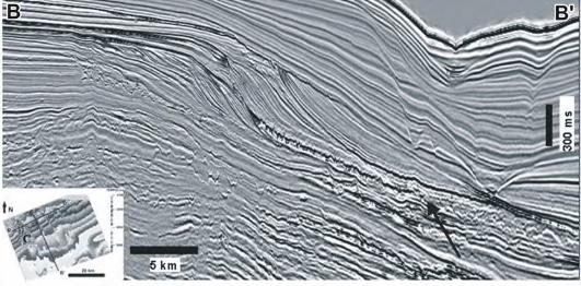
Fig. 6. (A) Strike seismic section in time through the study area, processed with the VA technique
(see Fig. 4). Dike swarms and other near-vertical structures can be seen as subvertical interruptions of
the continuous reflections (in white). (B) Zoom of A showing ring dikes with feeder dikes (subvertical
black lines, 1), interpreted as the conduits for magma ascent.
Fig. 7. Seismic section in time showing a sill, named Victoria Regia structure by Pedro Victor Zalán
(pers. comm., 2005). EH, Eocene hyaloclastite section; EB, Eocenic basalt lava flow; SD, Santonian
dike intruded into Cenomanian sediments.
Fig. 8. Conventional seismic section showing the signature of magmatic features in the area. Note the
volcanic edifice (V1) has a feeder dike that appears like a rotated “Y” and branches from a
synsedimentary fault related to halokinesis. In its last 300 m, the well drilled a section of compact
dolerite. The K/T unconformity, based on palaeontological data, seems to comprise older lava flows
over which the volcanic edifices were built.
Fig. 9. Same section as in Fig. 8, processed with the VA technique (phase rotation of 90°, Fig. 4)
(Bulhões and Amorim, 2005). This type of processing makes the seismic section resemble an
outcropping surface and thus reveals that the volcanic edifice, named V2, has a vertical feeder dike
that can be easily traced down to the lower limit of resolution of the seismic section. The fault plane
to the left is partially filled with magmatic rocks that are linked to volcanic edifice (V1).
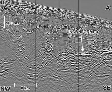
Fig. 10. (A) Root mean square (RMS) amplitude map extracted from the isochron of the Campanian
interval. Some dikes are aligned in the same direction as the pre-rift alignment, which corresponds to
a small portion of the big fault zone shown in the Fig. 5. To the left, the feeder dikes for the Tertiary
volcanic edifices appear as straight lines trending N30W. (B) Time slice at the level of the pre-salt
ACCEPTED MANUSCRIPT
ACCE
PTED
MAN
USCR
IPT
24
sequence (4484 ms) showing an alignment with N30W direction, a boundary between a near circular
structure (on left) and a chaotic seismofacies (on right). It also correlates with a zone of concentration
of ring dikes in the much higher Campanian sequence (A). See Fig. 5 for an explanation of the
amplitude scales.
Fig. 11. The same map as in Fig. 10, with two representative seismic sections, showing the ring dikes
with a “boomerang” form in 2D seismic profiles. The seismic sections were processed with the VA
technique with phase rotation of 90° (Fig. 4), so that the volcanic edifices (V) and the ring dikes (D)
become prominent, with associated feeder dikes (FD). In the seismic sections, (1) top of the
Paleocene; (2) K/T boundary; (3) top of the Santonian; (4) top of the salt; (5) base of the salt, and (6)
Lower K acoustic basement. See Fig. 5 for an explanation of the amplitude scales.
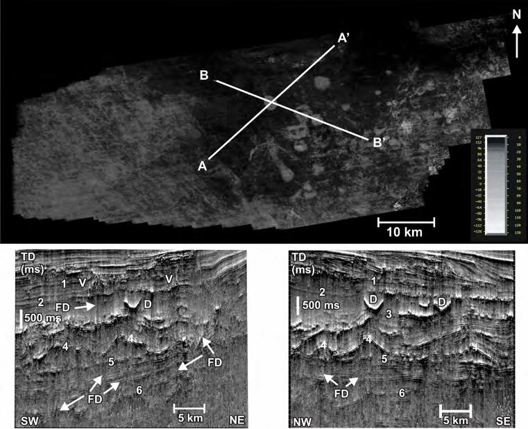
Fig. 12. (A) 3D time structural map of the top of the Early Tertiary volcanic section in the area
(GeoprobeTM processed image). (B) Map enhancing some important features; (F1) SW-NE Cabo Frio
fault zone (Szatmari et al., 1996); (F2) SE-NW faults. The volcanic edifices are aligned on the borders
of the two fault zone systems. On the intersections of the two fault systems, the volcanic edifices
became more abundant and larger. They eventually coalesce, forming clusters (1). The directions of
these edifices coincide with the main fault zones (Figs. 5 and 10). Almost all volcanic edifices have
their conic geometry preserved; therefore, they were not exposed to subaereal erosion (Oreiro, 2002).
(B) Seismic section (AA’) showing that the volcanic edifices are on and over the K/T unconformity.
Similarly, in the seismic section BB’ (C), the cones were built over older lava flows on the K/T
unconformity, as defined by palaeontological data.
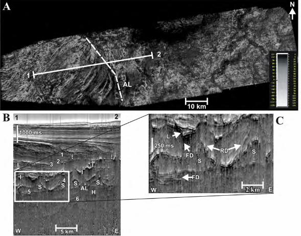
Fig. 13. (A) Root mean square (RMS) amplitude map from the isochron of the salt; (B) seismic
section, processed with the VA technique with a phase rotation of 90° (see Fig. 4, after Bulhões and
Amorim, 2005), (1) top of the Paleocene, (2) K/T boundary, (3) top of the Santonian, (4) top of the
salt, (5) base of the salt, and (6) Lower K magmatic basement; other intrusive and extrusive features
marked with (I) and (E), respectively; (C) zoom of (B) that emphasizes the lopolith-shaped structure
(L) and ring dike (RD), probably of Santonian age, lying above two salt domes (S) and concordant
with the minibasin located between the domes. L has a feeder dike (FD) that cuts the pre-salt
sequence. The same alignment (AL) present in Fig. 10 is located near a basement high (H) controlled
ACCEPTED MANUSCRIPT
ACCE
PTED
MAN
USCR
IPT
25
by faults that could have been of extensional character at the time of the basin formation and were
reactivated as strike-slip faults during the Cenozoic tectonic episodes. See Fig. 5 for an explanation of
the amplitude scales.
Fig. 14. Seismic section showing a flower structure with a set of normal faults with SE-NW strike-slip
offsets in the SW Cabo Frio High. Offsets are defined by regional seismic interpretation. This figure
shows a small portion of the big SE-NW fault zone in Fig. 10. See Fig. 5 for an explanation of the
amplitude scales.
Fig. 15. Shuttle Radar Topographic Mission (SRTM) mosaic of part of southeastern Brazil showing
near circular alkaline bodies (in white): 1, Poços de Caldas; 2, Ponte Nova; 3, Passa Quatro; 4,
Itatiaia; 5, Morro Redondo; 6, Marapicu; 7, Mendanha; 8, Tinguá; 9, Soarinho; 10, Tanguá; 11, Rio
Bonito; 12, Ilha de Cabo Frio and 13, Morro de São João. Also in white are linear old Precambrian
shear zones reactivated in the Cenozoic as normal faults, forming the Continental Rift of southeastern
Brazil (Almeida, 1976; Riccomini, 1989; Riccomini et al., 2004; Zalán, 2004; Zalán and Oliveira,
2005). Some of the proposed structures of this continental rift are as follows: A, Taubaté Basin; B,
Resende Basin; C, Volta Redonda Graben; D, Guanabara Graben; and E, Barra de São João Graben.
The transfer zones we interpret are shown as black alignments. F and VR are the Funil (Almeida,
2001) and Volta Redonda (Valeriano and Heilbron, 1993) transfer zones, respectively. The black
square onshore and black rectangle offshore show the areas of Fig. 16 and the mapped 3D survey,
respectively. The dashed line offshore shows the boundary between the Santos and the Campos
basins. The STRM data come NASA and are integrated and processed by the geologist João Batista
Françolin.
Fig. 16. Close-up of the Itatiaia and Passa Quatro massifs and their faulted late Proterozoic country
rocks. Note horse-tail structure (HT) at the southeast corner of the Passa Quatro intrusion, which may
reflect rotation caused by the effect on the hot alkaline massif of the associated NNW-trending dextral
strike-slip fault. F1 is after Bueno (2000). F2 lies along the continuation of a major transfer zone
defined by Almeida (2001). PCL, Precambrian lineaments. The dashed contour marks the near-
circular alkaline bodies; the dotted line marks the outcrop zone of alkaline rocks in the Itatiaia Massif.

ACCEPTED MANUSCRIPT
ACCE
PTED
MAN
USCR
IPT
26
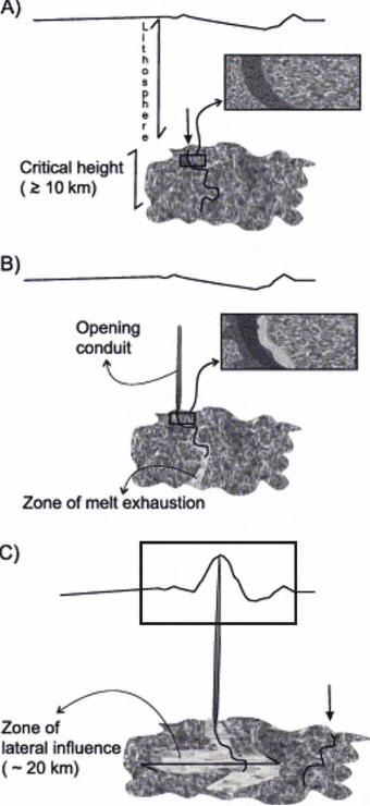
Fig. 17. Diagrams showing the evolution of the melt network during hydraulic fracturing. (A) Time
immediately before a narrow channel (curved line in black) reaches the critical height to initiate
fracturing. (B) Melt that flowed from the LVZ collected by the opening conduit, while producing a
zone of melt exhaustion in its vicinity, shown by lighter shades of gray. (C) System in which the
conduit is large enough to reach the surface and construct a volcanic edifice. The eruption stops when
the melt network cannot supply the conduit with enough melt to sustain the pressure on the dike, even
if there is enough melt available in the LVZ. The vertical arrows in (A) and (C) indicate the origin of
the next fracturing event. The insets in (A) and (B) show the effects of a well-interconnected network
of melt (left of conduit) and a limited degree of interconnectivity (right of conduit). In (C), the black
square is the approximate extent of our study area. Modified after Canon-Tapia and Walker, 2004.
Fig. 18. Schematic evolution of a volcanic system from just before the end of the gestation period.
Gray-scale conduits are active or very recent; black conduits mark older events in which magma has
solidified. The zones in light gray in the LVZ are filled with melted rock. (A) Melting zone within the
LVZ begins to form, (B) leading to the formation of a mush column. (C) The amount of
interconnected magma is not enough to keep the pressure in the mush column, regardless of the
regional stress orientation; however, if the supply of melt continues, a region of partial melting will
form at lower depths. Its influence on the regional stress may result in hydraulic fracturing directions
that could deviate considerably from the vertical. Note that scheme E is very similar to the VA
seismic sections of our study area (F), where FD, feeder dikes; RD, ring dikes; and V, volcanic
edifice. Modified after Canon-Tapia and Walker, 2004.
Fig. 19. Image of free air gravimetry (left) and the interpretation of Fairhead and Wilson (2005, right).
(1) Cruzeiro do Sul deformation zone (Souza, 1991), (2) Vitória–Trindade fracture zone, (3) Abrolhos
volcanic complex, and (4) Rio Grande rise. The small rectangle is the study area. The strike-slip
displacement is secondary in comparison to the lateral extension that created a collapsed zone that
constitutes the Cruzeiro do Sul deformation zone.
ACCEPTED MANUSCRIPT
ACCE
PTED
MAN
USCR
IPT
ACCEPTED MANUSCRIPT
ACCE
PTED
MAN
USCR
IPT

ACCEPTED MANUSCRIPTAC
CEPT
ED M
ANUS
CRIP
T

ACCEPTED MANUSCRIPT
ACCE
PTED
MAN
USCR
IPT

ACCEPTED MANUSCRIPT
ACCE
PTED
MAN
USCR
IPT
ACCEPTED MANUSCRIPT
ACCE
PTED
MAN
USCR
IPT

ACCEPTED MANUSCRIPT
ACCE
PTED
MAN
USCR
IPT

ACCEPTED MANUSCRIPTAC
CEPT
ED M
ANUS
CRIP
T

ACCEPTED MANUSCRIPTAC
CEPT
ED M
ANUS
CRIP
T

ACCEPTED MANUSCRIPT
ACCE
PTED
MAN
USCR
IPT
ACCEPTED MANUSCRIPT
ACCE
PTED
MAN
USCR
IPT

ACCEPTED MANUSCRIPT
ACCE
PTED
MAN
USCR
IPT
ACCEPTED MANUSCRIPTAC
CEPT
ED M
ANUS
CRIP
T

ACCEPTED MANUSCRIPTAC
CEPT
ED M
ANUS
CRIP
T
ACCEPTED MANUSCRIPT
ACCE
PTED
MAN
USCR
IPT

ACCEPTED MANUSCRIPT
ACCE
PTED
MAN
USCR
IPT

ACCEPTED MANUSCRIPT
ACCE
PTED
MAN
USCR
IPT

ACCEPTED MANUSCRIPT
ACCE
PTED
MAN
USCR
IPT
ACCEPTED MANUSCRIPT
ACCE
PTED
MAN
USCR
IPT

ACCEPTED MANUSCRIPT
ACCE
PTED
MAN
USCR
IPT

ACCEPTED MANUSCRIPT
ACCE
PTED
MAN
USCR
IPT