Embed Size (px)
Citation preview

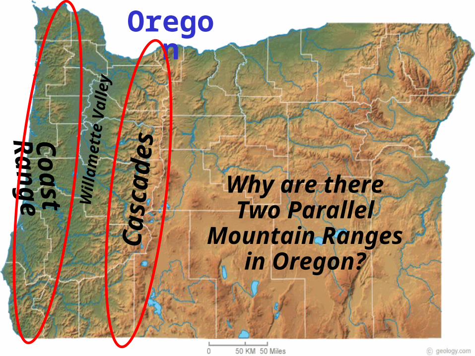
Oregon
Why is there a green side and a
brown side of Oregon?
Corvallis
Oregon
Cas
cade
s
Coa
st R
ange
Wil
lam
ette
Val
ley
Why are there Two Parallel Mountain Ranges in Oregon?
Nat
iona
l Aer
onau
ti cs
and
Spac
e A
dmin
i st r
ati o
n
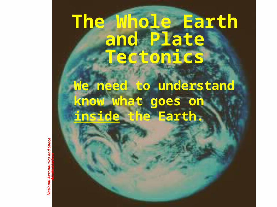
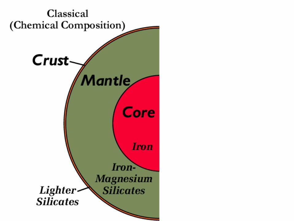
The Whole Earth and Plate Tectonics
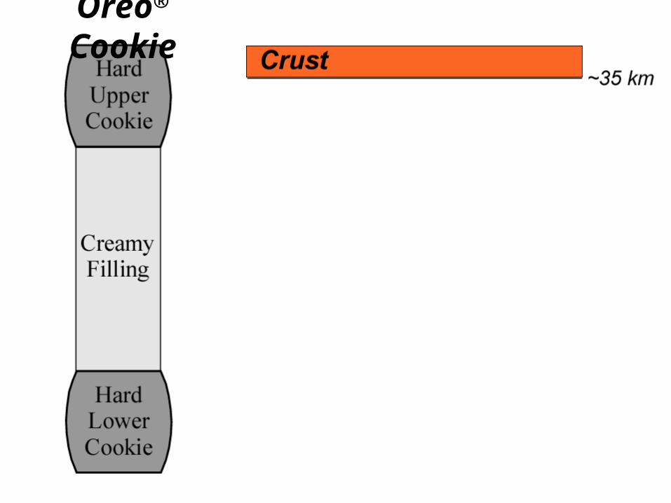
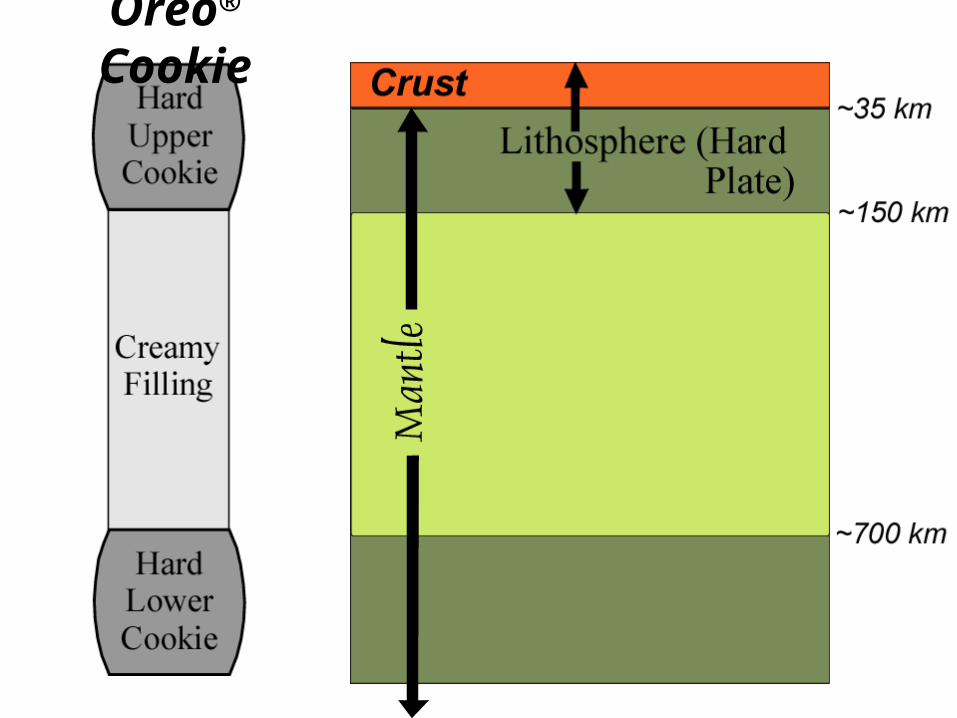
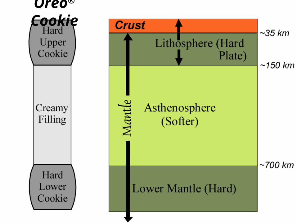
We need to understand know what goes on inside the Earth.


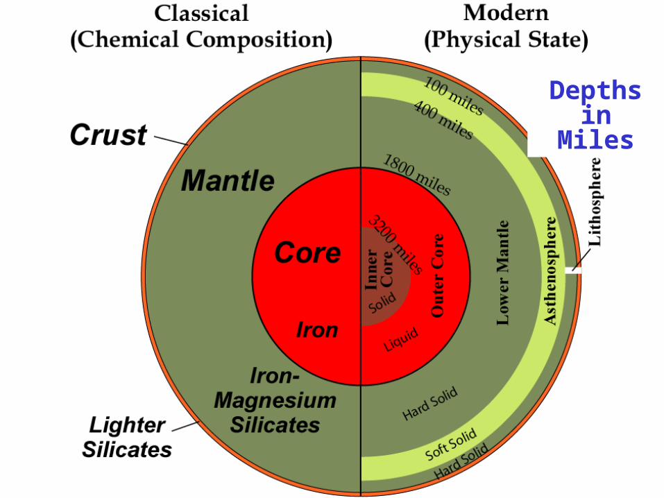
Depths in Miles
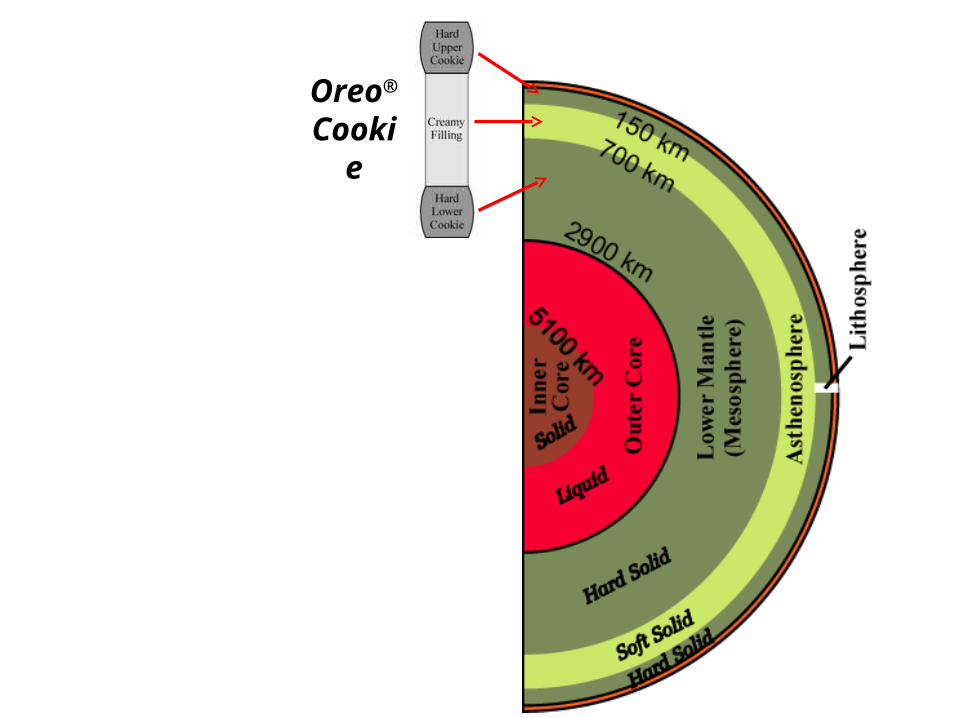
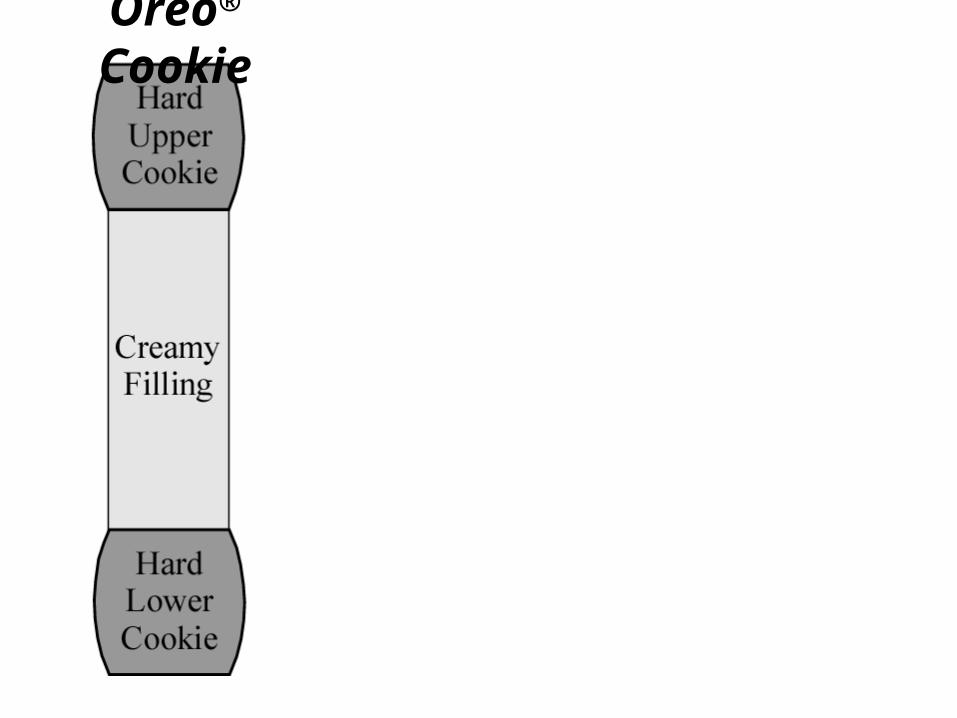
Oreo® Cookie
Oreo® Cookie
Oreo® Cookie

Oreo® Cookie
Oreo® Cookie

Oreo® Cookie
Oreo® Cookie

Rob
ert J
. Lil l
i e

Oreo® Psycho-Personality Test www.superkids.com/aweb/pages/humor/050199.sht
• Psychologists have discovered that the manner in which people eat Oreo® cookies provides great insight into their personalities. Choose which method best describes your favorite method of eating Oreos:
• 1. The whole thing at once.2. One bite at a time.3. Slow and methodical nibbles examining the results of each bite
afterwards.4. In little feverous nibbles.5. Dunked in some liquid (milk, coffee …..)6. Twisted apart, the inside, then the cookie.7. Twisted apart, the inside, and toss the cookie.8. Just the cookie, not the inside.9. I just like to lick them, not eat them.10. I don’t have a favorite way because I don’t like Oreos.

6. Twisted apart, the inside, then the cookie.
• You have a highly curious nature.• You take pleasure in breaking things apart
to find out how they work, though you’re not always able to put them back together, so you destroy all the evidence of your activities.
• You deny your involvement when things go wrong.
• You are a compulsive liar and exhibit deviant, if not criminal, behavior.

Rob
ert J
. Lil l
i e
Parks and Plates, ©2005 Robert J. Lillie
Sliding Plate over Asthenosphere

Rob
ert J
. Lil l
i e
Divergent Plate BoundaryParks and Plates©2005 Robert J. Lillie
North America
Africa
Atlantic Ocean

Nat
iona
l Geo
grap
hic M
id-A
tlant
ic R
idge
(Div
erge
nt P
late
Bou
ndar
y)
North America
Africa
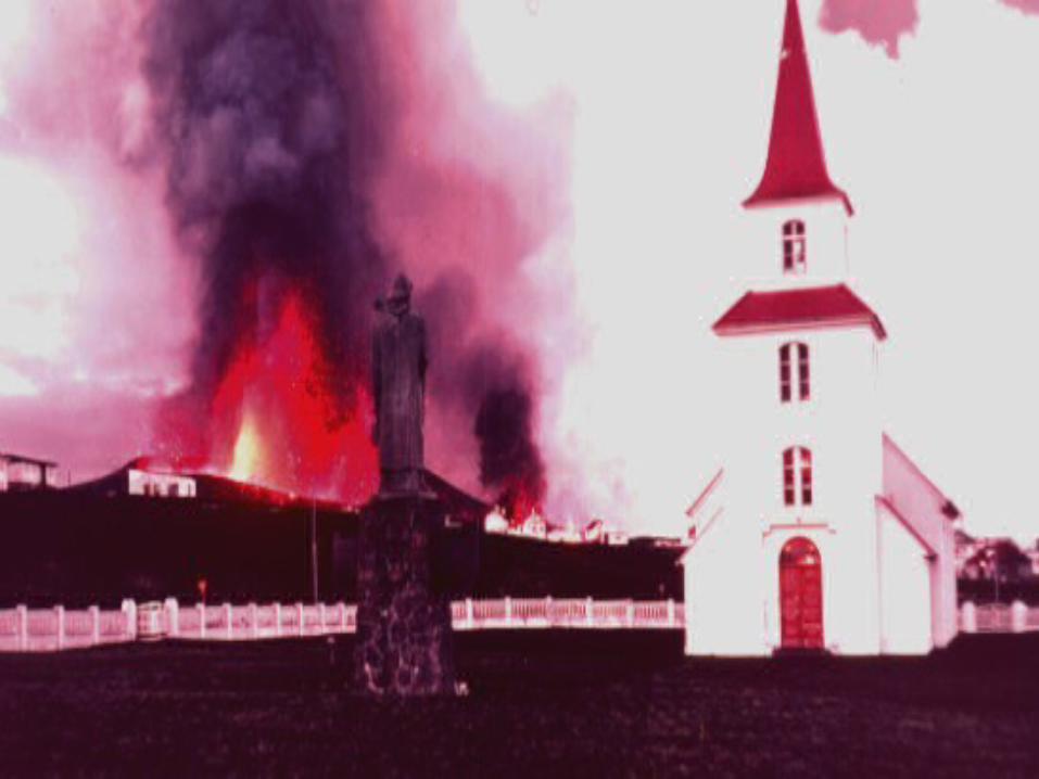
Iceland
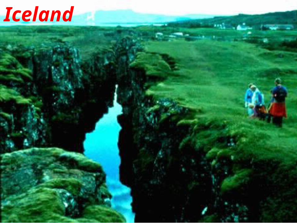
Iceland

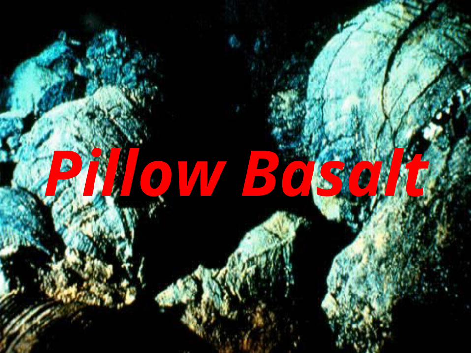
Pillow Basalt
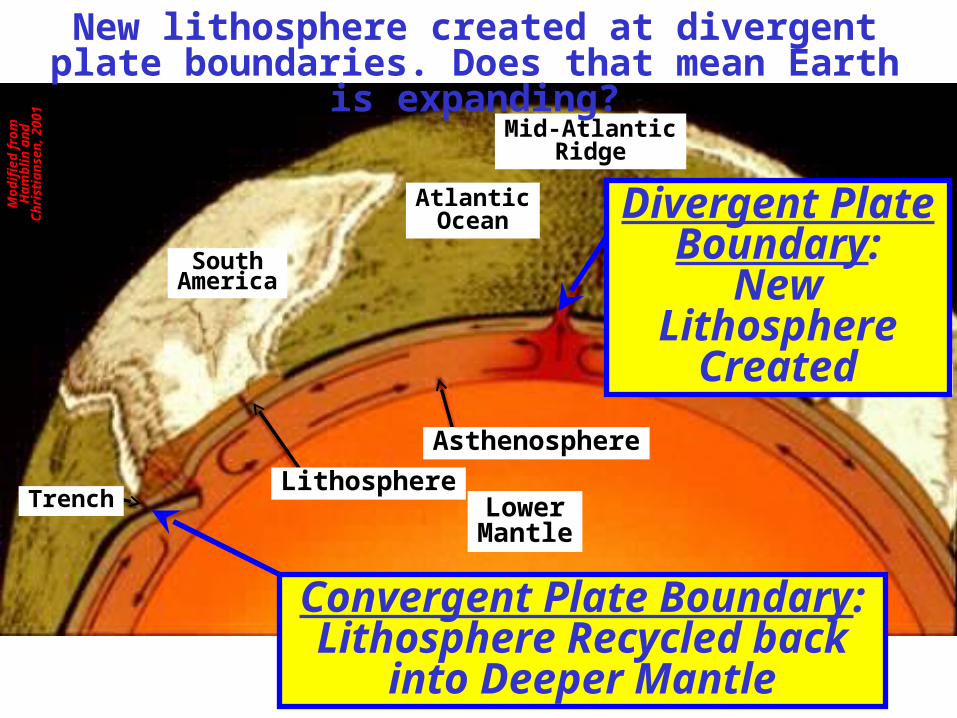
Africa
SouthAmerica
Core
LowerMantle
AtlanticOcean
Asthenosphere
LithosphereTrench
Divergent Plate Boundary:
New Lithosphere Created
Mid-AtlanticRidge
Convergent Plate Boundary:Lithosphere Recycled back into
Deeper Mantle
Mod
ifie
d f r
om H
ambl
in
and
Chr
i sti a
nsen
, 200
1New lithosphere created at divergent
plate boundaries. Does that mean Earth is expanding?

Rob
ert J
. Lil l
i e
Convergent Plate Boundary
Parks and Plates©2005 Robert J. Lillie
Subducting Plate Overriding
Plate
Deep-Sea Trench

Coast Range
Cascades
Subduction of the Juan de Fuca Plate forms the Coastal Ranges and Cascade Volcanoes

Rob
ert J
. Lil l
i e
Ber
nard
Gar
cia
Formation of the two parallel mountain ranges.

Rob
ert J
. Lil l
i e
Ber
nard
Gar
cia
Sedimentary layers scraped off the subducting plate form the Coast Range.
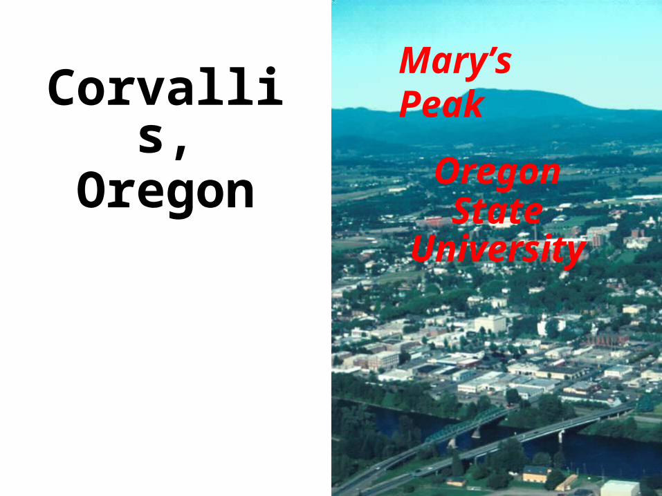
Mary’s PeakCorvallis,Oregon
Oregon StateUniversity

Mary’s Peak
Pillow Basalt – Coast Range Rocks made in the Ocean!

Rob
ert J
. Lil l
i e
Ber
nard
Gar
cia
Just like when you bicycle, the subducting plate sweats when it gets hot
Rob
ert J
. Lil l
i e
Ber
nard
Gar
cia
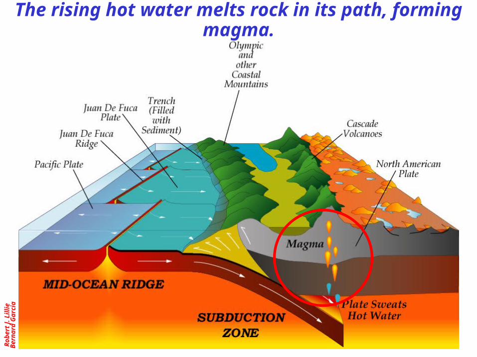
The rising hot water melts rock in its path, forming magma.
Rob
ert J
. Lil l
i e
Ber
nard
Gar
cia
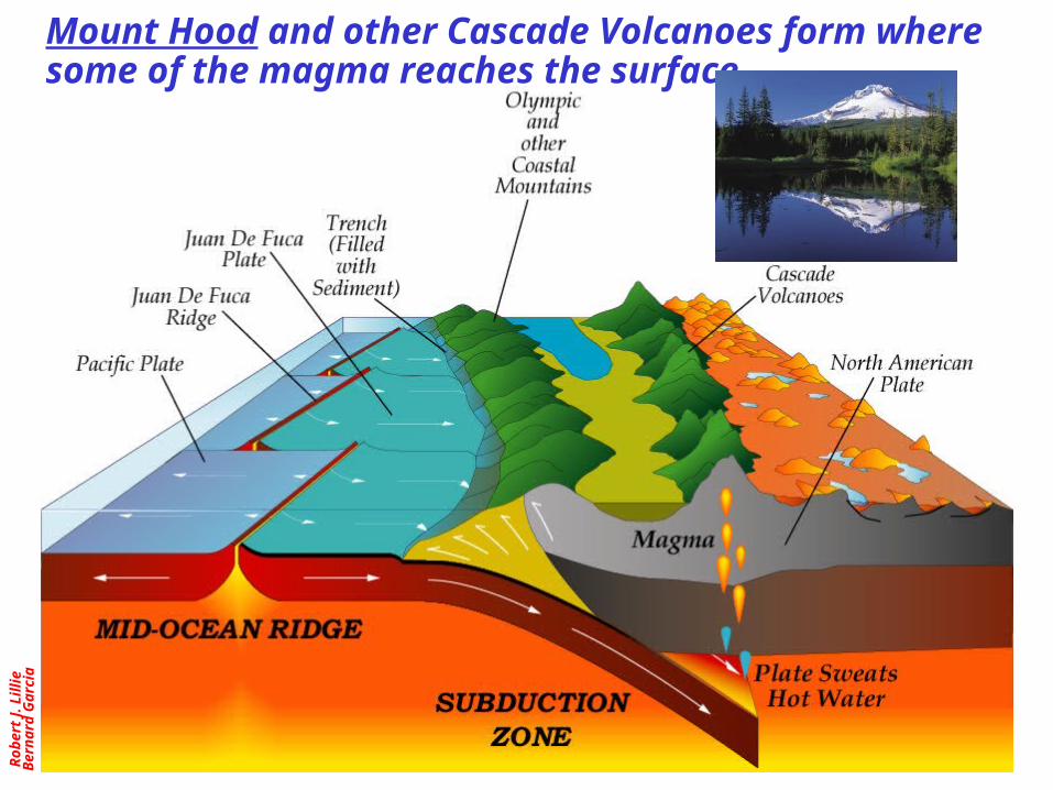
Mount Hood and other Cascade Volcanoes form where some of the magma reaches the surface.
Rob
ert J
. Lil l
i e
Ber
nard
Gar
cia
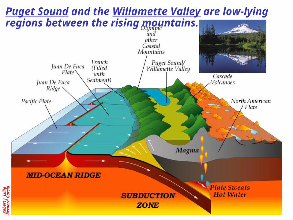
Puget Sound and the Willamette Valley are low-lying regions between the rising mountains.
U. S
. Geo
l ogi
cal S
urve
y
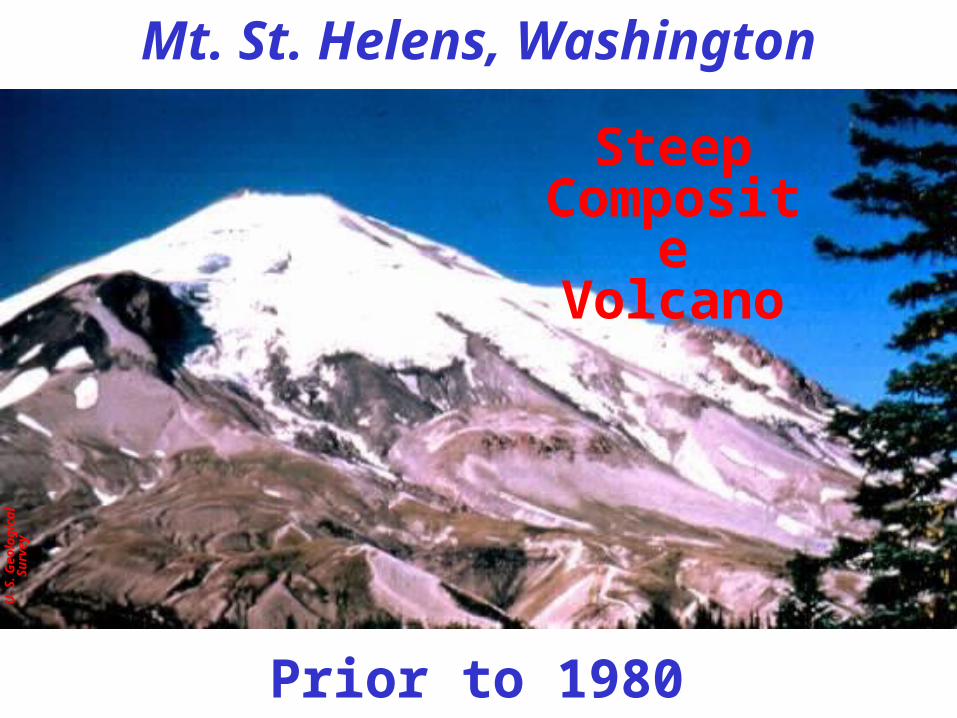
Mt. St. Helens, Washington
Prior to 1980
Steep Composite
Volcano
U. S
. Geo
l ogi
cal S
urve
y
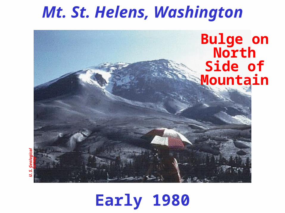
Early 1980
Bulge on North Side of
Mountain
Mt. St. Helens, Washington
U. S
. Geo
l ogi
cal S
urve
y
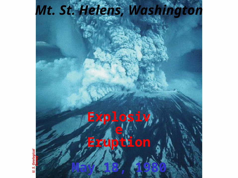
May 18, 1980
Explosive Eruption
Mt. St. Helens, Washington

U. S
. Geo
l ogi
cal S
urve
y
May 18, 1980
Mt. St. Helens, Washington
Eruption Cloud
Rob
ert J
. Lil l
i e
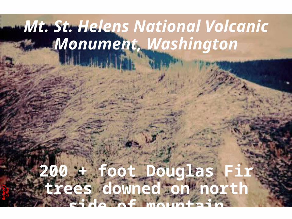
Mt. St. Helens National Volcanic Monument, Washington
200 + foot Douglas Fir trees downed on north side of mountain

U. S
. Geo
l ogi
cal S
urve
y
Mt. St. Helens National Volcanic Monument, Washington

Pau
l Roc
kwoo
d
7,700 years ago – Southern Oregon’s Mt. Mazama was
perhaps taller than Mt. Hood.
Pau
l Roc
kwoo
d
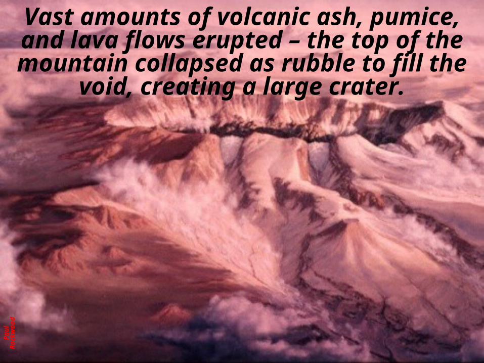
Vast amounts of volcanic ash, pumice, and lava flows erupted – the top of the mountain collapsed as rubble to fill the void, creating a
large crater.
Rob
ert J
. Lil l
i e
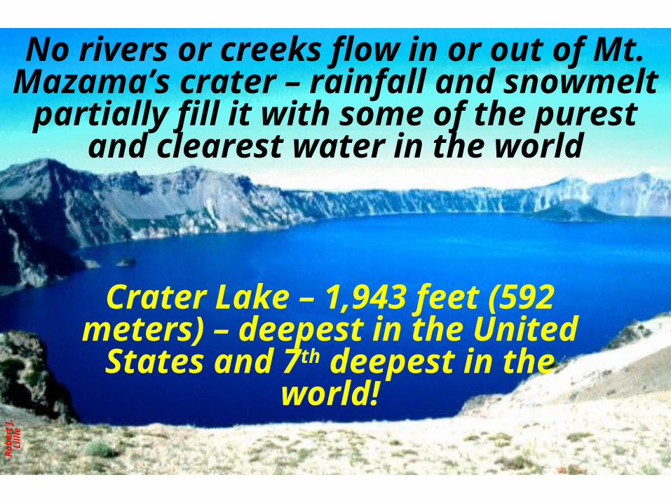
No rivers or creeks flow in or out of Mt. Mazama’s crater – rainfall and snowmelt partially fill it with some of the purest and
clearest water in the world
Crater Lake – 1,943 feet (592 meters) – deepest in the United States and 7th
deepest in the world!

M. W
i llia
ms,
Nat
i ona
l Par
k Se
r vic
e
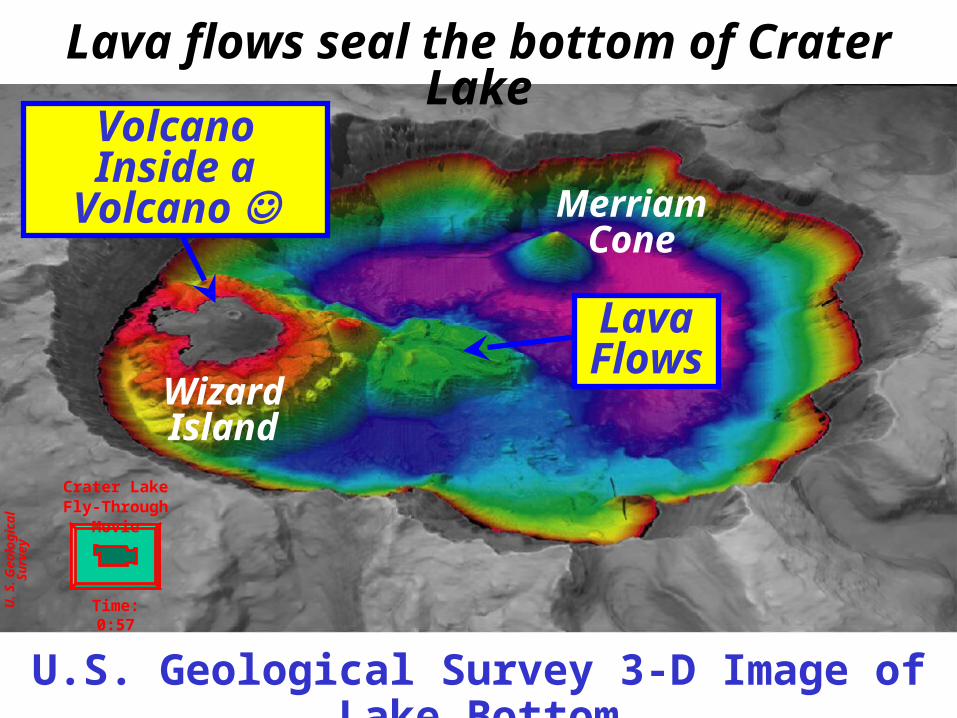
Later eruptions coated the crater floor – just like at Aniakchak Volcano in Alaska!
Volcano Inside a Volcano Lava Flows
Aniakchak National Monument, Alaska
U. S
. Geo
l ogi
cal S
urve
y
U.S. Geological Survey 3-D Image of Lake Bottom
Lava flows seal the bottom of Crater Lake
Volcano Inside a Volcano
Lava Flows
Wizard Island
Merriam Cone
Crater Lake Fly-Through Movie
Time: 0:57
Rob
ert J
. Lil l
i e
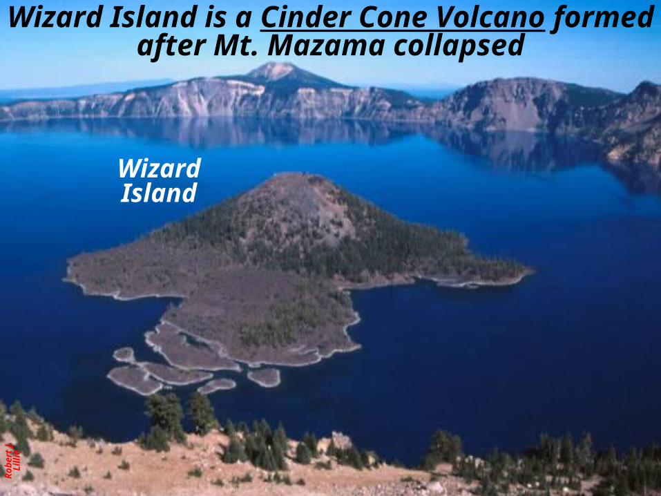
Wizard Island is a Cinder Cone Volcano formed after Mt. Mazama collapsed
Wizard Island
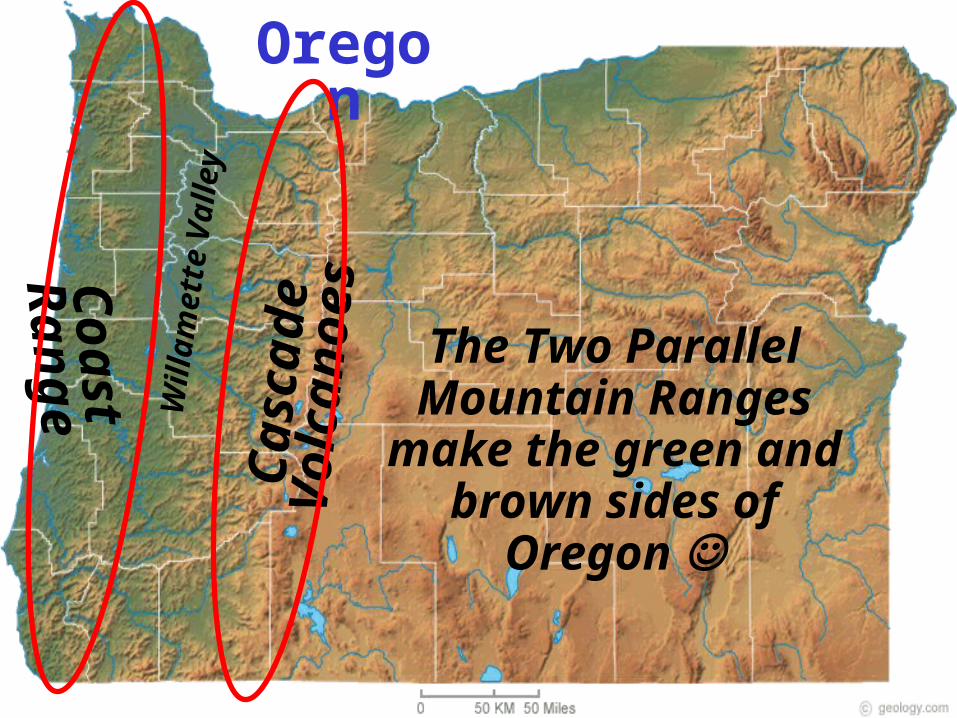
Oregon
Cas
cade
Vol
cano
es
Coa
st R
ange
Wil
lam
ette
Val
ley
The Two Parallel Mountain Ranges make
the green and brown sides of Oregon
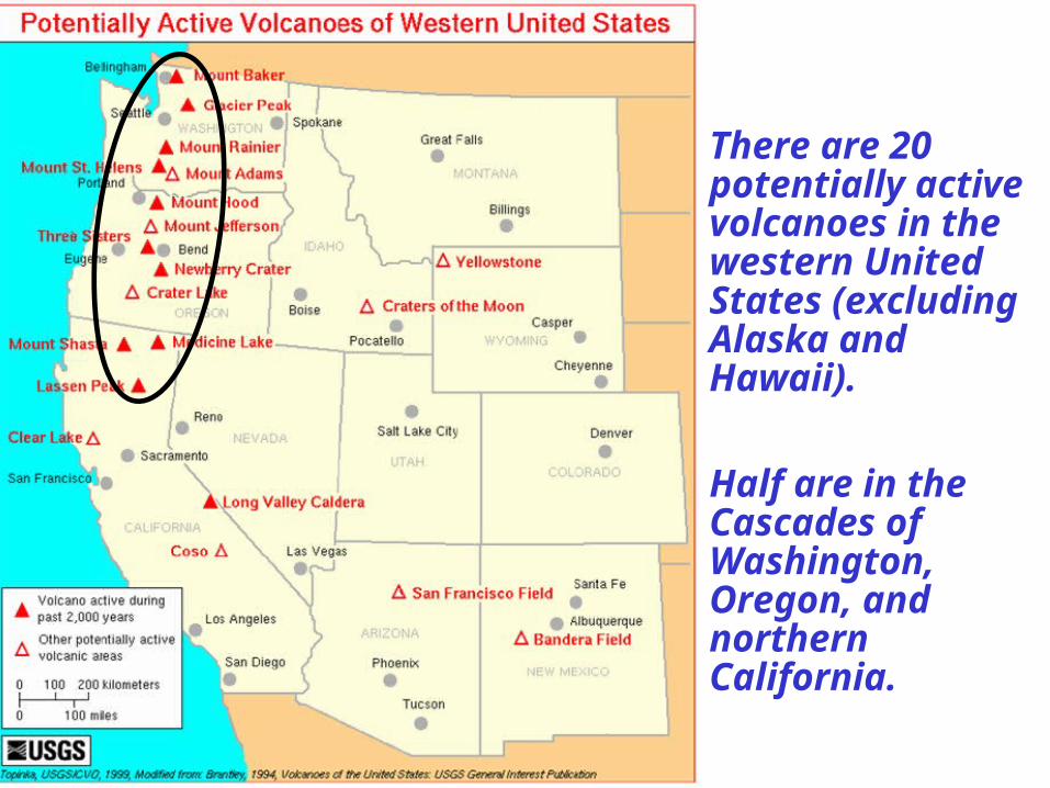
There are 20 potentially active volcanoes in the western United States (excluding Alaska and Hawaii).
Half are in the Cascades of Washington, Oregon, and northern California.

Cracked Egg Shell!Parks and Plates
©2005 Robert J. Lillie

Parks and Plates©2005 Robert J. Lillie
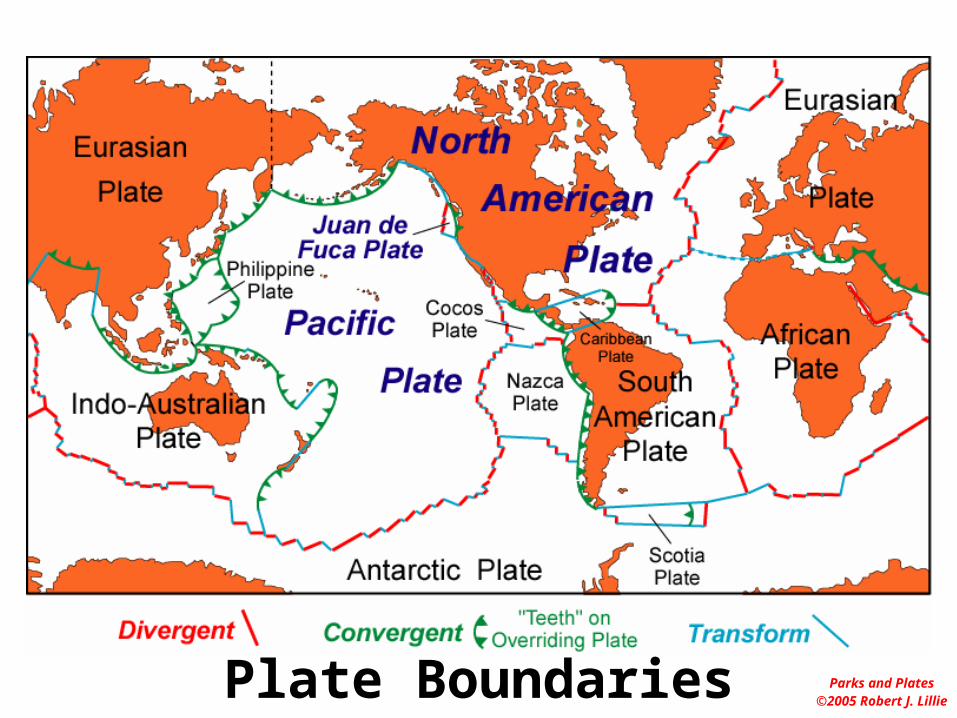
Plate Boundaries
San Andreas Fault
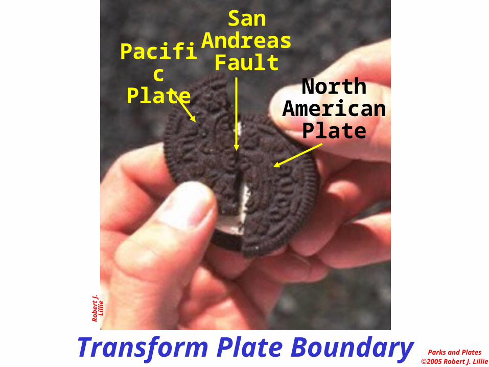
Western California is a Transform Plate Boundary
Rob
ert J
. Lil l
i e
Transform Plate Boundary Parks and Plates©2005 Robert J. Lillie
Pacific Plate
North American
Plate
San Andreas
Fault
Rob
ert J
. Lil l
i e
Parks and Plates©2005 Robert J. Lillie
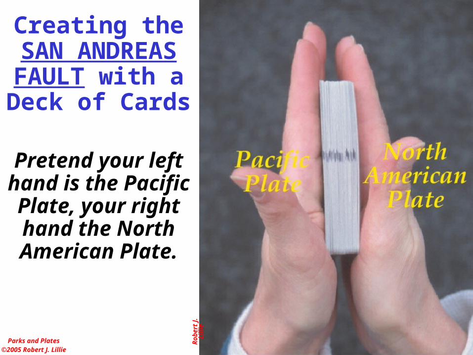
Creating theSAN ANDREAS FAULT with a Deck of Cards
Pretend your left hand is the Pacific Plate, your right hand the North American Plate.

Rob
ert J
. Lil l
i e
Parks and Plates©2005 Robert J. Lillie
Creating theSAN ANDREAS FAULT with a Deck of Cards
The TRANSFORM PLATE BOUNDARY
is a broad zone of shearing between the
two plates.

Rob
ert J
. Lil l
i e
Parks and Plates©2005 Robert J. Lillie
Creating theSAN ANDREAS FAULT with a Deck of Cards
One card face eventually takes
over, simulating the predominance of
movement along the San Andreas Fault.
North American PlatePacific Plate
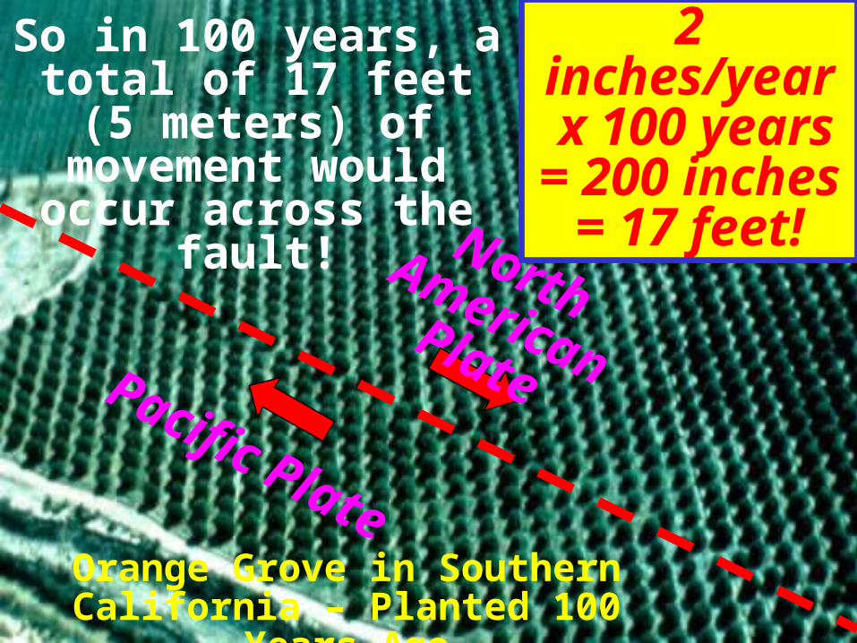
2 inches/year x 100 years= 200 inches
= 17 feet!
So in 100 years, a total of 17 feet (5 meters) of
movement would occur across the fault!
Orange Grove in Southern California – Planted 100 Years
Ago
Mar
s hak
, EA
RT
H (
Nor
ton,
200
5)
Parks and Plates©2005 Robert J. Lillie
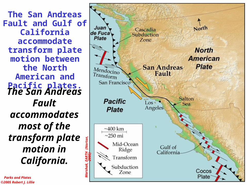
The San Andreas Fault and Gulf of California
accommodate transform plate motion
between the North American and Pacific
plates.
The San Andreas Fault accommodates
most of the transform plate
motion in California.

California Earthquake1973

Earthquakes
Parks and Plates©2005 Robert J. Lillie
Most earthquakes are at plate boundaries.
Parks and Plates©2005 Robert J. Lillie
Plate Boundaries

Where are the Volcanoes?
70% of them are in the "Ring of Fire"
Earth has more than 1500 active volcanoes
Turcotte, 1971
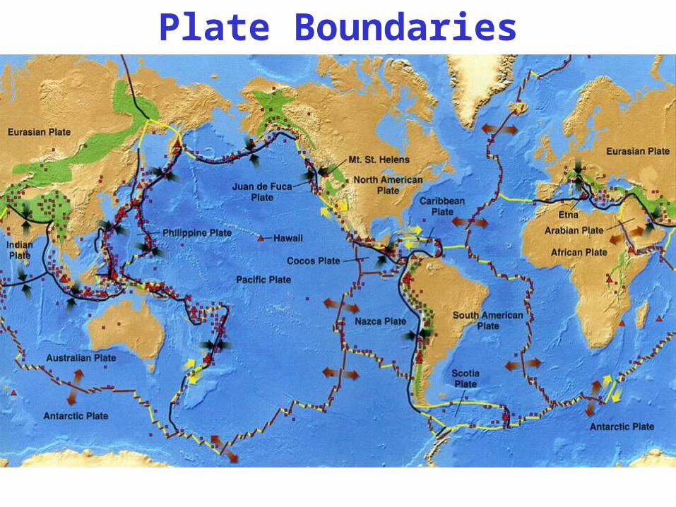
Plate Boundaries
Rob
ert J
. Lil l
i e
Ber
nard
Gar
cia
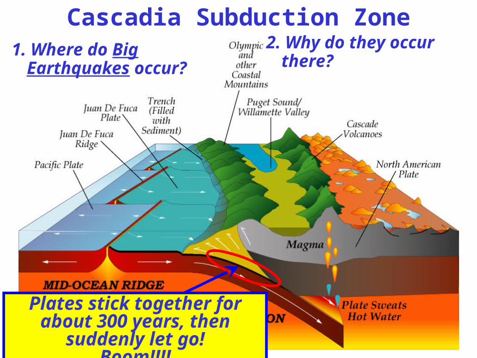
1. Where do Big Earthquakes occur?
Cascadia Subduction Zone2. Why do they occur there?
Plates stick together for about 300 years, then suddenly let go!
Boom!!!!
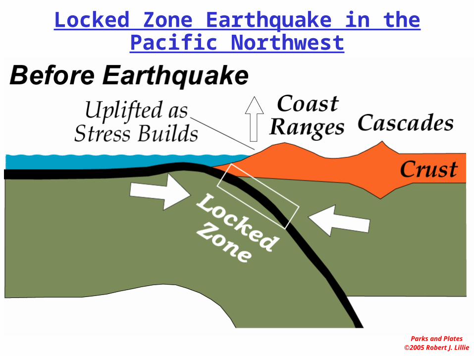
Parks and Plates©2005 Robert J. Lillie
Locked Zone Earthquake in the Pacific Northwest
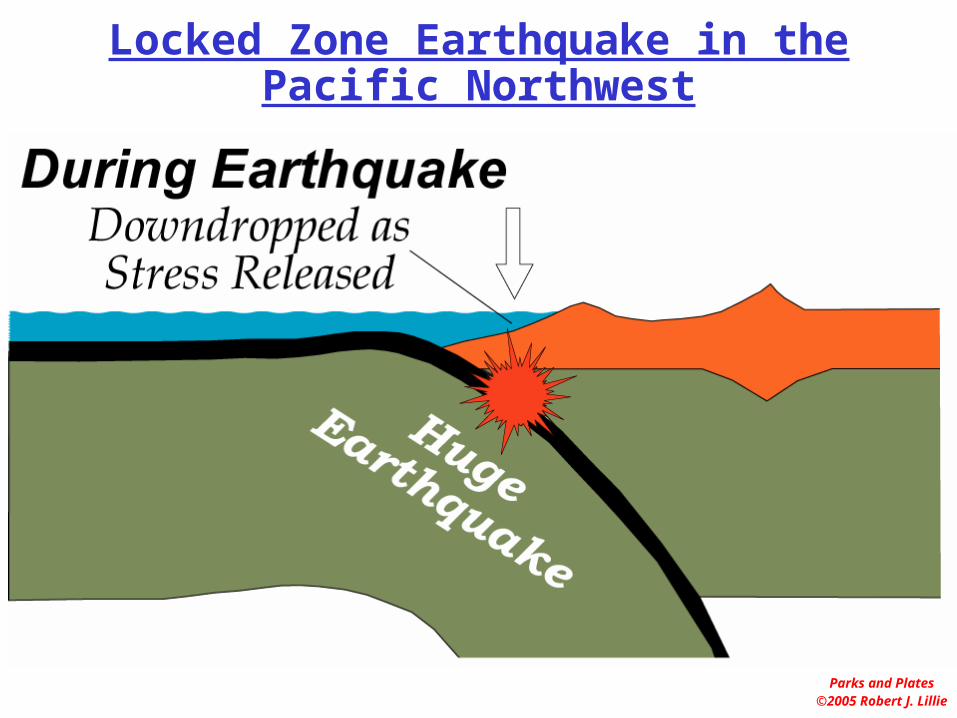
Parks and Plates©2005 Robert J. Lillie
Locked Zone Earthquake in the Pacific Northwest

U.S.G.S.
What drowned these trees 300 years
ago?
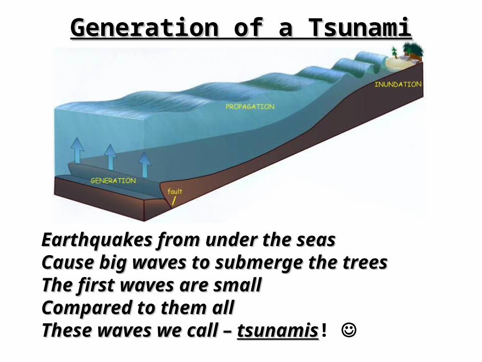
Earthquakes from under the seasEarthquakes from under the seas Cause big waves to submerge the trees Cause big waves to submerge the trees The first waves are small The first waves are small Compared to them allCompared to them all These waves we call – These waves we call – tsunamistsunamis!
Generation of a TsunamiGeneration of a Tsunami
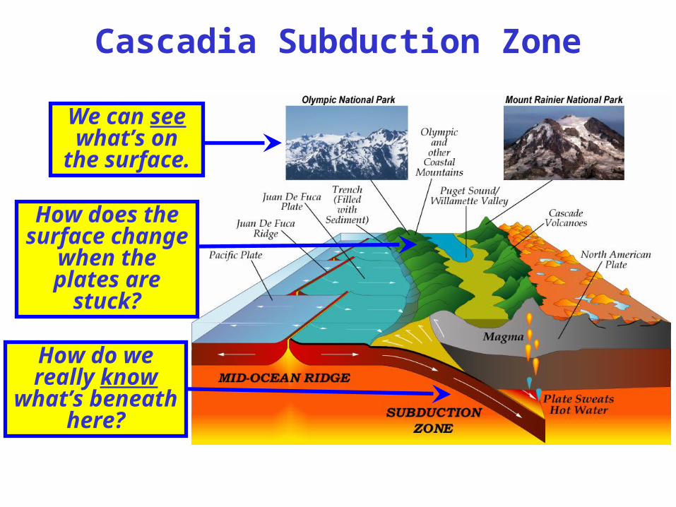
We can see what’s on the
surface.
Cascadia Subduction Zone
How does the surface change when the plates
are stuck?
How do we really know what’s
beneath here?

Drillhole across San Andreas Fault875 GPS Instruments175 Borehole Strainmeters5 Long-Baseline Laser Strainmeters400 Seismometers at 2,000 sites100 Permanent Seismometers
A project to:– Explore the structure and evolution of the North
American continent– Understand processes that cause earthquakes and
volcanic eruptions.
EarthScope

Rob
ert J
. Lil l
i e

Rob
ert J
. Lil l
i e